national weather service grand forks · my experience has given me a deeper appreciation for the...
TRANSCRIPT
Northern Exposure
Hello, eastern North Dakota and northwestern Minnesota!
My name is Ryan Knutsvig and I’m the new Meteorologist-in-Charge (MIC) here at
the NWS office in Grand Forks. I am excited to be back in the area and look forward
to serving the people of the Upper Midwest. I grew up in Buxton, ND, which is
about 20 miles south of Grand Forks. During my youth, I spent plenty of time out-
side playing football, baseball, and hockey across the region. After graduating from
Central Valley High School, I attended the University of North Dakota in Grand
Forks and obtained my B.S. and M.S. degrees in Atmospheric Sciences. I worked in
the private sector for a few years before joining the NWS. As a meteorologist with
the NWS, I worked in Texas, Wyoming, South Dakota, Nevada, and Nebraska be-
fore returning to North Dakota. My family and I are very excited to be back in
Grand Forks. My wife’s name is Stephanie and we have two boys, Caden (13 years
old) and Kannon (11 years old). My hobbies include nature photography and sports.
Since being in the NWS, I have experienced a wide variety of weather events. I’ve
had the opportunity to forecast weather ranging from extreme fire weather condi-
tions and downslope windstorms in Nevada to tornadoes and flooding in central Ne-
braska. My experience has given me a deeper appreciation for the wide variety of
dangerous weather on this planet. My job is to help people better prepare for weather
hazards that pose a significant threat to life and property. At the NWS, we have a
dedicated staff working 24 hours a day to help keep people safe. I’m proud to say
that I’m part of the NWS team here in Grand Forks and
look forward to serving the people in the region.
Meet the New Meteorologist-in-Charge Ryan Knutsvig
National Weather Service Grand Forks
Winter, Are
You Ready?
2
The Drive
Home
3-5
Social Media
6
Thunderstorm
Forecasting
7
Winter Out-
look
8
Coop
Program
9
Warnings and
Radar Tools
10-11
Inside this issue: Fall 2014
Ryan Knutsvig - MIC
Are You Ready for Winter?
Dave Kellenbenz
We all know what season is just around the corner, but are you ready? The National
Weather Service in Grand Forks will issue a variety of products to keep you ahead of any
storm this winter. These include: Hazardous Weather Outlooks, Top news stories, Weath-
er stories, in addition to Winter Storm Watches, Blizzard Watches, Winter Storm Warn-
ings, Blizzard Warnings and Winter Weather advisories. Do you know what these mean?
Here is a brief summary of the main products that will get you through this and any winter season.
Blizzard Warning - Issued when sustained winds or frequent gusts of 35 mph occurring in combination with
considerable falling and/or blowing snow and visibilities reduced to less than one-quarter mile for a period of
at least three hours.
Winter Storm Warning - Issued when snow accumulation of 6 inches in 12 hours, or 8 inches in 24 hours, or
4 inches in 12hr, or 6 inches in 24 hr in combination with 25 mph winds or greater causing blowing snow.
Ice Storm Warning - Freezing rain producing ice accumulation of one quarter of an inch or greater.
Freezing Rain Advisory - Freezing rain with ice accumulation less than one quarter of an inch.
Winter Weather Advisory - 3-5 inches of snow, or blowing snow reducing visibility to one half mile or less
at times, or other adverse winter weather such as freezing drizzle causing hazardous travel.
Wind Chill Warning - Wind chill temperatures 40 below and colder.
Wind Chill Advisory - Wind chill temperatures 25 to 40 below.
It is important to let us know what type of winter weather you are observing. This helps us out greatly since
you are our eyes out in the field. We don’t always know that 8 inches of snow has fallen at your home, or that
you may be experiencing blizzard conditions, or other hazardous winter weather. Please report the following:
Visibility, when it falls below 1 mile.
Snow amounts of 4 inches or more, and/or snow rates of 1-2 inches per hour.
Duration of low visibility in blowing snow, how long has it lasted so far?
Icing conditions, freezing drizzle, freezing rain, especially on power lines and trees.
Your exact location (i.e. 4 miles northwest of Gilby), whether it is sheltered, in the open country, etc.
You are our eyes out there, we want to hear from you this winter!!!!
You can let us know by calling 1-701-772-0720, or let us know on Facebook and/or Twitter, since we are
monitoring these social media sites.
Blizzards can be very challenging to forecast for, especially borderline ground blizzards that present many
challenges. On average, our area gets about 3 blizzards per year. Pay
attention to our forecasts this winter season, and let us know what you
are seeing out there! Stay safe this winter and be prepared. And listen
to our forecasts, watches, and warnings to stay one step ahead of moth-
er nature!
Winter Weather Awareness week is October 27-31 in North Dakota,
and Nov 10-14 in Minnesota. We will highlight safety tips during
these weeks on our homepage.
Page 2 Northern Exposure Fal l 2014
The Drive Home on the Morning of March 21, 2014
Dave Kellenbenz
I had just worked a midnight shift on March 21, 2014, the first full day of spring!
Despite the possibility of encountering near blizzard conditions, I made the mistake of
leaving work for my home to the northwest of Grand Forks.
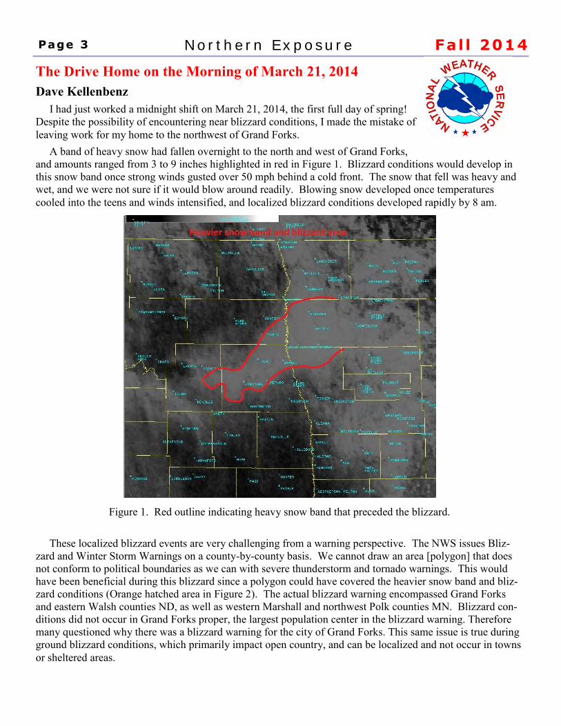
A band of heavy snow had fallen overnight to the north and west of Grand Forks,
and amounts ranged from 3 to 9 inches highlighted in red in Figure 1. Blizzard conditions would develop in
this snow band once strong winds gusted over 50 mph behind a cold front. The snow that fell was heavy and
wet, and we were not sure if it would blow around readily. Blowing snow developed once temperatures
cooled into the teens and winds intensified, and localized blizzard conditions developed rapidly by 8 am.
Figure 1. Red outline indicating heavy snow band that preceded the blizzard.
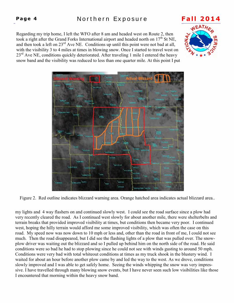
These localized blizzard events are very challenging from a warning perspective. The NWS issues Bliz-
zard and Winter Storm Warnings on a county-by-county basis. We cannot draw an area [polygon] that does
not conform to political boundaries as we can with severe thunderstorm and tornado warnings. This would
have been beneficial during this blizzard since a polygon could have covered the heavier snow band and bliz-
zard conditions (Orange hatched area in Figure 2). The actual blizzard warning encompassed Grand Forks
and eastern Walsh counties ND, as well as western Marshall and northwest Polk counties MN. Blizzard con-
ditions did not occur in Grand Forks proper, the largest population center in the blizzard warning. Therefore
many questioned why there was a blizzard warning for the city of Grand Forks. This same issue is true during
ground blizzard conditions, which primarily impact open country, and can be localized and not occur in towns
or sheltered areas.
Page 3 Northern Exposure Fal l 2014
my lights and 4 way flashers on and continued slowly west. I could see the road surface since a plow had
very recently cleared the road. As I continued west slowly for about another mile, there were shelterbelts and
terrain breaks that provided improved visibility at times, but conditions then became very poor. I continued
west, hoping the hilly terrain would afford me some improved visibility, which was often the case on this
road. My speed now was now down to 10 mph or less and, other than the road in front of me, I could not see
much. Then the road disappeared, but I did see the flashing lights of a plow that was pulled over. The snow-
plow driver was waiting out the blizzard and so I pulled up behind him on the north side of the road. He said
conditions were so bad he had to stop plowing since he could not see with winds gusting to around 50 mph.
Conditions were very bad with total whiteout conditions at times as my truck shook in the blustery wind. I
waited for about an hour before another plow came by and led the way to the west. As we drove, conditions
slowly improved and I was able to get safely home. Seeing the winds whipping the snow was very impres-
sive. I have travelled through many blowing snow events, but I have never seen such low visibilities like those
I encountered that morning within the heavy snow band.
Page 4 Northern Exposure Fal l 2014
Regarding my trip home, I left the WFO after 8 am and headed west on Route 2, then
took a right after the Grand Forks International airport and headed north on 17th St NE,
and then took a left on 23rd Ave NE. Conditions up until this point were not bad at all,
with the visibility 3 to 4 miles at times in blowing snow. Once I started to travel west on
23rd Ave NE, conditions quickly deteriorated. After traveling 1 mile I entered the heavy
snow band and the visibility was reduced to less than one quarter mile. At this point I put
Figure 2. Red outline indicates blizzard warning area. Orange hatched area indicates actual blizzard area..
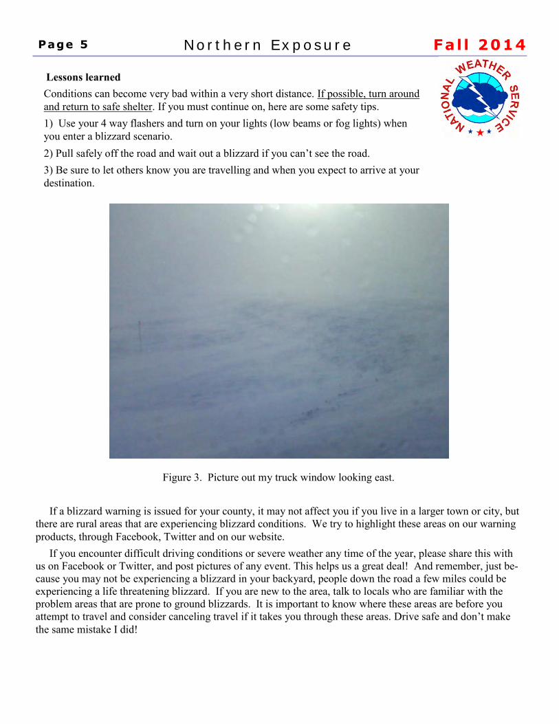
Figure 3. Picture out my truck window looking east.
If a blizzard warning is issued for your county, it may not affect you if you live in a larger town or city, but
there are rural areas that are experiencing blizzard conditions. We try to highlight these areas on our warning
products, through Facebook, Twitter and on our website.
If you encounter difficult driving conditions or severe weather any time of the year, please share this with
us on Facebook or Twitter, and post pictures of any event. This helps us a great deal! And remember, just be-
cause you may not be experiencing a blizzard in your backyard, people down the road a few miles could be
experiencing a life threatening blizzard. If you are new to the area, talk to locals who are familiar with the
problem areas that are prone to ground blizzards. It is important to know where these areas are before you
attempt to travel and consider canceling travel if it takes you through these areas. Drive safe and don’t make
the same mistake I did!
Page 5 Northern Exposure Fal l 2014
Lessons learned
Conditions can become very bad within a very short distance. If possible, turn around
and return to safe shelter. If you must continue on, here are some safety tips.
1) Use your 4 way flashers and turn on your lights (low beams or fog lights) when
you enter a blizzard scenario.
2) Pull safely off the road and wait out a blizzard if you can’t see the road.
3) Be sure to let others know you are travelling and when you expect to arrive at your
destination.
Are you aware that the National Weather Service (NWS) in
Grand Forks is on social media? Over the past few years,
we have made strides in developing a presence on Facebook, Twitter, and more
recently on YouTube. This has given us another means to get routine and critical
weather information to you!
The National Weather Service in Grand Forks typically creates posts for our Face-
book and Twitter pages each day, with more frequent updates at times, especially
when there is active weather. Although our social media pages are not meant to be
a replacement for other sources of weather information, such as NOAA Weather
Radio and our webpage, posting to social media helps us to reach as broad of an
audience as possible with critical weather information.
Unlike other sources of weather information, social media is intended to be highly
interactive. Social media pages are monitored at our office during all hours of the
day. We try to be responsive in answering any questions that we may receive, as
time permits.
Of course, each of you can provide important information that can assist us at the
NWS in providing the best forecasts and potentially life-saving warnings possible.
We always appreciate reports and photos via Facebook or Twitter of what’s hap-
pening with the weather where you live across eastern North Dakota as well as
northwestern and west-central Minnesota. These reports can be especially helpful
in the case of severe thunderstorms and heavy rainfall during the warmer months,
and also for wintry conditions, where snow amounts, road conditions, and visibility
can vary dramatically across our region. However, we greatly appreciate all re-
ports we receive!
We certainly encourage you to follow us on Twitter and on Facebook, and always
welcome feedback from you!
@NWSgrandforks
www.facebook.com/NWSGrandForks
Social Media, Get Connected! Jeff Makowski
“We always appreciate
reports and photos via
Facebook or Twitter”
Page 6 Northern Exposure Fal l 2014
“It is not possible to say
that a thunderstorm will
hit Fargo at exactly 4
p.m. in a 12 hour
forecast.”
Page 7 Northern Exposure Fal l 2014
Why is it So Hard to Forecast Thunderstorms?
Dave Kellenbenz
Thunderstorms are smaller scale features that affect a small part of the population at one time. For example, a thunderstorm may affect only part of a city or county compared to winter storms that affect a larger area all at once. There are times where a much larger area is affected, like when many thunderstorms form over an area, or are found with a cold front and form a line of storms affecting several counties. There are three main ingredients to form thunderstorms: moisture, instability, and a means to lift the air to its level of free convection (or level where it will grow on its own). Greater moisture will lead to greater instability, and the strength of the storm is tied to both instability and vertical wind shear (how winds change as you go up in the atmosphere). When forecasting thunderstorms, we look at real time data and, in turn, use that to determine how the models should behave. While the models usually do a good job forecasting moisture and instability, it is the small scale, focused lift in the atmosphere that is key to where thunderstorms will form. This is why some areas may get 3 or 4 inches of rain from thunderstorms, and a few miles down the road get only a few sprinkles. This adds to the difficulty in forecasting whether a thunderstorm will affect a certain area at a certain time. It is not possible to say that a thunderstorm will hit Fargo at exactly 4 p.m. in a 12 hour forecast. There are times when larger thunderstorm complexes affect a region, and models continue to get better at pinpointing larger areas that will be affected. The current technology does not allow us to forecast the exact time and location a thunderstorm may affect your backyard, but we always strive to give you the most accurate forecast we can!
An Early Outlook for Winter 2014-15
Dan Riddle
One of the most asked questions in September and October is “what does winter look like?” The answer to that
question is very complex due to the large number of global variables that influence temperature and precipita-
tion patterns. So what are some of the early signals showing for eastern North Dakota and northwestern and
west central Minnesota for meteorological winter (Dec-Jan-Feb)?
One of the better understood signals is the ENSO, which stands for El Nino Southern Oscillation. This signal
focuses on water temperatures along the Equator in the Pacific Ocean from Peru to Indonesia. When waters
are abnormally cool, it is called La Nina, and when waters are abnormally warm, it is called El Nino. ENSO
neutral is used for times when the water temperatures are near normal..
The Climate Prediction Center (CPC) is forecasting an El Nino this winter, which is due to warming waters in
the Pacific Ocean in the east-west zone near and just south of the equator. An El Nino typically brings our re-
gion a warmer and somewhat drier winter as the upper flow is more zonal and our area is flooded with mild Pa-
cific air masses. The strength of the El Nino is very important. This winter season, the El Nino is likely to be
weak, which means the influence of this El Nino pattern in our area may be weaker than otherwise it would be
if the El Nino is strong. But at this time, the CPC is forecasting enough of an influence so our area will likely
be warmer than normal for the 3 month winter period. It is very important to understand that this is a 3
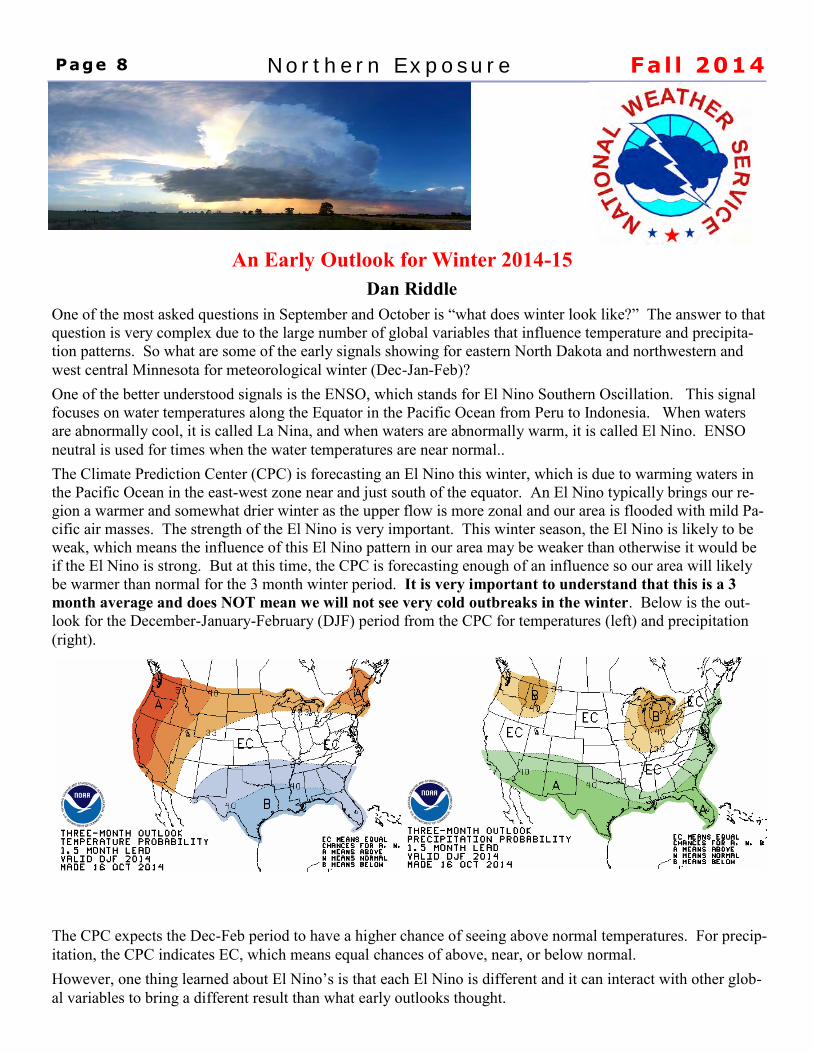
month average and does NOT mean we will not see very cold outbreaks in the winter. Below is the out-
look for the December-January-February (DJF) period from the CPC for temperatures (left) and precipitation
(right).
The CPC expects the Dec-Feb period to have a higher chance of seeing above normal temperatures. For precip-
itation, the CPC indicates EC, which means equal chances of above, near, or below normal.
However, one thing learned about El Nino’s is that each El Nino is different and it can interact with other glob-
al variables to bring a different result than what early outlooks thought.
Page 8 Northern Exposure Fal l 2014
The Cooperative Observing Program
Brad Hopkins
The Department of Commerce’s National Oceanic and Atmospheric
Administration (of which the NWS is a part) maintains a database of climatic
weather information. This is used by the NWS in preparing forecasts. Thus, the
collection of timely and accurate surface weather data is vital to both long and
short term forecasts.
The Cooperative Observing Program (COOP) is the backbone of the United States
Climatological database. COOP observers may also act as weather observers and severe storm spotters,
phoning in reports of hazardous weather in the winter and summer. Cooperative observers record temperature,
precipitation, and snowfall. This information is used to help assess flood potential, as well as verification of
our forecasts and warnings.
COOP observers are sometimes called to act as 'spotters' and are a valuable aid to the NWS by supplying
information which advanced technology cannot readily see. For example, a spotter who reports damaging
winds where the Doppler radar indicates damage may be occurring is very valuable. Also valuable is when, in
the winter, spotters report areas where blowing or drifting snow is causing hazardous travel, yet this weather is
occurring between official reporting points. These spotters help us verify severe weather, allowing the NWS
to do a better job warning the public and meeting our mission: the protection of life and property. This
network is comprised entirely of volunteers: men and women in all walks of life; and the NWS thanks them!
The NWS Cooperative Observers are the unsung heroes of the NWS, performing a vital task.
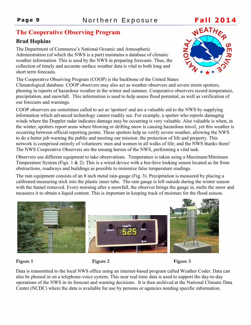
Observers use different equipment to take observations. Temperature is taken using a Maximum/Minimum
Temperature System (Figs. 1 & 2). This is a wired device with a bee-hive looking sensor located as far from
obstructions, roadways and buildings as possible to minimize false temperature readings.
The rain equipment consists of an 8 inch metal rain-gauge (Fig. 3). Precipitation is measured by placing a
calibrated measuring stick into the plastic inner tube. The rain gauge is left outside during the winter season
with the funnel removed. Every morning after a snowfall, the observer brings the gauge in, melts the snow and
measures it to obtain a liquid content. This is important in keeping track of moisture for the flood season.
Figure 1 Figure 2 Figure 3
Data is transmitted to the local NWS office using an internet-based program called Weather Coder. Data can
also be phoned in on a telephone-voice system. This near real-time data is used to support the day-to-day
operations of the NWS in its forecast and warning decisions. It is then archived at the National Climatic Data
Center (NCDC) where the data is available for use by persons or agencies needing specific information.
Page 9 Northern Exposure Fal l 2014
Under the right conditions the NWS employs a two-out-of-three principle in deter-mining when and if to issue a Tornado Warning. 1)Atmospheric Conditions - the NWS observes and forecast these conditions, so we know when and where tornadoes are most likely. 2)Radar Signatures - as storms develop, the NWS closely monitors storms with our network of weather radars. As we see certain features develop, in that right environment, we may begin to issue warnings. 3)Spotter Reports - we have trained SkyWarn Spotters, and if they see a tornado a warning may be issued.
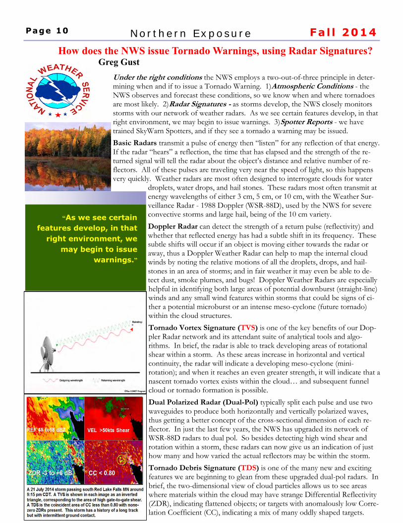
Basic Radars transmit a pulse of energy then “listen” for any reflection of that energy. If the radar “hears” a reflection, the time that has elapsed and the strength of the re-turned signal will tell the radar about the object’s distance and relative number of re-flectors. All of these pulses are traveling very near the speed of light, so this happens very quickly. Weather radars are most often designed to interrogate clouds for water
droplets, water drops, and hail stones. These radars most often transmit at energy wavelengths of either 3 cm, 5 cm, or 10 cm, with the Weather Sur-veillance Radar - 1988 Doppler (WSR-88D), used by the NWS for severe convective storms and large hail, being of the 10 cm variety.
Doppler Radar can detect the strength of a return pulse (reflectivity) and whether that reflected energy has had a subtle shift in its frequency. These subtle shifts will occur if an object is moving either towards the radar or away, thus a Doppler Weather Radar can help to map the internal cloud winds by noting the relative motions of all the droplets, drops, and hail-stones in an area of storms; and in fair weather it may even be able to de-tect dust, smoke plumes, and bugs! Doppler Weather Radars are especially helpful in identifying both large areas of potential downburst (straight-line) winds and any small wind features within storms that could be signs of ei-ther a potential microburst or an intense meso-cyclone (future tornado) within the cloud structures.
Tornado Vortex Signature (TVS) is one of the key benefits of our Dop-pler Radar network and its attendant suite of analytical tools and algo-rithms. In brief, the radar is able to track developing areas of rotational shear within a storm. As these areas increase in horizontal and vertical continuity, the radar will indicate a developing meso-cyclone (mini-rotation); and when it reaches an even greater strength, it will indicate that a nascent tornado vortex exists within the cloud… and subsequent funnel cloud or tornado formation is possible.
Dual Polarized Radar (Dual-Pol) typically split each pulse and use two waveguides to produce both horizontally and vertically polarized waves, thus getting a better concept of the cross-sectional dimension of each re-flector. In just the last few years, the NWS has upgraded its network of WSR-88D radars to dual pol. So besides detecting high wind shear and rotation within a storm, these radars can now give us an indication of just how many and how varied the actual reflectors may be within the storm.
Tornado Debris Signature (TDS) is one of the many new and exciting features we are beginning to glean from these upgraded dual-pol radars. In brief, the two-dimensional view of cloud particles allows us to see areas where materials within the cloud may have strange Differential Reflectivity (ZDR), indicating flattened objects; or targets with anomalously low Corre-lation Coefficient (CC), indicating a mix of many oddly shaped targets.
How does the NWS issue Tornado Warnings, using Radar Signatures? Greg Gust
“As we see certain
features develop, in that
right environment, we
may begin to issue
warnings.”
Page 10 Northern Exposure Fal l 2014
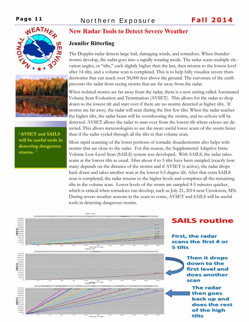
The Doppler radar detects large hail, damaging winds, and tornadoes. When thunder-
storms develop, the radar goes into a rapidly rotating mode. The radar scans multiple ele-
vation angles, or “tilts,” each slightly higher than the last, then returns to the lowest level
after 14 tilts, and a volume scan is completed. This is to help fully visualize severe thun-
derstorms that can reach over 50,000 feet above the ground. The curvature of the earth
prevents the radar from seeing storms that are far away from the radar.
When isolated storms are far away from the radar, there is a new setting called Automated
Volume Scan Evaluation and Termination (AVSET). This allows for the radar to drop
down to the lowest tilt and start over if there are no storms detected at higher tilts. If
storms are far away, the radar will scan during the first few tilts. When the radar reaches
the higher tilts, the radar beam will be overshooting the storms, and no echoes will be
detected. AVSET allows the radar to start over from the lowest tilt where echoes are de-
tected. This allows meteorologists to see the more useful lower scans of the storm faster
than if the radar cycled through all the tilts in that volume scan.
More rapid scanning of the lower portions of tornadic thunderstorms also helps with
storms that are close to the radar. For this reason, the Supplemental Adaptive Intra-
Volume Low-Level Scan (SAILS) system was developed. With SAILS, the radar takes
scans at the lowest tilts as usual. After about 4 to 5 tilts have been sampled (exactly how
many depends on the distance of the storms and if AVSET is active), the radar drops
back down and takes another scan at the lowest 0.5 degree tilt. After that extra SAILS
scan is completed, the radar returns to the higher levels and completes all the remaining
tilts in the volume scan. Lower levels of the storm are sampled 4-5 minutes quicker,
which is critical when tornadoes can develop, such as July 21, 2014 near Crookston, MN.
During severe weather seasons in the years to come, AVSET and SAILS will be useful
tools in detecting dangerous storms.
New Radar Tools to Detect Severe Weather
Jennifer Ritterling
“AVSET and SAILS
will be useful tools in
detecting dangerous
storms. ”
Page 11 Northern Exposure Fal l 2014