national vegetation classification: boreal and arctic
TRANSCRIPT

National Vegetation Classification: Boreal and Arctic Alaska Regional Analysis
Tina V. Boucher, Lindsey A. Flagstad, and Bonnie L. Bernard
Keywords: U.S. National Vegetation Classification, Alaska, Arctic, Subarctic, Boreal,
Ordination
Abbreviations: NVC (U.S. National Vegetation Classification), NMS (Non-metric
Multidimensional Scaling), CAVM (Circumarctic Vegetation Map), CBVM (Circumboreal
Vegetation Map), ACCS (Alaska Center for Conservation Science)
Nomenclature: USDA Plants Database, Accessed December 2015
Submitted: March 7, 2016
Correspondence:
Boucher, T.V.
Program Ecologist
Alaska Natural Heritage Program at the Alaska Center for Conservation Science
University of Alaska Anchorage
3211 Providence Dr.
Anchorage, Alaska 99508

i
Abstract The National Vegetation Classification (NVC) provides a standard through which the continuum
of species occurring across a landscape may be organized into discrete, observable, taxonomic
classes. As Alaska contains the entire arctic and most of the boreal biomes occurring within the
United States, consideration of ecological data from these regions is necessary for the full
development of the NVC across the range of North American biomes. The work presented herein
classifies Arctic and Boreal vegetation at the intermediate levels (macrogroup and group) of the
NVC hierarchy. To test assumptions inherent to these mid-level units, the Alaska Center for
Conservation Science (ACCS) performed a quantitative analysis of regional vegetation plot data
and based on the results of this analysis, proposed revisions to the structure and group
descriptions of the hierarchy. This current and continued verification of vegetation types will
promote the adoption and use of the NVC in Alaska and foster a more precise understanding of
ecological trends in the circumarctic and circumboreal north.
Acknowledgements The authors extend their gratitude to the USGS for funding this important work, to Alexa
McKerrow with the USGS for her flexible management of the agreement, to Don Faber-
Langendoen with NatureServe for his guidance on placement of types within the hierarchy, and
to Beth Schulz with the USFS Anchorage Forestry Sciences Lab for her input on forested types.

1
Table of Contents Abstract ............................................................................................................................................ i
Acknowledgements .......................................................................................................................... i
Introduction ..................................................................................................................................... 1
Methods........................................................................................................................................... 2
Scope of Work ............................................................................................................................ 2
Data Selection ............................................................................................................................. 2
Plot Attribution ........................................................................................................................... 3
Data Management ....................................................................................................................... 5
Taxonomic Standardization ........................................................................................................ 6
Data Analysis .............................................................................................................................. 6
Results ............................................................................................................................................. 7
Format of Results ........................................................................................................................ 7
Summary of Proposed Changes to the NVC............................................................................... 7
Group-level Analyses.................................................................................................................. 8
Forested Boreal Macrogroups and Groups ............................................................................. 8
Shrubland Macrogroups and Groups .................................................................................... 13
Herbaceous Macrogroups and Groups .................................................................................. 32
Discussion ..................................................................................................................................... 35
References ..................................................................................................................................... 37
Appendix I. Relationships of proposed NVC groups to established CBVM Level II Vegetation
and CAVM Classes. ...................................................................................................................... 39
Appendix II. Revised Hierarchy Descriptions .............................................................................. 42
1.B.4.Na. North American Boreal Forest & Woodland ............................................................ 42
M156. Alaskan-Yukon North American Boreal Forest ........................................................ 42
M179. North American Boreal Subalpine & Subarctic Woodland ...................................... 46
1.B.5.Na. North American Boreal Flooded & Swamp Forest .................................................. 49
M300. North American Boreal Rich Flooded & Swamp Forest .................................... 49
2.B.3.Na. North American Boreal Grassland & Shrubland ...................................................... 51
M055. North American Boreal Shrubland & Grassland ....................................................... 51
2.B.4.Nd. Arctic & Boreal Coastal Scrub & Herb Vegetation ................................................. 56

2
M402. North American Arctic & Boreal Coastal Beach, Dune & Rocky Shore.................. 56
2.C.4.Np. Circumpolar Arctic & Northern Boreal Freshwater Marsh, Wet Meadow &
Shrubland .................................................................................................................................. 57
M870. North American Arctic & Northern Boreal Freshwater Marsh, Wet Meadow &
Shrubland .............................................................................................................................. 57
2.C.5.Nk. Arctic Coastal Salt Marsh......................................................................................... 59
M403. North American Arctic Tidal Salt Marsh .................................................................. 59
4.B.1.Nb. Western North American Alpine Tundra ................................................................. 60
M404. Western Boreal Alpine Vegetation............................................................................ 60
4.B.2.Xa. Arctic Tundra & Barrens .......................................................................................... 63
M173. North American Arctic & Subarctic Tundra Macrogroup ........................................ 63
Figures Figure 1. Map showing the location of vegetation plots and project areas included in this
analysis. Bioclimatic zones modified from Raynolds et al. (2006) and Jorgenson and Meidinger
(2015). ............................................................................................................................................. 4
Figure 2. Ordination diagram of boreal forest plots excluding black spruce. Symbol color
represents group membership whereas symbols shape represents overstory dominance type (star
= deciduous, triangle = coniferous, square = mixed). ................................................................... 10
Figure 3. Ordination diagram of black spruce forest plots. Symbol color represents group
membership whereas symbols shape represents overstory or understory dominance type (star =
presence of deciduous trees or tussock understory, triangle = coniferous and/or Ledum
understory, circle = wetland, diamond = coniferous with ericaceous understory). ...................... 12
Figure 4. Ordination diagram of arctic and boreal alder and willow. Symbol colors differentiate
groups, while symbol shape represent alder (circles) vs. willow (asterisks). ............................... 15
Figure 5. Alder and Willow ordination diagrams with symbols graduated by species abundance
within each group. ......................................................................................................................... 18
Figure 6. Ordination diagram of arctic and boreal low shrub. Symbol colors differentiate groups
while symbol colors represent scrub birch (circles), willow (stars), and ericaceous (squares). ... 19
Figure 7. Ordination diagrams of low shrub analysis with symbols graduated by species
abundance. .................................................................................................................................... 21
Figure 8. Ordination diagram comparing floristic similarity of Arctic and Boreal Dwarf Shrub
and Tussock Tundra plots. ............................................................................................................ 23
Figure 9. Ordination diagram comparing floristic similarity of Arctic and Boreal Dwarf Shrub
and Tussock Tundra plots with symbols graduated by abundance of Empetrum nigrum. ........... 23
Figure 10. Ordination diagram of dwarf shrub plots symbolized by group and overlain by select
environmental variables. ............................................................................................................... 24

3
Figure 11. Dryas Dwarf Shrub Tundra plots with symbols graduated in accordance with Dryas
octopetala (left) and Dryas integrifolia (right) abundance. .......................................................... 26
Figure 12. Ordination diagram depicting spatially-coincident species and life form group
abundances within the Ericaceous Dwarf Shrub Tundra Group. .................................................. 27
Figure 13. Ordination diagram of tussock tundra plots symbolized by dominant or co-dominant
species and overlain by significant environmental variables. ....................................................... 29
Figure 14. Tussock Tundra plots with symbols graduated by abundance of dominant species:
Carex bigelowii (left) and Eriophorum vaginatum (right). .......................................................... 30
Figure 15. Ordination diagram of salt marsh and coastal and inland dune plots symbolized by
group and overlain by significant environmental variables. ......................................................... 33
Tables Table 1. Summary of the parks or projects from which original datasets were derived, including
the years of data collection, number of plots, biomes and associated report citation. .................... 3
Table 2. Original site names, recorded in the “FieldNumber” field, and their respective VPro
“PlotNumber” identifiers. ............................................................................................................... 5
Table 3. Soil moisture regime descriptors, their respective codes, and ACCS equivalents based
on descriptions in the Field Manual for Describing Terrestrial Ecosystems (BEC 2010).............. 6
Table 4. Significant correlation coefficients of species to axis 1 and 2 of the white sprue and
deciduous forest ordination. For n = 107 plots, r = 0.16 is the critical value for a directional test
at α = 0.05. .................................................................................................................................... 10
Table 5. Significant correlation coefficients of species to axes 1 and 2 of the black spruce
ordination. For 41 plots, r = +/- 0.26 is the critical value for directional test at α = 0.05............. 13
Table 6. Significant correlations of species to axes 1 and 2 of the alder - willow ordination. For
130 plots, r = +/- 0.16 is the critical value for a directional test at α = 0.05. ................................ 17
Table 7. Significant correlation coefficients of species to axes 2 and 3 of the low shrub
ordination. For 99 plots, r = +/- 0.17 is the critical value for a directional test at α = 0.05. ......... 20
Table 8. Significant correlations of species to axes 2 and 3 of the dwarf shrub ordination; 133
plots, r = +/- 0.197 is the critical value for directional test at α = 0.05. ........................................ 25
Table 9. Percent frequency and average cover of tussock tundra types, summarized by dominant
species. Species with frequency equal to or less than 10 in either type are not included;
significant (p<0.05) indicator species are in bold and highlighted. Tussock tundra plots (n=6)
codominated by Carex bigelowii and Eriophorum vaginatum are not presented. ........................ 31
Table 10. Significant correlations of species to axes 1 and 2 of the salt marsh and coastal and
inland dune ordination; 32 plots, r = +/- 0.344 is the critical value for directional test at α = 0.05.
....................................................................................................................................................... 34
Table 11. Percent frequency and average cover of species within the Moist and Mesic White
Spruce-Hardwood Forest Groups (G627 and G579) derived from 18 plots and 25 plots,
respectively; significant (p<0.05) indicator species are in bold and highlighted. ........................ 44

4
Table 12. Percent frequency and average cover of species within the Alaskan-Yukon Boreal
Mesic-Moist Black Spruce Forest (G350) derived from 7 plots. Species with frequency equal to
or less than 10 are not included; important indicator species are in bold and highlighted. .......... 46
Table 13. Percent frequency and average cover of species within the Western Subarctic
Woodland (G633) and Boreal Subalpine Woodland (G646) Groups derived from 15 and 19 plots,
respectively; significant (p<0.05) indicator species are in bold and highlighted. ........................ 48
Table 14. Percent frequency and average cover of species within the Western Boreal Floodplain
Forest (G548) derived from 31 plots. Species with frequency less than 10 are not included;
significant (p<0.05) indicator species are in bold and highlighted. .............................................. 50
Table 15. Percent frequency and average cover of species within the Western Boreal Scrub Birch
Shrubland Group (G356) derived from 36 plots. Species with frequency equal to or less than 10
are not included; significant (p<0.05) indicator species are in bold and highlighted. .................. 52
Table 16. Percent frequency and average cover of species within the Western Boreal Mesic
Alder - Willow Shrubland (G357), derived from 44 plots. Species with percent frequency less
than 10 are not included; significant (p<0.05) indicator species are in bold and highlighted. ..... 54
Table 17. Percent frequency and average cover of species within the Boreal Shrub and Herb
Dune Group (G374) derived from 6 plots. Species with percent frequency less than 20 are not
included; significant (p<0.05) indicator species are in bold and highlighted. .............................. 55
Table 18. Percent frequency and average cover of species within the Arctic and Boreal Coastal
Beach and Dune Group (G612) derived from 7 plots. All species are included; significant
(p<0.05) indicator species are in bold and highlighted. ................................................................ 56
Table 19. Percent frequency and average cover of species within the North American Arctic &
Subarctic Wet Shrubland Group (G830) derived from 17 plots. Species with frequencies less
than 10 are not included; significant (p<0.05) indicator species are in bold and highlighted. ..... 58
Table 20. Percent frequency and average cover of species within the Arctic Coastal Salt Marsh
Group (G535) derived from 19 plots. Species with frequency equal to or less than 10 are not
included; significant (p<0.05) indicator species are in bold and highlighted. .............................. 60
Table 21. Percent frequency and average cover of species within the Boreal Alpine Dwarf Shrub
Tundra Group (G613) derived from 28 plots. Species with frequency equal to or less than 10 are
not included; significant (p<0.05) indicator species are in bold and highlighted. ........................ 62
Table 22. Percent frequency and average cover of species within the Dryas Dwarf Shrub Tundra
Group (G366) derived from 68 plots. Species with frequency equal to or less than 10 are not
included; significant (p<0.05) indicator species are in bold and highlighted. .............................. 64
Table 23. Percent frequency and average cover of species within the Ericaceous Dwarf Shrub
Tundra Group (G367) derived from 17 plots. Species with frequency equal to or less than 10 are
not included; significant (p<0.05) indicator species are in bold and highlighted. ........................ 65
Table 24. Percent frequency and average cover of species within the Willow Dwarf Shrub
Tundra Group (G614) derived from 15 plots. Species with frequency equal to or less than 10 are
not included; significant (p<0.05) indicator species are in bold and highlighted. ........................ 67

5
Table 25. Percent frequency and average cover of species within the North American Arctic &
Subarctic Low Willow Tundra (G827), derived from 26 plots. Species with percent frequency
less than 10 are not included; significant (p<0.05) indicator species are in bold and highlighted*.
....................................................................................................................................................... 70
Table 26. Percent frequency and average cover of species within the North American Arctic &
Subarctic Scrub Birch Tundra (G828), derived from 13 plots. Species with percent frequency
less than 10 are not included; indicator species are in bold and highlighted*. ............................. 72
Table 27. Percent frequency and average cover of species within the North American Arctic &
Subarctic Tall Willow Tundra (G368), derived from 41 plots. Species with percent frequency
less than 10 are not included; significant (p<0.05) indicator species are in bold and highlighted.
....................................................................................................................................................... 75
Table 28. Percent frequency and average cover of species within the Tussock Tundra Group
(G371) derived from 51 plots. Species with frequency less than 10 are not included. Indicator
species analysis was not completed as plots do not represent more than one group. ................... 77

1
Introduction The ecological classification of vegetation seeks to organize the continuum of species occurring
across a landscape into discrete, observable, taxonomic classes. While this process allows a more
precise and consistent communication of ecological concepts, it also requires generalization and
the implementation of somewhat arbitrary boundaries based on character, indicator, differential,
and diagnostic species. The National Vegetation Classification (NVC) provides a standard
through which these necessary generalizations and delineations can be made and vegetation
resources can be summarized (FGDC 2008).
The NVC is a hierarchical organization of cultural and natural vegetation in which natural
vegetation is defined as that where ecological processes primarily determine species and site
characteristics (Küchler 1969, Westhoff and van der Maarel 1973). Within the NVC, natural
vegetation is further classified across eight levels, defined by diagnostic growth forms at upper
levels; by compositional similarity reflecting biogeographic differences, character species, and
dominant growth forms at intermediate levels; and by differential and dominant species and
compositional similarity at lower, floristic levels. The work presented herein classifies Arctic and
Boreal vegetation at the intermediate levels of the NVC hierarchy. Specifically, these levels are
the macrogroup, which is defined by the plant species and growth forms reflective of
biogeography and site conditions reflective of the region, and the group, which is defined by a
comparatively narrow set of diagnostic plant species and growth forms that relate to
biogeography (FGDC 2008).
The adoption of the NVC in Alaska has been delayed by the paucity of formally-described and
accepted vegetation types at the mid and lower levels of the hierarchy within the region. As
Alaska contains the entire arctic and most of the boreal biomes occurring within the United
States, consideration of ecological data from these regions is necessary for the full development
of the NVC across the range of North American biomes. Intermediate levels have been drafted
for Alaska; however, with the exception of some vegetation classes whose ranges extend to the
Pacific Northwest, these classes have not been formally reviewed.
To test assumptions inherent to these arctic and boreal mid-level classification units, the Alaska
Center for Conservation Science (ACCS) performed a quantitative analysis of regional
vegetation plot data and, based on the results of the analysis, proposed revisions to the structure
and group descriptions of the hierarchy. This data-driven verification provides a framework for
the future validation and revision of the NVC hierarchy and adds consistency and accuracy to the
descriptions. Furthermore, the group level is appropriately scaled for landcover mapping; thus,
their revision will support the future remapping of vegetation types in Alaska by the LANDFIRE
initiative (landfire.gov).

2
Methods
Scope of Work The work presented herein addresses the mid-level classification of vegetation in Alaska’s arctic
and boreal biomes. The scope of this funding opportunity precluded a comprehensive review of
all groups in Alaska, therefore 15 arctic and boreal groups that were either undescribed or
defined previously without sufficient plot data were targeted for analysis.
Data Selection Seven datasets containing 792 vegetation plots and representing the diversity of vegetation types
of the arctic and boreal biomes were selected for analysis (Table 1). These data were collected by
ACCS in support of landcover mapping projects and were previously analyzed for compositional
similarity and assigned provisional membership to plant community and alliances. A total of 116
of plots were rejected from analysis for various reasons, including plots representative of a
vegetation type transitional between boreal and temperate biomes, plots not representative of
homogenous vegetation, or plots whose dominant taxa were not identified to species. For final
analyses 676 of 792 plots available were employed to describe 19 groups representing eight
macrogroups. Approximately 40 pots were rejected on the basis of poor data quality; the
remaining 116 unused plots were excluded from analysis due to membership to a poorly-
represented or not-analyzed group. Of the 676 plots used in final analysis, 619 plots with
attribution to their proposed groups have been accepted by VegBank (vegbank.org), a
permanent, open-access database for the archival of vegetation plot data used in support of
the NVC (Peet et al. 2012); 57 plots were not accepted due to lack of geographic
coordinates.

3
Table 1. Summary of the parks or projects from which original datasets were derived, including the years of data
collection, number of plots, biomes and associated report citation.
Park/Project
Year(s) of
Data
Collection
Number
of Plots Biome Report Citation
Alagnak Wild
River
(ALAG)
2010 95 Boreal
Boucher, T. and L. Flagstad. 2014. Alagnak Wild River:
Landcover classes and plant associations. Natural
Resource Technical Report NPS/ALAG/NRTR-2014/927.
National Park Service, Fort Collins, CO.
Denali National
Park
(DENA)
1999 196 Boreal
Boggs, K., A. Garibaldi, J. L. Stephens, J. Grunblatt, and T.
Helt. 2001. Denali National Park and Preserve Landcover
Mapping Project Volume2: Landcover Classes and Plant
Associations. Natural Resource Technical Report
NPS/DENA/NRTR—2001/002. National Park Service, Fort
Collins, CO.
Colville River
Small Mammal
Survey
(CR)
2015 16 Arctic
Reimer, J., A. Baltensperger, K. Tremble, T. Nawrocki,
and L. Flagstad (in preparation) Colville River Small
Mammal Surveys,
Alaska Natural Heritage Program, University of Alaska
Anchorage
Gates of the
Arctic National
Park and
Preserve
(GAAR)
1998 110 Arctic &
Boreal
Boggs, K., A. Garibaldi, J.L. Stephens, and T. Helt, 1999.
Landsat Derived Map and Landcover Descriptions for
Gates of the Arctic National Park and Preserve. Natural
Resource Technical Report NPS/GAAR/NRTR—1999/001.
National Park Service, Fort Collins, CO.
Katmai
National Park
and Preserve
(KATM)
2000, 2002 104 Boreal &
Temperate
Boggs K., S. Klein, J. Grunblatt, and B. Koltun. 2003.
Landcover classes, ecoregions and plant associations of
Katmai National Park and Preserve. Natural Resource
Technical Report. NPS/KATM/NRTR—2003/001. US
National Park Service, Natural Resource Stewardship and
Science
North Slope
Science
Initiative
(NSSI)
2008, 2009,
2011 197 Arctic
Boggs, K. and T. Boucher. 2014. Plant Association
Classification for Northern Alaska. Alaska Natural
Heritage Program, University of Alaska Anchorage
Yukon-Charley
National Park
and Preserve
(YUCH)
2003 74 Boreal
Boggs, K., and M. Sturdy. 2005. Plant Associations and
Post-fire Vegetation Succession in Yukon-Charley Rivers
National Preserve. Natural Resource Technical Report
NPS/YUCH/NRTR—2005/001. National Park Service, Fort
Collins, CO.
Plot Attribution Plots were assigned a boreal, arctic, arcto-boreal transition, or temperate designation primarily in
accordance with location but refined by species composition and/or environmental characteristics
(Figure 1). Biome boundaries in Alaska were adopted from the bioclimatic subzones of the
Circumarctic Vegetation Map (Raynolds et al. 2006) and from the geographic sectors of the
Circumboreal Vegetation Map (Jorgenson and Meidinger 2015).

4
Figure 1. Map showing the location of vegetation plots and project areas included in this analysis. Bioclimatic zones
modified from Raynolds et al. (2006) and Jorgenson and Meidinger (2015).

5
Data Management Datasets were reconciled to a unified database to facilitate regional analysis and comparison of
groupings. The VPro data entry and management system developed for Environment Canada
was selected as the system in which to store and manipulate the ecological plot data for this
project (MacKenzie and Klassen 2013). VPro is a front-end interface that fills a niche between
static data storage systems and community analysis packages. This interface links project-
specific or otherwise independent datasets to standardized taxonomy and hierarchy, thereby
allowing the organization, analysis and classification of large ecological datasets.
The format and attribution required by the VPro interface required significant revision of the
project-specific databases. Sites were assigned unique 7-character identifiers, which served as
the primary key for each record, in accordance with their project acronym, year of collection and
plot number (Table 2). Categorical variables (e.g. soil moisture regime, Table 3) were
standardized; linear measurements (e.g. height, soil profile measurement, elevation) were
converted to metric units; geographic coordinates were converted to decimal degrees, referencing
the North American Datum of 1983 (NAD83); and site slopes were converted to percent, with
flat sites (i.e., those with 0% slope) assigned an aspect of 999 to differentiate them from a 0o (due
north) aspect.
Table 2. Original site names, recorded in the “FieldNumber” field, and their respective VPro “PlotNumber” identifiers.
Park
Code
Year(s)
Surveyed “FieldNumber” Format
“FieldNumber”
(Original Site
Name)
“PlotNumber”
(VPro ID)
ALAG 2010 [transect#].[plot#]
3.10 AG10025
GAAR 1998 15.06 GA98058
CR 2015 [site#][line#][plot#] S1L1V01 CR15001
DENA 1999 [3-character alphanumeric transect code][plot#] 01X 002 DN99019
KATM 2000,
2002 [transect name]-[plot#] Dumpling-4 KT00004
NSSI 2008
NSSI-[plot#]
(plots numbered sequentially; identical to VPro ID
numbering)
NSSI-011 NS08011
YUCH 2003 [transect#] - [plot#] 21-3 YC03083

6
Table 3. Soil moisture regime descriptors, their respective codes, and ACCS equivalents based on descriptions in the Field
Manual for Describing Terrestrial Ecosystems (BEC 2010).
Soil Moisture Descriptor (VPro) Code Soil Moisture Equivalent (ACCS)
Very Xeric 0 -
Xeric 1 Very Dry
Subxeric 2 Dry
Submesic 3 Mesic-Dry
Mesic 4 Mesic
Subhygric 5 Wet-Mesic
Hygric 6 Wet (water table >30cm)
Subhydric 7 Wet (water table <30cm)
Hydric 8 Aquatic (water table at surface)
Additional site data and environmental characteristics included survey date, observers,
physiognomy (forest, shrub, dwarf-shrub, herbaceous, non-vascular), original regional landcover
class and plant association, and summary cover values pertaining to coniferous trees, broadleaf
trees, tall shrubs (>1.5m), low shrubs (0.2-1.5m), dwarf shrubs (<0.2m), herbaceous vegetation
(including ferns and allies in the Lycopodaceae, Equisetaceae and Selaginaceae families),
graminoids (including the Poaceae, Cyperaceae, and Juncaceae families), bryophytes (including
liverworts and hornworts), and lichens.
Taxonomic Standardization The Alaska Center for Conservation Science’s local statewide species database served as the
reference taxonomy for the analyses presented here. This database was generated from the
PLANTS database (USDA 2015), augmented using non-vascular checklists and herbarium
records, rare and non-native vascular plant herbarium records, and reviewed by program
botanists. The species database largely adheres to PLANTS taxonomy and contains ancillary
data for each species, including synonymy, lifeform, wetland indicator and endemic status and
invasiveness and conservation ranks. Prior to analysis, taxa were corrected for synonymy and,
where intraspecific taxa were assigned, coarsened to the species level. Due to the varying effort
given to the record and collection of non-vascular taxa among projects, bryophytes and lichens
were collectively analyzed at the life form level (e.g. 2MOSS or 2LICHN).
Data Analysis Vegetation composition was evaluated using species association tables and formally analyzed
using multivariate ordination and indicator species analysis (PC-ORD Version 6; McCune and
Mefford 2010). Association tables comparing species composition by plot were constructed to
facilitate comparisons among plots and assign preliminary group membership. Using these
preliminary groupings, nonmetric multi-dimensional scaling (NMS) was used to visualize the
compositional similarity. To reduce heterogeneity within the dataset, plots were stratified by
dominant physiognomy (e.g. forest, shrub, herbaceous). The original intention was to analyze
boreal and arctic types independently, however compositional similarity between

7
physiognomicaly similar boreal and arctic groups (e.g. boreal and arctic tussock tundra)
encouraged combination of types spanning the arctic and boreal biomes. The combination of
woodland, shrubland, and tundra types across biomes allowed evaluation of regional floristics. In
order to meet the assumptions required by the statistical methods, variation within each dataset
was further reduced by deleting outlier plots (i.e., those ≥2 STD from the grand mean), removing
species that occurred only once or twice in the dataset, and equalizing the importance of common
and uncommon species by relativizing species covers by their maximum value. The Sørenson
(dissimilarity) index was used as the distance measure due to the high percentage of zero-cover
values (typically greater than 90%) and the general heterogeneity of the species data. NMS was
selected as the analysis tool due to the non-normality of the species response matrix. (For all
datasets average skewness and kurtosis of plots failed to approach zero, which indicates
normality.) Only significant NMS solutions (p<0.05) with stress less than or equal to 20 were
accepted for final interpretation.
The collective evaluation of the various groupings suggested by ordination, association tables
and literature review informed the final diagnosis of plot data to NVC Group membership.
Recommended revisions to the NVC hierarchy were then proposed to and discussed with
ecologists responsible for developing the NVC through a series of webinars during which groups
were prioritized for revision, analysis results were reviewed, and their implications for the NVC
hierarchy were discussed.
Results
Format of Results Our results are presented in several sections. First is a summary of changes proposed for the
NVC as it pertains to Alaska; second are group-level analyses of forest, shrubland and tundra,
and dune and salt marsh types in support of these proposed changes; third is an equivalency table
summarizing relationships among the proposed NVC and established CBVM and CAVM types
(Appendix I); and finally, specific revisions to descriptions of the revised groups are included as
Appendix II.
Summary of Proposed Changes to the NVC The following summarizes changes to the structure of the NVC hierarchy. Changes to group
nomenclature are captured in the revisions to hierarchy descriptions (Appendix II).
2B3.M055. North American Boreal Shrubland & Grassland
Absorption of Alnus viridis ssp. fruticosa types from G368 North American Arctic & Subarctic
Tall Willow Tundra to G357 Western Boreal Mesic Alder – Willow
Absorption of Betula glandulosa types from G369 North American Arctic & Subarctic Low
Shrub Tundra to G356 Western Boreal Scrub Birch Shrubland.

8
4B2.M173. North American Arctic & Subarctic Tundra
Conceptual expansion of M173 North American Arctic & Subarctic Tundra to include high-
elevation and high latitude boreal types, as most dwarf shrub groups (except M404.G613 Boreal
Alpine Dwarf Shrub) and the tussock tundra groups show considerable floristic overlap between
arctic and boreal ecoregions.
Renaming of G368 North American Arctic & Subarctic Tall Shrubland to ‘North American
Arctic & Subarctic Tall Willow Tundra’ with Salix alaxensis dominance in a floodplain
environment as the diagnostic characteristic. Absorption of Salix alaxensis types (boreal montane
floodplain) from G357 Western Boreal Mesic Alder – Willow into G368
Division of G369 North American Arctic & Subarctic Low Shrub Tundra to G827. North
American Arctic & Subarctic Low Willow Tundra and G828. North American Arctic & Subarctic
Scrub Birch Tundra. The latter group is further refined by specifying dominance by Betula nana
as a diagnostic characteristic.
Proposition of G(new) North American Arctic & Subarctic Moist Tundra to capture tundra with
less than 25% low shrub cover that is not dominated by tussock-forming sedges or Dryas, Willow
or Ericaceous dwarf shrubs.
2B2.M172. Northern Vancouverian Lowland-Montane Grassland & Shrubland
Provisional absorption Alnus viridis ssp. sinuata types to from G357 Western Boreal Mesic Alder
to G354 Vancouverian Alder - Salmonberry - Willow Shrubland
2C4.M780. North American Arctic & Northern Boreal Freshwater Shrubland, Wet Meadow &
Marsh
Proposition of G830. North American Arctic and Subarctic Wet Shrubland to capture the water
track type, which is currently not described in any other NVC class.
Group-level Analyses
Forested Boreal Macrogroups and Groups
Analysis of the boreal forest groups supported the existing structure of the NVC Hierarchy.
These forested ecosystems have been widely described for Alaska, and many are corroborated by
plot data and type descriptions from western Canada. Forested plot data spanned the following
Macrogroups and Groups:
M156. Alaskan-Yukon North American Boreal Forest
G349 Alaskan-Yukon Boreal Dry Aspen Forest1
G350 Alaskan-Yukon Boreal Mesic-Moist Black Spruce Forest
G579 Alaskan-Yukon Boreal Mesic White Spruce - Hardwood Forest
G627 Alaskan-Yukon Boreal Moist White Spruce - Hardwood Forest
1 Limited plot data

9
M179. North American Boreal Subalpine & Subarctic Woodland
G633 Western Subarctic Woodland
G646 Boreal Subalpine Woodland
M300. North American Boreal Rich Flooded & Swamp Forest
G548 Western Boreal Floodplain Forest
M876. North American Boreal & Sub-Boreal Acidic Bog & Fen
G360 Western North American Boreal Acidic Bog & Fen1
Ordination of the entire forest dataset elucidated complex patterning; thus, black spruce forest
plots were analyzed separately from the white spruce and deciduous forest plots. This reduced
the heterogeneity of each dataset and allowed evaluation of the environmental gradients within
the more productive forest types (white spruce, white spruce-deciduous, and deciduous)
independently from the less productive forest types (black spruce).
White Sprue and Deciduous Forest Analysis
A three-dimensional NMS solution with final stress of 18.0 was chosen to interpret the white
spruce and deciduous boreal forest plots. The total variance explained on three axes was 57.4%,
and the greatest proportion of variance was captured by axes 1 (24.9%) and 2 (16.6%). The final
ordination segregates plots along axis 1, which is interpreted as a compound
nutrient/productivity gradient and axis 2, which is interpreted as a moisture gradient (Figure 2).

10
Figure 2. Ordination diagram of boreal forest plots excluding black spruce. Symbol color represents group membership
whereas symbols shape represents overstory dominance type (star = deciduous, triangle = coniferous, square = mixed).
On the first axis, floodplain forests (G548; green stars) with a deciduous overstory (Populus
balsamifera) clustered at the nutrient-rich end of the gradient, whereas subalpine woodlands
(G646; blue) with a coniferous overstory (Picea glauca) and an ericaceous understory clustered
at the nutrient-poor end of the gradient. Intermediate groups were represented by moist spruce-
hardwood forest plots (G627; brown) and mesic spruce-hardwood forest plots (G579; pink).
Mid- to late-seral floodplain forests with mixed or coniferous overstories (G548; green squares
and triangles) occupied the same ordination space as moist spruce-hardwood forests (G627).
Along axis 2 wet sites (e.g. floodplain types) occurred in the lower portion of the ordination and
dry sites (e.g. G349. Dry Aspen and G579. Mesic Birch) in the upper portion.
Due to missing environmental values in the dataset, it was not possible to evaluate pattern among
plots with respect to variables such as pH, moisture, and elevation. However, correlations of
individual species to axes support the pattern observed in the ordination (Table 4).
Table 4. Significant correlation coefficients of species to axis 1 and 2 of the white sprue and deciduous forest ordination.
For n = 107 plots, r = 0.16 is the critical value for a directional test at α = 0.05.
Productivity Gradient - Axis 1
Correlation with Axis1 Nutrient-rich Site Species Correlation with Axis1 Nutrient-poor Site Species
-0.47 Calamagrostis canadensis 0.55 Ledum palustre ssp. decumbens -0.44 Chamerion angustifolium 0.47 Betula nana -0.38 Viburnum edule 0.43 Empetrum nigrum -0.34 Trientalis europaea 0.31 Vaccinium vitis-idaea -0.29 Rosa acicularis 0.29 Vaccinium uliginosum -0.28 Galium boreale 0.21 Pedicularis lanata -0.28 Aconitum delphiniifolium -0.26 Orthilia secunda -0.25 Equisetum arvense -0.25 Pyrola asarifolia -0.25 Cornus sericea ssp. sericea -0.25 Geranium erianthum -0.24 Streptopus amplexifolius -0.24 Alnus viridis ssp. sinuata -0.22 Equisetum arvense -0.22 Athyrium filix-femina
Moisture Gradient - Axis 2
Correlation with Axis 2 Moist-wet Site Species Correlation with Axis 2 Dry-mesic Site Species
-0.43 Calamagrostis canadensis 0.56 Betula neoalaskana -0.35 Betula papyrifera var. kenaica 0.36 Populus tremuloides -0.29 Betula nana 0.34 Rosa acicularis -0.26 Populus balsamifera 0.22 Arctostaphylos uva-ursi -0.22 Sphagnum spp. 0.22 Geocaulon lividum -0.21 Ledum palustre ssp. decumbens 0.20 Alnus viridis ssp. fruticosa -0.21 Comarum palustre -0.20 Alnus incana ssp. tenuifolia

11
The analysis focus for this set of groups was to refine the definitions of G627. Alaskan-Yukon
Boreal Moist White Spruce - Hardwood Forest, G579. Alaskan-Yukon Boreal Mesic White
Spruce - Hardwood Forest, and G646. Boreal Subalpine Woodland, and to develop a suite of
diagnostic indicators for each. The collective evaluation of these groups suggests that in the
boreal, moist white spruce-hardwood forests (G627) occur on nutrient-rich sites, while mesic
white spruce-hardwood forests (G579) occurs on less productive sites. Differential species for
the moist white spruce-hardwood forest group (G627) are consistent with more productive sites;
for example, Calamagrostis canadensis and Equisetum arvense are understory indicators for
both floodplain forests and moist spruce-hardwood forests. Differential species for mesic white
spruce-hardwood forests (G579) include ericaceous dwarf shrubs indicative of lower site
productivity (see individual Group descriptions for a complete list of indicator species, (Table
11). The two Groups also differ in their distributions; moist white spruce-hardwood forest
(G627) is more common in the sub-continental, cool boreal region whereas mesic white spruce-
hardwood forests (G579) occurs more commonly in the continental, cool boreal region (Figure
1). Along an elevation gradient, subalpine woodlands (G646) occupy sites near the elevational
limit of conifers in the continental and sub-continental, cool boreal regions. Northward, this
group is largely replaced by subarctic woodlands (G633), which is comprised of stunted
woodlands underlain by permafrost (see black spruce analysis). Similar classes for these groups,
including mapped distributions, have been defined in the Circumboreal Vegetation Map
(Jorgenson and Meidinger 2015). A crosswalk between forested NVC boreal groups and the
CBVM classes is provided as Appendix I.
Black Spruce Analysis
In general, black spruce forests tend to occur on relatively cold, low-productivity sites.
Analyzing this dataset independently from the rest of the boreal forest allowed closer
examination of the environmental gradients in black spruce forests without the influence of the
more productive forest types in the ordination. A three-dimensional NMS solution with final
stress of 18.5 was chosen to interpret the black spruce boreal forest plots. The total variance
explained on three axes was 66.4%, and the greatest proportion of variance was captured by axes
1 (27.3%) and 2 (24.1%). In the black spruce ordination (Figure 3) plots segregated according to
moisture status and slope position along axis 1 and site productivity along axis 2. Along axis 1,
Boreal Subalpine Woodland (G646) plots occupy the far left of the gradient; these forests
typically occurred on well-drained ridge tops or at treeline. Plots representing the Western
Subarctic Woodland (G633) group occupy the middle of the gradient; these forests are underlain
by permafrost and typically occur on gentle slopes. Western North American Boreal Acidic Bog
& Fen (G360) plots occupy the right side of the ordination, but are not tightly clustered as they
each represent a different plant association ranging from poor fen to acidic bog. Alaskan-Yukon
Boreal Mesic-Moist Black Spruce Forest (G350) plots occupy the upper end of axis 2 and
represent the highest productivity black spruce forest type. This group often has a deciduous
forest seral stage characterized by an overstory of either Betula neoalaskana or Populus
tremuloides. Contrary to their actual presence, relatively few lowland wetland plots were present
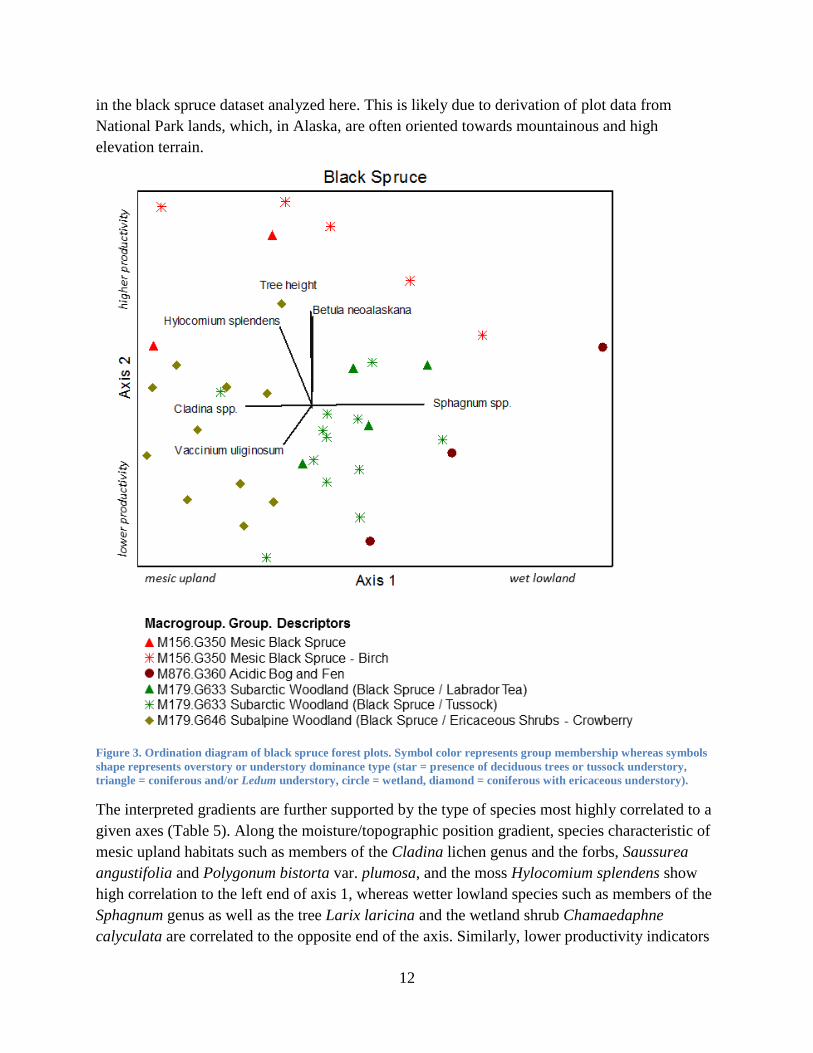
12
in the black spruce dataset analyzed here. This is likely due to derivation of plot data from
National Park lands, which, in Alaska, are often oriented towards mountainous and high
elevation terrain.
Figure 3. Ordination diagram of black spruce forest plots. Symbol color represents group membership whereas symbols
shape represents overstory or understory dominance type (star = presence of deciduous trees or tussock understory,
triangle = coniferous and/or Ledum understory, circle = wetland, diamond = coniferous with ericaceous understory).
The interpreted gradients are further supported by the type of species most highly correlated to a
given axes (Table 5). Along the moisture/topographic position gradient, species characteristic of
mesic upland habitats such as members of the Cladina lichen genus and the forbs, Saussurea
angustifolia and Polygonum bistorta var. plumosa, and the moss Hylocomium splendens show
high correlation to the left end of axis 1, whereas wetter lowland species such as members of the
Sphagnum genus as well as the tree Larix laricina and the wetland shrub Chamaedaphne
calyculata are correlated to the opposite end of the axis. Similarly, lower productivity indicators

13
such as the shrubs Vaccinium uliginosum and Rubus chamaemorus, and the dwarf shrubs
Andromeda polifolia and Loiseleuria procumbens are highly correlated to the lower end of axis
2, whereas higher productivity indicators such as the shrub Betula neoalaskana and Rosa
acicularis correlate to the upper end of the axis.
Table 5. Significant correlation coefficients of species to axes 1 and 2 of the black spruce ordination. For 41 plots, r = +/-
0.26 is the critical value for directional test at α = 0.05.
Moisture/ Topographic Position Gradient Axis 1
Correlation with Axis 1 Mesic Upland Species Correlation with Axis 1 Wet Lowland Species
-0.54 Cladina spp. 0.70 Sphagnum spp. -0.51 Saussurea angustifolia 0.50 Larix laricina -0.41 Polygonum bistorta var. plumosa 0.49 Chamaedaphne calyculata -0.37 Hylocomium splendens 0.35 Ledum palustre ssp. decumbens -0.37 Picea glauca 0.32 Polygonum alpinum -0.35 Vaccinium uliginosum 0.32 Rubus chamaemorus -0.33 Dasiphora fruticosa -0.32 Equisetum scirpoides -0.29 Geocaulon lividum -0.26 Mertensia paniculata
Productivity Gradient Axis 2
Correlation with Axis 2 Lower Productivity Indicators Correlation with Axis 2 Higher Productivity Indicators
-0.41 Vaccinium uliginosum 0.62 Betula neoalaskana -0.36 Rubus chamaemorus 0.58 Hylocomium splendens -0.34 Andromeda polifolia 0.57 Equisetum sylvaticum -0.28 Carex bigelowii 0.42 Rosa acicularis -0.26 Arctostaphylos rubra 0.41 Chamerion angustifolium
0.40 Calamagrostis canadensis 0.40 Spiraea stevenii 0.40 Cornus canadensis 0.37 Mertensia paniculata 0.30 Saussurea angustifolia 0.27 Alnus viridis ssp. fruticosa
Shrubland Macrogroups and Groups
To evaluate broad regional vegetation patterns across the arctic and boreal biomes, shrubland
data was organized into four broad physiognomic categories, which spanned our entire analysis
area: 1. boreal and arctic tall shrub, 2. boreal and arctic low shrub, 3. boreal and arctic dwarf
shrub, and 4. boreal and arctic tussock tundra, which has a significant shrub component.
Analysis of the boreal and arctic shrub plots revealed a need for significant revision of several
groups. In regions with similar environmental and floristic characteristics, analysis revealed
substantial overlap in groups previously described as having exclusively arctic or boreal
distributions. Thus, conceptual expansion of several groups is proposed to reflect these findings.
Within the shrub classes, changes are proposed within the North American Boreal Shrubland &
Grassland (M055) and North American Arctic & Subarctic Tundra (M173) Macrogroups.
Shrubland plot data spanned the following Macrogroups and Groups:

14
M055. North American Boreal Shrubland & Grassland
G356. Western Boreal Scrub Birch Shrubland
G357. Western Boreal Mesic Alder - Willow Shrubland
M172. Northern Vancouverian Lowland-Montane Grassland & Shrubland
G354. Vancouverian Alder - Salmonberry - Willow Shrubland
M173. North American Arctic & Subarctic Tundra
G827. North American Arctic & Subarctic Low Willow Tundra
G828. North American Arctic & Subarctic Dwarf Birch Tundra
G368. North American Arctic & Subarctic Tall Willow Tundra
Tall Shrub
Initial examination of the entire low and tall shrub dataset revealed high overall heterogeneity,
which underscored the need to subdivide the data. Plots were subsequently separated according
to physiognomic stature and dominant species. Alder and tall willow types were analyzed
separately from scrub birch and low willow, and intermediate-height willows (largely Salix
pulchra) were included in both analyses. Heterogeneity was further reduced within the dataset by
removing wetland shrub types (water tracks) and coastal plain moist tundra with low overall
shrub cover.
A three-dimensional NMS solution with final stress of 17.9 was selected for the alder-willow
ordination. The total variance explained on three axes was 52.3%, and the greatest proportion of
variance was captured by axes 1 (18.8%) and 2 (17.7%). Axis 1 is interpreted as a complex
moisture and bioclimatic gradient with dry-mesic arctic plots grouping on the left side of the
ordination, mesic-moist boreal plots in the center, and moist temperate plots on far right. Axis 2
is interpreted as a productivity gradient with floodplain willow plots occupying the upper end of
the gradient and willow tundra plots occupying the lower end (Figure 4). The interpreted
gradients are further supported by species correlations to the ordination axes (

15
Table 6). Along axis 1, species characteristic of mesic to dry arctic or boreal sites such Salix
glauca, S. alaxensis, S. richardsonii, Arctostaphylos spp. and Hedysarum alpinum show strong
correlation to the left side of axis 1, while species characteristic of moist temperate sites such as
Calamagrostis canadensis, Alnus viridis ssp. sinuata, Salix pulchra, Dryopteris expansa, and
Veratrum viride show strong correlation to the right side of the axis. Along axis 2 species
characteristic of low productivity sites, such as Vaccinium vitis-idaea, Betula nana, Empetrum
nigrum, and Ledum palustre ssp. decumbens are strongly correlated with the lower portion of the
axis, while species characteristic of high productivity sites such as Salix alaxensis, Populus
balsamifera, Artemisia tilesii, and Equisetum arvense are strongly correlated with the upper
portion of the axis.
Figure 4. Ordination diagram of arctic and boreal alder and willow. Symbol colors differentiate groups, while symbol
shape represent alder (circles) vs. willow (asterisks).
The range of Alnus viridis ssp. sinuata spans the sub-boreal and temperate biomes while Alnus
viridis ssp. fruticosa occurs in the boreal and sub-arctic biomes (Furlow 1997). The former is
provisionally grouped with temperate shrub in Vancouverian Alder - Salmonberry - Willow
Shrubland (G354). An analysis of sub-boreal and temperate Alnus viridis ssp. sinuata plots is

16
needed to validate this proposal, but is beyond the scope of the current analysis. After removing
Alnus viridis ssp. sinuata plots from the ordination set, the remaining analysis groups (boreal
alder, boreal willow, and boreal alder-willow) showed nearly complete overlap in the ordination
diagram and were thus combined in the description for the Western Boreal Mesic Alder - Willow
Shrubland group (G357).

17
Table 6. Significant correlations of species to axes 1 and 2 of the alder - willow ordination. For 130 plots, r = +/- 0.16 is the
critical value for a directional test at α = 0.05.
Bioclimatic and Moisture Gradient - Axis 1
Correlations with Axis 1 Dry Arctic/Boreal Indicators Correlations with Axis 1 Moist Temperate Indicators
-0.38 Salix glauca 0.66 Calamagrostis canadensis -0.31 Salix alaxensis 0.53 Alnus viridis ssp. sinuata -0.30 Salix richardsonii 0.41 Salix pulchra -0.28 Salix reticulata 0.35 Dryopteris expansa -0.27 Arctostaphylos rubra 0.30 Veratrum viride -0.27 Dryas octopetala 0.27 Spiraea stevenii -0.26 Hedysarum alpinum 0.24 Streptopus amplexifolius -0.26 Arctostaphylos alpina 0.23 Rubus arcticus -0.25 Stellaria longipes 0.22 Polemonium acutiflorum -0.22 Carex krausei 0.22 Athyrium filix-femina -0.22 Festuca rubra 0.22 Gymnocarpium dryopteris -0.22 Chamerion latifolium 0.22 Comarum palustre -0.21 Bromus inermis ssp. pumpellianus 0.21 Alnus viridis ssp. fruticosa -0.20 Astragalus alpinus 0.20 Angelica lucida
Productivity Gradient - Axis 2
Correlations with Axis 2 Lower Productivity Indicators Correlations with Axis 2 Higher Productivity Indicators
-0.46 Vaccinium vitis-idaea 0.68 Salix alaxensis -0.41 Betula nana 0.24 Populus balsamifera -0.40 Empetrum nigrum 0.23 Artemisia tilesii -0.37 Ledum palustre ssp. decumbens 0.20 Equisetum arvense -0.37 Salix glauca 0.20 Chamerion latifolium -0.35 Vaccinium uliginosum 0.20 Alnus viridis ssp. sinuata -0.34 Sphagnum spp. -0.32 Carex bigelowii -0.29 Alnus viridis ssp. fruticosa -0.28 Rubus chamaemorus -0.24 Betula glandulosa -0.23 Cassiope tetragona -0.23 Calamagrostis purpurascens
North American Arctic & Subarctic Tall Shrub Tundra (G368) and Arctic Low Willow Tundra
(G827) segregated by species dominance and landscape position with Salix alaxensis floodplain
plots grouping along the upper, higher-productivity portion of axis 2 and low willow tundra
dominated by Salix glauca, S. richardsonii, and S. pulchra grouping on the lower productivity
portion of the axis (Figure 5).
With the absorption of Alnus viridis ssp. fruticosa types into the Western Boreal Mesic Alder -
Willow Shrubland (G357) from the North American Arctic & Subarctic Tall Shrub Tundra
(G368), this group essentially became a tall willow group with Salix alaxensis dominance in a
floodplain environment as the diagnostic characteristic.

18
Figure 5. Alder and Willow ordination diagrams with symbols graduated by species abundance within each group.

19
Low Shrub
A significant, three-dimensional NMS solution with a final stress of 17.9 was selected for the
low shrub (scrub birch – willow) ordination. The ordination was rigidly rotated to align the
productivity gradient with axis 3. The total variance explained was 50.6%, with the greatest
proportion of variance captured by axes 2 (16.3%) and 3 (20.4%). Axis 2 is interpreted as a
bioclimatic gradient with arctic plots grouping on the left side of the ordination and temperate
plots grouping on right side. Axis 3 is interpreted as a productivity gradient with low
productivity plots grouping on the lower end of the gradient and high productivity plots on the
upper end of the axis (Figure 6). The interpreted gradients are further supported by species
correlations to the ordination axes (Table 7). Species correlations along axis 3 are described as
productivity indicators only in the context of this ordination set and are not necessarily consistent
indicators for groups not included in this ordination.
Figure 6. Ordination diagram of arctic and boreal low shrub. Symbol colors differentiate groups while symbol colors
represent scrub birch (circles), willow (stars), and ericaceous (squares).
The ordination diagram shows complete separation between the scrub birch and low willow
components of North American Arctic & Subarctic Low Shrub Tundra (formerly G369). For this
reason, division of this group into two new groups: North American Arctic & Subarctic Low
Willow Tundra (G827) and North American Arctic & Subarctic Dwarf Birch Tundra (G828) is
proposed. The dwarf birch group is further refined by specifying dominance by Betula nana as a

20
diagnostic characteristic and by extension, all Betula glandulosa types are placed in Western
Boreal Scrub Birch Shrubland (G356). The ericaceous low shrub component of Western Boreal
Scrub Birch Shrubland (G356; hollow squares) is characterized by Vaccinium uliginosum and
Ledum palustre ssp. decumbens and, although these plots do not count Betula glandulosa or
Betula nana as a dominant, they occupy much of the same ordination space as the other plots
within Western Boreal Scrub Birch Shrubland (G356) and are thus included within that group
(Figure 7).
Table 7. Significant correlation coefficients of species to axes 2 and 3 of the low shrub ordination. For 99 plots, r = +/- 0.17
is the critical value for a directional test at α = 0.05.
Bioclimatic Gradient - Axis 2
Correlations with Axis 2 Arctic or Alpine Species Correlations with Axis 2 Moist Temperate Species
-0.67 Betula nana 0.51 Salix barclayi
-0.41 Ledum palustre ssp. decumbens 0.49 Calamagrostis canadensis
-0.31 Anthoxanthum monticola ssp. alpinum 0.35 Equisetum arvense
-0.28 Loiseleuria procumbens 0.31 Salix pulchra
-0.25 Carex bigelowii 0.27 Sanguisorba canadensis
-0.23 Dryas octopetala 0.27 Geranium erianthum
-0.22 Rubus chamaemorus 0.27 Chamerion angustifolium
-0.21 Luzula confusa 0.24 Rhodiola integrifolia ssp. integrifolia
-0.20 Salix phlebophylla 0.23 Dryopteris expansa
0.23 Polemonium acutiflorum
0.22 Comarum palustre
0.22 Gymnocarpium dryopteris
Productivity Gradient - Axis 3
Correlations with Axis 3 Low Productivity Indicators Correlations with Axis 3 High Productivity Indicators
-0.47 Ledum palustre ssp. decumbens 0.62 Salix richardsonii
-0.33 Sphagnum spp. 0.42 Salix glauca
-0.33 Vaccinium vitis-idaea 0.37 Salix alaxensis
-0.32 Picea mariana 0.36 Salix reticulata
-0.28 Spiraea stevenii 0.35 Polygonum viviparum
-0.26 Equisetum sylvaticum 0.33 Dodecatheon frigidum
-0.25 Rubus chamaemorus 0.33 Lupinus arcticus
-0.22 Polygonum alpinum 0.32 Arctostaphylos rubra
-0.20 Salix fuscescens 0.29 Bromus inermis ssp. pumpellianus
-0.20 Andromeda polifolia 0.27 Equisetum varigatum
-0.20 Betula nana 0.26 Hedysarum alpinum
0.25 Salix arbusculoides
0.23 Anemone richardsonii
0.22 Dryas integrifolia
0.22 Equisetum arvense

21
Figure 7. Ordination diagrams of low shrub analysis with symbols graduated by species abundance.

22
Dwarf Shrub
Despite the considerable dwarf shrub component in tussock tundra, initial examination of
ordinations including the entire dwarf shrub and tussock tundra dataset, determined that separate
analysis of the dwarf shrub and tussock plots was required to reduce heterogeneity and allow
independent evaluation of the environmental gradients. The dwarf shrub and tussock tundra
analyses spanned the following macrogroups and groups:
M173. North American Arctic & Subarctic Tundra Macrogroup
G365. North American Arctic & Subarctic Lichen – Sparse Dwarf Shrub2
G366. North American Arctic & Subarctic Dryas Dwarf Shrub Tundra Group
G367. North American Arctic & Subarctic Ericaceous Dwarf Shrub Tundra Group
G614. North American Arctic & Subarctic Willow Dwarf Shrub Tundra Group
M404. Western Boreal Alpine Vegetation Macrogroup
G613. Western Boreal Alpine Dwarf Shrub Group
M173. North American Arctic & Subarctic Tundra Macrogroup
G371. North American Arctic & Subarctic Tussock Tundra
While the analysis of plot data supports the current groupings within the North American Arctic
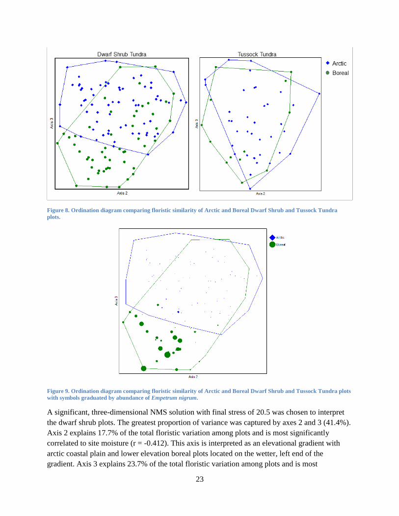
& Subarctic Tundra Macrogroup (M173), conceptual expansion of this Macrogroup to include
high-elevation and high latitude boreal types is proposed, as both dwarf shrub and tussock tundra
show considerable floristic overlap between arctic and boreal ecoregions (Figure 8). Distinctly
boreal dwarf shrub plots, located in the lower left corner of the ordination, represent sites
dominated by Empetrum nigrum (Figure 9). This group is retained as Western Boreal Alpine
Dwarf Shrub Tundra (G613) and is discussed below.
2 Limited plot data
23
Figure 8. Ordination diagram comparing floristic similarity of Arctic and Boreal Dwarf Shrub and Tussock Tundra
plots.
Figure 9. Ordination diagram comparing floristic similarity of Arctic and Boreal Dwarf Shrub and Tussock Tundra plots
with symbols graduated by abundance of Empetrum nigrum.
A significant, three-dimensional NMS solution with final stress of 20.5 was chosen to interpret
the dwarf shrub plots. The greatest proportion of variance was captured by axes 2 and 3 (41.4%).
Axis 2 explains 17.7% of the total floristic variation among plots and is most significantly
correlated to site moisture (r = -0.412). This axis is interpreted as an elevational gradient with
arctic coastal plain and lower elevation boreal plots located on the wetter, left end of the
gradient. Axis 3 explains 23.7% of the total floristic variation among plots and is most

24
significantly correlated to percent cover of lichen (r = -0.559) and low shrub species (r = -0.203).
This axis is interpreted as a bioclimatic gradient from Arctic to Boreal. Four of the five dwarf
shrub groups are common to both arctic and high-elevation boreal environments and are located
in the upper portion of the ordination. The fifth group, Boreal Alpine Dwarf Shrub (G613) is
located in the moist, low-elevation boreal area of the ordination and shows separation from the
groups that span the arctic and boreal ecoregions (Figure 10).
Figure 10. Ordination diagram of dwarf shrub plots symbolized by group and overlain by select environmental variables.
The interpreted gradients are further supported by the type of species most highly correlated to a
given axes (Table 8). Along the elevational gradient, species characteristic of lowland or mesic
habitats such as the ericaceous shrubs Vaccinium uliginosum and Empetrum nigrum show high
correlation to the left end of axis 2, whereas drier upland species such as the dwarf shrub Dryas
octopetala and the forbs Bupleurum americanum, Thalictrum alpinum and members of the
Saxifraga genus are correlated to the opposite end of the axis. Similarly, dwarf shrub species
with a boreal-centric distribution such as Empetrum nigrum and Loiseleuria procumbens are
highly correlated to the lower end of axis 3, whereas species with a more arctic distribution such
as dwarf shrubs Dryas octopetala and Salix reticulata rise to the upper end of the axis.

25
Table 8. Significant correlations of species to axes 2 and 3 of the dwarf shrub ordination; 133 plots, r = +/- 0.197 is the
critical value for directional test at α = 0.05.
Elevational Gradient - Axis 2
Correlation with Axis 2 Wet Lowland Species Correlation with Axis 2 Dry Upland Species
-0.39 Bryophyte Species 0.70 Dryas octopetala
-0.37 Vaccinium uliginosum 0.25 Bupleurum americanum
-0.35 Empetrum nigrum 0.22 Thalictrum alpinum
-0.27 Eriophorum vaginatum 0.22 Saxifraga tricuspidata
-0.27 Salix pulchra 0.22 Minuartia macrocarpa
-0.26 Equisetum arvense 0.20 Arabis lemmonii
-0.25 Petasites frigidus 0.20 Silene acaulis
0.20 Kobresia myosuroides
0.20 Arenaria capillaris
0.19 Arnica frigida
0.19 Saxifraga oppositifolia
Bioclimatic Gradient - Axis 3
Correlation with Axis 3 Boreal Alpine Species Correlation with Axis 3 Arctic Tundra Species
-0.55 Empetrum nigrum 0.47 Dryas octopetala
-0.32 Loiseleuria procumbens 0.45 Salix reticulata
-0.30 Ledum palustre ssp. decumbens 0.39 Bryophyte species
-0.28 Campanula lasiocarpa 0.29 Eriophorum angustifolium
-0.27 Carex spectabilis 0.27 Carex bigelowii
-0.24 Rhodiola integrifolia ssp. integrifolia 0.25 Polygonum bistorta
-0.22 Rhododendron camtschaticum 0.24 Equisetum arvense
0.24 Polygonum viviparum
0.23 Pedicularis langsdorffii
0.20 Equisetum scirpoides
Dryas Dwarf Shrub Tundra
The North American Arctic & Subarctic Dryas Dwarf Shrub Tundra Group (G366) is located in
the most arctic and upland position within the dwarf shrub ordination (Figure 10). Interestingly,
Dryas species dominance is well-partitioned within this group (Figure 11), with Dryas
octopetala occurring on drier sites at high-elevation (average 707 m; n = 48) and lower latitude
(69.96o; n = 33) relative to Dryas integrifolia dominated plots, which occur on more mesic sites
at low-elevation (225.5 m; n = 6) and high latitude (69.22o; n = 10).

26
Figure 11. Dryas Dwarf Shrub Tundra plots with symbols graduated in accordance with Dryas octopetala (left) and Dryas
integrifolia (right) abundance.
Dryas Dwarf Shrub tundra is characterized by high constancy and abundance of Dryas
octopetala; Dryas integrifolia occurs less frequently but in high abundance. Also present at high
constancy (>40%) are the dwarf shrubs Salix reticulata and Salix arctica and the ericaceous
shrub Vaccinium uliginosum. Within the dwarf shrub data set analyzed here, Dryas octopetala is
the sole significant indicator (p = 0.0002) species, likely due to the greater number of Dryas
octopetala-dominated plots represented (Appendix II, Table 22).
When split by dominance, the Dryas octopetala variant is marginally differentiated by
occurrence of the grass Anthoxanthum monticola ssp. alpinum (p = 0.06) whereas the Dryas
integrifolia variant is significantly differentiated by Arctagrostis latifolia (p = 0.0014), Papaver
species (p = 0.002) and marginally differentiated by Polygonum viviparum (0.0052). Dry types
dominated by Dryas octopetala are common on slopes and ridges of the Brooks Range Foothills
and high-elevation regions of boreal Alaska, whereas types dominated by Dryas integrifolia are
common on inactive floodplains and drained lake basins of the Arctic Coastal Plain. Where
Dryas species co-occur, Dryas octopetala occupies drier, more exposed microsites with Dryas
integrifolia restricted to wetter, more protected microsites such as swales or areas of late-lying
snow. Segregation of plots by Dryas species dominance is suggestive of alliance-level
distinctions.
Ericaceous Dwarf Shrub Tundra
The Ericaceous Dwarf Shrub Tundra Group (G367) is located in the higher moisture, lower
elevation and boreal area of the Dwarf Shrub ordination (Figure 10). This group is characterized
by high constancy (>40%) of the ericaceous shrubs Ledum palustre ssp. decumbens, Cassiope
tetragona, Vaccinium vitis-idaea; the dwarf willow Salix phlebophylla; the low shrubs Betula
nana and Salix pulchra; the dwarf shrub Diapensia lapponica; the graminoids Anthoxanthum

27
monticola ssp. alpinum and Luzula confusa; and the moss Hylocomium splendens. The
occurrence of the ericaceous shrubs Vaccinium vitis-idaea (p = 0.0028), Ledum palustre ssp.
decumbens (p = 0.005) and Cassiope tetragona (p = 0.0112) also differentiate the group from
other dwarf shrub types analyzed (Appendix II, 23).
A potential alliance level split within the Ericaceous Dwarf Shrub Tundra Group is suggested by
coincident species abundances in multivariate space (Figure 12). Within the group, plots
supporting high cover of Ledum palustre ssp. decumbens are also characterized by an abundance
of lichen species in the Cladina genus (likely Cladina rangiferina, Cladina mitis, Cladina
stellaris, and Cladina uncialis), whereas plots supporting high cover of Cassiope tetragona are
characterized by an abundance of bryophytes such as Hylocomium splendens. It is likely that
elevation and ecoregion influence this separation within the group, with Ledum-dominated plots
associated with low elevation and/or the boreal ecoregion and Cassiope-dominated plots
associated with moist sites at high elevation and/or the arctic ecoregion.
Figure 12. Ordination diagram depicting spatially-coincident species and life form group abundances within the
Ericaceous Dwarf Shrub Tundra Group.

28
Willow Dwarf Shrub Tundra
The Willow Dwarf Shrub Tundra Group (G614) is located in the higher moisture, higher
elevation and arctic area in the dwarf shrub ordination (Figure 10). This group is characterized
by high constancy (>40%) of the shrubs Salix pulchra, Salix reticulata, Dryas octopetala,
Cassiope tetragona, and Salix rotundifolia, the graminoids Carex bigelowii and Arctagrostis
latifolia, the forb Petasites frigidus, and the lichens Flavocetraria cucullata and Thamnolia
vermicularis. While this group occupies small patches and is uncommon on the landscape, it is
significantly differentiated (p = <0.05) by numerous species, which speaks to its unique floristics
and validity as a discrete group. The occurrence of the dwarf willows, Salix reticulata
(p = 0.0022), Salix polaris (p = 0.0224), and Salix rotundifolia (p = 0.0264), the forbs
Petasites frigidus (p = 0.0074), Tephroseris atropurpurea ssp. frigida (p = 0.0128), and
Polygonum bistorta var. plumosa (p = 0.0244), the sedges Carex bigelowii (p = 0.0266),
Eriophorum angustifolium (p = 0.0296), and Eriophorum vaginatum (p = 0.0366), the horsetail,
Equisetum arvense (p = 0.0346), Luzula species (p = 0.0436) (likely Luzula confusa and Luzula
arctica), and bryophyte species (p = 0.0022) (such as Tomentypnum nitens, Hylocomium
splendens, Aulacomnium species and Catoscopium nigritum) are all significant, differentiating
species (Appendix 1, 24).
Western Boreal Alpine Dwarf Shrub Tundra
Despite significant overlap between arctic and boreal dwarf shrub types within the North
American Arctic & Subarctic Tundra Macrogroup (M173), a distinctly boreal dwarf shrub type,
characterized by Empetrum nigrum is evident (Figure 10). While Empetrum nigrum occurs
throughout Alaska, it rarely dominates communities in the arctic and temperate zones. Thus,
while conceptual ranges of Dryas (G366), Ericaceous (G367) and Willow (G614) Dwarf Shrub
Groups as well as the Tussock Tundra Group (G371) should be expanded to include elevation
dwarf shrub types, the Western Boreal Alpine Dwarf Shrub Group (G613) should be preserved
within the Western Boreal Alpine Vegetation Macrogroup (M404) This revision will restrict the
Western Boreal Alpine Dwarf Shrub Group (G613) to vegetation dominated by Empetrum
nigrum and eliminate the Dryas, Dwarf Shrub, Dwarf Shrub-Lichen and Ericaceous variants
formerly included within the group.
The Boreal Alpine Dwarf Shrub Group is characterized by high constancy (>40%) of the shrubs
Vaccinium uliginosum and Ledum palustre ssp. decumbens and the dwarf shrubs Empetrum
nigrum, Loiseleuria procumbens, and Salix arctica and is significantly differentiated by the
presence of the dwarf shrubs Empetrum nigrum (p = 0.0002), Rhododendron camtschaticum
(p = 0.0122), and Loiseleuria procumbens (p = 0.0164), and the forbs Rhodiola integrifolia ssp.
integrifolia (p = 0.0146) and Campanula lasiocarpa (p = 0.038) (Appendix 1, 21).
Tussock Tundra Analysis
The tussock tundra plots were analyzed separately from other groups in the North American
Arctic & Subarctic Tundra Macrogroup (M173) due to the widespread recognition of tussock
tundra as a distinct type as well as the variation these plots introduced to the ordination when

29
combined with the dwarf shrub plots. For the tussock tundra plots a significant, three-
dimensional NMS solution with final stress of 19.2 was selected for interpretation. The greatest
proportion of variance was captured by axes 2 and 3 (56.4%). Axis 2 explains 16.4% of the total
floristic variation among plots and is most significantly positively correlated to percent cover of
bryophytes (r = 0.344) and negatively correlated to percent cover of low shrubs (r = -0.372). This
axis is interpreted as the effects of local topographic variables such as slope and
microtopography on site moisture, where higher shrub cover is indicative of improved drainage
and higher bryophyte cover is indicative of retarded drainage, likely due to the presence of
shallow and continuous permafrost. Axis 3 explains 40.0% of the total floristic variation and is
most significantly negatively correlated to the total cover of Sphagnum species (r = -0.338) and
tree cover (r = -0.302), which based on the acidifying capacity of the Sphagnum genus, is
interpreted as a pH gradient (Figure 13).
Figure 13. Ordination diagram of tussock tundra plots symbolized by dominant or co-dominant species and overlain by
significant environmental variables.
Tussock tundra in Arctic and Subarctic Alaska is dominated or codominated by the tussock
forming sedges, Carex bigelowii and/or Eriophorum vaginatum. While plots fall along a
continuum with respect to the relative abundances of these sedges, it is informative to explore the
environmental variables and cooccuring species that characterize tussock tundra plots that are
clearly dominated (greater than 30% cover) by either Carex bigelowii or Eriophorum vaginatum

30
(Figure 14, Table 9). Carex bigelowii- dominated tussock tundra is characterized by an average
pH of 6.3 (n = 5 measurements) as well as high constancy of the dwarf shrubs, Salix reticulata,
and Cassiope tetragona with Carex bigelowii (p = 0.0006) and the dwarf shrub, Dryas
octopetala (p = 0.0482) differentiating the type. Comparatively, Eriophorum vaginatum-
dominated tussock tundra is characterized by an average pH of 5.5 (n = 13 measurements) as
well as high constancy of the ericaceous dwarf shrub Vaccinium vitis-idaea and the low shrub
Betula nana, with Eriophorum vaginatum (p = 0.0002), the low shrub Ledum palustre ssp.
decumbens (p = 0.494) and the forb, Rubus chamaemorus (p = 0.5443) differentiating the type.
Based on the characteristic species and higher average pH values, Carex bigelowii tussock tundra
is considered a more productive and potentially younger type relative to mature Eriophorum
vaginatum tussock tundra.
Figure 14. Tussock Tundra plots with symbols graduated by abundance of dominant species: Carex bigelowii (left) and
Eriophorum vaginatum (right).
3 Marginally significant

31
Table 9. Percent frequency and average cover of tussock tundra types, summarized by dominant species. Species with
frequency equal to or less than 10 in either type are not included; significant (p<0.05) indicator species are in bold and
highlighted. Tussock tundra plots (n=6) codominated by Carex bigelowii and Eriophorum vaginatum are not presented.
Carex bigelowii Tussock
Tundra (n=20 plots) Eriophorum vaginatum
Tussock Tundra (n=25 plots)
Life Form Scientific Name Percent
Frequency Average
Cover Percent
Frequency Average
Cover
Tree Picea mariana 5 1 16 4
Shrub Salix pulchra 60 3 44 2
Ledum palustre ssp. decumbens 55 6 92 8
Betula nana 55 3 68 6
Vaccinium uliginosum 55 3 44 2
Betula glandulosa 10 2 12 2
Salix glauca 10 4 4 1
Salix richardsonii 10 14 4 1
Alnus viridis ssp. fruticosa 5 1 12 3
Dwarf Shrub Salix reticulata 50 3 8 4
Cassiope tetragona 40 3 20 2
Dryas octopetala 40 3 4 3
Empetrum nigrum 35 1 40 3
Vaccinium vitis-idaea 35 2 84 5
Arctostaphylos alpina 20 4 8 2
Salix phlebophylla 20 2 8 5
Rhododendron lapponicum 15 1 - -
Andromeda polifolia - - 20 3
Fern & Ally Equisetum arvense 15 12 - -
Graminoid Carex bigelowii 100 10 48 3
Eriophorum vaginatum 35 3 100 24
Eriophorum angustifolium 15 3 4 2
Carex aquatilis 10 1 12 6
Forb Petasites frigidus 15 1 8 1
Rubus chamaemorus* 10 2 40 3
Bryophyte Hylocomium splendens 45 4 48 6
Sphagnum 35 11 64 5
Aulacomnium turgidum 10 2 44 2
Dicranum - - 12 1
Dicranum elongatum - - 12 3
Polytrichum - - 16 3
Rhytidium rugosum - - 12 2
Lichen Flavocetraria cucullata 5 2 40 2
Cladina rangiferina - - 16 5
Dactylina arctica - - 16 2
Thamnolia vermicularis - - 16 1 *Marginally significant indicator (p = 0.054)

32
Herbaceous Macrogroups and Groups
There is a great diversity of herbaceous types in the arctic and boreal biomes; however, due to
the limited scope of this project, only a small portion of this diversity, capturing coastal types
and an inland analogue, is analyzed here. Salt marshes and coastal and inland dunes are discrete,
recognizable types that have been well-described for Alaska and are largely supported by plot
data; as such, plots were not stratified beyond their group designations for analysis. These three
types were combined in a single analysis to explore floristic overlap between topographically
adjacent types (salt marsh and coastal dune), as well as geographically separate yet structurally
similar types (coastal and inland dune). Although mature dunes are characterized by significant
shrub cover, earlier successional stages are largely herbaceous and for this reason are included in
the analysis of herbaceous systems. Analysis of the salt marsh and coastal and inland dune
groups supported the existing structure of the NVC Hierarchy. Salt marsh and coastal and inland
dune plot data spanned the following Macrogroups and Groups (note: one plot from M059.G498.
North Pacific Maritime Coastal Scrub & Herb Beach & Dune was included for reference):
M055. North American Boreal Shrubland & Grassland
G374. North American Arctic & Boreal Shrub & Herb Dune
M059. Pacific Coastal Beach & Dune Vegetation
G498. North Pacific Maritime Coastal Scrub & Herb Beach & Dune
M402. North American Arctic & Boreal Coast Vegetation
G612. Arctic & Boreal Coastal Herb & Dwarf-Shrub Beach & Dune
M403. North American Arctic Tidal Salt Marsh
G535. North American Low Arctic Coastal Salt Marsh
A significant, three-dimensional NMS solution with final stress of 7.9 was selected for the salt
marsh, coastal dune and inland dune ordination. The total variance explained was 30.1%, with
6.6, 16.5 and 7.1% of that variation partitioned along axis 1, 2 and 3, respectively. Although axes
2 and 3 explain the greatest cumulative variance, axis 1 and 2 were chosen for interpretation due
to the greater orthogonality of environmental gradients relative to the groups and comparatively
similar variance explained between axes 1 and 3 (i.e., 6.6 v. 7.1). Axis 1 is interpreted as a
continental gradient with salt marsh and coastal dune plots occupying the right end of the
gradient and inland dunes occupying the left end. Axis 2 is interpreted as a compound moisture
and salinity gradient with coastal plots clustering at the lower end and inland plots clustering
towards the upper end of the gradient (Figure 15).

33
Figure 15. Ordination diagram of salt marsh and coastal and inland dune plots symbolized by group and overlain by
significant environmental variables.
Correlations among axes, environmental variables, and species support the ecological
interpretation of the gradients. Axis 1 is most significantly correlated to low shrub cover
(r = -0.713) and height (r = -0.492), whereas axis 2 is most significantly correlated to site
moisture (r = -0.803). The interpreted gradients are further supported by their species
correlations. Numerous species characteristic of inland dunes, such as the willows Salix glauca
and Salix alaxensis, the forbs Astragalus alpinus, Eurybia sibirica, and Hedysarum alpinum, and
the grasses, Elymus alaskanus ssp. alaskanus and Bromus inermis ssp. pumpellianus are
significantly correlated to the inland end of axis 1. Along the moisture gradient, the flood- and
salt-tolerant grass Puccinellia phryganodes is significantly correlated to the wet end of axis 2,
whereas species tolerant of desiccation such as the succulent forb Honckenya peploides and the
beach grass Leymus mollis are positively correlated to the dry end of axis 2 (Table 10).

34
Table 10. Significant correlations of species to axes 1 and 2 of the salt marsh and coastal and inland dune ordination; 32
plots, r = +/- 0.344 is the critical value for directional test at α = 0.05.
Continental Gradient - Axis 1
Correlation with Axis 1 Inland Species Correlation with Axis 1 Coastal Species
-0.71 Salix glauca 0.33* Puccinellia phryganodes
-0.59 Astragalus alpinus 0.31* Stellaria humifusa
-0.55 Salix alaxensis
-0.51 Poa glauca
-0.49 Cnidium cnidiifolium
-0.47 Eurybia sibirica
-0.47 Hedysarum alpinum
-0.47 Salix reticulata
-0.46 Artemisia tilesii
-0.38 Equisetum arvense
-0.37 Draba spp.
-0.37 Tanacetum bipinnatum ssp. bipinnatum
-0.36 Elymus alaskanus ssp. alaskanus
-0.36 Bromus inermis ssp. pumpellianus
Moisture Gradient - Axis 2
Correlation with Axis 2 Wet Site Species Correlation with Axis 2 Dry Site Species
-0.42 Puccinellia phryganodes 0.54 Honckenya peploides
0.52 Leymus mollis
* Not significant – listed for purposes of comparison
Salt Marsh Analysis
The Arctic Salt Marsh Group (G535) is located in the wet and coastal area of the ordination and
is well separated from the dune groups along the moisture gradient (Axis 2). The group is
characterized by high constancy (>40%) of the grass Dupontia fisheri and the forb Stellaria
humifusa. Both Dupontia fisheri, Stellaria humifusa and the sedge, Carex subspathacea indicate
the group, with the grass Puccinellia phryganodes and the sedge Carex glareosa occurring in
local abundance (Appendix 1, Table 200).
Coastal and Inland Dune Analysis
The Coastal Beach and Dune (G612) and Boreal Shrub and Herb Dune (G374) Groups are
equally positioned on the dry end of the moisture gradient (Figure 15), but despite similar
moisture regime, substrate, and processes, the two groups are well separated by species diversity
and composition. The Coastal Beach and Dune Group is characterized by low species diversity
(n=10) coupled with high constancy (>40%) of the beach grass, Leymus mollis and the forb
Honckenya peploides. Along with the legume Lathyrus japonicus var. maritimus, Honckenya
peploides also indicates the group (Appendix 1, Table 18). Alternatively the Boreal Shrub and
Herb Dune Group is characterized by a diverse assemblage of species (n=52) including high
constancy (>40%) and abundance of the shrub willow Salix glauca, and high constancy of the
horsetail Equisetum arvense, the grasses Festuca rubra, Leymus mollis, Bromus inermis ssp.
pumpellianus, Koeleria asiatica and Poa glauca, and the forbs Astragalus alpinus, Artemisia
tilesii and Stellaria longipes (Appendix 1, Table 17).

35
Within this analysis, the Boreal Dune Group is differentiated by numerous species, but Salix
glauca, Salix alaxensis, Dryas integrifolia and Koeleria asiatica indicate active and stable types
within the group (Komarkova and Webber 1980). Differences in species diversity and
composition between coastal and inland dunes likely relate to greater exposure of the coastal
dunes to severe weather, which delivers wind-born salt spray and holds systems in an early
successional stage.
Discussion Comparison of similar physiognomic groups among the arctic, alpine, and boreal biomes
suggests that for some groups, local environmental conditions such as exposure and disturbance
may override the influence of climate on the distribution of their component plant species. In the
arctic and boreal biomes, these bioclimatic trends are particularly evident for tundra and
shrublands. While the occurrence of species across biomes is not a new concept, the occurrence
of vegetation types across biomes is not as well understood. Notably, the distribution of arctic
and alpine tundra, floodplain shrublands, and inland dunes across arctic and boreal biomes,
which is supported by the analyses presented here, was not previously captured by the NVC
hierarchy.
Compositional similarity between arctic and alpine tundra groups likely relates to the replication
of an arctic climate in high-elevation boreal environments. Specifically, mountainous habitat
above elevational treeline in the boreal biome is characterized by high exposure with low annual
precipitation, cool, short summers, and long, cold winters, which promote the development of
permafrost. By comparison, compositional similarity between arctic and boreal floodplain
shrublands and inland dunes likely relates to the perpetual maintenance of an early successional
state by periodic disturbance; specifically, the seasonal inundation of floodplains and wind
erosion across inland dunes. In these ruderal environments with disturbed mineral soils, pioneer
species— those characterized by high growth and dispersal rates— are most successful,
regardless of the climate. The greater importance of local environmental conditions relative to
climate is expected to extend to saturated habitats such as salt marshes and freshwater marshes.
In such wetlands, it is suspected that the moderating effects of water on the daily and annual
ambient temperature (due to water’s high specific heat) may create a habitat that is relatively
consistent between biomes.
This analysis, the first quantitative analysis of vegetation plot data in Alaska to directly address
the NVC, identified multiple objectives for future research. First, the documented bioclimatic
trends draw attention to the importance of evaluating vegetation data across biome transitions.
Future work within Alaska should review the compositional similarity among groups across the
boreal and temperate as well as arctic and western Alaska biomes. International collaboration
should also assess the commonality of groups between Alaska and Canada. Furthermore, as the
original scope of work funded the description of only 15 arctic and boreal groups, there are many

36
vegetation units in these regions yet to be reviewed. Most important is the analysis of plots
representing groups within the North American Arctic & Northern Boreal Freshwater Marsh,
Wet Meadow & Shrubland Macrogroup (M870). Additional priorities include analysis of plots
representing the proposed group concepts of arctic water tracks and moist, non-tussock,
polygonal tundra; greater representation of plots in the Western North American Boreal Acidic
Bog & Fen Group (G360) to refine analysis of black spruce dominated boreal forest types; and
further differentiation of subarctic and subalpine forest types, specifically the Boreal Subalpine
Woodland (G646) and the Western Subarctic Woodland (G633) groups. The continued
verification of vegetation types will promote the adoption and use of the NVC in Alaska and
foster a more precise understanding of ecological trends in the circumarctic and circumboreal
north.

37
References [BEC] British Columbia Ministry of Forests and Range and British Columbia Ministry of Environment. 2010. Field
manual for describing terrestrial ecosystems. 2nd ed. Forest Science Program, Victoria, B.C. Land
Management Handbook No. 25.
Boggs, K., A. Garibaldi, J.L. Stephens, and T. Helt, 1999. Landsat Derived Map and Landcover Descriptions for
Gates of the Arctic National Park and Preserve. Natural Resource Technical Report NPS/GAAR/NRTR—
1999/001. National Park Service, Fort Collins, CO.
Boggs, K., A. Garibaldi, J.L. Stephens, J. Grunblatt, and T. Helt. 2001. Denali National Park and Preserve
Landcover Mapping Project Volume 2: Landcover Classes and Plant Associations. Natural Resource
Technical Report NPS/DENA/NRTR—2001/002. National Park Service, Fort Collins, CO.
Boggs K., S. Klein, J. Grunblatt, and B. Koltun. 2003. Landcover classes, ecoregions and plant associations of
Katmai National Park and Preserve. Natural Resource Technical Report. NPS/KATM/NRTR—2003/001.
US National Park Service, Natural Resource Stewardship and Science
Boggs, K., and M. Sturdy. 2005. Plant Associations and Post-fire Vegetation Succession in Yukon-Charley Rivers
National Preserve. Natural Resource Technical Report NPS/YUCH/NRTR—2005/001. National Park
Service, Fort Collins, CO.
Boggs, K. and T. Boucher. 2014. Plant Association Classification for Northern Alaska. Alaska Natural Heritage
Program, University of Alaska Anchorage
Boucher, T. and L. Flagstad. 2014. Alagnak Wild River: Landcover classes and plant associations. Natural Resource
Technical Report NPS/ALAG/NRTR-2014/927. National Park Service, Fort Collins, CO.
Boucher, T.V., J. Taylor, J. Karl, S. Guyer, J.E. Herrick, J.W. Van Zee, S.E. McCord, E.M. Courtright, and L.M.
Burkett. 2015. Assessment, Inventory, and Monitoring Strategy for the National Petroleum Reserve-
Alaska: Draft Protocol June 2015. University of Alaska Anchorage, Alaska Center for Conservation
Science, Alaska Natural Heritage Program. Anchorage, AK.
DeVelice, R. L. , C. J. Hubbard, K. Boggs, S. Boudreau, M. Potkin, T. Boucher, and C. Wertheim. 1999. Plant
community types of the Chugach National Forest: South-central Alaska. USFS, Chugach National Forest,
Alaska Region, Anchorage, Alaska. Technical Publication R10-TP-76.
FGDC 2008. National Vegetation Classification Standard, Version 2. Federal Geographic Data Committee –
Vegetation Subcommittee. FGDC-STD-005-2008 (Version 2).
Furlow, J.J. 1997. Betulaceae In: Flora of North America Editorial Committee, eds. 1993+. Flora of North
America North of Mexico. 19+ vols. New York and Oxford. Vol. 3.
Jorgensen, T. and D. Meidinger. 2015. The Alaska Yukon Region of the Circumboreal Vegetation map (CBVM).
CAFF Strategies Series Report. Conservation of Arctic Flora and Fauna, Akureyri, Iceland. ISBN:
9789935-431-48-6
Komárková, V., and P.J. Webber. 1980. Two low arctic vegetation maps near Atkasook, Alaska. Arctic and Alpine
Research, 447-472.
Küchler, A.W. 1969. Potential natural vegetation. 1:7,500,000 colored map, sheet number 90. U.S. Department of
Interior, Washington, D.C.
MacKenzie, W. and R. Klassen. 2013.Vpro07. Vegetation and Environment Nexus Professional: data entry,
reporting and analysis tool. B.C. Ministry of Environment and B.C. Ministry of Forest, Victoria, B. C.
http://vuser.ca/vpro07/index.htm.
McCune, B. and M.J. Mefford, 2010. PC-ORD Version 6 Multivariate Analysis of Ecological Data. MjM Software,
Gleneden Beach, OR.
Peet, R.K., M.T. Lee, M.D. Jennings, and D. Faber-Langendoen. 2012. VegBank - a permanent, open-access archive
for vegetation-plot data. Biodiversity and Ecology 4: 233-241.

38
Raynolds, M.K., D.A. Walker and H.A. Maier. 2006. Alaska Arctic Tundra Vegetation Map. 1:4,000,000. U.S. Fish
and Wildlife Service. Anchorage, AK
Reimer, J.P., A.P. Baltensperger, L.A. Flagstad, T. Nawrocki, and K. Tremble. In prep. Colville River Small
Mammal Surveys [Draft Report]. Alaska Center for Conservation Sciences, University of Alaska
Anchorage.
USDA, NRCS. 2015. The PLANTS Database (http://plants.usda.gov, January 2015). National Plant Data Team,
Greensboro, NC 27401-4901 USA.
Westhoff, V., and E. van der Maarel. 1973. The Braun-Blanquet approach. Pages 617-726, in: Handbook of
vegetation science, part 5, Classification and ordination of communities, R.H. Whittaker, editor. Junk, The
Hague.

39
Appendix I. Relationships of proposed NVC groups to established CBVM Level II Vegetation and
CAVM Classes. Circumarctic and circumboreal vegetation concepts interpreted from Raynolds et al. (2006) and Jorgenson and Meidinger (2015),
respectively. Relationships are depicted by the following symbols: = indicates that the two concepts are equivalent, ~ indicates that the
proposed group is approximately equivalent to the established concepts, < indicates the proposed group is included within the
established concepts, > indicates the established concepts are included within the proposed concept, and <> indicates a contradiction
in floristic and distribution relationships.
NVC Macrogroup Name NVC Group Name Relationship CBVM Level II Vegetation Class Relationship CAVM Map Unit
M156. Alaskan-Yukon North American Boreal Forest
G579. Alaskan-Yukon Boreal Mesic White Spruce - Hardwood Forest
= Yukon Mixed Spruce-Birch-Aspen Forests
NA no equivalent type
G627. Alaskan-Yukon Boreal Moist White Spruce - Hardwood Forest
= Southern Alaska Spruce-Birch-Herb Forests
NA no equivalent type
G350. Alaskan-Yukon Boreal Mesic-Moist Black Spruce Forest
<> Yukon Subalpine Spruce Woodlands and Scrub
NA no equivalent type
<> Northern Alaska-Yukon Spruce Woodlands and Scrub
NA no equivalent type
G349. Alaskan-Yukon Boreal Dry Aspen Forest
= Yukon Dry Spruce-Aspen Forests NA no equivalent type
M179. North American Boreal Subalpine & Subarctic Woodland
G633. Western Subarctic Woodland ~ Northern Alaska-Yukon Spruce Woodlands and Scrub
NA no equivalent type
G646. Boreal Subalpine Woodland
> Yukon Subalpine Spruce Woodlands and Scrub
NA no equivalent type
> Southern Alaska Subalpine Spruce Woodlands and Scrub
NA no equivalent type
M300. North American Boreal Rich Flooded & Swamp Forest
G548. Western Boreal Floodplain Forest
> Yukon Floodplain Spruce-Poplar Forests and Scrub
NA no equivalent type
> Southern Alaska Floodplain Spruce-Cottonwood Forests and Scrub
NA no equivalent type

40
NVC Macrogroup Name NVC Group Name Relationship CBVM Level II Vegetation Class Relationship CAVM Map Unit
M055. North American Boreal Shrubland & Grassland
G356. Western Boreal Scrub Birch Shrubland
< Northern Alaska-Yukon Spruce Woodlands and Scrub
no equivalent type < Yukon Subalpine Spruce Woodlands and Scrub
< Southern Alaska Alder-Willow-Dwarf Birch Scrub
NA
G357. Western Boreal Mesic Alder - Willow Shrubland
< Southern Alaska Alder-Willow-Dwarf Birch Scrub
<> S2. Low-shrub communities
G374. North American Arctic & Boreal Shrub & Herb Dune
NA no equivalent type NA no equivalent type
M402. North American Arctic & Boreal Coastal Beach, Dune & Rocky
Shore
G612. Arctic & Boreal Coastal Beach & Dune
NA no equivalent type NA no equivalent type
M870. North American Arctic & Northern Boreal Freshwater Marsh,
Wet Meadow & Shrubland
G830. North American Arctic & Subarctic Wet Shrubland
NA no equivalent type ~ W3.4 Wet sedge communities in complex with shrub thickets
M403. North American Arctic Tidal Salt Marsh
G535. North American Arctic Coastal Salt Marsh
NA no equivalent type NA no equivalent type
M404. Western Boreal Alpine Vegetation
G613. Western Boreal Alpine Dwarf Shrub Tundra
<> Central-Northern Alaska-Yukon Alpine Dwarf Scrub and Meadows
< B3. Prostrate dwarf-shrub, gramionid/lichen communities on acidic substrates <>
Southern Alaska-Yukon Alpine Dwarf Scrub and Meadows
> Aleutian Heaths and Meadows
M173. North American Arctic & Subarctic Tundra Macrogroup
G366. North American Arctic & Subarctic Dryas Dwarf Shrub Tundra
< Central-Northern Alaska-Yukon Alpine Dwarf Scrub and Meadows
< B4. Prostrate dwarf-shrub, gramionid/lichen communities on non-acidic substrates
G367. North American Arctic & Subarctic Ericaceous Dwarf Shrub Tundra
< Central-Northern Alaska-Yukon Alpine Dwarf Scrub and Meadows
< B3. Prostrate dwarf-shrub, gramionid/lichen communities on acidic substrates
G614. North American Arctic & Subarctic Dwarf Willow Shrub Tundra
< Central-Northern Alaska-Yukon Alpine Dwarf Scrub and Meadows
< B4. Prostrate dwarf-shrub, gramionid/lichen communities on non-acidic substrates
< Southern Alaska-Yukon Alpine Dwarf Scrub and Meadows
G827. North American Arctic & Subarctic Low Willow Tundra
< Northern Alaska-Yukon Spruce Woodlands and Scrub
< S1. Erect dwarf-shrub communities

41
NVC Macrogroup Name NVC Group Name Relationship CBVM Level II Vegetation Class Relationship CAVM Map Unit
Yukon Subalpine Spruce Woodlands and Scrub
S2.1 Low-shrub communities of willow or birch
G828. North American Arctic & Subarctic Dwarf Birch Tundra
<
Northern Alaska-Yukon Spruce Woodlands and Scrub
<
S1. Erect dwarf-shrub communities
Yukon Subalpine Spruce Woodlands and Scrub
S2.1 Low-shrub communities of willow or birch
G(new). North American Arctic & Subarctic Moist Tundra
NA no equivalent type ~ G3. Non-tussock, sedge, dwarf-shrub, moss communities
G368. North American Arctic & Subarctic Tall Willow Tundra
NA no equivalent type <> S2.1 Low-shrub communities of willow or birch
G371. North American Arctic & Subarctic Tussock Tundra
NA no equivalent type = G4. Tussock sedge, dwarf-shrub, moss communities
42
Appendix II. Revised Hierarchy Descriptions
1.B.4.Na. North American Boreal Forest & Woodland
M156. Alaskan-Yukon North American Boreal Forest
G579. Alaskan-Yukon Boreal Mesic White Spruce - Hardwood Forest
Type Concept: This group is common throughout interior Alaska and extends eastward into
Yukon. It occurs on well-drained soils derived from glacial deposits, hillside colluvium, residual
soils, or loess. Forests contain all post-fire seral stages including needle-leaved evergreen, broad-
leaved deciduous or mixed. Dominant canopy species include Picea glauca, Betula neoalaskana,
and Populus tremuloides. Common shrubs include Alnus viridis ssp. fruticosa, Betula nana,
Betula glandulosa, Rosa acicularis, Ledum palustre ssp. decumbens, Ledum groenlandicum,
Salix glauca, Vaccinium vitis-idaea, Vaccinium uliginosum, Empetrum nigrum, and Linnaea
borealis. The herbaceous layer is sparse and often species poor and may include Calamagrostis
canadensis, Equisetum arvense, Equisetum sylvaticum, Gymnocarpium dryopteris or Geocaulon
lividum. The most common moss is Hylocomium splendens (Table 111).
Classification Comments: The CBVM Vegetation Level II class “Yukon Mixed Spruce-Birch-
Aspen Forests” is an equivalent concept (Jorgenson and Meidinger 2015).
Similar NVC Types: G627. Alaskan-Yukon Boreal Moist White Spruce - Hardwood Forest has
a similar overstory composition, but occurs on moist substrates and has an herb-rich understory.
Diagnostic Characteristics: Canopies are dominated by Picea glauca, Betula neoalaskana, and
Populus tremuloides or a mixture of one or more of these species. Indicator species in mid to late
seral stages are the ericaceous low and dwarf shrubs Ledum palustre ssp. decumbens, Ledum
groenlandicum, Vaccinium vitis-idaea, Vaccinium uliginosum, and Empetrum nigrum.
G627. Alaskan-Yukon Boreal Moist White Spruce - Hardwood Forest
Type Concept: This group is common throughout the sub-boreal region of Alaska and extends
eastward to southwest Yukon and northwest British Columbia. It occurs on moist well-drained
soils derived from glacial deposits, hillside colluvium, residual soils, or loess. Dominant canopy
species include Picea glauca or Picea xlutzii and Betula papyrifera var. kenaica or Betula
neoalaskana. Tsuga mertensiana may codominate with Picea xlutzii where their ranges overlap.
Common shrubs include Rosa acicularis, Viburnum edule, Menziesia ferruginea, Alnus viridis
ssp. sinuata, Salix pulchra, Vaccinium ovalifolium, and Oplopanax horridus. Common
herbaceous species include Calamagrostis canadensis, Equisetum arvense, Dryopteris expansa,
and Gymnocarpium dryopteris (Table 111).
43
Classification Comments: The Circumboreal Vegetation Map, Vegetation Level II class
“Southern Alaska Spruce-Birch-Herb Forests” is an equivalent concept (Jorgenson and
Meidinger 2015).
Similar NVC Types: G579. Alaskan-Yukon Boreal Mesic White Spruce - Hardwood Forest has
a similar overstory composition (Picea glauca - Betula neoalaskana) but it is less common than
this group in the sub-boreal region. G579. Alaskan-Yukon Boreal Mesic White Spruce -
Hardwood Forest differs from this group in that it has ericaceous shrub indicators, lower forb and
fern diversity, and less Calamagrostis canadensis. Species composition in G548. Western Boreal
Floodplain Forest can be similar to this group in late seral stands.
Diagnostic Characteristics: Canopies are dominated by Picea glauca or Picea xlutzii and
Betula papyrifera var. kenaica or Betula neoalaskana. Tsuga mertensiana may codominate with
Picea xlutzii where their ranges overlap. Forb and fern diversity is relatively high (contrasted
with G579). Diagnostic species include Alnus viridis ssp. sinuata, Calamagrostis canadensis,
Equisetum arvense, Dryopteris expansa, and Gymnocarpium dryopteris (Table 111). Regional
indicators include Oplopanax horridus, Menziesia ferruginea, and Vaccinium ovalifolium.
Plot data in this analysis captured the southwest portion of the distribution, but did not
encompass the central portion of the range in the Cook Inlet Basin and Kenai Peninsula. Several
of the species indicators listed above reflect plant associations described from the Chugach
National Forest (DeVelice et al. 1999), but those plots were not included in this analysis.

44
Table 11. Percent frequency and average cover of species within the Moist and Mesic White Spruce-Hardwood Forest
Groups (G627 and G579) derived from 18 plots and 25 plots, respectively; significant (p<0.05) indicator species are in
bold and highlighted.
Life Form
Moist White Spruce-
Hardwood Forest (G627) Mesic White Spruce-
Hardwood Forest (G579) ISA Value*
p-value
Species Percent
Frequency Average
Cover Percent
Frequency Average
Cover
Tree Picea glauca 89 14 92 19
Betula papyrifera var. kenaica 50 23 32 11
Betula neoalaskana 17 4 44 19 37 0.04
Populus balsamifera 11 1 - -
Populus tremuloides 6 4 8 0
Picea mariana - - 12 1
Shrub Vaccinium vitis-idaea 50 3 68 14 56 0.03
Salix pulchra 39 11 16 1 38 0.02
Betula nana 33 2 16 2
Spiraea stevenii 28 1 32 1
Vaccinium uliginosum 28 2 52 9 43 0.05
Betula glandulosa 17 1 20 3
Salix richardsonii 17 4 8 0
Empetrum nigrum 17 0 36 4 33 0.05
Ledum groenlandicum 11 1 24 1
Rosa acicularis 11 0 24 2
Salix barclayi 11 4 4 1
Viburnum edule 11 1 8 0
Linnaea borealis 11 1 12 1
Alnus incana ssp. tenuifolia 6 2 16 4
Alnus viridis ssp. fruticosa 6 1 32 6
Alnus viridis ssp. sinuata 6 3 8 1
Ledum palustre ssp. decumbens 6 0 36 3 33 0.03
Salix alaxensis 6 0 - -
Salix arbusculoides 6 1 - -
Salix bebbiana 6 0 8 0
Salix glauca 6 3 12 0
Grass Calamagrostis canadensis 94 38 36 2 90 0.0002
Fern & Ally
Equisetum arvense 44 13 24 2 39 0.04
Equisetum sylvaticum 28 5 16 3
Gymnocarpium dryopteris 22 2 12 1
Athyrium filix-femina 6 0 - -
Dryopteris expansa 6 1 4 0
Equisetum pratense 6 1 4 0
Forb Rubus arcticus 28 0 4 0
Cornus canadensis 22 2 12 1
Trientalis europaea 22 0 4 0
Geranium erianthum 17 0 - -
Mertensia paniculata 17 1 16 1
Polemonium acutiflorum 17 0 - -
Moehringia lateriflora 11 0 4 0
Petasites frigidus 11 0 - -
Pyrola asarifolia 11 0 - -
Rubus chamaemorus 11 0 8 0
Sanguisorba canadensis 11 1 - -
Heracleum maximum 6 0 - -
Moss Sphagnum spp. 33 10 12 2 33 0.03
Hylocomium splendens 22 6 44 18
Pleurozium schreberi 6 1 12 2
*ISA values greater than 30 and p = 0.05 or less

45
G350. Alaskan-Yukon Boreal Mesic-Moist Black Spruce Forest
Type Concept: This group is widespread on upland slopes, inactive alluvial deposits, and north-
facing slopes in the boreal region of Alaska. Sites are cold, acidic, and may be well-drained to
somewhat poorly-drained. Picea mariana is the dominant species in mature stands, although
Picea glauca may be codominant. In post-fire seral stages Betula neoalaskana or Populus
tremuloides may codominate. Common understory species include Alnus viridis ssp. fruticosa,
Ledum groenlandicum, Ledum palustre ssp. decumbens Vaccinium vitis-idaea, Empetrum
nigrum, Rosa acicularis, Spiraea stevenii, Calamagrostis canadensis, Equisetum sylvaticum, and
Cornus canadensis. Common mosses include Hylocomium splendens and Pleurozium schreberi
(Table 122).
Classification Comments: Distinguished within M156 by the presence of black spruce. This
group approximates two of the vegetation classes described by Jorgenson and Meidinger (2015).
G350 differs from ‘Alaska-Yukon Wet Black Spruce Woodlands and Scrub Coniferous’ concept
due to its lack of wetland indicator species and differs from the ‘Northern Alaska-Yukon Spruce
Woodlands and Scrub’ concept in its dominance of Picea mariana instead of Picea glauca.
Similar NVC Types: None in Alaska
Diagnostic Characteristics: Picea mariana is the most constant overstory species. Stands may
be codominated by Betula neoalaskana, Picea glauca, and Populus tremuloides. Total tree cover
in mature stands typically ranges from 40 to 80%. Compared to the other forest types within
M156 this is the least productive forest, however, of the black spruce forest types, it is the most
productive and is the only black spruce type with a post-fire hardwood seral stage. This group
can be differentiated from other black spruce forests by lack of wetland characteristics or peat
formation, the presence of hardwood codominants, and understory indicators such as Rosa
acicularis, Spiraea stevenii, Calamagrostis canadensis, and Equisetum sylvaticum.

46
Table 12. Percent frequency and average cover of species within the Alaskan-Yukon Boreal Mesic-Moist Black Spruce
Forest (G350) derived from 7 plots. Species with frequency equal to or less than 10 are not included; important indicator
species are in bold and highlighted.
Mesic-Moist Black Spruce Forest (G350)
Lifeform Species Percent Frequency Average Cover
Tree Picea mariana 100 31
Betula neoalaskana 71 29
Picea glauca 14 1
Shrub Alnus viridis ssp. fruticosa 71 11
Spiraea stevenii 71 1
Vaccinium vitis-idaea 57 4
Ledum palustre ssp. decumbens 43 11
Rosa acicularis 29 1
Vaccinium uliginosum 29 0.1
Ledum groenlandicum 14 4
Salix bebbiana 14 1
Empetrum nigrum 14 1
Graminoid Calamagrostis canadensis 71 2
Carex bigelowii 14 1
Fern Equisetum sylvaticum 71 25
& Ally Lycopodium annotinum 29 0.1
Equisetum arvense 14 1
Forb Cornus canadensis 43 4
Chamerion angustifolium 29 1
Geocaulon lividum 29 1
Mertensia paniculata 29 0.1
Polygonum alpinum 29 0.1
Saussurea angustifolia 29 0.1
Moss Hylocomium splendens 71 37
Polytrichum 29 4
Sphagnum 29 9
Pleurozium schreberi 14 3
Lichen Cladina 14 7
Cladonia 29 2
M179. North American Boreal Subalpine & Subarctic Woodland
G633. Western Subarctic Woodland
Type Concept: This group occurs primarily in the northern and western portion of the boreal
region of Alaska, but is also found at higher elevations throughout the continental boreal zone. It
typically occurs on gentle sideslopes, rolling hills, and inactive alluvial surfaces on soils
underlain by continuous permafrost. Canopies are sparse to open and dominated by Picea glauca
or Picea mariana. The shrub layer is composed of low and dwarf shrubs including Ledum
palustre ssp. decumbens, Betula nana, Betula glandulosa, Vaccinium uliginosum, and Vaccinium
vitis-idaea. Tussock forming sedges including Carex bigelowii and Eriophorum vaginatum may
be abundant on some sites. Common mosses include Hylocomium splendens and Sphagnum
species, with lichens, primarily those in the Cladina genus becoming an important component of
the understory in mature stands.

47
Classification Comments: The CBMV Level II class “Northern Alaska-Yukon Spruce
Woodlands and Scrub” is described as subarctic, but more information is needed to determine
whether or not this class is equivalent to G633.
Similar NVC Types: G646. Subalpine Woodlands is similar, but occurs in both the boreal and
sub-boreal. Comparatively, G633. Western Subarctic Woodland is distinguished by presence of
continuous permafrost, and does not occur in the sub-boreal.
Diagnostic Characteristics: This group is defined as a woodland featuring short-statured trees
and a sparse to open canopy dominated by Picea glauca or Picea mariana. The understory is
typically dominated by Betula nana, low and dwarf ericaceous shrubs, or tussock-forming
sedges.
G646. Boreal Subalpine Woodland
Type Concept: This group occurs on high-elevation or high-latitude sites in the boreal and sub-
boreal regions of Alaska. Soils are thin and develop on residual soils or sideslope colluvium.
Permafrost is generally absent in the sub-continental boreal but is discontinuous to continuous
farther north. The forest canopy is woodland to open and dominated by Picea glauca or
codominated by Picea mariana. The shrub layer is dominated by low and dwarf shrubs including
Betula nana, Betula glandulosa, Ledum palustre ssp. decumbens, Empetrum nigrum, Vaccinium
uliginosum, Vaccinium vitis-idaea and Arctostaphylos rubra. Ericaceous dwarf shrubs are
diagnostic. Locally abundant shrubs may include Alnus viridis ssp. fruticosa (in the continental
boreal), Alnus viridis ssp. sinuata (sub-continental boreal), Salix pulchra or Salix glauca.
Herbaceous species are sparse, but lichens, primarily Cladina spp., are an important component
of the understory.
Classification Comments: Two subalpine forest classes are described in the CBVM: “Yukon
Subalpine Spruce Woodlands and Scrub” and “Southern Alaska Subalpine Spruce Woodlands
and Scrub.” The CBVM class “Northern Alaska-Yukon Spruce Woodlands and Scrub” is
described as subarctic, but it has similarity with the boreal subalpine. It appears that both the
CBVM classes may be included within G646, however more information is needed to confirm
the relationships.
Similar NVC Types: This group may have a composition similar to G633. Subarctic Woodlands
however, G633 always has permafrost and often supports tussock-forming graminoids, either
Eriophorum vaginatum or Carex bigelowii.
Diagnostic Characteristics: This group is defined as a woodland group featuring a short-
statured canopy dominated by Picea glauca or codominated by Picea mariana. Dwarf ericaceous
shrubs including Empetrum nigrum, Vaccinium uliginosum, and Vaccinium vitis-idaea are
common and diagnostic (Table 13). Other important species are Betula nana, Betula glandulosa,
Ledum palustre ssp. decumbens, and Ledum groenlandicum. Lichens are often an important
component of the understory.

48
Table 13. Percent frequency and average cover of species within the Western Subarctic Woodland (G633) and Boreal
Subalpine Woodland (G646) Groups derived from 15 and 19 plots, respectively; significant (p<0.05) indicator species are
in bold and highlighted.
Subarctic Woodland (G633) Subalpine Woodland (G646)
Life form Species Percent
Frequency Average
Cover Percent
Frequency Average
Cover
Tree Picea mariana 100 29 32 8
Picea glauca - - 68 14
Betula papyrifera var. kenaica - - 32 3
Shrub Ledum palustre ssp. decumbens 73 16 71 15
Vaccinium uliginosum 73 7 84 11
Betula glandulosa 60 6 32 7
Betula nana 33 3 61 13
Chamaedaphne calyculata 20 0.1 3 0.1
Ledum groenlandicum 20 8 18 3
Alnus viridis ssp. fruticosa 13 0.1 24 2
Salix pulchra 13 3 24 1
Dasiphora fruticosa 13 0.1 8 0.1
Spiraea stevenii 7 0.1 16 0.1
Salix glauca - - 37 2
Dwarf Shrub
Vaccinium vitis-idaea 80 5 84 7
Empetrum nigrum 33 3 66 13
Arctostaphylos rubra 7 1 21 0.1
Graminoid Eriophorum vaginatum 53 24 3 0.1
Carex bigelowii 47 14 11 1
Calamagrostis canadensis 13 0.1 8 0.1
Forb Rubus chamaemorus 87 5 8 0.1
Petasites frigidus var. sagittatus 27 1 3 0.1
Moss Hylocomium splendens 67 10 29 8
Sphagnum (combined) 67 14 18 2
Pleurozium schreberi 13 1 16 1
Lichen Cladina (combined) 33 3 53 9

49
1.B.5.Na. North American Boreal Flooded & Swamp Forest
M300. North American Boreal Rich Flooded & Swamp Forest
G548. Western Boreal Floodplain Forest
Type Concept: This group includes glacially-fed and non-glacially-fed, low and high-volume
rivers and streams throughout the boreal and sub-boreal regions of Alaska. It occurs on active
and inactive portions of the floodplain. The substrate is typically well-drained sand or cobble,
although silts are found on higher terraces, distal floodplains, and in lower-energy systems.
Frequent river channel migration, flooding, scour and other fluvial processes constitute the major
disturbances in this type. Vegetation is variable, and may be dominated by short- or tall-statured
Populus balsamifera ssp. balsamifera, Populus balsamifera ssp. trichocarpa, Picea glauca, Salix
species, or Alnus viridis with mesic herbaceous species. Stands of full-statured Populus
balsamifera often have an understory of tall willow, Calamagrostis canadensis, ferns and
scattered forbs (see Table 14 for a list of the common species).
Classification Comments: Species composition is somewhat different between the sub-boreal
and boreal, particularly at the subspecies level; however, here the variants are treated collectively
as G548. This concept includes both the sub-boreal ‘Southern Alaska Floodplain Spruce-
Cottonwood Forests and Scrub’ and the boreal ‘Yukon Floodplain Spruce-Poplar Forests and
Scrub’ presented in the CBMV (Jorgenson and Meidinger 2015).
Similar NVC Types: This group is separated from the G254. North Pacific Lowland Riparian
Forest & Woodland, G507. North Pacific Montane Riparian Woodland by transition in
dominance from Populus balsamifera ssp. balsamifera in the boreal to Populus balsamifera ssp.
trichocarpa in more temperate regions. G548 is distinguished from G368. Arctic Tall Willow
(Salix alaxensis floodplains) by the presence of trees.
Diagnostic Characteristics: This group is characterized by deciduous or coniferous forest with
Populus balsamifera ssp. balsamifera (continental boreal), Populus balsamifera ssp. trichocarpa
(sub-boreal), and Picea glauca. The shrub canopy is typically dominated by Alnus spp. or Salix
spp. especially Alnus viridis, Alnus incana ssp. tenuifolia, and Salix alaxensis. Calamagrostis
canadensis and Equisetum arvense are often abundant in the understory.
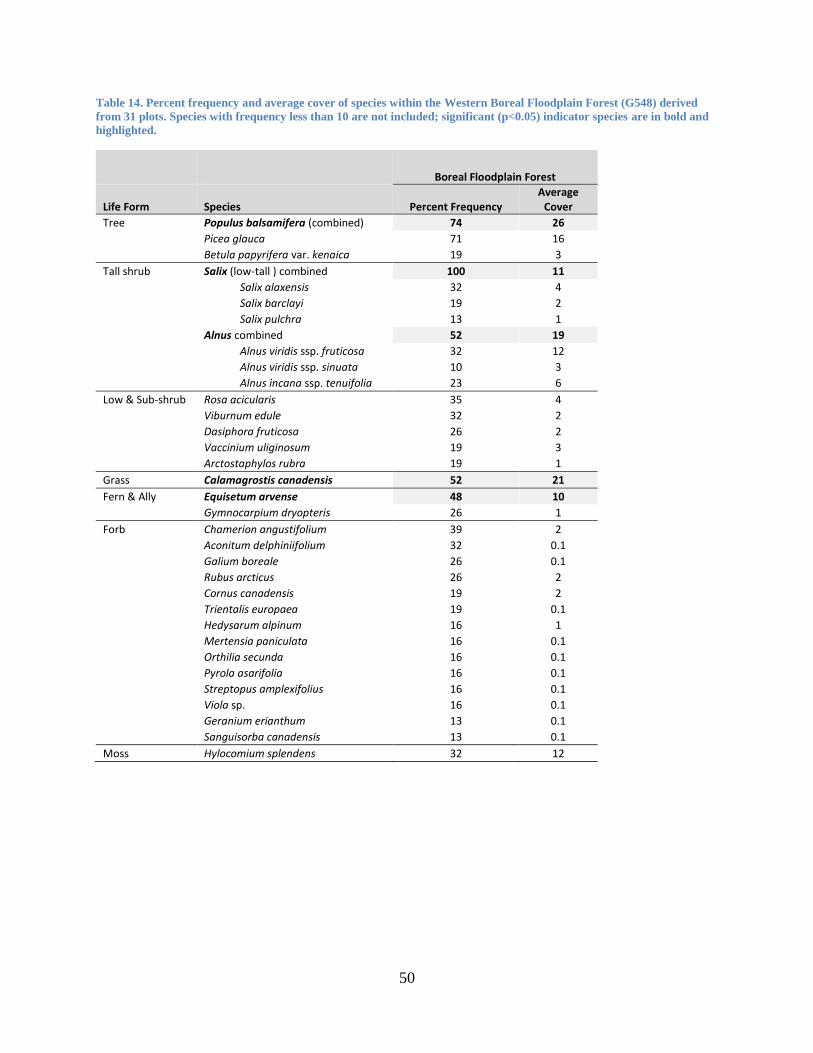
50
Table 14. Percent frequency and average cover of species within the Western Boreal Floodplain Forest (G548) derived
from 31 plots. Species with frequency less than 10 are not included; significant (p<0.05) indicator species are in bold and
highlighted.
Boreal Floodplain Forest
Life Form Species Percent Frequency Average
Cover
Tree Populus balsamifera (combined) 74 26
Picea glauca 71 16
Betula papyrifera var. kenaica 19 3
Tall shrub Salix (low-tall ) combined 100 11
Salix alaxensis 32 4
Salix barclayi 19 2
Salix pulchra 13 1
Alnus combined 52 19
Alnus viridis ssp. fruticosa 32 12
Alnus viridis ssp. sinuata 10 3
Alnus incana ssp. tenuifolia 23 6
Low & Sub-shrub Rosa acicularis 35 4
Viburnum edule 32 2
Dasiphora fruticosa 26 2
Vaccinium uliginosum 19 3
Arctostaphylos rubra 19 1
Grass Calamagrostis canadensis 52 21
Fern & Ally Equisetum arvense 48 10
Gymnocarpium dryopteris 26 1
Forb Chamerion angustifolium 39 2
Aconitum delphiniifolium 32 0.1
Galium boreale 26 0.1
Rubus arcticus 26 2
Cornus canadensis 19 2
Trientalis europaea 19 0.1
Hedysarum alpinum 16 1
Mertensia paniculata 16 0.1
Orthilia secunda 16 0.1
Pyrola asarifolia 16 0.1
Streptopus amplexifolius 16 0.1
Viola sp. 16 0.1
Geranium erianthum 13 0.1
Sanguisorba canadensis 13 0.1
Moss Hylocomium splendens 32 12

51
2.B.3.Na. North American Boreal Grassland & Shrubland
M055. North American Boreal Shrubland & Grassland
G356. Western Boreal Scrub Birch Shrubland
Type Concept: This shrubland group occurs on mesic, mid to upper slope sites throughout the
boreal and sub-boreal regions of Alaska and is often matrix forming above coniferous treeline.
Betula glandulosa dominates in the boreal with dominance transitioning to Betula nana in the
sub-boreal region of southwest Alaska. Vaccinium uliginosum and Ledum palustre ssp.
decumbens both have high constancy and canopy cover and may occasionally be canopy
dominants. Other common shrubs include Salix pulchra and Salix glauca. Dwarf shrubs
including Vaccinium vitis-idaea and Empetrum nigrum may be common below the low shrub
layer. Herbaceous species are sparse and may include Calamagrostis canadensis, Carex
bigelowii, Rubus chamaemorus, and Chamerion angustifolium ssp. angustifolium. Feathermosses
such as Hylocomium splendens and Pleurozium schreberi, lichens in the Cladina genus, and
Sphagnum species are common in the ground layer (Table 15). Wetland sites with organic soils
are not included in this group.
Classification Comments: Betula glandulosa is dominant in the continental boreal, while Betula
nana becomes more common in the sub-boreal region of southwest Alaska, which is beyond the
central range of Betula glandulosa. G356 may be considered a narrower, non-forested type
within the ‘Northern Alaska-Yukon Spruce Woodlands and Scrub’, ‘Yukon Subalpine Spruce
Woodlands and Scrub’, and ‘Southern Alaska Alder-Willow-Dwarf Birch Scrub’ CBVM
concepts described by Jorgenson and Meidinger (2015).
Similar NVC Types: This group is similar to G828. North American Arctic & Subarctic Dwarf
Birch Shrubland, but is differentiated by an Arctic distribution and the lack of Betula glandulosa.
Diagnostic Characteristics: This group is defined as a boreal to sub-boreal shrubland
dominated by Betula glandulosa in the boreal with dominance transitioning to Betula nana in the
sub-boreal region of southwest Alaska. Diagnostic species include Betula glandulosa, Vaccinium
uliginosum, Ledum palustre ssp. decumbens, and Vaccinium vitis-idaea.

52
Table 15. Percent frequency and average cover of species within the Western Boreal Scrub Birch Shrubland Group
(G356) derived from 36 plots. Species with frequency equal to or less than 10 are not included; significant (p<0.05)
indicator species are in bold and highlighted.
Boreal Scrub Birch Shrubland
(G356)
Life Form Scientific Name Percent
Frequency Average
Cover
Tree Picea glauca 50 1
Picea mariana 14 0.1
Shrub Ledum palustre ssp. decumbens 78 17
Vaccinium uliginosum 69 14
Betula glandulosa 53 19
Salix pulchra 44 2
Betula nana 39 11
Salix glauca 33 2
Spiraea stevenii 25 1
Alnus viridis ssp. fruticosa 19 0.1
Rosa acicularis 17 1
Ledum groenlandicum 11 3
Dwarf Shrub Vaccinium vitis-idaea 78 4
Empetrum nigrum 36 3
Vaccinium oxycoccos 14 0.1
Arctostaphylos rubra 11 1
Fern & Ally Equisetum sylvaticum 19 2
Graminoid Calamagrostis canadensis 47 4
Carex bigelowii 22 3
Eriophorum vaginatum 17 1
Forb Rubus chamaemorus 31 1
Chamerion angustifolium ssp. angustifolium 25 1
Pedicularis labradorica 19 0.1
Saussurea angustifolia 19 0.1
Cornus canadensis 17 0.1
Petasites frigidus 11 0.1
Polygonum bistorta 11 0.1
Moss Sphagnum 33 9
Pleurozium schreberi 19 1
Polytrichum 17 2
Hylocomium splendens 14 5
Lichen Cladonia 28 2
Cetraria 22 1
Cladina rangiferina 17 1
Stereocaulon 17 0.1
Thamnolia 17 0.1
Cladina 14 0.1

53
G357. Western Boreal Mesic Alder - Willow Shrubland
Type Concept: This common shrubland group occurs throughout the boreal region of Alaska
and extends north into the low Arctic. Stands are dominated by the deciduous shrub species
Alnus viridis ssp. fruticosa or Salix pulchra or a combination of the two. Willows such as Salix
glauca, Salix richardsonii, Salix barclayi, or Salix commutata may be codominant but have low
constancy within the group. Other shrub associates include Vaccinium uliginosum, Empetrum
nigrum, Betula nana or Betula glandulosa, Vaccinium vitis-idaea, and Ledum palustre ssp.
decumbens. Understory herbaceous species include Calamagrostis canadensis, Equisetum
arvense, Rubus arcticus, Chamerion angustifolium ssp. angustifolium, and Sanguisorba
canadensis (Table 166). This group occurs at low to mid elevations in broad valleys, on
mountain sideslopes, and in avalanche zones. Soils develop on hillslope colluvium, glacial
deposits, or residual substrates.
Classification Comments: Thickets of Alnus viridis ssp. fruticosa in the low arctic foothills of
the Brooks Range are considered part of this group. G357 approximates the ‘Southern Alaska
Alder-Willow-Dwarf Birch Scrub’ CBVM concept described by Jorgenson and Meidinger
(2015) but differs in its dominance of Alnus viridis ssp. fruticosa rather than Alnus viridis ssp.
sinuata, which gains dominance in more temperate regions.
Similar NVC Types: This type is similar to G354. Vancouverian Alder – Salmonberry – Willow
Shrubland but is differentiated by its boreal distribution and absence of Rubus spectabilis as a
dominant shrub. It is also similar to G368. North American Arctic & Subarctic Tall Willow
Shrubland but is differentiated by the non-dominance of Salix alaxensis and location outside of
active floodplains.
Diagnostic Characteristics: This group is defined by mesic willow- or alder-dominated
shrublands. Differential species are Alnus viridis ssp. fruticosa and Salix pulchra.

54
Table 16. Percent frequency and average cover of species within the Western Boreal Mesic Alder - Willow Shrubland
(G357), derived from 44 plots. Species with percent frequency less than 10 are not included; significant (p<0.05) indicator
species are in bold and highlighted.
Boreal Mesic Alder-Willow Shrubland (G357)
Life Form Scientific Name Percent Frequency
Average Cover
Shrub Salix pulchra 68 28
Alnus viridis ssp. fruticosa 52 26
Vaccinium uliginosum 45 10
Salix glauca 27 4
Ledum palustre ssp. decumbens 23 1
Betula nana 23 2
Spiraea stevenii 23 1
Salix alaxensis 18 2
Betula glandulosa 16 5
Salix barclayi 16 3
Salix richardsonii 11 3
Dwarf Shrub Empetrum nigrum 32 2
Vaccinium vitis-idaea 25 1
Fern & Ally Equisetum arvense 32 4
Graminoid Calamagrostis canadensis 64 17
Arctagrostis latifolia 14 1
Carex bigelowii 11 1
Festuca altaica 11 1
Forb Polemonium acutiflorum 23 0
Rubus arcticus 23 2
Chamerion angustifolium ssp. angustifolium 18 0
Comarum palustre 18 2
Sanguisorba canadensis 18 0
Rubus chamaemorus 16 1
Viola epipsila 14 1
Petasites frigidus 11 0
Moss Hylocomium splendens 32 6
Sphagnum 18 3
G374. North American Arctic & Boreal Shrub & Herb Dune
Type Concept: This group represents sparse to open cover of shrub and herbaceous vegetation
developing on active, inland dunes in Arctic and Boreal Alaska and Canada. Characteristic
species are the willow shrubs, Salix glauca and Salix alaxensis, the graminoids, Festuca rubra,
Koeleria asiatica, Juncus arcticus, Leymus mollis, Bromus inermis ssp. pumpellianus, and the
forbs Artemisia campestris ssp. borealis and Packera hyperborealis (Table 17). Dunes may be
derived from Pleistocene-era sandsheets or more recent fluvial deposits. Patch size may be small
to large. The main disturbance process, which creates and maintains dune systems, is the erosion,
transport and deposition of sand by wind.
Classification Comments: While this group occupies small patches and is uncommon on the
landscape, it is differentiated by numerous species, which speaks to its unique floristics and

55
validity as a discrete group. There are no equivalent types within the CBVM or CAVM
classifications (Jorgenson and Meidinger 2015, Raynolds et al. 2006).
Similar NVC Types: The Arctic and Boreal Coastal Beach and Dune Group (G612) resembles
the general environment and dynamics of this group but is well separated by its characteristic
species and lower species diversity. The North American Arctic & Subarctic Tall Willow Tundra
(G368) is also similar, but is separated by its greater constancy of Salix alaxensis and floodplain
location.
Diagnostic Characteristics: This group is defined by shrub and herbaceous vegetation, often
dominated by Salix glauca and Leymus mollis, developing on active, inland dunes in Arctic and
Boreal Alaska and Canada.
Table 17. Percent frequency and average cover of species within the Boreal Shrub and Herb Dune Group (G374) derived
from 6 plots. Species with percent frequency less than 20 are not included; significant (p<0.05) indicator species are in
bold and highlighted.
Boreal Shrub and Herb Dune (G374)
Life Form Scientific Name Percent Frequency Average Cover
Shrub Salix glauca 83 46
Salix alaxensis 33 2
Dwarf Shrub Arctostaphylos rubra 33 8
Dryas integrifolia 33 1
Fern & Ally Equisetum arvense 67 8
Graminoid Festuca rubra 67 6
Leymus mollis 67 4
Bromus inermis ssp. pumpellianus 50 2
Koeleria asiatica 50 0
Poa glauca 50 1
Poa pratensis ssp. alpigena 33 0
Poa sublanata 33 1
Forb Astragalus alpinus 83 1
Artemisia tilesii 67 0
Stellaria longipes 50 0
Cnidium cnidiifolium 33 0
Draba 33 0
Packera hyperborealis 33 0
Polemonium boreale 33 0
Tanacetum bipinnatum ssp. bipinnatum 33 0
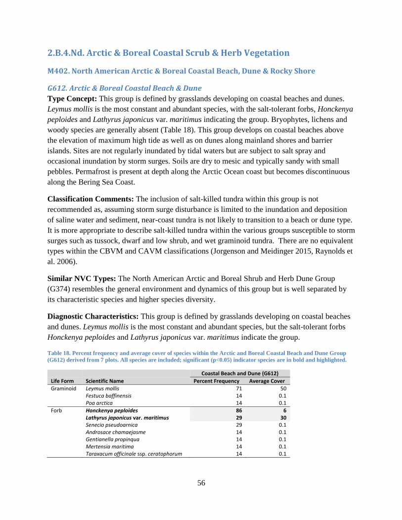
56
2.B.4.Nd. Arctic & Boreal Coastal Scrub & Herb Vegetation
M402. North American Arctic & Boreal Coastal Beach, Dune & Rocky Shore
G612. Arctic & Boreal Coastal Beach & Dune
Type Concept: This group is defined by grasslands developing on coastal beaches and dunes.
Leymus mollis is the most constant and abundant species, with the salt-tolerant forbs, Honckenya
peploides and Lathyrus japonicus var. maritimus indicating the group. Bryophytes, lichens and
woody species are generally absent (Table 18). This group develops on coastal beaches above
the elevation of maximum high tide as well as on dunes along mainland shores and barrier
islands. Sites are not regularly inundated by tidal waters but are subject to salt spray and
occasional inundation by storm surges. Soils are dry to mesic and typically sandy with small
pebbles. Permafrost is present at depth along the Arctic Ocean coast but becomes discontinuous
along the Bering Sea Coast.
Classification Comments: The inclusion of salt-killed tundra within this group is not
recommended as, assuming storm surge disturbance is limited to the inundation and deposition
of saline water and sediment, near-coast tundra is not likely to transition to a beach or dune type.
It is more appropriate to describe salt-killed tundra within the various groups susceptible to storm
surges such as tussock, dwarf and low shrub, and wet graminoid tundra. There are no equivalent
types within the CBVM and CAVM classifications (Jorgenson and Meidinger 2015, Raynolds et
al. 2006).
Similar NVC Types: The North American Arctic and Boreal Shrub and Herb Dune Group
(G374) resembles the general environment and dynamics of this group but is well separated by
its characteristic species and higher species diversity.
Diagnostic Characteristics: This group is defined by grasslands developing on coastal beaches
and dunes. Leymus mollis is the most constant and abundant species, but the salt-tolerant forbs
Honckenya peploides and Lathyrus japonicus var. maritimus indicate the group.
Table 18. Percent frequency and average cover of species within the Arctic and Boreal Coastal Beach and Dune Group
(G612) derived from 7 plots. All species are included; significant (p<0.05) indicator species are in bold and highlighted.
Coastal Beach and Dune (G612)
Life Form Scientific Name Percent Frequency Average Cover
Graminoid Leymus mollis 71 50 Festuca baffinensis 14 0.1 Poa arctica 14 0.1
Forb Honckenya peploides 86 6 Lathyrus japonicus var. maritimus 29 30 Senecio pseudoarnica 29 0.1 Androsace chamaejasme 14 0.1 Gentianella propinqua 14 0.1 Mertensia maritima 14 0.1
Taraxacum officinale ssp. ceratophorum 14 0.1

57
2.C.4.Np. Circumpolar Arctic & Northern Boreal Freshwater Marsh, Wet
Meadow & Shrubland
M870. North American Arctic & Northern Boreal Freshwater Marsh, Wet Meadow &
Shrubland
G830. North American Arctic & Subarctic Wet Shrubland
Type Concept: This proposed concept describes gently sloping water tracks that form linear
drainage networks in the foothills of northern Alaska. Water track wetlands conduct surface
water from seasonal thaw and summer rainfall events. In these wetland features, runoff is
confined to near surface due to shallow permafrost. Low shrub wetlands characterize vegetation
in well-developed water tracks. The dominant vegetation community is Salix pulchra /
Eriophorum angustifolium (Walker et al. 1994). Other important wetland sedges include Carex
aquatilis and Eriophorum russeolum. Important mosses include Calliergon stramineum,
Sphagnum girgensohnii, and Sphagnum warnstorfii (Table 19).
Classification Comments: This concepts needs further review. Plots with provisional
membership to this group are displayed in Table 19, however they have not been formally
analyzed. The ‘W3.4 Wet sedge communities in complex with shrub thickets’ type of the CAVM
(Raynolds et al. 2006) approximates G830 but is not considered equivalent; there is no
equivalent type within the CBVM classification (Jorgenson and Meidinger 2015).
Similar NVC Types: G(827). North American Arctic & Subarctic Low Willow Tundra includes
Salix pulchra in the overstory but it occurs on mesic-moist sites. The group G617. North
American Arctic & Subarctic Wet Meadow has a similar composition of wetland sedges and
cottongrass, but it is an herbaceous group. G368. North American Arctic & Subarctic Tall
Willow Tundra occurs in riparian areas, but substrates are well-drained, permafrost is absent near
the surface, and Salix alaxensis is the dominant willow.
Diagnostic Characteristics: This wet shrubland group occurs in the foothills of northern Alaska
along gently sloping water track drainage networks. Important species include Salix pulchra,
Carex aquatilis, and Eriophorum angustifolium.

58
Table 19. Percent frequency and average cover of species within the North American Arctic & Subarctic Wet Shrubland
Group (G830) derived from 17 plots. Species with frequencies less than 10 are not included; significant (p<0.05) indicator
species are in bold and highlighted.
Arctic & Subarctic Wet
Shrubland Group (G830)
Life Form Scientific Name Percent
Frequency Average
Cover
Shrub Salix pulchra 76 32
Betula nana 71 7
Ledum palustre ssp. decumbens 24 0.5
Vaccinium uliginosum 24 1
Salix richardsonii 12 3
Dwarf Shrub Salix reticulata 29 1
Vaccinium vitis-idaea 29 1
Salix arctica 18 3
Salix fuscescens 18 1
Dryas integrifolia 18 1
Fern & Ally Equisetum arvense 18 0
Graminoid Carex aquatilis 76 33
Eriophorum angustifolium 59 16
Eriophorum russeolum 18 3
Eriophorum vaginatum 41 4
Carex bigelowii 41 2
Calamagrostis stricta 24 1
Poa arctica 18 1
Arctagrostis latifolia 18 0.1
Forb Petasites frigidus 35 0.5
Saxifraga nelsoniana 29 0.1
Pyrola grandiflora 29 0.1
Comarum palustre 24 0.1
Pedicularis langsdorffii 24 0.1
Rubus chamaemorus 18 1
Stellaria longipes 18 0.2
Polygonum viviparum 18 0.1
Polemonium acutiflorum 12 0.1
Polygonum bistorta var. plumosum 12 0.1
Saxifraga hieraciifolia 12 0.1
Saxifraga hirculus 12 0.1
Pedicularis sudetica 12 0.1
Moss Sphagnum spp. 88 16
Aulacomnium spp. 47 7
Polytrichum spp. 29 1
Hylocomium splendens 18 3
Dicranum groenlandicum 12 1
Lichen Peltigera spp. 35 0.1
Flavocetraria cucullata 12 0.1
59
G370. North American Arctic & Subarctic Freshwater Marsh
Plots with provisional membership to this group were not analyzed.
G617. North American Arctic & Subarctic Wet Meadow
Plots with provisional membership to this group were not analyzed.
2.C.5.Nk. Arctic Coastal Salt Marsh
M403. North American Arctic Tidal Salt Marsh
G535. North American Arctic Coastal Salt Marsh
Type Concept: This group is defined as sparse to closed assemblages of forbs and graminoids
that are highly adapted to saturation and saline conditions that occupy the intertidal zone of the
Bering Sea and Arctic Ocean coastlines. Characteristic species include the halophytic
graminoids, Puccinellia phryganodes, Carex subspathacea and Dupontia fisheri and the
succulent forbs, Stellaria humifusa and Cochlearia groenlandica (Table 20). Arctic Salt Marshes
develop in protected coastal areas where relatively flat land receives periodic input of tidal
waters. Depending on local topography and exposure, marshes may be small patch to matrix
forming. Dynamics are chiefly driven by the inundation of tidal waters, which erode and
redeposit salt marsh sediment. The severity and magnitude of these effects are compounded by
storm events, ice rafting and thermal degradation of ice-rich coastal permafrost (where present).
Classification Comments: Several bases for distinction among Arctic salt marshes have been
previously proposed. For example, differentiation by region (e.g. a Low Arctic Region versus a
High Arctic Region), floristic province (e.g. Western North American versus Eastern North
American), or intertidal zone (e.g. Low Salt Marsh (i.e., outer tidal) versus High Salt Marsh
(inner tidal)). The description provided here pertains to Arctic Salt Marshes occupying the
intertidal zone (land that experiences daily inundation by tidal waters – outer and inner tidal) of
the Bering Sea and Arctic Ocean coastlines (low and high arctic in Western North America).
There are no equivalent types within the CAVM or CBVM classifications (Jorgenson and
Meidinger 2015, Raynolds et al. 2006).
Similar NVC Types: This group shares environmental characteristics and processes common to
Temperate Pacific Tidal Salt Marsh (G499) but differs in species composition.
Diagnostic Characteristics: This group is defined as sparse to closed assemblages of forbs and
graminoids that are highly adapted to saturation and saline conditions that occupy the intertidal
zone of the Bering Sea and Arctic Ocean coastlines. Woody and non-vascular species are
generally absent.

60
Table 20. Percent frequency and average cover of species within the Arctic Coastal Salt Marsh Group (G535) derived
from 19 plots. Species with frequency equal to or less than 10 are not included; significant (p<0.05) indicator species are
in bold and highlighted.
Arctic Coastal Salt Marsh (G535)
Life Form Scientific Name Percent Frequency Average Cover
Dwarf Shrub Salix ovalifolia 37 17
Graminoid Dupontia fisheri 58 30
Carex subspathacea* 37 39 Puccinellia phryganodes 32 53 Eriophorum angustifolium 26 9 Carex ursina 21 16 Calamagrostis deschampsioides 16 2 Poa arctica 16 4 Carex aquatilis 11 60 Carex glareosa 11 50 Eriophorum scheuchzeri 11 18 Puccinellia 11 51
Forb Stellaria humifusa 47 7 Cochlearia groenlandica 32 1 Stellaria crassifolia 16 1 Cerastium beeringianum 11 2 Chrysanthemum arcticum 11 3 Petasites frigidus 11 1 Primula borealis 11 1 Saxifraga cernua 11 3
Bryophyte Campylium stellatum 16 6 Polytrichastrum alpinum 11 5 Aulacomnium palustre 5 2
Lichen Bryocaulon divergens 11 18 Thamnolia vermicularis 11 0.1
* Marginally significant (p = 0.054)
4.B.1.Nb. Western North American Alpine Tundra
M404. Western Boreal Alpine Vegetation
G613. Western Boreal Alpine Dwarf Shrub Tundra
Type Concept: This group is defined as tundra vegetation dominated by the dwarf shrub,
Empetrum nigrum often in combination with other shrubs such as the low shrubs Vaccinium
uliginosum and Ledum palustre ssp. decumbens and the dwarf shrubs Loiseleuria procumbens
and Salix arctica (Table 21). Erect shrubs and trees provide less than 10% cover. The group
occurs on mountain and hill slopes, low summits and ridges and valley bottoms across a range of
soil types and hydrologies and is found in the Aleutian Islands and Boreal regions of Alaska,
Canada, and possibly Greenland. Patch size is small to matrix forming.
Classification Comments: Despite significant overlap between arctic and boreal dwarf shrub
types within the North American Arctic & Subarctic Tundra Macrogroup (M173), a distinctly
boreal dwarf shrub type, characterized by Empetrum nigrum is evident in multivariate analysis.
While Empetrum nigrum occurs throughout Alaska, it rarely dominates communities in the arctic
and temperate zones. Thus, while expansion of the conceptual ranges of Dryas (G366),

61
Ericaceous (G367) and Willow (G614) Dwarf Shrub Groups as well as the Tussock Tundra
Group (G371) is recommended to include alpine dwarf shrub types within the boreal ecoregion,
also recommended is the preservation of the Western Boreal Alpine Dwarf Shrub Group (613)
within the Western Boreal Alpine Vegetation Macrogroup (M404). This revision will restrict the
Western Boreal Alpine Dwarf Shrub Group (613) to vegetation dominated by Empetrum nigrum
and eliminate the Dryas, Dwarf Shrub, Dwarf Shrub-Lichen and Ericaceous variants formerly
included within the group. The ‘Aleutian Heaths and Meadows’ concept described by Jorgenson
and Meidinger (2105) may be considered a subset of G613. Floristically, G613 may be
considered a subset of the ‘Central-Northern Alaska-Yukon Alpine Dwarf Scrub and Meadows’
and ‘Southern Alaska-Yukon Alpine Dwarf Scrub and Meadows’ CBVM concepts; however
G613 has a broader distribution, thus the relationship is complex. With respect to the CAVM,
G613 may be considered a narrower type within the ‘B3. Prostrate dwarf-shrub,
gramionid/lichen communities on acidic substrates’ type (Raynolds et al. 2006). To generalize,
the NVC, CBVM, and CAVM types resemble each other with respect to the dominance of
Empetrum nigrum but differ in their associated species and geographic ranges.
Similar NVC Types: This group is similar to several arctic and subarctic tundra groups whose
ranges extend into the Boreal, namely: North American Arctic & Subarctic Ericaceous Dwarf
Shrub Tundra (G367), Dryas Dwarf Shrub Tundra (G366), and Willow Dwarf Shrub Tundra
(G613). The Western Boreal Alpine Dwarf Shrub Tundra differs in its dominance of Empetrum
nigrum.
Diagnostic Characteristics: This group is defined as tundra vegetation dominated by the dwarf
shrub, Empetrum nigrum where erect shrubs and trees provide less than 10% cover. It is found in
the Aleutian Islands and the boreal regions of Alaska, Canada, and possibly Greenland.
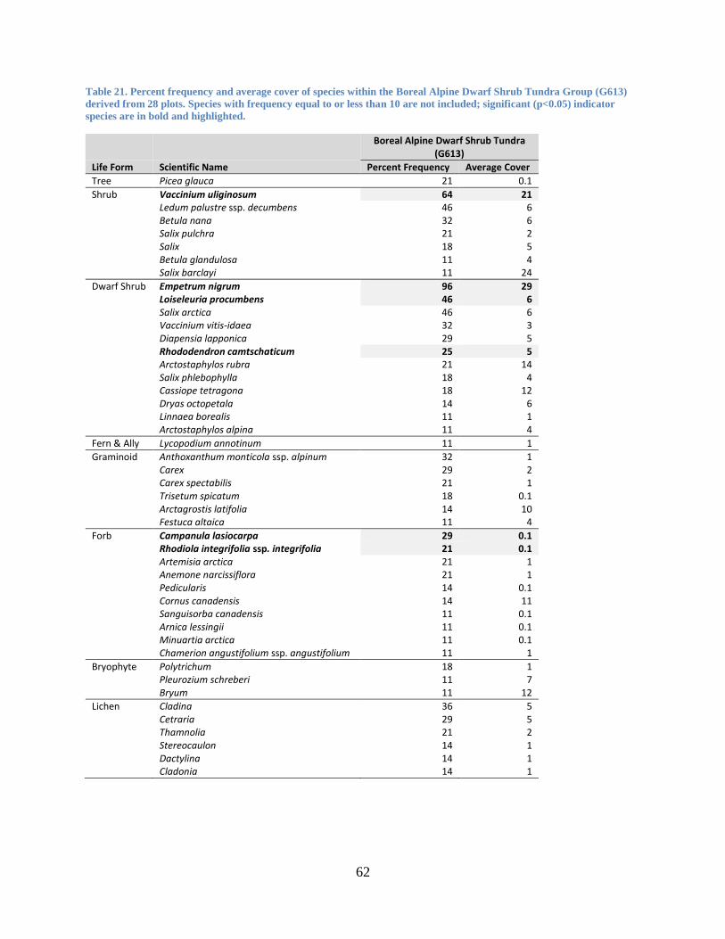
62
Table 21. Percent frequency and average cover of species within the Boreal Alpine Dwarf Shrub Tundra Group (G613)
derived from 28 plots. Species with frequency equal to or less than 10 are not included; significant (p<0.05) indicator
species are in bold and highlighted.
Boreal Alpine Dwarf Shrub Tundra
(G613)
Life Form Scientific Name Percent Frequency Average Cover
Tree Picea glauca 21 0.1
Shrub Vaccinium uliginosum 64 21 Ledum palustre ssp. decumbens 46 6 Betula nana 32 6 Salix pulchra 21 2 Salix 18 5 Betula glandulosa 11 4 Salix barclayi 11 24
Dwarf Shrub Empetrum nigrum 96 29 Loiseleuria procumbens 46 6 Salix arctica 46 6 Vaccinium vitis-idaea 32 3 Diapensia lapponica 29 5 Rhododendron camtschaticum 25 5 Arctostaphylos rubra 21 14 Salix phlebophylla 18 4 Cassiope tetragona 18 12 Dryas octopetala 14 6 Linnaea borealis 11 1 Arctostaphylos alpina 11 4
Fern & Ally Lycopodium annotinum 11 1
Graminoid Anthoxanthum monticola ssp. alpinum 32 1 Carex 29 2 Carex spectabilis 21 1 Trisetum spicatum 18 0.1 Arctagrostis latifolia 14 10 Festuca altaica 11 4
Forb Campanula lasiocarpa 29 0.1 Rhodiola integrifolia ssp. integrifolia 21 0.1 Artemisia arctica 21 1 Anemone narcissiflora 21 1 Pedicularis 14 0.1 Cornus canadensis 14 11 Sanguisorba canadensis 11 0.1 Arnica lessingii 11 0.1 Minuartia arctica 11 0.1 Chamerion angustifolium ssp. angustifolium 11 1
Bryophyte Polytrichum 18 1 Pleurozium schreberi 11 7 Bryum 11 12
Lichen Cladina 36 5 Cetraria 29 5 Thamnolia 21 2 Stereocaulon 14 1 Dactylina 14 1
Cladonia 14 1

63
4.B.2.Xa. Arctic Tundra & Barrens
M173. North American Arctic & Subarctic Tundra Macrogroup
G365. North American Arctic & Subarctic Lichen - Sparse Dwarf Shrub Tundra
The Lichen – Sparse Dwarf Shrub Tundra Group is expected to be a highly variable type that is
not well represented (n = 5 plots) within the dataset. Further analysis incorporating a greater
number of plots is recommended to refine the formal description of this group.
G366. North American Arctic & Subarctic Dryas Dwarf Shrub Tundra
Type Concept: This tundra group is defined by vegetation dominated by the dwarf, broad-
leaved evergreen shrub species, Dryas octopetala and/or Dryas integrifolia. In addition to its
dominant species, Dryas Dwarf Shrub Tundra supports high constancy of the dwarf willows,
Salix reticulata, Salix arctica, Salix phlebophylla, the ericaceous shrubs, Cassiope tetragona and
Vaccinium uliginosum, the grass Anthoxanthum monticola ssp. alpinum, the sedge, Carex
scirpoidea, and the lichens, Thamnolia vermicularis and Flavocetraria nivalis (Table 22). Dryas
vegetation is common on exposed, windswept areas with little winter snow cover throughout
arctic and subarctic Alaska, Canada, and possibly parts of Greenland. Types dominated by Dryas
octopetala appear to be more common at high-elevation on alpine slopes and ridges, whereas
types dominated by Dryas integrifolia are more common at high latitude in the arctic as well as
on inactive floodplains and in drained lake basins. Substrates are typically mineral and are non-
acidic to circumneutral. Patch size is small to matrix-forming.
Classification Comments: The dominance by Dryas octopetala versus Dryas integrifolia or the
acidic versus non-acidic Dryas types may provide alliance-level distinctions. G366 is considered
a subset of the ‘Central-Northern Alaska-Yukon Alpine Dwarf Scrub and Meadows’ concept
described by Jorgenson and Meidinger (2015), which includes a variety of dwarf shrub types not
necessarily dominated by Dryas species. Similarly, G366 may also be considered a subset of the
‘B4. Prostrate dwarf-shrub, gramionid/lichen communities on non-acidic substrates’ CAVM type
of Raynolds et al. (2006).
Similar NVC Types: The range of this type overlaps and shares a number of species with
Western Boreal Alpine Dwarf-Shrubland (G613) but is not dominated by Empetrum nigrum. It is
also floristically similar to North American Arctic Gravel Floodplain Vegetation (G616) where
this type is dominated by Dryas drummondii.
Diagnostic Characteristics: This group is defined by tundra vegetation dominated by the dwarf,
broad-leaved, evergreen shrub species, Dryas octopetala and/or Dryas integrifolia in the arctic
and subarctic regions of Alaska and Canada.

64
Table 22. Percent frequency and average cover of species within the Dryas Dwarf Shrub Tundra Group (G366) derived
from 68 plots. Species with frequency equal to or less than 10 are not included; significant (p<0.05) indicator species are
in bold and highlighted.
Dryas Dwarf Shrub Tundra (G366)
Life Form Scientific Name Percent Frequency Average Cover
Tree Picea glauca 7 1
Shrub Vaccinium uliginosum 44 8
Betula nana 24 13
Ledum palustre ssp. decumbens 16 2
Salix pulchra 15 3
Salix glauca 12 6
Dwarf Shrub Dryas octopetala 85 35
Salix reticulata 53 6
Salix arctica 40 3
Cassiope tetragona 37 15
Salix phlebophylla 31 5
Diapensia lapponica 21 5
Vaccinium vitis-idaea 21 2
Arctostaphylos rubra 19 6
Dryas integrifolia 16 30
Rhododendron lapponicum 13 4
Empetrum nigrum 12 5
Graminoid Anthoxanthum monticola ssp. alpinum 34 1
Carex scirpoidea 29 4
Arctagrostis latifolia 18 3
Carex bigelowii 18 13
Poa arctica 13 1
Forb Silene acaulis 26 1
Oxytropis nigrescens 25 1
Pedicularis 24 0
Minuartia macrocarpa 22 0
Polygonum bistorta 18 0
Polygonum viviparum 16 0
Chamerion latifolium 15 1
Saxifraga oppositifolia 15 1
Anemone narcissiflora 13 0
Anemone parviflora 12 0
Geum glaciale 12 0
Hedysarum alpinum 12 1
Potentilla biflora 12 1
Saussurea angustifolia 12 0
Saxifraga nelsoniana 12 1
Bryophyte Hylocomium splendens 16 22
Racomitrium lanuginosum 12 4
Lichen Thamnolia vermicularis 32 3
Flavocetraria nivalis 26 3
Flavocetraria cucullata 19 4
Stereocaulon 18 2
Dactylina arctica 16 1
Cetraria 15 6
Cladina rangiferina 13 3
Asahinea chrysantha 12 3

65
G367. North American Arctic & Subarctic Ericaceous Dwarf Shrub Tundra
Type Concept: This tundra group is defined by vegetation dominated by dwarf to low
ericaceous shrubs in the arctic and subarctic regions of Alaska and Canada. The group is
characterized by high constancy of, and indicated by the presence of the ericaceous shrubs
Ledum palustre ssp. decumbens, Cassiope tetragona, and Vaccinium vitis-idaea. The moss
Hylocomium splendens and lichen species in the Cladina genus may exceed 20% cover. The low
shrubs Betula nana, Salix pulchra and dwarf shrubs Salix phlebophylla and Diapensia lapponica
may reach high abundances but do not assume dominance (Table 23). This group is common in
semi-protected, mesic sites in the hills and mountains where snow cover is retained. Substrates
are acidic to non-acidic; patch size is small to large.
Classification Comments: An alliance level split is suggested by coincident species
abundances. Within the group, plots supporting high cover of Ledum palustre ssp. decumbens are
also characterized by an abundance of lichen species in the Cladina genus, whereas plots
supporting high cover of Cassiope tetragona are characterized by an abundance of bryophytes
such as Hylocomium splendens. G367 is considered a subset of the ‘Central-Northern Alaska-
Yukon Alpine Dwarf Scrub and Meadows’ concept described by Jorgenson and Meidinger
(2015), which includes a variety of dwarf shrub types not necessarily dominated by ericaceous
species. Similarly, G367 may be considered a subset of the ‘B3. Prostrate dwarf-shrub,
gramionid/lichen communities on acidic substrates’ CAVM type described by Raynolds et al.
(2006).
Similar NVC Types: The range of this type overlaps and shares a number of species with
Western Boreal Alpine Dwarf-Shrubland (G613) but is not dominated by Empetrum nigrum.
This type is also similar to North American Arctic & Subarctic Dwarf Willow Tundra (G614)
but is not dominated by dwarf shrubs in the Salix genus.
Diagnostic Characteristics: This group is defined by tundra vegetation dominated by dwarf to
low ericaceous shrubs in the arctic and subarctic regions of Alaska and Canada.
Table 23. Percent frequency and average cover of species within the Ericaceous Dwarf Shrub Tundra Group (G367)
derived from 17 plots. Species with frequency equal to or less than 10 are not included; significant (p<0.05) indicator
species are in bold and highlighted.
Ericaceous Dwarf Shrub Tundra (G367)
Life Form Scientific Name Percent Frequency Average Cover
Tree Picea glauca 18 1
Shrub Ledum palustre ssp. decumbens 71 6 Vaccinium uliginosum 59 8 Betula nana 35 10
Salix pulchra 35 6
Dwarf Shrub Cassiope tetragona 71 27 Vaccinium vitis-idaea 65 9 Salix phlebophylla 47 7 Diapensia lapponica 35 9 Dryas octopetala 29 4 Empetrum nigrum 29 4

66
Ericaceous Dwarf Shrub Tundra (G367)
Life Form Scientific Name Percent Frequency Average Cover
Salix reticulata 29 3
Arctostaphylos alpina 18 1 Arctostaphylos rubra 18 18 Dryas integrifolia 12 11 Rhododendron lapponicum 12 2
Salix arctica 12 1
Graminoid Anthoxanthum monticola ssp. alpinum 47 3 Luzula confusa 47 3 Carex aquatilis 24 10 Carex bigelowii 24 3 Arctagrostis latifolia 18 7 Carex microchaeta 18 8 Eriophorum vaginatum 18 7 Poa arctica 18 7
Carex 12 0
Forb Petasites frigidus 18 1 Saxifraga nelsoniana 18 0 Boykinia richardsonii 12 4 Pedicularis capitata 12 0 Polygonum bistorta var. plumosum 12 2 Pyrola grandiflora 12 0 Rubus chamaemorus 12 6 Silene acaulis 12 0
Stellaria longipes 12 0
Bryophyte Hylocomium splendens 53 20 Polytrichum 35 5 Sphagnum 24 4 Dicranum spadiceum 18 15 Aulacomnium 12 15 Aulacomnium turgidum 12 10 Dicranum 12 2
Lichen Cladina 35 27 Dactylina arctica 35 2 Flavocetraria cucullata 29 2 Thamnolia vermicularis 29 2 Stereocaulon 24 1 Cladina rangiferina 18 16 Flavocetraria nivalis 18 2 Peltigera 18 0 Cetraria 12 11 Cetraria ericetorum 12 2 Cladonia 12 1 Cladonia gracilis 12 5
Masonhalea richardsonii 12 1

67
G614. North American Arctic & Subarctic Dwarf Willow Shrub Tundra
Type Concept: This tundra group is dominated by dwarf willow shrubs and is commonly found
on exposed sites in the arctic and subarctic regions of Alaska and Canada. The group is indicated
by the dwarf willows, Salix reticulata, Salix polaris, Salix rotundifolia, and Salix phlebophylla.
Characteristic species include the dwarf shrubs Dryas octopetala and Cassiope tetragona, the
graminoids Carex bigelowii and Arctagrostis latifolia, the forb Petasites frigidus, and the lichens
Flavocetraria cucullata and Thamnolia vermicularis. The erect shrub, Salix pulchra is constant
at low cover (Table 24). This is a small patch type developing in shallow, well-drained, soils on
non-acidic substrates underlain by permafrost.
Classification Comments: While this group occupies small patches and is uncommon on the
landscape, it is significantly differentiated by numerous species, which speaks to its unique
floristics and validity as a discrete group. G614 is considered a subset of the ‘Central-Northern
Alaska-Yukon Alpine Dwarf Scrub and Meadows’ and ‘Southern Alaska-Yukon Alpine Dwarf
Scrub and Meadows’ concepts described by Jorgenson and Meidinger (2015), which includes a
variety of dwarf shrub types not necessarily dominated by willow species. Similarly, G614 may
be considered a subset of the ‘B4. Prostrate dwarf-shrub, gramionid/lichen communities on non-
acidic substrates’ CAVM type described by Raynolds et al. (2006).
Similar NVC Types: This type is similar to G367. North American Arctic & Subarctic
Ericaceous Dwarf-Shrub Tundra but differs in its dominance by members of the Salix genus
rather than ericaceous shrubs. It is also similar to G827. North American Arctic & Subarctic
Scrub Willow Tundra but differs in its dominance by dwarf rather than erect willow species.
Diagnostic Characteristics: This group is defined as tundra vegetation dominated by prostrate
to hemi-prostrate willow species found in the arctic and subarctic regions of Alaska, Canada, and
possibly Greenland. Erect shrubs and trees provide less than 25% cover.
Table 24. Percent frequency and average cover of species within the Willow Dwarf Shrub Tundra Group (G614) derived
from 15 plots. Species with frequency equal to or less than 10 are not included; significant (p<0.05) indicator species are
in bold and highlighted.
Willow Dwarf Shrub Tundra (G614)
Life Form Scientific Name Percent Frequency Average Cover
Shrub Salix pulchra 60 3 Vaccinium uliginosum 27 14 Betula nana 13 3
Dwarf Shrub Salix reticulata 67 22 Dryas octopetala 60 6 Cassiope tetragona 47 4 Salix rotundifolia 40 15 Salix arctica 33 13 Salix polaris 20 18 Dryas integrifolia 20 3 Salix phlebophylla 13 2 Empetrum nigrum 13 1 Rhododendron lapponicum 13 1
Graminoid Carex bigelowii 47 21 Arctagrostis latifolia 40 3

68
Willow Dwarf Shrub Tundra (G614)
Life Form Scientific Name Percent Frequency Average Cover
Eriophorum vaginatum 33 3 Poa arctica 27 5 Carex microchaeta 27 4 Carex aquatilis 20 8 Eriophorum angustifolium 20 7 Luzula confusa 20 4 Anthoxanthum monticola ssp. alpinum 20 3 Luzula 20 1
Poa 20 1 Luzula arctica 13 7 Trisetum spicatum 13 0
Fern & Ally Equisetum arvense 33 27 Equisetum variegatum 13 3 Equisetum scirpoides 13 0
Forb Petasites frigidus 47 1 Polygonum bistorta var. plumosum 33 3 Polygonum viviparum 27 1 Boykinia richardsonii 20 4 Polygonum bistorta 20 2 Pedicularis 20 1 Stellaria longipes 20 1 Saxifraga nelsoniana 20 0 Pedicularis langsdorffii 20 0 Tephroseris atropurpurea ssp. frigida 20 0 Anemone narcissiflora 13 0 Artemisia arctica 13 0 Tofieldia pusilla 13 0
Lichen Flavocetraria cucullata 60 1 Thamnolia vermicularis 47 1 Dactylina arctica 33 2 Flavocetraria nivalis 33 2 Cladina rangiferina 27 1 Masonhalea richardsonii 27 0 Peltigera 20 2 Cetraria 20 1 Sphaerophorus globosus 20 1 Alectoria nigricans 13 5 Cetraria islandica 13 3 Bryocaulon 13 2 Cladina 13 1
Bryophyte Tomentypnum nitens 27 40 Hylocomium splendens 27 34 Aulacomnium palustre 27 16 Dicranum elongatum 27 13 Sphagnum 20 10 Aulacomnium 13 20 Catoscopium nigritum 13 20 Polytrichum 13 11 Drepanocladus 13 8 Polytrichum hyperboreum 13 7
Racomitrium lanuginosum 13 3

69
G827. North American Arctic & Subarctic Low Willow Tundra
Type Concept: This shrub tundra group is common throughout arctic and subarctic Alaska on
mesic to moist side slopes and ridges in the Brooks Range foothills and also high-centered
polygonal tundra of the Arctic Coastal Plain. Vegetation is dominated by low shrub willows
including Salix richardsonii, Salix pulchra, and Salix glauca. Associated shrubs that occur
frequently at low cover include Salix reticulata, Betula nana, and Vaccinium uliginosum.
Understory herbaceous species typically have low cover and may include Equisetum arvense,
Petasites frigidus, Arctagrostis latifolia, Carex bigelowii, and Poa arctica. Hylocomium
splendens is the most common moss; lichens are uncommon (Table 25).
Classification Comments: This group has some overlap with Western Boreal Mesic Alder -
Willow Shrubland (G357) which also includes Salix pulchra types in its distribution. A review of
alliances and associations for both groups will help to refine the distinctions between these two
groups. G827 may be considered a non-forested subset of the ‘Northern Alaska-Yukon Spruce
Woodlands and Scrub’ and the ‘Yukon Subalpine Spruce Woodlands and Scrub’ concepts
described by Jorgenson and Meidinger (2015). G827 may also be considered a subset of the ‘S1.
Erect dwarf-shrub communities’ and ‘S2.1 Low-shrub communities of willow or birch’ CAVM
types described by Raynolds et al. (2006).
Similar NVC Types: This group is similar to G357. Western Boreal Mesic Alder - Willow
Shrubland but is differentiated by its arctic-centric distribution as well as the non-participation of
Alnus viridis. It is also similar to G830. North American Arctic & Subarctic Wet Shrubland but
lacks a wet sedge understory.
Diagnostic Characteristics: This shrubland group is defined by its occurrence on moist to mesic
sites and the dominance of low shrub willows (generally 40-150 cm tall with 25-90% canopy
closure), including Salix richardsonii, Salix pulchra, and Salix glauca. Additional differential
species include Salix reticulata, Equisetum arvense, and Petasites frigidus.

70
Table 25. Percent frequency and average cover of species within the North American Arctic & Subarctic Low Willow
Tundra (G827), derived from 26 plots. Species with percent frequency less than 10 are not included; significant (p<0.05)
indicator species are in bold and highlighted*.
Arctic & Subarctic Low Willow Tundra (G827)
Life Form Scientific Name Percent Frequency Average Cover
Shrub Vaccinium uliginosum 50 3 Salix richardsonii 46 18 Salix glauca 42 11 Salix pulchra 42 17 Betula nana 35 2 Salix alaxensis 19 1 Salix arbusculoides 19 4 Salix niphoclada 19 4
Ledum palustre ssp. decumbens 15 1
Dwarf Shrub
Salix reticulata 50 6
Arctostaphylos rubra 35 5 Dryas integrifolia 23 1 Dryas octopetala 23 1 Arctostaphylos alpina 19 1 Cassiope tetragona 19 1 Empetrum nigrum 19 1
Vaccinium vitis-idaea 19 1
Fern & Ally Equisetum arvense 54 5 Equisetum scirpoides 15 1
Equisetum variegatum 15 5
Graminoid Arctagrostis latifolia 35 1 Carex bigelowii 31 4 Poa arctica 31 1 Anthoxanthum monticola ssp. alpinum 19 1 Festuca altaica 19 0.1
Eriophorum vaginatum 15 1
Forb Petasites frigidus 46 1 Hedysarum alpinum 31 1 Polygonum viviparum 31 0.1 Lupinus arcticus 27 2 Pyrola grandiflora 27 0.1 Polemonium acutiflorum 23 0.1 Stellaria longipes 23 0.1 Valeriana capitata 23 0.1 Aulacomnium turgidum 23 2 Pedicularis langsdorffii 19 0.1 Anemone richardsonii 15 0.1 Orthilia secunda 15 0.1 Pedicularis capitata 15 0.1 Saussurea angustifolia 15 0.1 Saxifraga nelsoniana 15 0.1
Senecio lugens 15 0.1
Moss Hylocomium splendens 54 21 Rhytidium rugosum 19 2 Sphagnum 15 3
Tomentypnum nitens 15 3
Lichen Flavocetraria cucullata 15 0.1
*Indicator species in bold derived from an ISA comparing this group to Boreal Scrub Birch (G356) and Arctic
Dwarf Birch (G828)

71
G828. North American Arctic & Subarctic Dwarf Birch Tundra
Type Concept: This group is dominated by Betula nana and is commonly found throughout the
low Arctic on mesic to moist side slopes and ridges in the Brooks Range foothills and on high-
centered polygonal tundra of the Arctic Coastal Plain. Vegetation is characterized by low and
prostrate shrubs including Betula nana, Ledum palustre ssp. decumbens, Vaccinium uliginosum,
and Salix pulchra. Dwarf-shrubs such as Vaccinium vitis-idaea and Loiseleuria procumbens may
be common. Herbaceous species are sparse, but certain graminoids have high constancy
including Anthoxanthum monticola ssp. alpinum in montane sites and sedges in moist tundra on
the coastal plain. Fruticose lichens, particularly Cladina rangiferina and other Cladina species
are often abundant in the ground layer. Common mosses include Hylocomium splendens and
Sphagnum, Aulacomnium, and Polytrichum species (Table 26). Patch size is small to matrix-
forming.
Classification Comments: G828 may be considered a non-forested subset of the ‘Northern
Alaska-Yukon Spruce Woodlands and Scrub’ and the ‘Yukon Subalpine Spruce Woodlands and
Scrub’ concepts described by Jorgenson and Meidinger (2015). G828 may also be considered a
subset of the ‘S1. Erect dwarf-shrub communities’ and ‘S2.1 Low-shrub communities of willow
or birch’ CAVM types described by Raynolds et al. (2006).
Similar NVC Types: This group is similar in composition to G356. Western Boreal Scrub Birch
Shrubland, but lacks Betula glandulosa and is further differentiated by having an arctic
distribution.
Diagnostic Characteristics: This group is characterized by mesic to moist sites dominated by
Betula nana (25-90% cover) in a low or prostrate growth form. Additional differential species
for this group include Ledum palustre ssp. decumbens, Vaccinium uliginosum, and Cladina spp.

72
Table 26. Percent frequency and average cover of species within the North American Arctic & Subarctic Scrub Birch
Tundra (G828), derived from 13 plots. Species with percent frequency less than 10 are not included; indicator species are
in bold and highlighted*.
Arctic & Subarctic Scrub Birch
Tundra (G828)
Life Form Scientific Name Percent
Frequency Average
Cover
Shrub Betula nana* 100 51
Ledum palustre ssp. decumbens 92 10
Vaccinium uliginosum 77 4
Salix pulchra 62 2
Salix glauca 23 1
Dwarf Shrub Vaccinium vitis-idaea 69 2
Loiseleuria procumbens* 31 1
Cassiope tetragona 23 1
Dryas octopetala 23 3
Empetrum nigrum 23 2
Andromeda polifolia 15 0.1
Arctostaphylos rubra 15 0.1
Salix fuscescens 15 0.1
Vaccinium oxycoccos 15 0.1
Graminoid Anthoxanthum monticola ssp. alpinum 31 1
Eriophorum angustifolium* 31 0.1
Poa arctica 23 0.1
Carex bigelowii 15 2
Carex rotundata 15 3
Eriophorum vaginatum 15 1
Festuca altaica 15 0.1
Forb Petasites frigidus 23 0.1
Rubus chamaemorus 23 1
Pedicularis labradorica 15 0.1
Polygonum bistorta 15 0.1
Saussurea angustifolia 15 0.1
Moss Hylocomium splendens 38 5
Sphagnum 38 10
Aulacomnium 23 5
Polytrichum 23 6
Dicranum 15 1
Lichen Cladina rangiferina 46 16
Cladina 23 1
Cladonia 23 2
Flavocetraria cucullata 23 1
Peltigera 23 0.1
Dactylina arctica 15 0.1
Stereocaulon 15 0.1
Thamnolia vermicularis 15 0.1 * denotes significant indicator species (p<0.05) identified through an Indicator Species Analysis comparing this group to Boreal
Scrub Birch (G356) and Arctic Low Willow (G827). Because this Group shares many common species with G356, only those
that differentiate its arctic composition are reflected in the ISA. A broader list of indicators has been highlighted to provide a
more complete description. Eriophorum angustifolium was likely identified as an indicator for coastal plain sites because it
occurs commonly in polygon troughs and in wet microsites which were included in the species composition for these plots, but
these wet inclusions are part of a mosaic of vegetation communities found in polygonal tundra and not necessarily indicators for
this type.

73
G(new). North American Arctic & Subarctic Moist Tundra
Type Concept: This proposed group is most common in the high arctic but also occurs in the
low arctic. Moist Tundra types are associated with mesotopographic highs such as raised area
along drainages, the centers of high-centered polygons and the ridges of low-centered polygons.
Sites are underlain by permafrost and patch size is small. Shrubs are prostrate (low) to dwarf.
Low shrub cover does not exceed 25% and dwarf shrub cover is variable. Common low shrub
species are Salix pulchra, Betula nana, and Ledum decumbens with the participation of Betula
nana decreasing in the high arctic. Common dwarf shrub species are Vaccinium vitis-idea,
Cassiope tetragona, and Dryas integrifolia. Vegetation is dominated by sedges such as
Eriophorum angustifolium, Carex aquatilis var. stans, and Luzula arctica and may include
Eriophorum vaginatum, but sites are not tussocked, Moist- to dry-site mosses and lichens are
abundant, with notable presence of crustose lichens.
Classification Comments: While this is a recognized type in the Arctic (e.g. the Moist Shrub
Tundra on High-centered Polygons type of Jorgenson et al. 1994 and the ‘G3. Non-tussock,
sedge, dwarf-shrub, moss communities’ CAVM type Raynolds et al. 2006), the paucity of plot
data in our dataset precluded analysis. Conference with Canadian ecologists is recommended to
further refine this group.
Similar NVC Types: This group is similar to G827. North American Arctic & Subarctic Low
Willow Tundra and G828. North American Arctic & Subarctic Dwarf Birch Tundra; however,
Moist Tundra has lower (<25%) cover of shrubs that are often dwarfed (<40 cm) due to their
high arctic or coastal location. Species composition of the Moist Tundra group may also
resemble G371. North American Arctic & Subarctic Tussock Tundra, however sites are not
tussocked.
Diagnostic Characteristics: This proposed group is defined by tundra vegetation with less than
25% cover of prostrate (<40 cm) shrubs, most commonly Salix pulchra, and high constancy and
abundance of sedges; sites have a moist hydrologic regime and are not tussocked.
G368. North American Arctic & Subarctic Tall Willow Tundra
Type Concept: This group is defined by tall willow shrublands found in floodplains and riparian
corridors throughout the arctic, subarctic, and alpine boreal regions of Alaska. Salix alaxensis is
the dominant shrub with canopy heights often exceeding 2 m. Other common willows are Salix
arbusculoides, Salix glauca, Salix niphoclada, Salix pulchra, and Salix richardsonii. Dwarf
shrubs include Arctostaphylos and Dryas species. In the herbaceous layer Eurybia sibirica,
Chamerion latifolium, and Equisetum arvense have high constancy as do the grasses Bromus
inermis ssp. pumpellianus and Festuca rubra and the legumes Hedysarum alpinum, Astragalus
alpinus, Lupinus arcticus, and Oxytropis campestris. Mosses and lichens are uncommon in the
ground layer (Table 277).

74
Classification Comments: North American Arctic Floodplain Group was absorbed into this
group. Neither the CABVM nor the CAVM explicitly describes this group. While no equivalent
types are recognized for the CABVM, the CAVM describes a ‘S2.1 Low-shrub communities of
willow or birch’ type, however Salix alaxensis is not listed as a diagnostic or even associated
species (Raynolds et al. 2006). The applicability of this group concept in Canada needs critical
review.
Similar NVC Types: This group is similar to G357. Western Boreal Mesic Alder - Willow
Shrubland but is differentiated by its arctic-centric distribution, floodplain occurrence as well as
the infrequent occurrence of Alnus viridis. It also resembles G827. North American Arctic &
Subarctic Low Willow Tundra but is separated by taller stature willows and floodplain location.
Diagnostic Characteristics: This group is defined by tall willow shrublands found in
floodplains and riparian corridors. The dominant canopy species is Salix alaxensis; additional
differential species include Eurybia sibirica, Equisetum arvense, Chamerion latifolium Bromus
inermis ssp. pumpellianus, Festuca rubra, Hedysarum alpinum, Astragalus alpinus, Lupinus
arcticus, and Oxytropis campestris. (Additional diagnostic species added from the NPRA
Assessment Inventory and Monitoring Program summary of Arctic Floodplain Shrublands,
Boucher et al. 2015.)

75
Table 27. Percent frequency and average cover of species within the North American Arctic & Subarctic Tall Willow
Tundra (G368), derived from 41 plots. Species with percent frequency less than 10 are not included; significant (p<0.05)
indicator species are in bold and highlighted.
Arctic & Subarctic Tall Willow Tundra (G368)
Life Form Scientific Name Percent Frequency Average Cover
Tree Populus balsamifera 10 0.1
Shrub Salix alaxensis 100 44
Salix pulchra 29 4
Salix richardsonii 15 2
Vaccinium uliginosum 15 1
Salix arbusculoides 12 1
Salix glauca 12 1
Salix hastata 10 0.1
Salix niphoclada 10 1
Shepherdia canadensis 10 0.1
Dwarf Shrub Salix reticulata 24 4
Dryas spp. 17 2
Arctostaphylos spp. 12 0.1
Fern & Ally Equisetum arvense 51 10
Equisetum variegatum 20 1
Equisetum scirpoides 10 0.1
Graminoid Bromus inermis ssp. pumpellianus 22 1
Arctagrostis latifolia 17 1
Calamagrostis canadensis 15 4
Festuca rubra 10 0.1
Hierochloe odorata 10 0.1
Poa arctica 10 1
Forb Chamerion latifolium 37 0.1
Eurybia sibirica 37 1
Artemisia tilesii 27 1
Hedysarum alpinum 27 1
Polemonium acutiflorum 17 0.1
Astragalus alpinus 15 0.1
Stellaria longipes 15 0.1
Achillea millefolium var. borealis 12 0.1
Anemone parviflora 12 0.1
Polygonum viviparum 12 0.1
Astragalus umbellatus 10 0.1
Comarum palustre 10 1
Lupinus arcticus 10 0.1
Mertensia paniculata 10 0.1
Parnassia palustris 10 0.1
Trientalis europaea 10 0.1
Viola epipsila 10 0.1
*Indicator species identified from an ISA among Arctic Tall Willow (G368), Arctic Low Willow (Gn827, formerly G369), and
Boreal Alder-Willow (G357).

76
G615. North American Arctic & Subarctic Mesic Herb Tundra
The Mesic Herb Tundra Group is an uncommon and potentially variable type that is represented
by a single plot within the dataset. Further analysis incorporating a greater number of plots is
recommended to refine the formal description of this group.
G371. North American Arctic & Subarctic Tussock Tundra
Type Concept: This tundra group is defined by tussock-forming sedges often in combination
with dwarf and low shrubs occurring in the arctic and subarctic regions of Alaska and Canada.
The cottongrass, Eriophorum vaginatum is the predominant tussock-former on older landscapes
and acidic substrates. Tussock formation may transition to the sedge, Carex bigelowii across
younger landscapes, disturbance-prone landforms and circumneutral substrates. Carex bigelowii
tussock tundra is considered a more productive and type relative to mature Eriophorum
vaginatum tussock tundra. Eriophorum vaginatum tussock tundra is characterized by high
constancy of the dwarf shrub Vaccinium vitis-idaea and the low shrub Betula nana, with the low
shrub Ledum palustre ssp. decumbens and the forb, Rubus chamaemorus indicating the type. By
comparison, Carex bigelowii tussock tundra is characterized by high constancy of the dwarf
shrubs, Salix reticulata, and Cassiope tetragona with the dwarf shrub, Dryas octopetala
indicating the type. Where Eriophorum vaginatum and Carex bigelowii both contribute to
tussock formation, the low shrub, Vaccinium uliginosum and the dwarf shrub, Empetrum nigrum,
and the forb Polygonum bistorta, have high constancy; with the shrub, Salix pulchra indicating
the type (Table 28). For tussock tundra occurring in wet areas of Alaska’s Arctic Coastal Plain,
shrub abundance appears to increase on microtopographic highs such high-centered polygons.
On a broader scale, low shrub cover appears to increase in tussock tundra with increasing slope,
with the participation of dwarf shrubs increasing in the subalpine. The presence of continuous,
ice-rich permafrost renders sites cold and poorly-drained. Shallow organics in the intertussock
hollows are underlain by silty mineral soils. Patch size is small to matrix-forming.
Classification Comments: An alliance-level split in accordance with Carex bigelowii or
Eriophorum vaginatum dominance is suggested by characteristic species and pH values among
plots. Carex bigelowii tussock tundra is characterized by an average pH of 6.3 as well as high
constancy of the dwarf shrubs, Salix reticulata, and Cassiope tetragona with Carex bigelowii
and the dwarf shrub, Dryas octopetala differentiating the type. Comparatively, Eriophorum
vaginatum tussock tundra is characterized by an average pH of 5.5 as well as high constancy of
the ericaceous dwarf shrub Vaccinium vitis-idaea and the low shrub Betula nana, with
Eriophorum vaginatum, the low shrub Ledum palustre ssp. decumbens and the forb, Rubus
chamaemorus differentiating the type. G371 is considered equivalent to the ‘G4. Tussock sedge,
dwarf-shrub, moss communities’ CAVM type described by Raynolds et al. (2006); no equivalent
types are described for the CBVM.
Similar NVC Types: This type is similar to both Western Subarctic Woodland (G633) and
Subalpine Woodlands (G646) but does not support more than 10% cover of tree species. It may
also resemble the floristics of North American Arctic & Subarctic Mesic Herb Tundra (G615) or

77
Western Boreal Mesic Grassland & Meadow (G358) when these are dominated by graminoids
but is well separated by extensive tussock formation.
Diagnostic Characteristics: This tundra group is defined by tussock-forming sedges developing
over continuous, ice-rich permafrost throughout arctic and subarctic regions of Alaska and
Canada.
Table 28. Percent frequency and average cover of species within the Tussock Tundra Group (G371) derived from 51
plots. Species with frequency less than 10 are not included. Indicator species analysis was not completed as plots do not
represent more than one group.
Tussock Tundra (G371)
Life Form Scientific Name Percent Frequency Average Cover
Tree Picea mariana 10 3
Shrub Ledum palustre ssp. decumbens 75 7
Betula nana 63 5
Salix pulchra 57 4
Vaccinium uliginosum 53 3
Betula glandulosa 12 2
Dwarf Shrub Vaccinium vitis-idaea 65 4
Empetrum nigrum 35 2
Cassiope tetragona 29 2
Salix reticulata 27 3
Dryas octopetala 22 2
Salix phlebophylla 16 3
Andromeda polifolia 12 3
Arctostaphylos alpina 12 3
Graminoid Carex bigelowii 75 7
Eriophorum vaginatum 73 17
Carex aquatilis 10 4
Forb Rubus chamaemorus 27 3
Petasites frigidus 10 1
Bryophyte Sphagnum 53 7
Hylocomium splendens 47 5
Aulacomnium turgidum 29 2
Lichen Flavocetraria cucullata 24 2
Cladina rangiferina 10 4
Dactylina arctica 10 2
Masonhalea richardsonii 10 1
Peltigera 10 2
Thamnolia vermicularis 10 1