national space science and technology center, huntsville, al assimilation of amsr-e soil moisture...
TRANSCRIPT

National Space Science and Technology Center, Huntsville, AL
Assimilation of AMSR-E soil moisture into a coupled land surface-mesoscale model in the Land Information System using an ensemble
Kalman filter
Clay Blankenship and Bill Crosson
USRA

National Space Science and Technology Center, Huntsville, AL
Overview
Goal: Improve predictions in a coupled (land/atmosphere) weather model by assimilating observations of soil moisture into a land surface model.
• LIS (Land Information System)• Coupled mode--WRF and SHEELS LSM
• AMSR-E soil moisture observations• Data Assimilation by Ensemble Kalman Filter
Methodology1. Add SHEELS as a new land surface model in LIS.2. Add coupled-run and AMSR-E data assimilation
capability to SHEELS in LIS.3. Run data assimilation experiments.
National Space Science and Technology Center, Huntsville, AL
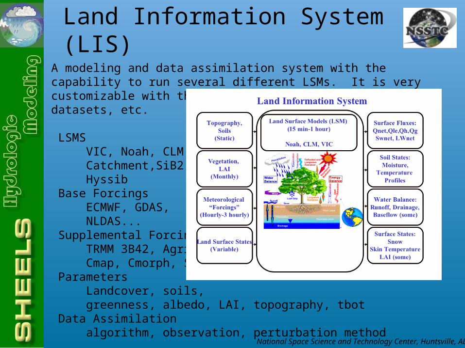
Land Information System (LIS)
A modeling and data assimilation system with the capability to run several different LSMs. It is very customizable with the ability to swap out LSMs, forcing datasets, etc.
LSMS VIC, Noah, CLM, Catchment,SiB2, Hyssib Base Forcings ECMWF, GDAS, NLDAS... Supplemental Forcings TRMM 3B42, Agrrad, Cmap, Cmorph, Stg4... Parameters Landcover, soils, greenness, albedo, LAI, topography, tbot Data Assimilation algorithm, observation, perturbation method

National Space Science and Technology Center, Huntsville, AL
SHEELS (Simulator for Hydrology and Energy Exchange at the Land Surface) is a spatially-distributed (grid cell) surface flux-hydrology model that can be run as a stand-alone model with meteorological input, or coupled with a meteorological model. Uses of the model include:
Provide areal soil moisture and surface energy flux estimates.Validate remotely-sensed moisture and temperature measurements where
observations are sparse or absent.Provide surface boundary conditions for mesoscale weather models.
HeritageBased on Biosphere-Atmosphere Transfer Scheme of Dickinson, 1986.Second generation: Ex-BATS of Smith et al., 1993. (Bill Crosson)Third generation: SHEELS, developed to include major modifications to soil layer structure, 1994.Added Kalman filter-based soil moisture assimilation scheme, 1998.Added full soil temperature diffusion scheme, 1999.Introduced overland flow and stream routing, 2001.Current version described in Martinez et al., 2001; Crosson et al., 2002.
SHEELS

National Space Science and Technology Center, Huntsville, AL
SHEELS:SHEELS:Simulator for Hydrology and EnergySimulator for Hydrology and Energy
Exchange at the Land SurfaceExchange at the Land Surface
Top ofcanopy
Bare soil energy fluxes
Surface runoff Groundheat flux
Sensible LatentShortwaveLongwave Precipitation
Interceptionby canopy
Canopy energy fluxes
Radiative Fluxes
Upper zone
Root zone
Bottom zone
Diffusion/drainage Heat exchange
SoilLayers
Wind
ThroughfallSensible Latent
Infiltration
Sub-surfacelateral flow

National Space Science and Technology Center, Huntsville, AL
SHEELS InputSHEELS InputTime-dependent input:• Wind speed• Air temperature• Relative humidity• Rainfall• Atmospheric pressure• Downwelling solar radiation• Downwelling longwave radiation
Required static variables:Soils: Landcover:Saturated hydraulic conductivity canopy heightSaturated matric potential fractional vegetation coverSoil wilting point minimum stomatal resistanceRooting depth leaf area indexSoil porosity reflectance properties
Topography:Surface elevation or slope
Soil texture classes

National Space Science and Technology Center, Huntsville, AL
SHEELS OutputSHEELS Output
SHEELS estimates many time-dependent variables at each grid point based on spatially-distributed meteorological input as well as soil, vegetation and topographic properties: Surface latent and sensible heat fluxes, Ground heat flux
including soil, canopy contributions Net radiationVapor mass fluxes from soil, canopy Reflected solar radiationSolar and longwave radiation absorbed Drag coefficients
by canopy and groundSoil surface and canopy temperatures Surface temperatureSoil temperature for each layer InfiltrationSoil moisture for each layer RunoffDepth of water on canopy (dew or rain) Ponded water

National Space Science and Technology Center, Huntsville, AL
SHEELS Output ExamplesSHEELS Output ExamplesTime/Depth Soil MoistureTime/Depth Soil Moisture
Fractional watercontent by volume
1997 Day of Year
Soil moisture is estimated for each layer. In this example there are 15 layers in the 2 m soil column.Note: - Surface drying - Penetration of wetting fronts - Transition at bottom of the root zone (1 m)

National Space Science and Technology Center, Huntsville, AL
Adding SHEELS to LIS•Added SHEELS as an LSM in LIS (rewrite code to fit into LIS structure)
•Enables use of LIS capabilities.•Run-time selection of base forcing, supplemental forcing, static data•Coupled WRF runs•EnKF data assimilation•Easy intercomparison with other models•MPI enabled•Allows subgrid variability in vegetation type
•Makes SHEELS available to LIS users.

National Space Science and Technology Center, Huntsville, AL
LSM Input Data
National Space Science and Technology Center, Huntsville, AL
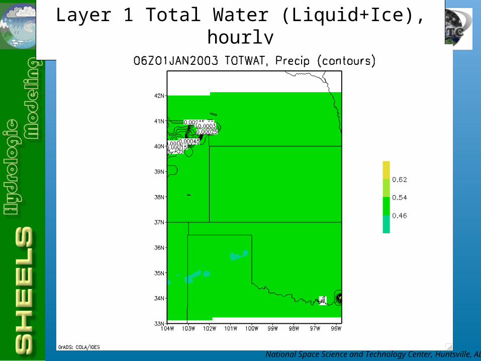
Layer 1 Total Water (Liquid+Ice), hourly

National Space Science and Technology Center, Huntsville, AL
Layer 1 Soil Ice (hourly)

National Space Science and Technology Center, Huntsville, AL
Snow cover (daily)
National Space Science and Technology Center, Huntsville, AL
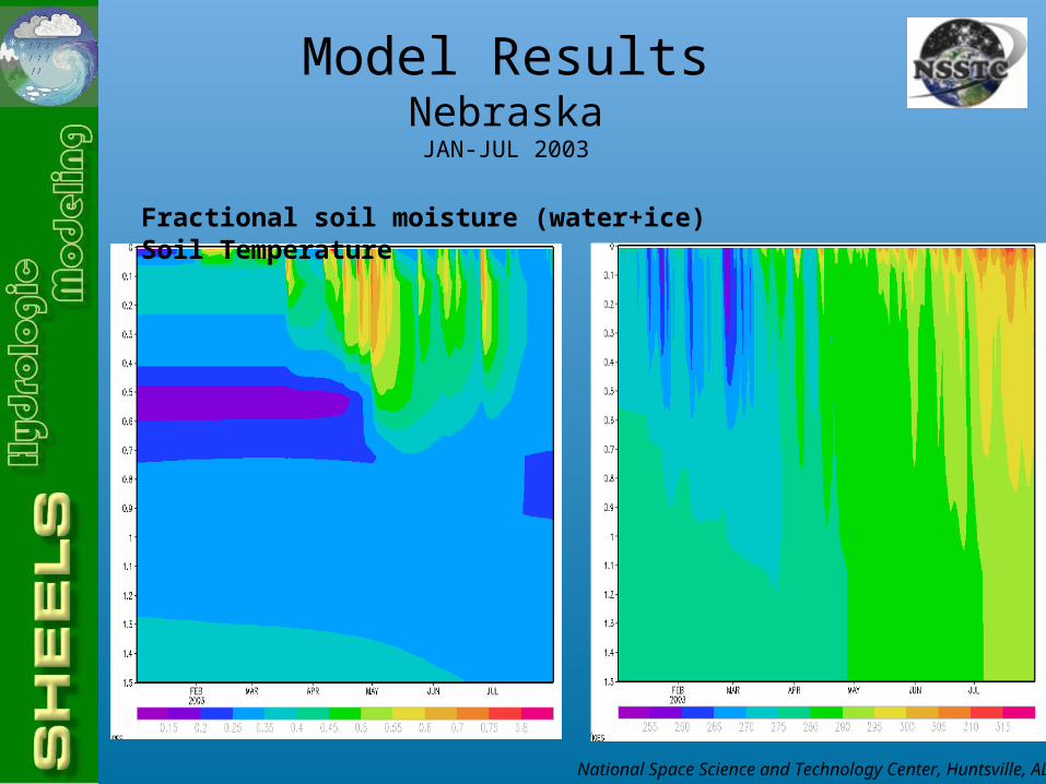
Fractional soil moisture (water+ice) Soil Temperature
Model ResultsNebraskaJAN-JUL 2003

National Space Science and Technology Center, Huntsville, AL
Fractional soil moisture (water+ice) Soil Temperature
Model ResultsN. TexasJAN-JUL 2003

National Space Science and Technology Center, Huntsville, AL
AMSR-E Soil Moisture Data
•Advanced Microwave Scanning Radiometer-EOS•On board NASA’s EOS Aqua satellite (sun-synchronous polar orbiter)
•Twice daily coverage•Measures microwave radiance at 6 frequencies with 10km sampling•Soil moisture measured by 10.65 GHz channel with resolution of 51x30 km
•Measures volumetric liquid water concentration in ~top 1 cm
Dataset: AMSR-E Level 3 Daily land product (25 km gridded)

National Space Science and Technology Center, Huntsville, AL
Ensemble Kalman filter (EnKF): The EnKF is initialized by creating an ensemble of N initial conditionfields around a mean model state at t=0, with an assumed covariance. The spread of an ensemble of N model ‘trajectories’ is used to estimate the error covariances. The full non-linear dynamic equations are used to propagate each ensemble member forward in time, thus determining the trajectories. This is in contrast to the traditional Kalman filter in which linearized model dynamics are used to propagate error covariances. The mean or median of the N ensemble states is used to define the state vector estimate. When observations are available, each ensemble member is updated based on the difference between the observation and the model state, weighted by the Kalman gain (as in the EKF). Random error is added to the observation based on assumed noise characteristics; this ensures that the variance of the updated ensemble matches the true estimation error covariances (Burgers et al., 1998, Mon. Wea. Rev.)Propagation of error covariance matrix is more stable than in the traditional Kalman filter, especially if there are strong non-linearities in the model.
Assumptions/issues in EnKF:Gaussion error distributions are assumed; this may be violated in some applications.A large ensemble may be needed for accurate determination of the error covariances.
Ensemble Kalman Filter

National Space Science and Technology Center, Huntsville, AL
Settings for Data AssimilationIn an EnKF, the relative strength of the background and observations is controlled by the observation error (specified) and the background error (derived from the ensemble, which depends on the state perturbations).
Observation: AMSR-E Surface Soil Moisture (g/cm3)Range: .01 to .52Error: .05
State: SHEELS 14-layer water fraction (0 to 1)Perturbation type: normalStandard deviation: .005 at surface, less belowCorrelation (vertical): 50% at ~2.3m
National Space Science and Technology Center, Huntsville, AL
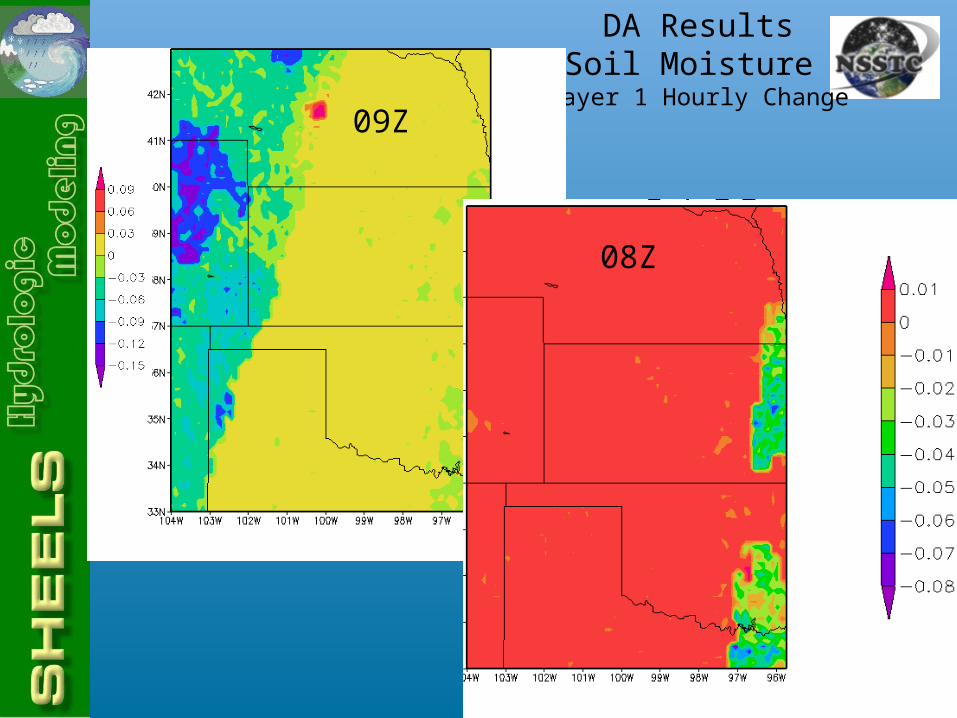
DA ResultsSoil Moisture
Layer 1 Hourly Change
08Z
09Z

National Space Science and Technology Center, Huntsville, AL
Assimilation ResultsSoil Moisture Layer 1
National Space Science and Technology Center, Huntsville, AL
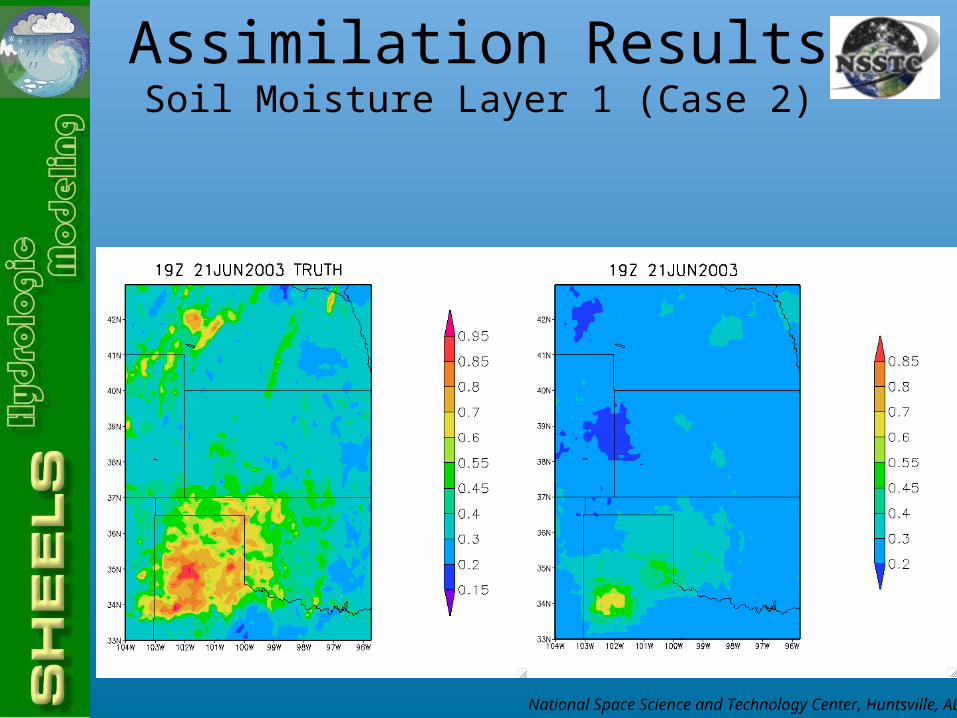
Assimilation ResultsSoil Moisture Layer 1 (Case 2)
National Space Science and Technology Center, Huntsville, AL