national report of canada, 3 twlwg meeting 5-7 april, … 3/twlwg3_3-c… · national report of...
TRANSCRIPT
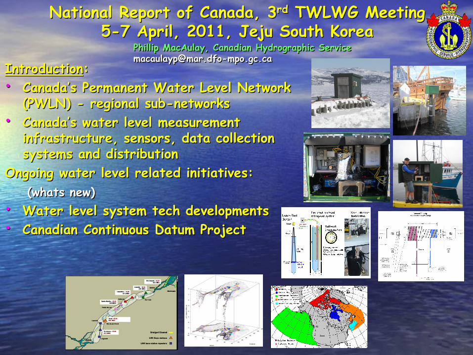
National Report of Canada, 3rd TWLWG Meeting5-7 April, 2011, Jeju South Korea
Introduction:
• Canada’s Permanent Water Level Network (PWLN) - regional sub-networks
• Canada’s water level measurement infrastructure, sensors, data collection systems and distribution
Ongoing water level related initiatives:
(whats new)
• Water level system tech developments
• Canadian Continuous Datum Project
Phillip MacAulay, Canadian Hydrographic [email protected]
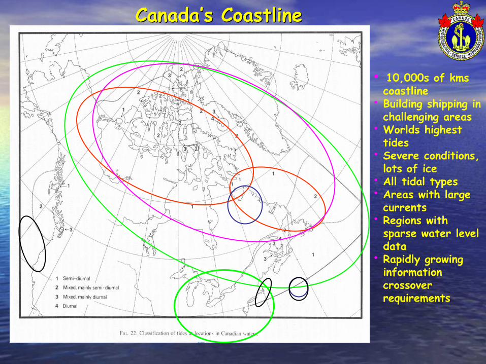
Canada’s Coastline
• 10,000s of kms coastline
• Building shipping in challenging areas
• Worlds highest tides
• Severe conditions, lots of ice
• All tidal types• Areas with large
currents• Regions with
sparse water level data
• Rapidly growing information crossover requirements
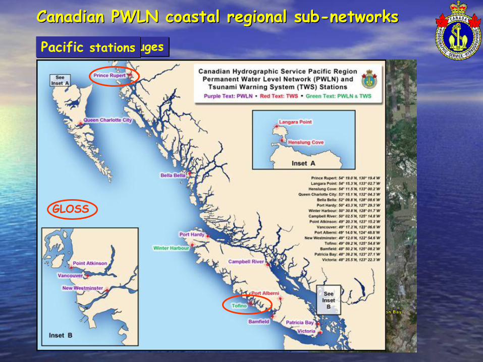
Canadian PWLN coastal regional sub-networks
Pacific PWLN gaugesPacific stations
GLOSS

Canadian PWLN coastal regional sub-networksCentral + Arctic PWLN gaugesCentral + Arctic stations
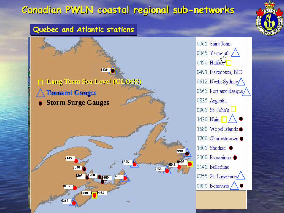
Canadian PWLN coastal regional sub-networks
Quebec’s PWLN gaugesAtlantic PWLN gauges
Long Term Sea Level (GLOSS)
Tsunami Gauges
Storm Surge Gauges
0990
0905
0755
17001805
2000
1430
06650835
0612
04910490
0365
0065
2145
1680
Quebec and Atlantic stations
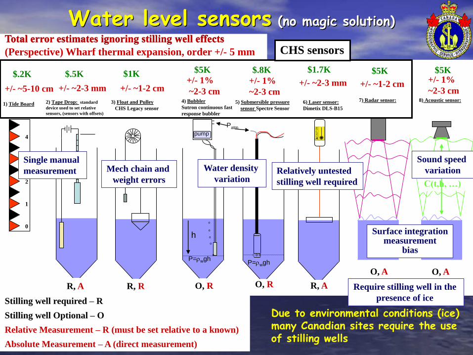
Water level sensors (no magic solution)
Stilling well required – R
Stilling well Optional – O
Relative Measurement – R (must be set relative to a known)
Absolute Measurement – A (direct measurement)
8) Acoustic sensor:
C(t,h, …)
Patm
3) Float and Pulley
CHS Legacy sensor
4) Bubbler
Sutron continuous fast
response bubbler
5) Submersible pressure
sensor Spectre Sensor
6) Laser sensor:
Dimetix DLS-B15
o
o
o
o
pump
P=rwgh
h
o 000
P=rwgh
0
1
2
3
4
1) Tide Board7) Radar sensor:2) Tape Drop: standard
device used to set relative
sensors, (sensors with offsets)
R, A R, AR, R
O, A
O, RO, R
O, A
+/- ~5-10 cm +/- ~1-2 cm+/- ~2-3 mm+/- 1%
~2-3 cm+/- ~1-2 cm+/- 1%
~2-3 cm+/- ~2-3 mm +/- 1%
~2-3 cm
(Perspective) Wharf thermal expansion, order +/- 5 mm
Total error estimates ignoring stilling well effects
Surface integrationmeasurement
bias
Sound speed
variationWater density
variation
Single manual
measurement Mech chain and
weight errorsRelatively untested
stilling well required
$.2K $1K$.5K$5K $.8K $1.7K $5K $5K
Require stilling well in the
presence of ice
CHS sensors
Due to environmental conditions (ice) many Canadian sites require the use of stilling wells
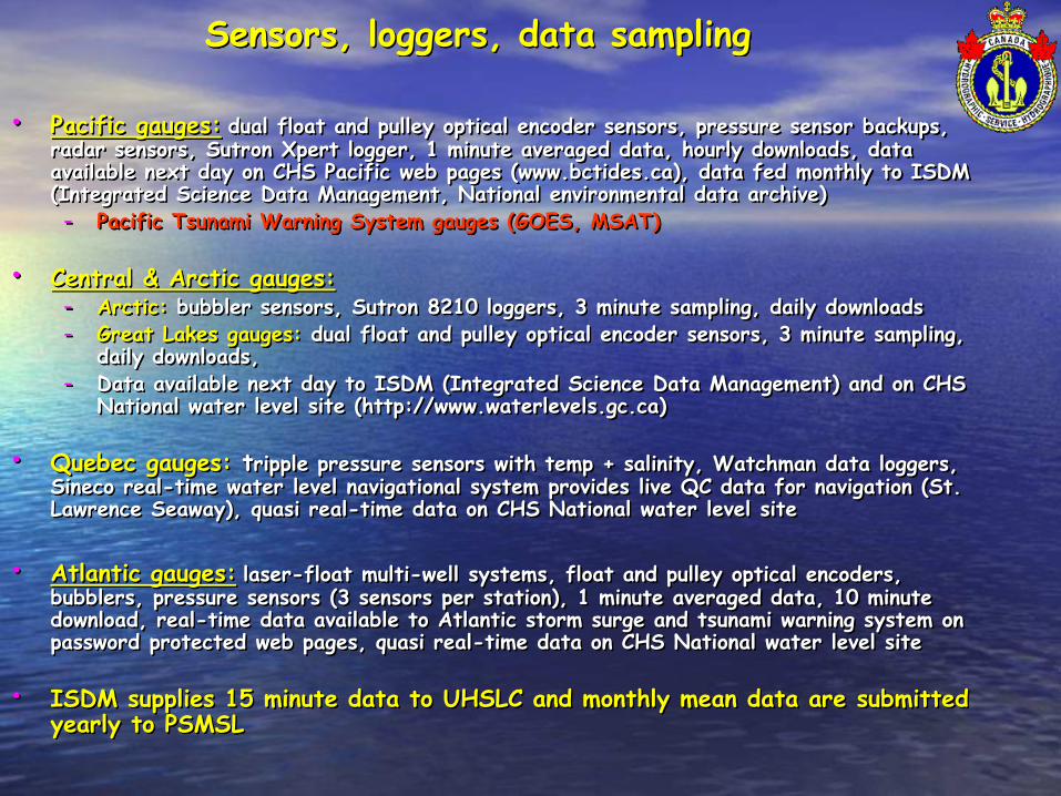
Sensors, loggers, data sampling
• Pacific gauges: dual float and pulley optical encoder sensors, pressure sensor backups, radar sensors, Sutron Xpert logger, 1 minute averaged data, hourly downloads, data available next day on CHS Pacific web pages (www.bctides.ca), data fed monthly to ISDM (Integrated Science Data Management, National environmental data archive)- Pacific Tsunami Warning System gauges (GOES, MSAT)
• Central & Arctic gauges:- Arctic: bubbler sensors, Sutron 8210 loggers, 3 minute sampling, daily downloads- Great Lakes gauges: dual float and pulley optical encoder sensors, 3 minute sampling,
daily downloads, - Data available next day to ISDM (Integrated Science Data Management) and on CHS
National water level site (http://www.waterlevels.gc.ca)
• Quebec gauges: tripple pressure sensors with temp + salinity, Watchman data loggers, Sineco real-time water level navigational system provides live QC data for navigation (St. Lawrence Seaway), quasi real-time data on CHS National water level site
• Atlantic gauges: laser-float multi-well systems, float and pulley optical encoders, bubblers, pressure sensors (3 sensors per station), 1 minute averaged data, 10 minute download, real-time data available to Atlantic storm surge and tsunami warning system on password protected web pages, quasi real-time data on CHS National water level site
• ISDM supplies 15 minute data to UHSLC and monthly mean data are submitted yearly to PSMSL
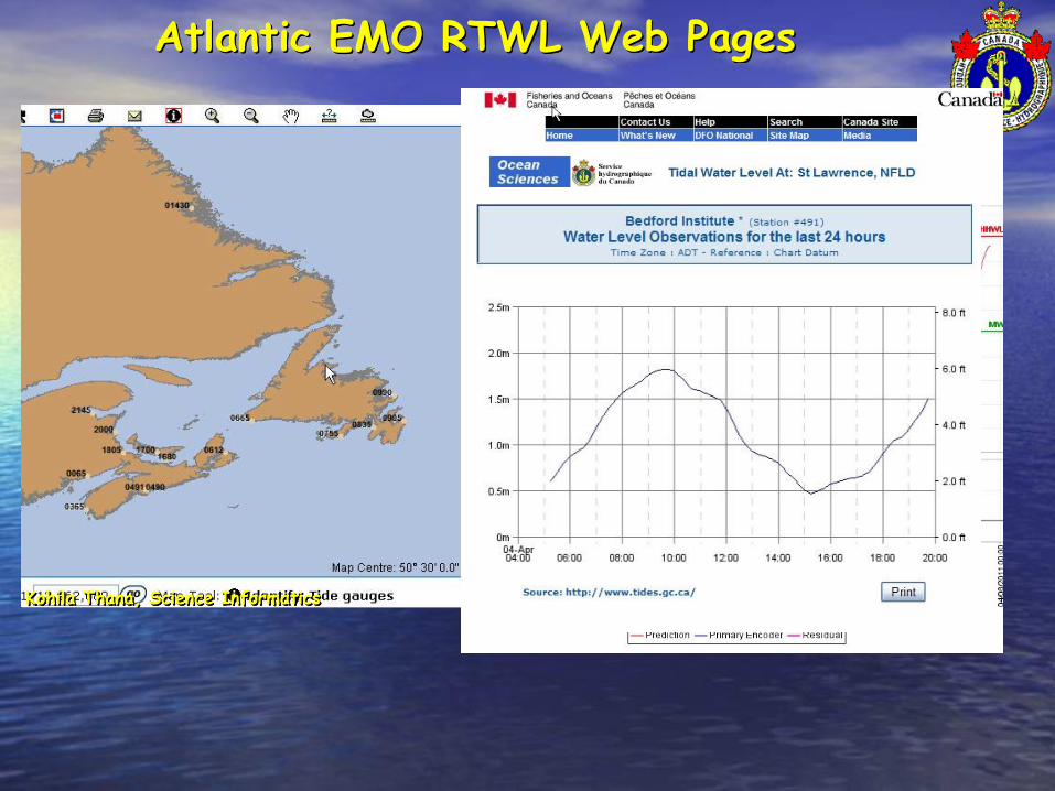
Atlantic EMO RTWL Web Pages
Kohila Thana, Science Informatics

Quebec’s Sineco System (St Lawrence seaway)
Ethernet
Réseau de lignes numériques/MUX
Serveur local Longueuil Serveur local Sorel
RouterPC / Océanus-SpyODIN
Ethernet
Réseau de lignes numériques/MUX
Serveur local Trois-Rivières Serveur local Montmagny
Router - MPO/Québec
Serveur local Mont-Bélair
Prévisions SINECODSO
Usager externeOcéanus
Internet
Frame Relay
Router Router
Hub
SCTM / MTL
SERVOX
Modem
Serveur téléphonique
SCTM / QUE
Usager externeOcéanus
MPO / Mont-Joli
MontmagnyMont-Bélair
Sorel
Ste-Marthe
Longueuil
Lie
n R
S-2
32
Lien 128 kbps
Lie
n d
éd
ié 5
6 k
bp
s
Lien 512 kbps
Lie
n d
éd
ié 5
6 k
bp
s
Lie
n d
éd
ié 5
6 k
bp
s
Lien dédié 56 kbps
Lien 384 kbps
Lie
n fib
re o
ptiq
ue
Observ ationsPrév isions (0-48 h)
Prédictions
Prév isions (2-30 jrs)
MUXMICOM
Rptr RDS
RX SINECO
TMS1000
Trois-Rivieres03360
TMS1000
Bécancour 03353
TMS1000
Batiscan03345
Vers usagersRDS
Rptr RDS
RX SINECO
Vers usagers
RDS
TMS1000
Contrecoeur15780
TMS1000
Sorel15930
TMS1000
Lac St-Pierre15975
Lie
n d
éd
ié 5
6 k
bp
s
St-Bruno
TX RDS
Vers usagers
RDS
RX SINECO
TMS1000
Montréal Jetée #115520
TMS1000
Montréal-Frontenac15540
TMS1000
Varennes15660
MUXMICOM
MUXMICOM
MUXMICOM
RX SINECO
TMS1000
Deschaillons03335
TMS1000 TMS1000
Neuville03280
TMS1000
Port de Québec03246
TMS1000
Lauzon03250
Portneuf03300
Rptr RDSVers usagers
RDS
MUXMICOM
TX RDS
RX SINECO
Vers usagersRDS
TMS1000 TMS1000
St-Joseph-de-la-Rive03057
St-François IO03100
Par: Michel Bernard 1-nov-2004DRA_SINECO_Réseau Observations-SHC_GCC_2004.vsd
Original: B.Tessier SHC/IML
Rptr RDS
Vers usagersRDS
Rptr RDSVers usagers
RDS
Grondines
Barre à Boulard(non installé)
Ste-Croix
MUXMICOM Lauzon
Rptr RDS
Vers usagersRDS
TMS1000
Modem
Ile d'Entrée01966
TMS1000
Modem
Port-Alfred03460
TMS1000
Modem
Rivière-au-Renard02330
TMS1000
Modem
Sept-Iles02780
TMS1000
Modem
Rimouski02985
MPO / QUE(104, Dalhousie)
Serveur central principalIML
Serveur central miroir104, Dalhousie
PC / Océanus-SpyOdin PC / Océanus-SpyOdin
• Broadcast modeled (river stage model) predictions and real-time observed waterlevels with interpolation between stations, originally radio, now web based.
• Uses GPS positioning and a continuous datum model for offset from ellipsoid to CD

New constituent analysis methodsVersatile Harmonic Tidal Analysis: Improvements and Applications
M. G. G. FOREMAN AND J. Y. CHERNIAWSKYInstitute of Ocean Sciences, Fisheries and Oceans Canada, Sidney, British Columbia, Canada
V. A. BALLANTYNECanadian Hydrographic Service, Fisheries and Oceans Canada, Sidney, British Columbia, Canada
(JOURNAL OF ATMOSPHERIC AND OCEANIC TECHNOLOGY, 2009, Vol 26)
Old Approach
New Approach
Permits analysis of long time-series and determination of long period constituents SA, SSA without vector averaging, new code allows direct selection of constituents for solution.
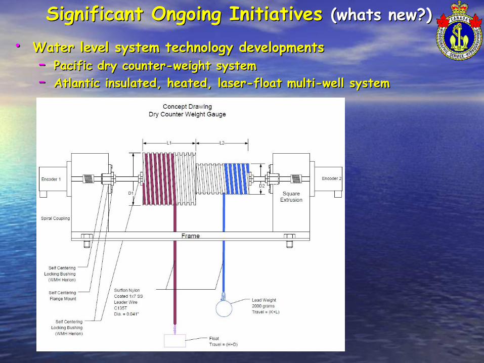
Significant Ongoing Initiatives (whats new?)
• Water level system technology developments– Pacific dry counter-weight system
– Atlantic insulated, heated, laser-float multi-well system

Insulated, heated multi-well and laser sensor

Well Construction
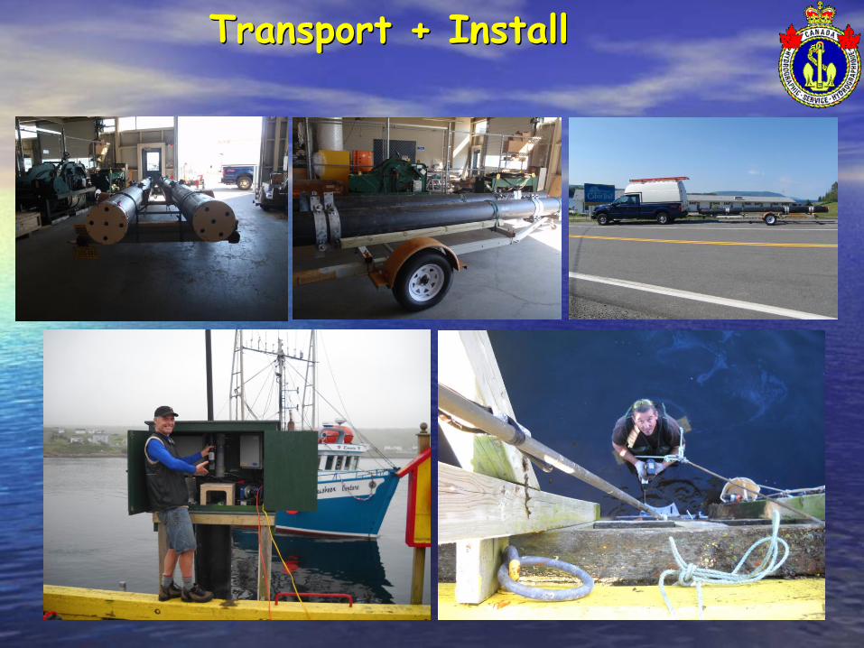
Transport + Install
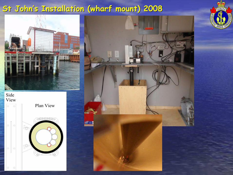
St John’s Installation (wharf mount) 2008
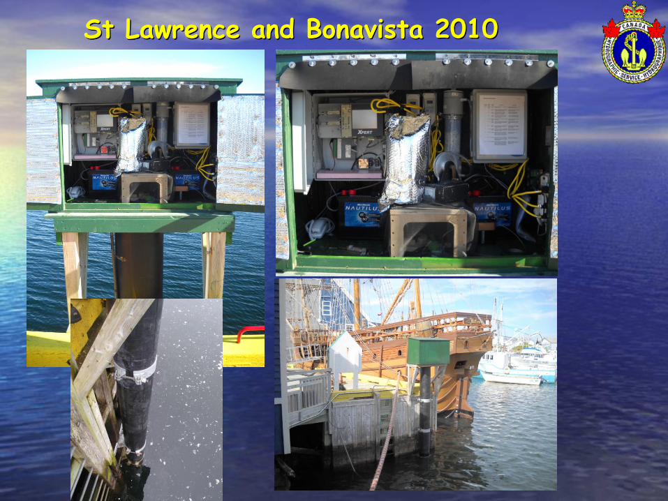
St Lawrence and Bonavista 2010
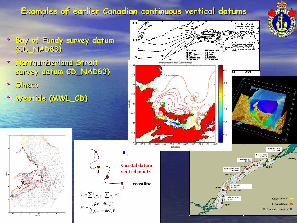
Examples of earlier Canadian continuous vertical datums
• Bay of Fundy survey datum (CD_NAD83)
• Northumberland Strait survey datum CD_NAD83)
• Sineco
• Webtide (MWL_CD)
1, jjji wwtT
j
p
j
p
j
jdistfar
distfarw
)(
)(
j
j
j
j
i
coastline
Coastal datum
control points

Canadian Continuous Vertical Datum Project
• National in scope: develop common strategies for all CHS regions (Pacific, Central and Arctic, Quebec and Atlantic)
• Present Status: – Planning methods
– Collecting, collating and improving shore based data and control
– Obtaining funding (this will ultimately determine timescale)
• Strategy:- Clean up shore based datum and target holdings and establish solid links to reference systems, NAD83(CSRS)xxxx, CGVD28
• In Progress, 24 hr occupations, NRCan PPP processed, references to NAD83(CSRS)2006 and CGVD28 (modeled HTv2.0)
- Mean water level in open ocean or far from land from satellite altimetry
- Open ocean and far from land transformations MLW_CDxxxx and to LATxxxx, HHWLTxxxx … (Ocean Modeling)
- Link offshore to shore based data (methods still under discussion May 2010, combination of VDATUM and VORF methods)

Starting with Webtide (really just an interpolation engine), Canadian version of the US VDatum tool including constituent
based water level prediction (test version completed)
Pred_CD, NAD83(CSRS)_CD, any gridded reference_CD
Constituents derived from a Hydrodynamic Barotropic Ocean Model
Assimilating Topex Posieden Altimeter data
Dupont, F., C.G. Hannah, D.A. Greenberg, J.Y. Cherniawsky and C.E. Naimie. 2002.
Modelling system for tides for the North-west Atlantic coastal ocean. [online].
[Accessed 21 April, 2008]. Available from World Wide Web: http://www.dfo-mpo.gc.ca/Library/265855.pdf
The End