national protected areas expansion strategy 2016 -...
TRANSCRIPT

National Protected Areas Expansion Strategy 2016: Spatial Issues
Stephen Holness [email protected], Andrew Skowno, Dave Balfour, James Jackelman
What I am not going to talk about…
• There is a new NPAES
• Builds on the 2008 NPAES
• Includes lots of institutional & other important but dull stuff like implementation frameworks….
• Consultation: Some technical consultation, PA task team, CEOs etc., and hopefully DEA will put it out more widely
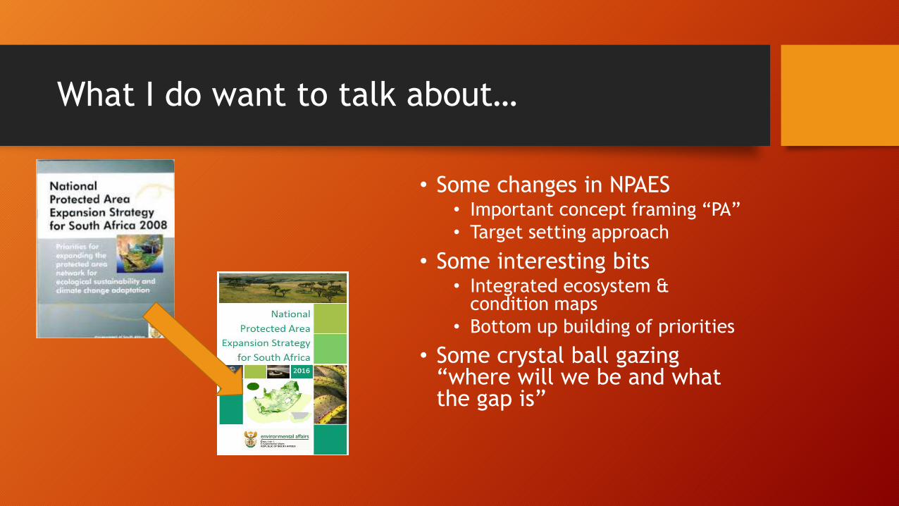
What I do want to talk about…
• Some changes in NPAES• Important concept framing “PA”
• Target setting approach
• Some interesting bits• Integrated ecosystem &
condition maps
• Bottom up building of priorities
• Some crystal ball gazing “where will we be and what the gap is”

That was then and this is now
2008:
• Few provincial plans & CBAs
• No FEPA, some early priorities
• No provincial PAES
• Few entities had any defined PA expansion priorities
• No marine map
2016:
• Everyone has plans
• Most provinces have some set of PAES priorities or even a formal PAES
• Decent habitat maps for all realms
• Establish principles
• We had to do quite a bit of planning
because there really was little to go on
• Keep all the good stuff & careful framing and messaging of v1
• NPAES sets out rules of the game (e.g. integrated maps, targets
and systematic approach)
• Evaluates where we are currently, progress and rate
• Collate priorities
• Evaluate where we will be if we do what we say we are doing

Where we are now….

Good but separate and
overlapping maps
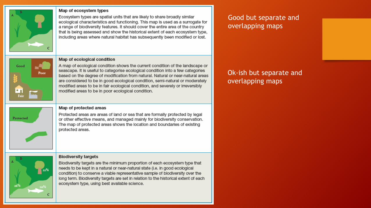
Good but separate and
overlapping maps
Ok-ish but separate and
overlapping maps

Good but separate and
overlapping maps
Ok-ish but separate and
overlapping maps
Better than it was but
mismatch between legal
and de facto

Good but separate and
overlapping maps
Ok-ish but separate and
overlapping maps
Better than it was but
mismatch between legal
and de facto
Separate, not explicit
“official” “PA” targets set
for many systems

Ecosystem map
• But not integrated
• Overlapping terrestrial, wetland, river
Decent separate maps
• River and coast lines vs area
• Benthic vs pelagic
Some spatial concept issues
• EstuariesSome flavour
issues

Building the ecosystem map
• Terrestrial Ecosystems: The revised 2012 National vegetation map based on Mucina & Rutherford (2006) was used.
• There are 450 ecosystem types.
• Wetlands: Natural wetlands included in the 2015 revised national wetland map (4a) were used.
• Wetlands were included at the group level which has 136 distinct ecosystem types.
• Coastal and marine types: The integrated coastal and benthic habitat maps prepared for the National Biodiversity Assessment 2012 was used as the starting point.
• Estuaries: Estuaries types were mapped based on the outlines in the national estuary map 2012 and the classification in Whitfield (1992).
• There are 46 estuary ecosystem types in 3 biozones.
• Rivers: River ecosystems were based on the NFEPA classification and dataset. • Variable buffer width based on stream order.


Category and Biozone Number of Ecosystem Types
Marine 109
Coast types 32
Inner Shelf 4
Inshore 10
Island 2
Lagoon 1
Offshore Benthic 60
Marine Pelagic 16
Marine Pelagic 16
Marine Southern Oceans 1
Southern Oceans 1
Terrestrial 445
Albany Thicket 14
Azonal Vegetation 36
Desert 15
Forests 12
Fynbos 122
Grassland 72
Indian Ocean Coastal Belt 6
Nama-Karoo 14
Savanna 90
Succulent Karoo 64
Subantarctic 5
Subantarctic Polar Desert 1
Subantarctic Tundra 4
Estuary 46
Estuary - Cool Temperate 12
Estuary - Subtropical 16
Estuary - Warm Temperate 18
Rivers 211
Rivers 211
Wetlands 136
Wetlands 136
Grand Total 969

Protected Areas
Currently we only evaluate
protected areas, but in
future other effective
area-based conservation
measures will be included

Progress
Mechanisms
Review against NPAES 2008

Targets
Note: 75% no-
take

Ecological Condition
Only intact areas should meet targets
• dams, plantations, rest camps, roads etc don’t contribute even if they are in a declared PA
Principle was in NPAES 2008
• But we only excluded dams in that assessment
Targets can only be met in
intact habitat. Hence, the
first ever integrated map
of ecosystem condition
was produced for South
Africa.

National Land Cover (NLC 2013/2014) for
inland areas
• The 72 land cover classes classified as good, fair, poor.
Marine ecosystems, estuaries, rivers and
wetlands
• National Biodiversity Assessment 2011.
Integrated based on the habitat type.
• Overridden by landcover.
Made a plan for PEI
• In principle needed to be on the map


Ecosystem
protection levelDefinition
Not ProtectedAn ecosystem type of which no intact area, or only a very small area (less
than 5% of the target), is located within the protected area network.
Poorly ProtectedAn ecosystem type in which less than half (but more than 5%) of the target
is located within the protected area network.
Moderately ProtectedAn ecosystem type in which more than half of the target for an ecosystem
type is located within the protected area network.
Well ProtectedAn ecosystem type in which the full target area falls within the protected
area network.
So finally we can evaluate protection levels…

201 (21%) Well Protected
122 (13%) Moderately Protected
286 (30%) Poorly Protected
360 (37%) Not Protected

21%
24%
13%
42%
Marine (Benthic and Coastal)
Well Protected Moderately Protected Poorly Protected Not Protected
38%
44%
9%9%
Coast Types
Well Protected Moderately Protected Poorly Protected Not Protected
18%
41%
29%
12%
Inner Shelf, Inshore, Islands & Lagoon
Well Protected Moderately Protected Poorly Protected Not Protected
14%
8%
10%
68%
Offshore Benthic
Well Protected Moderately Protected Poorly Protected Not Protected
12%
88%
Marine Pelagic
Well Protected Moderately Protected Poorly Protected Not Protected
100%
Marine Southern Oceans
Well Protected Moderately Protected Poorly Protected Not Protected

Priority Areas

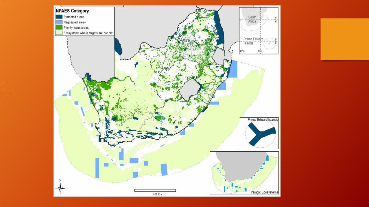
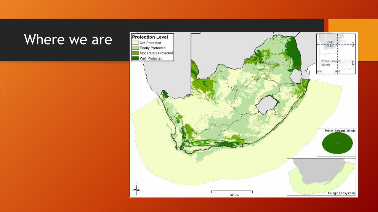
Where we are
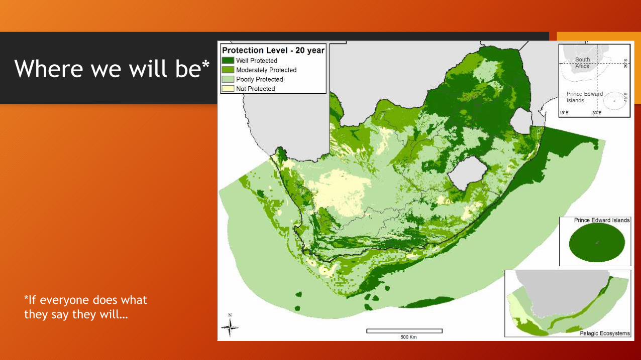
Where we will be*
*If everyone does what
they say they will…

Gaps
Important to recognize but not a criticism
• Current spatial implementation plans still leave “gap” in terms of securing target• Bigger and smaller baskets
• Different levels of ambition (realism??) between plans
• Shorter and longer timelines should also be noted
But this side is a big deal
• There is a major gap between our priorities and the actual commitmented deliverables over the next few years
• Structural problem (resources, mechanisms, approach)
• We need to fix this

Some concluding thoughts
• Hopefully the 2016 NPAES will be useful and eventually be openly available!
• It has highlighted to me how far we have moved in planning (and how much faster our implementation needs to be)
• There are some key improvements:• Clarify targets
• Secure the principle of building up national priorities from the provincial ones
• There are some issues raised that may be helpful to broader NBA discussion:• Can we move to integrated ecosystem maps rather than separate realm maps?
• Can we have an integrated condition map?
• Can we move to a PA map which fully accommodates both the legal/administrative and planning/assessment needs?