national oil and gas assessment project assessment of ... · fact sheet 2010–3043 june 2010...
TRANSCRIPT
U.S. Department of the InteriorU.S. Geological Survey
Fact Sheet 2010–3043June 2010
Assessment of Undiscovered Natural Gas Resources of the Arkoma Basin Province and Geologically Related Areas
Printed on recycled paper
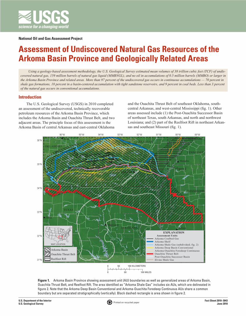
IntroductionThe U.S. Geological Survey (USGS) in 2010 completed
an assessment of the undiscovered, technically recoverable petroleum resources of the Arkoma Basin Province, which includes the Arkoma Basin and Ouachita Thrust Belt, and two adjacent areas. The principle focus of this assessment is the Arkoma Basin of central Arkansas and east-central Oklahoma
Using a geology-based assessment methodology, the U.S. Geological Survey estimated mean volumes of 38 trillion cubic feet (TCF) of undis-covered natural gas, 159 million barrels of natural gas liquid (MMBNGL), and no oil in accumulations of 0.5 million barrels (MMBO) or larger in the Arkoma Basin Province and related areas. More than 97 percent of the undiscovered gas occurs in continuous accumulations — 70 percent in shale gas formations, 18 percent in a basin-centered accumulation with tight sandstone reservoirs, and 9 percent in coal beds. Less than 3 percent of the natural gas occurs in conventional accumulations.
and the Ouachita Thrust Belt of southeast Oklahoma, south-central Arkansas, and west-central Mississippi (fig. 1). Other areas assessed include (1) the Post-Ouachita Successor Basin of northeast Texas, south Arkansas, and north and northwest Louisiana; and (2) part of the Reelfoot Rift in northeast Arkan-sas and southeast Missouri (fig. 1).
ARKANSAS
LOUISIANA
MISSISSIPPI
OKLAHOMA
TENNESSEE
TEXAS
MISSOURI89°W90°W91°W92°W93°W94°W95°W96°W
36°N
35°N
34°N
33°N
32°N
31°N
Cretaceous O
verlap
Tulsa
Memphis
Dallas
JacksonShreveport
Little Rock
0 50 100 MILES
0 50 100 KILOMETERS
MAP LOCATION
Arkoma BasinOuachita Thrust BeltReelfoot Rift
Assessment UnitsArkoma Coalbed GasArkoma ShelfArkoma Shale Gas (subdivided; fig. 2)Arkoma Deep Basin ConventionalArkoma-Ouachita Foredeep Continuous Ouachita Thrust BeltPost-Ouachita Successor BasinElvins Shale Gas
Figure 2
EXPLANATION
Figure 1. Arkoma Basin Province showing assessment unit (AU) boundaries as well as generalized areas of Arkoma Basin, Ouachita Thrust Belt, and Reelfoot Rift. The area identified as “Arkoma Shale Gas” includes six AUs, which are delineated in figure 2. Note that the Arkoma Deep Basin Conventional and Arkoma-Ouachita Foredeep Continuous AUs share a common boundary but are separated stratigraphically (vertically). Black dashed rectangle is area shown in figure 2.
National Oil and Gas Assessment Project
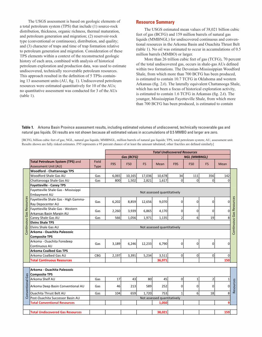
The USGS assessment is based on geologic elements of a total petroleum system (TPS) that include (1) source-rock distribution, thickness, organic richness, thermal maturation, and petroleum generation and migration; (2) reservoir-rock type (conventional or continuous), distribution, and quality; and (3) character of traps and time of trap formation relative to petroleum generation and migration. Consideration of these TPS elements within a context of the reconstructed geologic history of each area, combined with analysis of historical petroleum exploration and production data, was used to estimate undiscovered, technically recoverable petroleum resources. This approach resulted in the definition of 5 TPSs contain-ing 13 assessment units (AU, fig. 1). Undiscovered petroleum resources were estimated quantitatively for 10 of the AUs; no quantitative assessment was conducted for 3 of the AUs (table 1).
Total Undiscovered ResourcesGas (BCFG) NGL (MMBNGL)
Total Petroleum System (TPS) and Assessment Unit (AU)
Field Type
F95 F50 F5 Mean F95 F50 F5 Mean
Woodford - Chattanooga TPSWoodford Shale Gas AU Gas 6,065 10,165 17,036 10,678 34 111 356 142Chattanooga Shale Gas AU Gas 800 1,502 2,821 1,617 0 0 0 0Fayetteville - Caney TPSFayetteville Shale Gas - Mississippi Embayment AU
Not assessed quantitatively
Fayetteville Shale Gas - High Gamma-Ray Depocenter AU
Gas 6,202 8,859 12,656 9,070 0 0 0 0
Fayetteville Shale Gas - Western Arkansas Basin Margin AU
Gas 2,260 3,939 6,865 4,170 0 0 0 0
Caney Shale Gas AU Gas 566 1,056 1,971 1,135 2 6 19 8Elvins Shale TPSElvins Shale Gas AU Not assessed quantitativelyArkoma - Ouachita Paleozoic Composite TPSArkoma - Ouachita Foredeep Continuous AU
Gas 3,189 6,246 12,233 6,790 0 0 0 0
Arkoma Coalbed Gas TPSArkoma Coalbed Gas AU CBG 2,197 3,391 5,234 3,511 0 0 0 0Total Continuous Resources 36,971 150
Arkoma - Ouachita Paleozoic Composite TPSArkoma Shelf AU Gas 17 43 80 45 0 1 2 1
Arkoma Deep Basin Conventional AU Gas 46 213 589 252 0 0 0 0
Ouachita Thrust Belt AU Gas 104 659 1,720 753 1 6 18 8Post-Ouachita Successor Basin AU Not assessed quantitativelyTotal Conventional Resources 1,050 9
Total Undiscovered Gas Resources 38,021 159
Cont
inuo
us G
as R
esou
rces
Conv
entio
nal G
as
Reso
urce
sCo
ntin
uous
Gas
Res
ourc
es
Table 1. Arkoma Basin Province assessment results, including estimated volumes of undiscovered, technically recoverable gas and natural gas liquids. Oil results are not shown because all estimated values in accumulations of 0.5 MMBO and larger are zero.
[BCFG, billion cubic feet of gas; NGL, natural gas liquids; MMBNGL, million barrels of natural gas liquids; TPS, total petroleum system; AU, assessment unit. Results shown are fully risked estimates. F95 represents a 95 percent chance of at least the amount tabulated; other fractiles are defined similarly]
Resource SummaryThe USGS estimated mean values of 38,021 billion cubic
feet of gas (BCFG) and 159 million barrels of natural gas liquids (MMBNGL) for undiscovered continuous and conven-tional resources in the Arkoma Basin and Ouachita Thrust Belt (table 1). No oil was estimated to occur in accumulations of 0.5 million barrels (MMBO) or larger.
More than 26 trillion cubic feet of gas (TCFG), 70 percent of the total undiscovered gas, occurs in shale-gas AUs defined within two formations. The Devonian-Mississippian Woodford Shale, from which more than 700 BCFG has been produced, is estimated to contain 10.7 TCFG in Oklahoma and western Arkansas (fig. 2A). The laterally equivalent Chattanooga Shale, which has not been a focus of historical exploration activity, is estimated to contain 1.6 TCFG in Arkansas (fig. 2A). The younger, Mississippian Fayetteville Shale, from which more than 700 BCFG has been produced, is estimated to contain
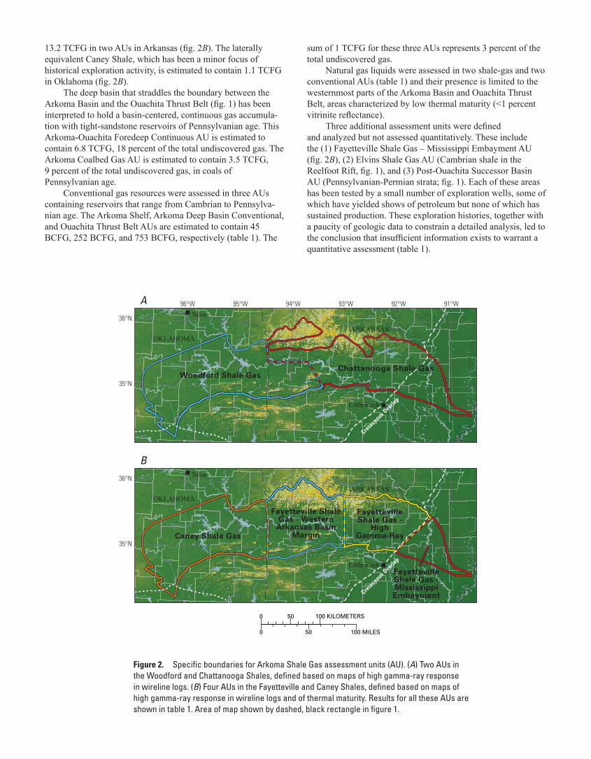
13.2 TCFG in two AUs in Arkansas (fig. 2B). The laterally equivalent Caney Shale, which has been a minor focus of historical exploration activity, is estimated to contain 1.1 TCFG in Oklahoma (fig. 2B).
The deep basin that straddles the boundary between the Arkoma Basin and the Ouachita Thrust Belt (fig. 1) has been interpreted to hold a basin-centered, continuous gas accumula-tion with tight-sandstone reservoirs of Pennsylvanian age. This Arkoma-Ouachita Foredeep Continuous AU is estimated to contain 6.8 TCFG, 18 percent of the total undiscovered gas. The Arkoma Coalbed Gas AU is estimated to contain 3.5 TCFG, 9 percent of the total undiscovered gas, in coals of Pennsylvanian age.
Conventional gas resources were assessed in three AUs containing reservoirs that range from Cambrian to Pennsylva-nian age. The Arkoma Shelf, Arkoma Deep Basin Conventional, and Ouachita Thrust Belt AUs are estimated to contain 45 BCFG, 252 BCFG, and 753 BCFG, respectively (table 1). The
91°W92°W93°W94°W95°W96°W
36°N
35°N
36°N
35°NCaney Shale Gas
Fayetteville Shale Gas -
High Gamma-Ray
FayettevilleShale Gas -MississippiEmbayment
Fayetteville ShaleGas - Western
Arkansas BasinMargin
Woodford Shale Gas
Cretaceous O
verlap
Cretaceous O
verlap
ARKANSASOKLAHOMA
ARKANSASOKLAHOMA
Tulsa
Little Rock
Tulsa
Little Rock
0 50 100 MILES
0 50 100 KILOMETERS
A
B
Chattanooga Shale Gas
Figure 2. Specific boundaries for Arkoma Shale Gas assessment units (AU). (A) Two AUs in the Woodford and Chattanooga Shales, defined based on maps of high gamma-ray response in wireline logs. (B) Four AUs in the Fayetteville and Caney Shales, defined based on maps of high gamma-ray response in wireline logs and of thermal maturity. Results for all these AUs are shown in table 1. Area of map shown by dashed, black rectangle in figure 1.
sum of 1 TCFG for these three AUs represents 3 percent of the total undiscovered gas.
Natural gas liquids were assessed in two shale-gas and two conventional AUs (table 1) and their presence is limited to the westernmost parts of the Arkoma Basin and Ouachita Thrust Belt, areas characterized by low thermal maturity (<1 percent vitrinite reflectance).
Three additional assessment units were defined and analyzed but not assessed quantitatively. These include the (1) Fayetteville Shale Gas – Mississippi Embayment AU (fig. 2B), (2) Elvins Shale Gas AU (Cambrian shale in the Reelfoot Rift, fig. 1), and (3) Post-Ouachita Successor Basin AU (Pennsylvanian-Permian strata; fig. 1). Each of these areas has been tested by a small number of exploration wells, some of which have yielded shows of petroleum but none of which has sustained production. These exploration histories, together with a paucity of geologic data to constrain a detailed analysis, led to the conclusion that insufficient information exists to warrant a quantitative assessment (table 1).
For Further InformationSupporting geologic reports on the Arkoma
Basin assessment are in preparation. These reports will be available as completed at the USGS Web site at: http://energy.cr.usgs.gov/oilgas/noga
Arkoma Basin Province Assessment Team: David W. Houseknecht (Task Leader; [email protected]), James L. Coleman, Robert C. Milici, Christopher P. Garrity, William A. Rouse, Bryant R. Fulk, Stanley T. Paxton, Marvin M. Abbott, John C. Mars, Troy A. Cook, Christopher J. Schenk, Ronald R. Charpentier, Timothy R. Klett, Richard M. Pollastro, and Geoffrey S. Ellis.
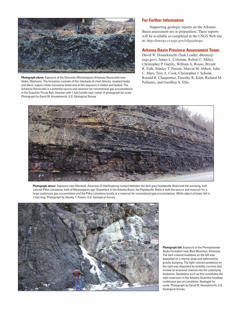
Photograph above: Exposure near Marshall, Arkansas of interfingering contact between the dark gray Fayetteville Shale and the overlying, buff colored Pitkin Limestone, both of Mississippian age. Elsewhere in the Arkoma Basin, the Fayetteville Shale is both the source and reservoir for a large continuous gas accumulation and the Pitkin Limestone locally is a reservoir for conventional gas accumulations. White object at lower-left is 1 foot long. Photograph by Stanley T. Paxton, U.S. Geological Survey.
Photograph above: Exposure of the Devonian-Mississippian Arkansas Novaculite near Atoka, Oklahoma. The formation consists of thin interbeds of chert (blocky, resistant beds) and black, organic shale (recessive beds) and at this exposure is folded and faulted. The Arkansas Novaculite is a potential source and reservoir for conventional gas accumulations in the Ouachita Thrust Belt. Hammer with 1 foot handle near center of photograph for scale. Photograph by David W. Houseknecht, U.S. Geological Survey
Photograph left: Exposure of the Pennsylvanian Atoka Formation near Blue Mountain, Arkansas. The dark-colored mudstone on the left was deposited on a marine slope and deformed by gravity slumping. The light-colored sandstone on the right was deposited by turbidity currents that incised an erosional channel into the underlying mudstone. Sandstone such as this constitutes the main reservoirs in the Arkoma-Ouachita foredeep continuous gas accumulation. Geologist for scale. Photograph by David W. Houseknecht, U.S. Geological Survey.