national museums 0f kenya
TRANSCRIPT

NATIONAL MUSEUMS 0F KENYA
WHERE I-IERITAGE L-VES ON
Ref: NMK/UN/2/1
31stJanuaiy2019
Dr. Mechtild Rossler,
Director of World Héritage Centre,UNESCO7, Place de Fontenoy, 75352 Paris CEDEX 07FRANCE
Dear Dr. Rossler,
RE: SOC REPORT FOR 4l COKE 7B. 21 KENYA LAKE SYSTEM IN THEGREAT RIFT VALLEY (KENYA) (N 1060REV)
Kindly receive thé State of Conservation report for thé Kenya Lakes System inGréât Rift Valley for year 2018. l apologize for thé late submission of this reportwhich was supposed to hâve been submitted by lst December 2018 but it wasnot possible due to some unavoidable challenges.
Yours sincerely,
Stanvas Ongalo
For: Director Général
/<MAA<^
., Mit.sii.wHis.eaetS'Si
Address P.O. Box 406S8 001 00 GPO Nairobi Téléphone 254 20 4448930/3. 254 20 3742161, 4. 254 20 3742131, 4 Fax 254 20 3741424 Websfte www.museums. or.ke

State of Conservation report 2019
Kenya Lakes System in the Great Rift Valley (Kenya), Decision: 41 COM 7B.21 (N 1060rev)
Executive Summary: The Kenya Lakes System in the Great Rift Valley comprises of three properties, namely Lake Bogoria, Lake Elementaita and Lake Nakuru. The natural sites all have management plans that are in review. Lake Nakuru management plan has expired but the internal review process has begun. Both lakes Elementaita and Bogoria, the management plans are being prepared with input from the stakeholders as outlined in the annexes attached.
A boundary survey exercise was undertaken between 24th to 31 May 2016. The survey points were sent to the Survey of Kenya for Gazettement. However, the Survey of Kenya advised that the Survey be repeated to reflect the flooding situation. The survey report is herewith attached as well as communication from the Survey of Kenya.
There have not been plans for geothermal exploration around the lake Elementaita area nor at Lake Bogoria. As regards the Endorois concerns, since the signing of the Kabarnet Declaration in 2014, the position has changed. The Endorois Welfare Council (EWC) and the County Government of Baringo have been developing a Joint Integrated Management Plan for the Lake Bogoria Ecosystem. Kenya Wildlife Service is offering technical support for the activity. Several stages have been achieved. A scoping meeting was undertaken on 31 March 2016 and the report is herein attached. Five members of the Endorois Welfare Council attended the scoping meeting as evidenced by the list of meeting attendants in the report. Currently, the drafting of the Management programs is being undertaken. There is a draft management plan for the Lake Elementaita Wildlife Sanctuary Ecosystem Management which is awaiting a final endorsement by the stakeholders before it can be presented to the KWS board. The draft plan is herewith attached.

1. Having examined Document WHC/17/41.COM/7B, 2. Recalling Decisions 35 COM 8B.6, 38 COM 7B.91 and 39 COM 7B.5, adopted at its 35th (UNESCO,
2011), 38th (Doha, 2014) and 39th (Bonn, 2015) sessions respectively, 3. Taking note of the progress of the Lake Elementaita Wildlife Sanctuary boundary modification
project, which aims to address encroachment and clearance of natural riparian vegetation in the areas adjoining the property by expanding the protected area, requests the State Party to submit a map of the new proposed boundaries, and encourages the State Party to incorporate into the next phase of the project proposals to strengthen the protection of the areas between Lakes Nakuru and Elementaita;
A boundary survey exercise was undertaken between 24th to 31 May 2016. The survey points were sent to the Survey of Kenya for gazettement. However, the Survey of Kenya advised that the Survey be repeated to reflect the flooding situation. The survey report is herewith attached as well as communication from the Survey of Kenya.
4. Notes the reported collaboration between the State Party and the local communities in revising the Lake Elementaita Management Plan, which will be submitted to the World Heritage Centre for review by IUCN, upon completion;
There is a draft management plan for the Lake Elementaita Wildlife Sanctuary Ecosystem Management which is awaiting a final endorsement by the stakeholders before it can be presented to the KWS board. The draft plan is herewith attached.
5. Reiterates its request to the State Party to report on: 1. The current status of potential geothermal prospecting activities undertaken adjacent to
the property, including the status of any Environmental Impact Assessments (EIAs), in accordance with Paragraph 172 of the Operational Guidelines,
There have not been plans for geothermal exploration around the Lake Elementaita area nor at Lake Bogoria.
2. Progress made to implement the African Commission on Human and Peoples’ Rights (ACHPR) Endorois ruling to ensure the full and effective participation of the Endorois in the management and decision-making of Lake Bogoria,
Regarding the Endorois concerns, since the signing of the Kabarnet Declaration in 2014, the position has changed. The Endorois Welfare Council (EWC) and the County Government of Baringo have been collaborating in the development of a Joint Integrated Management Plan for the Lake Bogoria Ecosystem. The State Party of Kenya wishes to clarify that Lake Bogoria was gazetted as a National Reserve and not as a National Park. Thus it is managed by the Baringo County Government. In Kenya, a National Reserve means that an area so gazetted is a trust land and therefore a community land but under management by the local government which manages such lands in the interests of the local population. The Kenya Wildlife Service is offering technical support for the activity. Several stages have been achieved. A scoping meeting was undertaken on 31 March 2016 and the report is herein attached. Five members of the Endorois Welfare Council attended the scoping meeting as evidenced by the list of meeting attendants in the report. Currently, the drafting of the Management programs is being undertaken.

3. Actions taken to ensure the removal of any existing illegal developments, to carry out the ecological restoration of affected areas, and to develop and implement strict and clear regulations to prohibit developments in close proximity to fragile habitats and in the critical buffer zone to the property;
As already explained in paragraph 3, a boundary survey exercise was undertaken in May 2016 but the Survey of Kenya advised that the Survey be repeated to reflect the flooding situation. It needs to be noted that all the central rift valley lakes have experienced an explained rise of the water levels to an extent which has not been known before in recorded history. This implies that there is still more work to be done to ascertain and agree on the official riparian area.
6. Also requests the State Party of Tanzania to report on the soda ash deposit investigation at Lake Natron as soon as any information is available, and before taking any decisions that may be difficult to reverse, in accordance with Paragraph 172 of the Operational Guidelines;
7. Further requests the State Party to submit to the World Heritage Centre, by 1 December 2018, an updated report on the state of conservation of the property and the implementation of the above, for examination by the World Heritage Committee at its 43rd session in 2019.
Signature of the Authority
Mr. David Mbuthia For: Director Antiquities Sites and Monuments National Museums of Kenya

Lake Bogoria National
Reserve Ecosystem
Management Plan
Plan Scoping Report
Proceedings of the Plan Scoping Workshop for Lake Bogoria National Reserve Ecosystem Held on 31 March, 2016 at Rift Valley Hills Resort, Kabarnet Town

Lake Bogoria National Reserve Ecosystem Management Plan: Plan Scoping Report
ii
Contents
1. Introduction ..................................................................................................................... 1
2. Geographical Scope of the Management Plan ................................................................ 1
3. Plan ownership ............................................................................................................... 3
4. Preliminary identification of problems and opportunities to be addressed by the plan ..... 4
5. Preliminary management themes Identification ............................................................... 6
6. Preliminary identification of management actions to address conservation and management related problems in LBNRE ........................................................................... 7
7. LBNRE Exceptional Resource Values (ERVs) ...............................................................10
8. Stakeholder Analysis ......................................................................................................11
9. Participation and Communication Strategy ....................................................................12
10. Planning Process Events and Timing ...........................................................................13
11. Core Planning Team Membership, Roles and Responsibilities ....................................14
12. Management Planning Activities for the Next six Months .............................................15
List of Figures
Figure 1: Lake Bogoria National Reserve ............................................................................ 3
Figure 2: Planning process events and estimated timing ....................................................14
List of Tables
Table 1: Identification of problems and opportunities .......................................................... 4
Table 2: Potential management programmes and major themes ........................................ 6
Table 3: Group one: Ecological management problems and proposed actions ................... 7
Table 4: Group Two: Tourism development and management problems and proposed actions ................................................................................................................................ 8
Table 5: Group 3: Community partnership and conservation education management problems and proposed actions .......................................................................................... 9
Table 6: Group 4: Operations and security management problems and actions .................. 9
Table 7: LBNRE’s Exceptional Resource Values and their categorization .........................11
Table 8: A preliminary analysis of stakeholders for LBNRE Management Plan ..................12
Table 9: Planning Participation and Communication Strategy ............................................12

Lake Bogoria National Reserve Ecosystem Management Plan: Plan Scoping Report
iii
List of Annexes
Annex 1 : Speech by His Excellency the Governor, Hon. Benjamin C. Cheboi EBS, on the Occasion of Launching Lake Bogoria Management Planning Process at the Rift Valley Hills Resort on 31st March, 2016 .............................................................................17
Annex 2 : Lake Bogoria Management Plan – ABS Perspective: Presentation By Mukonyi Kavaka Watai, KWS .............................................................................................20
Annex 3 : Community Protocols, Presentation By Rose Birgen, Natural Justice ................27
Annex 4 : List of Participants for the Stakeholders Plan Scoping Workshop for Development of Lake Bogoria National Reserve Management Plan, Rift Valley Hills Resort, Kabarnet, 31st March, 2016 ...................................................................................33
Annex 5 : LBNRE Plan Scoping Meeting Agenda ..............................................................35
Lake Bogoria National Reserve Ecosystem Management Plan: Plan Scoping Report
1
1. Introduction
This report sets out the scope of work for the development of a new management plan for the Lake Bogoria National Reserve Ecosystem (LBNRE). The scope of work was developed by the LBNRE stakeholders at a Plan Scoping Workshop held at Rift Valley Hills Resort, Kabarnet on 31st March, 2016. The meeting was opened by His Excellency the Governor, County Government of Baringo Hon. Cheboi and closed by the Deputy County Commissioner in charge of Marigat Sub-County, Mr. Thomas Sakah. Mr. Kavaka Watai from KWS presented background information on the project named “Developing the Microbial Biotechnology Industry from Kenya's Soda Lakes in line with the Nagoya Protocol” (referred
to as the Soda Lakes Project); while Rose Birgen from Natural Justice, an NGO, made a presentation on Community Protocols (see Annexes 2 and 3). The workshop was facilitated by the KWS Conservation Planner, Apollo Kariuki, and funded by the Soda Lakes Project. This plan scoping report outlines the key decisions made by stakeholders at the stakeholders plan scoping workshop. It is founded on the framework provided by the Protected Areas Planning Framework, the KWS management planning standard. The principal objective of the Plan Scoping Workshop was to develop specific “terms of reference” for the development of the LBNRE management plan. These terms of reference include:
A consideration of who owns the management plan and is responsible for its implementation
A definition of the geographical scope of the plan
Details of the management problems and opportunities to be addressed by the plan
The preliminary identification of Management Programmes to address these problems and opportunities
Identification of exceptional resource values in the LBNRE
The identification of information needs for planning, and responsibilities for information collection and report write up
Scheduling the planning process events and approximate timing
Carrying out an analysis of stakeholders potentially affected by the plan
Developing a participation and communication strategy for the development of the plan
Defining Core Planning Team roles and responsibilities
Summaries of the workshop discussions and the decisions made regarding each of the points outlined above are set out in the following sections of this report. Details of participants of the plan scoping workshop are given in Annex 4.
2. Geographical Scope of the Management Plan
The two main options for the appropriate geographical scope of the new management plan are:
The core protected area: i.e. Lake Bogoria National Reserve (LBNR)
The wider LBNR Ecosystem (LBNRE), comprising the protected area plus the adjacent community land whose residents interact a lot with the protected area, including the lakes water catchment area.
In deciding on the geographic scope of the plan the meeting was guided by the following questions:

Lake Bogoria National Reserve Ecosystem Management Plan: Plan Scoping Report
2
1. Is the Protected Area (PA) an “island” without a dispersal area? i.e. surrounded
by conservation-incompatible land uses
2. Does the PA have a buffer zone (conservation compatible land uses) and if so,
what is the extent of wildlife dispersal in this buffer zone?
3. Does the PA border other PAs e.g. national reserves or forest reserves?
4. Which ecological processes link the PA to the surrounding areas? E.g. River
flow, wildlife migration
5. What is the nature and extent of human/PA interactions?
After deliberating on the above questions, it was noted that the protected area, LBNR, is not an ecological island as some of its wildlife such as Greater Kudu have home ranges that extend into adjacent community land. In addition it was noted that the Reserve-adjacent community depends on the Reserve for grazing. The lake is also sustained by rivers whose water catchment is beyond the reserve in community land and forests in the highlands. Hence, it was decided that the management plan will cover LBNR Ecosystem, which includes LBNR, the adjacent community land and the forest catchment area. In summary, the meeting made the following decisions regarding the geographical scope of the plan:
The geographical scope of the management plan will:
primarily focus on Lake Bogoria National Reserve which is managed by the County Government of Baringo.
Seek to influence management of and address key issues in the community land surrounding the National Reserve and beyond in the highland catchment area due to the high Reserve-community interactions and its importance as water catchment area for Lake Bogoria

Lake Bogoria National Reserve Ecosystem Management Plan: Plan Scoping Report
3
Figure 1: Lake Bogoria National Reserve
3. Plan ownership
The question of who owns the plan and has lead responsibility for its implementation has important implications for how the planning process will be carried out and how stakeholders will be involved. In identifying the plan owners the meeting deliberated on the following issues:

Lake Bogoria National Reserve Ecosystem Management Plan: Plan Scoping Report
4
• Who are the competent authorities (legal owners) in regard to land and land use in the
planning area?
• The plan will contain Prescriptions and Limits of Acceptable Use (e.g. on tourism use).
The plan owners will need to agree on these, and then enforce them.
• The plan will contain Activities that will need to be implemented if it is to succeed. The
plan owners will need to agree on these activities, assign responsibility for delivering
them, and allocate the necessary resources. An MOU for plan implementation will be
drawn
• The plan owners will need to sign the Approval Page of the plan, agreeing that they will
implement the contents of the plan
• An alternative to being a plan owner is to simply be a stakeholder. Stakeholders are not
directly responsible for plan implementation, and plan activities will therefore address
stakeholder needs to a lesser extent
The meeting agreed that the County Government of Baringo (CGB) should be the primary owner and implementer of the management plan. The Endorois Community is a key stakeholder as the CGB holds the land in trust and manages the reserve on behalf of this local community. The CGB will therefore approve the plan but the local community will endorse it before approval. Other stakeholders should be involved in the planning process, but will not own the plan or be directly responsible for plan implementation.
4. Preliminary identification of problems and opportunities to be addressed by the plan
In a brainstorming session, each participant at the workshop was requested to write down what they considered to be the major management problems and opportunities at the LBNR Ecosystem. The problems and opportunities were later discussed in plenary and grouped according to envisaged management programmes. The output from the problems and opportunities analysis is given in table 1.
Table 1: Identification of problems and opportunities
Management Programme
Problems Opportunities
Ecological Water pollution
Deforestation of catchment areas
Adverse natural disaster e.g droughts, floods and fires
Pressure form the human population growth
Climate change
Lack of proper ecological monitoring systems
Erosion/siltation
Habitat loss and degradation
WHS/IBA/RAMSAR listings
Natural resources availability
Rare species of wild animals
Early warning mechanisms
Ongoing research activities
Tourism Development and
Reduced tourist numbers
Inadequate tourist facilities
Lack of proper marketing of the reserve
Potential for tourism based on its status as ramsar site
Tourism promotion and marketing initiatives

Lake Bogoria National Reserve Ecosystem Management Plan: Plan Scoping Report
5
Management Programme
Problems Opportunities
Management Distinct tourism product
Development of museum
Community partnership and Conservation Education
Human – wildlife conflict
poor benefit sharing mechanism between communities and county government
Historical injustices
Unable to accommodate African commission recommendation on Endorois case
Lack of Job opportunities
harassment for local community members found in the reserve
Lack of resource allocation
Lack of communication between KWS and community
Lack of awareness on the existing conservation related laws
Encroachment by the community (grazing and farming)
Unemployment
Lack of compensation from snake bites
Lack of skills among community members
Lack of recognition of community organizations that spearhead conservation
Good community support and favourable cultural practices
Positive community attitude towards conservation
Employment and alternative livelihood opportunities
Education bursaries
10% lake Bogoria community grant
Availability of animal caring community
Compensation for wildlife related loss
Protected Area Operations
Encroachment of water resources
Over abstraction of water
Poor Infrastructure
Poaching
Insecurity
Construction within the reserve
Lack of boundary marking
Livestock incursion
Lack of operation equipment
High poverty level
Lack of funds
Lack of proper management capacity by senior staff
Political goodwill
Ecosystem management plan
Trained staff
The county is a member of the NOREB economic block
Supportive legislations e.g WHS, Ramsar, Wildlife Act, Water Act
A clear distinction between African Commission decision and the management plan

Lake Bogoria National Reserve Ecosystem Management Plan: Plan Scoping Report
6
5. Preliminary management themes Identification
The problem and opportunities analysis described in the previous section and in particular the main categories of the problems and opportunities identified, provided the basis for the preliminary identification of plan management themes for each management programme. The principal management themes identified under each of programme are presented in Table 2 below.
Table 2: Potential management programmes and major themes
Ecological Management Programme
Tourism Development and Management Programme
Community Partnership and Conservation Education Management Programme
Protected Area Operations Management Programme
Habitat management
Animal Management
Ecological monitoring
Infrastructure development
Product diversification
Administration/ Management
Marketing
Human-wildlife conflict
Community Mobilization
Community projects
Education and Awareness
Human Resources
Administration and finances
Infrastructure development
Communications
Institutional collaboration
Revenue and asset security
Visitor security
Wildlife Security

Lake Bogoria National Reserve Ecosystem Management Plan: Plan Scoping Report
7
6. Preliminary identification of management actions to address conservation and management related problems in LBNRE
Participants were divided into four groups corresponding to the four management programmes to
deliberate on conservation and management problems in the LBNRE. The management themes identified earlier provided the basis for group identification of problems and management actions needed to address the problems. The outputs from the group discussions are presented in tables 3, 4, 5, and 6.
Table 3: Group one: Ecological management problems and proposed actions
Issue area Problems Proposed actions
Habitat management Invasive species e.g. Prosopis juliflora
Design invasive species control programs
Siltation from run off
Proper management of catchment areas
Construct check dams
Pollution from river catchments
Practice friendly agriculture
Enforce laws on pollution
Infrastructure development Plan and implement infrastructure development projects in line with relevant laws)
Destruction of catchment areas Enhance protection and management of catchment areas
Excessive abstraction of water upstream
Enforce water regulations
Loss of indigenous trees through human and non-human activities – e.g. Acacia senegal
Conduct research on loss of trees
Flooding affects riparian vegetation
Establish early warning systems
High poverty levels impacts on the environment
Design and implement catchment protection measures in collaboration with relevant community members
Bush fire Design and implement effective fire prevention and control measures
Animal Management Wildlife poaching for food
Empower the local community
Promote alternative livelihoods (e.g. fish ponds)
Enforce wildlife protection laws
Sensitize the community on impacts of poaching on the environment
Enhance benefit sharing mechanisms
Disease outbreak
Improve disease surveillance
Control tsetse fly (install tsetse targets)
Shrinking dispersal areas Establish wildlife

Lake Bogoria National Reserve Ecosystem Management Plan: Plan Scoping Report
8
Issue area Problems Proposed actions
conservancies and wildlife corridors
Protect critical habitats
Competition for water and pasture
Establish grazing zones based on grazing regimes
Provided additional water pans
Reseed with suitable grass species
Table 4: Group Two: Tourism development and management problems and proposed actions
Issue area Problems Proposed actions
Infrastructure development
Poor transport network
Open a circuit road round the lake
Improve existing road network
Install a cable car
Poor/Lack of communication network
Engage service providers
Product diversification Limited tourism products
Attract public-private partnership through incentives
Provide incentives for local investors
Set up a Tourism Enterprise Development Fund for investment
Lack of innovative tourism products
Train National Reserve staff in protected area interpretation and tour guiding
Promote research on tourism products
Develop regulations and guidelines to improve tourism
Promote tourism innovations
Low level of capacity among the community and stakeholders
Create awareness to local community on opportunities such as Cooperatives, uwezo fund, youth fund, women fund
Train target community members on tourism opportunities, governance an d create awareness on community rights
Administration /management
Lack of expertise in tourism management
Train staff in management and
leadership programmes
Improve capacity /expertise to
negotiate for agreements e.g.
biodiversity and conservation
products
Marketing Lack of website Develop a LBNRE Website
Lack of internet marketing expertise
Use digital platforms to market events e.g. waterfowl census, sports
Over reliance on traditional media
Enhance the circuit links
Explore unexploited tourism sectors, e.g. travellers, adventure seekers, student expeditions etc.

Lake Bogoria National Reserve Ecosystem Management Plan: Plan Scoping Report
9
Table 5: Group 3: Community partnership and conservation education management problems and proposed actions
Issue area Problem Proposed actions
Human- wildlife conflict Snake bites Provide anti-venom in all health centers
Educate the public on personal protection and home hygiene
Ensure adequate and timely compensation
Crop damage Install game proof barriers
Educate the communities on compatible forms of land use
Predation Provide water point in game reserve
Trap and translocate problem animals
Enhance livestock protection measures
Community mobilization Lack of resources Source funds from National and County Governments
Source for funds from donors
Illiteracy and ignorance Create awareness
Poor community governance Build the capacity of local communities
Community project Lack of prioritization of projects Prioritize projects through public participation
Inadequate funding Mobilize resources from stakeholders
Education & awareness Inadequate funding Mobilize resources from stakeholders
Lobby for funding from the county government
Conflicting sectoral policies Harmonize policies to enhance of synergies
Wildlife Conservancy Depletion of wildlife dispersal areas and corridors
Create more conservancies
Provide revenue to the community
Promote conservation-compatible land uses
Train wildlife scouts
Table 6: Group 4: Operations and security management problems and actions
Issue area Problem Proposed actions
Revenue security Pilferage/theft by staff Install improved revenue collection systems
Safety of cash in transit Secure serviceable vehicles
Provide insurance cover
Provide armed escorts
Fake currency Provide currency reading machines
Visitor security Proliferation of small arms(illegal)
Enhance security in the area
Lack of security personnel Employ and training security officers
Lake Bogoria National Reserve Ecosystem Management Plan: Plan Scoping Report
10
Issue area Problem Proposed actions
Poor health and safety measures
Install information signages
Upgrade communication systems
Poor road network Upgrade road network
Wildlife security Poaching/biopiracy Enforce relevant laws
Recruit adequate security personnel
Create awareness on impacts of poaching
Collaborate with local community members in security issues
Increased human population (encroachment, displacement)
Demarcate reserve boundary
Establish community sanctuaries/ conservancies
Livestock encroachment Agree on dry season grazing areas in the reserve
Establish alternative grazing areas
Human resource, administration and security, infrastructure development, communication
Inadequate staff Recruit more staff
Language barrier Train relevant staff in foreign languages
Lack of capacity Train staff in relevant skills
Inadequate budget allocation Enhance budget allocation
Lack of management tools and equipment
Provide adequate management tools and equipment
Poor staff quarters Upgrade staff quarters
Lack of adequate modern offices
Upgrade offices
Poor radio communication system
Upgrade radio communication systems
Lack of stakeholder collaboration
Draw Memorandum of Understanding with stakeholders for increased support of protected area management
7. LBNRE Exceptional Resource Values (ERVs) ERVs are the resources that provide outstanding benefits to local, national or international stakeholders, and that are especially crucial to maintaining the unique ecological character of the planning area. The ERVs provide a basis for the development of a conservation area’s purpose statement – the overall goal to which all management efforts aim to contribute. Through a brainstorming session, participants identified the key ERVs for LBNRE. The ERVs were grouped into four broad categories i.e. biodiversity, scenic, social and cultural as shown in table 7.

Lake Bogoria National Reserve Ecosystem Management Plan: Plan Scoping Report
11
Table 7: LBNRE’s Exceptional Resource Values and their categorization
Category Exceptional Resource Value
Biodiversity Diverse bird species including threatened species Large Ungulates e.g. Greater Kudu Large Carnivores e.g. Leopard (threatened) Primates e.g. Patas monkey Expansive wetlands e.g. Kesubo Swamp Extremophiles Cyanobacteria e.g. spirulina
Scenic Panoramic views Geysers The lake Rivers e.g. waseges, Emsos The Kapilat and Irong cliffs and caves Rift valley escarpment e.g. “Kapicha” and “Siracho” Hills e.g. Koibos
Social International designations (Ramsar Site, World Heritage Site, Important Bird Area)
Dry season livestock grazing area Hot springs e.g. Emsos Salt lick and salt harvesting sites Tourism Trans rift trails Medicinal plants
Cultural The rich culture of the Endorois Community, a minority group
Sites for cultural rites for initiation, traditional prayers etc (kaplogon site, sosicha and hot springs area)
Archeological site Sacred sites (forests and caves) E.g. pechulolong Forbidden sites
8. Stakeholder Analysis
The meeting identified and analyzed the potential stakeholders who should be involved in the development of the management plan. Table 5 shows the stakeholders who might be involved in plan development or affected by the plan, and are categorized into five groups’ i.e.
Supporters/Beneficiaries
Implementers
Partners/Collaborators
Policy makers Opponents/Losers

Lake Bogoria National Reserve Ecosystem Management Plan: Plan Scoping Report
12
Table 8: A preliminary analysis of stakeholders for LBNRE Management Plan
Supporters/ Beneficiaries
Implementers
Partners/ Collaborators
Policy makers
Opponents/ Losers
Endorois community
Kenya Wildlife Service
Local community County
Government of Baringo
Tour Operators Tourists Traditional
healers, WRUAs Hoteliers Ecotourism
groups Researchers KEFRI Bioprospecting
companies Beekeeping
groups Tour guides Local schools
County Government of Baringo
Endorois Community
Kenya Police Local
Administration Conservation
NGOs CBOs Research
Agencies Universities Donors Cultural
centers Baringo County
Wildlife Conservation and Compensation Committee
Friends of Nature-Bogoria
Conservancies-Kiborgoch
Hot springs Horizon Association
Natural Justice NETBON
Bogoria National
Museums of Kenya
Ministry of Tourism
County Tourism office
Politicians Ministry of
Interior and Coordination
Kenya Forest Service
Ministry of Agriculture
Ministry of Lands
Ministry of Environment and Natural Resources
WRMA NEMA KenGen
Poachers Illegal
loggers Charcoal
burners
9. Participation and Communication Strategy
Based on the identified stakeholders and their categorization (see Table 8 above), the table 9) shows how participation of various stakeholders in the planning process is expected to be solicited.
Table 9: Planning Participation and Communication Strategy
CPT
Working Groups
Stakeholder Workshop
Consult
Inform
No Action
County Government of Baringo
Endorois Community
County Government of Baringo
Endorois Community
Endorois community
Kenya Wildlife Service
County
Ministry of Tourism
Politicians Ministry of
Interior and
Kenya Police
Donors Tourists Farmers
Poachers Illegal loggers Charcoal
burners

Lake Bogoria National Reserve Ecosystem Management Plan: Plan Scoping Report
13
CPT
Working Groups
Stakeholder Workshop
Consult
Inform
No Action
KWS
KWS WRMA KFS Research
Agencies Universities National
Museums of Kenya
Tour Operators
NEMA
Government of Baringo
Tour Operators WRUAs Hoteliers Ecotourism
groups Researchers KEFRI Beekeeping
groups Tour guides Kenya Police Local
Administration Conservation
NGOs CBOs Research
Agencies Universities Cultural centers Baringo County
Wildlife Conservation and Compensation Committee
Friends of Nature-Bogoria
Conservancies-Kiborgoch
Hot springs Horizon Association
Natural Justice NETBON
Bogoria County Tourism
Office Kenya Forest
Service WRMA NEMA
Coordination Ministry of
Agriculture Ministry of Lands Ministry of
Environment and Natural Resources
KenGen National
Museums of Kenya
Donors Traditional
healers Bioprospecting
companies
Local schools
10. Planning Process Events and Timing
This section provides an overview of the planning process events and timing for the development of the management plan.

Lake Bogoria National Reserve Ecosystem Management Plan: Plan Scoping Report
14
Taking into consideration the decision that CGB and Endorois Community will be the implementers of the plan, a well coordinated external stakeholder involvement in the plan development is important. The deliberations on the events and timings by the CPT members that will guide the successful development of the LBNRE Management Plan are shown in Figure 1 below.
Figure 2: Planning process events and estimated timing
11. Core Planning Team Membership, Roles and Responsibilities
The LBNRE Management Plan Core Planning Team (CPT) will comprise of representatives from the County Government of Baringo, Endorois Community and Kenya Wildlife Service. The Core Planning Team’s roles and responsibilities are given in Box 1.
Approval by CGB and Endorois
Community
Stakeholders Plan Validation
Workshop
Plan Scoping Meeting
Resource Base Inventory &
Stakeholder Consultations
Management Programme Working
Group Meetings
October 2016
March 2016
April/May 2016
June –September 2016
November 2016
December 2016 Plan Gazettement

Lake Bogoria National Reserve Ecosystem Management Plan: Plan Scoping Report
15
12. Management Planning Activities for the Next six Months
The meeting deliberated on management planning activities that will be implemented between April 2016 and September 2016 and agreed on the following.
1. Plan scoping report write-up A plan scoping report will be prepared and circulated.
2. Resource Base Inventory (RBI) This will involve collection and collation of resource information in line with the information requirements based on the problems and opportunities identified. The inventory will include a bibliography of published and unpublished documents that are relevant to sound management of resources in the LBNRE. These documents will be scanned, with permission
Box 1: Planning roles and responsibilities
The Role of the Core Planning Team is to:
Steer the planning process
To ensure the plan incorporates interests of the two key plan owners (CGB and Endorois Community) throughout the planning process
Provide guidance to the entire planning process and plan development
Organize and facilitate planning process events
Ensure appropriate stakeholder participation throughout the process
The CPT Team Leader (Senior Warden- LBNR) responsibility:
Responsible for coordination of the overall planning process and ensuring it keeps to agreed schedule as stipulated in the planning process events and timing
Convening and chairing Core Planning Team meetings
The CPT Field Coordinator (KWS Senior Warden-Baringo) responsibility:
Coordinating RBI collection and report write up
Organizing planning meetings
The Planning Facilitator (KWS Planning Department) responsibility:
Planning workshop/working group facilitation
Synthesising meeting outputs into products stipulated in the PAPF

Lake Bogoria National Reserve Ecosystem Management Plan: Plan Scoping Report
16
from authors, to develop a digital library for the ecosystem. In addition a Geographic Information Systems (GIS) Database will be developed for the ecosystem. A comprehensive Resource Base Inventory including a digital library and GIS database will be available by September 2016.
3. Core Planning Team Meeting (CPT) A CPT meeting, with participants drawn from KWS, CGB and EWC, will be organized to draw a clear strategy for developing the plan given the need to raise additional resources to supplement the seed funds from KWS. The CPT meeting will be organized before the end of June 2016.

Lake Bogoria National Reserve Ecosystem Management Plan: Plan Scoping Report
17
Annex 1 : Speech by His Excellency the Governor, Hon. Benjamin C. Cheboi EBS, on the Occasion of Launching Lake Bogoria Management Planning Process at the Rift Valley Hills Resort on 31st March, 2016
Representatives of Kenya Wildlife Service (KWS)
Representatives of United Nations Environment Programme (UNEP)
Representatives of United States Agency for International Development (USAID)
Representatives of The Nature Conservancy (TNC)
Representatives of World Wildlife Fund (WWF)
Representatives of various government departments both at National and county
Ladies and gentlemen,
It gives me great pleasure to stand before you this day, on my own behalf and that of the people of Baringo to welcome you to Baringo, the County of great diversity and a land of a thousand views surrounded by the scenic Tugen Hills, gorgeous valleys and unique water bodies. Apparently, we are gathered here today to discuss the road map for the Renown Lake Bogoria management plan, one of the best tourist destinations in the world.
Dear ladies and gentlemen,
I would also like to appreciate the sponsors of this meeting notably the Global Environment Facility (GEF) through Kenya Wildlife Service and partners under the Soda Lakes Project for choosing Lake Bogoria among the eight Soda Lakes for consideration in the management plan. I thank you. This is indeed a great honor to my county government and to the people of Baringo. I would also, in the same spirit acknowledge WWF for having sponsored the previous management plan.
Distinguished guests,

Lake Bogoria National Reserve Ecosystem Management Plan: Plan Scoping Report
18
I assume that most of you may not know much about Baringo County. It is one of the 47 counties in Kenya covering an area of about 11,015 Km2. It is located in the former Rift Valley Province of Kenya, it borders the following Counties; Turkana to the North and North East, Samburu and Laikipia to the East, Nakuru to the South, Kericho and Uasin Gishu to the South West, Elgeyo Marakwet to the West, and West Pokot to the North West.
We pride ourselves as a land of diversity, rich in culture, natural resources both biological and non-biological and spectacular archeological formations expressed in various parts of the county that attract visitors from all walks of life, and this has profiled Kenya well on the global map.
Dear Participants,
Focusing on the development of the Lake Bogoria management plan is a highly welcome idea. You will realize that there was a management plan for 2007 – 2012 which has expired and needs urgent review to conform to government requirements. We further take cognizant of the fact that it’s illegal to undertake business in a designated conservation area under the Wildlife (Conservation and Management) Act 2013 without a gazetted management plan.
Ladies and gentlemen,
Lake Bogoria was gazetted in 1970 as a National Reserve under the Wild Life Act and in 1990; the management of the reserve was put under the Baringo and Koibatek County councils. Now, it is under the Baringo County government under the Wildlife (Conservation and Management) Act 2013.
This lake is a key national monument serving local, national and global interests. It is recognized under UNESCO as a world Heritage site and listed in 2001 as an important RAMSAR site of conservation importance. The reserve has shared resources for example the migratory birds which include the flamingoes, saline water and river Wasseges which require participation of all key stakeholders for effective conservation and sustainable utilization for the present and future generations. We also realize the contribution of genetic resources from Lake Bogoria especially the green algae that survives in the extreme high temperatures of the geysers and is one of the ingredients in the manufacture of industrial detergents that does not bleach the stonewash jeans among others. All these require proper planning for equitable sharing and to benefit everyone at all levels.
Ladies and gentlemen,
We realize many things have changed on the landscape since the previous management plan. These include regulatory frameworks for example, the Kenya constitution 2010, the County government and the devolved system of administration, new domestic laws such as Environment Management and Conservation (EMCA Act 2015) and Wildlife (Conservation and Management) Act 2013. There are other emerging issues at international levels such as the Nagoya Protocol on Access and Benefit sharing through clearly established structures which Kenya ratified in 2014.
Dear Participants,
I note the key objective of this meeting is to initiate the process of reviewing and developing an acceptable management plan for Lake Bogoria to be used as a model globally for access and benefit sharing system. As you also know, the previous Management plan also laid emphasis on conservation, sustainable utilization and benefit sharing system in compliance

Lake Bogoria National Reserve Ecosystem Management Plan: Plan Scoping Report
19
with the Convention on Biological Diversity (CBD) principals. Already, the county government has set platform for benefit sharing which can be captured in the management plan. We are also proud to be the first county to receive royalties on Research and Development arising from use of genetic resources found in Lake Bogoria.
Ladies and Gentlemen,
I realize a wide representation of participants ranging from key stakeholders i.e local communities, I am sure a concrete road map will be developed by the end of the meeting.
We are also gathered here to explore ways of resource mobilization. I am grateful to the soda lakes project, through KWS and partners who have supported this initial process. As a product of the County, my government will jointly with all the stakeholders towards development of the Lake Bogoria Management plan. I also request for special support from the partners for various stages and aspects during the development of this management plan. Once again, I thank the GEF, KWS and all partners under the Soda Lakes initiative for this noble initiative.
With these many remarks, I therefore declare this meeting officially opened.
GOD BLESS YOU ALL

Lake Bogoria National Reserve Ecosystem Management Plan: Plan Scoping Report
20
Annex 2 : Lake Bogoria Management Plan – ABS Perspective: Presentation by Mukonyi Kavaka Watai, KWS
Acknowledgement
• GEF –NPIF Soda Lakes Microbial Project
• Soda Lakes Project Partners - UNEP, KWS, UoN, JKUAT,
KIRDI,Moi Unversity ,BASF, Local Soda Lakes
Communities/Counties
• KWS Management
• County Government of Baringo
• Workshop Technical Committee.

Lake Bogoria National Reserve Ecosystem Management Plan: Plan Scoping Report
21
Background
• The LBNR management plan initial scooping/stakeholder meeting
funded under the GEF-NPIF Soda lakes Project.
• The GEF-NPIF Soda lakes project has focus on microbial genetic
resources in soda lakes
• Key outcomes – legislation, policy and institutional arrangements.
Develop model examples demonstrating access and benefit
sharing in line with Nagoya protocol
• Four strategic objectives, legislation, discovery and innovation,
technology transfer and access and benefit sharing instruments-
PIC, MAT, MTA stakeholder capacities enhanced.
• Project executed through a steering committee, Counties
represented by Baringo and local communities by Lucy Mulinkei
among others.

Lake Bogoria National Reserve Ecosystem Management Plan: Plan Scoping Report
22
The Kenyan Soda lakes

Lake Bogoria National Reserve Ecosystem Management Plan: Plan Scoping Report
23
Soda lakes connectivity
Access and benefit sharing framework

Lake Bogoria National Reserve Ecosystem Management Plan: Plan Scoping Report
24
• Recognized as best platform for sustainable development and
achieving the 3 objectives of the CBD, that is conservation,
sustainable use and equitable share of benefits.
• The country’s biodiversity ownership, land and benefit sharing
between state, county and citizens now defined in Kenya
constitution 2010.
• Rights been highlighted including participatory approach in policy
and legislative development
• Article 69 (1) (a) state that the state shall ensure sustainable
exploitation, utilization, management and conservation of the
environment and natural resources and ensure the equitable
sharing of the accruing benefits. In addition sections c-f;
• Article 11 of the constitution of Kenya recognizes culture as a
foundation of a nation and the promotion of cultural expression and
IPRs of the people of Kenya
• Articles 71 state that the manner of access and proposes
measures for putting in place appropriate measures.
• EMCA 2015,Wildlife (Conservation and Management )Act 2013
• Kenya Constitution 2010 articles 2 (5) (6)-Nagoya Protocol and
other MEAS
• Key things stakeholders especially ILC being involved in protected
areas management through CFAs and CWAs ,user rights and
benefit sharing considered
• Management plans prioritized and benefit sharing a component of
management plans.
Why Lake Bogoria
• Selected among the Kenyan Soda lakes as part of implementation
of the Soda lakes project

Lake Bogoria National Reserve Ecosystem Management Plan: Plan Scoping Report
25
• Identified through the Soda lakes mapping as a key area
• The LBNR has featured globally and locally on ABS issues
• Already demonstration of a benefit sharing between the
stakeholders, County set a benefit sharing committee ,benefits
between county and local community through tourism realized and
at global level between KWS/Novozyme/local communities
• High level of sensitization on ABS
• Already community structures exist which need improvement
through biocultural protocols and elements of PIC,MAT ,MTA
through a management plan
• There exist a management plan which has expired and need for
review. The previous management plan also emphasized on ABS
• Political support and consultation at various levels agreed on LBNR
management plan as a tool for sustainable development
• Need for compliance with the Wildlife Act 2013.

Lake Bogoria National Reserve Ecosystem Management Plan: Plan Scoping Report
26
Need for a Model ABS based management Plan
• As an example of a model showing best practices on ABS in
natural resource utilization
• Model for effective legislative, policy and institutional arrangements
frameworks.
• Contribute to sustainable development and increased likelihoods
• To show case at AU ,CBD/COPMOP meeting best examples of
ABS embeded in a working management plan
• Best Examples of community based biocultural protocol
frameworks within the management plans for enhanced
stakeholder benefits.
Purpose of the meeting
• To develop a road map of developing world class management
plan models with ABS elements
• To undertake scoping exercise with help of KWS expert on review,
development and launch of a new LBNR management plan
compliant to the law.
• With help of the stakeholders, undertake resource mobilization for
LBNR Management plan review. Noting that the Soda lakes have
committed USD 10,000 for the same.

Lake Bogoria National Reserve Ecosystem Management Plan: Plan Scoping Report
27
Annex 3 : Community Protocols, Presentation by Rose Birgen, Natural Justice

Lake Bogoria National Reserve Ecosystem Management Plan: Plan Scoping Report
28
Who are we?
Natural Justice: lawyers for communities and the environment
Lawyers researching environmental law
Ensure there is fairness in environment decision making
Natural Resource Laws
• Constitution of Kenya (Art 69) • Environmental management and Co-ordination Act (Section 53) • Environmental Management (Access and Benefit Sharing)
Regulation • Kenya Wildlife Management and Coordination Act (Section 22) • Forest Act
Nagoya Protocol
• Article 6(2) PIC and involvement of Ip for access to genetic resources
• Article 12 Recognizes the role of community protocol with regards to TK associated with genetic resources
Challenges in implementing the law
• How do you identify communities? • How is consent obtained? • What are the decision making structures? • How do you ensure fair and equitable process
What are Community Protocols?
• A consultative and reflective process of affirming lifestyle, customs and rights
• Declaration/charter for communities • Customary norms/rules/values in relation to the governance of their
resources • Set out the importance of these resources to their culture, spiritual
well-being and livelihoods • Provides a clear mandate to community leadership on how they
wish their knowledge and resources to be accessed + used

Lake Bogoria National Reserve Ecosystem Management Plan: Plan Scoping Report
29
• Provides clarity on how consent should be given to external agencies
• Explain terms to stakeholders on how they wish to engage with them.
• Refers to the laws that the process needs to abide by.
What do Community Protocols do?
• Interface between different legal systems and understandings of rights and responsibilities
• Supports dialogue and constructive collaboration between different stakeholders.
• Supports communities to take ownership over the law and decision-making processes that impact their ways of life
• Helps provide clarity and legal certainty to governments, researchers, and other actors
Elements of a BCP
• Definition community • Values related to ecosystem / use of resources • Spatial description of resources use (participatory mapping, GPS
etc.) • Governance structure • Contact details of identified point persons or committees • Problems faced by community • Aspiration of community (can be very targeted) • Relevant rights in national and international law • Particular elements – FPIC, Benefit Sharing etc • Obligations regarding use of biodiversity – often related to
customary practices
Examples and Outcomes: Community Protocol
Kruger National Park, South Africa

Lake Bogoria National Reserve Ecosystem Management Plan: Plan Scoping Report
30
• Traditional Healers – over 300 in number
Outcomes:
• Negotiations and now have gained access to protected areas.
Samburu – Maralal, Kenya
• Focused on livestock and TK of the red maasai sheep. • Community group formed

Lake Bogoria National Reserve Ecosystem Management Plan: Plan Scoping Report
31
South Africa, Khoi-San Council
• Benefit Sharing Agreement in relation to traditional knowledge of Buchu (medicinal plant).
• Currently negotiating benefit sharing agreement on Rooibos.

Lake Bogoria National Reserve Ecosystem Management Plan: Plan Scoping Report
32
Process of CP Development
• Participatory • Community Group decide on:
– Issues / Subject – Way forward
• Be mindful of who to involve • Prioritise Issues • Act on issues during CP Development • Know the law and how to use it
• Identify the community champions Resources
• www.naturaljustice.org • www.community-protocols.org
– Community Protocols Toolkit
THANK YOU
Lake Bogoria National Reserve Ecosystem Management Plan: Plan Scoping Report
33
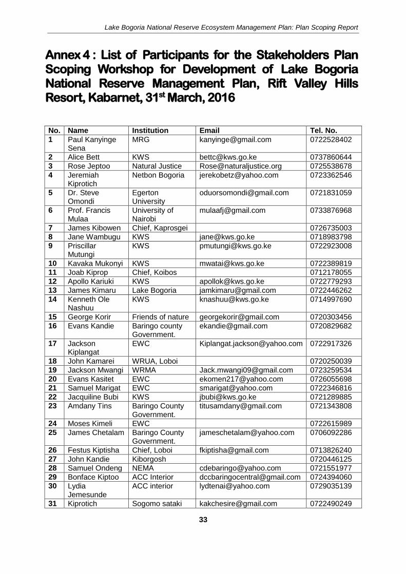
Annex 4 : List of Participants for the Stakeholders Plan Scoping Workshop for Development of Lake Bogoria National Reserve Management Plan, Rift Valley Hills Resort, Kabarnet, 31st March, 2016
No. Name Institution Email Tel. No.
1 Paul Kanyinge Sena
MRG [email protected] 0722528402
2 Alice Bett KWS [email protected] 0737860644
3 Rose Jeptoo Natural Justice [email protected] 0725538678
4 Jeremiah Kiprotich
Netbon Bogoria [email protected] 0723362546
5 Dr. Steve Omondi
Egerton University
[email protected] 0721831059
6 Prof. Francis Mulaa
University of Nairobi
[email protected] 0733876968
7 James Kibowen Chief, Kaprosgei 0726735003
8 Jane Wambugu KWS [email protected] 0718983798
9 Priscillar Mutungi
KWS [email protected] 0722923008
10 Kavaka Mukonyi KWS [email protected] 0722389819
11 Joab Kiprop Chief, Koibos 0712178055
12 Apollo Kariuki KWS [email protected] 0722779293
13 James Kimaru Lake Bogoria [email protected] 0722446262
14 Kenneth Ole Nashuu
KWS [email protected] 0714997690
15 George Korir Friends of nature [email protected] 0720303456
16 Evans Kandie Baringo county Government.
[email protected] 0720829682
17 Jackson Kiplangat
EWC [email protected] 0722917326
18 John Kamarei WRUA, Loboi 0720250039
19 Jackson Mwangi WRMA [email protected] 0723259534
20 Evans Kasitet EWC [email protected] 0726055698
21 Samuel Marigat EWC [email protected] 0722346816
22 Jacquiline Bubi KWS [email protected] 0721289885
23 Amdany Tins
Baringo County Government.
[email protected] 0721343808
24 Moses Kimeli EWC 0722615989
25 James Chetalam Baringo County Government.
[email protected] 0706092286
26 Festus Kiptisha Chief, Loboi [email protected] 0713826240
27 John Kandie Kiborgosh 0720446125
28 Samuel Ondeng NEMA [email protected] 0721551977
29 Bonface Kiptoo ACC Interior [email protected] 0724394060
30 Lydia Jemesunde
ACC interior [email protected] 0729035139
31 Kiprotich Sogomo sataki [email protected] 0722490249

Lake Bogoria National Reserve Ecosystem Management Plan: Plan Scoping Report
34
No. Name Institution Email Tel. No.
Chesire
32 Mengach Kangongi
Sogomo 0720927156
33 Raphael Ngetich Sogomo 0705305414
34 John Kiptum KWS [email protected] 0725847188
35 Raphael Kimosop
Baringo County Government
[email protected] 0723661887
36 Rebecca Kochulem
Ruko conservancy
[email protected] 0717730341
37 William kimosop Baringo County Government
[email protected] 0720317760
38 Christine Jepkemoi
Lake Bogoria [email protected] 0726017464
39 Jenipher Olang KWS [email protected] 0720840041
40 Paul Chepsoi EWC [email protected] 0722915809
41 Thomas Sakah
Baringo County Government.
[email protected] 0726959526
42 Jackson Komen Baringo County Government.
[email protected] 0726458637

Lake Bogoria National Reserve Ecosystem Management Plan: Plan Scoping Report
35
Annex 5 : LBNRE Plan Scoping Meeting Agenda
Wednesday 31 March, 2016
08.00 Opening remarks and introductions 08.15 Overview of the meeting agenda and expected outputs 09.40 Introduction to the Protected Areas Planning Framework 10.15 Tea 10.30 Geographic scope of the plan and plan ownership 11.30 Identification of problems and opportunities 13.00 Lunch 14.00 Identification of exceptional resources 13.00 Stakeholders analysis 16.00 Tea 16.15 Closing remarks 16.30 Departure

I
Lake Elementaita Wildlife Sanctuary Ecosystem
Management Plan, 2017-2027
Planning carried out by
LEWSE Managers, LEWSE Stakeholders and KWS Planning & Environmental Compliance Department
In accordance with the
KWS PROTECTED AREAS
PLANNING FRAMEWORK

II
Acknowledgements
This General Management Plan has been developed through a participatory planning process involving a cross section of Lake Elementaita Wildlife Sanctuary Ecosystem (LEWSE) stakeholders. The planning process was steered by representatives from Kenya Wildlife Service (KWS), National Museums of Kenya (NMK), Soysambu Ranch, National Environment Management Authority, and the Water Resources Management Authority (WRMA).
United Nations Educational, Scientific and Cultural Organization (UNESCO), through its Nairobi Regional Office, provided funding for development of this management plan.

III
Approval Page
The Management of Kenya Wildlife Service has approved the implementation of this management plan for the Lake Elementaita Wildlife Sanctuary Ecosystem
On behalf of the KENYA WILDLIFE SERVICE
Director General Date: .

IV
Executive Summary This 10-year general management plan (2017 - 2027) for the Lake Elementaita Wildlife Sanctuary Ecosystem (LEWSE) aims at harmonising the land-use activities in the LEWSE ensuring sustainable protection and conservation of the Lake Elementaita water body and the unique birdlife, habitats and landscapes. The planning process was carried out in accordance with the KWS Protected Areas Planning Framework (PAPF) and the management planning specifications outlined under Section 44 and the Fifth Schedule of the Wildlife Conservation and Management Act, 2013. The planning process is also in accordance with the Environmental Management and Coordination Act, 1999. The planning activities and events were funded by the UNESCO Regional Office, KWS, and other stakeholders. Stakeholders participated in the panning process through mechanisms such as the Core Planning Team, stakeholders planning workshops, and plan review and validation meetings. The geographic scope of the plan is the LEWSE covering the core zone (Lake Elementaita Wildlife Sanctuary), the buffer zone (the adjacent private riparian land, tourist accommodation facilities and Soysambu Ranch), and transition zone comprising large sections of the former Kikopey ranch.
LEWSE Purpose and Values
The purpose of the LEWSE as defined by the area’s stakeholders is:
To protect and conserve Lake Elementaita water body and its associated wildlife, especially water birds of conservation concern, and their habitats for the benefit
of present and future generations The Purpose Statement is based on LEWSE’s “Exceptional Resource Values” (ERVs), which include: Biodiversity – the Great white pelican (Pelecanus onocrotalus); the Lesser Flamingo
(Phoeniconaias minor); and the Greater Flamingo (Phoenicopterus roseus) Scenic – the lake; the riparian forest; the hills in Soysambu Ranch; the Kariandusi caves;
and the general landscapes found in LEWSE region Socioeconomic – irrigation from the rivers; salt harvesting; tourism; and Kikopey hot
springs Cultural – the diverse ethnic groups in the area; and the Kariandusi pre-historic site
LEWSE Zonation Scheme
The following zones have been identified: Core Zone, Buffer Zone and Transition Zone. Core Zone: The Core Zone is mainly for protection of environmentally sensitive areas which are critical breeding and feeding areas for water birds. The CZ contains the highest concentration of water fowl and consequently it is a major tourist attraction. Buffer Zone: The buffer zone lies between the core zone (LEWS) and developed areas or areas dedicated to farming and livestock production. The purpose of the BZ is to protect the primary conservation features of a protected area, while allowing for some uses. The buffer zone is supposed to avert the effect of negative environmental impacts arising from land uses

V
adjacent to the core conservation area. It will therefore be managed primarily for sustainable tourism development. Transition Zone: The transition zone is provided for establishing activities that promote sustainable development.
LEWSE Zonation

VI
Ecological Management Programme
The Ecological Management Programme aims to ensure that “the ecological components and processes of the LEWSE are understood, restored and conserved, and threats to the area’s key ecological features are reduced”. In order to achieve this aim LEWSE Management and stakeholders will strive to ensure that: key habitats and wildlife are protected and conserved; habitat connectivity within LEWSE is maintained; LEWSE receives a sufficient supply of clean water; and LEWSE’s ecological trends and threats are monitored, understood and managed. The ecosystem’s health and management effectiveness will be monitored and assessed based on the following seven conservation targets: 1. Great white pelican (Pelecanus onocrotalus 2. the Lesser Flamingo (Phoeniconaias minor) and the Greater Flamingo (Phoenicopterus
roseus) 3. Rothschild’s giraffe (Giraffa camelopardalis rothschildi) 4. Burchell’s zebra (Equus Burcheli) 5. Euphorbia candelabrum woodland 6. Acacia xanthophloea woodland 7. Lake riparian and river systems
Tourism Development and Management Programme
The Tourism Development and Management Programme aims to ensure that “the LEWSE is a major tourism destination in Kenya, offering a distinctive and diverse visitor experience that capitalises on the area’s special wilderness values and history”. To achieve this programme purpose, tourism will be developed as a major positive force in support of LEWSE’s conservation and management and tourism load will be maintained within the area’s carrying capacity. As such, tourism products will be expanded and diversified; and LEWSE will be marketed as a single destination. In addition, tourism management will be improved.
Community Partnership and Education Programme
The Community Partnership and Conservation Education Programme aims to “support and enhance the participation of LEWSE adjacent communities in conservation and sustainable use of LEWSE’s natural resources”. To realize this purpose LEWSE management will strive to ensure that communities can express their concerns, ideas and opinions; LEWSE is having a positive impact on the lives of local communities; communities and other stakeholders are aware of LEWSE’s values and importance; and there is collaboration between LEWSE management and other stakeholders in strengthening LEWSE community participation in conservation. It will also strengthen the conservation education and awareness programme; reduce Human-wildlife conflicts; and improve opportunities for communities to benefit from the LEWSE.
LEWSE Operations Programme
The aim of Protected Area Operations Programme is to ensure that “LEWSE’s operational systems and structures are effectively and efficiently supporting the achievement of the LEWSE purpose and the delivery of the LEWSE’s management programmes”. In implementing this programme LEWS management will strive to ensure that: sufficient human and financial resources are allocated; collaboration with key stakeholders is strengthened; management is

VII
integrated across the LEWSE; security presence is expanded across the LEWSE; and good communications and access is maintained.
Plan Monitoring
The Plan Monitoring framework provides a mechanism for assessing the impacts of plan implementation based on appropriate indicators and information sources.
Priority management and development actions
Priority management and development actions for enhancing ecological integrity in the LEWSE are given in the box below.
Priority actions
1. Control illegal activities in the LEWS
2. Mark and maintain LEWS boundaries
3. Establish a wildlife conservancy for LELO members
4. Establish a LEWSE Management Plan Implementation Committee (MPIC) comprising all stakeholders with interest in the conservation of LEWSE
5. Draw Memorandum of Agreement on land use in the buffer zone with relevant stakeholders
6. Support establishment of community income generating activities
7. Develop appropriate codes of conduct to regulate mining activities within the LEWSE
8. Collaborate with WRUAs in enforcement of water regulations
9. Support the development of walking safaris in parts of the Buffer Zone
10. Develop a visitor map covering the entire LEWSE
11. Promote and market the area as a single tourist destination
12. Hold regular meetings with LEWSE tourism investors and operators

VIII
Contents Acknowledgements ............................................................................................................. II Approval Page ..................................................................................................................... III Executive Summary ............................................................................................................ IV Contents ............................................................................................................................ VIII Acronyms ............................................................................................................................. X
Plan Foundations ........................................................................................ 1
The Plan ................................................................................................................................ 2 The Planning process ...................................................................................................... 2 Plan functions and structure ........................................................................................... 3
The LEWSE .......................................................................................................................... 5 Area description ............................................................................................................. 5 LEWSE Purpose Statement ........................................................................................... 10 LEWSE Exceptional Resource Values .............................................................................. 10 Major Issues of Concern................................................................................................ 16
LEWSE Zonation Scheme ........................................................................ 23
Introduction ........................................................................................................................ 24 Core Zone (CZ) ............................................................................................................. 27 Buffer Zone (BZ) .......................................................................................................... 27 Transition zone ............................................................................................................ 28
Ecological Management ........................................................................... 31
Programme ................................................................................................ 31
Programme Purpose and Strategy ................................................................................... 32 Guiding principles ............................................................................................................. 32 Targeting Ecological Management Action ....................................................................... 33
Ecological management objectives and actions .............................................................. 37 Management Objectives and Actions ............................................................................... 37
Objective 1: Conservation status of LEWSE’s species of concern enhanced ....................... 37 Objective 2: Forests, lake and river systems, and other important habitats protected and improved ............................................................................................................... 40 Objective 3: Water resource management enhanced ...................................................... 46
LEWSE Ecological Monitoring Plan ................................................................................. 48
Tourism Development & Management Programme .............................. 53
Programme Purpose and Strategy ................................................................................... 54 Guiding Principles ....................................................................................................... 56
Management Objectives and Actions ............................................................................... 56 Objective 1: The LEWSE tourism product expanded and diversified .................................. 56 Objective 2: LEWSE is marketed as a single destination ................................................... 58 Objective 3: LEWSE tourism management improved ....................................................... 59
Community Partnership & Conservation Education Programme ....... 61
Programme Purpose and Strategy ................................................................................... 62 Guiding Principles ....................................................................................................... 63
Management Objectives and Actions ............................................................................... 64 Objective 1: Conservation education and awareness programme strengthened ................ 64

IX
Objective 2: Human-wildlife conflict reduced .................................................................. 65 Objective 3: Opportunities for local communities to benefit from LEWSE improved .......... 66
Protected Area Operations Programme ................................................. 69
Programme Purpose and Strategy ................................................................................... 70 Management Objectives and Actions ............................................................................... 73
Objective 1: Sufficient resources (staff, infrastructure, transport, and finance) to support LEWSE management and tourism development availed ..................................... 73 Objective 2: Institutional collaborations formalised and strengthened ............................. 74 Objective 3: Visitor security ensured .............................................................................. 75 Objective 4: Security patrols enhanced .......................................................................... 75
Plan Monitoring ......................................................................................... 77
Figures
Figure 1. Plan Geographic Scope 6 Plate 1: Stand of Aloe lateritia under Euphorbia candelabrum woodland 13 Plate 2: Offshore islands in Lake Elementaita 14 Figure 2. Population trends of three large mammal species at SWC 17 Figure 3. Population trend of water birds of special concern in 2008-2014 17 Figure 4. Map showing part of the lake that is under private ownership 18 Plate 3: Hotel cottages 19 Plate 4: Pelicans at Soda mining area 19 Plate 5: Fences on the riparian area 19 Figure 5. Lake Elementaita water level trends (Source: WRMA-RVCA, 2016) 20 Plate 6: Community bathing and litter at the hot springs 21 Figure 6. LEWSE zonation 26 Figure 7. Extent of the riparian area defined by the 1780m contour 42 Figure 8. Preliminary map of the Lanneca wildlife corridor 45 Figure 9. Tourism facilities around L. Elementaita 55 Figure 10. Distribution of human activities around L. Elementaita 62 Figure 11. Infrastructure in LEWSE 71
Plates Plate 1: Stand of Aloe lateritia under Euphorbia candelabrum woodland 13 Plate 2: Offshore islands in Lake Elementaita 14 Plate 3: Hotel cottages 19 Plate 4: Pelicans at Soda mining area 19 Plate 5: Fences on the riparian area 19 Plate 6: Community bathing and litter at the hot springs 21
Tables
Table 1. LEWSE Exceptional Resource Values 10 Table 2. Summary of species of conservation concern in LEWSE 14 Table 3. International recognition of Lake Elementaita 15

X
Table 4. Land use categories identified within LEWSE 25 Table 5. Allowable Activities and Uses in different zones 30 Table 6. LEWSE conservation targets 34 Table 7. Threats to LEWSE Conservation Targets 36 Table 8. Framework for the development of the LEWSE Ecological Monitoring Plan 49 Table 9. Ecological Management Programme Monitoring Plan 78 Table 10. Tourism Development and Management Programme Monitoring Plan 79 Table 11. Community Partnership and Education Programme Monitoring Plan 79 Table 12. Protected Area Operations Programme Monitoring Plan 80
Acronyms AEWA African-Eurasian Migratory Water birds Agreement ASL Above Sea Level BoT Board of Trustees CAP Conservation Action Planning CBO Community Based Organisation CCC Community Consultative Committee CPT Core Planning Team EIA Environmental Impact Assessment EMCA Environmental Management and Coordination Act ERV Exceptional Resource Value GIS Geographic Information System LEWSE Lake Elementaita Wildlife Sanctuary Ecosystem LEWSE-CPT LEWSE Core Planning Team LEWSEMP LEWSE Management Plan GPS Global Positioning System HWC Human-Wildlife Conflict IUCN International Union for Conservation of Nature KEA Key Ecological Attribute KWS Kenya Wildlife Service LAU Limits of Acceptable Use LEECO Lake Elementaita Ecotourism Community Organization LELO Lake Elementaita Land Owners MPIC Management Plan Implementation Committee MoA Memorandum of Agreement NEMA National Environmental Management Authority NGO Non-Government Organisation NMK National Museums of Kenya OCPD Officer Commanding Police Division PAPF Protected Areas Planning Framework SWC Soysambu Conservancy SWS Soysambu Wildlife Sanctuary TNC The Nature Conservancy WCK Wildlife Clubs of Kenya WRMA Water Resources Management Authority WRUA Water Resource Users’ Association

Plan Foundations

LEWSE MANAGEMENT PLAN (2017 – 2027)
2
The Plan
This 10-year (2017 - 2027) management plan for the LEWSE is an update of the Greater Lake Elementaita Conservation Area Management Plan (2010-2020). The plan revision was carried out in consultation with LEWSE stakeholders, notably Lake Elementaita Land Owners (LELO), Soysambu Ranch, government agencies, non-governmental organisations and community based organizations. The planning process followed the specifications outlined in the KWS’s Protected Areas Planning Framework (PAPF), which is the KWS planning standard. The planning approach was highly participatory building on ideas from a broad cross-section of LEWSE stakeholders. The plan is developed using a standard PAPF management plan template that KWS uses to prepare protected area management plans. This is in light of the fact that most conservation strategies designed to address conservation issues are similar in most of the conservation areas as they are based on current national conservation laws and policies regulating the conservation sector. The structure of the management plan has been designed to maximise ease of implementation by the stakeholders. This has been achieved through a rigorous application of the “Logical Framework Approach” in the plan’s management programmes, and the development of “3-year Activity Plans” that provide the bridge from the 10-year vision components of the plan to the annual operational planning carried out by the managers of LEWSE who will be responsible for plan implementation. The following sections on the planning process, plan functions, plan structure and stakeholder participation in the plan’s development provide an overview of the practical application of this management plan.
The Planning process
The planning process involved a high degree of stakeholder participation in plan development. This was achieved through a multi-layered approach involving a variety of mechanisms that ensured that all stakeholders meaningfully contributed to the plan’s development. Three principal mechanisms were used to enable this participation. These are:
The Core Planning Team (CPT) Stakeholder Workshops Expert Working Groups
The Core Planning Team (CPT). The CPT provided overall guidance and oversight to the entire planning process. Membership consisted of KWS staff, National Museums of Kenya (NMK) staff, Soysambu Ranch management, representatives of LELO, and planning facilitators. CPT members defined the scope and functions of the plan and provided guidance and oversight during the plan’s development. Further, CPT members ensured that the plan’s development progressed smoothly, which included: ensuring funding was available for planning events; collecting and collating information necessary for planning; organising and facilitating planning events; and compiling planning event outputs into the final management plan. CPT members also participated in all other planning mechanisms described below. Stakeholder Workshops. Several stakeholder workshops were held during the plan development process. The first Stakeholder consultative meeting was held at Lake Elementaita Lodge on 19th September 2006. It set the terms of reference to guide the planning

PLAN FOUNDATIONS
3
process and identified the exceptional resources and purpose of LEWSE, the key problems and opportunities the plan must address and stakeholders that should be consulted during the planning process. The second stakeholders’ consultative planning workshop was held on 15th October 2009 at Stem Hotel, Nakuru. LEWSE stakeholders reviewed the contents of the draft management plan. The draft plan was revised and presented to stakeholders at a stakeholders’ consultative meeting held on 29th October 2015. Thereafter the plan was presented to stakeholders for endorsement at a stakeholders meeting held on 23rd June 2016. At the plan endorsement meeting, some of the stakeholders, and specifically LELO, requested for more time to review the plan before they could endorse it. A plan review meeting was later organised for LELO members on 9th February, 2017 at Zeituni Lodge, Lake Elementaita. At this meeting LELO reviewed the zoning scheme and zone prescriptions. The final stakeholders plan endorsement meeting was held on 23th March, 2017. Expert Working Groups. Four thematic expert working groups (EWG) were formed to refine the relevant management programme’s purpose, strategy and objectives, and developed subsidiary management actions for each objective. In addition, all Working Groups were involved in reviewing the LEWSE draft Zonation Scheme.
Plan functions and structure
This plan is primarily designed to be a practical management tool supporting LEWSE managers in carrying out their day to day activities. The plan will achieve this aim by providing strategic guidance on the goals that management is working on, and a series of prescriptions and management actions that need to be implemented in order to achieve these aims. Hence, the following points set out the key functions of the LEWSE Management Plan. The LEWSE Management Plan (2017 - 2027 is designed to achieve the following functions: Vision: Set out a common understanding between the different stakeholders about the
purpose of the LEWSE and its exceptional resource values, towards which all management action will be focused.
What: Establish clear management objectives that are agreed by the LEWSE
stakeholders and managers and that, if achieved, will ensure the conservation of all exceptional resource values.
How: Provide clear and unambiguous guidance and a rationale for the specific
management actions that LEWSE Managers will need to implement over the 10-year timeframe of the plan to achieve the management objectives.
Where: Define a mechanism for LEWSE zoning to enable different types and intensities
of use in different parts of the LEWSE, thereby facilitating reconciliation of LEWSE’s sometimes competing conservation and development objectives.
When: Provide a detailed activity plan for the first three years of implementing the
management plan, thereby establishing a crucial link between the plan’s long-term management objectives and the annual operational planning and budgeting routinely carried out by LEWSE managers.

LEWSE MANAGEMENT PLAN (2017 – 2027)
4
Rules: Set out clear and unambiguous prescriptions and regulations on what can and cannot be done in different parts of the LEWSE in order to achieve the area’s management objectives and fulfil the LEWSE purpose.
Who: Provide a practical framework enabling the collaboration of LEWSE managers
and other institutions and stakeholders in implementing the plan. The Plan is NOT designed to: Provide a comprehensive reference source for the LEWSE, with detailed background
information on the area’s biodiversity, ecology, geology, soils, etc. Set out a detailed inventory of issues or problems impacting the LEWSE, that is not directly
addressed through the plan’s management objectives and actions. Provide detailed descriptions of the LEWSE management, administration, and national
policies, unless they are relevant to the plan’s management objectives and actions. The following are the key components of the plan: Plan Foundations. This chapter introduces the planning process, the plan functions,
structure and stakeholder participation mechanisms. The chapter also provides an introduction to the LEWSE, its location and physical description, and exceptional resource values. It also sets out the LEWSE’s Purpose Statement, which explains why the LEWS has been established, and the major functions and roles the LEWSE aims to fulfil.
LEWSE Zonation Scheme. This chapter sets out the specific areas in LEWSE where
different types of activities and developments are permitted or not permitted. The four management programmes. The main bulk of the plan is contained in four
chapters:
Ecological Management Programme Tourism Development and Management Programme Community Partnership and Conservation Education Programme Protected Area Operations Programme
Each programme includes a programme purpose statement and a strategy describing the overall management approach pursued through the programme. Each programme also contains management objectives that set out the goals that LEWSE management aims to achieve, and a set of specific management actions to realize the goals. Each of the management programmes are completed by a 3-year Activity Plan, which breaks down the individual management actions to be completed in the first three years of the plan implementation period into a series of tangible management activities, and sets out the timeframe for their implementation, allocates responsibility for their completion, and the “milestones” that management aims to achieve. These activity plans are designed to provide the basis for annual operational planning by LEWSE managers and are a vital link between the management plan’s 10-year outlook, and day-to-day management activities in LEWSE. It is intended that the 3-year Activity Plans will be rolled forward annually as part of the annual operational planning carried out by LEWSE managers.

PLAN FOUNDATIONS
5
The LEWSE
Area description
History
Lake Elementaita is a natural lake formed by the Rift Valley tectonic movements and is part of the formation of the Great Gregory Rift Valley in Kenya. Some million years ago, a large lake covered the present area occupied by lakes Nakuru, Elementaita and Naivasha, which drained southwards towards Lake Naivasha. This was followed by drier conditions that left behind the three distinct lakes. Lake Elementaita basin has one of the oldest archeological sites belonging to the Oldowan period with stone tools dating to 700,000 years ago found at Kariandusi. The Obsidian mines at the Eburru Mountains are evidence of Obsidian trade dating over 3000 years ago. Subsequently the region was occupied by pastoral Neolithic, later the Maasai pastoral community who called it “Elementaita”. During the colonial occupation, the whole area between Elementaita and Naivasha was taken over and used for livestock and wildlife ranching by Lord Delamere. The area around Lake Elementaita was designated an Important Bird Area (IBA), a site of global significance for bird and biodiversity conservation, in 1999. The lake was designated a Ramsar site (wetland of international importance) in 2005. It was gazetted as a National Wildlife Sanctuary in 2010 and listed together with lakes Nakuru and Bogoria as the Kenya Lakes System in the Great Rift Valley World Heritage Site by UNESCO in 2011.
Location and geographic scope
LEWSE is approximately 120km north of Kenya’s capital city, Nairobi, from where it can be accessed by the Trans-African Highway (A104), the Kenya-Uganda railway or via several private airstrips existing within the area. The nearest administrative town is Gilgil within Nakuru District in Rift Valley Province. The geographic scope of the management plan includes the catchment basin for Lake Elementaita and covers an area of approximately 500 km2. To the South of the Lake, LEWSE extends to the Eburru ranges and to the west it extends to the western boundary of Soysambu Conservancy. Ndundori highlands form the northern catchment area, while the Aberdare escarpments form the eastern catchment. Lake Elementaita forms the core zone of LEWSE. It is a shallow alkaline lake lying on the floor of Kenya’s southern Rift Valley. Although the lake and a terrestrial buffer zone cover an area about 108.8 km2, the size of the open lake water body fluctuates between 19-22 km2 (see figure 1). The geographic extent of the LEWSE beyond the core area has been pegged on three main considerations, namely; Key ecological processes that determine sustainability of Lake Elementaita occur outside
the lake; therefore an ecosystem-based planning approach improves management of conservation targets, stakeholders’ collaboration and habitat connectivity.
Addressing issues of the neighbouring communities who impact on the Lake through competition for resources helps to maintain ecological integrity.

LEWSE MANAGEMENT PLAN (2017 – 2027)
6
Figure 1. Plan Geographic Scope

PLAN FOUNDATIONS
7
Climate
LEWSE falls under agro-climatic zone V with annual mean temperatures ranging between 18.5º and 19.8º C. Records from weather stations1 in the area indicate a mean annual precipitation of between 600 – 700 mm. Rainfall is bimodal with the long-rains in April to June and the short rains between October and November.
Geology
The geology of the area consists of young volcanic and sedimentary rocks. To the south of Lake Elementaita lies the “bad lands”, an area of young volcanic rocks including cones and flows of Holocene age (the last ~10,000 years of the Earth's history since the end of the last major glacial epoch). To the North are a number of slightly older volcanic rocks predominantly basalt lava. On the eastern side of the lake are a number of fault scarps. There is also an extensive faulted area further east forming the edge of the Rift Valley. The lake lies between two areas of diatomite, Kariandusi to the east and Kockum to the west. This gives evidence of the area having been a much bigger lake in the past. Saline flats covered with trona surround the modern lake. In most parts of the plan area the existence of the Gilgil trachyte is evident. These are particularly widespread along the Gilgil escarpment, Soysambu Conservancy and some parts of Mbaruk. The trachyte might also overlie the Mbaruk basalt at several places. McCall (1967) suggests that Pliocene fissure eruptions may have resulted in the emission of the basaltic lavas, trachytes and phonolites in many places across the catchment. Much of the southern and western sides of the lake is covered by what McCall terms “Elementaita bad lands” which form into basalt-cinder cones at various places the most distinguishable being the cone at the southern shores of the lake. Some very recent tuff cones can also be identified south of Lake Elementaita. Around Kariandusi area, diatomite forms layers separating the Gilgil trachyte to form the Kariandusi lacustrine sediments formed during lower or middle Pleistocene (~2.6 million years ago). This deposition is believed to have occurred within a larger basin of the joint ancient Nakuru-Elementaita Lake.
Soils
Stream basal materials in the area indicate higher proportions of fine sediments and silt except around Mbaruk railway station where clay is abundant. The middle watershed areas are relatively rocky, particularly across Kasambara and Kiringa where the proportion of sand and gravel in stream basal material is much higher. Upper catchment areas are relatively non-rocky and unlike the rest of the basin are characterized by more detritus silts with small quantities of clay. The Mbaruk-Chamuka watershed soils have Sand, silt and gravel constituting the dominant stream basal materials. Stream basal material of the Kariandusi consists of sand, gravel and diatomaceous earth. The lake bottom is filled with weathered material from the catchment area. The soil type is mainly sandy alluvial, of volcanic origin indicated by soda ash and fine sandy/loam soils on the lake bottom and its immediate surrounding areas. The soil in most areas is highly permeable and very little surface water is noticeable after the rains. Soils vary considerably within the
1 Soysambu Conservancy, Nderit and Winston Estate, Kikopey Ranch, Lanet police station, and Chokora farm near Mbaruk).

LEWSE MANAGEMENT PLAN (2017 – 2027)
8
basin. Light grey dusty soils (Andosols) on the flat plains around Lake Elementaita have developed on the diatomaceous silts of this part.
Topography
Lake Elementaita lies within the bed of the Great Rift Valley. To the east, the lake is bordered by the Ndundori-Ngorika-Gitare hills (elevation 2500m ASL) which are part of the Bahati escarpment and to the West by Eburru hills (elevation 2600m ASL) which are part of the Mau ranges. To the north and south is the almost flat rift valley floor (elevation 1900m ASL) with important catchment boundaries to Lake Nakuru and Lake Naivasha respectively. The Mbaruk-Chamuka landscape is monotonously flat at an elevation of about 1880m and river depth varies between 0.5 and 1m with fairly wide channels generally between 3 and 3.2m. Prominent features include the “Sleeping Warrior” hill, caves, “badlands lava”, spectacular flamingo cliffs and the pelican breeding rocky islands.
Hydrology
The drainage basin has a largely dendrite pattern, and can be divided into four minor watersheds Mbaruk, Chamuka, Kariandusi and Mbaruk-Chamuka. Mbaruk watershed is the largest and wettest while Kariandusi is the driest. Both Chamuka and Kariandusi manifest geothermal activities. The major tributaries of Mbaruk watershed include: Bonde, Rutara, Gichure, Ndundori and Weruini. Tributaries for Chamuka watershed include Ndiriini, Nyaituga, Kanjuiri and Kiringa. The Mbaruk-Chamuka watershed represents the flow into the Lake of both Mbaruk and Chamuka after converging about 1.5km from the lakeshore. The Kariandusi watershed extends from the upper areas of Gitare and Northern Gilgil, into the mid lowland and lowland zones of Kariandusi and Elementaita. Major tributaries include: Kabugi, Gitare, Kikopey and Mai Mahiu Rivers. These are relatively small streams, which are ephemeral in nature.
Flora
Vegetation around LakeElementaita drainage basin consists of upland forest, woodland, bush land and grassland. In recent years, much of the natural forest and woodlands has either been removed or modified into shrubs and bush land by cultivation, grazing and fires. Around the lake, vegetation is sparse and can be categorized into five major vegetation zones as follows: The forests and woodlands are concentrated around the mouth of rivers with Acacia xanthophloea as the dominant tree species rising up to 25m high with clear vertical stratification. Below the upper canopy are various climbers including: Senecio petitianus, Commicarpus pedunculosus and Ipomea cairica. The herbaceous layer is dominated by: Acyranthus aspera, Hypoestes verticillaris, Conyza foribunda, Solanum incanum, Urtrica maasaica and Gutenbergia cordifolia. Grasses of the ground layer include Cynodon dactylon, Pennisetum clandestinum and Pannicum species, among others. Dry bush land cover parts of the eastern, southern and western parts of the lake where dominant tree species include: Acacia xanthophloea and Eurphobia candelabrum. Shrubs include Rhus natalensis, Sesbania sesban, and Vernonia spp. The grasses include Cynodon dactylon, Chloris gayana and Panicum spp. Grasslands have been categorized into two groups:
Lakeside grasslands dominated by Sporobolus spicatus and Chloris gayana

PLAN FOUNDATIONS
9
Other grasslands dominated by Themeda triandra, Sporobolus fibriatus, Eragrostis spp., Pennisetum catabasis and Cynodon dactylon
Marshes are located in the Northern and Southern parts of the lake, dominated by Cyperus laevigatus and Typha species. Ututu scrubland is located south of the lake in the former Kikopey ranch and is dominated by Olea species and Tarchonanthus camphoratus.
Fauna
The lake provides seasonal habitats for both lesser and greater flamingos which migrate between lakes Elementaita, Nakuru and Bogoria and elsewhere into Eastern, Central and Southern Africa. The lake ecosystem has small populations of migratory zebras (Equus burchelli), Thomson’s gazelle (Gazella thomsoni) and Rothschild’s giraffe (Giraffa camelopardalis rothschildi).
Land tenure system
The LEWS is managed by the KWS. The surrounding buffer zone and transition area (Soysambu Conservancy and former Kikopey ranch) is privately owned through leasehold and freehold land tenure. Roads and most urban areas are on public land managed by either the national or County Governments.
Land-use patterns
(a) Within the Core and Buffer Zone: The Core and Buffer Zones around Lake Elementaita are mainly used for conservation and tourism. Over 15 tourist facilities have been developed in the lakes buffer zone. (b) Within the catchment and Transition Zone Subsistence agriculture is the main land use activity in the transition zone. Major crops grown include maize, beans, sweet and Irish potatoes, peas, oranges, cassava, paw paws, bananas, ground nuts, millet, onions, vegetables and yams. Farm holdings vary in size. Those at viewpoint, Kasarani and Kericho, ranging from 1-2ha and those at Kekopey area range from 5- 15ha. Crop failure is frequent due to unreliable rainfall. Much of the food is consumed locally and the surplus sold in the surrounding towns like Gilgil, Nakuru and Nairobi. Livestock rearing is a major occupation in the transition zone. There are three forms of livestock husbandry in the area:
(i) Small scale livestock husbandry involving keeping of a few cattle, sheep, goats, and sometimes donkey; (ii) Pastoralism practiced by the neighbouring pastoral community who keep cattle, sheep, goats, and donkeys; and (iii) Ranching practiced in the large scale farms where beef cattle for local consumption and export are reared.
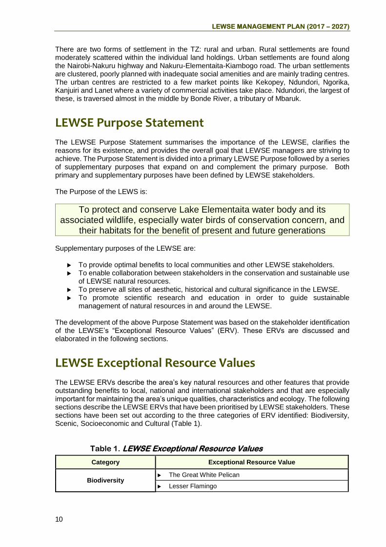
LEWSE MANAGEMENT PLAN (2017 – 2027)
10
There are two forms of settlement in the TZ: rural and urban. Rural settlements are found moderately scattered within the individual land holdings. Urban settlements are found along the Nairobi-Nakuru highway and Nakuru-Elementaita-Kiambogo road. The urban settlements are clustered, poorly planned with inadequate social amenities and are mainly trading centres. The urban centres are restricted to a few market points like Kekopey, Ndundori, Ngorika, Kanjuiri and Lanet where a variety of commercial activities take place. Ndundori, the largest of these, is traversed almost in the middle by Bonde River, a tributary of Mbaruk.
LEWSE Purpose Statement
The LEWSE Purpose Statement summarises the importance of the LEWSE, clarifies the reasons for its existence, and provides the overall goal that LEWSE managers are striving to achieve. The Purpose Statement is divided into a primary LEWSE Purpose followed by a series of supplementary purposes that expand on and complement the primary purpose. Both primary and supplementary purposes have been defined by LEWSE stakeholders. The Purpose of the LEWS is:
To protect and conserve Lake Elementaita water body and its associated wildlife, especially water birds of conservation concern, and
their habitats for the benefit of present and future generations Supplementary purposes of the LEWSE are:
To provide optimal benefits to local communities and other LEWSE stakeholders. To enable collaboration between stakeholders in the conservation and sustainable use
of LEWSE natural resources. To preserve all sites of aesthetic, historical and cultural significance in the LEWSE. To promote scientific research and education in order to guide sustainable
management of natural resources in and around the LEWSE. The development of the above Purpose Statement was based on the stakeholder identification of the LEWSE’s “Exceptional Resource Values” (ERV). These ERVs are discussed and elaborated in the following sections.
LEWSE Exceptional Resource Values
The LEWSE ERVs describe the area’s key natural resources and other features that provide outstanding benefits to local, national and international stakeholders and that are especially important for maintaining the area’s unique qualities, characteristics and ecology. The following sections describe the LEWSE ERVs that have been prioritised by LEWSE stakeholders. These sections have been set out according to the three categories of ERV identified: Biodiversity, Scenic, Socioeconomic and Cultural (Table 1).
Table 1. LEWSE Exceptional Resource Values
Category Exceptional Resource Value
Biodiversity The Great White Pelican
Lesser Flamingo
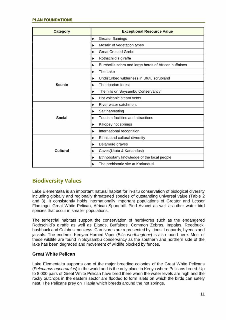
PLAN FOUNDATIONS
11
Category Exceptional Resource Value
Greater flamingo
Mosaic of vegetation types
Great Crested Grebe
Rothschild’s giraffe
Burchell’s zebra and large herds of African buffaloes
Scenic
The Lake
Undisturbed wilderness in Ututu scrubland
The riparian forest
The hills on Soysambu Conservancy
Hot volcanic steam vents
Social
River water catchment
Salt harvesting
Tourism facilities and attractions
Kikopey hot springs
International recognition
Cultural
Ethnic and cultural diversity
Delamere graves
Caves(Ututu & Kariandusi)
Ethnobotany knowledge of the local people
The prehistoric site at Kariandusi
Biodiversity Values
Lake Elementaita is an important natural habitat for in-situ conservation of biological diversity including globally and regionally threatened species of outstanding universal value (Table 2 and 3). It consistently holds internationally important populations of Greater and Lesser Flamingo, Great White Pelican, African Spoonbill, Pied Avocet as well as other water bird species that occur in smaller populations. The terrestrial habitats support the conservation of herbivores such as the endangered Rothschild’s giraffe as well as Elands, Buffaloes, Common Zebras, Impalas, Reedbuck, bushbuck and Colobus monkeys. Carnivores are represented by Lions, Leopards, hyenas and jackals. The endemic Kenyan Horned Viper (Bitis worthingtonii) is also found here. Most of these wildlife are found in Soysambu conservancy as the southern and northern side of the lake has been degraded and movement of wildlife blocked by fences.
Great White Pelican Lake Elementaita supports one of the major breeding colonies of the Great White Pelicans (Pelecanus onocrotalus) in the world and is the only place in Kenya where Pelicans breed. Up to 8,000 pairs of Great White Pelican have bred there when the water levels are high and the rocky outcrops in the eastern sector are flooded to form islets on which the birds can safely nest. The Pelicans prey on Tilapia which breeds around the hot springs.

LEWSE MANAGEMENT PLAN (2017 – 2027)
12
This species is global restricted in range and listed appendix 1 of the Convention on Migratory Species. It is a major tourist attraction in LEWSE. Receding shoreline and exposure of their eggs to predation is the main threat to pelican populations. Its population at the lake has been declining.
The Lesser and Greater Flamingos The Lesser and Greater Flamingos migrate between Lakes Magadi, Elementaita, Nakuru and Bogoria to feed and to Lake Natron in northern Tanzania for breeding. The lesser flamingo (Phoenicopterus minor) is classified as Near Threatened (NT) on the IUCN Red List. It is listed on Appendix II of Convention on International Trade in Endangered Species (CITES) and on Appendix II of the Convention for the Conservation of Migratory Species (CMS) mainly due to their habitat specificity and migratory behaviour. Lesser flamingos respond to changes in their food base by undertaking irregular nomadic movements that track lakes with preferred food species and concentrations. They are ecologically sensitive species and their movements provide spatial and temporal connectivity between the various alkaline lakes. The presence of diverse aquatic communities of microflora including Arthrospira fusiformis in Lake Elementaita provide stable food base for the lesser flamingo. The Greater Flamingo (Phoenicopterus roseus) is listed in the IUCN Red List where it is classified as a species of Least Concern (LC). As a migratory water bird, its conservation is achieved through international instruments such as CITES, CMS and African–Eurasian Migratory Water bird Agreement (AEWA). It is a numerous species, and increasing in some areas. Breeding success of Greater Flamingo is often reduced as a result of human disturbance or lowering water levels, which can increase the salinity of feeding sites and so, affect food resources. Other threats to this species include pollution, disease, lead poisoning (from ingesting lead shot), and habitat loss due to harbour and industrial development or drainage of wetlands for agriculture.
Large mammals The Soysambu Ranch has increasing populations of Burchell’s zebra, Buffalo and endangered Rothschild’s giraffe. Most of these animals are concentrated around the northern woodlands where human influence is minimal. These animals historically used to transit around the lake but now can only move between Soysambu Ranch and only as far as Country lodge. The confinement is as a result of perimeter fences most of which touch the lake water body, steep cliffs, tourist hotels and human activities such as settlements, livestock grazing, shore walks, salt mining, etc.
Rothschild’s giraffe The Rothschild’s Giraffe (Giraffa camelopardalis rothschildi) is listed as endangered on the IUCN Red List. It is at risk of hybridization, as the global population is so limited in numbers with only a few hundred members. There are very few locations where the Rothschild’s Giraffe can be seen in the wild, with notable spots being Lake Nakuru National Park, Ruma National Park and SWC in Kenya, and Murchison Falls National Park in Northern Uganda. It is an umbrella species in LEWSE. In 2016, Rothschild's giraffe was proposed to be conspecific with the Nubian giraffe, but that taxonomy has not been widely adopted.

PLAN FOUNDATIONS
13
Mosaic of vegetation types Lake Elementaita is a Soda Lake with extremely productive hyper alkaline environments due to high ambient temperatures, high light intensities and unlimited supplies of carbon dioxide. As a result it has a variety of fast growing single celled algae, e.g. the blue green algae (Arthrospira fusiformis) which is the main food for the Lesser Flamingos. In addition the marsh areas of this wetland are characterized by salt resistant sedge, dominated by Cyperus laevigatus and Typha spp. Key woodland species in LEWSE include: Acacia xanthophloea and globally endangered Eurphobia candelabrum (CITES, 2010). Bush species include: Rhus natalensis, Sesbania sesban, Vernonia spp and endangered Aloe lateritia (CITES, 2010). The grasses include: Cynodon dactylon, Chloris gayana and Panicum spp.
Plate 1: Stand of Aloe lateritia under Euphorbia candelabrum woodland

LEWSE MANAGEMENT PLAN (2017 – 2027)
14
Plate 2: Offshore islands in Lake Elementaita
Table 2. Summary of species of conservation concern in LEWSE
Species common name Scientific name Conservation status
Birds
Great White Pelicans Pelecanus onocrotalus CMS, Appendix I
Lesser flamingo Phoenicopterus minor IUCN, Near Threatened (NT), CITES, Appendix II, CMS Appendix II
Greater Flamingo IUCN, least concern
Great Crested Grebe Podiceps cristatus IUCN, least concern
Great Egret Casmerodius albus CITES. Appendix II
Maccoa Duck Oxyura maccoa Appendix I under CMS
Pied avocet Recurvirostra avosetta IUCN, least concern
Little stint Calidris alba IUCN, least concern
Eurasian Marsh Harrier Circus aeruginosus IUCN, least concern
Mammals
Rothschild’s Giraffe Giraffa camelopardalis rothschildi
IUCN, Appendix 1
Lion Panthera leo IUCN, Vulnerable
Leopard Panthera pardus IUCN, Vulnerable
Reptiles
Kenyan Horned Viper Bitis worthingtonii Endemic
Plants
Tree Eurphobia Eurphobia candelabrum CITES, Appendix II
Aloe lateritia CITES, Appendix II

PLAN FOUNDATIONS
15
Scenic Values
The Inselbergs dotting the LEWSE landscape; Lake Elementaita and associated assemblage of waterfowl communities; the riparian forest, hills and cliffs; Ututu scrubland; the Ututu volcanic caves; and the hot volcanic steam vents adjacent to Ututu collectively contribute to the scenic beauty of the landscape. This status of the Lake has attracted the mushrooming of tourist facilities in the area.
Social and cultural Values
LEWSE has several attributes of socio-cultural value. The Kariandusi prehistoric site and the early man caves found within the area are rich in archaeological artefacts. These sites present a very comprehensive account of the early man’s history. The more than 15 tourism and recreational facilities in the area are an important foreign exchange earner and employer. The presence of the migratory birds provides a unique opportunity for the protection and long-term monitoring of population changes in relation to changes in local habitat conditions and effects of global climate change, thus a unique opportunity for north-south cooperation and collaborative management within the framework of AEWA. The hot springs around Chamuka is a source of water for domestic, livestock watering and subsistence irrigation by the local community. For years the nomadic Maasai herdsmen have brought their livestock to the area for grazing and salt licking. The Lake and its catchment have continued to attract individuals and institutions for scientific research because of its rich biodiversity in a semi-arid area surrounding a saline lake. There are many local and foreign researchers and students who have studied various aspects of the Lake and there is also an increasing interest in the site by schools and youth groups. The history of the Delamere family is strongly engraved in the LEWSE. The family graves are of historical importance. On the other hand, Lake Elementaita is internationally recognized as an important conservation area. It is listed an Important Bid Area as well as a Ramsar site. Due to their Outstanding Universal Value, Lakes Elementaita, Nakuru and Bogoria are also a UNESCO World Heritage Site. The Government of Kenya declared Lake Elementaita National Wildlife Sanctuary in effort to maintain its international conservation status (Table 3).
Table 3. International recognition of Lake Elementaita
Designation Date Global Criteria
Coordinator National Focal Point
Procedure
IBA KE046
1999 A1, A2, A4i, A4iii
Bird Life international
Nature Kenya
Identified by Birdlife International using 4 global rating criteria
Ramsar Site Number 1498
05-09-2005 Criterion 6 on water birds: regularly supports > 1%
Ramsar Convention Secretariat
KWS – National Administra
State party through KWS (the National Administrative

LEWSE MANAGEMENT PLAN (2017 – 2027)
16
Designation Date Global Criteria
Coordinator National Focal Point
Procedure
of the world’s Lesser Flamingos
tive Authority
Authority) designates Ramsar sites based on a set of criteria Fills online Ramsar Information sheet and sends it to UNESCO
WHS 2011 vii, ix, x, UNESCO World Heritage Center
KWS Nominated by State Party using nomination form, ecosystem management plan is one of the requirements
Major Issues of Concern
The major management issues of concern addressed in this plan are outlined below:
1. Confined large mammals and declining bird populations
Soysambu Wildlife Sanctuary (SWS) hosts almost all the large mammals in confinement. The consequence of this is inbreeding and/or development of weak traits among some species, severe pasture degradation and competition for forage among herbivores leading to premature mortalities and low performance, and decline in visitor satisfaction. The Rothschild’s giraffe, Burchell’s zebras and buffalo populations in SWS have exceeded the conservancy carrying capacity; hence the urgency to offload the pressure. In contrast, large fauna are not observed around the eastern and southern neighborhood of the Lake which are under heavy human activities.

PLAN FOUNDATIONS
17
Figure 2. Population trends of three large mammal species at SWC
Biannual water fowl census results from 2008 – 2014 indicate population decline of 4 species of special concern. The Lesser Flamingo is the most populous species with peak population in 2011 when habitat conditions are likely to have been most suitable. The specific reasons for this trend have not been verified.
Figure 3. Population trend of water birds of special concern in 2008-2014
2. Poaching
Poaching for bush meat is another threat that could have led to reduced mammal fauna population and vegetation conversion in the hotspot areas which are Ututu scrub land and areas adjacent to Lake Elementaita. Zebras and giraffes are the main target for bush meat.
0
1000
2000
3000
4000
5000
6000
2004 2006 2008 2010 2012 2014 2016 2018
Nu
mb
er
of
anim
als
Year
Rothschild's giraffe
Buffalo
Burchells zebra
Linear (Rothschild'sgiraffe)
-50000
0
50000
100000
150000
200000
250000
300000
350000
400000
2007 2008 2009 2010 2011 2012 2013 2014 2015
G Flamingo
L Flamingo
GW Pelican
PB Pelican

LEWSE MANAGEMENT PLAN (2017 – 2027)
18
Illegal tree cutting, mostly in the riparian Acacia xanthophloea woodlands, has led to vegetation conversion to open marshes, disturbance of bird activities and reduced aesthetics.
3. Insufficient conservation of riparian buffer sub-zone The L. Elementaita Wildlife Sanctuary boundary plan No. 216/67 was defined based on boundaries of private land parcels neighboring the lake (Annex >>>). Consequently a large swathe of the riparian reserve and other ecologically sensitive sites such as the forests, steep slope hills and cliffs, and marshes were not protected. Ecologically sensitive areas are fragile, home to special species and require protection from direct impact from human activities. Some can tolerate only non-impact (short nature walks and wildlife viewing) or light impact (such as controlled livestock grazing, rock climbing) while others can tolerate medium to heavy impacts (ecolodge, picnic site, camp site). Lake riparian is rich in biodiversity and provides essential livelihood products to their riparian communities. Vegetation around the riparian zone plays an important role in intercepting surface runoff and store non-point pollutants like sediments, nutrients and certain heavy metals that would otherwise end up in the lake. Beyond the riparian there is required space for a perimeter road around the lake for community use as well sanctuary administration. Tourism investments have been increasing around the lake most likely due to the scenic characteristic of the lake. Most of the tourism facilities are concentrated on the eastern side close to the lake.
Figure 4. Map showing part of the lake that is under private ownership

PLAN FOUNDATIONS
19
Plate 3: Hotel cottages
Plate 4: Pelicans at Soda mining area
Plate 5: Fences on the riparian area
The riparian reserve has continued to be degraded through:
Some facilities and infrastructure such as fences have been installed in the riparian reserve hindering smooth KWS patrols around the Lake.

LEWSE MANAGEMENT PLAN (2017 – 2027)
20
Land use conversion of the riparian and cutting of trees for charcoal production, subsistence farming and settlement. These threats are driven by the rising demand for food, energy and other supplies to sustain the surrounding population.
In recent years, much of the natural forest and woodlands in LEWSE have either been removed or modified into shrubs and bush-land by cultivation, grazing and fires. However, there are remnant patches of forests at Ututu, hot springs and the Acacia stand at the southern end of the lake. Presently, there is a substantial amount of illegal grazing and poaching activities taking place in Ututu and areas immediately adjacent to Lake Elementaita. Success has been limited in combating these livestock incursions as the Ututu area and some lake shore are currently open access areas.
The pollutants which include pesticides and heavy metals end up distorting the food chain and reproduction of species within the ecosystem thus destroying biodiversity.
4. Receding Lake water level.
There has been general decrease of Lake water level from 1980. The level increased somehow in 2000 but then drastically reduced. This trend could be attributed to the destruction of the Lake’s catchments of Mereroni and Kariandusi Rivers. Another potential cause is global warming resulting in extreme or unpredictable rainfall patterns hence water level fluctuations which are unfavorable for forage and breeding conditions for the birds. The reduction of water levels by 2000 which was the time of spiraling developments along the lake shoreline has not been explained. Small irrigation dams have also been constructed along rivers flowing into the lake. The dams store and control water supply downstream. Increased abstraction of water from the Mereroni and Kariandusi streams could have reduced water inflows.
Figure 5. Lake Elementaita water level trends (Source: WRMA-RVCA, 2016)
5. Salt and sand mining
Mining activities are rampant along the Eastern and Southern Lake shores and Ututu scrub land. They form a significant source of livelihood for the communities but are illegal and interfere with wildlife habitats and especially birds through disturbance by removal of ground vegetation, soil erosion and runoff.
6. Uncontrolled washing activities at Kikopey hot springs
0
0.5
1
1.5
2
2.5
3
3.5
1950 1960 1970 1980 1990 2000 2010 2020
Lake Elementaita RGS 2FA9Level (m)

PLAN FOUNDATIONS
21
Warm baths in the hot springs is valued for skin healing and body refreshment. However this is likely to impact the water quality negatively due to introduction of phosphates and other soap ingredients. The aquatic area around the Kikopey hot springs is foraging area for water birds and breeding area for fish. Therefore human activities at the hot springs impact negatively on fish and birdlife.
Plate 6: Community bathing and litter at the hot springs
7. Barriers on wildlife corridors
The previously contiguous Ututu conservation area has been sold out, sub divided and the plots fenced. Some plots along the lake shore to the south and south east of the lake have been fenced to prevent encroachment. These fences block wildlife movement as well as visitor access to parts of the riparian area.
8. Lack of sanctuary administration office and staff houses
The LEWS is managed by residential KWS personnel who are currently housed in tents or hired premises. For efficient office and welfare operations such as communication, document processing, material and equipment handling and storage and staff housing there is urgent need for permanent non-residential and residential houses to accommodate more than 10 staff members.
9. Human encroachment into the LEWS
Several hotels that neighbour LEWS namely the Pelican camp, Surville lodge, Sentrim hotel, Country lodge have electric fences that have been installed on LEWS land. In June 2016 a camp site was under construction inside LEWS adjacent to Country Lodge.
10. Lack of access and benefit sharing mechanism Due to rich biodiversity and scenic resources L. Elementaita faces high user, regulator and executants interests, and consequently serious problems. However, there is no access and benefit sharing mechanism to ensure sustainable conservation and development of LEWSE. There is need to identify decision makers and resource users and define their rights and responsibilities.
11. Under-developed road network

LEWSE MANAGEMENT PLAN (2017 – 2027)
22
In addition to effectively exploiting the tourism potential in LEWSE, appropriate tourism support infrastructure is essential. Although Survey of Kenya has provided sufficient roads, most of them haven’t been properly developed or not yet opened up.
12. Skepticism over government approvals and riparian conservation
Investors and adjacent land owners have been concerned by alleged improper licensing of development projects by relevant public institutions. The proposed rehabilitation of the lake riparian and sensitive sites has the potential to not only improve the ecological health of the lake but in contrast negatively impact on adjacent land owners’ property rights and development activities.

LEWSE Zonation Scheme

LEWSE MANAGEMENT PLAN (2017 – 2027)
24
Introduction The LEWSEMP zonation scheme provides a framework for conservation and utilisation of natural resources in the LEWSE. The purpose of zoning LEWSE is to ensure long term conservation and protection of critical habitats for wildlife, and especially waterfowl that has led to Lake Elementaita’s international recognition as an Important Bird Area (IBA), Ramsar Site, and World Heritage Site. In addition, the zoning scheme aims to ensure that a balance between conservation and development is realized in the LEWSE. The zonation provide for: protection of environmentally sensitive areas such as the riparian zone and bird nesting sites; diverse visitor experiences based on scenery wildlife viewing; and human settlement and development areas. The different land tenure systems, public land in the Lake Elementaita Wildlife Sanctuary, private free hold land in the former kekopey Ranch, and private leasehold land in the Soysambu Conservancy, promote different land uses. As such, zoning aims to reduce land use conflicts arising from the land uses that are practiced in the planning area. In designing different zones, the following factors have been taken into consideration:
The land tenure systems in LEWSE
Existing and potential future land use (Table 2)
Conservation aims of the Lake Elementaita Wildlife Sanctuary
Conformity with LEWSE purpose
Optimal protection of the lake and its associated biodiversity
Ensuring habitat connectivity
Integrated land use management as required by management planning guidelines for Ramsar Sites2 as well as provision of buffer zones required under the operational guidelines for World Heritage Sites3
Promotion of nature based tourism
Further to the above factors, KWS and Water Resources Management Authority (WRMA) conducted boundary survey of LEWS and its riparian area in collaboration with the NLC, CGN, MLHUD, NEMA, local area administration and other key stakeholders in line with the Wildlife Act No. 474, 2013, Water Act No. 8 of 2002 and the EMCA (Wetlands) Regulations, 20095. To define the L. Elementaita riparian land, a high water mark contour (1780 meters a.s.l.) recorded in 1964 from WRMA’s regular gauging station (no. 2FA9) was adopted as benchmark and navigated on the ground using handheld GPS unit. This contour defines the peak flood perimeter of the lake. An offset of 30 meters riparian was demarcated following the Water Resource Rules6. This helped to identify riparian land that is not protected for inclusion in the buffer zone where practical.
2 New Guidelines for management planning for Ramsar sites and other wetlands 27/01/2003 3 Operational Guidelines for the Implementation of the World Heritage Convention WHC.15/01 8 July 2015 4 34. A notice under this section which proposes to- (a) vary the boundaries of a national park; ............... where a proposal is recommended by the Service after consultation with the NLC........ in accordance with subsection (2) of this section and is subsequently approved by a resolution of Parliament: 5 8. (i) The WRMA shall have, the following powers and functions: ...... (c) to receive and determine applications for Permits for water use; (d) to monitor and enforce conditions attached to permits for water use; (e) to regulate and protect water resources quality from adverse impacts... (f) to manage and protect water catchments; (i) to liaise \\'ith other bodies for the better regulation and management of water resources; 6 116.(5) Unless otherwise determined by a Water Resources Inspector, the riparian land adjacent to a lake, reservoir or stagnant body of water is defined as a minimum of two meters vertical height or thirty meters horizontal distance, whichever is less, from the highest recorded water level.

ZONATION SCHEME
25
The zonation scheme for LEWSE is adopted from UNESCO’s Man and the Biosphere Programme which is also used in zoning World Heritage Sites. Three zones have been designed for LEWSE: a Core zone which is legally protected and is designed to contribute to conservation of landscapes, ecosystems, species and genetic variation; a buffer zone which comprises private land whose land use is compatible with or promotes conservation of the core zone; and a transition zone that promotes sustainable development. The Zones correspond to the existing UNESCO WHS management sectors namely:- Lake Elementaita Wildlife Sanctuary which is the core; the buffer comprising part of the Soysambu Conservancy, riparian area inclusive of sensitive sites and tourism facilities; while areas designated for household settlements and farming is the transition zone or controlled development zone (See Figure 6). Since zonation regulates land use in the planning area, the zonation scheme and prescriptions pertaining to each zone are supposed to be agreed upon by land owners in the planning area.
Table 4. Land use categories identified within LEWSE
Land use Area Zone
Wildlife conservation Lake Elementaita Wildlife Sanctuary and Soysambu Wildlife Sanctuary
Core and buffer zones
Tourism Soysambu Wildlife Sanctuary & fringes of Lake Elementaita
Buffer zone
Human settlement Along A104 highway, Nakuru-Elementaita-Kiambogo road
Transition zone
Small Scale farming Kekopey Transition zone
Ranching and large scale farming
Soysambu Ranch Transition zone
Mining (diatomite, salt and sand) Diatomite and Ututu area Transition zone

LEWSE MANAGEMENT PLAN (2017 – 2027)
26
Figure 6. LEWSE zonation
The Zones correspond to the existing UNESCO WHS management sectors namely:- Lake Elementaita Wildlife Sanctuary which is the core; the buffer comprising part of the Soysambu Ranch, riparian area inclusive of sensitive sites plus tourism facilities; while areas designated for household settlements and farming is the transition zone (See Figure 6). The zones are described in the following sections:

ZONATION SCHEME
27
Core Zone (CZ)
Purpose: The CZ is mainly for protection of environmentally sensitive areas which are critical
breeding and feeding areas for water birds. The CZ contains the highest concentration of water fowl and consequently it is a major tourist attraction.
Location: The CZ covers 25.339 Km2 which is the entire gazetted LEWS. The area comprises
the open waters of the lake (including islets) where the Great White Pelicans breed. It also includes Kikopey hot springs where Tilapia (Alcolapia grahami) breed, as well as the protected part of the lake’s riparian.
Permitted developments: Only low impact infrastructure is permitted in the Lakes
riparian area. However, infrastructure to support low impact tourism such as nature trails and bird hides will be installed subject to approved EIA. All development will be guided by the relevant environmental laws.
Activity and access restrictions: These are fragile areas. Access to and use of this
zone will be restricted to sanctuary administration, research and conservation education, and low impact tourism activities such as short walks along designated nature trails. All activities that are prohibited in a terrestrial park are also prohibited in this zone7.
Buffer Zone (BZ)
Purpose: The LEWSE buffer zone lies between the core zone (LEWS) and developed areas or
areas dedicated to farming and livestock production. The purpose of the BZ is to protect the primary conservation features of a protected area, while allowing for some uses. The buffer zone is supposed to avert the effect of negative environmental impacts arising from land uses adjacent to the core conservation area. It will therefore be managed primarily for sustainable tourism development. As stated elsewhere in this document, LEWS is a World heritage Site. In the Operational Guidelines
for the Implementation of the World Heritage Convention of 20158 the inclusion of a buffer zone into
a nomination of a site to the World Heritage List is strongly recommended. The guidelines state that “Wherever necessary for the proper protection of the property, an adequate buffer zone should be provided. For the purposes of effective protection of the nominated property, a buffer zone is an area surrounding the nominated property which has complementary legal and/or customary restrictions placed on its use and development to give an added layer of protection to the property. This should include the immediate setting of the nominated property, important views and other areas or attributes that are functionally important as a support to the property and its protection”. Hence, the buffer zone is also established to fulfil the requirements of the World Heritage Convention’s Operational guidelines.
7 WILDLIFE CONSERVATION AND MANAGEMENT (PROTECTED WETLANDS) REGULATIONS, 2017. Prohibited activities in protected wetland: 10. (1) (a) activities prohibited in a terrestrial park; 8 Operational Guidelines for the Implementation of the World Heritage Convention WHC.15/01 8 July 2015

LEWSE MANAGEMENT PLAN (2017 – 2027)
28
Location: The Buffer Zone includes Soysambu Wildlife Sanctuary, tourism properties adjoining
LEWS and the unprotected riparian land. From the Soysambu Conservancy boundary in the south, the outer boundary of the buffer zone follows the Kekopey-Elementaita road up to a north-south ridge located about one kilometer from Kekopey center. Thereafter the boundary follows the ridge on a northward direction up to Zeituni Lodge and then follows the Zeituni road up to the Nairobi-Nakuru Main Road. It follows the main road up to the Kariandusi river and then follows the river westwards up to the riparian forest. Thereafter it follows the boundaries of the tourism facilities that are constructed adjacent to the lake up to Sunbird lodge. In the west the buffer zone follows the western boundary of Soysambu Wildlife Sanctuary. The key features in this zone are tourism facilities, acacia xanthophloea forest, cliffs, Kariandusi River, Mbaruk River, and Soysambu Wildlife Sanctuary.
Permitted developments: Wherever required, nature trails, campsites, picnic sites or
lodges or hotels, service road/track surrounding the lake, river bridges and tourism support amenities will be developed guided by relevant land and environmental laws. The main land uses to be promoted here are conservation and tourism.
Activity and access restrictions: Only conservation-compatible activities will be carried
out in the BZ. The main activities here will be wildlife and scenery viewing at designated viewpoints strategically located at wildlife congregation points; long walks in the forests/woodlands, grasslands; and short walks along specified routes. Access to this area will be subject to authorisation by land owners. The part of SWC bordering the LEWS will be managed for wildlife and associated conservation activities. The Acacia and Euphorbia woodlands, cliffs and hills adjacent to the lake will be rehabilitated in collaboration with land owners and kept under natural vegetation cover. The main activities here will be wildlife and sceneries viewing, ecotourism enterprises such as eco-lodges, tented camps, campsites, observation towers, viewpoints, picnic sites; associated visitor experiences and accommodation. Access to this area will be subject to authorisation by land owners. However, in the riparian land, no person shall undertake the activities listed in the Seventh Schedule (of the Water Resources Management Rules, 2009). These include
Tillage or cultivation;
Clearing of indigenous trees or vegetation;
Building of permanent structures;
Disposal of any form of waste within the riparian land;
Excavation of soil or development of quarries;
Planting of exotic species that may have adverse effect to the water resource; and
or any other activity that in the opinion of the Authority and other relevant stakeholders may degrade the water resource.
Further, new land subdivision will not be allowed in the Buffer Zone.
Transition zone
Purpose: The transition zone is provided for establishing activities that promote sustainable
development.

ZONATION SCHEME
29
Location: The TZ surrounds the BZ and include the former Ututu conservancy now Ututu
scheme, Kikopey settlements, and the catchment areas of the rivers that empty into Lake Elementaita. It also includes large parts of Soysambu Conservancy.
Permitted developments: Settlements, agricultural farms, urban centres, public
amenities are allowed as per the Physical Planning Act 286 Revised Edition 2012 [2010] and environmental laws.
Activity and access restrictions: Most of the land in this zone is owned by private
individuals. KWS and LEWSE stakeholders will undertake community-based wildlife conservation programmes to influence residents to support wildlife conservation in the sanctuary and adjacent sensitive areas. A summary of activities, uses or facility prescriptions for each of the three zones are provided in table 5.

LEWSE MANAGEMENT PLAN (2017 – 2027)
30
Table 5. Allowable Activities and Uses in different zones
Activity/Use/Facility Core Zone (LEWS)
Buffer Zone) Transition Zone Riparian
Sub-zone (Private)
Soysambu Ranch sub-zone
Tourism sub-zone
Lodges and eco-lodge N N Y Y Y
Permanent tented camp N N Y Y Y
Special campsite N Y Y Y Y
Starbed camp N Y Y Y Y
Public campsite N N Y Y Y
Administration office Y (subject to EIA) N Y Y N/A
Fence N Y (subject to EIA)
Y (subject to EIA)
Y (subject to EIA)
Y
Lake or river level gauge station
Y (subject to EIA) Y Y Y Y
Motorable road Y (subject to EIA) Y (subject to EIA)
Y Y Y
Nature trail/Foot path Y Y Y Y Where possible
Nature walk Y Y (subject to authority from owner)
Y Y Y (subject to authority from owner)
Wildlife viewing on foot Y Y Y Y Where possible
Wildlife related research Y (subject to authority from KWS)
Y Y Y Y
Game drive Y Y Y Y Where possible
Boating N N N N N
Filming (commercial) Y(with authority from KWS)
Y(with authority from owner)
Y(with authority from Soysambu Ranch)
Y(with authority from owner)
Y (with authority from owner)
Conservancy N Y Y Y Y
Residential buildings (bungalow only)
N N N Y Y
Agricultural farms N N N N Y
Public amenity N N Y N Y
Livestock grazing N N) Y(with authority from Soysambu ranch)
N Y
Land sub-division N N N N Y
Salt and sand mining N N N N Y
Tree cutting N N N N Y(with authority from administration)
Water abstraction N N Y (Subject to EIA)
Y (Subject to EIA)
Y (Subject to EIA)
Motor sport N N Y(with authority from Soysambu Ranch)
Y Y

Ecological Management
Programme

LEWSE MANAGEMENT PLAN (2017 – 2027)
32
Programme Purpose and Strategy
The ecological integrity of Lake Elementaita and adjacent environmentally sensitive sites are conserved and ecological
interactions are understood Information generated through scoping suggest that the ecology of the LEWSE has altered considerably over the past thirty years, with wildlife numbers being reduced substantially, mainly due to intense poaching pressure, clearance of land for human settlement, conversion and fencing of riparian land, wildlife confinement in Soysambu conservancy and possible climate variation impacts such as the decline of water level. Human activities and impacts observed along the southern and eastern lake shorelines such as livestock grazing, bathing in the hot springs, salt and sand mining, pollution, deforestation and hotel developments could have caused disappearance of large mammals. The problem of rapid increase of human population size has been attributed to influx of migrants to the area. Tourism growth and urbanization have also contributed to population increase in the area. For example Kekopey Market was a one shop market in 1989 but by 2016 it was a big market centre with over fifty shops. Other threats to the ecology of LEWSE, such as bush meat poaching, illegal grazing, invasive species and abstraction of water upstream of LEWSE have been escalating, mainly as a result of increasing human population and intensifying land-uses around LEWSE. The LEWSE Ecological Management Programme aims to address the threats that are impacting on the most important ecological features and values of the LEWSE ecosystem, and to provide a guiding framework for the long-term ecological monitoring of the area.
Guiding principles This plan sets out the guiding principles that will guide LEWSE managers and stakeholders in the implementation of the Ecological Management Programme and the achievement of the Programme Purpose. In implementing the LEWSE’s Ecological Management Programme, LEWSE Management and stakeholders should strive to ensure that: LEWSE’s key habitats and wildlife are protected and conserved Habitat connectivity within LEWSE is maintained LEWSE receives a sufficient supply of clean water LEWSE’s ecological trends and threats are monitored, understood and managed
LEWSE’s key habitats and wildlife are protected and conserved The Core and Buffer Zones contain LEWSE’s key habitats that require keen focus for protection and conservation. While not seeking to preserve LEWSE in a static ecological state, the Ecological Management Programme will aim to restore the area’s natural wildlife species composition, with particular attention to species of special concern (through their economic or ecological status), such as the Great White Pelicans, the Lesser Flamingos and the Greater Flamingos, the Rothschild’s Giraffe and work towards re-establishing natural vegetation composition and dynamics in the area.

ECOLOGICAL MANAGEMENT PROGRAMME
33
Habitat connectivity within LEWSE is restored Many of the large mammals in the LEWSE depend not only on the conservation of suitable habitat within the area, but also on habitat connectivity with surrounding areas. The ability of such species to move unhindered within the Lake Buffer is critical to their continued survival. Therefore, this programme will make, as appropriate, efforts to remove any barrier between The LEWSE’s Core Zone and buffer zone and where feasible, re-establish connectivity with other adjacent lands that have resident/migrant wildlife populations.
The LEWSE receives a sufficient supply of clean water A variety of habitats and wildlife species in LEWSE are dependent on water supplied by the rivers flowing into Lake Elementaita and the area’s riverine forest. However, human population and poorly controlled modern developments in the catchment areas has increased rapidly in recent years, and as a result, water extraction, pollution and disturbance of the natural hydrological cycles essential for the survival of key habitats in LEWSE have also increased to levels such that little or no water reaches the Lake during dry seasons while contaminated water flows into the lake during rainy seasons. As such, management actions under this programme will seek to maintain a hydrological cycle that ensures equitable distribution of water, and help ensure a consistent and clean supply of water to LEWSE, where appropriate in collaboration with other stakeholders.
LEWSE ecological trends and threats are monitored and understood Given the high human pressure LEWSE is facing, monitoring of trends of the most important features and drivers of LEWSE’s ecology, is a high priority of this programme. Therefore, an ecological monitoring programme will be designed and implemented to support adaptive management and measuring management effectiveness.
Targeting Ecological Management Action The PAPF prescribes the use of The Nature Conservancy’s (TNC) Conservation Action Planning (CAP) process as a foundation for designing the plan’s Ecological Management Programme. The rationale underlying this is that, with limited human and financial resources available to LEWSE managers, it is impractical to attempt to manage and monitor every single aspect of the complex ecology of a protected area. Hence the need to identify specific conservation elements that can be the focus of conservation efforts and which at the same time are a good representation of the biodiversity in the area. The PAPF identifies three main stages in applying the CAP methodology: the selection of conservation targets; the identification and ranking of threats to the conservation targets; and, the development of management objectives and actions to address these threats as well as to enhance the conservation targets. LEWSE stakeholders identified conservation targets, their threats and key ecological attributes (see table 6 & 7).

LEWSE MANAGEMENT PLAN (2017 – 2027)
34
Table 6. LEWSE conservation targets
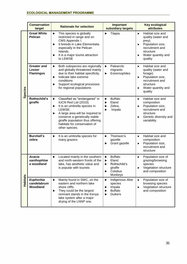
ECOLOGICAL MANAGEMENT PROGRAMME
35
Conservation
target Rationale for selection
Important subsidiary targets
Key ecological attributes
Sp
ecie
s
Great White Pelican
This species is globally restricted in range and on CMS Appendix I.
It breeds in Lake Elementaita especially in the Pelican Islands.
It is a major tourist attraction to LEWSE
Tilapia Habitat size and quality (water and prey)
Population size, recruitment and structure
Water quantity and quality
Greater and Lesser Flamingos
Both subspecies are regionally and globally threatened mainly due to their habitat specificity.
Indicate lake extreme conditions
Support ecological processes for regional populations
Palearctic migrants
Extremophiles
Habitat size and quality (water and forage)
Population size, recruitment and structure
Water quantity and quality
Rothschild’s giraffe
Classified as "endangered” in IUCN Red List (2010).
It is an umbrella species in LEWSE.
A large area will be required to conserve a genetically viable giraffe population thus offering habitats for conservation of other species.
Buffalo Eland Zebra, Impala
Habitat size and composition
Population size, recruitment and structure
Genetic diversity and variability
Burchell’s zebra
It is an umbrella species for many grazers
Thomson’s gazelle
Grant gazelle
Habitat size and composition
Population size, recruitment and structure
Hab
itats
Acacia xanthophloea woodland
Located mainly in the southern and north-western fronts of the lake, has aesthetic value and is popular with tourists
Buffalo Eland Rothschild’s
giraffe Colobus
Monkeys
Population size of grazing/browsing species
Vegetation structure and composition
Euphorbia candelabrum Woodland
Mainly found in SWC, on the eastern and northern lake shore cliffs.
They could be the largest remnant stands in the Kenya lake system after a major drying of the LNNP one.
Indigenous Aloe species
Impala Buffalo Duikers
Population size of browsing species
Vegetation structure and composition

LEWSE MANAGEMENT PLAN (2017 – 2027)
36
Conservation
target Rationale for selection
Important subsidiary targets
Key ecological attributes
Syste
ms
Lake and river systems
Essential riverine and Lake Buffer, wildlife habitat, threatened through intensifying water use and conversion of water catchment areas.
Riverine vegetation
Diverse bird species
Lake Elementaita
Forest catchment size
River regime (flow and pattern)
Water quantity and quality
Size, structure and composition of riparian habitat
Table 7. Threats to LEWSE Conservation Targets
THREATS
CONSERVATION TARGETS
River systems
Euphorbia candelabrum woodland
Acacia xanthophloea woodland
Great White Pelicans
Greater and Lesser Flamingos
Rothschild’s giraffe
Burchell’s zebra
Poaching High High
Livestock incursions
Medium High High High
Fire High High Medium Low Low
Invasive species
Low Low Low Low
Inbreeding High Low
Ecto-parasites
Low Low Low
Disease Low Low High High
Settlement in dispersal areas
Very High High High High
High
Predation High Low
Logging and charcoal production
Very High Low Very High
Human encroachment
Very High Very High Very High
Tourism infrastructure development
Low Low Low
Destruction of catchment forest
High
Conversion of riparian habitat
Very High
Swamp drainage
Very High

ECOLOGICAL MANAGEMENT PROGRAMME
37
THREATS
CONSERVATION TARGETS
River systems
Euphorbia candelabrum woodland
Acacia xanthophloea woodland
Great White Pelicans
Greater and Lesser Flamingos
Rothschild’s giraffe
Burchell’s zebra
Use of agricultural chemicals
Medium
Abstraction of water for irrigation
Very High
Mining (Sand, salt, diatomite)
Medium Medium Medium
Ecological management objectives and actions
The identification and ranking of the threats to LEWSE’s conservation targets and their Key Ecological Attributes (KEAs) provides the basis for the development of the Ecological Management Programme’s management objectives and actions. Objectives have been developed to address the clusters of threats shown in table 8. Three objectives have been developed addressing threats to LEWSE’s species of concern (covering conservation targets: Pelicans, Flamingos and Rothschild’s giraffe); addressing crosscutting threats to LEWSE’s most important habitats (covering conservation targets: Lake and river systems; and addressing threats to targets selected beyond the CZ and the BZ (i.e. river systems). The three objectives are: MO 1. Conservation status of LEWSE’s species of concern enhanced MO 2. Forests, lake and river systems, and other important habitats protected and
improved MO 3. Water resource management enhanced These management objectives and their subsidiary management actions are described in detail in the sections below. Under each management objective there is a brief description of the relevant management issues and opportunities.
Management Objectives and Actions
Objective 1: Conservation status of LEWSE’s species of concern enhanced
The drivers of the declining populations of Pelican, Flamingo and giraffe haven’t been understood. The Great White Pelican and the Pink-Backed Pelican breed in the western part of the lake on numerous islands of black lava. In dry years, these islands are connected to the shore by stretches of mud flats and have been found to provide the only suitable nesting and breeding grounds for Pelicans in the Rift Valley region. The pelicans are a key attraction to the lake as

LEWSE MANAGEMENT PLAN (2017 – 2027)
38
well as umbrella species to other waterfowls such as Blacksmith plover (Vanellus armatus). Therefore the pelican population can be used as a good indicator of the health for the Lake. The Flamingo species are both regionally and globally threatened mainly due to their habitat specificity. Climatic extremes are likely to negatively impact on Flamingo and Pelican food supply as well as breeding sites. When environmental conditions, particularly food resources dwindle in other saline lakes in the Rift Valley, flamingos disperse to Lake Elementaita, thus making the lake a major refuge in Kenya’s southern Rift Valley. The birds’ response initially would be to move in search of better conditions, which if unavailable, mortality would rise and numbers decline. The large aggregations of flamingos are a great spectacle which attracts tourists to the area. The ecological interactions can have diverse effects including tourism performance, habitat health in the Rift Valley lake systems and hence socio-economic implications for range countries. The health of the flamingo population is also an indicator of the health of the Lake. Therefore, under this objective climate change - related threats to key attributes of migratory, rare and endemic bird populations will be studied and managed to ensure that viable flamingo and Pelican populations are sustained in the area. Giraffes are the largest mega herbivores in Soysambu wildlife sanctuary and therefore an umbrella species. Survival of genetically viable Rothschild’s giraffe population in LEWSE will depend on availability of suitable habitat that can support a minimum viable population. This will require conservation of a sufficiently large track of land that will also contain large herds of other species. A focus on giraffe as a conservation target will ensure that the buffer zone is also protected. The desired future state of LEWSE is one where the four species level conservation targets for the LEWSE are effectively managed and monitored, to ensure their long-term survival in LEWSE, and that of the co-occurring species and habitats. In order to achieve this desired state, a series of management actions have been developed relating to the species-level conservation targets: pelicans, flamingos and Rothschild’s giraffe. These actions are elaborated in the following sections.
Action 1.1 Intensify monitoring of the Pelican and Flamingo populations
The National Museums of Kenya, in collaboration with other stakeholders, has established a long-term water fowl monitoring programme which carries out a water fowl count in the area semi-annually. They have accumulated long-term data on Pelican and Flamingo populations in the saline lakes of Rift Valley, including Lake Elementaita, which forms baseline information for further monitoring of the populations’ dynamics. In order to better understand the population trends of the Great White Pelicans and lesser Flamingos, LEWSE management will mobilize more personnel, transport and equipment from Soysambu Wildlife Sanctuary and local conservation community based organisations to support the water fowl censuses. Scheduled censuses will be carried out bi-annually from predetermined spatial locations in the lake shore.
Action 1.2 Protect the Pelican breeding habitats and investigate climate related pressures
The main threat to pelican populations is loss of their breeding sites due to receding shoreline. As a result, the rock islets are easily accessible to predators making eggs and chicks vulnerable. Therefore, under this management action, LEWS management will collaborate with stakeholders in the water catchment areas of rivers feeding Lake Elementaita to ensure regulated water abstraction and sufficient inflow (Action 3.2 – 3.4).

ECOLOGICAL MANAGEMENT PROGRAMME
39
These nesting sites can also be fenced to exclude predators. However, such a major intervention will be subject to EIA to identify and address adverse impacts. Some treatments will be experimental entailing data records on site location, timing, size of breeding flocks, nests and outputs comparable to climatic variables, food availability to reveal the drivers of breeding condition and success. Flamingos are potential competitors for prime nesting sites, so flamingo population and breeding data should be related to the comparable pelican data. Data on bird carcasses will be recorded according to date, location, sex, age and apparent cause (e.g. disease, starvation, predation, collision with power lines) and then related to climatic and other variables to explore their relevance to pelican mortality and population dynamics. Further laboratory work to establish cause will be undertaken as necessary. In the case of predation, the predator species concerned will be identified and their distribution and numbers monitored as necessary. Hyena predation in particular is known to increase under dry conditions.
Action 1.3 Maintain a Lake habitat that is suitable for flamingo foraging
So long as there is water in the lake, then a variety of fast growing single celled algae, diatoms and blue green algae (Spirulina platensis) will thrive in the lake and attract large numbers of flamingos and other waterfowls. The challenge therefore is ensuring that adequate water that does not suffer pollution, reaches the Lake. The major cause of declining water in the Lake is excessive abstraction of water from the two main rivers emptying into it i.e. Meroreni and Kariandusi Rivers. Agricultural and wood treatment chemicals and perhaps sewerage washed into the Lake from adjacent lands are the key sources of pollution. To maintain Lake Elementaita as an important foraging area for the flamingos, LEWSE management will work closely with NEMA to ensure that Environmental Audits (EA) are carried out for all major facilities (industrial and tourism) that have potential to pollute the Lake water. Once the EAs are carried out, LEWSE will follow-up with these facilities to ensure that pollution mitigation measures are implemented.
Action 1.4 Carry out a study on Rothschild’s giraffe habitat requirements and population dynamics
While Rothschild’s giraffe numbers have declined substantially in other areas within LEWSE because of human encroachment and subsequent habitat destruction, the population in Soysambu Wildlife Sanctuary (SWS) has been increasing due to suitable habitat. In order to maintain a viable Rothschild’s giraffe population, KWS will carry out a study to determine suitable stocking levels in SWS and other potential habitats in LEWSE. The variables to be measured are the population sizes, recruitment rates and age/sex structures over time, forage availability and suitability, land cover, and ecological carrying capacity. This information will provide a baseline for assessing the effectiveness of the management actions and for improving management responses to changing conditions. In addition, LEWSE management will continue its support of the regular wildlife census to monitor all wildlife population trends.

LEWSE MANAGEMENT PLAN (2017 – 2027)
40
Objective 2: Forests, lake and river systems, and other important habitats protected and improved
One of the main causes of decline in wildlife numbers in LEWSE is a combination of intense poaching pressure, wildfires, livestock grazing and logging. Most notably the Ututu scrubland, Acacia xanthophloea woodland and the wooded grasslands are being gradually encroached upon by charcoal producers resulting in an overall increase in open bushland habitat across LEWSE. The lake and river systems also have been threatened by conservation-incompatible human activities such as permanent tourism facilities and associated infrastructure. Waste effluents containing heavy metals and metabolites potentially from point and non-point sources (i.e. tourism hotels and agricultural farms) threaten the lake’s aquatic hyper alkaline environments which drive photosynthesis and nutrients cycling in soda lakes. Natural woodland vegetation has been irregularly cut rendering bare most of the southern and northern-eastern section of the cliffs. These changes have impacted negatively on the habitat diversity in LEWSE and the ability of grazing species to recolonize the area. Terrestrial areas of the lake’s riparian area are required to cushion water from impacts such as pollution, erosion, sedimentation, nutrient depletion and wildlife habitat fragmentation. This pressure occurs because the buffer zone is inadequate and has not been conserved to sustain its buffering functions. There is a need to consultatively identify and protect riparian land and some ecologically sensitive sites (such as forest, marshes, and cliff) that are outside LEWS and SWS. Cadastral maps developed in 1950s didn’t provide for an adequate riparian reserve and hence parts of Lake Elementaita’s riparian land falls inside private land. Likewise parts of the ecologically sensitive areas such as marshes, flood plains, cliffs, hills, woodlands fall outside the sanctuary. The same maps were used to compile LEWS boundary plan. The purpose of establishing the sanctuary was to protect and conserve birdlife and associated habitats around Lake Elementaita. Sanctuary operations require management access all-round the lake for security, surveillance and general administration. This has exposed the lake’s riparian land to incompatible activities leading to degradation observed through depletion of natural vegetation, water pollution, and fragmentation of wildlife habitats and sedimentation of the lake. Large mammals which historically used to transit around the lake can only move between Soysambu Conservancy and only as far as Country lodge. The affected species whose movements have been confined include buffalos, zebras, Elands, and Impalas while the Rothschild giraffes are confined due to their inability to cross the cliffs and fences. Some of these impacts can be reversed through first securing the lake’s riparian area and then implementing sustainable interventions. The desired future state that this objective aims to achieve is one where the management of key habitats is improved, so as to re-establish the area’s natural vegetation composition and dynamics support the restoration of the area’s natural wildlife species composition, and improve tourism game viewing in the buffer zones. In order to achieve this future desired state, eight management actions have been developed that address the threats impacting on the four habitat-level conservation targets selected for the LEWSE: Acacia xanthophloea woodland; Euphorbia candelabrum woodland; and lake riparian and river systems.

ECOLOGICAL MANAGEMENT PROGRAMME
41
Action 2.1 Continue implementation of the LEWS Re-survey and Boundary Variation Project
The UNESCO funded project on LEWS Re-survey and Boundary Variation was developed to secure Lake Elementaita riparian and sensitive sites in its neighbourhood (i.e. woodlands, cliffs, hills and hot springs). The project entailed stakeholders’ consultation, ecological and socioeconomic assessment, Lake and sanctuary boundary survey and riparian recovery. Phase 1 of the project has been implemented, and it involved holding two stakeholders consultative meetings in which project awareness was created, draft LEWSEMP reviewed, rapid ecological and socioeconomic surveys carried out, boundary survey of the Lake Elementaita Wildlife Sanctuary, riparian land under private ownership mapped9, and ecologically sensitive sites, critical wildlife dispersal areas and sanctuary operations space were also mapped (See figure 7). The following pending activities will be carried out: further ecological and socioeconomic assessment to address gaps in information on status of small mammals, forest/woodland birds, herpetofauna and invertebrates of Lake Elementaita; inventory of private owned land parcels in the riparian land and sensitive sites; and negotiate and agree with land owners on the best conservation measures to secure and rehabilitate riparian and sensitive sites.
9 based on the highest water mark recorded in December 1964 (i.e. of 3.39 Meters)

LEWSE MANAGEMENT PLAN (2017 – 2027)
42
Figure 7. Extent of the riparian area defined by the 1780m contour
Action 2.2 Control wild fires
Wildfires in Soysambu Conservancy and Ututu scrubland are a major threat to the wooded grasslands. Major outbreaks that occur annually impact negatively on the population of medium sized mixed-feeders as well as heavy grazer wildlife species. This results in escalation of human-wildlife conflicts when these grazers leave the conservancies to neighbouring settled areas in search of food. To control bush fires, LEWS management collaborate with the Soysambu Conservancy in creating awareness among the local community on the impacts of bush fires and the importance of fire preparedness. In addition, charcoal production in the buffer zone will be controlled. KWS will also assist Soysambu conservancy to put out wild fires when they occur.
Action 2.3 Develop research and monitoring programmes to address specific issues
Limited socio-economic and scientific studies have been undertaken in the area. Hence, there is inadequate information on hydrology, hydrogeology, flora, fauna and socio-economic

ECOLOGICAL MANAGEMENT PROGRAMME
43
aspects. Sound scientific data and information are imperative for effective conservation and management of Lake Elementaita ecosystem in view of the complexity of the existing environmental issues in the area. Consequently, the following research and monitoring programmes are recommended to understand ecological interactions:
Hydrology
Hydrogeology
Water quality and quantity
Floral and faunal dynamics
Land use changes and socio-economic trends
EIA for infrastructure development
Action 2.4 Carry out a LEWSE land use/cover change study
LEWSE’s adjacent areas have in the past suffered heavily from land conversion and habitat modification with far-reaching impacts on the area’s wildlife populations. Many browsing and grazing species have been drastically reduced in numbers after the influx of small scale settlers in areas adjacent to LEWSE. However, although these changes are widely acknowledged, scientific investigation and documentation of the actual changes in LEWSE vegetation types needed as a basis for their current management has not been undertaken. As such, a land use/cover change survey will be carried out with support from LEWSE stakeholders to establish the specific changes that have occurred regarding the LEWSE vegetation types and clearly identify areas where significant changes in land use and cover have occurred. This information will help in focusing the habitat management activities that are required to maintain a healthy mix of wildlife populations.
Action 2.5 Carry out a study to establish impacts of livestock on vegetation structure and composition
A critical tool that can be used to forestall livestock incursions is raising awareness among the local communities on the impacts of livestock grazing on the area’s vegetation structure and composition. This, however, can only be carried out if scientific information on the impacts of livestock is available. Consequently, a study will be carried out to establish the impacts of livestock incursions on the vegetation structure and composition of habitats in LEWSE. The study will be carried out by LEWSE researchers in collaboration with other institutions of higher learning such as universities with LEWSE management offering logistical support as appropriate.
Action 2.6 Carry out a study on the population size and carrying capacity of the key browsing/grazing species
There is a substantial relationship between the health of habitats and the prevailing browsing/grazing pressure. If the population of herbivores is maintained at below the carrying capacity, biological diversity and habitat health is more likely to be maintained. However, if the herbivore population is maintained above ecological carrying capacity, chances are that the habitat will be damaged. Hence, a study will be carried out to determine the optimal herbivore population sizes that are suitable for the buffer zone. Once this information is available, LEWSE management will focus its management activities in maintaining the recommended stocking levels.

LEWSE MANAGEMENT PLAN (2017 – 2027)
44
Action 2.7 Train the community in effective livestock husbandry practices
Livestock kept in the area include cattle, sheep, goats and donkeys, which are traditional breeds that yield low income. Most of the farmers’ land parcels in the plan area cannot support their livestock numbers due to inadequate pasture as a result of low rainfall. Inappropriate livestock breeds, prevalence of livestock diseases and livestock rustling are the major constraints to development of livestock production as a viable income generating activity. Consequently, LEWSE management will support training of community members in sound livestock husbandry practices to improve economic returns from livestock. In addition, the community will be trained in pasture improvement practices to create a favourable environment for livestock and wildlife to co-exist.
Action 2.8 Develop appropriate codes of conduct to regulate mining activities within the LEWSE
Mining activities in LEWSE involve extraction of sand, salt and diatomite. Sand is extracted at the old lakebed in the southern part of the lake. Salt is extracted using evaporation pans along the lakeshore and is sold at the roadside. Mining of whichever product has a negative impact on the environment in one way or another unless appropriate mitigation measures are implemented. Hence, to mitigate habitat degradation through mining, LEWSE managers will collaborate with miners and NEMA in developing mining regulations that will be adhered to by local miners and salt harvesters. However, mining will be prohibited in LEWS and the Lake’s riparian area.
Action 2.8 Support establishment habitat connectivity between Lakes Nakuru, Elementaita and Naivasha
To facilitate free movement of wildlife in the greater LEWSE, and ensure ecological linkage between lakes Nakuru, Elementaita and Naivasha, all wildlife migratory corridors and critical dispersal areas in the greater LEWSE will be Identified, mapped and protected. In particular to ensure that habitat connectivity is maintained, efforts will be made to design and protect a wildlife corridor where only conservation-compatible activities will be permitted (see figure 8). This initiative will increase ecological resilience in the wake of impacts of climate change. Further, a local physical development plan will be prepared for this corridor and LEWSE.

ECOLOGICAL MANAGEMENT PROGRAMME
45
Figure 8. Preliminary map of the Lanneca wildlife corridor
Action 2.9 Prepare a local physical development plan for LEWS
The riparian area to the south and east of LEWS is increasingly being overcrowded by tourism development. Tourist accommodation facilities are being established on small plots in the individual land parcels in the former Gema Holdings Ranch. This has resulted in the number of tourist facilities increasing to over 15 facilities in such a small area. The Kekopey trading center is also expanding towards the lake Elementaita at a fast rate. Further, the wilderness area in Ututu has been subdivided for residential development. Unplanned development in the LEWSE will degrade the aesthetic appeal and conservation value of the area.

LEWSE MANAGEMENT PLAN (2017 – 2027)
46
In order to enhance the aesthetic appeal of the LEWSE, KWS will collaborate with Department of Physical Planning, tourism stakeholders, individual land owners in the former Gema Holdings, and Soysambu Conservancy to curb uncontrolled tourism related infrastructure development in the ecosystem. Towards this, KWS will liaise with Department of Physical Planning to initiate a local physical development planning process as prescribed in the National Spatial Plan 2015-2045. This plan will define allowable land uses and set aside sites for future infrastructure development in the ecosystem. The output land use plan will be used by County Government of Nakuru to control future land use developments in the area. In addition, the physical development plan will clearly define and map all the environmentally sensitive areas and prohibit development in these areas.
Objective 3: Water resource management enhanced
LEWSE receives extremely low rainfall. The main water sources are two hot springs and the seasonal Kariandusi and Meroreni/Mbaruk Rivers. Most of the water from these sources is mainly used for domestic supply as well as small-scale irrigation leaving very little to recharge the Lake. Other problems facing the water use in the area include: paucity of information on hydrology and dynamics of water resources in the area; unequal accessibility of water resources to stakeholders; declining water resources; inefficient water delivery technology resulting in water wastage through burst pipes (Maji moto line) and poorly maintained water systems; unregulated water abstraction; absence of appropriate water management and planning systems; lack of alternative water sources e.g. roof water harvesting or storage reservoirs; ineffective enforcement of water legislation due to lack of personnel; deteriorating water quality and quantity; temporal availability of water; lack of adequate capacity for water regulatory institutions; and, poor education and awareness on conservation of water resources in the plan area. To effectively address the water sector issues and achieve the future desired state as regards water resource management in the area, a series of management actions have been developed that correspond to the river systems conservation target. These actions are elaborated in the following sections.
Action 3.1 Develop sub-catchment water allocation plans
The main instrument to guide water allocation from rivers in LEWSE is the Water Allocation Plan (WAP). The WAP provides the guidelines and procedures that govern the way in which water is to be allocated for different uses, and the management controls that are required to safeguard the water resource. To streamline water allocation in LEWSE and mitigate impacts of excessive abstraction from water bodies (rivers and springs), the Water Resources Management Authority (WRMA) will prepare sub-catchment WAPs for all the major rivers. The WAPs will spell out how water will be allocated to various types of users based on priority of use, measures to be taken during seasons of water stress, and ways and means of enforcement and compliance.
Action 3.2 Collaborate with WRMA in monitoring water abstraction in the LEWSE
As a result of enactment of the Water Act, which decentralized permit issuance to the Regions, there is need to take an inventory of all valid water permits and review them with a view of
ECOLOGICAL MANAGEMENT PROGRAMME
47
making them compliant with the requirements of the Water Act 2002. In regard to this, WRMA will create comprehensive databases of water abstractors which will be regularly updated. This information will be openly shared with the other stakeholders, and particularly those who are involved in the management of LEWSE. In addition, WRMA will collaborate with these stakeholders (LEWSE management) in carrying out inspections of water abstraction points in areas adjacent to LEWSE to ensure that illegal water abstraction is stopped.
Action 3.3 Develop unified water abstraction, storage and delivery systems
Illegal abstraction of water is exacerbated by proliferation of community as well as individual water intake points which are difficult to monitor as they are far apart. To curb illegal water abstraction, WRMA will cluster all authorised water intakes that are in close proximity of each other into common intake points to facilitate control and monitoring of water abstraction in the LEWSE catchment. To facilitate the establishment of common intake points, WRMA will carry out water abstraction surveys for all the major rivers emptying into Lake Elementaita to understand water demand and supply in the LEWSE catchment. In addition, all water abstractors will be required to install water metres to facilitate monitoring water utilisation and levying appropriate fees to water users.
Action 3.4 Collaborate with WRUAs to enforce water regulations
The Ministry of Water and WRMA, in collaboration with other stakeholders, have prepared a set of regulations in line with Water Act 2002 (Legal Notice 171-The Water Resources Management Rules, 2007). WRMA has the responsibility of enforcing these regulations, while Water Resource Users Associations (WRUAs) and other water users can also be used to support enforcement of the regulations. WRUAs have a potential role through signed MoUs between them and WRMA in: Identifying the members who are not compliant; sensitizing the members on the need to become compliant; conducting inspections as well as patrols on compliance; recommending remedial measures and preparing proposals for funding; and embedding code of practice for water users in their various constitutions. In light of this, WRMA will increasingly work with WRUAs to enforce water regulations ensuring that water allocation plans are adhered to and land use activities injurious to riparian systems are curbed.
Action 3.5 Support irrigation farmers to harvest run-off or flood water for irrigation
Rainwater harvesting for agriculture by local farmers in the watersheds of rivers flowing in LEWSE can immensely augment surface water use in agricultural production and address environmental problems such as soil erosion. Harvesting rainwater to support meaningful irrigated agriculture requires that simple, appropriate and affordable rain harvesting and irrigation technologies be availed to farmers. To increase gains from rain harvesting, it is essential that farmers are not only facilitated to harvest rain water, but they are also helped to adopt both water-saving irrigation systems and highly effective crop production systems. In view of this, to enhance rain water harvesting for irrigation and domestic use, WRMA will provide training and extension services to farmers to facilitate adoption of rain water harvesting.

LEWSE MANAGEMENT PLAN (2017 – 2027)
48
Action 3.6 Monitor water quality from water sources
It has been observed that intense human activities are taking place upstream of most rivers affecting water quality. One of the guiding principles of WRMA is to enhance protection of the quantity and the quality of all water resources based on improved information. Hence, for proper assessment of the status of water resources within the catchment, improved monitoring of the resources will be carried out. And to curb deterioration of the water resource due to pollution, WRMA will be vigilant in identifying pollution sources and taking appropriate management or legal action where necessary. Other measures to curb pollution include encouraging livestock keepers to construct water troughs; disseminating recommended water quality standards to stakeholders; and involving the local community in monitoring and reporting water pollution incidents.
Action 3.7 Implement management and development prescriptions for the riparian area
To protect the aesthetic value of the lakes environs and thereby enhance tourist enjoyment of the scenic attractions, LEWSE management will collaborate with stakeholders in ensuring that incompatible land use activities are prohibited in the lake’s riparian land, whether private or public owned. As such, efforts will be made to implement the stake-holder agreed zoning plan and zone prescriptions.
LEWSE Ecological Monitoring Plan The LEWSE Ecological Monitoring Plan (EMP) is a key component to the programme’s management objectives and actions (Table 8). The threats and the KEAs identified through the TNC CAP process are used to monitor the overall status of the conservation targets, and therefore a surrogate measure of the health of the LEWSE. The EMP facilitates assessment of the effectiveness of implementation of the management actions under this programme. The indicators of change provide easily measurable attributes for assessing the status and trends of the KEAs or threats to each conservation target. The indicators selected also provide an early warning of any serious threats that may develop during the lifespan of this plan, which may potentially require the development of new management actions. The CRCA Research Office will include monitoring activities in its annual work plans.

ECOLOGICAL MANAGEMENT PROGRAMME
49
Table 8. Framework for the development of the LEWSE Ecological Monitoring Plan
KEA/Threat Indicator of
change Method of
measurement Collection frequency
Data source
Responsibility
Data currently
collected?
Relevant Action(s)
Conservation Target 1: Great White Pelican
KEA: Habitat size and quality Threat: Water level fluctuation
Water level
Depth measurements Satellite images
Biannual
Monitoring reports
WRMA
Baseline data is available
Action 1.2
KEA: Population size, recruitment and structure
Number of individuals Direct count Biannual Water fowl census report
KWS Baseline data available
Action 1.1
Threat: Mining Ground cover
Land cover survey
Biannual Monitoring reports
KWS Baseline data available
Action 2.8
Conservation Target 2: Greater and Lesser Flamingos
KEA: Habitat size (water quantity and quality)
Water level Forage level
Depth measurements Microscopy
Biannual Monitoring reports
KWS Baseline data available
Action 1.1
KEA: Population size, recruitment and structure
Number of individuals Direct count Biannual Water fowl census report
KWS Baseline data is available
Action 1.1
Threat: Global warming
Surface temperature anomaly Rainfall
Annual weather average Climate data KWS YES Action 1.2
Threat: Pollution
Biological Oxygen Demand, Bacteria, Algae biomass, Cyanobacteria Acidity (pH), colour, dissolved oxygen and turbidity
Microbiological analysis Chemical analysis
Biannual Monitoring reports
KWS YES Action 1.3 Action 2.3 Action 3.6
Threat: Mining Ground cover
Land cover survey
Biannual Monitoring reports
KWS Baseline data is available
Action 2.8
Conservation Target 3: Rothschild’s giraffe

LEWSE MANAGEMENT PLAN (2017 – 2027)
50
KEA/Threat Indicator of
change Method of
measurement Collection frequency
Data source
Responsibility
Data currently
collected?
Relevant Action(s)
KEA: Habitat size and composition
Quantity and quality of preferred forage species;
Point-centred Quarter (PCQ) Bi-annual Monitoring reports
KWS Data unavailable
Action 1.4 Action 2.6
Threat: Confinement (Barriers on wildlife corridors, Settlement in dispersal areas, land tenure)
Fence porosity, Number of households
Land cover survey Bi-annual Monitoring reports
KWS Data unavailable
Action 1.4
KEA: Population size, recruitment, structure Threat: Poaching, Predation
Number of individuals Total enumeration Analysis of occurrence book data
Bi-annual Census reports Occurrence book
KWS Baseline data is available
Action 1.4
KEA: Genetic diversity and variability Threat: Inbreeding
Phenotypes & Genotypes Genetic analysis and mapping; Population performance
Every 3 years Genetic analysis reports
KWS Data unavailable
Action 1.4
Conservation Target 4: Burchell’s zebra
KEA: Habitat size and composition
Area of grassland forage availability and suitability Water availability
Land cover survey PCQ, Lab forage analysis
Bi-annual; Daily (rainfall data)
Monitoring report
KWS Data unavailable
Action 2.6
Threat: barriers and livestock incursions
Length of fences Number of livestock
Analysis of satellite images and aerial photos Ground survey
Bi-annual Monitoring report
KWS Data unavailable
Action 1.4 Action 2.4 Action 2.5
KEA: Population size, recruitment and structure
No. of individuals (age and sex); body condition
Individual IDs; ground counts Quarterly ID reports; ground count reports
KWS Data unavailable
Action 2.6

ECOLOGICAL MANAGEMENT PROGRAMME
51
KEA/Threat Indicator of
change Method of
measurement Collection frequency
Data source
Responsibility
Data currently
collected?
Relevant Action(s)
Threat: Poaching
Number of arrests made, snares removed, kills
Analysis of occurrence book data
Monthly Arrests and de-snaring reports
KWS Baseline data available
Action 4.2 (Operations Programme)
Conservation Target 5: Acacia xanthophloea woodland
KEA: Vegetation structure and composition
Forest cover, Species richness
PCQ Wet & dry season bi-annually
Vegetation survey report
KWS Data unavailable
Action 2.3 Action 2.4
Threat: Logging and charcoal production, Livestock incursions
Extent of deforestation Ground survey Wet & dry season annually
Vegetation survey report
KWS Data unavailable
Action 2.4 Action 2.5
KEA: Forest size Threat: Habitat conversion (logging & charcoal production, tourism infrastructure, encroachment
Forested area Extent of deforestation
Analysis of satellite images and aerial photos Ground survey
Every 5 years Land cover changes report
KWS Baseline data available
Action 2.4
Conservation Target 6: Euphorbia candelabrum Woodland
KEA: Vegetation structure and composition
Vegetation cover Species richness
PCQ Wet & dry season bi-annually
Vegetation survey report
KWS Data unavailable
Action 2.3 Action 2.4
Threat: Fire, Human encroachment
Forest cover Number of fire incidences
Satellite image & aerial photography analysis Ground survey
Every 5 years Land cover changes report Pre-burning, burning and
KWS Baseline data available
Action 2.4

LEWSE MANAGEMENT PLAN (2017 – 2027)
52
KEA/Threat Indicator of
change Method of
measurement Collection frequency
Data source
Responsibility
Data currently
collected?
Relevant Action(s)
post-burning reports
Conservation Target 7: Lake and River Systems
KEA: Forest catchment Threat: Logging and charcoal production Mining,
Riverine vegetation cover Extent of destruction
Satellite image, aerial photo analysis Ground survey
Bi-annually Daily surveillance
CGN Ortho photo WWF imagery data WRMA monitoring reports
KWS, WRMA Baseline data available
Action 2.4 Action 3.6
KEA: River regime (flow and pattern) Threat: Conversion of riparian habitat, Swamp drainage
Course shift Area under swamps Extent of destruction
Satellite image and aerial photo analysis GIS
Biannually, Daily surveillance
WRMA monitoring reports
KWS, WRMA Baseline data available
Action 3.6
KEA: Water quantity and quality Threat: Pollution and abstraction
Water volume (m3) BOD, Bacteria Turbidity, Electrical conductivity
Depth measurement from RGS Direct measurements (water toolkit) and lab analysis
Biannually WRMA monitoring reports
KWS, WRMA Baseline data available
Action 3.1 Action 3.2 Action 3.3 Action 3.4 Action 3.6

Tourism Development & Management Programme

LEWSE MANAGEMENT PLAN (2017 – 2027)
54
Programme Purpose and Strategy
The LEWSE is a major tourism destination in Kenya, offering a distinctive and diverse visitor experience that capitalises on the area’s mix of values
Lake Elementaita is an important tourist attraction for visitors destined for the Rift Valley alkaline lakes harbouring large flocks of flamingos and pelicans. A major viewpoint exists off the Trans-African highway which transverses the basin. Further, the NMK operates an anthropogenic pre-historic site at Kariandusi, which displays historical aspects of the Stone Age Man. Scenic sites around the lake include the Acacia and Euphorbia woodlands, the hills and cliffs, and lake water body. These features seem to have favoured private tourist facility developments fronting Lake Elementaita Wildlife Sanctuary to the east and north (Figure 10). Activities include game viewing and bird watching using bird hides, nature walks and scenic viewing, balloon safaris, restaurant services, guided tours and sale of handicrafts. Community members frequent hot springs for refreshing warm baths which allegedly have skin healing effects. The major factors limiting realization of the area’s tourism potential are: 1. Low diversity of attractions and under development of available sceneries,
2. Uneven mammal fauna distribution around the Lake,
3. Poor tourism infrastructure especially the roads,
4. Lack of information on tourist carrying capacity,
5. Insufficient marketing and publicity,
6. Insufficient participation of local household community members,
7. Uncoordinated management of the area.
The eastern and northern areas around the lake experience increasing spatial development of tourist camps, lodges, and home stays without the any controls (see figure 9). Such developments are meant to tap potential tourism value but if they are not controlled, environmental aesthetic values could be severely impaired. These and other related concerns led the National Environmental Management Authority of Kenya to declare a moratorium on all further developments or projects listed in the second schedule of the EMCA Amendment 2015 for the LEWS until the completion of this 10-year management plan.

TOURISM DEVELOPMENT & MANAGEMENT PROGRAMME
55
Figure 9. Tourism facilities around L. Elementaita

LEWSE MANAGEMENT PLAN (2017 – 2027)
56
Guiding Principles In implementing the LEWSE’s Tourism Development and Management Programme, LEWSE Management will adhere to the following guiding principles:
Tourism is developed as a major positive force in support of LEWSE’s conservation and management Tourism has a huge potential as a source for sustaining LEWSE’s long-term financing needs to run its management and conservation programmes. A significant and active tourism industry will also raise the profile of the area, and thereby encourage political and financial support from government and donors.
Tourism load within the area’s carrying capacity
While tourism has the potential to be a strong and sustainable source of support for conservation and management of the area, uncontrolled tourism development has the potential of keeping away visitors due to congestion. Most visitors to the LEWSE are presently attracted by the large waterfowl, especially pelicans and flamingos, as well as Kikopey Hot springs which are unique to this area. The challenge therefore is to develop the capacity of tourism to support the long-term conservation of the open water body of the Lake and contribute to national economic development, while continuing to ensure a top-quality visitor experience based on diverse tourist attractions. These guiding principles are intended to guide the implementation of the Programme‘s three management objectives that, when taken together, will achieve the Programme Purpose. These three objectives are: MO 1. LEWSE tourism product expanded and diversified MO 2. LEWSE is marketed as a single destination MO 3. LEWSE tourism management improved These management objectives and the actions needed to achieve them are described in the following sections. Under each management objective there is a brief description of the relevant management issues and opportunities, which provide the specific context and justification for the management actions.
Management Objectives and Actions
Objective 1: The LEWSE tourism product expanded and diversified
The LEWSE’s tourism product presently revolves around wildlife viewing in Soysambu Conservancy and in LEWS at the open Lake waters. This objective aims to expand and diversify LEWSE’s visitor activities and their support infrastructure to attract an increased number of visitors to the area and encourage tourism use of the entire LEWSE. Two of the key issues that need to be addressed in order to achieve this objective are the development of a conducive environment that fosters private sector interest and investment in new activities in LEWSE, and the establishment of management systems necessary to support the implementation of these activities. This will involve building on, and adapting any existing national guidelines to take

TOURISM DEVELOPMENT & MANAGEMENT PROGRAMME
57
account of the specific issues and opportunities in LEWSE, as well as communication and collaboration with the tourism industry to ensure that LEWSE is providing appropriate support for their initiatives. The management actions under this objective are elaborated in the following sections.
Action 1.1 Facilitate and regulate existing alternative activities to traditional game-viewing
There is significant scope for the development of a wide variety of new and innovative visitor activities in LEWSE (such as hiking, camel safaris and other activities). Due in part to ambiguous regulations and a lack of clear guidelines, currently existing activities are only occurring on an extremely limited scale in LEWSE, and their full potential in the area is not presently being realised. In addition, as tourism increases during the lifespan of this plan, the formalisation and regulation of these existing activities will become increasingly important in order to maintain a well-regulated and high quality tourism product. To facilitate the regulation and promotion of the existing alternative activities, this management action focuses on the review and adaptation of the relevant national guidelines, in order to create a set of specific guidelines appropriate for the LEWSE context. Once these guidelines have been developed, routes and areas where each activity can take place will be agreed amongst LEWSE managers, land owners and tourism stakeholders.
Action 1.2 Support the development of walking safaris in parts of the Buffer Zone
One of the activities that a visitor can engage in to enjoy the diverse values in LEWSE is walking. The LEWSE has a prehistoric site, Kariandusi that can be visited on foot from any tourist facility. The lake and associated waterfowl is a major attraction that can be enjoyed on foot. The private land adjacent to the lake also provides excellent opportunities for the development of walking safaris because of paucity of dangerous wildlife and presence of tourist attractions such as caves. Under this management action, therefore, LEWSE Management will support the development of walking safari routes in line with the general restrictions set out in the LEWSE Zonation Scheme. And to ensure that the routes are used by hikers, tour operators will be involved in the identification and alignment of the walking routes.
Action 1.3 Promote the development of horse and camel safaris in the buffer zone
Some of the remote areas in LEWSE are completely unused by visitors; mainly due to lack of infrastructure, lack of large mammals and unsuitable vegetation to sustain large mammals for game viewing from vehicles. However, these areas have potential for development of exclusive camel and horse safaris. As such, under this management action, such areas which are mainly located in the sparsely settled transition area and characterised by hills and ridges will be promoted as sites where tour operators can operate camel or horse safaris.
Action 1.4 Designate and establish special campsites in the Buffer Zone
Special campsites provide opportunities for camping in a safe and exclusive location within the CZ/BZ, a concept that appeals to many high-end mobile safari operators. Currently all of the LEWSE’s special campsites are located in Soysambu Wildlife Conservancy. However, there is significant potential for their development in the other areas of LEWSE. As such, sites suitable for

LEWSE MANAGEMENT PLAN (2017 – 2027)
58
development of special campsites will be identified and developed in LEWS as wells as adjacent land. And wherever possible these sites will be identified in collaboration with tourism operators.
Objective 2: LEWSE is marketed as a single destination
Currently, LEWSE is not a major tourist destination and many tour operators market/visit Lake Naivasha, then proceed to Lake Nakuru and skip most or all destinations in LEWSE; perhaps due to lack of adequate marketing and tourism support infrastructure in this area. Alongside the efforts to expand and diversify LEWSE’s tourism product as set out under the previous objective, it will be important to establish LEWSE’s identity as the only place in Kenya where pelicans breed and hence a distinctive and highly desirable destination. LEWSE is also a stopover refuge for the Greater and Lesser flamingos during their northward migration from their breeding sites in Lake Natron in Tanzania. This identity will be the cornerstone of efforts to market LEWSE and will underpin the expansion of tourism in the area. This objective focuses on building this distinctive identity for LEWSE, in particular through the coordinated marketing of the area as a single destination. Efforts to establish LEWSE’s tourism identity will be complemented by management actions aimed at enhancing the visitor experience in LEWSE, through improved interpretation facilities and education/interpretive materials highlighting the area’s exceptional natural resources and unique history. The management actions developed under this objective to ensure that awareness of LEWSE’s significance and values is raised are outlined below.
Action 2.1 Promote and market the area as a single tourist destination
LEWSE should build on the good will from the local populace to market the area as a top tourist destination based on its exceptional qualities and unique history. The history of the Delamere family blends well with LEWSE’s human settlement history and stands out as a unique historical item that should be captured in the LEWSE history. This action will focus on establishing and marketing a distinctive tourism identity and visitor experience for the entire LEWSE, which sets it apart from other tourism destinations in Kenya. Marketing will be based on the area’s special features including pelican breeding, flamingo refuge and the hot springs, along with the area’s rich history of the Delamere family, in particular with regard to their conservation and farming efforts.
Action 2.2 Develop interpretation displays at key sites associated with the Lord Delamere’s life and works
There are a number of historic sites of interest in LEWSE associated with the works of Hugh Cholmondeley, the 3rd, 4th and 5th Baron Delamere, and it is impossible to capture the history of LEWSE fully in the absence of a section on the Lord Delamere. Among Kenya’s white settlers, Delamere was famous for his utter devotion to developing Kenyan agriculture. For about twenty years, Delamere farmed his colossal land by trial, error and dogged effort, experimenting endlessly with crops and livestock, and accruing an invaluable stockpile of knowledge that would later serve as the foundation for the agricultural economy of the country. Hence there is huge written history about Lord Delamere and this should be included in LEWSE’s unique history. The graves of the Delamere family members should be included in the historical attractions.
Action 2.3 Develop a visitor map covering the entire LEWSE
A significant number of visitors to LEWSE are either Kenyan citizens or residents, who are likely to visit the area independent of any professional guide or safari company. As a result, almost all

TOURISM DEVELOPMENT & MANAGEMENT PROGRAMME
59
these visitors rely entirely on maps while navigating most tourist attractions. As such, to enhance visitor experience in LEWSE, a detailed visitor map covering the entire conservation area, will be produced and disseminated. LEWSE management will collect both spatial and non-spatial information which will be used to develop the visitor map. This information will then be cartographically processed using a Geographic Information System (GIS) environment to produce the visitor map. Once completed, these maps will be made available at entrance gates to LEWSE, visitor accommodation facilities, and appropriate retail outlets nationwide.
Action 2.4 Develop a guidebook covering the entire LEWSE
If properly developed and presented, guidebooks can not only enhance a visitor’s experience when visiting a protected area, but also serve to raise awareness of the area’s importance and the role of LEWSE in its protection. Typically these guidebooks provide visitors with information on the history of the LEWSE area, advice and information on visiting the area (including transport links from major centres), and information for visitors once in the area such as rules and regulations, accommodation options, maps, suggested itineraries and circuits, and detailed information on the biodiversity, ecology, and surrounding communities. As such, and in order to help improve the overall LEWSE visitor experience, a high quality guidebook will be developed for LEWSE.
Objective 3: LEWSE tourism management improved
Through the actions implemented under the previous two objectives, it is anticipated that visitor numbers, tourism support infrastructure and activities in the LEWSE will increase and diversify during the 10-year lifespan of this plan. If LEWSE Management is to achieve its obligations on tourism investors and operators, and ensure that the quality of the overall LEWSE visitor experience is maintained, the anticipated increases in the scale and complexity of tourism in the area need to be complemented by strengthening and enhancing of LEWSE tourism management capacity and systems. This objective focuses on ensuring that tourism management in LEWSE is strengthened, and that LEWSE managers have the capacity and supportive administration systems to meet their obligations to tourism industry partners. The management actions that have been developed under this objective are outlined below.
Action 3.1 Strengthen LEWSE tourism human resource capacity
The implementation of the management actions set out in this programme will require dedicated human resources at LEWSE who will take responsibility for implementation of this plan. The two competent authorities regarding land in LEWSE (KWS and Soysambu Conservancy) will jointly assess human resource needs and deploy relevant staff as appropriate.
Action 3.2 Hold regular meetings with LEWSE tourism investors and operators
Tourism investors and operators are major stakeholders in LEWSE, and their concerns and advice need to be regularly sought and considered in order to realise the area’s tourism potential, and to successfully implement a large number of the management actions contained in this programme. This group of stakeholders is also best placed to advise LEWSE management on the key issues that may be emerging in the tourism sector that may be discouraging the development of new activities and investments. As such, a LEWSE Tourism Management Committee will be established to improve communication and collaboration between LEWSE managers and private sector investors. This committee will consist of members from LEWSE Management and representatives from tourism industry stakeholders operating in LEWSE.

LEWSE MANAGEMENT PLAN (2017 – 2027)
60
Action 3.3 Implement LEWSE tourism infrastructure improvements
LEWSE management needs to be able to respond to the changing situation on the ground, and to the needs of tourism industry stakeholders. As such, as part of the preparation for LEWSE Tourism Management Committee meetings discussed under action 3.2 of this programme. LEWSE officers will hold individual consultations with tourism industry stakeholders in LEWSE to identify specific issues regarding infrastructure in the area. LEWSE management will then work together to ensure that the recommended improvements are included in their annual work plans and budgets.
Action 3.4 Model the area’s tourism carrying capacity
The LEWSE plan implementation committee will facilitate establishment of the lake’s Limits of Acceptable Use (LAU) for visitor accommodation in the buffer zone based on understanding of visitor use, investor business plan, relevant laws and the lake’s ecological carrying capacity. The LAU will be interpreted to prescribe zone-by-zone visitor accommodation numbers, visitor activities, facility density and designs and layout.

Community Partnership & Conservation Education
Programme

LEWSE MANAGEMENT PLAN (2017 – 2027)
62
Programme Purpose and Strategy
To support and enhance the participation of LEWSE adjacent communities in conservation and sustainable use of natural resources
The majority of LEWSE community members directly depend on natural resources for their livelihood needs. The main land use activities include agriculture, pastoralism, tourism, conservation and beef cattle ranching (see figure 10). These communities impact on LEWSE, through, for example, poor waste disposal, the closure of wildlife dispersal areas, irregular water abstraction, deforestation, uncontrolled use of the hot springs, visual intrusion on aesthetics and are also impacted through wildlife damage to property and human life. These reciprocal impacts are likely to escalate in the future as population density in the area continues to increase. Land owners and investors adjacent to LEWS feared the likely deprivation of ownership rights over riparian lands. These perceptions could influence undesirable reaction to conservation efforts. The Community Partnership and Conservation Education Programme will therefore work towards mitigating these impacts; improving awareness of LEWSE’s status and values, and fostering a constructive and supportive relationship between LEWSE management, its adjacent communities, and other key stakeholders. The key guiding principles for the implementation of this Programme towards achievement of its purpose over the next 10 years are set out below.
Figure 10. Distribution of human activities around L. Elementaita

COMMUNITY PARTNERSHIP AND CONSERVATION EDUCATION PROGRAMME
63
Guiding Principles In implementing LEWSE’s Community Partnership and Conservation Education Programme, LEWSE Management will strive to ensure that:
Communities can express their concerns, ideas and opinions
Effective communication between LEWSE managers and local communities is essential to enable both parties to raise common problems and work towards achieving shared goals. Without such two-way communication, it will be difficult to ensure community support for conservation, as minor issues are more likely to escalate into serious problems, and LEWSE management activities may not be optimally targeted towards community needs. As such, activities under this programme will aim to further develop and strengthen LEWSE management communication and collaboration mechanisms with local communities.
LEWSE is having a positive impact on the lives of local communities
LEWSE’s local communities bear many of the direct and indirect costs of wildlife conservation through human-wildlife conflicts. If LEWSE is managed primarily for conservation and tourism, communities will be denied access to certain areas that they had come to consider as ‘open access’ such as the shores of Lake Elementaita and Kekopey springs. Hence, there is need to address the community’s socio-economic needs so that communities support LEWSE’s conservation efforts.
Communities and other stakeholders are aware of LEWSE’s values and importance
One of the core functions of LEWSE will be to provide wildlife education and raise awareness of the values of LEWSE in order to improve support for wildlife conservation. As such, activities under this programme will establish a conservation education and outreach programme focusing outreach activities in community areas where support for conservation is poor, or where there are critical conservation issues that need to be addressed.
There is collaboration between LEWSE management and other stakeholders in strengthening LEWSE Community Participation in conservation
Many of the threats to the ecology and natural resources in LEWSE stem from community land-uses and practises many kilometres beyond the boundary of LEWSE’s CZ and BZ. The scale and intensity of these impacts is increasing and, although outside the direct mandate of LEWSE, these issues cannot be left unaddressed. As such, there is need to develop linkages and relationships with stakeholders and pursue partnerships and collaborations with other institutions and organisations (such as CBOs, County Administration and NGOs) to address issues of mutual concern outside of LEWSE. These guiding principles are intended to guide the development and implementation of the three management objectives that have been identified by stakeholders to achieve the Programme Purpose. These are:

LEWSE MANAGEMENT PLAN (2017 – 2027)
64
MO 1. Conservation education and awareness programme strengthened MO 2. Human-wildlife conflict reduced MO 3. Opportunities for communities to benefit from the LEWSE improved The following sections describe these management objectives and provide an outline of the management actions needed to achieve them. These management objectives and their subsidiary management actions are described in detail in the sections below.
Management Objectives and Actions
Objective 1: Conservation education and awareness programme strengthened
The desired future state for LEWSE is one where the existence of the conservation area is valued and supported by the local communities to ensure viable wildlife conservation in the long term. Investors and adjacent land owners have been concerned by alleged improper licensing of development projects by relevant public institutions. The proposed rehabilitation of the lake riparian and sensitive sites has the potential to not only improve the ecological health of the lake but in contrast negatively impact on adjacent land owners’ property rights, development activities or support to conservation of the lake. There is therefore need to develop mechanisms to resolve problems tainting project licensing and riparian rehabilitation activities and outcomes. Three management actions have been developed to realise the future desired state of the LEWSE in regard to enhancing community awareness of conservation issues. These actions focus on preparing interpretation materials targeting LEWSE’s local communities; promoting LEWSE through the mass media and the Internet; and supporting conservation education programmes in local schools. These actions are described further in the following sections.
Action 1.1 Prepare interpretation materials targeting local communities
Several promotion materials will be prepared for LEWSE, especially on the resources in the CZ/BZ, including a detailed infrastructure map, brochure and poster. The version of interpretation materials in Tourism D&M Programme will be reviewed to bring out the sensitivity and importance of diverse resource values to the various groups of the local community. The materials will be disseminated through the outreach activities envisaged under Action 1.3 of this programme.
Action 1.2 Promote LEWSE through the mass media, Internet, and organising and participating in both local and international conservation awareness events
The mass media (radio, television and the press) plays an important role in conveying conservation education messages to the community. Special radio and TV programmes will therefore be designed and aired through radio and TV stations that can be received within LEWSE. Efforts will also be made to prepare articles on the LEWSE and publish them in the local dailies. It is expected that this strategy will increase the variety of audiences that are

COMMUNITY PARTNERSHIP AND CONSERVATION EDUCATION PROGRAMME
65
educated on conservation issues within LEWSE and Kenya in general, and further enhance appreciation of the area. In addition, LEWSE managers will increasingly participate in local, national and international events such as World Environment Day, World Wetlands Day, and Agricultural Society of Kenya (ASK) shows, among others. During these events, the community will be enlightened on the unique LEWSE natural resources, and issues and challenges facing their conservation.
Action 1.3 Support conservation education programmes in local schools
LEWSE and its surroundings are a prominent area for Wildlife Clubs of Kenya (WCK). WCK maintains staff in Nakuru town who liaise with KWS personnel to enhance mutual efforts to gain public support for conservation. To strengthen the relationship between LEWSE management and WCK, KWS through this action will support WCK’s wildlife education activities such as organising conservation rallies, seminars and workshops for teachers and students in LEWSE. In addition, LEWSE managers will collaborate with WCK in organising visits for community members and school groups to LEWSE.
Objective 2: Human-wildlife conflict reduced
The future desired state of LEWSE is where human-wildlife conflict (HWC) around LEWSE and in particular crop raiding, livestock attacks/predation, disease transmission, and human injury or loss of life, are minimised to improve LEWSE-community relations. In addition, the desired future state of LEWSE is where there are effective and efficient communication and collaboration mechanisms for building supportive and constructive relationships between LEWSE managers and surrounding communities. These mechanisms need to ensure that issues can be raised and addressed by both sides before they escalate into serious problems, and enable managers and communities to work together to achieve shared goals. In order to achieve this objective, the following four management actions have been developed.
Action 2.1 Strengthen and support LEWSE- community consultation mechanisms
As mentioned, an effective community consultation mechanism is critical in resolving issues of resource use conflicts and human-wildlife conflicts that will arise in LEWSE once the area is strictly used for conservation and tourism. As such, a community consultative committee will be established to among other things deal with biodiversity resource utilisation conflicts and natural resource use and development in the area. The committee will participate in implementing measures to control habitat destructive activities such as poaching, illegal grazing and charcoal production. On the other hand, sustainability of some of the community projects being implemented through Government agencies and NGOs is largely dependent on continuous maintenance of any developed facility. It will therefore be critical that the community consultative committee is adequately equipped to manage such projects. Consequently the committee will be trained in various aspects of project planning and management and in maintenance of implemented projects. This will ensure that community projects do not stall because of poor management or lack of maintenance skills.

LEWSE MANAGEMENT PLAN (2017 – 2027)
66
Action 2.2 Develop wildlife barriers, buffers and cautionary signage in HWC prone areas
Human-wildlife conflict (HWC) is prevalent throughout LEWSE. However, its magnitude has not been quantified. This conflict results in the destruction of property by wildlife, loss of human lives/injury, and habitat denudation by human beings. The main conflict is crop destruction and raiding by baboon, burchell’s zebra, porcupine, buffalo and warthog. The situation has been complicated by human encroachment into the lake and consequent resource competition. The electric fence running from Sunbird to Mbaruk along Nakuru-Nairobi Highway will be regularly maintained to ensure minimal HWC. Conflict status assessment will be conducted to understand spatial and temporal extent of conflicts, intensity of incidences, conflict agents and suitable interventions. Further, the riparian land on the eastern and southern parts of the LEWS will be fenced to keep out tree poachers.
Action 2.3 Strengthen communication network to facilitate prompt reporting of HWC incidences
To ensure that incidences are reported promptly, the area KWS management has shared the relevant officers’ mobile telephone numbers and HWC telephone hot lines. Other efforts to be employed include working closely with the Nakuru County Wildlife Conservation and Compensation Committee (NCWCCC) honorary wardens and community leaders.
Objective 3: Opportunities for local communities to benefit from LEWSE improved
The desired future state of LEWSE is one where LEWSE-local communities are benefiting directly from support given through KWS’ social responsibility projects or income-generating conservation projects. Four management actions have been developed to achieve this objective, focusing on implementing social projects; supporting communities in identification and exploitation of ecotourism opportunities; promoting production of Aloe products in LEWSE; and supporting communities in preparation of proposals to seek donor funding. These actions are discussed further in the following sections.
Action 3.1 Implement and support maintenance of social projects
Assisting communities by funding their projects not only helps LEWSE management to fulfil its corporate social responsibility, but also increases community support for local conservation initiatives. Over the years, KWS and Soysambu Ranch have supported many community projects in the area including construction of schools, water projects and other social facilities. This support will be increased under this management action to ensure that the community adjacent to L. Elementaita Wildlife Sanctuary reap tangible benefits from the existence of the lake.

COMMUNITY PARTNERSHIP AND CONSERVATION EDUCATION PROGRAMME
67
Action 3.2 Support communities in identification and exploitation of eco-tourism opportunities
Involvement of local communities in tourism development can be an incentive to gain support for conservation outside the Sanctuaries. Aside from direct employment, tourism also offers opportunities for development of enterprises that supply inputs to the tourism trade. This action will seek to assist the community in identifying and mapping all potential ecotourism opportunities outside the Core Zone. These include wildlife concentration areas in the BZ and perhaps areas with plants of medicinal, scientific or cultural significance, strategically located hills or craters that provide vantage points for scenic viewing, picnicking and sundowners, hot spring bathing, and potential cultural villages, e.g., the Ututu caves. Sites that have potential for development of tourist facilities, saunas and spas will also be identified. This information will be used by LEWSE management to create awareness among potential tourism investors on the tourism opportunities within LEWSE. To enhance community utilization of the Kikopey hot springs, the LEWSE management will collaborate with relevant to develop a community sauna or spa facility outside LEWS but tapping from the hot springs.
Action 3.3 Promote sustainable production of Aloe products in LEWSE
The rich biological resources around LEWSE provide local communities with livelihood means through the many products that are harvested including: timber for building, firewood and charcoal as source of energy, honey, medicinal plant products, and edible wild fruits. The Aloe plant grows wildly in LEWSE and community members will be encouraged to utilise it commercially through establishment of sustainable Aloe farming enterprises to increasingly enable the community reap maximum benefits.
Action 3.4 Support communities in preparation of proposals to seek donor funding
It is vital that sustainability of LEWSE-funded community projects is ensured otherwise there is a likelihood of constructing community structures that cease to be of use when LEWSE support is no longer available. A very effective way of mobilising funds to support maintenance of community projects is through development of project proposals targeting identified donor funds. The LEWSE Community Partnership & Conservation Education Programme will assist the communities in preparing and marketing funding proposals to potential donor agencies with an aim of generating funds for maintaining the projects.
Action 3.5 Support establishment of community income generating activities
A number of community members depend on salt harvesting from the lake shore for their livelihood. This activity interferes with bird habitats; hence the need to seek for alternative livelihoods for those engaged in salt harvesting. As such, KWS and stakeholders will work with the local community in identifying and implementing viable income generating activities that can support livelihoods of those who are dependent on the lake’s resources.

LEWSE MANAGEMENT PLAN (2017 – 2027)
68
Action 3.6 Establish a wildlife conservancy for LELO members
The owners of the land in the eastern and southern buffer zones (the riparian and tourism buffer zones) have shown an interest in establishing a wildlife conservancy in accordance with the Wildlife Conservation and Management Act, 2013. The purpose of this conservancy is to promote sustainable natural resources management on private land to support nature based tourism. As such, KWS will support these land owners in the establishment of the conservancy by offering any technical assistance that will be required during the conservancy establishment process. Once established, any activities in this conservancy will be based on a LELO-approved and KWS-endorsed conservancy management. In addition, to enhance the security of wildlife in the conservancy and minimise human-wildlife conflicts, a wildlife barrier will be installed at the boundary between the conservancy and densely settled areas. This is expected to also stop the degradation caused largely by tree, shrub, and soil removal as well as livestock overgrazing and poor refuse disposal caused by individuals. However, before the conservancy is established and a barrier installed, an honorary warden will be appointed from among LELO members to assist in addressing conservation issues in LEWSE.

Protected Area Operations Programme

LEWSE MANAGEMENT PLAN (2017 – 2027)
70
Programme Purpose and Strategy
The LEWSE operational systems and structures are effectively and efficiently supporting the achievement of the LEWSE purpose and the
delivery of its management programmes With increased tourism and conservation activity, security of visitors and wildlife will require boosting. As such, efficient, effective and expansive security operations are particularly important in LEWSE, and are key to the successful implementation of various aspects of this plan (see figure 11). The following paragraphs set out the guiding principles that will guide LEWSE management in the implementation of the PA Operations Programme and the achievement of the Programme Purpose.

PA OPERATIONS MANAGEMENT PROGRAMME
71
Figure 11. Infrastructure in LEWSE
In implementing LEWSE’s PA Operations Management Programme, LEWSE management will strive to ensure that:
Sufficient human and financial resources are allocated Sufficient staff need to be deployed in LEWSE to ensure that all management programmes are implemented. Staff also require conducive working conditions, facilities, necessary equipment, financial resources and training to carry out their tasks.

LEWSE MANAGEMENT PLAN (2017 – 2027)
72
Collaboration with key stakeholders is strengthened LEWSE is a very complex area, with diverse land tenure systems and land uses and limited infrastructure, presenting major challenges for administrative and security operations. Despite the significant expansion of management presence and improvement of security operation effectiveness outlined in this management programme, communication and collaboration with key stakeholders in LEWSE will be more than essential to improve security responses, strengthen the deterrence against illegal activities in the area, and improve the overall effectiveness of security operations.
Management is integrated across the LEWSE A fundamental premise of this management plan is that LEWSE will be managed holistically as a unified and integrated single management unit. This approach will maximise the efficiency and effectiveness of the area’s administration and management, ensure the conservation of the area’s shared Exceptional Resource Values, and facilitate the development of tourism across the entire conservation area in an appropriate and compatible manner. As such, this programme will aim to ensure that agreements and mechanisms to enable the effective management of LEWSE as an integrated and unified unit are put in place.
Security presence is expanded across the LEWSE Currently, wildlife in LEWSE gets targeted security only within the precincts of Soysambu Conservancy and LEWS. Once they wonder away into the settled areas of LEWSE their chances of getting poached increase significantly. Even within Soysambu Conservancy, incidences of poaching have been reported despite intense security operations. Hence there is need to design an improved security system for LEWSE. Without significant enhancement in security and the reduction in illegal activities throughout LEWSE, wildlife populations are bound to decline, and tourism investment and use will not thrive.
Good communications and access Good communications and access throughout the entire LEWSE is essential to support the effective and unified management of the area, enable LEWSE managers to respond rapidly to specific issues as they arise (most notably issues relating to security and HWC), and to support the dispersal of tourism activities and investment and use across LEWSE. As such, this programme will emphasise enhancement of communication systems in support of management activities as well as cooperation between LEWSE management and other stakeholders, such as tourism industry partners. In addition, improvements in infrastructure across the area will be planned and targeted to provide maximum support for the effective management of LEWSE, and to support tourism development across the area. These guiding principles are intended to guide the implementation of the Programme‘s four management objectives that, when taken together, achieve the Programme Purpose. These four objectives are: MO 1. Sufficient resources (staff, infrastructure, transport, financial and
communications) to support LEWSE management and tourism development availed
MO 2. Institutional collaborations formalised and strengthened MO 3. Visitor security ensured MO 4. Security patrols enhanced
PA OPERATIONS MANAGEMENT PROGRAMME
73
The following sections describe these management objectives and provide an outline of the management actions needed to achieve them. Under each management objective there is a brief description of the relevant management issues and opportunities, which provides the specific context and justification for the management actions. A 3-Year Activity Plan for the PA Operations management Programme can be found in Annex 1.
Management Objectives and Actions
Objective 1: Sufficient resources (staff, infrastructure, transport, and finance) to support LEWSE management and tourism development availed
This objective addresses KWS challenge of access to critical lake shores, lack of a LEWS station, insufficient staff, encroachment into LEWS, and insufficient tourism support infrastructure. The actions that have been developed to realise this objective are elaborated in the following sections.
Action 1.1 Strengthen LEWS management unit
KWS requires an administrative office to coordinate and implement its mandate in LEWSE. KWS Activities in the area include protection of wildlife and habitats, provision of security and information to visitors in the sanctuary, human-wildlife conflicts management, conservation awareness creation and ecological research and monitoring. Currently, LEWS is manned by 10 resident KWS officers who include 1 warden in charge with administrative support from Assistant Director – Central Rift Conservation Area. However, the staff lack an appropriate office for coordination of operations. SWC have also resident staff that collaborate with KWS officers in conservation of the Lake. . Hence, in order to facilitate KWS staff to carry out their duties effectively, suitable sites will be identified for establishing a sanctuary station, security outposts and entry gates. A resource needs assessment will be conducted to determine required additional staff, residential housing, office facilities and equipment.
Action 1.2 Develop signage throughout LEWSE
Directional road and facility signage in LEWSE is limited and insufficient. Consequently, LEWSE management will, as appropriate, install directional and informational signage along roads and other tourism infrastructure in LEWSE.

LEWSE MANAGEMENT PLAN (2017 – 2027)
74
Action 1.3 Mark and maintain LEWS boundaries
Increased illegal activities such as livestock incursions into LEWS, encroachment on LEWS land and wildlife poaching can partly be attributed to unclear or unmarked LEWS boundary. To remove this boundary ambiguity, and stem illegal activities, LEWS boundary will be marked. In addition, KWS will enforce the law to stop any existing encroachment.
Action 1.4 Promote proper solid waste management measures
Solid waste emanating from shoreline activities such as washing at Kikopey hot springs and nearby tourist facilities is common and affects environmental health. An immediate action will be to provide visitors with reusable litter bags with clean-up campaign information. KWS will also work with the County Government of Nakuru and other relevant stakeholders to implement a solid waste management programme in the LEWS and tourism BZ area.
Action 1.5 Prepare funding proposals for LEWSE conservation and development
To ensure that stakeholders continue to contribute to the conservation activities at LEWSE, and that the area’s international recognition is capitalised on, KWS area management will collaborate with other stakeholders to develop funding proposals to support conservation efforts at LEWSE.
Objective 2: Institutional collaborations formalised and strengthened
The desired future state of LEWSE is where its components (Lake Elementaita Wildlife Sanctuary, Soysambu Conservancy and private buffer zone) are managed as a single ecological unit and conservation stakeholders have a forum through which they can participate effectively in the conservation efforts at LEWSE. This is expected to, among other things, secure a minimum viable conservation area for the conservation targets identified under the Ecological Management Programme, raise essential funds to support conservation efforts at LEWSE, and gain public support for conservation from the administration at the provincial and district levels.
Action 2.1 Establish a LEWSE Management Plan Implementation Committee (MPIC) comprising all stakeholders with interest in the conservation of LEWSE
LEWSE’s management planning process has greatly benefited from the input of other conservation stakeholders. To sustain the plan ownership, ease decision making and compliment some implementation costs, a LEWSE Management Plan Implementation Committee will be established to advise LEWS management on effective implementation and review of this management plan, identify and recommend conservation priorities within LEWSE, fundraise, build capacity of MPIC, and provide a forum for members of the LEWSE community to raise relevant issues. The MPIC members will be selected by LEWS management from among LEWSE stakeholders. The MPIC will be meeting quarterly and will be chaired alternately by LEWS Warden and the Soysambu Wildlife Sanctuary Manager. The

PA OPERATIONS MANAGEMENT PROGRAMME
75
LEWSE MPIC, in particular, will oversee implementation of the activity plan and compliance with management prescriptions for each zone.
Action 2.2 Draw Memorandum of Agreement on land use in the buffer zone with relevant stakeholders
In order to ensure that ecological integrity is maintained in LEWSE, it is critical that key land owners in LEWSE enter into formal agreements in concerning land use management and development in the LEWSE. As such, key land owners such as Lake Elementaita Land Owners association, Kenya Wildlife Service, Soysambu Conservancy will sign Memoranda of Agreement on land use in the LEWSE.
Objective 3: Visitor security ensured
The desired future state of LEWSE is one where visitors are safe in LEWSE. In order to achieve this objective, two management actions have been developed. These relate to: establishing a communication mechanism between the LEWSE security section and tourist facilities in the LEWSE, and liaising with the local police to enhance security at the tourist facilities throughout LEWSE. These actions are further elaborated below.
Action 3.1 Establish a communication mechanism between the LEWSE Security Section and tourist accommodation facilities
Sustainable tourism development in LEWSE hinges very much on maintenance of a heightened state of security in the area. It is worth noting that because of a high level of security in Soysambu Conservancy, not a single incident of attack on visitors has been reported. However, several facilities within LEWSE have experienced security breaches in the recent past. To strengthen security in the area a communication mechanism between the LEWSE security officers and tourist facilities in LEWSE will be established. In regard to this, a 24-hour security hotline (cell phone number) will be established to boost communication between LEWSE management, the tourist facilities and the general public.
Action 3.2 Liaise with the local police to enhance security at tourist accommodation facilities
KWS is mandated to provide a safe environment for wildlife in the protected areas, but the security of tourist facilities and tourists falls under the ambit of the Kenya Police Service, particularly the Kenya Tourist Police. It is therefore essential that LEWSE management liaises with the police to ensure that law and order is maintained at the tourist facilities given that these facilities will be employing many staff in future as tourism grows. Through this action, the tourism committee will liaise with the police to ensure that police officers are deployed at large tourist facilities in the area to maintain security.
Objective 4: Security patrols enhanced
In LEWSE, as elsewhere in the country, bush meat poaching is a major problem. Most of the poaching is carried out by subsistence poachers who are often members of the local community thus complicating security operations.

LEWSE MANAGEMENT PLAN (2017 – 2027)
76
As such, the future desired state this objective aims to achieve is one where security operations have been revamped to effectively address challenges posed by bush meat poaching in LEWSE and adjacent areas. Towards this, three management actions relating to establishing and equipping existing and new patrol outposts; carrying out intense ground and aerial patrols; and establishing a robust intelligence gathering mechanism have been developed. These actions are elaborated below.
Action 4.1 Establish operational patrol outposts and equip existing ones
Currently, LEWSE security presence is mainly felt in Soysambu Conservancy and Lake Elementaita wildlife Sanctuary. Once LEWS management unit is fully operational, new patrol outposts will be established. In addition the outposts in Soysambu Conservancy will be strengthened. These outposts will be assigned a patrol sector and it will be optimally staffed and provided with basic equipment such as binoculars, Global Positioning Systems (GPS) and a vehicle, to facilitate ground patrols.
Action 4.2 Control illegal activities in the LEWS
The resource use conflict issues in LEWSE are bush meat poaching, honey harvesting, salt harvesting, tree cutting in the riparian zone, illegal livestock grazing and charcoal production. These challenges are likely to continue during the life span of this plan unless security can be assured in these areas. As a result, the expansion and intensification of security patrols to curb illegal activities over the entire LEWSE is paramount during the implementation period of this plan. In order to combat illegal activities through deterrent means, ground patrols will be intensified within the LEWSE. The patrol teams will be equipped with modern security equipment including GPS to record spatial data on patrol routes and illegal activities encountered. This data will be used to continuously monitor patrol effectiveness and adapt as necessary.
Action 4.3 Establish a robust intelligence gathering system
An effective wildlife security system is normally supported by an equally effective wildlife intelligence system that collects security related information, analyses it, and advises the wildlife authority on steps to be taken to counter various wildlife issues. Many wildlife-related offences such as poaching for bush meat can be effectively prevented using reliable intelligence information. A well dispersed intelligence network is essential to obtain advance warning of events and movements of individuals that pose a threat to wildlife or tourism security in LEWSE. Community members can be a vital source of intelligence information as criminals live and operate within the community. Hence, in order to enhance intelligence information gathering, an intelligence gathering system that incorporates the local community will be established within LEWSE.

Plan Monitoring

The plan monitoring framework set out in the tables 9, 10, 11, and 12 below is meant to guide assessment of the plan implementation impacts. The framework also includes easily measurable and quantifiable indicators and sources of needed information. Monitoring the impacts of plan implementation is a key aspect in informing adaptive management of the area, ensuring maximisation of overall benefits and mitigation or minimization of negative impacts.
Table 9. Ecological Management Programme Monitoring Plan
Objective Potential Impacts (Positive and Negative)
Verifiable Indicator Sources and means of verification
Objective 1: Conservation status of the LEWSE’s threatened wildlife enhanced
-Sufficient scientific information to support management of Pelicans, Flamingos and Rothschild’s giraffe -Threats to threatened marine species are reduced
-Great White Pelican nesting sites -Number of Flamingos in L. Elementaita
Census, and audit reports
Objective 2: Forests, lake and river systems improved
-More riparian land and sensitive ecological sites protected through various means - Improved natural vegetation cover in the BZ -Sufficient information for management of habitats availed to re-establish the area’s ecological integrity -Visitor satisfaction increased
Increase in protected areas Natural vegetation density, Vegetation cover
-Protected area status reports -Vegetation monitoring report
Reduced conservation support from Lake adjacent community members
-Community participation incidences -Number of KWS/WRMA/NEMA-local community conflicts
Incidence reports
Objective 3: Water resource management enhanced
Lake Elementaita and local communities are supplied with sufficient water
Water quantity and quality Water quantity and quality analysis reports

PA OPERATIONS MANAGEMENT PROGRAMME
79
Table 10. Tourism Development and Management Programme Monitoring Plan
Objective Potential Impacts
(Positive and Negative) Verifiable Indicator
Sources and means of verification
Objective 1: The LEWSE tourism product expanded and diversified
Increased visitation and visitor satisfaction
LEWSE visitation
Visitation data
Increased tourist use of the CZ and BZ
Percentage of visitor increase Hotels visitor database
Pressure on the area’s attractions Degradation of LEWSE habitat Research and monitoring reports
Objective 2: LEWSE is marketed as a single destination
Improved visitation Improved tourism product
Tourism numbers LEWSE marketing materials
LEWSE tourism records
Objective 3: LEWSE tourism management improved
Improved tourism human and infrastructure capacity
Number of staff Tourism infrastructure
Inventory reports
Improved stakeholders support Number of collaborative initiatives Annual reports
Sufficient tourism information availed
Stakeholder set facility and visitor carrying capacity
Tourism carrying capacity report
Table 11. Community Partnership and Education Programme Monitoring Plan
Objective Potential Impacts
(Positive and Negative) Verifiable Indicator
Sources and means of verification
Objective 1: Conservation education and awareness programme strengthened
Increased community support for the LEWSE
Number of supported initiatives Management reports
Objective 2: Human-wildlife conflict reduced
Minimized human-wildlife conflicts in LEWSE
Number of human-wildlife conflicts around the LEWSE
Community Wildlife Service records (monthly reports and occurrence books)
Objective 3: Opportunities for local communities to benefit from the LEWSE improved
Increased nature-based benefits for LEWSE community
Number of nature-based enterprises
Community Wildlife Service reports
Increased benefit sharing initiatives
Number of ABS initiatives Amount of such benefits
Community Wildlife Service reports

LEWSE MANAGEMENT PLAN (2017 – 2027)
80
Table 12. Protected Area Operations Programme Monitoring Plan
Objective Potential Impacts
(Positive and Negative) Verifiable Indicator
Sources and means of verification
Objective 1: Sufficient resources availed to support LEWSE management and tourism development
Efficient and effective management
Response time to management issues e.g. security issues
LEWS quarterly reports
Improved access across the LEWSE
Distance of road built or improved Buildings inventory
LEWS boundaries secured and encroachment eliminated
Reclaimed encroached area Land survey reports
Environmental disturbance and pollution during civil works
Evidence of litter, pollution or excessive environmental damage
Targeted inspections by LEWSE management
Objective 2: Institutional collaborations formalised and strengthened
Enhanced management collaboration between KWS, Soysambu Conservancy and Lake Elementaita Land Owners
Percentage of joint responsibility 3-year activity plan milestones achieved
LEWS annual reports
Objective 3: Visitor security ensured
Improved security in LEWSE Number of joint security operations carried out, Level of security capacities strengthened, Change in security related incidences
LEWS Security records
Objective 4: Security patrols enhanced
Increased safety of visitors, wildlife and staff
Number of security incidences related to visitors, KWS assets, revenue or KWS staff
LEWS Security records
Reduced impact of illegal activities (e.g. poaching, logging, and charcoal burning) in LEWS and buffer zone
Number of arrests LEWS security records

LAKE ELEMENTAITA WILDLIFE SANCTUARY RE-SURVEY AND BOUNDARY VARIATION PROJECT PHASE 1
Lake Elementaita Wildlife Sanctuary Boundary Survey Report
Compiled by: Alice Bett, Raphael Meli, Willis Memo, Israel Makau, Grace Waiguchu, Judy Adipo, Pauline Wambui, Tracy Chepkorir
24th – 31st May 2016

EXECUTIVE SUMMARY Lake Elementaita is a major wetland of international importance and a national wildlife sanctuary set aside to protect and sustainably conserve its water body, the unique birdlife, and associated habitats. The boundary plan for the Sanctuary was developed following boundaries of adjoining land parcels some of which touch the water or are within the riparian. This exposed the Sanctuary to encroachment, riparian conversion through removal of natural vegetation, buildings, water pollution, blockage of wildlife habitats, declining wildlife population around the lake and others. This survey was carried out under UNESCO/KWS funded project for re-survey of the LEWS to inform recovery and rehabilitation of the lake riparian and ecological sensitive areas. KWS conducted the boundary survey in collaboration with the National Land Commission, Water Resources Management Authority, County Government of Nakuru, Ministry of Lands, Housing and Urban Development plus other key stakeholders. The main objective of the survey was to identify and map lake riparian so as to propose enhanced LEWS boundary plan. The expected outcome of the project would be gazettement of revised LEWS boundary plan including riparian and other ecological sensitive areas so as to buffer the lake against incompatible activities, provide wildlife movement habitat and sanctuary operations. The exercise entailed planning by project technical committee of experts who agreed upon the high water mark contour as the applicable method. The committee comprised of natural resource managers, water officers, land surveyors, physical planners, community wildlife managers and scientists. Secondary data comprising Cadastral Maps, Registration Index and Topographical Maps of L.
Elementaita ecosystem were procured from the SOK. The cadastral data was transformed from
Cassin to UTM for compatibility with primary data. Area Ortho photographic data taken in 2015
were also acquired from the CGN.
A high water mark contour 1780 meters from WRMA’s regular gauging station number 2FA9
was adopted as benchmark and navigated on the ground using handheld GPS unit to define the
peak flood perimeter of the lake and offset 30 meters riparian. Vegetation transition area were
referred to indicate extents of peak floods for example Sedge communities – woody bushes.
Primary data was collected by two teams; the land surveyors and planners picked the riparian
while the scientists mapped the sensitive areas off the riparian. Observed developments,
encroachments, pollution incidences, vegetation aspects, physical features such as hills, cliffs,
etc were also recorded.
The primary data was collated and superimposed onto the Ortho Aerial imagery map and the
LEWS Boundary plan using arc GIS to show location of the contour, the ecological sensitive
areas and other features. Then, RIM data were overlaid onto the boundary plan to show the

ii
relationship between the boundary plan and the riparian area. Ortho imagery data aided
detection and correction of tilts.
The resultant maps inform spatial overlap of private land parcels and riparian whose total area
was approximately 435.41 HA. These comprise part of SSR, LR NO. 9361/2: (244.34 HA) and
Gilgil/Gilgil block 1 formerly Kikopey ranch (191.06 HA). Affected sensitive sites include the hill
adjoining Kikopey hot springs, marsh and the parts of the southern Acacia forest, three hotels
in the eastern side, the two cliffs, a hotel in the North Eastern side of the lake.
Recommendations were KWS and NEMA stop and prosecute developers currently constructing buildings which encroach into the sanctuary; KWS and WRMA sensitize local communities on compatible land uses around Lake Elementaita; KWS inventory small mammals, forest/woodland birds, herpetofauna and invertebrates of L. Elementaita; the Technical Committee present project progress and findings to KWS management; NLC, NEMA and KWS acquire and rehabilitate riparian land and ecological sensitive areas.

iii
ABBREVIATIONS AND ACRONYMS
CGN County Government of Nakuru EMCA Environmental Management and Coordination Act F/R Folio Reference GIS Geographic Information System GLECAMP Greater Lake Elementaita Conservation Area Management Plan KWS Kenya Wildlife Service LEWS Lake Elementaita Wildlife Sanctuary LR NO Land Registration Number MICA Ministry of Interior and Coordination Affairs MLHUD Ministry of Lands Housing and urban Development NEMA National Environmental Management Authority NLC National Land Commission NMK National Museums of Kenya RIM Registered Index Map RLA Registered Land Act SOK Survey of Kenya SSR Soysambu Ranch SSWC Soysambu Wildlife Conservancy UNESCO EARO United Nations Educational Scientific and Cultural Organization East Africa
Regional Office UTM Universal Transverse Mercater WRMA Water Resource Management Authority WRUA Water Resources Users’ Association

iv
Table of Contents EXECUTIVE SUMMARY ................................................................................................................................... i
ABBREVIATIONS AND ACRONYMS ............................................................................................................... iii
ACKNOWLEDGEMENTS ................................................................................................................................ vi
1.0 INTRODUCTION ....................................................................................................................................... 1
1.1 Background ......................................................................................................................................... 1
1.1 Justification of the survey ................................................................................................................... 1
1.1.1 The issues scenario .......................................................................................................................... 2
1. 2 Objectives ........................................................................................................................................... 5
2.0 METHODS ................................................................................................................................................ 6
2.1 Area of survey ..................................................................................................................................... 6
2.2 Secondary data used ........................................................................................................................... 7
2.2.1 Primary data collection .................................................................................................................. 10
2.3 Ecological sensitive sites ................................................................................................................... 10
2.4 Data analysis and compilation .......................................................................................................... 11
2.5 The guiding principles ....................................................................................................................... 13
3.0 RESULTS................................................................................................................................................. 15
3.1 The riparian ....................................................................................................................................... 15
3.2 Human activities ............................................................................................................................... 15
3.3 Proposing enhanced LEWS boundary plan ....................................................................................... 18
4.0 CONCLUSIONS AND RECOMMENDATIONS ........................................................................................... 20
REFERENCES ................................................................................................................................................ 21
ANNEXES ..................................................................................................................................................... 22
Annex 1: Thematic Leaders and support participants ................................................................................ 22
Annex 2: Riparian affected properties ........................................................................................................ 23
List of Figures Figure 1: Lake Elementaita riparian issues scenario ................................................................................... 3
Figure 2: Lake Elementaita relief map ......................................................................................................... 4
Figure 3: Land use around Lake Elementaita .............................................................................................. 5
Figure 4: Boundary plan of survey area ....................................................................................................... 8
Figure 5: Draft cadastral map compiled from the existing F/R’s .................................................................. 9
Figure 6: Study area .................................................................................................................................... 12

v
Figure 7: Lake Elementaita riparian land ................................................................................................... 16
Figure 8: Proposed Lake Elementaita Wildlife Sanctuary ......................................................................... 19
List of Tables
Table 1: Definition and list of ecological sensitive sites adjoining Lake Elementaita .............................. 10
Table 2: Areas with obstruction to wildlife movement ............................................................................ 15
Table 3: Responsive action Plan ................................................................................................................ 20
List of Plates
Plate 1: Hill adjoining southern lake shores and hot springs.................................................................... 17
Plate 2: Cut Acacia trees within water marshes adjacent Pelican lodge .................................................. 17
Plate 3: Fenced and lawn mowed riparian section within the Southern Acacia woodland .................... 18
Plate 4: Eastern cliff .................................................................................................................................... 18

vi
ACKNOWLEDGEMENTS
Regards to the UNESCO EARO and Kenya Wildlife Service for funding this LEWS Re-survey Project. The KWS Head of Conventions and Research Authorization who is also the UNESCO Executive board member and project contact person Dr. James G. Njogu played the key role of fund raising. He is also the Project Coordinator.
Appreciation goes to KWS Head – Lands Management Department and team for technical and managerial support. Thanks to the CGN for sharing Ortho Imagery data, SOK for supplying needed cadastral and RIM, and finally representatives of Lake adjacent land owners for their cordial reception to survey team. We also recognize critical contributions from all the Technical committee members namely: Mr. Dickson Ritan, KWS SW – LNNP and Ag. Assistant Director CRCA Mohamed M. A, MIC Gigil Sub - County Benard Opaa, NLC Deputy Director Natural Resources Management Robert Wachira, Regional Surveyor SOK Rift Valley Province Karthryn Combes, Director Soy Sambu Wildlife Conservancy and Member of the Nakuru CWCCC James Kariuki, County Surveyor County Government of Nakuru Rose Nyamori and Willis Memo, WRMA Regional Manager Elizabeth Wakoli, NEMA Nakuru County Collins Ogolla, Physical Planner – Gilgil Sub County Dr. James G. Njogu, KWS Head Conventions and Research Authorization Joycelyn Makena, KWS Head of Lands Raphael Meli KWS Senior Land Officer Judy Akinyi Adipo, KWS Land Surveyor Pauline Mbuteti, KWS Cartographer Grace Waiguchu, KWS GIS Expert Jenipher Olang, KWS Secretary Project Tracy Chepkorir, Field Assistant Alice Bett, KWS Senior Research Scientist for Central Rift Conservation Area

1.0 INTRODUCTION
1.1 Background
Lake Elementaita wildlife sanctuary (LEWS) covers area of approximately 25.33 km2 within a
catchment area of 63 km2. The Lake is fed by two rivers namely Mereroni/Mbaruk and
Kariandusi as well the hot springs in the southern end and fresh water springs on the eastern
shores.
Biodiversity of importance include 4 endangered bird species and Palaearctic migrants (Lesser Kestrel, Grey-crested Helmet-Shrike, Jackson’s Widowbird, and the Greater Spotted Eagle) that stopover in Kenya. In recognition of its critical role as flyway for migrants, Lake Elementaita and two other lakes Nakuru and Bogoria have been designated as Important Bird Areas by BirdLife International. Lake Elementaita is a major breeding colony of the Great White Pelicans (Pelecanus onocrotalus) in the world while the lesser flamingo flock the lake for foraging making the largest colony in Africa and 75% globally. It’s also a wet land of internatiuonal importance under the Ramsar Convention (1971) It’s a soda lake meaning extreme saline, conductivity (5154), PH (9.2 – 10.2) and hydrothermal (450C) conditions which support critical biodiversity such as extremophiles with potential for commercial industrial development, microflora communities including Spirulina platensis and Arthrospira fusiformis - stable food base for the Lesser Flamingo population. Tilapia which breeds around the hot springs is essentially preyed upon by the pelicans. Under the Kenya Wildlife act, Lake Elementaita is protected as a National Wildlife Sanctuary to
conserve and protect its birdlife and habitats. The lake is one of the world heritatge sites under
the World Heritage Convention due to their overall universal values to significantly enhance the
ecological integrity and improve conservation status.
The terrestrial zone supports significant populations of threatened mammal species. These include the Black Rhino Diceros bicornis (Critically Endangered), and White Rhino Ceratotherium simum (Near-threatened), rothischild giraffe (endangered), Lion, Panthera leo (Vulnerable), Cheetah, Acinonyx mjubatus (Vulnerable) and Leopard, Panthera pardus (Near-threatened). The Kenyan Horned Viper (Bitis worthingtonii), which is endemic to the central Rift Valley is found within the Lake Elementaita terrestrial habitat. These concentrations of waterbirds and the presence of globally threatened species contribute to the scenic beauty of the landscape. This factor has attracted about 20 tourist hotel facilities and the number around the Lake seems to be increasing.
1.1 Justification of the survey
Terrestiral areas of lake riparian are required to cushion water from pollution, erosion,
sedimentation, nutrient depletion, wildlife habitat fragmentation Surrounding human

2
developments have been tempering with the ecological integrity of the lake. This pressure
occurs because the lake riparian reserve has not been conserved to sustain its buffering
functions.
There has been need to consultatively identify and set aside riparian and some sensitive sites
(forest, marshes, cliff) excluded from the LEWS boundary plan for wildlife and habitat
conservation purposes including provision of sanctuary operational space.
1.1.1 The issues scenario
Laws concerning riparian and the consequences
Cadastral maps developed in 1950s didn’t provide for the riparian and hence parts of the Lake
Elementaita fell inside private land. The same maps were used to compile LEWS boundary plan.
The purpose of establishing the sanctuary was to protect and conserve birdlife and associated
habitats around Lake Elementaita. Likewise parts of the ecological sensitive areas such as
marshes, flood plains, cliffs, hills, woodlands fall outside the sanctuary. In addition, sanctuary
operations require management access all round the lake for security, surveillance and general
administration. This has exposed the lake riparian to incompatible activities leading degradation
observed through depletion of natural vegetation, water pollution, and fragmentation of
wildlife habitats and sedimentation of the lake.
Large mammals which historically used to transit round the lake can only move SSWC as far as
Country lodge. This is often by buffalos and zebras while the rothischild giraffes are confined
due to their inability to cross the cliffs and fences. Heavy metals, phosphates, nitrates and
metabolites have detected in significant levels indicating serious water pollution. Natural
woodland vegetation have been irregularly cut rendering bare northern section of the cliff to
the East.
Some of these impacts can be reversed through first securing Lake Buffer and then
implementing sustainable interventions.

3
Figure 1: Lake Elementaita riparian issues scenario
LEWS BPPrivate land on
lake
Land fragmentation
Incompatible
land uses
Degradation
1.Declining fauna populationstatus
2.Reduced natural vegetation
3.Poor water quality
4.Encroached sanctuary areas
5.Sedimentation of the lake
Secured riparian
1.Healthy fauna populations
2.Recovering natural vegetation
3.Water quality
4.Enchroached sanctuary areasreclaimed
5.Minimal lake sedimentation

4
Figure 2: Lake Elementaita relief map

5
Figure 3: Land use around Lake Elementaita
1. 2 Objectives
Therefore, the general objective of the survey was to propose a new boundary plan for Lake
Elementaita Wildlife Sanctuary
The specific objectives were to:
1. Identify and map the highest water and riparian area
2. Map ecologically sensitive sites
3. Identify and map additional space for wildlife movement and sanctuary operations

6
2.0 METHODS
Survey planning and operations were conducted by a team of experts from lead government agencies in
consultation with local communities as acknowledged above and outlined in Annex 1.
Table 1: Participating experts
No Name Title, Organization Responsibility 1 Benard Opaa Deputy Director, NLC Advisory and oversight 2 Alice Bett Senior Research Scientist, KWS Coordination and identification of
ecological sensitive sites 3 Willis Memo WRMA – Rift Valley Identification of high water mark and
mapping riparian area 4 Raphael Meli Senior Land Officer, KWS Land survey oversight 5 Dan Kalis Cherotich Regional Surveyor Land surveyor SOK – Rift Valley 6 Judy Akinyi Land Surveyor, KWS Actual ground survey 7 Pauline Wambui Cartographer, KWS Mapping 8 Grace Waiguchu GIS Technician Mapping 9 Collins Ogolla Physical Planner, CGN Planning advice 10 Carol Mwangi Land Surveyor, CGN Support actual ground survey 11 Elizabeth Wakoli NEMA Environmental advisory 12 Israel Makau Research Scientist, KWS Support identification of sensitive sites
2.1 Area of survey
Lake Elementaita Sanctuary is the area defined by boundary plan no. 216/67 of Legal Notice No.
8077 dated 6th July 2010 having an approximate area of 25.34 km2. The Boundary Plan was
created from a compilation of fixed Surveys that surrounded the lake. These surveys were
carried out in disregard of riparian area as early as 1957 before the Survey Act Cap 299 was
enacted.
In Part IV section 25B of Survey Act Cap 299 Survey Act, it is stipulated that the riparian of a lake
should be 30 meters from the highest water mark (‘’Riparian Reserves (1) When surveying land
fronting a prescribed water body, a strip of land to be known as riparian reserve shall be
surveyed and reserved for government purposes as prescribed under the Regulations.’’) The
survey of L.R.No.9361/5 was converted to RLA (RLA Land Act Cap 300 now repealed).
Registration section Gilgil/Gilgil block 1 (Kikopey Ranch) was created to subdivide L.R.No.
9361/5into RIM sheet No. 1-17. As a result, some of the subdivided parcels and developments
extend to the water mass. L.R. No. 9361/2 (SSR is under conservation). Therefore this Re-Survey
of the Sanctuary was to establish the water way and riparian area as stipulated in the Survey
Act Cap 299, Water Act 2002, Physical Planning Act Cap 286 and in the EMCA (amended), 2015
in order to propose new boundary plan for the Lake Elementaita Wildlife Sanctuary.

7
2.2 Secondary data used
The secondary data for the Lake was collected through procuring of the Cadastral Maps (F/R’s),
Registration Index Maps (RIM) and Topographical Maps from Survey of Kenya .The maps were
procured both in soft and hard copy. The Topographical Maps were in a scale of 1: 50,000
which show the entire Lake Elementaita and its environs. These maps were scanned and Geo-
referenced using GIS. The data derived from the cadastral maps in coordinate form were
transformed from Cassin to UTM to enable ease of plotting other data from the GPS
equipment. Soft copies of ortho photographic data (for the area) taken in 2015 were also
acquired from the CGN.

8
Source: SOK
Figure 4: Boundary plan of survey area

9
Figure 5: Draft cadastral map compiled from the existing F/R’s

10
2.2.1 Primary data collection
The primary data for the Lake was collected using handheld GPS Garmin Surveying equipment
type with a + (-) 3 M accuracy. Having configured the instrument, a high water mark contour
1780 meters was adopted and defined on the ground by picking the points. High water means
the mean high mark of spring tides (RoK, 299). This contour defines the perimeter of lake
surface area at peak flood level and is therefore used to trace same altitude shoreline areas all
round the lake. This was carried out around the lake especially areas that had developments
into the Lake and encroachment of parcels onto the water bed. This was evident by the physical
features along the lake shores that indicated the highest water mark. The data was used for
mapping of the contour 1780 meters and also picking of the ecological sensitive areas namely
the hill adjacent Kikopey hot springs, marshes of water, woodlands and cliffs.
2.3 Ecological sensitive sites
Reference was made to the previous ecological and socioeconomic assessment report which
defined and listed the ecological sensitive sites around Lake Elementaita as tabulated below.
Table 1: Definition and list of ecological sensitive sites adjoining Lake Elementaita
No Site Rationale
0 What are they?
Fragile, home to species of special concern, require special interventions
1 Hill Steep topography (28.7- 40%) Uncontrolled grazing, Degraded woodland
2 Cliffs Fragile – Rocky surface, steep slopes ---%, Height - meters Critical habitat for endangered plant species Euphorbia
candelabra, Aloe folex, Aloe lateritia,Tarconanthus camporates e.t.c.
Habitat for rock hyrax, reptiles Scenic hence can allow for tourism activities such as rock-climbing
3 Hot springs Habitat for unique extremophiles, breeding area for Tilapia Alcolapia grahami, uncontrolled community use Recharges the lake
4 Marshes Breeding and feedings sites for birds and fish. Wetland recharge
5 Acacia and Euphorbia woodland
Habitat for threatened woodland specialists e.g. Grey crested helmet shrike, endangered Euphorbia and Aloe species, Indicator plants - Acacia xanthphloea, Medicinal plants - Warbugia ugandensis
Lake buffer – stabilizes lake shore, supports nutrient cycle

11
Ecological sensitive areas are fragile or homes to special species and require protection from
direct impact of human activities. Some can tolerate only non-impact (short nature walks and
wildlife viewing) or light impact (such as controlled livestock grazing, rock climbing) while
others can tolerate medium to heavy impacts (eco-lodge, picnic, camp site).
2.4 Data analysis and compilation
The collected data was superimposed onto the Ortho Aerial imagery map and onto the
Boundary plan to show the location of the contour and the ecological sensitive areas. The data
was then compiled to prepare the maps indicating the location of the water body, riparian area
and ecologically sensitive areas. The parcels from the RIM were overlaid onto the existing
boundary plan to show the relationship between the boundary plan and the riparian area.

12
Figure 6: Study area

13
2.5 The guiding principles
The methods and management decision in allocating use to riparian and other sensitive areas
will abide the following principles
1. Land use zoning: Separate development land-uses and a buffer zone to harmonize
incompatible activities so as to mitigate or minimize degradation of fragile ecological sites (
2. Lake means a body of fresh or salt water of considerable size, completely surrounded by
land, or a natural body or pool of water (Republic of Kenya, 2009), lake includes also the
riparian (RoK, 1969 and 2012). The EMCA (Amended) 2015 through integrated land use
guidelines and Survey act CAP 299 provides for 30 meters buffer/riparian beyond highest water
mark (RoK, 1969 and 2015).
Part XII Section 112 – 114 of Survey Act 299 provides for lake reservations, defining of
reservation boundaries and defining swamp boundaries
3. Any form of cultivation on areas of slope of between 12% - 55% must incorporate
appropriate soil and water conservation measures. There must be no cultivation at all on slopes
beyond 55%, instead there should be afforestation and the protection of existing vegetation.
Prohibit any form of cultivation on hilltops and hillsides beyond 55%, mountains and forest
areas. (NEMA, 2011 PP. 14), Agric. Cap 318.
4. Lake, river, stream, riparian land survey procedure as in Survey Act 299 laws of Kenya
(Republic of Kenya, 1969)
5. Kenya ascribed to and domesticated international agreements: Lake Elementaita is Wetland
of international importance under the Convention on Wetlands (Ramsar 1971) emphasizing
their importance as priority areas for conservation of unique and threatened species and
habitats. Lake Elementaita Ramsar site includes the lake buffer. Article 2 (5) of the Constitution
of Kenya 2010.
6. Constitution of Kenya 2010 (Republic of Kenya, 2010) Article 69
▪ Public land is 62 (i) all rivers, lakes and other water bodies as defined by an Act of
Parliament; (l) all land between the high and low water marks;
▪ (3) Public land classified under clause (1) (f) to (m) shall vest in and be held by the national government in trust for the people of Kenya and shall be administered on their behalf by the National Land Commission.
▪ The regulation and management functions of water resources is placed on the National Government (CoK, fourth schedule, sec 22 (c). These functions include the use of

14
international water and water resources, national public works - water resources development
It also captures the protection of the environment and natural resources with a view to
establishing a durable and sustainable system of development, including, in particular, water
protection, securing sufficient residual water, hydraulic engineering and the safety of dams.
7. Dublin Principles and the Water management rules, 2007 of the Water act 2002: The
managment of water resources is based on the Integrated Water Resources Management
(IWRM) principles which rests upon three fundamental considerations; Social equity: ensuring
equal access for all users to an adequate quantity and quality of water necessary to sustain
human well being, economic efficiency.
▪ 116 (5) Riparian land adjacent to a lake shall be defined as minimum of two metres vertical height or thirty metres horizontal distance, which is less, from the highest recorded water level
▪ 118 (1) proscribed activities on riparian land, sixth schedule o Tillage or cultivation o Clearing of indigenous trees or vegetation o Building of permanent structures o Disposal of any form of waste within the riparian land o Evacuation of soil or development of quarries o Planting of exotic species that may have adverse effect to the water resources
Or any other activity that in the opinion of the Authority and other relevant stakeholders may
degrade the water resource.
8. Provision for” Variation of boundaries ---- “: Section 34 (1a-b) a – c of the Wildlife act No. 47
2013 of the laws of Kenya

15
3.0 RESULTS
3.1 The riparian
The approximate total affected area within riparian is 435.41 HA comprising part of LR NO.
9361/2 of SSR measuring 244.34 HA and 191.06 HA of parcels within Gilgil/Gilgil block
1(Kikopey ranch). See Annex 2.
3.2 Human activities
Recorded human activities and threats around the sanctuary and riparian areas included fences,
sewerage effluent dumping, illegal logging, sand harvesting and encroachment into the sanctuary.
Various types of fences were used including; electric fence, chain link, barbed wire, rock wall,
stone wall or live fences
In particular;
▪ Fences erected right into the lake or sanctuary were by Pelican camp, Jacaranda lodge,
Sentrim hotel, Country Lodge, Sunbird lodge and St. Mary’s Hospital.
▪ There was ongoing construction of campsite inside the sanctuary allegedly by Country
Lodge
▪ Poor waste disposal system by Country lodge, Pelican, Sunbird
▪ Construction at Servile ecolodge were ongoing
▪ Sand harvesting along some sections of the shoreline
▪ Illegal tree felling in various sections of the lake
▪ Washing activities by local communities at the Kikopey hot spring. Other nearby activities
include livestock grazing, sand harvesting and access road operations. This is a ranging area
for congregator birds and therefore
Table 2: Areas with obstruction to wildlife movement
No Name of area Type of obstruction Affected animals
1 Southern SSR-LEWS boundary Rockwall All large mammals
2 SE of the LEWS Chain link fences All large mammals
3 Oasis camp – Surville lodge Electric and chain link fences All large mammals
4 Eastern Cliff Steep terrain, stone walls and chain link fence
All large mammals
5 Mwewe camp – Sentrim hotel Chain link fence All large mammals
6 Sentrim– Country lodge Electric fence, chainlink, stone wall All large mammals
7 Elementaita country lodge – St. Mary’s Hospital
Electric fence and Chain link fence, steep terrain
All large mammals
8 St. Mary’s Hosp. – Sunbird Lodge
Stone wall, steep terrain Rothischild giraffe
9 LEWS – SSR boundary Electric fence, steep terrain Rothischild giraffe

16
Figure 7: Lake Elementaita riparian land
Hill
Steep slopes (28.7%)
Uncontrolled grazing
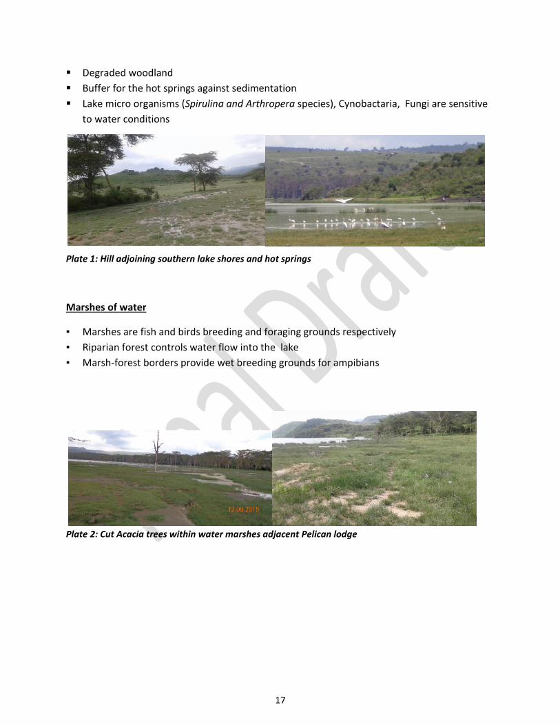
17
Degraded woodland
Buffer for the hot springs against sedimentation
Lake micro organisms (Spirulina and Arthropera species), Cynobactaria, Fungi are sensitive
to water conditions
Plate 1: Hill adjoining southern lake shores and hot springs
Marshes of water
▪ Marshes are fish and birds breeding and foraging grounds respectively
▪ Riparian forest controls water flow into the lake
▪ Marsh-forest borders provide wet breeding grounds for ampibians
Plate 2: Cut Acacia trees within water marshes adjacent Pelican lodge

18
Forest/woodland
Plate 3: Fenced and lawn mowed riparian section within the Southern Acacia woodland
Cliffs
▪ Fragile – steep slopes, rocky surfaces
▪ Specific habitat for endangered plant species, rock hyrax
Plate 4: Eastern cliff
3.3 Proposing enhanced LEWS boundary plan
In addition to the riparian sections the hill, forest, cliffs excluded from the LEWS boundary plan
were consultatively identified and proposed into the LEWS to ease mammal habitat
connectivity, stabilization of the lake shore, soil and water conservation, and sanctuary
operations. See Figure 8.

19
Figure 8: Proposed Lake Elementaita Wildlife Sanctuary

20
4.0 CONCLUSIONS AND RECOMMENDATIONS
The latest surveys which occurred long after 1969 neglected laws governing provisions of
riparian areas.
The sensitive sites are still usable for in situ conservation and relatively little rehabilitation
efforts are required enhance their ecological functions
If the status quo continues degradation of riparian and other sensitive sites might be
irreversible due to permanent developments.
The actions and costs requirements for recovery of riparian under private ownership,
encroached sanctuary land, potentially and actually degraded sensitive area are as sequentially
listed below.
Table 3: Responsive action Plan
No Intervention Responsibility Collaborator Time frame
1 Stop ongoing constructions by neighbors encroaching into the sanctuary
KWS NEMA, MICA June 2016
2 Sensitize local communities on compatible land uses around Lake Elementaita
KWS WRMA, NEMA, MICA
Regularly
3 Inventory forest/woodland birds, small mammals, herpetofauna and invertebrates of L. Elementaita
KWS NMK Immediately
4 Acquire and rehabilitate riparian land and ecological sensitive areas
KWS, NLC MLHUD August 2016
4(a) Identify affected land parcels KWS, NLC MLHUD, CGN
4(b) Develop inventory of affected land
KWS, MLUDH CGN, NLC August 2016
4© Stakeholders’ consultation KWS, NLC MLHUD, CGN Sep. 2016
4(d) Present project progress and findings to KWS management
KWS NLC Sep 2016
The KWS management will decide way forward and consult with Cabinet Secretary in charge of
Environment and Natural Resources on the acquisition path.

21
REFERENCES
1. NEMA (2011) Integrated Land Use Guidelines
2. Republic of Kenya (1969) Survey Act 299
3. Republic of Kenya (2010) Constitution of Kenya
4. Republic of Kenya (2002) Water Act 2002
5. Republic of Kenya (2010) Wildlife Act 2013
6. Republic of Kenya (2015) EMCA (Amended)

22
ANNEXES
Annex 1: Thematic Leaders and support participants
No Name Title, Organization Responsibility 1 Benard Opaa Deputy Director, NLC Advisory and oversight 2 Alice Bett Senior Research
Scientist, KWS Coordination and identification of ecological sensitive sites
3 Willis Memo WRMA – Rift Valley Identification of high water mark and mapping riparian area
4 Raphael Meli Senior Land Officer, KWS
Land survey oversight
5 Dan Kalis Cherotich Regional Surveyor Land surveyor SOK – Rift Valley 6 Judy Akinyi Land Surveyor, KWS Actual ground survey 7 Pauline Wambui Cartographer, KWS Mapping 8 Grace Waiguchu GIS Technician Mapping 9 Collins Ogolla Physical Planner, CGN Planning advice 10 Carol Mwangi Land Surveyor, CGN Support actual ground survey 11 Elizabeth Wakoli NEMA Environmental advisory 12 Israel Makau Research Scientist, KWS Support identification of sensitive sites

23
Annex 2: Riparian affected properties