national aeronautics and space administration … · gmao gmao.gsfc.nasa.gov national aeronautics...
TRANSCRIPT
Global Modeling and Assimilation Officegmao.gsfc.nasa.govGMAO
National Aeronautics and Space Administration
Continuing the Assessment of the Combined Impacts of AIRS, CrIS,
and IASI on Global Skill and Tropical Cyclone Representation
in the NASA GEOS-5Erica McGrath-Spangler1
Oreste Reale1, Will McCarty2, Dan Holdaway1, Ron Gelaro2, Manisha Ganeshan1
1 GESTAR/USRA and NASA/GMAO2NASA/GMAO

Global Modeling and Assimilation Officegmao.gsfc.nasa.govGMAO
National Aeronautics and Space Administration
Statement of the problemAfter examining the problem of error correlation within AIRS data, we are going to examine the possibility of horizontal error correlations across infrared instruments (AIRS, CrIS, and IASI)Errors from different hyperspectral infrared datasets may not be independent, introducing cross-instrument correlation errors that are not accounted for in current data assimilation systemsCurrently, the instruments are assimilated independentlyShould they be considered together with a comprehensive thinning strategy?

Global Modeling and Assimilation Officegmao.gsfc.nasa.govGMAO
National Aeronautics and Space Administration
Clear-sky AIRS radiance distribution
• Performed “bounding” experiments to explore various thinning levels for AIRS data only
• Found that these experiments affected assimilation of other hyperspectral infrared radiances
x ~4x ~1/4x

Global Modeling and Assimilation Officegmao.gsfc.nasa.govGMAO
National Aeronautics and Space Administration
Clear-sky global adjoint results
Globally, reduced data density results in a higher fraction of observations being beneficial to the analysisCrIS: Affected by
changes in AIRS data density, even though CrIS assimilation NOT modified in these experiments!
Global Modeling and Assimilation Officegmao.gsfc.nasa.govGMAO
National Aeronautics and Space Administration
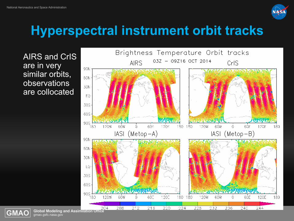
Hyperspectral instrument orbit tracks
AIRS and CrIS are in very similar orbits, observations are collocated
Global Modeling and Assimilation Officegmao.gsfc.nasa.govGMAO
National Aeronautics and Space Administration
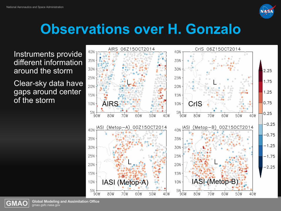
Observations over H. GonzaloInstruments provide different information around the stormClear-sky data have gaps around center of the storm AIRS
IASI (Metop-A)
CrIS
IASI (Metop-B)

Global Modeling and Assimilation Officegmao.gsfc.nasa.govGMAO
National Aeronautics and Space Administration
New ExperimentsGEOS-5 DAS version 5-13.0p1 run 1 Sep – 10 Nov 2014 with
10 day forecasts from 21 Sep – 31 Oct 2014
• RAD_noCrIS: AIRS clear-sky radiances, thinning 145 km, no CrIS data
• RAD_noIASI: AIRS clear-sky radiances, thinning 145 km, no IASI data
• CLD_noCrIS: AIRS cloud-cleared radiances, thinning 145 km, no CrIS
data
• CLD_noIASI: AIRS cloud-cleared radiances, thinning 145 km, no IASI
data
• RAD3_CrIS3_IASI3: AIRS clear-sky radiances, AIRS, CrIS, and IASI all
thinned 300 km
• CLD3_CrIS3_IASI3: AIRS cloud-cleared radiances, AIRS, CrIS, and
IASI all thinned 300 km

Global Modeling and Assimilation Officegmao.gsfc.nasa.govGMAO
National Aeronautics and Space Administration
Global 500 hPa height anomaly correlation
Reference = OPS
More aggressive, comprehensive thinning across instruments improves global skill

Global Modeling and Assimilation Officegmao.gsfc.nasa.govGMAO
National Aeronautics and Space Administration
AIRS clear-sky and cloud-cleared response
For clear-sky AIRS radiances, removing IASI has small positive impact at early forecast times, but degrades after 6 days
Reference = RAD Reference = RAD
However, for cloud-cleared AIRS radiances, removing IASI produces a significant improvement
Indication that error correlations among instruments are different if using clear-sky or cloud-cleared AIRS radiances

Global Modeling and Assimilation Officegmao.gsfc.nasa.govGMAO
National Aeronautics and Space Administration
H. Edouard analysis
10 hPa

Global Modeling and Assimilation Officegmao.gsfc.nasa.govGMAO
National Aeronautics and Space Administration
H. Edouard analysis
Vertical cross sectionWind magnitude (shaded)Temperature (°C, black)Temp. Anomaly (°C, red)
850 hPa winds (shaded)slp(contours)
Comprehensive thinning for both cases improves analyzed structure• Stronger wind
speed• Stronger warm
core
Global Modeling and Assimilation Officegmao.gsfc.nasa.govGMAO
National Aeronautics and Space Administration
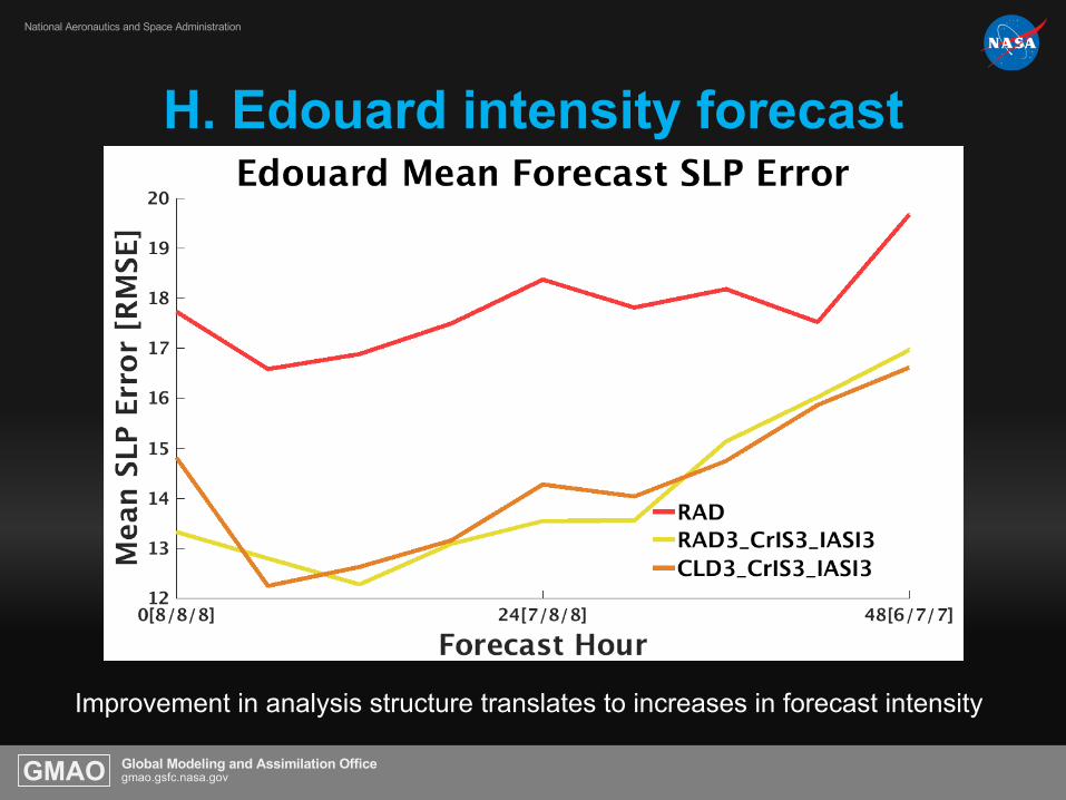
H. Edouard intensity forecast
Improvement in analysis structure translates to increases in forecast intensity

Global Modeling and Assimilation Officegmao.gsfc.nasa.govGMAO
National Aeronautics and Space Administration
H. Gonzalo analysis
More aggressive, comprehensive thinning produces greater storm intensification

Global Modeling and Assimilation Officegmao.gsfc.nasa.govGMAO
National Aeronautics and Space Administration
H. Gonzalo analysis
Vertical cross
section
Wind magnitude
(shaded)
Temperature (°C,
black)
Temp. Anomaly
(°C, red)
850 hPa winds
(shaded)
slp(contours)
Comprehensive
thinning results in
• Stronger warm core
• Increase in winds
• More symmetric
structure

Global Modeling and Assimilation Officegmao.gsfc.nasa.govGMAO
National Aeronautics and Space Administration
H. Gonzalo intensity forecast
Intensity forecasts from 00Z analysis are stronger through 48 hours when thinning is comprehensive and more aggressive

Global Modeling and Assimilation Officegmao.gsfc.nasa.govGMAO
National Aeronautics and Space Administration
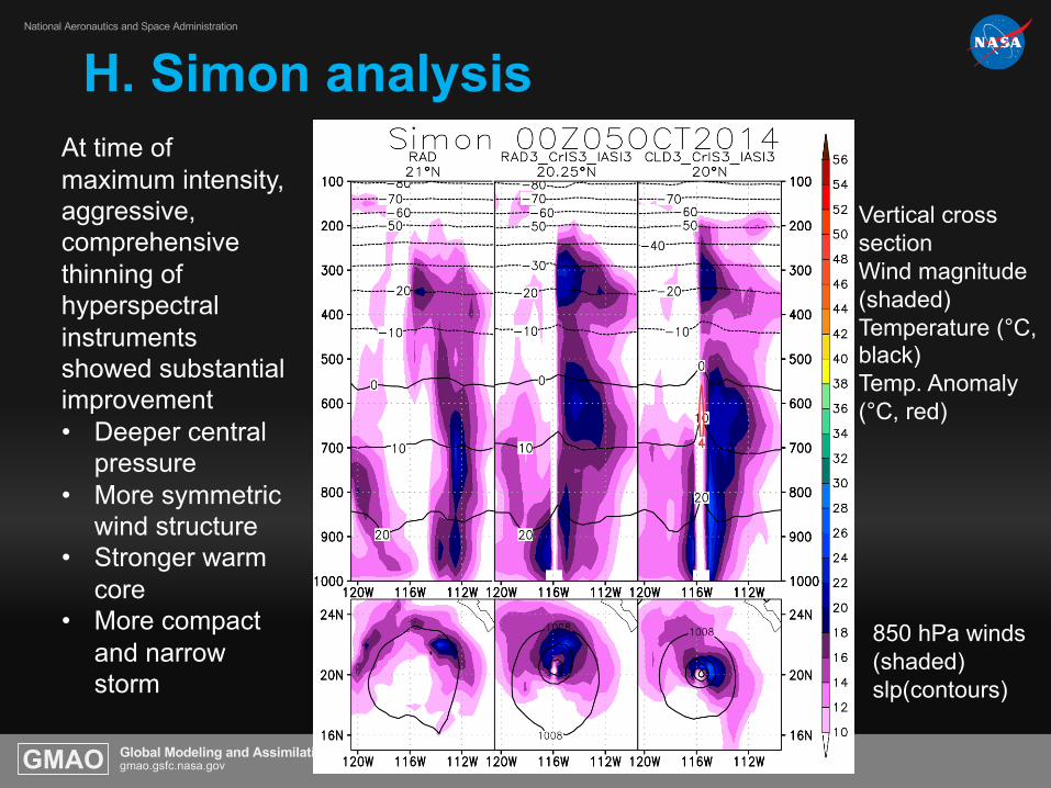
H. Simon analysis
Short-lived storm that was difficult to represent in DAS
Global Modeling and Assimilation Officegmao.gsfc.nasa.govGMAO
National Aeronautics and Space Administration
H. Simon analysis
Vertical cross sectionWind magnitude (shaded)Temperature (°C, black)Temp. Anomaly (°C, red)
850 hPa winds (shaded)slp(contours)
At time of maximum intensity, aggressive, comprehensive thinning of hyperspectral instruments showed substantial improvement• Deeper central
pressure• More symmetric
wind structure• Stronger warm
core• More compact
and narrow storm
Global Modeling and Assimilation Officegmao.gsfc.nasa.govGMAO
National Aeronautics and Space Administration
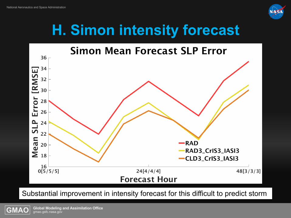
H. Simon intensity forecast
Substantial improvement in intensity forecast for this difficult to predict storm
Global Modeling and Assimilation Officegmao.gsfc.nasa.govGMAO
National Aeronautics and Space Administration
Summary• Evidence is presented suggesting that cross instrument
horizontal error correlations exist among hyperspectral soundersl• Data denial experiments in which CrIS and/or IASI are taken out
from a data assimilation experiment in which either AIRS clear-sky or AIRS cloud-cleared are used, produce a benefit
• This is suggestive of cross instrument correlation error
• However, two strategies of comprehensive thinning in which 1)clear-sky AIRS radiances are thinned together with CrIS and IASI or 2) cloud-cleared AIRS radiances are thinned together with CrIS and IASI BOTH produce improvement in forecast skill and TC representation
• This improvement is not as large as was found with adaptive thinning, but we are currently working to expand adaptive thinning strategy to CrIS and IASI

Global Modeling and Assimilation Officegmao.gsfc.nasa.govGMAO
National Aeronautics and Space Administration
AcknowledgementsThanks to:
Dr. Ramesh Kakar for support of the current proposal ”Using AIRS data to understand processes affecting TC structure and extreme precipitation in a Global Data Assimilation and Forecasting Framework (2014-2017)” (PI: Dr. O. Reale)
Dr. Ramesh Kakar for support of the previously funded proposal “Using AIRS data to understand processes affecting Tropical Cyclone structure in a Global Data Assimilation and Forecasting Framework (2011-2014)”
Dr. Tsengdar Lee for generous allocations of NASA High End Computing resources
AIRS team at JPL and the Sounder Research Team at NASA GSFC
GES DISC for their outstanding service to the community

Global Modeling and Assimilation Officegmao.gsfc.nasa.govGMAO
National Aeronautics and Space Administration