nat ops bulletin 2015_003 - ifalpa leaflets/air traffic... · nat ops bulletin 2015_003 sei...
TRANSCRIPT
NAT OPS Bulletin 2015_003 SEI RLatSM.docx
Serial Number: 2015_003
Subject: RLatSM Special Emphasis
Items
Effective: 1 June 2015
The purpose of North Atlantic Operations Bulletin 2015_003 is to provide guidance to North Atlantic (NAT)
operators on material to be included in pilot and dispatcher training programs and operations manuals to
prepare them for operations in the North Atlantic under Reduced Lateral Separation of 25 Nautical Miles
(NAT RLatSM). This Bulletin may be updated, as necessary, as progress is made toward the start date for
Phase 1 of the RLatSM trial
Any queries about the content of the attached document should be addressed to:
ICAO EUR/NAT Office: [email protected]
Roy Grimes: [email protected]
NOTICE NAT Ops Bulletins are used to distribute information on behalf of the North Atlantic Systems Planning
Group (NAT SPG). The material contained therein may be developed within the working structure of the
NAT SPG or be third party documents posted at the request of a NAT SPG Member State. A printed or
electronic copy of this Bulletin, plus any associated documentation, is provided to the recipient as is and
without any warranties as to its description, condition, quality, fitness for purpose or functionality and for use
by the recipient solely for guidance only. The information published by ICAO in this document is made
available without warranty of any kind; the Organization accepts no responsibility or liability whether direct
or indirect, as to the currency, accuracy or quality of the information, nor for any consequence of its use. The
designations and the presentation of material in this publication do not imply the expression of any opinion
whatsoever on the part of ICAO concerning the legal status of any country, territory, city or area of its
authorities, or concerning the delimitation of its frontiers or boundaries.
The NAT OPS Bulletin Checklist is available at www.icao.int/EURNAT/ EUR & NAT Documents, NAT
Documents, then NAT Ops Bulletins.
There is no objection to the reproduction of extracts of information contained in this Bulletin if the source is
acknowledged.
2 NAT OPS Bulletin 2015-003 – RLatSM Special Emphasis Items 2
NAT OPS Bulletin 2015_003 SEI RLatSM.docx
NAT OPERATIONS BULLETIN – RLATSM SPECIAL EMPHASIS ITEMS
1. Purpose of Bulletin. The purpose of this bulletin is to provide guidance to North Atlantic (NAT)
operators on material to be included in pilot and dispatcher training programs and operations manuals to
prepare them for operations in the North Atlantic under Reduced Lateral Separation of 25 Nautical Miles
(NAT RLatSM operations).
1.1 This Bulletin may be updated, as necessary, as progress is made toward the start date for Phase 1 of
the RLatSM trial. Any necessary updates will be distributed through industry organizations and posted on
the ICAO EUR/NAT Website. (See section 6).
1.2 See Attachment A for a summary listing of RLatSM Special Emphasis Items contained in this
bulletin.
1.3 The following is an explanation of the terms “should”, “must” and “shall” as used in this bulletin.
a) “Should” is used to indicate a recommended practice or policy that is considered as
desirable for the safety of operations.
b) “Shall” and “must” are used to indicate a practice or policy that is considered as
necessary for the safety of operations.
2. RLatSM Project Plan Overview. On or soon after 12 November 2015, Phase 1 of the NAT 25
NM Reduced Lateral Separation Minimum (RLatSM) trial is planned to commence in portions of the
Gander and Shanwick oceanic control areas (OCA). During the RLatSM Phase 1 trial:
a) The 25 NM lateral separation minimum will be implemented by applying ½ degree
track spacing between three core NAT Organized Track System (OTS) tracks. 25
NM lateral separation will be applied between flight level (FL) 350-390 (inclusive).
b) OTS tracks separated using the reduced lateral separation minimum will be established by
publishing one track defined by ½ degree waypoints (e.g., 54 degrees-30 minutes NORTH
latitude/50 degrees WEST longitude) between two adjacent tracks defined by whole degree
waypoints (e.g. 54 degrees NORTH latitude/50 degrees WEST longitude, respectively).
c) Only those operators/aircraft eligible for RLatSM operations will be allowed to operate
on designated RLatSM tracks between FL 350-390 (inclusive). See section 3
(Operator/Aircraft Eligibility).
d) Strategic Lateral Offset Procedures (SLOP) will continue to be used in accordance with
NAT Doc 007, paragraph 8.5
e) Enhanced ATC surveillance and communication will be provided via FANS 1/A (or
equivalent) data link systems. Automatic Dependent Surveillance (ADS-C) will provide
route conformance monitoring, periodic aircraft reporting and controller alerts for Lateral
Deviation Events (LDE) and vertical deviation events (Level Range Deviation Events
(LRDE). Controller-Pilot Data Link Communications (CPDLC) will enhance ATC
intervention and communication capabilities.

3 NAT OPS Bulletin 2015-003 – RLatSM Special Emphasis Items 3
NAT OPS Bulletin 2015_003 SEI RLatSM.docx
3. Operator/Aircraft Eligibility. Operators do not need to apply to NAT ANSPs to be part of the
trial, however, operators should consult with the State authority responsible for their operation prior to
starting RLatSM operations. Operators will be eligible to flight plan and fly RLatSM tracks provided the
flights are:
a) Authorized Required Navigation Performance 4 (RNP 4)
b) ADS-C and CPDLC equipped and, where applicable, authorized; and,
c) Operating required Communications, Navigation and Surveillance (CNS) systems
Note: Job Aids for RNP 4 and Data Link operations authorization are posted on the ICAO European and
North Atlantic (EUR/NAT) Office website. See section 6 below – Websites.
4. Flight Planning Provisions
4.1 Only those operators/aircraft eligible for RLatSM operations will be allowed to operate on
designated RLatSM tracks between FL 350-390 (inclusive). All RLatSM tracks and FLs will be uniquely
identified in Remark 3 of the OTS Track Message as shown below:
Westbound NAT Track Message Example with RLatSM Tracks
(Underlined-bold text highlights RLatSM tracks. It will not be bold in the actual OTS messages)
FF CYZZWNAT 102151 EGGXZOZX (NAT-1/3 TRACKS FLS 310/390 INCLUSIVE FEB 11/1130Z TO FEB 11/1900Z PART ONE OF THREE PARTS- A PIKIL 57/20 58/30 59/40 58/50 DORYY EAST LVLS NIL WEST LVLS 310 320 330 340 350 360 370 380 390 EUR RTS WEST NIL NAR NIL- B RESNO 56/20 57/30 58/40 57/50 HOIST EAST LVLS NIL WEST LVLS 310 320 330 340 350 360 370 380 390 EUR RTS WEST NIL NAR NIL- C VENER 5530/20 5630/30 5730/40 5630/50 IRLOK EAST LVLS NIL WEST LVLS 350 360 370 380 390 EUR RTS WEST NIL NAR NIL- END OF PART ONE OF THREE PARTS)
FF CYZZWNAT 102151 EGGXZOZX (NAT-2/3 TRACKS FLS 310/390 INCLUSIVE FEB 11/1130Z TO FEB 11/1900Z PART TWO OF THREE PARTS- D DOGAL 55/20 56/30 57/40 56/50 JANJO EAST LVLS NIL WEST LVLS 310 320 330 340 350 360 370 380 390 EUR RTS WEST NIL NAR NIL-
E MALOT 54/20 55/30 56/40 55/50 LOMSI EAST LVLS NIL WEST LVLS 310 320 330 340 350 360 370 380 390 EUR RTS WEST NIL NAR NIL- END OF PART TWO OF THREE PARTS)
FF CYZZWNAT 102152 EGGXZOZX (NAT-3/3 TRACKS FLS 310/390 INCLUSIVE FEB 11/1130Z TO FEB 11/1900Z PART THREE OF THREE PARTS- REMARKS. 1. TMI IS 042 AND OPERATORS ARE REMINDED TO INCLUDE THE TMI NUMBER AS PART OF THE OCEANIC CLEARANCE READ BACK. 2. ADS-C AND CPDLC MANDATED OTS ARE AS FOLLOWS TRACK A 350 360 370 380 390 TRACK B 350 360 370 380 390 TRACK C 350 360 370 380 390 TRACK D 350 360 370 380 390 TRACK E 350 360 370 380 390 END OF ADS-C AND CPDLC MANDATED OTS 3. RLATSM OTS TRACKS AND FLIGHT LEVELS ARE AS FOLLOWS TRACK B 350 360 370 380 390 TRACK C 350 360 370 380 390 TRACK D 350 360 370 380 390 …
4.2 Operators must file the correct ICAO Flight Plan annotations in Items 10 and 18 to indicate that
RLatSM required CNS systems are operational for the flight.
a) Item 10a (Radio communication, navigation and approach aid equipment and capabilities).
• Insert “J5” to indicate FANS 1/A (or equivalent) Inmarsat CPDLC SATCOM and/or “J7” to
indicate FANS 1/A (or equivalent) CPDLC Iridium SATCOM data link equipage and
operation;
4 NAT OPS Bulletin 2015-003 – RLatSM Special Emphasis Items 4
NAT OPS Bulletin 2015_003 SEI RLatSM.docx
b) Item 10b (Surveillance equipment and capabilities)
• Insert “D1” to indicate FANS 1/A (or equivalent) ADS-C equipage and operation
c) Item 18 (Other information)
• Insert the characters “PBN/” followed by “L1” to indicate RNP 4 authorization.
5. Special Emphasis Items for RLatSM Operators. The Special Emphasis Items (SEI) listed below
should be incorporated into operator training programs and operations manuals with the intent of raising
pilot and dispatcher awareness of the importance of following procedures in an environment where ½
degree waypoints and a lateral separation minimum of 25 NM are applied. Each SEI is followed by an
explanation of the factors leading it to be identified as an RLatSM SEI.
5.1 Requirement to use the CNS equipment that is indicated in the ICAO flight plan:
ATC uses the Flight Plan annotations in Items 10 and 18 to apply the reduced separation between
aircraft. Therefore, before entering the NAT, the pilot must ensure that:
1. the aircraft is logged on when data link capability (J5, J7, D1) has been filed in the FPL; and
2. RNP 4 is inserted into the FMC, when RNP4 capability (L1) has been filed in the FPL. This
is to enable aircraft navigation system monitoring and alerting against the required RNP 4
Navigation Specification.
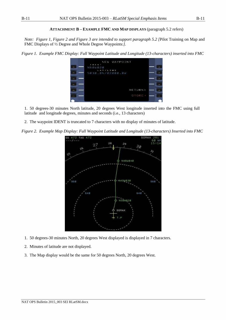
5.2 Pilot Training on Map and FMC Displays of ½ Degree and Whole Degree Waypoints:
To mitigate misinterpretation of waypoint coordinates, operator initial and re-current training
programs and operations manuals must incorporate training and guidance to enable pilots to
understand map and FMC displays of ½ degree and whole degree waypoints.
Explanation
5.2.1 Map displays and certain FMC pages generally do not display full waypoint degrees and minutes,
e.g. when the full 13 latitude/longitude characters are used to insert ½ degree waypoints. See Figure 1,
Figure 2, and Figure 3, in Attachment B.
5.3 Aircraft Navigation Database (NDB) Waypoint Identifiers:
It is strongly advocated that aircraft NDB vendors and flight planning services not provide
operators with half-degree waypoint identifiers in the ARINC 424, paragraph 7.2.5 “N-prefix”
format (e.g., N5250 = 52o30’ NORTH 050
o00’WEST).
NAT operators should use a full latitude/longitude (e.g., 13-character) input for waypoints
containing both half-degree and whole degrees of latitude and whole degrees of longitude, when
they are required to make a manual input of waypoints, unless they have the operational need
discussed below.
NAT operators with an operational need to populate the aircraft NDB with a 5-character
waypoint identifier should ensure that the aircraft NDB vendors and flight planning services use an
alternate half-degree of latitude 5-character format such as Hxxyy, where xx = degrees and 30
minutes of NORTH latitude and yy = degrees of WEST longitude (e.g., H5250 = 52o30’ NORTH
050o00’ WEST). (It is recognized that, for whole degree waypoint inputs, such operators will likely
continue using the ARINC 424, 7.2.5 “N-suffix” format (e.g., 5250N = 52o
00’ NORTH
050o00’WEST)).
It is recognized that such alternate formats may be available from NDB vendors beginning two
Aeronautical Information Regulation and Control (AIRAC) cycles before the scheduled start of the
5 NAT OPS Bulletin 2015-003 – RLatSM Special Emphasis Items 5
NAT OPS Bulletin 2015_003 SEI RLatSM.docx
RLatSM trial. The scheduled start date is 12 November 2015 (AIRAC 1512), therefore,
implementation of alternate formats could be as early as 17 September 2015 (AIRAC 1510).
Note. The NAT ANSPs are implementing CPDLC route clearance policies and capabilities that
will mitigate the need for pilots to manually insert waypoint coordinates.
Explanation
5.3.1 Half-degree waypoint identifiers in the ARINC 424, paragraph 7.2.5 “N-prefix” format have led to
a number of Gross Navigation Errors (GNEs) and Lateral Deviations. The guidance for waypoint insertion
in paragraph 5.3 above is intended to remove the potential for such errors. They occur when a pilot
intending to input a waypoint defined by a half-degree of latitude inadvertently loads a waypoint
containing a whole-degree of latitude, or vice versa, because the “N” is not loaded in the correct pre-fix or
suffix position.
5.4 Pilot Procedures for Verifying Waypoint Degrees and Minutes Inserted into Aircraft Navigation
Systems:
Procedures must be used to display and verify the DEGREES and MINUTES loaded into the Flight
Management Computer (FMC) for the “un-named” (Lat/Long) waypoints defining the route
contained in the oceanic clearance. (The “Sample Oceanic Checklist” NAT OES Bulletin refers).
Regardless of FMC waypoint format and entry method, crew procedures should be designed to
promote strong crew resource management techniques, to prevent opportunities for error occurring
as a result of confirmation bias and to generally maintain an attitude of healthy suspicion.
Accordingly, the waypoint verification procedures should be conducted as detailed below.
During pre-flight LRNS programming, both pilots independently verify the full latitude and
longitude coordinates of “un-named” (Lat/Long) waypoints defining the expected route of flight
within oceanic airspace as entered in the FMC.
Upon receipt of a revised oceanic clearance (i.e., one not conforming to the flight planned
route), both pilots independently verify the full latitude and longitude coordinates of “un-
named” (Lat/Long) waypoints defining the route contained in the revised oceanic clearance.
Approaching an oceanic waypoint, one pilot should verify the full latitude and longitude
coordinates of that waypoint in the FMC, the NEXT and NEXT +1 waypoints, while the other
pilot crosschecks the latitude and longitude coordinates against the master flight plan/oceanic
clearance.
Explanation
5.4.1 Due to the factors in the map and FMC display of ½ degree and whole degree waypoints, it is
imperative that pilots follow the procedure in paragraph 5.4 above to avoid lateral errors caused by incorrect
insertion of waypoints. Verification of the full DEGREES and MINUTES of oceanic waypoints loaded
into the FMC is a critical step in ensuring a proper navigational load.
5.5 Pilot Track and Distance Check:
It is strongly recommended that pilot pre-flight and in-flight procedures call for the pilot to compare
the track and distance between waypoints shown on the Computer Flight Plan (CFP) to those
displayed by the FMC. (The NAT “Sample Oceanic Checklist” Bulletin refers).
Pilots should be aware that waypoint insertion errors of ½ degree of latitude may in some cases
result in only small differences in track and distance, however, the track and distance check can help
prevent waypoint insertion errors of one degree or more that have been observed in oceanic
operations.
6 NAT OPS Bulletin 2015-003 – RLatSM Special Emphasis Items 6
NAT OPS Bulletin 2015_003 SEI RLatSM.docx
Note: `the currency of magnetic variation tables loaded into aircraft navigation databases and the
point at which the track is measured affect the track displayed on the FMC by as much as ±3
degrees.
Explanation
5.5.1 This check remains valuable for RLatSM operations because waypoint insertion errors are not
limited to ½ degree errors and waypoint insertion errors of one degree or more have been observed in
oceanic operations. Waypoint insertion errors of ½ degree produce a small difference in leg segment track
and distance, however, as noted above, waypoint insertion errors are not limited to ½ degree.
5.6 Pilot Action When Notified By ATC of Possible Deviation from Cleared Track:
Flight crews are advised that, should they be notified that ATC systems indicate the aircraft is not
flying the cleared route, they should immediately display the full degrees and minutes loaded into
the FMC for the NEXT and NEXT + 1 waypoints, and verify against the cleared route before
responding.
Voice message example: “SHANWICK CONFIRMS YOUR POSITION REPORT INDICATES
INCORRECT ROUTING. CHECK FULL DEGREES AND MINUTES LOADED INTO FMC.
YOUR CLEARED ROUTE IS [route]”
CPDLC message example:
YOUR POSITION REPORT INDICATES INCORRECT ROUTING. CHECK FULL
DEGREES AND MINUTES LOADED INTO FMC. YOUR CLEARED ROUTE IS [route]
When ATC notifies the pilot that the aircraft has indicated it has already deviated from the cleared
track (UM169f: ADS-C INDICATES OFF ROUTE. ADVISE INTENTIONS), the pilot shall
immediately display the full DEGREES and MINUTES loaded into the FMC for the NEXT
waypoint, and verify against the cleared route.
5.7 Policy for Operational Airborne Collision Avoidance System II (ACAS II):
Prior to departure for flight on an NAT OTS track at a flight level where RLatSM is applied, the
ACAS II system shall be fully operational for the pilot flying (i.e., the TA and RA visual display
and audio function will be operative for the pilot flying). If the ACAS II system is not fully
operational for the pilot flying, the operator has the option of requesting clearance to operate on a
track and/or at a FL where RLatSM is not applied. If the ACAS II system fails after departure, the
aircraft may continue on the cleared route.
Note: The ACAS II (TCAS II) system must be a Version 7.0 or more recent version).
Explanation
5.7.1 ACAS II provides a valuable situational awareness tool and safety net for pilots operating in NAT
airspace including those where aircraft separation standards have already been reduced in the vertical and
longitudinal dimensions. The carriage and operation of ACAS II is emphasized here in the context of
RLatSM trials for the following reasons:
a) The introduction of ½ degree OTS waypoints is an operational change that introduces the use
of ½ degree waypoints into NAT OTS operations. Although both pilot procedures and ADS-C
conformance monitoring capabilities should mitigate the occurrence of lateral deviations
related to ½ degree waypoints, ACAS II provides an independent margin of safety should
lateral deviations occur during the RLatSM trial period.
b) ACAS II will provide a situational awareness tool that will enable pilots to be better prepared
to safely execute weather deviation and contingency procedures necessitating lateral deviations
7 NAT OPS Bulletin 2015-003 – RLatSM Special Emphasis Items 7
NAT OPS Bulletin 2015_003 SEI RLatSM.docx
(e.g., diversions and turn-backs). In the RLatSM operational environment, such deviations will
occur in airspace where the minimum lateral separation is to be 25 NM.
5.8 Pilot In-flight Contingency Procedures and Weather Deviation Procedures (Diversions, Turn-
backs, etc.):
In training and checking programs, operators shall place special emphasis on pilot knowledge of and
preparation to execute the Special Procedures for Inflight Contingencies in Oceanic Airspace
published in ICAO Doc 4444, paragraph 15.2 and Weather deviation procedures (paragraph 15.2.3).
Pilots must be aware that when crossing adjacent tracks without an ATC clearance, the potential
vertical separation provided by the In-flight Contingency Procedure is 500 ft. Pilots must use all the
steps called for in the Contingency Procedures to avoid conflict with other aircraft.
Pilots must also be aware that when unable to obtain an ATC clearance, Weather Deviation
Procedures call for a climb or descent of 300 ft. based on direction of flight and direction of
deviation, and, in addition, guidance to the pilot is to adjust the path of the aircraft, if necessary, to
avoid aircraft at or near the same flight level.
Pilots must stringently follow all measures for avoiding conflict with other aircraft provided for in
the Doc 4444 Contingency and Weather Deviation Procedures.
Explanation
5.8.1 The implementation of RLatSM (25 NM) separation and ½ degree track spacing significantly
reduces the distance and time a diverting aircraft has to manoeuvre when executing a diversion, turn-back or
weather deviation without an ATC clearance before approaching adjacent tracks. It also reduces the time
that a pilot has to obtain an ATC clearance. (An aircraft deviating from track can be in the proximity of
aircraft on an adjacent track within approximately 4 minutes, depending on the angle of deviation from
cleared track). In addition, as discussed above, the margin for safety for aircraft crossing adjacent tracks is
150 m (500 ft.) of vertical separation when executing In-flight Contingency Procedures.
5.9 RLatSM Operational policies (aircraft CNS system failure, data link system failure, etc.):
5.9.1 Objective. The guidance provided in section 5.9 is intended to apply during the RLatSM trials that
are scheduled to start on 12 November 2015. It is intended to supplement the Global Operational Data Link
Document (GOLD) guidance to controllers and flight crew on data link service failures and aircraft data link
system failures (GOLD paragraphs 4.9.4 and 5.9.4 respectively).
5.9.2 RLatSM Required CNS System Failure Prior to Departure. If a flight experiences a failure of an
RLatSM required CNS system PRIOR TO DEPARTURE, the flight should flight plan so as to remain
clear of NAT RLatSM tracks between FL 350-390 (inclusive).
5.9.3 RLatSM Required CNS System Failure After Departure But Prior to Entering On To
RLatSM Tracks Between FL 350-390 (Inclusive). If a flight experiences a failure of an RLatSM required
CNS system AFTER DEPARTURE BUT PRIOR TO ENTERING RLATSM AIRSPACE, the flight
should contact ATC and request a revised clearance that will keep it clear of NAT RLatSM tracks between
FL 350- 390 (inclusive).
5.9.4 RLatSM Required CNS System Failure After Entering On To RLatSM Tracks Between FL
350-390 (Inclusive). If a flight experiences a failure of an RLatSM required CNS system WHILE
OPERATING IN RLATSM AIRSPACE, ATC must be immediately advised. Such flights may be re-
cleared to exit RLatSM airspace, but consideration will be given to allowing the flight to remain in the
airspace, based on tactical considerations. (GOLD paragraph 4.9.4.8 refers).
5.9.5 Continuous Climb or Descent of Aircraft Not RLatSM Eligible. Any aircraft that is not RLatSM
eligible may request continuous climb or descent without intermediate level off through the vertical extent
of the NAT RLatSM airspace. Such requests will be considered on a tactical basis.

8 NAT OPS Bulletin 2015-003 – RLatSM Special Emphasis Items 8
NAT OPS Bulletin 2015_003 SEI RLatSM.docx
5.9.6 Altitude Reservation (ALTRV) Requests. ALTRV requests will be considered on a case by case
basis (as is done today regarding NAT MNPS airspace), irrespective of the RLatSM eligibility status of the
participating aircraft.
5.9.7 Contingency Situations. NAT RLatSM airspace restrictions are not applicable to aircraft
experiencing a contingency situation.
5.10 Domestic ATC Agency Contact:
Pilots are reminded to ensure that they contact the appropriate domestic ATC agency BEFORE
exiting oceanic airspace.
6. Websites
6.1 The ICAO EUR/NAT Office Website is at: www.icao.int/eurnat. Click on EUR & NAT
Documents >> NAT Documents to obtain NAT Operations and NAT Region Update Bulletins and related
project planning documents.
6.2 Job Aid Templates. Click on EUR & NAT Documents >> NAT Documents >> Job Aid
Templates for:
a) RNP 4 Job Aid Template (Application to conduct RNP 4 operations), and,
b) Data Link Job Aid Template (Operator Application to Conduct Data Link Operations).
7. Contacts
7.1 The following individuals may be contacted for information or to provide feedback on
RLatSM operations:
UK NATS
Jamie Hutchison
GM Prestwick Operations
E-mail: [email protected]
NAV CANADA
Gander Area Control Centre
P.O. Box 328
Gander, NL A1V 1W7
Attn: Jeffrey Edison
Manager, ACC Operations
Direct line: +1 709-651-5223
E-mail: [email protected]
~~~~~~~~

A-9 NAT OPS Bulletin 2015-003 – RLatSM Special Emphasis Items A-9
NAT OPS Bulletin 2015_003 SEI RLatSM.docx
ATTACHMENT A – SUMMARY OF RLATSM SPECIAL INTEREST ITEMS
CONTAINED IN THIS NAT OPS BULLETIN
1. Operator/Aircraft Eligibility and Flight Planning Provisions:
Only operators that are authorized RNP 4 and equipped with and operating CPDLC and ADS-C will be
eligible for RLatSM operations. In addition, the ICAO Flight Plan must be correctly annotated to indicate
that RLatSM required CNS systems are operational for the flight (section 4 refers).
2. Requirement to use the CNS equipment that is indicated in the flight plan:
The pilot must use that CNS systems indicated on the ICAO Flight Plan because ATC uses the Flight Plan
annotations in Items 10 and 18 to apply the reduced separation between aircraft (paragraph 5.1 refers).
The pilot must also confirm that RNP4 is inserted into the FMC to enable aircraft navigation system
monitoring and alerting against the required RNP4 Navigation Specification (paragraph 5.1 refers).
3. Aircraft Navigation Database (NDB) Waypoint Identifiers:
Aircraft NDB vendors and flight planning services should not provide operators with half-degree waypoint
identifiers in the ARINC 424, paragraph 7.2.5 “N-prefix” format (e.g., N5250 = 52o30’ NORTH
050o00’WEST).
NAT operators should use a full latitude/longitude (e.g., 13-character) input for waypoint coordinates.
NAT operators with an operational need to populate the aircraft NDB with a 5-character waypoint
identifier should ensure that the aircraft NDB vendors and flight planning services use an alternate half-
degree of latitude 5-character format e.g., H5250 = 52o30’ NORTH 050
o00’ WEST (paragraph 5.3 refers)
4. Pilot Training on Map and FMC Displays of ½ Degree and Whole Degree Waypoints:
Operator initial and re-current training programs and operations manuals must have incorporated training
and guidance to enable pilots to understand map and FMC displays of ½ degree and whole degree
waypoints (paragraph 5.2 and Attachment B Figure 1, Figure 2, and Figure 3 refer).
5. Pilot Procedures for Verifying Waypoint Degrees and Minutes Inserted into Aircraft Navigation
Systems:
Pilot Pre-flight and In-flight procedures must call for each pilot to independently display and verify the
DEGREES and MINUTES loaded into the Flight Management Computer (FMC) for each waypoint
defining the cleared route of flight. Procedures must call for both pilots to independently verify the
waypoint coordinates inserted and concur on their accuracy prior to route activation (paragraph 5.4 refers).
6. Pilot Track and Distance Check:
It is strongly recommended that pilot pre-flight and in-flight procedures call for the pilot to compare the
track and distance between waypoints shown on the Computer Flight Plan (CFP) to those displayed by the
FMC.
Pilots should be aware that waypoint insertion errors of ½ degree of latitude may in some cases result in
only small differences in track and distance, however, the track and distance check can help prevent
waypoint insertion errors of one degree or more that have been observed in oceanic operations.
Note: the currency of magnetic variation tables loaded into aircraft navigation databases and the point at
which the track is measured affect the track displayed on the FMC by as much as +/- 3 degrees (paragraph
5.5 refers)
7. Pilot Action When Notified By ATC of Possible Deviation From Cleared Track:
When ATC notifies the pilot that ATC systems indicate that the aircraft is not flying the cleared track, the
pilot shall immediately display the full DEGREES and MINUTES loaded into the FMC for the NEXT
waypoint, and verify against the cleared route.
A-10 NAT OPS Bulletin 2015-003 – RLatSM Special Emphasis Items A-10
NAT OPS Bulletin 2015_003 SEI RLatSM.docx
8. Policy for Operational Airborne Collision Avoidance System II (ACAS II):
Prior to departure for flight on in airspace where RLatSM is applied, the ACAS II system shall be fully
operational for the pilot flying (i.e., the TA and RA visual display and audio function will be operative for
the pilot flying). If the ACAS II system is not fully operational for the pilot flying, the operator has the
option of requesting clearance to operate on a track and/or at a FL where RLatSM is not applied. If the
ACAS II system fails after departure, the aircraft may continue on the cleared route.
Note: The ACAS II (TCAS II) system must be a Version 7.0 or more recent version) (paragraph 5.7 refers)
9. Pilot In-flight Contingency Procedures and Weather Deviation Procedures (Diversions, Turn-
backs, etc.):
In training and checking programs, operators shall place special emphasis on pilot knowledge of and
preparation to execute the Special Procedures for Inflight Contingencies in Oceanic Airspace published in
ICAO Doc 4444, paragraph 15.2 and Weather deviation procedures (PANS-ATM, paragraph 15.2.3).
Pilots must be aware that when crossing adjacent tracks without an ATC clearance, the potential vertical
separation provided by the In-flight Contingency Procedure is 500 ft. Pilots must use all the steps called for
in the Contingency Procedures to avoid conflict with other aircraft.
Pilots must also be aware that when unable to obtain an ATC clearance, Weather Deviation Procedures call
for a climb or descent of 300 ft. based on direction of flight and direction of deviation, and, in addition,
guidance to the pilot is to adjust the path of the aircraft, if necessary, to avoid aircraft at or near the same
flight level.
Pilots must stringently follow all measures for avoiding conflict with other aircraft provided for in the Doc
4444 contingency procedures (paragraph 5.8 refers).
10. RLatSM Operational policies (aircraft CNS system failure, data link system failure, etc.):
Operators must be aware of the RLatSM operational policies posted in paragraph 5.9 In particular,
operators must be aware that all RLatSM required aircraft CNS systems must be operational PRIOR TO
DEPARTURE and PRIOR TO ENTRY on to RLatSM tracks between FL 350-390 (inclusive). In addition,
if RLatSM required aircraft systems fail WHILE OPERATING IN RLATSM AIRSPACE, ATC must be
advised immediately so that an appropriate course of action can be determined (paragraph 5.9 refers).
11. Domestic ATC Agency Contact:
Pilots are reminded to ensure that they contact the appropriate domestic ATC agency BEFORE exiting
oceanic airspace (paragraph 5.10 refers).
~~~~~~~~
B-11 NAT OPS Bulletin 2015-003 – RLatSM Special Emphasis Items B-11
NAT OPS Bulletin 2015_003 SEI RLatSM.docx
ATTACHMENT B – EXAMPLE FMC AND MAP DISPLAYS (paragraph 5.2 refers)
Note: Figure 1, Figure 2 and Figure 3 are intended to support paragraph 5.2 [Pilot Training on Map and
FMC Displays of ½ Degree and Whole Degree Waypoints:].
Figure 1. Example FMC Display: Full Waypoint Latitude and Longitude (13-characters) inserted into FMC
1. 50 degrees-30 minutes North latitude, 20 degrees West longitude inserted into the FMC using full
latitude and longitude degrees, minutes and seconds (i.e., 13 characters)
2. The waypoint IDENT is truncated to 7 characters with no display of minutes of latitude.
Figure 2. Example Map Display: Full Waypoint Latitude and Longitude (13-characters) Inserted into FMC
1. 50 degrees-30 minutes North, 20 degrees West displayed is displayed in 7 characters.
2. Minutes of latitude are not displayed.
3. The Map display would be the same for 50 degrees North, 20 degrees West.

B-12 NAT OPS Bulletin 2015-003 – RLatSM Special Emphasis Items B-12
NAT OPS Bulletin 2015_003 SEI RLatSM.docx
Figure 3. Example Map Display showing the potential for the same map display for different FMC inputs.
1. Top right FMC input: *N30°30.0’W050
2. Bottom right FMC input: *N30°W050°
* Significant NAT RLatSM waypoints are planned with whole and half degrees of latitude and whole degrees
of longitude. The two asterisked inputs are example of waypoints that will be used in RLatSM operations.
For a large number of aircraft FMS navigation displays, the waypoint input will result in the identical 7-
character waypoint map display.
Note: the following half-degree of longitude waypoints are not used in NAT operations for the RLatSM Trial
3. Top left FMC input: N30°30.0’W050°30.0’
4. Bottom left FMC input: N30°W050°30.0’
— END —