nasa fire program and new nasa geo...
TRANSCRIPT

1
NASA Fire Program and New
NASA GEO Contributions
Vince AmbrosiaWildland Fire Assoc. Program Manager - Applied Sciences Program
GEO-GWIS & GOFC Fire IT MeetingWindsor, England
20-23 November 2017

Research Flight (incl. Data Systems)
Applied Sciences Technology
Earth Science: Applications
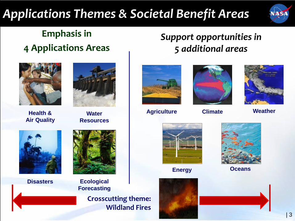
Applications Themes & Societal Benefit Areas
Energy
ClimateAgriculture Weather
Oceans
Disasters Ecological Forecasting
Water Resources
Health &Air Quality
| 3
Emphasis in 4 Applications Areas
Support opportunities in 5 additional areas
Crosscutting theme: Wildland Fires
Applications Themes & Societal Benefit Areas

Advancing NASA’s Wildland Fire Applications Capabilities
4
• Wildland Fire application science answering questions and supporting decisions transforming EO data and research results into environmental intelligence.
• Coordination and collaboration informing brokers, managers, and responders with critical products and services .
• Creation and leverage of partnerships strengthening and enabling effective response throughout the wildfire lifecycle.

National Aeronautics and Space Administration Applied Remote Sensing Training Program 5
• Pre-Fire (Fire Risk Modeling)– Vegetation density and extent– Soil moisture/drought severity– Topography
• Active Fire Mapping– Total area currently burning– Fire Radiative Power (FRP)
using thermal bands• Post-Fire Mapping
– Total area burned– Burn severity– Post-fire vegetation regrowth
(NDVI)
Above: A USGS Landfire map.
Right: S-NPP / VIIRS 375m fire detection time series growth
Below: 2007 Black Pine 2 Fire, Idaho, U.S. On the left: imagery, right: burn severity. USDA RSAC.
Wildfire Program Focus Areas

| 6
NASA Wildland Fire ProgramZachary Holden / USDA Forest Service:
A Prototype System for Predicting Insect and Climate-Induced Impacts on Fire Hazard in Complex Terrain;
Sher Schranz / NOAA:Wildland Fire Behavior and Risk Prediction;
James Vogelmann / USGS EROS CenterImproving National Shrub and Grass Fuel Maps Using Remotely Sensed Data and Biogeochemical Modeling to Support Fire Risk Assessments;
Birgit Peterson / USGS EROS Center:Enhanced Wildland Fire Management Decision Support Using Lidar-Infused LANDFIRE Data;
Karyn Tabor / Conservation International FoundationAn Integrated Forest and Fire Monitoring and Forecasting System for Improved Forest Management in the Tropics;
Wilfrid Schroeder / University of MarylandDevelopment and Application of Spatially Refined Remote Sensing Active Fire Data Sets in Support of Fire Monitoring, Management and Planning;
Stephen Howard / USGS EROS Center:Utilization of Multi-Sensor Active Fire Detections to Map Fires in the US;
Mary Ellen Miller / Michigan Tech Research Institute (MTRI):Linking Remote Sensing and Process-Based Hydrological Models to Increase Understanding of Wildfire Effects on Watersheds and Improve Post-Fire Remediation Efforts;
Keith Weber / Idaho State University;RECOVER: Rehabilitation Capability Convergence for Ecosystem Recovery;

NASA Earth Observations Support Rapid Assessment & Recovery Operations on Ft. McMurray Wildfire
Post-fire land cover / burn severity modeled classification
High sediment / runoff predictions
Landsat-derived Differenced Normalized Burn Ratio
Situation: Ft. McMurray (Horse River) Fire in Alberta burned 1 May to 5 July 2016, and consumed 1.5 M acres. It was the costliest disaster in Canadian history ($3.58B)!
Approach: Use MODIS and Landsat measurements, coupled with soils and terrain information to model burn severity and create inputs to hydrological forecast models in near-real-time.
Results / Implications:• Supported managers with tools to pinpoint active fire, develop post-fire burn severity and model
hydrologic processes for rapid remediation actions;• Helped prioritize watersheds to concentrate post-fire treatment areas and save resources and
mitigation costs.

Number of Participating Organizations by Country & U.S. States (2008-2015)•66 Trainings
Completed•4,000+ participants worldwide from:–1,400+ organizations–130+ countries
•More participants trained in 2015 than all previous years combined

National Aeronautics and Space Administration 9Applied Remote Sensing Training Program
Applied Remote SEnsing Training Program (ARSET)
http://arset.gsfc.nasa.gov
Training activities for environmental professionals to increase usage of NASA observational and modeling data for decision-making support.
Online Webinars• 1 hr. a week, 4-6 weeks• Live & recorded• Include demos on data
access
In-person Workshops• Held in a computer lab
for 2 - 4 days• Focus on data access• Locally relevant case
studies
Train the Trainers• Courses & training
manuals for those interested in doing their own remote sensing trainings

| 10
First ARSET Webinar: Wildfire ApplicationsWebinar: March 31 - April 28, 2015
• Objectives: Provide an overview of relevant NASA Earth science data products, tools, and access portals for wildfire applications for enhanced decision-making and assessment methods.
• Overview Statistics: 278 participants, 178 organizations, 42 countries, 33 states
• Attendees: USDA Forest Service, National Park Service, National Weather Service, Bureau of Land Management, US Geological Survey, US EPA, CAL FIRE, Idaho Army National Guard, Alaska Fire Science Consortium, Ministry of Environment and Natural Resources, El Salvador (MARN), Risk Management Solutions Inc., Western States Air Resources (WESTAR) Council, United Nations, Nature's Foster, ESRI, African Wildlife Foundation, Conservation International, etc.
• End-of-Training Survey: Majority of attendees (73%) indicated that the webinar met their expectations while 23% indicated that it exceeded expectations. 93% showed some level of improvement for understanding specific remote sensing data products appropriate for work needs.
Source: USDA Forest Service, Remote Sensing Applications Center
Source: NASA’s Fire Information and Resource Manager’s System/NASA LANCE
https://arset.gsfc.nasa.gov/wildfires/webinars/intro-wildfire-applications

| 11
ARSET Workshop: Wildfire Applications at ISS2
Workshop: November 14, 2016
• Objectives: Provide an overview of relevant NASA Earth science data products, tools, and access portals for wildfire applications for enhanced fire and smoke monitoring
• Training Summary: Attendees learned how to apply NASA Earth observations to air quality forecasting; smoke, fire, and PM2.5 monitoring; image interpretation; and image processing. The training provided practitioners in wildland fire, smoke management, public health, and air quality management with tools to incorporate satellite remote sensing into their decision-making process.
• Overview Statistics: 26 participants, 18 organizations, 5 countries,
• Audience: National and international entities involved in air quality and wildfire management. Professionals interested in implementing satellite capabilities for decision support activities. Attendees included: USDA Forest Service, National Park Service, National Weather Service, Bureau of Land Management, US EPA, Western States Air Resources (WESTAR) Council.
Source: USDA Forest Service, Remote Sensing Applications Center
https://arset.gsfc.nasa.gov/wildfires/workshops/smoke-symposium-2016
| 12
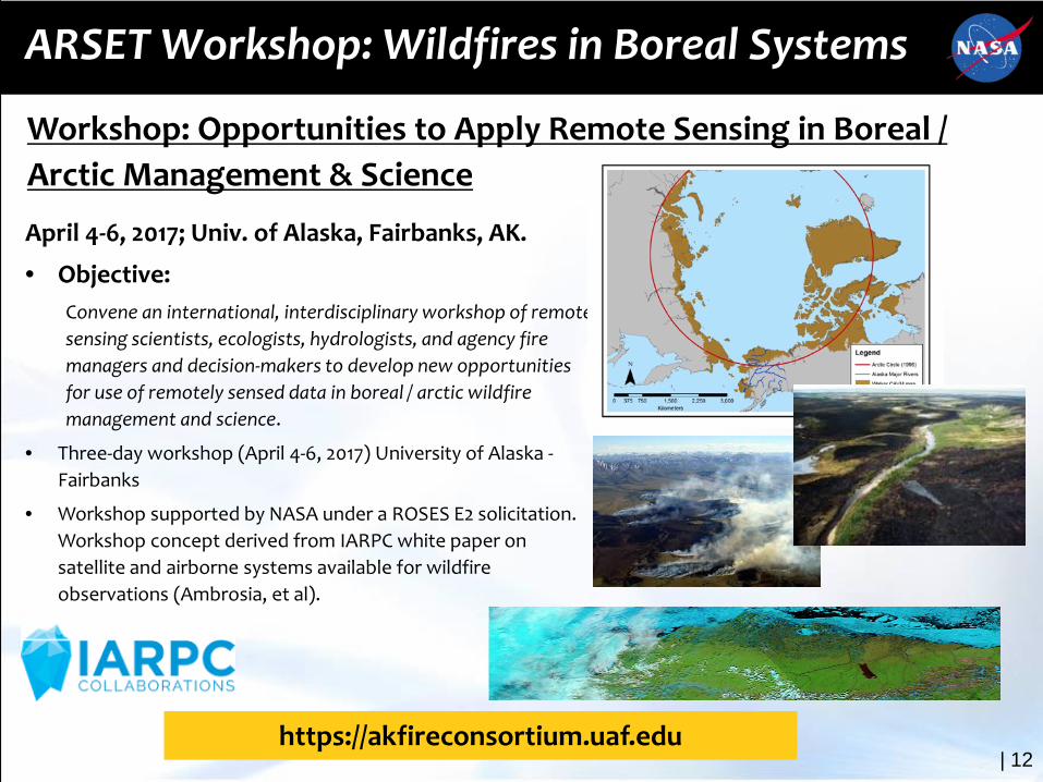
ARSET Workshop: Wildfires in Boreal Systems
April 4-6, 2017; Univ. of Alaska, Fairbanks, AK.
• Objective: Convene an international, interdisciplinary workshop of remote sensing scientists, ecologists, hydrologists, and agency fire managers and decision-makers to develop new opportunities for use of remotely sensed data in boreal / arctic wildfire management and science.
• Three-day workshop (April 4-6, 2017) University of Alaska -Fairbanks
• Workshop supported by NASA under a ROSES E2 solicitation. Workshop concept derived from IARPC white paper on satellite and airborne systems available for wildfire observations (Ambrosia, et al).
Source: USDA Forest Service, Remote Sensing Applications Center
Workshop: Opportunities to Apply Remote Sensing in Boreal / Arctic Management & Science
https://akfireconsortium.uaf.edu

| 13
ARSET 2018 Wildfire Applications Webinars:
GEO-GWIS• Objectives: Provide an overview of relevant uses of
GWIS and navigation through the GEO-GWIS tools and map services
• Dates: TBD (in 2018)
• Agenda / Schedule: Usually one, 1-hour session per week for 5-week. Materials can be accessed on own time following the completion of the webinar
• Audience: National and international entities involved in wildfire management or responsible for providing fire statistics on regional or national wildfire events. Professionals interested in implementing satellite capabilities for wildfire management activities.
Source: USDA Forest Service, Remote Sensing Applications Center
https://arset.gsfc.nasa.gov
Burned Area Detections• Objectives: Utilize an open source tool (QGIS) to
download Landsat imagery to identify suitable imagers for fire mapping, and subsequently create an automatically-derived, MTBS-like threshold burn severity products. Provides a much needed tool to allow worldwide users to track and map fires.
• Dates: TBD (in 2018)
• Agenda / Schedule: TBD; Workshop in conjunction with Josh Picotte (USGS-EROS)
Audience: National and international entities involved in burn severity assessment or providing fire statistics on regional or national wildfire events.

NASA GEO Solicitation
14
NASA ROSES-16 A.50 GEO Work Programme Solicitation
• Nine Elements of the ROSES-16 A.50 GEO solicitation• 3.1 AmeriGEOSS• 3.2 Earth Observations for Ecosystem Accounting (EO4EA)• 3.3 Earth Observations for Health• 3.4 GEO Biodiversity Observation Network (GEO BON)• 3.5 GEO Global Water Sustainability (GEOGLOWS)• 3.6 GEO Vision for Energy (GEOENER)• 3.7 Global Flood Risk Monitoring• 3.8 Global Wildfire Information System (GWIS)• 3.9 Human Planet

NASA ROSES-16 GEO Solicitation
A.50 Group on Earth Observations Work Programme
• Solicitation offered by NASA Earth Science and Applied Science Program
• To demonstrate a strong ability to support and advance GEO, to further U.S. and NASA interests, and to demonstrate U.S. and NASA commitments to GEO ;
• To foster broader domestic involvement in a U.S. national approach to GEO and the Work Programme;
• Advance the use of Earth observations to inform decisions and actions and broaden the organizations routinely using them;
• Increase international collaboration and partnering across GEO and broaden the GEO community;

GWIS Goals in GEO WP 2017-2019
• Provide harmonized fire information (e.g. fire danger) – building on initial activities of the EC in the EFFIS and the GOFC-GOLD Fire Implementation Team (GOFC-GOLD Fire IT);
• Promote networking of fire information providers through annual workshop through key international organizations and initiatives and national and regional providers;
• Establish operational links with other wildfire communities dealing with global wildfire aspects (e.g. burnt area assessment, emission estimation);
• Integrate / harmonize regional wildfire information data sources;• Develop, implement and promote interoperability and
communication among national, regional and global wildfire information systems following OGC standards and the GEOSS Data Sharing Principles;
• Coordinate / promote capacity building and training activities in close cooperation with the GOFC-GOLF Fire IT regional networks and the EFFIS network.

NASA ROSES-16 GEO Solicitation
A.50 GEO Work Programme Solicitation
• Funding Opportunity Number: NNH16ZDA001N-GEO• Number of New Awards: ~20-25 (increased to 32)• Max Duration of Awards: 36 months• Total Amount of NASA Funding (FY17-20): $8M (increased to
~$15M)• Expected Level of Awards: $30K - $200K per year• Proposal Due Date: March 10, 2017• Notify PIs: September 18, 2017 (about 2-3 weeks late)• Expected Project Start Date: December 1, 2017
GEO solicitation POC: Lawrence Friedl• GEO GWIS POC: Vince Ambrosia

GEO GWIS Element Solicitation
A.50 GEO Work Programme3.8 Global Wildfire Information System (GWIS)
• NASA requested proposals on one or both of the two items:
• Data Compilation and Analysis. NASA requests proposals for GWIS enhancements and tools for on-demand statistics, tabular information, and graphical information at various spatial scales (sub-national to continental) and temporal domains. Information on indices and fire variables would be derived from EO and other sources.
• Workshops and Trainings. NASA requests proposals for webinars, workshops, and in-person trainings to increase awareness, familiarity, and use of GWIS, as well as to characterize users and identify needs. Such proposals should target NGO, indigenous, government, or commercial organizations. Proposals for onsite trainings and workshops should articulate approaches to leverage in-region resources, such as for training facilities and participant travel. NASA particularly encourages proposals focused on AfriGEOSS, AOGEOSS, and AmeriGEOSS member countries.

GEO GWIS Selected Proposals
A.50 GEO Work Programme3.8 Global Wildfire Information System (GWIS)
• Robert Field (Columbia University) • “Enhancements to the Global Wildfire Fire Information System: Fire Danger
Rating and Applications in Indonesia”
• Wilfrid Schroeder, et al (University of Maryland / NOAA)• “Development of a Harmonized Multi-Sensor Global Active Fire Data Set”
• Luigi Boschetti / David Roy (U. of Idaho & So. Dakota State Univ.)• “Using the NASA polar orbiting fire product record to enhance and expand
the Global Wildfire Information System (GWIS)”
AMS Washington ForumFederal Panel
Michael H. Freilich4 April 2013
Suomi NPP VIIRSVisible Composite
NASA
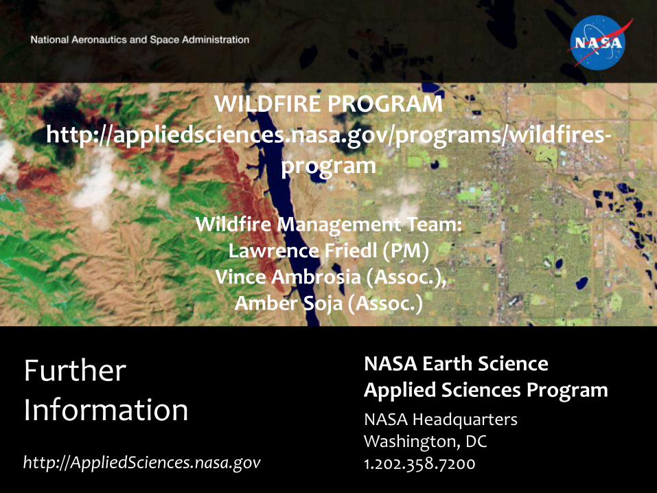
Further Information
NASA Earth Science Applied Sciences ProgramNASA HeadquartersWashington, DC1.202.358.7200http://AppliedSciences.nasa.gov
WILDFIRE PROGRAMhttp://appliedsciences.nasa.gov/programs/wildfires-
program
Wildfire Management Team:Lawrence Friedl (PM)
Vince Ambrosia (Assoc.),Amber Soja (Assoc.)