name / organisation · tom sadler, bilfinger gva on behalf of defence infrastructure organisation...
TRANSCRIPT
All responses received to the Local Plan Review Pre-Publication consultation and Sustainability Appraisal www.richmond.gov.uk/local_plan_pre-publication.htm Consultation from 8 July until 19 August 2016 Published by LBRuT on 14 October 2016 Please note, the responses below are as received from the respondents and have not been edited by the Council. They are not alphabetically ordered or in any other order of priority.
Name / Organisation Caroline Brock, Kew Society Jenine Langrish Myrna Jelman Cllr David Linnette Richard Geary Heather Mathew, Richmond CVS Helene Jelman Dale Greetham, Sport England Katharine Fletcher, Historic England Charles Pineles, Planning Spokesman, Richmond Society Peter Willan, Old Deer Park Working Group Celeste Giusti, Greater London Authority on behalf of Mayor of London Robert Leadbetter, Hon. Director Hampton and Kempton Waterworks Railway Robert Deanwood, Amec Foster Wheeler on behalf of National Grid Alison Mackay, Colliers on behalf of Greggs Plc Tom Sadler, Bilfinger GVA on behalf of Defence Infrastructure Organisation Judith Livesey, NLP Planning on behalf of St Paul's School James Togher, Environment Agency William Mortimer Tim Catchpole, Planning Representative Mortlake with East Sheen Society Andrew Dorrian, Transport for London Rachel Botcherby, Planning Advisor, London and South East National Trust
Name / Organisation Cllr Martin Elengorn, Environment Spokesperson Richmond upon Thames Liberal Democrat Councillors Group Rob Gray, Friends of the River Crane Environment (FORCE) Liz Ayres, Richmond Clinical Commissioning Group Wendy Crammond, Co-Chair Kew Residents Association Ben Mackworth-Praed, on behalf of the Barnes Community Association Kevin Goodwin, RPS CgMs for Goldcrest Land Sarah Stevens, Turleys for British Land Paul Massey Tim Lennon, Borough Coordinator Richmond Cycling Campaign Matthew Eyre, RPS CgMs on behalf of Historic Royal Palaces (HRP) Brian Willman, Chair Ham and Petersham Neighbourhood Forum Mike Allsop, Committee member Strawberry Hill Residents' Association Geoff Bond, Chair Ham and Petersham Association George Burgess, Indigo Planning on behalf of Beechcroft Developments Ltd Neil Henderson, Gerald Eve on behalf of Reselton Properties Ltd Alice Roberts, CPRE London Janet Nuttall, Natural England Tim Sturgess, Bilfinger GVA on behalf of The Lady Eleanor Holles School Unity Harvey David Taylor Sam Hobson, Quantum Group Richard Barnes, The Woodland Trust Lucy Owen, Port of London Authority
All responses received on the Local Plan Pre-Publication Consultation 1
Name / Organisation Kevin Scott, Kevin Scott Consultancy Ltd on behalf of Port Hampton Estates Limited Sarah Dixey, London Borough of Wandsworth Katharine Harrison, Surrey County Council Mike Mills, Firstplan Ltd on behalf of Maxicorp Ltd Tanja El Sanadidy, Indigo on behalf of Shepherd Enterprises Limited Maria Walker Stephen Rankin Sally Arnold, Planning Potential Ltd on behalf of Power Leisure Bookmakers Ross Anthony, The Theatres Trust Mel Barlow-Graham, London Fire and Emergency Planning Authority Bethany Evans, NLP Planning on behalf of The Harrodian School Krystyna Kujawinska Steve Simms, SSA Planning Limited on behalf of Kentucky Fried Chicken (Great Britain) Limited Michelle Hatton-Smith Spelthorne Borough Council Helen Harris, Cushman and Wakefield on behalf of Royal Mail Group Ltd James Sheppard, CBRE on behalf of LGC Ltd Strategic Planning Team, Royal Borough of Kingston Emily Vyse, Brooke Smith Planning on behalf of Ancient Order of Forester's Friendly Society Ltd Christian Leigh on behalf of Jane Miller Jamie Wallace, CgMs on behalf of Notting Hill Home Ownership Caroline Wilberforce, Indigo Planning on behalf of on behalf of Sharpe Refinery Service Teresa Gonet, Highways Agency Paul Luton Eliza Shaw Anthony Paish Lesley Forster John Finnerty
Name / Organisation Dinesh Vitharanage Cllr Liz Jaeger Fabio Galvano Caroline Britton Peter Britton Kathleen Massey Jane Morrison Ray Morrison Laura Stritch, Transport for London Jane Bond Savills on behalf of Thames Water Martin Kirrage Anna Smith David Yates Geoff Bond, Chair Martingales Close Residents' Association Dale and Juliet Nolan Andrew & Bryony Barnard Gilda Rogner Tess Pinto, 20th Century Society Peter Dowling, Indigo Planning on behalf of Sainsbury's Supermarkets Ltd Charlotte Gibb, St Mary's University Peter Willan, Chair for The Friends of Richmond Green Marie Claire Marsh, NLP Planning on behalf of RFU Paul Velluet Tor Barrett, NLP Planning on behalf of the West London Mental Health NHS Trust Joanne Merritt David Deaton Mark Jopling, The Teddington Society and the Friends of Udney Park Playing Fields Table 1: All respondents to the consultation
All responses received on the Local Plan Pre-Publication Consultation 2
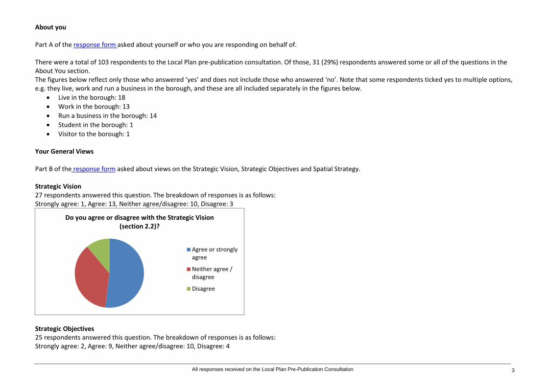
About you Part A of the response form asked about yourself or who you are responding on behalf of. There were a total of 103 respondents to the Local Plan pre-publication consultation. Of those, 31 (29%) respondents answered some or all of the questions in the About You section. The figures below reflect only those who answered ‘yes’ and does not include those who answered ‘no’. Note that some respondents ticked yes to multiple options, e.g. they live, work and run a business in the borough, and these are all included separately in the figures below.
• Live in the borough: 18 • Work in the borough: 13 • Run a business in the borough: 14 • Student in the borough: 1 • Visitor to the borough: 1
Your General Views Part B of the response form asked about views on the Strategic Vision, Strategic Objectives and Spatial Strategy. Strategic Vision 27 respondents answered this question. The breakdown of responses is as follows: Strongly agree: 1, Agree: 13, Neither agree/disagree: 10, Disagree: 3
Strategic Objectives 25 respondents answered this question. The breakdown of responses is as follows: Strongly agree: 2, Agree: 9, Neither agree/disagree: 10, Disagree: 4
Do you agree or disagree with the Strategic Vision (section 2.2)?
Agree or stronglyagree
Neither agree /disagree
Disagree
All responses received on the Local Plan Pre-Publication Consultation 3

Spatial Strategy 24 respondents answered this question. The breakdown of responses is as follows: Strongly agree: 1, Agree: 7, Neither agree/disagree: 12, Disagree: 4
Summary: A small proportion of respondents (between 24 and 27 of the 103 total) responded to these questions about the extent to which they agree with the Vision, Objectives and Strategy. Those who did not respond have not been included. More respondents agree than disagree with the vision, objectives and spatial strategy. The option ‘neither agree nor disagree’ was a popular option across the three questions with between one third and one half of respondents selecting this option on each question. In cases where respondents disagree this tends to be because of a specific issue that they were responding about and this detail is picked up in the tables (below / separate).
Do you agree or disagree with the Strategic Objectives (section 2.3)?
Agree or strongly agree
Neither agree / disagree
Disagree
Do you agree or disagree with the Spatial Strategy (section 3.1)?
Agree or strongly agree
Neither agree /disagree
Disagree
All responses received on the Local Plan Pre-Publication Consultation 4

Ref. No.
Name / Organisation Strategic Vision Comments Strategic Objectives Comments Spatial Strategy Comments
1 Richard Geary I have read the draft Local Plan but it does not seem to bear any relation to reality. There is already an Area Plan that has not been adhered to.
2 Judith Livesey, NLP Planning on behalf of St Paul's School
The School broadly agrees with the strategic vision, noting specifically that: Access to a range of education facilities is important, including schools within the independent sector which make an important contribution to education provision within the Borough. It is important to provide a wide choice of homes, particularly affordable homes of varying types. In the case of St Paul's School there is an urgent need to provide accommodation for staff that is affordable in order to retain staff and support future recruitment.
The School agrees with the Council's strategic objectives including those relating to education provision and housing and the need for a range of homes that are affordable. It notes that education provision will need to be delivered through development, including extensions of existing sites. Specific reference to the need for development would provide a clearer indication of what is required and be consistent with proposed Policy LP29.
The School acknowledges the principle of protecting open space that makes a valuable contribution to the Borough, however, as set out the detailed response, there is a need to review the boundary of the Metropolitan Open Land (MOL) to ensure that the delivery of required facilities is not unduly fettered or complicated by historic boundaries that are out of date or relate to land that does not function as MOL or meet the criteria for designation. A review through the plan process would be consistent with London Plan policy in relation to MOL and NPPF policy relating to Green Belt. For this reason the School objects to protecting existing areas of MOL as specified at para 3.1.12 (specifically at the St Paul's School site) in the absence of such a review.
3 Myrna Jelman Your intentions on every count seem spot on. I would have liked to see the Council be much more innovative and ambitious in solving public transport issues. I also enjoyed reading that accountability to the public is one of 4 strategic vision bullets in the report and was then very unhappy that no reference to accountability be placed anywhere else. As a resident dealing on almost a weekly basis with RHP (Richmond Housing Partnership) for example, I feel very little accountability in that organisation which is allowed to fail to deliver results for years, unchecked. At the end of the 200 something pages, there is no invitation to provide comments and finding how to leave the feedback was not clear. I also get little sense of where your priorities will lie in a context of reduced local budgets.
See above but in summary I would like more ambition on public transport and more accountability to the public.
4 Helene Jelman Your intentions on every count seem spot on. I would have liked to see the Council be much more innovative and ambitious in solving public transport issues. I also enjoyed reading that accountability to
I would like more ambition on public transport and more accountability to the public.
All responses received on the Local Plan Pre-Publication Consultation 5

Ref. No.
Name / Organisation Strategic Vision Comments Strategic Objectives Comments Spatial Strategy Comments
the public is one of 4 strategic vision bullets in the report and was then very happy that no reference to accountability be placed anywhere else. As a resident dealing on almost a weekly basis with RHP (Richmond Housing Partnership) for example, I feel very little accountability in that organisation which is allowed to fail to deliver results for years, unchecked. At the end of the 200 something pages, there is no invitation to provide comments and finding how to leave the feedback was not clear. I also get little sense of where your priorities will lie in a context of reduced local budgets.
5 Rachel Botcherby, Planning Advisor, London and South East National Trust
Overall we support the Vision for the future of the Borough, particularly the Council's commitment to the protection and enhancement of Listed Buildings and Conservation Areas, which contribute significantly to the character and success of the Borough, as well as the protection and enhancement of the outstanding natural environment and green infrastructure. Furthermore we support the vision that the Borough will continue to be an attractive and inviting place for visitors to come and enjoy the many tourist attractions including the unique, historic and cultural assets, such as Ham House.
We are also supportive of the draft strategic objectives, particularly those listed under the 'Protecting Local Character' sub-heading which seeks to protect and where possible enhance the environment including, inter alia, historic assets, the Borough's park and open spaces, network of green infrastructure and biodiversity.
As an organisation the Trust also supports the encouragement of opportunities for leisure, entertainment, sport, cultural activity and the development of community life as envisaged in the 'Meeting People Needs' Point 8 section. The National Trust is pleased to see that the Council have acknowledged that the 'unique and locally distinctive historic and cultural environment as well as protected parks and open spaces' does limit the potential for development and growth within the Borough. We are comforted by the commitment in the Spatial Strategy that there is a presumption against the loss of, or building on, greenfield sites and that the Council is committed to meeting is strategic housing target without using greenfield sites. We note that the Spatial Strategy supports the sustainable growth of the visitor economy for the benefit of the local area and states that the Council will promote and support the enhancement of the Borough's existing tourist attractions including the unique, historic and cultural assets that are connected by the River Thames, such as Ham House. As a major operator of heritage visitor attractions in the Borough, the National Trust is fully supportive of this strategy commitment.
All responses received on the Local Plan Pre-Publication Consultation 6
Ref. No.
Name / Organisation Strategic Vision Comments Strategic Objectives Comments Spatial Strategy Comments
6 William Mortimer As a resident of Barnes for some 45 years I am very glad of this opportunity to contribute to the Local Plan. At the age of 73 I am still actively engaged in the affairs of the community and help all sections of the community on a voluntary basis wherever I can. This response is important to me because it identifies deficiencies in the Local Plan almost all relating to the absence of an approach to Emergency Management. These will impact on the Spatial Requirements necessary to respond effectively. Solutions will involve closer attention to the use of the Thames, Telecommunications solutions and Transportation. I hope the concerns expressed will be welcomed and given due consideration. The Plan is required to take a view on the needs of next 15 years by which time the Thames Barrier will have exceeded its design life. In absence of a firm commitment to the funding of a new barrier, the Local Plan needs to be aware of an increasing flood risk and an event of serious consequence could happen before the intended solutions are in place. I cannot agree that the needs of people will be met without specific plans to deal with emergency situations. As stated in earlier responses, the spatial approach to serving the needs of citizens can only be justified if consideration is duly given to the associated requirements of Disaster Management. The Local Plan is deficient because the possibility that an Emergency will arise before mitigation activity provides answers to Global Warming - and even then there remains the possibility of events that are beyond beyond the bounds of climate forecasts. In chaotic emergency situations the normal telecommunications systems are put out of service and the transportation systems delivering goods and services as well as the movement of people by public transport or private vehicles are disrupted when roads are flooded. The railway is often the
Section 3.1 Full consideration of the current allocation of existing and new buildings to satisfy the future needs identified in the Local Plan cannot be completed without a consideration of emergencies that may overtake this Borough before a 15 year plan can be completed. Even when the vision set out in the Local Plan are completed the risk of a disaster cannot be excluded. Without an Emergency Plan of any description in the Local Plan it is hard to see how the needs of the community have been fully considered.
Currently the Local Plan omits any reference to the spatial needs of emergency situations. The Strategic Vision in the Local Plan has three elements: 1) Protecting Local Character 2) Providing a Sustainable Future and 3) Meeting People's Needs This third element requires a detailed explanation of the means by which Emergencies will be met and the lives and property of citizens will be protected.
All responses received on the Local Plan Pre-Publication Consultation 7
Ref. No.
Name / Organisation Strategic Vision Comments Strategic Objectives Comments Spatial Strategy Comments
highest point in areas such as Barnes and Mortlake and once the immediate shock of the disaster is over, the river Thames becomes the most important artery for re-supply and movement of people.
7 Wendy Crammond, Co-Chair Kew Residents Association
Kew Residents Association would like to propose the inclusion of the following additional important (6th) point at 2.1.4:"People have a right to expect a clean environment which will not compromise their health".
8 Ben Mackworth-Praed, on behalf of the Barnes Community Association
P. 14 first para: define Smart City Technology (not in glossary)
9 Kevin Goodwin, RPS CgMs for Goldcrest Land
Richmond does not contain villages. The Borough and the areas within the Borough form part of a larger urban area that exhibit different characteristics. The Oxford Dictionary defines a village as "A group of houses and associated buildings, larger than a hamlet and smaller than a town, situated in a rural area". There are no areas in the London Borough of Richmond that meet this definition. 5.
Richmond does not contain any villages. In section 10 after "Protect and encourage land for employment use, particularly for affordable small / medium spaces, start-up and incubator units and flexible employment space, in order to support the borough's current and future economic and employment needs" add .....'unless the location is no longer compatible with the provision of employment space, there is no demand or it is not financially viable to provide any'.
3.1.8 after "Higher density and larger development, including commercial schemes, will as far as possible be concentrated in the borough's five main centres (i.e. Richmond, Twickenham, Teddington, Whitton and East Sheen), thus enabling people to walk or cycle to shops and services or use public transport" add.....' as well as other locations with good and high levels of accessibility'.
10 Sarah Stevens, Turleys for British Land
British Land owns the land currently occupied by Homebase, Currys and a bus layover provision on Manor Road, North Sheen, opposite the Sainsbury’s Richmond store. British Land supports the Strategic Vision that is based on the presumption in favour of sustainable development.
The Strategic Objectives reflect sustainable growth and British Land fully supports the need to "optimise the use of land and resources by ensuring new development takes place on previously developed land" (pg.16 and referenced throughout the draft document) in order to accommodate people's needs and the growing demand for housing.
British Land supports the identification of its site within an area designated 'Sites with potential for change' on the Local Plan Key Diagram. The site is a previously developed site that can be more efficiently used to meet the housing needs of the Borough
11 Tim Lennon, Borough Coordinator Richmond Cycling Campaign
In general, we think that cycling has an important role to play in the borough: - Reducing congestion - Improving health outcomes for residents - Cutting air and sound pollution - Making our borough a better place to live - Reducing the pressures of car parking. We would like to see these aspirations reflected in the plan, and would like to see cycling
All responses received on the Local Plan Pre-Publication Consultation 8
Ref. No.
Name / Organisation Strategic Vision Comments Strategic Objectives Comments Spatial Strategy Comments
taken seriously as a mode of transport, with the same importance as walking, taking a bus, or driving.
12 Janet Nuttall, Natural England
Natural England generally supports the Plan Vision. We particularly welcome the aspiration to protect and enhance the outstanding natural environment and green infrastructure network, including the borough's parks and open spaces, biodiversity and habitats as well as the unique environment of the borough's rivers and their corridors. The Borough includes and is adjacent to significant areas of green infrastructure, including designated sites such as Sites of Special Scientific Interest (SSSIs), Special Areas of Conservation (SACs) and National Nature Reserves. These should be indicated on the Local Plan Proposals Map.
The Strategic Objectives address a wide range of environmental issues including protection and enhancement of the natural environment, recognising the benefits of maintaining and creating multi-functional green infrastructure for people and wildlife. Objectives to minimise air and water pollution, to minimise and mitigate the effects of climate change and promote sustainable transport are fully supported by Natural England. The objective to minimise impacts on land resources by targeting development on previously developed land is also welcomed where detailed assessment has confirmed that any adverse impacts on biodiversity can be adequately mitigated. We would recommend specific reference to the internationally and nationally designated sites within the Borough, their conservation objectives and the need to protect and enhance their value for people and wildlife through sustainable development.
Natural England is pleased that the Strategic Objectives for the natural environment are recognised and taken forward through the Spatial Strategy. We welcome that development of the Borough's target of 3,150 homes for the period 2015-2025 will be focused in established urban areas including Richmond, Twickenham, Teddington and The Hamptons, East Sheen and Whitton. Natural England supports the following new policies for the protection and/or enhancement they seek to provide for the natural environment: - LP 6 Royal Botanic Gardens, Kew World Heritage Site - LP 9 Floodlighting - LP 10 Local Environmental Impacts, Pollution and Land Contamination - LP 12 Green Infrastructure - LP 13 Green Belt and Metropolitan Open Land - LP 14 Other Open Land of Townscape Importance - LP 15 Biodiversity - LP 16 Trees and Landscape - LP 17 Green Roofs and Walls - LP 18 River corridors - LP 20 Climate Change Adaptation - LP 21 Flood Risk and Sustainable Drainage - LP 22 Sustainable Design and Construction - LP 23 Water Resources and Infrastructure - LP 31 Public Open Space, Play Space, Sport and Recreation - LP 32 Allotments and food growing spaces - LP 44 Facilitating Sustainable Travel Choices
13 Tim Sturgess, Bilfinger GVA on behalf of The Lady Eleanor Holles School
We write on behalf of the Lady Eleanor Holles School (LEHS) regarding the consultation the LB Richmond is currently undertaking for the new Local Plan (pre-publication version). GVA previously submitted representations on behalf of LEHS to the consultation on the scope and rationale for the review of planning policies, together with the emerging site allocations in January 2016. The purpose of that consultation was
All responses received on the Local Plan Pre-Publication Consultation 9
Ref. No.
Name / Organisation Strategic Vision Comments Strategic Objectives Comments Spatial Strategy Comments
to provide the opportunity for early engagement with interested parties. The focus of our representations proposed the allocation of the school for education use and an amendment to the Metropolitan Open Land (MOL) boundary in order to establish a positive policy position to support the expansion of the school to meet the future growth in education need. The pre-publication version being consulted on sets out the draft new planning policies and those existing policies which are to be superseded. This representation focusses on policies CP18 (Education and Training) which is proposed to be replaced by draft Policy LP29 and Policy DM OS2 (Metropolitan Open Land) which is proposed to be replaced by draft Policy LP13. In support of our representations we enclose a completed representation form and supporting statement to positively plan for the growth of the school to meet the identified education need. We are keen to work collaboratively with the Council to ensure that a sound Local Plan is brought forward which plans positively for the education needs of the Borough. Accordingly, we would welcome the opportunity to discuss the School’s aspirations with you at the earliest opportunity. Please refer to Supporting Statement attached See the Appendix (1) to this document.
14 Sam Hobson, Quantum Group
It is agreed that the Plan needs to strike an acceptable balance between meeting the future needs of its residents (such as elder residential accommodation and care, and access to open space and sports a facilities), businesses and visitors, whilst maintaining the character of the Borough. Therefore, the "Golden Thread", referred to in paragraph 2.2 and set out in the "Strategic Vision", is supported. It should be recognised that the "Strategic Vision" is a high level statement and so should be treated as such. The high level "Vision" cannot sufficiently address the complexities of
It is considered that the Strategic Objectives do not provide sufficient and specific emphasis on identifying and then prioritising to meet the accommodation and social and infrastructure needs of the elderly sector of the Borough's population. The remainder of the Strategic Objectives are supported. It is noted that the Council is yet to publish data on the housing needs of the elderly and to therefore create a Local Plan policy and allocations strategy for meeting this need. We have undertaken our own research, which concludes the following.
In particular paragraphs 3.1.4, 3.1.13, 3.1.22 and 3.1.24 as specifically supported. These paragraphs set out clearly the desire of the Council to ensure that the needs of the community are being considered when specific planning proposals are being assessed. The policies of the plan need to ensure that they mirror the objectives set out. As we note below, not all of the policies achieve this in their current written form and we propose amendments that we consider will help the plan achieve its objectives. As an example, a lot
All responses received on the Local Plan Pre-Publication Consultation 10

Ref. No.
Name / Organisation Strategic Vision Comments Strategic Objectives Comments Spatial Strategy Comments
meeting the needs of society over the plan period without providing further detail, which is what the rest of the Local Plan seeks to do. As we have set out, not all of this detail is supported (see below). It should be noted that in many situations there will be opposing pros and cons and so flexibility and judgement will be required in order to meet the high level vision. Maximising the potential of sites, including maximising underutilised sites and making them work as hard as they can, is important to meeting its needs whilst protecting the character of the Borough. This may mean that flexibility is required so that whilst some aspects of development proposals may be positive and some negative, if the overall outcome is positive then proposals should be supported. In the application of the Plan over the plan period, the Council needs to ensure that it continues to make an acceptable contribution to meeting wider London and South East issues, beyond those of just its borough.
The London Plan sets a minimum yearly housing provision target for LBR of 315dpa. Within in that, the Plan establishes an annualised need for LBR to deliver 105 private and 30 intermediate sale homes for the elderly. Over the Plan Period LBR is expected to experience a continued increase in the population of older people (above 55). LBR already has a higher than average older resident population. The Borough's existing elderly care accommodation is in the form of conventional sheltered housing, which is already over capacity with a shortfall of circa 1,000 units. This shortfall, unless specific accommodation is developed, will increase to over 1,500 units by 2019. Based on the above, we consider that the Local Plan needs to consider the housing needs of the elderly population more specifically and will need to identify sites for allocation and planning policy to ensure the plan is sound. The next version of the emerging Local Plan must specifically address these issues. As it stands, the emerging plan fails in this. We propose a new site allocation to help meet this need.
of focus is given to the protection of open spaces and community facilities in the borough for both meeting the needs of the borough population but also in giving the borough its character and desirability. In principle, this approach is supported. However, the situation whereby such assets are not being best utilised to provide the maximum benefit to the local community is not fully contemplated. Such circumstances might exist whereby some "enabling" or "facilitating" development can result in great gains being made to the strategic vision and objectives of the Council for the borough and for the benefit of the wider community. This might mean proposals may have some perceived isolated negative consequences but the overall effect of the proposal might be overwhelmingly positive. It is considered that this complexity needs to be acknowledged in the Spatial Strategy section and then specific policies and the supporting text of the Local Plan needs to reflect this.
15 Steve Simms, SSA Planning Limited on behalf of Kentucky Fried Chicken (Great Britain) Limited
We agree with the first part of point 12 under the heading 'Meeting People's Needs' in paragraph 2.3.1 regarding the creation of healthy environments and tackling childhood obesity. However, we disagree with restricting Class A5 uses in proximity to schools as a method of achieving the latter objective, because the overwhelming majority of evidence (all except one study in the US that showed a weak correlation based on a different definition of fast food outlets) shows that there is no correlation between the proximity of such uses and the incidence of obesity or overweight in pupils. Indeed, there
We agree with the first part of paragraph 3.1.25 that there is an emerging obesity issue. However, the spatial strategy refers to restricting access to fast food takeaways near existing schools, whereas the relevant policy LP30 would effectively ban new Class A5 Hot Food Takeaways, so that the strategy and its implementation correspond neither in the definition of the land use restricted nor in its effect - existing takeaways would remain and could cover a range of use classes.
All responses received on the Local Plan Pre-Publication Consultation 11

Ref. No.
Name / Organisation Strategic Vision Comments Strategic Objectives Comments Spatial Strategy Comments
is no evidence at all of a causal link between proximity and incidence.
16 Emily Vyse, Brooke Smith Planning on behalf of Ancient Order of Forester's Friendly Society Ltd
Meeting people's needs is fundamental to achieving a successful place. We STRONGLY AGREE with the need for a choice of new homes, given the considerable shortage of housing that the City faces. We recognise that the success of a local economy is in part dependent upon the provision of employment opportunities. However, we DISAGREE that business parks be protected from encroaching development. For an area to truly meet people's needs, residential development needs to be located in areas which support a quality residential environment and where business parks, providing non-conforming uses within a residential location exist, they should not be afforded protection from development. Sites should be considered on a site-by-site basis and where evidence supports an alternative land use as being more appropriate, it should be considered favourably by officers.
To ensure a sustainable future, the re-use of previously developed land should take precedence over development on green spaces. Ensuring a suitable stock and mix of high quality housing that reflects local needs is imperative to meeting people's needs and there is considerable demand for new housing within the Borough. We STRONGLY AGREE with the objective to seek this provision and with the objective of providing higher density development in sustainable locations. We consider sustainable locations to be those with excellent public transport connections and within existing residential areas. We STRONGLY DISAGREE however with the objective of protecting land for employment use. Land should not be afforded strict protection just because of its use. Such sites should be considered within their local context and against market signals, as required by para 22 of the National Planning Policy Framework (NPPF). Where existing employment sites are considered to provide an inappropriate and non-conforming use within their location, they should be permitted for redevelopment. We recognise the need to support current and future economic and employment needs, but the provision of employment space should be within appropriate locations to create appropriate living and working environments.
In delivering the housing that the Borough needs, we AGREE with the spatial strategy to protect greenfield sites from development. To ensure the achievement of sustainable development, new development should come forward on previously developed sites in the first instance, notwithstanding their existing use. To meet and exceed the housing target of 315 dwellings per annum, we AGREE that existing sites should be optimised, particularly those with good public transport accessibility. We agree that a key way to optimise existing employment sites would be to redevelop them for mixed use residential and commercial development. Such development will contribute to the housing need, whilst retaining employment opportunities. With regard to strengthening local employment and supporting businesses, we DISAGREE that the existing employment land should be protected. Employment land should be considered on its own merits, within the context it sits, and having regard to local market signals. We do agree however with the need for more office floorspace and consider that where redevelopment of existing employment uses seeks mixed use development, comprising office use, that this should also be supported. We STRONGLY DISAGREE with para 3.1.33 which takes a restrictive approach towards the transfer of industrial land to other uses. Whilst industrial land is needed to support the local economy, it is not always located in the most appropriate areas and is often situated within residential development. Industrial uses in such locations often present a non-conforming land use and create an inappropriate living environment and residential amenity to
All responses received on the Local Plan Pre-Publication Consultation 12

Ref. No.
Name / Organisation Strategic Vision Comments Strategic Objectives Comments Spatial Strategy Comments
dwelling occupiers. Issues arise from a number of issues, including noise, pollution, and congestion caused from larger vehicles travelling down the narrow residential roads to access industrial and business parks. Where industrial land and business parks are located within residential areas and provide a non-conforming use, their restriction towards the transfer to other uses should not apply. It is considered that employment uses could adequately be retained on such sites in a more appropriate way through their redevelopment for mixed uses, eg. residential and office space. Office development provides much greater employment opportunities per floorspace than industrial and is a much more conforming and appropriate use within a residential location.
17 Paul Luton The Strategic Vision is unambitious : Whilst cars will still be a crucial part of our future, the borough's improved transport network and interchanges will encourage many residents as well as those who work and visit the borough to make journeys using high quality public transport and walking and cycling routes. The document refers frequently to the ill effects of transport failing to point out that these refer to motorised transport. A future in which the default (not the only) means of transport was by cycling or walking would reduce noise and pollution and mitigate the borough's contribution to climate change. The assumption that transport = pollution can be broken by making cycling a default mode.
18 Jamie Wallace, CgMs on behalf of Notting Hill Home Ownership
The Local Plan identifies three key themes which provide the basis of the Strategic Vision including: 1. Protecting Local Character 2. A Sustainable Future 3. Meeting Peoples Needs. The principles contained within themes 1 and 2 are broadly supported, however the text included under the sub heading, "Jobs and the Local Economy", of theme three, is considered to require re-wording. Although it is
All responses received on the Local Plan Pre-Publication Consultation 13
Ref. No.
Name / Organisation Strategic Vision Comments Strategic Objectives Comments Spatial Strategy Comments
accepted that there is a requirement to provide employment space for new business start-ups, a blanket approach to protecting all industrial land and business parks from residential development is too restrictive and does not take account of the individual characteristics and details of individual sites. The proposed stance within the Local Plan, does not allow for consideration of individual site constraints, with any conversion of employment land to residential needing to be assessed on a site by site basis. An assessment of the quality of the existing stock and demand in the locality should be undertaken to establish an evidence base for protection of appropriate sites only, based on individual characteristics not just considering overall amount of employment land required The National Planning Policy Framework (NPPF), identifies 12 principles which should underpin the plan making process. One such principle is to encourage the effective use of land by reusing land that has been previously developed (brownfield land). Needless to say, employment sites containing outdated floorspace which is not fit for the modern market, as is the case with St Clare Business Park, have a role to play in the sustainable development for a mix of uses, which can cross fund the replacement of an element of new commercial floorspace and deliver appropriate new uses, including new homes to assist in housing delivery. This is underlined by paragraph 22 of the NPPF, which states that policies should avoid the long term protection of sites allocated for employment use where there is no reasonable prospect of a site being used for that purpose. Furthermore, where there is no reasonable prospect of a site being used for the allocated employment use, applications for alternative uses of land or buildings should be treated on their merits having regard to market signals and the relative need for different land uses. Whilst there may be a need for
All responses received on the Local Plan Pre-Publication Consultation 14

Ref. No.
Name / Organisation Strategic Vision Comments Strategic Objectives Comments Spatial Strategy Comments
the current amount, or an increase, in employment land, this should not lead to the protection of all existing floorspace in employment uses on existing sites where there are limited prospects of that floorspace being re-used, or where their continued use on this basis is unviable or inappropriate given their surroundings. Historic employment sites within the Borough, including the St Clare Business Park, are now outdated, not just in terms of the quality and nature of the accommodation provided, but also in terms of their location and the purposes which they serve. Therefore alternative reuse, on a mixed use basis, is required to provide an appropriate quantum of the right type of employment space in this location and to enable appropriate redevelopment to come forward. On this basis such sites have the opportunity to secure the replacement of an element of employment floorspace, which will have the potential to provide an increased density and number of jobs, whilst delivery other appropriate uses, including additional residential properties. An approach which requires all existing employment floorspace to be retained is unlikely to deliver the required redevelopment of the ageing employment buildings, many of which are not fit for modern employment uses, or to regenerate these sites to meet modern occupier demands.
Table 2: Detailed comments on Strategic Vision, Strategic Objectives and Spatial Strategy as received
All responses received on the Local Plan Pre-Publication Consultation 15
Your Detailed Response Part 4 of the response form asked about details including what change(s) are considered necessary, why these changes should be made and what your supporting evidence is.
Ref No.
Name / Organisation Detailed comment
General Comments 19 Janet Nuttall, Natural
England The Local Plan will need to be screened under Regulation 102 of the Conservation of Habitats and Species Regulations 2010 (as amended) at an early stage so that outcomes of the assessment can inform key decision making on strategic options and development sites. It may be necessary to outline avoidance and/or mitigation measures at the plan level, including a clear direction for project level Habitats Regulations Assessment (HRA) work to ensure no adverse effect on the integrity of internationally designated sites. It may also be necessary for plans to provide policies for strategic or cross boundary approaches, particularly in areas where designated sites cover more than one Local Planning Authority boundary. Natural England would welcome early discussion on the HRA of the plan and can offer further advice as policy options are progressed.
20 Michelle Hatton-Smith Inclusive and accessible environments for elderly people need to include community toilet facilities which are accessible to them. In the past Teddington Pool and fitness Centre included an easily accessible toilet. The new changes to the gym has meant the community toilet is now only accessible on the pool side which requires the removal of socks and shoes before entering. This change of facilities obviously makes the community toilets very difficult to use for elderly members of the community. Any changes to public buildings should take regard to the needs of elderly members of the public.
21 Caroline Brock, Kew Society Thank you for the opportunity to comment on this pre-publication draft. We welcome many of the changes and updates in the new policies proposed, including: - the reference to opposing Heathrow expansion and tackling the traffic, noise and air pollution issues associated with Heathrow; - The reference to the need to retain smaller retail units in paragraph 7.1.20 is also welcome and very relevant to Kew, for example it will assist in resisting inappropriate applications such as the redevelopment of the Kew Bookshop site which was, thankfully, refused permission; - new policy LP33 on telecoms facilities; - the policies designed to protect employment and office space, small businesses and the local economy from the use of permitted development rights through designation of Article 4 areas as set out in new policies LP40 and 41. We are also pleased to see that London House on Lower Mortlake Road, inappropriately suggested for school use, is now designated as a key office area (paragraph 10.2.7).
22 Heather Mathew, Richmond CVS
Include the voluntary and community sector. Throughout the plan there is no specific reference to the voluntary and community sector. It is essential to recognise the sector in the local plan in terms of their role as employers, in contributing to a sense of place, the development of communities and residents health and well- being. They contribute to two of the core elements of the local plan - a sustainable future, and meeting peoples needs and should be included to inform investment in social and physical infrastructure. I would highlight the following to evidence and illustrate this: (See further comments below)
23 Jenine Langrish I generally have no issues with the plan, and support the commitment to sustainability, biodiversity, protecting green spaces and the opposition to Heathrow expansion.
24 Myrna Jelman Omission 1: Increase accountability and performance of Council bodies to the local population/stakeholders, in particular for RHP (Richmond Housing Partnership). Having lived in the area only 11 months, I must have already complained to and about RHP on a monthly basis, most issues still remaining unresolved and with no clear knowledge of who RHP is accountable to Omission 2: Managing/culling some of the local urban fox population. I have a large garden neighbouring an abandoned garden where there have been up to 8 foxes who constantly mark their territory in my garden as well as dig the grass, etc. In practice, this means that every visit to my garden stars with picking up fox dropping and spraying a repellent. Moreover and more worryingly, I have a friend living in East Sheen who will not let her toddler daughters use their garden (at all!) because of fear of the foxes that live there. Surely at some stage, the noble wish for biodiversity needs to be subsumed to the need of human beings and especially children to be able to enjoy their little corner of nature in a borough that prides itself for its green aspect.
25 Helene Jelman Omission 1: Increase accountability and performance of Council bodies to the local population/stakeholders, in particular for RHP (Richmond Housing Partnership). Having lived in the area only 11 months, I must have already complained to and about RHP on a monthly basis, most issues still remaining unresolved and with no clear knowledge of who RHP is accountable to Omission 2: Managing/culling some of the local urban fox population. I have a large
All responses received on the Local Plan Pre-Publication Consultation 16
Ref No.
Name / Organisation Detailed comment
garden neighbouring an abandoned garden where there have been up to 8 foxes who constantly mark their territory in my garden as well as dig the grass, etc. In practice, this means that every visit to my garden stars with picking up fox dropping and spraying a repellent. Moreover and more worryingly, I have a friend living in East Sheen who will not let her toddler daughters use their garden (at all!) because of fear of the foxes that live there. Surely at some stage, the noble wish for biodiversity needs to be subsumed to the need of human beings and especially children to be able to enjoy their little corner of nature in a borough that prides itself for its green aspect.
26 Dale Greetham, Sport England
Evidence Base: Unsound. The National Planning Policy Framework (NPPF) requires each local planning authority to produce a Local Plan for its area. Local Plans should address the spatial implications of economic, social and environmental change. Local Plans should be based on an adequate, up-to-date and relevant evidence base. In addition, paragraph 73 of the NPPF requires that: "Planning policies should be based on robust and up-to-date assessments of the needs for open space, sports and recreation facilities and opportunities for new provision. The assessment should identify specific needs and quantitative deficits or surpluses of open space, sports and recreational facilities in the local area. "Paragraph 175 of the NPPF states: "Where practical, Community Infrastructure Levy charges should be worked up and tested alongside the Local Plan." Sport England advocates that new developments should contribute to the sporting and recreational needs of the locality made necessary by their development. Sport England is not aware of if a robust evidence base for indoor sports facilities has been signed off and adopted by the Council for Richmond. It is not clear how this lack of evidence base has been/will be taken into account to develop this document. Sport England would be happy to provide further advice on how local authorities can strategically plan for sports facilities. There are a number of tools and guidance documents available, which can be found on Sport England's website at: http://www.sportengland.org/facilities-planning/planning-for-sport/forward-planning/. In addition Sport England has a web based toolkit which aims to assist local authorities in delivering tailor-made approaches to strategic planning for sport. This can be found on Sport England's website at: http://www.sportengland.org/facilities-planning/planning-for-sport/previous-guidance. The toolkit focuses on built facilities for sport and recreation, setting out how planners can make the best use of sport-specific planning tools in determining local facility needs. Information regarding planning obligations for sport can be found on Sport England's website at: http://www.sportengland.org/facilities__planning/planning_tools_and_guidance/planning_contributions.aspx.
27 Katharine Fletcher, Historic England
Thank you for the opportunity to comment on the pre-publication local plan document and accompanying sustainability appraisal. As the Government's statutory adviser Historic England is keen to ensure that the protection and enhancement of the historic environment is fully taken into account at all stages and levels of the Local Plan process. The National Planning Policy Framework identifies the historic environment as a relevant matter contributing to sustainable development (para 7), and includes it within the core planning principles (para 17). These comments are made in the context of the principles in the NPPF and accompanying NPPG. We note that this consultation encompasses a full review of the local plan, including strategic and development management policies and site allocations, but excludes the Twickenham Area Action Plan adopted in 2013. Our specific comments are set out in the attached schedules, with separate comments provided on site allocations from the Greater London Archaeological Advisory Service within Historic England. Please note that Historic England operates an access to information policy. Correspondence or information which you send us may therefore become publicly available. There are matters relating both to generic policies and site allocations which we would be pleased to discuss with you.
28 Charles Pineles, Planning Spokesman, Richmond Society
The Richmond Society thanks the council for allowing the opportunity to comment on the pre-publication LOCAL PLAN. For the sake of brevity some comments may seem abrupt, but this is not the intention and we ask that the best interpretation be put on our words. The Draft Local Plan (DLP) breaks down into two basic missions; new investment and maintenance of assets already in existence. New Investment: largely refers to social housing and improved infrastructure. Maintenance: this is the most time consuming and difficult for any Local Authority and Richmond is certainly no exception given the breadth and complexities of its responsibilities. We take as an example the southern sector of the Richmond Athletic Ground (SA22). Separated as the council is from direct involvement, by the presence of the freeholder and its managing agents, it is difficult indeed to see what impact could be made to prevent the current unkempt and over-parked situation arising. However, this is just the sort of situation which the Richmond Society is anxious, and willing, to work with the council to resolve. The Richmond Society congratulates the council, and local officers, on a comprehensive and tireless up date of the current LDF, against a background of
All responses received on the Local Plan Pre-Publication Consultation 17
Ref No.
Name / Organisation Detailed comment
current and future financial restraints. As an amenity Society, consisting largely of residents in the borough, we are aware of these constraints and supportive of the efforts being made to solve them. It is with that attitude in mind that we urge the council to avoid the temptation to be over generous in the responsibilities which it seeks to take on, and to recognise that the residents know and acknowledge that a local authority can no longer be all things to all men.
29 Peter Willan, Old Deer Park Working Group
This submission is made by The Old Deer Park Working Group. 1.2 The Group comprises representatives of The Richmond Society, The Kew Society, The Friends of Richmond Green, The Friends of Old Deer Park and The St Margaret's Estate Residents Association. In June, 2012 the Group published the report: The Old Deer Park, Richmond - Re-connecting the Town to its local park - Realising an under-recognised parkland asset - A framework for conservation and enhancement. 1.3 The Group's aim in publishing the report was to provide a positive contribution to discussion and debate in the context of the falling-in and renewal of all but two of the existing leases granted by the Crown Estate for the land comprising the Old Deer Park, Richmond. Details about each of the local groups who made up the Working Group and their objectives were set out in Appendix 1 of the report. Copies of the report were circulated to the Crown Estate, Council members and officers, representatives of the respective lessees, and to English Heritage, and made available to the broader community. Since publication, the findings and recommendations of the report have been discussed at meetings with the Crown Estate and Council members and officers. A copy of the report is available on the Richmond Society's web-site. 1.4 This submission follows the formal submission to the Council made in 2013 by the Working Group of The Old Deer Park, Richmond - Re-connecting the Town to its local park - Realising an under-recognised parkland asset - A framework for conservation and enhancement - A submission urging review of boundary definitions, February, 2013, and its submissions to the Council of November, 2013 responding to consultation on the pre-publication version of The Richmond-upon-Thames Local Plan, Site Allocations Plan published in October, 2013, and of July, 2014, responding to consultation on the pre-publication version of The Richmond-upon-Thames Local Plan, Site Allocations Plan - New Additional Sites, June, 2013. 1.5 The Old Deer Park Working Group welcomes the opportunity to comment on the latest draft document and sets out its comments below. However, it is seriously concerned by the apparent absence of a draft Proposals Map to replace that adopted by the Council in 2011. Accordingly, the comments of the Group on the Draft Local Plan are entirely without prejudice to whatever may be shown in such a draft Proposals Map in due course. 2 1.6 Finally, over the last year or more, the Old Deer Park Working Group has been led to believe by Council members and officers that the Council is undertaking the preparation of a 'Village Plan' for the Old Deer Park. However, the Group notes that the Old Deer Park is not included in the list of 'Village Plans' set out in paragraph 7.1.13 of the Draft Local Plan. Instead, the Group notes the concluding statements given in the Site Allocations section of the Plan for SA 21 - Pools on the Park and surroundings, Richmond and SA 22 - Richmond Rugby and Richmond Athletic Ground, Richmond that 'A SPD for the overall Old Deer Park Conservation Area is currently being developed by the Council'. The Working Group looks forward to being consulted on the emerging SPD document. Accordingly, as with the Proposals Map, the comments of the Group on the Draft Local Plan are entirely without prejudice to whatever may be included in the emerging SPD for the Park. The Old Deer Park Working Group has a particular interest in the draft policies relating to The Royal Botanic Gardens Kew World Heritage Site - given that the Old Deer Park forms a major part of the designated 'buffer zone'; Metropolitan Open Land - given that the greater part of the Old Deer Park is so designated; other open land of townscape and landscape importance - given that other, lesser, parts of the Old Deer Park may be considered to be so regarded; and Views and vistas - given that the Proposals Map adopted by the Council in 2011 and the Crown Estate's The Old Deer Park Richmond - Landscape Strategy, 1999 identifies a number of vista/landmarks and views located within or extending across the Park. Comments specifically in relation to: LP5 - Views and Vistas LP6 - Royal Botanic Gardens, Kew World Heritage Site LP13 - Green Belt and Metropolitan Open Land LP 14 - Other Open Land of Townscape Importance Definitions of boundaries of Metropolitan Open Land, Public Open Space and the Richmond Town Centre SA 21 Pools on the Park and surroundings, Richmond SA 22 - Richmond Rugby and Athletic Ground, Richmond Please see accompanying attachments: - Response to the Draft Local Plan, August 2016 - Submission urging boundary definitions, February 2013 - Site Allocation Plans, October 2013 - Additional Sites Allocation Plan Response, June 2014 See the Appendix (13) to this document.
30 Celeste Giusti, Greater London Authority on behalf of Mayor of London
Thank you for consulting the Mayor of London on the pre-publication stage of Richmond upon Thames Council's Local Plan review. As you are aware, all development plan documents have to be in general conformity with the London Plan under section 24 (1)(b) of the Planning and Compulsory Purchase Act 2004. The Mayor has afforded me delegated authority to make comments on his behalf on the emerging DPD. Representations from Transport for
All responses received on the Local Plan Pre-Publication Consultation 18

Ref No.
Name / Organisation Detailed comment
London, which I endorse, are attached to this letter as Appendix 1 and have been sent separately. My comments are broader, given the nature of the document. The Mayor will issue his formal opinion on general conformity when requested at the second consultation 'publication' stage. I hope that these comments can inform the development of Richmond's Local Plan.
31 Andrew Dorrian, Transport for London
Since the last meeting, TfL has released the updated South Sub-Regional Transport Plan, now referred to as the Spatial Story of Growth - your officers have been briefed and consulted on this document which is now complete. This was issued to the council in July 2016 and includes many travel trends and growth aspects. This will be useful context for the Local Plan and preparation of the Infrastructure Delivery Plan. They are being prepared ahead of the next iteration of the Mayor's Transport Strategy. You will be aware of the renewed emphasis being placed on the relationship between transport infrastructure and housing development. The Housing and Planning Bill and changes to the NPPF, as well as the creation of the National Infrastructure Commission, further endorse this relationship. TfL is keen to investigate with the council any opportunities for developing plans and policies which can deliver new homes along transport corridors or around transport nodes. The council is advised that the new London Plan and new Mayor Transport Strategy is likely to include an enhanced emphasis on this relationship. As part of this process it will be important to establish funding mechanisms to capture land value uplift to help pay for future infrastructure funding, either through conventional s106 and CIL or other means.
32 Robert Leadbetter, Hon. Director Hampton and Kempton Waterworks Railway
Restoration of the Hampton and Kempton Waterworks Railway: A map of the railway in relation to the restoration of the Hampton and Kempton Waterworks Railway has been attached. The area in Hampton is highlighted in yellow. It runs from the Oldfield pedestrian gate back up to the Red House (Distributing) reservoir. Our Heritage Railway Restoration project certainly wishes to be included in the local plan as we will be a major feature in the community in this part of Richmond. We will impact on the movement of people and development of Hampton (as has the "Bluebell Line" in Sussex) Our training track that we built in a paddock leased by the Kempton Great Engines Trust has turned out to be a successful business that we are extending down to the Oldfield Road area of Hampton (and perhaps beyond back down to the Thames). I attach the official map. The overview of the proposed project and the route and track-bed description and preservation of the heritage track-bed in Hydes field is important to us. A look at our website www.hamptonkemptonrailway.org.uk will give a view of what is coming to the Hampton part of Richmond upon Thames Detail of the project provided separately. See the Appendix (11) to this document.
33 Robert Deanwood, Amec Foster Wheeler on behalf of National Grid
National Grid has appointed Amec Foster Wheeler to review and respond to development plan consultations on its behalf. We are instructed by our client to submit the following representation with regard to the current consultation on the above document. National Grid owns and operates the high voltage electricity transmission system in England and Wales and operates the Scottish high voltage transmission system. National Grid also owns and operates the gas transmission system. In the UK, gas leaves the transmission system and enters the distribution networks at high pressure. It is then transported through a number of reducing pressure tiers until it is finally delivered to our customers. National Grid own four of the UK's gas distribution networks and transport gas to 11 million homes, schools and businesses through 81,000 miles of gas pipelines within North West, East of England, West Midlands and North London. To help ensure the continued safe operation of existing sites and equipment and to facilitate future infrastructure investment, National Grid wishes to be involved in the preparation, alteration and review of plans and strategies which may affect our assets. National Grid infrastructure within Richmond-on-Thames: LBC Electricity Transmission: National Grid has one underground cable (listed below) within Richmond-on-Thames LBC's administrative area. This forms an essential part of the electricity transmission network in England and Wales. Line Ref: Underground - Cable Description: Wimbledon - Willesden National Grid has provided information in relation to electricity transmission assets via the following internet link: http://www2.nationalgrid.com/uk/services/land-and-development/planning-authority/shape-files/ Gas Distribution: National Grid has a high number of gas distribution apparatus within the administrative area of Richmond-on- Thames LBC. This includes:
All responses received on the Local Plan Pre-Publication Consultation 19
Ref No.
Name / Organisation Detailed comment
- Low Pressure (LP) and Medium Pressure (MP) (below 2 bar) Gas Pipes and associated equipment - Two High Pressure (HP) (above 2 bar) Gas Pipelines and associated equipment as listed below Pipe Pressure - HP 2280 Richmond to Fulham 30" Pipe Pressure - HP 2279 Southall to Richmond 30" The first point of contact for all works within the vicinity of gas distribution assets is Plant Protection ([email protected]). Please note that Gas pipeline diversions may take up to three years, please bear this in mind when engaging with National Grid. National Grid may have a Deed of Grant Easement for each asset which prevents the erection of permanent/ temporary buildings, or structures, changes to existing ground levels, storage of materials etc. Additionally written permission will be required before any works commence within the National Grid easement strip, and a deed of consent is required for any crossing of the easement. In the first instance please consider checking with the Land Registry for the development area. If further information is required in relation to an easement please contact Spencer Jefferies, Development Liaison Officer, [email protected] Electricity Distribution: UK Power Networks owns and operates the local electricity distribution network in Richmond-on-Thames LBC. Contact details can be found at www.energynetworks.org.uk. National Grid is happy to provide advice and guidance to the Council concerning our networks. If we can be of any assistance to you in providing informal comments in confidence during your policy development, please do not hesitate to contact us. In addition the following publications are available from the National Grid website or by contacting us at the address overleaf: - National Grid's commitments when undertaking works in the UK - our stakeholder, community and amenity policy; - Specification for Safe Working in the Vicinity of National Grid High Pressure Gas Pipelines and Associated Installations - Requirements for Third Parties; and - A sense of place - design guidelines for development near high voltage overhead lines. - T/SP/SSW22 - Specification for safe working in the vicinity of National Grid high pressure gas pipelines and associated installations - requirements for third parties. http://www2.nationalgrid.com/WorkArea/DownloadAsset.aspx?id=33968 - IGE/SR/18 - Safe working practices to ensure the integrity of gas pipelines and associated installations. - HS(G)47 - Avoiding Danger from Underground Services. Please remember to consult National Grid on any Development Plan Document (DPD) or site-specific proposals that could affect our infrastructure.
34 Tom Sadler, Bilfinger GVA on behalf of Defence Infrastructure Organisation
This representation has been prepared by GVA on behalf of the Defence Infrastructure Organisation (DIO), an operating arm of the Ministry of Defence (MoD) who own Kneller Hall ('the site') on Kneller Road in Twickenham where the Corps of Army Music (CAMUS) HQ and Royal Military School of Music are currently located. The representation is submitted in response to the current consultation on the London Borough of Richmond upon Thames Local Plan Pre-publication version for consultation (hereafter referred to as 'the Draft Local Plan'). The DIO play a vital role in supporting the UK armed forces by building, maintaining and servicing the infrastructure needed to support national and international defence. Following a review of the nationwide defence estate in 2010, the Treasury and MOD put in place a Strategic Defence Spending Review with the stated aim of reducing the size of the MOD estate by 30% by 2040. Kneller Hall is currently occupied by the Royal Military School of Music, a prestigious and longstanding asset of the MOD. Often cited as the 'home of military music', the school was founded in 1857 and has since played an important role in training numerous generations of military musicians. It is however one of the parts of the military estate that does not match the needs of modern military due to the age and layout of the buildings and the constraints of the site and, in January 2016, the Secretary of State for Defence announced in the House of Commons the closure of Kneller Hall. The Military School of Music remains, however, an important military function and will be relocated from Kneller Hall to a new facility within a larger barracks or garrison that will meet current health and safety requirements for sound reverberation and noise pollution, allowing the MoD to fulfil its statutory obligations to its employees. The DIO has appointed Bilfinger GVA to assist with the disposal of Kneller Hall, including reviewing and commenting where appropriate on the Draft Local Plan to ensure a sustainable future for the site. We have reviewed the Draft Local Plan and the published supporting evidence base and provide our
All responses received on the Local Plan Pre-Publication Consultation 20

Ref No.
Name / Organisation Detailed comment
response in the subsequent sections of this representation. Based on our review we conclude that the plan: - Has not been positively prepared; - Is not justified; - Is not effective; and - Is not consistent with national policy. In the main body of this representation we will demonstrate that this position is based upon the following grounds: - Much of the evidence base used to inform the newly proposed policies is out of date. The plan is therefore not justified and the plan is not capable of being effective; - The Draft Local Plan policies do not reflect the recommendations from the housing evidence base (the GL Hearn Strategic Housing Market Assessment 2016). The plan is therefore not justified, capable of being effective, nor consistent with national policy; and - There is a need to secure a sustainable long term future for the site at Kneller Hall, a soon to be vacant previously developed site in a reasonably accessible location. We note that there is no site specific policy in the Draft Local Plan for Kneller Hall. The plan fails to consider the role that the site at Kneller Hall can make in meeting the development needs of the Borough and London as a whole and does not put in place a conclusive policy position to guide future development at this site, which is necessary to ensure the proper planning of the Borough. The plan is therefore not positively prepared, justified, nor effective. We consider that the plan can be made sound by taking the following actions: - Prepare an updated set of land use evidence base documents and revise the relevant policies accordingly in response; - Revise the housing policies in accordance with National and Regional policy and the objectively assessed needs identified in the draft Strategic Housing Market Assessment (2016) prepared by GL Hearn; and - Add a site specific policy allocation for the Kneller Hall site, including a positively worded policy that supports mixed use development (to include residential uses along with other appropriate and compatible uses), informed by a Masterplan prepared collaboratively with the LPA, stakeholders and the community. This representation provides evidence and justification to underpin the above position, and is structured as follows: - Section 2 explains the background and context to the representations; - Section 3 presents an overview of the site and its key relevant characteristics; - Section 4 provides our representations on the Draft Local Plan Policies; - Section 5 presents the opportunity at the site of the Royal Military School of Music at Kneller Hall; and - Section 6 summarises our conclusions and recommended next steps for the Local Plan. In support of this representation, we also submit the following documentation: - Baseline Issues and Opportunities Report for the Kneller Hall site, prepared by AMEC. This representation is made in the context of the National Planning Policy Framework (NPPF). At the heart of the NPPF is a presumption in favour of sustainable development, which should be seen as a golden thread running through both plan-making and decision-taking (Paragraph 14). It states that there are three dimensions to sustainable development: economic, social and environmental: - Economic role - contributing to building a strong, response and competitive economy, by ensuring that sufficient land of the right type is available in the right places and at the right time to support growth and innovation; and by identifying and coordinating development requirements, including the provision of infrastructure; - Social role - supporting strong, vibrant and healthy communities, by providing the supply of housing required to meet the needs to present and future generations; and by creating a high quality built environment, with accessible local services that reflect the community's needs and support its health, social and cultural well-being; and - Environmental role - contributing to protecting and enhancing our natural, built and historic environment. For plan-making this means that: - local planning authorities should positively seek opportunities to meet the development needs of their area; - Local Plans should meet objectively assessed needs, with sufficient flexibility to adapt to rapid change. Paragraph 17 states that, within the overarching roles that the planning system ought to play, a set of core land-use planning principles should underpin both plan-making and decisiontaking, including a requirement to ensure that: - Plans are kept up-to-date, and be based on joint working and co-operation to address larger than local issues; - Proactively drive and support sustainable economic development to deliver the homes, business and industrial units, infrastructure and thriving local places that the country needs. Every effort should be made objectively to identify and then meet the housing, business and other development needs of an area, and respond positively to wider opportunities for growth; and - Encourage the effective use of land by reusing land that has been previously developed (brownfield land), provided that it is not of high environmental value. The NPPF recognises the significant national need for housing and, in light of this, states that Local Planning Authorities should be 'aspirational' and 'boost significantly the supply of housing'. To do this, LPA's should: '...use their evidence base to ensure that their Local Plan meets the full, objectively assessed
All responses received on the Local Plan Pre-Publication Consultation 21

Ref No.
Name / Organisation Detailed comment
needs for market and affordable housing in the housing market area, as far as is consistent with the policies set out in this Framework, including identifying key sites which are critical to the delivery of the housing strategy over the plan period' (Paragraph 47). London Plan consolidated with alterations since 2011 (2016) It is widely acknowledged that London constitutes a single housing market area, and the current London Plan recognises the pressing collective need for homes across the city. The Mayor of London has made it clear that delivering housing is a strategic priority and as a result, the current London Plan clearly states that the city 'desperately needs more homes' and therefore seeks to 'boost significantly the supply of housing'. In response to this pressing need for more homes to be built in London, Housing Policy 3.3 states that Boroughs should 'seek to achieve and exceed the relevant minimum borough annual housing target'. Furthermore, the policy states that Boroughs should: 'identify new housing sites for inclusion in LDFs" and "identify and seek to enable additional development capacity to be brought forward to supplement these targets having regard to the other policies of this Plan and in particular the potential to realise brownfield housing capacity through the spatial structure it provides'. Informed by the 2013 London Strategic Housing Land Availability Assessment (SHLAA) alongside the 2013 Strategic Housing Market Assessment, the London Plan seeks to deliver 42,000 net additional homes across London. However the Inspector's report recognised that the London Plan in its current form will not deliver sufficient homes to meet the objectively assessed need (c. 49,000 additional homes) and recommended immediate review. We note that the GLA are undertaking a full review of the London Plan, with the publication of 'Towards a new London Plan' expected in Autumn 2016. It is expected that they will propose blanket increases in housing targets for all London Boroughs. The London Plan currently sets a minimum target of 315 homes per annum for LBRuT between 2015 and 2025. However it is clear that to be compliant and consistent with national and London Plan policy these targets must be treated as a minimum and exceeded, especially where there is evidence of Brownfield land capacity. In addition the current London Plan stresses the need for all planning authorities to comply with the statutory duty to co-operate, which requires authorities to work together constructively on planning for strategic matters (such as housing). Consultation on 'Proposed Changes' to the NPPF took place between December 2015 and February 2016. From this it is apparent that the Government intend to require local planning authorities to publish and maintain up to date registers of brownfield sites suitable for housing. The ambition is for 90% of brownfield land which is suitable for housing to have planning permission by 2020. To ensure that all possible opportunities for brownfield development are pursued, the consultation proposed to clarify in national policy that substantial weight should be given to the benefits of using brownfield land for housing - in effect, a form of 'presumption' in favour of brownfield land. The document proposed to make it clear that development proposals for housing on brownfield sites should be supported, unless overriding conflicts with the Local Plan or the NPPF can be demonstrated and cannot be mitigated. Proposed Local Plan Policies and Evidence Base. The National Planning Practice Guidance (NPPG) states that appropriate and proportionate evidence is essential for producing sound Local Plans. The evidence should inform what is in the plan and shape its development, rather than being collected retrospectively. The NPPG confirms that the evidence base should be kept up-to-date. For example, it states that when approaching submission, if key studies are already reliant on data that is 'a few years old', they should be updated to reflect the most recent information available and, if necessary, the plan adjusted in the light of this information and the comments received at the publication stage. The training and ancillary facilities at the Kneller Hall Royal Military School of Music do not comply with EU Health and Safety regulations and do not meet the operational needs of the School. Consequently, a formal decision has been made by the DIO and Secretary of State for Defence to close the Kneller Hall Royal Military School of Music, relocate the facilities elsewhere within the UK to a more appropriate location, and to dispose of the Kneller Hall site. The Kneller Hall site is therefore a soon to be vacant, previously developed site in an accessible location. See the Appendix (17) to this document for the Baseline Issues and Opportunities Report referred to.
35 James Togher, Environment Agency
Thank you for consulting the Environment Agency on the draft Richmond Local Plan and supporting documents. We are pleased to see our previous response has informed the vision and new local plan policies. We support your local plan strategic vision for the natural environment, open spaces and the boroughs rivers. We support your objective to manage flood risk and climate change issues and opportunities. Natural environment, open spaces and the borough's rivers: The outstanding natural environment and green infrastructure network,(including the borough's parks and open spaces, biodiversity and habitats as well as the unique environment of the borough's rivers and their corridors) will have been protected and enhanced where possible. Residents will continue to highly value and cherish the borough's exceptional environmental quality. (page 13)
All responses received on the Local Plan Pre-Publication Consultation 22

Ref No.
Name / Organisation Detailed comment
We welcome the references to the unique environment and the importance of the river corridors and need to link green space together across the borough. We support the river corridors showing as a key feature on the local plan's main features map (page 15) and the local plan key diagram map (page 26). We support the proposed new local plan environmental policies relating to: - Policy LP10 - Local environmental impacts, pollution and land contamination - Policy LP 12 - Green infrastructure - Policy LP 15 - Biodiversity - Policy LP 17 - Green roofs and walls - Policy LP 18 - River corridors - Policy LP 19 - Moorings and floating structures - Policy LP 20 - Climate change adaptation - Policy LP 21 - Flood Risk and sustainable drainage - Policy LP 22 - Sustainable design and construction - Policy LP 23 - Water resources and infrastructure - Policy LP 24 - Waste management We welcome the focus on managing flood risk, climate change and the references to the Thames Estuary 2100 (TE2100) plan and the River Thames Scheme within the draft local plan. These schemes will help to manage flood risk and climate change strategically. Relevant actions should also be considered as part of the decision making and site allocation process on individual sites, for example, opportunities on major riverside sites to renew or set back tidal flood defences and "make space for water". We feel there are ongoing opportunities to work with local community and environmental groups to identify and map projects, with potential to improve river corridors and deliver green infrastructure which could then be delivered over the life time of the plan. We are pleased to see how a high quality environment and green infrastructure is linked into Policy LP30 Health and Wellbeing "2. Access to green infrastructure, including river corridors, local open spaces as well as leisure, recreation and play facilities to encourage physical activity." We encourage councils to identify river restoration / flood risk management projects as part of the local plan process. A map showing the potential enhancement projects in the local plan will also help to visualise and deliver your vision for improving Richmond's natural environment, open spaces and the borough's rivers. This could be combined with urban greening and retro fitting sustainable drainage projects, for example, in areas with surface water flooding issues. You could set annual targets and monitor delivery of improvements to rivers corridors and green infrastructure over the lifetime of the plan. The local plan evidence base including the Strategic Flood Risk Assessment should be regularly reviewed and updated with the latest environmental evidence, climate change allowances and flood risk management projects action to ensure new development is well designed and located in the right place. Environmental maps and data are available from the OpenGov website http://environment.data.gov.uk/ds/partners/index.jsp#/partners/login. We have provided detailed comments in Section 1 on the key environmental issues and opportunities and feedback on the proposed site allocations. We look forward to working in partnership with you as the local plan progresses to the next stage.
36 James Togher, Environment Agency
Flood Risk Sequential Test: We welcome the Flood risk sequential test document (separate from Plan) and your goal to steer new development away from the highest flood risk areas. This can reduce the need for new flood defence spending and reduces the risks to life, businesses and property. Locating new development outside the highest risk areas also reduces the burden on emergency services during a flood event. We welcome the assessment you have completed and how the majority of your proposed site allocations are in the lowest risk areas. Where no alternative lower risk sites are available and development is proposed in higher risk zones such as on brownfield riverside sites its essential the exception tests are also passed. We recommend completing the exception test for the sites remaining in the higher risk areas before allocating these sites with evidence demonstrating how the two tests below have also been passed. ï‚· The proposed development will provide wider sustainability benefits to the community that outweigh flood risk. Evidence of wider sustainability benefits to the community should be provided, for instance, through the sustainability appraisal. If a potential site allocation fails to score positively against the aims and objectives of the sustainability appraisal, or is not otherwise capable of demonstrating sustainability benefits, the local planning authority should consider whether the use of planning conditions and/or planning obligations could make it do so. Where this is not possible the Exception Test has not been satisfied and the allocation should not be made ï‚· The proposed development will be safe for its lifetime, without increasing flood risk elsewhere and where possible reduce flood risk overall. Wider safety issues need to be considered as part of the plan preparation. If infrastructure fails then people may not be able to stay in their homes. Flood warnings and evacuation issues therefore need to be considered in design and layout of planned developments. In considering an allocation in a Local Plan a level 2 Strategic Flood Risk Assessment should inform consideration of the second part of the Exception Test Raising floor levels and providing alternative types of escape (such as boats) does not mitigate the level of flood risk or make a development acceptable in a high risk area. In a major flooding event water can be very fast flowing and contaminated with sewage /debris/floating structures and is not suitable for navigation or walking through. Raising floor levels may mean the property is not flooded but residents could remain stranded in an extreme event for long periods of time without electricity if local power cuts / infrastructure failure
All responses received on the Local Plan Pre-Publication Consultation 23
Ref No.
Name / Organisation Detailed comment
and then require emergency rescue e.g. by helicopter or lifeboats. We recommend referring to reports from previous flooding events e.g. the Thames Flood and Winter 2015 flood events in Cumbria and Yorkshire to understand the devastating impacts and length of time to recover from flooding . The design and layout of all new development should be informed by the latest climate change allowances and flood maps and any actions from flood management projects such as the TE2100 project and the River Thames Scheme. https://www.gov.uk/government/publications/thames-estuary-2100-te2100 https://www.gov.uk/government/collections/river-thames-scheme
37 Geoff Bond, Chair Ham and Petersham Association
The Ham & Petersham Association welcomes the local draft plan and appreciate the hard work that has gone into the document. After the hard work that has gone into the document we welcome all the comments to protect open spaces and to limit development which will help keep the rural feel of Ham and Petersham.
Chapter1 - Introduction 38 Tim Catchpole, Planning
Representative Mortlake with East Sheen Society
1. Introduction: There is mention here of the existing plans including the Core Strategy, Development Management Plan, Unitary Development Plan, etc, but surprisingly no mention of the recent Village Plans. We note that the Village Plans get mentioned in the next chapter but we wondered why not in the introductory chapter?
Chapter2 - Strategic Context, Vision and Objectives 39 Heather Mathew,
Richmond CVS The vision for the borough as stated in the local plan over the next 15 years is "to build on the success of maintaining and enhancing the borough villages, its unique character, and develop a strong and varied sense of place in partnership with local communities and other key stakeholders" I would argue that the VCS should be referenced as key partners in creating a "Varied sense of place" contributing significantly to the development of communities both from a social and environmental perspective. The South London Partnership (SLP) comprises Croydon, Kingston, Merton, Richmond and Sutton. If it were a city it would be the fourth biggest in the UK. www.southlondonpartnership.co.uk Its director is Sarah Sturrock ([email protected] 07985 528 346) and the Policy and Programme Manager is Matt Maher ([email protected] 0208 891 7794). Richmond hosts the partnership at 44 York Street Twickenham. In April 2016 the SLP published "Distinctly South London - The South London's Growth Prospectus" http://www.southlondonpartnership.co.uk/reports/view/Distinctly_South_London_-_SLP_Growth_Prospectus.pdf. Many of your aspirations for Richmond are echoed at a regional level in this document and in the changing context of shared services over the coming years it could help to enhance planning for the borough by aligning with the wider growth strategy for the region. I have gone through the prospectus and picked out areas that I think are relevant to the local plan. I have highlighted in red where there are Richmond specific examples or where the VCS is a potential contributor. Vision South London will be a vibrant sub region contributing to London's competitiveness and sustainability through increased employment, and a highly skilled workforce and high quality of life. There is a focus - Shaping sustainable growth - Securing devolution to unlock opportunities - Driving efficiency The SLP commitments include - Working together and with partners to support the delivery of key economic development, growth and regeneration opportunities - Securing the social infrastructure and enhancing the quality of life to ensure that growth in our area is sustainable - Devolve powers- pursue the London devolution opportunities on adult skills, employment support and health and exploring opportunities to go further Plans for the coming months include strengthening partnerships. Over half of South London residents have higher education qualifications and over half work in knowledge industries Thriving SMEs, microbusiness and entrepreneurship with six times as many business start- ups as the London average and one of the best survival rates A thriving and varied business base: Kingston was the first Business Improvement District and there are now 10 more in the region. Twickenham Bid Zone is Richmond first BID and is known as TRY Twickenham http://www.trytwickenham.com/ . It brings businesses together to collectively decide on actions to improve the high street and footfall funded through an additional 1% on the business rate. It acts as an information hub and conduit to a group of businesses. Richmond Town Centre is currently in the process of canvassing interest in it being a BID co-ordinated by Richmond Business Retail Association http://www.richmondtown.org.uk/ There is also the proposed small business hub “ The Bridge” on the RACC site referred to earlier A strong quality of life offer that attracts people and business including: - Village feel ,and vibrant communities and voluntary sector - Richmond is the happiest place to live in London with Kingston and Sutton also in the top five The quality of life offer is enhanced by the VCS. Without a strong and well supported sector your “offer” to business and residents is severely diminished, and an areas ability to “be happy is” reduced. A strong and equal
All responses received on the Local Plan Pre-Publication Consultation 24
Ref No.
Name / Organisation Detailed comment
partnership with the VCS significantly contributes to Richmond aspirations in the Local and Community Plan and needs to be recognised. Challenges for growth include - Poor infrastructure - transport. - Increased challenges of housing affordability As a result of the government’s requirement to reduce rents from April 2015 by 1% which represents in real terms a 2.5% reduction in social landlords budgets Richmond main social landlord RHP ( alongside Paragon and Richmond Churches Housing Trust) have had to reconfigure their budgets to address the shortfall. Unfortunately this has lead to a cut in their wider community services and a refocus on very vulnerable clients. They are now looking to the wider VCS for support for their tenants. In addition Richmond has a number of providers of supported living and a high demand for places for young people with disabilities – this will continue as the requirements of the SEND reforms embed. - Opportunities to input into local developments - There is a real opportunity for VCS consortium and contributions to development proposals that would build stronger and well supported communities attracting investment and securing section 106 funding for community venues and support. In addition the VCS offers leverage to funding that the statutory sector cannot access. A good example of this is Whitton Link who partnered with LBRUT to secure NHS funding to build a dementia care day care setting in Whitton.
40 Katharine Fletcher, Historic England
Chapter 2 Strategic Context 2.2.1, p13 - Local Plan Strategic Vision and Strategic objectives, p16/17: Chapter 2 Strategic Context 2.2.1, p13 - Local Plan Strategic Vision The Vision should encompass the significance of the World Heritage Site, Kew and also the quality of the River Thames. We suggest that the protection of these strategically and internationally significant assets should be encompassed within the paragraph 'The borough and its interrelationship with Greater London and the South East'. Strategic objectives, p16/17 Protecting Local Character: - Objective2): We recommend that separate objectives are included for heritage assets and for high quality design. This is because it is important that the effect on the significance of heritage assets is able to be assessed including any impacts on their settings independently from design considerations. - Objective 10) we suggest this is amended to read: 'Conserve the borough's unique historic and cultural assets that are connected by the River Thames and their settings' Please note, these comments also are relevant to the sustainability appraisal.
41 Tim Catchpole, Planning Representative Mortlake with East Sheen Society
We note the Council's strong opposition to the expansion of Heathrow. Our Society is largely in support of the Council on this but the support is by no means unanimous. Certain members of our Society believe that construction of a third runway will spread the load and thereby, as indicated in the Davies Commission Report, enable a ban to be imposed on all scheduled night flights between 11.30pm and 6.00am. The Council needs to explain - for the benefit of the doubting Thomases in our Society - why it considers this ban is not do-able. We are pleased to see a reference in this chapter to a new village heart in Mortlake. We are also pleased to see references to affordable housing and also affordable small/medium spaces for employment use.
42 Charles Pineles, Planning Spokesman, Richmond Society
2.1.5 and 2.1.8 (2): we are very glad to see this expressed so early as a mission statement and would hope that early consultation, with goodwill, will inevitably lead to well thought out results for the long term to the benefit of all. 2.1.10 (3): with the phasing out of the central grant the council will either have to cut out a number of services completely or find new sources of revenue. With regret we do not see how this can be achieved whilst also undertaking to become a lower tax borough. 2.2.1: if local character is to be protected, and developments in the future are to be of "exceptional design quality," the council will have to make the resources available to both Development Control and to Conservation to ensure the retention of in-house expertise and compliance. 2.3.1 (9): Support growth in the visitor economy for the benefit of local communities: we seem to be heading in both directions at the same time. This is a step change from existing CP8 of the Core Strategy which holds that visitor numbers should be "maintained rather than expanded". Increased numbers will need to be catered for in such areas as the provision of public conveniences - a policy which, for understandable reasons of economy, the council has been at pains to limit. We would hope that with advent of a BID, businesses will primarily finance, and solve, the problems caused in the name of commercial expansion in general and the night time economy in particular.
43 Cllr Martin Elengorn, Environment Spokesperson Richmond upon Thames Liberal Democrat Councillors Group
Chapter 2 Strategic Context, Vision and Objectives - Village Planning: The text does not adequately describe what led to the Village Planning process and conflates the decision to use the phrase "Village Planning" to describe the production of area SPDs with the misconception that the borough consists of a large number of villages. In fact for very many years what is now the borough has consisted of large towns, small towns and former village centres embedded in continuous suburban development. There is also some exaggeration of the "unique" character of each area which carries with it the danger of discouraging outstanding new buildings in parts of the borough with more humdrum character and very few listed buildings or conservation areas.
All responses received on the Local Plan Pre-Publication Consultation 25

Ref No.
Name / Organisation Detailed comment
44 Cllr Martin Elengorn, Environment Spokesperson Richmond upon Thames Liberal Democrat Councillors Group
2.1.12: Delete first sentence and substitute "Village Plans have been developed for [14?] areas of the borough, the areas having been identified by residents as the ones to which they feel most affinity." In second sentence delete "village". In last sentence replace "the village areas" by "each area".
45 Cllr Martin Elengorn, Environment Spokesperson Richmond upon Thames Liberal Democrat Councillors Group
2.1.13: Replace first three sentences with "Each area is distinctive in terms of the community, facilities and local character and most contain many listed buildings and conservation areas." In fourth sentence add "many" before "residents" and "help" before "shape" and replace "Document" with "Documents". In the fifth sentence replace "of the village area" by "each". In the sixth sentence add "often" before "the main".
46 Cllr Martin Elengorn, Environment Spokesperson Richmond upon Thames Liberal Democrat Councillors Group
2.1.16: Replace "air-craft" by "aircraft"
47 Rob Gray, Friends of the River Crane Environment (FORCE)
Introduction and Vision: This response to the Richmond Local Plan Pre-publication Draft has been prepared by Friends of the River Crane Environment. FORCE is a registered charity, set up in 2003 and with 500 members, most of whom reside in LB Richmond. More information on FORCE can be found at www.force.org.uk The Objects of the Charity are to protect and enhance the corridors of the River Crane and Duke of Northumberland's River for the benefit of wildlife and local people. This response is prepared in relation to these Objects. FORCE welcomes the vision behind the council's policies. For example the Corporate Plan 2016 - 2019 (quoted in section 2.1) states; "The corporate vision is for Richmond upon Thames to be the best borough in London; a borough identified by its green character, historic buildings, high quality appearance, vibrant high streets and outstanding schools and services; one where businesses and the voluntary sector can thrive; where citizens can help change neighbourhoods in which they live". The importance of the natural environment is also recognised by local residents, as noted in section 2.1.14 which states; "The 2015 Residents' Survey showed that almost all Richmond residents (97%) are satisfied with their local area as a place to live. The natural environment with its high quality parks and open spaces, the location and convenience as well as the quiet and peaceful nature of the borough are the most important attributes for the borough's residents". Finally the Local Plan's strategic vision states; "Natural environment, open spaces and the borough's rivers - The outstanding natural environment and green infrastructure network, including the borough's parks and open spaces, biodiversity and habitats as well as the unique environment of the borough's rivers and their corridors will have been protected and enhanced where possible. Residents will continue to highly value and cherish the borough's exceptional environmental quality. FORCE wholeheartedly endorses this vision - and the intention for local people to play an active part in delivering it. The remaining parts of our response relate to (a) the overall approach to achieving this vision and (b) the specific policies with respect to our geographic areas of interest.
48 Rob Gray, Friends of the River Crane Environment (FORCE)
Strategic objectives - Green Infrastructure: FORCE welcomes the consideration of "Green Infrastructure" as a separate and important aspect of the Borough's infrastructure - a view which chimes with the primary level of importance attributed to the natural environment by local people. FORCE also welcomes the following strategic objectives as set out in Section 2.3 of the plan: 3. Protect and improve the borough's parks and open spaces to provide a high quality environment for local communities and provide a balance between areas for quiet enjoyment and wildlife and areas to be used for sports, games and recreation. 4. Protect and enhance the borough's network of green infrastructure that performs a wide range of functions for residents, visitors, biodiversity and the economy. 5. Protect and enhance the borough's biodiversity, including trees and landscape, both within open spaces but also within the built environment and along wildlife corridors. 6. Protect and improve the unique environment of the borough's rivers, especially the River Thames and its tributaries as wildlife corridors, as opportunities for recreation and river transport where possible, increasing access to and alongside the rivers where appropriate, and gain wider local community benefits when sites are redeveloped. These are all laudable objectives and FORCE would be
All responses received on the Local Plan Pre-Publication Consultation 26

Ref No.
Name / Organisation Detailed comment
very happy to help to deliver them, in line with the Corporate Vision of residents helping to change the neighbourhoods in which they live. FORCE would go further with respect to Objective 4. In our view Green Infrastructure also has a major actual and/or potential role to play in supporting education and learning, health and well-being, and social cohesion. FORCE's main concern with the plan is that there are no clear means by which these Objectives are to be delivered - other than an expectation that it may be delivered by local planning gain. FORCE considers that, for these planning objectives to be met, the council needs (a) a detailed evaluation of the existing value and potential of the borough's green infrastructure and (b) the means of delivering upon this potential. The findings of the evaluation, and the means of delivery, would then need to be built into planning policy. The Plan identifies the value of green corridors. However, it does not acknowledge that the value of these corridors - from both a wildlife and public amenity perspective - is also a function of how they link with the wider environment beyond the borough boundaries. This aspect is of great importance to both wildlife and local residents, neither of which are constrained by these boundaries. Acknowledgement in the plan, and implementation through joint working with adjacent boroughs and cross borough organisations (such as catchment partnerships for example), would in our view greatly aid the delivery of protections and improvements both within and outside the borough, to the benefit of the borough's wildlife and residents. The Plan does not mention the value of open spaces and wildlife corridors as dark corridors for the benefits of nocturnal wildlife including bats. There is in our view a need to identify and to protect and enhance these areas and corridors.
49 Alison Mackay, Colliers on behalf of Greggs Plc
Strategic context, vision and objectives: This section sets out the strategic planning framework for the borough for the next 15 years. Greggs supports the Local Plan Strategic Vision for the Borough, in particular, that it recognises the need to ensure residential quality of life through the improved environmental amenity of its residents and create a successful local economy through the creation of new floorspace to support new business start-ups and a variety of small local businesses, focusing on offering local jobs, and further opportunities for residents to set up their own enterprise. In order to ensure that the strategic objectives are delivered in the plan period, there is a need for the development management and site allocation policies to take a pragmatic approach to the redevelopment of existing sites. The Greggs site provides a vital opportunity to enhance the environment, improve the amenity of the neighbouring residential properties and provide much needed purpose built accommodation for start-up and small local businesses. The proposed safeguarding of existing industrial and office accommodation for employment only uses and the viability issues relating to this approach means that it is unlikely that any new purpose built accommodation will come forward on these sites over the plan period for affordable workspace. The introduction of a residential use on the site would allow for cross subsidised affordable workspace for start-up and local businesses which would be unviable to bring forward on its own.
50 William Mortimer Section 2.1.8 Overarching aims: To build the community capacity to enable residents to take greater control over their lives and to shape where they might appropriately contribute to the delivery of local services. As an active member of the Barnes Community Association I recognize this to mean there is the Council is placing greater emphasis on the social awareness of individual community needs and an active public engagement in delivery of voluntary community services. FiSH is an excellent example of a charitable welfare organisation. The Local Plan needs to identify where the local community can participate with the Council in aspects of Emergency Response, which topic is regrettably absent from the Local Plan in terms of Spatial Requirements. along with flooding consideration should also be given to the possibility of an airliner crash on the approach to Heathrow and terrorist activity involving 'dirty bombs' and chemical weapons. All these possibilities could render normal transportation and telecommunications services inoperable. Section 2.1.10 People Protecting the most vulnerable Emergency situations most effect vulnerable people, by which I am thinking in particular of invalids and the old. Since this is a Council responsibility it is essential that the plan shows how their needs are to be met and the provisions whereby help will be forthcoming in a timely way.
51 Liz Ayres, Richmond Clinical Commissioning Group
Can we please add something like... The Local Plan will take into account the work emerging from the NHS South West London Sustainability and Transformation Plan (STP). This plan will tackle the four biggest challenges in health - money, workforce, estates and consistent quality of care - and deliver proactive, preventative care. This work has been jointly carried out by local clinical commissioning groups (CCGs), hospitals, community health services and mental health trusts, with the support of local councils and members of the public.
52 Wendy Crammond, Co-Chair Kew Residents
At 2.1.4 you currently have 5 bullet points as follows: 2.1.4"The overall vision as set out in the Community Plan is, for a borough where: - people will lead happy lives and are able to enjoy life, with opportunities to learn, develop and fulfil their potential; - people can live as independently as possible in the
All responses received on the Local Plan Pre-Publication Consultation 27

Ref No.
Name / Organisation Detailed comment
Association local community and feel empowered to take responsibility for their health and wellbeing, and plan for their future; - people feel safe, are respected and valued, and able to contribute to their communities and where diversity is celebrated; - the local character of the environment is protected and new development is high quality and compatible with local character, meets people's needs and provides opportunities for all; and - our towns and local centres are attractive, viable for businesses and contribute positively to the quality of life for residents and visitors." Kew Residents Association would like to propose the inclusion of the following additional important (6th) point at 2.1.4: "People have a right to expect a clean environment which will not compromise their health". Kew Residents Association has recently undertaken substantial original research (publicised at a recent public meeting at which LBRUT was represented at senior level) which clearly demonstrates that air pollution is already a very serious issue and that it will remain so unless action is taken. In particular the risks to children and the elderly are very significant. (Full information available on request) Largely due to our work and representations, Planning Consent was recently refused for a new junior school whose proposed siting (immediately adjacent to a busy road and area of extremely high air pollution would have had a serious and quantifiable effect on the lives of children)
53 Richard Geary 2.1.4: the local character of the environment is protected and new development is high quality and compatible with local character: If this is the objective how it is therefore acceptable for a five story building to be built opposite a row of Victorian terraced houses on Crown Terrace, replacing the previous one-storey building? Likewise for a four storey building to be given permission on Dee Road, at the side of the existing two storey Victorian houses? All this in a "Conservation Area" where the previous "Area Plan" forbade development over three stories? 2.1.16: The Council, in line with the Mayor of London, strongly opposes any further expansion at Heathrow: This is to be commended. However if the Council can't or won't stand in the way of small scale developers how can they resist the BAA's resources?
54 Richard Geary 2.1.5.3: Being accountable to local people: Experience shows that the Planning Committee is not accountable to residents and works at the behest of developers. At the Planning Committee meeting where permission was given for the replacement of Elephant House on Crown Terrace only three Councillors attended at 7pm, (in time for the meeting), voting 3-0 in favour of the excessive redevelopment. Where were the six Councillors I had spoken to prior to the meeting who had all said that they would vote against the redevelopment? Why has the Council never investigated how decisions are really made? How is it that developers can do what they want to blight the lives of residents but when residents such as ourselves want to use our garden to park a car in, it is prohibited because it's a "Conservation Area"? Why does the "Conservation Area" only apply to residents? How will the new plan change this ethos?
55 Cllr Martin Elengorn, Environment Spokesperson Richmond upon Thames Liberal Democrat Councillors Group
2.2.1: In The Local Plan Strategic Vision add "towns and" before "villages" and amend sub-heading of PROTECTING LOCAL CHARACTER to read "Towns, villages and historic environment". In the first sentence below add "towns and" before "villages" and delete "unique". In second sentence replace "Villages" by "They". In Residential Quality of Life delete the absurdly overstated "breathtakingly". In the second part of Sustainable growth and transport replace "crucial" with "significant". In A Sustainable and smart borough replace "smart" by "innovative".
56 Cllr Martin Elengorn, Environment Spokesperson Richmond upon Thames Liberal Democrat Councillors Group
2.3.1: Under the first part of Protecting Local Character add "towns and" before "villages", delete "unique" and delete "villages" after "different".
57 Paul Massey Local Plan chapter 2.3 Strategic Objectives, particularly "Protecting Local Character": Many thanks for requesting our feedback and allowing us the opportunity to view the draft local plan. The 290 pages is obviously a major task to assess, but to target particular elements important to me, I would like to support the chapter 2.3 Strategic Objectives, particularly "Protecting Local Character".
Chapter3 – Spatial Strategy 58 Katharine Fletcher, Historic
England Chapter 3 Spatial Strategy: Para 3.1.6, p.19 - Amend the reference in the first sentence to read '...the quality of the natural, built and historic environment'. This would align with the references in the NPPF (for instance, in para 61) Protecting Local Character, p.21 It would be helpful to introduce this section with a paragraph identifying the historic development of Richmond and its heritage assets in a London and borough-wide context. Para 3.1.11,
All responses received on the Local Plan Pre-Publication Consultation 28
Ref No.
Name / Organisation Detailed comment
p.20 - amend to read '...along the River Thames and its banks will be maintained and enhanced, and historic views and the setting of heritage assets will be protected..' Para 3.1.13, p.20 - amend to read 'The borough is recognised as having exceptional green and open spaces of great historic significance including Richmond Park, Bushy and Home Parks and the Royal Botanic Gardens Kew, which isof international significance and is inscribed as a World Heritage Site. The existing areas of designated open land will continue to be protected for their visual amenity, historic, biodiversity, sport and recreation value.' Para 3.1.29, p.23, Final sentence - 'sustainable locations' here is used in terms of public transport access. The sustainability of developments must also be judged by the capacity of locations to accept development without harm to other aspects such as the character of historic places. We welcome the reference to compatibility with surroundings at the end of this paragraph but suggest that 'sustainable locations' needs to be qualified. Further, we recommend that the wording is amended as follows: '...respecting the quality, local character, including heritage value, and amenity of existing neighbourhoods and villages'.
59 Tim Lennon, Borough Coordinator Richmond Cycling Campaign
We welcome the emphasis on walking and cycling access in s3.1.8.
60 Charles Pineles, Planning Spokesman, Richmond Society
Spatial Strategy 3.1.9: in this paragraph, and in a considerable number elsewhere, there is continuing reference to A5 (Takeaway) user. Since this is directly contrary to the much repeated policy against obesity - which we heartily applaud - we would request that such use be granted sparingly, and only in the most pressing and exceptional of circumstances. 3.1.22: the preservation of community and social infrastructure does not appear to include adapting the Meadows Hall site off Church Road, a site whose central location means it is apt for a number of social uses, and the enabling development for which would certainly have the support of the Society. 3.1.26: In seeking a "good balance" of uses it has tended to be the market which determines the ultimate tenant since only those which can pay the rent, and the attendant rates, can occupy the premises. We certainly regret this fact and would support any council actions to discourage a duo culture of Estate Agents and hairdressers in the town centre. 3.1.31: Strong demand for employment in the future; if there is strong demand for employment space conversion to residential will be less rewarding and will fall, and indeed we have already seen this beginning to happen in recent applications for change of use from residential to office. Perhaps we will all have some luck and the problem will resolve itself! 3.1.37: Richmond Station: we completely agree that this provides a major redevelopment opportunity. We would look to sensitive planning and genuine consultation on any scheme - to be decided via a competition of architects specialising in the field - and would, again, appeal for a lack of further A5 user as part of it.
61 Alison Mackay, Colliers on behalf of Greggs Plc
Spatial Strategy: This section sets out the Boroughs strategy for delivering its vision and objectives over the plan period. The Draft Local Plan's strategy seeks to protect and maintain its employment base, and enhance it through new provision to accommodate the expected job growth. The spatial strategy prescribes that the London Plan requires a 'restrictive' approach towards the transfer of industrial land to other uses and this should be adopted in the Borough. It outlines that this means that a cautious approach should be taken to releasing industrial land for other uses. Greggs objects to this approach and wishes to highlight that the requirements of the London Plan have been fundamentally misunderstood. Rather, the London Plan requirement is for locally significant industrial sites to be designated on the basis of robust evidence demonstrating their particular importance for local industrial type functions to justify strategic recognition and protection. The London Plan states that where appropriate due to the environmental and transport restrictions of a site, existing industrial sites should be released and new industrial allocations should be located in areas that do not have sensitive neighbours (such as residential uses) and are close to a main road. This would encourage and enable occupiers to operate from the site without the current restrictions experienced by our client which has been seen to significantly impact on their business. Addressing employment need requires a spatial and Borough-wide approach rather than reactive safeguarding of existing stock. Other larger sites, currently proposed as redevelopment allocations in the Draft Local Plan (such as 'SA 20 Sainsbury's, Lower Richmond Road, Richmond') should therefore be considered as suitable locations for industrial and retail uses. There are more suitable locations with more scope to accommodate industrial uses. To simply protect existing industrial locations is simplistic and does not reflect the most sustainable approach.
All responses received on the Local Plan Pre-Publication Consultation 29
Ref No.
Name / Organisation Detailed comment
62 Myrna Jelman 3.1.26 and 3.1.41: You say there is currently good provision for services in parades. I disagree in the case of my local parade (Sheen Road) which is allowed to boast 3 Chinese restaurants in the space of 100 metres. How could that have been allowed to happen in the first place? Apart from the Dragon Inn which does have customers, the other two restaurants bring no life to the parade and must be a front for some other activity as I have only ever seen customers 4 different times in both these restaurants in the space of 11 months living here! Please shut them down and allow real restaurants, cafes, brunch places to open to give us a thriving parade! Furthermore, foot traffic at night would make me feel safer walking home when at present very few people walk at night. Similarly, there is an insufficiently good range of food provision for this parade. Friarstile road now boasts a small Sainsbury's local and several pleasant looking cafes/bakeries which allows local people to buy fresh fruit and vegetables, cakes as well as tinned and other goods. We have no such opportunity with an old fashioned corner shop and off-license our only choices. The parade however has two pharmacies within 100metres of each other. The larger one could be a great site for a larger Sainsbury Local.
63 Helene Jelman 3.1.26 and 3.1.41: You say there is currently good provision for services in parades. I disagree in the case of my local parade (Sheen Road) which is allowed to boast 3 Chinese restaurants in the space of 100 metres. How could that have been allowed to happen in the first place? Apart from the Dragon Inn which does have customers, the other two restaurants bring no life to the parade and must be a front for some other activity as I have only ever seen customers 4 different times in both these restaurants in the space of 11 months living here! Please shut them down and allow real restaurants, cafes, brunch places to open to give us a thriving parade! Furthermore, foot traffic at night would make me feel safer walking home when at present very few people walk at night. Similarly, there is an insufficiently good range of food provision for this parade. Friarstile road now boasts a small Sainsbury's local and several pleasant looking cafes/bakeries which allows local people to buy fresh fruit and vegetables, cakes as well as tinned and other goods. We have no such opportunity with an old fashioned corner shop and off-license our only choices. The parade however has two pharmacies within 100metres of each other. The larger one could be a great site for a larger Sainsbury Local.
64 Tim Lennon, Borough Coordinator Richmond Cycling Campaign
1. Cycling is clearly an afterthought in the local plan. Throughout the plan, it is clear that cycling is not seen as a mode of transport, but as a recreational activity. 2. It is wrong to make the assertion that high volumes of car parking are essential to the vitality of our town centres. The council holds no data to support this assertion, and it should not therefore be repeated.(Note that businesses telling you that car parking is important is not valid data: worldwide studies show that businesses are normally unable to accurately state where their trade comes from. And even if this were true, these claims are only being made by a small number of the businesses in the area.) 3. There is ample data from London and elsewhere that 'encouragement' and marketing or promotional campaigns, will make little or no difference to cycling rates. The local plan should not repeat these with the implication that they are useful activities for increasing cycling rates in the borough. (P16 s2.3.1 is an example.) 4. No mention is made in the plan of the building of any form of cycling specific facilities (cycle parking, dedicated cycle lanes, etc.) In order to deliver on the aspiration for more cycling, it needs to be treated formally as a standard form of transport, like walking, taking the bus, or driving. 5. In 'A Sustainable Borough' the council plans to deliver 'Smart City technology' but doesn't even mention transport as a part of moving towards zero carbon. 6. In s3.1.17 - Sustainable future - again mentions promotion of walking and cycling. A 'main element' of the Spatial Strategy is to promote walking and cycling, but actually this should read something like 'A main element of the Spatial Strategy is to provide safe places to cycle throughout the borough, focussing on the recognition that only the actual provision of cycling separate from motor traffic, on clear, well-signed, direct routes, will encourage reasonable numbers of people to start cycling instead of driving.' 7. In s3.1.24 - to create envmts and public realm which support everyone, transport needs to be a key factor. 25% of the borough doesn't drive, and we can't route buses to every possible spot. Therefore it is incumbent on the council to make sure that wherever humanly possible, places can be accessed by foot or by cycle.
65 Tim Catchpole, Planning Representative Mortlake with East Sheen Society
3. Spatial Strategy: We note the reference to East Sheen providing office space for businesses and we are pleased to see the reference to the Council creating a 'centre' for the village at Milestone Green and improving the convenience of shopping for the community including through a range of uses.
66 Cllr Martin Elengorn, Environment Spokesperson Richmond upon Thames Liberal Democrat
3.1.4: In line 5 replace "the unique" by "distinctive"
All responses received on the Local Plan Pre-Publication Consultation 30
Ref No.
Name / Organisation Detailed comment
Councillors Group
67 Heather Mathew, Richmond CVS
3.1.16 existing tourist attractions. It would be good to recognise newer heritage attractions which bring significant numbers to the borough such as Strawberry Hill House. It would be good to acknowledge the role of volunteers in supporting a sense of place - LBRUT has its own volunteer programme providing Visit Richmond volunteers at Richmond station, and supporting borough events ( Angela Ivey @LBRUT is the contact) and there are a number of volunteers in the LBRUT arts service at Orleans Houser Gallery and borough libraries. Outside LBRUT volunteers are the lifeblood of heritage and cultural settings across the borough, and this energy and interest in their local area contributes significantly to residents " sense of place" and visitors enjoyment of their local area. Richmond CVS holds the contract from LBRUT for the delivery of a volunteer service in Richmond. More information at www.richmondcvs.org.uk Inclusion of Kneller Hall as a potential site for development - the MOD have indicated that they are looking to disinvest from the site with a reported proposal of 192 homes on site. It has also been suggested that the RFU are interested in the site as a Rugby Academy. Given this is a local plan for the next 15 years, the heritage status of the building and the strength of public feeling about retaining Kneller Hall as the Army School of Music in the borough, it might be useful to reference the proposals for the site in the stated intentions section of the plan and give a clear steer from the boroughs perspective of the parameters that will be set around any proposed development. The RFU's World Cup Legacy project is a £500k development of sports facilities at St Marys University, already a centre of sporting excellence. I believe the intention is to ensure that the facilities are accessible to the wider community to encourage the legacy of physical fitness from the Rugby World Cup 2015. It would be good to reference this building project in the plan as it contributes to local infrastructure and developing a sense of place
68 Cllr Martin Elengorn, Environment Spokesperson Richmond upon Thames Liberal Democrat Councillors Group
3.1.6: In line 5 delete "for", in line 10 replace "the" by "a".
69 Cllr Martin Elengorn, Environment Spokesperson Richmond upon Thames Liberal Democrat Councillors Group
3.1.10: Replace second line by "towns and villages. The local character of each is distinctive, recognisable and".
70 Cllr Martin Elengorn, Environment Spokesperson Richmond upon Thames Liberal Democrat Councillors Group
3.1.11: In line 4 add "towns and" before "villages".
71 Cllr Martin Elengorn, Environment Spokesperson Richmond upon Thames Liberal Democrat Councillors Group
3.1.13: In line 13 replace "the" by "a".
72 William Mortimer Section 3.1.20 Development to become fully resilient to climate change in order to minimise the vulnerability of people and property.: The intentions are clear in terms of planning for an anticipated climate change but there is a void in terms of the spatial provisions to satisfy the logic of an emergency plan; the resources that will need to be stored; and the communication systems that will be deployed to service both street level activity directly with householders; the communication needs of command and control; the transportation routes that will be needed to sustain the population and the rescue
All responses received on the Local Plan Pre-Publication Consultation 31
Ref No.
Name / Organisation Detailed comment
teams while evacuation is in progress. Situations in my own experience have been the inundation of the Yangste floodplain where a small city sacrificed to avoid destruction of the levee was moved to the railway embankments and families lived in polythene tents barely clear of the tracks. They were fed from trains from nearby cities. One also needs to think in terms of war areas where satellite is the only way of getting news in or out of devastated areas. As an example, the strategic resource that is the third span of Barnes Bridge deserves careful consideration in the emergency planning for the area versus the current ideas for its use as a garden bridge. It is unreasonable to expect a fully considered emergency plan as part of this consultation but in response to subsequent sections of the Local Plan I indicate where more work is needed.
73 Cllr Martin Elengorn, Environment Spokesperson Richmond upon Thames Liberal Democrat Councillors Group
3.1.34: In line 4 add "town and" before "village"
74 Cllr Martin Elengorn, Environment Spokesperson Richmond upon Thames Liberal Democrat Councillors Group
3.1.39: In line 9 delete "for the village".
75 Sarah Stevens, Turleys for British Land
Housing: The Local Plan Key Diagram within the Spatial Strategy identifies British Land's site within an area identified as 'site with potential for change'. British Land is supportive of the designation that this reflects the Richmond and Richmond Hill Village Plan (June 2016) designation. It would be useful for the Plan to clarify that the scope of change that relates to redevelopment and improvements to public realm.
Chapter 4 – Local Character and Design 76 Katharine Fletcher, Historic
England Chapter 4 Local Character and Design: Historic England strongly supports the acknowledgement in the review of this policy area of the requirement for a positive strategy for the historic environment n in local plans (NPPF paras 126 and 157(8)). We also very much welcome the potential for an over-arching paper to address strategic character and heritage issues, and look forward to discussing this with you.
77 Matthew Eyre, RPS CgMs on behalf of Historic Royal Palaces (HRP)
We agree with the approach of consolidating the previous policies on designated heritage assets, Conservation Areas and Historic Parks, Gardens and Landscapes as part of the process of updating the policy for consistency with the NPPF. Furthermore, we agree with the approach of using localised supplementary guidance on Conservation Areas in assisting with the determination of application that impact upon the Conservation Area. However, it is noted that a Conservation Area Study / Management Plan has not to date been prepared in relation to the Hampton Court Park Conservation Area. The Hampton Court Park Conservation Area contains significant heritage assets, including the Scheduled Ancient Monument and listed buildings of Hampton Court Palace. Historic Royal Palaces (HRP) have prepared a Conservation Management Plan for the Palace and its gardens, as well as a Views Management Plan, which includes the strategic and/or historically significant views, and addresses the need to protect the setting of important historic buildings and design landscapes from visual intrusion. In the absence of a current Conservation Area Study/Management Plan for the Hampton Court Park Conservation Area, we would strongly request that Richmond upon Thames engage with Historic Royal Palaces at the earliest opportunity as part of the preparation of the Local Plan to prepare such supplementary guidance for this conservation area, taking account of the work undertaken by HRP, to ensure that there is appropriate supporting documentation and guidance in place for Policy LP3 to effectively manage development coming for in, and within the setting of, the Hampton Court Park Conservation Area. The new policies have increased the weight given to the considerations within Conservation Area Statements, Conservation Area Studies and Conservation Area Management Plans. In the absence of a Conservation Area Study and/or Management Plan for Hampton Court Park Conservation Area, which includes Hampton Court Palace, we request that the Royal Borough of Richmond upon Thames engage with Historic Royal Palaces at the earliest opportunity as part of the preparation of the Local Plan to jointly prepare a Conservation Area Study to ensure that appropriate policy/supplementary
All responses received on the Local Plan Pre-Publication Consultation 32
Ref No.
Name / Organisation Detailed comment
guidance is in place to enable new proposed policies LP3 and LP5 to function effectively and to provide appropriate protection to the conservation area, and to preserve and enhance the significance of the Scheduled Ancient Monument, Listed Buildings and Historic Parks and Garden that form Hampton Court Palace and its grounds.
78 Geoff Bond, Chair Ham and Petersham Association
We are concerned the policies may not be strong enough to provide such protection. Would like to see stronger emphasis on heritage sites and conservation areas with appropriate buffer zones around each.
79 Rachel Botcherby, Planning Advisor, London and South East National Trust
The National Trust is fully supportive of the policy wording of the following specific policies: LP4 - Non-Designated Heritage Assets Policy LP5 - Views and Vistas Policy LP7 - Archaeology Policy LP9 - Floodlighting Policy LP10 - Local Environmental Impacts, Pollution and Land Contamination Policy
Policy LP 1 Local Character and Design Quality 80 Katharine Fletcher, Historic
England Policy LP 1 Local character and Design Quality, p.30 - in part 4) we suggest the following amendment: '... relationship to the public realm, heritage assets and natural features'.
81 Rachel Botcherby, Planning Advisor, London and South East National Trust
Policy LP1 - Local Character and Design Quality: We support this policy, particularly the policy requirement for the high quality character and heritage of the borough and its villages to be maintained and enhanced where opportunities arise.
82 Sarah Stevens, Turleys for British Land
New Policy LP1 'Local Character and Design Quality': Emerging New Policy LP1 'Local Character and Design Quality' refers to relevant Village Planning Guidance. British Land's site falls within Character Area 6 of the adopted Richmond and Richmond Hill SPD. British Land supports the redevelopment opportunities identified in this Character Area on previously developed sites where land could be more efficiently used. British Land also supports the reference to the Council not encouraging a particular style or approach (paragraph 4.1.3) but expects high quality.
83 Brian Willman, Chair Ham and Petersham Neighbourhood Forum
Local Character and Design We support the aims and aspirations in this section of the plan including the emphasis on a contextual approach and high architectural and urban design quality. 4.1 (what the evidence says): This section, and those following where reference is made to Village Plans, should clarify that the emerging Ham and Petersham Neighbourhood Plan will provide guidance in that area of the borough. LP 1 generally: The emphasis on adopting a contextual approach to the design of new development is welcomed in policy LP1. The Ham and Petersham Neighbourhood Plan will supplement the Council's conservation area studies by providing information on the character and heritage of the different types of development throughout the area. LP 1 point 4: We suggest making reference to the design of the public realm in addition the 'relationship to the public realm'. LP 1 point 5: Note our comment on gated developments under transport.
84 Ben Mackworth-Praed, on behalf of the Barnes Community Association
P.31 para C P.30 para A5 and P 32 - 4.1.9: P.31 para C: Why has second para of DMDC been omitted? P.30 para A5 and P 32 - 4.1.9: Gated developments should be forbidden not just resisted.
85 Charles Pineles, Planning Spokesman, Richmond Society
New Policy LP 1: We see much reference to high quality of design, and strongly support all council initiatives on this score. We note that developments the length and breadth of the Quadrant have devalued the area, including certain shop fronts which had been refused consent, but then allowed on appeal. The recent shop front at the foreign exchange dealers at 21 George St, brings the same right into the centre. We would encourage and welcome the application of these policies which, now that the council has succeeded in obtaining Article 4 directions there, will, hopefully, become enforceable. (7.1.25)
All responses received on the Local Plan Pre-Publication Consultation 33
Ref No.
Name / Organisation Detailed comment
86 Cllr Martin Elengorn, Environment Spokesperson Richmond upon Thames Liberal Democrat Councillors Group
Policy LP1: A Line 3 - add "towns and " before "villages" Line 16 - add "green roofs and walls" after "adaptability" 4.1.1 Line 2 - after "smaller" delete "villages" and after "areas" insert "identified by residents as the ones with which they identify". After "Each" replace "village" by "area". Line 4 - add "towns and" before "villages" Line 5 - after "with" add "most containing" and after "buildings" add "and" Line 6 - delete "village is unique" and replace by "area is distinctive". 4.1.2 Line 2 - delete "village"Line 5 - after "of" delete rest of sentence and replace by "each area" Line 6 - after "are" insert "often". 4.1.3. Line 5 - after "approach" add "or stifle innovation, originality or initiative"Line 7 - replace "following" by "having regard to". 4.1.4 Line 3 - before "a key" add "often" Line 4 - delete "the" Line 5 - replace "that" by "where they" and replace "its" by "a". After "identity" add "Opportunities should be taken to improve the general level of design of an area where this is appropriate". Add "generally" before "respect". Add new paragraph 4.1.4A "The Council will re-establish its local design review arrangements and give great weight to outstanding or innovative design which help raise the standard of design more generally in the area."4.1.5 Line 2 - replace "which reflect" with "reflecting" Line 3 - at end add "where appropriate". 4.1.6. Line 1 - delete "The harmony of"4.1.16 Line 4 - replace "and" by "or".
87 Tim Lennon, Borough Coordinator Richmond Cycling Campaign
We welcome the emphasis on walking and cycling access in s4.1.9.
Policy LP 2 Building Heights 88 Brian Willman, Chair Ham
and Petersham Neighbourhood Forum
Section 4.2 & LP 2: Clarification of the terms 'tall' and 'taller' combined with guidance on where these types of development are appropriate is also helpful but we note that the term dense/ density is less clearly defined and expectations for appropriate densities are not identified in this section. Lower height developments will produce units in closer proximity, the parameters of which may also need establishing. We note that the Housing section makes reference to the Density Matrix provided in the London Plan which will be 'taken into account' (9.1.6) We would welcome clarity as to what this means in Ham and Petersham.
89 Kevin Goodwin, RPS CgMs for Goldcrest Land
The Councils proposed policy reads: New Policy LP 2 Building Heights: The Council will require new buildings to respect and strengthen the setting of the borough's valued townscapes and landscapes, through appropriate building heights, by the following means: 1. require buildings to make a positive contribution towards the local character, townscape and skyline, reflecting the prevailing building heights within the vicinity; 2. preserve and enhance the borough's heritage assets, their significance and their setting; 3. respect the local context, and where possible enhance the character of an area, through appropriate: a. scale b. height c. mass d. urban pattern e. development grain f. materials g. streetscape h. Roofscape and i. wider townscape and landscape; 4. take account of climatic effects, including overshadowing, diversion of wind speeds at ground level, heat island and glare; 5. refrain from using height to express and create local landmarks; 6. resist buildings that are taller than the surrounding townscape other than in exceptional circumstances, such as where the development is of such high architectural design quality and standards, delivers public realm benefits and as such has a wholly positive impact on the character and quality of the area; and 7. require full planning applications for any building that exceeds the prevailing building height within the wider context and setting. Our recommended change is: 6. carefully assess buildings that are taller than the surrounding townscape and support them other than in exceptional circumstances, such as where the development is of such high architectural design quality and standards, delivers public realm benefits and as such has a wholly positive impact on the character and quality of the area The proposed policy adopts a negative approach to buildings that may be taller than their surroundings, so sets a hurdle for developments to overcome. It fails to take a positive response to such development when there are locations in areas of good public transport accessibility that are suitable for buildings higher than existing development. Further the policy overall isn't reflective of paragraph
All responses received on the Local Plan Pre-Publication Consultation 34

Ref No.
Name / Organisation Detailed comment
14 of the NPPF and the presumption in favour of sustainable development.
90 Katharine Fletcher, Historic England
Section 4.2 Building Heights, pp.33 Historic England supports the Council's approach to tall/taller buildings which are, in general, unsuited to the character of the borough's townscape and historic areas. In advance of the next draft of the local plan it will be necessary to ensure it is clear which of the advice notes issued by English Heritage/Cabe (2007) and Historic England (2015) is being referenced, and whether the classifications in the policy 7.7 of the London Plan are the ones that will remain current (given that the London Plan is going into review). Based on the existing text we recommend: - Amend new policy LP 2 6) to reflect that character is not wholly a subset of design: '...delivers public realm benefits and as such has a wholly positive impact on the character and quality of the area' - Amend para 4.2.5, p.36, final sentence, to read '...They can also dominate, obscure or detract from the setting of Listed Buildings, Buildings of Townscape Merit, Conservation Areas, Scheduled Monuments, Registered Parks and Gardens and the World Heritage Site at Kew.'
91 Charles Pineles, Planning Spokesman, Richmond Society
New Policy LP 2: Taller buildings, New Policy LP 2 and Richmond Station: we would agree and support this policy and look forward to its implementation - always on the basis that it is truly along the lines of the conditions laid down under LP 2.
92 Richard Geary 4 Local Character and Design: predominately 3 storey terrace buildings, and in these areas 'taller buildings' would not be appropriate. 'Taller' buildings are defined as those being significantly taller than the neighbouring buildings. This is the recommendation but obviously does not apply to residents of Crown Terrace; two-story terrace buildings dwarfed by five storey redevelopments.
93 Tim Catchpole, Planning Representative Mortlake with East Sheen Society
We are also pleased to note the reference to higher densities being achieved in East Sheen without recourse to tall or taller buildings within its centre.
94 Cllr Martin Elengorn, Environment Spokesperson Richmond upon Thames Liberal Democrat Councillors Group
Policy LP 2: In 1 add "generally" before "reflecting" Omit 5 which adds nothing. 4.2.1 Line 2 - add "often" before "produced" Line 3 - replace "central" by "important"
95 Sarah Stevens, Turleys for British Land
New Policy LP2 'Building Heights': British Land supports the objective of emerging New Policy LP2 'Building Heights' that seeks to respect and strengthen the setting of the Borough's valued townscapes and landscapes. However we do not consider all new buildings should necessarily reflect the prevailing building heights (point 1). As explained in the policy's supporting text, variations can provide visual interest to a streetscape. We consider that point 1 of New Policy LP2 should state: require buildings to make a positive contribution towards the local character, townscape and skyline, reflecting 'considering' or 'responding to' the prevailing building heights within the vicinity; [amended text in bold] This reflects London Plan Policy 7.7.C.c. which states: "relate well to the form, proportion, composition, scale and character of surrounding buildings, urban grain and public realm (including landscape features), particularly at street level" New Policy LP2, Point 6 refers to buildings that are taller than the surrounding townscape being considered but only in exceptional circumstances. We consider that that the wording should be based on successfully demonstrating, using criteria listed in Point 3, that a design/development is appropriate. This would still require full consideration to be given to Village Planning SPDs etc. In relation to housing targets are minimum requirements so in appropriate cases high quality designed taller/tall residential buildings might be appropriate. Point 6 should be positively re-worded so that it states: resist buildings that are taller than the surrounding townscape will only be acceptable provided that they are supported by urban design analysis that demonstrates the proposal is part of a strategy that will meet the criteria set out in point 3 of this policy and other than in exceptional circumstances, such as where the development is of such high architectural design quality and standards, delivers public realm benefits and as such has, in balance, a wholly positive impact on the character and quality of the area; [amended text in bold] This again relates to the London Plan Policy 7.7.E "E Boroughs should work with the Mayor to consider which areas are appropriate, sensitive or inappropriate for tall and large buildings and identify them in their Local Development Frameworks. These areas should be consistent with the criteria above and the place shaping and heritage policies
All responses received on the Local Plan Pre-Publication Consultation 35

Ref No.
Name / Organisation Detailed comment
of this Plan." The requirement for full planning applications for 'any building that exceeds the prevailing building height within the wider context and setting' (Point 7 of New Policy LP2) is too onerous. Such a requirement should be based on a case by case basis and based upon the sensitivity of a site and its surrounding area. Paragraph 4.2.6 requires full design justification for 'any buildings or features taller or bulkier than the surrounding townscape'. Such an approach would also be required for Outline applications and if insufficient information is provided the Council can seek further information or refuse the application. The national Planning Practice Guidance (2014) includes guidance on the details that should be submitted with an outline planning application, but limits this to information about the proposed use or uses. There is no guidance on the amount of information to be provided to support tall buildings proposals. London Plan Policy 7.7 is concerned with the location and design of tall and large buildings. The policy gives guidance on tall buildings both on a strategic level and for planning decisions. It does not set out in any detail the amount of information required for outline, hybrid or full applications for tall buildings but instead comments on the requirement for 'urban design analysis that demonstrates the proposal is part of a strategy .....'. The supporting text does not make reference to whether applications should be submitted in Outline or in Full, but states that tall and large buildings should always be of the highest architectural quality. To demonstrate that a proposal subject of an Outline planning application would be of the highest architectural quality, it would be necessary to include a degree of design information on the taller elements, this can be in the form of design principles or coding to demonstrate design quality. We therefore suggest that the wording should be changed to: typically require full planning applications will be required for any building that exceeds the prevailing building height within the wider context and setting. If an outline application is submitted this will need to be supported by urban design analysis and design parameters that demonstrate that the proposal is part of a strategy and will be of the highest architectural quality. [amended text in bold] Tall or taller buildings do not necessarily generate adverse impacts or harm; in some cases it can improve the local townscape. The Village Plan for Richmond and Richmond Hill (June 2016) identifies British Land's site as being within the Old Gas Works area which notes that there is "no coherent frontage to either road and the whole area has an irregular; adhoc character due to its industrial past" (pg. 26). In examples such as this taller buildings than currently located on site would improve the character of the site and wider area. Supporting text 4.2.1 (final bullet point) states that 'Elsewhere in the Borough [outside identified centres] it is considered that taller or tall buildings are likely to be inappropriate and out of character with its historic context and local distinctiveness'. This statement does not apply to all sites 'elsewhere in the Borough' and should be amended to acknowledge this, including cross referring to areas that are identified with potential for change on the Key Diagram. In particular greater flexibility needs to apply to the location of taller buildings (less than 18 metres/below 6-storeys) and tall buildings.
96 Tim Catchpole, Planning Representative Mortlake with East Sheen Society
New Policy LP 2: Building Heights: We note the reference to tall or taller buildings being possibly appropriate at inter alia the Stag Brewery site in Mortlake subject to the criteria set out.
97 Celeste Giusti, Greater London Authority on behalf of Mayor of London
LP 2: Whilst the Mayor acknowledges Richmond's extensive historic environment and susceptibility to flooding, he agrees with the supporting text to proposed New Policy LP2 Building Heights that some areas of the borough would be appropriate for higher density development. In this regard the Mayor agrees that higher densities can be achieved without necessarily increasing the height of development. However, as outlined in the supporting text to proposed New Policy LP2 Building Heights, there are areas in the borough where tall or 'taller' buildings may be appropriate. This potential should be reflected in overarching policy New Policy LP2 Building Heights, which is restrictive, compared to its supporting text.
98 Mike Allsop, Committee member Strawberry Hill Residents' Association
Para 4.2 page 34: 1. Under the new policies Strawberry Hill is identified as an area where 'taller' buildings (defined as significantly taller than neighbouring buildings but less than 18 metres) will generally be inappropriate. This is a weakening of existing policy which deems taller buildings to be only appropriate in Twickenham and Richmond. We do not believe that this change is appropriate for Strawberry Hill in view of its character, particularly as consultation to set village planning guidance in the form of SPDs will not take place until 2017.
Policy LP 3 Designated Heritage Assets
All responses received on the Local Plan Pre-Publication Consultation 36
Ref No.
Name / Organisation Detailed comment
99 Ben Mackworth-Praed, on behalf of the Barnes Community Association
P39 para D: Will this prohibit (under Article 4 Direction or otherwise) Permitted Development in Conservation Areas. How would this have affected 15 Ranelagh Avenue had the new LP been in place? (Also P40 - 4.3.6.)
100 Katharine Fletcher, Historic England
Section 4.3 Designated Heritage Assets, pp.37 In the 'what the evidence says' box (p37) setting out the Council's positive strategy we suggest that the list includes reference to ensuring that heritage considerations are integrated into policies throughout the local plan, as appropriate, to ensure a sustainable approach in planning policy and decision-making. Policy LP 3 Designated Heritage Assets, p38/39 - In the introduction to part A we suggest the wording is amended to 'The Council will require development to conserve and, protect and where possible, take opportunities to make a positive contribution to the historic environment of the borough. The significance (including the settings) of the borough's designated heritage assets encompassing Conservation Areas, Listed Buildings, Scheduled Monuments and Registered Historic Parks and Gardens will be conserved and enhanced by the following means...' . This is to clarify and to avoid repetition. - Many of the points 1 to 7 in part A are only relevant to listed buildings and clearly the references to internal alterations would not apply to buildings in conservation areas. These points should be reworded to ensure appropriate references for each heritage asset. Similarly, the references to 'substantial' and 'less than substantial' harm are not only relevant to demolition in conservation areas but also to changes that harm any heritage asset. - The policy is lacking clarity in terms of broader assessment of proposals within conservation areas and the requirement to preserve or enhance the character or appearance of the conservation area. - Para 4.3.8, p41 - The text from the third sentence requires review as there is confusion resulting from the selective naming of assets here. - Para 4.3.10 - Enabling development is, in the terms described in para 140 of the NPPF and in Historic England's published advice, development that is contrary to planning policy. The reference to enabling development in a plan is inherently a contradiction in terms. We strongly recommend that this is omitted from the text and from individual site allocations.
101 Rachel Botcherby, Planning Advisor, London and South East National Trust
Policy LP3 - Designated Heritage Assets: The National Trust is fully supportive of this policy and the opportunity taken to update the existing heritage policies to accord with national policy and guidance. We are particular supportive of the policy criteria 1, which makes explicit reference to the need to give 'great weight' to the conservation of the heritage asset when considering the impact of a proposed development on the significance of the asset.
102 Charles Pineles, Planning Spokesman, Richmond Society
New Policy LP 3: 4.3: Designated Heritage Assets: under para 3 of page 37 we would, for the absence of doubt, prefer to see the wording changed to, “It is important to ensure that no benefit accrues to owners arising from their deliberate neglect or damage”. New Policy LP 3: para 6, "Encourage the reinstatement.." we seriously wonder whether, on past experience, encouragement is enough. We have seen little of it over the recent years concerning Doughty House, for example. The council might consider tightening up its wording on this, most important, aspect. 4.3.9: Listed Buildings returned to their original use. We wholly agree with this policy which has already had more than a little success in permitting the return of houses round the Green to residential. 4.3.11: Obligations to ensure Listed Buildings are properly maintained. We would very much like to see this rigorously enforced and urge the council to allocate such resources as are necessary to ensure compliance.
103 Cllr Martin Elengorn, Environment Spokesperson Richmond upon Thames Liberal Democrat Councillors Group
Policy LP 3: In 3 replace "its" by "their" 4.3.1 Line 2 - add "often" before "produced" Line 3 - replace " central" by "important" 4.3.7 At end add "It is recognised that older Conservation Area statements contain less detail than more recent ones and that the programme of Conservation Area Studies and Management Plans is incomplete".
104 Sarah Stevens, Turleys for British Land
New Policy LP3 'Designated heritage assets': Needs to reflect policy and guidance provided in the National Planning Policy Framework and the national Planning Practice Guidance (nPPG). New Policy LP3 Section A: Paragraph 126 of the NPPF states that local planning authorities should set out in their Local Plan a positive strategy for the conservation and enjoyment of the historic environment. "Conservation" rather than protection is recognised as part of national policy and guidance. Also the policy needs to recognise that the historic environment is not a heritage asset in its own right but may comprise heritage assets, and protection (of significance) should relate more correctly to heritage assets if the policy is to be used in this way. The NPPF's glossary defines that setting of a heritage asset is "the surroundings in which a heritage asset is experienced. Its extent is not fixed and may change as the asset and its surroundings evolve. Elements of a setting may make a positive or negative contribution to the significance of an asset, may affect the ability to appreciate that significance or may be neutral". The policy should not state that setting (alongside significance) of various heritage assets should be
All responses received on the Local Plan Pre-Publication Consultation 37

Ref No.
Name / Organisation Detailed comment
conserved and protected as this could mean that neutral or even negative parts of the setting of an asset would then be required to be retained. A more appropriate wording would be to preserve those elements of the setting that make a positive contribution to the significance of a heritage asset or better reveal its significance by improving the setting. Such an approach is set out in the provisions of paragraph 137 of the NPPF. New Policy LP3, Point 1: Should refer to "designated" heritage asset not just any heritage asset - this is set out in NPPF paragraph 132. The following NPPF reference (paragraph 132) should also be added to the paragraph: "the more important the asset, the greater the weight should be". New Policy LP3, Point 2: We consider that the term "normally" resist should be used rather than just resist. Demolition should only be resisted where such change would harm the significance of the listed building as this does not currently recognise that selective/partial demolition may in some cases be beneficial to a heritage asset. Exceptional circumstances should be based on assessment of significance but "also" consideration of any specific material justification for demolition. New Policy LP3, Point 3: We consider that the term "normally" resist should be used rather than just resist. New Policy LP3, Point 6: by definition "internal and external features of special architectural or historic significance" cannot be reinstated as if they have been lost they no longer have special interest. New Policy LP3, Section B: We question separating out designated heritage assets generally (Section A) from conservation areas (Section B) as this could cause confusion. NPPF paragraphs 133 and 134 set out that such harm could relate to any designated heritage asset New Policy LP3, Section B, Point 1: The wording should reflect NPPF paragraph 133: 'Where a proposed development will lead to substantial harm to or total loss of significance of a designated heritage asset, local planning authorities should refuse consent, unless it can be demonstrated that the substantial harm or loss is necessary to achieve substantial public benefits that outweigh that harm or loss, or all of the following apply etc.' New Policy LP3, Section B, Point 3: Reference needs to be made to 'significance' to relate back to overarching NPPF and nPPG . New Policy LP3, Section C: Wording should be closer to the NPPF (paragraph 130): "where there is evidence of deliberate neglect of or damage to a heritage asset the deteriorated state of the heritage asset should not be taken into account in any decision " New Policy LP3, Section D: It is not a statutory requirement under the Planning (Listed Buildings and Conservation Areas) 1990 Act, as amended, that full planning permission be required for applications within conservation areas. Historic England Advice Note 1 from 2016 is the definitive guide to Conservation Area Designation, Appraisal and Management and this also does not set out a requirement for full applications. New Policy LP3, Section D: SPG documents should be used as a basis for decision making, but must be alongside wider planning policies. Paragraph 4.3.4 should be amended, national policy and guidance does not require character, distinctiveness and setting of a designated heritage asset within a conservation area to be "retained". The first bullet point of para 4.3.5 needs to be amended to acknowledge that it is not always the case that "the setting will be proportionate to the significance of the asset". Paragraph 4.3.5, bullet point 6: the requirement for all proposals [to designated assets] to be of "exceptional design" goes beyond the requirements of national policy and guidance. Paragraph 4.3.8 should read: .... where full justification has been provided to demonstrate that any harm or loss has been carefully weighed up against the significance of the asset and the wider public benefits that might result from the proposal. [amended text in bold]
105 Matthew Eyre, RPS CgMs on behalf of Historic Royal Palaces (HRP)
We request that the Royal Borough of Richmond upon Thames engage with Historic Royal Palaces at the earliest opportunity as part of the preparation of the Local Plan to jointly prepare a Conservation Area Study to ensure that appropriate policy/supplementary guidance is in place to enable new proposed policies LP3 and LP5 to function effectively and to provide appropriate protection to the conservation area, and to preserve and enhance the significance of the Scheduled Ancient Monument, Listed Buildings and Historic Parks and Garden that form Hampton Court Palace and its grounds.
New Policy LP 4 Non-Designated Heritage Assets 106 Katharine Fletcher, Historic
England 4.4 Non-designated Heritage Assets, pp41 It would be helpful to provide a link to details of the assessments for individual Buildings of Townscape Merit; this would be especially useful where only part of a site is recognised as of merit. We support related Policy LP 4.
107 Sarah Stevens, Turleys for British Land
New Policy LP4 'Non-designated heritage assets': Needs to reflect policy and guidance provided in the National Planning Policy Framework and the national Planning Practice Guidance (nPPG). The first paragraph of Policy LP4 'Non-designated heritage assets' is too onerous and does not reflect national policy and guidance. Paragraph 126 of the NPPF states that local planning authorities should set out in their Local Plan a positive strategy for the
All responses received on the Local Plan Pre-Publication Consultation 38

Ref No.
Name / Organisation Detailed comment
conservation and enjoyment of the historic environment. "Conservation" rather than protection is recognised as part of national policy and guidance. Reference also needs to be made to 'weighing up the scale of any harm or loss and significance of the non-designated heritage asset' (nPPG paragraph 135).
108 Charles Pineles, Planning Spokesman, Richmond Society
Policy LP 4: again, always that the policy can be enforced, as with 4.4.2 (demolition of BTMs).
Policy LP 5 Views and Vistas 109 Matthew Eyre, RPS CgMs
on behalf of Historic Royal Palaces (HRP)
We request that the Royal Borough of Richmond upon Thames engage with Historic Royal Palaces at the earliest opportunity as part of the preparation of the Local Plan to jointly prepare a Conservation Area Study to ensure that appropriate policy/supplementary guidance is in place to enable new proposed policies LP3 and LP5 to function effectively and to provide appropriate protection to the conservation area, and to preserve and enhance the significance of the Scheduled Ancient Monument, Listed Buildings and Historic Parks and Garden that form Hampton Court Palace and its grounds.
110 George Burgess, Indigo Planning on behalf of Beechcroft Developments Ltd
Draft Policy LP 5: Views and Vistas: Draft Policy LP5 seeks to protect the quality of views, vistas and gaps in the skyline by six means and builds on Existing Policy DMHD7. However, the six means by which views will be protected are overly onerous. Point six of LP5 states that development will be required to preserve or enhance views within Conservation Areas, which we consider an unnecessary addition to the policy as the impact of development on the setting of a conservation area is already assessed through other planning policies. Policy LP5 therefore is repetitive of policy elsewhere in the Local Plan.
111 Katharine Fletcher, Historic England
4.5 Views and Vistas: We suggest the following changes: - In part 5) 'Seek improvements to views ...' - In part 6, review the wording to ensure consistency between the introductory sentence and parts a-c.
112 Sarah Stevens, Turleys for British Land
New Policy LP5 'Views and Vistas': New Policy LP5: The reference to 'views, vistas, gaps and the skyline' is vague and needs to relate to those that are protected by designations on the Proposals Map/Key Diagram or SPDs. New Policy LP5, Point 3: the requirement for "'...developments whose visual impacts extend beyond that of the immediate street to demonstrate how views are protected or enhanced" is too onerous. We recommend that the wording is amended as follows: 'require developments whose visual impacts extend beyond that of the immediate street to demonstrate how views and vistas identified on the Proposals Map are protected or enhanced;' [amended text in bold]
113 Peter Willan, Old Deer Park Working Group
Policy LP 5 - Views and vistas: The Old Deer Park Working Group notes the reference to protection of 'views and vistas identified on the Proposals Map'. However, in the absence of the draft Proposals Map, the Group wishes to be assured that those vista/landmarks and views shown in the Proposals Map adopted by the Council in 2011 and in the Crown Estate's The Old Deer Park Richmond - Landscape Strategy, 1999 will continue to be identified.
Policy LP 6 Royal Botanic Gardens Kew World Heritage Site 114 Caroline Brock, Kew Society The protection of the Royal Botanic Gardens, its buffer zone and wider setting in new policy LP6 is particularly helpful given the developments across the
river in Hounslow to which you refer in your evidence supporting the new policy. (Incidentally there is a typo to correct in line 2 of paragraph 4.6.3). 115 Matthew Eyre, RPS CgMs
on behalf of Historic Royal Palaces (HRP)
We agree with and support the revised wording of this policy in line with the NPPF and the continued weight given to the World Heritage Site and all the designated heritage assets within the site, including Kew Palace. Policy LP6 includes reference to a number of other documents and identifies that appropriate weight is to be given to these documents. We believe the policy context would be better understood if the referenced documents the Royal Botanic Gardens, Kew World Heritage Site Management Plan and the Royal Botanic Gardens and Kew Landscape Master Plan, were also easily available on the Council website.
116 Katharine Fletcher, Historic England
4.6 Royal Botanic Gardens Kew World Heritage Site (WHS) Policy LP 6, p.45: Historic England welcomes the inclusion of this policy and strongly supports its content. It may be beneficial to consider some re-working of the policy in the interests of clarity, for instance: 'The Council will protect, conserve, promote and where appropriate enhance the Royal Botanic Gardens Kew World Heritage Site, its buffer zone and its wider setting. In doing this the Council will take into consideration that: - The World Heritage Site inscription denotes the highest level of significance to the site as an internationally important heritage asset - The appreciation of the Outstanding Universal Value of the site, its integrity, authenticity and significance, including its setting (and the setting of individual heritage assets within it) should be protected from harm - Appropriate weight should be given to the Royal Botanic Gardens Kew World Heritage Site Management Plan and the Royal Botanic Gardens Kew Landscape Master Plan'
All responses received on the Local Plan Pre-Publication Consultation 39

Ref No.
Name / Organisation Detailed comment
Reference could be made to the ICOMOS method of heritage impact assessment for World Heritage Sites within the supporting text and to the Mayor's SPG addressing London's World Heritage Sites.
117 Charles Pineles, Planning Spokesman, Richmond Society
New Policy LP 6: We have referred to this in our opening paragraph. The whole of this area does indeed need significant attention, something which neither the freeholder, nor their managing agents seem to have done for far too many years. The southern part of Richmond Athletics Grounds has become a port-a-cabin ridden, over parked, dust bowl. This would appear to be a text book case of the need for managerial ability and resources, to which we are constantly returning and which we see as particularly trying to the council in this moment of great change.
118 Peter Willan, Old Deer Park Working Group
Policy LP 6 - Royal Botanic Gardens, Kew World Heritage Site: The Group questions the deletion of reference to 'working with others' from the first paragraph, and the omission of any reference to the Crown Estate's The Old Deer Park Richmond - Landscape Strategy, 1999 from the second paragraph of the new policy, and urges that these matters be addressed and satisfactorily resolved.
119 Cllr Martin Elengorn, Environment Spokesperson Richmond upon Thames Liberal Democrat Councillors Group
4.6.3: Line 2 - replace "guider" by "guiding"
Policy LP 7 Archaeology 120 Katharine Fletcher, Historic
England Archaeology, p47: We strongly support proposed policy LP 7. We would like to draw your attention to our recently published Archaeological Priority Area Guidelines which can be found at: https://www.historicengland.org.uk/images-books/publications/greater-london-archaeological-priority-area-guidelines/ The Greater London Archaeological Advisory Service (GLAAS) co-located with Historic England is making good progress on the APA reviews and now intends to complete the Richmond review in 2017-18. The GLAAS team will be in touch with you to progress the work next year.
Policy LP 8 Amenity and Living Conditions 121 Richard Geary What the evidence says: Adding balconies retrospectively is usually unacceptable on grounds of unneighbourliness and loss of privacy. However I live
opposite a building in a "Conservation Area" where flats up to the fourth storey have recently had balconies added. It seems acceptable to the Council that we now have to have our curtains closed to ensure privacy. What about our Human Rights to privacy?
122 Ben Mackworth-Praed, on behalf of the Barnes Community Association
P.49 - LP8.1.: Replace last line with: "They should be improved where possible and economically viable".
123 Sarah Stevens, Turleys for British Land
New Policy LP8 'Amenity and Living Conditions': The Mayor's Housing SPG (March 2016) acknowledges that in the past, planning guidance for privacy has been concerned with achieving visual separation between dwellings by setting a minimum distance of 18-21m between facing homes however it states that "... these can still be useful yardsticks for visual privacy, but adhering rigidly to these measures can limit the variety of urban spaces and housing types in the city, and can sometimes unnecessarily restrict density" (pages 85). We note that within the supporting text whilst the minimum distance expected between habitable rooms within residential developments is 20m, a lesser distance may be acceptable in some circumstances. We request that this wording should be included within the main body of the policy for clarity and to avoid any discrepancies in determining applications. British Land supports Policy LP8's supporting paragraph (4.8.4) which acknowledges that it is the overall design, taking in to account all factors that will be the determinant of whether a proposal provides reasonable amenity and living conditions.
124 Neil Henderson, Gerald Eve on behalf of Reselton Properties Ltd
LP8 We support, in principle, the general aim of this draft policy to secure high quality development to protect the amenity and living conditions of new and existing residents in the borough. However, in terms of separation distances, we consider that criterion 2 of the draft Policy is overly onerous and does not take account of site specific circumstances and individual design characteristics that may be able to achieve adequate privacy levels for existing and new residents. We would draw attention to para 2.3.6 of the Mayor's Housing SPG which encourages flexibility when applying minimum separation distance standards:
All responses received on the Local Plan Pre-Publication Consultation 40
Ref No.
Name / Organisation Detailed comment
"Designers should consider the position and aspect of habitable rooms, gardens and balconies, and avoid windows facing each other where privacy distances are tight. In the past, planning guidance for privacy has been concerned with achieving visual separation between dwellings by setting a minimum distance of 18- 21m between facing homes (between habitable room and habitable room as opposed to between balconies or terraces or between habitable rooms and balconies/terraces). These can still be useful yardsticks for visual privacy, but adhering rigidly to these measures can limit the variety of urban spaces and housing types in the city, and can sometimes unnecessarily restrict density." Innovative architectural methods should be encouraged which can protect privacy whilst at the same time increasing housing density and boosting housing provision. We therefore consider that criterion 2 of draft Policy LP 8 should be amended to read: "ensure that appropriate distances between main facing windows of habitable rooms (this includes living rooms, bedrooms and kitchens with a floor area of 13sqm or more) are achieved to ensure reasonable visual privacy for occupants of new development and for occupants of existing properties affected by new development;"
125 Celeste Giusti, Greater London Authority on behalf of Mayor of London
LP 8: Richmond should reconsider whether some of its proposed amenity policies (proposed New Policy LP8 - 20m distance between windows; and proposed new Policy LP35 - minimum thresholds for gardens), reflect the character across the whole borough and the possibility of providing a more flexible approach to support the delivery of additional housing.
126 Mike Allsop, Committee member Strawberry Hill Residents' Association
4.8.9: 2. We can see no mention of balconies in the new policies, apart from a brief reference in para 4.8.9, to replace DM DC 6 which dealt with these specifically. Balconies appear to be a continuing subject of concern in application and we believe further consideration should be given to a continuing with a more explicit policy in this area.
127 Cllr Martin Elengorn, Environment Spokesperson Richmond upon Thames Liberal Democrat Councillors Group
4.8.5: Penultimate line - replace "andan" by " and an"
128 Cllr Martin Elengorn, Environment Spokesperson Richmond upon Thames Liberal Democrat Councillors Group
Add after sixth criterion "The applicant will need to demonstrate that the carbon profile of the installation is minimised and proportionate to the benefit"
Policy LP 9 Floodlighting 129 Ben Mackworth-Praed, on
behalf of the Barnes Community Association
P.52 4.9.4: POs must include obligation to maintain correct settings.
Policy LP 10 Local Environmental Impacts, Pollution and Land Contamination 130 Sarah Stevens, Turleys for
British Land New Policy LP10 'Local Environmental Impacts, Pollution and Land Contamination': The second paragraph of New Policy LP10 'Local Environmental Impacts, Pollution and Land Contamination' should be rephrased. It currently states that "Developers should follow any guidance provided by the Council on local environmental impacts and pollution as well as on noise generating and nose sensitive development.....". We understand that the objective is for developers to engage with the Council and its technical officers and respond to advice and guidance provided. This does not necessarily require 'following any guidance provided'. The first sentences in New Policy LP10 Sections D and E, and LP28, should state: The Council will seek to ensure [amended text in bold]. This reflects other policy wording throughout the draft Plan. Paragraph 4.10.1, first sentence: 'material' or 'significant' should be inserted before the words 'adverse environmental impacts of development'. Adverse effects that are insignificant should not require mitigation.
131 Charles Pineles, Planning Spokesman, Richmond Society
New Policy LP 10, para G: we applaud the proposals set down in this Policy but urge the council to consider most carefully how it is to be policed and enforced such that it does not become a hollow fancy. 4.10.1: “developers should explore ways to minimise…” Should? 4.10.3: we look forward to the SPD.
All responses received on the Local Plan Pre-Publication Consultation 41

Ref No.
Name / Organisation Detailed comment
132 Cllr Martin Elengorn, Environment Spokesperson Richmond upon Thames Liberal Democrat Councillors Group
Policy LP 10: Line 1 - replace "impacts" by "effects" to avoid repetition. 4.10.11. Line 1 - replace "light pollution" by "artificial lighting"
133 Neil Henderson, Gerald Eve on behalf of Reselton Properties Ltd
New Policy LP 10 Local Environmental impacts, Pollution and Land Contamination Part F under 'Land Contamination' suggests that all land will require remediation where development is to be brought forward. The general principle of this policy is supported but recognition should be made to take account of the fact that not all land will require remediation work. Accordingly, it is proposed that the policy be worded as follows: "The Council promotes, where necessary, the remediation of contaminated land where development comes forward."
134 Ben Mackworth-Praed, on behalf of the Barnes Community Association
P.56 4.10.3: Air, Noise and Light Pollution constraints should also be applied during construction.
Policy LP 11 Subterranean developments and basements 135 Caroline Brock, Kew Society Our main concern remains the policy on basements. New policy LP11 covers some of our concerns but we would like to see a strengthening of safeguards
in the following areas: (1) Something equating more closely to the Structural Impact Assessment required where listed buildings are affected to be applicable to all adjacent building types. We wondered whether the wording in Westminster City Council's basement policy CM28.1 on page 111, paragraph A might provide stronger safeguards for neighbouring residents. See: http://transact.westminster.gov.uk/docstores/publications_store/cityplan/app_8_westminster's_city_plan_july_2016.pdf (2) Something to cover the need to take account of site specific ground conditions, including underground water courses. Para A1 in Westminster's policy may go some way to providing for this. (3) A specific requirement for evidence that insurance policies held by the applicant would cover any damage to adjacent buildings as a result of the work. An applicant might also be required to secure formal duties of care to owners of adjacent buildings from the applicant's architects, structural engineers and building contractor, providing clear routes for redress for injured parties. (4) A restriction to one basement level only to be established whether for residences or any other property unless exceptional circumstances are demonstrated (see the definitions in paragraph B page 111 and also p114 of the Westminster City Council policy). There may be other Councils developing policies on basements that cover the areas that remain of concern to us which might serve as models. I am copying this letter to Councillor Evans with whom I have been in correspondence on this issue as I know he is in the process of establishing a scrutiny panel on this topic which should also be of help in identifying the best safeguards.
136 Richard Geary Subterranean developments and basements: These are arguably vanity projects which cause disturbance to neighbours and at best add a cinema space to a house. No research has been carried out as to the long-term consequences to the structure of neighbouring houses. If residents are so desperate for such additions I would argue that they should move to a larger property and the Council should be bold enough to reject these applications.
137 Tim Catchpole, Planning Representative Mortlake with East Sheen Society
New Policy LP 11: Subterranean Developments and Basements: We are pleased to see that such developments are not within 'permitted development rights' but are considered to require planning permission. We note the new policy and are pleased to see the proviso in para 4.11.5 that "the proposal is appropriate for the character of the area and the site allows for appropriate access for plant and machinery to enable construction without adverse impacts". We also note in para 4.11.14 that applicants are strongly advised to discuss their proposal with neighbours and other parties prior to submission of a planning application. In this regard, however, we would like to see the following wording added: "Evidence of engagement with neighbouring occupiers and evidence of no objection from them must be included as supporting information with the planning application".
138 Charles Pineles, Planning Spokesman, Richmond
Policy LP 11 - Subterranean Developments and Basements: here again this has been an extremely difficult area to analyse and control for a number of London councils. We recommend close study of the Kensington & Chelsea solutions, recently promulgated, although the research carried out by Camden
All responses received on the Local Plan Pre-Publication Consultation 42

Ref No.
Name / Organisation Detailed comment
Society has a closer resemblance to that of Richmond, having regard to the characteristics of the two towns and their respective geology. New Policy LP 11: we welcome the outline set out in the Policy which is largely in accordance with our submission to the consultation of March 2015. We are aware, however, that measures such as demanding Structural Impact Assessments can only ever have limited value on land subject to underground water courses, or which is very close to the water table. In areas where it is felt that not enough certainty as to future water flows can be ascertained the subterranean development should, with regret, be refused. This would be particularly so where neighbouring properties run a high risk of sinking or damage to their stability, (4.11.10). Accordingly we particularly welcome the application of policy LP21.
139 Ben Mackworth-Praed, on behalf of the Barnes Community Association
P.59: LP11: LP11 is toothless and does not even satisfy the aspirations set out in 4.11.1-14. The Council needs to rethink this policy. There should be a presumption against all retro-fitted basements (at least in Barnes) as they: 1. Are not part of the traditional architecture, though cellars are. 2. Cause unnecessary distress to, and damage to the property of, existing residents during construction. 3. Increase the already excessive price of houses. 4. Divert building resources away from more desirable purposes such as increasing housing stock including low-cost housing. 5. Are an unnecessary flood risk. 6. Ground water pumped from them adds to load on sewers.
140 Sarah Stevens, Turleys for British Land
New Policy LP 11 'Subterranean Developments and Basements': The policy wording needs to clarify that it relates to existing buildings where basements are introduced rather than new developments where basements are comprehensively planned as part of an overall development and are therefore able to consider all material planning considerations from the outset.
141 Neil Henderson, Gerald Eve on behalf of Reselton Properties Ltd
New Policy LP 11 Subterranean development and basements: This policy is considered to relate wholly to existing residential properties and is not considered to be relevant in the context of a major comprehensive redevelopment masterplan. As a result, it is considered that the policy wording should be amended for the avoidance of doubt as follows: "A. In the context of existing residential properties, the Council will resist subterranean and basement development of more than one storey below the existing ground level to existing residential properties or those which were previously in residential use."
142 Celeste Giusti, Greater London Authority on behalf of Mayor of London
Basements LP 11: The Mayor welcomes Richmond's proposed policy LP11 on basement developments. He will be including a policy on this topic in his new London Plan in order to reduce environmental impacts of basements and minimise the impact of their construction on residents. In draft paragraph 4.11.8 Richmond may want to make it clear that restricted uses include self-contained units and bedrooms.
Chapter 5 – Green Infrastructure 143 Rachel Botcherby, Planning
Advisor, London and South East National Trust
The National Trust is fully supportive of the policy wording of the following specific policies: LP12 - Green Infrastructure Policy LP13 - Green Belt and Metropolitan Open Land Policy LP14 - Other Open Land of Townscape Importance LP15 - Biodiversity Policy LP16 - Trees and Landscaping Policy
144 Richard Barnes, The Woodland Trust
The Trust supports Richmond's commitment to the protection of biodiversity, woodland, trees and Green Infrastructure, as indicated in Policies LP12, LP15 and LP 16.
145 Mark Jopling, The Teddington Society and the Friends of Udney Park Playing Fields
“Local Green Space” Designation: Herewith an application for Udney Park Playing Fields to be granted the status of “Local Green Space” as part of the forthcoming Village Plan consultation, from the Teddington Society and the Friends of Udney Park Playing Fields. As part of the Village Plan consultation process communities have the opportunity in the National Planning Policy (NPP) framework to propose locations for Local Green Space designation. The NPP Guidance for Local Green Spaces Paragraph 6 states Local Green Space designation is for use in Local Plans or Neighbourhood Plans. These plans can identify on a map (‘designate’) green areas for special protection. Anyone who wants an area to be designated as Local Green Space should contact the local planning authority" We welcome the ACV designation greatly, and were relieved that Quantum, the current private equity firm that owns the Playing Fields embraced the ACV (presumably after legal advice that the LBRUT decision would not be over-turned by a judge at Tribunal). However, ACV is not directly part of the Planning Framework whereas Local Green Space provides protection in Planning Policy. In the Planning Practice Guidance, the attachment to the NPP, Paragraph 22 states "Land designated as Local Green Space may potentially also be nominated for listing by the local authority as an Asset of
All responses received on the Local Plan Pre-Publication Consultation 43
Ref No.
Name / Organisation Detailed comment
Community Value. Listing gives community interest groups an opportunity to bid if the owner wants to dispose of the land". So, Local Green Space is a direct vehicle defined in the NPP to help local authorities enforce Planning Policy for their Village Plans, ACV is a complementary legislation with the purpose of enabling communities to buy the land in question. We understand from Policy document that a full justification for Local Green Space designation should be registered with the “local planning authority” so herewith is our rationale and application for Udney Park Playing Fields. The Natural Environment White Paper (The Natural Choice: securing the value of nature 2011) highlighted “the importance of green spaces to the health and happiness of local communities”. Green spaces, particularly natural green spaces, located close to local people provide a range of social, environmental and economic benefits, including - improved mental and physical health - increased social activity - increased physical activity - increased voluntary action - improved community cohesion and sense of belonging - climate change adaptation for example by flood alleviation. The White Paper recommended that a new Green Areas designation be introduced that would give local people an opportunity to protect green spaces that have significant importance to their local communities. “We propose that green spaces should be identified in neighbourhood plans and local plans which complement and do not undermine investment in homes, jobs and other essential services. Given the importance of green spaces to the health and happiness of local communities the Government considers the new designation should offer suitably strong protection to localised areas that are demonstrably special ….”� Local Green Spaces are now incorporated into the NPP and it is that designation we are applying for Udney Park, which remains under grave threat of partial development. The National Planning Policy provides the following information on Local Green Space designations: 76. Local communities through local and neighbourhood plans should be able to identify for special protection green areas of particular importance to them. By designating land as Local Green Space local communities will be able to rule out new development other than in very special circumstances. Identifying land as Local Green Space should therefore be consistent with the local planning of sustainable development and complement investment in sufficient homes, jobs and other essential services. Local Green Spaces should only be designated when a plan is prepared or reviewed, and be capable of enduring beyond the end of the plan period. 77. The Local Green Space designation will not be appropriate for most green areas or open space. The designation should only be used: - where the green space is in reasonably close proximity to the community it serves; - where the green area is demonstrably special to a local community and holds a particular local significance, for example because of its beauty, historic significance, recreational value (including as a playing field), tranquility or richness of its wildlife; and - where the green area concerned is local in character and is not an extensive tract of land. 78. Local policy for managing development within a Local Green Space should be consistent with policy for Green Belts. We have completed a template attached based against the key criteria in the National Planning Policy Framework for Local Green Spaces and the associated “Planning Practice Guidance” http://planningguidance.communities.gov.uk/blog/guidance/open-space-sports-and-recreation-facilities-public-rights-of-way-and-local-green-space/local-green-space-designation/ We trust you find our application for Local Green Space designation to be an appropriate case for the Policy to deployed and so provide additional protection for Udney Park. Whilst Udney Park is already an OOLTI, Local Green Spaces NPP Guidance Para 20 states Designating a green area as Local Green Space would give it protection consistent with that in respect of Green Belt, which increases the prospect of saving ALL of Udney Park Yours sincerely Completed by Mark Jopling on behalf of the The Teddington Society Friends and the Friends of Udney Park Playing Fields. See Appendix (3) to this document for a full copy of the application.
Policy LP 12 Green Infrastructure 146 Alice Roberts, CPRE London LP12: CPRE London is the London branch of the Campaign to Protect Rural England. We are a membership based charity concerned with the protection
and enhancement of London's Green Belt, Metropolitan Open Land and urban open and green spaces, as well as its wider green infrastructure. We very much support existing policies CP4 and CP10 relating to protected land, parks and biodiversity. We also support New Policy LP12, relating to the promotion of Green Infrastructure. We note the statement that housing need can be met without releasing open land and this is very much supported.
147 Janet Nuttall, Natural England
LP12 Green Infrastructure: Natural England supports this policy which sets out the hierarchy of open spaces to be protected and ensure all development proposals protect, and where opportunities arise enhance, green infrastructure. However, Natural England's advice is that the policy should reference the
All responses received on the Local Plan Pre-Publication Consultation 44
Ref No.
Name / Organisation Detailed comment
current recreational pressure on existing green infrastructure, including nationally and internationally designated areas such as Richmond Park SSSI, SAC, NNR and Bushy and Home Park SSSI. New residential development is likely to exacerbate this pressure hence the policy should require all new developments to mitigate this potential impact. A strategic approach for green infrastructure networks should support a similar approach for ecological networks, as outlined below. Evidence of a strategic approach can be underpinned by a Green Infrastructure Strategy. We therefore welcome reference, in line with our previous advice, to the All London Green Grid which provides the strategic framework for the delivery of green infrastructure in London. Natural England has also published Accessible Natural Greenspace Standards (ANGSt) to support decision makers in planning for the provision of natural greenspace: http://webarchive.nationalarchives.gov.uk/20140605090108/http://publications.naturalengland.org.uk/publication/40004?category=47004 The Sustainability Appraisal (SA), informed by Habitats Regulations Assessment (HRA) should identify direct and indirect impacts (e.g. through increased recreational pressure) on green infrastructure, including designated wildlife areas. Where impacts are predicted the SA should identify mitigation such as green infrastructure provision and/or contribution to management of existing green infrastructure, to be secured through the relevant Plan policies.
148 Brian Willman, Chair Ham and Petersham Neighbourhood Forum
Green Infrastructure: We support the incorporation of biodiversity features into new development. LP 12 Public Open Space Hierarchy, Main Function- we suggest including visual amenity as a main function. Justification: all reference to gardens from the previous policy has been omitted, new open space is often provided on a low cost and maintenance basis, ignoring the garden and visual amenity aspect of public open space. This is particularly important for residents without gardens and the older generation. A list of the regional, metropolitan, district and local parks with their size and features would enhance this section and would aid linking in with other policies We support the enhancement and re-creation of landscapes including the restoration of lost floodplains which will be included in the emerging neighbourhood plan.
149 Katharine Fletcher, Historic England
Chapter 5 Green infrastructure pp63: We are concerned that the highly significant historic landscapes on Historic England's national Register of Parks and Gardens, and other landscapes of strategic heritage interest, should be appropriately recognised and covered by policies in the local plan. There is a danger that these landscapes may be less prominent and fall between the two chapters addressing heritage assets and green infrastructure. Existing policy CP10 refers to these historic landscapes but new policy LP 12 omits the historic dimension of Richmond's exceptional landscape heritage. We would welcome the opportunity to discuss how this could be addressed in the plan.
150 Tim Lennon, Borough Coordinator Richmond Cycling Campaign
New policy LP12 Green Infra - needs to include accessibility by bicycle, as well as cycle parking.
151 James Togher, Environment Agency
Green space to manage flood risk: We support the references to the importance of green space and Green infrastructure in helping to manage flood risk. To enable delivery of these objectives we suggest mapping potential flood storage areas or surface water drainage improvement areas to manage increased intensity of storms as a result of climate change and enable delivery of relevant actions from the TE2100 project and the River Thames Scheme. 5.1.5 The presence of a network of green spaces may reduce the likelihood of flooding by allowing water to permeate through the ground. Green infrastructure can also be designed to act as flood storage areas, holding large volumes of water in temporary ponds to protect built up areas from flooding.
152 Cllr Martin Elengorn, Environment Spokesperson Richmond upon Thames Liberal Democrat Councillors Group
5.1.9: Last line - replace "the" by "a"
Policy LP 13 Green Belt and Metropolitan Open Land 153 Alice Roberts, CPRE London LP13: In relation to Green Belt, Metropolitan Open Land and Open Land, we would urge that the council explicitly states that it will not seek to develop
land with these designations for schools and that it will resist any attempts to apply to do so by any other body, including any proposals involving the government's Education Funding Agency. Unfortunately, there are many cases across London where protected spaces are being developed for schools in
All responses received on the Local Plan Pre-Publication Consultation 45

Ref No.
Name / Organisation Detailed comment
association with the government's EFA.
154 Judith Livesey, NLP Planning on behalf of St Paul's School
St Paul's School (SPS or 'the School') is located within the predominantly residential area of north Barnes, occupying 18Ha of grounds immediately west of the Hammersmith Bridge. The School is made up of senior and junior schools catering for boys aged between 7 and 18. The MOL designation at the School site incorporates both the east and west playing fields and is tightly drawn to exclude the main cluster of 1960's School buildings on the site, although there are a number of buildings within the MOL, including; the boat house and pavilions, the Centenary Building, the Highmaster's House, Junior Music School and West House and areas of car parking. A plan of the existing MOL boundary is appended to this response form (Appendix 1). As the Council is aware, the School is undertaking significant redevelopment works following the grant of hybrid planning permission (ref: 08/1760/OUT) in January 2009. This permission allows a total of 2,385 sqm footprint of inappropriate development and 1,500 sqm footprint of appropriate development in MOL, within defined land parcels as set out in the approved parameter plans and on land to the east of the access drive which is proposed for staff accommodation. A plan of the 'MOL Gain' approved under the hybrid permission is appended to this response form (Appendix 2) (N.B. the layout of the proposed buildings was provided on an indicative basis only). New Policy LP 13 (Green Belt and Metropolitan Open Land), paragraphs 5.2.2 and 5.2.6: Proposed New Policy LP 13 deals with MOL. As currently drafted, the policy makes no mention of exceptions (as set out at NPPF para 89 and 90). Additional clarity is sought so that New Policy LP 13 reflects national policy in this regard. Confirmation that there may be exceptional cases where small scale structures may be acceptable is welcomed given the challenges of operating a site that is designated as MOL. New Policy LP 13 as currently worded incorrectly implies that developments outside of MOL have an impact on openness. This is not the case; developments beyond the MOL may have a visual impact but do not have an effect on the openness of the MOL. The policy wording should be amended to reflect this. The School supports the acknowledgement in paragraph 5.2.6 that the redistribution of open space can be considered where a comprehensive approach can be taken but suggest that it should be incorporated within the text of New Policy LP 13 itself rather than supporting text. Within the Council's Detailed Review of Existing Policies document (part of the Scoping Consultation on the Local Plan), examples of 'major schemes' referred to in para 5.2.2 were provided: "e.g. for regeneration proposals, social community or educational uses" (page 15). SPS considers that such additional clarification, including reference to educational uses, would be helpful and should be included. It is noted that through the NPPF, the Government attaches "great importance" to both the protection of Green Belt land (and by reference in the London Plan, MOL) and ensuring that sufficient choice of school places is available to meet the needs of existing and new communities (paragraphs 72 and 79). Paragraph 5.2.2 notes that MOL plays an important strategic role. This is not the case for some of the land within the MOL designation at the School. Accordingly the School considers it essential that the MOL boundary is reviewed in relation to these areas in order for the paragraph to be accurate. The School has commissioned its own review and this demonstrates that a number of areas on the west side of the School do not fulfil a strategic MOL function and that there is an opportunity to redraw the boundary along the access road to provide a permanent edge to the MOL. Need for MOL Review - particularly in relation to St Paul's School: Paragraph 83 of the NPPF states that once Green Belt (and by extension MOL) boundaries have been established, they should only be altered in exceptional circumstances, through the review of the Local Plan. "At that time, authorities should consider the Green Belt boundaries having regard to their intended permanence in the long term, so that they should be capable of enduring beyond the plan period." Policy 7.17 of the London Plan (MALP, March 2016) considers MOL and states that "any alterations to the boundary of MOL should be undertaken by Boroughs through the Local Development Framework process, in consultation with the Mayor and adjoining authorities. " It was confirmed in the 'consultation on the scope and rationale for review of planning policies' (January/February 2016) that the Council does not propose to review MOL boundaries as part of the Local Plan Review. There is an exception at the Harrodian School (south west of SPS) where the MOL designation is being revised to move the cluster of buildings from within the site. St Paul's School objects to the lack of a wider MOL boundary review, specifically the review of the MOL boundary at St Paul's School.
All responses received on the Local Plan Pre-Publication Consultation 46

Ref No.
Name / Organisation Detailed comment
A review of the MOL boundary at the St Paul's School Site is sought as part of the Local Plan Review process. This is required to address the contradiction between the current boundary of the MOL designation at St Paul's School, the development granted planning permission (that has been implemented) and paragraph 157 of the NPPF. This is the appropriate time to review and amend the MOL boundary. It is considered that the exceptional circumstances required by paragraph 83 of the NPPF exist by virtue of the extant planning permission and the site conditions. Regularising the boundary would enable a clearer permanent boundary to be defined as required by paragraph 83 of the NPPF. When consulted on the approved hybrid permission, the GLA prepared a planning report ref: PDU/1291a/01. In considering the proposed development within MOL land, paragraph 23 states "The current uses of this land include a range of tarmac car parks, access roads and existing buildings. As such, these areas are not distinguishable from the built-up area, are not of a nature conservation or habitat value, and it could therefore be argued that the areas of land do not fulfil the function of MOL land... A case could be made for these areas to be de-designated as MOL through the Local Development Framework process. This approach is supported by London Plan policy and national guidance." Assessment of SPS MOL Character Areas of land to the south and west of the main School buildings have been identified as not meeting the criteria for designation of MOL set out in London Plan policy 7.17. The School considers that these areas should be removed from the MOL as part of the current Local Plan Review. A plan and associated photographs is appended to this response form (Appendix 3). These identify three main areas where the School considers that the criteria for designation are not satisfied and that the MOL designation should be removed: 1 Car park and other land to the east of the School drive at the entrance to the site that has detailed planning permission for staff residential development with a total footprint of 695 sqm in the MOL; 2 The area around the Centenary Building to the east of the main School access and west of the main School buildings. This area has outline planning permission for new building footprint of up to 1,030 sqm within the MOL; and 3 The area around the Thames Water Compound and 'bowl' car park which includes Parcel 7 of the approved parameter plans which has outline permission for new building footprint of up to 650 sqm within the MOL and the existing buildings: East House, Junior Music School and West House. This area is predominantly hard landscaped or occupied by buildings. London Plan (Policy 7.17) confirms that land to be designated as MOL should: a contribute to the physical structure of London by being clearly distinguishable from the built up area; b include open air facilities, especially for leisure, recreation, sport, the arts and cultural activities, which serve either the whole or significant parts of London; c contain features of landscape (historic, recreational, biodiversity) of either national or metropolitan value; d form part of a Green Chain or a link in the network of green infrastructure and meet one of the above criteria. The performance of the three key areas identified in relation to the criteria above and their visual relationship to the MOL are considered in turn below. Area 1: the car park to the east of the School entrance and driveway: 1 The site does not meet any of the criteria for MOL and does not function as MOL. It has an essentially urban character relating more to the residential area to the east. It is not clearly distinguishable from the built up area. It does not serve a strategic recreational purpose or contain a feature or landscape of national or metropolitan importance. It does not have a green open character and is currently largely developed and used as a car park. The site has planning permission and will be developed to provide staff residential units within the Local Plan Review period. 2 The site is visually discrete from the area of playing fields that are designated as MOL owing to the double line of mature trees, the wall along the driveway and the high concrete slab wall on the Lonsdale Road frontage. It is not viewed as an open space from public vantage points. 3 Within the planning report ref: PDU/1291a/01, the GLA agreed that the car park to the north east of the School entrance does not fulfil the function of MOL land as "the land is screened by an avenue of trees which act as an existing border to the open playing fields to the west, and the residential streets to the east" (paragraph 23). In addition: "The land is currently a tarmac car park, is separated from open MOL by the school access road and screened by an avenue of trees, and is adjacent to existing residential units. Therefore it can be argued that this land is urban and not open in character and does not fulfil the function of MOL" (paragraph 29). We consider that there is a clear justification for the removal of this area of land from MOL and that view was shared by GLA officers. Area 2: the land between the main School buildings and the driveway and turning head: 1 The land does not meet any of the criteria for MOL and does not function as MOL. It predominantly comprises hardstanding and existing buildings and is located adjacent to existing developed areas. It is not clearly distinguishable from the built up area. It does not serve a strategic recreational purpose or contain a feature or landscape of national or metropolitan importance and it
All responses received on the Local Plan Pre-Publication Consultation 47
Ref No.
Name / Organisation Detailed comment
does not have a green open character. 2 The land has planning permission for the development of school buildings that are anticipated to be built within the Local Plan Review period. 3 The land is not prominent from existing vantage points as a result of screening by intervening trees, buildings and other structures. Development in this area would have a limited effect on views from Lonsdale Road. The visual effects will be limited by the distance over which the views are obtained, the screening provided by intervening buildings (Centenary Building/Pavilion) and the reservoir, the trees within the MOL and the backdrop of taller buildings beyond. There are limited views of the site from the tow path to the north due to the existing buildings. 4 Within the report ref: PDU/1291/01 (which considered development proposals under application ref: 07/1760/OUT; proposals in respect of land to the west of the main School buildings remain the same as the approved hybrid scheme), the GLA considered that "The majority of this land is on the edge of the existing school building envelope, which is not designated as MOL. The proposed development is therefore located immediately adjacent to existing development. In this respect the proposal will not impact the significantly on the current openness of the site" (paragraph 21). We consider that there is a clear justification for the removal of this area of land from MOL. Area 3: the Thames Water Compound, 'bowl' car park and West House: 1 The land does not meet any of the criteria for MOL and does not function as MOL. It contains a large amount of hardstanding and existing buildings and is not clearly distinguishable from the built up area. It does not serve a strategic recreational purpose or contain a feature or landscape of national or metropolitan importance and it does not have a green open character. There is planning permission for development in this area including on Parcel 7. As noted above the GLA considered that land on the edge of existing school buildings did not contribute significantly to the open character of the site and this remains the case. 2 From the tow path, views are limited by intervening bunding, trees and buildings. The bowl car park is sunken and is not visually prominent from Lonsdale Road as it is seen across the School’s western playing field which is elevated due to the underground reservoir. The existing buildings are visible from the towpath and seen in conjunction with the main group of buildings on the site and perceived as part of the developed area. We consider that there is a clear justification for the removal of this area of land from MOL. Conclusion: The School considers that Local Plan Review provides an opportunity to redefine the outdated MOL boundary at St Paul's School site. It requests that the boundary of the MOL is reviewed and redrawn to facilitate the provision of a logical and permanent boundary to the School shown on the attached plan. This would reflect the grant of planning permission and the implemented realigned driveway which clearly defines the western edge of the school buildings. Moreover, the areas sought for removal from MOL do not meet any of the criteria for MOL. They do not function as MOL and are visually discrete. New Policy LP 13 Proposed New Policy LP 13 deals with MOL. As currently drafted, the policy makes no mention of exceptions (as set out at NPPF para 89 and 90). Additional clarity is sought so that New Policy LP 13 reflects national policy in this regard. Confirmation that there may be exceptional cases where small scale structures may be acceptable is welcomed given the challenges of operating a site that is designated as MOL. New Policy LP 13 as currently worded incorrectly implies that developments outside of MOL have an impact on openness. This is not the case; developments beyond the MOL may have a visual impact but do not have an effect on the openness of the MOL. The policy wording should be amended to reflect this. The School supports the acknowledgement in paragraph 5.2.6 that the redistribution of open space can be considered where a comprehensive approach can be taken but suggest that it should be incorporated within the text of New Policy LP 13 itself rather than supporting text. See the Appendix (2) to this document.
155 Ms Unity Harvey I looked at the section on Barn Elms and Rocks Lane and saw very little about Barn Elms itself nothing about protecting it - MOL (not mentioned in list, mostly Royal Parks); Floodlights (how about banning mobile lights as well as ordinary floodlights? - used on the Wandsworth Sports Centre now by Barnes rugby club - maybe one day they could be banned; The passage seemed so skewed in favour of Rocks Lane and the area to the west.....perhaps you could look at this area again to see how it is covered as a whole including the towpath to the east which is so often neglected, Beverley Brook footpaths here too. Dog walkers frequently use the Richmond Playing Field south of the Brook by Rocks Lane Tennis Centre... and so on... With regard to Barn Elms. M.O.L. 1. Any fencing should preferably open like chain link, not close board - screening can by done with planting 2.There should not be a proliferation of shipping containers - used instead of buildings for storage There are at least 5 now. 3. there should not be a proliferation of scattered advertisements attached to chain like fencing, even they are advertising an activities on the centres. They should be in a minimum number of places and taken down after use. They are large and block views. Some are up permanently.
All responses received on the Local Plan Pre-Publication Consultation 48

Ref No.
Name / Organisation Detailed comment
156 Tim Sturgess, Bilfinger GVA on behalf of The Lady Eleanor Holles School
Policy LP13, Para 5.2, Page 67-70: Omission of Change to MOL boundary for LEHS: Relevant extracts from the Supporting Statement: The Lady Eleanor Holles School (LEHS) is an independent school located on Hanworth Road, Hampton. It provides education to girls aged 7-18 years, spread across a Junior Department (around 180 pupils) and Senior Department (around 680 pupils). The school does not currently offer school places to younger children (aged 4-7 years). The School Governors wish to expand the school in order to meet current (and projected future) unmet local demand for additional school places for this age group (referred to as ‘pre-prep’). The preliminary expansion plans comprise the development of a new pre-prep facility at the Hanworth Road site, to provide teaching accommodation for 2-forms of entry across 3 year groups (total 120 pupils). The current MOL designation across the majority of the site provides a policy conflict with the need to meet education needs. The purpose of this paper is to set out the planning case in support of the principle of expanding the school, and to demonstrate that exceptional circumstances exist which should be considered as part of the local plan process to proactively plan for the identified education need. The paper reviews the potential development options for expanding the school from a planning perspective. It concludes that the school is currently unable to provide a new pre-prep facility within the existing parts of the site which are excluded from the MOL. The intention is that this paper will inform representations to the emerging Local Plan to allow the LB Richmond to take forward a planled approach in planning for growth in advance of any early pre-application discussions with the Local Planning Authority and the preparation of detailed plans. This paper was originally prepared in June 2013, and subsequently updated in November 2013 for the purpose of discussion with the Local Planning Authority (LPA). This update (August 2016) has been prepared for the purposes of making representations to the draft Local Plan (Pre- Publication Version) and follows our previous representations submitted in January 2016 to the scoping consultation. In summary, there is a current strategic policy conflict between protectionist MOL policy and firmly predevelopment policies relating to education facilities which has the potential to prevent the further expansion of the school which is required to meet education need. It has been clearly demonstrated that the existing MOL designation across the majority of the site prevents the strategic planning of growth to meet this need. This paper has set out the planning case in support the principle of expanding the school and has demonstrated that exceptional circumstances exist. It is important that this is recognised as part of the local plan process to allow the Council to proactively plan for the identified education need. This paper has reviewed the potential development options for expanding the school from a planning perspective and concludes that the school is currently unable to provide a new preprep facility within the existing parts of the site which are excluded from the MOL. Therefore, the LEHS is seeking to take forward a plan-led approach to assist its expansion through proactive engagement with the Council at their Hanworth Road site. On this basis we request that these representations are taken into account as part of the preparation of the emerging Local Plan, and we welcome the opportunity to discuss our representations further to discuss the principle matters in advance of the preparation of detailed plans. Please refer to Supporting Statement attached. See the Appendix (1) to this document.
157 Savills on behalf of Thames Water
New Policy LP 13 - Green Belt and Metropolitan Open Land: Thames Water consider that it is important that Hampton Water Treatment Works (WTW) is continued to be identified as a 'Major Developed Site' in the Green Belt as per the current adopted plan. Hampton WTW is Thames Water's second largest works and it will be inevitable that further upgrades will be required over the plan period in increase capacity required to service new development identified in the Local Plan or meet new standards. Policy Site HA2 Hampton Water Treatment Works, of the earlier Site Allocations plan did identify Hampton WTW as a Major Developed Site. The justification text in the earlier Site Allocations plan was very similar to the wording of Policy ENV 2 (A) of the UDP adopted in March 2005.
158 Brian Willman, Chair Ham and Petersham Neighbourhood Forum
LP 13 B1 '..development may be acceptable if it does not harm character, openness and... ' We suggest adding visual amenity here.
159 Peter Willan, Old Deer Park Working Group
Policy LP 13 - Green Belt and Metropolitan Open Land: In the interests of clarity and certainty, the Group urges the rewording of the second sentence in the second paragraph of the policy to read: 'Development will only be supported if it is appropriate and contributes to preserving and/or enhancing that part of the Green Belt or Metropolitan Open Land to which it directly relates.
All responses received on the Local Plan Pre-Publication Consultation 49
Ref No.
Name / Organisation Detailed comment
160 Celeste Giusti, Greater London Authority on behalf of Mayor of London
LP 13: The Mayor welcomes proposed new policy LP13 that would continue to protect Metropolitan Open Land, in line with Green Belt policy, as set out in London Plan policy 7.17 as well as a green infrastructure approach to open space as set out in London Plan policy 2.18. He would be cautious with regards to the potential comprehensive redevelopment of any Green Belt or MOL, as set out in proposed paragraph 5.2.6, where the Green Belt or MOL still perform their functions as set out in the NPPF and the London Plan.
161 Celeste Giusti, Greater London Authority on behalf of Mayor of London
Educational uses in MOL/Green Belt: The Mayor would not generally be supportive of the allocation of open spaces, including the Green Belt and Metropolitan Open Land for the development of schools.
162 David Taylor LP13 Page 69: Green Belt and Metropolitan Land: I strongly believe that virginal Green Belt and Metropolitan Open Land should continue to enjoy a high level of protection from development, particularly where land has extensive biodiversity and especially where it has public access. However there are pockets of land historically caught in blanket zone designation as Green Belt, despite being de-facto Brownfield land, fenced-off with buildings and land used and scarred by long-term industrial use, currently offering little or no biodiversity. Such pockets of Brownfield Land should, exceptionally, be considered for residential development, consistent with the Local Plan's proposed Spatial strategy section 3.1.7 (page 18). Any such residential development should be subject to contributing positively to the specific location's future biodiversity through conditional soft landscaping and housing design should reflect and complement any existing residential development in close proximity. The Local Plan sets aggressive new-build housing targets (policy LP34), mostly on small sites. Setting a lower threshold for considered re-development approval, by exception, of demonstrably Brownfield sites zones as Green Belt or Metropolitan Open Space would clearly help to make such Borough targets potentially more achievably whilst justifying an effectively blanket ban rejecting the development of all truly green, Green Belt land. Supporting evidence Central Government's stated policy in 2012 (section 9.1.9, Page 159 of draft plan) states that 'it is intended to maximise the use of Brownfield land and ensure delivery against the number of homes set out in Local Plans'. LBRUT's draft Local Plan's spatial strategy, section 3.1.7 on page 18 states 'new housing will be provided through re-development and maximising the use of Brownfield sites'. There are pockets of Brownfield land currently anomalously classified as Green Belt land purely for historic zoning, long since superseded. I would instance a @ 0.1 hectare 'pocket' of LBRUT land, abutting Spelthorne Borough boundary that was owned for several decades by Thames Water and their predecessor as part of their operational land for Sunnyside reservoir. It has zero biodiversity and has long been fenced-off. It is now redundant with derelict storage structures; the site is currently vulnerable to fly-tipping. It is isolated from any public access Green Belt land and immediately abuts an established area of attractive, substantial residential properties; it is less @600m from a high-frequency bus route stop. Any good policy should not be a straight-jacket but be able to consider obviously anomalous exceptions, like the above, as exceptions. Policy LP13 should be consistent with & supportive of the Local Plan's over-riding spatial strategy for considering Brownfield land.
163 Cllr Martin Elengorn, Environment Spokesperson Richmond upon Thames Liberal Democrat Councillors Group
Policy LP 13 para 5.2.1: 3rd sentence - delete and replace by "Land acquired under the Green Belt (London and Home Counties) Act 1938 may or may not be Green Belt."
Policy LP 14 Other Open Land of Townscape Importance 164 George Burgess, Indigo
Planning on behalf of Beechcroft Developments Ltd
Draft Policy LP 14: Other Open Land of Townscape Importance: The subtext of Site Allocation SA16 identifies that the gardens of St Michael's Convent are to be designated as Other Open Land of Townscape Importance (OOLTI). However there is a lack of evidence produced by the council to support this designation and we have fundamental concerns regarding the introduction of this designation without the appropriate evidence. The draft Site Allocations DPD (2014), which has since been incorporated into the new Local Plan Review, sought to introduce the gardens to the OOLTI designation. In 2006 Allen Pyke & Associates, on behalf of the Council, carried out a review of open land designations in the Borough to assess whether they were appropriately designated. They then reviewed a further 100 other open areas. The consultants suggested that 35 areas be designated as OOLTI, and a further 65 should be put forward for consideration. St Michael's Convent was not identified in this comprehensive study which forms the basis of formal
All responses received on the Local Plan Pre-Publication Consultation 50

Ref No.
Name / Organisation Detailed comment
designations through the 2011 Development Management Development Plan Document. This is clear evidence that the site is not of sufficient value in planning terms to be designated OOLTI. Given the comprehensive nature of the work on the review, it was the DM DPD which should have introduced the OOLTI designation if this was justified. The Site Allocations DPD was not the appropriate document to amend the provisions of the DM DPD or the Local Plan proposals map. Supporting paragraph 5.3.4 of the Pre-Publication Local Plan states that OOLTI should be predominantly open or natural in character with associated criteria. The council has not undertaken any proper assessment of the site in the context of this description. The proposed OOLTI designation covers the majority of the garden area to the rear of the convent. This area is part of the domestic amenities of the main building. It is very well screened on its boundary, to the point where it is very difficult to get any views into the site. This is not surprising given the domestic nature of the area. The boundary planting provides some general amenity and it is protected by virtue of its location within a conservation area. In this way, the value of the site to its surrounding will be maintained into the future. The site is relatively small and is not visible in general views from Ham Common and it fronts onto a cul-de-sac comprising 19 dwellings, built in the late 1960s on land similar to the proposed OOLTI land once owned by the convent and the adjoining neighbour. The proposed OOLTI land does not therefore meet the criteria of the OOLTI designation due to its lack of contribution to local character. Furthermore, paragraph 5.3.4 of the Pre-Publication Local Plan has introduced text prior to the OOLTI assessment criteria, as follows: "note that the criteria are qualitative and not all need to be met". This text undermines the value of the OOLTI policy; making it open-ended and preventing it from being rigorously applied in practice.
165 Geoff Bond, Chair Ham and Petersham Association
In particular we support section 5.3 Other Open Land of Townscape Importance and LP 14.
166 Sam Hobson, Quantum Group
As set out in our response to Questions 4, 5, and 6 (above), we are conscious of the need for specific policies of the Plan to ensure that they are flexible enough to accommodate, rather than frustrate, development proposals that will achieve the Strategic Vision and Objectives of the plan (as set out in Sections 2.2, 2.3, 3.1, and paragraphs 3.1.1-3.1.41). We propose changes to the wording of Policy LP14 to reflect our comments (set out above) and also to better mirror the supporting text to the policy at paragraph 5.3.6. Policy LP14 is reproduced below with the changes sought: "New Policy LP 14 Other Open Land of Townscape Importance Other open areas that are of townscape importance will be protected in open use, and enhanced where possible. It will be recognised that there may be exceptional cases where appropriate development is acceptable. The following criteria will be taken into account when assessing whether development is appropriate: a. it must be linked to the functional use of the Other Open Land of Townscape Importance; or b. it can only be a replacement of, or minor extension to, existing built facilities; or c. it forms part of comprehensive proposals for community and social infrastructure that results in new, or improved provision of and quality of facilities, and improves on the usability and accessibility of the open land and its facilities by the general public, and; d. it does not materially harm the overall character or overall openness of the open land. Improvement and enhancement of the openness or character of other open land and measures to open up views into and out of designated other open land will be encouraged. For criterion d. evidence of "material harm" will be considered where more than 12.5% of the designated open land is proposed to be lost to development. When considering developments on sites outside designated other open land, any possible visual impacts on the character and openness of the designated other open land will be taken into account." The proposed amendments would enable proposals that overall create a materially better outcome for the provision, access and usability of community facilities, sport and open space, to be permitted as in accordance with Policy LP14. The proposed changes are written in such a way that it does not, in our view, weaken the Council's position in defending against proposals that result in the loss of open space to development, but allows the Council to support proposals that might result in some change to open space, including a small amount of loss, but which overall results in a significant overall betterment to the local community and borough as a whole. On this basis, we consider that with our wording changes, Policy LP14 better reflects the Council's own intentions, as set out particularly in paragraph 5.3.6 and in section 2.3, and so represents a positive proposal. The reason why these changes are put forward can be explained as below. - We are the owners of the former Imperial College Private Ground at Udney Park Road in Teddington. We completed the acquisition of the site in September 2015. Whilst we took part in the Consultation on Scope of Review of Policy and draft Site Allocations (January 2016 - February 2016), having only just acquired the site we advised the Council that we would be in a better position to set out our plans for the site at the time of the Pre-Publication Consultation. Our plans are broadly as follows. - We acquired the site because it
All responses received on the Local Plan Pre-Publication Consultation 51

Ref No.
Name / Organisation Detailed comment
was substantially underutilised and an opportunity existed to propose something that would be materially beneficially for residents of Teddington and beyond, whilst preserving the openness of the site and its townscape importance. - The former Imperial College Private Ground (which extends to some 5.2ha) has been in private ownership since the 1950s. The site has been used privately with only limited and occasional third party use. The whole site was enclosed by a close-boarded fence up until 1989. Fullerton Court (a 38-unit retirement block) was developed on part of the site during the 1990s. - The site was designated as an Asset of Community Value in March 2016, something that we support and wish to strengthen further. Our aims for the site are twofold: 1. Our first aim is to open up the majority of the site for public access to be used for sport and recreation. As noted above, this will be a substantial improvement for the community over how the site has been used to date and it reflects the objectives the Local Plan is seeking, as set out in section 3.1. To make the most of the sporting and recreational opportunities the site presents for the community, we intend to invest significantly in the development of new sport and recreation facilities, provide a structure for the in-perpetuity operation and maintenance of the land and gift this to the community/LPA. There has been an approach by local interested parties to establish a "Community Interest Company" to potentially take over ownership and run the site in the community interest. This is being actively explored. 2. The second aim for the site is to develop approximately one third of the land as a Continuing Care Retirement Community (retirement/extra care/care home accommodation) that may include health care and other community uses for the wider community and help meet Richmond's pressing requirement for specialist accommodation. We are owners and operators of care-led communities for the elderly and care homes and intend to develop and then run this site as our own facility. This element of development will not only meet an important growing community need but will also enable the funding for the first aim for the site (as above). Therefore our objective is to bring forward proposals for the site that will benefit the community and be progressive. We are confident that we can bring forward proposals that will preserve the overall townscape character of the site for residents and the borough, open up the majority of the site for public ownership and use, substantially increase the sports and recreation facilities of the borough, deliver much needed specialist elderly care accommodation, provide new community health facilities, and create meaningful employment opportunities to further improve social infrastructure. The changes that we propose to Policy LP14 will enable planning policy to better respond to opportunities, such as ours, that might come forward over the plan period and provide a policy context to control and judge them.
167 Tim Catchpole, Planning Representative Mortlake with East Sheen Society
New Policy LP 14: Other Open Land of Townscape Importance: Para 5.3.1 indicates these areas as being shown on the Proposals Map. This was not attached to the Pre-Publication Local Plan but we managed to find it on the Council's website and noticed that it was last updated in 2015. We agree with the areas identified but have a comment about the Stag Brewery sportsground - see Chapter 12 below.
168 Peter Willan, Old Deer Park Working Group
Policy LP 14 - Other Open Land of Townscape Importance: In the interests of clarity and certainty, the Group urges the rewording of the heading of the policy and the relevant parts of the policy to refer to 'Other open land of townscape and landscape importance'.
Policy LP 15 Biodiversity 169 Janet Nuttall, Natural
England LP 15 Biodiversity: We fully support this policy and it's recognition of the need to protect and enhance biodiversity, including designated sites and ecological networks, and the requirement for developers to apply the mitigation hierarchy. We believe this policy generally accords with paragraph 109 of the NPPF; however, we believe the policy could include stronger requirements for all development to deliver net gain for biodiversity, through incorporation of ecological enhancements, wherever possible. The SA, informed by HRA should identify direct and indirect impacts (e.g. through increased recreational pressure) on biodiversity, including designated sites. Where impacts are predicted the SA should identify mitigation such as habitat creation and/or enhancement, to be secured through the relevant Plan allocation policies. As with other policies, Policy LP 15 should be revised in accordance with the findings and recommendations of the emerging SA.
170 Brian Willman, Chair Ham and Petersham Neighbourhood Forum
LP 15 The policy addresses protection, enhancement and creation of biodiversity. We propose adding in A: "The Council will protect, enhance and manage the borough's biodiversity...." Lack of resources and management has degraded existing sites and reduced their biodiversity. Resourcing the BAP should be a policy commitment.
171 James Togher, Environment Agency
LP 15 Biodiversity: We support the inclusion of improving river corridors as part of the biodiversity policy. We are keen to work in partnership with you and local groups to proactively identify projects for improving river corridors rather than reactive "where opportunities arise". We suggest an additional point on the Biodiversity Policy LP 15:
All responses received on the Local Plan Pre-Publication Consultation 52

Ref No.
Name / Organisation Detailed comment
- Seek opportunities and identify projects to integrate flood risk management and climate change actions into improving river corridors and increasing the amount and quality of green infrastructure across the borough
Policy LP 16 Trees and Landscape 172 Richard Barnes, The
Woodland Trust The Trust supports Richmond's commitment to the protection of biodiversity, woodland, trees and Green Infrastructure, as indicated in Policies LP12, LP15 and LP 16. However, there isn't an explicit reference to retaining the existing extent of woodland (especially ancient woodland), or veteran/ancient trees, or enhancing tree canopy cover, in the borough. I would therefore request that Policy LP15 has an additional paragraph to reflect the wording of NPPF para 118 as updated by the Communities and Local Government Select Committee's recommendations (Communities and Local Government Committee - Fourth Report, Operation of the National Planning Policy Framework, Paragraph 25, http://www.publications.parliament.uk/pa/cm201415/cmselect/cmcomloc/190/19005.htm#a8), specifically for ancient woodland and veteran trees: 'The Council will not permit any development proposal which would result in the loss or deterioration of irreplaceable habitat such as ancient woodland and the loss of aged or veteran trees found outside ancient woodland, unless the need for, and benefit of, the development in that location is wholly exceptional'. Old individual trees are an important part of Richmond's cultural and landscape heritage: ancient, veteran and notable trees resonate with the history of the landscape and form markers in the lives of individual people and communities. Ancient trees also have a special conservation value, supporting many species of epiphytes, invertebrates and fungi, whilst also providing a habitat for other animals including owls, woodpeckers, other hole nesting birds and bats. In addition, trees make a significant contribution to the urban environment both in visual terms and in helping to abate air pollution and create oxygen. It is important that there is no further avoidable loss of ancient trees through development pressure, mismanagement or poor practice. The Woodland Trust would like to see all such trees recognised as historical, cultural and wildlife monuments scheduled under TPOs and highlighted in plans so they are properly valued in planning decision-making. There is also a need for policies ensuring good management of ancient trees, the development of a succession of future ancient trees through new street tree planting and new wood pasture creation, and to raise awareness and understanding of the value and importance of ancient trees. Therefore please include the above points in Section 5.5 Trees and Landscape Housing, and general comments on the cross-cutting benefits of woodland, access to woodland and a high canopy cover outside woodland. There is now a wealth of evidence on the many benefits of accessible woodland and high canopy cover, including improving: physical and mental health; air quality; water quality; water management (reducing flooding); shading; cooling through evapotranspiration; as well as the more obvious benefit of improving biodiversity. Most of these issues are summarised, along with the appropriate references for the background research and evidence, in the Trust's publication Residential Development and Trees http://www.woodlandtrust.org.uk/publications/2015/07/residential-developments-and-trees/ I suggest that the above document is used to inform the design principles of new housing development within the Local Plan, and any future Development Plan Documents. A new sentence could be added to paragraph 5.4.6 or 5.4.7: "Guidance on the retention and planting of trees in new development can be found in the report Residential Development and Trees published by the Woodland Trust.” I have expanded on some of the topics in Residential Development and Trees below, and given suggestions for where paragraphs elsewhere in the Local Plan could be adapted, but there needs to be a cross-reference to the benefits of and need for trees (and Green Infrastructure) within the Housing chapter. Woodland Access Standard The Woodland Trust believes that proximity and access to woodland is an important contributor to creating healthy communities and 'placemaking'. As highlighted in Government policy by the Public Health White Paper (Healthy Lives, Healthy People; Nov 2010), there are currently tremendous opportunities for native woodland to contribute positively towards delivering improved mental and physical health. The White Paper states that: "Access to green spaces is associated with better mental and physical health across socioeconomic groups." and that "Defra will lead a national campaign to increase tree planting throughout England, particularly in areas where tree cover would help to improve residents' quality of life and reduce the negative effects of deprivation, including health inequalities." Recognising these policy linkages, the Woodland Trust has researched and developed the Woodland Access Standard (WASt) for local authorities to aim for, encapsulated in our Space for People publication. We believe that the WASt can be an important policy tool complimenting other access standards used in delivering green infrastructure for health benefits. The WASt is
All responses received on the Local Plan Pre-Publication Consultation 53
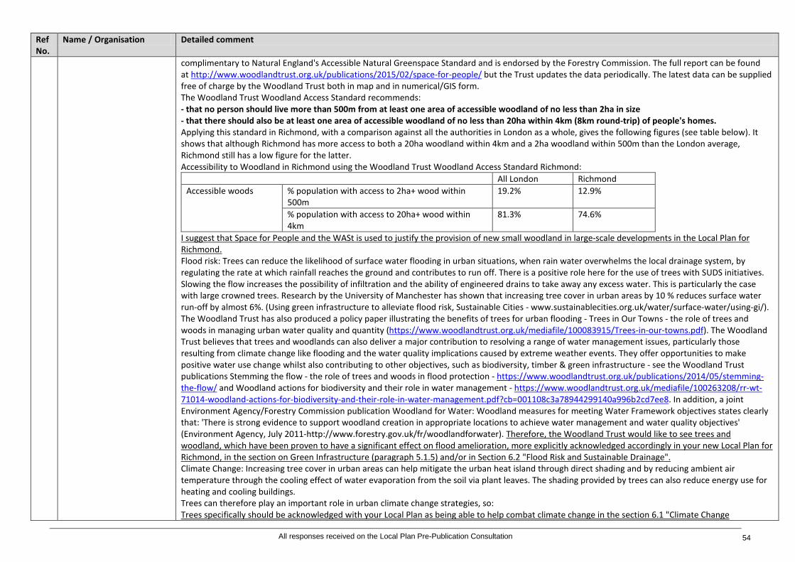
Ref No.
Name / Organisation Detailed comment
complimentary to Natural England's Accessible Natural Greenspace Standard and is endorsed by the Forestry Commission. The full report can be found at http://www.woodlandtrust.org.uk/publications/2015/02/space-for-people/ but the Trust updates the data periodically. The latest data can be supplied free of charge by the Woodland Trust both in map and in numerical/GIS form. The Woodland Trust Woodland Access Standard recommends: - that no person should live more than 500m from at least one area of accessible woodland of no less than 2ha in size - that there should also be at least one area of accessible woodland of no less than 20ha within 4km (8km round-trip) of people's homes. Applying this standard in Richmond, with a comparison against all the authorities in London as a whole, gives the following figures (see table below). It shows that although Richmond has more access to both a 20ha woodland within 4km and a 2ha woodland within 500m than the London average, Richmond still has a low figure for the latter. Accessibility to Woodland in Richmond using the Woodland Trust Woodland Access Standard Richmond:
All London Richmond Accessible woods % population with access to 2ha+ wood within
500m 19.2% 12.9%
% population with access to 20ha+ wood within 4km
81.3% 74.6%
I suggest that Space for People and the WASt is used to justify the provision of new small woodland in large-scale developments in the Local Plan for Richmond. Flood risk: Trees can reduce the likelihood of surface water flooding in urban situations, when rain water overwhelms the local drainage system, by regulating the rate at which rainfall reaches the ground and contributes to run off. There is a positive role here for the use of trees with SUDS initiatives. Slowing the flow increases the possibility of infiltration and the ability of engineered drains to take away any excess water. This is particularly the case with large crowned trees. Research by the University of Manchester has shown that increasing tree cover in urban areas by 10 % reduces surface water run-off by almost 6%. (Using green infrastructure to alleviate flood risk, Sustainable Cities - www.sustainablecities.org.uk/water/surface-water/using-gi/). The Woodland Trust has also produced a policy paper illustrating the benefits of trees for urban flooding - Trees in Our Towns - the role of trees and woods in managing urban water quality and quantity (https://www.woodlandtrust.org.uk/mediafile/100083915/Trees-in-our-towns.pdf). The Woodland Trust believes that trees and woodlands can also deliver a major contribution to resolving a range of water management issues, particularly those resulting from climate change like flooding and the water quality implications caused by extreme weather events. They offer opportunities to make positive water use change whilst also contributing to other objectives, such as biodiversity, timber & green infrastructure - see the Woodland Trust publications Stemming the flow - the role of trees and woods in flood protection - https://www.woodlandtrust.org.uk/publications/2014/05/stemming-the-flow/ and Woodland actions for biodiversity and their role in water management - https://www.woodlandtrust.org.uk/mediafile/100263208/rr-wt-71014-woodland-actions-for-biodiversity-and-their-role-in-water-management.pdf?cb=001108c3a78944299140a996b2cd7ee8. In addition, a joint Environment Agency/Forestry Commission publication Woodland for Water: Woodland measures for meeting Water Framework objectives states clearly that: 'There is strong evidence to support woodland creation in appropriate locations to achieve water management and water quality objectives' (Environment Agency, July 2011-http://www.forestry.gov.uk/fr/woodlandforwater). Therefore, the Woodland Trust would like to see trees and woodland, which have been proven to have a significant effect on flood amelioration, more explicitly acknowledged accordingly in your new Local Plan for Richmond, in the section on Green Infrastructure (paragraph 5.1.5) and/or in Section 6.2 "Flood Risk and Sustainable Drainage". Climate Change: Increasing tree cover in urban areas can help mitigate the urban heat island through direct shading and by reducing ambient air temperature through the cooling effect of water evaporation from the soil via plant leaves. The shading provided by trees can also reduce energy use for heating and cooling buildings. Trees can therefore play an important role in urban climate change strategies, so: Trees specifically should be acknowledged with your Local Plan as being able to help combat climate change in the section 6.1 "Climate Change
All responses received on the Local Plan Pre-Publication Consultation 54

Ref No.
Name / Organisation Detailed comment
Adaptation". Practical guidance and potential SPD The Woodland Trust is a member of the Trees and Design Action Group (TDAG) - a unique multi-disciplinary group of professionals and organisations from both the private and public sectors that is seeking to promote the benefits of trees within the built environment. TDAG published Trees in the Townscape (TDAG, June 2012) http://www.tdag.org.uk/trees-in-the-townscape.html. This contains 12 principles of best practice aimed at designers, developers and planners to encourage integrated, joined up thinking, strategies, policies and implementation relating to trees in the urban realm. TDAG have also recently published a practical guide for the retention and planting of trees in urban situations, including new development - Trees in the Hard Landscape (TDAG, September 2014). (http://www.tdag.org.uk/trees-in-hard-landscapes.html) TDAG publications are referenced in the London Plan, and Trees in the Townscape is endorsed by a number of local authorities; therefore, I recommend that Richmond Borough Council considers referencing TDAG guidance, and the Woodland Trust's Residential Development and Trees report in its Local Plan, and when developing any future Development Plan Documents .
173 Brian Willman, Chair Ham and Petersham Neighbourhood Forum
LP 16. 4 New trees - we suggest adding that trees which will in the future be of townscape or amenity value are encouraged where appropriate. The policy prioritizes protection over new planting when new developments need to provide space for trees to mature. It is customary to consider the number of trees planted rather than their long term size and future contribution to amenity, townscape and ecology.
174 Cllr Martin Elengorn, Environment Spokesperson Richmond upon Thames Liberal Democrat Councillors Group
Policy LP 16: In line 3 replace "compliment" by "complement". At end add "Fruit trees will be encouraged." 5.5.1 Carbon dioxide is a greenhouse gas not a pollutant. In line 8 substitute "reduce levels of carbon dioxide and airborne pollutants such as nitrogen dioxide....."
175 Neil Henderson, Gerald Eve on behalf of Reselton Properties Ltd
New Policy LP 16 Trees and Landscape: We recognise that importance of retaining and enhancing trees and vegetation within new build developments. Part 1 of the draft Policy does recognise that in some instances some low quality, dead trees can be removed and this recognition is welcome. However, Part 2 of the draft Policy allows no flexibility for instances where works are required to existing trees which contribute to the local landscape. It is appreciated that the Council will want to ensure maximum tree protection measures are in place for new development, but it should be recognised that some developments may require the removal of trees that are considered to be of townscape or amenity value where this results in significantly greater planning benefits. Flexibility should be built in to the Policy to allow the Council to determine the scheme on its overall planning merits. Mitigation measures can then be secured through parts 3 and 4 of the Policy. In order to incorporate greater flexibility, we consider that part 2 of the draft Policy should be amended to state: "resist development which results in the damage or loss of trees that are considered to be of townscape or amenity value, unless clear planning benefits can be demonstrated. The Council will require that site design or layout ensures a harmonious relationship between trees and their surroundings and will resist development which will be likely to result in pressure to significantly prune or remove trees."
Policy LP 17 Green Roofs and Walls 176 Brian Willman, Chair Ham
and Petersham Neighbourhood Forum
LP 17 Strongly support strengthening the green and brown roofs policy and incorporating green walls where green or brown roofs are not feasible
177 Cllr Martin Elengorn, Environment Spokesperson Richmond upon Thames Liberal Democrat Councillors Group
Policy LP 17: Add at end "whether or not it is part of local character".
All responses received on the Local Plan Pre-Publication Consultation 55

Ref No.
Name / Organisation Detailed comment
178 Sarah Stevens, Turleys for British Land
New Policy LP17 'Green Roofs and Walls': Supporting paragraphs 5.6.2 and 5.6.3 state that brown roofs are equally supported by the Council and provide many of the same benefits. The Policy should incorporate references to brown roofs to provide clarity.
179 Neil Henderson, Gerald Eve on behalf of Reselton Properties Ltd
New Policy LP 17 Green Roofs and Walls: We consider that a target of using at least 70% of roof plate areas as green roofs is onerous and could have scheme implications in terms of viability and the ability for roof areas to deliver other scheme requirements, such as plant. We do, however, welcome the flexibility that is incorporated into policy in allowing the target to be considered on a site by site basis. Where applicants cannot provide green roofs, the draft Policy states that the Council "will normally expect a green wall to be incorporated". Green walls are not always suitable (for example, where the orientation is not correct) and may not always provide sustainable and ecological benefits. In addition, the walls can be very expensive to maintain. The draft Policy seeks to maximise sustainable and ecological measures where feasible and we do not consider that the blanket provision of green walls will secure this aim. We consider that the draft Policy should be amended to seek a range of sustainable design methods, and consider that it would be more appropriate for green roofs (and other methods such as the provision of parks, ponds etc.) to be covered within the supporting policy text. Accordingly, we consider that the draft Policy should be amended as follows: "Green roofs should be incorporated into new major developments with roof plate areas of 100sqm or more where technically feasible and subject to considerations of visual impact. The aim should be to use at least 70% of any potential roof plate area as a green roof. The onus is on an applicant to provide evidence and justification if a green roof cannot be incorporated. The Council will normally expect other sustainable design methods to enhance biodiversity and provide sustainability benefits a green wall to be incorporated where it has been demonstrated that a green roof is not feasible.” We would also note that in the supporting text to the draft Policy, it states that "green roofs are not roof terraces". We consider that there is an opportunity for green roofs and roof terraces to be incorporated to provide attractive amenity spaces that provide a green environment for residents whilst at the same time assisting in meeting sustainability and biodiversity aims. We consider that the supporting text should be amended to reflect this opportunity.
Policy LP 18 River Corridors 180 Rob Gray, Friends of the
River Crane Environment (FORCE)
River Corridors: FORCE does not agree with the proposal to remove CP12 and the Lower Crane Area of Opportunity from the plan. These two policy initiatives have been very helpful over the last five years in delivering improvements on the ground in the lower Crane valley. FORCE does not agree that the plan has "largely fulfilled its role". The Richmond College site and station site are still be delivered on the ground; and there are potential new developments at both Harlequins and the depot site. In addition, several other sites (Greggs, RFU and the Mereway Day Centre) are adjacent to the Area of Opportunity. In our view there is a need to review the operation of the SPG and CP 12 and then to update it so that it continues to be effective in delivering improvements in line with council strategic objectives. There would be considerable benefit to widening this Area of Opportunity to include Greggs, Mereway Day Centre and the RFU sites, such that the potential benefits to the adjacent green corridor of any developments at these sites can be properly evaluated and delivered. The policy proposals also remove any reference to river restoration for the lower Crane. This opportunity is currently being actively investigated by the Crane Valley Partnership working group, including LB Richmond, LB Hounslow, Environment Agency and FORCE. FORCE believes that improving the value of the lower Crane, currently within a deep concrete culvert, is entirely in line with the strategic objectives of the plan and needs to be included specifically if improvements are to be secured on the ground. FORCE notes section 5.7.4 with the following specific references to the Crane corridor: "The River Crane is an important river corridor, which runs for 30 kilometres from Harrow through Twickenham and St Margarets to the Thames at Isleworth, and which has benefited from significant environmental improvements. Where appropriate, developments alongside and adjacent to the River Crane should contribute to the overarching aim of creating a new metropolitan park that provides a continuous, accessible link between Hounslow Heath and Twickenham Station, including a long distance footpath, improved access for surrounding communities and an enhanced wildlife corridor". FORCE welcomes this section though we would note the following developments since it was first drafted several years ago: - The objective of a continuous accessible riverside open space between Hounslow Heath and Twickenham Station is now largely realised, although the designation of metropolitan park is yet to be conferred
All responses received on the Local Plan Pre-Publication Consultation 56

Ref No.
Name / Organisation Detailed comment
- There has been considerable progress and public engagement downstream of Twickenham Station, linking with Friends of Moormead and The Tidal Crane Association among others, such that the aim can now be extended to include the tidal reaches of the river to the River Thames - There has also been considerable investment and improvement works along the Lower Duke of Northumberland's River, enhancing its status as a high value river corridor linking the River Crane and Thames through Twickenham, Whitton and Isleworth. We believe that the greatly enhanced value and importance of this corridor needs to be reflected in the Plan - The benefits of these actual and potential developments are also wider than is currently set out in the plan. In our view these benefits include the wider Objectives we propose for Objective 4 above of "education and learning, health and well-being, and social cohesion". - This aspiration is part of a wider set of Objectives for creating a coherent wildlife and amenity corridor along the 30 kms of the Crane valley that have been almost a hundred years in the development (since the Middlesex Plan of 1926). Wider objectives are set out in the GLA's All London Green Grid and are being delivered through the Crane Valley Partnership, of which LB Richmond is a key member.
181 Lucy Owen, Port of London Authority
Local Plan Policy LP18, page 82, Paragraph 5.7: The PLA is supportive of the Local Plan Review process taking the opportunity to consolidate and streamline the policies relating to the River Corridors. The New Policy LP18 is supported in principle however amendments are required. The PLA would wish to see the evidence base that supports providing new public access to the foreshore. As the Council will be aware there are health and safety issues associated with accessing the foreshore such as rapidly rising tides (the Thames has a seven metre tidal range) and accessing the foreshore can have an impact on its environment - contrary to the Council's desire to protect and enhance the natural environment. It is questioned whether the Council is seeking through policy LP18 for any member of the public to walk from the riverbank onto the foreshore or rather whether it is seeking through the policy for opportunities for organised activities such as rowing, stand up paddle boarding etc. to be realised. Whilst the PLA is supportive of access along the Riverside being protected and improved it objects to unrestricted access to the foreshore. Additionally in encouraging people to the riverside it is considered that the Council should also be seeking for all development proposals adjacent to the Borough's rivers to provide riparian life saving equipment (grab chains, access landders and life buoys). The Council's approach to riverside uses is welcomed, it is however considered that the policy should set out its support for riverside development to seek to utilise the river for the transport of construction and waste materials wherever practicable. Amend wording relating to access to the foreshore to clarify under what circumstances the Council is seeking access. Include a requirement for development proposals to provide riparian life saving equipment. Include a requirement for development proposals in close proximity to the river to utilise the river for the transport of construction materials and waste where practicable.
182 Kevin Scott, Kevin Scott Consultancy Ltd on behalf of Port Hampton Estates Limited
Policy LP18: This policy, in respect of public access to the riverside states that: "B. All development proposals alongside or adjacent to the borough's river corridors should: a. Retain existing public access to the riverside and alongside the river; and b. Enhance existing public access to the riverside where improvements are feasible; or c. Provide new public access to the riverside and the foreshore where possible. There is an expectation that all major development proposals adjacent to the borough's rivers shall provide public access to the riverside and foreshore." While we support the principle of this policy, it must be acknowledged that in some cases the use of the site or ownership issues would prevent this. This policy should make reference to this and we suggest that additional wording be added to B (c) as follows: "c. Provide new public access to the riverside and the foreshore where possible. There is an expectation that all major development proposals adjacent to the borough's rivers shall provide public access to the riverside and foreshore unless site specific characteristics would prevent this." In respect of Riverside uses this policy states that: "D. The Council will resist the loss of existing river-dependent and river-related uses that contribute to the special character of the River Thames, including river-related industry (B2) and locally important wharves, boat building sheds and boatyards and other riverside facilities such as slipways, docks, jetties, piers and stairs. This will be achieved by: 1. resisting redevelopment of existing river-dependent or river-related industrial and business uses to non-river related employment uses or residential uses; 2. ensuring development on sites along the river is functionally related to the river and includes river-dependent or river-related uses where possible, including gardens which are designed to embrace and enhance the river, and be sensitive to its ecology; 3. requiring an assessment of the effect of the proposed development on the operation of existing river-
All responses received on the Local Plan Pre-Publication Consultation 57
Ref No.
Name / Organisation Detailed comment
dependent uses or riverside gardens on the site and their associated facilities on and off-site; or requiring an assessment of the potential of the site for river-dependent uses and facilities if there are none existing; 4. ensuring that any proposed residential uses, where appropriate, along the river are compatible with the operation of the established river-related and river-dependent uses; 5. requiring setting back development from river banks and existing flood defences along the River Thames." The wording of the policy needs to reflect that the retention of such uses may no longer be viable or appropriate in certain locations. In some instances the introduction of new complementary uses is sometimes appropriate. For this reason we suggest a rewording of the policy as follows:"1. resisting redevelopment of existing river-dependent or river-related industrial and business uses to non-river related employment uses or residential uses unless the applicant can make a case that the retention of such uses is unviable";
183 Ben Mackworth-Praed, on behalf of the Barnes Community Association
P.84 5.7.8: What is "inclusive access?" P.84 5.7.11: Add at end: "Where use of the riverside path is shared priority shall be given to pedestrians."
184 Katharine Fletcher, Historic England
5.7 River Corridors New policy LP 18, p82/83 We support this policy and the reference to the historic environment at the beginning. The historic landscapes along the Thames are a key strategic heritage asset and this policy can link to across to a separate new policy covering historic landscapes, as suggested above.
185 Charles Pineles, Planning Spokesman, Richmond Society
Riverside uses: broadly we wholly support this policy but, in high footfall pedestrian amenity areas, such as Richmond Riverside we have concerns about balance of uses, health and safety and waste handling practices in areas where work is carried out, or the area is used to stock of work in progress. Where this does occur the space permitted for such use should be controlled, and should be clearly demarcated, with appropriate restrictions on pedestrian access to such limited areas.
186 Neil Henderson, Gerald Eve on behalf of Reselton Properties Ltd
New Policy LP 18 River Corridors: Our client's aim for the Stag Brewery site is to deliver a scheme which connects to and enhances the river, providing an attractive setting for residents, visitors and river-users. However, we consider that part C of draft Policy LP 18 is overly onerous and does not take into account any land ownership issues that may limit the ability of a developer to deliver a scheme which can provide a public riverside walk. In addition, flood defence requirements may limit the ability for riverside developments to provide public walkways. Whilst we support the aim of the Policy in principle, we consider that the wording should be amended to provide some level of flexibility. We consider that Part C of the policy should read: "All development proposals adjoining the River Thames are required to provide a public riverside walk where feasible, including for pedestrians and cyclists, which will contribute to the overarching aim of providing a continuous publicly accessible riverside walk." The Stag Brewery site is currently not in use by river-dependent uses and facilities. Its proposed use, a mixed use scheme delivering housing, employment, education provision, retail and amenity space, will not, at this stage, deliver mainly river-dependent uses or facilities. However, whilst this use is not specifically river-related, it will deliver significant planning benefit to the local community and the wider borough. Therefore, we consider that Part D Sections 2 and 3 of the draft Policy should acknowledge that riverside sites can present opportunities to deliver uses which are not river-dependent and which deliver significant planning benefits. We consider that the policy wording should be amended to read: "2. Where appropriate, ensuring development on sites along the river is functionally related to the river and includes river-dependent or river-related uses where possible, including gardens which are designed to embrace and enhance the river, and be sensitive to its ecology; 3. requiring an assessment of the effect of the proposed development of the operation of existing river-dependent uses or riverside gardens on the site and their associated facilities on- and off-site; or where appropriate requiring an assessment of the potential of the site for river-dependent uses and facilities if there are none existing;"
187 James Togher, Environment Agency
Policy LP 18 - We welcome this new policy which will help to protect and enhance river corridors across the borough. Its important development next to river maximises opportunities to make space for water and does not encroach into the river habitats and this new policy clearly demonstrates your vision to improve all river corridors. We strongly support the objective to include a 16 metre buffer zone next to the Tidal Thames and 8 metres on all other rivers across Richmond. 5.7.5 Setting back built development from the borough's rivers, including riverbanks and existing flood defences will be encouraged and supported. This will not only allow for the maintenance and future upgrading of the flood defences, but provide opportunities to enhance biodiversity as well as increase and open up public access alongside and to the river.
All responses received on the Local Plan Pre-Publication Consultation 58

Ref No.
Name / Organisation Detailed comment
The Council, in conjunction with the Environment Agency, will require a buffer zone of 8 metres on the borough's rivers (including the fluvial Thames) and 16 metres for the tidal Thames. We welcome the policy to restrict non river related uses and the need to maintain / deliver new river related industry to ensure a sustainable and functioning river for all river users. Riverside uses, including river-dependent and river-related uses D. The Council will resist the loss of existing river-dependent and river-related uses that contribute to the special character of the River Thames, including river-related industry (B2) and locally important wharves, boat building sheds and boatyards and other riverside facilities such as slipways, docks, jetties, piers and stairs.
188 William Mortimer Section 5.7.12 Riverside Uses: For centuries Mortlake Brewery depended upon river access for the raw materials necessary to brewing fine quality English beer and of course in Elizabethan times the river offered the safest and fastest form of transport for persons visiting the Manor House. It seems regrettable that the site is to lose an important part of its history in the developments so far proposed and a catamaran service would serve to maintain the contact between community and river for the future.
189 Lucy Owen, Port of London Authority
Local Plan policy LP19, paragraph 5.8: Whilst 'the evidence' box advises there is a need to ensure that any proposal for houseboats, moorings and other floating structures safeguard the character and openness of the River Thames, this does not appear to be reflected in policy LP19 which has a presumption against houseboats, including extensions and other moorings or floating structures designed for permanent residential use. Additional the supporting text to Section 5.8 advises that updates are needed to provide definitions for houseboats, residential moorings, temporary and permanent moorings but these definitions are not provided in the policy or in the supporting text. Given the number of houseboats within Richmond and elsewhere on the River Thames it is questioned whether houseboats, by definition are an inappropriate use within Metropolitan Open Land. It is also questioned how they cause problems because of infrastructure provision that are any different to for example a new housing development on the land which also requires sewage, waste, water, secure storage and washing etc. It is recommend to review the evidence base and policy with a comprehensive re-write of the policy based on the evidence.
190 Kevin Scott, Kevin Scott Consultancy Ltd on behalf of Port Hampton Estates Limited
Policy LP19: This policy, in respect of mooring and floating structures states that: "B. A mooring or other floating structure will be supported if it complies with the following criteria: 1. it does not harm the character, openness and views of the river, by virtue of its design and height; 2. the proposed use is river-dependent or river-related; 3. there is no interference with the recreational use of the river, riverside and navigation; and 4. the proposal is of wider benefit to the community." The purpose or meaning of "wider benefit to the community" in this policy is meaningless and difficult to quantify in respect of the submission of any planning application. The previous three criteria in this draft policy provides sufficient control over the provision of such structures in the river. For these reasons we request that criteria 4 is deleted from the policy.
Chapter 6 – Climate Change and Sustainable Design 191 Tim Catchpole, Planning
Representative Mortlake with East Sheen Society
6. Climate Change and Sustainable Design: There is much duplication here of policies in other chapters, e.g. there is a section on basements and subterranean developments which has already appeared in Chapter 4.
Policy LP 20 Climate Change Adaptation 192 William Mortimer Section 6 Climate Change and Sustainable Design LP 20: The Council is responsible for managing tidal and fluvial flooding Much of what the document
says in terms of the Plan to mitigate the impact of global climate change is extremely encouraging. However, the concepts are incomplete without a disaster management plan and the spatial requirements thereof. (Please refer previous comments) It is inappropriate to ask for changes a proposals with supporting information from this review of the Local Plan in the absence of any skeletal proposals from the Council in terms of Emergency Management. It must first accept there is a deficiency and address the changes required to the Local Plan accordingly.
193 Savills on behalf of Thames Water
New Policy LP 20 - Climate Change Adaption: The Environment Agency has designated the Thames Water region to be "seriously water stressed" which reflects the extent to which available water resources are used. Future pressures on water resources will continue to increase and key factors are population growth and climate change. Water conservation and climate change is a vitally important issue to the water industry. Not only is it expected to have an impact on the availability of raw water for treatment but also the demand from customers for potable (drinking) water. Therefore, Thames Water
All responses received on the Local Plan Pre-Publication Consultation 59

Ref No.
Name / Organisation Detailed comment
supports water conservation and the efficient use of water and the references to this at paragraphs 6.3.3 to 6.3.6, but consider that there should be clearer reference in Policy LP 23 itself. Thames Water support the mains water consumption target of 110 litres per head per day as set out in the NPPG (Paragraph: 015 Reference ID: 56-015-20150327) and consider that this should be covered in the new Policy LP 23 and LP20. Thames Water have a water efficiency website: http://www.thameswater.co.uk/save-water/3786.htm Customers can discover how you can start saving water, help protect the environment, reduce your energy bill and even cut your water bill if you have a meter. You can calculate your water use, see how you compare against other Thames Water customers and the Government's target, and get lots of hints and tips on how to save water. Thames Water customers, can also order a range of free devices to help save water. The Policy/supporting text could make reference to this guidance. However, managing demand alone will not be sufficient to meet increasing demand and Thames Water adopt the Government's twin-track approach of managing demand for water and, where necessary, developing new sources, as reflected in the latest Thames Water Water Resource Management Plan.
194 Ben Mackworth-Praed, on behalf of the Barnes Community Association
P.90 6.1.6 Add at end: "and will be discouraged/forbidden."
Policy LP 21 Flood Risk and Sustainable Drainage Sustainable Drainage 195 Brian Willman, Chair Ham
and Petersham Neighbourhood Forum
LP 21 6.2.21 As the borough is very susceptible to surface water flooding and there is evidence in the SWMP, SuDS should be a requirement (rather than encouraged) in all new development.
196 Charles Pineles, Planning Spokesman, Richmond Society
New Policy LP 21: Since it is stated that this and Flood Risk are being reviewed, 6.1 and 6.2, perhaps we had better wait. New Policy LP 21 A: per Subterranean Developments under 4, we welcome the intention that unacceptable developments will be refused and most especially such as relate to basements under B. However, it is not only the potential loss of life which is of concern. As per the current troubles caused to neighbours of the existing ATS Garage development in the Kings Road, 14/3983, the excavation of a basement of considerable size can displace water in previously drained areas, especially where the water table is already higher than in past years, and threaten to destabilise a number of previously solid buildings on Sheen Road.
197 Savills on behalf of Thames Water
New Policy LP 21 - Flood Risk and Sustainable Drainage Sustainable Drainage Limiting the opportunity for surface water entering the foul and combined sewer networks is of critical importance to Thames Water. Thames Water have advocated an approach to SuDS that limits as far as possible the volume of and rate at which surface water enters the public sewer system. By doing this, SuDS have the potential to play an important role in helping to ensure the sewerage network has the capacity to cater for population growth and the effects of climate change. SuDS not only help to mitigate flooding, they can also help to: - improve water quality - provide opportunities for water efficiency - provide enhanced landscape and visual features - support wildlife - and provide amenity and recreational benefits. Thames Water therefore support the section on Sustainable Drainage of new Policy LP21. In relation to flood zone 1, Thames Water support the requirement that 'A Drainage Statement is required for sites all major developments'. Basements - Sewage flooding Thames Water's main concerns with regard to subterranean development are: 1) The scale of urbanisation throughout London is impacting on the ability of rainwater to soak into the ground resulting in more rainfall in Thames Water's sewerage network when it rains heavily. New development needs to be controlled to prevent an increase in surface water discharges into the sewerage network. 2) By virtue of their low lying nature basements are vulnerable to many types of flooding and in particular sewer flooding. This can be from surcharging of larger trunk sewers but can also result from operational issues with smaller sewers such as blockages. Basements are generally below the level of the sewerage network and therefore the gravity system normally used to discharge waste above ground does not work. During periods of prolonged high rainfall or short duration very intense storms, the main sewers are unable to cope with the storm flows. The policy should therefore require all new basements to be protected from sewer flooding through the installation of a suitable (positively) pumped device. Clearly this criterion of the policy will only apply when there is a waste outlet from the basement i.e. a basement that includes toilets, bathrooms, utility rooms etc. Applicants should show the location of the device on the drawings submitted with the planning application. Definition of Functional Floodplain When reviewing and defining Flood Risk Zones 3a and 3b it is important to recognise that water and/or sewerage
All responses received on the Local Plan Pre-Publication Consultation 60
Ref No.
Name / Organisation Detailed comment
infrastructure may be required to be developed in flood risk areas. By their very nature existing water and sewage treatment works are located close or adjacent to rivers (to abstract water for treatment and supply or to discharge treated effluent), such as Hampton Water Treatment Works (WTW). It is likely that these existing works will need to be upgraded or extended to provide the increase in treatment capacity required to service new development identified in the Local Plan or to meet new treatment consents being set by the Environment Agency.
198 Sarah Stevens, Turleys for British Land
New Policy LP21 'Flood Risk and Sustainable Drainage', Part A: With regards to the 'Environment Agency's floodplain compensation', we would suggest a definition of compensation is included within the New Local Plan for guidance to distinguish between fluvial and surface water flooding. It is common to promote compensation storage through connected river-bank areas which are sacrificial for fluvial flooding if the development would encroach in fluvial zones. For surface water flooding, it is common to promote flood storage as an option as part of the drainage system, which is also considered to be compensation. Further guidance and clarity on this is needed. New Policy LP21 'Flood Risk and Sustainable Drainage', Part C: The difference between a 'brown field' site and a 'green field' site needs to be acknowledged in this policy and/or supporting text. DEFRA's 'Sustainable Drainage Systems: Non-statutory technical standards for sustainable drainage systems' (March 2015) sets out non-statutory technical standards for sustainable drainage systems. These standards should be used in conjunction with the National Planning Policy Framework and Planning Practice Guidance and provide clear concise guidance on rates for the two types of site. If it was demonstrably impractical to reduce runoff rates to Greenfield, then the development is expected to reduce the existing runoff rates by 50%. This is more onerous than National Standards and would lead to greater flood storage requirements. The rationale or evidence to support this policy needs to be provided. In the alternative the runoff rate should be increased to 100% as per the National Standards. Paragraph 6.2.4 needs to cross refer to the peak flow and peak volume requirements set out in DEFRA's 'Sustainable Drainage Systems: Non-statutory technical standards for sustainable drainage systems' (March 2015). These standards should be used in conjunction with the NPPF and nPPG.
199 James Togher, Environment Agency
Feedback on Policy LP 21 - Flood Risk and sustainable drainage, including flood defences: We welcome the new flood risk and sustainable drainage policy to ensure new development does not increase flood risk on or off site and the right development is in the right place. We recommend adding the additional text in bold below to strengthen this policy further and align it with the River Corridor Policy. This will ensure all flood defence structures across the borough are protected and enhanced we suggest deleting reference to just tidal defences and widening this to all flood defences. Flood defences D. Applicants will have to demonstrate that their proposal complies with the following: 1. Retain the effectiveness, stability and integrity of flood defences, river banks and other formal and informal flood defence infrastructure. 2. Ensure the proposal does not prevent essential maintenance and upgrading to be carried out in the future. 3. Set back developments from river banks and existing flood defence infrastructure where possible (16 metres tidal Thames and 8 metres other rivers) 4. Take into account the requirements of the Thames Estuary 2100 Plan and the River Thames Scheme and demonstrate how the current and future requirements for 'for the River Thames tidal' flood defences have been incorporated into the development. 5. The removal of formal or informal flood defences is not acceptable unless this is part of an agreed flood risk management strategy by the Environment Agency.
Policy LP 22 Sustainable Design and Construction 200 Sarah Dixey, London
Borough of Wandsworth Energy/Sustainability: Whilst there doesn't appear to be any new issues arising in Duty to Cooperate terms since our meeting, we would be interested to see how certain topics are approached as the plan progresses and we will attempt top follow your emerging policy, which may help inform the forthcoming Full Review of the Local Plan but I don't think there is anything that is significant.
201 Katharine Harrison, Surrey County Council
The proposed sustainable construction policy (New Policy LP 22, p.102) does not include the use of secondary materials. We would like to see greater emphasis on the use of recycled or secondary aggregates and the efficient use of building materials in new development.
202 Katharine Fletcher, Historic England
6.3 Sustainable Design and Construction, pp99: Historic England has carried out research with regard the potential for retrofitting historic buildings to secure energy efficiencies. We suggest that you include the Historic England advice on retrofitting historic buildings and energy conservation 'Energy efficiency and Historic Buildings'. (HE advice ‘Energy efficiency and Historic Buildings can be found at: https://historicengland.org.uk/advice/technical-
All responses received on the Local Plan Pre-Publication Consultation 61

Ref No.
Name / Organisation Detailed comment
advice/energy-efficiency-and-historic-buildings/) This provides technical advice to help prevent conflicts between energy efficiency requirements in Part L of the building regulations and the conservation of historic and traditionally constructed buildings.
203 Brian Willman, Chair Ham and Petersham Neighbourhood Forum
Support the Council's aspiration to achieve zero carbon standards but would prefer zero carbon standards to be required unless evidence is provided showing it is not technically feasible. Support the encouragement to retrofit energy and water efficiency in existing developments.
204 Cllr Martin Elengorn, Environment Spokesperson Richmond upon Thames Liberal Democrat Councillors Group
Policy LP 22: Line 2 - delete "against"6.3.13 Add at end "In other cases good design which promotes high levels of sustainability should mitigate impact on existing townscape."
205 Mike Mills, Firstplan Ltd on behalf of Maxicorp Ltd
Policy LP22 - Sustainable Design & Construction: Draft Policy LP22 states that new non-residential buildings above 100 sq m are required to meet BREEAM 'Excellent' and all non-residential buildings are required to achieve a 35% reduction in energy. Maxicorp has a number of comments on this policy as follows:- - This is a very low floorspace threshold for when BREEAM is a relevant consideration. The National Planning Practice Guidance (2014) recommends that local planning authorities take into account the impact on the viability of development when formulating policies relating to the sustainability of nonresidential buildings. Policy LP22 does not provide supporting evidence to confirm that it is feasible and viable for all non-residential development over 100 sq m to meet BREEAM requirements. For example, we are aware of similar policies in other Boroughs (eg Wandsworth and Kensington & Chelsea) where a threshold of 1,000 sq m or more and therefore is aligned with the definition of 'major development'. An amendment to the threshold would improve the viability of smaller developments which can also play a key role in enhancing and maintaining the vitality and viability of the town centre. - Requiring BREEAM 'Excellent' and a 35% energy reduction in all new non-residential buildings is not flexible enough and should take into account site circumstances and viability, particularly relating to complex town centre sites. Without such flexibility, our client is concerned that this could place an unreasonable burden on developers and investors. This in turn could jeopardise investment, regeneration and employment creation in the Borough. Overall, it is felt that greater flexibility should be introduced to the wording of the proposed Site Allocation SA 18 and to Policy LP22 to take into account site circumstances and viability. The proposed amendments to each policy are below. A. Developments will be required to achieve the highest standards of sustainable design and construction in order to mitigate against climate change. Applicants will be required to comply with the following: 1. Development of 1 dwelling unit or more, or 100sqm or more of non-residential floor space (including extensions) will be required to comply with the Sustainable Construction Checklist SPD. A completed Checklist has to be submitted as part of the planning application. Development that results in a new residential dwelling, including conversions, change of use, and extensions that result in a new dwelling unit, will be required to incorporate water conservation measures to achieve maximum water consumption of 110 litres per person per day for homes (including an allowance of 5 litres or less per person per day for external water consumption). 3. New non-residential buildings over 1,000 sqm will be required to meet BREEAM 'Excellent' standard unless there is robust evidence to demonstrate that this is not feasible and/or viable 4. Proposals for change of use to residential will be required to meet BREEAM Domestic Refurbishment 'Excellent' standard (where feasible). B. Developers are required to incorporate measures to improve energy conservation and efficiency as well as contributions to renewable and low carbon energy generation. Proposed developments are required to meet the following minimum reductions in carbon dioxide emissions: 1. All new residential buildings should achieve a 35% reduction unless there is robust evidence to demonstrate that this is not feasible and/or viable 2. All major non-residential buildings should achieve a 35% reduction unless there is robust evidence to demonstrate that this is not feasible and/or viable.
206 Neil Henderson, Gerald Eve on behalf of Reselton Properties Ltd
New Policy LP 22 Sustainable Design and Construction: It is recognised that new development should target a 35% reduction in carbon emissions. However, we consider that draft Policy LP 22 should recognise more clearly instances where a proposed development scheme will not be able to meet the stated 35% reduction in carbon dioxide emissions. This is especially the case for development in LBRuT, where the Council does not currently operate a carbon off-setting scheme (although we do note that para 6.3.12 in the policy supporting text acknowledges that this method could in theory be used
All responses received on the Local Plan Pre-Publication Consultation 62
Ref No.
Name / Organisation Detailed comment
should it not be feasible to achieve the required carbon dioxide reductions through on-site measures). We would urge LBRuT to consider a carbon off-setting scheme, as this is one of the Mayor's priorities. As the Council does not currently operate a carbon off-setting scheme, policy wording should be made more flexible to recognise that the 35% reduction is a target for schemes. This approach would be in line with the Mayor's 'Sustainable Design and Construction SPG' (April, 2014) which states that the Mayor recognises "that some building types will find it harder to achieve the 35% target without a contribution to a local off-set fund". In these instances, "Developers will continue to need to undertake sufficient calculations to demonstrate compliance with London Plan policy 5.2. Should particular building types struggle to meet the target on-site, developers will need to provide the Mayor with sufficient evidence to demonstrate that this is the case". Therefore it is suggested that Part B Sections 1 and 2 of draft Policy LP 22 should state: "1. All new residential buildings should achieve target a 35% reduction. All major non-residential buildings should achieve target a 35% reduction. If this 35% reduction target is not feasible, justification should be provided".
207 Celeste Giusti, Greater London Authority on behalf of Mayor of London
LP 22, zero carbon, air quality and CO2 emissions: The Mayor welcomes Richmond's robust approach to improving air quality. Improving London's air quality and reducing levels to at least within legal limits is one of the Mayor's top priorities. However, the Mayor believes Richmond's approach could explicitly refer to reducing emissions from transport. The Mayor also welcomes Richmond's commitment to working towards zero carbon standards for all new development. This is in line with his manifesto pledge for London to become a 'zero carbon' city by 2050. In this regard the policy and supporting text should refer to the London Plan policy 5.2 which expects the housing element of major development s to be 'zero carbon'. Further details of the definition of 'zero carbon' are explained in the Mayor's Housing SPG 2016. This approach is supported by the 'need' and 'viability' evidence produced for the Minor Alterations to the London Plan (Housing).
Policy LP 23 Water Resources and Infrastructure 208 Savills on behalf of Thames
Water A key sustainability objective for the preparation of the new Local Plan should be for new development to be co-ordinated with the infrastructure it demands and to take into account the capacity of existing infrastructure. Paragraph 156 of the National Planning Policy Framework (NPPF) states: “Local planning authorities should set out strategic policies for the area in the Local Plan. This should include strategic policies to deliver:……the provision of infrastructure for water supply and wastewater….” Paragraph 162 of the NPPF relates to infrastructure and states: “Local planning authorities should work with other authorities to: assess the quality and capacity of infrastructure for water supply and wastewater and its treatment…..take account of the need for strategic infrastructure including nationally significant infrastructure within their areas.” The web based National Planning Practice Guidance (NPPG) includes a section on ‘water supply, wastewater and water quality’ and sets out that Local Plans should be the focus for ensuring that investment plans of water and sewerage/wastewater companies align with development needs. The introduction to this section also sets out that “Adequate water and wastewater infrastructure is needed to support sustainable development” (Paragraph: 001, Reference ID: 34-001-20140306). Policy 5.14 of The London Plan, March 2015 is directly relevant as it relates to Water Quality and Wastewater Infrastructure and Policy 5.15 relates to Water Use and Supplies. Thames Water therefore support Policies DM SD 9 Protecting Water Resources and Infrastructure and DM SD 10 Water and Sewerage Provision of the Development Management Plan and Policy CP16 Local Services / Infrastructure of the Core Strategy. Thames Water similarly support the proposed new Policy LP 23. The supporting text on page 107 states that: “Minor updates are required to reflect most recent national standards for water efficiency in line with the Building Regulations”. However, this does not seem to be included in the new Policy LP 23. The Environment Agency has designated the Thames Water region to be “seriously water stressed” which reflects the extent to which available water resources are used. Future pressures on water resources will continue to increase and key factors are population growth and climate change. Water conservation and climate change is a vitally important issue to the water industry. Not only is it expected to have an impact on the availability of raw water for treatment but also the demand from customers for potable (drinking) water. Therefore, Thames Water supports water conservation and the efficient use of water and the references to this at paragraphs 6.3.3 to 6.3.6, but consider that there should be clearer reference in Policy LP 23 itself.
All responses received on the Local Plan Pre-Publication Consultation 63

Ref No.
Name / Organisation Detailed comment
Thames Water support the mains water consumption target of 110 litres per head per day as set out in the NPPG (Paragraph: 015 Reference ID: 56-015-20150327) and consider that this should be covered in Policy LP 23.
209 Ben Mackworth-Praed, on behalf of the Barnes Community Association
P.110 6.4.6: Add at end: "Ground water pumped up to protect or as the result of retro-fitted basements should not be discharged to the sewer system."
Policy LP 24 Waste Management 210 Katharine Harrison, Surrey
County Council We support policy to safeguard and improve existing sites in accordance with the recently adopted West London Waste Plan (WLWP) in 2015 (Existing Policy CP6, p. 110). The WLWP safeguarding policy covers all existing and allocated waste sites (Appendix 2, p. 246). We support the approach by Richmond Council to minimize waste arisings and maximise self-sufficiency and see monitoring as an important way of ensuring that this is achieved (Existing Policy CP6, p. 110).
Chapter 7 – Town Centres 211 Brian Willman, Chair Ham
and Petersham Neighbourhood Forum
Town Centres The proposed hierarchy of centres supports the need to improve access to Richmond from Ham and Petersham, and potentially across the river to Twickenham, to ensure access to a range of shopping and other services. The centre on the Richmond Road is known locally as Ham Parade and we consider that calling it 'Ham Common' is misleading.
212 Tim Catchpole, Planning Representative Mortlake with East Sheen Society
7. Town Centres: Our comments on the East Sheen shopping centre are the same as for Chapter 3 above. However, there is one additional item not mentioned in Chapter 3, vis. "improve Mortlake Station."
213 Jenine Langrish I also find it hard to believe the assertion that we need more shops, and can't believe that your consultations to date would have shown residents demanding more.
Policy LP 25 Development in centres 214 Brian Willman, Chair Ham
and Petersham Neighbourhood Forum
7.1.3 Table of proposals from Village Plans. We assume that in due course proposals in the Ham and Petersham Neighbourhood Plan will be included in this table.
215 Brian Willman, Chair Ham and Petersham Neighbourhood Forum
7.1.14 The majority of Petersham is further than 400m from local convenience shopping. This has not emerged in our consultation as a particular problem but it highlights the need to maintain the important local parade at Ham Street / Back Lane.
216 Tanja El Sanadidy, Indigo on behalf of Shepherd Enterprises Limited
Policy LP 25: We are writing on behalf of our client, Shepherd Enterprises Limited, to make representation in respect of the Council's first consultation on the draft Local Plan (pre-publication). Shepherd Enterprises Limited is the owner of the land at 1D Becketts Place, Hampton Wick, KT1 4EW. They are intending to implement a residential use at the site following the recently approved prior approval (15/3256/GPD15) from office (B1 use) to residential (C3). An application for the demolition and the re-development for eight residential units (16/2537/FUL) has been submitted to the council and is currently under consideration. We previously objected on the "consultation on scope of review of policies and draft site allocations" via a letter dated 1 February 2016 (ref. let.001.TE.SM.22510003). We continue to express our objection to the site allocation (Policy LP 25 and LP 41) as well as Policy LP 36 relating to affordable housing financial contributions on small sites. As part of this letter we include the consultation form. We have set out our justification below. The site has been designated within the Hampton Wick's "Neighbourhood Centre". The Council states that neighbourhood centres are places that should provide services and shops for day to day needs. Key objectives for these areas are to encourage a wider range of shops and services as well as attracting other uses of an appropriate scale. There is no reference of office uses within a Neighbourhood Centre. Therefore, this policy contradicts Policy LP 41 which considers the area to be a "Key office area". The research mentioned above clearly shows that the area is mainly in residential use with retail and some office uses. Therefore, we consider that the area should not be allocated as a Neighbourhood Centre and should be recognised as a primarily residential area with a mix of other uses that support the area. Policies LP 25 and LP 41 do not recognise the predominately residential use within the
All responses received on the Local Plan Pre-Publication Consultation 64

Ref No.
Name / Organisation Detailed comment
Hampton Wick area, where our client's site is situated. The policies seek to protect an area that has changed significantly, therefore, we consider Policy LP 25 and LP 41 should reflect the existing character of the area.
217 Charles Pineles, Planning Spokesman, Richmond Society
7. Town Centres and LP 25: 7.1: increase in retail space: we acknowledge the findings of the Retail Study but continue to oppose further A3, A4 and A5 uses. (Forgive the repetition). The saturation of Richmond Town Centre with A3, A4 and A5 units is demonstrated by figures set out in the Nathaniel Lichfield and Partners report which show that the UK average for town centres is 2.9% of units in A4 (pubs and bars) use whereas in Richmond Town centre it is 140% greater at 6.5% of units and for A3/A5 it is 14.7% of units whilst in Richmond Town Centre it is 17.5%. Existing Policy CP8: we wonder if some of the aims are contradictory and urge the council to be flexible in mind - particularly over the huge amount of effort which it has put into the preparation of this initial draft. A wish to provide larger floor plates whilst seeking diversity of offer might be tricky and it is often regretted that the High St currently provides such sterile, major chain dominated, opportunities. Larger plates can only exacerbate this situation. Probably, the only potential large plate site is Richmond Station which would move the centre of gravity of the town significantly away from the large plate Dickinson & Jones and nearby retail outlets possibly to the detriment of the town as a whole. As to improved transport, obviating the need for car parking we can only applaud. Better parking management will be necessary, possibly centred on the Paradise Road multi-storey, if the Friar's Lane zone is to be developed and further parking pressure on the Green, Richmond, is to be avoided, but then more demand should make extended hours at Paradise Road more viable. Under C, p.116, continuing the theme of larger plates "not to adversely affect diversity", we are anxious to avoid a mini Kingston. Policy DM TC 1 (g): it follows that we would very much encourage this development and feel that it should the strength and difference of Richmond as a small town and small centre. It would be a major draw for serious, up-market, shoppers. 7.1.7: Cumulative Impact Policy: we note the designation in the London Plan but insist that "increases in such uses (A3, A4)do not adversely impact on the amenities of local residents" which chimes with "the growth of the evening economy will need to be carefully managed" before. In brief the Society and its' members are most anxious to avoid uncontrolled spread of A3, A4 and A5 uses down the side lanes off George St (Brewers Lane, Golden Court, Paved Court, Duke St) and on Hill Rise and the Hill Rise /Petersham Road side of restaurants and would prefer to have them declared free of such further establishments. 7.1.24: Additional housing on upper floors: agreed. DM TC 3 prohibition of certain uses due to saturation: we are very pleased to see the retention of this policy, particularly as regards A3 and A4 on Richmond Riverside south. There has been a notable, and regrettable, increase in asb south of the Bridge since the gardens were refurbished and any increase in retail or, worse, drinking establishments in the area can only serve for the worse. 7.1.5: As such we would regard the demand led projections of retail expansion of 21,500 sq m as assigning far more (6,500 sq m) A3, A4 and A5 than is warranted and only a tiny proportion of which can be met be re-occupying vacant premises. We would regard these activities as already being more than well served in the town and would really urge the council to seriously consider the impact of yet further offer of this kind on the police and cleaning services in addition to that on the residents. There would seem a direct conflict with 7.1.7.
218 Tim Lennon, Borough Coordinator Richmond Cycling Campaign
In LP25 - development of centres: needs to talk about how people access them - the borough will start to choke if we get more people, but don't provide other ways to get around.
219 Tim Lennon, Borough Coordinator Richmond Cycling Campaign
We suggest a new policy about actively encouraging the use of pooling, sharing, scheduling and other methods to minimise the impact of deliveries on town centres. This will cut the number of heavy vehicles in the area, cut pollution, and make the area more inviting for visitors.
220 Sarah Stevens, Turleys for British Land
New Policy LP25 'Development in Centres': The wording of Part 2b of New Policy LP25 'Development in Centres' needs to reflect the national Planning Practice Guidance. If a threshold of 200 sq m gross is to be applied this is to relate to the requirement for an impact assessment. British Land supports the need to optimise the use of land, as discussed in paragraph 7.1.25
221 Tim Lennon, Borough Coordinator Richmond Cycling Campaign
In LP25 - development of centres: needs to talk about how people access them - the borough will start to choke if we get more people, but don't provide other ways to get around.
All responses received on the Local Plan Pre-Publication Consultation 65
Ref No.
Name / Organisation Detailed comment
222 Celeste Giusti, Greater London Authority on behalf of Mayor of London
Town Centres including LP25 Development in Centres: Town Centres The Mayor welcomes the distinctive approach Richmond has taken to its five main centres. However, he is disappointed that the overarching draft policy LP25 Development in Centres does not explicitly encourage residential use, and that residential use is only explicitly stated as being part of the vision and approach in Richmond town centre. As noted in proposed paragraphs 7.1.23 and 7.1.24 of Richmond's Plan residential use can contribute to the overall vitality and health of a centre. As set out in Richmond's draft Plan, the Mayor also encourages active uses on the ground floor.
223 Cllr Martin Elengorn, Environment Spokesperson Richmond upon Thames Liberal Democrat Councillors Group
7.1.12: omit "for villages" in heading. Omit "village" in lines 2 and 3. Omit second "Village Plan" in third heading of table
224 Maria Walker Town Centres/ 7.1.13/St Margarets : 'improve streetscape including the area outside of Twickenham Studios': As a proud resident of St Margarets, it is with great despair that our village centre outside the studio and next to the bus stop is so unkempt. The bins are often overflowing and messy, frequently with broken glass nearby which is dangerous. Up by the station is also litter ridden and could do with a freshening up. This small segment of St Margarets has unfortunately become an eyesore. When you drive into St Margarets from Richmond heading towards the A316, you are met by this disappointing site which is such a shame, especially as the rest of the area is so beautiful. It is imperative that this area is rejuvenated so that St Margarets can flourish with business opportunities. We really support your ideas to improve this part of the streetscape of St Margarets as thoroughly believe it will improve the appearance of our village.
Policy LP 26 Retail Frontages 225 Stephen Rankin LP 26 C and D: While new Policy LP26 is similar to existing policy DM TC 3, I fully support the introduction of Part C on Over-Concentration of certain uses.
My family and I live alongside a location identified in DM TC 3 D (and also previously in the UDP) and have experienced adverse impacts of an increase in A3-A5 uses for certain reasons notwithstanding the longstanding policy provision. Clearly the intention to keep the situation under review in DM TC 3 D has been fulfilled. However, in our opinion there ought to be a commitment added to new policy LP 26 to follow up with Article 4 Directions for the specifically identified locations in order to prevent circumstances where this policy can circumvented. The Council has already displayed a commitment to introducing Article 4 Directions in other situations where a threat has developed from the introduction of Permitted Development rights, and we wish to see a similar commitment for the long-standing identification of locations where over-concentration of A3, A4 and A5 uses already exists. The criteria for any Article 4 proposal to be specific is entirely fulfilled in relation to the list of 7 locations in DM TC 3 D (LP 26 D). We appreciate that there is an initial administrative burden, however without such a restriction the chance of greater resources having to be expended in dealing with Pre-Notification applications and subsequent planning applications could be significantly greater. Taking the identified frontage at 112-196 High Street, Teddington as an example, the NLP Town Centre review in 2014 identified a demand-based need for 2200 sq.m gross of new retail space by 2029 of which 1000 sq.m would be for A3-A5 uses. Discounting any capacity within the low vacancy rate for Teddington, the total projection is assumed to be met by two allocated sites (Tel Exchange and Sorting Office). There is no discussion in that 2014 study about the impact of current PD rights, neither is it easy to see any analysis within the current Local Plan review papers. It is not known when or if the two sites will come forward for development and in what form. In the meantime the pressure for additional A3 uses continues, and while such uses certainly contribute to the social and economic character of Teddington their proliferation, location and operations need to be managed. The operation of national PD rights designed to assist areas with completely different characteristics to Teddington for example threatens to negate local plan policies. Article 4 Directions for the specifically identified locations are the most effective way available to the Council of protecting its policy provisions, the amenity of residents and the balanced vitality of its centres.
226 Caroline Brock, Kew Society We wondered whether in New Policies LP 26 and LP 27 it would be better to allow some flexibility on the length of time marketing is required before change of use is permitted as this can, in some cases, lead to unsightly underused facilities for a considerable time. Perhaps paragraph 7.2.15 could be
All responses received on the Local Plan Pre-Publication Consultation 66
Ref No.
Name / Organisation Detailed comment
amended to say "normally at least 2 years". Where change of use is allowed more quickly than 2 years, then a requirement for any frontage windows to be "dressed" as retail pending redevelopment to reduce a negative impact to the area would be helpful. A condition might also be imposed in the planning approval for work to start within say 18 months in recognition of the fact that earlier approval will have been granted than would normally have been the case.
227 Brian Willman, Chair Ham and Petersham Neighbourhood Forum
7.2.10 We support the restrictions on additional fast food takeaways within 400m of schools as a contribution towards healthy living.
Policy LP 27 Local Shops, Services and Public Houses 228 Brian Willman, Chair Ham
and Petersham Neighbourhood Forum
7.3.4 Public Houses. We support the policies aimed at retaining local pubs which are the centre of social life for many people.
229 Caroline Brock, Kew Society We wondered whether in New Policies LP 26 and LP 27 it would be better to allow some flexibility on the length of time marketing is required before change of use is permitted as this can, in some cases, lead to unsightly underused facilities for a considerable time. Perhaps paragraph 7.2.15 could be amended to say "normally at least 2 years". Where change of use is allowed more quickly than 2 years, then a requirement for any frontage windows to be "dressed" as retail pending redevelopment to reduce a negative impact to the area would be helpful. A condition might also be imposed in the planning approval for work to start within say 18 months in recognition of the fact that earlier approval will have been granted than would normally have been the case.
230 Geoff Bond, Chair Ham and Petersham Association
We also support the Article four Direction to protect the shops on Ham Parade.
231 Sally Arnold, Planning Potential Ltd on behalf of Power Leisure Bookmakers
Policy LP26 - Retail Frontages: We note that Section A of Policy LP26 is very similar to the existing wording of existing policy DMTC3. The policy states that proposals that involve a loss of A1 retail in key shopping frontages will be resisted. It is also noted that other uses converting to retail will be supported subject to there being no adverse impact on the centre. However, the policy seems to exclude 'other town centre uses' or 'non-A1 uses' from locating within the key shopping frontages, and it is not clear from the evidence base why this is the case as the 2013 Town Centre Healthcheck states that the borough contains healthy town centres. Supporting text 7.2.5 does not align with the policy and states that 'a proposal for a change of use from an existing non-A1 use to another appropriate use will generally be acceptable, provided that the proposed use complies with Section B parts 1- 3 and Section C of this policy'. We provide comments on Section B parts 1 - 3 and Section C in further detail below, however, prior to turning to these sections, it is important to state that our client considers that the sentiments made within the supporting text should be translated within the policy wording itself. If non-A1 uses are appropriate within key frontages, it should be noted within the policy wording. This should be reviewed and clarified. Section B of the policy relates to secondary frontages. The policy notes that non-A1 proposals will be acceptable in secondary shopping frontages subject to the use meeting the criteria set out within the policy (parts 1 - 4). Part 1 of the policy states that non-A1 uses will be acceptable if (a) they meet community needs (specific uses are referenced) and (b) they fall within use classes A2 - A5. Supporting text paragraph 7.2.7 states that 'the list of uses suitable in secondary shopping frontages included in the policy is not exhaustive and other suitable uses may include B1 and Sui Generis uses, provided they meet the other criteria set out in this policy'. Again, there is a disparity between the policy itself and the supporting text. It is unclear why B1 and Sui Generis uses are excluded from the policy itself, yet are clearly seen as appropriate uses within secondary frontages as stated within the supporting text. This also needs to be clarified. The wording of the policy in both sections A and B should be updated reflecting our client's comments, otherwise, there is a clear discrepancy between the policy itself and the supporting text. If non-A1 typical town centre uses are excluded from the policy, there is a danger that appropriate town centre uses such as betting shop uses will be discouraged from both the key shopping areas and secondary shopping areas within the borough, potentially encouraging new operators and uses out of these areas. Clearly such an approach is inappropriate and would fly in the face of the town centres first policy
All responses received on the Local Plan Pre-Publication Consultation 67

Ref No.
Name / Organisation Detailed comment
as set out in the NPPF which seeks to encourage town centre shops and services to locate within centres, rather than in out of centre locations. Section C of the policy relates to the over-concentration of uses and impact on amenity. Within this section it is noted that the 'Council will resist proposals that result in an over-concentration of similar uses (such as betting shops, estate agents, restaurants and takeaways) in any one area'. Although our client does not object to the way in which the policy is worded, it does object to the fact that betting shops are specially referenced. We have reviewed the evidence base produced by the Council and there is no reference to an evident overconcentration of betting shops within the borough. For example, it is noted within the Council's Town Centre Health Check (2013) that Barnes is actually under-represented in terms of betting shop provision (well under the UK average). Although there are 3 betting shops in Whitton, this cannot be judged as an 'over-representation'. The London Borough of Southwark contains over 75 betting shops (which is a small number compared to many other London Boroughs). For this reason, it is considered that the reference to 'betting shop use' should be specifically removed from the policy. Importantly, it should be noted that a betting shop use is a typical town centre use which has a number of positive (not just negative) impacts on a centre and there is no firm evidence to suggest that this use could cause harm to a centre. Section G of the policy relates to 'Marketing requirements for change of use'. Within the policy, it is noted that where a proposal involves a change of use not supported by policy, the Council will require satisfactory evidence of full and proper marketing of the site for at least two years. It is noted within supporting text paragraph 7.2.15 that marketing evidence should be provided in line with Appendix 5 which sets out what marketing should entail for loss of retail (A1), pubs (A4) and Offices (B1). Although marketing policies are well established in London for loss of B1 uses in particular, our client considers that the Council's marketing requirements for two years are overly onerous and unnecessary. It is considered that this part of the policy should be reviewed. Firstly, it is very unlikely that a property in Richmond would be vacant for two years as it is a popular location with London, and therefore being able to provide vacancy for two years continuously would be near on impossible. Secondly, it provides yet a further hurdle that betting shop operators would need to overcome in order to operate within a town centre location. Indeed, since the Use Class Order changed in April 2015, Betting Shop Uses are now considered under 'Sui Generis' use class and an application is now always required for Betting shop uses. We have no issue with the fact that the Council will want to scrutinise new betting shop applications however, to assert unnecessary vetoes on areas where Betting Shop operators can locate, or to assert specific marketing requirements as a starting point for all new applications (when there is no robust evidence to support the approach) is wholly unsubstantiated and does not allow officers/members to make objective decisions. It also places unnecessary burdens on betting shops operators who already need to submit an application when looking for new units. We are concerned that the document will conflict with paragraph 23 of the NPPF which states that policies should be positive and promote competitive town centres. Bullet point 4 of this paragraph states that LPAs should "promote competitive town centres that provide customer choice and a diverse retail offer and which reflect individuality of town centres". This is a sentiment echoed in the London Plan (Policy 4.8). Clearly the document is likely to have a serious impact on particular industries and healthy competition between different operators by preventing new operators from locating within a particular centre. Again, regard needs to be had to the very real impact that the document is likely to have on a number of different industries and the clear conflict that would arise with the NPPF and the London Plan. In summary our comments are as follows: - Policy LP26 Section A - It is unclear whether non-A1 uses are actually considered appropriate within designated key frontages. There is no evidence to suggest that any appropriate town centre use should be excluded from key frontages. There is a disparity between the policy and the supporting text (paragraph 7.2.5); - Policy LP26 Section B - It is clear that non-A1 uses are acceptable in secondary frontages, but it is unclear whether Sui Generis uses such as betting shops are included within the 'non-A1' use category. Again there is disparity between the policy and supporting text (paragraph 7.2.7); - Policy LP26 Section C - It is clear that the Council are seeking to resist an over-concentration of uses (especially betting shops) within any one area. However, there is no background information produced by the Council to suggest there is an over-concentration in the first place (in fact, quite the opposite). Reference to betting shops should therefore be removed from the policy; - Policy LP26 Section G - It is clear that betting shop uses are not supported by policy (as noted above) and therefore two years marketing will be required for new betting shops applications. This is an additional and unnecessary burden on betting shop operators (on top of the fact that betting shops now always require
All responses received on the Local Plan Pre-Publication Consultation 68
Ref No.
Name / Organisation Detailed comment
applications as they fall within the Sui Generis use category). This is against the aspirations of the London Plan and the NPPF.
232 Sally Arnold, Planning Potential Ltd on behalf of Power Leisure Bookmakers
Policy LP27 - Local Shops, Services, and Public Houses Section A Part (a) of Policy LP27 needs further clarification, as our client is unclear on the intention of the policy. The Council note that in order to protect local shops, change of use from a premises falling within A1 - A5 uses will not be permitted unless (a) the unit is within 400 metres of a designated shopping frontage. However, this policy is essentially restricting Sui Generis uses such as betting shops locating in areas where there is no key frontage or secondary frontage within 400 metres, which could effectively mean that betting shop operators cannot locate within many parts of the borough (particularly in the local centres, parades and AMUs such as Barnes, Kew, Mortlake, Whitton and Heathfield, Richmond and Richmond Hill, East Twickenham and St Margarets). In summary our comments are as follows: Policy LP27 Section A Part (a) - This part of the policy restricts Sui Generis uses such as betting shops from local centres if they are not within 400 metres of key / secondary frontage. This effectively means that betting shop operators are restricted from locating in many areas of the borough which again is against the spirit and aspirations of the NPPF.
233 Charles Pineles, Planning Spokesman, Richmond Society
Policy LP 26: 7.2.9 Over-concentration of uses: we would agree and note that this paragraph makes special mention of the Cumulative Impact Policy in this regard. Specifically we recommend the following changes: New Policy LP 26 C (Over-concentration of uses and impact on amenity) page 127 to read as follows: 1. Heading to read ‘Over-concentration of uses and adverse impact on amenity’ 2. Changes: ‘The Council will resist proposals that result in an over-concentration of similar uses (such as betting shops, estate agents, restaurants, pubs, bars and take-aways) in any one area and/or would result in an adverse impact on the amenity of nearby users as well as surrounding residential areas, including an adverse cumulative adverse effect.’ New Policy LP 26 D page 128 to read as follows: ‘There are areas of the borough where certain changes of use and intensification of use will no longer be allowed due to existing concentrations. These include, but are not limited to, the following frontages and/or areas subject to specific restrictions:’'
Chapter 8 – Community Facilities Policy LP28 Social and Community Infrastructure
234 Heather Mathew, Richmond CVS
Social Value The core carried forward from the previous plan includes "meeting people's needs and later in the plan it talks about the importance of developing " inclusive and sustainable communities, social interaction, cohesive, healthy and dementia friendly communities enable the older population to remain independent and active for longer" A significant contributor to " meeting people's needs " are the voluntary and community sector, and it is important to specifically reference them alongside statutory and other partners such as arts and culture ( many of whom are also registered charities) for their contribution to the health and well- being of local communities and a sense of place. The Public Services (Social Value Act) 2013 requires people who commission public services to think about how they can also secure wider social economic and environmental benefits when procuring. Whilst planning is not commissioning public services, social value provides a useful framework to consider when planning social and community infrastructure projects, and working with developers on appropriate Section 106 projects. It would be useful to make reference to this at 13.2.3 Infrastructure to support sustainable growth
235 Brian Willman, Chair Ham and Petersham Neighbourhood Forum
8.1.8 We support the principle of multi-use of premises, but our neighbourhood planning consultation and experience indicate that restricted availability and cost of hire/use significantly limit the realisation of the potential scale and range of community usage.
236 Ross Anthony, The Theatres Trust
Policy LP28: The Theatres Trust supports Policy LP28 to promote and safeguard community and social infrastructure, given the description in 8.1.2 includes cultural uses, reflecting guidance in para. 70 of the NPPF. However, that description could be simplified to provide clarity and obviate the need for specific examples and recommend: community facilities provide for the health, welfare, social, educational, spiritual, recreational, leisure and cultural
All responses received on the Local Plan Pre-Publication Consultation 69
Ref No.
Name / Organisation Detailed comment
needs of the community.
237 Mel Barlow-Graham, London Fire and Emergency Planning Authority
Policy LP 28 (Social and Community Infrastructure) and paragraph number 8.1.2.: Please note that we act on behalf of the London Fire and Emergency Planning Authority (LFEPA) and that this representation is made on their behalf. For your information, the following LFEPA sites are within the borough:- - Richmond Fire Station: 323 Lower Richmond Road, TW9 4PN - Twickenham Fire Station: 30 South Road, TW2 5NT We note that Policy LP 28 (Social and Community Infrastructure) refers to the resistance of the loss of community infrastructure, and more particularly, that 'fire services' are included as an example of such a facility, within paragraph 8.1.2. We strongly resist this and request that the following wording be added:-"This is with the exception of fire station sites, which will not be subject to such restriction on use." This is requested as it is not appropriate for LFEPA to be bound by such restrictions regarding use. Whilst we understand that fire stations do provide a function with significant local benefit, the location of any fire station within a particular area is determined by strategic planning, including response times, fire cover, and other operational matters, with the purpose of ensuring that the whole of London is properly covered to deliver it's statutory duty. Furthermore, the sale of any surplus sites by LFEPA provides much required funding for the continued development of fire-fighting facilities to enable the London Fire Brigade to provide their essential services. In this context a fire station should not be considered in the same way as other community uses.
238 George Burgess, Indigo Planning on behalf of Beechcroft Developments Ltd
Draft Policy LP28: Social and Community Infrastructure: On a without prejudice basis, Part C of Draft Policy LP28 sets out three criteria that proposals for the loss of social infrastructure must demonstrate compliance with. The third criteria (LP28, Part C.3) requires applicants to fully assess the potential of re-using or redeveloping the existing site for the same or alternative social infrastructure use. London Plan Policy 3.16 however is clear that only social infrastructure uses for which there is a defined local need should be considered. It states:"The suitability of redundant social infrastructure premises for other forms of social infrastructure for which there is a defined need in the locality should be assessed before alternative developments are considered". Part C of Policy LP28 should therefore be amended to accord with London Plan Policy 3.16. In addition, supporting paragraph 8.1.2 to this emerging policy identifies that the Council will determine, as part of the pre-application process, whether any facility or service is considered to be a social infrastructure or community use. This appears to be at odds with paragraph 154 of the NPPF which states that "only policies that provide a clear indication of how a decision maker should react to a development proposal should be included in the plan". Paragraph 8.1.2 lacks the clarity required to guide potential developers in the Borough. It suggests a necessity for pre-application discussions with the Council, which the NPPF states, at paragraph 189, cannot be required of a developer by a local planning authority prior to the submission of a planning application. Paragraph 8.1.2 should therefore be amended to accord with the NPPF and provide potential developers with clearer guidance.
239 Charles Pineles, Planning Spokesman, Richmond Society
New Policy LP 28: para C, we have already referred to the Meadows Hall site in Church Road. We are aware that the immediately precedent use is no longer viable but we would look forward to the site being used under 8.1.8 "multi-use, flexible and adaptable" rather than being lost forever to the community. Enabling development would be necessary and the Society recognises that.
240 Dale Greetham, Sport England
8 Community Facilities - 8.1 Social and Community Infrastructure - Policy LP 28: Unsound Sport England welcomes the inclusion of these sections, however Sport England recommends that indoor and outdoor sports facility needs are specifically mentioned. These sections should therefore be revised to reflect Sport England's Land Use Planning Policy Statement 'Planning for Sport Aims and Objectives' (http://www.sportengland.org/media/162412/planning-for-sport_aims-objectives-june-2013.pdf), which is in line with the NPPF. The statement details Sport England's three objectives in its involvement in planning matters; 1) To prevent the loss of sports facilities and land along with access to natural resources used for sport. 2) To ensure that the best use is made of existing facilities in order to maintain and provide greater opportunities for participation and to ensure that facilities are sustainable. 3) To ensure that new sports facilities are planned for and provided in a positive and integrated way and that opportunities for new facilities are identified to meet current and future demands for sporting participation. Furthermore, this section should be in line with Paragraph 74 of the NPPF and Sport England's Playing Fields Policy (http://www.sportengland.org/facilities-planning/planning-for-sport/development-management/planning-applications/playing-field-land/). These sections should also make reference to the Richmond Playing Pitch Strategy.
Policy LP29 Education and Training
All responses received on the Local Plan Pre-Publication Consultation 70
Ref No.
Name / Organisation Detailed comment
241 Richard Geary In conclusion, what is the point of another Local Plan, compiled at huge expense to Council Tax payers, when it will be ignored? The time and money spent on producing it could have been better utilised, such as 18D: identifying new sites for educational uses as part of this Plan; the Council will work with landowners and developers to secure sites for pre-schools, primary and secondary schools as well as sixth forms to ensure sufficient spaces can be provided for children aged 2-18;
242 Bethany Evans, NLP Planning on behalf of The Harrodian School
Policy LP29 (Education and Training): Local Plan Policy LP29 encourages the provision of facilities and services for education and training of all age groups to help reduce inequalities and support the local economy, by, amongst other things, encouraging the potential to maximise existing educational sites through extensions, redevelopment or refurbishment to meet identified educational needs. The School supports this policy as it rightly acknowledges the need to plan positively for education uses. The NPPF places great importance on ensuring that a sufficient choice of school places is available to meet the needs of existing and new communities and recognises that Local Planning Authorities should take a proactive, positive and collaborative approach to meeting this requirement. The School must ensure it continues to develop and enhance its facilities to meet the demand of current and future students. If the education needs of more residents can be met locally at the School, by making the most efficient use of a previously developed site, this would reduce the need to provide for alternative facilities in new locations. Expansion of the School would lead to an increase in social infrastructure to the benefit of pupils, parents and the wider community.
243 Tim Sturgess, Bilfinger GVA on behalf of The Lady Eleanor Holles School
Policy LP29, Para 8.2, Page 139-142: Omission of Change to MOL boundary for LEHS - Please refer to Supporting Statement attached. Please refer to Supporting Statement attached See the Appendix (1) to this document.
244 Tim Catchpole, Planning Representative Mortlake with East Sheen Society
New Policy LP 29: Education and Training: Our Society is not wholly convinced by the need for additional school places in the area. The East Sheen and Sheen Mount Primary Schools have recently been expanded and a new Thomson school has emerged in Vernon Road. Some children from these primary schools go on to attend independent secondary schools. It would be useful if the map showing the location of schools, shown inappropriately in the Health and Wellbeing section, could be transferred to the Education and Training section and could distinguish between the state schools and independent schools. We note in para 8.2.11 that the Stag Brewery site in Mortlake has been identified for a new 6-form of entry secondary school and the Barnes Hospital site for a new 2-form of entry primary school. Our Society is not enamoured of either proposal. Secondary school children need good public transport access (PTA) and the PTA level for the Brewery site is a mere 2 points, which is poor. Primary school children are often chauffeured by parents in cars (alas regrettable but in the current security climate somewhat inevitable) and the car access to the Barnes Hospital site in South Worple Road is very poor. See our comments on these sites in Chapter 12 below.
245 Celeste Giusti, Greater London Authority on behalf of Mayor of London
Educational uses : The Mayor welcomes Richmond's approach to encourage the potential maximisation of existing educational sites through extensions, redevelopment or refurbishment to meet identified educational needs as well as the co-location with other social infrastructure.
246 Tom Sadler, Bilfinger GVA on behalf of Defence Infrastructure Organisation
LP 29 Community / Education: Community/Education 4.29 The NPPF attaches great importance to ensuring that a sufficient number and choice of school places is available to meet the needs of existing and new communities. It states that Local planning authorities should take a proactive, positive and collaborative approach to meeting this requirement and to development that will widen choice in education. 4.30 Draft Local Plan Policy LP29 (Education and Training) states that the Council encourages the provision of facilities and services for education and training. The supporting text at paragraph 13.1.7 states that 'a key challenge for this borough over the lifetime of this Plan will be the delivery of sufficient school places to meet the needs of the existing and growing population'. It highlights that 'adequately sized sites for new schools within the borough are extremely rare.' 4.31 The Draft Local Plan identifies the following sites for educational uses: - Richmond College, Twickenham; - Stag Brewery, Mortlake; - Ryde House, East Twickenham; and - Barnes Hospital, Barnes. 4.32 Supporting paragraph 13.1.8 states that, in addition to these identified sites, the Council 'is undertaking a further review of potential site opportunities for education uses'. The Draft Local Plan fails to recognise and plan for the role that sites such as Kneller Hall could play in meeting
All responses received on the Local Plan Pre-Publication Consultation 71
Ref No.
Name / Organisation Detailed comment
identified education needs through sustainable mixed use development, particularly as a reasonably large Brownfield site in a sustainable location. 4.33 We note that the most recent education research published by the Borough is the 'Education Provision in the Borough 2007 update' which provides a succinct update to the original 2005 study. As it is more than 'a few' years old (in fact almost 10 years old) the evidence base used to support the draft Local Plan policies is considerably out of date. As such it is not possible for the Local Plan to adequately plan for or to be effective is meeting the Borough's education needs. We therefore suggest an updated study is undertaken to ensure an up to date position on education provision and needs in the Borough, with the relevant policies updated and adequate land subsequently identified to meet needs.
247 Judith Livesey, NLP Planning on behalf of St Paul's School
New Policy LP 29 (Education and Training) and paragraph 8.2.10 The provisions provided in New Policy LP 29 are welcomed and supported by the School; in particular, the commitment to support the provision of educational facilities and encouraging the potential to maximise existing and educational sites through extensions, redevelopment or refurbishment to meet identified educational needs. Paragraph 8.2.10 recognises the contribution of independent schools in providing education facilities and states that the Council is generally supportive of proposals which increase the provision of places, provided they can evidence that they meet local need. The School welcomes this recognition of the role of the independent sector in the Borough and supports the inclusion of this paragraph in the plan.
Policy LP30 Health and Wellbeing 248 Brian Willman, Chair Ham
and Petersham Neighbourhood Forum
LP30 We regret the proposed loss of the specific reference in Existing Policy CP17 to the immediate need for primary health care facilities (especially doctor's surgeries) in Ham, a deficiency which remains unresolved. We ask that this reference be re-instated, preferably in the policy, but at least in the supporting text.
249 Caroline Brock, Kew Society In policy LP30 paragraph A 1, it would be helpful to insert something on the need to promote non conflict between all transport uses - buses, cars, bicycles, motor bikes and pedestrians - on all thoroughfares, including bus and cycle lanes, and on leisure routes including the Thames Pathway.
250 Steve Simms, SSA Planning Limited on behalf of Kentucky Fried Chicken (Great Britain) Limited
LP30 Part B2 and reference to the 'school zone' in the text at paragraphs 7.2.10 and 7.3.3 supporting the retail policies under Policy LP26: 1 We consider that inclusion of Policy LP30 Part B2 renders the draft LP unsound because the draft policy fails to meet the criteria set out at NPPF paragraph 182, as follows: Positively Prepared 2 The draft policy is not based on any objectively assessed development requirement. It effectively assesses the requirement for hot food takeaways within 400 metres of the boundary of a school or further education establishment as zero, but does so without evidence of either a link between the incidence of obesity and the proximity of hot food takeaways to such places or any particular distance at which that link is demonstrated. Consequently, the development requirement has not been objectively assessed. 3 In fact, the distance chosen would have the effect of banning hot food takeaways from a majority of the Borough. No assessment has been made of the number of hot food takeaways that might be refused as a result of this or what the social, economic or environmental impacts of that might be, so it is not possible to balance these impacts. 4 The policy is negative in its assumptions, using the concept of 'unhealthy food', which is at best unhelpful in isolation from an understanding of the person eating the food, their health and lifestyle, and at worst is simply subjective. Furthermore, it assumes all hot food takeaways offer little choice and serve the same type and standard of food. 5 We are further of the view that food of high energy density or poor nutritional value is sold from and at a range of premises within a variety of other classes, including many in Class A1, such as coffee or sandwich shops, bakeries or, simply, supermarkets, and that focussing on Class A5 uses is both unhelpful and unfair. Justified 6 There is no evidence for a causal link between the incidence of obesity and proximity of hot food takeaways to schools and only limited evidence of any correlation at all, so it is unclear how refusing planning permission for hot food takeaways within 400 metres of such locations could ever be justified. 7 The only study that has shown any correlation at all (Currie et al, 2010), was in fact carried out in the United States, used a different and wider definition of "fast food outlets" to Class A5, and showed a very weak correlation at a distance so short that it was, in fact, in many cases within the school boundary.
All responses received on the Local Plan Pre-Publication Consultation 72
Ref No.
Name / Organisation Detailed comment
8 Furthermore, the planning and urban context of the United Kingdom is very different to the United States, where car dependency is higher and non-car-ownership correlates very often with deprivation, limiting the transferability of that evidence. Fundamentally, the study showed a (weak) correlation and not causality. 9 The correlation between deprivation and the incidence of overweight or obesity fundamentally relates to a different subject to that to which the policy relates. Albeit unrelated, the deprivation correlation is likely to be caused by the economics of local centres in deprived areas and not diet. 10 There is no evidence of any threshold number of hot food takeaways at which the harm that the draft policy seeks to mitigate occurs or is noticeably greater. Indeed, there is no evidence of a causal spatial link between clusters of hot food and the incidence of obesity or overweight at all. 11 It is better to rely on objective evidence in a retail study to set maximum proportions of hot food takeaways. Whilst these are primarily directed at protecting the retail health of designated centres, there is scope to widen their application to support health outside centres. 12 As it is usually impractical to apply a maximum frontage proportion outside centres, the 400-metre walk distance might be applied, within which the proportion (rather than number) of units, be they in- or out-of-centre, used as hot food takeaways would not be permitted to exceed the same threshold as set for centres. 13 In adopting such an approach, it would be preferable to consider optimal proportions of all retail uses that could contribute to healthy centres or to a healthy offer generally, whether in- or out-of-centre, instead of focussing on particular uses considered to be a problem. 14 The inclusion of primary schools is particularly problematic, as it is clear that children at primary schools are not usually permitted to leave the premises at lunchtime and, given their age, are unlikely to travel to or from school unaccompanied. Outside school time, children's diets are quite properly the responsibility their parents or guardians. 15 Consequently, it is far from clear how refusing planning permission for hot food take-aways within 400 metres of primary schools could ever be justified. This was the view taken by a Planning Inspector in an appeal (APP/P4415/A/11/2159082) against refusal of a restaurant and hot food takeaway in January 2012. 16 On a practical point, there is a difficulty in using radii that take no account of real barriers, physical or perceptual, so that premises on the other side of a feature such as a canal or busy road could be affected despite in reality being more than a 400m walk away. It is better to use walk isochrones. Effective 17 Some hot food takeaways, together with restaurants, pubs and shops are clearly a source of cheap, energy dense and nutrient poor foods, however, not all hot food takeaways, restaurants, pubs and shops are, and the planning system is ineffective in distinguishing between those that are and those that are not. 18 The area that would be affected by the policy covers a large part of the Borough, so it is hard to see how the effectiveness of its extent could be monitored. Would poor or negative achievement against objectives result in reduction or expansion of the zones? What other corrective action might be taken short of its withdrawal? 19 Diet is clearly a key determinant both of general health and obesity levels. Exercise is the other key determinant and must be considered for a complete picture. Focussing on improving access to open space, sport and recreation facilities would be a far more effective strategy for reducing childhood obesity. Consistent with National Policy 20 We consider that no regard has been had to national policy and advice in preparing Policy LP30 Part B2 because none of the NPPF policies include dietary issues. 21 The NPPF recognises the role planning takes in better enabling people to live healthier lifestyles. However, it seeks to do this by creating, not restricting choice, by increasing access to recreation and health services, and by ensuring developments are within walkable distances of local facilities and public transport to other facilities. We consider that inclusion of Policy LP30 Part B2 renders the draft Richmond Local Plan unsound and so OBJECTS to that policy on the grounds above. It may be possible to replace the policy to similar effect. We do not consider a reasoned justification for the draft policy has been substantially provided in
All responses received on the Local Plan Pre-Publication Consultation 73

Ref No.
Name / Organisation Detailed comment
accordance with regulation 8 (2) of The Town and Country Planning (Local Planning) (England) Regulations 2012. The evidence on this issue thus far, for example, the Strategic Review of Health Inequalities in England post-2010 (Marmot et al, 2010) concluded that studies that show association between proximity, or lack of, to healthy food, and health outcomes such as obesity or malnutrition "...should be approached with caution. They are most often observational and so do not show causality between inadequate access and health outcomes."More recent studies in the United Kingdom (Williams, J et al, 2014) did not find strong evidence to justify policies related to regulating the food environments around schools, recognising inconsistencies across studies in definitions of "fast food outlets" and other key variables. The amendment sought, and the only change to Plan that would render it sound, is the deletion of Policy LP30 Part B2. Similar objectives might be achieved with a retail policy based on a wider application of proportional limits as set out above.
251 Liz Ayres, Richmond Clinical Commissioning Group
Is it possible to add and "pharmacy services" :"An immediate need for primary health care facilities (particularly GP surgeries and pharmacy services)".
252 Ben Mackworth-Praed, on behalf of the Barnes Community Association
P.144 A5: The Councils' Community Toilet Scheme needs to be re-examined. There are far too few sites available in Barnes and one of these is misplaced by about a mile on the map.
253 Charles Pineles, Planning Spokesman, Richmond Society
New Policy LP 30 and Obesity: New Policy LP 30 Travel: A 1, cycling has become immensely popular in recent years but has tended to be concentrated, at certain times, notably weekends, in certain areas to the detriment of the public at large. We would urge the council, building on the work done with the, almost successful, bid to the Mayor London, to continue to explore ways in which all road travellers can work together for the benefit, and good understanding, of all. This particularly would seem to apply to Richmond Park and to the Richmond tow path. 8.3.13 Obesity: we feel we have said enough already on this subject.
Policy LP31 Public Open Space, Play Space Sport and Recreation 254 Cllr Martin Elengorn,
Environment Spokesperson Richmond upon Thames Liberal Democrat Councillors Group
Policy 31: Line 4 - after "character" add "and biodiversity value" 8.4.5 - line .2 - after "character" add "nature conservation"
255 Dale Greetham, Sport England
8.4 Public Open Space, Play Space, Sport and Recreation: Unsound Sport England welcomes the inclusion of these sections, however Sport England recommends that indoor and outdoor sports facility needs are specifically mentioned. These sections should therefore be revised to reflect Sport England's Land Use Planning Policy Statement 'Planning for Sport Aims and Objectives' (http://www.sportengland.org/media/162412/planning-for-sport_aims-objectives-june-2013.pdf), which is in line with the NPPF. The statement details Sport England's three objectives in its involvement in planning matters; 1) To prevent the loss of sports facilities and land along with access to natural resources used for sport. 2) To ensure that the best use is made of existing facilities in order to maintain and provide greater opportunities for participation and to ensure that facilities are sustainable. 3) To ensure that new sports facilities are planned for and provided in a positive and integrated way and that opportunities for new facilities are identified to meet current and future demands for sporting participation. Furthermore, this section should be in line with Paragraph 74 of the NPPF and Sport England's Playing Fields Policy (http://www.sportengland.org/facilities-planning/planning-for-sport/development-management/planning-applications/playing-field-land/). These sections should also make reference to the Richmond Playing Pitch Strategy.
256 Sarah Stevens, Turleys for British Land
New Policy LP31 ' Public Open Space, Play Space, Sport and Recreation': British Land recognises the importance of providing open space and play space within the Borough and notes that LBRuT's green infrastructure and open spaces are highly valued not only for those that live and work in the Richmond but also for the local communities and residents in neighbouring Boroughs. British Land is supportive of the Council's ambition to strengthen the role of open space and play space for social cohesion; however we consider amendments need to be made to New Policy LP31 ' Public Open Space, Play Space, Sport and Recreation': Part 1: As stated in supporting text paragraph 8.4.10, this part of the policy needs to explicitly acknowledge that there will be some cases where on-site
All responses received on the Local Plan Pre-Publication Consultation 74

Ref No.
Name / Organisation Detailed comment
public open space is not feasible and alternatives need to be acknowledged. This could include financial contributions towards improving existing facilities. Part 2: This part of the policy requires the on-site play space within new major developments to be made publicly accessible. Making this space publicly accessible could potentially compromise meeting private play space requirements to serve a development and/or potentially generate amenity concerns. We consider that such a requirement should be considered on a case by case basis considering matters such as management, safety, access and hours of operation.
257 Rob Gray, Friends of the River Crane Environment (FORCE)
8.49 (page 152): The access distances set out in Section 8.49 (page 152) differ from those in the London Plan with no apparent justification - viz 400m for local park and 800 for district park. A walking speed of 1m per sec is more reasonable for carers with children and older people - making it 7+min and 20min. The same applies to childrens' play area - London Plan requirements of 800m not 1200m. The policy should be explicit that the distances are to park access points along pedestrian routes and not distances as the crow flies, also taking into account extra time required to cross main roads and other barriers.
258 Tim Lennon, Borough Coordinator Richmond Cycling Campaign
LP31 on open space - needs to include a requirement on how the space is accessed - this should prioritise walking and cycling, and should include the need for accessibility for all users (i.e. safe access for people with disabilities, etc.)
Policy LP32 Allotments and food growing spaces 259 Brian Willman, Chair Ham
and Petersham Neighbourhood Forum
LP 32 The second part of the proposed policy, particularly referring to allotments becoming surplus to requirements, seems inconsistent with the evidence of long waiting lists indicating unmet demand for allotment spaces across the borough.
Policy LP33 Telecommunications 260 Brian Willman, Chair Ham
and Petersham Neighbourhood Forum
8.6 We would ask for reference to be included in this section to priority for addressing the particularly poor broadband speeds and mobile phone reception in Ham and Petersham.
261 William Mortimer Section 8.6 Telecommunications The Local Plan considers the importance of broadband and cellular infrastructure, which are critical to thriving private and commercial activity in the Borough. However, both technologies are at risk in case of flooding because of a dependence in the networks on electrical power from the grid and the resilience of the building in which the routers and servers are housed. Even supposing these installations were water and fire proof the same is not true for the users in offices and homes. What thought has been given to communications with the public, particularly vulnerable people in case of disaster? One could argue that a battery radio is the answer but the medium offers only broadcast capability for the authorities. In a disaster situation there is need to provide both-way communication services between the rescue teams and the householders and business premises so that evacuation and subsequent policing can be properly coordinated. The rescuers could be operating in total darkness and it will be essential to find the elderly and infirm quickly to prevent deaths from hypothermia. The rescue teams also need to correspond with the command and control centres to call in the help of ambulances, fire brigade and police informatively and quickly. It is possible that the RNLI will also be required to help with evacuation. Section 8.6 Telecommunications Thought is necessary on the strategic locations by which the needs of rescue teams can quickly be satisfied and that such locations can be readily resupplied with fuel, water and food. Satellite communication should be considered for command and control function while small generators, short-wave radio, waders, small boats, flashlights, loud-hailers, whistles and bells are more appropriate to work undertaken by rescue teams at street level. Local people with 4 by 4 vehicles may have a place to the needs of rapid response. The Environment Agency is well-versed in the needs of communities where the unexpected has already happened. The recent example of flooding in Paris illustrates the point that no capital city is immune to flooding or to terrorist activity. Telecommunications are a very important subject for analysis in the Local Plan and for the Spatial requirements to be given due attention. Imagine a war zone and the only reliable way to get news in or out of areas where of civic disruption is so sever that only satellite services can do the job and the power demand can be satisfied by very small generating equipment.
All responses received on the Local Plan Pre-Publication Consultation 75
Ref No.
Name / Organisation Detailed comment
262 Charles Pineles, Planning Spokesman, Richmond Society
LP 33 Telecommunications: 8.6 Telecommunications: we support the spread of high grade telephone services but have often requested that the masts, cabinets and pillars be placed in less intrusive, convenient, or more pedestrian orientated, positions, often within a matter of metres of that proposed - without thought - by the provider, in accord with 8.6.2. 8.6.3: we are not entirely convinced by the system of self-certification and would ask the council to keep this under review.
Chapter 9 – Housing 263 Spelthorne Borough Council Spelthorne Borough Council is pleased to note that consideration has been given to the impact that conversions are making in contributing to meeting
certain housing needs. Spelthorne BC is currently undertaking work to consider the impact of residential extensions on the stock of dwellings, which tends to increase the stock of larger dwellings whilst depleting the supply of smaller more affordable dwellings. In light of this, a greater proportion of smaller dwellings is needed to ensure a suitable balance of housing overall. Providing more small dwellings in this way may further increase the number of dwellings that can be secured from the sites that are available for development.
264 Brian Willman, Chair Ham and Petersham Neighbourhood Forum
Housing We generally support the Housing policies, with a few minor exceptions as set out below. We look forward to further information when details of the legislation for Starter Homes emerges.
265 Alison Mackay, Colliers on behalf of Greggs Plc
Housing: This section sets out the overarching approach, need and development management policies to enable housing delivery across the Borough over the plan period. Greggs supports the recognition that the Borough must deliver its housing target, as derived by the evidence and adopted in the London Plan. The London Plan emphases a pressing need to deliver housing in the Greater London area and the Borough's target has been revised since the adoption of the Core Strategy and now requires the delivery of 3,150 homes for the period 2015-2025 (315 units per annum). The approach taken to direct the largest housing growth to the larger settlements of Twickenham and Richmond is supported. However, in order to ensure that 1000-1050 units are delivered in each settlement there is a need to allocate suitable sites for residential development. Given the constraints of the Borough and the reliance on completions through Permitted Development Rights to convert office floorspace to residential units in order to meet annual targets (210 units as defined by the latest AMR 2014/2015), the need to allocate previously developed industrial sites for housing is essential. This is particularly the case since the Borough introduced a blanket restriction on Permitted Development rights as this accounted for 68% of completions. New allocations should be by way of an evidence based approach, which reviews and recommends lower quality sites to be released for residential or mixed use.
266 Spelthorne Borough Council The Local Plan is utilising the London Plan target of 315 compared to the 895-915 in the Borough SHMA. The London Plan is based on 42,000 dwellings whereas the London SHMA has identified a need of 49-62,000 per annum. It is clear that the Richmond Plan is therefore based on an out of date housing need figure. LB Richmond should be exploring all of the options for meeting the potential level of need set out in the SHMA and as such, it appears that LB Richmond has not sought to do this including options to meet housing needs fully. Failure to do so has implications for the adjoining authorities. The expectation that Spelthorne might take part of Richmond's need has not been discussed under the Duty to Cooperate.
267 Sarah Stevens, Turleys for British Land
Housing: We appreciate that the Council acknowledges the opportunities for higher density and larger development outside the main centres on key development sites which may include allocated sites. Whilst the allocated sites were identified through suggestions from officers and Members, existing saved UDP proposal sites, and a call for sites exercise, it should be acknowledged that there will be windfall sites that were not available at the time of previous consultations but that are equally strategic and/or can aid in delivering the Council's vision and objectives and exceeding minimum housing targets. The Site Allocations DPD that was published for consultation acknowledges that not all the present and future needs for housing, employment, retail, transport, education, health, community facilities, and sport and leisure will be met through allocated sites.
Policy LP 34 New Housing 268 Brian Willman, Chair Ham
and Petersham Neighbourhood Forum
LP 34 The current table in the Local Plan gave a range of new housing units related to Ham, Petersham and Richmond Riverside specifically and this was more helpful than the new table, which includes South Richmond, North Richmond and Kew: Could this be broken down to provide more detailed guidance?
269 Charles Pineles, Planning Spokesman, Richmond
LP 34 New Housing: 9.1 New Housing: we note that the council expects to exceed the allocation laid down in the London Plan. In the light of an imminent revised Plan (2016/17) this may no longer be the case. Under New Policy LP 34 the Richmond Area allocation has already risen from a 700 units,
All responses received on the Local Plan Pre-Publication Consultation 76

Ref No.
Name / Organisation Detailed comment
Society minimum, to 1000. We would counsel caution in unilaterally raising estimates as a further London review is due for 2019/20 which may make the council's task difficult to accomplish. 9.1.8 Retention of land in employment use: per the Site Allocations below, there is a limit to the amount of developable land before serious encroachment is made on services and employment. This should be looked at from a very longer term perspective, not just one of ten years.
270 Helen Harris, Cushman and Wakefield on behalf of Royal Mail Group Ltd
We are instructed by our client, Royal Mail Group Ltd (Royal Mail), to submit representations to the London Borough of Richmond Council - Pre Publication Local Plan 2016. Background Royal Mail is the UK's designated Universal Postal Service Provider, supporting customers, businesses and communities across the country. This means it is the only company to have a statutory duty to collect and deliver letters six days a week (and packets five days a week) at an affordable and geographically uniform price to every address in the UK. Royal Mail's services are regulated by Ofcom. Land use planning is an important issue for Royal Mail with regard to protecting its assets and operations, and in planning future investment across its estate and supporting its infrastructure. On this basis, Royal Mail's involvement in the plan making process and working with Local Planning Authorities to sharpen and influence planning policy is considered critical to the future success of its business and in its continued role as the UK's designated Universal Postal Service Provider. Royal Mail Properties Royal Mail has a statutory duty to provide efficient mail sorting and delivery services within the London Borough of Richmond. This service is currently provided from the following freehold and leasehold Royal Mail properties: - Richmond Delivery Office/Industrial - Teddington Delivery Office - Mortlake and Barnes Delivery Office. Royal Mail possess long leases on the property in Richmond with no plans to relocate their operations in the near future. All of the other properties fall within freehold ownership and similarly, there are no plans to relocate in the foreseeable future. Representation :Cushman & Wakefield has reviewed the London Borough of Richmond's Pre-Publication Local Plan 2016 in the context of its impact on the operations of the Royal Mail's properties within the borough. The delivery offices are of strategic importance to Royal Mail in ensuring they are able to continue to fulfil their statutory duty for mail collection and delivery. The subject of this representation is to make London Borough of Richmond Council aware of Royal Mail's operations within the borough. These representations made on behalf of Royal Mail are in reference to the following two key issues: 1) Housing Growth; 2) Employment Housing Growth & Future Postal Provision It is evident from the Draft Local Plan Consultation document that the London Borough of Richmond Council has positive housing growth targets for the period 2015-2025. The Borough's target is for the delivery of 3,150 homes in this timeframe. Any major increase in the number of dwellings is likely to have impacts on the capacity of Royal Mail's operations and on its ability to provide effective, universal postal services across the District. As an indicative guideline, for every 500 new dwellings proposed, one additional postal round (described by Royal Mail as a "walk") is required. As such, it is considered that the expected growth targets in the draft Local Plan will potentially have major capacity implications for those existing delivery offices. As a result, Royal Mail, as a statutory provider, is likely to seek the expansion of its existing assets or require the allocation of sites for additional delivery offices, particularly in those locations where housing developments will be concentrated and where existing delivery offices are nearing capacity. Given the aforementioned, it is imperative that the ongoing role/functions of Royal Mail are duly considered throughout the forthcoming stages of the London Borough of Richmond's Local Plan. In this way, Royal Mail must continue to be informed about proposals for strategic locations, planned expansions and growth areas to allow for appropriate and timely business development and planning.
271 Tim Catchpole, Planning Representative Mortlake with East Sheen Society
New Policy LP 34: New Housing: We note the number of units expected to be provided in East Sheen (including Mortlake and Barnes Common) during 2015-2025 is around 400-500. We assume this includes the number of units expected to be provided on the Stag Brewery site in Mortlake?
272 James Sheppard, CBRE on behalf of LGC Ltd
Housing Need Position: The London Plan and Pre-Publication Version Local Plan Proposed Policy LP34 specifically relates to housing, housing targets and five year housing land supply. Policy LP34 confirms the Borough's target over the period 2015-2025 of 3,150 homes, or 315 dwellings per annum, as prescribed by the London Plan (FALP). LBRuT proposes to retain this target until a replacement London Plan target is agreed. Crucially, the policy clearly states that "the Council will exceed the minimum strategic dwelling requirement, where this can be achieved in accordance with other Local Plan policies". We strongly agree with the principle of exceeding the minimum strategic requirement, taking into consideration the London Plan's (FALP) requirement that housing numbers should be considered minimums, rather than maximums. Indeed, the Inspector's review into the London Plan FALP overall found
All responses received on the Local Plan Pre-Publication Consultation 77
Ref No.
Name / Organisation Detailed comment
the Plan strategy would not deliver sufficient homes to meet objectively assessed housing need. The GLA are beginning the process of preparing a new London Plan. Given the ever increasing pressure on housing, it is very likely that any housing requirement for LBRuT will increase. As such, it is the duty of LBRuT to prepare for this increase and ensure that any new Local Plan allows for future increases in requirement. The London Plan is currently being redrafted and will include for an increased housing target. This is likely to be in the region of 60,000 dwellings (net) per annum or 50,000 dwellings (net) per annum as a minimum. There will be an expectation for the outer London Boroughs to meet much of this additional need. The LBRuT emerging Local plan proposed to set out a 15 year strategic vision (up to 2033). Policy 3.3 of the London Plan states that Borough's should seek to achieve and exceed the relevant minimum borough annual average housing target, if a target beyond 2025 is required, boroughs should roll forward and seek to exceed [housing targets]. In addition, Boroughs should identify and seek to enable additional development capacity to be brought forward to supplement these targets and in particular the potential to realise brownfield housing capacity through the spatial structure it provides, including mixed-use redevelopment, especially of surplus commercial capacity and particularly that with good transport accessibility. Supporting paragraph 9.1.4 of the pre-publication version of the Local plan states a five year housing land supply potentially (emphasis by CBRE) providing for 2154 units over the next five years. This would equate to 579 units more than the 'target' supply in the London Plan. As a result, the paragraph notes that the borough is on course to meet and exceed the strategic dwellings requirement. CBRE have carried out a high-level assessment of the sites that contribute to this proposed housing delivery as illustrated in the AMR (2014/15). It is highly likely that a number of suggested sites, (particularly proposal/other known sites), or phases of sites will not be delivered over the five year period. As such, other available, suitable and achievable sites should be allocated to ensure that LBRuT's Housing Land Supply Position is robust. The Pre-publication version of the Local Plan makes reference to the Strategic Housing Market Assessment (SHMA) 2016 in supporting paragraph 9.1.5. Broadly speaking, the SHMA concludes that the unconstrained demographic position in the borough is for 895-915 dwellings per annum throughout the 2014-33 period. As such, if the LGC Ltd site is allocated for mixed-use, this would create the potential for substantial housing delivery on a brownfield site that will assist in circumventing the notably constrained nature of LB Richmond. Proposals for the LGC site would also meet the objectives of supporting paragraph 9.1.7 by optimising the potential of the site and ensuring the majority of housing delivery in the borough is on previously developed land. Paragraph 9.1.8 continues by stating that "housing delivery against the borough target is capable of being met without the release of employment land, although there is potential for housing gain on employment land through mixed uses schemes (emphasis by CBRE) which retains or enhances the level of existing employment floorspace". This point is further iterated in proposed Policy LP40. The proposed reduction in employment floorspace at the site directly results from the evolution and miniaturisation of scientific method and process, requiring less space that has been historically necessary. A special case exists here, whereby a mixed use redevelopment would allow for both the retention of a significant, specialised employer within the Borough, alongside a significant addition to the Borough's housing land supply. Strategic Housing Market Area – June 2016 The SHMA notes that due to the complex interactions between Boroughs and across the Capital, London is defined by GLA as a housing market area in its own right, albeit the SHMA deals solely with housing need in LB Richmond. Given this, full regard should be given by LBRuT to the wider housing need across London and as such assist where possible in delivering sustainable housing, especially as part of wider mixed-use proposals. Paragraph 2.39 of the SHMA (2016) states the wider housing need across London. 42,000 homes per annum (net) are planned for 2015-2025. This falls below the need projections in the London SHMA 2013 which indicated a need for between 48,841pa (2015-36) and 62,088 pa (2015-36) homes a year across the Capital. A mixed-use development at Queen's Road in Teddington would help to deliver sustainable housing to support London’s wider housing requirement. The SHMA confirms the 2015 London Plan (as updated) sets a minimum 10 year target for 3,150 homes between 2015 and 2025 (315 per annum) for Richmond Borough. Notably, this figure takes into account a constrained land supply position. Based on population projection data, the SHMA confirms projections of 16.3% population growth in Richmond from 2014 to 2033, resulting in a housing need for 913 dwellings per annum. However, the SHMA, making reference to the GLA SHLAA position, reduces that population growth to 1.8%, reflecting a long term constrained supply position. As such, given
All responses received on the Local Plan Pre-Publication Consultation 78
Ref No.
Name / Organisation Detailed comment
the impact of such a constrained supply of housing land we would strongly suggest that LB Richmond would benefit from a mixed-use allocation at the site, allowing for the development of a significant quantum of housing, alongside the retention of an important local employer of national significance. Annual Monitoring Report: Five Year Housing Land Supply Position The AMR (2014/2015) evaluates a number of sites that make up the Council's five year housing land supply. We consider given the current market price adjustment post-referendum, there is potential for a number of sites to take longer to develop than originally expected. Importantly, this could well impact upon the delivery timescales and phasing for larger sites. It is also likely that a number of landowners and developers could re-evaluate proposed schemes including reappraising viability. As such, this may well result in scheme re-design seeking a new, implementable planning permission. The impact of this to timescales could subsequently mean specific sites (small and large) could drop out of the five year housing land supply. To ensure an available, suitable and achievable five year housing land supply can be demonstrated, we would strongly advocate that the LGC site is afforded a mixed-use allocation that provides for an available, suitable and deliverable site that can both help LBRuT achieve a deliverable housing land supply, whilst also retaining a high level of employment at the site. In addition, upon review of LB Richmond's 6-10 year supply, there seem few sites that will likely be able to be delivered within the five years. As such, there are insufficient sites that could be brought forward if so required upon any five year delivery shortfall. In summary, a proportion of the site is no longer required by LGC, whilst the facility requires substantial modernisation and structural change. In light of the above, it is therefore proposed that a mixed-use residential/employment allocation would be both suitable and appropriate enabling development, allowing LGC Ltd to have a continuing presence in LB Richmond for the foreseeable future. Refer also to Comment 472 under Site Allocations
273 Celeste Giusti, Greater London Authority on behalf of Mayor of London
Housing, SHMA: The Mayor welcomes Richmond's commitment to meeting its minimum housing monitoring target as set out in table 3.1 of the London Plan and that the borough has identified sufficient capacity to exceed this figure over the next 10 years. However, he is disappointed Richmond has not attempted to seek to further close the gap between local supply and need, in line with approaches set out in policy 3.3 of the London Plan. Richmond's Strategic Housing Market Assessment identifies a need of 895-915 homes per annum, excluding any consideration of market signals. London Plan policy 3.3 and paragraph 3.19i require boroughs to seek to augment targets to address need in terms of the wider London Plan and NPPF (paragraphs 14 and 47). The minimum supply targets set out in table 3.1 of the Plan should be supplemented with additional housing capacity from the types of location outlined in London Plan Policy 3.3E in order to close the gap between identified need and capacity. Policy 3.3E of the London Plan identifies the types of locations which are anticipated to provide a substantial increment to housing supply in London. These include town centres, surplus industrial, commercial and public land and other large sites, especially near transport nodes as well as general intensification and sensitive intensification of residential areas, especially in areas of good public transport accessibility. This should comprise a pro-active and targeted re-appraisal of a borough's SHLAA findings, drawing on scenario tests, supplemented by more local sensitivity testing. The borough will have to satisfy itself it can demonstrate it has looked at all options for housing delivery in order to meet demand and to protect other designated land. In this regard, Richmond should consider if any of its proposed site allocation sites would be suitable for higher density development line with the objectives of London Plan policy 3.7. The Mayor strongly urges Richmond to find additional housing capacity in order to be in conformity with the London Plan.
274 Tom Sadler, Bilfinger GVA on behalf of Defence Infrastructure Organisation
Housing - LP 34: Housing 4.16 The relevant housing considerations for plan-making focus on objectively assessed need and land supply. We now turn to each in respect the Draft Local Plan. Need: The Borough's objectively assessed need has been assessed at a strategic and local level. As aforementioned, the London Strategic Housing Market Assessment (SHMA) and current London Plan require LBRuT to make provision for a minimum of 3,150 dwellings over the next 10 years (an annual supply of 315 dwellings) with an expectation that this should be exceeded. However we note that a Draft Housing Market Assessment (2016) was undertaken by GL Hearn to inform the Draft Local Plan, representing the most up to date evidence on objectively assessment need for the Borough. This document concludes that the unconstrained demographic need of the Borough would require between 895-915 homes per annum (equating to between 8,950 and 9,150 homes over the next 10 years). Furthermore, the assessment notes that this level of need is at
All responses received on the Local Plan Pre-Publication Consultation 79

Ref No.
Name / Organisation Detailed comment
the bottom end of the range identified by the demographic projections but is consistent with past trends in population growth. Supply: The most up to date monitoring data (2015) published by LBRuT in relation to housing concludes that the Borough can identify the minimum London Plan requirement of 315 dwellings per annum over the next 5 years. However, this must be considered in the context of the current NPPF and London Plan policy requirement for housing targets to be treated as a minimum and exceeded to ensure there is adequate pipeline supply across London as a whole. This quantum of supply does not reflect the new objectively assessed needs for 895-915 homes per annum. Draft Local Plan Policy LP 34 states: 'The Borough's target is 3,150 homes for the period 2015-2025. This target will be rolled forward until it is replaced by a revised London Plan target. The Council will exceed the minimum strategic dwelling requirement, where this can be achieved in accordance with other Local Plan policies.' This policy does not reflect the objectively assessed needs of 8,950-9,150 dwellings across the plan period and, as such, is not justified, effective or consistent with national policy. The supportive text to this policy in paragraph 9.1.5 acknowledges that the Draft Housing Market Assessment (2016) identified need for 895-915 dwellings per annum and that national guidance requires Local Plans to provide land to meet those needs in full, insofar as their areas have the sustainable capacity to do so. It references the fact that the Borough is characterised by large areas of protected open land and constraints such as flood risk, and that there are 'few large potential housing sites available'. The Draft Local Plan fails however to recognise and plan for the role that sites such as Kneller Hall could play in meeting identified housing needs, particularly as a Brownfield site in a sustainable location with a large area of land outside the MOL policy designation. In general the Draft Local Plan makes insufficient recognition of the national and regional priority for housing delivery and growth. The policy does not clearly state that the 315 dwellings per annum target is a minimum target, nor does it acknowledge the need to contribute to the significant London-wide housing needs. The policy also do not make reference to the need for the Borough to adhere to the 'duty to co-operate' with neighbouring boroughs who may not be able to reach their own housing targets. Consequently, the plan is not positively prepared or consistent with national and London policy. With the incorrect housing needs target set, the plan fails to identify sufficient land supply to meet objectively assessed needs. Additional land will need to be identified to ensure that the Local Plan is effective in providing sufficient housing supply to meet and exceed needs. As it stands the Draft Local Plan (in particular the Strategic Vision and Policies LP22 and LP34) places insufficient weight on the importance of promoting previously developed brownfield sites for housing and is therefore not consistent with NPPF and London Plan policy. Properly investigating and identifying potential available Brownfield land supply (including sites such as Kneller Hall) could assist in plugging gaps to ensure housing targets are met and exceeded in line with NPPF and London Plan policies. In addition, we consider there is insufficient evidence to justify the affordable housing requirement set out in Policy LP36 and further viability assessments are required to justify the targets. The Draft Local Plan policies do not reflect the recommendations from the housing evidence base (the GL Hearn Strategic Housing Market Assessment 2016) or the strategic objectives of both London-wide and national policy. The plan is therefore not justified, capable of being effective, nor consistent with regional and national policy.
275 Strategic Planning Team, Royal Borough of Kingston
LP34: Our principal comment relates to your proposed new housing policy (LP34). Whilst we understand the proposed changes to the existing housing policy (CP14) update the Borough's housing target to bring it in line with the London Plan 2015 target, we question if this is, as a Regulation 18 consultation of the Local Plan, premature given the conclusions of your draft Borough SHMA. Paragraph 9.1.5 states that the draft Borough SHMA concludes that the unconstrained demographic-based need for housing in the Borough is for around 895-915 dwellings per annum in the 2014 - 2033 period. Whilst we understand that this is at the bottom end of the range identified by the demographic projections and is consistent with past trends in population growth, it is significantly higher than the current Local Plan housing target (315 dwellings per annum). We therefore have concerns that a failure to address any unmet housing need may result in additional pressures on neighbouring local authorities, including the Royal Borough of Kingston upon Thames. We question why consideration has not been made as to how you intend to address this housing need given the preparation of new evidence. Is a review of opportunities and constraints, such as an open and green spaces review, being considered? Are you intending to produce a SHLAA? If not, is a subsequent review of the Local Plan being considered if the current draft Local Plan is adopted? Your supporting review of existing policies documents states, in the 'rationale and scope for review' column under Policy CP14, that a separate paper setting the context for the borough SHMA will be published. In the spirit of the Duty to Cooperate it would be appreciated if you could inform us when this paper is expected to be published
All responses received on the Local Plan Pre-Publication Consultation 80
Ref No.
Name / Organisation Detailed comment
and your intended programme for reviewing any housing policies once the Borough SHMA has been published.
276 Emily Vyse, Brooke Smith Planning on behalf of Ancient Order of Forester's Friendly Society Ltd
Pg 160, para 9.1.8 states, "housing delivery against the Borough target is capable of being met without the release of employment land". We question this statement as despite housing land being identified, there can be no guarantee that the identified sites will come forward for residential purposes. This is particularly the case now more than ever following the recent Brexit referendum decision, which has had implications on housing developments, particularly within the Capital. We do however strongly agree with the recognition that housing gain can be achieved on employment land through mixed use schemes, especially where such schemes see the redevelopment of non-conforming employment sites within residential locations to more appropriate employment space eg. offices. Such mixed use redevelopment is a sustainable way to address housing need whilst retaining employment space.
Policy LP 35 Housing Mix and Standards 277 Brian Willman, Chair Ham
and Petersham Neighbourhood Forum
LP 35 "Family sized accommodation" should be defined. The private space allocations in C are too prescriptive - we feel there should be greater flexibility and 70sqm is too high - 50 or 60sqm is adequate for a modern family, while 40sqm might be too high for a small maisonette. [Similarly, the minimum ceiling height of 2.5m in paragraph 9.2.6 is unreasonably high, especially as it depends on the size of the room.]
278 Kevin Goodwin, RPS CgMs for Goldcrest Land
New Policy LP 35 Housing Mix and Standards A. Development should generally provide family sized accommodation, except within the five main centres and Areas of Mixed Use where a higher proportion of small units would be appropriate. The housing mix should be appropriate to the location. Our recommended change is: A. Development should generally provide family sized accommodation, except within the five main centres and Areas of Mixed Use where a higher proportion of small units would be appropriate. The proposed housing mix should be appropriate to the location having regard to the accessibility of the development. B. A contribution towards affordable housing will be expected on all housing sites: a. on sites capable of ten or more units gross and all former employment sites, at least 50% on-site provision. Where possible, a greater proportion than 50% affordable housing on individual sites should be achieved. b. on sites below the threshold of 'capable of ten or more units gross', a financial contribution to the Affordable Housing Fund commensurate with the scale of development, in line with the sliding scales set out below and in the Affordable Housing SPD. Our recommended change is: That in light of the recent Court of Appeal Decision in respect of the wording of the NPPG on small sites contributions "which give legal effect to the policy set out in the Written Ministerial Statement of 28 November 2014 and should be taken into account" that this part B of the policy and the relevant supporting text be struck out. The Council makes reference to Starter Homes in paragraph 9.13 of the draft plan and states: "Furthermore, Starter Homes at 80% of market price would not be affordable for low income households in the borough. An approach to Starter Homes in London needs to take account of affordability and viability. The local evidence from the Richmond Housing Register is that the income and/or deposit needed to access a Starter Home would render it unaffordable for the vast majority of people with an interest in securing low cost home ownership housing. Low cost home ownership options would only be acceptable as part of a mix with rented affordable homes, having regard to local needs and involvement of Registered Providers to secure products in perpetuity". Given the Governments position of support for Starter Homes, the plan period and changes to the London Plan the Local Plan should include a policy on Starter Homes. Our recommend change is: That the Local Plan includes a Policy on Starter Homes.
279 Charles Pineles, Planning Spokesman, Richmond Society
New Policy LP 35 Housing Mix and Standards: the Society very much approves the laying down of minimum standards so clearly, as it does the policy to generally seek to provide family housing.
280 Sarah Stevens, Turleys for British Land
New Policy LP35 'Housing Mix and Standards': British Land supports the flexibility provided by Part A of New Policy LP35 'Housing Mix and Standards' which states that the housing mix should be appropriate to the location, with the supporting text going on to say that this will be considered "on a site by site basis having regard to its location, the existing stock in the locality and the character of an area" (pg. 163).
All responses received on the Local Plan Pre-Publication Consultation 81

Ref No.
Name / Organisation Detailed comment
281 Celeste Giusti, Greater London Authority on behalf of Mayor of London
LP 35 Housing mix and standards: The Mayor welcomes the adoption of the National Space and access standards. The Mayor also welcomes Richmond's general approach to supporting a wide range of housing needs. However, Policy 3.8 of the London Plan specifically requires boroughs to plan for strategic and local accommodation needs of students, not local need alone. In this regard proposed paragraph 9.4.12 should be deleted. In addition, the policy should refer to Richmond's indicative annualised strategic benchmarks for specialist housing for older people set out in Table A5.1 of the London Plan. Richmond should reconsider whether some of its proposed amenity policies (proposed New Policy LP8 - 20m distance between windows; and proposed new Policy LP35 - minimum thresholds for gardens), reflect the character across the whole borough and the possibility of providing a more flexible approach to support the delivery of additional housing.
282 Judith Livesey, NLP Planning on behalf of St Paul's School
New Policy LP 35 – Standards: The School support the need to deliver housing within the Nationally Described Space Standards but encourage the Council to recognise that there may be specific cases where there is justification for not meeting these standards. Sufficient flexibility in the wording on the policy is sought in order to allow delivery of such schemes. Sufficient flexibility in the wording on the policy is sought in order to allow delivery of particular specialist forms of housing where it is not advantageous to comply with the Nationally Described Space Standards without being contrary to the development plan.
Policy LP 36 Affordable Housing 283 Tim Catchpole, Planning
Representative Mortlake with East Sheen Society
New Policy LP 36: Affordable Housing: We are pleased to see a reference to 50% affordable units on sites capable of 10 or more units and a reference to a financial contribution being made to the Affordable Housing Fund on a sliding scale in respect of development of less than 10 units.
284 Celeste Giusti, Greater London Authority on behalf of Mayor of London
Vacant Building Credit: My officers would also be happy to discuss the Mayor's proposed approach to vacant building credit with Richmond in order to protect existing employment floorspace, and where appropriate ensure the delivery of housing, including affordable housing.
285 Caroline Brock, Kew Society We would also like to see a specific requirement inserted in new policy LP36 on affordable housing for economic viability assessments and their appraisal by the Council to be published in full on the Council's website with the planning application so that they are available for public scrutiny. A policy should we think also be established for a public review of the viability assessment on completion of the development with additional CIL being payable if the original assessment proves to have been inaccurate by more than 10%.
286 Christian Leigh on behalf of Jane Miller
Policy LP36, paragraphs 9.3.1-9.3.12: Objection is raised to any calculation of affordable housing provision on a 'gross' basis, ie not a 'net' basis. It is unfair not to take into account existing housing numbers on site. The objective of the policy is to increase affordable housing numbers. Paragraph 9.3.2 says 'The policy applies to all new housing development': replacement of an existing house is not 'new' housing development, yet by seeking a gross figure that is the effect of the policy. Paragraph 9.3.2 then provides no detailed justification for the use of a gross figure: it is merely said 'The affordable housing provision (on-site or off-site) or any financial contribution should be calculated in relation to gross rather than net development i.e. it should be based on the total number of units proposed in the final development.' This approach stifles new housing provision. It means that a proposal for, say, conversion of one dwelling to two flats means a provision towards two affordable dwellings. That is unjust when there is only a net increase of one. The request is unjustified. Objection is also raised to the provision of affordable housing below the 10 units threshold, in light of policy in the Planning Policy Guidance and the Ministerial Statement of November 2014. This sets out that such a threshold is a circumstance where contributions should not be sought. The rigid criteria in seeking contributions for small sites set out in Policy LP36, when also combined with the 'gross' criterion, has proven to restrict the provision of new housing in the Borough through the Council's rigidity in seeking contributions on small sites. Remove reference to specific and rigid contributions from small sites. Remove reference to 'gross' figures for provision of dwelling numbers.
287 Brian Willman, Chair Ham and Petersham Neighbourhood Forum
LP 36 We agree with the aspiration to provide 50% affordable housing on larger sites, but not with the requirement for an affordable housing contribution on all sites. The government has already expressed concern that this will adversely affect smaller house builders and has made clear through the NPG that sites of 10 units or less should be exempted: we agree with this but are prepared to accept that 5 units might be a better cut-off number. We strongly oppose the requirement to make a contribution of any kind for developments of 1 or 2 new units - such a contribution for a very small development is not necessary "to make it acceptable in planning terms". We are not clear how paragraph 9.3.12 could operate and disagree with the principle of "claw-back"
All responses received on the Local Plan Pre-Publication Consultation 82
Ref No.
Name / Organisation Detailed comment
and the uncertainty that it would cause to developers. We note that this policy may need amendment when details of the Starter Home and Planning in Principle procedures under the Housing and Planning Act have been published.
288 Charles Pineles, Planning Spokesman, Richmond Society
LP 36: 9.3: Affordable Housing: the London Plan hands down the 50% requirement, although this will not apply in a number of cases. With the cooling of the housing market it remains to be seen whether such a figure can be attained. CP 15 the Affordable Contribution Calculator is not the easiest programme to operate and the Society would appreciate a revision in the interests of certainty. 9.3.1: Net Deficit in Affordable Housing: at 906 units each year to 2033 this is a question of more than a little urgency. 9.3.13 Starter Homes: as is clearly set out, the theory behind starter homes is a complete non-starter in the borough. In sum there are a number of fundamental aspects relating to housing which are under review and we would much appreciate being kept informed as they progress.
289 Tanja El Sanadidy, Indigo on behalf of Shepherd Enterprises Limited
Policy LP36, B. b. states that a contribution towards affordable housing will be expected on sites below the "threshold of 'capable of ten or more units gross', a financial contribution to the Affordable Housing Fund commensurate with the scale of development in line with the...Affordable Housing SPD". This policy is not in line with national planning guidance and the reasons for this have been set out below. The government has recently reintroduced national planning guidance which relates to affordable housing thresholds and financial contributions. Paragraph 020 of the National Planning Policy Guidance in relation to development proposals for residential schemes under 10 units states that, "for sites where a threshold applies, planning obligations should not be sought to contribute to affordable housing or to pooled funding 'pots' intended to fund the provision of general infrastructure in the wider area". The intention of the policy is to help ensure the delivery of more small housing sites. This affordable housing exception was challenged by Reading Borough Council and West Berkshire District Council. The Court of Appeal has recently upheld the Government's policy, and the policy was reintroduced into the PPG on 19 May 2016. Given the fact that this is now national policy, it is a material consideration and significant weight should be given to it as part of Plan-making in line with the NPPF. This has been further reiterated in a recent Appeal Decision (appeal ref. APP/L5810/W/16/3143164) for 39 Second Cross Road, Twickenham, TW2 5QY which is within the London Borough of Richmond. The Inspector, at paragraph 25 of the Appeal Decision, concludes that a financial contribution is no longer required in light of the change in Government policy. The paragraph reads: "The approach set out within the WMS, which is reiterated in the PPG, provides clarification on national policy and is to be read alongside the Framework. The WMS is therefore a significant material consideration in the determination of this appeal. The proposal conflicts with policy DM HO 6 in that it makes no contribution towards local affordable housing provision. Notwithstanding this, the conflict is outweighed by the change in Government policy on affordable housing contributions, as set out in the WMS. On that basis, I consider that a contribution towards affordable housing is no longer required." The Appeal Decision has been attached at the end of this letter. We consider that the reference to the financial contribution within Policy LP 36 should be removed in light of recent change in Government policy and appeal decisions. It should also be noted that the Affordable Housing SPD (March 2014) is out dated and not in line with national policy guidance, as set out above. Policies LP 25 and LP 41 do not recognise the predominately residential use within the Hampton Wick area, where our client's site is situated. The policies seek to protect an area that has changed significantly, therefore, we consider Policy LP 25 and LP 41 should reflect the existing character of the area. Affordable housing contributions should no longer be required on small sites in light of the changes to Government policy. This has been reiterated in a recent Appeal Decision (attached) within the London Borough of Richmond which agreed that a contribution was no longer required on small sites. Therefore, this requirement should be removed from policy. See the Appendix (5) to this document for attached document referred to.
290 Sarah Dixey, London Borough of Wandsworth
LP 36 Affordable Housing: As a general comment on to New Policy LP 36 Affordable Housing: 'A. The Council expects: a. 50% of all housing units will be affordable housing, with a tenure mix of 40% housing for rent and 10% intermediate housing.' It would be helpful if you could clarify whether the tenure mix is to be applied to the total number of affordable units or to the total of all housing units -it appear to us to be ambiguous.
291 Neil Henderson, Gerald Eve on behalf of Reselton Properties Ltd
New Policy LP 36 Affordable Housing: Draft Policy LP 36 relates to affordable housing provision. Part C confirms that the maximum reasonable amount will be sought from mixed-use schemes, having regard to economic viability, site costs, other planning benefits etc. Part D of the draft policy relates to economic viability and the requirement for development appraisals to demonstrate that the maximum reasonable provision is being made. It states that, in most circumstances, the Existing Use Value (EUV) approach to assessing benchmark land values will be used. This approach ignores the market, is inconsistent with PPG guidelines and is in conflict with paragraph 173 of the NPPF which refers to providing competitive returns to a willing landowners
All responses received on the Local Plan Pre-Publication Consultation 83
Ref No.
Name / Organisation Detailed comment
and a willing developer to enable development to be deliverable. PPG guidance states that Site Value should: a) Reflect policy requirements and planning obligations and, where applicable, any Community Infrastructure Levy charge; b) Provide a competitive return to willing developers and land owners (including equity resulting from those wanting to build their own homes); and c) Be informed by comparable, market-based evidence wherever possible. Where transacted bids are significantly above the market norm, they should not be used as part of this exercise. The competitive return to the willing seller of land is set out in all three documents (NPPF, PPG and RICS GN) and relates to the market and what the market considers will be the incentive for the land owner to release the land for development. There are a number of market signals of which planning policy is just one. The NPPF states that development should "provide competitive returns to a willing land owner and willing developer to enable the development to be deliverable". PPG states "A competitive return for a landowner is the price at which a reasonable land owner would be willing to sell their land for the development. The price will need to provide an incentive for the land owner to sell in comparison with the other options available. Those options may include the current use value of the land or its value for a realistic alternative use that complies with planning policy." The idea that a willing landowner would only have regard to the EUV of its land is flawed and too singular an approach. A willing seller will not only have regard to the EUV of their land, but they will also have regard to its value for a range of alternative uses (alternative use value I AUV), each carrying a unique set of risks, as well as the value that has been achieved by other landowners in the market for comparable development sites. If their site already benefits from a planning permission or allocation this will also be a consideration. As set out in the RICS GN it is only within this context that an appropriate judgement to what a competitive return for a landowner is can be made. On this basis, the relevant section of draft Policy LP 36 (which refers to use of EUV) should be deleted from the policy as it does not accord with national policy and guidance, and does not have regard to the market or allow for competitive returns.
292 Celeste Giusti, Greater London Authority on behalf of Mayor of London
Affordable housing: The Mayor welcomes the draft Plan's priority to maximise the delivery of affordable housing through a range of measures. He also welcomes Richmond's target that 50% of all housing units will be affordable housing, with a tenure split of 40% housing for rent and 10% intermediate. This is in line with the Mayor's manifesto commitment that 50% of all new housing is to be affordable. He will be issuing further guidance on how he expects this target to be achieved through his planning and wider powers. It is unclear why the approach set out in proposed New Policy LP36 B(a) applies only to major housing developments and former employment sites. Could the approach also extend to other land uses which would generally have a lower existing use value such as community uses, where they are appropriate for release? Given the above 50% target, and although, in line with London Plan policy, the overall policy is confusing. It firstly sets a clear affordable housing target of 50% (which the Mayor supports), but then says the Council will 'seek the maximum reasonable amount of affordable housing' with reference to economic viability. GLA officers would be happy to have further discussions with you to clarify Richmond's approach. In line with the Mayor's manifesto commitment that 50% of all new housing is to be affordable, the Mayor supports Richmond's approach of seeking a contribution towards affordable housing provision from schemes of less than ten units. The Mayor supports the use of Existing Use Value plus a premium in viability assessments.
Policy LP 37 Housing Needs of Different Groups 293 George Burgess, Indigo
Planning on behalf of Beechcroft Developments Ltd
Draft Policy LP 37: Housing Needs of Different Groups: We welcome the positive approach of draft Policy LP37 Part B, which states that planning permission will be granted for new accommodation where housing is providing for an identified local need. The policy should however go further and expressly identify such housing, for example the need for specialist accommodation for the ageing population within the borough, which has been well documented by the Mayor for London and the Council. The Council's final draft Strategic Housing Market Assessment (SHMA) (June 2016), notes that a significant growth in the population in older age groups, particularly over 65s, is expected. The SHMA sets out that there is likely to be requirement for additional levels of care/support along with the provision of some specialist accommodation in both the market and affordable sectors. It estimates that some 50-65 units of new provision per annum should be some form of specialist housing for older people. We therefore believe that the need for elderly accommodation should be emphasised within the provisions of emerging Policy LP37.
Policy LP 38 Loss of Housing 294 Brian Willman, Chair Ham
and Petersham Neighbourhood Forum
LP 38 We are concerned that "the suitability of the property and design considerations" (B) are too general and need fuller clarification.
All responses received on the Local Plan Pre-Publication Consultation 84
Ref No.
Name / Organisation Detailed comment
Policy LP 39 Infill, Backland and Backgarden Development 295 Brian Willman, Chair Ham
and Petersham Neighbourhood Forum
LP 39 Infill and Backland Development. We suggest "backland development should reflect" and "the following factors must be addressed" (similarly "should" rather than "must" in the final sentence of this policy - some flexibility is required). Under A3 appropriate is too vague, proportionate might be better. We are not sure whether the wording of this policy adequately covers side gardens that adjoin roads (ie corner sites). Backgarden Development. We support the restrictive approach of this policy.
296 Charles Pineles, Planning Spokesman, Richmond Society
New Policy LP 39 Infill, Backland and Garden Development: A 2, we very much encourage the policy of retaining spacing between new buildings and would like to see more insistence on the same in existing townscapes where side extensions tend to form a terracing effect, destroying the homogeneity and spaciousness of the street scene.
297 Tim Catchpole, Planning Representative Mortlake with East Sheen Society
New Policy LP 39: Infill, Backland and Backgarden Development: Our Society is concerned about large summerhouse creep in back gardens and is pleased to see this policy.
298 Celeste Giusti, Greater London Authority on behalf of Mayor of London
LP 39: Richmond could also consider having a less stringent approach to infill and backland development (draft policy LP39), especially outside of conservation areas. As discussed above, Richmond's current identified housing capacity would result in a substantial gap between local supply and need.
Chapter 10 – Employment and Local Economy 299 Charles Pineles, Planning
Spokesman, Richmond Society
Employment and Local Economy: We have dealt with most points arising elsewhere. We would appreciate seeing the Proposals Map without which we find comment less informed.
Policy LP40 Employment and Local Economy 300 Sarah Dixey, London
Borough of Wandsworth Employment: Notwithstanding any subsequent feedback including information via interview with my housing department colleague, it is considered that the main strategic changes since our Duty to Cooperate meeting relates to strategic issues arising from our updated position on industrial/employment land which may have a cross-boundary impact in terms of displacement of demand and supply. Wandsworth welcomes the firm line in protecting all kinds of employment floor space, given the demand for such uses in Richmond and the wider functional economic market area (FEMA). The emerging evidence from Wandsworth's Employment Land and Premises Study (due to be published in September) shows an increased demand for office floor space in Wandsworth and the FEMA (which includes Richmond) as well as a continuing demand for industrial land; the protection of existing offices and industrial premises is therefore important in meeting this demand. Wandsworth have a slight concern as to whether Richmond's pre-submission Local Plan can demonstrate how the increased demand for office floorspace will be met. The PPG takes a more robust approach than previous national guidance on planning for employment land, and requires an assessment of sites and/or broad locations for both employment to meet the development need (following the same approach as land for housing). Given the significant constraints to large scale development in Richmond, it may be the case that the borough does not have the capacity to meet its demand, which could impact on neighbouring boroughs. At Wandsworth, we intend to carry out a review of sites with employment development potential over the autumn, which will inform the proposed submission version of Wandsworth's Employment and Industry Local Plan Review. It may be the case that a similar exercise at Richmond would be appropriate, unless the site allocations set out in the pre-submission Local Plan have the capacity to meet this demand. Other neighbouring boroughs, particularly those with similar development constraints, may also be in similar positions. Wandsworth would welcome a discussion on this issue with colleagues at Richmond, noting that a joint working relationship is likely to be clarified in the near future which could bring forward opportunities to share resources by the joint commissioning/sharing of evidence/ etc.
301 Kevin Scott, Kevin Scott Consultancy Ltd on behalf of Port Hampton Estates Limited
Policy LP40: We support the wording of this policy which encourages a diverse and strong local economy. In particular criteria 3 and 4 which encourage flexible and mixed use employment developments.
All responses received on the Local Plan Pre-Publication Consultation 85
Ref No.
Name / Organisation Detailed comment
302 Helen Harris, Cushman and Wakefield on behalf of Royal Mail Group Ltd
Policy LP40 Employment & Local Economy: Employment All four Royal Mail sites are well established, having operated successfully for a number of years, serving a wide catchment area. Due to the nature of use, operations extend well beyond the normal working day, including associated vehicular movements. The potential juxtaposition of alternative, possibly sensitive land uses particularly residential uses adjacent or within close proximity to the sites is of direct concern to our client. Given the business functions of Royal Mail, operations often take place in sensitive hours in the early mornings and late evenings which sees delivery times and the constant movement of delivery vehicles and could therefore result in significant amenity issues should sensitive land uses, particularly new dwellings, be located nearby. Royal Mail are supportive of the policy wording to Draft Policy LP40 (Employment & Local Economy) which is considered to be sufficiently robust to safeguard those Royal Mail properties which are located both within and outside of designated areas against the implementation of residential development or other insensitive land uses which would be contrary to, and which do not provide direct, ongoing support to, existing business operations. This approach accords with adopted Government guidance set out in the NPPF which advises that local planning authorities should help achieve economic growth by planning proactively to meet the development needs of business and support an economy fit for the 21st century. The NPPF also advises that local planning authorities should support the existing business sectors, taking account of whether they are expanding or contracting. Conclusion Royal Mail would welcome further engagement with London Borough of Richmond Council particularly where proposals would impact on the usage of the highway and allocations / sites next to or adjacent to the Delivery Offices coming forward for redevelopment.
303 Emily Vyse, Brooke Smith Planning on behalf of Ancient Order of Forester's Friendly Society Ltd
Pg 179, New Policy LP 40 states, "land in employment use should be retained in employment use for business, industrial or storage purposes". We recognise that permitted development rights have had a negative effect on the office stock within the Borough. We disagree, however, that all land in employment use should be retained for business, industrial or storage purposes. Often times, employment / industrial sites are located within residential areas and provide a B2 use (general industry), which typically comprise uses that are not suitable for location within close proximity to dwellings. This is due to the noise, dust and usage of large vehicles associated with them which can have implications on the residential amenity. We consider that the principle of proposed policy LP 40.4 is a more reasonable approach to take with regards to employment and the local economy and welcome that residential development is considered appropriate in some mixed use schemes. However, we strongly contend that mixed use redevelopment of employment land should not be constrained to those proposals that retain existing employment floorspace. Sites should rather be assessed on a site by site basis against their individual merits as significant social, economic and environmental benefits can be achieved through alternative schemes. For example, the redevelopment of a business / industrial park (B2/B8) for a mixed use residential (C3) and office scheme (B1) would be able to considerably increase the number of jobs on site, whilst being developed over a smaller employment floorspace. We consider this approach to have two key benefits: 1. It removes physical limitations from a previously developed site as the developer is no longer restricted to providing equal employment floorspace. This allows the most sustainable and viable scheme to come forward. 2. Many industrial / business park sites are inefficiently and poorly laid out and continued business / employment use can often be made more efficient across a smaller footprint, thereby making best use of a site. The onus should therefore not be placed on matching floorspace but instead should take into consideration job creation. Given the evidence in the Council's Employment Land and Premises Study (2013), which states that projected demand for office space is 62,000sqm over the period 2011-2031, this alternative approach should be considered key. This is even more so the case now given the additional impact permitted development rights have had on office stock since the study was undertaken. Pg 180, para 10.1.3 states, "it is important that employment land is retained close to residential areas to provide a choice of employment opportunities within the Borough". The importance of employment land being within proximity to residential areas is understood, however, this should not be the case for all employment land. As stated above, some forms of employment are often inappropriate in residential locations (namely B2/B8) and create a unsuitable residential environment. Proximity to residents and the impact that the employment use is having on their quality of amenity should be given great consideration in determining the future for an employment site. Sites should not simply be retained for continued use where that use is having adverse effects on the residential environment - this does not demonstrate sustainable development.
304 Kevin Goodwin, RPS CgMs for Goldcrest Land
New Policy LP 40 Employment and local economy: The Council will support a diverse and strong local economy in line with the following principles: 1. Land in employment use should be retained in employment use for business, industrial or storage purposes. In line with the following principles: 2. Major new employment development should be directed towards Richmond and Twickenham centres. Other employment floorspace of an appropriate scale
All responses received on the Local Plan Pre-Publication Consultation 86

Ref No.
Name / Organisation Detailed comment
may be located elsewhere. 3. The provision of small units, affordable units and flexible workspace such as co-working space is encouraged. 4. Mixed use development proposals must retain, and where possible enhance, the level of existing employment floorspace. The inclusion of residential use within mixed use schemes will not be appropriate where it would be incompatible with, or impact on, the continued operation of other established employment uses within that site or on neighbouring sites. Our recommended changes are: 1. Land in employment use should be retained in employment use for business, industrial or storage purposes where possible and where it is viable to continue to do so, subject to environmental and other considerations. 4. Mixed use development proposals should aim to retain, and where possible enhance, the level of existing or past employment levels. It will not be the case that all existing employment sites are capable of being retained for their previous use. Therefore the policy must contain wording that allows for flexibility in such cases. In assessing the impact of proposals on existing employment sites it is valid to consider the previous level of job creation when assessing the replacement provision. Therefore provision of less floorspace can also result in enhanced levels of potential jobs on a site and is a valid approach such proposals. This is particularly the case where new office floorspace can replace outworn and tired industrial or warehousing floorspace.
305 Tom Sadler, Bilfinger GVA on behalf of Defence Infrastructure Organisation
LP 40 Employment: Employment 4.24 Draft Local Plan Policy LP40 (Employment and local economy) states that the Council will support a diverse and strong local economy in line with a number of principles, including directing major new employment development towards Richmond and Twickenham centres. It notes that other employment floorspace of an appropriate scale may be located elsewhere. Whilst we broadly agree in principle with the spatial proposition of this policy, we note that the plan does not identify any targets for the quantum of employment floorspace required to meet Borough needs. 4.25 The NPPF and London Plan requires LPAs to prepare an up to date evidence base to assess the needs for land or floorspace for economic development, as well as assessing the existing and future supply of land available for economic development and its sufficiency and suitability to meet the identified needs. We note that the most recent evidence base studies used to inform the new Draft Local Plan employment policies comprise the 'Richmond Employment Sites and Premises' report published in March 2013, and the supplementary 2009 Employment Land Study prepared by URS. As it was prepared more than 'a few' years ago, we consider this evidence base to be out of date, and as such it is not possible for the Local Plan to specify a justified employment target or to be effective is meeting the Borough's employment needs. We suggest updated studies are undertaken and the relevant policies are updated accordingly to identify how the assessed needs for employment floorspace will be met over the plan period.
306 Janet Nuttall, Natural England
LP 40 Employment and local economy: Natural England welcomes that major new employment development will be directed towards Richmond and Twickenham centres. This should help minimise adverse impacts on the natural environment. Any recommendations to mitigate adverse impacts on the natural environment, identified through the SA, should be secured through the relevant policies.
307 Jamie Wallace, CgMs on behalf of Notting Hill Home Ownership
New Policy LP 40 identifies a series of principles considered to support a diverse and strong economy by the Council. Principle (1) states that land in employment use should be retained in employment use for business, industrial or storage purposes. In accordance with paragraph 22 of the National Planning Policy Framework (NPPF) planning polices should avoid the long term protection of sites allocated for employment use where there is no reasonable prospect of a site being used for that purpose. As no allowance is made within new policy LP40 that mixed use developments can be a significant provider of employment floorspace, the policy is not consistent with the approach identified within the NPPF. Principle (4) of new policy LP 40 states that mixed use development proposals must retain, and where possible enhance the level of existing employment floorspace. This approach to mixed use development requiring to retain employment floorspace does not allow for the consideration of viability matters. Consideration needs to be afforded to the requirement to cross fund uses on sites such as the St Clare Business Park. The wording of principle (1) and (4) is not consistent with a more stringent requirement that employment floorspace "must" be retained for mixed use development, where land in employment use "should" be retained in employment use for business, industrial or storage purposes. It should therefore be acknowledged within policy LP 40 that mixed use development can assist in the delivery of employment floorspace and appropriate policy wording should be included to enable employment floorspace to be reduced where justified in appropriate sites to deliver mixed use redevelopment, including new, improved employment uses.
All responses received on the Local Plan Pre-Publication Consultation 87

Ref No.
Name / Organisation Detailed comment
In-line with the comments set out above the following changes should be made to the wording of the policies identified. New Policy LP 40 Part (1)"Land in employment use should be retained in employment use for business, industrial or storage purposes, unless there is no reasonable prospect of its continued use for employment purposes." New Policy LP 40 Part (4)"Mixed use development proposals should retain, and where possible enhance, the level of existing employment floorspace, subject to viability matters contained within policy LP 36." Refer also to Comment 473 under Site Allocations
Policy LP41 Offices 308 Heather Mathew,
Richmond CVS The VCS as an employer contributing to sustainable growth. In 2013 RCVS and Richmond Parish Lands funded an independent state of the sector report to consider the strengths of the sector locally and the challenges for growth going forward. It estimated that there were an estimated 578 VCS organisations operating in the borough with an estimated total income of £113 million. There was an estimated 1640 FTE post and a significant volunteer contribution (c 7000 volunteers annually) One of the big challenges that faces the sector in common with business and commercial employers is the availability and affordability of office accommodation, and the Permitted Development Rights allowing offices to become residential units has made a small market even smaller. The move in Richmond from voluntary sector grants to commissioning has increased the number of providers of council services needing local accommodation. LBRUT in partnership with the Mayor of London and RACC are currently working on the "The Bridge" project ([email protected]) the refurbishment of a RACC building to serve as a hub for start-up and social enterprise, and it is envisaged that small VCS groups would be able to take up space there, but the nature of the model means that it necessitates a turnover of tenants and long term occupancy is not possible. It is essential the needs of the VCS are included when identifying Key Office areas to ensure that the continued loss of office space does not disproportionately affect the voluntary sector.
309 Celeste Giusti, Greater London Authority on behalf of Mayor of London
Employment and LP 41: Employment Richmond has been particularly vulnerable to the loss of employment floorspace through permitted development rights. The Mayor welcomes Richmond's approaches to protecting and encouraging additional employment floorspace (including industrial floorspace), especially low cost workspace. Where compatible, the Mayor would particularly welcome mixed used schemes that would also contribute to Richmond's housing supply in line with London Plan policy 3.3. In this regard it is noted that the London Plan (Annex 2) identifies Richmond town centre and Twickenham district centre as having the potential to accommodate speculative office space in the most accessible locations. This is reflected in the proposed Key Office Areas under Richmond's draft New policy LP41.
310 Tanja El Sanadidy, Indigo on behalf of Shepherd Enterprises Limited
Policy LP 41 Designation of Key Officer Area: We are writing on behalf of our client, Shepherd Enterprises Limited, to make representation in respect of the Council's first consultation on the draft Local Plan (pre-publication). Shepherd Enterprises Limited is the owner of the land at 1D Becketts Place, Hampton Wick, KT1 4EW. They are intending to implement a residential use at the site following the recently approved prior approval (15/3256/GPD15) from office (B1 use) to residential (C3). An application for the demolition and the re-development for eight residential units (16/2537/FUL) has been submitted to the council and is currently under consideration. We previously objected on the "consultation on scope of review of policies and draft site allocations" via a letter dated 1 February 2016 (ref. let.001.TE.SM.22510003). We continue to express our objection to the site allocation (Policy LP 25 and LP 41) as well as Policy LP 36 relating to affordable housing financial contributions on small sites. As part of this letter we include the consultation form. We have set out our justification below. Policy LP 41 Designation of Key Officer Area Our client's site (1D Becketts Place, Hampton Wick, KT1 4EW) has been designated to be part of the Lower Teddington Road as a "Key office area", as set out I Policy LP 41 of the draft Local Plan. Paragraph 10.2.2, of the draft Local Plan, states that the designation as a "Key office area" is applicable to sites subject to an Article 4 Direction. The Council gave notice on 4 September 2015 of an Article 4 Direction which will take effect on 1 October 2016 for the removal of permitted development rights for the change of use from office to residential at our client's site. Within the Council's consultation document, they have stated that "significant research" had been undertaken. We have still not received the background information on this, even though we have requested it from the Council. As stated previously in our first objection letter (ref. let.001.TE.SM.22510003), we have undertaken our own desk-top review of uses along Lower Teddington Road using the Council's planning records, Google Street View and Estate's Gazettes search tool. This was supported by several site visits between September and December 2015. Our findings were set out in our first objection letter, however, for clarity we have set out our findings again below. The results show
All responses received on the Local Plan Pre-Publication Consultation 88

Ref No.
Name / Organisation Detailed comment
that the area is predominantly of mixed use accommodating mainly residential use as well as retail and some office uses. Residential uses are located on mainly the upper floors with some office use, with residential dominating the banks of the River Thames, especially south of the railway line. There are more mixed uses with residential use south around Kingston Bridge. Leading up to Hampton Wick train station the area is mainly occupied by A-uses on ground floors with residential use above. Therefore the results clearly show an area of mixed use character with mainly residential use and therefore should not be considered as a "Key office area" within the draft Local Plan. Policies LP 25 and LP 41 do not recognise the predominately residential use within the Hampton Wick area, where our client's site is situated. The policies seek to protect an area that has changed significantly, therefore, we consider Policy LP 25 and LP 41 should reflect the existing character of the area.
311 Tim Catchpole, Planning Representative Mortlake with East Sheen Society
New Policy LP 41: Offices: We note and agree the office locations identified in our area.
312 Emily Vyse, Brooke Smith Planning on behalf of Ancient Order of Forester's Friendly Society Ltd
New Policy LP 41: Pg 183, New Policy LP 41, C refers to Key Office Areas and states that within such areas "development proposals for new employment or mixed use floorspace will be required to contribute to a net increase in office floorspace". We strongly agree that mixed use floorspace can constitute appropriate and sustainable land use within Key Office Areas. In particular, we consider that compatible uses to office space comprise A Class and C Class Use. Office space is conforming within residential locations due to the quiet and undisruptive nature of work it provides. Pg 185, East Twickenham and St Margaret's sets out the proposed Key Office Areas within this area. It is considered that St Margaret's business park, located at Winchester Road, St Margaret's, should be added as a Key Office Area. The business park is surrounded by residential development to the north, east and west, with a railway line bounding the site to the south. St Margaret's business park largely accommodates light industrial uses and is greatly unwelcomed by local residents residents due to the implications it has on their residential amenity and environment. The site contitutes a non-conforming use within its residential location and thus is inappropriate. It is strongly contended that employment could be retained on site in the form of office space. This would remove the local concerns and provide a more conforming use. St Margaret's Business Centre, located at Winchester Road, St Margaret's, should be removed from its proposed allocation as a 'locally important industrial and business park'. It should instead be allocated for mixed use development, or as a Key Office Area. The site currently accommodates 7 industrial units which were all constructed in 1988. These collectively provide a floorspace of approx. 29,650 sqft. Six are aligned in a single terrace backing onto the rear of the residential properties along Godstone Road and a single unit is situated within the south west corner of the site adjacent the railway. The buildings are deteriorating and do not offer modern industrial floorspace. The uses of the units are generally non-conforming within the residential location and cause great disruption to the residential environment. The nature of the uses on site attract vans and large vehicles on a daily basis, with the largest vehicle practically able to serve the property being fixed wheel base 'Luton' vans. Due to the restricted access and the general area being dependent upon on-street parking, the free flow of traffic is frequently affected. Additionally, the traffic levels travelling to and from the site are having implications on the existing infrastructure and the roads are becoming damaged. This is one of the main causes for concern to the local residents Officers will be aware that the use of the site is subject to a number of restrictive conditions relating to, hours of operation; restrictions to access; restrictions to the presence of openable or glazed windows; and restrictions on the number of units that can be in operation. These do not make the site attractive in the market and act as deterents to occupiers moving into site. It should be noted that B1 uses should not present an unacceptable residential environment. The very fact that an hours of operation restriction exists suggests that the Council acknowlege the inappropriateness of the existing use in this location. The retention of the site as an industrial / business park therefore seems erroneous and illogical. In addition to planning conditions, the physical characteristics of the site also acts as a deterent to industrial occupiers. Servicing vehicles are unable to access the site due to the narrow residential access roads. This in addition to the hours restrictions places considerable limits on who can physically operate on site and results in occupiers moving in who don't maximise the employment opportunity. Officers will also be aware of the local opposition to this site which has resulted in a number of enforcement proceedings. These were initiated by local resident complaints and led to the reinstatment of a width restriction post to limit the Winchester Road access to 2.2 metres. Enforcement notices have also been served on units 5 and 7, requiring cessation of the work outside permitted hours. The site is locally contentious. 50 people are currently employed across the approx. 29,650 sqft of industrial floorspace. It is considered that a more
All responses received on the Local Plan Pre-Publication Consultation 89

Ref No.
Name / Organisation Detailed comment
conforming employment use can be achieved on site, across a smaller footprint, whilst signficantly increasing job numbers. In this case, by just halving the amount of employment floorspace to provide office space (14,825 sqft), 1,375 jobs could be achieved (based on 10.78 sqft per person - equivalent of 1 sqm per person). This creates more than 27 times the number of jobs that are currently available on site. It is strongly contended that such use would create much more sustainable development, and to demonstrate this, we set out below the environmental, economic and social implications/benefits of continuing the business park use, and a mixed use residential/office development;
Continued industrial/business park use Mixed use development (C3/B1) Economic The existing nature of the site and form of the
accommodation restrict the use of the site to a certain type of occupier that does not maximise employment opportunity, resulting in a nominal number of employees on site. The planning conditions and physical site constraints, specifically the access and hours of use restrictions act as a deterrent to industrial users, which results in issues when letting the estate.
B1 office space would significantly increase job numbers on site, contributing to the low and declining office stock in the Borough. New residential development on site would contribute towards the housing shortage in the City and would bring more residents to the local area who would use local services and amenities, thus supporting and contributing to the local economy. The change in nature of the site would reduce the number of vehicle movements to and from the site, particularly from larger vehicles. This would reduce the impact on the roads, thus requiring less maintenance cost to the local authority.
Environmental
Continued noise, dust and pollution from industrial uses on site (e.g. car related businesses) and pollution from vehicle fumes from vans queuing down the residential streets waiting to access the site.
Despite office use increasing job numbers, the great majority of people will travel to the site for work by way of public transport. This would particularly be the case here due to the accessibility to the St Margaret's railway station. Office use would therefore considerably reduce the number of vehicle movements to and from the site, which would have great environmental benefits from reduced congestion and car pollution.
Social Continued objections and resentment to the site from local residents through the continued implications to residential amenity and environment caused by the current use.
Office use of the site would create a significantly higher number of jobs, providing much greater employment opportunities within the Borough. Office use would constitute a conforming use within this residential location. This would remove the contentious use that exists and create a more pleasant residential environment for existing and future local residents. The development of housing on this site will contribute to the housing stock in the Borough, providing a greater choice of homes. The increase to the supply of housing will also help to make properties more affordable.
It is clear from the above table that the existing site in fact presents economic, environmental and social implications, whereas a C3 / B1 mixed use scheme would generate numerous economic, social and environmental benefits - such a scheme is therefore sustainable development. Given the above, we respectfully ask that these representations, objecting to the policies outlined, are taken into account as the Local Plan proceeds. The respective policies should be amended accordingly and the site in question specifically released from the proposed industrial allocation.
313 Jamie Wallace, CgMs on behalf of Notting Hill Home Ownership
New policy LP 41 underlines the Councils approach to ensuring there is a range of office premises within the borough. The policy identifies certain criteria which must be fulfilled, to allow for any loss of office space. Criteria 1 is the requirement to provide a marketing exercise of the site at realistic prices for the existing office use over a minimum period of two continuous years. The requirement to provide two years worth of marketing is considered to be overly restrictive and not compliant with the requirements of the NPPF paragraph 22 which seeks to avoid the long term protection of employment sites
All responses received on the Local Plan Pre-Publication Consultation 90
Ref No.
Name / Organisation Detailed comment
where there is no reasonable prospect of re-use and states that where there is no reasonable prospect of a site being used for employment use, applications for alternative uses of land or buildings should treated on their merits. In reality it is evident from a much shorter marketing period, or from market evidence, whether there is demand for existing commercial accommodation/sites. The requirement for a 2 year marketing period unnecessarily stifles the redevelopment of sites to deliver appropriate redevelopment, which may include new employment space as well as other uses and can secure new employment opportunities much sooner than the ongoing protection of sites with limited future potential. Furthermore, paragraph 51 requires Local Planning Authorities to normally approve planning applications for a change to residential use from commercial buildings, provided that there are not strong economic reasons why such a development would be inappropriate. It is considered that either the provision of a marketing period over 1 year, or the submission of marketing information to justify a lack of occupier demand, is sufficient to demonstrate compliance with the requirements of the NPPF. The sequential approach identified in criteria 2, prioritises the redevelopment of sites for alternative employment uses including social or community infrastructure, and mixed use development above residential. A key theme running through the NPPF is to significantly boost the supply of housing and therefore the sequential approach should be reworded to comply with this approach, with the redevelopment of employment sites for a mix of employment and residential development being given priority, especially on many ageing employment sites, including the St Clare Business Park where residential development will be required to enable the delivery of new employment floorspace. In addition, the sequential approach states that mixed use sites should maximise the amount of affordable housing provision. The redevelopment of many ageing employment sites will require the provision of a significant element of residential floorspace to enable the reprovision of employment floorspace and therefore affordable housing requirements are likely to need to be balanced against employment reprovision. The policy should include reference to viability assessments in determining the appropriate provision of affordable housing, as set out in draft Policy LP36. In-line with the comments set out above the following changes should be made to the wording of the policies identified. New Policy LP 41 Part 1" Robust and compelling evidence is provided which clearly demonstrates that there is no longer demand for an office based use in this location and that there is not likely to be in the foreseeable future. This must include evidence of completion of a full and proper marketing exercise of the site at realistic prices both for the existing office use or an alternative office-based use completed over a minimum period of six continuous months in accordance with the approach set out in Appendix 5 or the provision of market evidence to demonstrate a lack of demand in the locality;" New Policy LP 41 Part 2 (a)"Redevelopment of mixed use proposals including residenital and employment uses, balanced together with the level of affordable housing provision in accordance with policy LP 36 Affordable Housing and viability considerations." Refer also to Comment 473 under Site Allocations
Policy LP42 Industrial Land and Business Parks 314 Kevin Goodwin, RPS CgMs
for Goldcrest Land New Policy LP 42 Industrial Land and Business Parks: The borough has a very limited supply of industrial floorspace and demand for this type of land is high. Therefore the Council will protect, and where possible enhance, the existing stock of industrial premises to meet local needs. Retention of industrial space A. There is a presumption against loss of industrial land in all parts of the borough. Loss of industrial space (outside of the locally important industrial land and business parks) will only be permitted where: 1. Robust and compelling evidence is provided which clearly demonstrates that there is no longer demand for an industrial based use in this location and that there is not likely to be in the foreseeable future. This must include evidence of completion of a full and proper marketing exercise of the site at realistic prices both for the existing use or an alternative industrial use completed over a minimum period of two continuous years in accordance with the approach set out in Appendix 5; and then 2. A sequential approach to redevelopment or change of use is applied as follows: a. Redevelopment for office or alternative employment uses. b. Mixed use including other employment generating or community uses. Locally important industrial land and business parks B. The Council has identified locally important industrial land and business parks (as set out in the supporting text and Appendix 6). In these areas: a. loss of industrial floorspace will be resisted unless full, on-site replacement floorspace is
All responses received on the Local Plan Pre-Publication Consultation 91

Ref No.
Name / Organisation Detailed comment
provided; b. development of new industrial floorspace and improvement and expansion of existing premises is encouraged; and c. proposals for non-industrial uses will be resisted where the introduction of such uses would have an adverse impact on the continued operation of the existing services. New industrial space C. Development of appropriate scale industrial uses, and improvement and expansion of such premises, is encouraged. New industrial space should be flexible and adaptable for different types of uses and suitable to meet future needs, especially to provide for the requirements of local businesses. Our recommended changes in respect of Locally important land are: a. loss of industrial floorspace will be resisted unless similar levels of potential jobs are re-provided; d. proposals for mixed use development including other employment generating uses will be considered. Paragraph 10.3.6 contains list of proposed Locally important industrial land and business parks. It states: - Kempton Gate Business Park, Oldfield Road, Hampton - Kingsway Business Park, Oldfield Road, Hampton - St Clare Business Park, Holly Road, Hampton - 74 Oldfield Road, Hampton - 50-56 Waldegrave Road, Teddington - National Physical Laboratory and Laboratory of the Government Chemist, Hampton Road, Teddington - Teddington Business Park, Station Road, Teddington - West Twickenham cluster (including Gregg's Bakery and surroundings), Twickenham - Heathland Industrial Estate, Twickenham - St George's Industrial Estate, The Green, Twickenham - Mereway Road Industrial Estate, Twickenham - Swan Island Industrial Estate, Strawberry Vale, Twickenham - Electroline House and surrounds, Twickenham - St Margarets Business Centre, Winchester Road, St Margarets - Twickenham Film Studios and Arlington Works, St Margarets - Market Road, Richmond - Sandycombe Centre, Sandycombe Road, Kew - Marlborough Trading Estate, Mortlake Road, Kew - Mill Farm Business Park, Whitton - Big Yellow Self Storage, Lower Mortlake Road, Richmond - Big Yellow Self Storage, Lower Richmond Road, Richmond - Currie Easy Self Storage, Market Road, Richmond Our recommended change is the deletion of the Sandycombe Centre from this list: - Sandycombe Centre, Sandycombe Road, Kew An application for the development of this site for a mixed use development was recently considered by the Council. Whilst the application was refused permission this was not on land use grounds. Therefore unless the land use policy approach towards the site is changed as we have suggested the site should be deleted from the list of sites to be designated as LLIL. It is considered that in any respect the site should also be deleted as it is no longer a suitable future employment site. It has been marketed with no interest for two years and so should now be considered suitable for a wholly residential development. Appendix 6 - Locally important industrial land and business parks As noted above the Council have included the Sandycombe Centre, Sandycombe Road, Kew within the proposed LIIL designation. Our recommended change is the deletion of the Sandycombe Centre from this list
• Sandycombe Centre, Sandycombe Road, Kew 315 Tim Catchpole, Planning
Representative Mortlake with East Sheen Society
New Policy LP 42: Industrial Land and Business Parks: We note that the list of industrial sites identified in para 10.3.6 does not includes any sites in Mortlake and East Sheen. We are concerned about the loss or absence of any service industry that needs to be in our area but is unable to afford the rents.
316 Emily Vyse, Brooke Smith Planning on behalf of Ancient Order of Forester's Friendly Society Ltd
Objection to allocation of land at St Margaret's Business Centre under New Policy LP 42 'Industrial Land and Business Parks Brooke Smith Planning Consultants Ltd. have been instructed by Ancient Order of Foresters Friendly Society Ltd c/o Aston Rose, to submit representations relating to the pre-publication Local Plan for London Borough of Richmond upon Thames. Ancient Order of Foresters Friendly Society is the freehold owner of St Margaret's Business Centre, located at Winchester Road, St Margaret's Twickenham. On its behalf we are OBJECTING to allocation of the land under New Policy LP 42 'Industrial Land and Business Parks', of the emerging Local Plan. It is understood that the Local Plan, once adopted, is to replace the Core Strategy and Development Management Plan. It will set out a 15 year strategic vision, objectives and the spatial strategy as well as the planning policies and site allocations that will guide future development of the Borough. Following the completion of the consultation on the scope of review of policies and draft site allocations during January and February 2016, the first draft of the pre-publication Local Plan has been prepared. It is this version which is the subject of these representations. We have reviewed the consultation documents and other available background information and have completed the Response Form. This letter should be read in conjunction with the response form as it sets out our detailed response provides further detailed representations to the pre-publication Local Plan, addressing sections 8 and 9. To provide context for our submission, it is considered important to consider the National Planning Policy Framework.
All responses received on the Local Plan Pre-Publication Consultation 92
Ref No.
Name / Organisation Detailed comment
NATIONAL PLANNING POLICY National Planning Policy Framework (NPPF) The NPPF emphasises that the purpose of the planning system is to contribute to the achievement of sustainable development (para 6) with a presumption in favour of sustainability and the efficient use of land in the context of an economic, social and environmental role. Indeed, a presumption in favour sustainable development is at the heart of the NPPF. It should be seen as a golden thread running through both plan-making and decision-taking (para 14). For plan-making this means that: - Local planning authorities should positively seek opportunities to meet the development needs of their area; - Local Plans should meet objectively assessed needs, with sufficient flexibility to adapt to rapid change, unless: - Any adverse impacts of doing so would significantly and demonstrably outweigh the benefits, when assessed against the policies in this Framework taken as a whole; or - Specific policies in this Framework indicate development should be restricted. The NPPF makes clear that a set of core land-use planning principles should underpin both plan-making and decision-taking. These include, proactively driving and supporting sustainable economic development to deliver homes, business and industrial units, infrastructure and thriving local places the country needs, and responding positively to wider opportunity. They also encourage the effective use of land by reusing land that has been previously developed, and states that planning should not be about scrutiny, but be a creative exercise in finding ways to enhance and improve the places in which people live their lives (para 17). With regard to the efficient use of land, the NPPF looks favourably on the alternative uses of land and buildings. Para 22 states, "...alternative uses of land or buildings should be treated on their merits having regard to market signals and the relative need for different land uses to support sustainable local communities". Paras 150-177 of the Framework refer to Plan-making of Local Plans. Local Plans must be prepared with the objective of contributing to the achievement of sustainable development (para 151). Additionally, local planning authorities should seek opportunities to achieve each of the economic, social and environmental dimensions of sustainable development, and net gains across all three (para 152). Pg 188, New Policy LP 42 states, "the Borough has a very limited supply of industrial floorspace and demand for this type of land is high". This is acknowledged, however it is considered that a presumption against the loss of industrial land within the Borough is not appropriate, particularly where these sites constitute a non-conforming use. Part B(a) of the policy states that "loss of industrial floorspace will be resisted unless full, on-site replacement floorspace is provided". We strongly disagree and consider it to be resistant to social, environmental and economic improvements that could be achieved on site through more appropriate redevelopment. This should be fundamental given that these three themes make up sustainable development and the fact that the presumption in favour of sustainable development lies at the heart of the national planning policy framework. As stated above, the requirement to replace floorspace is unrealistic. A significant increase in job numbers can be achieved across a smaller footprint, in addition to providing a more appropriate and conforming employment use. As a standard within office space, 1 sqm per person is required. This is significantly smaller than what is typically provided for a B2/B8 use. The justification for industrial land and business park loss should therefore be considered against other factors, rather than being limited to matching floorspace. With regard to the limited supply of industrial floorspace, given that it is typical in London for residents to work outside of the Borough within which they live, a review of the impact that the loss of industrial land will have on supply should not be limited to the boundary of the Borough. Pg 189, para 10.3.4 states that in order to justify the loss of industrial space, marketing evidence must be provided to demonstrate the lack of demand for a minimum period of 2 consecutive years. 2 years is considered an inappropriately long period of time. Whilst we acknowledge that market signals should play a part in determining the future of a site, as stated above, the wider context should be taken into consideration and the site assessed on its own merits. It is considered that this should have regard to the social, economic and environmental gains that could be achieved through redevelopment, when compared against the social, economic and environmental benefits of retaining the industrial use. This will ensure true sustainable development is achieved. Pg 189, para 10.3.6 & Pg270, Appendix 6 identifies St Margaret's Business Centre as a 'locally important industrial land and business park'. It is strongly contended that this allocation is inappropriate given the nature of the uses accommodated and the fact that it comprises a locally contentious development within its residential location. Mixed use, comprising office (B1) and residential (C3) development would be much more appropriate. This would retain employment use on site; significantly increase the number of job opportunities; contribute towards the office shortage; and provide much
All responses received on the Local Plan Pre-Publication Consultation 93

Ref No.
Name / Organisation Detailed comment
needed housing.
317 James Sheppard, CBRE on behalf of LGC Ltd
See comment 472 under Site Allocations.
318 Alison Mackay, Colliers on behalf of Greggs Plc
Colliers International, on behalf of our client Greggs PLC, are instructed to comment on the Pre-Publication Local Plan consultation document. This report follows comments made to the previous emerging development plan consultation exercises, reiterating and expanding upon the points made. The previous representations were made after the consultation deadline as notification of the consultation exercise was not received, this is despite representations on all other relevant consultation exercises having me made to the Borough and contact details provided. Greggs PLC (hereafter 'Greggs') own the freehold to land at Gould Road, Twickenham. We wish to comment specifically in relation to the proposed employment allocation for the 'West Twickenham cluster (including Greggs Bakery and surroundings), Twickenham'. In particular, whilst some employment uses might be achievable, Greggs strongly objects to the Borough's proposal to allocate their site for 'Locally important industrial land'. It considered the proposed designation to be unsound as it is not justified, effective or consistent with national policy. Greggs has operated a bakery from the site since the business took control of it as part of a larger property acquisition in 1994. Throughout this period it has proven problematic from an operational and asset management perspective, resulting in the business beginning a search for alternative premises in the late 1990s as the site was considered unfit for purpose, but has been continuous and on-going. The business imperative to date has therefore been to operate the unit, albeit unsatisfactorily and inefficiently, trying to maintain sometime fractious relationships with neighbours for as long as possible until a replacement can be found. The building contains asbestos and has reached the end of its useful life. The operational nature of the business has also changed over time. In addition to the premises being unfit for purpose, the company has recently made a strategic decision to move from operating smaller decentralised bakeries and will centralise production in larger, more suitable premises, over the next few years. As a result a decision was made by Greggs early in 2016 to consult with its employees on the closure of the Twickenham bakery and the relocation of production and distribution to Enfield by the end of this year. Greggs are nonetheless committed to securing the best long-term use for the site and are therefore eager to engage with the Borough as to its future. The site is located on Gould Road in Twickenham and comprises an inverse 'L' shape that extends to 1.1 ha. The extent of Greggs landholdings is shown in the site location plan included at Appendix One. The site is located to the north-east of the centre of Twickenham, in a predominantly residential area. The surrounding streets are characterised by two storey Victorian terraced housing. The site currently comprises industrial buildings which house production facilities for Greggs and which fall within a B2 Use Class. To the north, the site is bounded by the river Crane and the railway line. Access to the site is through two vehicular accesses; one on Edwin Road and the other on Gould Road. The site is not currently allocated for any particular uses. Greggs have owned the site since 1994, when they took ownership of the property as part of a much larger property portfolio purchase. They would not have acquired the site as a standalone proposition and since incorporating it into their business the property has been blighted by the substandard quality of existing accommodation; including, for example, the discovery of asbestos upon occupation. The result has been that the business has been incurring an on-going and unsustainable cost of maintenance. In addition to problems with the building fabric, the physical constraints of the site (not least relating to transport and noise), have been continually problematic. The physical and financial constraints of the site were such that Greggs began the search for alternative premises in the late 1990s, including a discussion with the London Borough of Richmond in 2001. The purpose of this engagement with the Borough was to seek support for the identification of an alternative five acre site. Greggs failed to identify a suitable replacement site but the firm has maintained a watching brief for alternative premises, the site's problems have persisted, with Greggs needing to address significant management issues. As the enclosed Guardian article shows (Appendix Two), this includes various well-reported negative impacts on the amenity of nearby residents. Typical conflicts with residents relate to damage done to parked vehicles, highways blockages (from both deliveries and staff parking) and the emission of noise, light and odour. The firm has also received complaints about the littering of surrounding streets, such as cigarette butts and coffee cups, by factory staff. Greggs has made an exceptional amount of effort to address these concerns, in partnership with the local community, committing considerable financial resource to the site's management in the process. Yet, in addition to the property's physical shortcomings, unavoidable conflicts still occur with local residents. Greggs is therefore of the opinion that the long-term industrial operation of the site is unacceptable from both a business and community
All responses received on the Local Plan Pre-Publication Consultation 94
Ref No.
Name / Organisation Detailed comment
perspective. The future approach should not therefore include any industrial uses. Colliers International and an associated team of consultants have been working on behalf of Greggs Plc to secure a future use for the site following the planned closure of the site at the end of 2016. Representations to relevant emerging development plan consultation exercises are set out below. The Borough previously identified the land as part of a wider potential allocation when, in late 2013, it sought comments on a draft Site Allocations Plan. This document sought to allocate the Greggs site and adjoining land as the 'West Twickenham cluster, Twickenham' as outlined below and overleaf. TW 11 West Twickenham cluster, Twickenham: Proposal: Mixed residential, start up and small scale hybrid business space and / or primary school. Proposed Designation as key employment site Justification: Mixed uses, retaining levels of employment for start up / creative workshops and small scale business uses. Possibly primary school on part of site. Residential to include appropriate amounts of affordable housing. Access arrangements to be carefully designed to be commensurate with the road network. Colliers International submitted representations on behalf of Greggs in November 2013. These supported the allocation of the site and wider area for a residential-led mixed-use development. However, they also highlighted that the reference in the policy text to a 'Proposed Designation as key employment site' was misguided. Greggs were aware at this stage that the site was not suitable for continued employment purposes due to the sites constraints and this was made clear. This remains the case and influenced the decision to cease manufacturing at the property. In 2015, LB Richmond decided against progressing the Site Allocations Plan DPD and revised the Local Development Scheme to include a review of the adopted development plan policies and the Draft Site Allocations Plan DPD in order to form a new consolidated Local Plan. An informal Scoping Consultation was undertaken in January 2016 and identified a number of sites that were considered necessary to deliver the Borough's spatial strategy. The Greggs site remained included as part of the 'West Twickenham cluster'. However, the allocation was identified as a site suitable for 'important industrial estates, business parks, creative industries and other key employment facilities'. The site boundary was also amended, now including land to the south and excluding land to the east. The accompanying text makes no reference to any mix of uses. This is despite Greggs controlling the majority of the land and making clear previously that there was little long-term opportunity for industrial uses. The Pre-Publication Local Plan (hereafter 'Draft Local Plan) was issued for consultation in July 2016. Greggs welcomes the opportunity to comment on this document and wishes to specifically comment on the following sections of the Draft Local Plan consultation document. New Policy LP 42 and allocation of Greggs site: This section sets out the proposed development management policies derived to facilitate, enable and deliver the spatial objectives for jobs and the economy over the plan period. The justification text for employment policies contained in this section reflects that set out in the spatial strategy and states that the Borough has a very limited supply of industrial floorspace and demand for this type of land is high. Therefore, it says, the Borough will protect, and where possible enhance, the existing stock of industrial premises to meet local needs. The Draft Local Plan proposes to replace Existing Policy DM EM 2 (Retention of employment) with a number of new employment related policies relating to specific B uses. The Greggs site is identified as forming a large part of the proposed 'West Twickenham Cluster'. The proposed allocation is for it to be defined as 'locally important industrial land', governed by proposed New Policy LP 42 (Industrial land and business parks). Greggs objects to the allocation of its land for industrial use and the restrictive nature of the wording contained in New Policy LP 42. The reasons are set out in this report and accompanying supporting documents and Greggs does not believe that this approach is justified, effective or consistent with national policy. An Employment Land Assessment undertaken by NLP accompanies this representation (Appendix Three) and analyses the Borough's evidence base documents relating to employment land and provides a market overview. This report demonstrates that there are clear gaps in the evidence base documents. Paragraph 10.1 of the Draft Local Plan consultation document states that the policies focusing on the protection of the employment land are considered to be in general conformity with the NPPF and London Plan. Greggs do not agree with this statement. The NPPF makes clear that "planning policies should avoid the long term protection of sites allocated for employment use where there is no reasonable prospect of a site being used for this purpose" (paragraph 22). The London Plan sets out nine matters for local planning authorities to take into account when preparing local development plans in order to demonstrate how the Boroughs will plan and manage industrial land. The lack of transparency associated with the current approach, and lack of evidence base and logic chain, fails to meet the London Plan requirement for locally significant industrial sites to be designated on the basis of robust evidence
All responses received on the Local Plan Pre-Publication Consultation 95

Ref No.
Name / Organisation Detailed comment
demonstrating their particular importance for local industrial type functions to justify strategic recognition and protection. The 2013 Richmond Employment Sites and Premises Study (ESP) is seen as a key evidence base document and identifies that many of the existing larger industrial sites suffer from accessibility constraints and for this reason are unlikely to meet industrial occupier's future needs. The ESP recommends that a mixed use development with an employment element should be supported on these sites. The subsequent employment evidence base studies have sought to update this key evidence in a piecemeal and fragmented way and as such the Borough has failed to provide a robust and transparent logic chain to justify the current approach. This lack of evidence base and logic chain fails to meet the London Plan requirements for locally significant industrial sites to be designated on the basis of robust evidence demonstrating their particular importance for local industrial type functions to justify strategic recognition and protection. Indeed, the site is unsuitable for continued industrial use and this conclusion is supported by the Borough's own assessment of industrial sites prepared earlier in 2016, which describes the site as being of 'fair' quality and therefore one of the poorest scoring sites in the Borough. Our client therefore objects to the inclusion of their site as an allocation for 'Locally important industrial land' as this approach has not been justified by evidence base documents. It is Greggs view that in order to meet the proposed Strategic vision and objectives for jobs and the economy over the plan period, the Borough should be selective in determining which sites to protect for industrial use. This assessment should be in line with the scoring process previously adopted to review sites in the ESP. This would allow for poorer scoring sites to be allocated for mixed use development, including providing employment floorspace for start-up and creative business uses. In light of the evidence base, a mixed use approach represents a pragmatic and sensible future use for the site, given the site's existing constraints and amenity issues. This would also allow for the provision of a high level of quality flexible, small scale business space (with a focus on B1 a, b and c use) which is expected to drive occupier requirements in the Borough over the plan period. The site has operated as a bakery for nearly fifty years, before which it was a dairy, and benefits from an unrestricted permission. This allows the use of the site for 24 hour industrial operations without any planning restrictions on access, servicing, noise or emissions. If the site were to be disposed of on the open market, to an industrial occupier, they could therefore manufacture and transport goods without these processes being subject to planning controls. This is likely to have a significant negative impact upon the amenity of nearby residents. As set out previously, Greggs does not consider the site suitable for employment use. Whilst lawful, the company does not agree with the notion that the property offers the flexibility required for modern industrial operations to take place. This is particularly given the close proximity to residential uses and the resulting negative impact on the transport network and residential amenity; something which the Greggs management team has worked hard to mitigate during occupation and operation of the property, but which has still resulted in conflict. Greggs have therefore instructed JMP Consultants to prepare a Transport Statement to assess the impact of the current use of the site on the transport network (Appendix Four). The report, which supplements this representation, details that the surrounding roads are not of a sufficient size to accommodate the HGV's and other traffic associated with industrial use. The report also highlights the on-going conflict between the use of the site and the amenity of the surrounding residents. Greggs also instructed The Equus Partnership to prepare a Noise Assessment to evaluate the impact of the current use of the site as a bakery on the amenity of the neighbouring properties (Appendix Five). The report sets out that the site currently operates on a 24 hour basis every day of the week and the only time the bakery process ceases is between 8pm on Saturday and 6am on Sunday. However, even during these periods other site activities, including the operation of some plant items and arrival/departure of lorries and other vehicles continues. The noise survey and assessment results clearly demonstrates that noise emissions from the site are currently resulting in a significant adverse impact on the amenity of the neighbouring residential properties. The redevelopment of the site for use as a bakery or any other industrial use has been considered by Colliers International's Industrial and Logistics team as part of the wider feasibility work undertaken to direct the sites future. The letter accompanying this report at Appendix 6 sets out that the site is not suitable or likely to come forward as an industrial redevelopment scheme. Therefore, the proposed allocation is undeliverable. Furthermore, the protection of the site for this purpose is not in accordance with the objectives of the NPPF or the London Plan. A survey of the surrounding area undertaken by Snapdragon also indicates that the local residents would be supportive of these uses ceasing. The Draft Local Plan consultation document suggests that the proposed allocation has previously been explored through consultation on the draft Site Allocations Plan, Local Plan Review and new evidence base documents. However, the proposed allocation of the site for employment use is in conflict with the draft Site Allocations Plan, which supported the mixed-use redevelopment of the site.
All responses received on the Local Plan Pre-Publication Consultation 96

Ref No.
Name / Organisation Detailed comment
Moreover, the Employment Land Assessment produced by NLP to accompany this representation highlights that the evidence base does not justify the change of approach to allocating the site as 'Locally significant industrial land'. The transport analysis prepared by JMP and noise assessment prepared by The Equus Partnership highlights some of the highways and noise issues associated with the continued use of the site for industrial purposes and the detrimental impact that this could / does have on the road network and residential amenity. An acoustic assessment is also being undertaken which can be provided once complete. Greggs has previously made clear that the site is no longer appropriate for industrial uses and the evidence submitted alongside these representations support this. The allocation of the site for a mixed-use scheme capable of accommodating 96 residential units and 2,757 sqm, in-line with that previously set out in the draft Site Allocations Plan, is therefore considered the most appropriate use of the site. As set out above, Greggs has struggled to operate the site in a satisfactory manner since the site was acquired in 1994. Disposal of the site and relocation to improved premises has been a business consideration for almost two decades. Aside from the current premises being unsatisfactory from a commercial perspective, despite a proactive and committed effort by the Greggs management team, their operation has also negatively impacted upon the amenity of local residents. The site does not meet the requirements of good quality modern manufacturers and Greggs took the decision to consult with its employees on the proposed closure of the site. This consultation exercise was completed to the satisfaction of all parties and the decision was taken to cease operations from the site at the end of this year. Consequently, Greggs does not support the current approach and objects to the proposed allocation. Their understanding of the site's history, physical and operational constraints, it considers it necessary to object to the proposed allocation for employment-led use of the site and request that the site be included as a mixed-use allocation for employment and residential use (as per the wording of the Draft Site Allocations Plan). APPENDICES See Appendix (6) to this document. 1 Site Location Plan 2 Guardian News Article 3 Employment Land Assessment 4 Transport Assessment 5 Noise Assessment 6 Letter from Industrial and Logistic Agents Whilst the site is not appropriate for continued industrial use, Greggs is of the opinion that it could contribute to continued employment generation through a mixed-use residential development. This has the potential to either maintain or increase the number of employees at the site and contribute to meeting housing need in a manner which supports and enhances the character and appearance of the area. Greggs has been working on draft proposals to identify and understand the site's potential. These have identified that the site is capable of accommodating a significant amount (2,757sq m) of flexible start-up and small scale hybrid business space. At a typical office density, this would allow for approximately 275 employees to be accommodated as part of a redevelopment scheme, which is more employees than currently employed at the site. The indicative proposals have also sought to respond to the surrounding residential properties in a manner that is complementary and of a similar density. In recreating a traditional London street, with modern flats adjacent to the commercial space, this creates capacity for some 96 residential units. This includes a mix of terraced houses and apartments, family homes and smaller units. Whilst the site is not currently allocated for any particular uses, Greggs is of the opinion that the Borough's previous approach to the site in the Draft Site Allocations Plan, which sought a residential-led mixed-use allocation, was the correct one. Greggs is able to demonstrate, through its capacity assessments, that this approach would benefit both the employment generating potential of the site and also contribute to meeting housing need. This could be done in a manner which reduces conflicts between the site and surrounding area, improving and enhancing the amenity of local residents.
319 Caroline Wilberforce, Indigo Planning on behalf of on
LP 42 - Arlington Works, St Margarets: We act on behalf of Sharpe Refinery Service (Hydro-Carbons) Ltd and write in response to the above consultation. We welcome the opportunity to comment on the draft policies and allocations set out in the Pre-Publication version of the Local Plan. These
All responses received on the Local Plan Pre-Publication Consultation 97

Ref No.
Name / Organisation Detailed comment
behalf of Sharpe Refinery Service
representations relate to the proposed locally important industrial land and business parks allocation referred to in the council's document as 'Twickenham Film Studios and Arlington Works, St Margarets'. This letter is submitted alongside the 'Response Form', available on the council's website. Background Sharpe Refinery Service (Hydro-Carbons) Ltd owns Arlington Works on Arlington Road, TW1 2BB. Paragraph 10.3.6 of the sub text of New Policy LP 42 lists proposed locally important industrial land and business parks. The list includes the allocation stated as 'Twickenham Film Studios and Arlington Works, St Margarets'. Appendix 6 of the Pre-Publication Consultation version of the Local Plan graphically maps out the proposed locally important industrial land and business parks. Page 270 shows the map of the proposed 'Twickenham Film Studios and Arlington Works, St Margarets' allocation. The map identifies that Twickenham Film Studios is proposed to be allocated as locally important industrial land, however, it is evident from the map that Arlington Works is not included within this allocation, despite its name being included within the title of the allocation. The area that Arlington Works in fact comprises is shown at Appendix 2. Purpose of representations Given the discrepancy noted above, we assume that the inclusion of 'Arlington Works' in the title of the allocation was made in error. We request that 'Arlington Works' is removed from the proposed allocation title, so that the allocation reads 'Twickenham Film Studios, St Margarets'. Arlington Works should therefore remain unallocated. If the Council is minded to allocate Arlington Works for development, we request that the site should be subject to a separate allocation for residential led, mixed use development. Our justification for this is set out below and is based on the four tests of soundness set out in Paragraph 182 of the NPPF. Given that there is no direct reference to the requirement for oil storage and refinery uses within the borough in the evidence base, and that the use is not suitable for its current location in close proximity to several residential developments, and doesn't need to be located in St Margarets, we note that the council should in fact be promoting this site for a new mixed-use development, enabling the provision of new, fit-for-purpose employment floorspace as well as new residential dwellings. This would not only mean that there would be the potential for a more neighbourly scheme to occupy the site, there is also the potential for new employment generating uses and new houses to be brought forward. Justification Individual allocation, separate to Twickenham Film Studios: Although both Twickenham Film Studios and Arlington Works are located next to each other, the nature of the two uses differs significantly. Arlington Works is an oil recycling plant that processes and separates hazardous waste oil, such as used engine oil and coolant oils, and converts it into Waste Recycled Fuel Oil. This is in stark contrast to Twickenham Film Studios, which is a TV and film studio that includes production and post-production facilities. Given the specific differences between both sites outlined above, and if Arlington Works is to be allocated within the emerging Local Plan, the site should be subject to a separate allocation from the allocation for the Twickenham Film Studios. Mixed-use allocation: As noted above, Arlington Works is an industrial process plant, however, it is located in a predominately residential area and therefore the current use of the site is inappropriate. Oil is currently stored and processed approximately 90 metres (200 ft) from the nearest residential dwellings. This has led to numerous complaints from local residents in the past, who have been concerned about the odours and noise pollution from the plant. The site also has poor access. Vacuum tankers currently deliver waste oil to the site via narrow residential roads and the only access to the site is via a single track road between two buildings, one of which is residential. Due to the narrowness of the road and limited turning space within the site, the tankers have to reverse down the road when making deliveries. This raises issues in regards to pedestrian safety and impacts on residential amenity. It is evident that the sites location in a predominately residential area is no longer suitable for an oil refinery. Waste oils are likely to be classified as Ecotoxic by the Environment Agency. If this occurs the plant would fall under the COMAH regulations (Control of Major Accident Hazards). This would mean that the use of the site as an oil refinery would be controlled by the Health and Safety Executive rather than by the Environment Agency, as the risk is deemed much greater should an accident occur. Given the above, if the site is to be allocated within the emerging local plan, the site should be allocated for a more appropriate use such as residential-led mixed use development. A mixed-use development will be a more neighbourly use for the site as it will improve the residential amenity of surrounding properties. A mixed-use allocation on the site will assist to facilitate any potential redevelopment of the site. The site has been used to process and store oil since 1965 and the site is contaminated. The existing buildings are in poor condition, have no insulation and are not suitable for other types of employment uses, therefore further supporting the need for the site to be redeveloped. Due to the cost
All responses received on the Local Plan Pre-Publication Consultation 98

Ref No.
Name / Organisation Detailed comment
of land remediation, a mixed use development or solely residential development is the only financially viable option to redevelop the site. See the Appendix (14) to this document.
320 Jamie Wallace, CgMs on behalf of Notting Hill Home Ownership
As part of the supporting text to emerging policy LP 42, St Clare Business Park is identified with a new allocation as being a 'locally important industrial land and business park'. The existing site comprises some light industrial (B1c) and storage uses (B8) uses, as well as the office (B1) uses. The existing stock is of poor quality, with a 50% vacancy rate found across the site. The existing buildings suffer from constrained access and servicing arrangements, coupled with poor internal configurations. The site itself, and its activities, are also constrained by the close relationship with the surrounding residential properties. As a result the site has limited potential for continued use for industrial or storage uses, which is indicated by the existing and increasing level of vacancy. In these terms, the site will require to be re-developed in order to be able to offer an appropriate quantum and type of employment floorspace which can meet modern requirements and compete with other available accommodation in the area. As was also concluded within the marketing report submitted with a recently withdrawn scheme for mixed use proposals on the site (App Ref: 15/0621/OUT), neither a purely employment or mixed use scheme retaining the same level of employment floorspace on the site is unlikely to be viable. The policy wording needs to reflects these instances to ensure employment space can be reduced where required to deliver an appropriate mixed use redevelopment. In order for the redevelopment of the site to be viable, which would deliver improved employment floorspace on the site, meet local needs and demands, and overcome the constrained access arrangements, an element of residential development would be required. Such a proposal is the only mechanism through which the provision of appropriate employment accommodation can be provided on the site. The site is identified as an area for mixed use development within the currently adopted Proposals Map, being located within Hampton Hill Town Centre. Adopted and emerging policy CP8, identify Hampton Hill as a Local Centre within the hierarchy of centres. Local Centres are noted as offering shops and services for day to day needs, with the provision of small offices. Employment sites of the scale of this site should be located within the Major Town and District Centres in the first instance as identified in LP40, whilst a mixed use redevelopment of the site would be appropriate given the existing policy context. The London Land for Industry and Transport SPG identifies the London Borough of Richmond as a "restricted transfer" Borough, encouraging a more detailed review of the release of industrial land. The SPG requires the Borough to set appropriate evidence based criteria to manage smaller non-designated sites, whilst striking a balance between retaining sufficient industrial land in appropriate locations and releasing land to other uses. As identified within the latest Annual Monitoring Report, the annual net dwelling target in 2014/15 was 304 units, marginally under the London Plan target. In the five years prior to this the borough delivered 1682 dwellings, an average of 336 per year. A total of 2154 units are identified to be delivered in the next five years delivering in excess of 400 units per annum. In accordance with National policy an additional buffer of 5% should also be identified. In these terms a mixed use development on the site, including an element of residential, would help achieve the Boroughs Housing Needs targets, as well as delivering new modern commercial space, capable of meeting occupants needs and delivering an improved employment stock. In accordance with National Policy there is a significant requirement to deliver housing and optimise the use of previously developed sites. New draft Policy LP 40 identifies the focus for major new employment development should be directed to Richmond and Twickenham centre. Local Centres such as Hampton Hill are more suitable for mixed use development including an element of employment floorspace as reflected in the current mixed use designation. St Clare Business Park, is considered appropriate for a mixed use employment/residential development located on brownfield land. Part A of LP42 provides the criteria against which any loss of industrial space will be permitted. Criteria (1) requires the inclusion of marketing evidence over a minimum period of two years as also required by policy LP 41. For the same reason, such a requirement is considered to be excessively onerous, not allowing for consideration on a site by site basis, with 6 months, or a maximum of 1 year, being a more appropriate period of time. Criteria 2 of part A of New Policy LP 42, identifies the sequential approach to redevelopment or change of use of industrial space, with the redevelopment for office or alternative office uses, then mixed use including other employment uses being identified. It is considered that reference to the inclusion of residential uses should be included as a priority as part of any redevelopment. Such developments have the ability to deliver improved employment
All responses received on the Local Plan Pre-Publication Consultation 99

Ref No.
Name / Organisation Detailed comment
accommodation to meet occupier demands, which without the inclusion of residential uses would not be possible. Part B(a) of New Policy LP 42 states that in locally important industrial land and business parks, the loss of industrial floorspace will be resisted unless full, on site replacement floorspace is provided. This protection of industrial floorspace is considered to be overly restrictive and an exception should be included which allows for a reduction in floorspace where it can be justified in relation to vacancy, marketing or market evidence, and where reprovision of employment uses is provided as part of a new mixed use redevelopment. In-line with the comments set out above the following changes should be made to the wording of the policies identified. New Policy LP 42 Part A (1)"Robust and compelling evidence is provided which clearly demonstrates that there is no longer demand for an industrial based use in this location and that there is not likely to be in the foreseeable future. This must include evidence of completion of a full and proper marketing exercise of the site at realistic prices both for the existing use or an alternative industrial use completed over a minimum period of six continuous months in accordance with the approach set out in Appendix 5 or the provision of market evidence to demonstrate a lack of demand in the locality." New Policy LP 42 Part B (a)"Loss of industrial floorspace will be resisted unless the reduction in floorspace can be justified in relation to vacancy levels, assessment of market demand and part reprovision as part of a residential mixed use development in accordance with part (d)." New Policy LP Part B - addition of category (d)"Mixed use re-development including an element of replacement improved employment floorspace and residential accommodation, subject to market evidence in accordance with part (a)." Refer also to Comment 473 under Site Allocations
Policy LP43 Visitor Economy 321 Caroline Brock, Kew Society We notice that little mention is made in the draft Plan of the importance of the National Archives as a visitor attraction. It should perhaps be included in
the map of Local Plan Main Features on page 15, in the list in paragraph 3.1.16 and in policy LP43 as a visitor centre. Policy LP 43 could usefully include a reference to the need for facilities helping visitors with direction funding and general information on the area. This would allow, for example, for the ticket office at Kew Gardens Station, now unfortunately designated for closure, to be changed into a visitor information facility in time.
322 Charles Pineles, Planning Spokesman, Richmond Society
New Policy LP 43 Visitor Economy: New Policy LP 43 Visitor Economy: again we have covered this elsewhere but note a change of tone from consolidation to growth - with all that that implies for residents and services. Since there is a continuing need for additional hotel places were are pleased to see that such investment will be assessed against transport capacity. The hours to which transport is available can be key to a number of such situations.
323 Tom Sadler, Bilfinger GVA on behalf of Defence Infrastructure Organisation
Hotels/Leisure 4.26 Draft Local Plan Policy LP43 (Visitor Economy) states that the Council will support the sustainable growth of the visitor economy of the local area, and that proposals which increase the number of bed spaces for visitor accommodation will be supported subject to other Local Plan policies. 4.27 The London Plan includes a blanket target of 40,000 net additional hotel bedrooms by 2036. In addition the London Tourism Action Plan 2009-2013 produced by the GLA identified a potential additional room requirement for the Borough of 300 serviced rooms (hotels, B&Bs and hostels), and a further 100 rooms of non-serviced accommodation. The most recent Boroughlevel Hotel Study, published in 2012, concluded that, in comparison to other areas of London, Richmond had 'relatively little accommodation stock', and there will be further accommodation needed in order to accommodate growth with a requirement of around 900 new bedrooms in the Borough by 2026. 4.28 Whilst we agree in principle with the premise of draft Local Plan Policy LP43, we note that the evidence base underpinning the policy is out of date (as it is more than 'a few' years old) and the policy itself makes no mention of a target quantum of rooms needed during the plan period. As such it is not possible for the Local Plan to specify a justified employment target or to be effective is meeting the Borough's hotel needs. We therefore suggest that an up to date visitor economy study is prepared and the relevant policies are updated accordingly.
324 James Togher, Environment Agency
Policy LP 43 - Visitor Economy We recommend adding Teddington Lock as a key tourist attraction within this policy and the value of the River Thames as a waterway for a wide variety of river users from boaters to anglers http://www.visitthames.co.uk/about-the-river/river-thames-locks/teddington-lock Visitor Economy A. The Council will support the sustainable growth of the visitor economy for the benefit of the local area by: 1. supporting proposals which promote and enhance the borough's existing tourist attractions, including the unique, historic and cultural assets that are connected via the River Thames, such as The Royal Botanic Gardens, Kew, Ham House and Hampton Court Palace, Teddington Lock;
All responses received on the Local Plan Pre-Publication Consultation 100

Ref No.
Name / Organisation Detailed comment
325 Sarah Stevens, Turleys for British Land
New Policy LP43 'Visitor economy: British Land supports the provision of new visitor accommodation in accessible locations.
326 Rachel Botcherby, Planning Advisor, London and South East National Trust
The National Trust is also fully supportive of the policy wording of LP43 - Visitor Economy.
Chapter11 –Transport 327 Teresa Gonet, Highways
Agency Highways England has been appointed by the Secretary of State for Transport as strategic highway company under the provisions of the Infrastructure Act 2015 and is the highway authority, traffic authority and street authority for the strategic road network (SRN). The SRN is a critical national asset and as such Highways England works to ensure that it operates and is managed in the public interest, both in respect of current activities and needs as well as in providing effective stewardship of its long-term operation and integrity. Highways England will be concerned with proposals that have the potential to impact on the safe and efficient operation of the Strategic Road Network (SRN) in this case the M3, A3, A30 and M25. Having examined the above document, we do not offer any comment on its contents.
LP 44 Facilitating Sustainable Travel Choices 328 Eliza Shaw Cycling and walking need to be embedded as a means of transport for all areas of the borough, and the local plan must recognise this with specific
commitments to providing safe infrastructure for cycling, and a recognition that advisory and marketing programmes will not increase the rates of cycling or walking in the borough.
329 Eliza Shaw I also would like for the borough to start considering pedestrianisation of George Street and the Quadrant in Richmond borough.
330 Eliza Shaw Car parking in town centres is wrongly suggested within this plan to be essential to the vitality of our town centres. This isn't true: not only does the council have no evidence to support the idea that 30 mins of free parking actually makes any economic difference to justify its cost, but this emphasis removes from consideration of other ways to access our town centres.
331 Brian Willman, Chair Ham and Petersham Neighbourhood Forum
Transport: We generally support the aims and aspirations of the Local Plan transport policies. Ham and Petersham's PTAL, generally 1b, is very low for a metropolitan area. The proposed policy to facilitate sustainable travel choices (LP44) accords with the need to improve the connectivity of Ham and Petersham through the development of sustainable travel options and routes. It is also in line with the sustainability policies in the emerging Ham and Petersham Neighbourhood Plan (HPNP). Safeguarding land for proposals (p.193/196) requires these proposals to be identified. Specific cycling network proposals and public realm improvements will be included in the emerging HPNP. HPNP policies will also support a new cycle and pedestrian river crossing and ferry services, including the appropriate infrastructure, which are referred to in the LBRuT draft Local Plan. LP 44 B: It would help to clarify the use of 'appropriate' i.e. when it is not 'appropriate' to design new development to support walking and cycling. The emerging HPNP establishes that it is appropriate for development in Ham and Petersham to provide cycling routes and good pedestrian environments including supporting routes beyond the development site. LP 44 B 11.2.4: Designing streets to reduce traffic speeds and improve pedestrian environments might also be referred to here. LP 44 F: To appropriately safeguard the land for local sustainable travel (walking and cycling) networks, proposals should be identified and the relevant proposal documents cited, including the emerging HPNP. 11.1.6 It is noted that the policy of not permitting gated development is not in the new transport policy but is within LP 1 in 4.1 Local Character and Design Quality. It is important to retain reference to it within the transport section (and also refer to the transport section within the LP 1/ 4.1) as one of the reasons for this policy is not to compromise the retention and improvement of pedestrian and cycle routes within the borough.
332 Cllr Martin Elengorn, Environment Spokesperson Richmond upon Thames Liberal Democrat
Chapter 11 Transport: In line 3 - after "pollution" add " carbon emissions"
All responses received on the Local Plan Pre-Publication Consultation 101

Ref No.
Name / Organisation Detailed comment
Councillors Group
333 Andrew Dorrian, Transport for London
Crossrail 2: You will be aware that TfL and Network Rail are taking forward Crossrail 2 as a priority transport scheme for London with a view of submitting a Hybrid Bill application during 2019. The current route alignment would directly serve four stations within the Borough (Hampton Wick, Hampton Teddington, Fulwell) although the major town centres of Richmond and Twickenham are also likely to benefit from improvements in public transport offer as a result of easy access and interchange with Crossrail 2 services. Whilst the scheme is not yet committed, it is expected that safeguarding will be updated for the route during 2017 and therefore the Local Plan would benefit from Crossrail 2 being shown on the Key Diagram. As specific safeguarding requirements become clearer, it may also be beneficial to expand Policy CP5 (5B) to reflect this. Consistent with the Borough's response to the 2015 consultation, TfL would also welcome Borough support for the scheme to be acknowledged in Policy CP5 (5B). In developing the scheme, TfL and Network Rail are beginning to work with key stakeholders to implement the recommendations of the National Infrastructure Commission which relate to the delivery of Crossrail 2's wider benefits. Specifically there is a need for Crossrail 2 to 'be at the heat of a new London Plan' and for the 200,000 homes supporting the case for Crossrail 2 to be turned into reality. Work on this is ongoing as part of the London Plan review and TfL will be looking for further engagement with the GLA and Borough as both the London Plan and emerging Local Plan progress. Whilst it is recognised that under current timescales, Crossrail 2 will not be operational until 2033 (the current end date of the Local Plan), there is evidence from similar transport schemes that suggest development benefits may be realised ahead of this. A pro-active approach to optimising development capacity within the vicinity of Crossrail 2 stations ahead of its opening would therefore be welcomed. The need for more proactive consideration of how the benefits of the scheme can be planned for ahead of the scheme opening was recently recognised in the report of the Crossrail 2 Growth Commission http://crossrail2.co.uk/crossrail-2-growth-commission. By way of example, the London Borough of Haringey have a policy in their emerging Site Allocations document (Policy SA1) which actively encourages scrutiny of sites within 1km of Crossrail 2 stations and this may be an approach. TfL would be happy to work with the Borough and the GLA to explore a similar approach as the plan is progressed.
334 Jenine Langrish I think the Council needs to do more than promote the creation of a safe network for pedestrians and cyclists, and actually commit to investing itself in the creation of a visionary network of safe cycling routes. Without this degree of strategic leadership cycle and pedestrian routes will remain patchy and fragmented accidents of history, rather than a coherent network. The London Cycle Design Standards are mentioned, but there is no clear commitment to investment by the Council to achieve them.
335 Tim Lennon, Borough Coordinator Richmond Cycling Campaign
In LP44, section B, it is not sufficient to say 'where appropriate' for permeability by walking and cycling. These should be the primary methods of access, and should be prioritised as such.
336 Lucy Owen, Port of London Authority
Local Plan policy LP44: The PLA welcomes the Council's review of the policies and the specific encouragement that is now given to river transport. As well as protecting and improving existing infrastructure, support should be given to new infrastructure. The relevant infrastructure should be widened to include piers / landing stages. It is recommended to widen the wording of policy LP44 to include reference to supporting new infrastructure and to piers / landing stages.
337 Caroline Brock, Kew Society We wondered whether policy LP44 on minimising congestion and air pollution could make a specific cross reference to policies on schools admissions and transport plans to minimise traffic.
338 Myrna Jelman LP44-C: Public transport needs to be improved more than you seem to propose. In particular, houses along the Sheen Road (like mine) are deprived of direct buses to the station (e.g. running down Church Road). Train journeys are grossly overcrowded. The design of all new train and tube carriages are shockingly badly suited to the experience of commuting in London with less and less hand rails to hold onto and those that exist placed higher and higher and in inconvenient places, not suitable for shorter people. Londoners know how to squeeze in a carriage as long as they can hang on
339 William Mortimer Facilitating Sustainable Travel Choices LP44: The Local Plan intends to encourage affordable, new transportation solutions and identifies River Transport as an important element of this objective. However, the plan talks only about the maintaining the relevant infrastructure of wharves and slipways. This betrays a lack of imagination on the navigable river highway that features so highly in the geography of our Borough as my comments for previous
All responses received on the Local Plan Pre-Publication Consultation 102
Ref No.
Name / Organisation Detailed comment
sections of this response have revealed. River transportation offers the advantage of carrying huge loads with very little consequent pollution of the atmosphere. River Transportation: Of course consideration of river cleanliness is essential when more vessels and people opting to use the Thames to get to work or travel for social purposes. An important element of requirement specifications for river craft must also recognise the waterway is a shared resource. The safety of boat crews using the river for recreational purposes must be preserved. But as the example of Sydney Australia shows, these are far from insurmountable problems. The depth and width of the river Thames is far greater than the creek in which the boat docks at Parramatta and speed restrictions would apply in certain parts of the route. Road transportation is overly congested and dangerous to say nothing of the associated air pollution problems as a check of the air-quality monitoring for the Borough will show, The other concern is that the cost of altering the road network in terms of space requirements and the disruption to a leafy residential Borough are enormous if reliance is placed on road transportation. Were the telecommunication provisions on a catamaran service to be adequate and area set aside for people to work on-board the journey time into the City could be used by commuters productively. This is an innovative and practical opportunity to improve the lives of people living in the Borough.
340 Andrew Dorrian, Transport for London
DMTP5 - Taxis and Private Hire Vehicles: The council proposes to remove this policy and integrate it into strategic policies. TfL previously noted that we had no objection to this proposal. The redrafted policy should however ensure that taxis and private hire vehicles are adequately catered for in appropriate locations (e.g. stations, town centres and hotels). The TfL Ranks Action Plan (2015) should be referred to when planning for taxi provision. TfL requests a reference to Taxis within policy LP44.
341 Helene Jelman LP44C: Public transport needs to be improved more than you seem to propose. In particular, houses along the Sheen Road (like mine) are deprived of direct buses to the station (e.g. running down Church Road). Train journeys are grossly overcrowded. The design of all new train and tube carriages are shockingly badly suited to the experience of commuting in London with less and less hand rails to hold onto and those that exist placed higher and higher and in inconvenient places, not suitable for shorter people. Londoners know how to squeeze in a carriage as long as they can hang on.
342 Paul Luton LP44: Overall there are warm words about active travel but limited promises of decisive action. LP44 Ensure that, where appropriate, new development is designed to maximise permeability within and to the immediate vicinity of the development site through the provision of safe and convenient walking and cycling routes, Why should it not be appropriate? I the light of Public Health advice the borough should be looking at the provision of safe and pleasant walking and cycling routes to make journeys more convenient than using a car. 11/1.7 The London Cycle Design Standards sets out requirements and advice for cycle network planning and for the design of dedicated cycle infrastructure, cycle-friendly streets and cycle parking. Indeed - and the council should commit to adhering to them. 11.1.9 Proposals that improve transport links within or between the borough and other areas will be encouraged. For public health reasons this should apply only to active travel and public transport. Indeed selective permeability of back roads should keep through traffic out of residential areas. 11.1.11 Travel Plans should include the requirement to monitor the actual travel modes with public reporting and the need to explain why they have failed - and how far the borough could help to make a difference. PS after writing the above I looked at the Government's Childhood Obesity strategy. Children walking and cycling to school is a key part so Local Authorities should be expected to provide safe routes for them to do so and this should now be in the plan.
343 Anthony Paish Lip service is paid to the possible contribution which increased cycling could make to residents' health and well-being, but little concrete is in consequence proposed. The great contribution which increased walking and cycling and reduced motor vehicle journeys could make to improved air quality and the battle against climate change is simply ignored - see the examples of Holland and Denmark.
344 Lesley Forster I would love to see more work to make cycling (and walking) safer in the borough. I would be grateful if any local plans could include commitments to providing safe infrastructure for cycling. We have to encourage more cycling and walking (especially short journeys and commutes) which will benefit as many people as it can (including car commuters who will see less cars on the road if more people are encouraged to cycle or walk/train/bus.
345 John Finnerty I think that cycling has an important role to play in the borough: - Reducing congestion - Improving health outcomes for residents - Cutting air and sound pollution - Making our borough a better place to live - Reducing the pressures of car parking We would like to see these aspirations reflected in the plan, and would like to see cycling taken seriously as a mode of transport, with the same
All responses received on the Local Plan Pre-Publication Consultation 103
Ref No.
Name / Organisation Detailed comment
importance as walking, taking a bus, or driving.
346 Dinesh Vitharanage As a resident of the borough, it is my opinion that the borough is not focussing enough on building infrastructure for pedestrians and cyclists. I, like many others of my generation, choose not to drive. I therefore rely on public transport for medium to long journeys and cycling for shorter ones. I often have to abandon the idea of cycling some journeys due to the inadequate infrastructure (not having a place to secure my bike at the destination, for example). Furthermore, the pavements near the Quadrant is often overcrowded which benefits neither shoppers nor those who are waiting to get on a bus. Cycling and walking need to be embedded as a means of transport for all areas of the borough, and the local plan must recognise this with specific commitments to providing safe infrastructure for cycling, and a recognition that advisory and marketing programmes will not increase the rates of cycling or walking in the borough. As a fit young male cycling advocate, I still find it difficult to cycle in the borough. This must highlight how far away the borough is in encouraging other demographics in to choose alternative modes of transport. I hope you take in to consideration my views when planning future improvements to make this borough an even better place to live!
347 Katharine Harrison, Surrey County Council
Where there are likely to be cross boundary impacts of development proposed in the Richmond Local Plan on Surrey's transport network we consider that these impacts would need to be assessed and appropriate measures identified to resolve them. We would further anticipate that any required mitigation measures will be funded by the developer.
348 Charles Pineles, Planning Spokesman, Richmond Society
Transport: We have always supported improved transport, both as to quality and frequency in the public sector. We continue to urge the council in its mission to improve cross-borough cycling access and safety, albeit in the knowledge of just how difficult this task is.
349 James Togher, Environment Agency
LP 44 - Facilitating Sustainable Travel Choices: We support Policy New Policy LP 44 and encouraging use of the River Thames for passenger and freight transport. E. River transport: Encourage the use of the River Thames for passenger and freight transport through the protection of, and improvement to, the relevant infrastructure including wharves and slipways.
350 Myrna Jelman 11.1.6: redoing the footpath along the Sheen Road parade will greatly support the enjoyment and safety near those shops. The footpath is currently uneven in most places with surface flooding every time it rains.
351 Helene Jelman 11.1.6: redoing the footpath along the Sheen Road parade will greatly support the enjoyment and safety near those shops. The footpath is currently uneven in most places with surface flooding every time it rains.
Policy LP45 Parking standards and servicing 352 Cllr Liz Jaeger Please could I suggest some additional wording to try to prevent side extensions on shared driveways. The case below at 53 Crane Way means that the
neighbour at 51 is forced either to park in their front garden or on the road. Can the council restrict permitted development rights for side extensions on shared driveways? Or say something like 'there will be a presumption against allowing side extensions to homes with shared driveways where this would block a neighbours access to off-street parking'?
353 Tim Lennon, Borough Coordinator Richmond Cycling Campaign
LP45 needs to mention cycle parking specifically. Bikes are vehicles, but too much documentation fails to recognise this, so they need calling out specifically. We suggest a new policy about actively encouraging the use of pooling, sharing, scheduling and other methods to minimise the impact of deliveries on town centres. This will cut the number of heavy vehicles in the area, cut pollution, and make the area more inviting for visitors. LP45 needs to mention cycle parking specifically. Bikes are vehicles, but too much documentation fails to recognise this, so they need calling out specifically.
354 Caroline Brock, Kew Society Policy LP 45 might be strengthened by requiring hard standing for parking to be kept to the minimum necessary in line with the ideas on front garden design contained in the Royal Horticultural Society's Greening Grey Britain. See: https://www.rhs.org.uk/advice/profile?pid=738.
355 Andrew Dorrian, Transport for London
Car Parking: TfL recognises that the council are undertaking research to inform the review of local planning policy which is due in August 2016. TfL looks forward to engaging with the council on this research. In the interim, TfL's comments are written in the context of London Plan policy 6.13. TfL supports
All responses received on the Local Plan Pre-Publication Consultation 104
Ref No.
Name / Organisation Detailed comment
the assertion that parking should be directly related to the level of public transport accessibility. The car parking standards within the London Plan have been developed on this basis and are reflective of the characteristics of Outer London. Parking policy can have a significant effect on influencing travel choice and addressing congestion issues as well as contributing to improved health outcomes for Londoners and ensuring effective use of land. The level of congestion and air quality are important factors in determining an appropriate level of parking on a site specific or network basis. As a result, London Plan policy does not advocate the requirement for parking for new development sites, in that it does not set minimum criteria. Policy 6.13, suggests in Outer London, boroughs should take account of residents' dependency on the car in areas with low public transport accessibility (generally Public Transport Accessibility Level 0-1). Furthermore in outer London a more flexible approach for applications may also be acceptable in some limited locations within PTAL 2, where the orientation or levels of public transport mean that a development is particularly dependent on car travel. This however requires consideration of the elements outlined in paragraph 39 of the NPPF. It is also recommended that the council through this research look to the levels of parking being proposed through developments and developments that is likely to happen within PTAL areas of 0-2 (Site Allocations) to consider whether proposals would incidentally be in conformity with the London Plan. If the council wish to apply a more flexible approach to PTAL 2 areas, account should also be taken to the implications for air quality and the impact of on-street parking measures such as CPZs. This evidence should be produced as part of the research that the council is preparing around these policies. Other measures such as Car Clubs and exclusion from Controlled Parking Zones should be considered as an alternative to on site provision of car parking. TfL supports the restraint based approach to parking in accessible locations. Currently the policy suggests that car free developments would be limited to PTAL areas 5 or 6. This runs the risk that some areas of PTAL 3 or 4 which have good levels of access would not normally be considered for no or low parking provision. As a result TfL considers the current approach to car parking as noted in policy LP45 not to fully comply with London Plan policy 6.13. However the following changes could be made, - Suggested rewording of paragraph 1 of Policy LP45 to remove reference to requirement for proper provision or add in, in line with borough standards, - Point 3 of policy LP45 remove reference to PTAL 5 or 6 and replace with areas of good or excellent accessibility. It is recommended that low parking is referenced in this section as well. - Should a more flexible approach be proposed for PTAL 2, evidence should be provided including around air quality, which TfL looks forward to reviewing. - Remove reference that car clubs do not remove the need for parking as per paragraph 11.2.5. Cycle Parking It is understood that as part of this research to underpin parking policy, cycle parking standards will also be considered. TfL requests that this is reflective of London Plan policy and is in accordance with minimum cycle parking standards therein, and looks forward to exploring this with the council. Developers should be required to accord with this advice and be willing to make contributions towards cycling infrastructure which is necessitated by new demand for cycling in Richmond and across the borough.
356 Ben Mackworth-Praed, on behalf of the Barnes Community Association
P.200 LP45.2.a-c: Not sufficient. Front garden parking should always be resisted/forbidden because: 1. Apart from a few streets such as Castelnau where carriageways were part of the initial design it breaks up the continuity of the historic street scene. 2. By removing one or more on-street parking places from the general pool, whether the off-street space is being used or not, it inevitably reduces the overall number of parking spaces available at any given moment. A suggestion is to charge those householders with off-street parking an annual fee commensurate with the Residents' Parking Charge in a CPZ for each on-street parking space or part of space that they remove from the general pool. A further suggestion to alleviate parking problems overall is to increase rather than reduce the fee for second cars in a household.
357 Brian Willman, Chair Ham and Petersham Neighbourhood Forum
LP 45 1. We understand Appendix 3 of the Local Plan is currently under review. It currently only refers to vehicle parking and would benefit from the clarification of cycle parking and charging points. The emerging HPNP will specify cycle parking requirements in line with the London Plan. LP 45 2. The emerging HPNP does not contain specific policies to resist the provision of front garden car parking. Consideration of the appropriateness of front garden parking in respect of the local character and heritage is supported when assessing applications. However, it is also recognised that there may be some benefit if it reduces on street parking in terms of improving visibility and decluttering street environments for vulnerable road users particularly near crossing points and junctions. There is a requirement for SUDS for parking surfaces in the sustainability section of the emerging HPNP. 11.2.2 We support the need for parking to be sensitively located and designed with particular regard for the design and maintenance of high quality, safe
All responses received on the Local Plan Pre-Publication Consultation 105

Ref No.
Name / Organisation Detailed comment
pedestrian environments which might also be referred to here.
358 Sarah Stevens, Turleys for British Land
We understand the Council is still examining local parking standards for the Borough and we reserve the right to submit representations at a later date. Paragraph 11.2.3 states that 'developers may only provide fewer parking spaces, including car free schemes, if they can show that there would be no adverse impact on amenity, street scene, road safety or emergency access in the surrounding area, a result of the generation of unacceptable overspill of on-street parking in the vicinity'. This paragraph and paragraph 11.2.1 need to also acknowledge the need to encourage people to travel by means other than the car.
359 Tim Catchpole, Planning Representative Mortlake with East Sheen Society
New Policy LP 45: Parking Standards and Servicing: It would be useful if this section could be accompanied by a map indicating the different PTA levels throughout the Borough.
360 Neil Henderson, Gerald Eve on behalf of Reselton Properties Ltd
New Policy LP 45 Parking Standards and Servicing (and associated Appendix 3): Draft Policy LP 45 requires parking facilities in line with those standards set out in Appendix 3. Appendix 3 has not been published for consultation and we understand that the Council is in the process of developing research to inform the review of local parking standards. The level of parking provision is a major factor in the design of schemes and these standards must be made available for public consultation. Therefore, the standards must be fully developed prior to the next consultation of the emerging Local Plan, in order to allow interested parties to comment appropriately. In the absence of revised parking standards, we set out below our comments on the Council's existing parking standards and our suggestions for the direction that this policy should take. The Council's existing parking standards are stringent and no flexibility is provided to take account of site specific characteristics. We consider that this approach is incorrect and not in accordance with national, regional, or indeed local ambitions to move towards more sustainable transport solutions. The National Planning Policy Framework ('NPPF') sets out that a presumption in favour of sustainable development "should be seen as a golden thread running through both plan making and decision-taking" (para 14). One of the three components of sustainable development is environmental, where development should, amongst other aims "minimise waste and pollution, and mitigate and adapt to climate change including moving to a low carbon economy" (para 7). Policy 6.1 of the London Plan sets out a strategic approach for the Mayor to encourage travel methods that "reduce the need to travel, especially by car". Draft LBRuT Emerging Local Plan Policy LP 44 is generally in line with this aim, setting out that the Council will "promote safe, sustainable and accessible transport solutions, which minimise the impacts of development including in relation to congestion and air pollution". The current standards are overly prescriptive and are likely to lead to the provision of more parking than is likely to be required . This will have an impact on the existing community through the encouragement of increased traffic congestion and noise and impacts on noise and air quality. This is in conflict with the aims of the NPPF, the London Plan and emerging draft Local Plan Policy LP 44. Instead of applying rigid parking standards, we consider that policy should be flexible to allow decision-makers to consider the proposed transport strategies of schemes as a whole. This is in line with the NPPF which, at paragraph 39, states that local authorities should take into account a number of factors when setting local parking standards, including accessibility, the type, mix and use of development, opportunities for public transport, local car ownership levels and the overall need to reduce the use of high-emission vehicles . The London Plan also advocates this approach. Policy 6.1 sets out that the parking standards set out in Table 6.2 should be used by boroughs to set maximum car parking standards. At present, the LBRuT parking standards are more onerous than London Plan standards. Therefore, in order to be in accordance with the London Plan, LBRuT should work towards parking standards being set as maximum, with flexibility to take into account site specific circumstances and opportunities to reduce car ownership. It is recognised that development will generate a need for transport infrastructure, which may well include car parking provision. We consider that policy should incorporate scope to consider where reduced parking provision can be supported by appropriate management strategies to ensure that there is not an unacceptable impact on on-street parking. This would include the use of car clubs I pool cars, car sharing, improved public transport and enhanced walking and cycling facilities. Parking impact can also be mitigated through extended CPZ arrangements. The provision of appropriate mixed use development can also reduce the need for long distance trips, especially by private car.
All responses received on the Local Plan Pre-Publication Consultation 106

Ref No.
Name / Organisation Detailed comment
Chapter 12 – Site Allocations 361 Rachel Botcherby, Planning
Advisor, London and South East National Trust
The National Trust has no specific comments to make in respect of the proposed Site Allocations. We wish to continue to be consulted on future versions of this document and any planning applications on the sites that may have an impact on either Ham House or Petersham Meadows, or any others, affecting National Trust land and property.
362 Janet Nuttall, Natural England
Natural England advises that all relevant Sites of Special Scientific Interest (SSSIs), European sites (Special Areas of Conservation and Special Protect Areas) and Ramsar sites (The following wildlife sites should also be given the same protection as European sites: potential SPAs, possible SACs, listed or proposed Ramsar sites and sites identified, or required, as compensatory measures for adverse effects on European sites) should be included on the Proposals Map for the area so they can be clearly identified in the context of proposed development allocations and policies for development. Site Allocations: Based on a review of the location of sites allocated for development we are not aware that these are likely to have a direct impact on designated sites. The Sustainability Appraisal report suggests that indirect impacts are also unlikely; however, it is not clear that the SA has considered impacts such as public access pressure on SSSIs, European sites and green infrastructure. As advised above, the proposed development of an additional 3000 plus homes is likely to place increased pressure on existing green infrastructure. Impacts on sensitive interest features need to be carefully considered and appropriate mitigation measures identified to address these. A combination of on-site GI and contribution to SSSI management is likely to be required. The impact of individual site allocations alone, and in-combination with each other and with housing allocations in adjacent districts needs to be assessed. This is particularly important when considering the effects of potentially longer-distance effects such as visitor pressure. We would encourage your authority to use Natural England's SSSI Impact Risk Zones (available on Magic and as a downloadable dataset) in the further consideration of potential indirect impacts.
363 Savills on behalf of Thames Water
12. Site Allocations Specific Water Supply and Sewerage/Wastewater Infrastructure Comments: The attached table (incorporated within this table) provides Thames Water's site specific comments as previously provided to Richmond Council from desktop assessments on water supply and sewerage/wastewater infrastructure in relation to the proposed sites, but more detailed modelling may be required to refine the requirements. These sites have been assessed on an individual base with only limited opportunity to consider cumulative impacts. Therefore, the impact of multiple sites in the same area coming forward may have a greater impact. The scale, location and time to deliver any required network upgrades will be determined after receiving a clearer picture of the location, type and scale of development together with its phasing. Where we have identified sites where drainage infrastructure is likely to be required to ensure sufficient capacity is brought forward ahead of the development, in the first instance a drainage strategy would be required from the developer to determine the exact impact on our infrastructure and the significance of the infrastructure required to support the development in line with the new Policy LP 23 - Water Resources and Infrastructure. Such a requirement should be mentioned in each site allocation in section 12 of the Local Plan. It should be noted that in the event of an upgrade to our sewerage network assets being required, up to three years lead in time is usual to enable for the planning and delivery of the upgrade. As a developer has the automatic right to connect to our sewer network under the Water Industry Act we may also request a drainage planning condition if a network upgrade is required to ensure the infrastructure is in place ahead of occupation of the development. This will avoid adverse environmental impacts such as sewer flooding and / or water pollution.
364 Dale Greetham, Sport England
12 Site Allocations: Unsound The following sites include (or potentially include) existing sports facilities: - SA8 - SA9 - SA10 - SA11 - SA15 - SA16 - SA17 - SA21 - SA22 - SA27 - MOL boundary change at Harrodian School, Barnes (please see Sport England's consultation response to the Pre-Publication Site Allocations Plan - Consultation On New Additional Sites for our specific comments in relation to this site) Planning Policy Objective 1 within Sport England's Land Use Planning Policy Statement 'Planning for Sport Aims and Objectives' (http://www.sportengland.org/media/162412/planning-for-sport_aims-objectives-june-2013.pdf), aims to prevent the loss of sports facilities and land along with access to natural resources used for sport. Furthermore, It is understood that some of the above sites form part of, or constitute a playing field as defined in The Town and Country Planning (Development Management Procedure) (England) Order 2010 (Statutory Instrument 2010 No.2184). Sport
All responses received on the Local Plan Pre-Publication Consultation 107
Ref No.
Name / Organisation Detailed comment
England would be consulted as a statutory consultee on any forthcoming planning applications and they would be considered in light of its playing fields policy (http://www.sportengland.org/facilities-planning/planning-for-sport/development-management/planning-applications/playing-field-land/). A site allocation and subsequent development on the playing field aspect of these sites (which did not accord with Sport England's playing fields policy) would contravene paragraph 74 of the NPPF, which includes a strong presumption against building on open space. Sport England objects to the allocation of the land at the above sites and any other sites unless the above policies are fulfilled.
365 Katharine Fletcher, Historic England
General - Site Allocations: Chapter 12 Site Allocations: In the case of all site allocations we recommend that designated heritage assets on or adjoining the sites should be referred to in the policy. At this stage we are unclear as to whether the borough's conservation area appraisals (CAAs) are completely encompassed within the Village Planning Guidance and we recommend that CAAs should continue to be referred to where applicable, as a useful source of information. Where relevant, we recommend reference to Archaeological Priority Areas (APAs), and requirements for likely archaeological assessments. Please see the archaeological information attached (Annex 2). In all cases we would be pleased to discuss the potential heritage interest with you and this may involve engaging in our Enhanced Advisory Service. See the Appendix (12) to this document.
366 Celeste Giusti, Greater London Authority on behalf of Mayor of London
Site Allocations and MOL: The Mayor notes that a number of Richmond's proposed Site Allocation sites have open space and MOL designations and he would like a stronger emphasis to be placed on protecting these elements from development.
367 James Togher, Environment Agency
We welcome the need to protect and enhance the river corridors and deliver quality green infrastructure as part of any development at the following sites: - SA 9 Richmond upon Thames College, Twickenham - SA 10 The Stoop (Harlequins Rugby Football Club), Twickenham - SA 11 Twickenham Stadium, Twickenham - SA 23 Stag Brewery, Lower Richmond Road, Mortlake To deliver improvements to the river corridors at these sites we encourage early pre application discussions with the Environment Agency and partnership working with community groups and environmental charities such as The Friends of the River Crane, Thames 21, London Wildlife Trust etc. Developers should contact the Environment Agency at the earliest stages in the planning process so we can provide advice and guidance to ensure development next to rivers delivers an improved environment and helps to manage flood risk and climate change issues.
SA 1 Hampton Square, Hampton 368 Savills on behalf of Thames
Water SA 1 Hampton Square, Hampton: Due to the complexities of wastewater networks, the level of information available does not allow Thames Water to make a detailed assessment of the impact the proposed housing provision will have on the wastewater infrastructure. To enable us to provide more specific comments on the site proposals we require details of the Local Authority’s aspiration for the site. For example, an indication of the location, type and scale of development together with the anticipated timing of development. Thames Water would welcome the opportunity to meet to discuss the wastewater infrastructure needs relating to the proposals in the Local Plan.
SA 2 Platts Eyot, Hampton 369 Kevin Scott, Kevin Scott
Consultancy Ltd on behalf of Port Hampton Estates Limited
Policy SA 2: This policy relates to the specific allocation of Platts Eyot for: "Regeneration of the island by maintaining, and where possible enhancing, existing river-dependent and river-related uses. New business and industrial uses (B1, B2 and B8) that respect and contribute to the island's special and unique character are encouraged. Residential development to enable the restoration of the Listed Buildings, especially those on the Heritage at Risk Register, may be appropriate." The supporting text also supports: - Retention of the unique employment and business uses - Improvement and enhancement of listed buildings and the conservation area - Enabling residential development - Safe access and egress to and from the site during times of flooding - Preparation of a masterplan Overall, we support the wording of this policy. However, new vehicular access is required to the island to support growth in uses on the site. The policy should, therefore include reference to the need for vehicular access to the island as part of any development proposals.
370 Savills on behalf of Thames Water
SA 2 Platts Eyot, Hampton: We have concerns regarding Wastewater Services in relation to this site. Specifically, the wastewater network capacity in this area is unlikely to be able to support the demand anticipated from this development. Upgrades to the existing drainage infrastructure are likely to be required to ensure sufficient capacity is brought forward ahead of the development. Where there is a capacity constraint the Local Planning Authority should require the developer to provide a detailed drainage strategy informing what infrastructure is required, where, when and how it will be delivered.
All responses received on the Local Plan Pre-Publication Consultation 108

Ref No.
Name / Organisation Detailed comment
At the time planning permission is sought for development at this site we are also highly likely to request an appropriately worded planning condition to ensure the recommendations of the strategy are implemented ahead of occupation of the development. It is important not to under estimate the time required to deliver necessary infrastructure. For example: local network upgrades can take around 18 months to 3 years to design and deliver.
371 Katharine Fletcher, Historic England
SA 2 Platts Eyot, Hampton: The reference to enabling development is inappropriate since there are specific conditions within which such development should be considered, and these always fall outside statutory local planning policies. We therefore recommend that this reference is omitted. Platts Eyot Conservation Area should be referenced, and the five listed buildings on the island. We note Hampton Village Plan is not yet available.
SA 3 Hampton Traffic Unit, 60-68 Station Road, Hampton 372 Savills on behalf of Thames
Water SA 3 Hampton Traffic Unit, 60-68 Station Road, Hampton: We have concerns regarding Wastewater Services in relation to this site. Specifically, the wastewater network capacity in this area is unlikely to be able to support the demand anticipated from this development. Upgrades to the existing drainage infrastructure are likely to be required to ensure sufficient capacity is brought forward ahead of the development. Where there is a capacity constraint the Local Planning Authority should require the developer to provide a detailed drainage strategy informing what infrastructure is required, where, when and how it will be delivered. At the time planning permission is sought for development at this site we are also highly likely to request an appropriately worded planning condition to ensure the recommendations of the strategy are implemented ahead of occupation of the development. It is important not to under estimate the time required to deliver necessary infrastructure. For example: local network upgrades can take around 18 months to 3 years to design and deliver.
373 Katharine Fletcher, Historic England
SA 3 Hampton Traffic Unit, 60-68 Station Road, Hampton: Is the extent of the Building of Townscape Merit defined and is this information accessible? It would be useful for potential developers to understand the interest of the building. Hampton Village CA should be referenced. We note Hampton Village Plan is not yet available.
SA 4 Hampton Delivery Office, Rosehill, Hampton 374 Savills on behalf of Thames
Water SA 4 Hampton Delivery Office, Rosehill, Hampton: We have concerns regarding Wastewater Services in relation to this site. Specifically, the wastewater network capacity in this area is unlikely to be able to support the demand anticipated from this development. Upgrades to the existing drainage infrastructure are likely to be required to ensure sufficient capacity is brought forward ahead of the development. Where there is a capacity constraint the Local Planning Authority should require the developer to provide a detailed drainage strategy informing what infrastructure is required, where, when and how it will be delivered. At the time planning permission is sought for development at this site we are also highly likely to request an appropriately worded planning condition to ensure the recommendations of the strategy are implemented ahead of occupation of the development. It is important not to under estimate the time required to deliver necessary infrastructure. For example: local network upgrades can take around 18 months to 3 years to design and deliver.
375 Katharine Fletcher, Historic England
SA4 Hampton Delivery Office, Rosehill, Hampton: This is a modern building and there is no objection to redevelopment. It would be helpful to include a reference to Hampton Village CA and CAA. We note that Hampton Village Plan is not yet available
SA 5 Telephone Exchange, Teddington 376 Savills on behalf of Thames
Water SA 5 Telephone Exchange, Teddington: On the information available to date we do not envisage infrastructure concerns regarding wastewater infrastructure capability in relation to this site.
377 Katharine Fletcher, Historic England
SA 5 Telephone Exchange, Teddington: There is no objection to redevelopment of modern Telephone Exchange. The plan should refer to the position of the site within the High Street Teddington CA and any CAA. The development should also respect the setting of the listed buildings on the opposite side of the High Street - 79A-81A, 83-85, and 93-95 High Street, all listed grade II, and making up an important group within the medieval core of the village. We note the Teddington and Hampton Wick village plan is not yet available.
SA 6 Teddington Delivery Office, Teddington 378 Savills on behalf of Thames
Water SA 6 Teddington Delivery Office, Teddington: On the information available to date we do not envisage infrastructure concerns regarding wastewater infrastructure capability in relation to this site.
All responses received on the Local Plan Pre-Publication Consultation 109

Ref No.
Name / Organisation Detailed comment
379 Katharine Fletcher, Historic England
SA 6 Teddington Delivery Office, Teddington: The policy should refer to the retention of the Building of Townscape Merit. It is not clear which part of the buildings presently on the site are excluded from the local listing designation. A reference to the location within the Teddington High Street CA is important, and any CAA. The 7 storey Harlequin House on the corner is an unfortunate development that relates poorly in terms of its bulk, height and design to the approach into Teddington High Street. It will be important that the conversion and redevelopment opportunities for the delivery office are modest and conserve and, where appropriate, enhance the conservation area. WE note the Teddington and Hampton Wick village plan is not yet available.
SA 7 Strathmore Centre, Strathmore Road, Teddington 380 Savills on behalf of Thames
Water SA 7 Strathmore Centre, Strathmore Road, Teddington: On the information available to date we do not envisage infrastructure concerns regarding wastewater infrastructure capability in relation to this site.
381 Katharine Fletcher, Historic England
SA 7 Strathmore Centre, Strathmore Road, Teddington: No designated heritage assets are likely to be affected. Teddington Cemetery in the vicinity is a Registered Park and Garden.
382 Krystyna Kujawinska Comment specifically in reference to the development of site SA 7 Strathmore Centre, Strathmore Road, Teddington. As referenced on the map of this site, this site is the location of Scamps - a child-care organisation providing an essential service that numerous local residents rely on for out of school hours and preschool child-care. Scamps enables over 200 local families to go out to work, as well as employing over 30 staff. The Council acknowledges the demand for primary school places is particularly high in Teddington: Evidence of this is the expansion of Stanley School that started its expansion to four-form entry six years ago (to provide 120 places in each year) and is looking forward to another year of expansion. The Strathmore site, where Scamps is situated, is just opposite Stanley School and this is an ideal location from which Scamps provides its services to the increasing number of Stanley School parents as well as to parents of nearby St. James's Catholic School. Fulwell Station is a five minute walk away enabling parents to catch trains to work in Central London. You cannot work regular hours (eg: 9-5) without childcare around the time your children are in school (School hours = 8.50am to 3.20pm). In order to start at 9am in Central London you need to catch the 7.53am train from Fulwell station: Scamps runs a pre-school club starting at 7.30am which enables this. Their after-school club runs to 6pm and they are constantly re-evaluating the hours offered to ensure they are, where possible, responding to parents' needs. Our management is very flexible and works well with the staff at Stanley School just opposite, which permits the children of Stanley School to take part in the school's extra-curricular activities (including school sports teams and squads) and clubs. This would not be possible from a location much further from the school. Scamps runs a holiday club during all the school holidays (school holiday = 13 weeks - a typical annual holiday allowance is 4-5 weeks). There is an OFSTED registered nursery provision for pre-school children at Little Scamps (the morning session), which enables parents to get back to work after maternity/paternity leave. In addition, Scamps provides wrap around care, walking children to and from Stanley pre-school from the main Scamps site, allowing children to attend who otherwise would not have this opportunity, due to parental work commitments. Scamps works to a very high standard of education: our OFSTED rating for the pre-school is OUTSTANDING. Our management is highly skilled and experienced in delivering Early Years education and is dedicated to the care of the children, service to parents and development of our staff. We plan and implement specific programmes to meet the individual needs of each child in our care. All programmes are based on the child's own interests and we develop the children by building on skills they already learnt. The deepest learning comes through play and we are passionate about learning though play, and focus on children exploring our environment to becoming active learners through involvement and motivation. Scamps was founded in 2004 from roots formed 20 years before that, and our managers and staff are very much part of the local community. We work well with, and are trusted by the staff at Stanley and St. James Schools facilitating the numerous flexible drop off and pick up arrangements that enable the local children, whose parents cannot do the school run in the middle of the working day, to still be part of school clubs and sports teams. This provides great continuity of care for the children of both schools. Scamps is a non-profit making organisation. The fees we charge simply cover our costs as it is our aim to provide childcare that is as affordable as possible. Our non-profit making stance also allows us to offer a higher than average staff to child ratio. Any surplus funds from parents' fees are reinvested to improve the service it offers (eg: see no. 7 of the Sustainability Appraisal). Scamps is existing social infrastructure, which provides a complete range of child-care services for children up to and including Year 6, as well as acting as
All responses received on the Local Plan Pre-Publication Consultation 110
Ref No.
Name / Organisation Detailed comment
a nursery to pre-school aged children. The Council has assured us that it is their objective to re-provide Scamps with suitable accommodation within any redevelopment of the site (we have sent to Ishbel Murray a draft 'brief' setting out our accommodation needs in the event of the site's development), and that this would only be possible in full consultation with us; and they have reassured us that any redevelopment proposals will require sufficient notification from the outset. With the expansion of Stanley School, Scamps has seen its numbers grow, and has permanently expanded into the unused Strathmore Centre building on the site. We have just signed a lease permitting us to continue use of this building until July 2017, so we have been able meet the needs of the local community and offer the necessary number of places for this academic year. We are concerned that the redevelopment will mean we have to scale back on the number of places we offer and this will need careful planning and careful communication with parents. Scamps will need to prepare a timely communication strategy to ensure current and potential future parents are apprised of what's happening, and Stanley School, and to some extent St James, will also need to be managing the expectations of prospective parents looking to place their children in those schools in the coming couple of years. It is important that any re-provisioning related to the site is managed in conjunction with Scamps, in order to provide continuity of care for the children who attend.
383 Joanne Merritt Site Allocations page 212 SA 7 Strathmore Centre, Strathmore Road, Teddington: This is a response to the consultation on behalf of the Governing Body of Stanley Primary School. We are pleased to note that the consultation states that "social and community infrastructure uses are the most appropriate land uses for this site". And we would like to reiterate the comments we made to the earlier consultation in 2013. SCAMPS has been providing before/after school care to the local community for 30 years. Its service is vital to many Stanley Primary School families and any proposed redevelopment of the site must ensure this provision continues. Indeed, the LA Cabinet acknowledged the importance of Scamps at their meeting on 15th November 2012. The minutes state 2.5 Note that the future terms of sale for the Strathmore Centre should include ongoing provision for Scamps to be accommodated within the footprint of the existing land. Approximately 10% of the school’s current population attends SCAMPS on a regular basis. As a 4 form entry school those numbers are large & have continued to grow as the school has expanded. SCAMPS is recognised as an integral part of our school community without which many families would struggle to manage their childcare needs. SCAMPS' location so close to Stanley Primary ensures that all children at Stanley have the opportunity to participate in after school clubs & activities further enriching their school experience. This is only possible because SCAMPS is housed on the Strathmore site. It is essential that the provision remains where it is in order to allow multiple pick ups from school at different times. In addition, the large numbers & wide age range of the children demands that there should be no reduction in the physical size of the facility. It is also imperative that outside space is maintained for the children's use. It should be noted that the large number of children walking to and from the school to SCAMPS has a considerable impact on keeping down the traffic congestion at pick up and drop off times since it staggers the pressure. Any redevelopment of the Strathmore site must include sufficient additional parking. The surrounding area already suffers from inadequate parking & a congested one-way system which is especially evident at the start & end of the school day.
SA 8 St Mary's University, Twickenham 384 Charlotte Gibb, St Mary's
University The map showing on page 215 of St Mary's is incorrect. Please can you replace it with the attached map. This supersedes any previous plans/maps that have been sent you. See the Appendix (9) to this document.
385 Katharine Fletcher, Historic England
SA 8 St Mary's University, Twickenham: This is a highly sensitive site and consultation with Historic England is recommended at this stage to help inform the proposed site allocation. In addition to the Strawberry Hill House (grade I) and associated designations the site includes high quality Edwardian villas within the Waldegrave Park CA which should be retained. We look forward to discussions prior to the publication local plan. We note that Strawberry Hill Village Plan is yet to be prepared.
386 Mike Allsop, Committee member Strawberry Hill Residents' Association
St Mary's University: We note the inclusion of St Mary's University as one of the 'site allocations' and the fact that most of the undeveloped land on the site is Metropolitan Open Land. We endorse the comment in the plan regarding the need for any development proposal to respect the special and unique location and setting of the University within Strawberry Hill. The importance and relative openness of views across much of the site and its link as part of a green corridor make any developments on the site of particular interest and potential concern to residents. The University has agreed to liaise with the Strawberry Hill Residents' Association to keep us abreast of their proposals as they develop, ahead of a fuller consultation with local residents when plans
All responses received on the Local Plan Pre-Publication Consultation 111
Ref No.
Name / Organisation Detailed comment
are somewhat more advanced. SA 9 Richmond upon Thames College, Twickenham
387 Andrew Dorrian, Transport for London
SA9, Richmond Upon Thames College and SA 10 Harlequins Rugby, Langhorn Way, Twickenham: As noted earlier, TfL recognises that changes may be required to the A316 Chertsey Road (TLRN). Any changes to or additional signalised junctions onto the A316 must be fully justified having regard to operation of the wider network so as to ensure general conformity with London plan policy 6.11.
388 Katharine Fletcher, Historic England
SA 9 Richmond upon Thames College, Twickenham: There are no heritage designations. A reference to the forthcoming Twickenham Village Plan could be included.
SA 10 The Stoop (Harlequins Rugby Football Club), Twickenham 389 Rob Gray, Friends of the
River Crane Environment (FORCE)
SA 10: SA 10 should refer to DNR
390 Katharine Fletcher, Historic England
SA 10 The Stoop (Harlequins Rugby Club) Twickenham: We recommend references to the setting of Rosecroft CA and the forthcoming Twickenham Village Plan.
SA 11 Twickenham Stadium, Twickenham 391 Andrew Dorrian, Transport
for London SA 11 Rugby Football Union, Whitton Road, Twickenham TfL will continue to work closely with the applicant and council on the development of the stadium and any ancillary uses. The A316 study referred to in our February response is applicable for any future development at the site, together with, servicing facilities and a visitor management plan.
392 Katharine Fletcher, Historic England
SA 11 Twickenham Stadium: A reference to the forthcoming Twickenham Village Plan could be included.
393 Rob Gray, Friends of the River Crane Environment (FORCE)
SA 11: SA 11 should make it clear that any proposals should facilitate improved access along DNR and include environmental improvements
394 Savills on behalf of Thames Water
SA 11 Twickenham Stadium, Twickenham: We have concerns regarding Wastewater Services in relation to this site. Specifically, the wastewater network capacity in this area is unlikely to be able to support the demand anticipated from this development. Upgrades to the existing drainage infrastructure are likely to be required to ensure sufficient capacity is brought forward ahead of the development. Where there is a capacity constraint the Local Planning Authority should require the developer to provide a detailed drainage strategy informing what infrastructure is required, where, when and how it will be delivered. At the time planning permission is sought for development at this site we are also highly likely to request an appropriately worded planning condition to ensure the recommendations of the strategy are implemented ahead of occupation of the development. It is important not to under estimate the time required to deliver necessary infrastructure. For example: local network upgrades can take around 18 months to 3 years to design and deliver.
395 Marie Claire Marsh, NLP Planning on behalf of RFU
SA 11 Twickenham Stadium, Twickenham: Representations to Pre-Publication Local Plan This letter has been prepared by Nathaniel Lichfield & Partners (NLP) on behalf of our client, Rugby Football Union (RFU), and comprises formal representations to the Pre-Publication Local Plan in respect of the emerging Richmond-upon-Thames Local Plan. This letter follows our representations made to the Local Plan Review, dated 29 January 2016. NLP submitted representations to the Local Plan Review, which included draft site allocations, on 29 January 2016. Our representations suggested amended wording to the draft site allocation covering Twickenham Stadium. The representations also stated that LBRuT should take this opportunity to review the Borough's MOL boundary and we provided clear evidence to support the deletion of the MOL designation from the Stadium site. The Council published their responses to the representations submitted to the Local Plan Review in February 2016 and we were pleased to note that the Council had used the representations to inform the proposal site wording for 'SA 11 Twickenham Stadium, Twickenham'. However, it was also stated that the Council were not taking this opportunity to undertake a borough-wide Green Belt/MOL review as part of the preparation of the Local Plan. The RFU is concerned that the draft Policy for the Stadium site requires additional detail and clarification. The RFU is also of the view that it is
All responses received on the Local Plan Pre-Publication Consultation 112
Ref No.
Name / Organisation Detailed comment
important to specifically review the MOL boundary at this site. We set out the explanation and justification below. Twickenham Stadium Twickenham Stadium is owned by the RFU and has been the national stadium for the England rugby team for over 100 years. Over the past 25 years the RFU have gradually modernised the site to increase seating capacity, improve spectator comfort and meet modern safety requirements. In addition to improvements to the stadium and a range of operational facilities, and associated uses, planning permission has also been granted for residential development on the site. These all support a vibrant range of sporting and other commercial operations which are part of the business typical of major stadia. The site comprises the 82,000 seat stadium, and uses at ground floor such as a hotel, banqueting and conference facilities, and a gymnasium. To the north-west and south-west of the stadium there is extensive hard-surfaced parking areas as well as plant and storage. Pre-Publication: The RFU welcomes the opportunity to comment on the draft site allocation for Twickenham Stadium, as set out at SA 11 'Twickenham Stadium, Twickenham'. As you will appreciate, NLP has submitted representations on behalf of the RFU to all stages of the Plan process to date. As previously set out in our January representations, the London Plan (FALP 2015) is clear at Policy 3.19 that "Within LDFs Boroughs should assess the need for sports and recreation facilities in line with the NPPF (paragraphs 73-74) at the local and sub-regional levels regularly, and secure sites for a range of sports facilities". The NPPF states at paragraph 8 that "the planning system should play an active role in guiding development to sustainable solutions" and advises that "LPAs should positively seek opportunities to meet the development needs of their area..." (paragraph 14). Policy, contained within national policy and the London Plan is clear that LPAs should positively seek to meet the development needs within their areas, and play an active role in guiding development. It is considered that the amended site allocation policy suggested above will ensure that development for this international stadium is guided to ensure sustainable solutions, whilst making the most of this opportunity within Twickenham. In this regard, the RFU welcomes the inclusion of a draft site allocation policy for the Stadium site, but would request the following suggested amendments (as underlined) to the text below to provide more detail and clarity. These points were acknowledged in the previous draft Policy for the Stadium. MOL Designation The representations submitted in January 2016 requested that the existing MOL designation, across up to 50m of the western boundary of the stadium should be deleted. The MOL land comprises hard surfaced areas of extensive car parking areas, storage, temporary marquees, plant and circulation space. The representations assessed the existing MOL designation in accordance with London Plan Policy 7.17 and, due to the existing land use on this portion of the site, it was noted that this area of land does not meet any of the criteria set out within the policy and therefore there is no justification to retain MOL status. The Council's response confirmed that they agree the MOL land does not provide 'open air facilities for leisure', and therefore does not meet criterion b of the London Plan Policy 7.17 MOL designation criteria. However, the Council's response stated that the site forms part of a wider green infrastructure network. It was argued that the MOL land is distinguishable from the built-up area (criterion a) and that 'by virtue of being situated adjacent to the river, it is considered to be of importance to the local as well as wider green infrastructure network' (criterion d). The Council did not comment either way in respect of criterion c which states MOL land included features or landscapes of either national or metropolitan value. Following the Council's response, the RFU appointed a landscape consultant to undertake a review of the MOL designation on the Stadium site, and a wider view of the Duke of Northumberland River. The Landscape Character and Visual Appraisal report is appended to these representations, and a summary is below. MOL - Landscape Character and Visual Appraisal It has been identified, through assessment, that the MOL designation of a band spanning between 30 and 50m of the RFU's land at the Twickenham Stadium is arbitrary in its application and that the eastern boundary within the stadium grounds does not relate to any physical features or land uses. It is assessed that the Designation is inappropriate in terms of its urban character, scale, use and appearance, when judged against the criteria set out in the London Plan and emerging Local Plan Policy. The large areas of parking, storage compounds and disparate collection of associated permanent and temporary service buildings are ancillary to the main sports activity at the stadium and, in isolation, provide no specific leisure, recreational or open space function. We also note that the approach adopted for this site by the Council is inconsistent. A precedent for the removal of the MOL designation has been established at neighbouring sports grounds adjacent to the Duke of Northumberland River. In circumstances similar to those at the RFU, LBRuT did not consider it necessary to retain MOL over areas used for parking and servicing facilities at the Harlequins ground, or to retain parts of the designation to provide a future landscape buffer along the watercourse. Where public open space was retained at the Stoop its long-term protection in policy terms was achieved by using the Borough's local OOLTI designation. You will also note that the MOL designation is not continued across the neighbouring borough boundary into Hounslow to the north of Whitton Dene, where the Duke
All responses received on the Local Plan Pre-Publication Consultation 113
Ref No.
Name / Organisation Detailed comment
of Northumberland River corridor and other incidental public open spaces are given adequate protection by a local open space designation. In terms of the relationship between the MOL designation on the RFU's land and the Duke of Northumberland River corridor, it will be noted that any direct link between the river and the stadium grounds is prevented by the boundary security fencing. Where visible from the public footpath on the riverbank, the stadium and parking areas are a substantial and discordant element beside a small-scale linear corridor whose semi-rural character is enclosed, tranquil and intimate. The character of the river corridor is distinctly different and clearly distinguishable from that of the urban stadium site in terms of scale, form and appearance and closely associated surrounding mixed built form of Twickenham. Therefore, the retention of the designation on the RFU land as a 'landscape buffer' is no longer appropriate or necessary in terms of the emerging Local Plan, which contains policies that provide considerable protection and enhancement measures for the Duke of Northumberland River and its setting along with all the Borough's other major watercourses and the associated green corridors they run through. In respect of ecology, the ecologist's site walkover confirmed that approximately 95% of the MOL designated land at the stadium is hard standing or buildings, comprising astroturf, brick paving, concrete surface and loose stone paving. The green space is restricted to a very narrow band of opportunistic growth by trees and shrubs along the western boundary. The MOL designated land has very little existing attributable wildlife value and opportunities for enhancement are extremely restricted at the site due to both the lack of available green space and the nature of use of the site by large numbers of people on a frequent basis. Therefore, we would request that the designation of this land as MOL is reconsidered in light of the unique circumstances of this site. Summary: The RFU welcomes the site specific allocation for Twickenham and agrees that the stadium of international importance should have a positive and flexible policy. We have suggested amendments to the site allocation text above to ensure that the site can continue to evolve and enhance the facilities for visitors and retains its status as the national stadium. The proposed amendments to the specific policy for this site would ensure that development is positively and sustainably planned, in line with the requirements of the NPPF. It is also requested that the Council reconsider the MOL designation that covers part of the stadium site. We consider that the proposed revisions set out within these representations are appropriate and will assist in ensuring that the Local Plan is 'sound'. Given the importance of the site allocation and designations relating to the site, and the national significance of Twickenham Stadium, we request a meeting with you and the policy team to discuss the matters set out in this letter further. SA 11 Twickenham Stadium, Twickenham "The Council supports the continued use and growth of the grounds for sports uses so that it can continue to provide a world class standard of facilities and visitor experience, appropriate to its status as a national stadium and the internal home of rugby. Appropriate additional facilities including a new east and north stands, indoor leisure, hotel or business uses, as well as hospitality and conference facilities, may will be supported provided that they are complementary to the main use of the site as a sports ground and events stadium. Residential and/or office developments would also be acceptable. Proposals for new development and uses will be considered positively, provided that the proposed development or new uses would not have a detrimental environmental impact on the surrounding area, in particular residential amenity, and that there would not be an unacceptable impact on the local highway network. Proposals should protect the Duke of Northumberland River." See Appendix (16) to this document.
SA 12 Mereway Day Centre, Mereway Road, Twickenham 396 Savills on behalf of Thames
Water SA 12 Mereway Day Centre, Mereway Road, Twickenham: On the information available to date we do not envisage infrastructure concerns regarding wastewater infrastructure capability in relation to this site.
397 Katharine Fletcher, Historic England
SA 12 Mereway Day Centre, Mereway Road, Twickenham: There are no designated heritage assets. A reference to the forthcoming Twickenham Village Plan could be included.
398 Rob Gray, Friends of the River Crane Environment (FORCE)
SA 12: SA 12 drawing omits crane and new bridge, and height limitation essential
SA 13 Telephone Exchange, Whitton
All responses received on the Local Plan Pre-Publication Consultation 114
Ref No.
Name / Organisation Detailed comment
399 Katharine Fletcher, Historic England
SA 13 Telephone Exchange, Whitton: There are no designated heritage assets
SA 14 Ham Close, Ham 400 Savills on behalf of Thames
Water SA 14 Ham Central Area, Ham: We have concerns regarding Wastewater Services in relation to this site. Specifically, the wastewater network capacity in this area is unlikely to be able to support the demand anticipated from this development. Upgrades to the existing drainage infrastructure are likely to be required to ensure sufficient capacity is brought forward ahead of the development. Where there is a capacity constraint the Local Planning Authority should require the developer to provide a detailed drainage strategy informing what infrastructure is required, where, when and how it will be delivered. At the time planning permission is sought for development at this site we are also highly likely to request an appropriately worded planning condition to ensure the recommendations of the strategy are implemented ahead of occupation of the development. It is important not to under estimate the time required to deliver necessary infrastructure. For example: local network upgrades can take around 18 months to 3 years to design and deliver.
401 Geoff Bond, Chair Ham and Petersham Association
SA 14 Ham Close: We would like Ham Village Green designated as Public Open Space and as an Other Site of Townscape Importance. The Public Open Space designation indicates that it is part of the hierarchy of greenspace infrastructure available to all residents and not part of the Ham Close estate. We consider would like any redevelopment to respond to the distinctive character of Ham rather than just the existing Ham Close which is not typical of Ham.
402 Brian Willman, Chair Ham and Petersham Neighbourhood Forum
SA 14 (Ham Close) This development site will be included in the Central Ham Opportunity Area in the emerging Ham and Petersham Neighbourhood Plan and we welcome the statement that any development will need to take account of that Plan. The Opportunity Area will include the Ham Street / Back Lane shopping Parade of Local Importance, adjoining highways and adjoining sites (but not Ham Library). We also note that whilst Ham Close is identified in the Spatial Strategy (3.1.8) as a key development site, the primary reason quoted for including the site is the shortcomings of the existing flats and the condition of the building fabric. We consider the current planning guidance in this section is inadequate in that it does not mention the designation of Ham Village Green as Public Open Space and as an Other Site of Townscape Importance. The Public Open Space designation indicates that it is part of the hierarchy of greenspace infrastructure available to all residents and not part of the Ham Close estate. Additionally, we consider that any redevelopment proposal must respond to the distinctive character of Ham and not just the existing Ham Close which is completely untypical of the wider area. Character Area appraisals are included in the emerging HPNP and will provide the context for a required Character and Context Appraisal following the London Plan's Supplementary Planning Guidance 'Shaping Neighbourhoods: Character and Context'. The reference to servicing and car parking should include storage for bicycles and would more usefully cross refer to policies for character, amenity and townscape quality standards the development will be expected to attain rather than the current vague statement about not compromising unspecified amenity and townscape qualities. The new policy on building heights (LP 2) is particularly relevant.
403 Katharine Fletcher, Historic England
SA 14 Ham Close, Ham: This site presents real opportunities for enhancement through redevelopment so that it enhances the quality of the local townscape and creates a more cohesive sense of place. To do this we would like to see greater information in the supporting text regarding how the development can respond to 'local character and history' (NPPF, para 58). The site adjoins Ham House Conservation Area which draws much of its identity from Ham Street and the many listed buildings and Victorian properties that line the frontages. In particular, special regard should be had to Beaufort House, Newman House, Manor House and their associated listed buildings and to how the new development responds positively to the conservation area and its qualities. We would like the opportunity to discuss this site prior to the next plan stage.
SA 15 Cassel Hospital, Ham Common, Ham 404 Brian Willman, Chair Ham
and Petersham Neighbourhood Forum
SA 15 (Cassell Hospital, Ham Common) The plan does not make clear how much of the site is designated OSNI/OOLTI - not just the "grounds to the rear" but also to the side, according to the July 2015 Proposals Map (see the Policy SA 16 plan). It would be helpful if the Listed Buildings reference was to the "original buildings" so that the reference does not cover the whole site. The emerging HPNP identifies the permeability of the area arising from the network of paths as characteristic of the neighbourhood and a footpath /cycle path link from Dukes Avenue to Ham Common could make a valuable addition to this network and a link between the Thames Path and Ham Common.
405 Katharine Fletcher, Historic England
SA 15 Cassel Hospital, Ham Common: As noted above, we strongly advise that reference to enabling development is omitted since this is inappropriate to the circumstances in this case, and should not be a matter included in local plan policy. We would be very pleased to discuss the heritage issues relating to
All responses received on the Local Plan Pre-Publication Consultation 115

Ref No.
Name / Organisation Detailed comment
this important site prior to the next local plan stage. If the Council consider residential use is appropriate we have previously advised the following amendments to the text: 'Should the Grade II listed Cassel Hospital become surplus to requirement, it is to be converted to residential and community uses with an appropriate level of affordable units. The restoration and conversion would need to protect and enhance the listed buildings and the Ham Common Conservation Area and their settings. The settings of neighbouring listed buildings including the Grade II* listed 1-18, 19-24 and 25-30 Langham House Close, and Grade II listed Langham House, will also need to be considered as part of any development on this site. The grounds ...
406 Savills on behalf of Thames Water
SA 15 Cassel Hospital, Ham Common, Ham: We have concerns regarding Wastewater Services in relation to this site. Specifically, the wastewater network capacity in this area is unlikely to be able to support the demand anticipated from this development. Upgrades to the existing drainage infrastructure are likely to be required to ensure sufficient capacity is brought forward ahead of the development. Where there is a capacity constraint the Local Planning Authority should require the developer to provide a detailed drainage strategy informing what infrastructure is required, where, when and how it will be delivered. At the time planning permission is sought for development at this site we are also highly likely to request an appropriately worded planning condition to ensure the recommendations of the strategy are implemented ahead of occupation of the development. It is important not to under estimate the time required to deliver necessary infrastructure. For example: local network upgrades can take around 18 months to 3 years to design and deliver.
407 Tor Barrett, NLP Planning on behalf of the West London Mental Health NHS Trust
SA15 - Cassel Hospital: On behalf of our client, the West London Mental Health NHS Trust (the Trust), we enclose representations to the London Borough of Richmond upon Thames (LBRuT) Local Plan Pre-Publication consultation in relation to the proposed site allocation (Site Allocation SA15) for Cassel Hospital, no. 1 Ham Common, Ham, TW10 7JF. Background As explained in previous correspondence, Cassel Hospital is the Trust's only site in LBRuT. The Cassel Specialist Personality Disorder Service (CSPD) (previously known as the Emerging Severe Personality Disorder Service (ESPD)) is a national service. The CPSP occupies less than half the premises at Cassel Hospital. The remainder of the buildings are vacant and have been since 2011. The Trust has no ongoing requirement for this vacant space and can no longer sustain the financial cost of maintaining this largely empty, listed property and extensive grounds in the long term. Accordingly, the Trust is considering options for the location of the CSPD service and as such the future of the site. The main Grade II listed building has previously been marketed for lease for over 12 months in accordance with its current planning designation but did not generate any serious enquiries. By way of background we have previously submitted representations on behalf of the Trust as part of the Site Allocations Plan consultation back in January 2013, the Site Allocation DPD Pre-publication consultation on additional sites in July 2014, the New Educational Sites consultation in October 2014 and the Local Plan Review consultation in February 2016. These representations supported the Council's identification that suitable alternative uses for the site would be residential and/or community use and sought the removal of education use from the allocation. We welcome the removal of education use from the site allocation since the Local Plan Review consultation. However, the Trust is seriously concerned about the wording in the Pre-Publication Local Plan for Site Allocation SA15, which states that "social and community infrastructure uses are the most appropriate land uses for this site. Conversion or potential redevelopment for residential uses could be considered if it enables the protection and restoration of the Listed Buildings." The reasons for this are set out below. Viability: The National Planning Policy Framework (NPPF, 2012) requires that Local Plans should be positively prepared, justified, effective and consistent with national planning policy (para. 182). Whilst the Trust supports the possibility of delivering some form of small-scale social/community infrastructure on the site in principle, it cannot support the promotion of this use as "the most appropriate land use" as this is not deliverable and effective in accordance with the NPPF. Paragraph 173 of the NPPF identifies that careful attention should be paid to viability to ensure that plans are deliverable; therefore sites should not be subject to such policy burdens that their ability to be developed viably is threatened. This is critically important to the Trust because in order to secure a long term future for the site, the project must be economically viable and deliverable. Taking into account the extensive nature of the works that need to be undertaken and the quality that will be demanded of those works, due to its status as a listed building and its location within the Ham Common Conservation Area, it is important that the wording of the site allocation is positively prepared to facilitate a viable scheme. The Trust is a provider of community services and it cannot sustain the financial burden of operating and maintaining this listed building in the long term. As set out above, the Trust has previously marketed the site for a range of uses, which did not yield credible interest for community uses. The Trust has
All responses received on the Local Plan Pre-Publication Consultation 116
Ref No.
Name / Organisation Detailed comment
owned the building for a long time and is aware of the ongoing issues and liability associated with a listed building of this type. It is clear to us that there is no prospect of a community use taking over the liability of this listed building and sustaining a community use, notwithstanding that we do not consider this to be an appropriate use for the site. The building was originally a residential dwelling-house and there are numerous examples across London where buildings of a similar age and type have been successfully converted to provide residential apartments, thereby securing a long-term and viable future for the buildings. It is an appropriate alternative use for the site and it is our view that residential development will be necessary as a significant part of any viable redevelopment scheme. In light of the above, greater support should be provided in the site allocation wording itself for the provision of residential use to ensure that the policy is deliverable in accordance with paragraph 173 of the NPPF. This use will complement the prevailing character of the surrounding area which is residential and is considered to be a pre-requisite to fund works to the listed building and secure a long term and viable future for it and its grounds. This must be reflected in the site allocation wording, rather than presenting it as an alternative use that "could be considered if it enables the protection and restoration of the Listed Building," and as secondary to social/community use. This existing wording is not positively prepared as it will not enable a sustainable and viable use to be found for this site. The Historic England guidance applies to 'enabling development' that by definition is contrary to established planning policy. Given that the Local Plan will become established planning policy once adopted, and even in its current form the wording would support some limited residential development at the site subject to it supporting the protection and restoration of listed building, a residential led development would comply with planning policy and therefore would not be enabling development. Accordingly, this extract should be removed from the site allocation. It is an entirely inappropriate and unnecessary form of control that could undermine the successful re-use of the site and buildings. Over and above the policy which relates to this site specifically, a whole raft of other policies will need to be taken into account which deals with design and heritage matters, alongside the general duty placed on the local planning authority by the Planning (Listed Buildings and Conservation Areas) Act 1990. Conclusion: In conclusion, the Trust supports the removal of the education use from the site allocation compared to the Local Plan Review consultation document. However it cannot support the designation of social/community infrastructure use as the most appropriate use for the site. It is considered that this approach will not allow a viable and deliverable scheme to be established for the site and is contrary to paragraphs 182 and 173 of the NPPF. Residential use is a pre-requisite for a viable development given the context of the site and this should be promoted primarily with social/community use as secondary. Accordingly we consider that the wording should be amended as set out above. Proposed Alternative Wording: Notwithstanding our view that residential use is an appropriate alternative use at this site, which will help to ensure a viable and deliverable development at the Cassel Hospital site and secure a viable future for this listed building, the Trust is agreeable to there being some flexibility in the policy wording to accommodate some social/community uses. Indeed, that could facilitate some use of the building(s) by the Trust should it transition to alternative premises on a phased basis. To support this, the site allocation wording should be amended as follows: "If the site is declared surplus to requirements, residential and/or some social and community infrastructure uses are the most appropriate land uses for this site." This would be in accordance with the approach adopted in previous consultation versions of the Site Allocations document and Local Plan Review. In addition it would appropriately promote both residential and social/community uses to ensure that a viable and deliverable development scheme could be established for the site in accordance with paragraphs 182 and 173 of the NPPF. This approach, would be consistent with the Sustainability Appraisal (2016) prepared by the Council to support the preparation of the Local Plan Pre-Publication draft. This states that in relation to 'possible mitigation' for the Cassel Hospital site "to mitigate the loss of the social infrastructure, there should be some re-provision on this site, possibly in the form of community use." In association with this revised wording we consider that the supporting text should also be amended as follows: "If the site is declared surplus to requirements, in whole or part, appropriate land uses include residential use, and/or some social and community infrastructure uses." "Only if other alternative social or community infrastructure uses have been explored and options discounted in line with other policies in this Plan, would A residential-led scheme will be expected to provide affordable housing and on-site car parking be considered as a potential redevelopment option subject to robust viability evidence" In addition, it is considered that the following statement should be removed from the supporting text. "It is acknowledged that conversion or potential redevelopment for enabling residential uses may be needed to support the protection and restoration of the Listed Buildings; residential uses should however be limited to the minimum necessary to achieve viability, in line with Historic England guidance on 'Enabling Development and the Conservation
All responses received on the Local Plan Pre-Publication Consultation 117

Ref No.
Name / Organisation Detailed comment
of Significant Places'. SA 16 St Michael’s Convent, Ham Common, including new OOLTI designation
408 Katharine Fletcher, Historic England
SA 16 St Michael's Convent, Ham Common: As noted above, we strongly advise that reference to enabling development is omitted since this is inappropriate to the circumstances in this case, and should not be a matter included in local plan policy. We would be very pleased to discuss the heritage issues relating to this important site prior to the next local plan stage. If the Council consider residential and community use is appropriate we have previously advised the following amendments to the text: ' Should the Grade II listed St Michael's Convent, including The Cottage (also Grade II listed), become surplus to requirement, it is to be converted to residential and community uses with an appropriate level of affordable units. The restoration and conversion would need to protect and enhance the two listed buildings and the Ham Common Conservation Area, including their settings. The settings of neighbouring heritage assets including Grade II* registered Ham House Historic Park and Garden of special historic interest, Grade II listed Avenue Lodge, Avenue Lodge Cottage, Avenue Cottage and Hardwicke House will also need to be considered as part of any development on this site. The grounds...'
409 Fabio Galvano SA 16 St Michael's Convent, Ham Common: Although the site above is already proposed for designation as "Other Open Land of Townscape Importance" (OOLTI), I strongly feel that such designation should be implemented as soon as possible in order to protect one of the few quality areas remaining in Ham and to prevent improper changes of its nature. The Convent gardens are a rare pocket of unspoilt haven for a wide range of wildlife: any intrusion by developers, now or in the future, would destroy this habitat forever. As a former resident of Martingales Close I can assure you that the gardens are essential to the character of the area: not only in terms of views and tranquillity, but also of security due to the long (and protected) wall separating them from Martingales Close. The presence of those gardens and the lack of any through-traffic has made Martingales Close a child-friendly street, where generations of children have grown without the incumbent fear of heavy traffic. This reality, of course, would be overthrown in the case of any massive development. I feel, therefore, that anything possible should be done to prevent a change of the situation, be that by designating the site as OOLTI or, due to the biodiversity of the gardens, by the protection as Other Site of Nature Importance (OSNI). The Convent gardens represent an undeniable contribution to the green unspoilt corridor of non-urbanised gardens from the land around the river and all the way to Ham Common and Richmond Park. By virtue of their size, position and quality they represent great value to local people, as I was grateful to appreciate when living in Martingales Close. I feel any change of their nature would be to the detriment of a way of life and of the open beauty that is one of the most endearing characteristics of Richmond and Ham. As some of the residents have pointed out, those gardens guarantee "the presence of nature on our doorsteps". I hope and trust you will accept my point of view as that of someone who has been - and still is - in love with that area and would hate to see it destroyed by interests that have nothing to do with peaceful beauty.
410 Caroline Britton SA16 - St Michael's Convent, Ham Common: As a local resident for many years, with a real love for Ham, I am particularly concerned about St Michael's Convent and strongly support the proposed protection of the gardens by giving them an OOLTI designation. I hope this can be done as soon as possible. My parents moved to 18 Martingales Close in 1981 and as I then lived only a mile away, I spent a great deal of time here, including living here off and on for several periods. My husband and I moved to 8 Martingales Close in 1995 and have lived here ever since. We had not intended to live quite so close to my parents' house, but the draw of the Close was irresistible and one of the main attractions was the Convent garden and the feeling of being part of a real community. This was greatly enhanced by having houses on only one side of the Close, which meant that children could play safely in the road and we all benefited from the wonderful view over the gardens. It is an oasis of peace, tranquillity and greenness. Living on nature's doorstep, as we do, is so precious and once lost, can never be recovered. The gardens provide an essential link in the green corridor that links the riverside land, through to Ham Common and Richmond Park. Visitors from other parts of London, England and overseas all comment on the natural beauty of the area, the animals, birds and other wildlife - the children especially love it! - and are all genuinely concerned at the possibility that the gardens could be at risk of development. They find it hard to believe that something so rare and precious could be jeopardised, and applaud the Council's plan to protect them by designating them as OOLTI. I would be so grateful if the proposed designation could be made as soon as possible, to help ensure that the gardens are protected from development, for the benefit of residents of Ham - present and future - and the delight of visitors to the area.
411 Peter Britton SA 16 - St Michael's Convent: I am writing to strongly support the draft plan, particularly as it relates to the proposed designation of the garden at St Michael's Convent as an "Other open area of landscape importance (OOLTI)"The gardens at the Convent have been a well-loved local area of tranquility
All responses received on the Local Plan Pre-Publication Consultation 118

Ref No.
Name / Organisation Detailed comment
and biodiversity for generations and action now is urgent given the proposed commercial development of this site. There are attractive aspects of the plans recently put forward by the developers but building on the OOLTI is definitely not one of them. I very much hope that the draft plan will be adopted very soon.
412 Jane Morrison Further to viewing the Local Draft Plan in respect of Ham and Petersham I am keen to endorse this, particularly the sections concerning the restrictions on any development on the St Michael's Convent and Cassel Hospital sites. In particular it is important that development of the St Michael's Convent site takes into consideration of the proposed OOLTI in the gardens as this provides protection to a natural haven for both flora and fauna that would be destroyed should development into the gardens be permitted.
413 Paul Massey SA 16 St Michael's Convent, Ham Common, including new OOLTI designation: I write in support of the OOLTI designation of St. Michael's Convent Ham Common. St. Michael's Convent is one of those properties which are delightful to have in your area. Many other places in London would welcome it, as a property to value and enjoy. We in Ham are lucky to have it and should protect it at all costs: its size, character and location on the famous Ham Common provide a magnificent backdrop to the area. The gardens in particular provide the local people with an open area of peace and tranquillity (enormously valued in this busy and over populated world). Furthermore, as a result of the way the gardens have been looked after for all these years, providing a haven for wildlife and conservation, they should be enjoyed and preserved for future generations Re Education Use: On the subject of our over-populated world, we in Ham suffer from a restricted road infrastructure as we live in the bend of the Thames. We therefore suffer from high traffic congestion particularly in the "rush hours" affecting travel times and pollution. We must therefore strive to minimise additional traffic in this area by ensuring no new schools or public amenities which encourage additional vehicles are built here. I therefore fully support the OOLTI designation. You stated on page 221 SA16 that you will take account of the Ham & Petersham Neighbourhood Plan, I understand that this new Forum now holds much influence on our future environment and trust that their report will be regarded with the utmost respect. I am concerned about the developments on the St. Michaels Convent, Ham project and the way that Indigo/Beechcroft are disregarding these Strategic Objectives when presenting their plans. My letter of 3rd October 2014 (attached) still holds true that we wish to preserve the character of our area with the assistance of an OOLTI designation for the gardens and respect of your point 2 - Protect and, where possible, enhance the environment including historic assets, retain and improve the character and appearance of established residential areas, and ensure new development and public spaces are of high quality design. The Covent gardens provide a unique and attractive area; rich in biodiversity, character and green infrastructure/corridor. Allowing even a small development on this designated site will open the door to further development destruction over time.
414 Ray Morrison St Michael's Convent: Central to the plan is local involvement. My understanding is that local residents want to ensure that the current biodiversity is protected. Furthermore, I understand that the gardens at St Michael's are being considered for OOLTI designation. If successful this would, in the residents view, protect the gardens. This view is not shared by the developer or their agents who have expressed that the OOLTI is ineffective and will therefore be ignored. I hope that the OOLTI will be agreed and furthermore that the development at St Michael's will hold to the existing foot print.
415 Savills on behalf of Thames Water
SA 16 St Michael's Convent, Ham Common: Due to the complexities of wastewater networks the level of information contained in this document does not allow Thames Water to make a detailed assessment of the impact the proposed housing provision will have on the wastewater infrastructure. To enable us to provide more specific comments on the site proposals we require details of the Local Authority’s aspiration for each site. For example, an indication of the location, type and scale of development together with the anticipated timing of development. Thames Water would welcome the opportunity to meet to discuss the wastewater infrastructure needs relating to the Local Plan.
416 Kathleen Massey SA 16 St Michael's Convent, Ham Common: Further to your email of 8th July regarding the first draft of the Local Plan (Pre-Publication version), I welcome and fully support the Council's OOLTI designation for the gardens of St Michael's Convent outlined in the plan. I am fully in agreement with the Council's recognition that development in this area would be totally unacceptable, given the biodiversity value of the gardens, their location at the heart of the ' green corridor' from the River Thames up to Richmond Park and indeed also their true worthiness of protection as an OSNI (Other site of Nature Importance). I note that one of the criteria of OOLTI designation is that any development 'does not harm the character and openness of the open land'. This is an essential consideration in relation to the Convent Gardens. The Convent enhances the overall character of the Ham Common area. It is an historic building, one of several of character around Ham Common that define the area and make it so special. The OOLTI designation for St. Michael's
All responses received on the Local Plan Pre-Publication Consultation 119
Ref No.
Name / Organisation Detailed comment
Convent will retain the historic boundary and the setting of the Listed Building. In terms of the openness of the open land, the convent lies in the Great South Avenue of Ham House, at the heart of the wildlife corridor which locals enjoy and have worked hard to retain and maintain. The convent garden is a beautiful mix of mature trees, plants and vegetation. It is a traditional, peaceful English garden, the like of which is rare in an urban landscape. It is a delight much enjoyed by all who live locally and those who visit. I am pleased to read in the Local Plan that he the Council will take account of the emerging Ham & Petersham Neighbourhood Plan which I fully expect will support the above-mentioned protection of the gardens by OOLTI designation. We are already witnessing the degradation of Ham Common and Martingales Close which have become a 'car park' for commuters who leave their cars here daily in order to take the 65 bus to Kingston or Richmond. There is also increased overspill parking from South Lodge on Ham Common, a listed building with conversion flats but hugely inadequate parking for the number of residents' cars, hence their need to park around the Common or in Martingales Close. Hazardous parking around the Common is therefore worsening, gridlock becoming more frequent and the Common is becoming more dangerous than calm, as cars, lorries and cyclists weave dangerously in and out of the parked vehicles. The Convent gardens offer peace and nature on our doorstep, which must be preserved, because if lost from the area through over-development, they will never be returned and the special beauty of this part of Ham Common will be permanently diminished. I therefore wholeheartedly support the OOLTI designation for the Convent Gardens by the Council in this plan and feel strongly that they also merit OSNI protection.
417 David and Patricia Yates We are writing in support of the proposal contained in the Local Draft Plan to grant OOLTI status to the garden of the former St Michael's Convent in Ham. There are two main reasons for our support. 1. It is an established principle of nature conservation that major conservation areas are much strengthened if there are corridors of wildlife-friendly habitat linking them. The map shows that at present there is such a corridor linking Richmond Park to the River Thames via Ham Common, St Michael's Convent and Avenue Lodge gardens, Grey Court School playing fields, Ham House avenues and gardens, and the Ham Lands. This means that the Convent garden fits well in this respect with the requirements for OOLTI status as given in the Draft Plan. 2. Martingales Close has a special attractive character because its houses are on one side of the road only, the other side adjoining the Convent garden. This unusual feature would of course be lost if the garden was developed, and the garden is therefore almost by definition 'of Townscape Importance'.
418 Geoff Bond, Chair Ham and Petersham Association
SA 16 St Michael's Convent: We support the OOLTI designation for St Michael's Convent as previously communicated. The site provides considerable local amenity in terms of a tranquil setting for wildlife, open views and its value in the green corridor from the Thames to Ham Common. Its location in a Conservation area and close to the listed historic Great South Avenue make this an ideal site for OOLTI designation.
419 Dale and Juliet Nolan Designate gardens of St Michael's convent in Ham as an OOLTI: I am a resident of Martingales Close, directly behind the convent gardens. The gardens are essential to the character of Ham, and our road and the Common area in particular. They provide an oasis of calm and tranquility with many interesting and unusual old apple trees and wildflowers. They are crucial to the green, peaceful, unique street scene of Martingales Close. The gardens provide a vital link between the river and Richmond Park for a variety of wildlife. We regularly hear owls, see a large number of woodpeckers and have even over the years heard nightingales. As an unspoilt, non-urbanised garden these gardens help maintain the biodiversity of the area in a way that 'sanitised', developed gardens will not. I urge you to proceed with the designation of the gardens as an OOLTI and help to protect them from any kind of building and development
420 Andrew & Bryony Barnard SA 16 St Michael's Convent, Ham Common, including new OOLTI designation: We are pleased to have the opportunity to comment on any redevelopment of the St. Michael's Convent site and fully support the comments on page 221 of the pre-publication document in particular the designation of the gardens as OOLTI and the recognition of the value of the site in respect of biodiversity. We welcome the proposals from Beechcroft to redevelop the site for over 55 occupation by converting the older buildings into apartments and with the replacement of more recent additions with sympathetically designed housing but these changes should not be allowed to encroach on the gardens.
421 Gilda Rogner St. Michael's Convent site on Ham Common.: My name is Gilda Rogner and I am a property owner of 14 Martingales Close, off Ham Common, TW10 7JJ. I bought my house back in 1991 and during all those years my neighbours and I had chosen this area because of its open views aross the garden and presence of nature on our doorsteps. The Covent garden is an essential part o the character of this area and a contribution o the green corridor from the land around the river to Ham Common and Richmond Park. Furthermore it presents a rare haven for a wide range of wildlife. For all those reasons I would like to ask Richmond Council to fully protect this area when agreeing to any development of the St. Michael's Convent site on Ham Common. Granting the
All responses received on the Local Plan Pre-Publication Consultation 120
Ref No.
Name / Organisation Detailed comment
Convent grounds OOLTI status is crucial to ensure the necessary protection 422 Geoff Bond, Chair
Martingales Close Residents' Association
SA 16 St Michael's Convent: I wish to support the designation of St Michael's Convent garden as Other Open Land Of Townscape Importance because it gives so much to the local community. It is a large garden occupying a critical space on the green corridor from the Thames to Ham Common. It provides for a range of habitats for birds and animals. As such the neighbouring streets and Great South Avenue are greatly enhanced both in terms of the closeness to wildlife, tranquillity and the open views. The garden has been little touched over the years making it a valuable part of the green infrastructure. It is indeed a rare pocket of green for local people to gain amenity from.
423 Jane Bond SA 16 St Michael's Convent, Ham Common: I am writing to express my views regarding the proposed designation of the Convent Gardens (Convent on Ham Common) as OOLTI. I feel strongly that the gardens are a precious local wildlife corridor - as a neighbouring resident I regularly (nightly if I choose to view) observe families of badgers in particular travel into the gardens where they clearly reside/use as a thoroughfare. The biodiversity in the gardens, particularly the non-landscaped sections is wonderful and should absolutely be protected. This is addition to the beautiful unspoilt nature of the gardens which clearly form part of the green and undeveloped corridor of ancient open land in this stunning area between the river and Richmond Park. The preservation and protection of such increasingly rare open spaces is so important in this modern age. This area is so special since it has several peaceful and nature-rich green spaces. To protect them for future generations (of both humans and other animals and plant species) seems essential in my mind.
424 Martin Kirrage SA 16 St Michael's Convent, Ham Common, including new OOLTI designation: With reference to the above, we support the OOLTI plan. The gardens are of great environmental importance to both the immediate and surrounding area of Ham and Ham Common. The gardens are home to a large variety of bird and animal wild life. It is very important to maintain this level of biodiversity, plus maintaining the semi-rural nature of the area which is very rare in a London Borough.
425 George Burgess, Indigo Planning on behalf of Beechcroft Developments Ltd
SA 16 St Michael's Convent, Ham Common, including new OOLTI designation: We submit these representations to the London Borough of Richmond upon Thames (LBRuT) Pre-Publication Local Plan Consultation on behalf of our client, Beechcroft Developments Ltd. Beechcroft Developments are seeking to develop St Michael's Convent, Ham Common for residential use. St Michael's Convent is currently occupied by the Sisters of the Church and the women of faith who living alongside them. The buildings no longer suit the Sisters' needs, particularly given the decline in numbers and costs of maintaining the property and its grounds. As a result, the Sisters are moving to a brand new facility at Gerrards Cross in Buckinghamshire in 2017. With St Michael's Convent becoming surplus to the Sisters' requirements, the site has been purchased by Beechcroft Developments. Several stages of consultation have been undertaken by Beechcroft Developments to discuss the proposals with the local community and LBRuT. A planning application for the development of the site will be submitted imminently. Proposed Site Allocation SA 16: St Michael's Convent, Ham Common Draft Site Allocation SA16 relates to St Michael's Convent and implies that it is an existing community use. Firstly, St Michael's Convent is not open to the public and is essentially in quasi residential use, serving as a home to the Sisters of the Church and the women of faith who live alongside them. The site also occasionally accommodates a very modest number of visitors who attend as part of their studies to join the clergy. We are advised that these visitors come from other parts of the UK and internationally including Africa. In this sense the site does not play any real role in supporting an extensive or substantive local community use. There is no public access to St Michael's Convent except with the permission of the Sisters, which maybe are held a couple of times a year, for example open garden days as part of the National Garden Scheme. However this is very far removed from any reasonable definition of community use. Draft Policy SA 16 states that if the site is declared surplus to requirements, social and community infrastructure uses are the most appropriate land use for the site. The council has not undertaken any assessment or provided any evidence that supports such conclusion. Conversely, the council and the GLA has a very strong evidence base which demonstrates a strong need for residential accommodation. Residential is the only serious land use that can support the long term viability of looking after the listed buildings and adjoining land. Also see comments 110, 164, 238 & 293 above
426 Anna Smith SA16 St Michaels Convent Ham: I understand that the there is potential for redevelopment at the St. Michaels Convent off Ham Common and I would like to support the restoration within the listed buildings and any redevelopment within the existing footprint of the current buildings. However I strongly believe that there should not be any further development within the rest of the grounds and I am in support of the convent garden being designated an OOLTI. which I already believed it was & should remain so. We live behind the convent in Martingales Close and regularly see badgers coming out of the
All responses received on the Local Plan Pre-Publication Consultation 121

Ref No.
Name / Organisation Detailed comment
convent gardens as it is a haven for wildlife and should be protected. We are very lucky to live so near to London and yet feel as though we are in the country and if development within these beautiful unspoilt areas is permitted that will be changed forever. The un-spoilt non urbanised gardens need to be preserved to retain the green corridor from ham lands to Richmond park and to keep nature on our doorsteps.
427 Brian Willman, Chair Ham and Petersham Neighbourhood Forum
SA 16 (St Michael's Convent, Ham Common) We understand the Convent has been sold to a developer, therefore the first two bullet points need to be updated. We support the designation of the garden as OOLTI but it is not clear if the designation has already been confirmed or whether it is proposed as part of the revision to the Local Plan. The same comment as for SA 15 applies to "original" Listed Buildings.
SA 17 Ryde House, East Twickenham 428 Katharine Fletcher, Historic
England SA 17 Ryde House, East Twickenham: Historic England has no objection to redevelopment of the modern two storey office building. The proposal should respect the prevailing height of buildings along the Richmond Road and conserve or enhance the Richmond Road (E Twickenham) CA. We recommend that the policy refers to CA in policy and any CAA. Special regard should also be had to the setting of Ryde House (listed grade II) adjoining the site. An early assessment of capacity should be made to ensure the site can accommodate the school and supermarket needs within the parameters of securing a beneficial relationship with these heritage assets.
SA 18 Richmond Station, Richmond 429 Andrew Dorrian, Transport
for London SA 18 Richmond Station and above track, Richmond TfL welcomes the desire to improve the station and requests consultation on the detailed proposals due to the incidence of both London Overground and London Underground services operating from this station.
430 Charles Pineles, Planning Spokesman, Richmond Society
SA 18 Richmond Station: we do not need to repeat what has been covered elsewhere except to say that we heartily approve the redevelopment of the station area which represents an opportunity not to be missed for the longer term future of the town.
431 Helene Jelman Richmond station redevelopment: I have read the approved 2002 plan for the redevelopment of Richmond Station. It was not immediately clear if the new development would give direct access to the tracks from Church Road. This would save 2-2.5mns walk to all the commuters living in the area and be ESSENTIAL to any redevelopment. As the redevelopment might not happen for a while (It is already 14 years old), I ask that access to the tracks and new ticket gates be prioritised and provided on the Church Road end of the tracks. It would immediately relieve congestion at the other ticket gates as well as promote foot journeys to the station instead of car rides, which in turn can help the Sheen Road parade thrive economically for smalls shop/restaurants.
432 Myrna Jelman Richmond station redevelopment: I have read the approved 2002 plan for the redevelopment of Richmond Station. It was not immediately clear if the new development would give direct access to the tracks from Church Road. This would save 2-2.5mns walk to all the commuters living in the area and be ESSENTIAL to any redevelopment. As the redevelopment might not happen for a while (It is already 14 years old), I ask that access to the tracks and new ticket gates be prioritised and provided on the Church Road end of the tracks. It would immediately relieve congestion at the other ticket gates as well as promote foot journeys to the station instead of car rides, which in turn can help the Sheen Road parade thrive economically for smalls shop/restaurants.
433 Mike Mills, Firstplan Ltd on behalf of Maxicorp Ltd
Site Allocation SA18 - Richmond Station: We have been instructed by our client, Maxicorp Ltd, to review the First Draft Richmond Local Plan, which is subject to consultation until 19 August 2016. Our client has acquired Westminster House and is assessing various options for the building, including implementing the extant planning permission for a part one part two storey, roof extension (ref: 15/5230/FUL) and for the wider site as a whole. On the basis that the site falls within the proposed site allocation for Richmond Station (SA 18), the wording of this policy and other elements of the emerging Local Plan relating to this site are of direct interest to Maxicorp Ltd and accordingly, we are instructed to make the following representations. As the new owners of the site, our client would very much welcome an early meeting with the Council to understand the aspirations for the redevelopment of the site and discuss how a mutually acceptable wording can be provided for all stakeholders. Maxicorp Ltd supports the site allocation for the mixed use redevelopment of the wider Richmond Station site. In land use terms, the policy is considered to be flexible in allowing and encouraging a mix of town centre uses including retail, office, leisure and residential. Whilst the wording of the policy notes that the provision of retail floorspace is a priority, there are no stipulations within the policy regarding the quantum of floorspace for each use and split/mix in terms of any affordable housing and such flexibility is welcomed in these challenging economic times. However, it should be noted that the regeneration of the site cannot be facilitated without a viable
All responses received on the Local Plan Pre-Publication Consultation 122

Ref No.
Name / Organisation Detailed comment
redevelopment scheme and our client is concerned that the site allocation is not sufficiently flexible with regard to development costs. The NPPF (2012) at paragraph 173 supports the consideration of viability in plan-making stating that "plans should be deliverable". This supports paragraph 21 of the document, which confirms that "policies should be flexible enough to accommodate needs not anticipated in the plan and to allow a rapid response to changes in economic circumstances. "To this end, the site has been subject to a Planning Brief since 2002, but it has not come forward for redevelopment. This demonstrates that it is a complex and expensive site to deliver regeneration, particularly with the need to balance the provision of town centre uses with improving the public transport interchange and taking into account the significant CIL requirements associated with any forthcoming scheme. The complexities of development and viability considerations should be reflected in the site allocation. It is considered that greater flexibility can be introduced to enhance the viability of development in terms of the form of development acceptable on site, particularly in relation to building heights. Whilst draft Policy LP2 already recognises that there is potential for 'tall buildings' clustered around Richmond Station, these buildings are defined as 6 storeys high and/or extending to 18 metres in height. The viability of any forthcoming redevelopment scheme could be significantly improved if the site allocation would allow for taller buildings than 6 storeys/18 metres where there are exceptional circumstances and can be robustly justified in design and heritage terms. This will enable cross funding of the more constrained and expensive parts of the sites to deliver with the less complicated and costly parts of the site to ensure that the scheme can be delivered and ultimately the benefits to securing the long term vitality and viability of Richmond Town Centre can be realised. A well designed taller building that responds well to local context could also improve the appearance of this important 'gateway' site by providing a new landmark building and a new sense of place. Overall, a 'blanket' opposition to 'tall buildings' than the definition set out in Policy LP2 could result in this site remaining unviable and the desired regeneration unachievable in the timeframe of the Local Plan. Overall, it is felt that greater flexibility should be introduced to the wording of the proposed Site Allocation SA 18 and to Policy LP22 to take into account site circumstances and viability. The proposed amendments to each policy are below. The proposed amendment to the wording is highlighted in red below:- Comprehensive redevelopment to provide an improved transport interchange and an appropriate mix of main centre uses. This includes as a priority the provision of retail floorspace as well as employment floorspace. Appropriate main centre uses, such as other employment generating uses as well as social infrastructure and community uses should also be provided. The provision of housing (including affordable housing) in upper floors as part of a mixed use scheme would be appropriate. - This is a key development site and gateway into Richmond main centre. - There is a need for comprehensive redevelopment, including transport interchange improvements (both National Rail and London Underground). - The Council's Retail Study forecasts a requirement for approximately 10,000sqm (gross) of retail floorspace. This site plays a key role in delivering this requirement. - This site is located in the borough's largest centre and therefore there is an expectation that any proposal makes a substantial provision of employment floorspace, particularly B1 offices. - An appropriate mix of main centre uses should bring additional benefits to Richmond centre and enhance its vitality and viability by complementing and linking well with the surrounding areas. Therefore, other uses, such as for community, leisure and entertainment, would also be appropriate. - The provision of housing (including affordable housing) in upper floors as part of a mixed use scheme would be appropriate. The Council has produced and adopted a development brief for this site, which provides further guidance on the site's characteristics, constraints, land use and development opportunities. - Tall buildings above 6 storeys/18 metres may be acceptable on this site where there is robust justification in design and heritage terms - Detailed guidance on design and local character for the redevelopment of this site is also set out in the Richmond Village Planning Guidance SPD.
434 Tess Pinto, 20th Century Society
Site Allocation SA 18 - Richmond Station, Richmond: The Twentieth Century Society wishes to register objections to Site Allocation SA 18 as set out in the first Local Plan draft, and in support of the comments submitted to you by Paul Velluet RIBA. Although the public consultation period on the first draft ended on the 19 August, we hope that our comments can still be taken into consideration in this matter. Richmond Station is a fine example of inter-war railway architecture, built in 1937 to the designs of Southern Railway's in-house architectural team led by J. Robb Scott, and undoubtedly one of the best works by this office. It is a dignified composition; symmetrical and in a pared-down classical style, with good survival of internal details and fine Victorian canopies to some platforms. Many internal features remain, and there is scope for improvement works that would further restore the architectural integrity of the station. The Society is greatly concerned that the current draft promotes Richmond Station as a site for 'comprehensive redevelopment'.
All responses received on the Local Plan Pre-Publication Consultation 123

Ref No.
Name / Organisation Detailed comment
Given the architectural and historic importance of the building, as well as its clear townscape value within a conservation area, we consider that the draft as it stands runs counter to the guidance of the NPPF and to the guidance set out in the Central Richmond Conservation Area statement, which specifically identifies development pressure as a problem, and which promotes the preservation, enhancement and reinstatement of architectural quality. We wish to strongly urge that SA 18 is redrafted in a way which encourages only conservation-led development, and which explicitly safeguards the retention and restoration of the 1937 station building.
435 Savills on behalf of Thames Water
SA 18 Richmond Station, Richmond: On the information available to date we do not envisage infrastructure concerns regarding wastewater infrastructure capability in relation to this site.
436 Katharine Fletcher, Historic England
SA 18 Richmond Station, Richmond: This is within the Central Richmond Conservation Area. The policy should state that any redevelopment must be of the highest quality in character with the CA, and CAA. Historic England would be pleased to discuss the nature of proposals for this site and note that there is an extant planning brief. The height of the replacement station will be a key consideration in terms of ensuring this is appropriate to the scale of the conservation area.
437 Paul Velluet SITE ALLOCATIONS - SA 18 RICHMOND STATION, RICHMOND: I write as a locally-based architect, a resident of the Borough since 1948 and as a former Chairman of The Richmond Society. I am a member of the RIBA's Awards Group, a former Assistant Director of English Heritage London Region and a former member of the Richmond-upon-Thames Council's Conservation Areas Advisory Committee. I wish to raise fundamental objections to proposal SA 18 as presently drafted. The original frontage building of the Station facing Kew Road containing the generously proportioned upper concourse together with the circulation areas, platform-buildings and platform-canopies comprise a well-designed and coherent complex of sufficient special architectural and historic interest to merit statutory listing. Completed in 1937 the station complex was designed for the Southern Railway by the company's Architects Department under the direction of James Robb Scott (1882-1965) and connects sensitively to the surviving and very fine, 19th century platform-canopies serving island-platforms 4 and 5 and 6 and 7. The same architectural team designed the almost contemporary, grade II* listed Surbiton Station. Having used the Station almost continuously since the early-1960s, together with many other Borough residents and visitors to Richmond, I value the distinctive architectural character and significance of the complex, its efficient layout, and above all, the platforms being day-lit and open to the sky and naturally ventilated. Any development taken across and above some or all of the existing tracks and platforms would not only seriously damage the architectural integrity of the existing station complex but would destroy the amenity presently enjoyed by the travelling public. Accordingly, the proposal as presently envisaged under SA 18 is not only totally unacceptable, but runs against the relevant policies contained in the National Planning Policy Framework and the Council's existing and emerging conservation and other policies. The project needs to be fundamentally reviewed and redrafted to provide for the retention and restoration of the entire Southern Railway station complex as completed in 1937 together with the surviving 19th century platform-canopies serving platforms 4 to 7, and the retention of the daylighting and natural ventilation of all the platforms.
SA 19 Friars Lane Car Park, Richmond 438 Savills on behalf of Thames
Water SA19 Friars Lane Car Park, Richmond: On the information available to date we do not envisage infrastructure concerns regarding wastewater infrastructure capability in relation to this site.
439 Peter Willan, Chair for The Friends of Richmond Green
SA 19 Friars Lane Car park, Richmond: Background and reason for recommended change: The redevelopment of the Friars Lane Car Park will reduce Richmond town's car parking spaces by around 60 spaces. In the context of total car parking spaces off-street and on-street in the town and at the Old Deer Park car park this number is relatively small. However, the impact of increased parking sought on Richmond Green could be considerably negative given the flow of traffic in the town and location of alternative parking spaces. Parking spaces on the Green for local residents is already under pressure due to competition from visitors for dual-use bays and from residents living on lower Richmond Hill for dual-use and resident only bays (both within the same A1 controlled parking zone). It is important residents' parking amenity is maintained and where possible improve This recommendation is made without prejudice to our further comments on the Council's emerging SPD on Sustainable Transport Choices. Recommendation: Add the following to the site allocation SA 19 Friars Lane Car park, Richmond: ‘Access to parking facilities other than around Richmond Green will be encouraged through improved signage and other measures so as to avoid
All responses received on the Local Plan Pre-Publication Consultation 124
Ref No.
Name / Organisation Detailed comment
additional pressure on the limited and sometimes oversubscribed parking facilities around the Green which has a negative impact on residents' amenity.’ 440 Katharine Fletcher, Historic
England SA 19 Friars Lane Car Park, Richmond: This lies within the Richmond Riverside CA and is surrounded by grade II listed buildings. The policy wording should reflect these designations and the sensitivity of the site.
441 Charles Pineles, Planning Spokesman, Richmond Society
SA19 Friar's Lane Car Park: has represented a challenge for too many years now and we look forward to a full architectural competition, for specialist firms of the highest grade, to meet the brief in a way which will give the town back a much needed, and most welcome, centre.
SA 20 Sainsbury's, Lower Richmond Road, Richmond 442 Peter Dowling, Indigo
Planning on behalf of Sainsbury's Supermarkets Ltd
SA 20 Sainsbury's, Lower Richmond Road, Richmond: In particular, we write in respect of Sainsbury's existing site at Manor Road / Lower Richmond Road. We note that the Council has identified the site, through Policy SA20, as a site allocation suitable for retail and residential uses. This includes the requirement to ensure the continued use of the foodstore and the retention of the existing retail floorspace. Sainsbury's supports this proposed allocation given that the intensification of the use of the site for a mix of uses is in accordance with the National Planning Policy Framework, the London Plan and existing LB Richmond Local Plan policies. Sainsbury's is eager to explore options at this site to assist the Council to meet the current and future demand for housing within the Borough. Equally, Sainsbury's is committed to retaining this important existing store. In this respect, Sainsbury's in-principle aspirations for the site match those of the Council as set out within the emerging policy. Further to this, it is important that viability matters in respect of key sites such as this are considered and flexibility is incorporated into the policy to take account of this. This includes having regard to site specific circumstances, such as in this case, the fact that proposals to redevelop supermarkets inevitably necessitate a period of closure and / or a significant loss of trade during construction. All of these factors can impact upon Sainsbury's ability to provide policy compliant redevelopment. We trust that that the above representations will be considered appropriately as part of the Local Plan Review process. In addition, we would welcome the opportunity to meet with officers to discuss the redevelopment options for this site and discuss how Sainsbury's can assist the Council in promoting it.
443 Charles Pineles, Planning Spokesman, Richmond Society
SA20 Sainsbury's, Lower Richmond Road: we would heartily agree with the council that this site is custom made for "substantial provision of housing units". Indeed the Society always felt the site was more appropriate for housing than for yet another supermarket.
444 Sarah Stevens, Turleys for British Land
Site Allocation 20, Sainsbury's, Lower Richmond Road: this site along with British Land's site falls with an area identified for potential change. British Land supports the comprehensive development of both sites to optimise their use and provide for new homes. See Appendix (4) to this document.
445 Robert Deanwood, Amec Foster Wheeler on behalf of National Grid
SA 20 Sainsbury's, Lower Richmond Road, Richmond: Gas Distribution The following sites have been identified as being crossed by or within close proximity to IP/ HP apparatus: - SA 20 Sainsbury's, Lower Richmond Road, Richmond National Grid Gas Distribution would like to take this opportunity to advise prospective land developers and the local authority of the following: Crossing of assets: Construction traffic should only cross the pipeline at locations agreed with National Grid. To facilitate these crossings protection or diversion may be required; depending on site condition and pipe parameters. Cable Crossings: For all assets, the contractor / developer will need to consider the clearance and necessary protection measures. The crossing must be perpendicular to the asset. The crossing may require a deed of consent to be agreed prior to work commencing. Piling: No piling should take place within 15m of gas distribution assets without prior agreement from a National Grid Representative. Pipeline Safety: National Grid will need to ensure that access to the pipelines is maintained during and after construction. Our HP/IP pipelines are normally buried to a depth cover of 1.1 metres, however; actual depth and position must be confirmed on site by trial hole investigation to be monitored by a National Grid representative. Ground cover above gas distribution mains should not be reduced or increased. Our MP/LP mains will not be as deep as the pipelines. A National Grid representative may be required to monitor any excavations or any embankment or dredging works within 3 metres of a HP/IP pipeline or within 10 metres of an Above Ground Installations (AGI). Monitoring of works in relation to MP/LP assets may be required by a National Grid representative. National Grid steel pipelines are cathodically protected to prevent corrosion to the pipeline. For further information please refer to SSW/22 (see further advice section below). If you require any further information in relation to the above please contact National Grid's
All responses received on the Local Plan Pre-Publication Consultation 125

Ref No.
Name / Organisation Detailed comment
Plant Protection team via the email address at the top of this letter. Appendices - National Grid Assets Please find attached in Appendix 1 provides maps of the sites referenced above in relation to the affected National Grid Gas Distribution (Intermediate Pressure /High Pressure) assets outlined above. See the Appendix (15) to this document.
SA 21 Pools on the Park and surroundings, Richmond 446 Katharine Fletcher, Historic
England
SA 21 Pools on the Park and surroundings, Richmond: The potential for development of this site should be subject to discussion prior to the next draft of the local plan to identify the capacity for change to the existing buildings on this site. The listed status of the Pools building does not necessarily preclude alteration but the significance of the building should first be understood to inform any scheme and ensure that it respects this significance. Historic England will be pleased to have early discussions with you. The justification for complete demolition and rebuilding of the Pools has not been made at this juncture. It should further be noted in the policy that the site lies within the World Heritage Site buffer zone.
447 Charles Pineles, Planning Spokesman, Richmond Society
SA21 Pools on the Park: whichever team wrote this SA gets the Gold Star. Hard hitting and courageous, it hits the spot time after time with unremitting clarity: - The cost of maintaining and running. - The buildings age - Tired and unattractive - Internal layout poorly configured Conclusion: should be rebuilt. Congratulations and good luck. There is a significant User Group loyalty to the Old Girl but if the building is out of date and as near unfit for purpose as it can get now, what for the next twenty years? With an annual foot fall in excess of 500,000 we have the strong impression that we are running out of sticking plasters.
448 Peter Willan, Old Deer Park Working Group
SA 21 - Pools on the Park and surroundings, Richmond: As noted above, The Old Deer Park Working Group has made formal submissions to the Council in past years in response to consultation on the Council's pre-publication versions of the Site Allocation Plans, specifically in respect of The Pools-on-the-Park Site and The Richmond Athletic Ground Site in the Old Deer Park. Whilst noting the amendments made to the wording of the statements for each of the sites reflected in the current consultation document, the Group offers the following comments: The Woking Group urges the Council to amend (and correct) the title of the site to 'The Pools-on-the-Park and surroundings, Old Deer Park, Richmond'. As recommended by the Working Group in its submission of November, 2013, it would once again urge the addition of the following to the site statement in the interests of clarity and certainty: 'Any proposed improvements or additional development must ensure the preservation of the special interest of the listed complex and its setting and sustain their significance; preserve or enhance the character or appearance of the conservation area and registered park (and the World Heritage Site buffer-zone) in which the complex and its landscaped setting are located and sustain their significance; and respect the parkland character of the Metropolitan Open Land, avoiding encroachment into the area beyond the boundary of the site and the present public sports changing-rooms and club-room building and the largely redundant and derelict Council maintenance-depot for the Park. Any proposed improvements or additional development should have full regard to the relevant policies set out in The Crown Estate's The Old Deer Park Richmond - Landscape Strategy, 1999'. The anomalous definitions of the designation boundaries relating to the site which require resolution are referred to in paragraphs 2.5 and 2.6 above, and in the attached documentation. See the Appendix (13) to this document.
SA 22 Richmond Rugby and Richmond Athletic Ground, Richmond 449 Charles Pineles, Planning
Spokesman, Richmond Society
SA22 Richmond Rugby and Athletic Ground: largely covered elsewhere. The whole site much in need of comprehensive refurb' for which enabling development will be essential. The Society has been working with the head lessees for some little time towards this goal and, providing that some symbiosis can be found with the long term future of a, renewed, Pools on the Park, this result should represent a massive benefit to sport in particular and the town in general.
450 Katharine Fletcher, Historic England
SA 22 Richmond Rugby and Richmond: This site lies within the World Heritage Site buffer zone which should be referenced. Historic England would like to engage in discussions with the Council before the next draft of the local plan.
451 Peter Willan, Old Deer Park Working Group
SA 22 - Richmond Rugby and Athletic Ground, Richmond: Once again, the Working Group urges the Council to amend (and correct) the title of the site to 'The Richmond Athletic Association Ground, Old Deer Park, Richmond'. As recommended by the Working Group in its submission of November, 2013, it would once again urge the addition of the following to the site statement in the interests of clarity and certainty: 'Any proposed improvements or additional development must ensure the preservation of the special interest of the listed pavilion/grandstand and its setting and sustain their significance; preserve or enhance the character or appearance of the conservation area and registered park (and World Heritage Site buffer-zone) in which the site is
All responses received on the Local Plan Pre-Publication Consultation 126

Ref No.
Name / Organisation Detailed comment
located and sustain their significance; and respect the parkland character of the Metropolitan Open Land, avoiding encroachment into the area beyond the boundary of the site. Only car-parking directly relating to the primary use of the site for recreation purposes shall be permitted and should be extensively landscaped to reflect the significant location of the site within the Park. The potentially adverse effects of any floodlighting of pitches shall be mitigated in order to protect the significance of the site as an integral part of the Old Deer Park and the amenity of nearby local residents. Any proposed improvements or additional development should have full regard to the relevant policies set out in The Crown Estate's The Old Deer Park Richmond - Landscape Strategy, 1999'.
SA 23 Stag Brewery, Lower Richmond Road, Mortlake 452 Lucy Owen, Port of London
Authority Local Plan SA 23: The site allocation 23 Stag Brewery includes for river related uses. This is supported and the PLA looks forward to working with the Council and the Developer to identify appropriate river related uses. No changes required.
453 Savills on behalf of Thames Water
SA 23 Stag Brewery, Lower Richmond Road, Mortlake: We have concerns regarding Wastewater Services in relation to this site. Specifically, the wastewater network capacity in this area is unlikely to be able to support the demand anticipated from this development. Upgrades to the existing drainage infrastructure are likely to be required to ensure sufficient capacity is brought forward ahead of the development. Where there is a capacity constraint the Local Planning Authority should require the developer to provide a detailed drainage strategy informing what infrastructure is required, where, when and how it will be delivered. At the time planning permission is sought for development at this site we are also highly likely to request an appropriately worded planning condition to ensure the recommendations of the strategy are implemented ahead of occupation of the development. It is important not to under estimate the time required to deliver necessary infrastructure. For example: local network upgrades can take around 18 months to 3 years to design and deliver.
454 Andrew Dorrian, Transport for London
SA 23 Stag Brewery, Lower Richmond Road, Mortlake TfL will continue to work closely with the applicant and council on the development of the brewery linking to the SPD which was adopted by the council.
455 Katharine Fletcher, Historic England
SA 23 Stag Brewery, Lower Richmond Road, Mortlake: We welcome the proposed retention of Buildings of Townscape Merit within the site and recommend that this requirement is included in the policy. The policy should also refer to the need to take into account Mortlake Conservation Area that partially covers and also adjoins the site, and the listed buildings (grade II) that adjoin the site to the north. The requirements for archaeological evaluation should also be included (see attached schedule).
456 Tim Catchpole, Planning Representative Mortlake with East Sheen Society
SA 23 Stag Brewery, Lower Richmond Road, Mortlake: The 3rd bullet indicates there is a clear need for a new 6-form of entry secondary school, plus a sixth form, in this area, as set out in the council's School Place Planning Strategy... Our Society would like to see more evidence of this need and is much concerned that the Council's decision to change the school allocation on this site from a small primary school to a much larger secondary school was taken without any form of public consultation. Our concern about the poor PTA level has already been stated in our comments on Chapter 8 above. We are, in addition, concerned that the development of such a school on this site could result in the loss of part of the Brewery sportsground which is shown on the Proposals Map as 'Other Open Land of Townscape Importance'. We have wondered if the Council has properly identified the most appropriate site for this secondary school (if it is required). Secondary school catchment areas go beyond borough boundaries and we have wondered whether the Council has considered for example Barn Elms where there appears to be a duplication of recreational facilities by the two boroughs of Richmond and Wandsworth and where a rationalisation of these facilities could result in the release of land for a secondary school. We realise this suggestion is in conflict of New Policy LP13 which states that 'inappropriate development will be refused unless very special circumstances can be demonstrated that clearly outweigh the harm to Metropolitan Open Land.' We feel that, on the assumption that there is a need for an additional secondary school, the circumstances here are indeed 'very special.' We are aware that the whole of Barn Elms is in the ownership of one borough, namely Richmond. The 7th bullet makes reference to "the provision of residential uses (including affordable housing)". We don't like to see affordable housing in brackets as it suggests it might not happen. The 11th bullet indicates the Council has produced and adopted a development brief for the site. It should be noted that the brief, which was adopted in 2011, needs to be re-adopted for two reasons: first, the Council is now proposing to include a secondary school instead of a primary school and, secondly, the whole site is now within a Conservation Area whereas previously most of it was not. It should also be noted that the development brief gave no indication of the number of housing units to be expected. The most critical issue is the impact of traffic generated by the site
All responses received on the Local Plan Pre-Publication Consultation 127
Ref No.
Name / Organisation Detailed comment
and the capacity of the Lower Richmond Road to accommodate it - and this has not been addressed. We note there are no bullets covering (a) the heights of buildings despite the reference to this in Chapter 4 above and (b) the density of development and its traffic impact on Lower Mortlake Road given that the Chalker's Corner junction and Sheen Lane level crossing present serious constraints to any increase in traffic capacity. There is no mention of tall or taller buildings in the summary brief for the Brewery site in Chapter 12 below.
457 Neil Henderson, Gerald Eve on behalf of Reselton Properties Ltd
Draft Site Allocation 23 Stag Brewery, Lower Richmond Road, Mortlake: We support the inclusion of the Stag Brewery site as an allocated mixed-use site in the draft Local Plan. We do, however, have some comments on the
draft policy and supporting wording : (1) Policy requirement for the provision of an on-site new 6-form entry secondary school
Discussions are ongoing between our client, LBRuT's and the Education Funding Agency team regarding the requirement for a new secondary school on the Stag Brewery site. While Reselton Properties Ltd would support the use of the site for the incorporation of an education facility as part of a comprehensive redevelopment scheme, the implications of including a new 6-form entry secondary school will need to be fully explored to ensure the site offers the most suitable location and solution to meet any identified need under all circumstances. We therefore consider that the policy wording should be amended as follows: "...The provision of an on-site new 6-form entry secondary school, plus sixth form, will be required sought..." In addition, we consider the third supporting bullet to the policy should be amended as follows: "There is a clear need for a new 6-form of entry secondary school, plus a sixth form, in this area, as set out in the Council's School Place Planning Strategy. Therefore, the Council expects will seek any redevelopment proposal to allow for the provision of this school." (2) Policy requirement for the retention and upgrading of the playing field Our client's ambitions for the site will include the provision of new open space including the re-provision of a new sports field on the site of the current area of open space. However it is important that the policy allows for the flexible re-provision of a sports pitch in order that the full range of planning benefits can be achieved as part of a comprehensive redevelopment scheme. We therefore propose that the following text for Site Allocation 23 is amended as follows: ".... river-related uses as well as sports and leisure uses, including the retention re- provision and upgrading of the playing field . ...." (3) Employment Uses The comprehensive redevelopment proposals for the site will include employment uses. These may include lower cost units for small businesses, creative industries and green technology uses as referred to in the draft wording. At this stage, flexibility must be incorporated within the supporting text wording to assess the correct balance, proportion and mix of employment uses. We therefore propose that the following supporting text to the policy should be amended as follows: ".... Therefore, it is expected that this site will provide a substantial mix of employment uses (Buses) including which may include lower cost units suitable for small businesses ....." (4) Planning Obligations The supporting text to Policy SA23 makes reference to the provision of a secondary school and affordable housing. An additional bullet point should be incorporated dealing with planning obligations in a holistic sense, acknowledging that the overall planning obligation and contribution package will be subject to viability. This is also important in the context of the adopted Development Brief requirement (for a primary school) and the Council's current requirement (for a secondary school). We suggest the following is added as an additional bullet point: "The Council recognises that the priority of infrastructure requirements may affect other planning obligations and contributions sought, including affordable housing. The basis of this will be treated on its merits, and subject to detailed viability appraisal."
458 David Deaton SA 23; Redevelopment of the Stag Brewery: I was pleased to see that the aim is to deliver a new village heart for Mortlake. This is important as it is a historic village which was ripped apart by the expansion of the brewery over the centuries and the widening of the once-thriving High Street. The local plan is consistent with the 2011 Planning Brief which was drawn up in consultation with the community. The only difference is the proposal to include a large secondary school compared with the small primary school envisaged at the time of the planning brief. I very much hope that this will be done
All responses received on the Local Plan Pre-Publication Consultation 128
Ref No.
Name / Organisation Detailed comment
without jettisoning any of the welcome features in the planning brief. I am therefore pleased to see the emphasis on: - providing green links through the site to the river, - retaining the playing field, - including features such as cafes and restaurants to add vibrancy, - preserving the Buildings of Townscape Merit, - the need for high quality open spaces. If the spirit of the planning brief is to be adhered to, the increase in the area taken up by the school must mean less housing. There should be no increase in the height or the density of housing compared with that envisaged in the planning brief. Local residents are concerned about the traffic implications of the brewery development. I welcome the aim to achieve improvements in public transport. In particular I would like to see the 209 bus service extended to Richmond rather than turning round at the Avondale Road bus station or at the Stag Brewery site (the latter would mean less space for housing or shops on the site). Richmond is a popular leisure and shopping destination. Also commuters could pick up fast trains from Richmond to Waterloo or trains westwards. The present 419 service is useful but is not frequent enough. With both the 209 and 419 going on different routes from Hammersmith to Richmond it would be a real improvement in service frequency and therefore encourage more people to use public transport. It would add to the attraction of the properties on the brewery site.
SA 24 Mortlake and Barnes Delivery Office, Mortlake 459 Savills on behalf of Thames
Water Mortlake And Barnes Delivery Office, 2-12 Mortlake High Street, Mortlake: On the information available to date we do not envisage infrastructure concerns regarding wastewater infrastructure capability in relation to this site.
460 Tim Catchpole, Planning Representative Mortlake with East Sheen Society
SA 24 Mortlake and Barnes Delivery Office: On the understanding that this site is being declared surplus to requirements by Royal Mail we agree that this site should be redeveloped for employment generating uses. In addition to offices there should be scope for any service industry including affordable units, which needs to be in the area and is currently missing.
SA 25 Kew Biothane Plant, Mellis Avenue, Kew 461 Cllr David Linnette SA 25 Kew Biothane Plant, Mellis Avenue, Kew This site is in private hands but is an ideal location for a community asset (such as a community centre) and
should form part of any design brief for this site. 462 Savills on behalf of Thames
Water SA25: We generally support site allocation SA25 but object to the penultimate bullet point, which states: "Parts of the site are designated as Metropolitan Open Land and development in this area would not be acceptable. There is an expectation that any redevelopment proposal improves the character and openness of the Metropolitan Open Land." This is not considered to conform with national guidance in the NPPF. The London Plan sets out that Metropolitan Open Land is given the same status, in planning terms, as Green Belt. The National Planning Policy Framework (NPPF) states, at paragraph 89, that certain types of development are not 'inappropriate' within the Green Belt. This includes: "limited infilling or the partial or complete redevelopment of previously developed sites (brownfield land), whether redundant or in continuing use (excluding temporary buildings), which would not have a greater impact on the openness of the Green Belt and the purpose of including land within it than the existing development." This is the proper policy test that should determine whether development on site SA25 is acceptable or otherwise. The NPPF does not state that development on Green Belt (or Metropolitan Open Land) is unequivocally unacceptable. There are parts of the Kew Biothane site that constitute Previously Developed Land within Metropolitan Open Land. Accordingly, SA25 as proposed is not consistent with national planning policy guidance. The relevant section of NPPF paragraph 89 should apply. Further, the NPPF allows 'very special circumstances' to justify inappropriate development within the Green Belt. We therefore request that the penultimate bullet point in allocation SA25 is deleted and replaced with: Parts of the site are designated as Metropolitan Open Land. Development within Metropolitan Open Land should be consistent with the NPPF such that redevelopment should not have a greater impact on the openness of the Metropolitan Open Land, unless very special circumstances apply.
463 Savills on behalf of Thames Water
SA 25 Kew Biothane Plant, Mellis Avenue, Kew: Thames Water support the allocation of the site for residential development. However, we are concerned that the penultimate bullet point of the allocation, relating to Metropolitan Open Land, is not in accordance with national planning guidance. The 'bullet point' in question states: "Parts of the site are designated as Metropolitan Open Land and development in this area would not be acceptable. There is an expectation that any redevelopment proposal improves the character and openness of the Metropolitan Open Land." The London Plan sets out that Metropolitan Open Land is given the same status, in planning terms, as Green Belt. The National Planning Policy Framework (NPPF) states, at paragraph 89, that certain types of development are not 'inappropriate' within the Green Belt. This includes: "limited infilling or the partial or complete redevelopment of previously developed sites (brownfield land), whether redundant or in continuing use (excluding temporary buildings), which would not
All responses received on the Local Plan Pre-Publication Consultation 129
Ref No.
Name / Organisation Detailed comment
have a greater impact on the openness of the Green Belt and the purpose of including land within it than the existing development." This is the proper policy test that should determine whether development on site SA25 is acceptable or otherwise. The NPPF does not state that development on Green Belt (or Metropolitan Open Land) is unequivocally unacceptable. There are parts of the Kew Biothane site that constitute Previously Developed Land within Metropolitan Open Land. Accordingly, SA25 as proposed is not consistent with national planning policy guidance. The relevant section of NPPF paragraph 89 should apply. Further, the NPPF allows 'very special circumstances' to justify inappropriate development within the Green Belt. We therefore request that the above bullet point (the penultimate bullet point in the allocation) is deleted and replaced with: "Parts of the site are designated as Metropolitan Open Land. Development within Metropolitan Open Land should be consistent with the NPPF such that redevelopment should not have a greater impact on the openness of the Metropolitan Open Land, unless very special circumstances apply." The Kew Biothane plant is currently a Thames Water site. As set out in our comments reviewing the water/wastewater infrastructure issues for the site allocations, there are wastewater network capacity constraints in the area. Thames Water will be working with the developer to ensure that the foul flows from the development can be accommodated. Given the network capacity constraints we would recommend that the Local Planning Authority should require the developer to provide a detailed drainage strategy informing what drainage infrastructure is required, where, when and how it will be delivered. The Kew Biothane plant is currently a Thames Water site. Thames Water will be working with the developer to ensure that the foul flows from the development can be accommodated. Given the network capacity constraints we would recommend that the Local Planning Authority should require the developer to provide a detailed drainage strategy informing what drainage infrastructure is required, where, when and how it will be delivered. At the time planning permission is sought for development at this site we are also highly likely to request an appropriately worded planning condition to ensure the recommendations of the strategy are implemented ahead of occupation of the development. It is important not to under estimate the time required to deliver necessary infrastructure.
SA 26 Telephone Exchange and 172-176 Upper Richmond Road West, East Sheen 464 Savills on behalf of Thames
Water SA 26 Telephone Exchange and 172-176 Upper Richmond Road: On the information available to date we do not envisage infrastructure concerns regarding wastewater infrastructure capability in relation to this site.
465 Tim Catchpole, Planning Representative Mortlake with East Sheen Society
SA 26 Telephone Exchange and 172-176 Upper Richmond Road: No change from previous plans and hence no comment.
SA 27 Barnes Hospital, East Sheen 466 Liz Ayres, Richmond Clinical
Commissioning Group SA 27 Barnes Hospital: The possibility of locating primary and /or community health services on this site should be further investigated.
467 Tim Catchpole, Planning Representative Mortlake with East Sheen Society
SA 27 Barnes Hospital: We are much concerned about the part development of this site alongside the remnant hospital for a primary school for reasons already stated in our comments on Chapter 8 above. Our preference for this site alongside the remnant hospital is for a housing development, including social housing, for which a scheme already exists.
468 Katharine Fletcher, Historic England
SA27: Historic England is keen to encourage the retention of locally significant heritage assets. Although the buildings are not listed they are distinctive and have been identified by Richmond Council as buildings of townscape merit. Consequently they fall into the category in Annex 2 of the NPPF where heritage assets are specifically defined as including assets identified by local planning authorities. National policy also promotes development that responds to local character and history (NPPF para 58) and we note that the site adjoins the Queens Road conservation area. We support the reference in the plan site allocation SA27 to the need for the retention of the buildings of townscape. The need to respect the setting of the conservation area, and particularly the relationship with Mortlake cemetery, should also be referenced. In view of the size of the site, and the need to integrate the distinctive heritage assets, it is desirable to refer to the need for a masterplan for the site in the local plan. This latter suggestion may, however, be covered by the E Sheen Village Planning Guidance SPD.
All responses received on the Local Plan Pre-Publication Consultation 130
Ref No.
Name / Organisation Detailed comment
469 Savills on behalf of Thames Water
SA27 Barnes Hospital, South Worple Way, Barnes: We have concerns regarding Wastewater Services in relation to this site. Specifically, the wastewater network capacity in this area is unlikely to be able to support the demand anticipated from this development. Upgrades to the existing drainage infrastructure are likely to be required to ensure sufficient capacity is brought forward ahead of the development. Where there is a capacity constraint the Local Planning Authority should require the developer to provide a detailed drainage strategy informing what infrastructure is required, where, when and how it will be delivered. At the time planning permission is sought for development at this site we are also highly likely to request an appropriately worded planning condition to ensure the recommendations of the strategy are implemented ahead of occupation of the development. It is important not to under estimate the time required to deliver necessary infrastructure. For example: local network upgrades can take around 18 months to 3 years to design and deliver.
MOL boundary change at Harrodian School, Barnes 470 Bethany Evans, NLP
Planning on behalf of The Harrodian School
On behalf of our client, The Harrodian School Limited, we enclose representations in relation to the London Borough of Richmond upon Thames' (LBRuT) Local Plan Pre-publication Version consultation (July 2016). Background: By way of background, we previously submitted representations to the Site Allocation Plan pre- Publication consultation (November 2013) identifying the need for a change to the Metropolitan Open Land (MOL) boundary. Following this, we submitted representations to the Site Allocation New Additional Sites Consultation (June 2014) which supported the alteration of the MOL boundary at the School to remove the south west corner from the MOL designation. We then submitted representations to the Local Plan Review consultation document (December 2015) which continued to support the proposed alteration of the MOL boundary. The Harrodian School continues to support the proposed alteration of the MOL boundary in this current consultation document. We reiterate our reasoning for support below and also comment on draft Policy LP29 (Education and Training). Proposed Alteration to MOL Boundary We note Part 12 (Site Allocations - page 234) of the Local Plan refers to the proposed alteration to the MOL boundary at the School and states: "This change in the MOL boundary was agreed by the Council and Harrodian School as part of the emerging work on the Site Allocations Plan in 2014, where it was recognised and acknowledged that the cluster of buildings in the south-western corner of the site can be clearly distinguished from the predominately open character of the remainder of the site." The removal of the south west corner of the School site from the MOL boundary continues to be supported by the School. As previously set out in our representations to the Local Plan Review consultation document (December 2015), the current MOL policy designation of the entire School site places a significant constraint on the School and its ability to provide for the needs of the community it serves. National policy within the NPPF attaches the same level of importance - 'great importance' - to both the protection of MOL (para. 79) and to ensuring that a sufficient choice of school places is available to meet the needs of existing and new communities (para. 72). It is against this national policy that the School supports the proposed alteration, as removing this section of the site from the MOL designation seeks to fairly balance the future needs of the School with its existing designation within MOL. The proposed alteration to the MOL boundary at the School site will result in the School being able to provide for the needs of its children throughout the course of their schooling. The School is a major employer in Barnes and plays an active role in the wider community. Planning policy must serve to support the school and balance its needs against wider planning policy objectives. This change allows for this to happen. If the School remains at a disadvantage to others like it and cannot meet the needs of the pupils, its closure would mean those needs would have to be met elsewhere in the Borough and place a huge additional burden on infrastructure that probably cannot sustain it. The School, therefore, continues to support the removal of the south west corner of the site from the MOL designation. As noted in our previous representations, this change represents a reasonable and balanced application of policy at all levels which relates to protecting MOL and providing for future educational needs.
471 Celeste Giusti, Greater London Authority on behalf of Mayor of London
Harrodian School - MOL boundary change: With regards to the loss of a portion of MOL at Harrodian School, in this instance the Mayor has no objection as the site is built up and he is satisfied it no longer performs the function of MOL.
Chapter 12 – Comments in relation to other sites / site omissions 472 James Sheppard, CBRE on
behalf of LGC Ltd LGC Ltd. draft Mixed-Use Allocation: We write on behalf of our client LGC Ltd. and in response to the above consultation. These representations follow previous comments submitted to London Borough Richmond upon Thames (LBRuT) on 28 January 2016 in response to 'Consultation on the Scope for the
All responses received on the Local Plan Pre-Publication Consultation 131

Ref No.
Name / Organisation Detailed comment
Review of the Policies'. In addition, on 28 June 2016 the site was submitted to the GLA London SHLAA for consideration. These representations do not seek to repeat the background information previously provided, notwithstanding the two sets of representations should be read together (see Appendix 2). These representations seek to further make the case for a mixed-use allocation at the site, allowing for enabling development to support the LGC Ltd business. LGC Ltd was founded in 1996 following the privatisation of the Laboratory of the Government Chemist. The company's headquarters is located on Queens Road in Teddington (herewith known as 'the site'). A site plan is enclosed (see Appendix). The site is incorrectly named within the Pre-Publication version of the Local Plan as 'Laboratory of the Government Chemist'. Subsequent to privatisation the company is simply known now as LGC Limited (to be amended on pages p180, 189 and 266 of the pre-publication version). It is also worthy of note that two buildings, previously owned by LGC Ltd, fronting Queen's Road have subsequently been sold by LGC Ltd and now benefit from a change of use to residential. As such, these should be removed from within the LGC Ltd boundary. The pre-publication version of the Local Plan seeks to protect the overall LGC Ltd site as 'Locally Important Industrial Land and Business Park'. As previously stated, we are seeking to remove the LGC Ltd site from the proposed employment allocation, instead advocating an employment/residential mixed-use allocation, allowing for the redevelopment of the site to provide LGC Ltd with a modern, fit for purpose facility. This will provide LGC Ltd with an opportunity to respond to recent and on-going significant operational changes, changes in customer requirements and the continued evolution of scientific techniques. This would allow LGC Ltd to be much better positioned to continue their operations within LBRuT. LGC Ltd can only continue to operate from within LBRuT if enabling residential development can be implemented on part of the site to cross-subsidise the development of a new fit-for-purpose facility. The existing building suffers from some of the highest running costs associated with any of the UK LGC sites and is as such not fit for LGC's purposes. The importance of retaining LGC Ltd within the borough is highlighted within the pre-publication version of the Local Plan. Paragraph 10.1.4 states "the borough is home to nationally important scientific institutions such as the head office of the Laboratory of the Government Chemist (LGC)". This paragraph goes on to state that "Scientific, innovation and research, provision of incubator units and laboratories will be supported", (emphasis by CBRE). We have reviewed and assessed the pre-publication document, along with a number of evidence based studies. CBRE, on behalf of LGC Ltd fully advocate the allocation of the site for mixed-use development, positively contributing to the housing land supply position of the borough, whilst supporting and promoting an important local and regional employer. See Appendix (10) to this document.
473 Jamie Wallace, CgMs on behalf of Notting Hill Home Ownership
Site Allocation St Clare Business Park: Section 12 of the Pre-Publication Local Plan proposes a number of site allocations. It is considered that St Clare Business Park should not be identified as locally important industrial land and business park as it is not suitable for ongoing use on this basis given the limitations and constraints, demonstrated by the high level of existing vacancy. Increased flexibility is requried to be added and the following allocation is put forward to enable appropriate redevelopment for a mix of uses to deliver appropriate new employment floorspace which can generate new jobs and deliver additional benefits: St Clare Business Park "A comprehensive mixed use development comprising employment floorspace (B1) and residential development with associated landscaping and parking." Such a designation will provide the opportunity for the site to be developed to deliver new commercial uses and generate employment, whilst delivering amenity benefits to the local area and assisting with meeting the borough's housing need. Refer also to Comments 307, 313 & 320 above.
474 Tom Sadler, Bilfinger GVA on behalf of Defence Infrastructure Organisation
Proposed Site Allocation at Kneller Hall: We note that, although representations proposed a mixed use allocation for the site and there have been subsequent discussions with officers, the Draft Local Plan does not include a site allocation for Kneller Hall. Section 2 of this report explains that the decision has been made to close and dispose of the Kneller Hall site, with the Royal Military School of Music due to be relocated elsewhere. As such the Kneller Hall site will become vacant within the plan period. The site will therefore be available, deliverable and appropriate for a range of alternative uses within the plan period.
All responses received on the Local Plan Pre-Publication Consultation 132
Ref No.
Name / Organisation Detailed comment
In the absence of a site specific allocation, the Draft Local Plan fails to consider the role of the Kneller Hall site - a soon to be vacant Brownfield site - in meeting the future development needs of the Borough and does not put in place a conclusive policy position to guide future development which is necessary to ensure proper planning of the Borough. As such the Draft Local Plan is not positively prepared, justified or effective, and not consistent with NPPF or London Plan policy. In this context, and having regard to the previously identified shortcomings of the draft Local Plan in meeting the Borough's objectively assessed needs, a site specific allocation should be included for Kneller Hall. We expand on our proposal for a mixed use site allocation below. Proposed Mixed Use Site Allocation: As noted above, the Kneller Hall site is surplus to military requirements and soon to be vacant. There is no requirement for alternative military use of the site as a secure residential institution (C2A). As identified in Section 3 of this report, the site comprises previously developed Brownfield land in a reasonably accessible location with very good access to a range of local services, facilities and amenities. On this basis, the site is suitable for a range of alternative uses (subject to needs and demand), including: - Public, community or social Infrastructure; - Employment; - Hotel or leisure uses; and - Residential. The site therefore has the potential to contribute towards meeting local and wider strategic needs through alternative use and development. Following our critique of the draft Local Plan in the previous section, we have concerns with the adequacy of the evidence base supporting the draft Plan and, as a result, consider that the needs identified could be greater than currently stated in the Draft Local Plan with an even greater requirement to properly assess the available land supply capacity. The National Government and Mayor of London have made it clear that delivering housing is a strategic priority. The current London Plan clearly states that the city 'desperately needs more homes' and therefore seeks to 'boost significantly the supply of housing'. The objectively assessed needs for the Borough clearly demonstrate a higher need that that stated in the Draft Local Plan policies, which does not identify sufficient supply to meet that need. Having regard to the above, and the characteristics of the site set out in section 3 and in the Amec report at Appendix A, the site is in our opinion is highly appropriate for a mixed use development, including a significant proportion of housing alongside other compatible uses such as: - Retained playing fields and open spaces; - Community use (e.g. Primary School). Our initial analysis has confirmed that this type of development could be incorporated sensitively into the site whilst retaining, and importantly enhancing, key attributes (as identified by the Amec report at Appendix A). These include for example: - The Grade II Listed Kneller Hall building, the Grade II Listed Gatepiers and their settings; - The openness and character of the Metropolitan Open Land; - Sports pitches and playing fields; - Existing trees and green spaces; - Existing views and vistas; and - Features of high ecological value. This approach would be entirely consistent with NPPF and London Plan policies in terms of: - Meeting and exceeding strategic and local housing needs (NPPF Paragraphs 7, 17. 47 and London Plan Policy 3.3); - Supporting sustainable economic growth (NPPF Paragraphs 7, 17, 18, 19 and London Plan Policy 4.1 ; - Meeting community needs through the provision of social infrastructure (NPPF Para 70 and London Plan Policies 3.16, 3.17 and 3.18); - Protecting MOL from inappropriate development (NPPF Para 74 and London Plan Policies 7.16, 7.17 and 7.18); - Protecting sports facilities and open space (NPPF Para 74 and London Plan Policies 3.19 and 7.18); - Conserving, restoring, enhancing and reusing heritage assets (NPPF Para 126 and London Plan Policy 7.8); and - Protecting and enhancing the natural environment (NPPF Paragraphs 109,110 and London Plan Policies 7.19 and 7.21). To ensure a positive and collaborative approach to defining the future uses and development we propose that the mixed use policy allocation would include a requirement for a Masterplan to be prepared in partnership with the LPA, stakeholders and the community to determine the appropriate mix, scale and form of the development. We note that there is no proposal in the draft Local Plan for a mixed use allocation for Kneller Hall, despite putting the site forward for a mixed use
All responses received on the Local Plan Pre-Publication Consultation 133
Ref No.
Name / Organisation Detailed comment
allocation in previous representations and in discussions with officers regarding the future of the site. The Draft Local Plan therefore fails to consider the role of the Kneller Hall site in meeting the future development needs of the Borough and does not put in place a conclusive policy position to guide future development which is necessary to ensure proper planning of the Borough. In this context and having regard to the shortcomings of the Draft Local Plan and its associated evidence base, a site specific allocation for mixed use development should be included for Kneller Hall. General description of site: Background and Context Introduction to the Site: Established in 1857, the Royal Military School of Music has been based at Kneller Hall for over 150 years. The school has developed a national and international reputation as a military music centre of excellence and is regarded as the 'home' of many generations of army musicians. The school continues to operate today as a secure musical training facility, with both pupils and some staff residing on site throughout their terms. The following activities take place at the site today, all associated with the principal use as a Military School of Music with accommodation for staff, students and visitors: - Classrooms (for use by students); - Concert Halls (for use by students); - Practice Rooms (for use by students); - Student and staff residential accommodation and facilities; - Outdoor training/sports grounds (for use by staff and students); - Officer's Mess; - Ancillary offices (for staff); and - Kitchens, canteens and break-out areas (for staff and students). The existing lawful use of the site is as a secure residential institution (Class C2A). MOD Estate Rationalisation Plan and Site Disposal. The decision to release Kneller Hall for disposal was made on 18 January 2016 in the House of Commons. The site was one of 12 announced early as part of the delivery of the Footprint Strategy. The Footprint Strategy is a MOD initiative which aims to create a smaller more efficient and fit for purpose and better estate that effectively supports our Armed Forces and their role in protecting the security independence and interests of our country at home and abroad. The Footprint strategy will implement the following from the Strategic Defence and Security Review of 2015: - That the MOD's built estate footprint will reduce by 30% by 2040; and - That 55,000 new homes will be created in this parliament. Other announcements have been made of sites for early release and the Footprint Strategy document will be published in Autumn 2016. Work is currently underway to decide a new location for the Royal Military School of Music (RMSM) and the corps of Army Music (CAMUS) HQ currently located at Kneller Hall. The training facilities and accommodation at Kneller Hall are non-compliant in terms of Health and Safety and do not meet the needs of the RMSM. The assessment study into possible new locations started in April 2016. The possible sites contain Phase 1 army training which is compatible with the facilities required by the musicians. As a result of the above, we confirm that Kneller Hall is a soon to be vacant previously developed site. In the next section we provide a summary of the characteristics of Kneller Hall that have informed the representations in Sections 4 and 5. 3. Site Description: The Kneller Hall site is located in West London within the London Borough of Richmond upon Thames (LB RuT). The site is uniform in shape and extends to approximately 9ha of previously developed land accommodating approximately 10,683 sq.m of existing floorspace within a number of buildings. Access The site is accessed by road via Kneller Road, a 'Local distributor road' (Kneller Road/Warren Road) which provides access to Chertsey Road (A316) which links Richmond to Central London via Hammersmith and the M3 to the west. The site has good access to a range of public transport services within walking distance, including a number of local bus stops in the immediate surroundings with access to services 281, 481, 681 and H22. These services provide regular buses to locations such as Twickenham, Hounslow, Teddington, Kingston and Richmond. Train stations within a 20 minute walk from the site include Whitton (1km), Hounslow (1.4km) and Twickenham (1.5km), all of which provide regular services into Central London. Surrounding Context. The prevailing character of the area surrounding the site is residential, with the predominant typology being suburban, semi-detached and detached housing accompanied by generous front and rear gardens all within a green setting. Neighbouring buildings in the immediate surrounds are modest in height, with the majority at a scale of two-storeys along the northern, southern and western boundaries of the site. The residential flats to the east of the site boundary are three storeys in height. The site is not within a town centre but is located approximately 700 metres (8 minute walk) from Whitton district centre and a 20 minute walk from Twickenham district centre. It is also situated directly west of Twickenham Stadium, one of London's most prestigious sporting grounds.
All responses received on the Local Plan Pre-Publication Consultation 134
Ref No.
Name / Organisation Detailed comment
The site has excellent access to a range of shops and services within: - Local Parades on Whitton Dene, Kneller Road and Nelson Road including the Duke of Cambridge Pub on Kneller Road (100m); - Whitton District Centre which includes a Tesco Metro convenience store (900m); - Tesco Extra Twickenham (1.3km north east); - Twickenham District Centre which includes a Waitrose and Marks & Spencer Simply Food (1.5km); - Hounslow Town Centre (1.5km north-west which includes an ASDA and the Treaty Shopping Centre; and - Ivybridge Retail Park which includes an ASDA, TK Maxx, Sports Direct and Halfords (1.5km). The site is also well provided for in terms of access to community facilities, with the following located near to the site: - Whitton Social Centre (50m) on Kneller Road; - Chase Bridge Primary School (400m) to the east; - Nelson Primary School and St Edumund's Catholic Primary School (700m) to the west; and - Richmond upon Thames College (1.3km) to the south east. The following leisure/tourism and hotel facilities are also located near to the site: - Whitton Tennis Club (200m) to the north east; - Twickenham Stadium, home to England Rugby RfU, (800m) directly to the east; - Twickenham Stoop (Harlequins Rugby Club) (800m) to the south east; - London Marriot Hotel (Twickenham Stadium) (800m) to the east; - Travelodge (Twickenham Station) (1.5km); and - Premier Inn Twickenham Stadium (Whitton) (1km). 3.10 The site is well provided for in terms of access to public open spaces, with the following located near to the site: - Murray Park (160m); - Hounslow open space (180m); - Hounslow Heath (1.6km); - Crane Park (1.8km); - Syon Park (3km); and - Richmond Park (4km). Site Characteristics: The site comprises previously developed Brownfield land. A full site analysis has been undertaken to identify the constraints and opportunities that any future use or development would need to respond to. A summary of the key findings from the various surveys undertaken by AMEC are provided below. Please refer to the supporting Issues and Opportunities report for further details. Buildings: The site has the following built form (layout and scale) characteristics: - Buildings are located in the western half of the site; - Kneller Hall (Grade II Listed) is the most prominent building (equivalent of 4 storeys); - There are a range of other buildings within the site which vary in scale (1 - 4 storeys); - Buildings are set within a context of parking and circulation areas, green space and sports facilities. Landscape: The site has the following landscape and open space characteristics: - The overarching landscape typology of the site is a parkland setting featuring numerous trees throughout, some of which are mature; - The western part of the site contains a large amount of hardstanding and car parking; and - The eastern part of the site is within Metropolitan Open Land (MOL), largely comprising grassed playing fields, with some sports pitches, buildings and structures. Secure Boundary: The site has a secure boundary, comprising a combination of walls and fencing, which is currently guarded and monitored at all times. In addition, part of the boundary wall and four Gatepiers (at the main entrance and the end of the railed part of the boundary wall) are Grade II Listed. 3.15 The boundary to the site (including the listed wall) varies considerably in quality and type. Metal fencing to the east and south of the playing fields contribute positively towards views of the open space. The boundary walls located on the west and northern edges of the site varies considerably in height, coupled with the barbed wire/spiked fencing acting as a physical deterrent from entering unlawfully. A significant portion of the northern boundary wall is currently made up of thick grey concrete detracting from the setting of the site. Summary: The following is a summary of the site analysis: - The site is accessible and has good access to a range of services and amenities; - The site contains a range of buildings, comprising previously developed Brownfield land; - The site includes a number of heritage assets which are Grade II listed - Kneller Hall and Gatepiers; - The site has a varied landscape, including hard surfaced areas, parking and green space; and - The site features a range of green spaces and sports pitches, the majority of which fall within MOL. Any future use or development on the site will need to respond to the characteristics identified within this section, preserving and enhancing important attributes where possible.
475 Sam Hobson, Quantum Group
Insert New Site Allocation to Local Plan at Chapter 12 - Site Allocation, page 203 onwards: We propose the allocation of a new site as follows."SA28: FORMER IMPERIAL COLLEGE PRIVATE GROUND, UDNEY PARK ROAD, TEDDINGTON The Council supports the continued use of the fields for sports purposes. As part of comprehensive development proposals the council may support the partial development of a maximum of 2 ha for Class C2 extra care accommodation, care home accommodation and community and health facilities if this leads to least 3.2ha of the site being made available in perpetuity to the local community for open sports and recreational purposes. The sport and recreational facilities will be required to be substantially upgraded and improved and a long-term ownership, management and maintenance plan
All responses received on the Local Plan Pre-Publication Consultation 135

Ref No.
Name / Organisation Detailed comment
prepared that will ensure on-going financial stability and community access or ownership for any proposals to be supported by the Council. The Council recognises that the site's openness and scale means it provides an important townscape benefit to establishing and reinforcing the local area's character. However, as the site is private open land and is in private ownership with up to 90% of the perimeter boundary enclosed by development, close boarded fence or thick hedge this means the site is not maximising its potential to enhance the areas open character. The Council recognises that it does not presently meet its full potential in terms of accessible community use and contribution to openness and views into the site, which is a lost opportunity, particularly as the general area is identified as an area poorly provided by public open space in the present adopted proposals map (see Policy DMOS6), and in the background papers - Open Land Review and Sport, Open Space and Recreation Needs Assessment. The Council recognises that in order to realise the benefits the site could bring to the community, an element of "enabling" development is needed. The Council recognises that the Borough needs to meet the housing requirements of all sections of society, particularly the elderly and extra care, as detailed in our response to Question 5 |(above), including in LBRs Wellbeing and Independence Framework for Prevention 2015-2018, and LBRs Intermediate Housing Policy, which seeks to work in partnership to provide and market sustainable intermediate housing and provide tailored housing products which offer a local home ownership solutions, such as elderly (or over 55s) shared ownership. The Council considers that if carefully and comprehensively planned, the overall site could provide material benefit to the community on a wide range of areas whilst protecting its contribution to the townscape and character of Teddington. The Council will therefore support a comprehensive package of proposals that will collectively deliver: 1- At least 3.2 ha of publicly accessible open space for sport and recreation in perpetuity, in the broad area identified on the attached plan. 2- A combination of sports pitches to meet the needs of the community in the form of 1 international standard 3G rugby pitch, a cricket square with 4 wickets, 1 national standard grass football pitches, 1 MUGA/tennis court, youth pitches, a new pavilion, changing rooms and car parking, or another arrangement as agreed with the Council and other relevant stakeholders, in the broad area identified on the attached plan. 3- A management and maintenance plan, developed with the Council and local groups, covering the land shown to the south on the attached plan that secures the long-term financial security of this site, and transfers the land to the Council or local community ownership. 4- Continuing Care Retirement Accommodation (including a mix of Class C2 extra care accommodation and care homes) and one or more complimentary social, educational, and health facilities that will also be available to the wider community. 5- The protection of the general openness and character of the area. It is acknowledged that there will be some impact as a result of proposals but the outcome should be to protect the overall feeling of openness the site presently provides. "The basis for this new allocation proposal is as follows: We are the owners of the former Imperial College Private Ground at Udney Park Road in Teddington. We completed the acquisition of the site in September 2015. Whilst we took part in the Consultation on Scope of Review of Policy and draft Site Allocations (January 2016 - February 2016), having only just acquired the site we advised that we would be in a better position to set out our plans for the site at the time of the Pre-Publication Consultation. Our plans are broadly as follows. We acquired the site because it was substantially underutilised and an opportunity existed to propose something that would be materially beneficially for residents of Teddington and beyond, whilst preserving the openness of the site and its townscape importance. The former Imperial College Private Ground (which extends to some 5.2ha) has been in private ownership since the 1950s. The site has been used privately with only limited and occasional third party use. The whole site was enclosed by a close-boarded fence up until 1989. Fullerton Court (a 38-unit retirement block) was developed on part of the site during the 1990s. The site was designated as an Asset of Community Value in March 2016, something that we support and wish to strengthen further. Our aims for the site are twofold: 1. Our first aim is to open up the majority of the site for public access to be used for sport and recreation. As noted above, this will be a substantial improvement for the community over how the site has been used to date and it reflects the objectives the Local Plan is seeking, as set out in section 3.1. To make the most of the sporting and recreational opportunities the site presents for the community, we intend to invest significantly in the development of new sport and recreation facilities, provide a structure for the in-perpetuity operation and maintenance of the land and gift this to the community/LPA. There has been an approach by local interested parties to establish a "Community Interest Company" to potentially take over ownership and run the site in the community interest. This is being actively explored. 2. The second aim for the site is to develop approximately one third of the land as a Continuing Care Retirement Community (retirement/extra care/care home accommodation) that may include health care and other community uses for the wider community and help meet Richmond's pressing requirement for specialist accommodation. We are owners and operators of care-led communities for the elderly and care homes and intend to develop and then run this site as
All responses received on the Local Plan Pre-Publication Consultation 136
Ref No.
Name / Organisation Detailed comment
our own facility. This element of development will not only meet an important growing community need but will also enable the funding for the first aim for the site (as above). Therefore our objective is to bring forward proposals for the site that will benefit the community and be progressive. We are confident that we can bring forward proposals that will preserve the overall townscape character of the site for residents and the borough, open up the majority of the site for public ownership and use, substantially increase the sports and recreation facilities of the borough, deliver much needed specialist elderly care accommodation, provide new community health facilities, and create meaningful employment opportunities to further improve social infrastructure. The introduction of a new specific site allocation for the former Imperial College Private Ground is so that the Council can efficiently control the development of the site and to provide the site owner and community with clarity and certainty of the future. The proposed new allocation is considered to deliver exactly the sort of development that the Strategic Vision and Objectives of Plan (as set out in sections 2.2, 2.3, 3.1, and paragraphs 3.1.1 - 3.1.24 and 5.3.6) are promoting. It is on this basis that the new allocation is put forward. As set out in answer to question 8 above, a new site allocations policy is needed. A site plan is also included. See the Appendix (8) to this document.
476 Savills on behalf of Thames Water
Hampton Water Treatment Works, Lower Sunbury Road, Middlesex, TW12 2ES: I have set out our comments below which relate to Chapter 12 of the document (Site Allocations). We are concerned that the emerging Local Plan does not make any allocations in respect of the Hampton Water Treatment Works. It is proposed that Saved UDP Allocation H1 will be superseded by the new proposed allocations and that this designation will fall away. This will create uncertainty for any future redevelopment discussions for the site. London Borough of Richmond Upon Thames' (LBRUT) Saved UDP Policies allocate land and buildings at Hampton Water Treatment Works (H1) for: Conversion of redundant Thames Water buildings for business, residential and other compatible uses together with re-use of the associated filter beds and surrounding land. This is shown on the extract from the Core Strategy Proposals Map below:
Chapter 12 of the UDP sets out the details of allocation H1 and states: 'Thames Water has indicated that the eastern part of the treatment works will become surplus to requirements. Conversion of listed buildings for mixed use development (business, residential and other compatible uses) is desirable to ensure their retention and provide the opportunity for a mixed use development allowing a working community to develop, and reducing the need to travel. However, the achievement of such objectives may necessitate development going outside and beyond the footprints of the listed buildings. The nature of such development would need to be assessed with reference to the site's green belt designation. Development would be limited to the minimum necessary to achieve viability and this would be demonstrated through detailed financial analysis. Any permission granted would be subject to a legal agreement to ensure that the conversion of the listed buildings is phased in relation to new development. With the foregoing possible exception, the existing water treatment lagoons should be retained to preserve the open area which has an important relationship with the river and forms a setting for the listed buildings. Proposals should have regard to the improvement of links to the riverside, the creation of a public riverside walkway, and the improvement of pedestrian and cycle links to the site. Mature trees along the Lower Sunbury Road and the riverside must be retained.' We believe that the site should remain allocated for redevelopment and that its removal does not meet the tests set out in the NPPF. The removal of this site as an allocation is not justified. The site should be the subject of two allocations: 1) Karslake and Ruston Ward Buildings (see location plan) - these buildings currently fall within the adopted H1 designation. A request for pre-application
All responses received on the Local Plan Pre-Publication Consultation 137
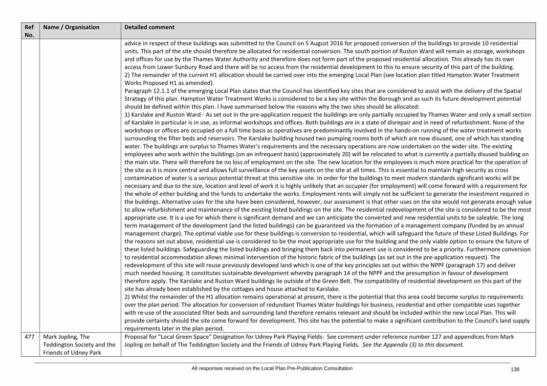
Ref No.
Name / Organisation Detailed comment
advice in respect of these buildings was submitted to the Council on 5 August 2016 for proposed conversion of the buildings to provide 10 residential units. This part of the site should therefore be allocated for residential conversion. The south portion of Ruston Ward will remain as storage, workshops and offices for use by the Thames Water Authority and therefore does not form part of the proposed residential allocation. This already has its own access from Lower Sunbury Road and there will be no access from the residential development to this to ensure security of this part of the building. 2) The remainder of the current H1 allocation should be carried over into the emerging Local Plan (see location plan titled Hampton Water Treatment Works Proposed H1 as amended). Paragraph 12.1.1 of the emerging Local Plan states that the Council has identified key sites that are considered to assist with the delivery of the Spatial Strategy of this plan. Hampton Water Treatment Works is considered to be a key site within the Borough and as such its future development potential should be defined within this plan. I have summarised below the reasons why the two sites should be allocated: 1) Karslake and Ruston Ward - As set out in the pre-application request the buildings are only partially occupied by Thames Water and only a small section of Karslake in particular is in use, as informal workshops and offices. Both buildings are in a state of disrepair and in need of refurbishment. None of the workshops or offices are occupied on a full time basis as operatives are predominantly involved in the hands-on running of the water treatment works surrounding the filter beds and reservoirs. The Karslake building housed two pumping rooms both of which are now disused, one of which has standing water. The buildings are surplus to Thames Water's requirements and the necessary operations are now undertaken on the wider site. The existing employees who work within the buildings (on an infrequent basis) (approximately 20) will be relocated to what is currently a partially disused building on the main site. There will therefore be no loss of employment on the site. The new location for the employees is much more practical for the operation of the site as it is more central and allows full surveillance of the key assets on the site at all times. This is essential to maintain high security as cross contamination of water is a serious potential threat at this sensitive site. In order for the buildings to meet modern standards significant works will be necessary and due to the size, location and level of work it is highly unlikely that an occupier (for employment) will come forward with a requirement for the whole of either building and the funds to undertake the works. Employment rents will simply not be sufficient to generate the investment required in the buildings. Alternative uses for the site have been considered, however, our assessment is that other uses on the site would not generate enough value to allow refurbishment and maintenance of the existing listed buildings on the site. The residential redevelopment of the site is considered to be the most appropriate use. It is a use for which there is significant demand and we can anticipate the converted and new residential units to be saleable. The long term management of the development (and the listed buildings) can be guaranteed via the formation of a management company (funded by an annual management charge). The optimal viable use for these buildings is conversion to residential, which will safeguard the future of these Listed Buildings. For the reasons set out above, residential use is considered to be the most appropriate use for the building and the only viable option to ensure the future of these listed buildings. Safeguarding the listed buildings and bringing them back into permanent use is considered to be a priority. Furthermore conversion to residential accommodation allows minimal intervention of the historic fabric of the buildings (as set out in the pre-application request). The redevelopment of this site will reuse previously developed land which is one of the key principles set out within the NPPF (paragraph 17) and deliver much needed housing. It constitutes sustainable development whereby paragraph 14 of the NPPF and the presumption in favour of development therefore apply. The Karslake and Ruston Ward buildings lie outside of the Green Belt. The compatibility of residential development on this part of the site has already been established by the cottages and house attached to Karslake. 2) Whilst the remainder of the H1 allocation remains operational at present, there is the potential that this area could become surplus to requirements over the plan period. The allocation for conversion of redundant Thames Water buildings for business, residential and other compatible uses together with re-use of the associated filter beds and surrounding land therefore remains relevant and should be included within the new Local Plan. This will provide certainty should the site come forward for development. This site has the potential to make a significant contribution to the Council's land supply requirements later in the plan period.
477 Mark Jopling, The Teddington Society and the Friends of Udney Park
Proposal for "Local Green Space" Designation for Udney Park Playing Fields: See comment under reference number 127 and appendices from Mark Jopling on behalf of The Teddington Society and the Friends of Udney Park Playing Fields. See the Appendix (3) to this document.
All responses received on the Local Plan Pre-Publication Consultation 138

Ref No.
Name / Organisation Detailed comment
Playing Fields 478 Savills on behalf of Thames
Water Omission Site: Thames Water consider that the following site which has been also put forward to the GLA Call for Sites and as identified on the enclosed plans, should be allocated for residential development: 1. Land to West of Stain Hill West Reservoir, Hampton Water Treatment Works, Upper Sunbury Road. Site area 3.58 hectares (refer to enclosed location plan). See the Appendix (7) to this document.
479 Savills on behalf of Thames Water
Omission Site: Thames Water consider that the following site which has been also put forward to the GLA Call for Sites and as identified on the enclosed plans, should be allocated for residential development: 2. Hydes Field, Land to North of Hampton Water Treatment Works, Upper Sunbury Road. Thames Water consider that the site at Hydes Field, as identified on the enclosed plan, should be allocated as a site for a Highly Sustainable Residential Development. Site area 21.18 hectares (refer to enclosed location plan). See the Appendix (7) to this document.
480 Laura Stritch, Transport for London
Twickenham Bus Station, Station Yard, Twickenham: The following comments represent the views of officers in Transport for London Commercial Development Property Team (TfL Property) in its capacity as a significant landowner only and does not form part of the TfL corporate response. This Representation should not be taken to represent an indication of any subsequent Mayoral decision in relation to the emerging policy document. Our colleagues in Borough Planning will provide a separate response regarding TfL wide operational and land use planning/transport policy matters. London Buses are the freeholder of Twickenham Bus Station, Station Yard, identified as proposal site TW2 in the Twickenham Area Action Plan for the provision of a residential scheme up to 3-4 storeys. Subject to the operational status of the bus standing facility, TfL Property would welcome a partnership with Network Rail (subject to agreement) and London Buses to bring forward a viable and comprehensive development at this site, and as such for it to remain an allocated proposal by the council and to form part of the Local Plan's Site Allocations. It is possible this development will retain some bus standing on part of the site, either alongside or under a development. Further details on capacity can be provided to the council upon request.
481 Peter Willan, Old Deer Park Working Group
Proposals Map - Definition of the boundaries of Metropolitan Open Land, Public Open Space and the Richmond Town Centre: Over the last three years, the Group has repeatedly urged the Council to resolve the significant anomalies relating to the definition of the boundaries of Metropolitan Open Land, Public Open Space and the Richmond Town Centre insofar as they relate to the Old Deer Park. Most regrettably, despite the Group's entirely sound and fully justified submissions on these important matters, the Council has declined to respond positively to the Group's proposals for resolving these significant anomalies. 2.7 In the absence of a new Proposals Map showing potential adjustments to the boundaries shown in the Proposals Map adopted by the Council in 2011 responding positively to the Group's repeated submissions, the Group once again urges the Council to address and resolve the existing anomalies and refers to the following documents in support of its case - copies of which are attached to this submission: The Old Deer Park, Richmond - Re-connecting the Town to its local park - Realising an under-recognised parkland asset - A framework for conservation and enhancement - A submission urging review of boundary definitions, February, 2013; A response by the Old Deer Park Working Group to consultation on the pre-publication version of The Richmond-upon-Thames Local Plan Site Allocations Plan, of November, 2013; and A response by the Old Deer Park Working Group to consultation on the pre-publication version of The Richmond-upon-Thames Local Plan Site Allocations Plan - New Additional Sites of July, 2014. See the Appendix (13) to this document.
482 Charles Pineles, Planning Spokesman, Richmond Society
Old Deer Park: The Society is aware of the work done by the Old Deer Park Working Group, in concert with local officers, has taken note of the Formal Response of August 2016 submitted by that Group and wishes to state that it thoroughly endorses the contents of the submission and requests that the council take the contents into careful consideration in forming its policy towards the future of the Park.
483 Tim Catchpole, Planning Representative Mortlake with East Sheen Society
New site to be added - SA 28 Mortlake Station: This site was in previous plans but for some reason has been omitted. Chapter 7 above mentions "improve Mortlake Station." The land on both sides of the station is used for the sale of timber. On the north side of the station the timber yard, which has no room to expand outwards, is instead expanding upwards and, whilst we have no objection to the timber yard per se - it provides an invaluable service - we are
All responses received on the Local Plan Pre-Publication Consultation 139
Ref No.
Name / Organisation Detailed comment
much concerned about its visual appearance and also about the generation of lorry traffic next to a crowded level crossing. There are issues here that need to be addressed.
Chapter13 – Implementation 484 Janet Nuttall, Natural
England Implementation: We welcome recognition that the implementation of the Council's own strategies and plans as well as those of key partner organisations will be essential to the delivery of the Strategic Vision. Natural England is pleased that Green Infrastructure provision will be included within the Infrastructure Delivery Plan. We support your authority's commitment to working in partnership with physical, social and green infrastructure providers to establish what infrastructure provision there is in the borough, and identifying any gaps or capacity issues within the existing provision, in order to support sustainable growth in the borough. We trust that a Green Infrastructure Strategy for the Borough will set out objectives and targets to address areas of deficit and mitigate the direct and indirect impacts of Local Plan development. This will help to quantify GI requirements and levels of developer contributions through Planning Obligations and/or Community Infrastructure Levy (CIL). Natural England welcomes the proposal to revise the monitoring framework to reflect the adoption of the new Local Plan policies, informed through the Sustainability Appraisal process.
485 Dale Greetham, Sport England
Implementation - 13.2 Infrastructure Delivery - Infrastructure Delivery Plan: 13.2.8: Unsound The first bullet point should be more specific about which sports facilities are included.
Appendices 486 Richard Geary Glossary: Area Plan: A plan drawn up for an area at massive expense, paid for by residents. Ignored at the behest of developers where there is a quick
buck to be made. Conservation Area: An area deemed fit for conserving in character, unless a developer requests these considerations to be ignored. Enforced against residents because the Council does not understand the meaning of democracy (or where their finances come from).
487 Sarah Stevens, Turleys for British Land
Glossary: It would be useful to include a definition of "social infrastructure" in the Glossary to reflect that of the London Plan's definition.
Table 3: Detailed comments on the policies and site allocations as received
All responses received on the Local Plan Pre-Publication Consultation 140
Ref No.
Name / Organisation
Detailed comment
488 Krystyna Kujawinska
Testing the Site Allocations of the Local Plan: SA 7 Strathmore Centre, Strathmore Road, Teddington Scamps, which is the child-care provider on this site, would like to comment on the description that this site is partly vacant and derelict. It is certainly the case that the Council has not put any effort into the upkeep of the site, but it is not accurate to describe it as derelict. It has regularly been used as a dumping ground by some, including the building company rebuilding Stanley School just opposite. The Strathmore Centre at the front of the site was unused and empty for several years. Scamps expanded into this building with its Over-8s after-school club, freeing up space in the original Scamps building at the back of the site thereby enabling us to meet the growing need for nursery places in the local community and out of school hours childcare. We are a not for profit organisation; the fees we charge just cover our costs to provides as affordable a service as possible. And we have in fact used our own funds to improve the look of the area, putting up fencing, laying large areas of Astroturf, and improving signage, and we have paid for private waste disposal to get rid of unsightly rubbish and discarded items dumped in the area that have nothing to do with us. We have also invested significant funds in the site to provide safe and attractive outdoor play areas for the children.
489 Janet Nuttall, Natural England
We note that no reference is made to a Habitats Regulations Assessment (HRA). The Local Plan should be screened under Regulation 102 of the Conservation of Habitats and Species Regulations 2010 (as amended) at an early stage so that outcomes of the assessment can inform key decision making on strategic options and development sites. It may be necessary to outline avoidance and/or mitigation measures at the plan level, including a clear direction for project level HRA work to ensure no adverse effect on the integrity of internationally designated sites. It may also be necessary for plans to provide policies for strategic or cross boundary approaches, particularly in areas where designated sites cover more than one Local Planning Authority boundary. Natural England would welcome early discussion on the HRA of the plan and can offer further advice as policy options are progressed. As discussed above, it will be particularly important to ensure the effects of longer-ranging impacts, such as through air and water mediated effects and recreational pressure, are fully considered for policies and allocations alone, and in-combination, and that sufficient mitigation is identified to address any adverse effects. We would expect the SA to specifically reference the nationally and internationally designated sites within the Borough, and their conservation objectives, available here. This information is important evidence to inform the detailed assessment of the effects of Plan policies and site allocations and to help identify any mitigation measures. We recommend reference to Natural England’s SSSI Impact Risk Zones to inform the Local Plan SA/HRA and planning application process. Notwithstanding the above, we welcome the efforts so far to provide a comprehensive assessment of the effects of the Richmond upon Thames Local Plan. Natural England is satisfied that the SA objectives, assessment methodology and framework generally accord with the requirements of the Planning and Compulsory Purchase Act 2004 and the Strategic Environmental Assessment Regulations. The objectives used to assess the impacts of the Plan are appropriate and address key issues within Natural England’s remit including biodiversity, landscape and soils in addition to air quality, water quality/resources and climate change. Impacts on geodiversity have not been considered; however, Natural England is not aware of any national or local sites of geological interest within the Borough. The objectives of the draft Local Plan have been tested against the Sustainability Appraisal objectives. Natural England generally supports the conclusion of the appraisal that the draft Local Plan, both its policies and its site allocations, are well designed to deliver sustainable development. The report identifies generally neutral or positive effects for biodiversity through draft policies. However, as mentioned above, it is not clear whether the SA has considered impacts such as public access pressure on existing green infrastructure including accessible designated sites such as Richmond Park SSSI, SAC, NNR and Bushy and Home Park SSSI. The notified and qualifying features of Richmond Park, for example, are under increasing pressure from the effects of public access. Consequently, proposals likely to add to this pressure, alone and in-combination with other allocations within Richmond and adjacent boroughs, must be carefully assessed and mitigation to identified to address impacts. SA2 is assessed as having negative impacts on biodiversity and green infrastructure as the site is entirely ‘Other Site of Nature Importance’ (OSNI). The SA states that any redevelopment scheme would need to take account of the biodiversity value, trees and designated open land, ensuring that these designations are not impacted upon. Policy SA2 should be amended accordingly to secure this requirement. This advice applies to other allocations where impacts on biodiversity have been identified through the SA including SA3, SA9, SA11, SA14, SA15, SA16 and SA27. As mentioned above, a strategic approach needs to be taken to green infrastructure to ensure relevant development contributes to objectives to mitigate any direct and indirect impacts on existing GI. As the SA emerges, predicted impacts on other aspects of the natural environment, including landscape, soils and public access should be addressed through mitigation secured in the relevant site allocation policies.
Table 4: Detailed responses to the Sustainability Appraisal
All responses received on the Local Plan Pre-Publication Consultation 141
Appendices: 1. Tim Sturgess, Bilfinger GVA on behalf of The Lady Eleanor Holles School 2. Judith Livesey, NLP Planning on behalf of St Paul's School 3. Mark Jopling, The Teddington Society and the Friends of Udney Park Playing Fields 4. Sarah Stevens, Turleys for British Land 5. Tanja El Sanadidy, Indigo on behalf of Shepherd Enterprises Limited 6. Alison Mackay, Colliers on behalf of Greggs Plc 7. Savills on behalf of Thames Water 8. Sam Hobson, Quantum Group 9. Charlotte Gibb, St Mary's University 10. James Sheppard, CBRE on behalf of LGC Ltd 11. Robert Leadbetter, Hon. Director Hampton and Kempton Waterworks Railway, including further comments from Bryan Woodriff 12. Katharine Fletcher, Historic England – archaeological information 13. Peter Willan, Old Deer Park Working Group 14. Caroline Wilberforce, Indigo Planning on behalf of on behalf of Sharpe Refinery Service 15. Robert Deanwood, Amec Foster Wheeler on behalf of National Grid 16. Marie Claire Marsh, NLP Planning on behalf of RFU 17. Tom Sadler, Bilfinger GVA on behalf of Defence Infrastructure Organisation
All responses received on the Local Plan Pre-Publication Consultation 142