n€¦ · web viewbuilt of red/brown bricks, ... dwarf wall with railings to the front of the...
TRANSCRIPT

Local List of Historic Assets of Special InterestAn extension of the Historic Environment Record (HER) for North East Lincolnshire
Draft Edition for the Wolds
Draft October 2015


Draft – Not AdoptedContents
INTRODUCTION............................................................................................................................................................................2
A NOTE ON SOURCES..................................................................................................................................................................2
CRITERIA FOR LISTING................................................................................................................................................................3
BASIC REQUIREMENTS FOR ASSETS............................................................................................................................................3
BEELSBY......................................................................................................................................................................................4
EAST RAVENDALE.....................................................................................................................................................................12
HATCLIFFE.................................................................................................................................................................................18
HAWERBY CUM BEESBY............................................................................................................................................................29
IRBY UPON HUMBER..................................................................................................................................................................36
WEST RAVENDALE....................................................................................................................................................................58
WOLD NEWTON.........................................................................................................................................................................64
Draft – Not AdoptedLocal List of Historic Assets of Special Interest
1

Draft – Not Adopted
Introduction
This Local List of Historic Assets of Special Interest has been compiled in order to act as a
planning tool. The entries within the list are the historic assets taken from the North East
Lincolnshire Historic Environment Record, or HER, which require the greatest attention from
developers and planning officers, among others, during the development process and
regeneration schemes.
Heritage assets are usually included in the list because they are the best of their kind in the
authority; however some assets are included because of the contribution that they make to the
character of the local area.
By their very nature, buildings will make up the bulk of the list as they are the most visible of the
historic assets and contribute greatly to the character of an area. Conversely, archaeological
sites will be greatly under-represented on the list due to the difficulty in establishing the nature
and extent of any individual assets without first excavating, particularly within the urban
environment. Designed Landscapes, pieces of art and other assets are low in overall number
and so will make up a minor part of the list; they are also the least likely to be affected by
development.
A Note on Sources
The majority of the text in this document has been produced from scratch by staff in the Historic
Environment Record. Where text has come from a single external source, every effort has been
made to show that source in the text; however, the information on some assets, particularly
archaeological sites, has been compiled from numerous sources and it would not be
appropriate to list them all in a document such as this. In these cases, the reader is directed to
the appropriate Historic Environment Record entries for further information and a list of the
sources used to compile the information.
Draft – Not AdoptedLocal List of Historic Assets of Special Interest
2

Draft – Not Adopted
Criteria for Listing
General:
1a – The asset is rare or unique, in terms of the Borough, due to the period it represents, extent, architectural style or technological method of construction.1b – The asset has the potential to contribute to our information on, understanding of, and appreciation of the Borough’s history and development.1c – The asset makes a significant contribution to the historic character of an area and conforms to a Thematic criteria.1d – The asset is part of a group of similar examples which, together, make a significant contribution to the character of an area or have the potential to provide high quality and/or quantity of historic environment data.
Thematic:
2a – Assets which exemplify a previous character type in a settlement or area which retain sufficient structure to inform on the previous character.2b – Assets which are/were essential infrastructure associated with the Docks and Railways that retain a good proportion of their original extent.2c – Assets which form an integral part of the character of the Resort of Cleethorpes.2d – Assets which exemplify the rapid expansion, wealth or the major industrial and commercial activities of Grimsby in the 19th and early 20th centuries.2e – Assets which exemplify the early development of Immingham and Cleethorpes from Villages and/or Hamlets into Towns.2f – Post 1850s Urban Housing that retains the majority of its original structure, components and is of a high standard of design.2g – Ecclesiastical, Manorial, Educational, Social and Agricultural assets representing the historic functions and practices of the towns and villages.
Basic Requirements for Assets
Buildings must retain the majority of their original fabric, external design style and character.
Archaeological Sites must be definable in extent and origin and be likely to retain well preserved deposits.
Designed Landscapes must be identifiable through aerial photography and at ground level. They must also be significant features in the wider landscape.
Ship Wrecks and Historic Ships must relate to the main industries of the Borough or form a group or loose association of assets.
Memorials must commemorate events of national or significant local significance and be of architectural or artistic interest.
Complex Assets are not a category in their own right, but rather contain two or more assets of the above categories that should be considered interdependent on each other.
Draft – Not AdoptedLocal List of Historic Assets of Special Interest
3

Draft – Not Adopted
Beelsby
Beelsby is a small settlement clustered to the south of the church, St Helen’s, mostly to the
north west of a sub-rectangular road system of probable medieval origin. Beelsby is known to
have existed since at least the early medieval period (410AD to 1066AD).
Beelsby is recorded as having a population of 176 in the 1851 census according to White's
directory of 1856. In the 2001 census the population is recorded as 116.
At the time of writing – 2nd October 2015 – Beelsby has:
58 Historic Environment Records of which:
1 is a nationally Listed Building
1 is a nationally Scheduled Monument
6 are proposed Locally Listed Historic Assets
Draft – Not AdoptedLocal List of Historic Assets of Special Interest
4
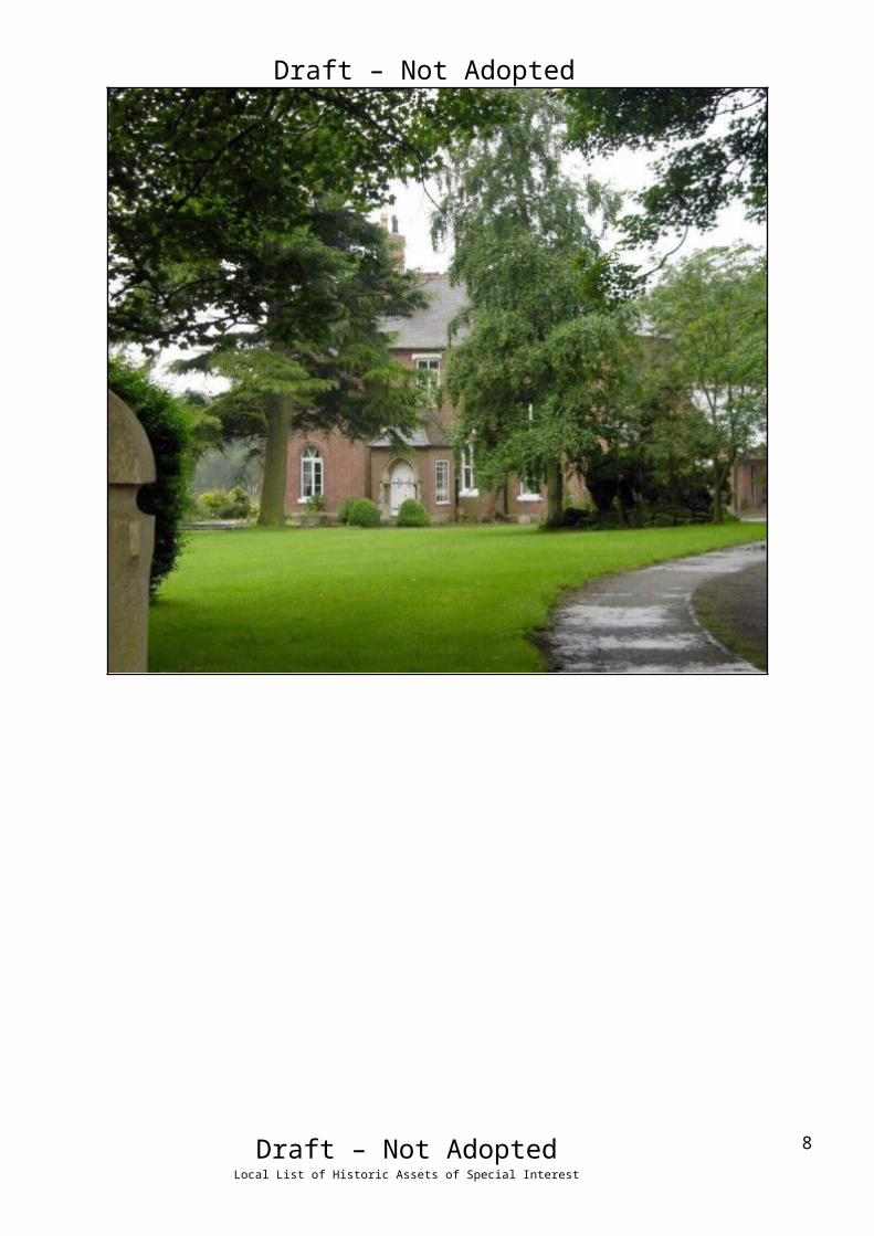
Draft – Not AdoptedName: Greenwood House, BeelsbyDate Designated: N/A – New ProposalGrid Reference: TA 2055 0184Area Designation: NoneAsset Type: Complex (Building, Designed Landscape, Archaeological Site)Main Criteria Used: 1c, 2gDescription:
A rectory built by T C Hine of Nottingham in 1868. Big and spreading, in red brick with a staircase in stone balustrade.
Pevsner N and J Harris. 1989. The Buildings of England Lincolnshire. 2nd Edition. Yale University Press. New Haven and London.
The house is surrounded by a small area of parkland containing faint medieval village earthworks which are also included in the listing. The site shows the development of formal landscapes around the houses of wealthy people in the 19th century, and the fossilisation of the earlier landscape of the deserted medieval village. As a vicarage the house also represents an important part of the ecclesiastical functions of the village.
Draft – Not AdoptedLocal List of Historic Assets of Special Interest
5
Draft – Not AdoptedName: 1 to 4, 6 to 13, 17 to 18, Owls Hoot, Well Garth and The Old Smithy, Main RoadDate Designated: N/A – New ProposalGrid Reference: TA 2075 0194Area Designation: NoneAsset Type: BuildingMain Criteria Used: 1d, 2gDescription:
A group of 17 estate cottages of various ages and designs forming a coherent group along the main street of Beelsby. Although all have modifications of some sort the group value and lack of too many unsympathetic alterations mean that they are of special local interest.
Groups of estate cottages such as this are important parts of landscapes like the Lincolnshire Wolds as they indicate areas where the influence of country estates was particularly strong. This group survives well with no outright loses and only one which has been too heavily altered to form part of the listing (Rosedene, 5 Main Road).
1 and 2 Main Road (left) 3 and 4 Main Road (right)
6 and 7 Main Road (left) 8 and 9 Main Road (right)
Draft – Not AdoptedLocal List of Historic Assets of Special Interest
6

Draft – Not Adopted
10 and 11 Main Road (left) 12 and 13 Main Road (right)
Owl’s Hoot and Well Garth, Main Road (left) 17 and 18 Main Road (right)
The Old Smithy, Main Road
Draft – Not AdoptedLocal List of Historic Assets of Special Interest
7

Draft – Not AdoptedName: Cast Iron Phone Box, Main RoadDate Designated: N/A – New ProposalGrid Reference: TA 2083 0205Area Designation: NoneAsset Type: BuildingMain Criteria Used: 1c, 2gDescription:
K6, or similar model, telephone kiosk. Cast iron. Square kiosk with domed roof. Un-perforated crowns to top panels and margin glazing to windows and door
Although once widespread, cast-iron phone boxes have become synonymous with historic and rural areas and are therefore important to the character of the villages.
Draft – Not AdoptedLocal List of Historic Assets of Special Interest
8
Draft – Not AdoptedName: Signpost, Junction of Swallow Road and Main Road, BeelsbyDate Designated: N/A – New ProposalGrid Reference: TA 2067 0184Area Designation: NoneAsset Type: BuildingMain Criteria Used: 1c, 2gDescription:
A historic road side sign post with a black and white striped post and two planks set into recesses forming three arms. The signs point to Croxby and MKT [Market] Rasen to the south, Swallow and Caistor to the north west, Caistor and Grimsby to the north east. The distances to each village are not shown.
Although once widespread, this style of sign post is now only found in the rural areas of North East Lincolnshire and form part of the less developed rural character.
Draft – Not AdoptedLocal List of Historic Assets of Special Interest
9

Draft – Not AdoptedName: Signpost, Junction of Croxby Road, Hatcliffe Road and Main Road, BeelsbyDate Designated: N/A – New ProposalGrid Reference: TA 2063 0164Area Designation: NoneAsset Type: BuildingMain Criteria Used: 1c, 2gDescription:
A historic road side sign post with a black and white striped post and two planks set into recesses forming three arms. The signs point to Croxby and MKT [Market] Rasen to the south, Swallow and Caistor to the north west, Caistor and Grimsby to the north east. The distances to each village are not shown
Although once widespread, this style of sign post is now only found in the rural areas of North East Lincolnshire and form part of the less developed rural character.
Draft – Not AdoptedLocal List of Historic Assets of Special Interest
10

Draft – Not AdoptedName: Bronze Age Barrow Cemetery 180m north east of The Thatches, BeelsbyDate Designated: N/A – New ProposalGrid Reference: TA 2003 0062Area Designation: Lincolnshire Wolds AONBAsset Type: Archaeological SiteMain Criteria Used: 1bDescription:
A shallow (c.20cm) earthwork of a probable Bronze Age Round Barrow and at least three further possible barrows indicated by cropmark ring-ditches. The earthwork is known to have been 100ft across and 3ft 6in high before being levelled.
Despite the levelling of the barrow(s) important paleoenvironmental deposits relating to the Bronze Age landscape and environment of Beelsby are likely to be preserved in the surrounding ring-ditches.
See HER Number - 0098/1/0 - for further information and sources
Photograph of the remains of the barrow highlighting the slight earthwork
Draft – Not AdoptedLocal List of Historic Assets of Special Interest
11

Draft – Not Adopted
East Ravendale
East Ravendale is a sparsely settled village with a degree of nucleation around the parish
church of St Martin. At the time of Domesday (1086AD) and the Lindsey Survey (c.1115AD)
Ravendale is referred to as a single entity; however the original parish had been split into East
and West Ravendale by the time of the Episcopal Registers (1219AD).
East Ravendale is recorded as having a population of 76 in the 1851 census according to
White's directory of 1856. In the 2001 census the population is recorded as 125.
At the time of writing – 2nd October 2015 – East Ravendale has:
51 Historic Environment Records of which:
4 are nationally Listed Buildings
None are nationally Scheduled Monuments
5 are proposed Locally Listed Historic Assets
Draft – Not AdoptedLocal List of Historic Assets of Special Interest
12

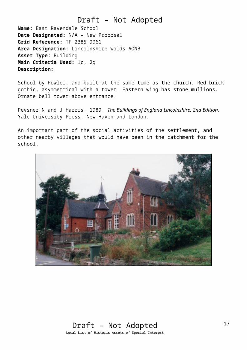
Draft – Not AdoptedName: East Ravendale SchoolDate Designated: N/A – New ProposalGrid Reference: TF 2385 9961Area Designation: Lincolnshire Wolds AONBAsset Type: BuildingMain Criteria Used: 1c, 2gDescription:
School by Fowler, and built at the same time as the church. Red brick gothic, asymmetrical with a tower. Eastern wing has stone mullions. Ornate bell tower above entrance.
Pevsner N and J Harris. 1989. The Buildings of England Lincolnshire. 2nd Edition. Yale University Press. New Haven and London.
An important part of the social activities of the settlement, and other nearby villages that would have been in the catchment for the school.
Draft – Not AdoptedLocal List of Historic Assets of Special Interest
13

Draft – Not AdoptedName: The Old RectoryDate Designated: N/A – New ProposalGrid Reference: TF 2384 9966Area Designation: Lincolnshire Wolds AONBAsset Type: BuildingMain Criteria Used: 1c, 2gDescription:
A vicarage of 1858. Three bays with a central projecting bay topped by a gablet with decorated barge board. End stacks and roof dormers.
A prominent building which represents an important part of the ecclesiastical functions of the village.
Draft – Not AdoptedLocal List of Historic Assets of Special Interest
14

Draft – Not AdoptedName: CrosswaysDate Designated: N/A – New ProposalGrid Reference: TF 2372 9970Area Designation: Lincolnshire Wolds AONBAsset Type: BuildingMain Criteria Used: 1c, 2gDescription:
A large estate style cottage. Two storeys, red brick with slate roof and central stack. Fine detailing with decorated bargeboards, gablets to the front elevation and decorative stack. Sensitively extended, giving a secondary frontage to the road to West Ravendale.
Although altered the good quality of design and prominent position on a crossroads mean that this cottage is of a high level of importance to the character and appearance of the village.
Draft – Not AdoptedLocal List of Historic Assets of Special Interest
15

Draft – Not AdoptedName: Signpost, East Ravendale CrossroadsDate Designated: N/A – New ProposalGrid Reference: TF 2374 9968Area Designation: NoneAsset Type: BuildingMain Criteria Used: 1c, 2gDescription:
A historic road side sign post with a black and white striped post and two planks set into recesses forming four arms. The signs point to Hatcliffe to the west, Waltham to the north, East Ravendale to the east, Binbrook to the south. The distances to each village are not shown.
Although once widespread, this style of sign post is now only found in the rural areas of North East Lincolnshire and form part of the less developed rural character.
Draft – Not AdoptedLocal List of Historic Assets of Special Interest
16
Draft – Not AdoptedName: Signpost, Junction of Wold Newton Road and an un-named road, East RavendaleDate Designated: N/A – New ProposalGrid Reference: TF 2359 9928Area Designation: NoneAsset Type: BuildingMain Criteria Used: 1c, 2gDescription:
A historic road side sign post with a black and white striped post and two planks set into recesses forming three arms. The signs point to Wold Newton and Kelstern to the south, Thorganby and Binbrook to the west, Brigsley and Hatcliffe to the north. The arms also display distances to the annotated villages/towns: Brigsley 2, Hatcliffe 2, Wold Newton 2, Kelstern 6, Thorganby 2, Binbrook 4.
Although once widespread, this style of sign post is now only found in the rural areas of North East Lincolnshire and form part of the less developed rural character.
Draft – Not AdoptedLocal List of Historic Assets of Special Interest
17
Draft – Not Adopted
Hatcliffe
Hatcliffe is a small nucleated village, known to have existed since the early medieval period
(410AD to 1066AD), which is concentrated along the main road around the church of St Mary.
The village also spills across its northern border into the parish of Beelsby.
The parish also contains the hamlet of Gunnerby, to the south of Hatcliffe, which is also known
to have existed since the early medieval period (410AD to 1066AD)
Hatcliffe is recorded as having a population of 147 in the 1851 census according to White's
directory of 1856. In the 2001 census the population is recorded as 116.
At the time of writing – 2nd October 2015 – Hatcliffe has:
65 Historic Environment Records of which:
4 are nationally Listed Buildings
1 is a nationally Scheduled Monument
9 are proposed Locally Listed Historic Assets
Draft – Not AdoptedLocal List of Historic Assets of Special Interest
18

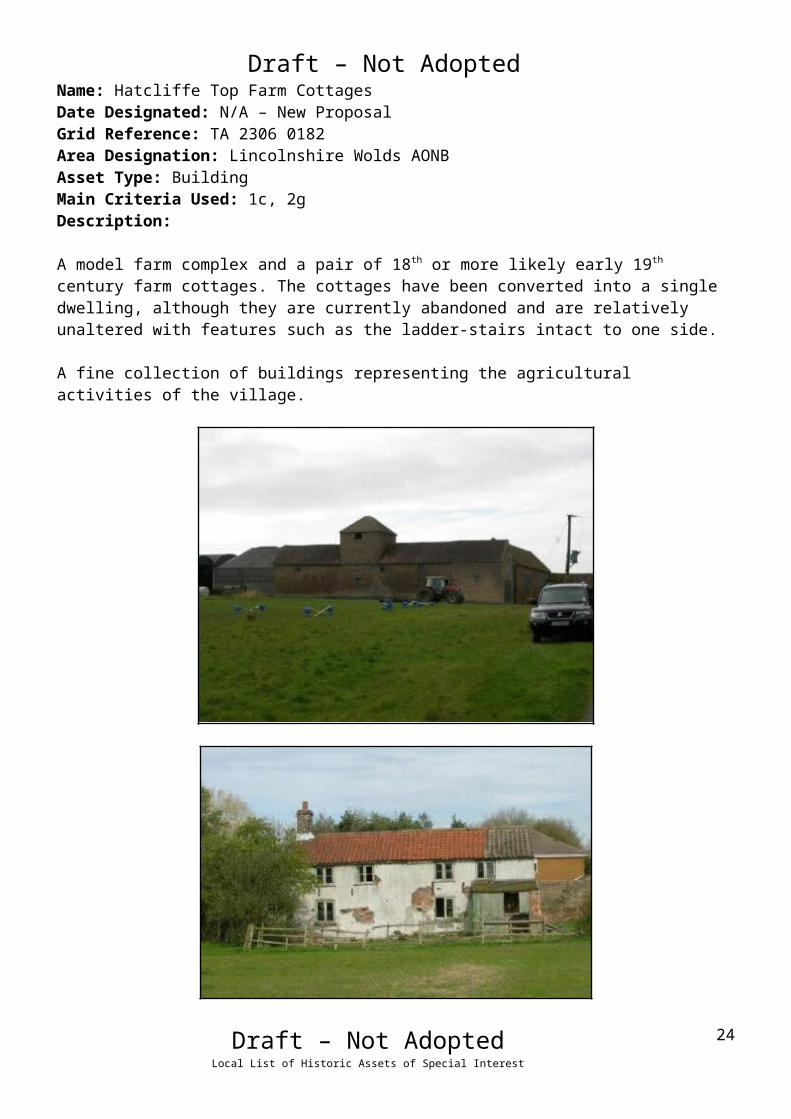
Draft – Not AdoptedName: Hatcliffe Top Farm CottagesDate Designated: N/A – New ProposalGrid Reference: TA 2306 0182Area Designation: Lincolnshire Wolds AONBAsset Type: BuildingMain Criteria Used: 1c, 2gDescription:
A model farm complex and a pair of 18th or more likely early 19th century farm cottages. The cottages have been converted into a single dwelling, although they are currently abandoned and are relatively unaltered with features such as the ladder-stairs intact to one side.
A fine collection of buildings representing the agricultural activities of the village.
Draft – Not AdoptedLocal List of Historic Assets of Special Interest
19

Draft – Not AdoptedName: Ings Cottages, HatcliffeDate Designated: N/A – New ProposalGrid Reference: TA 2140 0081Area Designation: Lincolnshire Wolds AONBAsset Type: BuildingMain Criteria Used: 1c, 2gDescription:
Probable early 19th century estate, or farm workers, cottage. Brown brick with interlocking pantile roof, ground floor left window widened historically but other apertures intact with modern windows.Paint mark around the door indicates the former position of a 20th century wooden porch.
A fine village cottage with few alterations, representative of the agricultural activities of the settlement.
Draft – Not AdoptedLocal List of Historic Assets of Special Interest
20

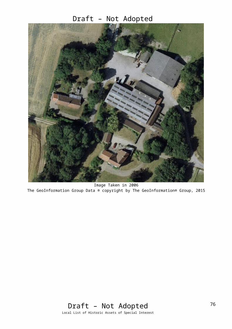
Draft – Not AdoptedName: Old Farm House, HatcliffeDate Designated: N/A – New ProposalGrid Reference: TA 22389 01382Area Designation: NoneAsset Type: BuildingMain Criteria Used: 1c, 2gDescription:
An 18th century house, two storeys, four bays, originally L-shaped on plan but now with an extension to form a square footprint. Formerly a Grade III (three) listed building. Recorded in 1824 as "manor house."All of the buildings shown on Ordnance Survey maps of 1887-9 are present.
Image Taken in 2006The GeoInformation Group Data ® copyright by The GeoInformation® Group, 2015
Draft – Not AdoptedLocal List of Historic Assets of Special Interest
21

Draft – Not AdoptedName: Hatcliffe House/Hatcliffe ManorDate Designated: N/A – New ProposalGrid Reference: TA 21413 00028Area Designation: NoneAsset Type: BuildingMain Criteria Used: 1c, 2gDescription:
A farmstead, probably 19th century, which appears to consist of a large farmhouse and a complex lose 8-plan range of farm buildings around two courtyards. All but one of the buildings shown on Ordnance Survey maps of 1887-9 are present.
This site has been surveyed from aerial photographs and maps only. It is assumed from this evidence that it is of at least local interest. The barns were photographed prior to conversion to residential but have not been re-visited.
Image Taken in 2006The GeoInformation Group Data ® copyright by The GeoInformation® Group, 2015
Draft – Not AdoptedLocal List of Historic Assets of Special Interest
22
Draft – Not AdoptedName: Signpost, Junction of Low Road and Main Road, HatcliffeDate Designated: N/A – New ProposalGrid Reference: TA 2149 0046Area Designation: NoneAsset Type: BuildingMain Criteria Used: 1c, 2gDescription:
A historic road side sign post with a black and white striped post and two planks set into recesses forming three arms. The signs point to Hatcliffe and Beelsby to the north, Thorganby and Swinhope to the south, Barnoldby le Beck to the east. The distances to each village are not shown.
Although once widespread, this style of sign post is now only found in the rural areas of North East Lincolnshire and form part of the less developed rural character.
Draft – Not AdoptedLocal List of Historic Assets of Special Interest
23

Draft – Not AdoptedName: Cropmark enclosures and boundaries 120m west of Gunnerby House, HatcliffeDate Designated: N/A – New ProposalGrid Reference: TF 2132 9874Area Designation: Lincolnshire Wolds AONBAsset Type: Archaeological SiteMain Criteria Used: 1b, 2aDescription:
A possible Prehistoric or Roman settlement was seen as earthworks and mapped from good quality air photographs. The main feature of the settlement is an asymmetric, rectilinear, ditched enclosure, measuring 90m by 70m, centred at TF 2142 9875. An enclosure, measuring 20m by 20m, is formed in the corner of this enclosure. The sides of the main enclosure extend to subdivide the area around into parcels of land measuring on average 70m by 50m. Adjacent are fragments of ditches, centred at TF 2125 9872, which are probably parts of a system of enclosure associated with the settlement (National Monuments Record: TF 29 NW 33)
Plot of the Cropmark, as mapped by the RCHMEReproduced from an Ordnance Survey map with the permission of the Controller of HMSO © Crown Copyright.
Licence number 100020759 North East Lincolnshire Council
Draft – Not AdoptedLocal List of Historic Assets of Special Interest
24
Draft – Not AdoptedName: Cropmark ring ditches 200m east of Hatcliffe ManorDate Designated: N/A – New ProposalGrid Reference: TA 2160 0003Area Designation: Lincolnshire Wolds AONBAsset Type: Archaeological SiteMain Criteria Used: 1b, 2aDescription:
A pair of ring ditches seen on aerial photographs less than 500m from the scheduled round barrow to the west of Hatcliffe Manor. Listed due to their potential association with the scheduled site and therefore the high potential that they represent the site of further barrows.
Image Taken in 2006The GeoInformation Group Data ® copyright by The GeoInformation® Group, 2015
Draft – Not AdoptedLocal List of Historic Assets of Special Interest
25

Draft – Not AdoptedName: Earthworks of enclosures, ponds, leats and trackways west of The Old Farm Date Designated: N/A – New ProposalGrid Reference: TA 2220 0131Area Designation: Lincolnshire Wolds AONBAsset Type: Archaeological SiteMain Criteria Used: 1b, 2gDescription:
A large area of archaeological earthworks relating to the medieval and post medieval settlement of Hatcliffe.Three possible Medieval or Post Medieval ponds, two sides of a potential Medieval or Post Medieval enclosure defined by ditches and several possible Medieval or Post Medieval trackways seen as earthworks on air photographs. Also the Mill Race for Hatcliffe Mill is extant in long sections within this site.
As a landscape feature the earthworks represent long extinct activities within the village, probably water management with possible fish farming.
See HER Number - 0440/4/0 - for further information and sources
© Humber Archaeological Partnership 1991
Draft – Not AdoptedLocal List of Historic Assets of Special Interest
26

Draft – Not AdoptedName: Hatcliffe Medieval shrunken village earthworks.Date Designated: N/A – New ProposalGrid Reference: TA 2137 0042Area Designation: Lincolnshire Wolds AONBAsset Type: Archaeological SiteMain Criteria Used: 1b, 2gDescription:
An area of shrunken medieval village including a possible mill site and leat shown on aerial photographs. Shown by cropmarks and earthworks.
As a landscape feature the earthworks represent the shrinking and re-organisation of the village following the medieval period, and will contain archaeological deposits which have the potential to inform the understanding of the development of the village.
See HER Number - 0440/0/0 - for further information and sources
© Humber Archaeological Partnership 1991
Draft – Not AdoptedLocal List of Historic Assets of Special Interest
27

Draft – Not Adopted
Hawerby cum Beesby
Hawerby cum Beesby is in reality a pair of parishes which were merged together in 1450AD
due to population loss. Both of the villages are known to have existed since the early medieval
period (410AD to 1066AD) and both are now virtually depopulated.
Hawerby cum Beesby is recorded as having a population of 85 in the 1851 census according to
White's directory of 1856. In the 2001 census the population is recorded as 24.
At the time of writing – 2nd October 2015 – Hawerby cum Beesby has:
38 Historic Environment Records of which:
2 are nationally Listed Buildings
1 is a nationally Scheduled Monument
4 are proposed Locally Listed Historic Assets
Draft – Not AdoptedLocal List of Historic Assets of Special Interest
28

Draft – Not AdoptedName: Hawerby Hall Farm including CottagesDate Designated: N/A – New ProposalGrid Reference: TF 25667 9812Area Designation: Lincolnshire Wolds AONBAsset Type: BuildingMain Criteria Used: 1c, 2gDescription:
A complex farmstead associated with Hawerby Hall (NHLE 1103494). The site appears to have consisted of two semi-detached cottages and one detached cottage, a slightly irregular E-shaped range of barns, a small detached cart shed and a large round pond. One of the semi-detached cottages, the detached cottage, the pond, ¾ of the range of farm buildings and the detached cart shed survive.
Photo taken from Rightmove, need one of our own.
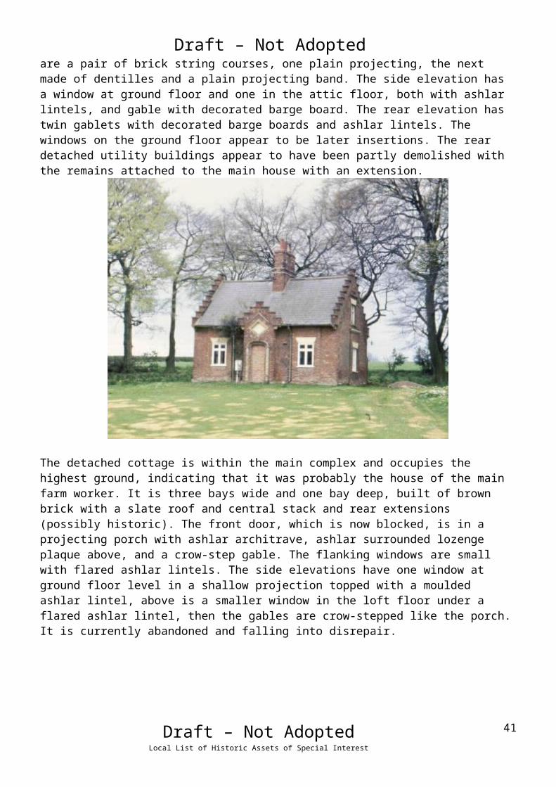
The remaining semi-detached cottage is slightly detached from the main complex, and has been knocked-through into a single property. It is built of brown brick with a slate roof and central stack made of a pair of octagonal pillars topped with square pots. The original frontage, facing roughly north-east, is three bays wide with a central entrance and a shadow of a former porch in the brickwork. The flanking windows are tall and narrow with slim chamfered ashlar lintels. Above are a pair of brick string courses, one plain projecting, the next made of dentilles and a plain projecting band. The side elevation has a window at ground floor and one in the attic floor, both with ashlar lintels, and gable with decorated barge board. The rear elevation has twin gablets with decorated barge boards and ashlar lintels. The windows on the ground floor appear to be later insertions. The rear detached utility buildings appear to have been partly demolished with the remains attached to the main house with an extension.
Draft – Not AdoptedLocal List of Historic Assets of Special Interest
29

Draft – Not Adopted
The detached cottage is within the main complex and occupies the highest ground, indicating that it was probably the house of the main farm worker. It is three bays wide and one bay deep, built of brown brick with a slate roof and central stack and rear extensions (possibly historic). The front door, which is now blocked, is in a projecting porch with ashlar architrave, ashlar surrounded lozenge plaque above, and a crow-step gable. The flanking windows are small with flared ashlar lintels. The side elevations have one window at ground floor level in a shallow projection topped with a moulded ashlar lintel, above is a smaller window in the loft floor under a flared ashlar lintel, then the gables are crow-stepped like the porch. It is currently abandoned and falling into disrepair.
Draft – Not AdoptedLocal List of Historic Assets of Special Interest
30

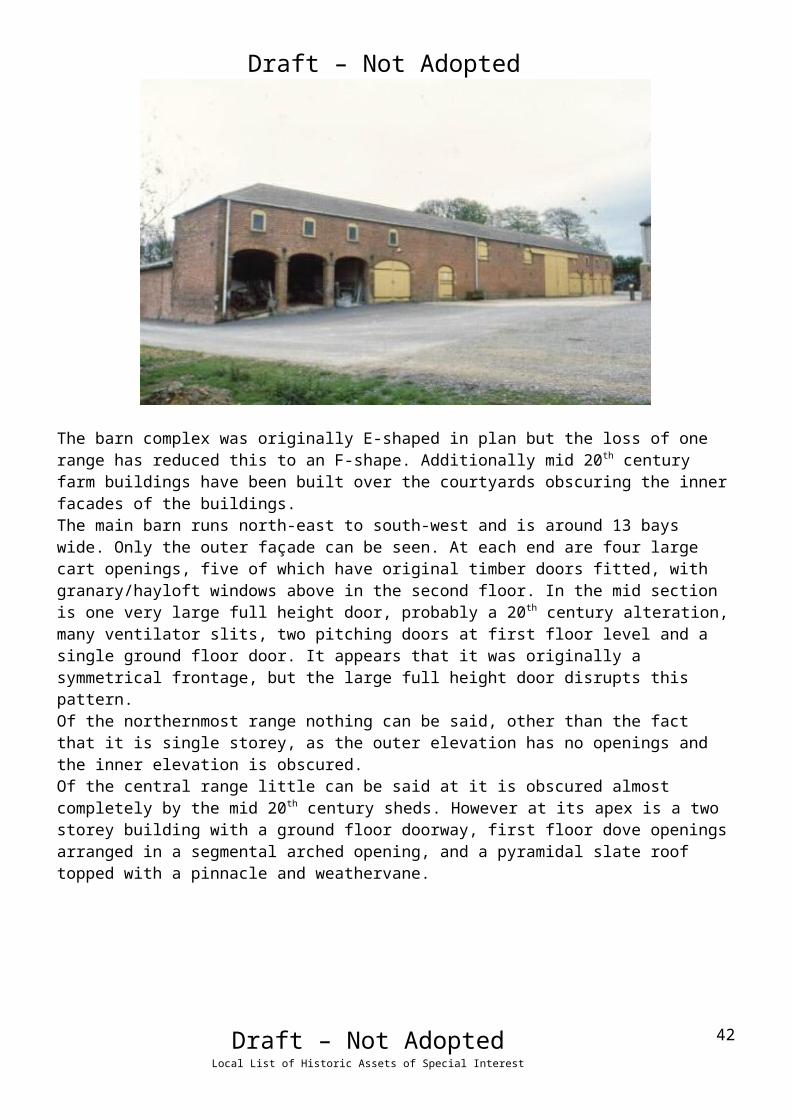
Draft – Not AdoptedThe barn complex was originally E-shaped in plan but the loss of one range has reduced this to an F-shape. Additionally mid 20th century farm buildings have been built over the courtyards obscuring the inner facades of the buildings. The main barn runs north-east to south-west and is around 13 bays wide. Only the outer façade can be seen. At each end are four large cart openings, five of which have original timber doors fitted, with granary/hayloft windows above in the second floor. In the mid section is one very large full height door, probably a 20th century alteration, many ventilator slits, two pitching doors at first floor level and a single ground floor door. It appears that it was originally a symmetrical frontage, but the large full height door disrupts this pattern. Of the northernmost range nothing can be said, other than the fact that it is single storey, as the outer elevation has no openings and the inner elevation is obscured.Of the central range little can be said at it is obscured almost completely by the mid 20 th century sheds. However at its apex is a two storey building with a ground floor doorway, first floor dove openings arranged in a segmental arched opening, and a pyramidal slate roof topped with a pinnacle and weathervane.
The detached cart shed is a simple brick building with piers to the open front and a corrugated iron roof. The pond is lined with stone and/or concrete and surrounded by iron railings.
Hawerby Hall Farm is the most architecturally elaborate of North East Lincolnshire’s farms, as would be expected given the association with Hawerby Hall which was, for a significant period of time, the only noble seat in the borough.
Draft – Not AdoptedLocal List of Historic Assets of Special Interest
31

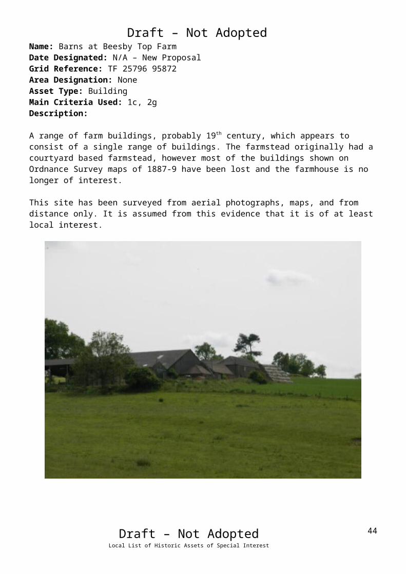
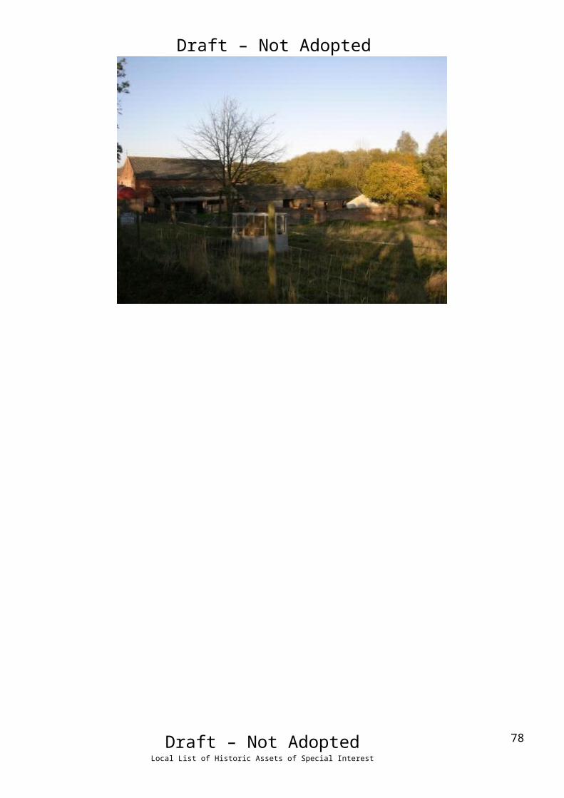
Draft – Not AdoptedName: Barns at Beesby Top FarmDate Designated: N/A – New ProposalGrid Reference: TF 25796 95872Area Designation: NoneAsset Type: BuildingMain Criteria Used: 1c, 2gDescription:
A range of farm buildings, probably 19th century, which appears to consist of a single range of buildings. The farmstead originally had a courtyard based farmstead, however most of the buildings shown on Ordnance Survey maps of 1887-9 have been lost and the farmhouse is no longer of interest.
This site has been surveyed from aerial photographs, maps, and from distance only. It is assumed from this evidence that it is of at least local interest.
Draft – Not AdoptedLocal List of Historic Assets of Special Interest
32

Draft – Not AdoptedName: Cropmark and shallow earthwork of a Bronze Age Round Barrow 550m south west of Hawerby Hall FarmDate Designated: N/A – New ProposalGrid Reference: TF 2534 9765Area Designation: Lincolnshire Wolds AONBAsset Type: Archaeological SiteMain Criteria Used: 1b, 2aDescription:
A round barrow, formerly 53 feet in diameter and up to 5 foot high, with two obvious signs of disturbance. It is now much reduced by ploughing. A number of related finds have been found, including a barb and tanged flint arrowhead.
Loughlin N and K R Miller. 1979. A Survey of Archaeological Sites in Humberside. Humberside Libraries and Amenities. Hull.
Located within Beacon Field and probably connected to the Horby Beacon of 1703.
The origin of the name of the parish of Hawerby, ("Hawarth's Farm/Village") has been linked to that of the Wapentake of Haverstoe ("Hawarth's Mound"), and further this mound/barrow has been suggested to be the meeting place for the Wapentake.
Kenneth Cameron, 1995, The Place Names of Lincolnshire. Part 4, Ludborough and Haverstoe Wapentakes.
The barrow as depicted on Ordnance Survey maps of 1887-9
Draft – Not AdoptedLocal List of Historic Assets of Special Interest
33

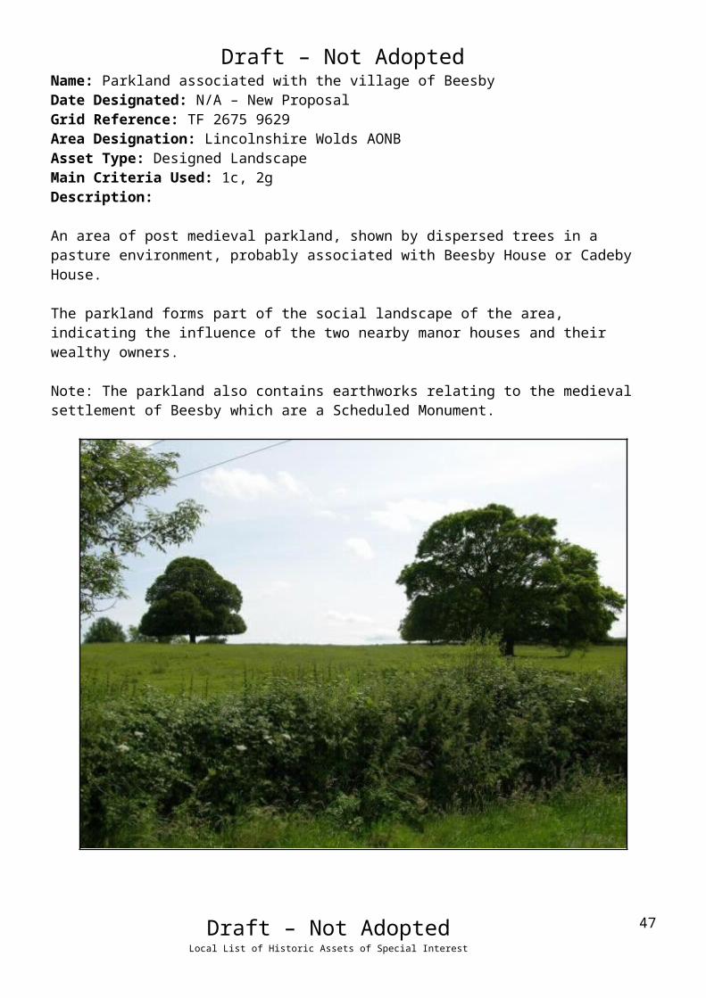
Draft – Not AdoptedName: Parkland associated with the village of BeesbyDate Designated: N/A – New ProposalGrid Reference: TF 2675 9629Area Designation: Lincolnshire Wolds AONBAsset Type: Designed LandscapeMain Criteria Used: 1c, 2gDescription:
An area of post medieval parkland, shown by dispersed trees in a pasture environment, probably associated with Beesby House or Cadeby House.
The parkland forms part of the social landscape of the area, indicating the influence of the two nearby manor houses and their wealthy owners.
Note: The parkland also contains earthworks relating to the medieval settlement of Beesby which are a Scheduled Monument.
Draft – Not AdoptedLocal List of Historic Assets of Special Interest
34

Draft – Not Adopted
Irby upon Humber
Irby upon Humber is a historic settlement known to have existed since the early medieval
period (410AD to 1066AD). The character of the village is predominantly that of a shrunken
village with the historic houses scattered along several different roads but reflecting a formerly
nucleated settlement.
Irby on Humber is recorded as having a population of 253 in the 1851 census according to
White's directory of 1856. In the 2001 census the population is recorded as 124.
At the time of writing – 2nd October 2014 – Irby upon Humber has:
73 Historic Environment Records of which:
4 are nationally Listed Buildings
1 is a nationally Scheduled Monument
12 are proposed Locally Listed Historic Assets
Note – Irby upon Humber currently has 17 Locally Listed Buildings, these having been added
as part of the 2009 Conservation Area work. It is proposed that 9 of these are removed from the
list in order to concentrate resources on those assets which are the most
architecturally/historically intact.
Draft – Not AdoptedLocal List of Historic Assets of Special Interest
35
Draft – Not AdoptedName: Manor Farmhouse, Church LaneDate Designated: 14/12/2009Grid Reference: TA 1976 0493Area Designation: Irby upon Humber Conservation Area, Lincolnshire Wolds AONBAsset Type: BuildingMain Criteria Used: 1c, 2gDescription:
Early 20th Century two storey manor house in light brown or buff brick with ashlar dressing and slate roof, set in landscaped grounds.
The adjacent model farm complex appears to retain most of the early buildings, judging purely from mapping, but cannot be seen from the highway.
An important part of the social and manorial structure of the village.
Draft – Not AdoptedLocal List of Historic Assets of Special Interest
36

Draft – Not AdoptedName: Mount Farm, Church LaneDate Designated: 14/12/2009Grid Reference: TA 1976 0482Area Designation: Irby upon Humber Conservation Area, Lincolnshire Wolds AONBAsset Type: BuildingMain Criteria Used: 1c, 2gDescription:
19th Century two storey farm or manor house in buff brick with ashlar dressings and a slate roof, set in landscaped grounds with contemporary wall and railings on part of the street front.
The farmstead still includes its original E-shaped model farm complex with detached cart shed; one of the best survivors in the Borough.
An important part of the social and agricultural structure of the village.
Draft – Not AdoptedLocal List of Historic Assets of Special Interest
37

Draft – Not AdoptedName: Hastings and Millfield Cottages, Old Main RoadDate Designated: 14/12/2009Grid Reference: TA 1982 0519Area Designation: Irby upon Humber Conservation Area, Lincolnshire Wolds AONBAsset Type: BuildingMain Criteria Used: 1c, 2gDescription:
A pair of estate cottages in buff brick with slate roofs. Symmetrical with paired front bays and single side bays set back, ground and first floor segmental arched windows with brick drip moulds. Decorated bargeboards and grand central stack shared by both houses.
An important part of the social and agricultural structure of the village.
Draft – Not AdoptedLocal List of Historic Assets of Special Interest
38

Draft – Not AdoptedName: Millfield and Brandybuck Cottages, Old Main RoadDate Designated: 14/12/2009Grid Reference: TA 1976 0512Area Designation: Irby upon Humber Conservation Area, Lincolnshire Wolds AONBAsset Type: BuildingMain Criteria Used: N/ADescription:
A pair of estate cottages in red/brown brick with slate roofs. Symmetrical with paired front bays and single side bays set back, ground and first floor square arched windows with brick drip moulds. Brick eaves cornices and central stack shared by both houses.
***This asset has been assessed against the new Criteria for Listing and is no longer thought to be of sufficient special local interest to be Locally Listed***
Draft – Not AdoptedLocal List of Historic Assets of Special Interest
39

Draft – Not AdoptedName: Mount Cottages, Old Main RoadDate Designated: 14/12/2009Grid Reference: TA 1961 0471Area Designation: Irby upon Humber Conservation Area, Lincolnshire Wolds AONBAsset Type: BuildingMain Criteria Used: 1c, 2gDescription:
A pair of estate cottages in buff brick with slate roofs. Square arched windows with brick dripmoulds, brick quoins and bargeboards to the gables.
An important part of the social and agricultural structure of the village.
Draft – Not AdoptedLocal List of Historic Assets of Special Interest
40

Draft – Not AdoptedName: Irby Dales Farmhouse, Old Main RoadDate Designated: 14/12/2009Grid Reference: TA 1949 0462Area Designation: Irby upon Humber Conservation Area, Lincolnshire Wolds AONBAsset Type: BuildingMain Criteria Used: N/ADescription:
Two storey, three bay 19th century farmhouse with many modern alterations, most notably a large central entrance and re-roofing.
***This asset has been assessed against the new Criteria for Listing and is no longer thought to be of sufficient special local interest to be Locally Listed***
Draft – Not AdoptedLocal List of Historic Assets of Special Interest
41
Draft – Not AdoptedName: Farm Buildings at Irby Dales Farm, Old Main RoadDate Designated: 14/12/2009Grid Reference: TA 1935 0457Area Designation: Irby upon Humber Conservation Area, Lincolnshire Wolds AONBAsset Type: BuildingMain Criteria Used: N/ADescription:
Seemingly intact, judging by map evidence, E-shaped model farm complex featuring a large integrated cart shed with granary above. Red-brown brick with slate roofs.
Fixture to the Listed Building known as “Dovecote at Irby Dales Farm approximately 150 metres west of Irby Dales Farmhouse” and therefore Local Listing is not necessary.
***This asset is no longer thought to be suitable for Local Listing***
Draft – Not AdoptedLocal List of Historic Assets of Special Interest
42
Draft – Not AdoptedName: Irby Dales Farm Cottage, Old Main RoadDate Designated: 14/12/2009Grid Reference: TA 1931 0454Area Designation: Irby upon Humber Conservation Area, Lincolnshire Wolds AONBAsset Type: BuildingMain Criteria Used: ***Description:
A pair of estate cottages in brown brick with slate roofs. Part of the Irby Dales Farm complex.
An important part of the social and agricultural structure of the village.
Draft – Not AdoptedLocal List of Historic Assets of Special Interest
43

Draft – Not AdoptedName: St Andrew’s Church Hall, School LaneDate Designated: 14/12/2009Grid Reference: TA 1981 0466Area Designation: Irby upon Humber Conservation Area, Lincolnshire Wolds AONBAsset Type: BuildingMain Criteria Used: ***Description:
A school of 1900, now used as the village/church hall.Built in dark buff bricks with slate roof.
An important part of the social and potentially the religious structure of the village.
Draft – Not AdoptedLocal List of Historic Assets of Special Interest
44
Draft – Not AdoptedName: End Cottage & Glenfield, School LaneDate Designated: 14/12/2009Grid Reference: TA 1980 0458Area Designation: Irby upon Humber Conservation Area, Lincolnshire Wolds AONBAsset Type: BuildingMain Criteria Used: N/ADescription:
A pair of twentieth century estate cottages in light brown brick with red brick stringcourse, limited ashlar dressings and a slate roof.
***This asset has been assessed against the new Criteria for Listing and is no longer thought to be of sufficient special local interest to be Locally Listed***
Draft – Not AdoptedLocal List of Historic Assets of Special Interest
45

Draft – Not AdoptedName: Telephone Kiosk, Walk LaneDate Designated: 14/12/2009Grid Reference: TA 1980 0466Area Designation: Irby upon Humber Conservation Area, Lincolnshire Wolds AONBAsset Type: BuildingMain Criteria Used: 1c, 2gDescription:
A decommissioned K6, or similar model, telephone kiosk now maintained by the parish council. Cast iron. Square kiosk with domed roof. Un-perforated crowns to top panels and margin glazing to windows and door
Although once widespread, cast-iron phone boxes have become synonymous with historic and rural areas and are therefore important to the character of the villages.
Draft – Not AdoptedLocal List of Historic Assets of Special Interest
46

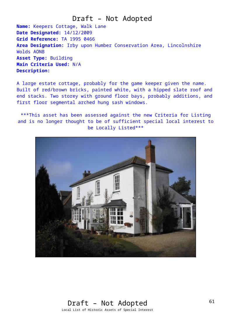
Draft – Not AdoptedName: Keepers Cottage, Walk LaneDate Designated: 14/12/2009Grid Reference: TA 1995 0466Area Designation: Irby upon Humber Conservation Area, Lincolnshire Wolds AONBAsset Type: BuildingMain Criteria Used: N/ADescription:
A large estate cottage, probably for the game keeper given the name.Built of red/brown bricks, painted white, with a hipped slate roof and end stacks. Two storey with ground floor bays, probably additions, and first floor segmental arched hung sash windows.
***This asset has been assessed against the new Criteria for Listing and is no longer thought to be of sufficient special local interest to be Locally Listed***
Draft – Not AdoptedLocal List of Historic Assets of Special Interest
47
Draft – Not AdoptedName: The Old Chapel, Walk LaneDate Designated: 14/12/2009Grid Reference: TA 1991 0468Area Designation: Irby upon Humber Conservation Area, Lincolnshire Wolds AONBAsset Type: BuildingMain Criteria Used: N/ADescription:
A poorly converted Wesleyan Methodist Chapel with a large extension, French windows cut into a side wall and front windows partly blocked.Built of red/brown brick with ashlar dressings.
***This asset has been assessed against the new Criteria for Listing and is no longer thought to be of sufficient special local interest to be Locally Listed***
Draft – Not AdoptedLocal List of Historic Assets of Special Interest
48

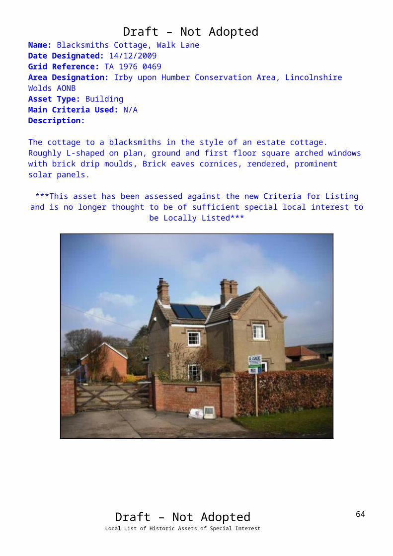
Draft – Not AdoptedName: Blacksmiths Cottage, Walk LaneDate Designated: 14/12/2009Grid Reference: TA 1976 0469Area Designation: Irby upon Humber Conservation Area, Lincolnshire Wolds AONBAsset Type: BuildingMain Criteria Used: N/ADescription:
The cottage to a blacksmiths in the style of an estate cottage.Roughly L-shaped on plan, ground and first floor square arched windows with brick drip moulds, Brick eaves cornices, rendered, prominent solar panels.
***This asset has been assessed against the new Criteria for Listing and is no longer thought to be of sufficient special local interest to be Locally Listed***
Draft – Not AdoptedLocal List of Historic Assets of Special Interest
49

Draft – Not AdoptedName: Sackville Cottage, Walk LaneDate Designated: 14/12/2009Grid Reference: TA 1973 0467Area Designation: Irby upon Humber Conservation Area, Lincolnshire Wolds AONBAsset Type: BuildingMain Criteria Used: N/ADescription:
A small double depth farmhouse or large estate cottage built of brown brick, now rendered, with a concrete tile roof. Many modern alterations.
***This asset has been assessed against the new Criteria for Listing and is no longer thought to be of sufficient special local interest to be Locally Listed***
Draft – Not AdoptedLocal List of Historic Assets of Special Interest
50

Draft – Not AdoptedName: Millfield Cottage & Welbeck Cottage, Walk LaneDate Designated: 14/12/2009Grid Reference: TA 1977 0465Area Designation: Irby upon Humber Conservation Area, Lincolnshire Wolds AONBAsset Type: BuildingMain Criteria Used: N/ADescription:
Symmetrical estate cottages with paired front bays and single side bays set back, ground and first floor square arched windows with brick drip moulds, and brick eaves cornices. Millfield Cottage is rendered.
***This asset has been assessed against the new Criteria for Listing and is no longer thought to be of sufficient special local interest to be Locally Listed***
Draft – Not AdoptedLocal List of Historic Assets of Special Interest
51

Draft – Not AdoptedName: Walk House Farm, Walk LaneDate Designated: 14/12/2009Grid Reference: TA 1967 0465Area Designation: Irby upon Humber Conservation Area, Lincolnshire Wolds AONBAsset Type: BuildingMain Criteria Used: 1c, 2gDescription:
A large 3 bay farmhouse built of buff brick with red brick dressings and a slate roof. A small L-shaped block of outbuildings survives to the rear and has been at least partially converted.
An important part of the social and agricultural structure of the village.
Draft – Not AdoptedLocal List of Historic Assets of Special Interest
52

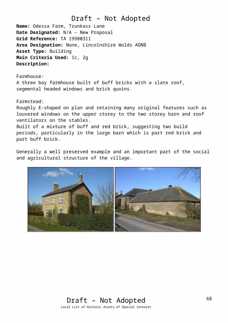
Draft – Not AdoptedName: Odessa Farm, Trunkass LaneDate Designated: N/A – New ProposalGrid Reference: TA 19980311Area Designation: None, Lincolnshire Wolds AONBAsset Type: BuildingMain Criteria Used: 1c, 2gDescription:
Farmhouse:A three bay farmhouse built of buff bricks with a slate roof, segmental headed windows and brick quoins.
Farmstead:Roughly E-shaped on plan and retaining many original features such as louvered windows on the upper storey to the two storey barn and roof ventilators on the stables.Built of a mixture of buff and red brick, suggesting two build periods, particularly in the large barn which is part red brick and part buff brick.
Generally a well preserved example and an important part of the social and agricultural structure of the village.
Draft – Not AdoptedLocal List of Historic Assets of Special Interest
53

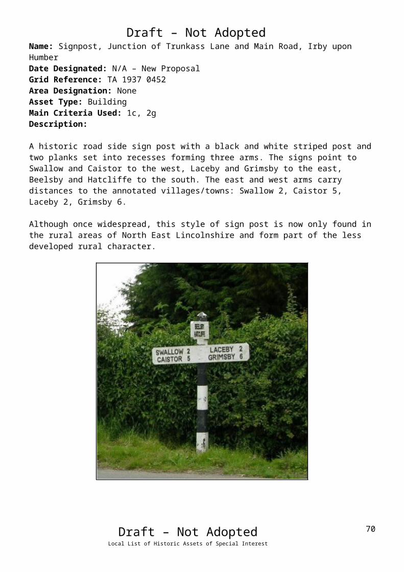
Draft – Not AdoptedName: Signpost, Junction of Trunkass Lane and Main Road, Irby upon HumberDate Designated: N/A – New ProposalGrid Reference: TA 1937 0452Area Designation: NoneAsset Type: BuildingMain Criteria Used: 1c, 2gDescription:
A historic road side sign post with a black and white striped post and two planks set into recesses forming three arms. The signs point to Swallow and Caistor to the west, Laceby and Grimsby to the east, Beelsby and Hatcliffe to the south. The east and west arms carry distances to the annotated villages/towns: Swallow 2, Caistor 5, Laceby 2, Grimsby 6.
Although once widespread, this style of sign post is now only found in the rural areas of North East Lincolnshire and form part of the less developed rural character.
Draft – Not AdoptedLocal List of Historic Assets of Special Interest
54

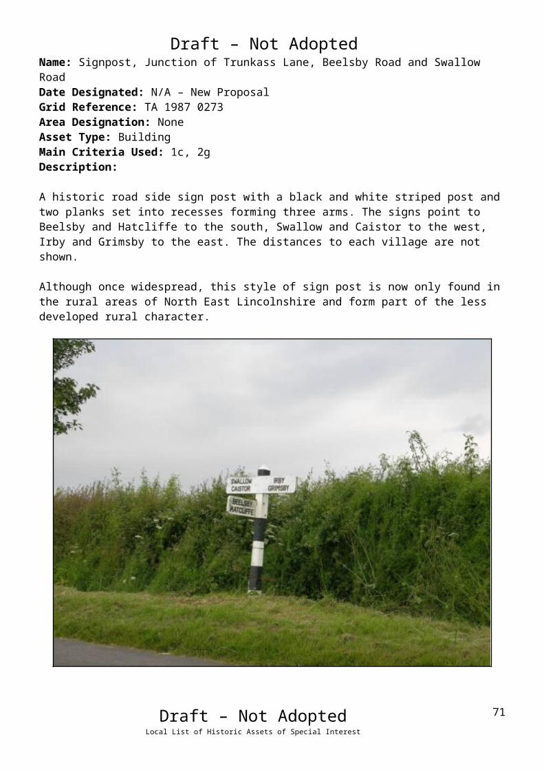
Draft – Not AdoptedName: Signpost, Junction of Trunkass Lane, Beelsby Road and Swallow RoadDate Designated: N/A – New ProposalGrid Reference: TA 1987 0273Area Designation: NoneAsset Type: BuildingMain Criteria Used: 1c, 2gDescription:
A historic road side sign post with a black and white striped post and two planks set into recesses forming three arms. The signs point to Beelsby and Hatcliffe to the south, Swallow and Caistor to the west, Irby and Grimsby to the east. The distances to each village are not shown.
Although once widespread, this style of sign post is now only found in the rural areas of North East Lincolnshire and form part of the less developed rural character.
Draft – Not AdoptedLocal List of Historic Assets of Special Interest
55

Draft – Not AdoptedName: Shrunken medieval village earthworks in Irby upon HumberDate Designated: N/A – New ProposalGrid Reference: TA 1959 0486Area Designation: Lincolnshire Wolds AONBAsset Type: Archaeological SiteMain Criteria Used: 1b, 2aDescription:
Four dispersed areas of shrunken medieval village earthworks, separated by extant housing and farms. The earthworks include linear property boundaries, possible croft, tofts and other enclosures, as well as a post medieval moated site with possible medieval origins.
Although some of the earthworks have been lost to 19th century and later developments, a significant amount are still intact. The extant earthworks are likely to contain buried archaeological deposits of high significance to understanding the growth and development of the village.
See HER Numbers - 0511/0/0 and 0511/2/0 - for further information and sources
The post medieval moated site, c.1986
Draft – Not AdoptedLocal List of Historic Assets of Special Interest
56

Draft – Not Adopted
West Ravendale
West Ravendale is a very small hamlet which represents an almost entirely deserted village.
The settlement was to the east of Priory Farm and the ruins of the Priory Chapel. The site of the
medieval priory itself is not clear but is likely to lie within the settlement area.
At the time of Domesday (1086AD) and the Lindsey Survey (c.1115AD) Ravendale is referred
to as a single entity; however the original parish had been split into East and West Ravendale
by the time of the Episcopal Registers (1219AD).
West Ravendale is recorded as having a population of 59 in the 1851 census according to
White's directory of 1856. In the 2001 census the population is recorded as 18.
At the time of writing – 2nd October 2015 – West Ravendale has:
25 Historic Environment Records of which:
1 is a nationally Listed Buildings (and is also a part of a Scheduled Monument)
1 is a nationally Scheduled Monument (part of which is also a Listed Building)
5 are proposed Locally Listed Historic Assets
Draft – Not AdoptedLocal List of Historic Assets of Special Interest
57

Draft – Not AdoptedWest Ravendale
Name: Ravendale Top FarmDate Designated: N/A – New ProposalGrid Reference: TA 23370 00341Area Designation: NoneAsset Type: BuildingMain Criteria Used: 1c, 2gDescription:
A farmstead, probably 19th century, which consists of a O-shaped range of farm buildings around a courtyard. Most of the farmyard buildings shown on Ordnance Survey maps of 1887-9 appear to be present, but it is not clear if the farmhouse is original or a rebuild. Recorded as Little Ravendale Farm in 1828.
This site has been surveyed from aerial photographs and maps. It is assumed from this evidence that it is of at least local interest.
Image Taken in 2006The GeoInformation Group Data ® copyright by The GeoInformation® Group, 2015
Draft – Not AdoptedLocal List of Historic Assets of Special Interest
58

Draft – Not AdoptedName: Ravendale Priory FarmDate Designated: N/A – New ProposalGrid Reference: TF 22754 99759Area Designation: NoneAsset Type: BuildingMain Criteria Used: 1c, 2gDescription:
A large farmhouse and farmyard buildings, with most of the buildings shown on Ordnance Survey maps of 1887-9 surviving. Despite the losses to the courtyard and alterations to the main house the group is of local interest.
Draft – Not AdoptedLocal List of Historic Assets of Special Interest
59

Draft – Not AdoptedName: Cropmark Enclosure 350m north west of Ravendale Top FarmDate Designated: N/A – New ProposalGrid Reference: TA 2308 0064Area Designation: Lincolnshire Wolds AONBAsset Type: Archaeological SiteMain Criteria Used: 1b, 2aDescription:
A potential Prehistoric or Roman enclosure was seen as cropmarks and mapped from poor quality air photographs. It is rectilinear in shape, 50m by 30m, defined by 1 ditch (National Monuments Record: TA 20 SW 33)
Plot of the Cropmark, as mapped by the RCHMEReproduced from an Ordnance Survey map with the permission of the Controller of HMSO © Crown Copyright.
Licence number 100020759 North East Lincolnshire Council
Draft – Not AdoptedLocal List of Historic Assets of Special Interest
60

Draft – Not AdoptedName: Medieval enclosure cropmarks 120m north of Priory Farm, West RavendaleDate Designated: N/A – New ProposalGrid Reference: TF 2268 9986Area Designation: Lincolnshire Wolds AONBAsset Type: Archaeological SiteMain Criteria Used: 1b, 2aDescription:
A large ditched enclosure seen on aerial photographs. The ditch is roughly 7m wide and enclosure a sub-rectangular area which measures c.80x50 meters (National Monuments Record: TF 29 NW 31). It has a strong potential to be related in some way to the Premonstratensians Priory chapel to the south, including the potential that this is the site of the priory itself.
The enclosure shown on 1940s aerial photographs The GeoInformation Group Data ® copyright by The GeoInformation® Group, 2015
Draft – Not AdoptedLocal List of Historic Assets of Special Interest
61
Draft – Not AdoptedName: West Ravendale medieval settlement earthworks and cropmarksDate Designated: N/A – New ProposalGrid Reference: TF 2287 9962Area Designation: Lincolnshire Wolds AONBAsset Type: Archaeological SiteMain Criteria Used: 1b, 2aDescription:
A small area of medieval earthworks, probably toft boundaries, representing part of the medieval settlement of West Ravendale
The site also wraps around the scheduled monument known as “Premonstratensian priory chapel 170m south west of Priory Farm” including the former area of the church yard around the chapel which is not covered by the scheduling.
See HER Numbers - 0675/0/0 and 0675/1/0 - for further information and sources
Shallow medieval village earthworks in West Ravendale
Draft – Not AdoptedLocal List of Historic Assets of Special Interest
62

Draft – Not Adopted
Wold Newton
Wold Newton is a long thin village arranged along the main road at the base of a valley in the
Wolds. It is known to have existed since the early medieval period (410AD to 1066AD). The
limits of the historic core are defined to the north by North Farm, and to the south by South
Farm and The Grange.
Wold Newton is recorded as having a population of 179 in the 1851 census according to White's
directory of 1856. In the 2001 census the population is recorded as 56.
At the time of writing – 2nd October 2015 – Wold Newton has:
71 Historic Environment Records of which:
4 are nationally Listed Buildings
None are nationally Scheduled Monuments
17 are proposed Locally Listed Historic Assets
Draft – Not AdoptedLocal List of Historic Assets of Special Interest
63

Draft – Not AdoptedName: North Farm HouseDate Designated: N/A – New ProposalGrid Reference: TF 2432 9706Area Designation: Lincolnshire Wolds AONBAsset Type: BuildingMain Criteria Used: 1c, 2gDescription:
Two storey farmhouse, four bays; chalk, ironstone and limestone ashlar to the ground floor front elevation and sides, brick upper portions, gables have parapets with ashlar coping, pantile roof. Adjacent agricultural building in rougher dressed stone and brick also included, as are the estate railings to the front.
The mix of stone, which is similar to that used in many local medieval churches, strongly suggests that it came from the rebuild of the nearby Church of All Hallows (NHLE 1161343) which was carried out in 1862.
The small east-west orientated barn was detached from the adjacent model farm complex and shares design features and construction materials with the farm house and so it is probable that it was the domestic stables.
Draft – Not AdoptedLocal List of Historic Assets of Special Interest
64
Draft – Not AdoptedName: Barns at North FarmDate Designated: N/A – New ProposalGrid Reference: TF 2428 9709Area Designation: Lincolnshire Wolds AONBAsset Type: BuildingMain Criteria Used: 1c, 2gDescription:
A large north-south orientated barn built of chalk and brick with a pantile roof. The barn is the last survivor of a double-courtyard farm complex, probably mid to late 19th century.
Despite the loss of the other buildings in the complex, the size and unusual construction of the building means that it is still makes a significant contribution to the historic character of the village.
Draft – Not AdoptedLocal List of Historic Assets of Special Interest
65

Draft – Not AdoptedName: The Manor, Wold NewtonDate Designated: N/A – New ProposalGrid Reference: TF 2430 9698Area Designation: Lincolnshire Wolds AONBAsset Type: BuildingMain Criteria Used: 1c, 2gDescription:
Two storey, 3 bay Manor House in large grounds with a landscape park to the south. Built of light brown brick with a projecting slate roof, bay windows to the ground floor with central doorways, sliding shutters to the first floor windows which are 6/6 hung sash.
Part of the manorial functions and practices of the village.
Draft – Not AdoptedLocal List of Historic Assets of Special Interest
66

Draft – Not AdoptedName: North Farm, North Field, Ploughman's, Shepherd's, Groom's, The Roost, Chalk, Post Office, Gardener's, Foreman's, Garthman's and Waggoner's CottagesDate Designated: N/A – New ProposalGrid Reference: TF 2416 9716Area Designation: Lincolnshire Wolds AONBAsset Type: BuildingMain Criteria Used: 1c, 2gDescription:
A group of 14 estate cottages of various ages and designs forming a coherent group along the main street of Wold Newton. Although almost all have modifications of some sort, the group value and lack of too many unsympathetic alterations mean that they are of special local interest.
Chalk Cottage and Post Office Cottage were both once semi-detached houses and have since been converted into single dwellings.
Church Path, Woodman’s and Dionard Cottages are also estate cottages but have been too extensively altered to be considered part of the group.
North Farm and North Field Cottages (left) Ploughman’s and Shepherd’s Cottages (right)
Groom’s Cottage and The Roost (left) Chalk Cottage (right)
Draft – Not AdoptedLocal List of Historic Assets of Special Interest
67

Draft – Not Adopted
Post Office Cottage (left) Gardener’s and Foreman’s Cottages (right)
Garthman’s and Waggoner’s Cottages
Draft – Not AdoptedLocal List of Historic Assets of Special Interest
68
Draft – Not AdoptedName: Wold Newton War MemorialDate Designated: N/A – New ProposalGrid Reference: TF 2437 9700Area Designation: Lincolnshire Wolds AONBAsset Type: MemorialMain Criteria Used: 1b, 2gDescription:
Stone war memorial in high-medieval style, dwarf wall with railings to the front of the memorial forming an enclosure with the field fence to the rear.
Dedicated to loses in the Boer Wars (1880–1881 and 1899–1902) and the First World War (1914-1918) with 1 death and 4 deaths recorded respectively for the village.
Draft – Not AdoptedLocal List of Historic Assets of Special Interest
69

Draft – Not AdoptedName: Buildings at South FarmDate Designated: N/A – New ProposalGrid Reference: TF 2451 9616Area Designation: Lincolnshire Wolds AONBAsset Type: BuildingMain Criteria Used: 1c, 2gDescription:
A large range of farm buildings built of mixed chalk (ashlar and rubble) and brick including barns and a horse gin.
The large north-east, south-west orientated building is a complex of builds and is the remains of an E shaped model farm complex.
Despite the loss of the other buildings in the complex, the size and unusual construction of the building means that it is still makes a significant contribution to the historic character of the village. Possibly Curtilage to The Grange (Listed Building 164416)
Draft – Not AdoptedLocal List of Historic Assets of Special Interest
70
Draft – Not AdoptedName: Signpost, Junction of Main Road, Wold Newton Road and an Un-Named RoadDate Designated: N/A – New ProposalGrid Reference: TF 2408 9745Area Designation: NoneAsset Type: BuildingMain Criteria Used: 1c, 2gDescription:
A historic road side sign post with a black and white striped post and two planks set into recesses forming three arms. The signs point to East Ravendale and Waltham to the north, Swinhope and Binbrook to the west, Wold Newton and Louth to the south. The distances to each village are not shown.
Although once widespread, this style of sign post is now only found in the rural areas of North East Lincolnshire and form part of the less developed rural character.
Draft – Not AdoptedLocal List of Historic Assets of Special Interest
71
Draft – Not AdoptedName: Signpost, Junction of Main Road, Wold Newton Road and an Un-Named RoadDate Designated: N/A – New ProposalGrid Reference: TF 2436 9702Area Designation: NoneAsset Type: BuildingMain Criteria Used: 1c, 2gDescription:
A historic road side sign post with a black and white striped post and two planks set into recesses forming three arms. The signs point to Grimsby to the north, Louth to the south, N[orth] Thoresby to the east. The arms also display distances to the annotated villages/towns: Grimsby 9, Louth 9, North Thoresby 3 ½.
Although once widespread, this style of sign post is now only found in the rural areas of North East Lincolnshire and form part of the less developed rural character.
Draft – Not AdoptedLocal List of Historic Assets of Special Interest
72

Draft – Not AdoptedName: Signpost, Junction of Main Road, Brats Lane, Beesby Lane, and an Un-named RoadDate Designated: N/A – New ProposalGrid Reference: TF 2436 9702Area Designation: NoneAsset Type: BuildingMain Criteria Used: 1c, 2gDescription:
A historic road side sign post with a black and white striped post and two planks set into recesses forming four arms. The signs point to Wold Newton to the north, Louth and Kelstern to the south, N[orth] Thoresby to the east, Binbrook to the west. The distances to each village/town are not shown.
Recently repaired following damaged caused by a collision.
Although once widespread, this style of sign post is now only found in the rural areas of North East Lincolnshire and form part of the less developed rural character.
Draft – Not AdoptedLocal List of Historic Assets of Special Interest
73

Draft – Not AdoptedName: Cropmark enclosures 650m north west of Scallows Hall, Wold NewtonDate Designated: N/A – New ProposalGrid Reference: TF 2413 9522Area Designation: Lincolnshire Wolds AONBAsset Type: Archaeological SiteMain Criteria Used: 1b, 2aDescription:
Faint and partial cropmarks of a series of possible enclosures. Probably prehistoric or Roman in date.
Image Taken in 2006The GeoInformation Group Data ® copyright by The GeoInformation® Group, 2015
Draft – Not AdoptedLocal List of Historic Assets of Special Interest
74

Draft – Not AdoptedName: Cropmark enclosures 300m north east of Cold Harbour, Wold NewtonDate Designated: N/A – New ProposalGrid Reference: TF 2338 9577Area Designation: Lincolnshire Wolds AONBAsset Type: Archaeological SiteMain Criteria Used: 1b, 2aDescription:
Possible ditched enclosures and boundaries of unknown date were seen as cropmarks and mapped from good quality air photographs. Perpendicular sinuous boundaries, up to 100m long, are centred at TF 2346 9570. Attached to the south side of one of the boundaries is a subcircular enclosure, with a diameter of 10m and centred at TF 2348 9570. Another boundary to the south, centred at TF 2349 9565, could be related to the enclosures (National Monuments Record: TF 29 NW 38)
Image Taken in 2006The GeoInformation Group Data ® copyright by The GeoInformation® Group, 2015
Draft – Not AdoptedLocal List of Historic Assets of Special Interest
75

Draft – Not AdoptedName: Cropmark enclosures 300m north east of The Grange, Wold NewtonDate Designated: N/A – New ProposalGrid Reference: TF 2484 9649Area Designation: Lincolnshire Wolds AONBAsset Type: Archaeological SiteMain Criteria Used: 1b, 2aDescription:
Probable Prehistoric or Roman enclosures and boundaries were seen as cropmarks and mapped from good quality air photographs. A NE-SW oriented linear arrangement of four conjoined rectilinear enclosures are visible, on a west facing slope overlooking a dry valley. They measure on average 40m by 25m and are centred at TF 2482 9646. The enclosures are attached to a ditched boundary 220m long. Another boundary, perpendicular to the first one partially encloses the enclosures. Fragments of boundaries to the south, measuring on average 40m, may relate to the enclosures (National Monuments Record: TF 29 NW 37)
Image Taken in 2006The GeoInformation Group Data ® copyright by The GeoInformation® Group, 2015
Draft – Not AdoptedLocal List of Historic Assets of Special Interest
76
Draft – Not AdoptedName: Cropmark enclosures, boundaries and a trackway 520m west of North Farm, Wold NewtonDate Designated: N/A – New ProposalGrid Reference: TF 2349 9692Area Designation: Lincolnshire Wolds AONBAsset Type: Archaeological SiteMain Criteria Used: 1b, 2aDescription:
Probable Prehistoric enclosures and boundaries, possibly the remains of a settlement, were seen as cropmarks and mapped form air photographs. An asymmetric polygonal enclosure with a possible funnel entrance, or droveway, in its east side, is centred at TF 2356 9700. Attached to the inside of its west side is a rectangular enclosure, 50m by 15m. The settlement is situated on a north and west facing slope of a dry valley. Fragments of a boundary cross the valley from the settlement, and are centred at TF 2340 9697. An incomplete subcircular enclosure, (see TF 29 NW 36), is partially visible directly across the valley from the settlement but no obvious association between the features is visible (National Monuments Record: TF 29 NW 35)
Image Taken in 2006The GeoInformation Group Data ® copyright by The GeoInformation® Group, 2015
Draft – Not AdoptedLocal List of Historic Assets of Special Interest
77

Draft – Not AdoptedName: Cropmark of a probable Neolithic Long Barrow 950m west south west of All Saints' Church, Wold NewtonDate Designated: N/A – New ProposalGrid Reference: TF 2331 9626Area Designation: Lincolnshire Wolds AONBAsset Type: Archaeological SiteMain Criteria Used: 1b, 2aDescription:
Cropmark of a probable long barrow, measuring c.90m in length, with a 35m wide end facing roughly SW and a c.15m wide end facing roughly NE.
Image Taken in 2006The GeoInformation Group Data ® copyright by The GeoInformation® Group, 2015
Draft – Not AdoptedLocal List of Historic Assets of Special Interest
78
Draft – Not AdoptedName: Cropmark ring ditches 420m north of Scallows Hall, Wold NewtonDate Designated: N/A – New ProposalGrid Reference: TF 2448 9511Area Designation: Lincolnshire Wolds AONBAsset Type: Archaeological SiteMain Criteria Used: 1b, 2aDescription:
Cropmarks of three possible ring ditches, all roughly 20m in diameter.
Image Taken in 2006The GeoInformation Group Data ® copyright by The GeoInformation® Group, 2015
Draft – Not AdoptedLocal List of Historic Assets of Special Interest
79

Draft – Not AdoptedName: Wold Newton medieval settlement earthworksDate Designated: N/A – New ProposalGrid Reference: TF 2441 9663Area Designation: Lincolnshire Wolds AONBAsset Type: Complex (Archaeological Site and Designed Landscape)Main Criteria Used: 1c, 2gDescription:
Earthworks to the South and West of the present village. Interrupted in places by modern houses and gardens. The earthworks include toft boundaries, possible house sites and an old lane West of the present main street.
The area to the north west, to the south of the Manor, is also a landscape park with significant mature trees.
See HER Number - 0745/0/0- for further information and sources
The parkland and earthworks to the south of The Manor
Draft – Not AdoptedLocal List of Historic Assets of Special Interest
80