myanmar opium survey 2017 - unodc.org opium survey 2017 iv fact sheet year 2015 year 2017 change...
TRANSCRIPT

Myanmar Opium Survey
Central Committee for Drug Abuse control
Research
December 2017

In Southeast Asia, UNODC supports Member States to develop and implement evidence based rule of law, drug control and related criminal justice responses through the Regional Programme 2014‐2018 and aligned country programmes including the Myanmar Country Programme 2014‐2018. This study is connected to the Mekong MOU on Drug Control which UNODC actively supports through the Regional Programme, including the commitment to develop data and evidence as the basis for countries of the Mekong region to respond to challenges of drug production, trafficking and use. UNODC’s Research and Trend Analysis Branch promotes and supports the development and implementation of surveys globally.
The implementation of Myanmar opium survey was made possible thanks to the financial
support of the Governments of Japan, Sweden and the United States of America.
UNODC Regional Office for Southeast Asia and the Pacific Telephone: +6622882100 Fax: +6622812129 Email: [email protected] Website: www.unodc.org/southeastasiaandpacific Twitter: @UNODC_SEAP
The designations employed and the presentation of material in this publication do not imply the expression of any opinion whatsoever on the part of UNODC concerning the legal status of any country, territory or city, or its authorities, or concerning the delimitation of its frontiers or boundaries.

Contents
Acknowledgments ............................................................................................................................ i
Abbreviations ................................................................................................................................... i
Executive Summary ........................................................................................................................ iii
1. Introduction ............................................................................................................................ 3
2. Findings .................................................................................................................................. 7
2.1 Estimated area under opium poppy cultivation ..................................................................... 7 2.2 Opium yield and production estimates ................................................................................. 12 2.3 Opium farm‐gate price .......................................................................................................... 16
3. Eradication and Seizures ........................................................................................................ 19
3.1 Eradication ............................................................................................................................ 19 3.2 Seizures ................................................................................................................................. 22
4. Methodology ........................................................................................................................ 27
4.1 Area estimation ..................................................................................................................... 27 4.2 Yield and potential opium production estimation ................................................................ 35 4.3 Opium farm‐gate prices ........................................................................................................ 40


Myanmar Opium Survey 2017
i
Acknowledgments
Central Committee for Drug Abuse Control (CCDAC)
Pol. Maj. Gen. Aung Win Oo Chief of Myanmar Police Force, Secretary of CCDAC
Pol. Brig. Gen. Myint Aung Commander of Drug Enforcement Division, Joint Secretary of CCDAC
Pol. Col. Zaw Lin Tun Head of Project Management Department, CCDAC
Implementation of the survey would not have been possible without the support of local administrations.
UNODC Regional Office for Southeast Asia and the Pacific
Jeremy Douglas Regional Representative, Southeast Asia and the Pacific
Akara Umapornsakula Graphic Designer
UNODC Myanmar
Troels Vester Country Manager
San Lwin Htwe Remote Sensing/GIS Specialist and Survey Coordinator
Naing Lin Aung Data Analyst
UNODC Headquarters
Angela Me Chief, Research and Trend Analysis Branch (RAB)
Anja Korenblik Chief, Programme and Development Unit (PDMU)
Coen Bussink Programme Officer (Research), Team Leader ICMP, PDMU
Jaqueline Garcia‐Yi Research Officer, PDMU
Lorenzo Vita Programme Officer (Remote Sensing and GIS), PDMU
Irmgard Zeiler Statistician, PDMU
Abbreviations
CCDAC Central Committee for Drug Abuse Control
GOUM Government of the Republic of the Union on Myanmar
ICMP UNODC Illicit Crop Monitoring Programme
PDMU Programme Management and Development Programme
RAB Research and Analysis Branch
SR Special Region
UNODC United Nations Office on Drugs and Crime
USG United States Government

Myanmar Opium Survey 2017
ii

Myanmar Opium Survey 2017
iii
Executive Summary
In 2017, the Central Committee for Drug Abuse Control (CCDAC) of the Myanmar Police Force of the Republic of the Union of Myanmar collaborated for the 15th time with the United Nations Office on Drugs and Crime (UNODC) to implement an opium survey. 2016 and 2017 surveys focused on different aspects of opium production: in 2016, the survey focused on the socio‐economic conditions of farmers in opium growing areas (https://www.unodc.org/ documents/crop‐monitoring/sea/2016_Myanmar_Shan_Opium_Poppy_web.pdf)1, and in 2017 on estimating the extent of poppy cultivation and opium production. The area and production survey in 2017 has focused on major opium producing states, Shan and Kachin2. In addition, a selective sampling rate has been applied for the collection of the satellite imagery, using an approach that guarantees comparability with 2015 results.
The 2017 opium survey estimates that 41,000 ha of opium poppy has been cultivated in Shan and Kachin States. Compared to the 2015 estimate, this represents a 25% decrease.
Reductions have taken place in East and South Shan (‐37% and ‐29% respectively), whereas in North Shan and Kachin States the cultivation remained practically stable (‐3% and ‐7%). Continued turmoil in North Shan and Kachin appear to be linked to the steady cultivation levels. The reported amount of eradication has also been very low in these two states (less than 130 ha), whereas the large majority (85%) of the total eradication (3,533 ha) has been reported from South Shan.
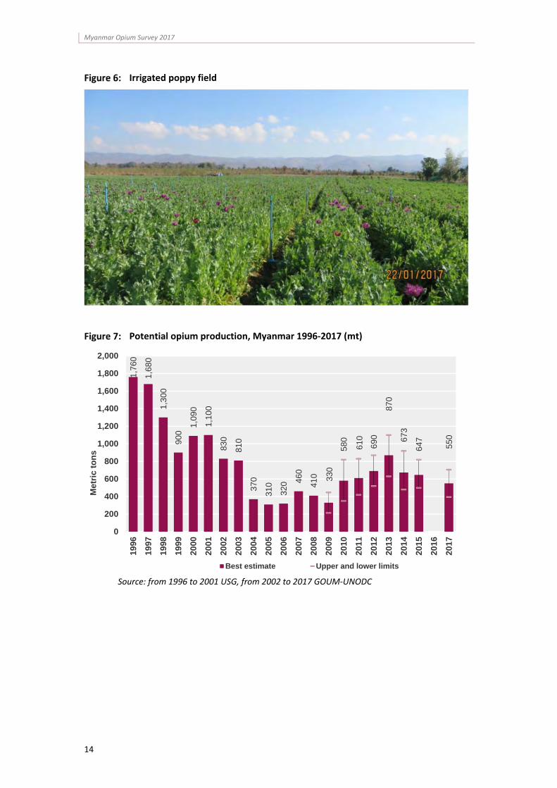
In terms of opium production, part of the area reduction has been offset by an increase in yields per hectare in South Shan, which have risen by 43% to 14.2 kg/ha. Combined with the reduced cultivation areas, this resulted in a 14% decrease of potential dry opium production in Shan and Kachin states. In 2017, South Shan state remains the largest opium producer supplying almost half (43%) of the total estimated potential production of 550 metric tons.
Cultivation, eradication and drug seizure figures showed similar trends in the past eight years, showing increases from 2010 to 2012‐2014 and decreasing slightly since then. These trends, in combination with declining opium prices and anecdotal evidence of reduced trafficking suggest that the demand for opium and heroin has decreased. These trends will be further researched in the upcoming remote sensing survey and a new village survey, which the Government of the Union of Myanmar and UNODC are currently preparing for the 2018 opium poppy season.
1 Announced March 2017.
2 In 2015, less than 2% of the estimated opium area was cultivated in Chin and Kayah states, but were not surveyed in 2017.

Myanmar Opium Survey 2017
iv
Fact Sheet
Year 2015 Year 2017 Change
2015-2017
Total opium poppy cultivation (ha)3, 4
55,500 (42,800 to 69,600)
41,000 (30,200 to 51,900)
NA5
Opium poppy cultivation in Shan State (ha)
50,300 (31,500 to 73,500)
37,100 (26,500 to 47,600)
-26%
Opium poppy cultivation in Kachin State (ha)
4,200 (2,300 to 7,600)
3,900 (1,500 to 6,400)
-7%
Total potential production of dry opium (mt)6
647 (500 to 820)
550 (395 to 706)
NA7
Potential dry opium production in Shan State (mt)
648 (500 to 820)
501 (349 to 653)
-23%
Potential dry opium production in Kachin State (mt)
53 (26 to 96)
49 (17 to 81)
-7%
Average opium yield (kg/ha)
11.7 (9.0 to 14.3)
13.4 (9.3 to 17.6)
15%
Total opium poppy eradication reported by the Government of Myanmar (ha)
13,450 3,533 -74%
3 Total area estimate in 2017 does not consider cultivation in Chin and Kayah States. Since in 2015 there were estimates for these states, the estimates for the two years are not directly comparable.
4 The estimates may include areas that were eradicated after the acquisition date of the satellite images.
5 Considering the sum of Shan and Kachin states only, the change percentage is ‐25%.
6 Total potential production in 2017 does not consider Chin and Kayah States. Since in 2015 there were estimates for these states, the estimates for the two years are not directly comparable.
7 Considering the sum of Shan and Kachin states only, the change percentage is ‐14%.

1. INTRODUCTION


Myanmar Opium Survey 2017
3
1. Introduction
This report presents the results of the fifteenth annual opium survey in Myanmar. It was conducted by the Central Committee for Drug Abuse Control (CCDAC) of Myanmar with the support and participation of UNODC, which has been collecting statistical information on illicit crop cultivation in Myanmar within the framework of its Illicit Crop Monitoring Programme (ICMP) since 2001.
ICMP works with national Governments to increase their capacity to monitor illicit crops and supports the international community in monitoring the extent and evolution of illicit crops. The need for illicit crop monitoring was reiterated in the plan of action adopted by the United Nations (the 53rd session of the Commission on Narcotic Drugs in March 2009) and in the recent outcome document from the United Nations General Assembly Special Session on the World Drug Problem8.
Until 2015, Myanmar opium surveys comprised three components: an opium cultivation area assessment, a yield and production assessment, and a socio economic survey. In 2016, a socio economic survey was carried out, whereas in 2017 the extent of opium cultivation and production was assessed.
In the 1980s, Myanmar was the world’s largest producer of illicit opium. Between 1981 and 1987 the country had an average annual opium production of about 700 tons, which continued to increase until 1996 when it reached annual production levels of some 1,600 tons. In 1991, Afghanistan replaced Myanmar as the world’s largest producer of opium, primarily due to its higher opium yield per hectare. However, the area under opium poppy cultivation remained larger in Myanmar than in Afghanistan until 2002.
In 1999, the Government of the Republic of the Union of Myanmar (GOUM) and local authorities in areas affected by opium poppy cultivation developed a 15‐year plan to eliminate illicit crop production by the year 2014. Until 2006 there was a considerable decrease in the total area under opium poppy cultivation in Myanmar. However, opium poppy cultivation has since increased until 2013, when it started levelling off and eventually decreased in 2017.
Annual opium surveys remain essential for assessing the extent of opium poppy cultivation in Myanmar, as well as changes in cultivation patterns. They are also useful tools for gauging the effectiveness of opium bans and their implications, as well as aiding the understanding of cultivation techniques, rural livelihoods and potential alternative development options.
The methodology used in this report combines satellite imagery and a field yield survey to evaluate the extent of opium poppy cultivation and production. Such information is essential for supporting decision makers in developing effective strategies as well as sustaining the transition from an illicit to a licit economy.
8 See points 3u, 7c, 7d, 7g in Our joint commitment to effectively addressing and countering the world drug problem. Outcome Document of the 2016 United Nations General Assembly Special Session on the World Drug Problem, New York, 19‐21 April 2016

Myanmar Opium Survey 2017
4
Map 1: Opium poppy cultivation trends in Myanmar, 2012‐2017

2. FINDINGS


Myanmar Opium Survey 2017
7
2. Findings
2.1 Estimated area under opium poppy cultivation
In 2017, the amount of opium poppy cultivation area in Myanmar was estimated at 41,000 ha. The survey covered the major producing states, Shan and Kachin which accounted for more than 98% of the national opium poppy cultivation in 2015. The 2017 figure cannot be directly compared with the 2015 estimate (55,500ha), since the opium poppy areas in Chin and Kayah states were not included due to budget constraints. The comparison can be made though for Shan and Kachin.
Considering only Shan and Kachin states, a significant decrease in cultivation of 25% was recorded, from 54,500 ha in 2015 to 41,000 ha in 2017.
Opium poppy cultivation in Myanmar, 1996‐2017 (ha)*
*Sources: from 1996 to 2001 USG, from 2002 to 2017 GOUM‐UNODC. The surveys in 2014 and 2015 included satellite image estimates for Kayah and Chin States.
Regional distribution of opium poppy cultivation in Myanmar, 2017*
*Chin and Kayah States are not considered
163,
000
155,
150
130,
300
89,5
00
108,
700
105,
000
81,4
00
62,2
00
44,2
00
32,8
00
21,6
00
27,7
00
28,5
00
31,7
00
38,1
00
43,6
00
51,0
00
57,8
00
57,6
00
55,5
00
41,0
00
0
20,000
40,000
60,000
80,000
100,000
120,000
140,000
160,000
180,000
200,000
1996
1997
1998
1999
2000
2001
2002
2003
2004
2005
2006
2007
2008
2009
2010
2011
2012
2013
2014
2015
2016
2017
Hec
tare
s
Best estimate Upper and lower limits
South Shan40%
East Shan27%
North Shan23%
Kachin 10%

Myanmar Opium Survey 2017
8
Significant reductions in cultivation occurred in Shan State (‐26%), particularly in East (‐37%) and South (‐29%) Shan, and although the figures for North Shan (‐3%) and Kachin State (‐7%) showed slight decreases, these changes were within the statistical uncertainties of the estimates in 2015 and 2017.
Shan continued to be by far the major cultivating state in Myanmar, accounting for more than 90% of the total opium poppy area. The regions of North, East and South Shan accounted for 27%, 23% and 40% of total cultivation and Kachin State for almost 10% (3,900 ha).
Table 1: Areas under opium poppy cultivation in Myanmar (ha), 2017
* The change is within the statistical uncertainty of the estimates. ** ‐25% for the comparable areas, considering the sum of Shan and Kachin States only.
Opium poppy cultivation is concentrated in areas characterized by a combination of specific topographical conditions, socio‐economic circumstances and the security situation (see map 2). For example, from an environmental and geographic perspective the south‐western mountains in South Shan provide a good opportunity for opium poppy cultivation, as well the area north of Kyaing Tong city in East Shan and the areas at the boundary of East and South Shan, on both sides of the Than Lwin river. The areas with reductions in cultivation between 2015 and 2017 took place, however, in those areas that are well‐suited for opium cultivation but also had a relatively good security situation (South and East Shan).
In the past, Special Region 2 ‐ or Wa region ‐ showed high levels of poppy cultivation, but nowadays there are hardly any poppy fields due to the ban on opium poppy cultivation. The eastern part of North Shan, bordering the Wa region, showed high concentrations of poppy, similarly to the border with Kachin State. The latter is probably related to the insecurity situation that is reflected by the number of conflicts in this area (see map 3).
2015 2017 Change 2015 ‐2017
East Shan 17,500
(10,300 to 26,500) 11,000
(6,900 to 15,100)‐37%
North Shan 9,700
(6,500 to 13,500) 9,400
(5,200 to 13,600)‐3%*
South Shan 23,400
(14,800 to 35,600) 16,700
(7,900 to 25,400)‐29%
Shan State Total 50,300
(38,700 to 64,900) 37,100
(26,500 to 47,600)‐26%
Kachin 4,200
(2,300 to 7,600) 3,900
(1,500 to 6,400)‐7%*
Kayah 460
(410 to 510) NA ‐
Chin 490
(440 to 530) NA ‐
National Total (rounded) 55,500
(42,800 to 69,600) 41,000
(30,200 to 51,900)NA**

Myanmar Opium Survey 2017
9
Poppy field in South Shan
Interpretation of poppy fields in South Shan (Myanmar, 2017) on Pleiades VHR imagery. 2D visualization (left) vs 3D visualization (right).

Myanmar Opium Survey 2017
10
Map 2: Opium poppy cultivation density, Myanmar (2012 – 2017)9
9 Density map was created using poppy cultivation data from 2012 to 2017 (see methodology chapter).

Myanmar Opium Survey 2017
11
Map 3: Reported conflicts in Myanmar, 2016‐2017

Myanmar Opium Survey 2017
12
2.2 Opium yield and production estimates
The national average yield in 2017, was estimated at 13.4 kg/ha, a 15% increase compared to 2015. The increase was concentrated in South Shan, where yield reached a level of 14.2 kg/ha; this was an increase of 43% compared to 2015 and was back to the average level of earlier years. The yield in East Shan was comparable to 2015 (‐2%). Due to security constraints, the yield survey in 2017 was conducted in East and South Shan only; for the production calculation in North Shan and Kachin state the 2015 yield estimates were used.
Average opium yield in Myanmar, 2002 – 2017
Table 2: Potential opium yield by region (kg/ha), 2015 and 2017
Region 2015 2017 Change
2015‐2017
East Shan 13.0
(11.8 ‐ 14.2) 12.8
(11.4 ‐ 14.1) ‐2%
North Shan 13.3
(9.9 ‐ 16.6) NA NA
South Shan 9.9
(8.5 ‐ 11.2) 14.2
(12.7 ‐ 15.6) 43%
Kachin 12.5
(9.7 ‐ 15.3) NA NA
Average* yield 11.7
(9.0 – 14.3) 13.4
(9.3 – 17.6) 15%
* Weighted average by area under poppy cultivation in each state. For North Shan and Kachin state data on opium yield are from 2015 as the yield survey could not be implemented in 2017.
The resulting estimate of potential dry opium production in 2017 was 550 metric tons. The 2017 production figure does not include the potential production in Chin and Kayah States10, hence this figure is not directly comparable with the 2015 figure. When the total opium production in Shan State and Kachin States are compared, there is a decrease of 14%, from
10 In absence of cultivation figures for Chin and Kayah,
10.0
13.0
8.0
9.5
14.6
16.6
14.4
10.4
15.114.0 13.5
15.0
11.7
11.7
13.4
0.0
2.0
4.0
6.0
8.0
10.0
12.0
14.0
16.0
18.0
20.0
2002 2003 2004 2005 2006 2007 2008 2009 2010 2011 2012 2013 2014 2015 2016 2017
Yie
ld (
kg/h
a)

Myanmar Opium Survey 2017
13
637 mt to 550 mt. This decrease took mainly place in East Shan (‐37%), due to a reduction in cultivation with stable yields. The decrease in cultivated area in South Shan was completely offset by the increase in yield and the dry opium production remained practically the same as in 2015 (2%). The production in North Shan (‐3%) and Kachin (‐7%) do not show significant changes, in line with the cultivation trend.
Table 3: Potential opium production by region (mt), 2015 and 2017
Region Potential
production 2015 Potential
production 2017 Change
2015‐2017
Share of production by state
(%)
East Shan 223 140 ‐37% 25%
North Shan 129 125 ‐3% 23%
South Shan 232 236 2% 43%
Shan state total
584 501 ‐14% 91%
Kachin state 53 49 ‐7% 9%
Kayah state 5 NA ‐ ‐
Chin state 6 NA ‐ ‐
Total (rounded)
647 (500 – 820)
550 (395 – 706)
NA* 100%
* ‐14% for the comparable areas, considering the sum of Shan and Kachin states only. The survey area in 2015 included Kayah and Chin States.
Myanmar Opium Survey 2017
14
Irrigated poppy field
Potential opium production, Myanmar 1996‐2017 (mt)
Source: from 1996 to 2001 USG, from 2002 to 2017 GOUM‐UNODC
1,76
0
1,68
0
1,30
0
900
1,09
0
1,10
0
830
810
370
310
320 46
0
410 33
0
580
610
690
870
673
647
550
0
200
400
600
800
1,000
1,200
1,400
1,600
1,800
2,000
1996
1997
1998
1999
2000
2001
2002
2003
2004
2005
2006
2007
2008
2009
2010
2011
2012
2013
2014
2015
2016
2017
Met
ric
ton
s
Best estimate Upper and lower limits

Myanmar Opium Survey 2017
15
Latex oozing from mature capsules in Myanmar, February 2017
Lancing of opium poppy in Myanmar

Myanmar Opium Survey 2017
16
2.3 Opium farm‐gate price
In the absence of a village survey in 2017, only limited data on opium prices could be collected by the field team that collected ground truth data for the satellite image and that undertook the yield survey.
The few villagers that were interviewed suggested significantly lower opium prices compared to 201611, with around 206,300 Kyat per kilogram fresh opium (or 153 U$ per kg at the December 2016 exchange rate) and 291,400 Kyat per kg dry opium (216 U$). In addition, villagers in South Shan and East Shan reported a reduced number of opium buyers. Since the amount of seizures also decreased (see chapter 3.3), this could mean that the opium market in Myanmar is shrinking, probably as a result of the expanding market of Afghan opiates.
Poppy field in village’s proximities in South Shan (Myanmar 2017).
11 See the socio‐economic report for 2016, https://www.unodc.org/documents/cropmonitoring/sea/2016_Myanmar_ Shan_Opium_Poppy_web.pdf

3. ERADICATION AND SEIZURES


Myanmar Opium Survey 2017
19
3. Eradication and Seizures
As in former years, the Government of the Republic of the Union of Myanmar (GOUM) provided the data on eradication of opium poppy and seizures of opium in 2017.
3.1 Eradication
In 2017, a total amount of 3,533 ha of opium poppy eradication was reported, representing a decrease of 53% compared to 2016, continuing the decline that started in 2015. As in previous years, most of the eradication occurred in South Shan (85%). The decline in eradication since 2015 follow the decreasing cultivation trend (figure 5).
Table 4: Reported eradication in Myanmar (ha), 2007‐2017*
*Source: GOUM/CCDAC ** Figures for 2017 are partial and refers to the period January ‐ August
Eradication versus cultivation in Myanmar, 2007‐2017
*Opium poppy cultivation for the year 2016 was plotted through linear interpolation
0
10,000
20,000
30,000
40,000
50,000
60,000
70,000
2007 2008 2009 2010 2011 2012 2013 2014 2015 2016* 2017
Eradication (ha) Cultivation (ha)
Region 2007 2008 2009 2010 2011 2012 2013 2014 2015 2016 2017**
East Shan 1,101 1,249 702 868 1,230 1,257 537 356 378 482 264
North Shan 916 932 546 1,309 1,315 977 532 337 532 69 97
South Shan 1,316 1,748 1,466 3,138 3,579 21,157 10,869 13,696 10,715 4,947 3,019
Shan State total 3,333 3,929 2,714 5,315 6,124 23,391 11,939 14,389 11,625 5,498 3,381
Kachin 189 790 1,350 2,936 847 83 250 395 1,495 1,504 28
Kayah 12 12 14 13 38 84 59 67 54 16 47
Magway 45 ‐ 1 1 ‐ 4 7 60 8 9 47
Chin 10 86 5 2 10 110 32 277 267 534 28
Mandalay ‐ 3 2 ‐ 39 45 ‐ ‐ ‐ ‐ 1
Sagaing 9 ‐ 1 ‐ ‐ ‐ 2 1 ‐ ‐ ‐
Other States 64 ‐ ‐ ‐ ‐ ‐ ‐ ‐ ‐ ‐ ‐
National total 3,662 4,820 4,087 8,267 7,058 23,718 12,288 15,188 13,450 7,561 3,533

Myanmar Opium Survey 2017
20
Map 4: Eradication reported for 2017 with cultivation density (2012 – 2017)12, Myanmar
12 Density map was created using poppy cultivation data from 2012 to 2017 (see methodology chapter).

Myanmar Opium Survey 2017
21
The locations of eradication overlap with the higher opium density cultivation areas in South and East Shan (see map 4). Eradication in North Shan is minor and non‐existing in the cultivation areas at the border with Kachin where there were many security incidents (see map 3). In Kachin only little eradication was reported in the high density hotspot at the border with China.
GOUM eradication team
The opium poppy cultivation estimates presented in this report refer to the fields that were identified at the time that the satellite images were taken. Therefore, if any eradication was carried out after the satellite image date, it was not reflected in the presented cultivation figure. Besides, data provided by GOUM may include eradication implemented during the monsoon poppy season, prior to the main growing season when the remote sensing survey was implemented.

Myanmar Opium Survey 2017
22
3.2 Seizures
Likewise to the eradication figures, the seizures of different opium products reported by GOUM showed decreases in all opiate types. Most of the opium seizures took place in South Shan, whereas heroin was mostly seized in North Shan and Kachin, as shown in map 5.
Table 5: Seizures of drugs (opiates) in Myanmar (kg), 2007‐2017*
*Source: GOUM/CCDAC ** Figures for 2017 correspond to January – August only
Seizures of drugs (opiates) in Myanmar (kg), 2007‐2017*
*Source: GOUM/CCDAC ** Figures for 2017 correspond to January – August only
13 Pure opium gum before processing (might be fresh or dry).
14 Reported as “brown opium”, probably refers to morphine base.
15 Low quality raw opium mixed with some impurities (e.g. opium gum mixed with dry banana leaf slices for local use in Tanai area, Kachin).
0
2,000
4,000
6,000
8,000
10,000
12,000
14,000
2007 2008 2009 2010 2011 2012 2013 2014 2015 2016 2017**
Kilo
gram
s
Raw Opium Herion Brown Opium Liquid Opium Low‐grade opium
Year 2007 2008 2009 2010 2011 2012 2013 2014 2015 2016 2017**
Raw Opium13 1,273.97 1,463.39 752.04 764.78 828.27 1,470.35 2,356.98 1,828.41 888.84 943.71 645.08
Heroin 68.38 88.13 1,076.13 88.54 42.44 335.79 238.93 435.46 186.04 769.26 301.62
Brown Opium14 1,120.97 206.08 325.70 98.20 36.88 45.76 71.55 1,108.76 538.91 472.00 55.50
Liquid Opium 56.36 80.14 27.48 35.47 60.04 29.32 115.25 102.11 38.08 47.19 27.41
Low‐grade opium15
10,972.20 2,452.79 465.43 147.07 281.65 80.79 65.98 134.10 34.92 22.15 4.11

Myanmar Opium Survey 2017
23
Map 5: Reported seizures in Myanmar, 2016‐2017

Myanmar Opium Survey 2017
24

4. METHODOLOGY


Myanmar Opium Survey 2017
27
4. Methodology
In 2017, the size of the survey was adjusted to the available funds; therefore, some adjustments in the methodology were required.
The 2017 survey included two components that were implemented at the same time:
1. Estimation of opium poppy cultivation area throughout North Shan, East Shan, South Shan and Kachin States. The area estimation survey was based on the use of satellite images as the primary source of data, which was supplemented by field surveys to provide ground‐truthing that supports the interpretation of opium poppy fields;
2. Crop yield survey throughout South Shan and East Shan. Due to on‐going conflicts and the insecure field situation, crop yield measurements could not be conducted in North Shan and Kachin States.
4.1 Area estimation
Remote sensing imagery
The area estimation with remote sensing techniques was carried out in North Shan, East Shan, South Shan as well in Kachin. For Shan and Wainmaw district in Kachin, 5x5 km squared very high‐resolution satellite images were purchased for 46 sample locations. In the case of Tanai area in Kachin, a specific area with concentration of poppy cultivation was targeted using a high‐resolution satellite image. It is more precise and cost‐efficient to do a full cover survey in these areas compared to a sampling approach.
The very‐high resolution (VHR) images at the sample locations were taken by Pleiades satellites, with 2 meter resolution, multi‐spectral 4 bands and a 50‐centimetre panchromatic band). For each location, two images were acquired within a five‐week interval; the first image was taken in December/January and the second one in February/March. Two‐dates imagery facilitates the identification of opium poppy, considering the different crop stage and harvesting time. The images were acquired taking into account the regional differences between the crop calendars.
The satellite image taken in the Tanai area in Kachin state was acquired by a RapidEye satellite, with 5 metres resolution, also with 4 multi spectral bands.
VHR image (Pleiades), on the left vs HR image (Rapid Eye, on the right)

Myanmar Opium Survey 2017
28
Map 6: Location of different types of satellite images within the sampling frame, 2017

Myanmar Opium Survey 2017
29
Risk area and sampling frame for the selection of satellite image locations
The risk area describes the geographic area considered in the area estimation survey. The risk area for the opium survey was developed by a combination of the following factors:
Land cover
Altitude
Opium poppy free16 areas according to ground information
Land cover was the first important factor in defining the risk area. From the 2012 survey onwards, a land cover map, which was developed by classifying 5 DMC images with 22 metre resolution, acquired in February 2011, was used. From this map, large agricultural areas were extracted and considered to be poppy‐free, since the cultivation of opium poppy is normally practised in small agricultural areas, often surrounded by natural vegetation. Wetlands and settlements were also excluded. Other classes of land use were considered to have the potential for opium poppy cultivation.
Prior to 2013, only altitudes between 800 and 1,800 metres were to be considered within the risk area. This was based on survey findings which had revealed that 95% of opium poppy was cultivated at such altitudes. However, more recent evidence showed the existence of poppy fields at 600 metre altitude and above, without a specific higher limit. Consequently, the sampling frame for the selection of the sample locations was updated in 2013. Several opium poppy‐free areas were identified based on ground information. The special regions; Wa (former S.R.2), Mongla (former S.R.4), and Kokant (former S.R.1); were excluded from the sampling frame. The townships; Mabein, Kyaukme, Nawng Hkio and Kunlon in North Shan; and Kalaw, Pindaya, Yak Sauk and Ywa Ngan in South Shan were excluded from the sampling frame for the same reason. A 10‐km buffer zone along the border with Thailand, which had been considered to be opium poppy‐free in former surveys, was included in the risk area again as of 2013 since ground information from the 2012 survey indicated a certain poppy risk.
The above‐mentioned factors were combined in a Geographic Information System to calculate the risk area in Shan State. The risk area for Waingmaw Township in Kachin State was developed only considering an altitude factor of 800 metres and above.
Altitude ranges of opium poppy fields found in satellite images, 2016/2017 (metres)
16 Opium poppy free in the sense of no indication for significant levels of opium poppy cultivation.
0%
20%
40%
60%
80%
100%
South Shan East Shan North Shan Kachin (Waingmaw)
% of poppy fields found
<600 600-800 800-1000 1000-1200 1200-1400 1400-1600 >1600

Myanmar Opium Survey 2017
30
Map 7: Sampling frame and selected samples, 2015 and 2017

Myanmar Opium Survey 2017
31
Sampling approach, sample size and sample selection
Because of widespread poppy cultivation in the North Shan, East Shan, South Shan and in southern Kachin, a sampling approach was applied.
The sampling frame for the 2015 survey was a set of 5x5 km segments which were used to select the locations for obtaining satellite imagery. For that purpose a 5x5 km regular grid was superimposed on the risk area described in the previous section. To increase the efficiency of the sample (to reduce the number of images purchased that only cover a small part of the risk area), a threshold of a minimum of 30% of risk area was set: if a segment contained less than 30% of risk area (e.g. a cell at the boundary of the risk area), it was not included in the sampling frame. In the extrapolation, the whole risk area is considered, with the underlying assumption that the area outside of the frame behaves on average as the area inside the sampling frame.
In 2017, the total number of satellite images chosen was set to 46, keeping the same number of samples for Kachin (8) as in the previous year and halving the number of samples for Shan (38). These numbers were mainly defined by the available budget.
Since 2010, a simple random sampling within geostrata has been applied. For 2017, the selected samples were a sub‐sample of the 2015 samples. Using a sub‐sample ensured partial comparability of the results. The 2017 sub‐sample was selected by first numbering the 2015 geo‐strata in clockwise direction starting from the north‐west corner of the map with strata and selecting every other geo‐stratum, starting a randomly selected number (see map 7).
Table 6: Sample size allocation, 2017
Since the 2017 sample is a sub‐sample of the 2015, the 2015 selection method is explained as well. In 2015, firstly, the frame was separated by region. Here, each segment had to be assigned to exactly one per region: if the majority of the risk area was within that region, the segment was assigned to that region. Secondly, each sub frame (region) was divided into compact geographical strata of approximately equal area. In former surveys the definition of the strata was done manually but a clustering algorithm (“k‐means”) in the statistical software R17 package spcosa was applied since the 2014 survey. In each stratum, two sampling locations were selected by simple random sampling. This sampling method provided a geographically well distributed sample and allowed the variance (uncertainty) to be estimated in an unbiased manner. See for more details the 2015 Survey report18.
17 http://www.r‐project.org/ and package http://cran.r‐project.org/web/packages/spcosa/index.html
18 https://www.unodc.org/documents/crop‐monitoring/sea/Southeast_Asia_Opium_Survey_2015_web.pdf
Region Sample size
2015 Sample size
2017 Number of
geo‐strata 2015 Number of geo‐strata
2017
East Shan 30 14 15 7
Kachin 30 16 15 8
North Shan 16 8 8 4
South Shan 8 8 4 4
Total 84 46 42 23

Myanmar Opium Survey 2017
32
Ground truth data collection
The interpretation of satellite images requires the collection of data that can be used as a reference data, so‐called ground truth. Due to limited funds, a smaller field team than in earlier years implemented the 2017 area survey19. The 2017 field team comprised of two surveyors from the UNODC Myanmar office and one officer from the local drug enforcement police conducted the ground truthing in parallel with the yield survey data collection from January to February 2017. Nevertheless, the field work was seriously hampered by problems with accessibility and security and in the end the field team was only able to visit three sample locations. The team used printouts of the satellite images for orientation and to collect GPS coordinates and to take field photos.
Target area selection and interpretation
The estimate for Tanai area in Kachin was based on a so‐called targeted approach, in which a larger area was deliberately chosen based on information from the ground. This area was then fully covered by satellite imagery. The target area was defined based on information on poppy cultivation from previous surveys.
For 2017, a combination of high resolution RapidEye image with three very high‐resolution samples (5x5 km segments by Pleiades with 2 metre resolution multi‐spectral 4 bands plus one 50 centimetre panchromatic band) was taken, which allowed for an estimation of the omission/commission and geometric error that stems from the use of a slightly lower resolution RapidEye image. To that end, the area was first interpreted on the lower resolution image and then on the very high‐resolution images. The variation of the differences between the interpretations was then calculated and used for correcting the area estimation and adding ranges to the estimates. Those variations were applied for correcting the area estimation in this area.
Satellite images coverage in Tanai region
19 Former poppy area surveys were conducted in collaboration with the Remote Sensing and the GIS Section of the Forest Department, Ministry of Natural Resources and Environmental Conservation.

Myanmar Opium Survey 2017
33
Satellite image processing
Back in the office, the collected data were used to classify the satellite images combining digital and visual interpretation techniques, conducted by a UNODC national expert in the Myanmar office, with a long‐time experience in poppy interpretations.
The classification procedure of the very‐high resolution images is illustrated in the following flow chart.
Flow chart of satellite image processing steps in Shan state and Kachin (Waingwaw township)
For the first round of images, supervised classifications with maximum likelihood rules were applied to obtain maps that identified different land cover as forest, scrubs, grass, agricultural land and possible poppy‐growing areas. The images taken in the second round were used to observe changes in possible poppy‐growing areas. If there was an apparent change that corresponded to the harvesting of the poppy, it was used to confirm that the field was indeed a poppy field. This was done in a visual manner, since the images were not geometrically corrected and automation was not possible due to the displacement of the fields in question.
In visual interpretation, accuracy and precision of the result vary with the experience and the skills of those doing the interpretation. Therefore an interpretation key (decision rule) was developed for bringing the interpreters to a comparable level of knowledge, experience and notion of the topic. The interpretation key uses features of poppy fields (historical training materials collected in the former surveys) such as tone, colour, shape or texture, in addition to context information and knowledge about the area.

Myanmar Opium Survey 2017
34
The decision rules can vary by region and stage of poppy cultivation. However, the most commonly applied rule was that potential poppy in the first classification, when classified as bare soil in the second classification, meant that it was opium poppy. Historical data on poppy cultivation, 3D terrain visualization and real colour pan‐sharpened (very high‐resolution images) visualization were used to facilitate the decision‐making.
The final results were subjected to quality‐control by the experts at UNODC Headquarters, Vienna.
Area estimation methods in 2015 and 2017
The area estimation consisted of a sampling estimate and a target area estimate. The final national estimate is the sum of poppy estimated in the sample region and the estimate obtained from the target areas. The following section describes the sampling estimation method. The sample area estimation of the extent of opium poppy cultivation is a ratio estimate using risk area as an auxiliary variable. In 2015, the sample mean was calculated as
∑ ; ∑ .
where k is the number of strata, y is the sample mean of poppy in stratum h; x is the sample mean of the risk area in stratum h;N is the number of sampling units in stratum h, and N is the population size.
The combined ratio estimate of the area under poppy cultivation then is given by:
where is the total risk area in the sampling frame.
Given that the 2017 sample was a sub‐sample of 2015 (i.e., the imagery was taken at overlapping locations) the trend 2015‐2017 could be estimated by comparing the images. In practice this meant that the change between the two ratio estimators in 2015 and 2017 (using the images that were selected for 2017) was applied to the area estimations in 2015 to calculate the 2017 area20.
Table 7: Combined ratio estimators of area under poppy cultivation to risk area, by region by stratum
Region 2015 samples coinciding with the 2017 samples
2017 samples Change
East Shan 0.010952 0.00702 ‐36%*
Kachin 0.017631 0.016323 ‐7%
North Shan 0.007235 0.006996 ‐3%
South Shan 0.010341 0.007365 ‐29%*
* significantly different from 0 at the 0.05 level; for 2015 only those samples of 2015 which are as well observed in 2017
20 Note: this approach assumes that the same trend took place in the areas of 2015 that were not selected in the sample of 2017.

Myanmar Opium Survey 2017
35
Table 8: Estimated poppy cultivation areas for the sampled areas, by region, 2015 and 2017
2015 2017 Difference
2015‐2017
East Shan 17,166 11,003 ‐36%
Kachin 3,089 2,860 ‐7%*
North Shan 9,721 9,399 ‐3%*
South Shan 23,408 16,672 ‐29%
Total 53,385 39,933 ‐25%
* In statistical terms the trends in Kachin and North Shan are stable
In the targeted area in Tanai, Kachin State 1,040 hectares of opium poppy was observed. This was summed to the amount estimated with the sampling approach in South Kachin and resulted in a total area of 3,900 ha.
Confidence intervals of the sampled areas
For estimating the variance of the 2017 sample two steps were necessary. First, the variance was estimated for all samples (and thus geo‐strata) available in 2017. The variance of the set of geo‐strata that was not observed in 2017 was approximated by the variance present in 2015. All calculations were performed with the statistical software R (package ‘survey’). Given the independence of the strata, the combined variance was the weighted sum of the variance in each stratum (the sets of geo‐strata available and not available in 2017).
Opium poppy cultivation density map
The opium poppy cultivation density map was created combining two different approaches. For the targeted area (i.e., Tanai region) the density was directly calculated from the full coverage cultivation data of 2017, whereas for the sampled areas historical data from 2012 to 2017 were interpolated using the inverse distance weighting method (IDW). A total of 208 segments (5 x 5 km) were considered in the analysis, which have been assessed since 2012. In case of multiple observations for the same segment, the most recent data was applied.
4.2 Yield and potential opium production estimation
Collection of yield data
The 2017 yield data collection was conducted by opportunistic manner only. In previous surveys, crop yield data collection was accompanied with the village socio‐economic survey which was run by local survey teams organized by CCDAC. This year, due to down‐sized survey, yield data collection was implemented by UNODC without involvement of CCDAC surveyors. A field team which included two UNODC national staff from UNODC Myanmar office, incorporated with one officer from the local drug enforcement unit (formerly it was called anti‐narcotic task force) conducted collection of yield data in South Shan and North Shan. Due to armed conflict issues in North Shan, field data collection in North Shan was not allowed by the authorities.
In South Shan, data collection was conducted in 22 poppy growing villages in five townships (Hopong, His Hseng, Pinlaung, Pekon, and Loilem townships) from 25 Dec 2016 to 30 Jan 2017. The villages were selected by opportunistic‐based according to accessibility and security. Field measurements were taken from three poppy fields in each village. The field team followed

Myanmar Opium Survey 2017
36
the UNODC Guidelines for yield assessment21. The team selected mature fields close to village and selected a good, an average and a bad field for each village. Once a field was selected, a transect was drawn through the field, along which three 1 m2 sample plots were defined. In each plot, flower’s buds, flowers, immature capsules and mature capsules expected to yield opium were counted, and the diameter and height of 10 to 14 lanced capsules were measured with a digital calliper. All measurements were recorded by digital cameras to check for data quality assurance. Yield data was taken from 67 poppy fields in South Shan.
Map 8: Location of field visited in the framework of the yield survey in Myanmar, 2017
21 UNODC Guidelines for yield assessment of opium gum and coca leaf from brief field visits, United Nations New York, 2001, ST/NAR/33. See also UNODC (2003): limited opium yield assessment surveys. Technical report: Observations and findings. Guidance for future activities. In: Scientific and Technical Notes, SCITEC/19, December 2003.

Myanmar Opium Survey 2017
37
In East Shan data was collected in 14 poppy growing villages in four townships (Kyaing Tong, Mong Hpyat, Mong Khat, and Mong Pyin townships) from 2 to 25 Feb 2017. Same as South Shan, villages were selected according to accessibility and security. Field measurements were taken in 51 poppy fields.
Field data of 118 poppy fields were collected in the 2017 yield survey and a total of 3564 poppy capsules were measured.
The different opium cultivation periods are highlighted in the calendar below. The survey period mostly overlapped with the opium poppy’s main growing season.
Table 9: Opium cultivation calendar Myanmar, 2015‐2016
Jun Jul Aug Sep Oct Nov Dec Jan Feb Mar Apr May
East Shan
All Townships
Round 1 Early crop
Round 1 Normal cultivation
Round 2
Round 1 Late crop
North Shan
Lashio, Mong Yai, Tant Yang Townships
Round 1 Normal cultivation
Round 2
Round 1 Late crop
Round 1 Late crop (irrigated)
Nam Kham, Theinne, Kutkai, Muse, Manton Townships
Round 1 Normal cultivation
Round 1 Late crop
South Shan
Pinlaung, Pekhon, Nyaung Shwe, Mawk Mai, Hsi Hseng Townships
Round 1 Monsoon cultivation
Round 1 Early crop on hillside
Round 1 Normal cultivation
Round 2
Round 1 Late crop (irrigated)
Hopong, Loilem, Nam Sang, Monea, Lin Khay, Mong Pan Townships
Round 1 Early crop on hillside
Round 1
Normal cultivation Round 2
Round 3
Round 1 Late crop
Kunhein, Lai Hkya, Mong Shu, Mong Kaing, Kyae Thee Townships
Round 1
Normal cultivation Round 2
Round 3
Kayah
Loikaw, Demawso, Hpruso Townships
Round 1 Normal cultivation
Round 1 Late crop (irrigated)

Myanmar Opium Survey 2017
38
Estimating potential opium yield
Yield data collection and calculation follows the UNODC Guidelines for yield assessment.22 In Myanmar, surveyors select mature fields close to villages selected for the village survey and are instructed to visit a good, an average and a bad field. Field selection is also influenced by security. Thus, due to circumstances in the field, a certain proportion of fields was chosen in a non‐random, opportunistic manner.
Once a field is selected, a transect is drawn through the field, along which three 1 m2 plots are selected. In each plot, the numbers of flower buds, flowers, immature capsules and mature capsules expected to yield opium are counted, and the diameter and height of 10 to 15 opium‐yielding capsules are measured with a calliper. All data is entered in data sheets for subsequent analysis.
Yield data collection in the field
22 UNODC Guidelines for yield assessment of opium gum and coca leaf from brief field visits, UN New York, 2001, ST/NAR/33.

Myanmar Opium Survey 2017
39
For the 2017 survey, the capsule volume per square metre was calculated and entered into the formula for the yield calculation. Each plot thus provided one yield observation. The simple average of the three plots in a field was the field yield. The yield by state was calculated as the simple average of all fields in a state.
For estimating potential opium yield, a relationship between poppy capsule volume per square metre and dry opium yield is used. Since capsule volumes exceeding 900 cm3/m2 were not observed in 2017 yield assessment, the following relationship was employed
1.89 0.0412
where Y is dry opium weight (kg/ha) and V is the mature capsule volume (cm3/m2).
This formula has been developed based on extensive data collected in Thailand and emphasizes the lower end of observed capsule volume, between 0 and 900 cm3/m2.
A range was calculated to express the uncertainty of the yield estimate due to sampling with the 95% confidence interval23.
Estimating opium production
Opium production was calculated by region as the product between the estimated area under opium cultivation and the corresponding opium yield.
All opium estimates in this report are expressed in oven‐dry opium equivalent, i.e. the opium is assumed to contain 0% moisture. The same figure expressed in air‐dry opium, i.e. opium under “normal” conditions as traded, would be higher as such air‐dry opium contains some moisture.
The uncertainties of the opium production estimate combine those due to sampling for the area under poppy cultivation and those related to the yield estimate. These uncertainties were
23 1.96√ , where Y is the point estimate, n is the number of samples and σ is the standard deviation.

Myanmar Opium Survey 2017
40
calculated by using the standard method for error propagation. The point estimates and uncertainties of the the area under poppy cultivation and yield can be expressed as ap ±Δa and yp ± Δy respectively, where the uncertainty is determined from the 95% confidence intervals. These uncertainties will impact on the estimate of production (pp ± Δp, or equivalently expressed as the range [pp ‐ Δp , pp+Δp]), where the best estimate is pp = ap yp. Therefore,
Δppp
Δaap
Δyyp
expresses the error in production (Δp) , resulting from uncertainty in the estimates for cultivation area and yield.
4.3 Opium farm‐gate prices
The field team which including two UNODC staff and one officer from the local drug enforcement unit (formerly it was called as anti‐narcotic task force) conducted informal interviews for poppy price at poppy growing villages where crop yield data was collected.
In 2017, interviews were conducted in 11 poppy growing villages. In South Shan survey team visited 6 villages in January, whereas in East Shan 5 villages were surveyed in February.

Regional Office for Southeast Asia and the Pacific United Nations Building, 3rd floor B Block, Secretariat Building, Raj Damnern Nok Avenue, Bangkok 10200, ThailandTel. (66-2) 288-2100 Fax. (66-2) 281-2129 E-mail: [email protected] Website: http://www.unodc.org/southeastasiaandpacific Twitter: @UNODC_SEAP