multnomah county functional classification of trafficways
TRANSCRIPT
Functional Classification of Trafficways Findings and Recommendations Technical Report
Multnomah County
October 2003

Multnomah County Functional Classification of Trafficways
Findings and Recommendations Technical Report
Prepared for: Multnomah County Transportation Division
1600 SE 190th Avenue Portland, Oregon
Prepared by: David Evans and Associates, Inc.
2100 SW River Parkway Portland, Oregon
October 2003
List of Acronyms
AASHTO American Association of State Highway and Transportation Officials ADT Average Daily Traffic CIP Capital Improvement Program EMCTC East Multnomah County Transportation Committee FHWA U.S. Department of Transportation Federal Highway Administration I-84 Interstate 84 IGA Intergovernmental Agreement mm millimeter ODOT Oregon Department of Transportation RTP Regional Transportation Plan TAC Technical Advisory Committee TGM Transportation Growth Management TPR Transportation Planning Rule TSP Transportation System Plan

Functional Classification of Trafficways
Findings and Recommendations Technical Report i October 2003
Executive Summary The purpose of the project is to review and evaluate the functional classification of roadways in the county. The intent of the trafficways classification is to support the operation of a safe and efficient system, to provide efficient and economical maintenance and repair of existing roadways, and to preserve adequate right-of-way for future transportation system improvements. The project involved two steps. One step was comparing the Comprehensive Framework Plan Policy 34, which contains the definitions and descriptions of functional classifications, to the Oregon Transportation Planning Rule (which implements Statewide Planning Goal 12). The second step was comparing the County’s classifications to federal, state (Oregon Department of Transportation), regional (Metro), and local (Fairview, Gresham, Portland, Troutdale, Wood Village) classifications. Representatives from Multnomah County, ODOT, Tri-Met, Metro, Fairview, Gresham, Portland, Troutdale, and Wood Village served on the Technical Advisory Committee. The project area includes all of Multnomah County, including both urban (excluding the city of Portland) and unincorporated areas. The project focuses more on the urbanized east county area than the west county area because of substantial growth and interface between multiple jurisdictions in east county. Multnomah County Comprehensive Framework Plan Policy 34: Trafficways 1. Add definition of Industrial Streets to overlay classifications 2. Add definition of Green Streets to overlay classifications 3. Amend policies and strategies to comply with the Transportation Planning Rule Multnomah County Design Standards, Part I—Design Manual, Section 2—Geometric Design 1. Amend cross sections to conform with standards in Section 4—Pavement Design 2. Amend Principal Arterial to allow two turn lanes as needed at intersections 3. Amend Major Arterial to increase planter strip width to 7 feet to comply with Metro’s standard 4. Add Regional Street standards 5. Add Community Street standards 6. Add Green Street standards (new functional classification overlay) 7. Amend Section 2.3, Intersection Design Standards to ensure that adequate right-of-way is
provided at intersections to comply with the Americans with Disabilities Act Multnomah County Functional Classifications of Trafficways Map and Database 1. Recommended amendments based on review and comparison of functional classification Roadway Segment Current Classification Recommended
Classification 242nd Ave (Hogan) Burnside Rd to Glisan St Major Arterial Principal Arterial 238th Dr North of I-84 Major Collector Minor Arterial Sandy Blvd 207th Ave to end Major Collector Minor Arterial 207th Ave North of I-84 Major Collector Major Arterial Arata Rd Neighborhood Collector Major Collector 257th Ave (Kane) Powell Valley Rd to Orient Dr Minor Arterial Major Arterial Proposed 174th connector
Entire roadway Not classified Minor Arterial
Bluff Rd Entire roadway Local Rural Collector

Functional Classification of Trafficways
October 2003 ii Findings and Recommendations Technical Report
2. Recommended amendments to correct errors
Roadway Segment Incorrect Classification
Correct Classification
District 4 Barbara Welch Rd Portland limits and County
limits Neighborhood Collector Rural Local
Butler Rd Gresham limits to 242nd Ave Neighborhood Collector Rural Local Chase Rd 287th Ave to 302nd Ave Rural Arterial Rural Local Division St/Dr to 257th Ave Major Arterial Major Collector 268th Ave to Gresham limits Rural Local Minor Arterial east of Troutdale Rd to 302nd
Ave Minor Arterial, Rural Arterial
Rural Collector
East of Oxbow Dr Rural Collector Rural Local Jenne Ln Entire roadway Urban Local Rural Local Orient Dr 257th Ave to Gresham limits Minor Arterial Major Arterial Troutdale Rd Division Dr to Anderson Rd Major Collector Rural Arterial 181st Ave Sandy Blvd to Airport Wy Minor Arterial Major Arterial District 5 Brower Rd Entire roadway Local Street Rural Collector Lampert Rd Entire roadway Rural Collector Rural Local Woodard Rd HCRH to Troutdale limits Rural Collector Urban Local

Functional Classification of Trafficways
Findings and Recommendations Technical Report iii October 2003
Table of Contents Page 1.0 INTRODUCTION ......................................................................................................................... 1
1.1 Purpose............................................................................................................................................. 1 1.2 Scope................................................................................................................................................ 1 1.3 Background...................................................................................................................................... 2
2.0 FUNCTIONAL CLASSIFICATION DEFINITIONS AND DESCRIPTIONS ....................... 2
2.1 Comparison among Jurisdictions ..................................................................................................... 3 2.2 Additional Functional Classifications Needed................................................................................. 3 2.3 Inconsistencies in Design Standards and References ...................................................................... 4 2.4 Recommended Amendments to Multnomah County Comprehensive Framework Plan Policy
34: Trafficways—Functional Classifications and Design Standards, Part I—Design Manual........ 4
3.0 FUNCTIONAL CLASSIFICATIONS OF ROADWAYS (DESIGNATIONS)........................ 4
3.1 Comparison Among Jurisdictions.................................................................................................... 5 3.1.1 Pleasant Valley and Other Future Planning Areas................................................................... 5 3.1.2 Metro ......................................................................................................................................... 6 3.1.3 Other.......................................................................................................................................... 6
3.2 Recommended Amendments to Multnomah County Functional Classification of Trafficways Map and Database............................................................................................................................ 7
4.0 STREET STANDARDS ................................................................................................................ 7
4.1 Comparison among Jurisdictions ..................................................................................................... 7 4.2 Recommended Amendments to Multnomah County Design Standards, Part I—Design
Manual ............................................................................................................................................. 8
5.0 COMPLIANCE WITH THE TRANSPORTATION PLANNING RULE ............................... 8
5.1 Comparison to the Transportation Planning Rule............................................................................ 9
6.0 ISSUES FOR FUTURE DISCUSSION........................................................................................ 9
6.1 System-Wide Issues ......................................................................................................................... 9 6.2 Truck Routes.................................................................................................................................. 10 6.3 Problematic Roadway Segments/Intersections .............................................................................. 12
6.3.1 Birdsdale/NE 202nd Avenue ................................................................................................... 12 6.3.2 SW 257th Avenue/Kane Road ................................................................................................... 13 6.3.3 NE Burnside Road/US 26/SE 242nd Avenue/SE Hogan Road ................................................. 13 6.3.4 242nd Avenue Connector/NE 238th Drive................................................................................. 14 6.3.5 238th Drive Extension to Marine Drive ................................................................................... 14 6.3.6 NE Halsey Street between NW Fairview Avenue and the Historic Columbia River Highway
(HCRH) ................................................................................................................................... 15 6.3.7 Pleasant Valley........................................................................................................................ 15
7.0 REFERENCES............................................................................................................................. 15
7.1 Documents ..................................................................................................................................... 15 7.2 Personal Communications ............................................................................................................. 16 7.3 Agency Meetings ........................................................................................................................... 17

Functional Classification of Trafficways
October 2003 iv Findings and Recommendations Technical Report
List of Tables Table 1: Current Truck Restrictions............................................................................................................ 11
List of Figures Follows Page Figure 1: Multnomah County Functional Classification of Trafficways Maps ............................................ 4 Figure 2: Pleasant Valley Concept Plan Map ............................................................................................... 6
List of Appendices APPENDIX A: FUNCTIONAL CLASSIFICATIONS COMPARISON APPENDIX B: FUNCTIONAL CLASSIFICATIONS DESIGNATIONS BY ROADWAY SEGMENT APPENDIX C: STREET STANDARDS APPENDIX D: RECOMMENDED AMENDMENTS TO POLICY 34 TO COMPLY WITH THE TPR APPENDIX E: POLICY 34: TRAFFICWAYS (PROPOSED AMENDMENTS) APPENDIX F: SOURCES

Functional Classification of Trafficways
Findings and Recommendations Technical Report 1 October 2003
1.0 Introduction
1.1 Purpose The purpose of the Multnomah County Functional Classification of Trafficways Findings and Recommendations Technical Report is to provide the basis for amendment of the Multnomah County Comprehensive Framework Plan and the Functional Classification of Trafficways map. The report compares Multnomah County functional classifications to federal (U.S. Department of Transportation Federal Highway Administration [FHWA]), state (Oregon Department of Transportation [ODOT]), regional (Metro), and cities within Multnomah County (Fairview, Gresham, Portland, Troutdale, Wood Village) functional classifications; identifies discrepancies; and remedies discrepancies where possible. The intent of the trafficways classification is to support the operation of a safe and efficient system, to provide efficient and economical maintenance and repair of existing roadways, and to preserve adequate right-of-way for future transportation system improvements.
1.2 Scope The project area includes all of Multnomah County, including both urban (excluding the city of Portland) and unincorporated areas. The project focuses more on the urbanized east county area than the west county area because of substantial growth and interface between multiple jurisdictions in east county, including the cities of Fairview, Gresham, Troutdale, and Wood Village, as well as the Pleasant Valley area. This report provides: • A comparison of functional classification definitions and descriptions between Multnomah
County and other jurisdictions; • A comparison of functional classifications (designations of trafficways) between Multnomah
County and other jurisdictions; • A comparison of street standards between Multnomah County and other jurisdictions for
different functional classifications; • Recommended classification changes based on the comparison (the project includes
recommending amendments to the adopted Multnomah County Functional Classifications of Trafficways map and database) (see Section 3.0);
• Recommended amendments to Comprehensive Framework Plan Policy 34: Trafficways functional classification definitions and descriptions based on the comparative evaluation (see Section 2.0 and Appendix E);
• An evaluation of Comprehensive Framework Plan Policy 34: Trafficways policies and strategies compliance with the Transportation Planning Rule (TPR) (see Section 5.0 and Appendix E);
• Recommended amendments to the Comprehensive Framework Plan Policy 34 policies and strategies based on the TPR evaluation (see Section 5.0 and Appendix E);
• Recommended amendments to Multnomah County Design Standards, Part I-Design Manual (see Section 4.0);
• A discussion of system-wide issues raised at group or individual Technical Advisory Committee (TAC) meetings (see Section 6.0);
• A discussion of roadway intersection/segment-specific issues raised at group or individual TAC meetings (see Section 6.0); and

Functional Classification of Trafficways
October 2003 2 Findings and Recommendations Technical Report
• Recommendations for future action for the East Multnomah County Transportation Committee (EMCTC), Metro’s Regional Transportation Plan (RTP) update, and other studies (see Section 6.0).
1.3 Background In 1995, the “Multnomah County Urban Roads Functional Classification Study” (Bernstein) was prepared to provide a system and link analysis relating planned land uses to the planned transportation system and to recommend amendments to Policy 34. The 1995 study based recommended functional classification amendments on analyses of existing and future population and employment, travel demands, and traffic conditions; recommended policy updates; and identified classification inconsistencies with other jurisdictions. This report is intended, in part, to serve as an update of the 1995 report. This report incorporates information, classifications, definitions, and standards from the 2000 RTP, cities’ Transportation System Plans (TSPs), and Pleasant Valley plan. Therefore it incorporates the updated modeling done for these documents. However, no existing or future population, employment, travel demand, or traffic condition analyses were conducted for this report. For the project, a TAC was formed. It includes representatives from Multnomah County, ODOT, Tri-Met, Metro, Fairview, Gresham, Portland, Troutdale, and Wood Village. The TAC met three times as a group prior to the preparation of this draft report. The consultant also met individually with the local jurisdiction representatives.
2.0 Functional Classification Definitions and Descriptions The Multnomah County Comprehensive Framework Plan Policy 34 (“Policy 34”) functional classification definitions and descriptions were compared with those of the other jurisdictions to identify differences. The first page of the table in Appendix A summarizes the different functional classification categories among the jurisdictions. The following pages contain the corresponding definitions and descriptions for each classification and jurisdiction. The table in Appendix A is broken down into several categories in order to ease comparison. They are: connectivity; volume and posted speed; access; pedestrian and bicycle facilities; transit facilities; and freight. Connectivity refers to the intended origins and destinations of trips on the roadway and the size and type of areas the roadway is intended to connect. Average daily traffic (ADT) ranges are given for Multnomah County, Gresham, and Pleasant Valley. American Association of State Highway and Transportation Officials (AASHTO) provides percentages of total traffic volume a classification should carry. The access category describes the degree to which adjacent properties are allowed or encouraged to have direct access to the roadway classification. The pedestrian and bicycle, and transit categories include information about whether such facilities may be provided, and what type is appropriate. The freight category includes available information about types and quantity of truck movement. Although the maps and tables in the Fairview and Troutdale TSPs designate roadways as major and minor arterials and collectors, the TSPs provide only definitions for the broad arterial, collector, and neighborhood street categories. Therefore, Table 1b does not include definitions and descriptions for the major and minor classifications. However, the Table 1a summary does include the major and minor categories in order to compare across jurisdictions.

Functional Classification of Trafficways
Findings and Recommendations Technical Report 3 October 2003
Multnomah County has five functional classification overlay designations: scenic route, regional boulevard, community boulevard, regional street, and community street. Multnomah County adopted Metro’s descriptions of the boulevard and street overlays. Boulevards are designated on roadways at intensely developed activity centers. Design standards intend to promote multi-modal travel. Regional boulevards can be applied to the major arterial classification while community boulevards can be applied to minor arterials. The street overlays typically are more vehicle-oriented and emphasize vehicle mobility in comparison to boulevards. Regional streets can be applied to the major arterial roads, while the community streets can be applied to minor arterials. However, the County does not have any design standards for regional or community streets.
2.1 Comparison among Jurisdictions In terms of connectivity and access control, the definitions across the jurisdictions are fairly consistent. Gresham has a boulevard functional classification that is the equivalent of a major arterial, while Multnomah County and Metro treat a boulevard as a street design/overlay designation. Gresham, Pleasant Valley, Troutdale, and Portland do not distinguish an expressway nor define it as a principal arterial. Neither the Pleasant Valley plan nor the City of Troutdale have principal arterial classifications. For the County, the differences between the principal and major and minor arterial and major collector classifications are in terms of connectivity and access, not the design standards (see Section 4.0 and Appendix C). All jurisdictions except Metro and the federal system have a neighborhood or community level street that functions as a minor collector. The main discrepancies are between the City of Gresham’s and the Pleasant Valley Plan’s major collector/collector and neighborhood collector design volumes. The Pleasant Valley Plan shows 1,000 to 10,000 ADT for collector. Gresham shows 10,000 to 25,000 ADT. For Community Street/Neighborhood Collector, Pleasant Valley shows less than 5,000 ADT; whereas Gresham shows 3,500 to 10,000 ADT. County ADT is 2000-12,000 for major collector and 500-4,500 for neighborhood collector, which are consistent with Pleasant Valley target volumes.
2.2 Additional Functional Classifications Needed The County’s current functional classifications and overlays do not address the specific needs of industrial areas nor do they provide any “green” street options. As described below, both should be considered for new classifications or overlays. As discussed in Section 6.2 of this document, there are segments of roadway classified as collector that serve industrial areas. County street design standards do not allow for sufficient asphalt (125 millimeter [mm]) and base (325 mm) to accommodate truck traffic on minor collectors or major collectors (150 mm asphalt; 375 mm base). Classifying all roadways that serve industrial areas as arterials would require the roadways to have an excessive amount of right-of-way, unnecessarily thick section, and restricted access. Metro’s green street standards include “…features such as street trees, landscaped swales and special paving materials that limit stormwater runoff within the street right-of-way, which in turn, helps protect stream habitat” (Metro, 2002b).

Functional Classification of Trafficways
October 2003 4 Findings and Recommendations Technical Report
2.3 Inconsistencies in Design Standards and References The cross sections in Section 2 of the Multnomah County Design Standards, Part 1–Design Manual, conflict with those in Section 4. All the cross sections in Section 2 show 330 mm of 25-0 mm of aggregate base material. Section 4 requires 425 mm for arterial, 375 mm for major collector, and 325 mm for collector and local. Section 2 indicates 150 mm of asphaltic concrete for arterial and boulevard and 102 mm for collector, local, and rural. Another inconsistency exists between Policy 34 and the Design Manual regarding standards for overlay designations. The Policy 34 definitions of Boulevard and Street overlay designations reference the County’s design standards, but the design manual includes standards only for boulevards.
2.4 Recommended Amendments to Multnomah County Comprehensive Framework Plan Policy 34: Trafficways—Functional Classifications and Design Standards, Part I—Design Manual
While none of the discrepancies discussed in Section 2.1 require amending the County Comprehensive Framework Plan or trafficways map; some inconsistencies within the Design Manual and additional classifications should be addressed as noted in Sections 2.2 and 2.3. The Design Manual needs to be updated with standards for Streets overlays, and Policy 34 of the Comprehensive Framework Plan and the Design Manual needs to be amended to include two new overlay designations: Industrial Streets and Green Streets. Multnomah County design standards should be amended to include standards for Regional Street and Community Street in order to implement these overlays. A new functional classification overlay is proposed for collectors serving truck traffic. Proposed language for the overlay is shown in Appendix E. The two roadway segments of immediate concern are both currently classified as major collectors. Sandy Boulevard east of 207th Avenue is proposed to be reclassified as a minor arterial. The other roadway is Marine Drive in Troutdale. The Design Manual does not need to be changed, as the new overlay would apply two existing arterial section standards to collectors. Policy 34 should include a green street overlay as per Metro’s guidelines. Proposed language for the overlay is shown in Appendix E. The overlay would be applied as appropriate according to location and size of the proposed development. Green Street standards, following Metro’s “Green Streets” and “Creating Livable Streets” handbooks, also need to be added to the Design Manual. Finally, the County needs to amend the Multnomah County Design Standards, Part I – Design Manual, Section 2 – Geometric Design cross sections to conform with the standards in Section 4 – Pavement Design.
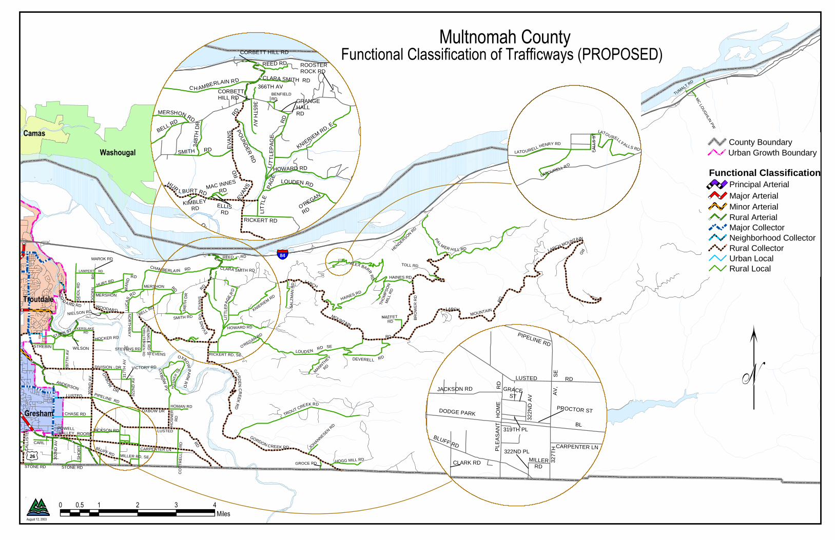
3.0 Functional Classifications of Roadways (Designations) The roadways and designations are shown on Figure 1, Multnomah County Functional Classification of Trafficways maps (separated into five districts). The tables in Appendix B list roadway segments in Multnomah County with the functional classification designations in each jurisdiction. The tables in Appendix B include roadways classified as the highest level (i.e., “expressway”) to those classified as minor collectors (“neighborhood;” “community”), but do not generally include local streets. While Multnomah County has jurisdiction over local roadways, these facilities are
OAK ISLAND DR
REED
ER
RD
REED
ER R
D
RD
GILLIHAN RD
WAPATO AV
WAPATO DR
BURLINGTON DR
SKYLINE BLVD
CO
RN
ELI
US
GERMANTOWN RD
GIL
LIH
AN
RD
THOMPSON RD
RD
RD
PASS
RD
SAUV
IE I S
LAND
RD
THOMPSON RD
CORNELL RD
53RD DR
SKYLINE BLVD
SK
YLIN
E B
LVD
REEDER
RD
GILLIHAN RD
KAISER
JOHN
SON
R
D
RO
CK C
RE
EK RD
GILKISON RD
BECK RD
SPRINGVILLE
WATSON RD
MORGAN
LUCY REEDER RD
BR
OO
KS
RD
ELLI
OTT
RD
OLD
ST. H
ELE
NS
RD
RIVERVIEW DR
FERRY R
D
CO
RN
ELIU
S
PA
SS R
D
MC
NA
ME
E R
D
ROCKY POINT RDOAK ISLAND DR
LOGIE TRAIL R
D
LAIDLAW
NEW
BERR
Y RD
OLD GERMANTOWN RD
MO
RELA
ND R
D
PEDERSON RDCHARLTON RD
QU
AR
RY
RD
THOMPSON RD
SHELTERED NOOK RD
BURLINGTON CT
MUNSON RD
OLD
CORNELIUS
PASS RD HARBORTON DR
HOWELL PARK RD
MC DANIEL RD
OLDCORNELIUS
PASS RD
LOWER ROCKY POINT
RD
GILLIH
AN
(LOOP)
RD
Multnomah CountyMultnomah CountyFunctional Classification of Trafficways (PROPOSED)Functional Classification of Trafficways (PROPOSED)
Portland
Vancouver
County Boundary
Urban Growth Boundary
Functional Classification
Principal Arterial
Major Arterial
Minor Arterial
Rural Arterial
Major Collector
Neighborhood Collector
Rural Collector
Urban Local
Rural Local
August 12, 2003
0 1 2 3 40.5Miles

OAK ISLAND DR
REED
ER
RD
REED
ER R
D
RD
GILLIHAN RD
WAPATO AV
WAPATO DR
BURLINGTON DR
SKYLINE BLVD
CO
RN
ELI
US
GERMANTOWN RD
GIL
LIH
AN
RD
THOMPSON RD
RD
RD
PASS
RD
SAUV
IE IS
LAND
RD
THOMPSON RD
CORNELL RD
53RD DR
SKYLINE BLVD
SK
YLIN
E B
LVD
REEDER
RD
GILLIHAN RD
KAISER
JOHN
SON
R
D
RO
CK C
RE
EK RD
GILKISON RD
BECK RD
SPRINGVILLE
WATSON RD
MORGAN
LUCY REEDER RD
BR
OO
KS
RD
ELLI
OTT
RD
OLD
ST. H
ELE
NS
RD
RIVERVIEW DR
FERRY R
D
CO
RN
ELIU
S
PA
SS R
D
MC
NA
ME
E R
D
ROCKY POINT RDOAK ISLAND DR
LOGIE TRAIL R
D
LAIDLAW
NEW
BERR
Y RD
OLD GERMANTOWN RD
MO
RELA
ND R
D
PEDERSON RDCHARLTON RD
QU
AR
RY
RD
THOMPSON RD
SHELTERED NOOK RD
BURLINGTON CT
MUNSON RD
OLD
CORNELIUS
PASS RD HARBORTON DR
HOWELL PARK RD
MC DANIEL RD
OLDCORNELIUS
PASS RD
LOWER ROCKY POINT
RD
GILLIH
AN
(LOOP)
RD
Multnomah CountyMultnomah CountyFunctional Classification of TrafficwaysFunctional Classification of Trafficways
Portland
Vancouver
County Boundary
Urban Growth Boundary
Functional Classification
Principal Arterial
Major Arterial
Minor Arterial
Rural Arterial
Major Collector
Neighborhood Collector
Rural Collector
Urban Local
Rural Local
July 18, 2003
0 1 2 3 40.5Miles

THOMPS ON 53RD DR
SKYLINE BL
53RD DRCORNELL RD
GREEN
LEAF R
D
SK
YL
IN
E B L
MIL
LER RD
THOMPS ON RD
TERWILLIG
ER
MILITARY
CORNELL RD
CORNELL RD
5
I84
26
I5-I405
I84-I5
I5
I5
I5
DIVISION
POWELL
39T
H
HOLGATE
17TH
52N
D
BARBUR
12T
H
72N
D
I405
YEON
CA
PIT
OL
42N
D
BELMONT
11T
H
FLAVEL
35T
H
45T
H
WOODSTOCKMC
LOU
GH
LIN
NAITO50T
H
60T
H
76T
H
VIS
TA
CU
LLY
DO
SC
H
23R
D
19TH
18TH
VERMONT
STEELE
21S
T
MULTNOMAH
TERWILLIG
ER
PRESCOTT
BR
OA
DW
AY
MILW
AU
KIE
WEIDLER
SH
ATT
UC
K
13T
H
57T
H
RIV
ER
SID
E
SUNSET
T AY
LORS FER RY
LOVEJOY
WASHINGTONCLAY
NICOLAI
MORRISON
20T
H
MA
RT
IN L
UT
HE
R K
ING
JR
BO
ON
ES FE
RR
Y
K
E RR
GOING
H UMPHREY
62N
D
LLOYD
BEAVERTON HILLSDALE
GR
AN
D
FRONT
STEPHENSON
INTE
RS
TATE
BE
RTH
A
I5 F
WY
-I84
FWY
HARNEY
VAUGHN
MAC
ADA
M
49T
H
CAMERON
CLATSOP
LES
SE
R
HWY 30
TH
ORBURN
61S
T
ROSS ISLAND
ALDER
TE NINO
I205 FW Y-I84 FW
Y
MADISON
28T
H
SELLWOOD
I405 FWY-I5 FW
Y
HAWTHORNE
FREMONT
STARK
TAYLORS FERRY
20T
H
82N
D
SKYLINE
60T
H
PRESCOTT
21S
T
BROADWAY
33R
D
13TH
BURNSIDE
21S
T
SU
NSET
62N
D
17T
H
FLAVEL
I40
5
SKYL IN
E
HALSEY
HE
WE
TT
BL
64TH PL
SCHOLLS F
ER
RY
RD
57T
H A
V
WESTDALE DR
57T
H A
V
DOWNSVIEW
CT
55T
H D
R
PL
50TH
AV
SH
AT
TU
CK
RD
48T
H
PL
WINDSOR CTWINDSOR CT
26
BUCHAREST CT
WOODS CT
CANYON CT
HIGHLAND RD
61ST DR
SCHOLLS FERRY CT GROVER CT
MAX
SUNSET
PATTON
CAN YON
HEWE T T
H UMPHREY
61ST
BARNES
SK
YLINE
FAIRVIEW
47TH
RAAB
57T
H
DOSCH
JERALD
BR
AY
52
ND
TH OMAS
FIS
CH
ER
ZOO
55
TH
BURNSIDE
KNIGH
T
44T
H
41S
T
U PLAN
D
50T
H
58T
H
MILL
43R
D
45TH
TUNNEL WOOD
SA LMON
48 T H
HIG HLAND
FAI RH
A
VEN
54TH
K ING
ST ON
TAYLOR
G R EENLEAF
ELM
HILLTOP
LOWELL
36T
H
G
RE ENHILLS
LYLE
BANCROFT
40T
H
BU
RTON
WEST DA
LE
OR
M
A N DY
D OW
NS VIEW
MAIN
WESTGATE
60T
H
HILLSIDE
H
UMPHREY PARK
G ROVER
TALBOT
SH E RIDAN
A RTHUR
CA
SCADE
LABER
WYN DHAM
64TH
63R
D
YAMHILL
SWEETBRIAR
WOO DS
AR
BORETUM
SANTA MONICA
PAR
KV
IEW
UNNAMED
ME ADE
54
TH
58T
H
44T
H
BUR N S IDE
HILLSI DE
SWEETBRIAR
57T
H
60T
H
48TH
UN
NAMED
55TH
36T
H
58T
H
64TH
52N
D
55T
H
HIGH
LAN
D
48T
H
SUNSET
W OODS
BURNSIDE
60T
HRADCLIFF RD
GREE N WOOD
TRYON HILL RD
IRON MO
UNTA
IN B
L
RD
RD
MIL
ITA
RY
R
D MIL
ITA
RY RD
RIV
ERWOOD RD
IRO
N M
OU
NT
AIN
BL
RADCLIFF RD
PALATINE
HILL R D
MILITARY RD, S
W
TE
RW
ILLIGE
R B
L
ED
GE
CL
IFF
R
D
BR
EY
MA
NRIVERDALE RD
TERWILLIG
ER BL
MILITA
RY
RIDGE
TR
YO
N
SO
UTH
RID
GE
MO
AP
A
CAREY
CO
LLINA
HE
DLU
ND
MAUS
FIEL
DIN
G
PALATER
ELY
SIU
M
RIVERSIDE
POWERS
HO
OD
RIV
ER
SID
E
COMUS
BUDDINGTON
HALF STREET
EAST
43
Portland
Portland
Portland
Milwaukie
Milwaukie
Lake Oswego
Lake Oswego
Multnomah CountyMultnomah CountyFunctional Classification of Trafficways (PROPOSED)Functional Classification of Trafficways (PROPOSED)
0 1 20.5Miles
August 12, 2003
County Boundary
Urban Growth Boundary
Functional Classification
Principal Arterial
Major Arterial
Minor Arterial
Rural Arterial
Major Collector
Neighborhood Collector
Rural Collector
Urban Local
Rural Local

THOMPS ON 53RD DR
SKYLINE B L
53RD DRCORNELL RD
GREEN
LEAF R
D
SK
YL
IN
E B L
MIL
LER
RD
THOMPS ON RD
TERWILLIG
ER
MILITARY
CORNELL RD
CORNELL RD
5
I84
26
I5-I405
I84-I5
I5
I5
I5
DIVISION
POWELL
39T
H
HOLGATE
17TH
52N
D
BARBUR
12T
H
72N
D
I405
YEON
CA
PIT
OL
42N
D
BELMONT
11T
H
FLAVEL
35T
H
45T
H
WOODSTOCKMC
LOU
GH
LIN
NAITO50T
H
60T
H
76T
H
VIS
TA
CU
LLY
DO
SC
H
23R
D
19TH
18TH
VERMONT
STEELE
21S
T
MULTNOMAH
TERWILLIG
ER
PRESCOTT
BR
OA
DW
AY
MILW
AU
KIE
WEIDLER
SH
ATT
UC
K
13T
H
57T
H
RIV
ER
SID
E
SUNSET
T AY
LORS FER RY
LOVEJOY
WASHINGTONCLAY
NICOLAI
MORRISON
20T
H
MA
RT
IN L
UT
HE
R K
ING
JR
BO
ON
ES FE
RR
Y
K
E RR
GOING
HUMPHREY
62N
D
LLOYD
BEAVERTON HILLSDALE
GR
AN
D
FRONT
STEPHENSON
INTE
RS
TATE
BE
RTH
A
I5 F
WY
-I84
FWY
HARNEY
VAUGHN
MAC
ADAM
49T
H
CAMERON
CLATSOP
LES
SE
R
HWY 30
TH
ORBURN
61S
T
ROSS ISLAND
ALDER
TENINO
I205 FW Y-I84 FW
Y
MADISON
28T
H
SELLWOOD
I405 FWY-I5 FW
Y
HAWTHORNE
FREMONT
STARK
TAYLORS FERRY
20T
H
82N
D
SKYLINE
60T
H
PRESCOTT
21S
T
BROADWAY
33R
D
13TH
BURNSIDE
21S
T
SU
NSET
62N
D
17T
H
FLAVEL
I40
5
SKYL IN
E
HALSEY
HE
WE
TT
BL
64TH PL
SCHOLLS F
ER
RY
RD
57T
H A
V
WESTDALE DR
57T
H A
V
DOWNSVIEW
CT
55T
H D
R
PL
50TH
AV
SH
AT
TU
CK
RD
48TH
P
L
WINDSOR CTWINDSOR CT
26
BUCHAREST CT
WOODS CT
CANYON CT
HIGHLAND RD
61ST DR
SCHOLLS FERRY CT GROVER CT
MAX
SUNSET
PATTON
CAN YON
HEWE T T
H UMPHREY
61ST
BARNES
SK
YLINE
FAIRVIEW
5
5TH
47TH
RAAB
57T
H
DOSCH
JERALD
BR
AY
52
ND
TH OMAS
FIS
CH
ER
ZOO
KNIGH
T
44T
H
41S
T
U PLAN
D
50T
H
BURNSIDE
MILL
58T
H 43R
D
45TH
TUNNEL WOOD
SA LMON
48 T H
HIG HLAND
FAI RH
A
VEN
54TH
K
ING
ST ON
TAYLOR
G R E ENLEAF
ELM
HILLTOP
LOWELL
36T
H
G
REENHILLS
LYLE
BANCROFT
40T
H
BU
RTON
WEST DA
LE
OR
M
A N DY
D OW
NS VIEW
MAIN
WESTGATE
60T
H
HILLSIDE
H
UMPHREY PARK
G ROVER
TALBOT
SH E RIDAN
A RTHUR
CA
SCADE
LABER
WYN DHAM
64TH
YAMHILL
SWEETBRIAR
WOO DS
AR
BORETUM
63
RD
SANTA MONICA
PAR
KV
IEW
UNNAMED
ME ADE
UN
NAMED
55TH
58T
H
48T
H
BURNSIDE
57T
H
BUR N SIDE
HILLS I DE
48TH
52N
D
60T
H
54TH
SWEETBRIAR
58T
H
55T
H
W OODS
SUNSET
60T
H
44TH
64TH
HIGH
LAN
D
36T
H
RADCLIFF RD
GREE N WOOD
TRYON HILL RD
IRON M
OUN
TAIN B
L
RD
RD
MIL
ITA
RY
R
D MIL
ITA
RY RD
RI V
ERWOOD RD
IRO
N M
OU
NT
AIN
BL
RADCLIFF RD
PALATINE
HILL R D
MILITARY RD, S
W
TE
RW
ILLIGE
R B
L
ED
GE
CL
IFF
R
D
BR
EY
MA
NRIVERDALE RD
TERWILLIG
ER BL
MILITA
RY
RIDGE
TR
YO
N
SO
UTH
RID
GE
MO
AP
A
CAREY
CO
LLINA
HE
DLU
ND
MAUS
FIEL
DING
PALATER
ELY
SIU
M
RIVERSIDE
POWERS
HO
OD
RIV
ER
SID
E
COMUS
BUDDINGTON
HALF STREET
EAST
43
Portland
Portland
Portland
Milwaukie
Milwaukie
Lake Oswego
Lake Oswego
Multnomah CountyMultnomah CountyFunctional Classification of TrafficwaysFunctional Classification of Trafficways
0 1 20.5Miles
County Boundary
Urban Growth Boundary
Functional Classification
Principal Arterial
Major Arterial
Minor Arterial
Rural Arterial
Major Collector
Neighborhood Collector
Rural Collector
Urban Local
Rural Local
July 18, 2003

SU
ND
IAL
RDIN
TERLA
CHEN LN
MARINE DR MARINE DRE.B. RAMP
MARINE DRW.B. RAMP
BLU
EL AKE RD
BLUE LAKE LOOP
AIR
PO
RT
WY
STARK ST
HIG
HLAND DR
174TH AV
JENNE LN
RO
DLU
N R
D
BUTLER RD
FOS
TER
HALSEY ST
GLISAN ST CHERRY PARK
TR
OU
TD
AL E
RD
MARIN E DR
SA NDY BL
RICHEY RD
RD
257T
H
AV
/ K
AN
E D
R
PO WELL VALLEY RD
BURNSIDE
RD BRIAR
RD
COCHRANERD
282ND DR
DIVISION/TROUTDALE
LP
238TH DR
HALSEY ST
ORIENT DR
SH
OR
TR
D
ANDERSON STATE RD
223RD
AV
242N
D D
R (
HO
GA
N
RD
)
181S
T A
V
LAMPERT RD
WOODARD RD
SE
IDL
RD
OG
DE
N R
D
HURT RD
MERSHON
WAND
WAND
W
IL SONHOCKERT RD
VICTORY
KERSLAKE RD
RUGG RD
262N
D
CALLISTER RD
267T
H A
V26
7TH
AV
282N
D A
V
CARL ST
172N
D A
V
JACKSON RD
PIPELINE RD
LUSTED RD
BL UFF RD
CLA
RK
RD
PLE
AS
AN
T H
OM
E
84
205
MARINE
GLISAN
HALSEY
FOSTER
92N
D
148T
H
162N
D
HO
GA
N
POWELL
302N
DKA
NE
AIRPORT
72N
D
136T
H
OR
IEN
T
HW
Y 26
MA
IN
111T
H
PA
LMB
LAD
PALMQUIST
CLATSOP
223R
D
112T
H11
1TH
STARK ST
GLISAN ST
BURNSIDE RD, E
HALSEY ST
DIVISION ST
OR
IENT D
R
223R
D A
V
202N
D A
V, S
E
242N
D D
R
(H
OG
AN
RD
)
182N
D A
V, S
E18
1ST
A
V
190T
H
DR
209T
H A
V
162N
D
A
V
201S
T A
V
TELFOR
D R
D
CHASE RD
DIVISION DR
207TH
AV
LUSTED RD
STONE RD
ARATA RD
252N
D A
V
SWEET
JEN
NE
R
D
RE
GN
ER
RD
CHELDELIN RD
STREBIN
DODGE PARK BL
BU
XT
ON
ST
BAXTER RD
MC KINLEY RD
SANDY BL
282N
D
AV
112TH
AV
162ND AV
CLATSOP ST
STONE RD
STARK ST
182N
D A
V
DIVISION ST
BUR
NSID
E RD
257T
H A
V /
KA
NE
DR
257T
H A
VK
AN
E D
R
TR
OU
TD
ALE
RD
EA
STM
AN
PK
238TH DR
HISTORIC COLUMBIA HY
287T
H A
V
262N
D A
V
GEISE RD POWELL VALLEY RD
CHERRY PARK
ROORK RD
244T
H A
V
170TH AV
ANDERSON, W.K. RD
MC NUTT RD
BARBARA WELCH RD
JEANETTE STMT SCOTT BL SE
ELSA ST
216TH AV
BARR RD
CRYSTAL SPRINGS BL
CLATSOP ST
164T
H A
V
174T
H A
V
CIRCLE AV
242ND DR EXTENSION
168T
H A
V, S
E16
6TH
PL
162N
D A
V
Portland
Gresham
Troutdale
Fairview
Wood Village
0 1 20.5Miles
HA
LF S
T W
ES
T
DIVISION D
R
Multnomah CountyMultnomah CountyFunctional Classification of Trafficways (PROPOSED)Functional Classification of Trafficways (PROPOSED)
26
August 12, 2003
County Boundary
Urban Growth Boundary
Functional Classification
Principal Arterial
Major Arterial
Minor Arterial
Rural Arterial
Major Collector
Neighborhood Collector
Rural Collector
Urban Local
Rural Local
SU
ND
IAL
RDIN
TERLA
CHEN LN
MARINE DR MARINE DRE.B. RAMP
MARINE DRW.B. RAMP
BLU
EL AKE RD
BLUE LAKE LOOP
AIR
PO
RT
WY
STARK ST
HIG
HLAND DR
174TH AV
JENNE LN
RO
DLUN R
D
BUTLER RD
FO
S
TER
HALSEY ST
GLISAN ST CHERRY PARK
TR
OU
TD
AL E
RD
MARIN E DR
SA NDY BL
RICHEY RD
RD
257T
H
AV
/ K
AN
E D
R
PO WELL VALLEY RD
BURNSIDE
RD BRIAR
RD
COCHRANERD
282ND DR
DIVISION/TROUTDALE
LP
238TH DR
HALSEY ST
ORIENT DR
SH
OR
TR
D
ANDERSON STATE RD
223RD
AV
242N
D D
R (
HO
GA
N
RD
)
181S
T A
V
LAMPERT RD
WOODARD RD
SE
IDL
RD
OG
DE
N R
D
HURT RD
MERSHON
WAND
WAND
W
IL SONHOCKERT RD
VICTORY
KERSLAKE RD
RUGG RD
262N
D
CALLISTER RD
267T
H A
V26
7TH
AV
282N
D A
V
CARL ST
172N
D A
V
JACKSON RD
PIPELINE RD
LUSTED RD
BL UFF RD
CLA
RK
RD
PLE
AS
AN
T H
OM
E
84
205
MARINE
GLISAN
HALSEY
FOSTER
92N
D
148T
H
162N
D
HO
GA
N
POWELL
302N
DKA
NE
AIRPORT
72N
D
136T
H
PRESCOTT
OR
IEN
T
HW
Y 26
MA
IN
111T
H
PA
LMB
LAD
PALMQUIST
CLATSOP
223R
D
112T
H11
1TH
STARK ST
GLISAN ST
BURNSIDE RD, E
HALSEY ST
DIVISION ST
OR
IENT D
R
223R
D A
V
202N
D A
V, S
E
242N
D D
R
(H
OG
AN
RD
)
182N
D A
V, S
E18
1ST
A
V
190T
H
DR
209T
H A
V
162N
D
A
V
201S
T A
V
TELFOR
D R
D
CHASE RD
DIVISION DR
207TH A
V
LUSTED RD
STONE RD
ARATA RD
252N
D A
V
SWEET
JEN
NE
R
D
RE
GN
ER
RD
CHELDELIN RD
STREBIN
DODGE PARK BL
BU
XT
ON
ST
BAXTER RD
MC KINLEY RD
SANDY BL
282N
D
AV
112TH
AV
162ND AV
CLATSOP ST
STONE RD
STARK ST
182N
D A
V
DIVISION ST
BUR
NSID
E RD
257T
H A
V /
KA
NE
DR
257T
H A
VK
AN
E D
R
TR
OU
TD
ALE
RD
EA
STM
AN
PK
238TH DR
HISTORIC COLUMBIA HY
287T
H A
V
262N
D A
V
GEISE RD POWELL VALLEY RD
CHERRY PARK
ROORK RD
244T
H A
V
170TH AV
ANDERSON, W.K. RD
MC NUTT RD
BARBARA WELCH RD
JEANETTE STMT SCOTT BL SE
ELSA ST
216TH AV
BARR RD
CRYSTAL SPRINGS BL
CLATSOP ST
164T
H A
V
174T
H A
V
CIRCLE AV
242ND DR EXTENSION
168T
H A
V, S
E16
6TH
PL
162N
D A
V
Portland
Gresham
Troutdale
Fairview
Wood Village
0 1 20.5Miles
DIV
ISION DR
Multnomah CountyMultnomah CountyFunctional Classification of TrafficwaysFunctional Classification of Trafficways
26
July 18, 2003
County Boundary
Urban Growth Boundary
Functional Classification
Principal Arterial
Major Arterial
Minor Arterial
Rural Arterial
Major Collector
Neighborhood Collector
Rural Collector
Urban Local
Rural Local
WO
O
D A RD RD WOODAR D
WA
ND
RD
LUC
AS
RD
CHAMBERLA IN RD
RD RDEV
AN
S R
D
GORDON CREEK RD
TROUT CREEK RD
OXBOW
PA
RK
RD
HO
SN
ER
TR
OX
BO
W P
Y
OXB
OW
DR
OXBOW DR
CH
RIS
TE
NS
EN
RD
PA
LMER HILL RD
HAINES RD
ALEX BARR R
D
DEVERELL RD
RD
LIT
TLE
PA
GE
RD
CLARA SMITH RD
MERSHON
LOUD EN RD SE
26
84
302N
D A
V
CHASE RD
ANDERSON
LUSTED
CARL
STONE RD STONE RD
SH
OR
T
JACKSON RDROORK
POWELL VALLEY
CA
LLIS
TE
R
WILSON
287T
H A
V
STREBIN
LUSTED
302N
D A
V
TOLL RD
HAINES RD
BR
OW
ER
RD
MERSHON
EV
AN
S
BELL RD KNIERIEM RD
BLUFF RD
PIPELINE RD
SE
IDL
RD
SMITH RD
HOWARD RD
CARPENTER LN
HURT RD
CO
TT
RE
LL
R
D
OG
DE
N
R
D
RICKERT RD, SE
DIVISION DR
HOGG MILL RD
LAMPERT RD
348T
H D
R
SA
LZM
AN
RD
KERSLAKE RD
REED RD
HE
NK
LE
RD
STARK ST
TUMALT RD
HOMAN RD
HO
SN
ER
RD
NO
RT
HW
AY
MANNTHEY
RD
HOCKER RD
THO
MP
SO
NM
ILL
RD
HENDERSON RD
317T
H A
V
MAFFET RD
NIELSON RD
JOHANNESEN R
D
GROCE RD
VICTORY RD
MILLER RD, SE
O'REGAN RD
322N
D A
V
STEVENSSTEVENS RD
MC
LOU
GH
LIN P
W
MAROK RD
C H AMBERLAIN RD
RD
EVAN
S
RD
CORBETT HILL RD
MERSHON RD
GRANGEHALL RD
LIT
TLE
PA
GE
RD
LIT
TLE
P
AG
E
HURL BURT RD
BENFIELD RD
SMITH RD
RICKERT RD
365TH
AV
HE
NK
LE R
D, S
E
CLARA SMITH RD
LOUDEN RD, SE
EV
AN
SBELL RD
KNIERIEM RD, E
HOWARD RD
PO
UN
DE
R R
D
348T
H D
R
OX
BOW
PAR
K R
D, SE
REED RD
HO
SN
ER
TR
, SE
CORBETT HILL RD
ELLIS RD
366TH AV
O'REGAN
RD
MAC INNES
RD
STEVENS RD, SE
STEVENS RD, SE
KIMBLEYRD
BENFIELD RD, NE
ROOSTERROCK RD
521
539
431
502502
0 1 2 3 40.5Miles
LOUDEN RD
LARCHMOUNTAIN
RD
LARCH MOUNTAIN
RD
LARCH
MOUNTAIN
RD
LATOURELL FALLS RDFA
LLS
ST
LATOURELL HENRY RD
GO
RD
EN
CR
EE
K R
D
LATOURELL R D
BL
452
468
428
LUSTED RD
327
TH
A
V,
SE
DODGE PARK
302
ND
AV
, SE
JACKSON RD
OXBOW DR, SE
CARPENTER LN
BLUFF RD
PL
EA
SA
NT
H
OM
E
RD
PIPELINE RD
PROCTOR ST
CLARK RD
GRACE ST
MILLERRD
322
ND
AV
322ND PL
319TH PL
Troutdale
Gresham
Washougal
Camas
Multnomah CountyMultnomah CountyFunctional Classification of Trafficways (PROPOSED)Functional Classification of Trafficways (PROPOSED)
County BoundaryUrban Growth Boundary
Functional ClassificationPrincipal ArterialMajor ArterialMinor ArterialRural ArterialMajor CollectorNeighborhood CollectorRural CollectorUrban LocalRural Local
August 12, 2003
WO
O
D A RD RD WOODAR D
WA
ND
RD
LUC
AS
RD
CHAMBERLA IN RD
RD RDEV
AN
S R
D
GORDON CREEK RD
TROUT CREEK RD
OXBOW
PA
RK
RD
HO
SN
ER
TR
OX
BO
W P
Y
OXB
OW
DR
OXBOW DR
CH
RIS
TE
NS
EN
RD
PA
LMER HILL RD
HAINES RD
ALEX BARR R
D
DEVERELL RD
RD
LIT
TLE
PA
GE
RD
CLARA SMITH RD
MERSHON
LOUD EN RD SE
26
84
302N
D A
V
CHASE RD
ANDERSON
LUSTED
CARL
STONE RD STONE RD
SH
OR
T
JACKSON RDROORK
POWELL VALLEY
CA
LLIS
TE
R
WILSON
287T
H A
V
STREBIN
LUSTED
302N
D A
V
TOLL RD
HAINES RD
BR
OW
ER
RD
MERSHON
EV
AN
S
BELL RD KNIERIEM RD
BLUFF RD
PIPELINE RD
SE
IDL
RD
SMITH RD
HOWARD RD
CARPENTER LN
HURT RD
CO
TT
RE
LL
R
D
OG
DE
N
R
D
RICKERT RD, SE
DIVISION DR
HOGG MILL RD
LAMPERT RD
348T
H D
R
SA
LZM
AN
RD
KERSLAKE RD
REED RD
HE
NK
LE
RD
STARK ST
TUMALT RD
HOMAN RD
HO
SN
ER
RD
NO
RT
HW
AY
MANNTHEY
RD
HOCKER RD
THO
MP
SO
NM
ILL
RD
HENDERSON RD
317T
H A
V
MAFFET RD
NIELSON RD
JOHANNESEN R
D
GROCE RD
VICTORY RD
MILLER RD, SE
O'REGAN RD
322N
D A
V
STEVENSSTEVENS RD
MC
LOU
GH
LIN P
W
MAROK RD
C H AMBERLAIN R D
RD
EVAN
S
RD
CORBETT HILL RD
MERSHON RD
GRANGEHALL RD
LIT
TLE
PA
GE
RD
LIT
TLE
P
AG
E
HURL BURT RD
BENFIELD RD
SMITH RD
RICKERT RD
365TH
AV
CLARA SMITH RD
LOUDEN RD, SE
EV
AN
SBELL RD
KNIERIEM RD, E
HOWARD RD
PO
UN
DE
R R
D
348T
H D
R
OX
BOW
PAR
K R
D, SE
REED RD
HO
SN
ER
TR
, SE
CORBETT HILL RD
ELLIS RD
366TH AV
O'REGAN
RD
MAC INNES
RD
STEVENS RD, SE
STEVENS RD, SE
KIMBLEYRD
ROOSTERROCK RD
521
539
502502
0 1 2 3 40.5Miles
LOUDEN RD
LARCHMOUNTAIN
RD
LARCH MOUNTAIN
RD
LARCH
MOUNTAIN
RD
LATOU RELL FALLS RDFA
LLS
ST
LATOURELL HENRY RD
GO
RD
EN
CR
EE
K R
D
LATOURELL R D
BL
452
428
LUSTED RD
327
TH
A
V,
SE
DODGE PARK
302
ND
AV
, SE
JACKSON RD
OXBOW DR, SE
CARPENTER LN
BLUFF RD
PL
EA
SA
NT
H
OM
E
RD
PIPELINE RD
PROCTOR ST
CLARK RD
GRACE ST
MILLERRD
322
ND
AV
322ND PL
319TH PL
Troutdale
Gresham
Washougal
Camas
Multnomah CountyMultnomah CountyFunctional Classification of TrafficwaysFunctional Classification of Trafficways
County BoundaryUrban Growth Boundary
Functional ClassificationPrincipal ArterialMajor ArterialMinor ArterialRural ArterialMajor CollectorNeighborhood CollectorRural CollectorUrban LocalRural Local
July 18, 2003

Functional Classification of Trafficways
Findings and Recommendations Technical Report 5 October 2003
generally located in rural portions of the County, where no other jurisdiction applies a classification. One exception is Clatsop Street/Cheldelin Road, which the Pleasant Valley Concept Plan classifies as minor arterial. The other exception is Bluff Road, which needs to be reclassified from local street to rural collector. The first table shows east Multnomah County; the second table shows west Multnomah County. The roadways are broken down into segments, as necessary, in order to capture all the classification changes through the jurisdictions. Where roadways have multiple names or numbers, all those given for that segment are given, separated by slashes (/). Roadways are for existing alignments, unless listed as “proposed.” All segments in the west side table are outside City of Portland limits. All classifications are urban unless preceded by “rural” (i.e., “minor arterial” refers to an urban road while “rural arterial” refers to a rural road). ODOT classifications are not shown because ODOT’s classifications are not directly comparable with the classifications of Multnomah County and the other jurisdictions (see Appendix F). The County does not designate regional boulevard, community boulevard, regional street, or community street overlays. The County relies on the RTP and local TSPs and other planning documents to identify roadways with these overlay designations. The County does, however, designate scenic routes. The County does not have any design standards for scenic route, but unique design standards may be imposed on scenic routes to preserve and enhance the scenic character of the facility on a case-by-case basis. The following are identified as scenic routes: • Skyline Boulevard (Rocky Point Road to NW McNamee Road) • Skyline Boulevard (Cornell Road to Barnes Road/Burnside Road) • NW Skyline Boulevard (NW Springville Road to New Germantown Road) • NW Thompson Road (NW Skyline Boulevard to NW Cornell Road) • N Marine Drive (NE 185th Ave to NE 223rd Avenue) • Historic Columbia River Highway (I-84 [NE 244th Avenue] to Bonneville Area)
3.1 Comparison Among Jurisdictions Discrepancies between Multnomah County classification of a roadway and another jurisdiction are highlighted in the tables in Appendix B and summarized as follows: Yellow indicates a recommended amendment to the classification, with the recommendation in italics; Blue indicates a discrepancy, but where no amendment is recommended; Green indicates a classification that does not match the County’s preferred street standards, but does fall within the County’s range of acceptable standards; and Pink indicates segments in the Pleasant Valley and Powell-Foster areas whose County classifications will change when the plans are implemented, and whose classifications will be included/updated in the 2003 RTP update.
3.1.1 Pleasant Valley and Other Future Planning Areas The Multnomah County Board of Commissioners has accepted the Pleasant Valley Concept Plan. The County will retain the current rural classifications for the roadways in the plan area (see Figure 2). With the acceptance of the Pleasant Valley Concept Plan, the Board of Commissioners resolved to retain ownership of regional roads. Upon implementation, when the parcels are annexed by the City of Gresham, the County will transfer non-regional roads to the City on amending the IGA. The County will treat roadways in future planning areas such as the Springwater Corridor and Damascus-
Functional Classification of Trafficways
October 2003 6 Findings and Recommendations Technical Report
Boring area in the same manner: the County will update or develop an IGA upon annexation to transfer appropriate roadways. Until future planning areas are annexed, the County shall retain current classifications. The development of the Pleasant Valley area will impact the roadway system in other ways as well. For example, a recommended implementation proposal from the Powell Boulevard/Foster Road Corridor Transportation Plan – Phase I is a new two- or three-lane connector extending 174th Avenue between Jenne Road and Giese Road. Upon construction of this connector, Jenne Road would be reclassified as a local road between Foster Road and the 174th Avenue extension.
3.1.2 Metro There are discrepancies between the County and Metro on some of the road segments. However, it is not recommended that the County amend any of these classifications. Although Metro’s classifications closely match those of the County’s in title and in the description of connectivity (see Section 2.0 and Appendix A for a discussion of functional classification definitions and descriptions), Metro uses Regional Street Design Classifications for street standards (see Section 4.0 and Appendix C), and not the Regional Motor Vehicle Functional Classifications used in appendices A and B. Therefore any discrepancies that would affect street design are covered in the discussion of street standards (Section 4.0 and Appendix C). Several of the arterial and collector-level roadways classified by Multnomah County are not shown in the RTP (for example, the Wood Village Boulevard extension). Multnomah County should work with Metro to add these to the RTP during the next update. There are two segments shown in the RTP as Collector of Regional Significance that should be minor arterial: Sandy Boulevard from 207th Avenue to end, and Stark Street east of Troutdale Road. Stark Street from Kane Road to 257th Avenue, and from 257th Avenue to Troutdale Road should be a major arterial—Metro currently shows these two segments as Collector of Regional Significance. Finally, 181st Avenue from the north boundary to I-84 should be a major arterial; not a minor arterial.
3.1.3 Other Some changes in classification are also recommended to address discrepancies between Multnomah County and other jurisdictions. Burnside Street between 162nd Avenue and 181st Avenue is classified as major collector by Multnomah County and as major arterial by Metro. It is recommended that the City of Gresham evaluate its community designation for this segment. There are three segments that it is recommended the City of Wood Village change from neighborhood collector to major collector: • Wood Village Boulevard from Arata Road to Glisan Street • Arata Road • 244th Avenue from Sandy Boulevard to Halsey Street Likewise, the City of Troutdale should consider changing 242nd Avenue from major arterial to principal arterial. There are no recommended changes for the City of Fairview. The West of Sandy Rural Area Plan recommends that Bluff Road be reclassified from local street to rural collector. Bluff Road serves as on of the two main connections between the Pleasant Home rural community and the City of Sandy (Dodge Park Boulevard is the other connection).
Functional Classification of Trafficways
Findings and Recommendations Technical Report 7 October 2003
Approximately half the traffic on Orient Dr east of Dodge Park Boulevard is to or from Bluff Road. The reclassification would recognize the roadway’s function as a farm-to-market route. No changes are recommended to west side (Portland) roadways (second table in Appendix B). In terms of classifications, Portland’s Regional Trafficway corresponds to the County’s Freeway and Expressway. Portland’s Major City Traffic Street corresponds to the County’s arterial designations. District Collector for Portland is the equivalent of Major Collector for Multnomah County. The County is participating with the City of Portland in the development of a TSP for urban unincorporated areas, pending the award of a TGM grant.
3.2 Recommended Amendments to Multnomah County Functional Classification of Trafficways Map and Database
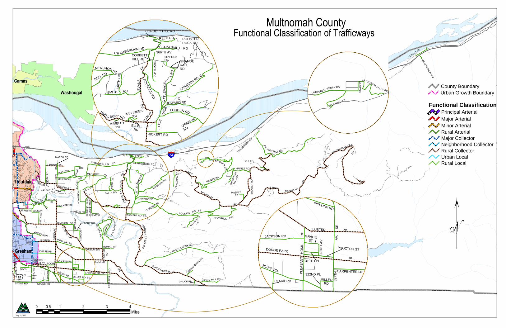
Multnomah County should amend the functional classification of the roadways as shown in Appendix B. As described in the introduction, recommendations for changes to the adopted Multnomah County Functional Classifications of Trafficways map (Figure 1) will be made. In addition, there are several errors on the map that need to be corrected as part of the amendment process. These errors are only in the mapping system. Therefore, only the correct functional classification shows in Appendix B. The corrections are listed in the “Summary of Recommended Amendments” on page i of this report.
4.0 Street Standards The table in Appendix C works in conjunction with the tables in appendices A and B and contains the roadway design standards for each jurisdiction. The table does not include standards for local streets. No column for the City of Troutdale is included, as all arterials and collectors within the city limits are county roads. Troutdale only provides standards for local streets, which are not included in the table in Appendix C. For both Multnomah County and Metro, the preferred standard is shown first, with the acceptable range immediately following in parentheses. Metro has ideal, predominant, functional, and absolute minimum width standards. The Appendix C table uses the predominant width for the preferred standard.
4.1 Comparison among Jurisdictions An analysis of jurisdictional street standards resulted in the identification of two potential types of differences from the Multnomah County standards. The first type is when a jurisdiction’s standards differ from the preferred standards but are within the acceptable range provided by the County. (These differences are shown highlighted in green in the Appendix C table.) The second type of difference is when jurisdictional standards or portions of standards fall outside of Multnomah County’s acceptable range. (These differences are shown highlighted in blue in the table.) Where other jurisdictions’ standards differ from Multnomah County’s preferred standards but still fall within the County’s acceptable range, no change needs to be made to the County standards. The values that do not fall within the range of acceptable County standards indicate a need to re-evaluate the County’s preferred values and acceptable ranges. In particular, the County should strive to meet Metro’s absolute minimum width. The County’s principal and major arterial classifications have similar design standards, but are different in terms of connectivity and access. Likewise, although the County’s minor arterial and
Functional Classification of Trafficways
October 2003 8 Findings and Recommendations Technical Report
major collector standards are very similar, there is a key functional difference in terms of allowed number of access points. Arterials have limited access, while collectors may have more driveways (see Appendix A).
4.2 Recommended Amendments to Multnomah County Design Standards, Part I—Design Manual
The County should amend their design standards to provide the following: • Principal Arterial—allow two turn lanes as needed at intersections • Major Arterial—Increase planter strip width to 7 feet to comply with Metro’s standard • Add the Regional Street Overlay standards • Add the Community Street Overlay standards • Adequate right-of-way at intersections to ensure compliance with the Americans with Disabilities
Act On rural arterials, AASHTO, Metro, and Portland require a median/turn lane, which the County does not require. However, at this time the County will not require the addition of a median/turn lane on its rural roadways. Therefore no amendment to the county standards is recommended. The County and Metro’s median/turn lane widths differ for principal arterials, major arterials, and minor arterials. For Metro’s regional boulevards (major arterial) and community boulevard (minor arterial, major collector) the standard is a 10-foot-wide lane. For principal arterial it is 16 feet. For maintenance and safety reasons, it is not recommended that the County reduce its 12-foot minimum standard for medians/turn lanes. The County needs to amend the Multnomah County Design Standards to adopt Metro’s Regional Street, Community Street, and Green Street overlays. The definitions of Regional and Community Street overlays are included in Policy 34, but the design manual does not include standards for them. The Green Street and Industrial Street overlays currently are not included in Policy 34, but language to add the two overlays is shown in Appendix E.
5.0 Compliance with the Transportation Planning Rule This section has two purposes: (1) to identify areas where Policy 34 does not comply with Oregon Administrative Rules (OAR) 660-012-0000 through 660-012-0070, Department of Land Conservation and Development (DLCD), Division 12, Transportation Planning (“Transportation Planning Rule [TPR]”) and (2) to recommend amendments to Policy 34 to ensure compliance with the TPR. The TPR implements Oregon Statewide Planning Goal 12: Transportation, which is “to provide and encourage a safe, convenient and economic transportation system.” Since the goals and guidelines of Goal 12 provisions are incorporated into the TPR, the Goal is not addressed directly in this memorandum. Both Goal 12 and the TPR define the required elements of TSPs and transportation planning procedures. The TPR establishes the contents of TSPs prepared by regional and local governments, and the process to select transportation projects developed by regional and local governments. The two TPR sections relevant to ensuring Policy 34 compliance are 660-012-0045, Implementation of the TSP and 660-012-0060, Plan and Land Use Regulation Amendments.
Functional Classification of Trafficways
Findings and Recommendations Technical Report 9 October 2003
5.1 Comparison to the Transportation Planning Rule In general, Policy 34 addresses the main principles of the TPR, including access control and coordination with other governments. However, Policy 34 lacks language ensuring adequate accommodation of bicycle and transit facilities. One recommendation to address this deficiency is to integrate Policy 36: Transportation System Development Requirements with Policy 34. Policy 36 deals with elements of the TPR that are included but inadequate in Policy 34, such as access management, bicycle and transit facilities, pedestrian connectivity, and parking. Many recommended amendments to Policy 34 include language that references Policy 36 and other applicable Comprehensive Framework Plan policies, so that Policy 34 will be consistent with the other policies, even if other policies are amended in the future. The table in Appendix D summarizes the relevant TPR subsections and the section of Policy 34 that addresses each issue. The “Comments” column describes elements that Policy 34 is missing. Recommended changes to Policy 34 language are shown in strikethrough (language to be deleted) and double underline (language to be added) in the “Recommended Amendments” column. The Appendix D table is formatted to ensure that all relevant sections of the TPR are included in Policy 34. A basic assumption is that Policy 34 can comply with the TPR even though Policy 34 includes additional policies and strategies that are not mentioned in the TPR, and vice-versa. For example, 660-012-0045(2)(c) of the TPR is not included because it addresses protection of airports, but Policy 34 deals only with trafficways. Other TPR subsections are omitted from the table because they are covered in other Multnomah County Comprehensive Framework Plan policies, particularly the Physical Support Systems Plan policies. However, some TPR requirements should be included in Policy 34 by reference, even if they are covered in other policies (for example, provisions for bicycles).
6.0 Issues for Future Discussion The EMCTC should establish an approach to resolve the following system-wide and segment/intersection-specific issues. Multnomah County should undertake an East Multnomah County Circulation Study that would follow the approach established by EMCTC and would identify solutions. The study should include recommendations for staging improvements and recommendations for coordinating improvements among the affected jurisdictions, and identification of potential funding sources.
6.1 System-Wide Issues Multnomah County should take the following actions in order to ensure that planning and improvements are coordinated with Metro and the local jurisdictions. • Once the Transportation Growth Management (TGM) grant is secured, coordinate with the City
of Portland on preparation of the urban unincorporated areas TSP. • Evaluate application of Metro regional overlays. • Review the cities’ parking standards for consistency with County’s and Metro’s parking design
standards, particularly where on-street parking is acceptable and not acceptable. Metro guidelines allow on-street parking on Regional Boulevards, Community Boulevards and Community Streets. No parking is allowed on freeways, highways, Regional Streets, or Urban or Local roads. Green Street treatments may apply to any of these trafficways.

Functional Classification of Trafficways
October 2003 10 Findings and Recommendations Technical Report
• The Intergovernmental Agreements (IGAs) between the County and local jurisdictions should be reviewed and potentially amended to include language protecting transportation facilities when local plans and regulations are amended, as per the TPR (660-012-0060).
• Create an IGA between the City of Wood Village. There is a Memorandum of Understanding between Multnomah County and Wood Village in effect.
• Work with cities on identifying potential areas to amend their TSPs for greater coordination among the jurisdictions in terms of functional classifications and design standards.
• Any changes recommended to the Multnomah County Comprehensive Framework Plan or Multnomah County Functional Classification of Trafficways map need to comply with the RTP. The RTP is scheduled to be updated in October 2003, after this project is completed. Amendments to the County Framework Plan and map should be evaluated for compliance with the updated RTP once it is released. For example, some of the arterial and collector-level roadways listed in Appendix B are not shown in the RTP (i.e., the Wood Village Boulevard extension). Multnomah County should work with Metro to add these to the RTP during the upcoming update, as discussed in Section 3.1.2.
• The County should continue to work through the inter-agency Intelligent Transportation Systems Subcommittee on Public Safety. The subcommittee coordinates homeland security, emergency evacuation routes, hazardous material routes, and emergency communications. The subcommittee is developing a map of emergency routes.
6.2 Truck Routes Issue. Multnomah County does not have any designated truck routes. The County allows trucks on arterials, with restrictions on particular segments that have insufficient geometric characteristics, such as turning radii. The County and cities cannot restrict trucks on National Highway System (NHS) routes. NHS routes east of Portland are: • I-84/US 30 east to 188th Drive • I-84 from the Union Pacific railroad crossing at NW Dunbar Road to the east County boundary • NE 181st Avenue between I-84 and SE Burnside Street • SE Burnside Street (NW Burnside Road, NE Burnside Road) from NE 181st Avenue to E Powell
Boulevard • US 26 (Mount Hood Highway) from the E Powell Boulevard/SE Powell Valley Road/NE
Burnside Road intersection to the south County boundary • OR 212 between I-205 and US 26 Designated truck routes are shown in the 1999 Oregon Highway Plan. The routes within the project area are the interstate highways (I-5, I-84, I-205, I-405). The City of Gresham and Multnomah County support moving the freight route from 181st/Burnside because there are land use conflicts with truck passage and substandard roadway conditions along Burnside in the Rockwood area. If the 242nd Avenue Connector is constructed, it would serve as the truck route as identified in the RTP. As either an interim or permanent alternative, EMCTC needs to discuss alternatives for consideration, including designating 207th Avenue and 257th Avenue as the NHS route. The region is undertaking a Regional Freight Study that should provide direction concerning regional freight movements through East Multnomah County.
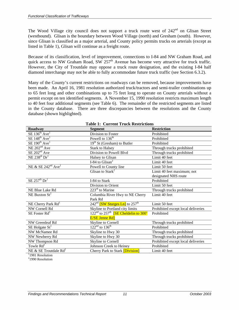
Functional Classification of Trafficways
Findings and Recommendations Technical Report 11 October 2003
The Wood Village city council does not support a truck route west of 242nd on Glisan Street (westbound). Glisan is the boundary between Wood Village (north) and Gresham (south). However, since Glisan is classified as a major arterial, and County policy permits trucks on arterials (except as listed in Table 1), Glisan will continue as a freight route. Because of its classification, level of improvement, connections to I-84 and NW Graham Road, and quick access to NW Graham Road, SW 257th Avenue has become very attractive for truck traffic. However, the City of Troutdale may oppose a truck route designation, and the existing I-84 half diamond interchange may not be able to fully accommodate future truck traffic (see Section 6.3.2). Many of the County’s current restrictions on roadways can be removed, because improvements have been made. An April 16, 1981 resolution authorized truck/tractors and semi-trailer combinations up to 65 feet long and other combinations up to 75 feet long to operate on County arterials without a permit except on ten identified segments. A November 15, 1990 resolution restricts maximum length to 40 feet four additional segments (see Table 6). The remainder of the restricted segments are listed in the County database. There are three discrepancies between the resolutions and the County database (shown highlighted).
Table 1: Current Truck Restrictions Roadway Segment Restriction SE 136th Ave1 Division to Foster Prohibited SE 148th Ave1 Powell to 136th Prohibited SE 190th Ave1 19th St (Gresham) to Butler Prohibited NE 202nd Ave Stark to Halsey Through trucks prohibited SE 202nd Ave Division to Powell Blvd Through trucks prohibited NE 238th Dr1 Halsey to Glisan Limit 40 feet I-84 to Glisan2 Limit 40 feet NE & SE 242nd Ave1 Powell to County line Limit 50 feet Glisan to Stark2 Limit 40 feet maximum; not
designated NHS route SE 257th Dr1 I-84 to Stark Prohibited Division to Orient Limit 50 feet NE Blue Lake Rd 223rd to Marine Through trucks prohibited NE Buxton St2 Columbia River Hwy to NE Cherry
Park Rd Limit 40 feet
NE Cherry Park Rd1 242nd [SW Sturges Ln] to 257th Limit 50 feet NW Cornell Rd Skyline to Portland city limits Prohibited except local deliveries SE Foster Rd1 122nd to 257th [SE Cheldelin to 300’
E/SE Jenne Rd] Prohibited
NW Greenleaf Rd Skyline to Cornell Through trucks prohibited SE Holgate St1 122nd to 136th Prohibited NW McNamee Rd Skyline to Hwy 30 Through trucks prohibited NW Newberry Rd Skyline to Hwy 30 Through trucks prohibited NW Thompson Rd Skyline to Cornell Prohibited except local deliveries Towle Rd1 Johnson Creek to Heiney Prohibited NE & SE Troutdale Rd2 Cherry Park to Stark [Division] Limit 40 feet 11981 Resolution 21990 Resolution

Functional Classification of Trafficways
October 2003 12 Findings and Recommendations Technical Report
The County would like to continue to allow trucks on arterials. The County Commissioners should resolve to lift the restrictions on all segments because of improvements made since the original restricting resolution. One exception is 238th/242nd Avenue between Glisan and Halsey streets, which should remain restricted because of steep grade, narrow right-of-way and tight turns. In addition, there are 11 bridge weight restrictions. All are limited to vehicles of 80,000 pound gross weight or less, except the Sellwood Bridge, Stark Street viaduct, and Corbett Hill viaduct where additional restrictions exist. No changes are recommended to the bridge restrictions. • Sauvie Island Bridge • Burnside Bridge • Morrison Bridge east side approach ramps • Hawthorne Bridge east side approach ramps • Sellwood Bridge • Palmblad Bridge (Johnson Creek) • Beaver Creek Bridge • Stark Street viaduct (Sandy River) • Stark Street Bridge (Sandy River) • Corbett Hill viaduct • Gordon Creek Bridge • Gordon Creek viaduct Future Discussion: The upcoming freight study will address truck routes in the east Multnomah County area. However, EMCTC should make identifying truck routes a priority, because the RTP update which begins in October 2003 will include changes to freight corridor designations as one of three policy issues to be addressed (the other two are boulevard definitions and Special Transportation Areas). In particular, Multnomah County will work through EMCTC to facilitate discussion of truck movements through East Multnomah County. The ultimate goal of this discussion is to identify the NHS route through East Multnomah County. Multnomah County, in conjunction with Metro and the City of Portland, should consider a future I-84 westbound interchange at 122nd Avenue, or another location west of 162nd Avenue. Truck traffic is heavy westbound on Marine Drive, and westbound interchange access on I-84 could alleviate some of the traffic.
6.3 Problematic Roadway Segments/Intersections The following roadway segments and/or intersections have been identified by the TAC as having issues related to functional classification. Resolution is beyond the scope of this project, but the issues and potential future actions are discussed below.
6.3.1 Birdsdale/NE 202nd Avenue Issue. Gresham completed a study to re-align Birdsdale off 202nd Avenue in 1994. An alternative was investigated because the existing truck route (NE 181st Avenue) will not be able to support the future truck traffic. Although the study is outdated and current conditions need to be revisited, the study found that NE 181st Avenue’s current five-lane facility would need two additional travel lanes, which is untenable. In the 1995 roads transfer between the County and cities, the County retained jurisdiction of Birdsdale. Multnomah County classifies Birdsdale as a major collector (preferred

Functional Classification of Trafficways
Findings and Recommendations Technical Report 13 October 2003
standard is 80 feet of right-of-way, including 50 feet of paved width, two to three 12-foot travel lanes, two 6-foot bike lanes, two 6-foot planter strips, and two 6-foot sidewalks). Currently, Birdsdale is a two-lane facility with right-of-way ranging from 40 to 50 feet. Metro classifies it as a collector of regional significance. Gresham classifies it as a collector. There are four logistical and financial obstacles to accommodating trucks on Birdsdale: there are major power lines and a concentration of residences adjacent to the right-of-way, a substandard railroad crossing, and massive Douglas-fir trees within the right-of-way, which the community wishes to protect. The railroad line runs on the south side and parallel to I-84 and crosses just north of NE Thompson Road. In addition, there is no readily available opportunity (i.e., a major land development) at this time to construct a new route. Future Discussion. Multnomah County should undertake a re-alignment study of 202nd, to identify potential short- and long-term solutions for truck movement through the area, including requiring appropriate right-of-way dedication from land development projects. Currently, trucks are prohibited between Stark and Glisan streets and will not be allowed on this section.
6.3.2 SW 257th Avenue/Kane Road Issue. Multnomah County classifies 257th as a major arterial. It is designed to major arterial standards and functions as a major arterial between I-84 and Division Street. However, the segment between Division and Powell Valley Road needs to be improved to major arterial standards. Because of its classification, level of improvement, and connections to I-84 and NW Graham Road, SW 257th Avenue may become a defacto truck route in the future. SW 257th Avenue has become very attractive for truck traffic because it provides quick access to NW Graham Road, an industrial park. It may be designated a truck route in the RTP. However, the City of Troutdale may oppose the designation, and the existing I-84 half diamond interchange may not be able to fully accommodate future truck traffic. Future Discussion. Examine possibility of constructing a full diamond interchange at I-84/SW 257th Avenue or explore other options and redirect truck traffic. One potential option to be evaluated is construction of a southbound connection to Halsey Street from the split-diamond interchange. The regional freight study may determine that the truck traffic on 257th is more local rather than regional in origin.
6.3.3 NE Burnside Road/US 26/SE 242nd Avenue/SE Hogan Road Issue. The main issues with these two intersections are accommodating both future boulevard design implementation and truck use, and reducing the number of accesses. Boulevard design standards provide a safe facility for moderate/heavy volumes of traffic at moderate/high speeds. This design standard is very difficult to achieve due to the numerous access points along US 26 as well as its major truck route use through these intersections. Currently, there are many accessways onto the roadways, more than prescribed by Multnomah County functional classification (Hogan would become a major arterial if the 242nd Avenue connector is built; Burnside is a principal arterial). Future Discussion. Multnomah County can work with the City of Gresham on establishing a plan to decide whether the freight route or boulevard designation is more appropriate, and to reduce the number of accesses, as parcels redevelop.

Functional Classification of Trafficways
October 2003 14 Findings and Recommendations Technical Report
6.3.4 242nd Avenue Connector/NE 238th Drive Issue. The condominium residents along NE 238th Drive (south of Arata Road) have requested that the roadway be blocked and reclassified as a local street. The roadway currently is classified as a minor arterial and has an ADT of 25,000. The 242nd Avenue Connector project has been suspended because the transportation analysis completed for the Environmental Assessment found low demand for the connector in the short-term. In mid to late 1990s, the Troutdale City Council was a major proponent of the project. However, the current Troutdale City Council is not likely to support the project, although it has not passed a resolution in opposition. The Wood Village City Council passed a resolution to not support the project. In addition, the County classifies 238th south of I-84 as a minor arterial. The City of Wood Village is concerned about traffic safety due to the current configuration of this segment of 238th. It is also concerned about bicycle safety. The existing roadway curves do not meet AASHTO urban design standards and two six-foot bike lanes are required. The City of Gresham classifies 242nd north of Burnside as a principal arterial. The street standard is for 120 feet of right-of-way. The City of Wood Village’s concerns about the potential negative traffic and noise impacts on the community are outlined in a December 17, 2001 memorandum. The City of Wood Village is concerned about traffic densities and impacts increasing on an already hazardous NE 238th Drive north of Glisan, and the functional classification differences between Gresham and Wood Village. Future Discussion. Although the County would not construct a barrier to access to NE 238th Drive, alternatives should be evaluated, such as the impacts of a future 242nd Avenue connector. The connector would redirect traffic from NE 238th Drive. The Springwater Corridor study, the freight study, and Gresham’s north-south study will address the regional impacts of the proposed connector and potential alternatives.
6.3.5 238th Drive Extension to Marine Drive Issue. The City of Troutdale evaluated development options for the former Reynolds Aluminum manufacturing site north and west of Graham Road (DKS Associates, Inc., 2002). The report was completed as part of an economic development study. The manufacturing site currently is classified as a superfund site. Although the property is for sale, the owners are not marketing it aggressively. Connections to the site are limited, as the site is bounded by the Columbia River on the north and the Sandy River on the east. The main access is from the I-84/Frontage Road (Marine Drive) interchange. ODOT recently made improvements to the 238th Drive/I-84 interchange that increased its capacity. The major obstacles to the 238th Drive extension identified by DKS Associates, Inc., are acquisition of private property, construction of a new railroad undercrossing, and impacts to environmentally sensitive lands. Marine Drive currently is classified as a major collector. As discussed previously, the County standards for base and asphalt on major collectors are adequate for truck traffic. Future Discussion. Evaluate necessity of constructing 238th Drive extension if development does not occur on the Reynolds Aluminum site. Other options to the 238th Drive extension could include extending 242nd Avenue to Marine Drive. A north-south connection to Marine Drive should be

Functional Classification of Trafficways
Findings and Recommendations Technical Report 15 October 2003
included in the RTP and Troutdale TSP updates. Troutdale has applied for a TGM grant from ODOT to prepare its TSP update.
6.3.6 NE Halsey Street between NW Fairview Avenue and the Historic Columbia River Highway (HCRH)
Issue. The major issue to be addressed is whether Halsey should serve local or through traffic. Wood Village has adopted Halsey Street design standards, which are pedestrian friendly and have raised landscaped medians. The City of Wood Village would like the County to consider the installation of roundabouts at the future Wood Village Boulevard intersection and the existing NE 244th Avenue intersection as traffic calming measures. Within its city limits, the City of Wood Village would like to construct two parking lanes, where feasible. In addition, Fairview has Halsey Street identified with boulevard type treatments (although does not have a boulevard overlay). On the other hand, Halsey Street currently connects three town centers, the McMenamins Edgefield in Troutdale, and the Greyhound Park. This creates a conflict with the County’s Capital Improvements Project (CIP) list, which identifies Halsey Street as a major arterial to provide a better connection to Fairview Village. Future Discussion. If Halsey Street is downgraded to a local street, will parallel routes have adequate capacity to serve the additional traffic? If it is determined that Halsey should have a boulevard overlay, the boulevard designation should be incorporated into the RTP update. The County has applied for a TGM grant to do a design charrette on Halsey Street. If constructed, the 242nd Avenue connector would provide access from south and north to NE Halsey Street on the east boundary of Wood Village, and would allow NE 238th Drive to provide only local access. Once a decision has been reached for the treatment of Halsey Street, it should be included in the RTP, the County’s CIP, the Wood Village TSP, and the Fairview TSP.
6.3.7 Pleasant Valley Issue. The access roads into the area on the north and west (SE Foster Road, SE 162nd Avenue, SE 190th Drive, SE 174th Avenue, SE McKinley Road) are already congested. The existing congestion, combined with the policy of following Metro’s green streets guidelines, mean that the design for the area roadways is constrained. Constructing the roadways to Multnomah County standards for number and width of vehicle travel lanes may not be possible. Future Discussion. The Pleasant Valley concept plan has been accepted by all jurisdictions. The Powell-Foster study will address gateway road possibilities. Multnomah County, the City of Gresham, the City of Portland, and Metro may jointly evaluate alternatives to ease congestion on access roads on the outskirts of Pleasant Valley and establish standards that will meet area transportation needs, Metro design guidelines, and County standards.
7.0 References
7.1 Documents American Association of State Highway and Transportation Officials (AASHTO). 2001. “A Policy
on Geometric Design of Highways and Streets.” Fourth Edition.

Functional Classification of Trafficways
October 2003 16 Findings and Recommendations Technical Report
Bernstein, Robert, P.E., J.K. McFarland Transportation Planning Services, and David Kline & Associates. 1995 (June). “Multnomah County Urban Roads Functional Classification Study: Technical Study Report.”
DKS Associates, Inc. 2002 (February). “Transportation Concept System Planning Study: Troutdale
Science and Technology Park.” _____. 2001 (September). “City of Wood Village Transportation System Plan Roadway Element
Final Report.” _____. 2000 (August 8; “June 1999” on cover). “Fairview Transportation System Plan.” _____. 1995 (December 12). “Troutdale Transportation System Plan.” Gresham, City of, Transportation Planning. 2002. “Transportation System Plan.” Metro. 2002a (June). “Creating Livable Streets: Street Design Guidelines for 2040.” Second
edition. _____. 200b (June). “Green Streets: Innovative Solutions for Stormwater and Stream Crossings.”
First edition. _____. 2000b (August 10). “2000 Regional Transportation Plan.” Multnomah County. No date. Multnomah County Design Standards. Part I – Design Manual. Multnomah County, Board of County Commissioners. 1990 (November 15). Order No. 90-191. _____. 1981 (April 16). Resolution. Oregon Department of Transportation. 2002. “Metric Highway Design Manual.” _____, Transportation Development Division, Planning Section. 1999 (March 18). “1999 Oregon
Highway Plan: An Element of the Oregon Transportation Plan.” Pleasant Valley Project Partners. 2002 (July). “Pleasant Valley Concept Plan: Implementation
Strategies.” Portland, City of, Office of Transportation. 2002 (Adopted October 30; Effective December 14).
“Transportation System Plan: Volume 1 Policies and System Improvements.”
7.2 Personal Communications Anderson, John, Community Development Director, City of Fairview. 2003 (September 24).
Telephone interview. Galloway, Jim, Director of Public Works, City of Troutdale. 2003 (March 25). Telephone interview.
Malone, Carl, Public Works Director, City of Wood Village. 2003 (March 25). Telephone interview.
Functional Classification of Trafficways
Findings and Recommendations Technical Report 17 October 2003
7.3 Agency Meetings During the project, the consultant team met with the following state, regional, and local agencies: Oregon Department of Transportation, Ross Kevlin, TGM Planner. May 13, 2003. Metro, Ted Leybold, Principal Transportation Planner. May 13, 2003. Portland Office of Transportation, John Gillam, Transportation Planner Supervisor. May 13,
2003. City of Fairview, Bob Cochran, Public Works Director. May 16, 2003. City of Gresham, Jon Dorst, Director of Transportation and Development Services; Ron Papsdorf,
Principal Planner; Rebecca Ocken, Senior Planner; Jay McCoy, Civil Engineer II. May 16, 2003.
City of Troutdale, Jim Galloway, Director of Public Works. May 16, 2003. City of Wood Village, Carl Malone, Public Works Director, and Clayton Morgan, Assistant to the
City Administrator. May 16, 2003. o:\project\m\mult0000-0010\6000 transportation\report\final final report.doc

Functional Classification of Trafficways
APPENDICES

Functional Classification of Trafficways
Appendix A
Functional Classifications Comparison Table
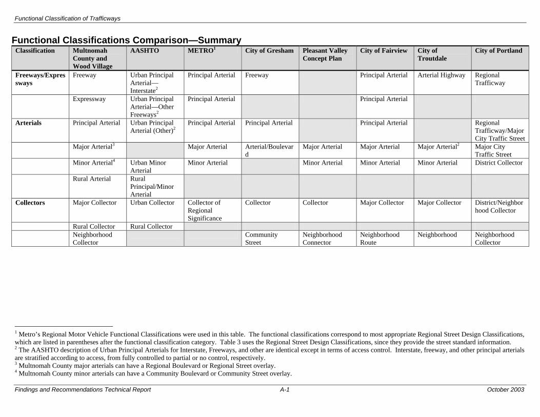
Functional Classification of Trafficways
Findings and Recommendations Technical Report A-1 October 2003
Functional Classifications Comparison—Summary Classification Multnomah
County and Wood Village
AASHTO METRO1 City of Gresham Pleasant Valley Concept Plan
City of Fairview City of Troutdale
City of Portland
Freeways/Expressways
Freeway Urban Principal Arterial—Interstate2
Principal Arterial Freeway Principal Arterial Arterial Highway Regional Trafficway
Expressway Urban Principal Arterial—Other Freeways2
Principal Arterial Principal Arterial
Arterials Principal Arterial Urban Principal Arterial (Other)2
Principal Arterial Principal Arterial Principal Arterial Regional Trafficway/Major City Traffic Street
Major Arterial3 Major Arterial Arterial/Boulevard
Major Arterial Major Arterial Major Arterial2 Major City Traffic Street
Minor Arterial4 Urban Minor Arterial
Minor Arterial Minor Arterial Minor Arterial Minor Arterial District Collector
Rural Arterial Rural Principal/Minor Arterial
Collectors Major Collector Urban Collector Collector of Regional Significance
Collector Collector Major Collector Major Collector District/Neighborhood Collector
Rural Collector Rural Collector Neighborhood
Collector Community
Street Neighborhood Connector
Neighborhood Route
Neighborhood Neighborhood Collector
1 Metro’s Regional Motor Vehicle Functional Classifications were used in this table. The functional classifications correspond to most appropriate Regional Street Design Classifications, which are listed in parentheses after the functional classification category. Table 3 uses the Regional Street Design Classifications, since they provide the street standard information. 2 The AASHTO description of Urban Principal Arterials for Interstate, Freeways, and other are identical except in terms of access control. Interstate, freeway, and other principal arterials are stratified according to access, from fully controlled to partial or no control, respectively. 3 Multnomah County major arterials can have a Regional Boulevard or Regional Street overlay. 4 Multnomah County minor arterials can have a Community Boulevard or Community Street overlay.

Functional Classification of Trafficways
Findings and Recommendations Technical Report A-2 October 2003
Functional Classifications Comparison—Descriptions and Definitions Multnomah County and
Wood Village AASHTO METRO City of Gresham Pleasant Valley Concept
Plan City of Fairview City of Troutdale City of Portland
CLASSIFICATION NAME
FREEWAY Urban Principal Arterial—Interstate
Principal Arterial (Regional Street Design Classifications: Freeway, Highway, Urban Road, Rural Road)
Freeway Principal Arterial Arterial Highway Regional Trafficway
Connectivity Inter-state; inter-regional; most do not have an origin or destination in Multnomah County
Serves the major centers of activity of urbanized areas, the highest traffic volume corridors, and the longest trip desires; carries most of the trips entering and leaving the urban areas as well as most of the through movements bypassing the central city, and significant intra-area travel; system provides continuity for all rural arterials that intercept the urban boundary; service to abutting land use subordinate to travel service to major traffic movements
Should provide an integrated system that is continuous throughout the urbanized area and should also provide for statewide continuity of the rural arterial system; should serve the central city, regional centers, industrial areas and intermodal activities; also form the primary connection between neighbor cities and the urban area
Regional, statewide, interstate
Typically are freeways and state highways that provide the highest level of connectivity; connect over the longest distance and are less frequent than other arterials or collectors; generally span several jurisdictions and many times have statewide importance
Regional, statewide or interstate
Interregional district movement that has only one trip end in a transportation district or to serve trips that bypass a district completely; should connect to other Regional Trafficways, Major City Traffic Streets, and District Collectors; should serve the Central City, regional centers, industrial areas, and intermodal facilities
Volume; posted speed 40,000 to 100,000 ADT; high speed
Highest; system should carry 40 to 65 percent of total traffic volume
High volume—excess of 60,000 per day; high posted speed
Direct interregional traffic to use Regional Trafficways and manage these facilities to maximize their existing capacity (Policy 6.16, Objective A)
Access access to abutting properties is prohibited
Fully controlled access Fully controlled property access
Work with ODOT to manage the location, spacing, and type of road and street intersections on Regional Trafficways (Policy 6.16 A, Objective A)
Ped; bike Ped and bike traffic on urban freeways are prohibited
Bicycle and pedestrian travel within these corridors is provided either on parallel streets or on dedicated pathways
Transit Carries important intra-urban as well as intercity bus routes
Transit service, if it is provided, consists of express buses or fixed-guideway service such as light rail
Freight Should connect key freight routes within the region to points outside the region, with an emphasis on mobility; freight movement should not be restricted
Grade separated interchanges
Built, operated and maintained by the ODOT
Connect key freight routes within the region to points outside the region
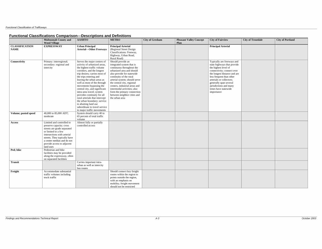
Functional Classification of Trafficways
Findings and Recommendations Technical Report A-3 October 2003
Functional Classifications Comparison—Descriptions and Definitions Multnomah County and
Wood Village AASHTO METRO City of Gresham Pleasant Valley Concept
Plan City of Fairview City of Troutdale City of Portland
CLASSIFICATION NAME
EXPRESSWAY Urban Principal Arterial—Other Freeways
Principal Arterial (Regional Street Design Classifications: Freeway, Highway, Urban Road, Rural Road)
Principal Arterial
Connectivity Primary: interregional; secondary: regional and intercity
Serves the major centers of activity of urbanized areas, the highest traffic volume corridors, and the longest trip desires; carries most of the trips entering and leaving the urban areas as well as most of the through movements bypassing the central city, and significant intra-area travel; system provides continuity for all rural arterials that intercept the urban boundary; service to abutting land use subordinate to travel service to major traffic movements
Should provide an integrated system that is continuous throughout the urbanized area and should also provide for statewide continuity of the rural arterial system; should serve the central city, regional centers, industrial areas and intermodal activities; also form the primary connection between neighbor cities and the urban area
Typically are freeways and state highways that provide the highest level of connectivity; connect over the longest distance and are less frequent than other arterials or collectors; generally span several jurisdictions and many times have statewide importance
Volume; posted speed 40,000 to 85,000 ADT; moderate
System should carry 40 to 65 percent of total traffic volume
Access Limited and controlled to preserve capacity; cross streets are grade separated or limited to a few intersections with arterial streets. They typically have a center median and do not provide access to adjacent land uses
Almost fully or partially controlled access
Ped; bike Pedestrian and bike facilities may be provided along the expressway, often on separated facilities
Transit Carries important intra-urban as well as intercity bus routes
Freight Accommodate substantial traffic volumes including truck traffic
Should connect key freight routes within the region to points outside the region, with an emphasis on mobility; freight movement should not be restricted
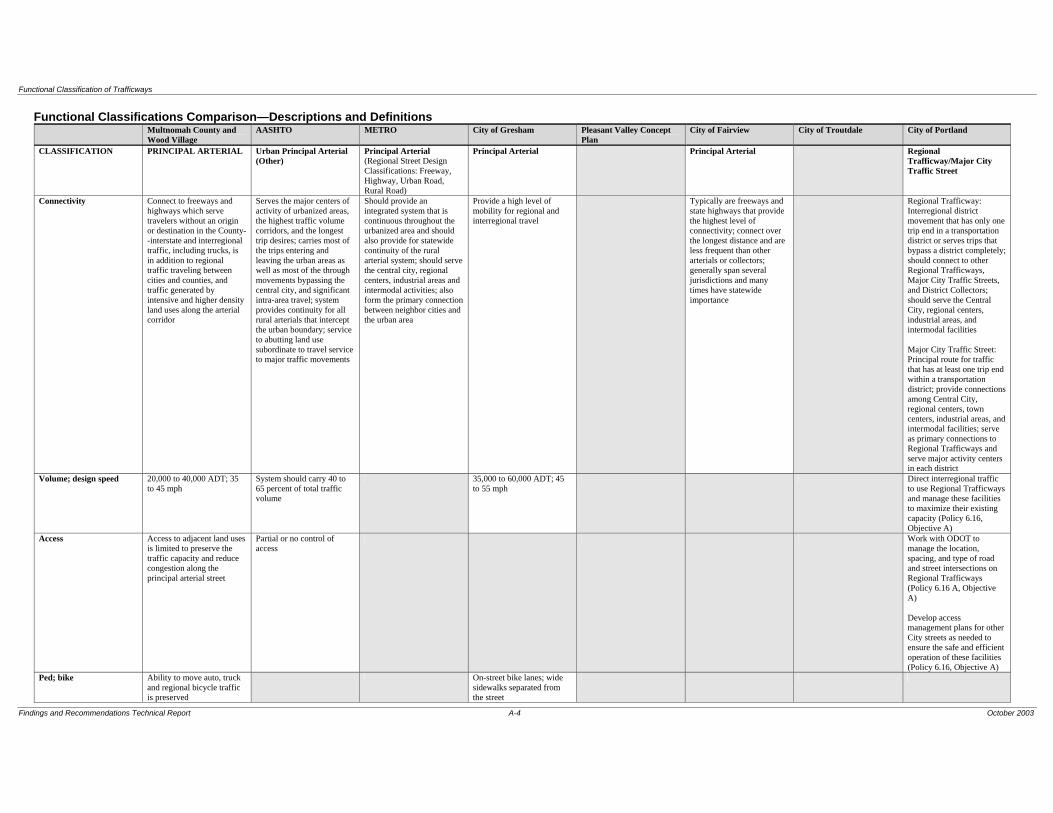
Functional Classification of Trafficways
Findings and Recommendations Technical Report A-4 October 2003
Functional Classifications Comparison—Descriptions and Definitions Multnomah County and
Wood Village AASHTO METRO City of Gresham Pleasant Valley Concept
Plan City of Fairview City of Troutdale City of Portland
CLASSIFICATION PRINCIPAL ARTERIAL Urban Principal Arterial (Other)
Principal Arterial (Regional Street Design Classifications: Freeway, Highway, Urban Road, Rural Road)
Principal Arterial Principal Arterial Regional Trafficway/Major City Traffic Street
Connectivity Connect to freeways and highways which serve travelers without an origin or destination in the County--interstate and interregional traffic, including trucks, is in addition to regional traffic traveling between cities and counties, and traffic generated by intensive and higher density land uses along the arterial corridor
Serves the major centers of activity of urbanized areas, the highest traffic volume corridors, and the longest trip desires; carries most of the trips entering and leaving the urban areas as well as most of the through movements bypassing the central city, and significant intra-area travel; system provides continuity for all rural arterials that intercept the urban boundary; service to abutting land use subordinate to travel service to major traffic movements
Should provide an integrated system that is continuous throughout the urbanized area and should also provide for statewide continuity of the rural arterial system; should serve the central city, regional centers, industrial areas and intermodal activities; also form the primary connection between neighbor cities and the urban area
Provide a high level of mobility for regional and interregional travel
Typically are freeways and state highways that provide the highest level of connectivity; connect over the longest distance and are less frequent than other arterials or collectors; generally span several jurisdictions and many times have statewide importance
Regional Trafficway: Interregional district movement that has only one trip end in a transportation district or serves trips that bypass a district completely; should connect to other Regional Trafficways, Major City Traffic Streets, and District Collectors; should serve the Central City, regional centers, industrial areas, and intermodal facilities Major City Traffic Street: Principal route for traffic that has at least one trip end within a transportation district; provide connections among Central City, regional centers, town centers, industrial areas, and intermodal facilities; serve as primary connections to Regional Trafficways and serve major activity centers in each district
Volume; design speed 20,000 to 40,000 ADT; 35 to 45 mph
System should carry 40 to 65 percent of total traffic volume
35,000 to 60,000 ADT; 45 to 55 mph
Direct interregional traffic to use Regional Trafficways and manage these facilities to maximize their existing capacity (Policy 6.16, Objective A)
Access Access to adjacent land uses is limited to preserve the traffic capacity and reduce congestion along the principal arterial street
Partial or no control of access
Work with ODOT to manage the location, spacing, and type of road and street intersections on Regional Trafficways (Policy 6.16 A, Objective A) Develop access management plans for other City streets as needed to ensure the safe and efficient operation of these facilities (Policy 6.16, Objective A)
Ped; bike Ability to move auto, truck and regional bicycle traffic is preserved
On-street bike lanes; wide sidewalks separated from the street
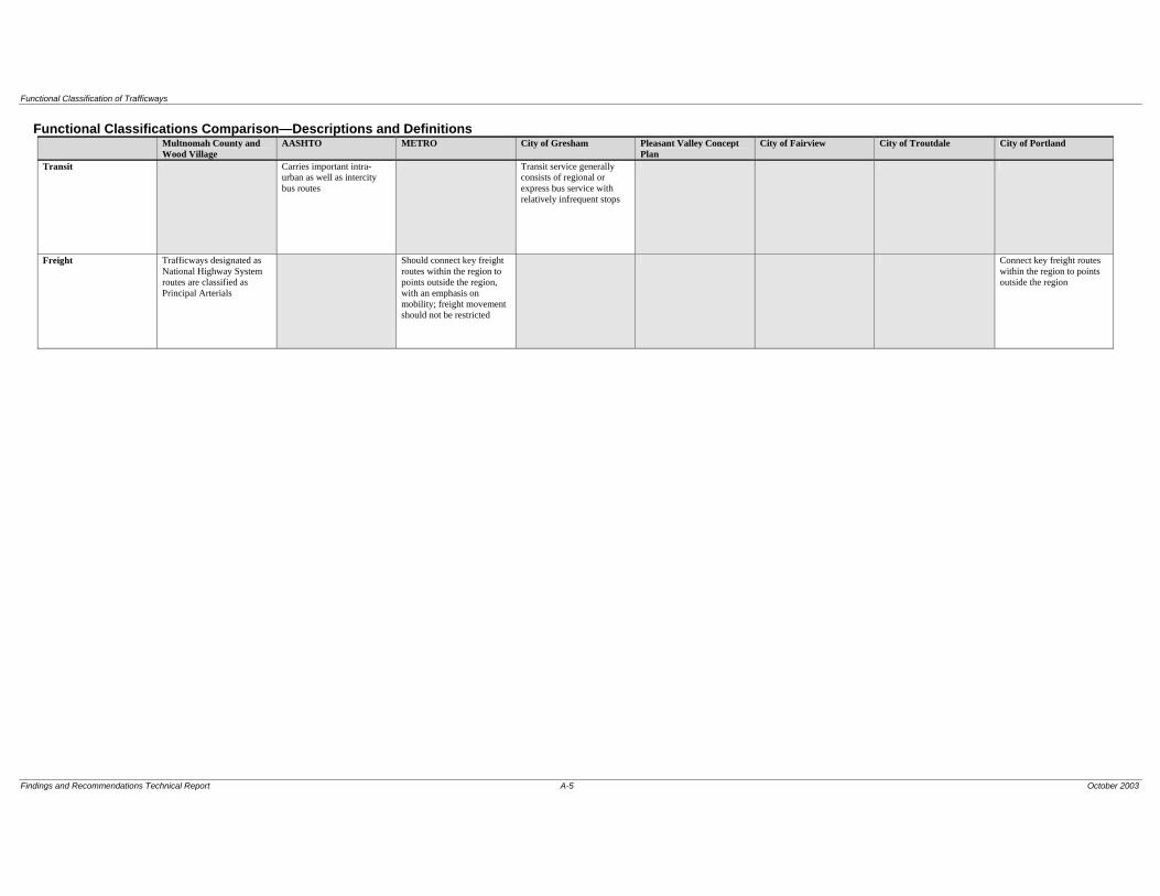
Functional Classification of Trafficways
Findings and Recommendations Technical Report A-5 October 2003
Functional Classifications Comparison—Descriptions and Definitions Multnomah County and
Wood Village AASHTO METRO City of Gresham Pleasant Valley Concept
Plan City of Fairview City of Troutdale City of Portland
Transit Carries important intra-urban as well as intercity bus routes
Transit service generally consists of regional or express bus service with relatively infrequent stops
Freight Trafficways designated as National Highway System routes are classified as Principal Arterials
Should connect key freight routes within the region to points outside the region, with an emphasis on mobility; freight movement should not be restricted
Connect key freight routes within the region to points outside the region
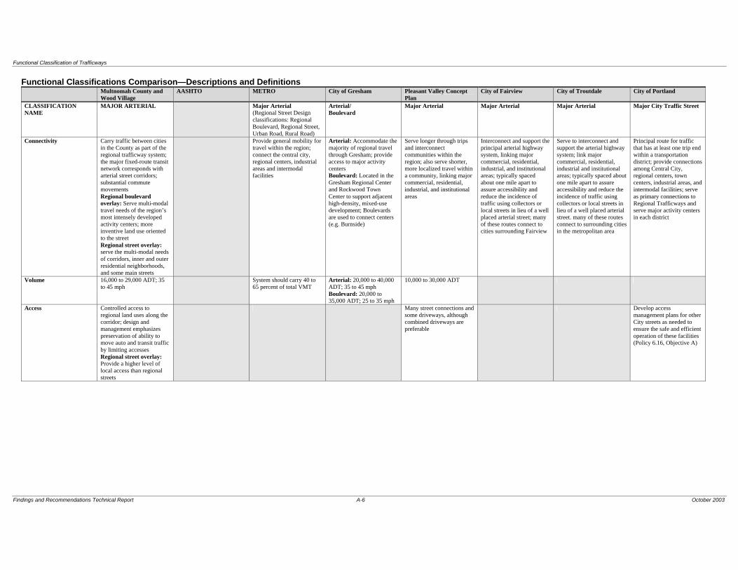
Functional Classification of Trafficways
Findings and Recommendations Technical Report A-6 October 2003
Functional Classifications Comparison—Descriptions and Definitions Multnomah County and
Wood Village AASHTO METRO City of Gresham Pleasant Valley Concept
Plan City of Fairview City of Troutdale City of Portland
CLASSIFICATION NAME
MAJOR ARTERIAL Major Arterial (Regional Street Design classifications: Regional Boulevard, Regional Street, Urban Road, Rural Road)
Arterial/ Boulevard
Major Arterial Major Arterial Major Arterial Major City Traffic Street
Connectivity Carry traffic between cities in the County as part of the regional trafficway system; the major fixed-route transit network corresponds with arterial street corridors; substantial commute movements Regional boulevard overlay: Serve multi-modal travel needs of the region’s most intensely developed activity centers; more inventive land use oriented to the street Regional street overlay: serve the multi-modal needs of corridors, inner and outer residential neighborhoods, and some main streets
Provide general mobility for travel within the region; connect the central city, regional centers, industrial areas and intermodal facilities
Arterial: Accommodate the majority of regional travel through Gresham; provide access to major activity centers Boulevard: Located in the Gresham Regional Center and Rockwood Town Center to support adjacent high-density, mixed-use development; Boulevards are used to connect centers (e.g. Burnside)
Serve longer through trips and interconnect communities within the region; also serve shorter, more localized travel within a community, linking major commercial, residential, industrial, and institutional areas
Interconnect and support the principal arterial highway system, linking major commercial, residential, industrial, and institutional areas; typically spaced about one mile apart to assure accessibility and reduce the incidence of traffic using collectors or local streets in lieu of a well placed arterial street; many of these routes connect to cities surrounding Fairview
Serve to interconnect and support the arterial highway system; link major commercial, residential, industrial and institutional areas; typically spaced about one mile apart to assure accessibility and reduce the incidence of traffic using collectors or local streets in lieu of a well placed arterial street. many of these routes connect to surrounding cities in the metropolitan area
Principal route for traffic that has at least one trip end within a transportation district; provide connections among Central City, regional centers, town centers, industrial areas, and intermodal facilities; serve as primary connections to Regional Trafficways and serve major activity centers in each district
Volume 16,000 to 29,000 ADT; 35 to 45 mph
System should carry 40 to 65 percent of total VMT
Arterial: 20,000 to 40,000 ADT; 35 to 45 mph Boulevard: 20,000 to 35,000 ADT; 25 to 35 mph
10,000 to 30,000 ADT
Access Controlled access to regional land uses along the corridor; design and management emphasizes preservation of ability to move auto and transit traffic by limiting accesses Regional street overlay: Provide a higher level of local access than regional streets
Many street connections and some driveways, although combined driveways are preferable
Develop access management plans for other City streets as needed to ensure the safe and efficient operation of these facilities (Policy 6.16, Objective A)

Functional Classification of Trafficways
Findings and Recommendations Technical Report A-7 October 2003
Functional Classifications Comparison—Descriptions and Definitions Multnomah County and
Wood Village AASHTO METRO City of Gresham Pleasant Valley Concept
Plan City of Fairview City of Troutdale City of Portland
Ped; bike Also accommodate regional bikeways and pedestrian movements; priority may be given to pedestrian-oriented land uses Regional boulevard overlay: Include bike lanes and wide sidewalks Regional street overlay: Pedestrian buffering from street; balanced multi-modal function; corridor land use set back from the street
Arterial: On-street bike lanes; sidewalks Boulevard: On-street bike lanes; wide sidewalks to accommodate high levels of pedestrian travel
Mix a significant amount of motor vehicle traffic with bicycle (bike lanes) and pedestrian travel (broad sidewalks, special crossing amenities, buffering
Provide planned bicycle facilities in conjunction with street improvements or develop equally safe and convenient alternative access for bicycles on parallel streets when the appropriate bikeway facility cannot be provided on the designated street because of severe environmental or topographical constraints, unacceptable levels of traffic congestion, or the need to retain on-street parking (Policy 11.10 F); include sidewalks on both sides of all new street improvement projects, except where there are severe topographical or natural resource constraints or when consistent with the Pedestrian Design Guide (Policy 11.10 G)
Transit Priority may be given to transit-oriented land uses
Arterial: Primary bus routes with frequent bus stops located to serve major destinations Boulevard: Primary bus routes with frequent bus stops
Mix a significant amount of motor vehicle traffic with public transportation (substantial amenities at stops and station areas)
Include improvements that enhance transit operations, safety, and travel times in projects on existing or planned transit routes (Policy 11.10 H)
Freight Traffic includes trucks and goods delivery
Freight movement should not be restricted; emphasis on mobility
Improve streets within Freight Districts and on truck-designated streets to facilitate truck movement (Policy 11.10)

Functional Classification of Trafficways
Findings and Recommendations Technical Report A-8 October 2003
Functional Classifications Comparison—Descriptions and Definitions Multnomah County and
Wood Village AASHTO METRO City of Gresham Pleasant Valley Concept
Plan City of Fairview City of Troutdale City of Portland
CLASSIFICATION MINOR ARTERIAL Urban Minor Arterial Minor Arterial (Regional Street Design Classifications: Community Boulevard, Community Street, Urban Road, Rural Road)
Minor Arterial Minor Arterial Minor Arterial District Collector
Connectivity Lowest order arterial facility in the regional street network; but have a high degree of connectivity between communities; land uses along the corridor are a mixture of community and regional activities Community boulevard overlay: located within the most intensely developed activity centers with development oriented to the street; landscaped medians, noon street parking Community street overlay: higher level of street connectivity than regional streets; on-street parking; may have a median
Accommodates trips of moderate length at a lower level of travel mobility than principal arterials; distributes travel to geographic areas smaller than those identified with the higher system; urban connections to rural roads
Connect town centers, corridors, main streets, and neighborhoods to nearby regional centers and other major destinations; connect to major arterials, collectors, local streets and some principal arterials where appropriate; complement and support the arterial and major arterial systems; serve shorter trips than principal and major arterials, and therefore must balance mobility and accessibility demands
Serve shorter, more localized travel within a community
Interconnect and support the principal arterial highway system, linking major commercial, residential, industrial, and institutional areas; typically spaced about one mile apart to assure accessibility and reduce the incidence of traffic using collectors or local streets in lieu of a well placed arterial street; many of these routes connect to cities surrounding Fairview
Serve to interconnect and support the arterial highway system; link major commercial, residential, industrial and institutional areas; typically spaced about one mile apart to assure accessibility and reduce the incidence of traffic using collectors or local streets in lieu of a well placed arterial street; many of these routes connect to surrounding cities in the metropolitan area
Distribute traffic from Major City Traffic Streets to streets of the same or lower classification and to serve trips that both start and end within a district; connect to Major City Traffic Streets, other collectors, and local streets, and where necessary, to Regional Trafficways
Volume; design speed 8,000 to 16,000 ADT (5,000 to 12,000 ADT for rural arterial); 35 to 45 mph
Minor arterial and principal arterial systems together should carry 65 to 80 percent of total traffic volume
System should carry 65 to 80 percent of total VMT
Access Access management may be implemented to preserve traffic capacity Community street overlay: provide a higher level of local access than regional streets
More emphasis on land access than higher arterial system
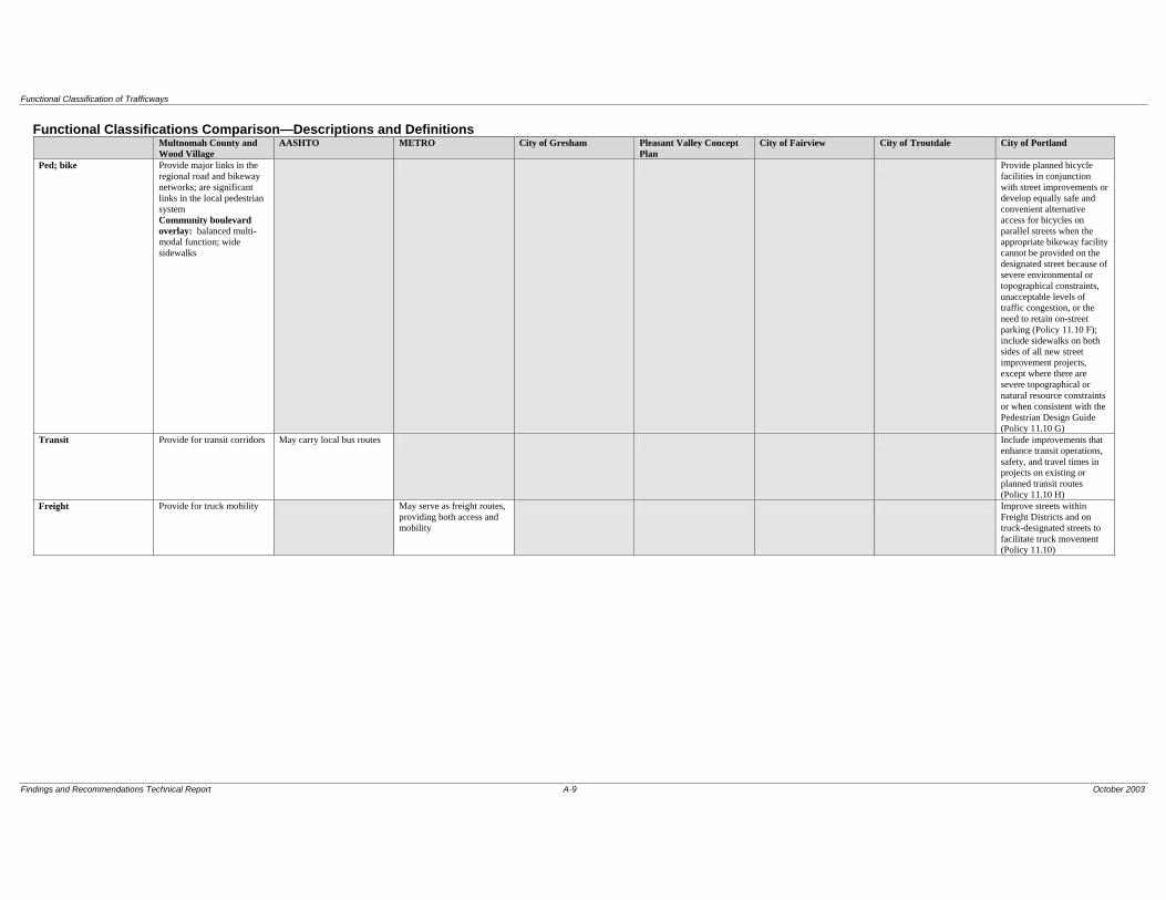
Functional Classification of Trafficways
Findings and Recommendations Technical Report A-9 October 2003
Functional Classifications Comparison—Descriptions and Definitions Multnomah County and
Wood Village AASHTO METRO City of Gresham Pleasant Valley Concept
Plan City of Fairview City of Troutdale City of Portland
Ped; bike Provide major links in the regional road and bikeway networks; are significant links in the local pedestrian system Community boulevard overlay: balanced multi-modal function; wide sidewalks
Provide planned bicycle facilities in conjunction with street improvements or develop equally safe and convenient alternative access for bicycles on parallel streets when the appropriate bikeway facility cannot be provided on the designated street because of severe environmental or topographical constraints, unacceptable levels of traffic congestion, or the need to retain on-street parking (Policy 11.10 F); include sidewalks on both sides of all new street improvement projects, except where there are severe topographical or natural resource constraints or when consistent with the Pedestrian Design Guide (Policy 11.10 G)
Transit Provide for transit corridors May carry local bus routes Include improvements that enhance transit operations, safety, and travel times in projects on existing or planned transit routes (Policy 11.10 H)
Freight Provide for truck mobility May serve as freight routes, providing both access and mobility
Improve streets within Freight Districts and on truck-designated streets to facilitate truck movement (Policy 11.10)

Functional Classification of Trafficways
Findings and Recommendations Technical Report A-10 October 2003
Functional Classifications Comparison—Descriptions and Definitions Multnomah County and
Wood Village AASHTO METRO City of Gresham Pleasant Valley Concept
Plan City of Fairview City of Troutdale City of Portland
CLASSIFICATION RURAL ARTERIAL Rural Principal/ Minor Arterial
Connectivity Rural arterial roads are the primary means of access into the County's large rural districts, and often connect between counties to accommodate through movements. Rural arterials connect to freeways or highways, and link rural collector and local roads to the urban area and other regions
Corridor movement with trip length and density suitable for substantial statewide or interstate travel; integrated movement without stub connections except where unusual geographic or traffic flow conditions dictate otherwise
Volume; design speed 5,000 to 12,000 ADT; carry greater traffic volumes than rural collector roads, including commuters and other home-based trips
Relatively high travel speeds
Access Ped; bike Carry recreational trips
involving bicycles and equestrians
Transit Freight Carry natural resource trips
involving trucks
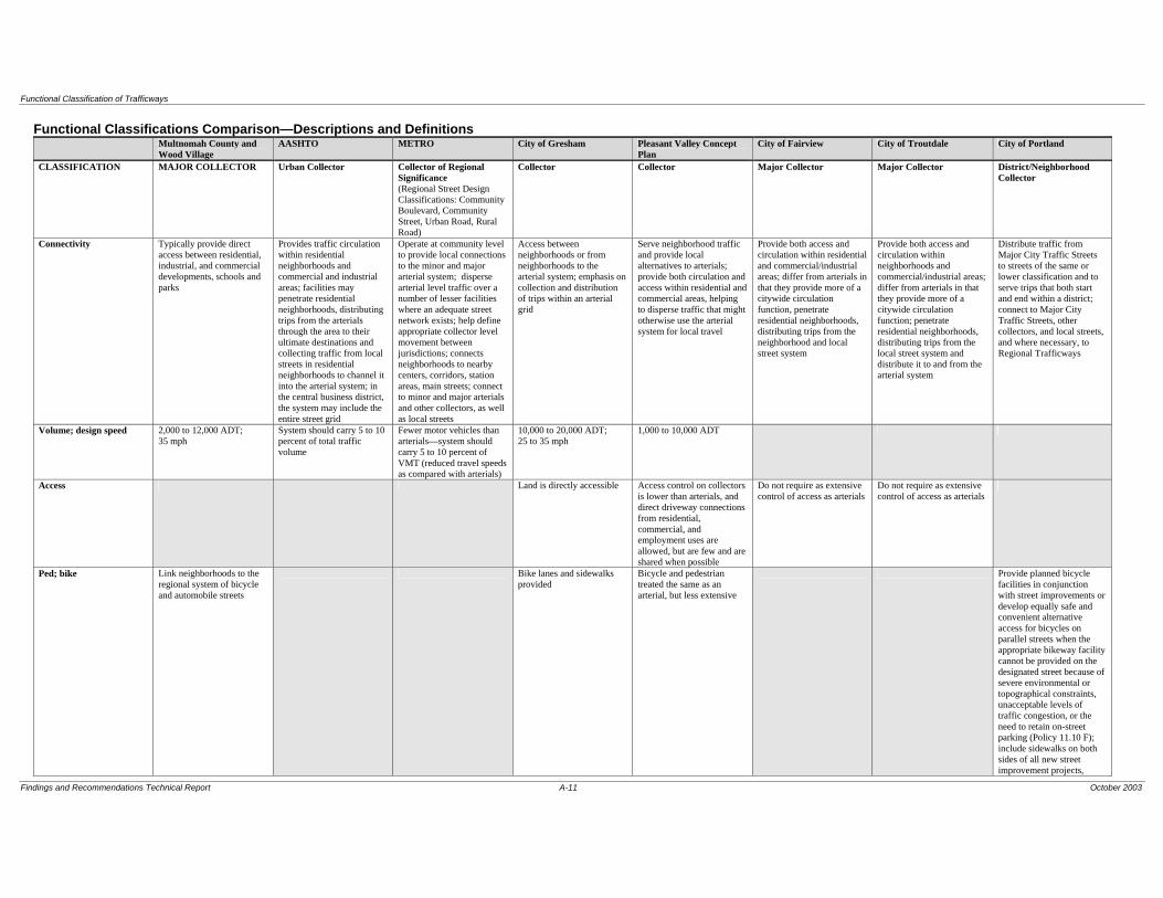
Functional Classification of Trafficways
Findings and Recommendations Technical Report A-11 October 2003
Functional Classifications Comparison—Descriptions and Definitions Multnomah County and
Wood Village AASHTO METRO City of Gresham Pleasant Valley Concept
Plan City of Fairview City of Troutdale City of Portland
CLASSIFICATION MAJOR COLLECTOR Urban Collector Collector of Regional Significance (Regional Street Design Classifications: Community Boulevard, Community Street, Urban Road, Rural Road)
Collector Collector Major Collector Major Collector District/Neighborhood Collector
Connectivity Typically provide direct access between residential, industrial, and commercial developments, schools and parks
Provides traffic circulation within residential neighborhoods and commercial and industrial areas; facilities may penetrate residential neighborhoods, distributing trips from the arterials through the area to their ultimate destinations and collecting traffic from local streets in residential neighborhoods to channel it into the arterial system; in the central business district, the system may include the entire street grid
Operate at community level to provide local connections to the minor and major arterial system; disperse arterial level traffic over a number of lesser facilities where an adequate street network exists; help define appropriate collector level movement between jurisdictions; connects neighborhoods to nearby centers, corridors, station areas, main streets; connect to minor and major arterials and other collectors, as well as local streets
Access between neighborhoods or from neighborhoods to the arterial system; emphasis on collection and distribution of trips within an arterial grid
Serve neighborhood traffic and provide local alternatives to arterials; provide both circulation and access within residential and commercial areas, helping to disperse traffic that might otherwise use the arterial system for local travel
Provide both access and circulation within residential and commercial/industrial areas; differ from arterials in that they provide more of a citywide circulation function, penetrate residential neighborhoods, distributing trips from the neighborhood and local street system
Provide both access and circulation within neighborhoods and commercial/industrial areas; differ from arterials in that they provide more of a citywide circulation function; penetrate residential neighborhoods, distributing trips from the local street system and distribute it to and from the arterial system
Distribute traffic from Major City Traffic Streets to streets of the same or lower classification and to serve trips that both start and end within a district; connect to Major City Traffic Streets, other collectors, and local streets, and where necessary, to Regional Trafficways
Volume; design speed 2,000 to 12,000 ADT; 35 mph
System should carry 5 to 10 percent of total traffic volume
Fewer motor vehicles than arterials—system should carry 5 to 10 percent of VMT (reduced travel speeds as compared with arterials)
10,000 to 20,000 ADT; 25 to 35 mph
1,000 to 10,000 ADT
Access Land is directly accessible Access control on collectors is lower than arterials, and direct driveway connections from residential, commercial, and employment uses are allowed, but are few and are shared when possible
Do not require as extensive control of access as arterials
Do not require as extensive control of access as arterials
Ped; bike Link neighborhoods to the regional system of bicycle and automobile streets
Bike lanes and sidewalks provided
Bicycle and pedestrian treated the same as an arterial, but less extensive
Provide planned bicycle facilities in conjunction with street improvements or develop equally safe and convenient alternative access for bicycles on parallel streets when the appropriate bikeway facility cannot be provided on the designated street because of severe environmental or topographical constraints, unacceptable levels of traffic congestion, or the need to retain on-street parking (Policy 11.10 F); include sidewalks on both sides of all new street improvement projects,
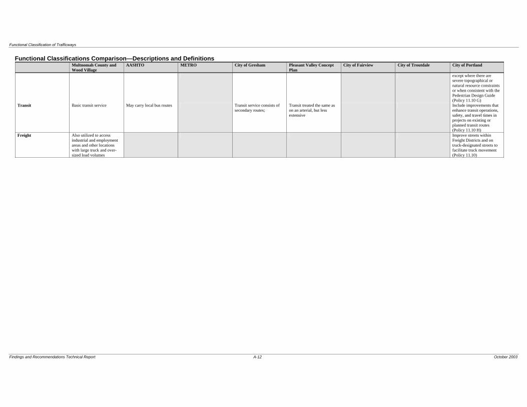
Functional Classification of Trafficways
Findings and Recommendations Technical Report A-12 October 2003
Functional Classifications Comparison—Descriptions and Definitions Multnomah County and
Wood Village AASHTO METRO City of Gresham Pleasant Valley Concept
Plan City of Fairview City of Troutdale City of Portland
except where there are severe topographical or natural resource constraints or when consistent with the Pedestrian Design Guide (Policy 11.10 G)
Transit Basic transit service May carry local bus routes Transit service consists of secondary routes;
Transit treated the same as on an arterial, but less extensive
Include improvements that enhance transit operations, safety, and travel times in projects on existing or planned transit routes (Policy 11.10 H)
Freight Also utilized to access industrial and employment areas and other locations with large truck and over-sized load volumes
Improve streets within Freight Districts and on truck-designated streets to facilitate truck movement (Policy 11.10)

Functional Classification of Trafficways
Findings and Recommendations Technical Report A-13 October 2003
Functional Classifications Comparison—Descriptions and Definitions Multnomah County and
Wood Village AASHTO METRO City of Gresham Pleasant Valley Concept
Plan City of Fairview City of Troutdale City of Portland
CLASSIFICATION RURAL COLLECTOR Rural Collector (Major and Minor)
Connectivity Well connected in rural communities to distribute automobile traffic over large areas and generally connect to urban streets or rural arterials
Primarily intracounty rather than statewide importance; predominate travel distances are shorter than on arterials
Volume; design speed 1,000 to 4,000 ADT Moderate speeds Access Primary access is provided
to land uses adjacent to the facility and over large rural districts
Ped; bike May also provide for recreational trips by auto, bicycle and equestrian
Transit Freight Provide for necessary truck
transport (agricultural, timber and minerals) out of rural districts
Functional Classification of Trafficways
Findings and Recommendations Technical Report A-14 October 2003
Functional Classifications Comparison—Descriptions and Definitions Multnomah County and
Wood Village AASHTO METRO City of Gresham Pleasant Valley Concept
Plan City of Fairview City of Troutdale City of Portland
CLASSIFICATION NEIGHBORHOOD COLLECTOR
Community Street Neighborhood Connector Neighborhood Route Neighborhood Neighborhood Collector
Connectivity Provide access primarily to residential land uses and link neighborhoods to higher order roads; through or non-local traffic is discouraged
Facilitate travel within the community and neighborhoods; emphasis on serving adjacent land uses
Serve residential neighborhoods and provide connectivity to the collector and arterial street system; they are intended to serve travel between neighborhoods and provide options to the arterial and collector streets for travel within the community
Provide connectivity to collectors or arterials; used by residents in the area to get into and out of the neighborhood, but do not serve citywide/large area circulation; traffic from cul-de-sacs and other local streets may drain onto neighborhood routes to gain access to collectors or arterials
Provide connectivity to collectors or arterials; used to get out of the neighborhood, but don’t serve as citywide circulation; traffic from cul-de-sacs and other local streets may drain onto Neighborhood routes to gain access to collectors or arterials
Distribute traffic from Major City Traffic Streets or District Collectors to Local Service Streets and to serve trips that both start and end within areas bounded by Major City Traffic Streets and District Collectors; connect to Major City Traffic Streets, District Collectors, and other Neighborhood Collectors, as well as to Local Service Streets; although some may have a regional function, they should be designed to operate as neighborhood streets
Volume; design speed 500 to 4,500 ADT 3,500 to 10,000 ADT; 25 to 35 mph
Serve more traffic than local streets, but still less than 5,000 ADT
Generally have more traffic than local streets because neighborhood routes have greater connectivity
More traffic than local streets
Manage traffic consistent with the land uses they serve and to preserve and enhance neighborhood livability (Policy 6.13)
Access Emphasis on serving adjacent land uses
Ped; bike Bike lanes and sidewalks provided to facilitate neighborhood access
Street design elements include sidewalks, bike lanes depending on traffic volumes, on-street parking and a landscaped buffer between travel lanes and sidewalks
Provide planned bicycle facilities in conjunction with street improvements or develop equally safe and convenient alternative access for bicycles on parallel streets when the appropriate bikeway facility cannot be provided on the designated street because of severe environmental or topographical constraints, unacceptable levels of traffic congestion, or the need to retain on-street parking (Policy 11.10 F); include sidewalks on both sides of all new street improvement projects, except where there are severe topographical or natural resource constraints or when consistent with the Pedestrian Design Guide (Policy 11.10 G)
Functional Classification of Trafficways
Findings and Recommendations Technical Report A-15 October 2003
Functional Classifications Comparison—Descriptions and Definitions Multnomah County and
Wood Village AASHTO METRO City of Gresham Pleasant Valley Concept
Plan City of Fairview City of Troutdale City of Portland
Transit Transit service, if provided, consists of neighborhood circulation routes
Include improvements that enhance transit operations, safety, and travel times in projects on existing or planned transit routes (Policy 11.10 H)
Freight Street length is typically about a quarter to a half mile total; neighborhood traffic management measures are often appropriate
Usually long relative to local streets (at least 500 to 1,000 feet) measures such as neighborhood traffic management are needed; generally have residential frontage
Improve streets within Freight Districts and on truck-designated streets to facilitate truck movement (Policy 11.10)

Functional Classification of Trafficways
Appendix B
Functional Classifications Designations by Roadway Segment Table

Functional Classification of Trafficways
Roadway Multnomah County City of Gresham City of Wood Village City of Fairview City of Troutdale Metro Pleasant ValleyI-84 Freeway Freeway Freeway Freeway Freeway Principal Arterial (Freeway)US 26/Mount Hood Hwy/Powell Blvd
west boundary to Eastman Pkwy Minor Arterial Arterial Major ArterialEastman Pkwy to Hogan Rd Major Arterial Arterial Major ArterialHogan Rd to Burnside Rd Major Arterial Arterial Minor Arterialsouth of SE Powell Valley Rd Principal Arterial Principal Arterial Major Arterialnew alignment from Hogan Rd and Roberts to south boundary Principal Arterial (Highway)
Glisan162nd Ave to 207th Ave Major Arterial Arterial Major Arterial Minor Arterial207th Ave to 242nd Ave (north side of street from 238th/242nd Ave to 223rd Ave is in Wood Village; south side is in Gresham
Major Arterial Arterial Major Arterial Major Arterial Major Arterial
SW Cherry Park Rd (South)242nd Ave to end (257th Ave) (south) (Cherry Park Rd in Troutdale) Minor Arterial Minor Arterial Minor Arterial
257th Ave to end Major Collector Major Collector Collector of Regional Significance
242nd AveHogan Rd (Burnside Rd to Glisan St) Major Arterial
Principal ArterialPrincipal Arterial Major Arterial
Principal ArterialPrincipal Arterial (Highway)
south of NE Burnside Rd and north of Powell Blvd Major Arterial Arterial w/transit Principal Arterial (Highway)south of Powell Blvd Major Arterial Arterial w/transit Principal Arterial (Highway)
Proposed 242nd Ave Connector Principal Arterial Principal Arterial (Highway)238th Dr
north of I-84 Major CollectorMinor Arterial
Minor Arterial Minor Arterial
south of I-84 Minor Arterial Minor Arterial1 Minor ArterialProposed 238th Dr Extension (Sandy Blvd to Marine Dr) Major Collector Major Collector Collector of Regional
SignificanceHalsey St
162nd Ave to 182nd Ave Major Arterial Arterial w/transit Major Arterial182nd Ave to 192nd Ave Major Arterial Arterial w/transit Minor Arterial192nd Ave to 207th Ave Minor Arterial Arterial w/transit Minor Arterial Minor Arterial Minor Arterial Minor Arterial207th Ave to end (north and south sides vary between Wood Village and Fairview from 244th Ave to Fairview Ave; in Troutdale between 244th Ave to HCRH)
Major Arterial Minor Arterial Minor Arterial Minor Arterial Minor Arterial
Sandy Blvd92nd Ave of 207th Ave Minor Arterial Arterial w/transit Minor Arterial Major Arterial207th Ave to end (north and south sides vary between Wood Village and Fairview from Fairview city limits to terminus)
Major CollectorMinor Arterial
Minor Arterial Minor Arterial Collector of Regional Significance Minor Arterial
Historic Columbia River Hwy Major Collector Major Collector Collector of Regional Significance
207th Avenorth of I-84 Major Collector
Major ArterialMajor Arterial Major Arterial
south of I-84 Major Arterial Major Arterial Major Arterial223rd Ave
NW Fairview Ave/Blue Lake Rd (north of Glisan St) Major Collector Major Collector Major Collector Collector of Regional Significance
Glisan St to Halsey St (east side of street from Glisan St to Arata Rd is in Wood Village; west side is in Fairview)
Major Arterial Arterial w/transit Major Collector Major Arterial
Eastman PkwyBurnside St to Powell Blvd Major Arterial Boulevard w/transit Major ArterialSW Towle Ave (from Powell Blvd to end (ends @Butler Rd) Collector Collector of Regional
SignificanceTowle Ave
Powell Blvd to Binford Pkwy Minor Arterial Collector Collector of Regional Significance
Binford Pkwy to Butler Rd Major Collector Collector Collector of Regional Significance
Wood Village BlvdProposed Halsey St to Arata Rd (abuts east City of Wood Village boundary)
Major Collector Major Collector Collector of Regional Significance
Arata Rd to Glisan St Major Collector Neighborhood Collector Major Collector
Collector of Regional Significance
Arata Rd (north and south sides vary between Wood Village and Fairview from 238th Ave to 223rd Ave)
Neighborhood Collector Major Collector
Neighborhood CollectorMajor Collector
Major Collector Collector of Regional Significance
Stark St162nd Ave to 181st Ave Major Arterial Arterial w/transit Major Arterial181st Ave to 197th Ave Major Arterial Boulevard w/transit Major Arterial
Functional Classification Designations by Roadway Segment - East Multnomah County
Findings and Recommendations Technical Report B-1 October 2003
Functional Classification of Trafficways
Roadway Multnomah County City of Gresham City of Wood Village City of Fairview City of Troutdale Metro Pleasant ValleyFunctional Classification Designations by Roadway Segment - East Multnomah County
197th Ave to Kane Rd/SW 257th Ave Major Arterial Arterial w/transit Major ArterialKane Rd to Gresham/Troutdale boundary Major Arterial Collector Major Arterial Collector of Regional
SignificanceMajor Arterial
east of Gresham/Troutdale boundary and west of Troutdale Rd Major Arterial Major Arterial Collector of Regional SignificanceMajor Arterial
east of Troutdale Rd Minor Arterial Minor Arterial2 Collector of Regional SignificanceMinor Arterial
Burnside St162nd Ave to 181st Ave Major Collector Community w/transit Major Arterial181st Ave to Hogan Rd Principal Arterial Boulevard w/transit Major ArterialSE Hogan Rd to NW of US 26/Powell Principal Arterial Principal Arterial Major ArterialMount Hood Hwy (to County boundary) Principal Arterial Principal Arterial Major Arterial
Division St174th Ave west boundary to Birdsdale Ave Major Arterial Arterial w/transit Minor ArterialBirdsdale St to Burnside St Major Arterial Boulevard w/transit Minor ArterialBurnside St to Kane Rd Major Arterial Arterial w/transit Minor ArterialKane Rd/Dr to city boundary Major Collector Community Collector of Regional
SignificanceOrient Dr (US 26 to Gresham boundary) Minor Arterial Arterial Minor Arterial257th Ave/Kane Dr/Rd
north of SW Cherry Park Rd Major Arterial Major Arterial Major Arterialsouth of SW Cherry Park Rd Major Arterial Major Arterial3 Major Arterialsouth of Stark St to Division St Major Arterial Arterial w/transit Major ArterialDivision St to Powell Valley Rd Major Arterial Arterial Major ArterialPowell Valley Rd to Orient Dr Minor Arterial
Major ArterialArterial Major Arterial
162nd AveHalsey St to Stark St Minor Arterial Arterial Collector of Regional
SignificanceSE Foster Rd to PV plan limits Major Collector Collector of Regional
SignificanceCollector
172nd Av (SE Giese Rd to PV plan limits) Rural Arterial Major Arterial 5
Arterial Major Arterial Major Arterial
Proposed 174th connector Minor Arterial 6 Minor Arterial 6
181st Ave north boundary to I-84 Major Arterial Minor Arterial
Major ArterialI-84 to Burnside St Principal Arterial Arterial w/transit Major ArterialBurnside St to Stark St Major Arterial Boulevard w/transit Major Arterial
182nd AveStark to Yamhill Major Arterial Boulevard w/transit Major ArterialYamhill St to SW Pleasant View Dr Major Arterial Arterial w/transit Major ArterialGiese Rd to Cheldelin Rd Major Collector Collector of Regional
SignificanceCollector
190th Ave (PV plan limits) Rural Arterial Major Arterial
Community w/transit Major Arterial Major Arterial
201st Ave (Sandy Blvd to Glisan St) Major Collector Collector Collector of Regional Significance
202nd Ave/NW Birdsdale Ave (Glisan St to Powell Blvd) Major Collector Collector Collector of Regional Significance
Foster Rd/SE Giese Rd (PV plan limits) Rural Arterial Minor Arterial Minor ArterialClatsop St/Cheldelin Rd (PV plan limit to 190th Ave) Rural Local Minor Arterial Minor ArterialJenne Rd Rural Arterial
Local 6Minor Arterial Minor Arterial
Butler Rd (Regner Rd to Gresham boundary) Neighborhood Collector Collector Collector of Regional Significance
Collector
Richey Rd (182nd Ave to 190th Ave) Rural Collector Major Collector
Collector of Regional Significance
Collector
Marine Dr (east of 185th Ave) Major Collector Collector Major Collector Major Collector Collector of Regional Significance
Graham Rd Major Collector Major Collector4 Collector of Regional Significance
Sundial Rd Major Collector Major Collector Collector of Regional Significance
Cochran Dr Major/Rural Collector Major Collector Collector of Regional Significance
Findings and Recommendations Technical Report B-2 October 2003

Functional Classification of Trafficways
Roadway Multnomah County City of Gresham City of Wood Village City of Fairview City of Troutdale Metro Pleasant ValleyFunctional Classification Designations by Roadway Segment - East Multnomah County
Troutdale Rd Major/Rural Collector Major Collector Collector of Regional Significance
185th Ave Extension Major Collector Collector Collector of Regional Significance
NE River Side Pkwy CollectorWilkes Rd CollectorSan Rafael St (181st Ave to 192nd Ave) Major Collector Collector Collector of Regional
SignificancePowell Valley Rd
Burnside Rd to Kane/257th Ave Major Arterial Collector Minor Arterial257th Ave to 262nd Ave Major Collector Collector Collector of Regional
SignificanceKane/257th Ave to east boundary Major Collector Collector Collector of Regional
Significance192nd Ave (Halsey St to Wilkes Rd) Major Collector Collector Collector of Regional
SignificancePleasant View Dr (SW Highland Dr to Powell Lp) Neighborhood Collector
Major Collector 5Collector5 Collector of Regional
Significance5
Powell Lp (SW Pleasant View Dr to W Powell Blvd) Neighborhood Collector Major Collector 5
Collector5 Collector of Regional Significance5
Cleveland Ave (Division St to Stark St) Major Collector Collector Collector of Regional Significance
Regner Rd (SE Roberts Ave to south boundary) Major Collector Collector Collector of Regional Significance
Roberts Ave (US 26/E Powell Blvd to Hogan/242nd Ave) Major Collector Collector Collector of Regional Significance
Palmquist Rd (Hogan/242nd Ave to US 26/or SE Orient Dr) Minor Arterial Collector Collector of Regional Significance
244th Ave (Sandy Blvd to Halsey St) Major Collector Neighborhood Collector Major Collector
Bluff Rd Local Street Rural Collector
Recommend amendment Recommended ClassificationWithin Multnomah County's design standard range, but not preferredDo not recommend amending classificationCounty Classification will change when Pleasant Valley and Powell-Foster plans are implemented; Metro will add to 2003 RTP update1 (Halsey St to 242 Ave connector/Glisan St) The neighborhood collector classification is proposed at the time that an alternative north/south route to 238th Ave is built2 Shown on the Troutdale TSP Appendix A list as major collector3 Shown on the Troutdale TSP Appendix A list as major collector4 Shown on the Troutdale TSP Appendix A list as major collector/major arteria5 Will change when the Powell-Foster Community Plan in implemented6 The Powell-Foster Corridor Transportation Plan - Phase I recommends a new connector extending 174th Ave between Jenne Rd and Giese Rd that would be a 2-3 lane minor collector. With the construction of this connector, Jenne Rd could be down classified as a local road between Foster Rd and the connector.o:/project/M/MULT0000-0010/6000 Transportation/Report/Table 2 rev 2.xls
Findings and Recommendations Technical Report B-3 October 2003


Functional Classification of Trafficways
Appendix C
Street Standards Table

Functional Classification of Trafficways
Findings and Recommendations Technical Report C-1 October 2003 Indicates standard that County needs to amend Indicates standard is outside County’s allowable range Indicates standard is within County’s allowable range, but not County’s preferred standard Numerical values in parenthesis identify the minimum and/or maximum values accepted by the jurisdiction; preceding number indicates preferred standard (predominant standard for Metro)
Roadway Design Standards Multnomah County AASHTO
METRO and Pleasant Valley
Plan City of Gresham City of Wood Village City of Fairview City of Portland
Principal Arterial 100’ (80’-115’) ROW Four 12’ (11’-14’) travel lanes Two 6’ (5’-6’) bike lanes Two 6’ (0’-8’) planter strips Two 7’ (6’-8’) sidewalks Two (optional) 14’ (12’-16’) medians/turn lanes
Arterial ROW: none given Four or more 10’-12’ travel lanes (width determined by speed) Two 2’ + shoulder 4’-30’ median sidewalks depend on speed
Principal Four to six 12’ travel lanes Two 6’ bike lanes Two 8’ planter strips Two 6’ sidewalks 16’ divided median
Principal 120’ ROW Four (four to six) 12’ travel lanes Two 6’ bike lanes Two 6’ planter strips Two 8’ sidewalks 24’ median/turn lane
Principal/Major 80’-115’ ROW Four 12’ travel lanes Two 6’ bike lanes Two 6’ planter strips Two 7’ sidewalks 14’ median/turn lane
Principal/Major 80’-115’ ROW Four 11’-14’ travel lanes Two 5’-6’ bike lanes Two 0’-8’ planter strips Two 6’-8’ sidewalks 12’-15’ median/turn lane
Principal Four travel lanes Striped bike lanes Sidewalks (optional buffer) On-street parking (limited)
Major Arterial 100’ (80’-115’) ROW Four 12’ (11’-14’) travel lanes Two 6’ (5’-6’) bike lanes Two 7’ 6’ (0’-8’ ) planter strips Two 7’ (6’-8’) sidewalks 14’ (12’-16’) median/turn lane Regional Boulevard Overlay1 90’ (90’-105’) ROW Four 11’ (11’-12’) travel lanes Two 5’ (5’-6’) bike lanes Two 5’ (5’-8’) planting strips Two 6’ (6’-8’) sidewalks 14’ (12’-14’) median/turn lane Regional Street Overlay1 Four 12’ travel lanes Two 6’ bike lanes Two 6’ sidewalks with 5’-8’ pedestrian buffer One 14’ (12’-14’) median/turn lane
Regional Boulevard Four 11’ (10’-11’) travel lanes Two 5’ bike lanes Two 15’ (6’-15’) sidewalks Two 7’ planter strips One 10’ (4’-12’) median/turn lane Two 7’ on-street parking (optional) Regional Street Four 12’ (11’-12’) travel lanes Two 6’ (5’-6’) bike lanes Two 6’ (5’-6’) sidewalks with 5’ (4’-5’) pedestrian buffer One 14’ (14’-15’) median/turn lane
Arterial 100’ ROW Four 12’ travel lanes Two 6’ bike lanes Two 4’ planter strips Two 6’ sidewalks 16’ median/turn lane Boulevard 115’ ROW Four 11’ travel lanes Two 6’ bike lanes Two 4’ planter strips Two 11’ sidewalk 14’ median/turn lane Two 7’ parking lanes
Regional Main Street Four travel lanes Bike lanes or wide shoulders Sidewalks Medians/curb extensions On-street parking Regional Corridor Four travel lanes Striped bike lanes or wide shoulder Pedestrian buffer Sidewalks Medians/curb extensions On-street parking

Functional Classification of Trafficways
Findings and Recommendations Technical Report C-3 October 2003 Indicates standard that County needs to amend Indicates standard is outside County’s allowable range Indicates standard is within County’s allowable range, but not County’s preferred standard Numerical values in parenthesis identify the minimum and/or maximum values accepted by the jurisdiction; preceding number indicates preferred standard (predominant standard for Metro)
Roadway Design Standards Multnomah County AASHTO
METRO and Pleasant Valley
Plan City of Gresham City of Wood Village City of Fairview City of Portland
Major Collector 80’ (60’-97’) ROW Two (2’-3):12’ (10-12’) travel lanes Two 6’ (5’-6’) bike lanes Two 6’ (0’-8’) planter strips Two 6’ (6’-7’) sidewalks 14’ (10’-14’) median/turn lane (optional)
Urban Collector ROW: 40’+ Two 10’-12’travel lanes Two 2’-12’ shoulders/ parking lanes;eventually to be 4-travel lanes 2’-25’ median treatment Two 4’-8’ sidewalks
Collector 80’ ROW Two 11’ travel lanes Two 6’ bike lanes Two 7’ parking lanes Two 4’ planter strips Two 6’ sidewalks 12’ median/turn lane
Major 60’-97’ ROW Two 12’ travel lanes Two 6’ bike lanes Two 6’ planter strips Two 6’ sidewalks 12’ median/turn lane
Major2 60’-97’ ROW Two 10’-12’ travel lanes Two 5’-6’ bike lanes Two 0’-8’ planter strips Two 6’-7’ sidewalks 10’-14’ median/turn lane
Neighborhood Collector 60’ (50’-72’) ROW Two 11’ (11’-12’) travel lanes Two 5’ bike lanes Two 7’ (7’ one side-8’ both sides) parking lanes Two 2’ (0’-5’) planter strips Two 5’ (4’-6’) sidewalks
Community Street 70’ ROW Two 11’ travel lanes Two 6’ bike lanes Two 7’ parking lanes Two 4’ planter strips Two 6’ sidewalks
Neighborhood 50’-72’ ROW Two 11’ travel lanes Two 5’ bike lanes Two 7’ parking lanes Two 5’ planter strips Two 5’ sidewalks
Community Corridor Two travel lanes Striped bike lanes or shoulders On-street parking Sidewalks with buffers & amenities Medians/curb extensions
Rural Collector 60’ (50’-80’) ROW Two 12’ (11’-12’) travel lanes Two 6’ (5’-8’) shoulders
Rural Collector ROW: none given Two 10’-12’ travel lanes Two 2’-12’ shoulders/ parking lanes
Urban/Rural Two to four travel lanes Two bike/pedestrian ways or shoulders One median/turn lane
1 Can be applied to major arterial functional classification 2 Can be applied to minor arterial functional classification

Functional Classification of Trafficways
Findings and Recommendations Technical Report C-2 October 2003 Indicates standard that County needs to amend Indicates standard is outside County’s allowable range Indicates standard is within County’s allowable range, but not County’s preferred standard Numerical values in parenthesis identify the minimum and/or maximum values accepted by the jurisdiction; preceding number indicates preferred standard (predominant standard for Metro)
Roadway Design Standards Multnomah County AASHTO
METRO and Pleasant Valley
Plan City of Gresham City of Wood Village City of Fairview City of Portland
Minor Arterial 90’ (80’-105’) ROW Two (two to four) 11’ (11’-12’) travel lanes Two 6’ (5’-6’) bike lanes Two 6’ (0’-8’) planter strips Two 6’ (5’-8’) sidewalks 12’ (12’-14’) median/turn lane Community Boulevard Overlay2 80’ (80’-111’) ROW Two (two to four) 11’ (10’-12’) travel lanes Two 5’ (2’-6’) bike lanes Two 5’ planting strips Two 5’ (5’-6’) sidewalks 12’ (12’-14’) median/turn lane Community Street Overlay2 Two 11’ travel lanes Two 5’ bike lanes Two sides of 7’ on street parking Two 12’ sidewalks with 7’ pedestrian buffer
Community Boulevard Two 11’ (10’-11’) travel lanes Two 5’ bike lanes Two sides of 7’ on-street parking Two 12’ (6’-12’) sidewalks with pedestrian buffer One 10’ (4’-10’) median/turn lane Community Street Two 11’ travel lanes Two 5’ bike lanes Two sides of 7’ on street parking Two 12’ (6’-15’) sidewalks with 7’ pedestrian buffer
Minor 80’-105’ ROW Two 11’ travel lanes Two 6’ bike lanes Two 6’ planter strips Two 6’ sidewalks 12’ median/turn lane
Minor 80’-105’ ROW Two 11’-12’ travel lanes Two 5’-6’ bike lanes Two 0’-8’ planter strips Two 5’-8’ sidewalks 12’-14’ median/turn lane
Community Main Street Max of four travel lanes Striped bike lanes or wide shoulder Sidewalks with trees Medians/curb extensions
Rural Arterial 60’ (60’-90’) ROW Two (two to four): 12’ (11’-14’) travel lanes Two 8’ (6’-8’) shoulders; if wider than 6’ only need to pave 5’
Rural Arterial ROW: none given Two to four travel lanes (width determined by speed) Two 2’ + shoulder 4’-30’ median sidewalks depend on speed
Urban/Rural Two to four travel lanes Two bike/pedestrian ways or shoulders One median/turn lane
Urban Road Four travel lanes Striped bike lanes Median/turn lane


Functional Classification of Trafficways
Appendix D Recommended Amendments to Policy 34
to Comply With the TPR
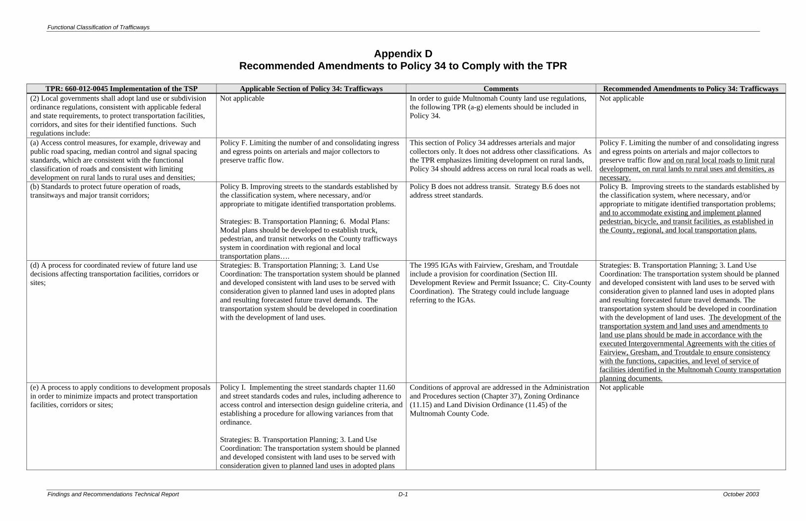
Functional Classification of Trafficways
Findings and Recommendations Technical Report D-1 October 2003
Appendix D Recommended Amendments to Policy 34 to Comply with the TPR
TPR: 660-012-0045 Implementation of the TSP Applicable Section of Policy 34: Trafficways Comments Recommended Amendments to Policy 34: Trafficways
(2) Local governments shall adopt land use or subdivision ordinance regulations, consistent with applicable federal and state requirements, to protect transportation facilities, corridors, and sites for their identified functions. Such regulations include:
Not applicable In order to guide Multnomah County land use regulations, the following TPR (a-g) elements should be included in Policy 34.
Not applicable
(a) Access control measures, for example, driveway and public road spacing, median control and signal spacing standards, which are consistent with the functional classification of roads and consistent with limiting development on rural lands to rural uses and densities;
Policy F. Limiting the number of and consolidating ingress and egress points on arterials and major collectors to preserve traffic flow.
This section of Policy 34 addresses arterials and major collectors only. It does not address other classifications. As the TPR emphasizes limiting development on rural lands, Policy 34 should address access on rural local roads as well.
Policy F. Limiting the number of and consolidating ingress and egress points on arterials and major collectors to preserve traffic flow and on rural local roads to limit rural development, on rural lands to rural uses and densities, as necessary.
(b) Standards to protect future operation of roads, transitways and major transit corridors;
Policy B. Improving streets to the standards established by the classification system, where necessary, and/or appropriate to mitigate identified transportation problems. Strategies: B. Transportation Planning; 6. Modal Plans: Modal plans should be developed to establish truck, pedestrian, and transit networks on the County trafficways system in coordination with regional and local transportation plans….
Policy B does not address transit. Strategy B.6 does not address street standards.
Policy B. Improving streets to the standards established by the classification system, where necessary, and/or appropriate to mitigate identified transportation problems; and to accommodate existing and implement planned pedestrian, bicycle, and transit facilities, as established in the County, regional, and local transportation plans.
(d) A process for coordinated review of future land use decisions affecting transportation facilities, corridors or sites;
Strategies: B. Transportation Planning; 3. Land Use Coordination: The transportation system should be planned and developed consistent with land uses to be served with consideration given to planned land uses in adopted plans and resulting forecasted future travel demands. The transportation system should be developed in coordination with the development of land uses.
The 1995 IGAs with Fairview, Gresham, and Troutdale include a provision for coordination (Section III. Development Review and Permit Issuance; C. City-County Coordination). The Strategy could include language referring to the IGAs.
Strategies: B. Transportation Planning; 3. Land Use Coordination: The transportation system should be planned and developed consistent with land uses to be served with consideration given to planned land uses in adopted plans and resulting forecasted future travel demands. The transportation system should be developed in coordination with the development of land uses. The development of the transportation system and land uses and amendments to land use plans should be made in accordance with the executed Intergovernmental Agreements with the cities of Fairview, Gresham, and Troutdale to ensure consistency with the functions, capacities, and level of service of facilities identified in the Multnomah County transportation planning documents.
(e) A process to apply conditions to development proposals in order to minimize impacts and protect transportation facilities, corridors or sites;
Policy I. Implementing the street standards chapter 11.60 and street standards codes and rules, including adherence to access control and intersection design guideline criteria, and establishing a procedure for allowing variances from that ordinance. Strategies: B. Transportation Planning; 3. Land Use Coordination: The transportation system should be planned and developed consistent with land uses to be served with consideration given to planned land uses in adopted plans
Conditions of approval are addressed in the Administration and Procedures section (Chapter 37), Zoning Ordinance (11.15) and Land Division Ordinance (11.45) of the Multnomah County Code.
Not applicable
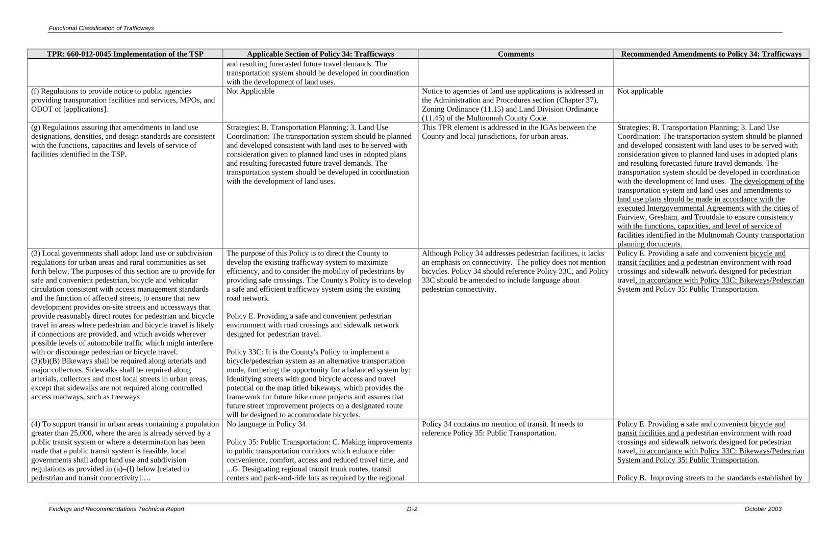
Functional Classification of Trafficways
Findings and Recommendations Technical Report D-2 October 2003
TPR: 660-012-0045 Implementation of the TSP Applicable Section of Policy 34: Trafficways Comments Recommended Amendments to Policy 34: Trafficways and resulting forecasted future travel demands. The transportation system should be developed in coordination with the development of land uses.
(f) Regulations to provide notice to public agencies providing transportation facilities and services, MPOs, and ODOT of [applications].
Not Applicable Notice to agencies of land use applications is addressed in the Administration and Procedures section (Chapter 37), Zoning Ordinance (11.15) and Land Division Ordinance (11.45) of the Multnomah County Code.
Not applicable
(g) Regulations assuring that amendments to land use designations, densities, and design standards are consistent with the functions, capacities and levels of service of facilities identified in the TSP.
Strategies: B. Transportation Planning; 3. Land Use Coordination: The transportation system should be planned and developed consistent with land uses to be served with consideration given to planned land uses in adopted plans and resulting forecasted future travel demands. The transportation system should be developed in coordination with the development of land uses.
This TPR element is addressed in the IGAs between the County and local jurisdictions, for urban areas.
Strategies: B. Transportation Planning; 3. Land Use Coordination: The transportation system should be planned and developed consistent with land uses to be served with consideration given to planned land uses in adopted plans and resulting forecasted future travel demands. The transportation system should be developed in coordination with the development of land uses. The development of the transportation system and land uses and amendments to land use plans should be made in accordance with the executed Intergovernmental Agreements with the cities of Fairview, Gresham, and Troutdale to ensure consistency with the functions, capacities, and level of service of facilities identified in the Multnomah County transportation planning documents.
(3) Local governments shall adopt land use or subdivision regulations for urban areas and rural communities as set forth below. The purposes of this section are to provide for safe and convenient pedestrian, bicycle and vehicular circulation consistent with access management standards and the function of affected streets, to ensure that new development provides on-site streets and accessways that provide reasonably direct routes for pedestrian and bicycle travel in areas where pedestrian and bicycle travel is likely if connections are provided, and which avoids wherever possible levels of automobile traffic which might interfere with or discourage pedestrian or bicycle travel. (3)(b)(B) Bikeways shall be required along arterials and major collectors. Sidewalks shall be required along arterials, collectors and most local streets in urban areas, except that sidewalks are not required along controlled access roadways, such as freeways
The purpose of this Policy is to direct the County to develop the existing trafficway system to maximize efficiency, and to consider the mobility of pedestrians by providing safe crossings. The County's Policy is to develop a safe and efficient trafficway system using the existing road network. Policy E. Providing a safe and convenient pedestrian environment with road crossings and sidewalk network designed for pedestrian travel. Policy 33C: It is the County's Policy to implement a bicycle/pedestrian system as an alternative transportation mode, furthering the opportunity for a balanced system by: Identifying streets with good bicycle access and travel potential on the map titled bikeways, which provides the framework for future bike route projects and assures that future street improvement projects on a designated route will be designed to accommodate bicycles.
Although Policy 34 addresses pedestrian facilities, it lacks an emphasis on connectivity. The policy does not mention bicycles. Policy 34 should reference Policy 33C, and Policy 33C should be amended to include language about pedestrian connectivity.
Policy E. Providing a safe and convenient bicycle and transit facilities and a pedestrian environment with road crossings and sidewalk network designed for pedestrian travel, in accordance with Policy 33C: Bikeways/Pedestrian System and Policy 35: Public Transportation.
(4) To support transit in urban areas containing a population greater than 25,000, where the area is already served by a public transit system or where a determination has been made that a public transit system is feasible, local governments shall adopt land use and subdivision regulations as provided in (a)–(f) below [related to pedestrian and transit connectivity]….
No language in Policy 34. Policy 35: Public Transportation: C. Making improvements to public transportation corridors which enhance rider convenience, comfort, access and reduced travel time, and ...G. Designating regional transit trunk routes, transit centers and park-and-ride lots as required by the regional
Policy 34 contains no mention of transit. It needs to reference Policy 35: Public Transportation.
Policy E. Providing a safe and convenient bicycle and transit facilities and a pedestrian environment with road crossings and sidewalk network designed for pedestrian travel, in accordance with Policy 33C: Bikeways/Pedestrian System and Policy 35: Public Transportation. Policy B. Improving streets to the standards established by

Functional Classification of Trafficways
Findings and Recommendations Technical Report D-3 October 2003
TPR: 660-012-0045 Implementation of the TSP Applicable Section of Policy 34: Trafficways Comments Recommended Amendments to Policy 34: Trafficways transportation plan of the Portland Metropolitan Area as shown on the regional transit trunk route map.
the classification system, where necessary, and/or appropriate to mitigate identified transportation problems; and to accommodate existing and implement planned pedestrian, bicycle, and transit facilities, as established in the County, regional, and local transportation plans.
(5) In MPO areas, local governments shall adopt land use and subdivision regulations to reduce reliance on the automobile which:
Policy G. Reducing reliance on the automobile and assuring that the Planned transportation system supports patterns of travel and land use which will avoid or mitigate problems of air pollution, Traffic congestion and community livability.
Language is adequate. Not applicable
(a) Allow transit-oriented developments (TODs) on lands along transit routes;
Strategies: A. Trafficways, 3. Fostering Choice: The trafficway system should be managed to provide opportunities for choices among available travel modes so that reliance on automobiles as single-occupant vehicles can be reduced, and so that total vehicle miles traveled as a measure of automobile use per capita can be reduced in the future, in accordance with the state Transportation Planning Rule. Policy 35: Public Transportation Policies: A. Increasing overall density levels in the urban area, particularly at light rail stations, B. Locating population concentrations, commercial centers, employment centers, and public facilities in areas which can be served by public transportation.
Policy 35: Public Transportation does address TODs. The language in Policy 34 needs to reference Policy 35.
Strategies: A. Trafficways, 3. Fostering Choice: The trafficway system should be managed to provide opportunities for choices among available travel modes so that reliance on automobiles as single-occupant vehicles can be reduced, and so that total vehicle miles traveled as a measure of automobile use per capita can be reduced in the future, in accordance with the state Transportation Planning Rule and Policy 35: Public Transportation.
(b) Implements a demand management program to meet the measurable standards set in the TSP in response to 660-012-0035(4);
Policy G. Reducing reliance on the automobile and assuring that the Planned transportation system supports patterns of travel and land use which will avoid or mitigate problems of air pollution, Traffic congestion and community livability; Policy H. Encouraging ride-share and flextime programs to help meet the projected increase in travel demand. The County will work with metro and tri-met to develop ride-share programs, flextime and other transportation demand strategies to achieve the ride-share goal given in the regional transportation plan; and
Language is adequate. Not applicable
(c) Implements a parking plan which: (A) Achieves a 10% reduction in the number of parking spaces per capita in the MPO area over the planning period. This may be accomplished through a combination of restrictions on development of new parking spaces and requirements that existing parking spaces be redeveloped to other uses;
Policy 34 does not mention parking. Policy 34 needs to include language about parking along trafficways under the County’s jurisdiction. There may be discrepancies between County and city on-street parking standards. See Section 2.3 Street Standards, and Section 7.0 Recommendations in this report.
L. Ensuring that on-street parking is provided in accordance with County street standards and coordinating with cities to implement Metro’s regional 10 percent reduction goal.
(6) In developing a bicycle and pedestrian circulation plan as required by 660-012-0020(2)(d), local governments shall identify improvements to facilitate bicycle and pedestrian
The purpose of this Policy is to direct the County to develop the existing trafficway system to maximize efficiency, and to consider the mobility of pedestrians by
Although Policy 34 addresses pedestrian facilities, it lacks an emphasis on connectivity. The policy does not mention bicycles. Policy 34 should reference Policy 33C, and Policy
Policy E. Providing a safe and convenient bicycle and transit facilities and a pedestrian environment with road crossings and sidewalk network designed for pedestrian
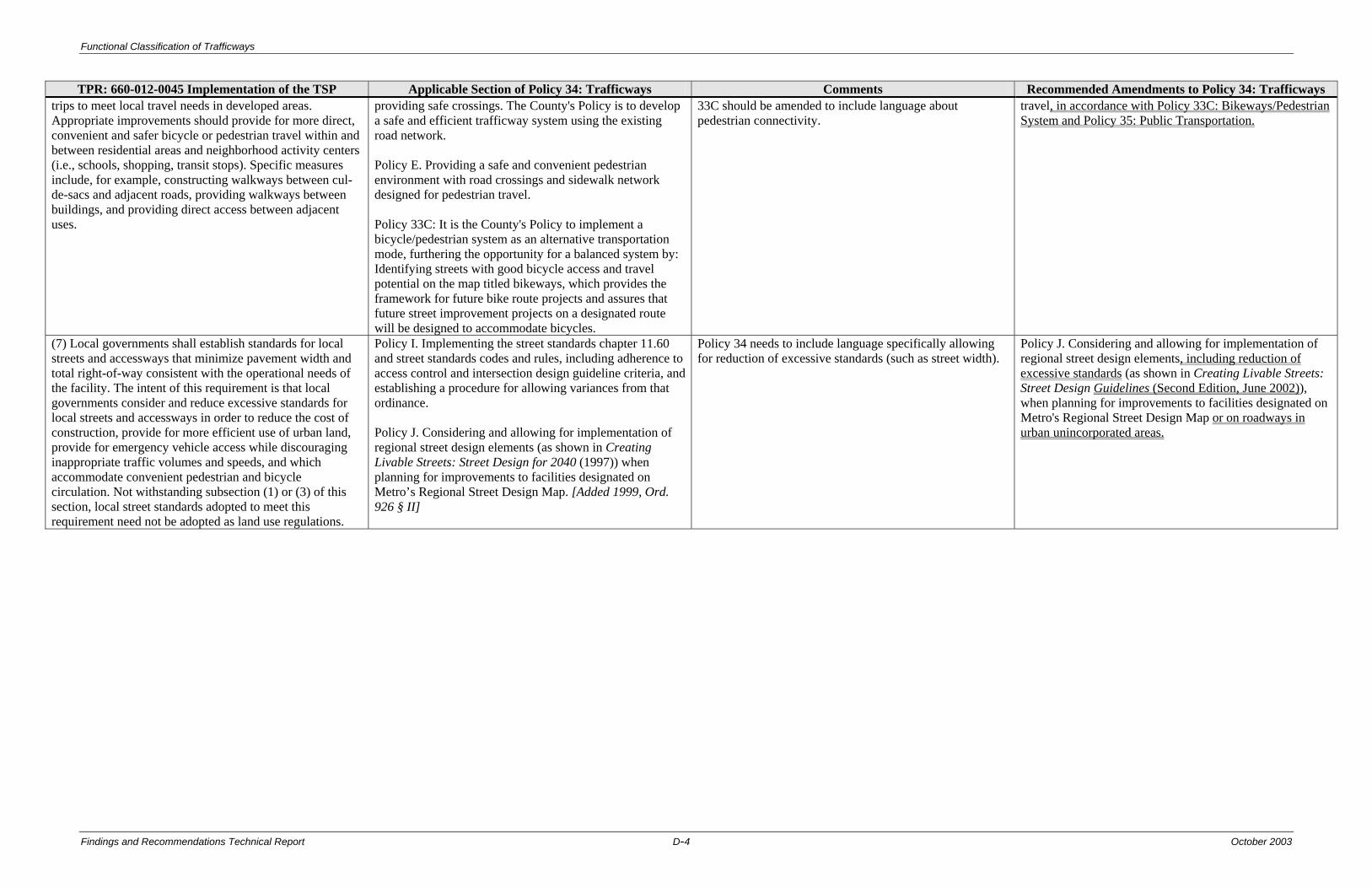
Functional Classification of Trafficways
Findings and Recommendations Technical Report D-4 October 2003
TPR: 660-012-0045 Implementation of the TSP Applicable Section of Policy 34: Trafficways Comments Recommended Amendments to Policy 34: Trafficways trips to meet local travel needs in developed areas. Appropriate improvements should provide for more direct, convenient and safer bicycle or pedestrian travel within and between residential areas and neighborhood activity centers (i.e., schools, shopping, transit stops). Specific measures include, for example, constructing walkways between cul-de-sacs and adjacent roads, providing walkways between buildings, and providing direct access between adjacent uses.
providing safe crossings. The County's Policy is to develop a safe and efficient trafficway system using the existing road network. Policy E. Providing a safe and convenient pedestrian environment with road crossings and sidewalk network designed for pedestrian travel. Policy 33C: It is the County's Policy to implement a bicycle/pedestrian system as an alternative transportation mode, furthering the opportunity for a balanced system by: Identifying streets with good bicycle access and travel potential on the map titled bikeways, which provides the framework for future bike route projects and assures that future street improvement projects on a designated route will be designed to accommodate bicycles.
33C should be amended to include language about pedestrian connectivity.
travel, in accordance with Policy 33C: Bikeways/Pedestrian System and Policy 35: Public Transportation.
(7) Local governments shall establish standards for local streets and accessways that minimize pavement width and total right-of-way consistent with the operational needs of the facility. The intent of this requirement is that local governments consider and reduce excessive standards for local streets and accessways in order to reduce the cost of construction, provide for more efficient use of urban land, provide for emergency vehicle access while discouraging inappropriate traffic volumes and speeds, and which accommodate convenient pedestrian and bicycle circulation. Not withstanding subsection (1) or (3) of this section, local street standards adopted to meet this requirement need not be adopted as land use regulations.
Policy I. Implementing the street standards chapter 11.60 and street standards codes and rules, including adherence to access control and intersection design guideline criteria, and establishing a procedure for allowing variances from that ordinance. Policy J. Considering and allowing for implementation of regional street design elements (as shown in Creating Livable Streets: Street Design for 2040 (1997)) when planning for improvements to facilities designated on Metro’s Regional Street Design Map. [Added 1999, Ord. 926 § II]
Policy 34 needs to include language specifically allowing for reduction of excessive standards (such as street width).
Policy J. Considering and allowing for implementation of regional street design elements, including reduction of excessive standards (as shown in Creating Livable Streets: Street Design Guidelines (Second Edition, June 2002)), when planning for improvements to facilities designated on Metro's Regional Street Design Map or on roadways in urban unincorporated areas.

Functional Classification of Trafficways
Findings and Recommendations Technical Report D-5 October 2003
660-012-0060
Plan and Land Use Regulation Amendments Policy 34 Comments Recommended Amendments
(1) Amendments to functional plans, acknowledged comprehensive plans, and land use regulations which significantly affect a transportation facility shall assure that allowed land uses are consistent with the identified function, capacity, and performance standards (e.g. level of service, volume to capacity ratio, etc.) of the facility…. (2) A plan or land use regulation amendment significantly affects a transportation facility if it: (a) Changes the functional classification of an existing or planned transportation facility; (b) Changes standards implementing a functional classification system; (c) Allows types or levels of land uses which would result in levels of travel or access which are inconsistent with the functional classification of a transportation facility; or (d) Would reduce the performance standards of the facility below the minimum acceptable level identified in the TSP. (5) In determining whether proposed land uses would affect or be consistent with planned transportation facilities as provided in 0060(1) and (2), local governments shall give full credit for potential reduction in vehicle trips for uses located in mixed-use, pedestrian-friendly centers, and neighborhoods as provided in (a)–(d) below…
Policy 34 does not contain language that explicitly seeks to protect transportation facilities from effects of plan or land use regulation amendments. Five of the policies in Policy 34 relate to this subsection of the TPR: Policy A. Maintaining a trafficway classification system; Policy B. Improving streets to the standards established by the classification system, where necessary, and/or appropriate to mitigate identified transportation problems; Policy C. Placing priority on maintaining the existing trafficways; Policy G. Reducing reliance on the automobile and assuring that the Planned transportation system supports patterns of travel and land use which will avoid or mitigate problems of air pollution, Traffic congestion and community livability; Policy H. Encouraging ride-share and flextime programs to help meet the projected increase in travel demand. The County will work with metro and tri-met to develop ride-share programs, flextime and other transportation demand strategies to achieve the ride-share goal given in the regional transportation plan.
Reference to the IGAs needs to be incorporated into Policy 34. IGAs need to be amended to include language protecting transportation facilities when local plans and regulations are amended. See Section 7.0 Recommendations in this report.
Strategies: B. Transportation Planning; 3. Land Use Coordination: The transportation system should be planned and developed consistent with land uses to be served with consideration given to planned land uses in adopted plans and resulting forecasted future travel demands. The transportation system should be developed in coordination with the development of land uses. The development of the transportation system and land uses and amendments to land use plans should be made in accordance with the executed Intergovernmental Agreements with the cities of Fairview, Gresham, and Troutdale to ensure consistency with the functions, capacities, and level of service of facilities identified in the Multnomah County transportation planning documents.


Functional Classification of Trafficways
Findings and Recommendations Technical Report E-1 October 2003
Appendix E Multnomah County Comprehensive Framework Plan
Policy 34: Trafficways (Proposed Amendments)
Introduction Trafficways are a vital part of the transportation system in Multnomah County, functioning to move people and goods between their origins and destinations. A hierarchy of trafficways provides necessary access to land uses, and mobility to travelers and commerce. The trafficway network accommodates several modes of travel within public right-of-way, and acknowledges differing transportation needs between the urban and rural areas of the County. Communication and power networks, and public utilities including storm and sanitary sewers, and water supply share the right-of-way with roads. Trafficways are developed according to their functional classification, which distinguishes streets and roads, by their operational purposes. Many aspects are considered when classifying trafficways:
• Travel characteristics: trip length, origin and destination • Intensity and density of land uses served: urban and rural • Travel modes to be served: automobiles, bicycles, transit, trucks, and pedestrians • Relationship between traffic movement and access management • Projected traffic volumes and capacity requirements at acceptable levels of service
The hierarchy of trafficways generally progresses from low traffic volumes and low speeds to higher volumes and speeds. Trip types vary by origins and destinations, and by trip length and purpose: from local and neighborhood trips to countrywide and intra-regional travel, or inter-regional and interstate trips. Access to property is inversely related to the mobility function of a trafficway. Access to adjacent property is greatest on local streets, but mobility is limited to local trips on local and neighborhood streets. The greatest level of mobility to the greatest number of travelers is provided by the freeway system, however, there is no direct property access provided by the interstate system. County roads serve a distribution of trips between home and work, school, shopping and recreation, and from sources of materials and manufacturers to distributors. The system of trafficways to meet the needs of County residents, visitors, and businesses are functionally identified by the following types of facilities. Each type of trafficway accommodates various modes of travel, and relates to land uses to which access is being provided.
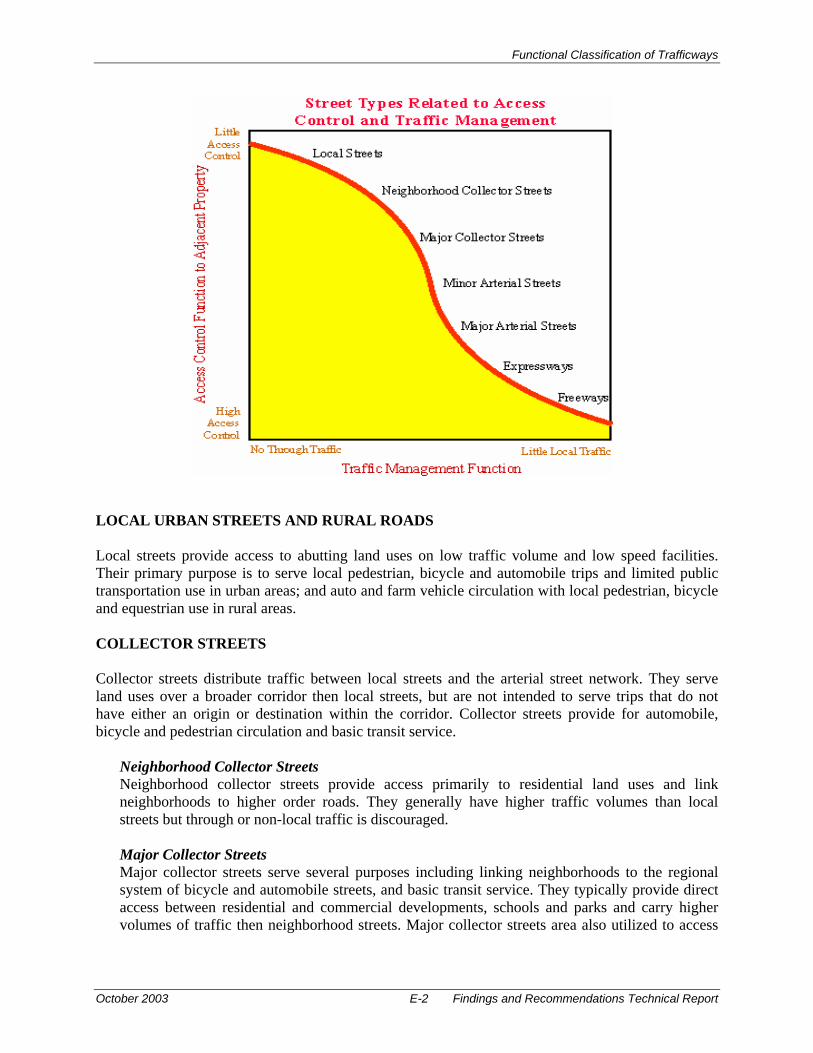
Functional Classification of Trafficways
October 2003 E-2 Findings and Recommendations Technical Report
LOCAL URBAN STREETS AND RURAL ROADS Local streets provide access to abutting land uses on low traffic volume and low speed facilities. Their primary purpose is to serve local pedestrian, bicycle and automobile trips and limited public transportation use in urban areas; and auto and farm vehicle circulation with local pedestrian, bicycle and equestrian use in rural areas. COLLECTOR STREETS Collector streets distribute traffic between local streets and the arterial street network. They serve land uses over a broader corridor then local streets, but are not intended to serve trips that do not have either an origin or destination within the corridor. Collector streets provide for automobile, bicycle and pedestrian circulation and basic transit service.
Neighborhood Collector Streets Neighborhood collector streets provide access primarily to residential land uses and link neighborhoods to higher order roads. They generally have higher traffic volumes than local streets but through or non-local traffic is discouraged. Major Collector Streets Major collector streets serve several purposes including linking neighborhoods to the regional system of bicycle and automobile streets, and basic transit service. They typically provide direct access between residential and commercial developments, schools and parks and carry higher volumes of traffic then neighborhood streets. Major collector streets area also utilized to access

Functional Classification of Trafficways
Findings and Recommendations Technical Report E-3 October 2003
industrial and employment areas and other locations with large truck and over-sized load volumes. Rural Collector Roads Rural collector roads are well connected in rural communities to distribute automobile traffic over large areas and generally connect to urban streets or rural arterials. Where rural collector streets connect roads in adjacent counties, through traffic will occur with volumes greater than local rural roads. They may also provide for recreational trips by auto, bicycle and equestrian. Primary access is provided to land uses adjacent to the facility and over large rural districts. Rural collector roads provide for necessary truck transport of (agricultural, timber and minerals) out of rural districts.
ARTERIAL STREETS Arterial streets comprise the regional transportation network, and provide for travel between communities in the County, and between counties. Arterial streets accommodate the full array of travel modes with the regional bikeway system, fixed-route transit network, goods delivery and higher volume automobile traffic then collector streets. Arterial streets connect to freeways and expressways, and collector streets. More intensive land uses occur along arterial street corridors and at arterial street intersections. Urban arterial roadways may be overlayed with a regional or community boulevard or street designation by Metro in the 2040 Growth Concept. Multnomah County acknowledges Metro's Street Design Guidelines for 2040. The design elements in the Street Design Guidelines will be considered on regional facilities under Multnomah County's jurisdiction in the urban area. [Added 1999, Ord. 926 § II]
Minor Arterial Streets Minor arterial streets are the lowest order arterial facility in the regional street network. They typically carry less traffic volume then principal and major arterials, but have a high degree of connectivity between communities. Access management may be implemented to preserve traffic capacity. Land uses along the corridor are a mixture of community and regional activities. Minor arterial streets provide major links in the regional road and bikeway networks; provide for truck mobility and transit corridors; and are significant links in the local pedestrian system. Major Arterial Streets Major arterial streets carry high volumes of traffic between cities in the County as part of the regional trafficway system. The major fixed-route transit network corresponds with arterial street corridors. Priority may be given to transit- and pedestrian-oriented land uses. Traffic includes trucks and goods delivery, substantial commute movements and controlled access to regional land uses along the corridor. Design and management of major arterial streets emphasizes preservation of ability to move auto and transit traffic by limiting accesses while also accommodating regional bikeways and pedestrian movements. Principal Arterial Streets Principal arterial streets connect to freeways and highways, which serve travelers without an origin or destination in the County. This interstate and interregional traffic, including trucks, is in addition to regional traffic traveling between cities and counties, and traffic generated by intensive and higher density land uses along the arterial corridor. Thus, traffic volumes are high and access to adjacent land uses is limited to preserve the traffic capacity and reduce congestion
Functional Classification of Trafficways
October 2003 E-4 Findings and Recommendations Technical Report
along the principal arterial street. The ability to move auto, truck and regional bicycle traffic is preserved. Trafficways designated as National Highway System routes shall be classified as Principal Arterial roadways. Rural Arterial Roads Rural arterial roads are the primary means of access into the County's large rural districts, and often connect between counties to accommodate through movements. Rural arterials connect to freeways or highways, and link rural collector and local roads to the urban area and other regions. Rural arterial roads carry greater traffic volumes then rural collector roads, including commuters and other home-based trips, natural resource trips involving trucks, and recreational trips involving autos, bicycles and equestrians.
EXPRESSWAYS Expressways principally serve interregional travel, and secondarily, regional and intercity travel. They are designed for moderate speeds, with limited and controlled access to preserve capacity, and accommodate substantial traffic volumes including truck traffic. Cross streets are grade separated or limited to a few intersections with arterial streets. They typically have a center median and do not provide access to adjacent land uses. Pedestrian and bike facilities may be provided along the expressway, often on separated facilities. FREEWAYS Freeways are high-speed roadways with grade-separated interchanges. They function to move goods and people between states, and between regions within Oregon. Freeways carry high volumes of traffic, much of which does not have an origin or destination in Multnomah County. Access to abutting properties is prohibited. Pedestrian traffic and bicycle traffic on urban freeways are also prohibited. OVERLAY CLASSIFICATION In addition to a streets basic functional classification, an overlay classification is used to further describe the design or function of a facility. Included in the overlay classification are Regional and Community Boulevards, and Regional and Community Streets, and Green Streets as designated by Metro.
Scenic Routes Scenic routes occur on streets that offer unique scenic views, and are used for recreational and scenic travel in addition to traffic appropriate to the facility functional classification. Unique designs and materials and other accommodations, or traffic restrictions, may be imposed to preserve and enhance the scenic character of the facility. Landscape treatments should incorporate native species that integrate roadway improvements with the scenic character of the area. Industrial Streets Industrial streets occur on roadways that either serve as a freight route identified in the Regional Transportation Plan or serve industrial use areas. The standards for asphalt and base for major and minor collectors and lower classifications are insufficient for truck traffic. Therefore the arterial asphalt and base standards need to be applied to non-arterial roadways carrying truck
Functional Classification of Trafficways
Findings and Recommendations Technical Report E-5 October 2003
traffic. Regardless of classification, the pavement section of trafficways designated with the industrial streets overlays shall be constructed to arterial standards as per the Multnomah County Design Standards. Part I – Design Manual, Section 4 – Pavement Design. Boulevards [Added 1999, Ord. 926 § II] Boulevards serve the multi-modal travel needs of the region’s most intensely developed activity centers, including regional centers, station communities, town centers and some main streets. Boulevards are the continuation of the regional street network within more intensively developed activity centers. Boulevards are designed with special amenities that promote pedestrian, bicycle, and public transportation travel in the districts they serve. Boulevards are classified as regional and community scale designs. Regional boulevards can be applied to the major arterial classification while community boulevards can be applied to the minor arterial classification. The Boulevard overlay classifications are designated in the Regional Transportation Plan and in local jurisdiction’s Transportation System Plans and other transportation planning documents.
Regional Boulevards [Added 1999, Ord. 926 § II] Regional boulevards consist of four or more vehicle lanes, balanced multi-modal function, and a broad right of way. Features highly desirable on regional boulevards include on-street parking, bicycle lanes, narrower travel lanes than throughways, more intensive land use oriented to the street, wide sidewalks, and may include a landscaped median. Community Boulevards [Added 1999, Ord. 926 § II] Community boulevards consist of four or fewer vehicle travel lanes, balanced multi-modal function, narrower right of way than a regional boulevard, landscaped medians, no-street parking, narrower travel lanes than throughways, more intensive land use oriented to the street, and wide sidewalks. Community boulevards are located within the most intensely developed activity centers with development oriented to the street. These are primarily regional centers, town centers, station communities and some main streets.
Streets [Added 1999, Ord. 926 § II] Streets serve the multi-modal travel needs of corridors, inner and outer residential neighborhoods and some main streets. Streets typically are more vehicle-oriented and less pedestrian-oriented than boulevards, providing a multi-modal function with an emphasis on vehicle mobility. Streets are classified as regional and community designs. Regional streets can be applied to the major arterial roads, while the community streets can be applied to minor arterial roads. The Street overlay classifications are designated in the Regional Transportation Plan and in local jurisdiction’s Transportation System Plans and other transportation planning documents.
Regional Streets [Added 1999, Ord. 926 § II] Regional streets consist of four or more vehicle travel lanes, balanced multi-modal function, broad right of way, limited on-street parking, wider travel lanes than boulevards, corridor land use set back from the street, sidewalk with pedestrian buffering from street, and a raised landscaped median or, usually a continuous two way left turn lane.

Functional Classification of Trafficways
October 2003 E-6 Findings and Recommendations Technical Report
Community Streets [Added 1999, Ord. 926 § II] Community streets consists of two to four travel lanes, balanced multi-modal function, narrower right of way than regional streets, on-street parking, narrower or fewer travel lanes than regional streets and residential neighborhood and corridor land use set back from the street. Community streets provide a higher level of local access and street connectivity than regional streets. Community streets have the greatest flexibility in cross sectional elements. Depending on the intensity of adjacent land use and site access needs, community streets can have three different median conditions; center two way left turn lane, narrow landscaped median, or no median.
Green Streets Green Streets are designed to incorporate a system of stormwater treatment within their right-of-way to protect the quality of the region’s stream system. Green streets are designated according to the location-specific circumstances, including environmental conditions such as the soil conditions, water table, etc.; and surrounding land uses. The trafficways designated with green street overlay classifications are identified in the Regional Transportation Plan and in local jurisdiction’s Transportation System Plans and other transportation planning documents. Multnomah County shall consider implementation of Green Streets design standards when developing a project listed in the County’s Capital Improvement Program. Standards for Green Streets are in the Multnomah County Design Standards. Part I – Design Manual, Section 2 – Geometric Design. TRAFFIC VOLUME GUIDELINES The following chart illustrates the extent of traffic volumes by functional classification of each type of facility. The upper and lower limits are design guidelines, actual volumes may vary.
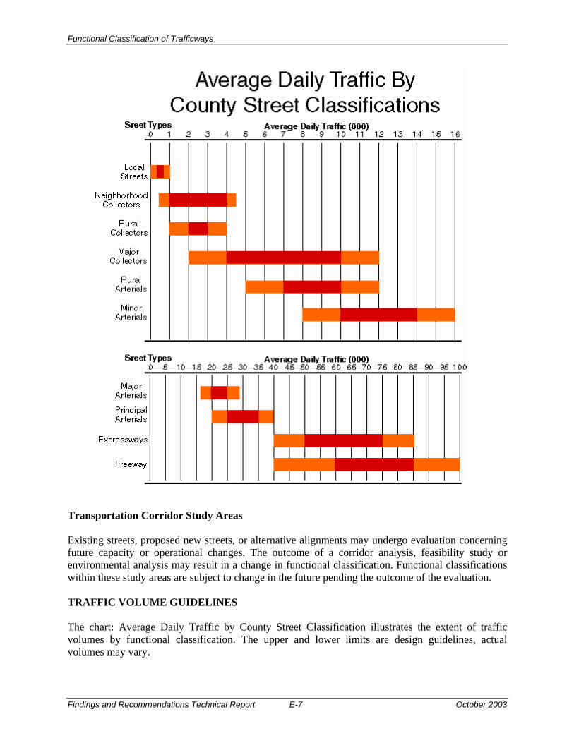
Functional Classification of Trafficways
Findings and Recommendations Technical Report E-7 October 2003
Transportation Corridor Study Areas Existing streets, proposed new streets, or alternative alignments may undergo evaluation concerning future capacity or operational changes. The outcome of a corridor analysis, feasibility study or environmental analysis may result in a change in functional classification. Functional classifications within these study areas are subject to change in the future pending the outcome of the evaluation. TRAFFIC VOLUME GUIDELINES The chart: Average Daily Traffic by County Street Classification illustrates the extent of traffic volumes by functional classification. The upper and lower limits are design guidelines, actual volumes may vary.

Functional Classification of Trafficways
October 2003 E-8 Findings and Recommendations Technical Report
The purpose of this Policy is to direct the County to develop the existing trafficway system to maximize efficiency, and to consider the mobility of pedestrians by providing safe crossings. Policy 34 The purpose of this Policy is to direct the County to develop the existing trafficway system to maximize efficiency, and to consider the mobility of pedestrians by providing safe crossings. The County's Policy is to develop a safe and efficient trafficway system using the existing road network, and by:
A. Maintaining a trafficway classification system; B. Improving streets to the standards established by the classification system, where necessary,
and/or appropriate to mitigate identified transportation problems and to accommodate existing implemented and planned pedestrian, bicycle (Policy 33c), and transit facilities (Policy 35) as established in the County, regional, and local transportation plans;
C. Placing priority on maintaining the existing trafficways;
D. Developing additional transportation facilities to meet community and regional transportation
needs where capacity of the existing system has been maximized through transportation system management and demand management measures; Average Daily Traffic by County Street Classifications chart here
E. Providing a safe and convenient bicycle and transit facilities and a pedestrian environment
with road crossings and sidewalk network designed for pedestrian travel in accordance with Policy 33c: Bikeways/Pedestrian System and Policy 35: Public Transportation;
F. Limiting the number of and consolidating ingress and egress points on arterials and major
collectors to preserve traffic flow and on rural local roads to limit rural development, as necessary;
G. Reducing reliance on the automobile and assuring that the Planned transportation system
supports patterns of travel and land use which will avoid or mitigate problems of air pollution, Traffic congestion and community livability;
H. Encouraging ride-share and flextime programs to help meet the projected increase in travel
demand. The County will work with metro and tri-met to develop ride-share programs, flextime and other transportation demand strategies to achieve the ride-share goal given in the regional transportation plan; and
I. Implementing the preferred street standards chapter 29.500, administrative rule or the County
Design and Construction Manual, including adherence to access control and intersection design guideline criteria,; and establishing a procedure for allowing variances from that ordinance deviation from the preferred standard only when a physical obstacle prevents construction to the preferred standard or when the appropriate local jurisdiction’s

Functional Classification of Trafficways
Findings and Recommendations Technical Report E-9 October 2003
Transportation System Plan provides an alternate adopted standard. In all cases, roadways shall be constructed to standards within the County’s allowable ranges for the appropriate classification.
J. Considering and allowing for implementation of regional street design elements including
reduction of excessive standards (as shown in Creating Livable Streets: Street Design for 2040 (1997)) Guidelines (Second Edition, June 2002) when planning for improvements to facilities designated on Metro’s Regional Street Design Map or on roadways in urban unincorporated areas. [Added 1999, Ord. 926 § II]
K. Improving local circulation by keeping through trips on arterial streets and minimizing local
trip lengths by increasing street connectivity. [Added 1999, Ord. 926 § II]
L. Ensuring that on-street parking is provided in accordance with county street standards and coordinating with cities to implement Metro’s regional 10 percent reduction goal.
M. Ensuring that additional right-of-way is dedicated at intersections that are currently
signalized and that potentially may be signalized in order to comply with the Americans with Disabilities Act.
Excluding that portion of Multnomah County included in the Columbia River Gorge National Scenic Area, this Policy and the functional classification of trafficways map accompanying this Policy shall control over conflicting provisions of community plans or other pre-existing plans in determining the functional classification of trafficways. Trafficways located within the Columbia River Gorge National Scenic Area are subject to and superceded by provisions of the Columbia River Gorge Scenic Area Management Plan. Strategies
A. TRAFFICWAYS
Adequate trafficways are essential for the efficient movement of goods and people. County trafficways should be designed and built to accommodate travel by a variety of travel modes, to provide access to abutting properties and as locations for utilities within the trafficway right-of-way. To develop an efficient and safe trafficway system, the following strategies should be pursued.
1. Classification of Trafficways: Trafficways should be classified into a functional
network that is integrated with land uses and travel needs. The hierarchy of the functionally classified network should be based on trip types and length, traffic volume and travel modes, and access to adjacent land uses within travel corridors.
2. System Efficiency: An inventory of the trafficway system should be maintained to
determine current and future deficiencies as the basis for a capital improvement program. The trafficway system should:
a. be designed and operated to optimize travel capacities within acceptable levels of service, and

Functional Classification of Trafficways
October 2003 E-10 Findings and Recommendations Technical Report
b. be consistent with land uses and transportation needs as determined by local and regional plans.
3. Fostering Choice: The trafficway system should be managed to provide
opportunities for choices among available travel modes so that reliance on automobiles as single-occupant vehicles can be reduced, and so that total vehicle miles traveled as a measure of automobile use per capita can be reduced in the future, in accordance with the state Transportation Planning Rule and Policy 35: Public Transportation.
4. Environmental and Social Values: Development and operation of the County
trafficway system should promote air quality consistent with federal standards, preserve open space and agricultural and forest lands consistent with local plans, protect scenic views, protect neighborhood cohesiveness and historic and cultural sites, and minimize the dislocation of residents and businesses resulting from County transportation projects.
5. Safety: Safety is a primary objective in the development and operation of the
trafficway system through traffic signing and signalization, speed limits and speed control measures, road design and access control measures. Through the use of accepted design and traffic management principles and practices, traffic accidents and conflicts between pedestrians, bicyclists, equestrians and motorists can be minimized.
6. Economics: Work with the business community and regional and state agencies to
assure efficient movement of goods and services in and through the County, including coordination of the trafficway system with intermodal facilities, and use of public right of way for power and telecommunication purposes.
7. Freight movement: County trafficways shall provide for the movement of freight on
facilities designed and built to accommodate the types and frequency of freight trips, and which provide for convenient access to major highways, industrial areas and resource extraction sites. County should identify a trafficway network for the purpose of freight movement. Trafficways designated as National Highway System routes shall be classified as Principal Arterial roadways.
8. Aesthetics: Trafficways are an important visual element in the urban and rural
environment. As public spaces, trafficways should facilitate the public's use of the right-of-way in a manner that provides an aesthetic benefit to the community through facility design, landscaping and their relationship to the natural and built environment.
9. Street Connectivity: Local street design impacts the effectiveness of the regional system when local travel is restricted by a lack of connecting routes, and local trips are forced onto the regional network. Streets should be designed to keep through trips on arterial streets and provide local trips with alternative routes. [Added 1999, Ord. 926 § II]
Functional Classification of Trafficways
Findings and Recommendations Technical Report E-11 October 2003
B. TRANSPORTATION PLANNING
As part of Multnomah County's ongoing transportation planning program, the County should strive to anticipated and provide for the future travel needs of County residents, businesses and visitors.
1. Compliance with Rules and Regulations: Multnomah County should comply with existing and future state and federal legislation, and resulting rules and regulations, regarding environmental, energy, land use and transportation measures affecting the County trafficways system.
2. Comprehensive Framework Plan Policy Revisions: Multnomah County should
revise CFP Policy 33 to include Policy 33d—Pedestrianways that incorporates all Policy references to the provision of pedestrian circulation, and a map of the County pedestrian network. CFP Policy 35—Public Transportation should be amended to incorporate all Policy references to the transit classification system and transportation demand management, and a map of the County transit system.
3. Land Use Coordination: The transportation system should be planned and
developed consistent with land uses to be served with consideration given to planned land uses in adopted plans and resulting forecasted future travel demands. The transportation system should be developed in coordination with the development of land uses. The development of the transportation system and land uses and amendments to land use plans should be made in accordance with the executed Intergovernmental Agreements with the cities of Fairview, Gresham, and Troutdale to ensure consistency with the functions, capacities, and level of service of facilities identified in the Multnomah County transportation planning documents.
4. System Optimization: Transportation planning should strive to solve existing
transportation problems, in response to community input, by maximizing the operational capacity of the current system using available management techniques, and providing new or expanded facilities only where necessary.
5. Public Input: Community input is vital to the transportation planning process and
should be sought at key points in each planning process, including project development.
6. Modal Plans: Modal plans should be developed to establish truck, pedestrian and
transit networks on the County trafficway system in coordination with regional and local transportation plans, and the appropriate CFP policies amended to incorporate the network maps. Modal networks plans for the County trafficways and bikeways should be maintained in coordination with regional and local transportation plans.
7. Transportation Studies: Transportation studies and corridor analyses should be conducted to determine transportation needs, identify and analyze problems and alternative solutions, giving the public and communities the opportunity to participate in and effect the decision process.

Functional Classification of Trafficways
October 2003 E-12 Findings and Recommendations Technical Report
Specific corridor studies should include: • Mt. Hood Parkway: A through-route connection between Interstate-84 and US-26
in the East County area. • Participation in the regional freight study to identify an alternative NHS truck
route through the east Multnomah County area. The existing freight route along 181st/Burnside has land use conflicts with truck passage and substandard roadway conditions along Burnside in the Rockwood area. The 242nd Avenue Connector was identified as the alternate truck route in the Regional Transportation Plan. However, the project has been suspended because the transportation analysis completed for the Environmental Assessment found low demand for the connector in the short-term.
• 201st/202nd Avenues: Study of the capacity needs of a connection between Powell
Boulevard. and Sandy Boulevard. in the vicinity of 201/202nd Avenue.
• Evacuation routes in regards to homeland security, including routes for transport of hazardous materials and evaluating any conflicts between evacuation routes and hazardous material routes. The County should continue to work through the inter-agency Intelligent Transportation Systems Subcommittee on Public Safety. to develop a map of emergency routes and coordinate with federal, state, and local agencies.
C. COMMUNITY DEVELOPMENT ORDINANCE
Measures to plan for, develop, and manage the County trafficway system should be codified in Multnomah County Code: Title II: Community Development.
a. Street Standards: Codes and Rules should be revised specifying characteristics, permitting requirements and operational measures necessary to implement the County transportation system identified in CFP Policies 33c, 33d, 34, and 35.
b. The Multnomah County Transportation Capital Improvement Plan and Program
identifies and ranks by criteria of need, trafficway deficiencies and future capital needs, identifies future capital, and programs future transportation improvements based on a schedule of capital available for expenditure on the trafficway system.
D. STATE AND REGIONAL COORDINATION
Advise state and regional governments with regard to existing trafficways not under the County's jurisdiction. The County should alert provide notice to the state and(ODOT), regional (Metro) and affected local governments of required improvements, and should provide documentation as to public needs.

Functional Classification of Trafficways
Findings and Recommendations Technical Report F-1 October 2003
Appendix F Sources
Functional Classification Descriptions and Definitions Information on federal classifications is from the AASHTO “A Policy on Geometric Design of Highways and Streets,” which incorporates information from the FHWA “Highway Functional Classification: Concepts, Criteria, and Procedures.” The “1999 Oregon Highway Plan” (OHP) contains descriptions of the state highway classification system. Since the plan primarily deals with state highways, the classifications do not conform to the classifications of the other jurisdictions in the table. Therefore, the State classifications are not included in Appendix A table. The classifications are as follows: Connectivity Speed Volume Other Interstate Highways
Primary: major cities, regions of the state, and other states; secondary: regional trips within metropolitan areas
High Continuous flow operation
Major freight routes
Statewide Highways
Primary: inter-urban and inter-regional mobility and connections to larger urban areas, ports, and major recreation areas that are not directly served by Interstate Highway; secondary: intra-urban and intra-regional trips
High Continuous flow operation; in constrained and urban areas, interruptions to flow should be minimal
Local access may be a priority in Special Transportation Areas (STAs)
Regional Highways
Primary: regional centers, Statewide and Interstate Highways, or economic or activity centers of regional significance; secondary: serve land uses in the vicinity of the highways
Rural areas: high; urban and urbanizing areas: moderate to high
Continuous flow operation; in constrained and urban areas, interruptions to flow should be minimal
Local access may be a priority in STAs
District Highways
Primary: inter-urban and inter-regional mobility and connections to larger urban areas, ports, and major recreation areas that are not directly served by Interstate Highway; secondary: intra-urban and intra-regional trips
High Continuous flow operation
Local access is a priority in STAs; local access is balanced with mobility in Urban Business Areas

Functional Classification of Trafficways
October 2003 F-2 Findings and Recommendations Technical Report
Local Interest Roads
Function as local streets or arterials and serve little or no purpose for though traffic mobility; ODOT seeks to transfer these to local jurisdictions
Low to moderate
Local access is a priority inside STAs
Expressways (subset of Statewide, Regional, and District Highways) Definition: complete routes or segments of existing two-lane and multi-lane highways and planned multi-lane highways
Primary: interurban travel and connections to ports and major recreation areas with minimal interruptions; secondary: long distance intra-urban travel in metropolitan areas
Rural areas: high; urban areas: moderate to high
High Private access is discouraged; public road connections are highly controlled; usually no pedestrian facilities; bikeways may be separated from the roadway
The City of Wood Village TSP uses Multnomah County’s functional classifications. The Wood Village TSP provides a summary of the arterial, collector, and local categories and refers to Multnomah County’s Design and Construction Manual. Therefore, Multnomah County and Wood Village share a column in the table. The language in the RTP and the TSPs was copied as directly as possible into the table, to preserve the definitions of the classifications. Functional Classifications The Transportation System Plans (TSPs) for each of the jurisdictions were used to compile the table of functional classifications by roadway (Table 2). Functional classifications in the table refer to those designated as “proposed” in the TSPs, as it is assumed that the TSPs are or will be adopted, and the proposed designations are the accepted designations. Street Standards Information on federal classification is from the AASHTO “A Policy on Geometric Design of Highways and Streets”. Information was also taken from Metro’s “2000 Regional Transportation Plan,” and the cities’ TSPs. Information from Troutdale and ODOT was not included. Arterials and collectors within the City of Troutdale are all County roads. ODOT’s “Metric Highway Design Manual” contains design standards for rehabilitation and reconstruction of urban and rural highways (non-freeway). Since the manual primarily deals with state highways, the classifications do not conform to the classifications of the other jurisdictions in the table.