multiscale patterns of habitat and space use by the ... · more detailed surveys in the san eugenio...
TRANSCRIPT

ENDANGERED SPECIES RESEARCHEndang Species Res
Vol. 16: 273–281, 2012doi: 10.3354/esr00391
Published online March 22
INTRODUCTION
Understanding patterns of habitat and space useis essential for the conservation of populations ofthreatened animals (Johnson et al. 2004). The hab -itat features that animals require and the factorsthat limit their distribution vary at different spatial
scales (Ciarniello et al. 2007). At large scales, thepresence of populations is determined by factorssuch as geomorphology, topography, and habitatconfiguration. At small scales, resource availabilityis one of the major factors influencing the distribu-tion and ranging patterns of individual animals(Johnson 1980).
© Inter-Research 2012 · www.int-res.com*Email: [email protected]
Multiscale patterns of habitat and space use by thepacarana Dinomys branickii: factors limiting
its distribution and abundance
Carlos A. Saavedra-Rodríguez1,2,*, Gustavo H. Kattan3,4, Karin Osbahr5, Juan Guillermo Hoyos4
1Wildlife Conservation Society Colombia Program, Carrera 25 No. 4-39, Cali, Colombia2Grupo de Investigación en Ecología Animal, Departamento de Biología, Universidad del Valle, A. A. 25360, Cali, Colombia3Departamento de Ciencias Naturales y Matemáticas, Pontificia Universidad Javeriana, Calle 18 No. 118-250, Cali, Colombia
4Fundación EcoAndina, Carrera 2 A Oeste No. 12-111, Cali, Colombia5Unidad de Investigación en Fauna Silvestre, Universidad de Ciencias Aplicadas y Ambientales, Calle 222 No. 55-37, Bogotá,
Colombia
ABSTRACT: The factors that influence habitat and space use by animals, and therefore their dis-tribution and abundance, vary with spatial scale. The pacarana Dinomys branickii is a largerodent of the tropical Andes threatened by illegal hunting and habitat loss. We identified variablesrelated to pacarana habitat use at 4 spatial scales in the Colombian Andes: landscape (3.14 km2
circles), forest patch, foraging area, and den. At the landscape scale, pacaranas used areas with 20to 95% forest cover that were not different from randomly sampled sites. At the forest fragmentscale, used patches (mean = 12 ha) were larger than unused patches, but independent of distanceto continuous forest. At the foraging area scale, habitat use was related to the presence of rockycaves used as dens and was unrelated to forest structure. At the den scale, pacaranas used deepcaves (>4 m) in sloping rocky outcrops with >40% exposed rock (in 100 m2 patches). Pacaranagroups (4 to 5 individuals) had a mean home range of 2.45 ha around caves. We estimated a pop-ulation density of 9.9 and 5.5 groups km−2 based on sign clusters (footprints, latrines, and foragingareas) and dens, respectively. Pacaranas fed on a variety of plant families found in primary andsecondary forest and disturbed areas near streams. Our results indicate that pacaranas can sur-vive in forest fragments, and the main factor limiting their distribution and abundance is the avail-ability of adequate dens. Conservation of pacarana populations in rural landscapes may be helpedby protecting a network of forest patches connected by riparian vegetation, but these populationswould be vulnerable to illegal hunting.
KEY WORDS: Den · Forest fragmentation · Habitat use · Home range · Population density
Resale or republication not permitted without written consent of the publisher
OPENPEN ACCESSCCESS
Endang Species Res 16: 273–281, 2012
Multiscale studies provide critical information forsupporting conservation actions, because they allowthe identification of scale-specific variables that limitthe persistence of populations, and they support thedevelopment of effective management options (Boydet al. 2008). For example, the occurrence of small mam-mals and birds is in some cases better predicted bylandscape than by microhabitat variables (Saab 1999,Coppeto et al. 2006). However, species re sponses maydiffer within a taxonomic group. The occurrence ofsome species of dasyurid marsupials in Australia is bet-ter predicted at coarse spatial scales, but other speciesrespond to microhabitat variables at fine scales (Hay -thorn th waite & Dickman 2006). Some animals re spondto the presence or abundance of specific re sources atlocal scales. For instance, the presence of browntreecreepers Climacteris rufa in Australia is re lated tothe density of tree holes (i.e. nest sites; Luck 2002). If ananimal is limited by the availability of a particularresource at a local scale, then investing in in creasingthe amount of habitat cover without making sure thatthe resource is present would be ineffective.
The conservation of animal populations also re-quires knowledge of animals’ space needs and gen-eral habits, such as foraging behavior and socialstructure (Swihart et al. 1988), as these factors deter-mine the area requirements of individuals (homerange sizes) and populations (population density andsize). In particular, animals that roost in burrows mustreturn to the burrow every day, and therefore areconstrained in their foraging areas and movementpatterns (central place foragers; Swihart et al. 1988).Their spatial distribution and population density arealso constrained by the availability of adequate dens(Beck-King et al. 1999, Aliaga-Rossel et al. 2008).
The pacarana Dinomys branickii (Peters 1873) is aunique Andean rodent. It is the only extant represen-tative of a once diverse caviomorph family, Dinomyi-dae, and with males reaching 15 kg, it is the thirdlargest rodent worldwide and the largest in montanehumid forest in the Neotropics (White & Alberico1992). The species has a patchy distribution in the An-des and western Amazonian foothills from Venezuelato Bolivia, at elevations between 300 and 3400 m. InColombia, the pacarana occurs in the 3 Andeanranges (Osbahr 1998a). Historically, the pacarana hasbeen considered a rare species (Goeldi 1904, Sanborn1931, Allen 1942), and as recently as the 1980s wasfirst reported in Venezuela (Boher et al. 1988). Thisapparent rarity may reflect low population densities ora lack of knowledge of its habits and habitat, as it is anelusive species that inhabits difficult terrain. Pacaranasare gregarious and crepuscular or nocturnal, and
spend the day resting in deep, rocky caves nearstreams (White & Alberico 1992). Latrine use by allmembers of a family group is common (Osbahr 2010).
Because of its rarity, patchy distribution, large size,and gregariousness, the pacarana is globally Vulnera-ble (Tirira et al. 2008), and in Colombia it is threatenedby hunting and habitat loss and fragmentation (Al-berico et al. 2006). The development of managementplans for its conservation is constrained by a lack ofprecise knowledge of its habitat and resource require-ments and responses to forest fragmentation. In thispaper, we report on patterns of habitat and space use,population density, diet, and behavior of pacaranas ina rural landscape in the Central Cordillera of theColombian Andes. We explore factors determiningpacarana presence and abundance at 4 spatial scales:landscape, forest patch, foraging area, and den.
MATERIALS AND METHODS
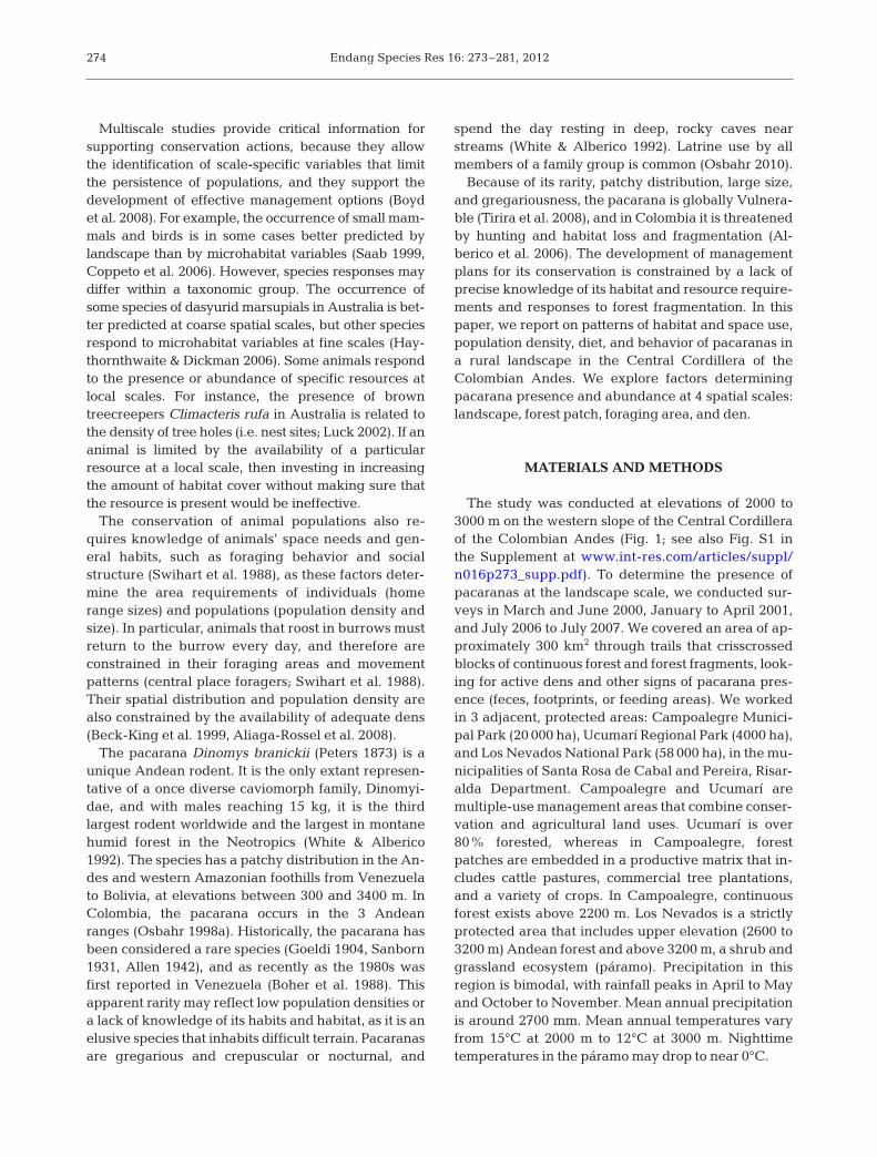
The study was conducted at elevations of 2000 to3000 m on the western slope of the Central Cordilleraof the Colombian Andes (Fig. 1; see also Fig. S1 inthe Supplement at www.int-res.com/articles/suppl/n016p273 _supp.pdf). To determine the presence ofpacaranas at the landscape scale, we conducted sur-veys in March and June 2000, January to April 2001,and July 2006 to July 2007. We covered an area of ap-proximately 300 km2 through trails that crisscrossedblocks of continuous forest and forest fragments, look-ing for active dens and other signs of pacarana pres-ence (feces, footprints, or feeding areas). We workedin 3 adjacent, protected areas: Campoalegre Munici-pal Park (20 000 ha), Ucumarí Regional Park (4000 ha),and Los Nevados National Park (58 000 ha), in the mu-nicipalities of Santa Rosa de Cabal and Pereira, Risar-alda Department. Campoalegre and Ucumarí aremultiple-use management areas that combine conser-vation and agricultural land uses. Ucumarí is over80% forested, whereas in Campoalegre, forestpatches are embedded in a productive matrix that in-cludes cattle pastures, commercial tree plantations,and a variety of crops. In Campoalegre, continuousforest exists above 2200 m. Los Nevados is a strictlyprotected area that includes upper elevation (2600 to3200 m) Andean forest and above 3200 m, a shrub andgrassland ecosystem (páramo). Precipitation in thisregion is bimodal, with rainfall peaks in April to Mayand October to November. Mean annual precipitationis around 2700 mm. Mean annual temperatures varyfrom 15°C at 2000 m to 12°C at 3000 m. Nighttimetemperatures in the páramo may drop to near 0°C.
274

Saavedra-Rodríguez et al.: Multiscale habitat use by pacarana
To characterize the landscape around sites show-ing signs of pacarana presence, we delimited circleswith a radius of 1 km (area of 3.14 km2) on a map.Maps were based on classified Aster and Landsatsatellite images from the years 2003 to 2005. Withineach circle, we measured the percent cover of
mature and second-growth forest, pasture, timberplantations, and other crops using ArcGIS (ESRI). Wecharacterized landscape heterogeneity with Shan-non’s index as a measure of diversity of land covertypes. To describe physical conditions, we calculatedfor each circle the mean slope and the density of
275
Fig. 1. Study areas in the Central Andes of Colombia. (a) Location of used and randomly selected potential landscapes (3.14km2 circles) used by, or potentially suitable for use by, the pacarama Dinomys branickii, showing forest areas (gray), urban ar-eas (black) and non-forested areas (white). (b) San Eugenio River watershed (circle no. 1 in Fig. 1a; 75°33’W, 4°49’N) showinglarge block and fragments of forest with confirmed occurence of pacarana (black). Abbreviations correspond to different cate-gories of protected areas. SFF: Sanctuary of Fauna and Flora; PRN: Parque Regional Natural; PNN: Parque Nacional Natural;
PMN: Parque Municipal Natural

Endang Species Res 16: 273–281, 2012
catchment areas with a main stream and a variablenumber of brooks draining into it, using a digital ele-vation model with a resolution of 30 m (see Iverson etal. 2001 for methodological details). To determinewhether pacaranas were using sites with particularcombinations of landscape variables, we comparedsites with pacarana presence to control sites selectedby placing random coordinates on the map.
To determine patterns of habitat use at the forestpatch, foraging area, and den scales, we conductedmore detailed surveys in the San Eugenio Riverwatershed in Campoalegre (Fig. 1b). This study
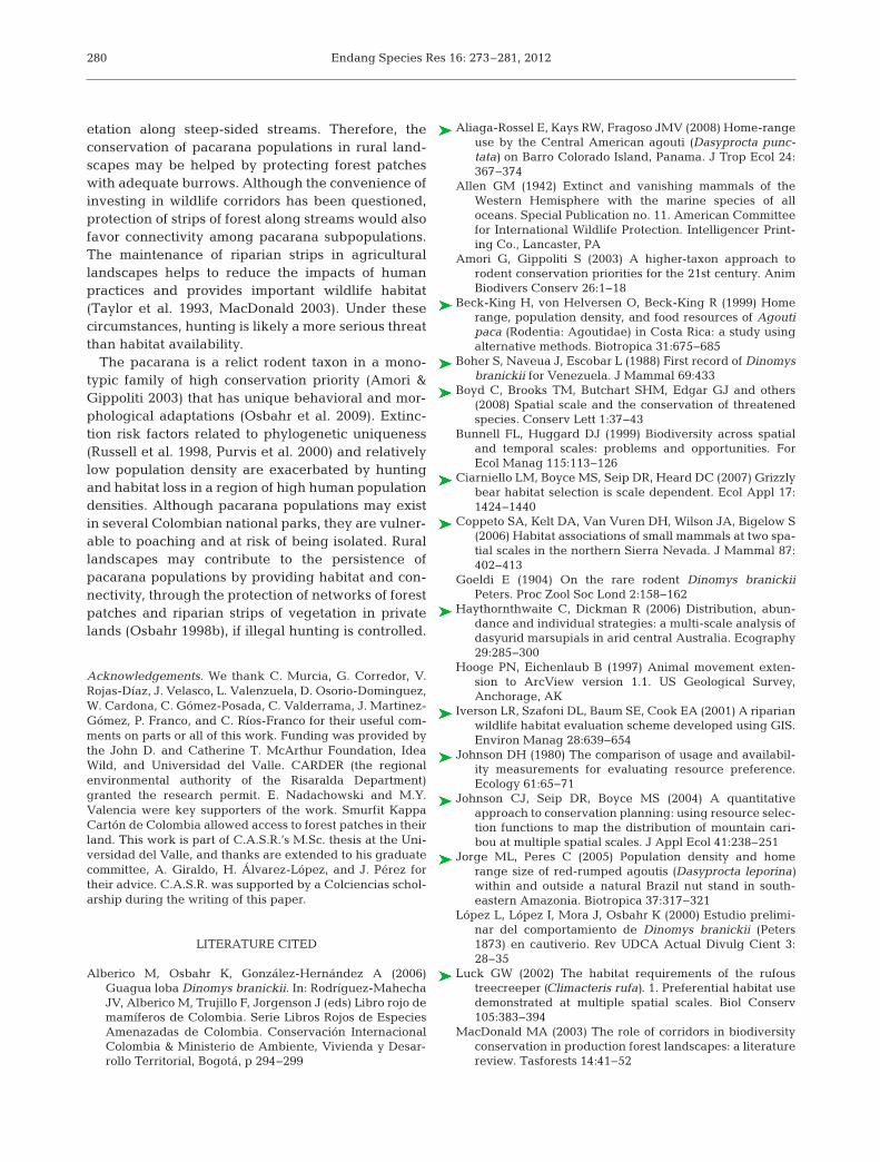
area encompassed 4709 ha, and included a 1643ha forest block (which was much larger and con-tinuous outside the study area), and forest patchestotaling 478 ha in a 2588 ha matrix of pastures,timber plantations, and a variety of small-scalecrops. Between July 2005 and June 2006, we vis-ited 17 forest patches, chosen based on elevation(between 2000 and 2300 m) and accessibility. Ineach forest patch, we looked for signs of pacaranasand measured the respective patch area, perimeter,and the shortest edge-to-edge distance to continu-ous forest (Table 1).
276
Variable Description Used Potential U (p-value)
LandscapeForest cover (%) Measured within a circle of 1 km radius 56.8 (25.2) 71.2 (24.1) 45 (0.3)Heterogeneity of land cover types Shannon diversity index of area of habitat types 0.8 (0.4) 0.6 (0.4) 41 (0.2)Mean slope (%) Measured within a circle of 1 km radius 18.5 (6.1) 19.8 (4.0) 51 (0.5)Stream density (km−2) Number of streams in a drainage divided by area 1.8 (0.4) 1.6 (0.4) 39 (0.17)Sample size 11 11
Forest patchPatch area (ha) 19.6 (20.3) 1.8 (2.0) 9 (0.0)Patch perimeter (m) 5443 (6493.5) 723 (489.9) 1.8 (0.1)Distance to continuous forest (m) Nearest edge-to-edge distance 981 (1031.9) 800.7 (399.2) 32 (0.8)Sample size 7 10
Foraging areaDiversity of vertical strata Shannon Index: a 6 m long pole divided into sec- 0.7 (0.0) 0.7 (0.1) 21 (0.8)
tions of 1 m was used to measure no. of contactswith vegetation (no. of contacts with each polesection = species abundance measurement)
Total volume of vegetation (m3) Estimate in mid-level and understory vegetation 1.3 (0.2) 1.3 (0.4) 22.5 (1)Canopy cover (%) Measured with a densitometer 75.7 (6.1) 79.5 (6.1) 15.5 (0.3)DBH (cm) Mean diameter of trees and shrubs (>5 cm) 19.3 (5.1) 20.2 (8.2) 22 (0.95)Mid-level vegetation cover (%) Visual estimate of vegetation cover (DBH <5 cm 65 (18.7) 78.9 (16.6) 8.5 (0.6)
and height <5 m)Understory vegetation cover (%) Visual estimate of understory vegetation (<1.5 m) 71 (18.5) 66.1 (12.4) 19 (0.6)Mid-level vegetation height (m) Mean height of vegetation with DBH <5 cm 3.1 (0.6) 2.92 (0.3) 20 (0.7)
and height <5 mNumber of plants with DBH >5 cm 22.5 (12.1) 21.22 (12.5) 22 (0.9)Distance to nearest potential den (m) 56 (26.9) 142.2 (72.9) 8.5 (0.1)Sample size 7 8
DenNumber of entrances Single den with multiple entrances 1.7 (0.7) 1.6 (2.1) 29 (0.13)Den area slope (%) Mean slope of 100 m2 area around den, measured 63.3 (31.9) 35.4 (30.1) 26.5 (0.09)
with a clinometerDiameter of main entrance (cm) Diameter of largest entrance in multiple- 45 (6.2) 39.5 (19.8) 35.5 (0.30)
entrance densDepth (m) Measured by inserting a stick (see ‘Materials 6.4 (2.1) 2.9 (1.6) 10.5 (0.003)
and methods’)Distance to nearest stream (m) 50.1 (51.0) 63.6 (88.9) 46.5 (0.85)Exposed rock cover (%) Percent of rock cover in 100 m2 area around 87.8 (10.9) 47.3 (29.7) 13 (0.006)
den entranceSample size 9 11
Table 1. Dinomys branickii. Variables used to describe pacarana habitat at 4 spatial scales in the Central Andes of Colombia and compar-ison of habitat variables measured at sites used by pacaranas and potential sites selected at random. Values are means (SD), p-values are
based on Mann-Whitney tests. DBH: diameter at breast height

Saavedra-Rodríguez et al.: Multiscale habitat use by pacarana
We characterized foraging areas and dens withinCampoalegre’s large block of continuous forest. Ineach foraging area (identified by signs such as tooth-marks in plants; see Fig. S2 in the Supplement atwww.int-res.com/articles/suppl/n016p273_supp.pdf),we measured vegetation variables (Table 1) in a 25 × 2m transect and compared them to a control site (poten-tial foraging areas), selected in a random directionwithin the forest, at least 500 m from known foragingareas. To test whether dens might be a factor associ-ated with selection of foraging areas, we measured thedistance from potential foraging areas to the nearestpotential den, and compared it to the distance be -tween used foraging areas and active dens. We identi-fied active dens by the presence of signs such as freshtracks and hairs. We compared pacarana hair from zooand museum specimens and from skins of hunted ani-mals, to those of potential sympatric species that alsouse burrows, such as South American coati Na sua na-sua, mountain paca Cuniculus taczanowskii, and Cen-tral American agouti Dasyprocta punctata. We mea-sured 6 descriptive variables on dens (Table 1), basedon prior knowledge of pacarana ecology and observa-tions of the species’ behavior in our study area. Wemeasured den depth by crawling into the cave as far aspossible and inserting a long stick. Our measure ofdepth is a minimum value because sometimes caveshad sharp turns that impeded the stick. To avoid dis-turbing the animals, we took these measurementswhen the pacaranas were away (i.e. when they werefor aging at night or were not using the den). As controlsites (potential dens) we used similar rocky caves thatshowed no signs of having been used by the species.
For each spatial scale, we examined correlationsbetween pairs of variables using Pearson’s correla-tion coefficients, to see which variables needed to beeliminated. We used Mann-Whitney U-tests to testfor differences between used and potential sites forall variables and spatial scales.
Between July 2005 and June 2006, we made 5 ses-sions of behavioral observations between 17:00 and00:00 h in 3 active dens (35 total hours of observa-tion), from hiding places 15 to 20 m from the den. Wewaited for the animals’ emergence and their return afew hours later. To describe the diet, we collectedplants with incisor marks along trails and in feedingareas near dens. To distinguish pacarana marks fromthose of the sympatric mountain paca, we measuredthe incisors of 5 paca and 3 pacarana museum speci-mens from the Universidad del Valle, Cali, Colombia.The incisor marks of pacarana (mean ± SE = 15.0 ±0.7 mm) were wider and easily distinguishable frompaca marks (mean = 8.5 ± 0.9 mm).
To estimate home ranges and density of pacaranagroups in the San Eugenio River watershed, weestablished 15 transects along mountain ridges andstream margins within continuous forest. The tran-sects varied from 390 to 4000 m, for a total of 23.4 km.To determine pacarana home ranges, we mapped allsigns of activity around dens, including trails used bythe species and leading from the den to foragingareas and latrines. The longest pacarana trail that wefound leading from a den to foraging areas or latrineswas 200 m, so we considered signs that were 200 mor less from other signs as a cluster belonging to asingle pacarana group. Data collection for this part ofthe study was limited to 3 mo (December 2006 toFebruary 2007). Therefore, our home range sizesmay be underestimated, because we did not test foran asymptote in home range sizes as more data wereadded, and we could not detect long excursions. Welimited our visits because pacaranas are very sensi-tive to disturbance and easily abandon dens. We donot know how long pacaranas stay in a particular denin the absence of disturbance, but the animals switchcaves spontaneously (López et al. 2000) and appar-ently have a rotation system, returning to a particularden up to 2 yr later (C. A. Saavedra-Rodríguez pers.obs.). Data were processed in ArcView 3.2 (ESRI),and home ranges were measured using the animalmovement extension (Hooge & Eichenlaub 1997)with the kernel analytical method.
To estimate population density, each transect wassampled twice, in the morning (05:00 to 08:00 h)and evening (18:00 to 21:00 h). We used the fixed-width transect method, with a predetermined tran-sect width (W) of 10 m on each side of the trail.Density was calculated as D = n/2WL, where n isthe number of sign clusters detected and L is tran-sect length.
RESULTS
At the landscape scale, we recorded active densand signs of pacarana activity at 11 sites (Fig. 1).Pacaranas used humid forest habitats near streams inheterogeneous landscapes. Forest cover in land-scapes (3.14 km2 circles) varied from 20 to 95%.Areas occupied by pacaranas had slopes between 15and 30% and a mean of 2 streams km−2. There wereno differences between sites with evidence of paca -rana presence and sites selected at random for any ofthe variables (Table 1, Tables S1 & S2 in the Supple-ment at www.int-res.com/articles/suppl/n016 p273_supp.pdf).
277

Endang Species Res 16: 273–281, 2012
We found evidence of pacarana presence in 7 ofthe 17 forest patches. There was a correlation be -tween forest patch area and perimeter (r = 0.76, p =0.05), so we eliminated perimeter from the analysis.Forest patches with pacarana presence were signifi-cantly larger than patches with no evidence of cur-rent pacarana presence (Table 1).
Within continuous forest, we located 25 areas withforaging signs, but only 7 were associated with activedens and were used for analysis (we did not find densassociated with the other 18 areas, but some mayhave been in rocky slopes inaccessible to us). Noneof the vegetation variables showed significant differ-ences between used and potential foraging areas,but there was a marginally significant difference inthe distance between foraging areas and dens, withused sites closer to active dens than potential sites(Table 1).
Den characteristics were examined in 9 used and11 potential caves. There were significant differ-ences between used and potential dens in den depthand rock cover (Table 1). Used dens were deeperand had a higher percent rock cover than potentialcaves. There was a statistical tendency for useddens to have a higher slope than potential caves(Table 1). There were no differences between usedand potential caves in entrance diameter or distanceto stream (Table 1).
Based on the presence of dens,footprints, foraging areas, and la -trines, we obtained home rangemaps for 4 pacarana groups. Meanhome range size was 2.45 ha (SD =0.62, 95% CI = 2.425−2.470 ha;Figs. S3 & S4, Table S3 in the Sup-plement at www. int-res.com/ articles/suppl/ n016p273_ supp.pdf). Pacara -na groups used burrows that con-sisted of 1 to 8 caves that were 2 to100 m apart, each cave with a singleor multiple entrances. Latrines andforaging areas were located 26 to 60m and 10 to 150 m away from activeburrows, respectively. Burrows, la -trines, and foraging areas were con-nected by a system of paths that tun-neled through thick understoryvegetation.
Observations at active dens (n = 3)revealed 2 groups of 4 and 1 group of5 individuals. Groups were composedof 2 adults (presumably a male anda female) and 2 or 3 juveniles. The
groups initiated activities at dusk (18:30 h), when thelarger individual (presumably a male) partiallyemerged from the cave emitting soft grunts and clack-ing its teeth, and then backed into the cave. Two min-utes later it re-emerged, followed by the rest of thegroup, and followed a trail to a feeding area. Individu-als came back into the den independently between22:00 and 23:00 h. Some activity could be heard withinthe cave for about 5 min after the last animal entered.
During transect sampling, we counted 3 individu-als (1 adult and 2 juveniles), 17 dens, 3 latrines, and26 sign clusters consisting of foraging signs or foot-prints. Signs of pacarana presence were detected in 8of the 15 transects. In many cases, we found signs butno active dens nearby, so we calculated 2 populationdensities: using only sign clusters, we estimated adensity of 9.9 groups km−2 (SD = 14.2, 95% CI =9.62−10.06); using only dens, our density estimatewas 5.5 groups km−2 (SD = 7.2, 95% CI = 5.35−5.58).
In foraging areas we obtained evidence of 18 plantspecies eaten by pacaranas (Table 2). The animalsfed on diverse plant parts including foliage, fruits,and succulent stems and rhizomes from ferns, herbs,shrubs, and trees. Fruits eaten included the fallen,soft fruits of fig trees (Ficus spp.), hard fruits such asacorns of Quercus humboldtii and nuts of Juglansneotropica, as well as the whole infructescenses ofherbaceous Anthurium sp.
278
Family Species Plant parts Present study Osbahr
Apiaceae Myrrhidendron pennellii Roots ×Araceae Anthurium sp. Leaf, stem, fruit × ×Arecaceae Geonoma sp. Young leaf ×
Wettinia kalbreyeri Young leaf ×Asteraceae Bidens sp. Leaf, stem ×Blechnaceae Blechnum sp. Leaf × ×Boraginaceae Cordia sp. Leaf, stem ×Commelinaceae Unidentified Leaf, stem ×
Ageratum sp. Leaf, stem ×Cyclanthaceae Cyclanthus sp. Leaf, stem × ×Dryopteridaceae Dryopteris sp. Leaf, stem × ×Gunneraceae Gunnera manicata Stem, rhizome ×Fagaceae Quercus humboldti Acorn ×Heliconiaceae Heliconia sp. Leaf, stem × ×Juglandaceae Juglans neotropica Nut ×Moracea Ficus gigantocise Fruit ×Poaceae Arundo sp. Leaf, stem ×
Chusquea sp. 1 Leaf, stem ×Chusquea sp. 2 Leaf, stem ×Guadua sp. Leaf, stem ×
Solanaceae Solanum sp. Leaf, root ×Unidentified (3 spp.) Leaf, stem ×
Table 2. Dinomys branickii. Plant species and parts eaten by pacaranas inthe Andes of Colombia, determined in this study and recorded from other
Colombian localities (Osbahr 1998 a,b, 1999)

Saavedra-Rodríguez et al.: Multiscale habitat use by pacarana
DISCUSSION
In the Central Andes of Colombia, pacaranas usedlandscape units (3.14 km2 circles) with as little as20% forest cover. At a local scale, pacaranas usuallyoccupied larger forest patches (mean = 12 ha), butthey were present in patches as small as 5 ha, inde-pendently of their distance to continuous forest. It isimportant to note, however, that there is a large andcontinuous block of forest at upper elevations (2200to 3200 m), which may be acting as a populationsource. Pacaranas in fragments are probably morevulnerable to hunting and may constitute populationsinks.
Pacaranas used a wide variety of plant food sources(Table 2), including species from mature and second-growth forest. Some of these plants (e.g. Gunneramanicata) are common in humid, disturbed areas,such as steep slopes near streams where small land-slides frequently occur. Rocky outcrops with cavesare also more common near streams, and these rockyareas are frequently exposed as a result of landslides.Therefore, the association of pacaranas with streamsmay actually be dictated by the presence of burrowsand feeding areas rather than by the stream itself.
There are no published estimates of pacaranahome ranges or population densities. For compara-tive purposes, the most ecologically similar speciesare agoutis and pacas, but these rodents are solitaryand have more frugivorous diets. Amazonian red-rumped agoutis Dasyprocta leporina (body mass of 3to 6 kg) have home ranges of 2.3 to 4.5 ha and densi-ties that vary between 9 and 61 ind. km−2 (Silvius &Fragoso 2003, Jorge & Peres 2005). The smaller (up to3 kg) Central American agouti uses home ranges ofup to 2.5 ha, and may reach densities of 100 ind. km−2
(Aliaga-Rossel et al. 2008). The paca Cuniculus pacais larger (12 kg) but also has home ranges of 2 to 3 haand may reach densities of 93 ind. km−2 (Beck-Kinget al. 1999). All 3 species exhibit considerable geo-graphic variation in density, which may be as low as3 to 5 ind. km−2 for both Central American agouti andpaca, depending on local ecological conditions suchas habitat productivity and predator abundance(Swihart et al. 1988, Beck-King et al. 1999, Aliaga-Rossel et al. 2008). Considering the higher biomassrepresented by pacarana groups, their home rangesare relatively small (<3 ha), but their population den-sities (5.5 groups km−2 as a low estimate) are withinthe ranges reported for agoutis and pacas.
The need to return to a burrow probably limitspacarana home ranges, as occurs with central placeforagers (Swihart et al. 1988). This slow-walking ani-
mal, with an average speed of 1.04 km h−1 (Osbahr &Azumendi 2010), apparently does not move long dis-tances during its nocturnal activity. During foraging,the species exhibits exploratory behavior of the foodpatches and manipulates food with the forepaws, soit is expected that these animals do not invest toomuch time searching for food but will prefer food-stuffs with high fiber and protein content (Osbahr &Restrepo-Mejia 2001). Because of their highly her-bivorous and varied diet, pacaranas may find enoughfood resources in a relatively small area, but presum-ably food in the form of vegetative plant parts willeventually be depleted (particularly slow-growingsucculent stems and rhizomes) and pacaranas willhave to move to a different area. This species doesnot make nests and frequently changes its burrowsand latrine sites (López et al. 2000, Osbahr 2010).Therefore, burrow availability is probably a majorfactor limiting pacarana distribution and abundance.
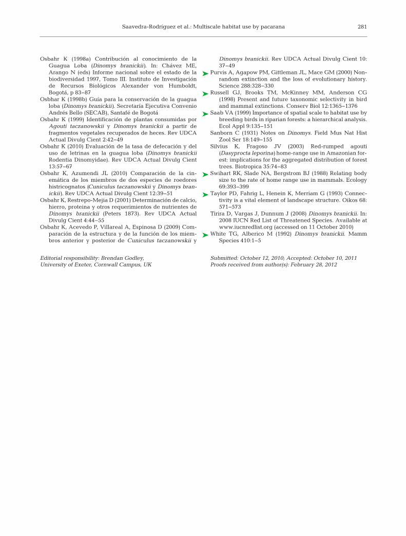
Multi-scale studies are important for identifyingcritical factors limiting populations of threatened ani-mals (Fig. 2) and developing effective conservationstrategies (Boyd et al. 2008). Our surveys at largespatial scales suggested that pacaranas can persist inforest fragments, but are usually absent from thesmaller patches. At small scales, however, we identi-fied caves as the critical resource. Caves were deep(>4 m) and were located in areas with >60% slopeand >40% rock cover. Pacaranas used small forestfragments that had caves with these characteristics.These small fragments were frequently strips of veg-
279
Fig. 2. Dinomys branickii. Conceptual diagram of factors de-termining pacarana habitat use at 4 spatial scales in theCentral Andes of Colombia (after Bunnell & Huggard 1999)
Endang Species Res 16: 273–281, 2012
etation along steep-sided streams. Therefore, theconservation of pacarana populations in rural land-scapes may be helped by protecting forest patcheswith adequate burrows. Although the convenience ofinvesting in wildlife corridors has been questioned,protection of strips of forest along streams would alsofavor connectivity among pacarana subpopulations.The maintenance of riparian strips in agriculturallandscapes helps to reduce the impacts of humanpractices and provides important wildlife habitat(Taylor et al. 1993, MacDonald 2003). Under thesecircumstances, hunting is likely a more serious threatthan habitat availability.
The pacarana is a relict rodent taxon in a mono-typic family of high conservation priority (Amori &Gippoliti 2003) that has unique behavioral and mor-phological adaptations (Osbahr et al. 2009). Extinc-tion risk factors related to phylogenetic uniqueness(Russell et al. 1998, Purvis et al. 2000) and relativelylow population density are exacerbated by huntingand habitat loss in a region of high human populationdensities. Although pacarana populations may existin several Colombian national parks, they are vulner-able to poaching and at risk of being isolated. Rurallandscapes may contribute to the persistence ofpacarana populations by providing habitat and con-nectivity, through the protection of networks of forestpatches and riparian strips of vegetation in privatelands (Osbahr 1998b), if illegal hunting is controlled.
Acknowledgements. We thank C. Murcia, G. Corredor, V.Rojas-Díaz, J. Velasco, L. Valenzuela, D. Osorio-Dominguez,W. Cardona, C. Gómez-Posada, C. Valderrama, J. Martinez-Gómez, P. Franco, and C. Ríos-Franco for their useful com-ments on parts or all of this work. Funding was provided bythe John D. and Catherine T. McArthur Foundation, IdeaWild, and Universidad del Valle. CARDER (the regionalenvironmental authority of the Risaralda Department)granted the research permit. E. Nadachowski and M.Y.Valencia were key supporters of the work. Smurfit KappaCartón de Colombia allowed access to forest patches in theirland. This work is part of C.A.S.R.’s M.Sc. thesis at the Uni-versidad del Valle, and thanks are extended to his graduatecommittee, A. Giraldo, H. Álvarez-López, and J. Pérez fortheir advice. C.A.S.R. was supported by a Colciencias schol-arship during the writing of this paper.
LITERATURE CITED
Alberico M, Osbahr K, González-Hernández A (2006)Guagua loba Dinomys branickii. In: Rodríguez-MahechaJV, Alberico M, Trujillo F, Jorgenson J (eds) Libro rojo demamíferos de Colombia. Serie Libros Rojos de EspeciesAmenazadas de Colombia. Conservación InternacionalColombia & Ministerio de Ambiente, Vivienda y Desar-rollo Territorial, Bogotá, p 294−299
Aliaga-Rossel E, Kays RW, Fragoso JMV (2008) Home-rangeuse by the Central American agouti (Dasyprocta punc-tata) on Barro Colorado Island, Panama. J Trop Ecol 24: 367−374
Allen GM (1942) Extinct and vanishing mammals of theWestern Hemisphere with the marine species of alloceans. Special Publication no. 11. American Committeefor International Wildlife Protection. Intelligencer Print-ing Co., Lancaster, PA
Amori G, Gippoliti S (2003) A higher-taxon approach torodent conservation priorities for the 21st century. AnimBiodivers Conserv 26: 1−18
Beck-King H, von Helversen O, Beck-King R (1999) Homerange, population density, and food resources of Agoutipaca (Rodentia: Agoutidae) in Costa Rica: a study usingalternative methods. Biotropica 31: 675−685
Boher S, Naveua J, Escobar L (1988) First record of Dinomysbranickii for Venezuela. J Mammal 69: 433
Boyd C, Brooks TM, Butchart SHM, Edgar GJ and others(2008) Spatial scale and the conservation of threatenedspecies. Conserv Lett 1: 37−43
Bunnell FL, Huggard DJ (1999) Biodiversity across spatialand temporal scales: problems and opportunities. ForEcol Manag 115: 113−126
Ciarniello LM, Boyce MS, Seip DR, Heard DC (2007) Grizzlybear habitat selection is scale dependent. Ecol Appl 17: 1424−1440
Coppeto SA, Kelt DA, Van Vuren DH, Wilson JA, Bigelow S(2006) Habitat associations of small mammals at two spa-tial scales in the northern Sierra Nevada. J Mammal 87: 402−413
Goeldi E (1904) On the rare rodent Dinomys branickiiPeters. Proc Zool Soc Lond 2: 158−162
Haythornthwaite C, Dickman R (2006) Distribution, abun-dance and individual strategies: a multi-scale analysis ofdasyurid marsupials in arid central Australia. Ecography29: 285−300
Hooge PN, Eichenlaub B (1997) Animal movement exten-sion to ArcView version 1.1. US Geological Survey,Anchorage, AK
Iverson LR, Szafoni DL, Baum SE, Cook EA (2001) A riparianwildlife habitat evaluation scheme developed using GIS.Environ Manag 28: 639−654
Johnson DH (1980) The comparison of usage and availabil-ity measurements for evaluating resource preference.Ecology 61: 65−71
Johnson CJ, Seip DR, Boyce MS (2004) A quantitativeapproach to conservation planning: using resource selec-tion functions to map the distribution of mountain cari-bou at multiple spatial scales. J Appl Ecol 41: 238−251
Jorge ML, Peres C (2005) Population density and homerange size of red-rumped agoutis (Dasyprocta leporina)within and outside a natural Brazil nut stand in south-eastern Amazonia. Biotropica 37: 317−321
López L, López I, Mora J, Osbahr K (2000) Estudio prelimi-nar del comportamiento de Dinomys branickii (Peters1873) en cautiverio. Rev UDCA Actual Divulg Cient 3: 28−35
Luck GW (2002) The habitat requirements of the rufoustreecreeper (Climacteris rufa). 1. Preferential habitat usedemonstrated at multiple spatial scales. Biol Conserv105: 383−394
MacDonald MA (2003) The role of corridors in biodiversityconservation in production forest landscapes: a literaturereview. Tasforests 14: 41−52
280
Saavedra-Rodríguez et al.: Multiscale habitat use by pacarana 281
Osbahr K (1998a) Contribución al conocimiento de laGuagua Loba (Dinomys branickii). In: Chávez ME,Arango N (eds) Informe nacional sobre el estado de labiodiversidad 1997, Tomo III. Instituto de Investigaciónde Recursos Biológicos Alexander von Humboldt,Bogotá, p 83−87
Osbhar K (1998b) Guía para la conservación de la guagualoba (Dinomys branickii). Secretaría Ejecutiva ConvenioAndrés Bello (SECAB), Santafé de Bogotá
Osbahr K (1999) Identificación de plantas consumidas porAgouti taczanowskii y Dinomys branickii a partir defragmentos vegetales recuperados de heces. Rev UDCAActual Divulg Cient 2: 42−49
Osbahr K (2010) Evaluación de la tasa de defecación y deluso de letrinas en la guagua loba (Dinomys branickiiRodentia Dinomyidae). Rev UDCA Actual Divulg Cient13: 57−67
Osbahr K, Azumendi JL (2010) Comparación de la cin-emática de los miembros de dos especies de roedoreshistricognatos (Cuniculus taczanowskii y Dinomys bran-ickii). Rev UDCA Actual Divulg Cient 12: 39−51
Osbahr K, Restrepo-Mejia D (2001) Determinación de calcio,hierro, proteina y otros requerimientos de nutrientes deDinomys branickii (Peters 1873). Rev UDCA ActualDivulg Cient 4: 44−55
Osbahr K, Acevedo P, Villareal A, Espinosa D (2009) Com-paración de la estructura y de la función de los miem-bros anterior y posterior de Cuniculus taczanowskii y
Dinomys branickii. Rev UDCA Actual Divulg Cient 10: 37−49
Purvis A, Agapow PM, Gittleman JL, Mace GM (2000) Non-random extinction and the loss of evolutionary history.Science 288: 328−330
Russell GJ, Brooks TM, McKinney MM, Anderson CG(1998) Present and future taxonomic selectivity in birdand mammal extinctions. Conserv Biol 12: 1365−1376
Saab VA (1999) Importance of spatial scale to habitat use bybreeding birds in riparian forests: a hierarchical analysis.Ecol Appl 9: 135−151
Sanborn C (1931) Notes on Dinomys. Field Mus Nat HistZool Ser 18: 149−155
Silvius K, Fragoso JV (2003) Red-rumped agouti(Dasyprocta leporina) home-range use in Amazonian for-est: implications for the aggregated distribution of foresttrees. Biotropica 35: 74−83
Swihart RK, Slade NA, Bergstrom BJ (1988) Relating bodysize to the rate of home range use in mammals. Ecology69: 393−399
Taylor PD, Fahrig L, Henein K, Merriam G (1993) Connec-tivity is a vital element of landscape structure. Oikos 68: 571−573
Tirira D, Vargas J, Dunnum J (2008) Dinomys branickii. In: 2008 IUCN Red List of Threatened Species. Available atwww.iucnredlist.org (accessed on 11 October 2010)
White TG, Alberico M (1992) Dinomys branickii. MammSpecies 410: 1−5
Editorial responsibility: Brendan Godley,University of Exeter, Cornwall Campus, UK
Submitted: October 12, 2010; Accepted: October 10, 2011Proofs received from author(s): February 28, 2012