multi model integration of bus and train services mira bhayandar
TRANSCRIPT

Multi Model Integration of Bus Services WithSub-urban Trains of Mira-Bhayandar
Project byMr. Vilas Dhage, MBMC, Dist. Thane
Dr. Dipak Sawant, MBMC, Dist. ThaneMr Sunil Kumar Garg, MRVC, Mumbai
MentorMs. Manjiri Akalkotkar
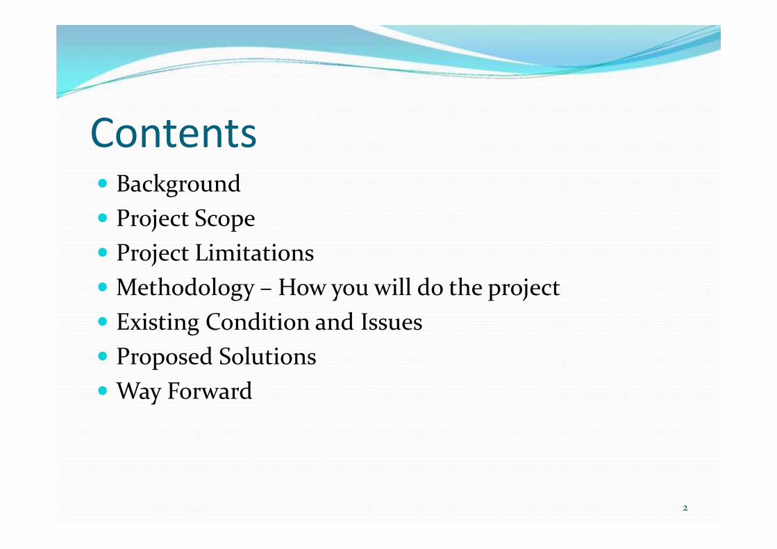
Contents Background Project Scope Project Limitations Methodology – How you will do the project Existing Condition and Issues Proposed SolutionsWay Forward
2

Location of Mira-BhayandarMuniciapal Corporation
3
•Area: 79 Sq km
•Density : 10200 Persons / Sqkm
•Population: 10 Lakh
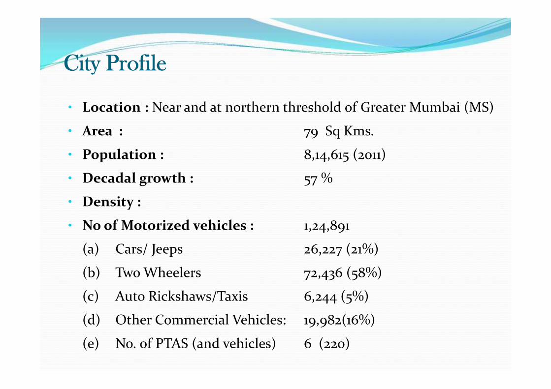
City Profile
• Location : Near and at northern threshold of Greater Mumbai (MS)
• Area : 79 Sq Kms.
• Population : 8,14,615 (2011)
• Decadal growth : 57 %
• Density :
• No of Motorized vehicles : 1,24,891
(a) Cars/ Jeeps 26,227 (21%)
(b) Two Wheelers 72,436 (58%)
(c) Auto Rickshaws/Taxis 6,244 (5%)
(d) Other Commercial Vehicles: 19,982(16%)
(e) No. of PTAS (and vehicles) 6 (220)

Population Growth Pattern
5
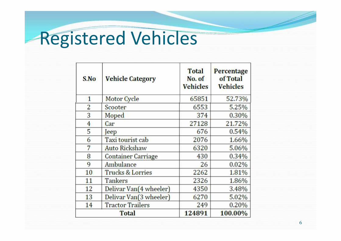
Registered Vehicles
6

Distribution According to Household Income
7
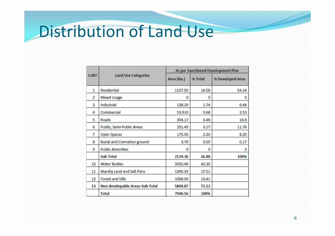
Distribution of Land Use
8
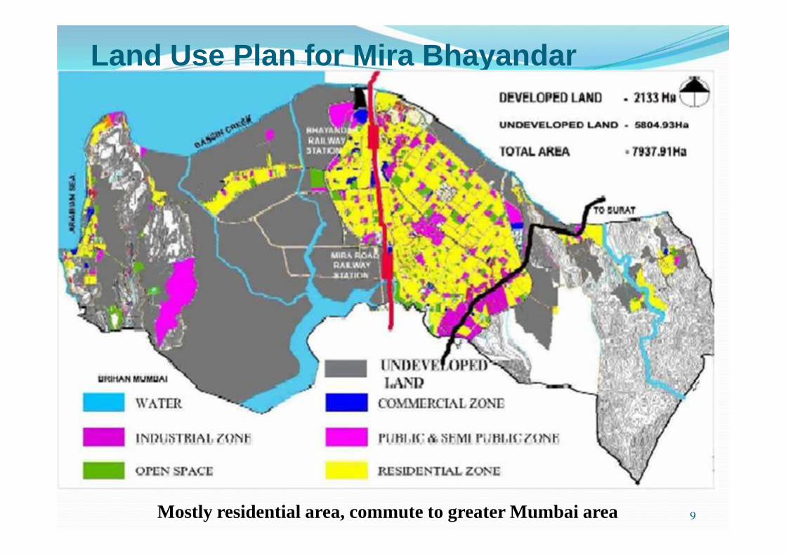
Land Use Plan for Mira Bhayandar
9Mostly residential area, commute to greater Mumbai area

Agencies Two important agencies MRVC - A PSU of Ministry of Railways with
participation of Ministry of Railway and Govt. ofMaharashtra with equity in the ratio of 51:49. MRVCimplementing Rail Component of Mumbai UrbanTransport Project (MUTP). MBMC - A local municipal body also running Bus
services in the area.
10

Overall Objective• To develop specific actions in the form of short, medium and
long term transportation improvement proposals that willachieve the transportation vision for the area.
• Long term and short term strategic planning to achieve desirablemobility pattern for the city’s population in a sustainable andcost effective manner.
• To make city to make the “engine of economic growth”
• To provide amenities and infrastructure for the convenience ofpassengers and public transport vehicles.
• To take up measure of development for improvement of mobilityof people and make city livable.

Objective for the Project To assess the existing condition at Railway stations and
plan safe, efficient & environmentally sustainablemeans for multimodal integration of bus Services withsub-urban trains of Mira-Bhainder. To rationalize the bus services to sub-urban trains.

Background of city in context of project
• Existing Public Transport :-
• Sub-Urban Trains.
• MBMT, BEST, NMMT, TMT, MSRTC.
• Taxi & auto rickshaw.
• Road Network :- Well connected by road to National High Way.(Thane, Mumbai & Gujrat)
• Rail Network :- Two railway stations
• Mira Road, Bhainder
• Suburban western local train service viz. Chuchgate to Virar. Two lakhpassengers board-alight everyday at above two stations (total 4 lakh)

Mira Bhayandar Road Network
14
Connected to MMR by two mainarterials

MMR Existing Rail Route
15
Location map of Mira Road Station
Location map of Bhayandar Station
Connected two main stations –Chrchgate –Virar Line

Mira Bhayandar Stations Feeder service by multiple Public Transport
Authorities viz. MBMT, MSRTC, BEST, TMT, UMT, KDMT, NMMT,
VVMT Majority of people take bus to the stations 2nd most preferred way is to walk to station 3rd most preferred way is autorickshaw Station area need improvement for seamless journey
16

Railway Station Characteristics of Mira Road
Mode of Transportation By people :-Bus 30%Auto 20%2 /4 Wheeler 14%By Walking 34%Cycle 2%
No ofPassengerEntered
No ofPassengerexited
No ofBusRouts
Trip Of BusesPer Day
Frequencyof Busesper Hours
Mira Road 99,370 96,228 12 698 38

Railway Station Characteristics Of Bhaindar
Mode of Transportation By people :-Bus 49%Auto 10%2 /4 Wheeler 14%By Walking 27%Cycle 1%
No ofPassengerEntered
No ofPassengerexited
No ofBusRouts
Trip Of BusesPer Day
Frequencyof Busesper Hours
Bhaindar 1,01,042 1,14,050 24 1032 57

Scope of Work Delineate Station planning area for the Integration
of bus services with Sub-Urban Local trains
Existing condition analysis and demand – supplygap analysis of transportation needs
Define Mobility Vision and Goals
Identification of policy measures and individualprojects
Preparation of a detailed plan involvingstakeholders consultation.
19

Methodology• Define the scope & goals for the station area
integration
• Data collection & analysis (PTAs and Railways)
• Identification of issues, observations & conclusions
• Study on improvement / modification of existingfacilities
20

Methodology• Identify Participation and involvement of all
Stakeholders, including that of NGOs & communityorganizations.
• Assessment of impact on environment and socialaspect.
Preparation of Plans and Estimates.
21

Existing Problems• Traffic Congestion at stations• Issues related to the bus service at stations
• Lack of coordination among the PTAs;• Absence of Bus Terminus & Shelters;• Uncertainty of Bus Schedules and Routes and lack of
public information systems;• Direct connection from railway exit/entrance to the bus
stops lacking
22

Existing Problems• Transfer of passengers from one mode that i.e. From
Local train to Bus services is inconvenient and timeconsuming.
• Exposure of users to inclement climate (rains, humidand hot weather)
• Various activities in the station vicinity• Hawkers• Drop off by other vehicles
23

Approach Travel pattern origin and destination Time of the day and mode choice Land use pattern & bus routes
Mobility challenges Street connectivity within MBMC
Institutional issues Coordination of bus schedules among PTA
24

Integration of Transport Infrastructure Integration Institutional Integration Operational Integration Information Integration

Information Integration
Mobile enabled ITS facilities (M-Indicator) forinformation regarding Rail & all STAs bus timings. Display boards at Bus stops with ETA for different Bus
operators Display boards at Terminals

Strategies• Rationalization of bus service to stations
• Schedules, span of service and destination• Integration Public information
• For railway and buses – time and route• Station Area Traffic Improvement ,
• Seamless Accessibility with bus stops and• Common fare collection mechanism• Parking and drop off facilities• Development of terminus, bus shelters• Pedestrian pathways,
• Establishing Control/Management• Funding by contribution of PTA and/or Government
Grants.27
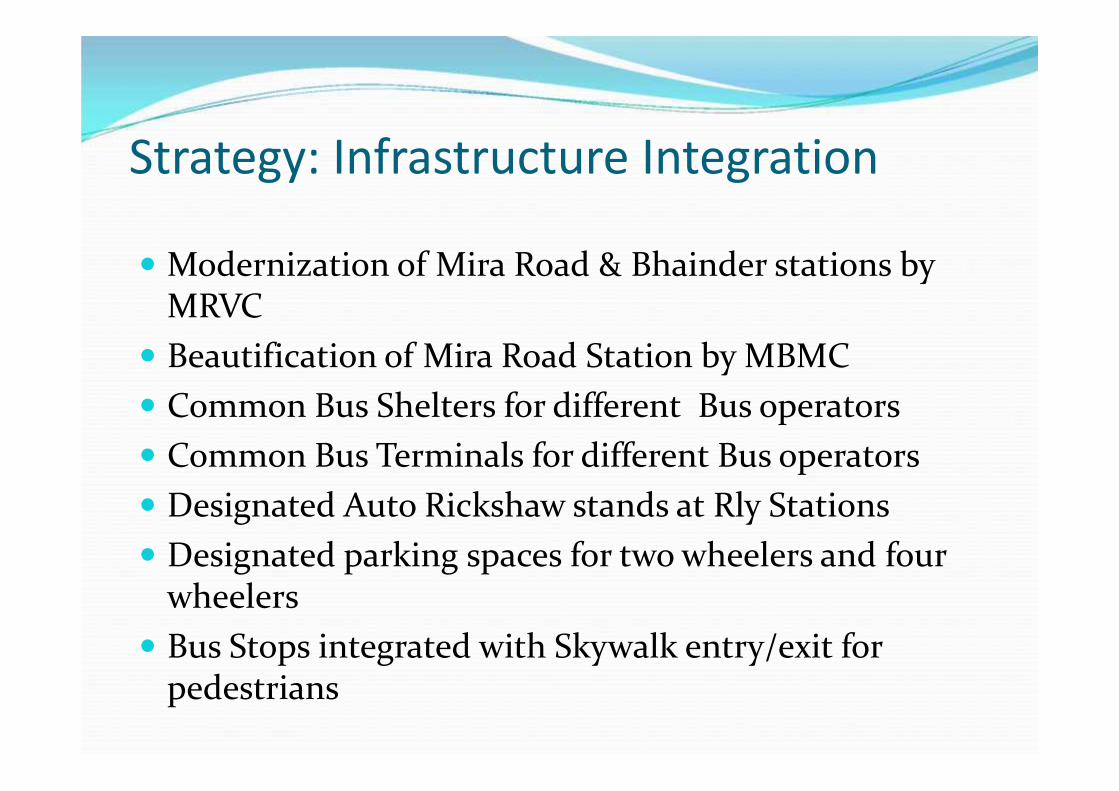
Strategy: Infrastructure Integration
Modernization of Mira Road & Bhainder stations byMRVC Beautification of Mira Road Station by MBMC Common Bus Shelters for different Bus operators Common Bus Terminals for different Bus operators Designated Auto Rickshaw stands at Rly Stations Designated parking spaces for two wheelers and four
wheelers Bus Stops integrated with Skywalk entry/exit for
pedestrians

Strategy: Institutional Integration
UMMTA for MMR Region Seamless ticketing for all STAs and trains in MMR
region Planning coordination amogst different municipalities
and councils in MMR Region.

Data Collected – Other Agencies
1. Trespassing over Railway Track in Mumbai Suburban area& remedial measures thereon By JJ School of Architecture,Mumbai.2. Mumbai Sub- urban Rail Passenger Surveysand Analysis By Wilber Smith3. Study on Station Area improvement of MIRA-Bhyandar
stations by Egis,4. Comprehensive Mobility Plan (CMP) for Mira Bhayandar by
Urban Mass Transit Company Limited,5. Short Term Traffic Improvement and Management Planfor Mira Bhayandar by Urban Mass Transit Company Limited,6. Field Visit
30

Data Collected7. Data has been collected regarding future proposed
expenses road networking metro lines etc.• Assessment of impact on environment and social aspect.
• Interaction with all Stakeholder, including that of NGOs &community organization.
8. No of trains at both stations
9. Boarding and alighting data at both stations
10. Mode share at both stations
31

Details of Buses from Bhayandar Rly. Station
32

33
Details of Buses from Mira Road Rly. Station

New Bus Routes New Route Identification for Implementation
RouteNo.
Bhaindar(W)
RouteNo.
Bhaindar(E)
RouteNo.
Mira Road
35 Boriwali,Charkop
36 & 43 Ring Route(via Indalok)
37 Ring Route(via S.K. Stone)
42 Thane (W)(ChendaniKoliwada)
40 Mulund (W) 39 Thakur Colledge(via Magathane)
44 Mira Road(E)
41 Ring Route(Golden Nest via
Indralok)
46 Ring Route(Sec. 7 to Sec. 10)

NOS OF TRAINS AT MIRA ROAD & BHAYANDAR RILWAY STATIONS
35

Passangers Entry-Exit Detail At Mira Road Rly Station
36
37
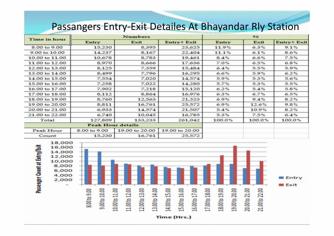
Passangers Entry-Exit Detailes At Bhayandar Rly Station

Peak hour mode shares for Mira Road & BhayandarStations
38
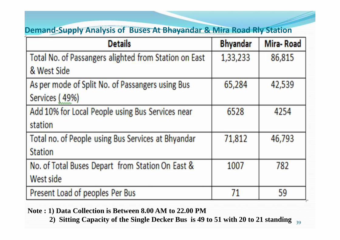
Demand-Supply Analysis of Buses At Bhayandar & Mira Road Rly Station
39
Note : 1) Data Collection is Between 8.00 AM to 22.00 PM2) Sitting Capacity of the Single Decker Bus is 49 to 51 with 20 to 21 standing
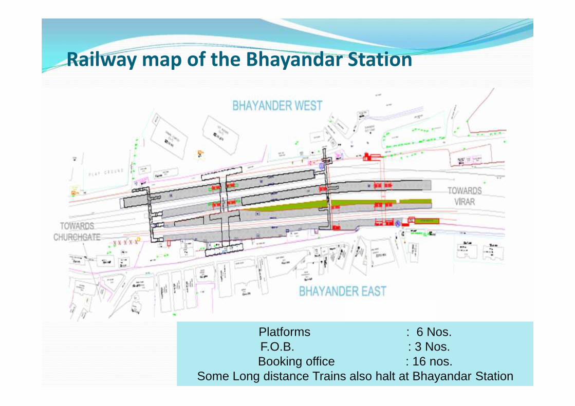
Railway map of the Bhayandar Station
40
Platforms : 6 Nos.F.O.B. : 3 Nos.Booking office : 16 nos.
Some Long distance Trains also halt at Bhayandar Station

Railway map of the Mira Road Station
41
Platforms : 4 Nos.F.O.B. : 3 Nos.Booking office : 13 nos.

Present Scenario at Bhyandar Road Rly Station
42
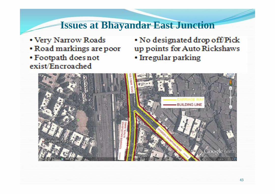
Issues at Bhayandar East Junction
43

Present Scenario at mira Road Station
44

•
Issues at Mira Road East Junction
45
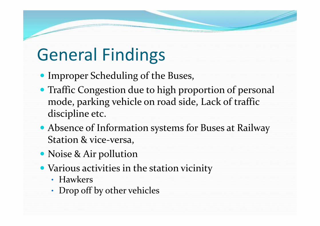
General Findings Improper Scheduling of the Buses, Traffic Congestion due to high proportion of personal
mode, parking vehicle on road side, Lack of trafficdiscipline etc. Absence of Information systems for Buses at Railway
Station & vice-versa, Noise & Air pollution Various activities in the station vicinity
• Hawkers• Drop off by other vehicles

Findings -InstitutionalMultiplicity of agencies Difficulty in coordinating the roles of central, state and
Local Government agencies Individual objectives which are inconsistent with overall
development objectives Difficulties encountered within individual transport
agencies Functional responsibility unrelated to available
resources
47

Findings -Institutional Delays in implementation or non implementation of
essential schemes Lack of appropriate resources – Rarely the transport planning/ execution/ operational
organizations are staffed with the professionals required toaccomplish the given objectives
Lack of shared goals & Objectives
48

Findings - Infrastructure Lack of proper bus terminal with basic facility like shelter, toilet & water
Inadequate parking space, un-athorised parking, Encroachment of circulating area near railway
station by hawkers Lack of foot path leading to transit stopsMixing of buses and private vehicles;
49

Findings Operations• Transfer of passengers from one mode that i.e. From
Local train to Bus services is inconvenient and timeconsuming
• Mismatch of bus schedule, frequency and demand ofpassengers
• Exposure of users to inclement climate (rains, humidand hot weather)

Short Term Solution1. Improvement to circulating area near station by
shifting hawkers, unauthorized parking,2. Proper lane provision for buses, autorikshaw etc.3. Rescheduling of buses according to demand,4. Common fare system for various mode,5. Dedicated footpath, skywalk up to bus pick-up
point including proper Informatory sign boards,6. Enforcing of Traffic discipline,7. Display of information of various mode,8. Set-up of unilateral body to monitor various
mode of transport,
51

Long Term SolutionConsidering the growing population &
potential of the further development of land use,1. Development of Modern Bus Terminal with basic
amenities,2. Station area improvement by segregating traffic
on various mode at different level to seamlessaccess to railway station,
3. Multi-level parking facility for Private vehiclesfor convenient inter-chainging,
4. Identifying the new route to promote publictransport,
5. Promotion to NMT
52

Perception Plan For Mira Road Station Area
53

PLATFORM NO 2 & 3
PLATFORM NO 4
PLATFORM NO 1
ELEVATED WALKWAYFO
B 3FOB 2
FOB
1
RAILWAYVACANT LAND TF ROOM
SHANTIOFFICE
RAILWAYOFFICE
TOILETBOO
KINGO
FFICEBOOKIN
GOFFICE
PROPOSEDBASEMENT AREA FOR
PARKINGAPPROX 10000 SQM
Perception Plan For Mira Road Station Area
54

11
22
33
44 5555
22
6666
77
8899
11
22
33
44
55
66
77
88
99
10
11
12
CENTRAL PLAZASTALLSPROPOSED BUILDINGPLANTERRAMP FOR CENTRAL PLAZARAMP FOR BASEMENT TWO WHEELER PARKINGPRIVATE VEHICLE LANEAUTO VEHICLE LANETAXI VEHICLE LANEPLATFORM FOR BUSSTAIRS TO SKYWALKBUS LANE
12
10
11
Perception Plan For Mira Road Station Area
55

Planning at Bhayandar Station
56
• FOB 3 is congested Need Widening / Additional FOB• Escalators for the Convenience of the Old People.
V/C=0.82
V/C=0.92

Perception Plan for Bhayandar Station Area ImprovementVehicular Movement
drop-off
pick-up
Bus stop
Terminal

Perception Plan for Bhayandar Station Area Improvement
TO BE DEMOLISHED
LAND IDENTIFIEDFOR STATIONIMPROVEMENT

Perception Plan for Bhayandar Station Area Improvement
11
22
3344
55
6677
88
99
10
11
22
33
44
55
66
77
88
99
10
PROPOSED DROP OFF AND PICK UP
PROPOSED BOOKING OFFICE AT FOB LEVEL
PROPOSED STATION BUILDING ON WEST SIDE
EXISTING FOB-2 JOINEDWITH PROPOSED STATION BUILDING
PROPOSED DROP OFF AND PICK UP
PROPOSED STATION BUILDING ON EAST SIDE
PROPOSED BOOKING OFFICE AT BOTH LVL
PROPOSED STAIRS AND ESCALATORS
PROPOSED LIFTS
RAILWAY PROPOSED FOB

Way Forward / Future Steps• Analyzing existing transport / situation.
• Traveled demand assessment .
• Development of vision and goal, planning of mediumand long range measure along with cost estimated andprioitization of project.
60

DiscussionAny project or New Idea comes into reality only
with the Fund Availability & Institutional Support atlocal, State & Central level.
61
62