multi-functionality in a conservation landscape: the case ... · pdf filemulti-functionality...
TRANSCRIPT

Multi-functionality in a conservation landscape: the case of Bac Kan province,
northern Vietnam
Do Trong Hoan, Delia Catacutan & Rachmat Mulia
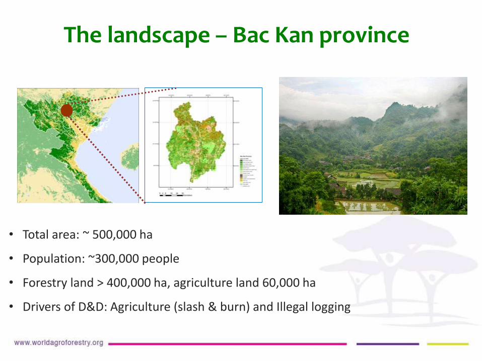
• Total area: ~ 500,000 ha
• Population: ~300,000 people
• Forestry land > 400,000 ha, agriculture land 60,000 ha
• Drivers of D&D: Agriculture (slash & burn) and Illegal logging
The landscape – Bac Kan province

Lam Dong
Bac Ninh
Ha Tinh
Binh Phuoc
Binh Thuan
Ca Mau
Da Nang
Lao Cai
Bac Kan
Ha Tinh
Ha Giang
0.0
10.0
20.0
30.0
40.0
50.0
60.0
70.0
80.0
0 5000 10000 15000 20000 25000 30000
Fore
st c
ove
rage
(%
)
Ave.Agriculture land size (m2/HH)
Lam Dong
Bac Ninh
Binh Phuoc
Binh Thuan
Ca Mau
Da Nang
Lao Cai
Bac Kan
Ha Tinh
Ha Giang
0.0
10.0
20.0
30.0
40.0
50.0
60.0
70.0
80.0
0.0 200.0 400.0 600.0 800.0 1000.0 1200.0 1400.0
Fore
st c
ove
rage
(%
)
Pop Density (people/km2)
Lam Dong
Bac Ninh
Binh Phuoc
Binh Thuan
Ca Mau
Da Nang
Lao Cai
Bac Kan
Ha Tinh
Ha Giang
0.0
10.0
20.0
30.0
40.0
50.0
60.0
70.0
80.0
0.0 500.0 1000.0 1500.0 2000.0 2500.0 3000.0
Fore
st c
ove
rage
(%
)
Food production/capita (kg/person.year)
Low agricultural productivity
Lam Dong
Bac Ninh
Binh Phuoc
Binh Thuan
Ca Mau
Da Nang
Lao Cai
Bac Kan
Ha Tinh
Ha Giang
0.0
10.0
20.0
30.0
40.0
50.0
60.0
70.0
80.0
20000 40000 60000 80000 100000 120000 140000 160000
Fore
st c
ove
rage
(%
)
Average income (000 VND/HH)
Low population density
Limited agricultural Land Among the poorest provinces
General Statistics Office, 2012

Questions
All of the above in relation to national & provincial socio-economic development strategies
1. What is the stage of forest transition? Can economic incentives help to stop D&D?
2. Does a high forest cover guarantee sustainable income and other needs, even conservation?
3. Can REDD+/PES help to secure landscape multi-functionality?
4. How should future planning be made to reconcile local people and policy makers’ perspectives?

Forest transition
Government: 5 M hectares reforestation
program since 1998
Shifting cultivators, loggers
82% forest cover by 2020
70% forest cover by 2015

What happened to the forest?
STU
DY
OB
JEC
TIV
ES
246.2 238.9
306.7
235.6 218.8
268.1
10.6 20.1 38.5
2000 2005 2010
Tho
usa
nd
sh
a
Forest Natural Forest
Planted Forest

Is CO2 emission from LUC avoidable by C payment?
1995-2000
2005-2010
1 USD/tCO2 eq
1 USD/tCO2 eq
Even C price as low as 1 USD/tCO2 can
compensate for most LUC
Bac kan landscape was a net emitter (in LUC) in
1995-2000
Bac kan landscape was a net C- sequester in 2005-
2010

48%
2000 2010 2020
Natural forest
Planted forest
Bareland
Rocky mountain
Agricutural land
Tree based
Shifting cultivation
Settlement-Infrastruture
55% 51%
2% 8% 33%
39% 27% 2%
2%
4%
1%
1%
1%
1%
1% 2%
4% 4% 6%
1%
1%
2%
Pathway of forest change
Deforestation
Reforestation
Landuse conversion

What is the right pathway to take?
More forest conservation?
More economic development?
Both at the same time?

4- Production forest 3- Other land
Water
regulationIncome
Spiritual,
historical
values
Water
regulationIncome
Natural
hazard
mitigation
Soil
retentionIncome Raw
materials
Food
Income
Local perspectives
Policy makers
perspective
1- Special use forest 2- Protection forest
Water
regulation
Spiritual,
historical
values
Stakeholders have different priorities farmers vs. policy makers
Analytical hierarchy process (Saaty, 1990) with pairwise ranking through FGDs and individual ranking at commune and district levels (186)
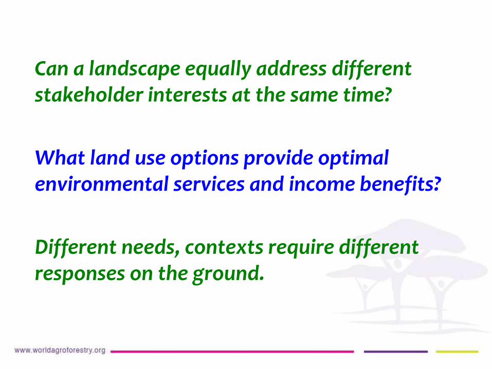
Can a landscape equally address different stakeholder interests at the same time?
What land use options provide optimal environmental services and income benefits?
Different needs, contexts require different responses on the ground.

1. Analyse land use trade-offs
Forest, Agroforest, Low-value Lands Or Waste (FALLOW) model
Input maps• Initial landcover• Soil map• Suitability, etc.
BiophysicalAGB• Yield, etc.
Socio-economic• Return to land/labor• Demographic change• Price etc.
Potential scenarios
• Discussion with different stakeholders
Outputs:
• Economic: Income per capita• Ecological: C-stock at landscape level

Land use change scenarios
BAU
Acacia mangium expansion
Crop expansion
REDD+
REALU
Forest /tree conservation & expansion
Agriculture expansion
Agroforestry replaces shifting cultivation
No illegal logging + establishing forest tree plantation
Acacia mangium planted in natural production forest (20 -50% of establishment cost is subsidized)
Free competition based on economic interests
10-20% subsidy for annual crops
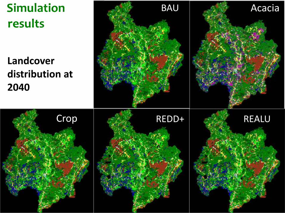
BAU
Crop
Landcover distribution at 2040
Simulation Acacia
REDD+ REALU
results

-16
-14
-12
-10
-8
-6
-4
-2
0
2
4
6
8
-50 -25 0 25 50 75 100
ΔC
sto
ck (
Mto
n)
Δ Income per capita (USD)Crop 2Crop 1
REDD++/REALU
REDD+
Acacia 1
Acacia 2
BAU
Trade-offs between C and $
Trees inside and outside forests bring more carbon benefits in the landscape
Reducing Emissions from All Land Uses (REALU) can be a win-win scenario, if incentives will be provided

2. Adopt participatory land use planning for low emissions development strategy LUWES framework for reconciling different objectives
• Multiple functions, multiple needs, multiple agenda, multiple stakeholders, multiple policies, multiple scale issues from limited resources
• Reconciliation is necessary; often involving trade-offs
• Land use planning for development and environmental services should be conducted inclusively and by integrating spatial and development planning on valid and up-to-date data and information.
• Capacity strengthening for land use planning in tropical landscapes is necessary
• Several rapid tools for assessing environmental services, including simple indicators are available
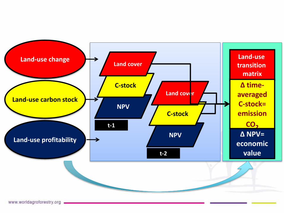
NPV
C-stock
Land-use transition
matrix
∆ time-averaged C-stock= emission
CO2
Land-use profitability∆ NPV=
economic value
Land-use carbon stock
Land-use changeLand cover
NPV
C-stock
Land cover
t-1
t-2

Piloting LUWES in Ba Be district
Special use F
• 8,797 ha
• Forest protection contract
• Forest planting (small scale)
• Natural regeneration
Protection F
• 11,528 ha
• Forest protection contract
• Natural regeneration
• Forest planting on bare land
Production F
• 37,034 ha
• Forest planting on bare land
• Natural regeneration
• Converting shifting cultivation area into agroforestryland use systems
Non F
• 10,838 ha
• Accelerating production area such as AF or fruit tree planting
• BAU: business as usual (as of 2005-2010)
• Scenario 1 (optimistic): Pprotect all forests and replant forest wherever possible
• Scenario 2 (DARD): Forestry planning by provincial DARD
• Scenario 3 (District consultation): DARD’s plan + district authority consultation
• Scenario 4 (LUWES- participatory scenario): Local consultation with villagers and communities
Scenario development

-1.5
-1
-0.5
0
1 2 3 4 5
Mt
CO
2
BAU Optimistic Plan DARD's Plan
District's Plan LUWES
DARD’s plan: Land sparing approach, strict forest protection and planting forest anywhere possible
LUWES plan: Land sharing approach, forest should be used to meet local demands and plantation of TOF can help to achieve carbon and livelihood objectives
Piloting LUWES in Ba Be district
Emission reductions by different land use plans
Participatory plan
Top down- plan
Optimistic plan
CO
2 e
mis
sio
ns
2010 2010- 2015 2015- 2020 2020- 2025 2025- 2030 2030- 2035
BAU
Time

What we have learnt?
REDD+ should be designed to achieve multiple objectives rather than solely climate-related
REDD+ needs integrated, bottom-up and multi stakeholder land-use planning
Carbon is important, but don’t forget other environmental services and people’s livelihoods
The provincial government needs to define their development pathway in ways that simultaneously address conservation and development ambitions
A landscape perspective is needed, to ensure that other sectors are in synch with, or supportive of REDD++ objectives
THANK YOU VERY MUCH!
Contact:
Dr. Delia Catacutan
Country Representative
ICRAF VIETNAM
Tel/Fax: +84 4 37834644/45 (Ext. 81)
Email: / [email protected]
http://worldagroforestry.org/regions/southeast_asia/vietnam
Research teamDo Trong HoanDam Viet BacRachmat MuliaNguyen Mai PhuongDelia Catacutan