multi-disciplinary development of state and...
TRANSCRIPT
Multi-disciplinary development of state
and transition models An Example from Northwestern Colorado
Emily Kachergis and Maria Fernandez-Gimenez
USDA-Agricultural Research Service
Colorado State University
1
1
2
2
Outline
• Introduction
• Integrating Local Knowledge and Field
Data to Create STMs in northwestern
Colorado
• Lessons Learned

Models help us learn about
the way the world works
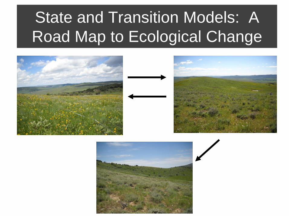
State and Transition Models: A
Road Map to Ecological Change
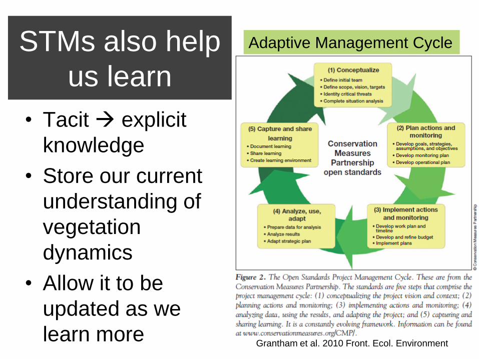
STMs also help
us learn
• Tacit explicit
knowledge
• Store our current
understanding of
vegetation
dynamics
• Allow it to be
updated as we
learn more
Adaptive Management Cycle
Grantham et al. 2010 Front. Ecol. Environment

Study Area: Elkhead Watershed,
northwestern Colorado
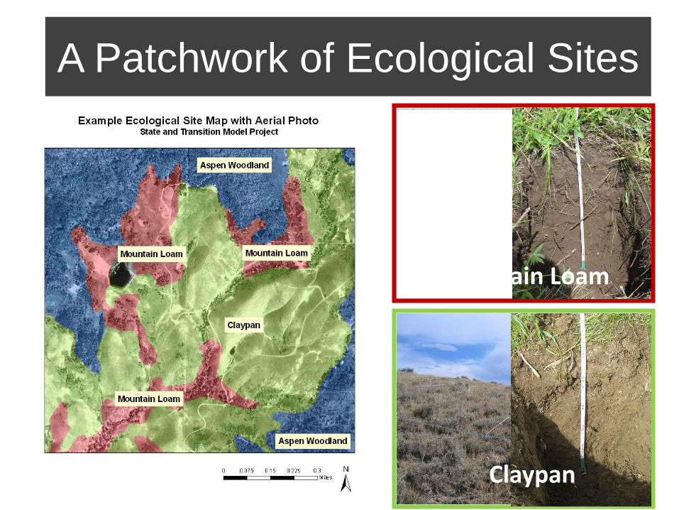
A Patchwork of Ecological Sites
Mountain Loam
Claypan
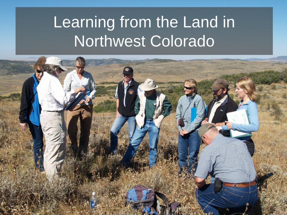
Learning from the Land in
Northwest Colorado
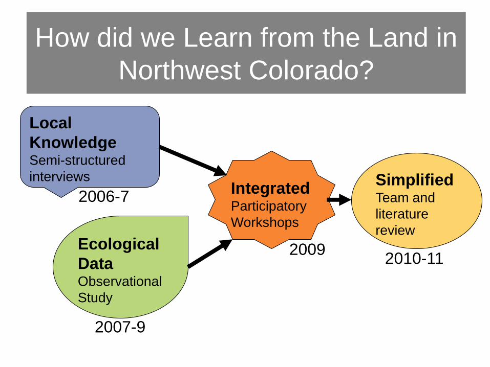
How did we Learn from the Land in
Northwest Colorado?
Local
Knowledge Semi-structured
interviews
2006-7
Ecological
Data Observational
Study
2007-9
Integrated Participatory
Workshops
2009
Simplified Team and
literature
review
2010-11
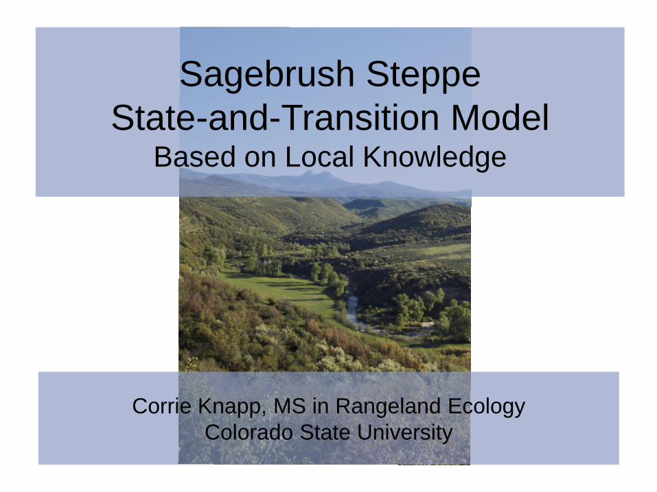
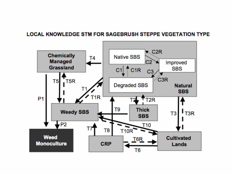
Sagebrush Steppe
State-and-Transition Model Based on Local Knowledge
Corrie Knapp, MS in Rangeland Ecology
Colorado State University
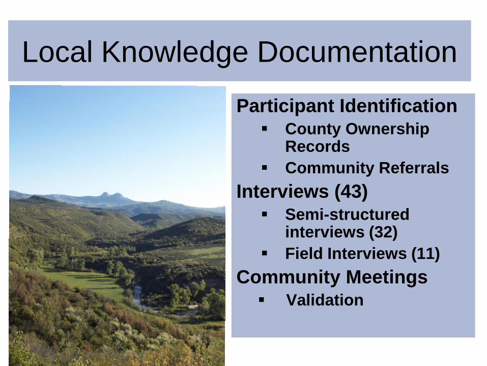
Local Knowledge Documentation
Participant Identification County Ownership
Records
Community Referrals
Interviews (43) Semi-structured
interviews (32)
Field Interviews (11)
Community Meetings Validation
Building Data-Driven
State-and-Transition Models
Emily Kachergis
PhD in Ecology, Colorado State University
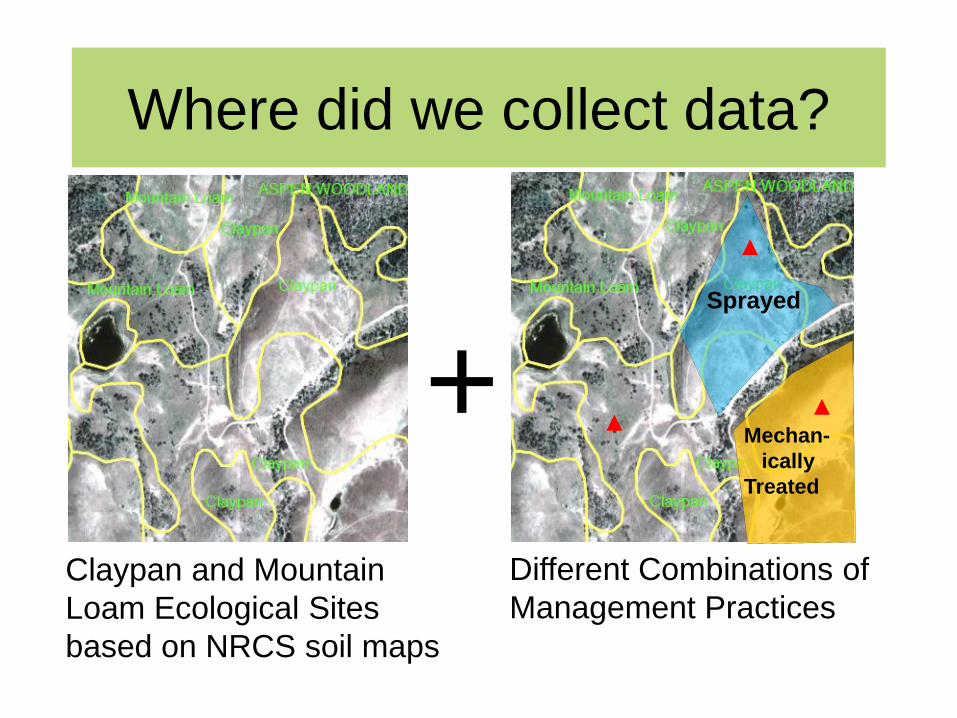
Where did we collect data?
Claypan and Mountain
Loam Ecological Sites
based on NRCS soil maps
+
Different Combinations of
Management Practices
Sprayed
Mechan-
ically
Treated
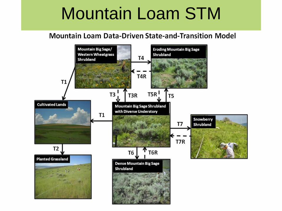
Mountain Loam STM
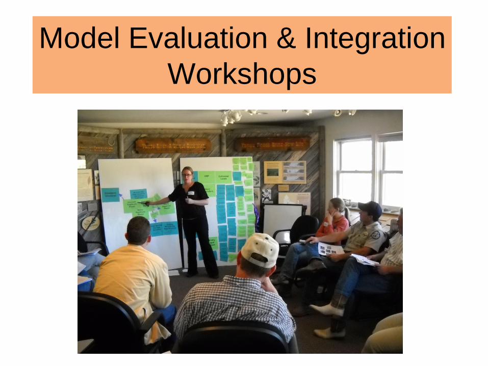
Model Evaluation & Integration
Workshops

2009 Model Integration
Workshops -- Process
1. Brief introduction to STMs and concepts
2. Brief introduction to each model
3. Small-group breakout sessions with a
large paper copy of each model
4. Group modeling process
5. Assessing agreement
6. Survey
17
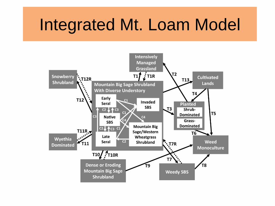
Integrated Mt. Loam Model
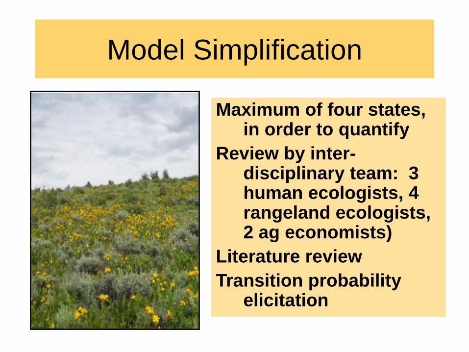
Model Simplification
Maximum of four states, in order to quantify
Review by inter-disciplinary team: 3 human ecologists, 4 rangeland ecologists, 2 ag economists)
Literature review
Transition probability elicitation
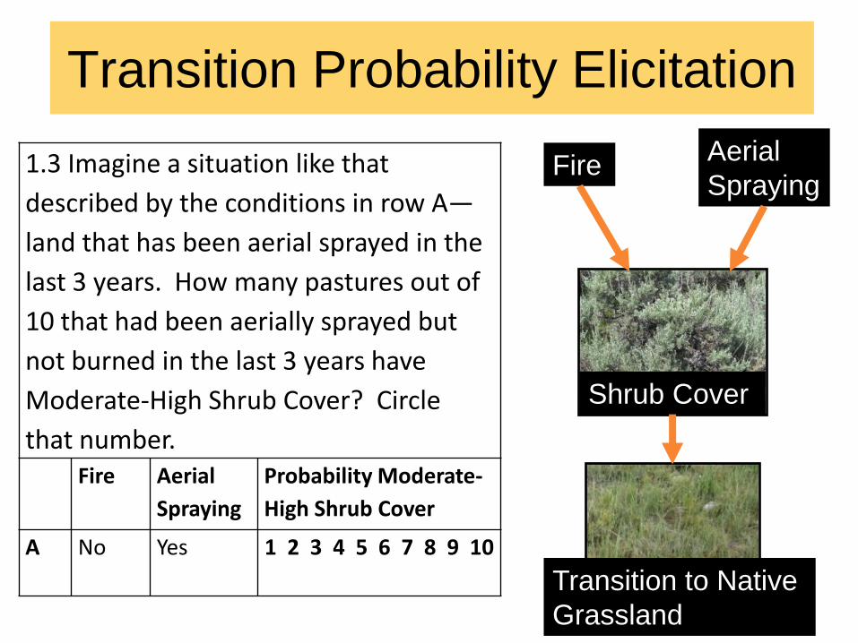
Transition Probability Elicitation
Part I
Effects of drivers
on intermediate factors
Part II
Effects of intermediate
factors on transitions
between states
Fire Aerial
Spraying
Shrub Cover
Transition to Native
Grassland
1.3 Imagine a situation like that
described by the conditions in row A—
land that has been aerial sprayed in the
last 3 years. How many pastures out of
10 that had been aerially sprayed but
not burned in the last 3 years have
Moderate-High Shrub Cover? Circle
that number. Fire Aerial
Spraying
Probability Moderate-
High Shrub Cover
A No Yes 1 2 3 4 5 6 7 8 9 10
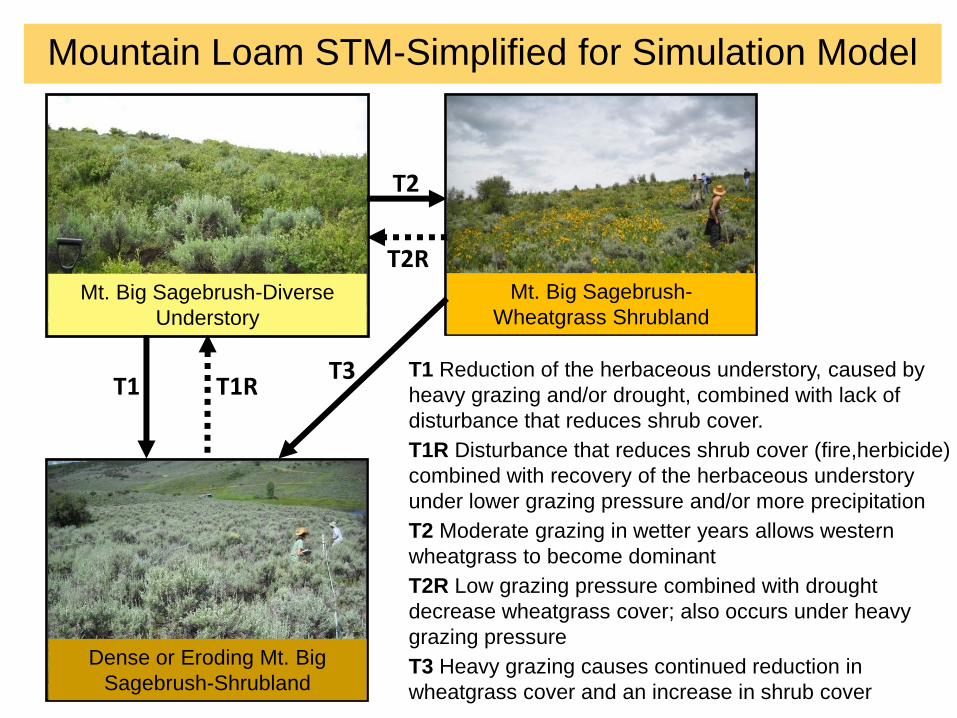
T1
T2
T2R
T3 T1 Reduction of the herbaceous understory, caused by
heavy grazing and/or drought, combined with lack of
disturbance that reduces shrub cover.
T1R Disturbance that reduces shrub cover (fire,herbicide)
combined with recovery of the herbaceous understory
under lower grazing pressure and/or more precipitation
T2 Moderate grazing in wetter years allows western
wheatgrass to become dominant
T2R Low grazing pressure combined with drought
decrease wheatgrass cover; also occurs under heavy
grazing pressure
T3 Heavy grazing causes continued reduction in
wheatgrass cover and an increase in shrub cover
Mt. Big Sagebrush-Diverse
Understory
Mt. Big Sagebrush-
Wheatgrass Shrubland
Dense or Eroding Mt. Big
Sagebrush-Shrubland
T1R
Mountain Loam STM-Simplified for Simulation Model
T1
T2
T2R
T3
Mt. Big Sagebrush-Diverse
Understory (Reference State)
Mt. Big Sagebrush-
Wheatgrass Shrubland
Dense or Eroding Mt. Big
Sagebrush-Shrubland
T1R
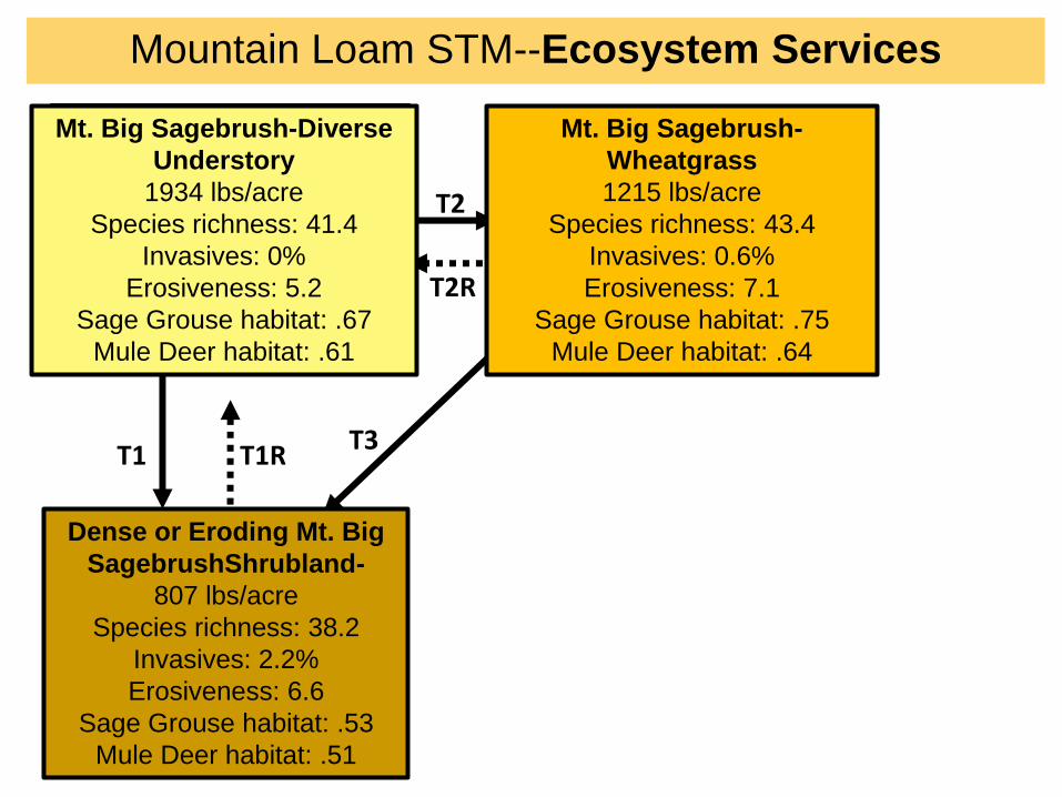
Mountain Loam STM--Ecosystem Services
Mt. Big Sagebrush-Diverse
Understory
1934 lbs/acre
Species richness: 41.4
Invasives: 0%
Erosiveness: 5.2
Sage Grouse habitat: .67
Mule Deer habitat: .61
Mt. Big Sagebrush-
Wheatgrass
1215 lbs/acre
Species richness: 43.4
Invasives: 0.6%
Erosiveness: 7.1
Sage Grouse habitat: .75
Mule Deer habitat: .64
Dense or Eroding Mt. Big
SagebrushShrubland-
807 lbs/acre
Species richness: 38.2
Invasives: 2.2%
Erosiveness: 6.6
Sage Grouse habitat: .53
Mule Deer habitat: .51
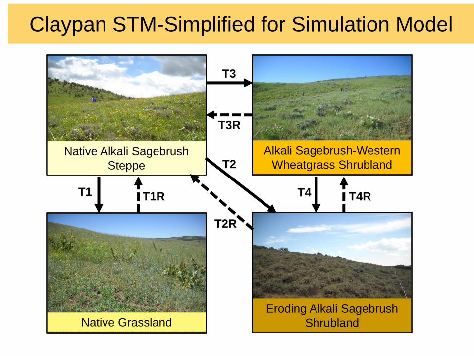
Claypan STM-Simplified for Simulation Model
Native Alkali Sagebrush
Steppe
Native Grassland
Alkali Sagebrush-Western
Wheatgrass Shrubland
Eroding Alkali Sagebrush
Shrubland
T1 T1R
T2
T2R
T3
T3R
T4 T4R
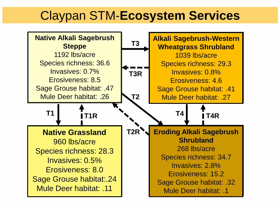
Claypan STM-Ecosystem Services
Native Alkali Sagebrush
Steppe (Reference State)
Native Grassland
Alkali Sagebrush-Western
Wheatgrass Shrubland
Eroding Alkali Sagebrush
Shrubland
T1 T1R
T2
T2R
T3
T3R
T4 T4R
Native Alkali Sagebrush
Steppe
1192 lbs/acre
Species richness: 36.6
Invasives: 0.7%
Erosiveness: 8.5
Sage Grouse habitat: .47
Mule Deer habitat: .26
Native Grassland
960 lbs/acre
Species richness: 28.3
Invasives: 0.5%
Erosiveness: 8.0
Sage Grouse habitat:.24
Mule Deer habitat: .11
Alkali Sagebrush-Western
Wheatgrass Shrubland
1039 lbs/acre
Species richness: 29.3
Invasives: 0.8%
Erosiveness: 4.6
Sage Grouse habitat: .41
Mule Deer habitat: .27
Eroding Alkali Sagebrush
Shrubland
268 lbs/acre
Species richness: 34.7
Invasives: 2.8%
Erosiveness: 15.2
Sage Grouse habitat: .32
Mule Deer habitat: .1
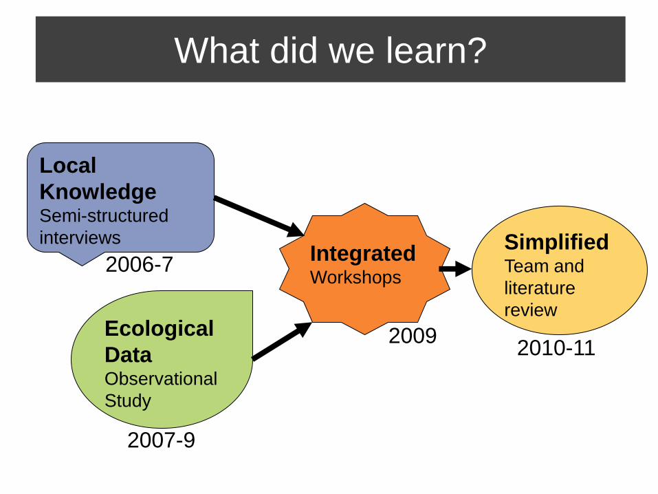
What did we learn?
Ecological
Data Observational
Study
Local
Knowledge Semi-structured
interviews Integrated Workshops
Simplified Team and
literature
review
2006-7
2007-9
2009 2010-11
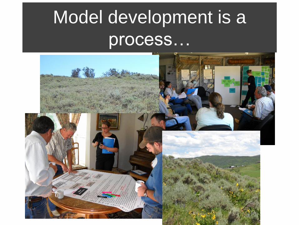
Model development is a
process…
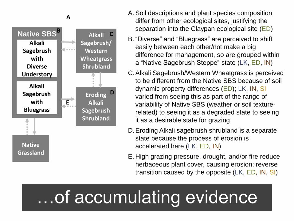
…of accumulating evidence
A
E
Alkali Sagebrush/
Western Wheatgrass Shrubland
Alkali Sagebrush
with Diverse
Understory
Alkali Sagebrush
with Bluegrass
Native SBS
Native Grassland
Eroding Alkali
Sagebrush Shrubland
B C
D
A. Soil descriptions and plant species composition
differ from other ecological sites, justifying the
separation into the Claypan ecological site (ED)
B. “Diverse” and “Bluegrass” are perceived to shift
easily between each other/not make a big
difference for management, so are grouped within
a “Native Sagebrush Steppe” state (LK, ED, IN)
C.Alkali Sagebrush/Western Wheatgrass is perceived
to be different from the Native SBS because of soil
dynamic property differences (ED); LK, IN, SI
varied from seeing this as part of the range of
variability of Native SBS (weather or soil texture-
related) to seeing it as a degraded state to seeing
it as a desirable state for grazing
D.Eroding Alkali sagebrush shrubland is a separate
state because the process of erosion is
accelerated here (LK, ED, IN)
E. High grazing pressure, drought, and/or fire reduce
herbaceous plant cover, causing erosion; reverse
transition caused by the opposite (LK, ED, IN, SI)
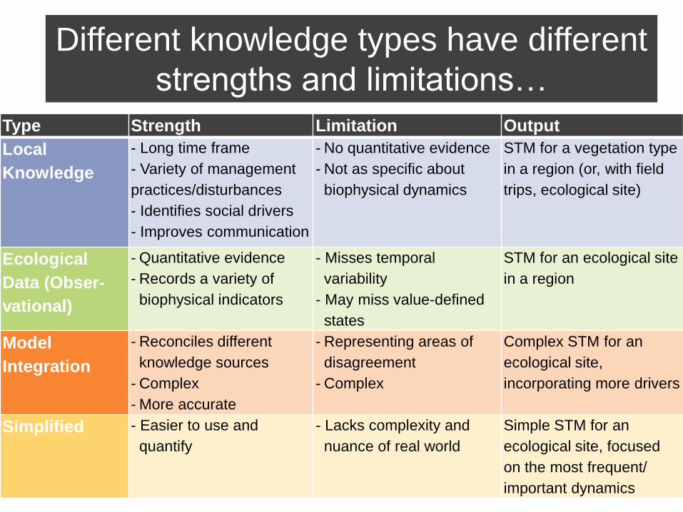
Type Strength Limitation Output
Local
Knowledge
- Long time frame
- Variety of management
practices/disturbances
- Identifies social drivers
- Improves communication
- No quantitative evidence
- Not as specific about
biophysical dynamics
STM for a vegetation type
in a region (or, with field
trips, ecological site)
Ecological
Data (Obser-
vational)
- Quantitative evidence
- Records a variety of
biophysical indicators
- Misses temporal
variability
- May miss value-defined
states
STM for an ecological site
in a region
Model
Integration
- Reconciles different
knowledge sources
- Complex
- More accurate
- Representing areas of
disagreement
- Complex
Complex STM for an
ecological site,
incorporating more drivers
Simplified - Easier to use and
quantify
- Lacks complexity and
nuance of real world
Simple STM for an
ecological site, focused
on the most frequent/
important dynamics
Different knowledge types have different
strengths and limitations…
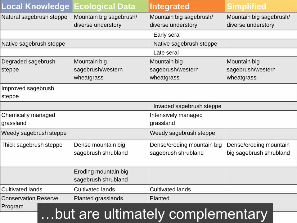
Local Knowledge Ecological Data Integrated Simplified Natural sagebrush steppe Mountain big sagebrush/
diverse understory
Mountain big sagebrush/
diverse understory
Mountain big sagebrush/
diverse understory
Early seral
Native sagebrush steppe Native sagebrush steppe
Late seral
Degraded sagebrush
steppe
Mountain big
sagebrush/western
wheatgrass
Mountain big
sagebrush/western
wheatgrass
Mountain big
sagebrush/western
wheatgrass
Improved sagebrush
steppe
Invaded sagebrush steppe
Chemically managed
grassland
Intensively managed
grassland
Weedy sagebrush steppe Weedy sagebrush steppe
Thick sagebrush steppe Dense mountain big
sagebrush shrubland
Dense/eroding mountain big
sagebrush shrubland
Dense/eroding mountain
big sagebrush shrubland
Eroding mountain big
sagebrush shrubland
Cultivated lands Cultivated lands Cultivated lands
Conservation Reserve
Program
Planted grasslands Planted
…but are ultimately complementary
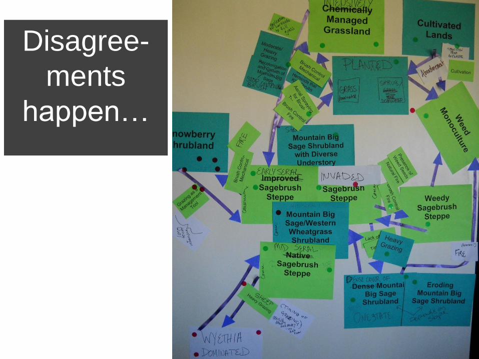
Disagree-
ments
happen…
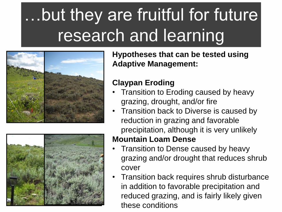
…but they are fruitful for future
research and learning Hypotheses that can be tested using
Adaptive Management:
Claypan Eroding
• Transition to Eroding caused by heavy
grazing, drought, and/or fire
• Transition back to Diverse is caused by
reduction in grazing and favorable
precipitation, although it is very unlikely
Mountain Loam Dense
• Transition to Dense caused by heavy
grazing and/or drought that reduces shrub
cover
• Transition back requires shrub disturbance
in addition to favorable precipitation and
reduced grazing, and is fairly likely given
these conditions
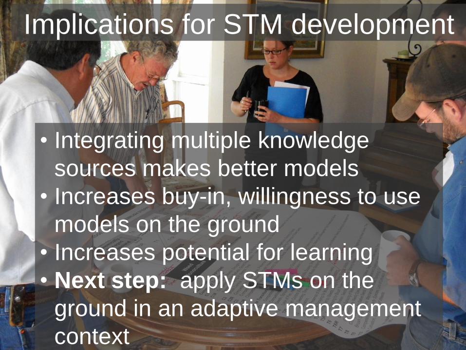
Implications for STM development
• Integrating multiple knowledge
sources makes better models
• Increases buy-in, willingness to use
models on the ground
• Increases potential for learning
• Next step: apply STMs on the
ground in an adaptive management
context
Thanks!
Funding provided by: USDA NIFA AFRI,
CO Agricultural Experiment Station, USDA NRCS
Project team: Maria Fernandez-Gimenez, Emily Kachergis,
Windy Kelley, Corrie Knapp, Kira Puntenney, Willow Hibbs, Jay
Parsons, James Pritchett, John Ritten, Roy Roath, Monique
Rocca, Ryan Wattles
Community Advisory Group: Ranchers of the Elkhead
watershed and Moffatt County, Routt County Extension, Routt
National Forest, BLM Little Snake Field Office, CO Division of
Wildlife, TNC Carpenter Ranch, NRCS, Community Agricultural
Alliance, Tread of Pioneers Museum.
Questions?
Summing it all up…
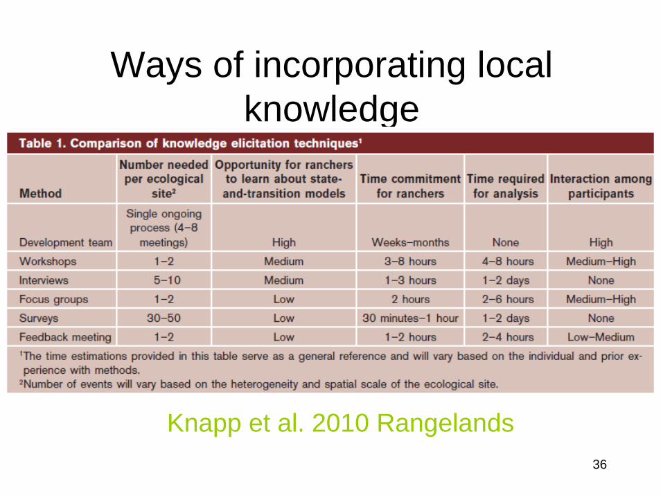
Ways of incorporating local
knowledge
Knapp et al. 2010 Rangelands
36
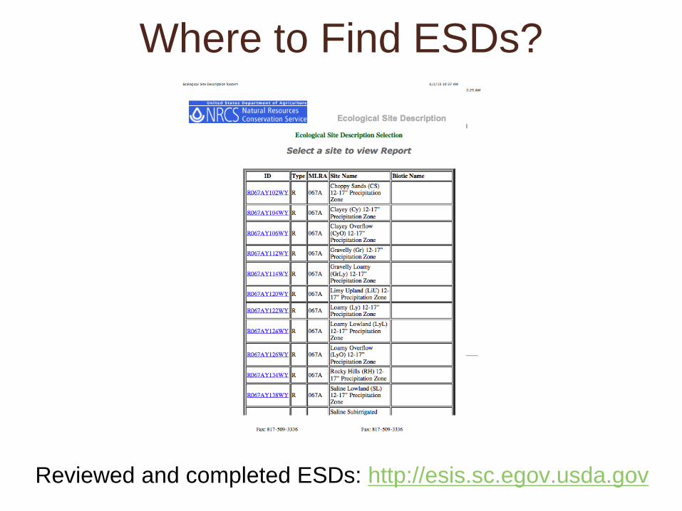
Where to Find ESDs?
Reviewed and completed ESDs: http://esis.sc.egov.usda.gov
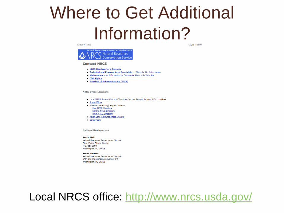
Where to Get Additional
Information?
Local NRCS office: http://www.nrcs.usda.gov/
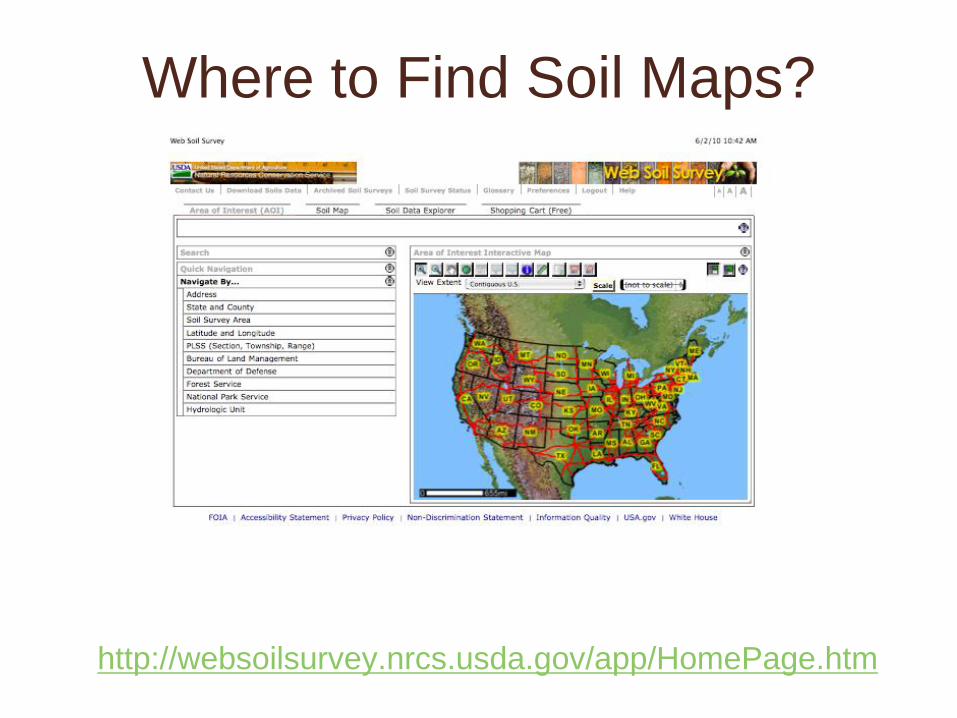
Where to Find Soil Maps?
http://websoilsurvey.nrcs.usda.gov/app/HomePage.htm
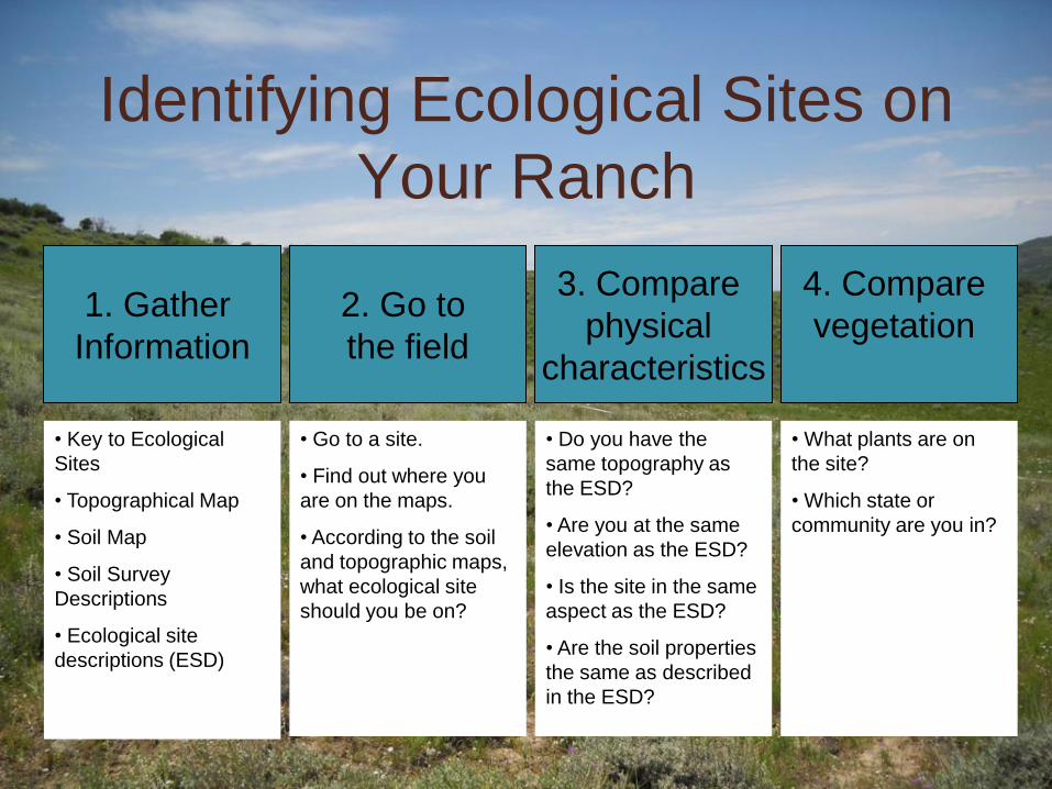
Identifying Ecological Sites on
Your Ranch
1. Gather
Information
2. Go to
the field
3. Compare
physical
characteristics
4. Compare
vegetation
• Key to Ecological
Sites
• Topographical Map
• Soil Map
• Soil Survey
Descriptions
• Ecological site
descriptions (ESD)
• Go to a site.
• Find out where you
are on the maps.
• According to the soil
and topographic maps,
what ecological site
should you be on?
• Do you have the
same topography as
the ESD?
• Are you at the same
elevation as the ESD?
• Is the site in the same
aspect as the ESD?
• Are the soil properties
the same as described
in the ESD?
• What plants are on
the site?
• Which state or
community are you in?