mule shoe bar south ranch -...
TRANSCRIPT

Mule Shoe Bar South Ranch
All contiguous rangeland with sub irrigated range sites consisting of 11,555 total acres
Mike LashleyOwner|Broker
Mike’s Cell: 308-530-0134Email: [email protected]

Mike LashleyOwner|Broker
Mike’s Cell: 308-530-0134Email: [email protected]
Property Highlights
List Price $7,223,462
Location The historic Mule Shoe Bar South Ranch is located in the western tier of the famed Nebraska Sandhills approximately 30 miles southeast from Alliance, Nebraska or approximately 30 miles north from Lisco, Nebraska.
Broker Comments This is an excellent producing ranch that has only been on the market for a second time in over 100 years. It would not be for sale now if the current ownership did not have opportunities to purchase other land closer to their parent operations.
DescriptionHISTORY: The Mule Shoe Bar South Ranch has a previous ownership history that dates back prior to the last century. A family of brothers by the name of Peterson settled in this area of the Sandhills, and proceeded to acquire land via homestead and purchase over the years and their lifetimes. Mule Shoe Bar was one of the ranch names with a brand that went with it. They ended up being some of the largest land owners in this area of the Sandhills joining other names such as Abbott, Black, Hord and Eldred, all of which including the Peterson Brothers, built ranching empires in their own names. Some of the original Peterson ownership is still currently held by their third and fourth generations today. Peterson Brothers stories have been passed down and shared through the generations of Sandhill families.One such story was about the Peterson “Hay Trains”. During the summer hay season the brothers would team up and share their resources to put up each other’s hay meadows for winter feed. Horses, mules, hired men, and horse drawn hay equipment were all brought together to form a large hay crew that worked from the hay train during the summer months. The hay train consisted of several wagons each dedicated to a special purpose to get the hay put up. There could be as many as 5-6 wagons all connected together and pulled by a large team of many mules or horses. The first wagon was generally the “straw boss quarters”, second wagon, the “cook house”, third wagon the “supply wagon”, the fourth and fifth wagons “the “bunk house wagons” and the last wagon the “hay supplies wagon”. This operation was self-contained with food and supplies for generally several weeks at a time with hay crew, horses, mules and the “hay train” traveling over thousands of acres putting up hay wherever the Peterson Brothers would want it put up. Spring brandings were also often completed with Peterson ranch shared cowboys. It was a good way to stay “social” in a day when your only means of transportation was by horseback for the average ranch cowboy working for wages at $25/month or by horse and buggy if you owned the ranch.
NEBRASKA SANDHILLS: The Mule Shoe Bar South Ranch is located in the western region of the famed Nebraska Sandhills, known for one of the finest cattle producing regions in the United States. The Sandhills of Nebraska is the Nation’s largest undisturbed native grassland area. If covers approximately 13 million acres in 20 counties located in the north central part of the state. The grasses are vigorous and nutritious and have proven themselves as drought tolerant species centuries ago by supporting vast herds of Buffalo prior to the arrival of the white man.
OGALLALA AQUIFER: The Sandhills of Nebraska also sits on top of the largest fresh water aquifer in the continental U.S. Known as the Ogallala or High Plains Aquifer, it supports fresh water bearing material where this ranch is located in the range of 400’-600’ in depth. Stock wells and irrigation wells are generally considered shallow by comparison to other cattle producing regions in other states.
RAINFALL: The rainfall belt in the area and location of these ranches ranges from 16”-19” per year with the majority of it falling during the grass growing season. It is generally considered consistent and reliable to the extent that cattle sell downs because of drought are rare.
MARKETS: The ranch is well located to auction barns in Ogallala and Gordon, Nebraska. Ogallala supports one of the finest livestock sale barns in the state of Nebraska. Thousands of reputation cattle pass through it gates annually in the form of special stock cow, bred heifer, yearling, and calf sales throughout the year. Buyers from several states are always on hand to create a consistent, top-end market for all classes of cattle. There are also video auction markets available that are nationwide in scope.
MINERALS: The current ownership will convey all the owned minerals.
EXCHANGES: The current ownership will cooperate with 1031 exchanges.
APPROACH TO MANAGEMENT AND REVENUE: The Mule Shoe Bar South Ranch under the current ownership has been utilized by grazing with some summer haying to supplement for winter feed. In the analysis and use of this resource, five sub irrigated meadows were hayed, three in the northwest end of the ranch and two in the east end of the ranch. The ranch has a number of sub irrigated range sites that

LashleyLand.com
Property Highlightscould be utilized in haying with some aftermath grazing or for just grazing.The USDA NRCS has developed and provided both ranch range site maps with estimated acreages as well as an animal unit study for each ranch. These studies have been utilized in determining the estimated carrying capacities of each ranch resource. What follows are the ranch estimates of deeded acres and current real estate taxes from the respective counties; as well as the NRCS estimates of acres, range sites, carrying capacity AUMs under average use, number of pastures, and number of stock wells. The ranch has been evaluated for annual carrying capacity and an estimate of landlord revenue generation on a summer grazing basis utilizing cow-calf pairs and marketing the landlord share of hay production.
MULE SHOE BAR SOUTH RANCH:Description: An all contiguous rangeland resource with sub irrigated rangeland sites with a modest set of building improvements. Ranch has 40 pastures and 29 stock wells some of which are shared with neighbors. A combination of county acres and NRCS* acres were utilized for the analysis.
Deeded acres by County Record: 11,555.29 acres 2015 Real Estate Taxes by County Record: $33,607.00
Land Classification Summary Estimated acres by County Record and NRCS* Sub Irrigated/Sandy Lowland – Hayed: 832 ac* Sub Irrigated/Sandy Lowland – Grazed: 1454 ac* Sandhill Rangeland: 8640 ac* Lake/Marsh: 408 ac* Bldg. Site & Lots : 221 ac*
Total estimated acres by county record: 11,555 ac
Landlord Revenue Estimate 832 acres* sub irrigated/sandy lowland – hayed 1038 Ton @ 2.5 AUMs/Ton – 2595 AUMs (832 acres*) aftermath grazing 168 AUMS 10,094 acres* sub irrigated/sandy lowland/sandhill range – 4771 AUMs 408 acres* lake and marsh 221 acres* building site and lots 11,555 acres total by county record
7534/12 months – 628 AUs or 18 acres/AU 832 acres* hayed 1038 Ton @ $60/Ton/2 - $31,140 or $37/ac CE (includes aftermath) 4,771/ 5 months/1.5 BWE – 636 Pair or 16 ac/pair 636 pair @ $55/pair/month for 5 months -$174,900 or $17/ac CE
$206,040 Gross Income $33,607 RE Taxes $23,000 R & R $2,200 Misc. $147,233 Net Income, Say $147,000 Net to Landlord
Year Around Carrying Capacity Estimate 7534/12 mo 628 AUs Winter 2595 AUMs/4 mo – 649 AUs Spring/Summer/Fall 4939 AUMs/8 mo -618 AUs 625 AUs .80 500 Cows (cow calf, retaining replacements, bulls) 11,555 ac/625 AU - 18 ac/AU 11,555 ac/500 Cows – 23 ac/Cow

Mike LashleyOwner|Broker
Mike’s Cell: 308-530-0134Email: [email protected]
Property HighlightsLegal DescriptionMule Shoe Bar South Ranch:Township 22 North, Range 45 West of the 6th P.M., Garden County, Nebraska:Section 6: W1/2Section 7: SE1/4, W1/2Section 8: S1/2Section 17: ALLSection 18: ALLSection 19: ALLSection 20: ALL
Township 22 North, Range 46 West of the 6th P.M., Garden County, Nebraska:Section 1: E1/2E1/2Section 3: W1/2SW1/4Section 4: SE1/4NE1/4, S1/2SE1/4, NE1/4SE1/4Section 9: NE1/4, E1/2SE1/4, SW1/4, W1/2SE1/4Section 10: NW1/4, W1/2NE1/4, S1/2, SE1/4NE1/4Section 11: S1/2Section 12: E1/2NE1/4, S1/2Section 13: ALLSection 14: ALLSection 15: ALLSection 16: ALLSection 21: E1/2, E1/2W1/2Section 22: ALL Section 23: ALLSection 24: ALL
Township 23 North, Range 45 West of the 6th P.M., Garden County, Nebraska:Section 31: S1/2SW1/4
Township 23 North, Range 46 West of the 6th P.M., Garden County, Nebraska:Section 36: S1/2SE1/4, NE1/4SE1/4
Township 22 North, Range 46 West of the 6th P.M., Morrill County, Nebraska:Section 8: E1/2SE1/4Section 17: E1/2NE1/4, E1/2SE1/4

LashleyLand.com
LANd Inventory By County Record
Land Inventory by County Record
Garden County 2015Description Grass Water Irrigated Bld
SiteRoads Waste Total Taxes
Mule Shoe Bar South RanchW1/2 6-22-45 359.13 2.99 0.00 0.00 3.25 0.00 365.37 $1,041.40 SE1/4, W1/2 7-22-45 515.88 0.00 0.00 0.00 5.25 0.00 521.13 $1,491.74 S1/2 8-22-45 333.22 0.00 0.00 0.00 0.00 0.00 333.22 $963.50 ALL 17-22-45 625.60 0.00 0.00 0.00 0.00 12.22 637.82 $1,815.02 ALL 18-22-45 654.37 0.00 0.00 0.50 12.50 0.00 667.37 $1,990.64 ALL 19-22-45 644.63 18.85 0.00 0.00 8.50 0.00 671.98 $1,873.34 ALL 20-22-45 598.34 18.39 0.00 0.00 0.00 32.97 649.70 $1,755.72 E1/2E1/2 1-22-46 158.49 3.33 0.00 0.00 0.00 0.00 161.82 $462.08 W1/2SW1/4 3-22-46 80.48 0.00 0.00 0.00 0.00 0.00 80.48 $232.70 SE1/4NE1/4, S1/2SE1/4, NE1/4SE1/4 4-22-46
157.65 3.07 0.00 0.00 0.00 0.00 160.72 $457.38
NE1/4, E1/2SE1/4 9-22-46 241.39 3.08 0.00 0.25 0.00 0.00 244.72 $726.18 SW1/4, W1/2SE1/4 9-22-46 242.88 0.00 0.00 0.00 0.00 0.00 242.88 $702.30 NW1/4, W1/2NE1/4, S1/2, SE1/4NE1/4 10-22-46
576.20 35.35 0.00 0.00 0.00 0.00 611.55 $1,684.92
S1/2 11-22-46 238.39 46.52 0.00 0.00 0.00 38.07 322.98 $731.46 E1/2NE1/4, S1/2 12-22-46 383.44 14.65 0.00 0.00 0.00 7.55 405.64 $1,119.84 ALL 13-22-46 587.38 31.87 0.00 12.24 5.75 16.22 653.46 $2,499.22 ALL 14-22-46 646.12 0.00 0.00 0.00 0.00 0.00 646.12 $1,868.26 ALL 15-22-46 578.78 65.97 0.00 0.00 0.00 2.64 647.39 $1,710.60 ALL 16-22-46 641.68 0.00 0.00 0.00 0.00 0.00 641.68 $1,855.42 E1/2, E1/2W1/2 21-22-46 484.05 0.00 0.00 0.00 0.00 0.00 484.05 $1,399.84 ALL 22-22-46 644.41 4.47 0.00 0.00 0.00 0.00 648.88 $1,865.54 ALL 23-22-46 651.11 0.00 0.00 0.00 0.00 0.00 651.11 $1,882.68 ALL 24-22-46 639.51 13.13 0.00 0.00 0.00 0.00 652.64 $1,857.92 S1/2SW1/4 31-23-45 86.35 2.18 0.00 0.00 2.00 0.00 90.53 $250.78 S1/2SE1/4, NE1/4SE1/4 36-23-46 75.56 0.00 0.00 0.00 0.00 46.49 122.05 $241.86 Morrill CountyE1/2SE1/4 8-22-46 80.00 0.00 0.00 0.00 0.00 0.00 80.00 $381.28 E1/2NE1/4 17-22-46 80.00 0.00 0.00 0.00 0.00 0.00 80.00 $381.28 E1/2SE1/4 17-22-46 80.00 0.00 0.00 0.00 0.00 0.00 80.00 $364.10 Total 11,085.04 263.85 0.00 12.99 37.25 156.16 11555.29 $33,607.00

Mike LashleyOwner|Broker
Mike’s Cell: 308-530-0134Email: [email protected]
Aquifer Map
Mule Shoe Bar South Ranch

LashleyLand.com
Vegetation MapNative Vegetation of Nebraska
This map depicts the vegetation as it was before European settlement, in the 1860s. It was developed mostly from field observations of remnants of native vegetation.
(Modified from the original 1: 1,000,000 version prepared by Robert Kaul and Steven Rolfsmeier in 1993. Published by UNL Conservation & Survey Division. Available in 24” x 36” format from http://nebraskamaps.unl.edu.)
See following pages for key descriptions.
The Sandhills area of Nebraska is the Nation’s largest undisturbed native grassland. It covers 13 million acres in 20 counties in the north central part of the State.
As the name implies, it is an area of fine, windblown sand which, without the heavy cover of grass, would be an expanse of moving sand dunes. The roots of these grasses can penetrate 3’-5’, which allow it to thrive on the abundant groundwater.
The Sandhills area is recognized as one of the nation’s finest for livestock production. The grasses are a vigorous and nutritious species that supported the vast herds of bison in the days before the coming of the settlers.
Mule Shoe Bar South Ranch

Mike LashleyOwner|Broker
Mike’s Cell: 308-530-0134Email: [email protected]
Location Map
Boundary lines are estimates - Map for illustration onlySources: Esri, HERE, DeLorme, USGS, Intermap, INCREMENT P, NRCan, EsriJapan, METI, Esri China (Hong Kong), Esri Korea, Esri (Thailand), MapmyIndia,NGCC, © OpenStreetMap contributors, and the GIS User Community
Boundary Lines Are Estimates. Map For Illustration Only0 6 12 Miles
LocationMule Shoe Bar South

LashleyLand.com
Aerial Map
Boundary lines are estimates - Map for illustration onlyEsri, HERE, DeLorme, MapmyIndia, © OpenStreetMap contributors, Esri, HERE,DeLorme, MapmyIndia, © OpenStreetMap contributors, and the GIS usercommunity, Source: Esri, DigitalGlobe, GeoEye, Earthstar Geographics,CNES/Airbus DS, USDA, USGS, AeroGRID, IGN, and the GIS User Community
Boundary Lines Are Estimates. Map For Illustration Only0 0.8 1.6 Miles
AerialMule Shoe Bar South

Mike LashleyOwner|Broker
Mike’s Cell: 308-530-0134Email: [email protected]
South Ranch With Roads
Boundary lines are estimates - Map for illustration only
Alliance Refuge Rd

LashleyLand.com
South Ranch With Roads
Boundary lines are estimates - Map for illustration only
Road 124
Alliance Refuge Rd
Road
155
Road 155Road 155
Alliance Refuge Rd

Mike LashleyOwner|Broker
Mike’s Cell: 308-530-0134Email: [email protected]
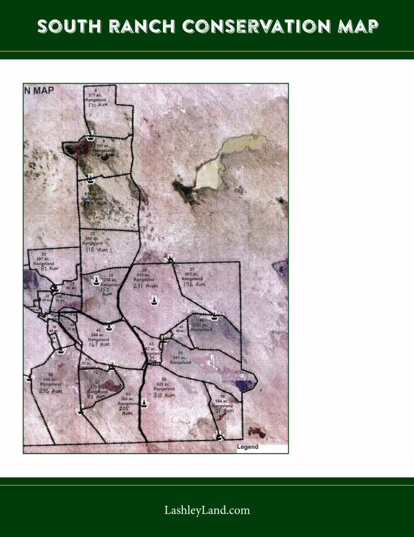
South Ranch Conservation Map
LashleyLand.com
South Ranch Conservation Map


LashleyLand.com
Property Images


LashleyLand.com
Property Images


LashleyLand.com
Property Images


LashleyLand.com
Property ImagesBranding on the
Mule Shoe Bar Ranch(This crew posed for the camera sometime in the 1950’s.)
Haying Time on the Mule Shoe BarThese photos are from the early days on the Mule Shoe Bar Ranch, showing the crew hardat work stacking hay in the meadows.
Haying Time on the Mule Shoe BarThese photos are from the early days on the Mule Shoe Bar Ranch, showing the crew hardat work stacking hay in the meadows.
Haying Time on the Mule Shoe Bar
Haying and branding at the Mule Shoe Bar South Ranch during the 1950’s.
The land experts you can trust
Mike LashleyOwner|Broker
Mike’s Cell: 308-530-0134Email: [email protected]
Contact InformationOffice: 308-532-9300
Fax: 308-532-1854Email: [email protected]
Website: LashleyLand.com
Mike Lashley, Owner|BrokerScott Saults, Skip Marland, Adam Marshall, April Good
Jordan Maassen, Lucy Thierer and Amy Johnston
Like us on FacebookFacebook.com/LashleyLand
2218 E. Walker Road • North Platte, NE 69101
All information herein is from sources deemed reliable, however the accuracy is not guaranteed by Lashley Land and Recreational Brokers, Inc., seller or agent. Offering is subject to error, omissions, prior sale, price change or withdrawal without notice.