moving forward together plan - home | halifax · the moving forward together plan is intended to...
TRANSCRIPT
0
Moving Forward
Together Plan

1
2
Executive Summary
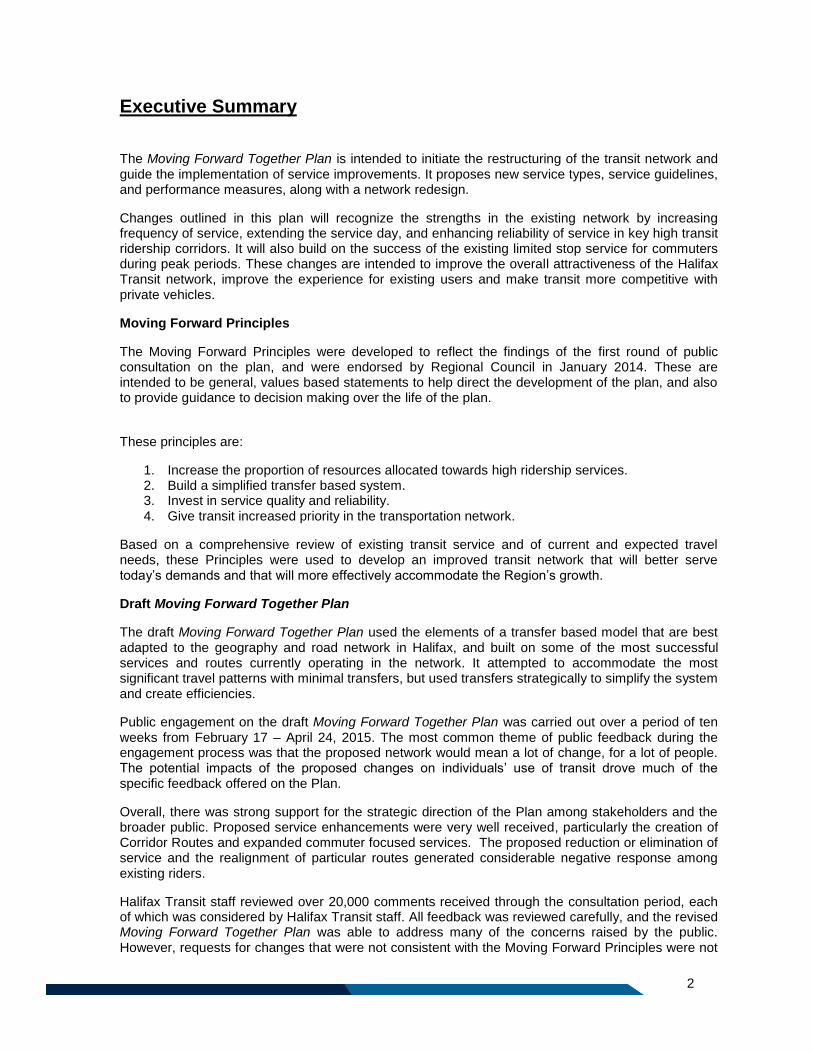
The Moving Forward Together Plan is intended to initiate the restructuring of the transit network and guide the implementation of service improvements. It proposes new service types, service guidelines, and performance measures, along with a network redesign.
Changes outlined in this plan will recognize the strengths in the existing network by increasing frequency of service, extending the service day, and enhancing reliability of service in key high transit ridership corridors. It will also build on the success of the existing limited stop service for commuters during peak periods. These changes are intended to improve the overall attractiveness of the Halifax Transit network, improve the experience for existing users and make transit more competitive with private vehicles.
Moving Forward Principles
The Moving Forward Principles were developed to reflect the findings of the first round of public consultation on the plan, and were endorsed by Regional Council in January 2014. These are intended to be general, values based statements to help direct the development of the plan, and also to provide guidance to decision making over the life of the plan.
These principles are:
1. Increase the proportion of resources allocated towards high ridership services. 2. Build a simplified transfer based system. 3. Invest in service quality and reliability. 4. Give transit increased priority in the transportation network.
Based on a comprehensive review of existing transit service and of current and expected travel needs, these Principles were used to develop an improved transit network that will better serve today’s demands and that will more effectively accommodate the Region’s growth.
Draft Moving Forward Together Plan
The draft Moving Forward Together Plan used the elements of a transfer based model that are best adapted to the geography and road network in Halifax, and built on some of the most successful services and routes currently operating in the network. It attempted to accommodate the most significant travel patterns with minimal transfers, but used transfers strategically to simplify the system and create efficiencies.
Public engagement on the draft Moving Forward Together Plan was carried out over a period of ten weeks from February 17 – April 24, 2015. The most common theme of public feedback during the engagement process was that the proposed network would mean a lot of change, for a lot of people. The potential impacts of the proposed changes on individuals’ use of transit drove much of the specific feedback offered on the Plan.
Overall, there was strong support for the strategic direction of the Plan among stakeholders and the broader public. Proposed service enhancements were very well received, particularly the creation of Corridor Routes and expanded commuter focused services. The proposed reduction or elimination of service and the realignment of particular routes generated considerable negative response among existing riders.
Halifax Transit staff reviewed over 20,000 comments received through the consultation period, each of which was considered by Halifax Transit staff. All feedback was reviewed carefully, and the revised Moving Forward Together Plan was able to address many of the concerns raised by the public. However, requests for changes that were not consistent with the Moving Forward Principles were not
3
accommodated, as well as those that would have required resource reallocation from higher ridership services.
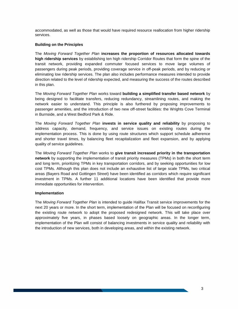
Building on the Principles
The Moving Forward Together Plan increases the proportion of resources allocated towards
high ridership services by establishing ten high ridership Corridor Routes that form the spine of the
transit network, providing expanded commuter focused services to move large volumes of
passengers during peak periods, providing coverage service in off-peak periods, and by reducing or
eliminating low ridership services. The plan also includes performance measures intended to provide
direction related to the level of ridership expected, and measuring the success of the routes described
in this plan.
The Moving Forward Together Plan works toward building a simplified transfer based network by
being designed to facilitate transfers, reducing redundancy, streamlining routes, and making the
network easier to understand. This principle is also furthered by proposing improvements to
passenger amenities, and the introduction of two new off-street facilities: the Wrights Cove Terminal
in Burnside, and a West Bedford Park & Ride.
The Moving Forward Together Plan invests in service quality and reliability by proposing to
address capacity, demand, frequency, and service issues on existing routes during the
implementation process. This is done by using route structures which support schedule adherence
and shorter travel times, by balancing fleet recapitalization and fleet expansion, and by applying
quality of service guidelines.
The Moving Forward Together Plan works to give transit increased priority in the transportation
network by supporting the implementation of transit priority measures (TPMs) in both the short term
and long term, prioritizing TPMs in key transportation corridors, and by seeking opportunities for low
cost TPMs. Although this plan does not include an exhaustive list of large scale TPMs, two critical
areas (Bayers Road and Gottingen Street) have been identified as corridors which require significant
investment in TPMs. A further 11 additional locations have been identified that provide more
immediate opportunities for intervention.
Implementation
The Moving Forward Together Plan is intended to guide Halifax Transit service improvements for the
next 20 years or more. In the short term, implementation of the Plan will be focused on reconfiguring
the existing route network to adopt the proposed redesigned network. This will take place over
approximately five years, in phases based loosely on geographic areas. In the longer term,
implementation of the Plan will consist of balancing investments in service quality and reliability with
the introduction of new services, both in developing areas, and within the existing network.
4
TABLE OF CONTENTS
Executive Summary ........................................................................................................................... 2
Part 1: Background ................................................................................................................................. 8
1 Background ............................................................................................................................... 10
1.1 Halifax Transit Mission Statement .................................................................................... 10
1.2 About The Moving Forward Together Plan....................................................................... 11
1.3 Related Initiatives ............................................................................................................. 11
1.4 Development of The Moving Forward Together Plan ....................................................... 13
1.5 Values Based Consultation .............................................................................................. 13
1.6 Developing the Moving Forward Principles ...................................................................... 15
1.7 Drafting the Plan ............................................................................................................... 15
1.8 Consultation on the Draft Plan .......................................................................................... 15
1.9 Engagement Activities ...................................................................................................... 16
1.10 Feedback Summary .......................................................................................................... 19
1.11 Most Frequent Comments ................................................................................................ 21
Part 2: Building on the Principles .......................................................................................................... 23
2 Navigating the Route Ahead – Building on the Principles ........................................................ 25
2.1 Principle 1 ......................................................................................................................... 25
2.2 Principle 2 ......................................................................................................................... 30
2.3 Principle 3 ......................................................................................................................... 31
2.4 Principle 4. ........................................................................................................................ 33
Part 3: The Network .............................................................................................................................. 35
3 Transit Network Overview ........................................................................................................ 37
3.1 Service Types ................................................................................................................... 37
3.2 Corridor Routes ................................................................................................................ 37
3.3 Local Routes ..................................................................................................................... 39
3.4 Express Routes ................................................................................................................ 41
3.5 Regional Express Routes ................................................................................................. 43
3.6 Ferry .................................................................................................................................. 45
3.7 Rural Routes ..................................................................................................................... 46
3.8 School Routes .................................................................................................................. 47
3.9 Access-a-Bus .................................................................................................................... 48
Part 4: Geographic Areas ..................................................................................................................... 49
4 Network Overview ..................................................................................................................... 51
4.1 Regional Centre ................................................................................................................ 51
5
4.2 Mainland South ................................................................................................................. 53
4.3 Mainland North ................................................................................................................. 54
4.4 Bedford ............................................................................................................................. 55
4.5 Sackville ............................................................................................................................ 56
4.6 Burnside & Dartmouth Crossing ....................................................................................... 57
4.7 Dartmouth, Woodside, Woodlawn, Eastern Passage, Cole Harbour, Cherry Brook, Lake
Loon, Westphal, and North Preston ............................................................................................. 58
4.8 Service outside the Urban Transit Service Boundary ....................................................... 60
Part 5: Transit Infrastructure ................................................................................................................. 63
5 Transit Facilities ........................................................................................................................ 65
5.1 Passenger Amenity Classifications .................................................................................. 66
5.2 Transit Terminals .............................................................................................................. 68
5.3 Park & Rides ..................................................................................................................... 69
Part 6: Measuring Success ................................................................................................................... 71
6 Performance Measures ............................................................................................................ 73
6.1 Ridership Guidelines ......................................................................................................... 73
6.2 Operations below Ridership Guidelines ........................................................................... 74
6.3 Bus Stop Locations ........................................................................................................... 75
6.4 Route Directness Guideline .............................................................................................. 75
6.5 Route Variation Guideline ................................................................................................. 76
6.6 Quality of Service Guidelines ........................................................................................... 76
Part 7: Transit Priority Measures .......................................................................................................... 79
7 Transit Priority: Giving Transit The Advantage ......................................................................... 81
7.1 Investing Where it Makes Sense ...................................................................................... 82
7.2 Implementing TPMs: Getting Started .............................................................................. 83
7.3 Developing a Long Term Strategy .................................................................................... 86
Part 8: Implementation ......................................................................................................................... 88
8 Plan Implementation ................................................................................................................. 90
8.1 Annual Service Plans ........................................................................................................ 90
8.2 Five Year Plan Reviews.................................................................................................... 90
8.3 Routing Variability ............................................................................................................. 90
8.4 Stage I – Implementing the Network ................................................................................ 91
8.5 Stage II – Expansion of the Network ................................................................................ 93
6
TABLE OF FIGURES
Figure 1: Bicycle Repair Facility at Lacewood Terminal....................................................................... 12 Figure 2: Public Consultation Fall 2014 ................................................................................................ 14 Figure 3: MakeTransitBetter.ca Survey Submissions .......................................................................... 16 Figure 4: Pop Up Consultation at the Halifax Central Library .............................................................. 17 Figure 5: Urban Transit Service Boundary (Map 7, Regional Municipal Planning Strategy) ............... 27 Figure 6: Route 320 Airport/Fall River .................................................................................................. 44 Figure 7: Alderney Ferry Terminal ........................................................................................................ 59 Figure 8: Bridge Terminal ..................................................................................................................... 65 Figure 9: Bus Stop Flag Sign ................................................................................................................ 66 Figure 10: Example of Enhanced Stop ................................................................................................. 67 Figure 11: Service Frequency Guidelines ............................................................................................ 78
LIST OF TABLES
Table 1: Most Frequent Comments on Draft Network .......................................................................... 21 Table 2: Ridership and Cost of Low Ridership Routes......................................................................... 29 Table 3: Level of Service Guidelines for Corridor Routes .................................................................... 38 Table 4: Level of Service Guidelines for Local Routes......................................................................... 39 Table 5: Level of Service Guidelines for Regional Express Routes ..................................................... 43 Table 6: Level of Service Guidelines for Ferry Routes ......................................................................... 45 Table 7: Minimum Ridership Guidelines ............................................................................................... 73 Table 8: Vehicle Load Guidelines by Service Type .............................................................................. 77 Table 9: Example Transit Priority Measures ........................................................................................ 81 Table 10: Short Term TPM Opportunities ............................................................................................ 85
7
Appendices
A. Network Maps
B. Detailed Route Descriptions
C. Alternative Measures of Route Productivity
D. Frequency Guidelines by Route
E. Cost/Benefit Analysis of Transit Priority Measures

8
Part 1: Background

9
10
1 Background
Public transit has been a part of the Halifax landscape since the early 1800s, when The Sherbrooke, a horse powered ferry, entered into service with the Halifax Steam Boat Company. For almost 200 years, transit vehicles have provided a cost effective, efficient means to get around for generations of residents and visitors.
Recent investment in transit services has had a large impact on the quality, accessibility, and availability of transit in Halifax. In the past 10 years, total service hours have increased by 63%, and today, Halifax Transit provides more service hours per capita than any other Canadian transit property serving a similar population size.
Halifax Transit provides an integrated public transit system for over 300,000 residents living in communities within the Halifax Regional Municipality, using 65 routes and a fleet of 325 vehicles, 100% of which will be low floor accessible by the end of 2016. Transit is recognized as a key element in addressing economic, environmental, land use, and transportation objectives of the Municipality, in the face of both a changing landscape and dynamic population.
The overall structure of the existing transit network is a radial grid, with the primary focus of most routes on either downtown Halifax or downtown Dartmouth. In the more rural parts of the Region, routes tend to converge at the nearest terminal, where passengers can transfer to routes which travel downtown. Some routes are notable exceptions, and provide direct trips across town, not directly serving the downtown core.
Although there has been substantial growth and expansion in recent years, the underlying transit network has not seen significant changes since the early 1990s. Many routes on the road today have remained largely unchanged for decades, despite the fact that in the intervening years, there have been significant changes to adjacent land uses and travel patterns.
The transit network today reflects the thinking of a number of different transit planning ideologies, and as a result the network does not operate as a cohesive system, but rather as a complex web of routes which do not always complement one another or integrate well. The existing network is difficult to learn, and its complexity has become a barrier to many potential transit users.
1.1 Halifax Transit Mission Statement Halifax Transit’s Mission Statement is as follows:
“Working together to provide a safe, reliable and sustainable transit system for all.”
This mission statement is applicable to all facets of Halifax Transit’s organization, including the development of this plan. This plan has been prepared through collaboration with Halifax Transit staff, other municipal departments, and the public. Implementation of the Moving Forward Together Plan will assist in achieving this mission statement by increasing the reliability and sustainability of the transit network.
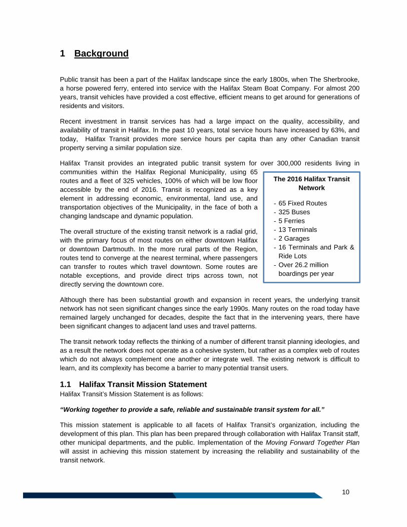
The 2016 Halifax Transit Network
- 65 Fixed Routes - 325 Buses - 5 Ferries - 13 Terminals - 2 Garages - 16 Terminals and Park &
Ride Lots - Over 26.2 million
boardings per year
11
1.2 About The Moving Forward Together Plan The Moving Forward Together Plan is intended to initiate the restructuring of the transit network, and
guide the implementation of service improvements. It proposes new service types, service guidelines,
and performance measures, along with a network redesign.
In alignment with the Halifax Transit Mission Statement, changes outlined in this plan will recognize
the strengths in the existing network by increasing frequency of service, extending the service day
and enhancing reliability of service in key high transit ridership corridors. It will also build on the
success of the existing MetroLink and Urban Express services, which offer limited stop service for
commuters during peak periods. These changes are intended to improve the overall attractiveness of
the Halifax Transit network, improve the experience for existing users and make transit more
competitive with private vehicles.
1.3 Related Initiatives The Moving Forward Together Plan is part of a bigger picture for growth and development in Halifax.
In addition to this plan, there are a number of other plans and programs being undertaken by Halifax
Transit and other Municipal Business Units to make transit and active transportation more attractive
and accessible.
Some of these plans and programs are described below:
The Regional Municipal Planning Strategy: As noted above, The Regional Plan for Halifax
establishes a long-range, region-wide strategy which outlines where, when, and how future growth
and development should take place. Regional Council began research associated with the
development of a regional plan in the fall of 2001 to ensure future growth is both fiscally and
environmentally sustainable. The Regional Municipal Planning Strategy (or The Regional Plan) was
approved in 2006, and the first five year review concluded when the 2014 Regional Plan was adopted
on October 18th, 2014. Among the themes and actions underlying the first five year review is a focus
on growth centres and corridors, appropriately designed transit service, improvements in the
experience of transit users, the enhancement of transit service in appropriate areas, and increasing
transit ridership while reducing single-occupant vehicle trips.
The Integrated Mobility Plan: This plan, currently under development, is intended to be a strategic
plan specifically aimed at increasing the modal split of sustainable forms of transportation as per the
Regional Plan. The Integrated Mobility Plan will help to direct our future investment in transportation
demand management, transit and the active transportation and roadway network. The plan will also
strive to identify the two-way inter-relationship between growth patterns and investment in mobility.
The plan will examine a variety of scenarios and will test the ability of each to address the need to link
people and communities with each other and with the goods, services and employment opportunities
which they seek, in an environmentally sensitive, socially beneficial and fiscally responsible manner.
A choice of interconnected travel modes can form a powerful tool for shaping future development. For
this to occur, new investments in infrastructure or services should be strategically planned in
conjunction with land use and coordinated with all levels of government. The scope of the project will
include factors that influence demand, sway mode choice, affect life cycle costs and contribute to the
economy of the region. The plan will clearly state Council’s priorities for investment and their
relationship to growth patterns: regional centre, in-fill within the urban service boundary and extension
of the urban service boundary.
The Halifax Transit Technology Plan: In 2012, Halifax Transit partnered with Halifax’s Finance and
Information, Communication and Technology department to develop a five year strategy to adopt new
12
technology in Halifax Transit’s operations and customer service platforms. This ambitious plan
represents an approximately $44 million dollar commitment by Regional Council to improve the
efficiency of the transit operations and ridership experience. The final strategy, titled A Transit
Technical Solutions Roadmap, includes approximately 30 new projects.
While some of the proposed projects will not impact customer service directly, the replacement of
Halifax Transit’s current Computer Aided Dispatch (CAD) and Automatic Vehicle Location (AVL)
systems will set the groundwork for customer service-related projects such as public interfaces, stop
annunciation and a fare management system.
Halifax Active Transportation Priorities Plan (2014): The Halifax Regional Municipality Active
Transportation Functional Plan identifies the approach that the municipality will take to meet the
modal share objectives to double the number of residents who choose to walk or bicycle. The 2014-
2019 Halifax Active Transportation Priorities Plan provides an update of the 2006 plan and identifies
the candidate routes and facility types for urban, suburban and rural areas of the municipality for both
on and off-road facilities and identifies priority initiatives for the next five years. Many of the key
projects recommended in the Active
Transportation Priorities Plan provide
improved active transportation
connections to key transit facilities.
Rural Transit Funding Program:
Recognizing that the Halifax Transit
service model may not be the most
appropriate service in rural communities,
Regional Council has approved the Rural
Transit Funding Program, which provides
funding support to community
organizations offering transit services to
residents. Approved in August 2014, as
of December 2015, two rural transit
service providers receive funding through
this program.
Metro Transit Universal Accessibility
Plan: The intent of the Universal
Accessibility Plan prepared in 2011 is to
improve the overall accessibility of the
Halifax Transit fixed route bus and ferry
system. This plan is used to inform
development of Halifax Transit
infrastructure and communication
materials. Figure 1: Bicycle Repair Facility at Lacewood Terminal
13
1.4 Development of The Moving Forward Together Plan On February 26, 2013, Regional Council initiated the development of the new five year strategic
planning framework for Halifax Transit. At this time, it was anticipated that the planning process would
take approximately one year to complete, and would include two rounds of public consultation.
A multifaceted public and stakeholder engagement plan for the first round of consultation was
developed and presented to the Transportation Standing Committee in July of 2013. The formal
public and stakeholder engagement process began in August of 2013, and continued until October
15th, 2013.
1.5 Values Based Consultation
1.5.1 First Round of Consultation
The initial round of public consultation was values based and was intended to provide an overall
direction for the plan’s development. Participants were asked to think big and to tell Halifax Transit
how it should grow, expand, and prioritize resource investment for the next five years.
In order to engage as many people as possible, a diverse public engagement strategy was developed
and heavily promoted in print ads, over the radio, through social media, bus advertisements, and
through a direct mail-out.
The public engagement strategy included the following elements:
Stakeholder meetings;
Public meetings;
Online engagement; and
Online and paper-based surveys.
Due to the diversity of engagement opportunities, participants represented all districts in the
Municipality, and approximately one quarter of survey participants were not regular transit users.
The following summarizes participation in the engagement process:
25 stakeholder groups participated in three stakeholder meetings;
135 individuals participated in six public meetings;
2,115 registered site users on the project website;
o 1,600 online surveys were completed;1
Approximately 60 paper surveys were completed;
Over 130 email submissions were received.
1 This significantly exceeds the number of surveys generally required to be considered statistically valid (one
survey for every 1,000 residents or a total of 400- 500 surveys).
14
Figure 2: Public Consultation Fall 2014
1.5.2 Consultation Summary
All participants were asked to provide feedback on four key themes. The following summarizes the
overall findings of the public engagement activities in the first round of public consultation, organized
by theme.
What should the Goal of the network be?
This discussion demonstrated that diverse opinions exist about why public transit is important
to the Municipality. Overall, participants indicated that a shift towards higher ridership
services should be the priority in the next five years, however there was some recognition of
the importance of services that have lower ridership. While there was some discussion about
the importance of low ridership routes in less dense areas, the majority of participants who
felt low ridership services were important were focused on maintaining or increasing key
services in the off-peak periods.
What role should transfers play in the Halifax Transit network?
Across all public engagement activities, participants indicated strong support for increasing
the role of transfers in the Halifax Transit network if it resulted in shorter, more reliable and
frequent routes. This support was contingent on the following conditions being met:
The frequency of connecting transit services is high;
The use of transfers make the total trip time faster;
There is appropriate infrastructure so that passengers are comfortable while waiting
for their transfer; and
Service is reliable so that connections are not missed.
How should resources be split between maintaining the existing network and increasing
service?
Participants consistently indicated that both the maintenance of existing service and the
introduction of new service were important, although many agreed that there should be
slightly more emphasis on improving the reliability of the existing service.
What role should Transit Priority Measures
play in the Halifax Transit network?
Overall, there was strong support for the
implementation of Transit Priority Measures
(TPMs), but many noted that each situation
must be carefully considered to ensure that
the right measure is implemented in the right
location. Both regular transit users and non-
transit users agreed that TPMs play a key
role in increasing the reliability of transit, and
in making it more attractive and user-friendly.
15
1.6 Developing the Moving Forward Principles The results of the values based consultation were used to develop the Moving Forward Principles, the
foundation on which the plan is designed. The Moving Forward Principles were developed to reflect
the findings of the consultation, and were endorsed by Regional Council in January 2014. These are
intended to be general, values based statements to help direct the development of the plan, and also
to provide guidance to decision making over the life of the plan. They are explored further in this
document.
These principles are:
5. Increase the proportion of resources allocated towards high ridership services.
6. Build a simplified transfer based system.
7. Invest in service quality and reliability.
8. Give transit increased priority in the transportation network.
In order to ensure that the transit network best meets the intent of the Moving Forward Principles,
Regional Council approved an expansion in the initial scope of work proposed as part of the Moving
Forward Together Plan to include a comprehensive review of the entire transit network, and an
increase in the life of the plan beyond the five year horizon.
1.7 Drafting the Plan Following direction from Regional Council in January 2014, Halifax Transit began the process of
conducting a comprehensive review of the transit network in order to propose a draft plan and
network design that has a consistent, cohesive, approach to transit planning, reconciling the
inconsistencies in the existing network.
The development of the Plan was informed by a variety of data sources including census Journey to
Work data, the National Household Survey, ridership counts, terminal surveys, the regional VISUM
traffic model, MetroLink origin-destination surveys, and proposed developments across the region.
Also reviewed were a number of surveys and other documentation prepared by other organizations
related to transit needs, including Capital Health, the Greater Burnside Business Association,
Dalhousie University, and the Main Street Business Improvement District.
The drafting process was iterative, and focused on finding the right balance of transfer based and
single seat trips for Halifax. As the network evolved, staff tested the system by comparing typical trips
which are made on the Halifax Transit network today, with trips that would be made in the proposed
conceptual network.
The draft Moving Forward Together Plan used the elements of a transfer based model that are best
adapted to the geography and road network in Halifax, and built on some of the most successful
services and routes currently operating in the network. It attempted to accommodate the most
significant travel patterns with minimal transfers, but used transfers strategically to simplify the system
and create efficiencies.
1.8 Consultation on the Draft Plan Public engagement on the draft Moving Forward Together Plan was carried out over a period of ten
weeks from February 17 – April 24, 2015. In order to ensure a robust consultation with as many
Halifax residents as possible, Halifax Transit developed a program which focused on bringing the
16
engagement opportunity directly to people, where they spend their time in person and online. The
engagement strategy acknowledged that people have busy lives, and aimed to make it as easy as
possible to learn about the proposed transit network redesign and to provide specific feedback on
how it would impact residents’ transit use.
The biggest challenge through this process was to clearly articulate complex information about the
proposed transit network that would allow residents to provide specific, informed feedback. To these
ends, the MakeTransitBetter.ca website was developed to provide both high level and very detailed
information about the changes and strategic direction proposed in the draft Moving Forward Together
Plan.
The following snapshot of the program and participation levels demonstrates the significant interest
and commitment of residents and stakeholders to engage in this process.
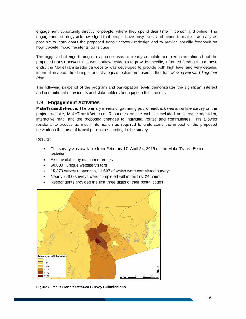
1.9 Engagement Activities MakeTransitBetter.ca: The primary means of gathering public feedback was an online survey on the
project website, MakeTransitBetter.ca. Resources on the website included an introductory video,
interactive map, and the proposed changes to individual routes and communities. This allowed
residents to access as much information as required to understand the impact of the proposed
network on their use of transit prior to responding to the survey.
Results:
The survey was available from February 17–April 24, 2015 on the Make Transit Better
website
Also available by mail upon request
50,000+ unique website visitors
15,370 survey responses, 11,607 of which were completed surveys
Nearly 2,400 surveys were completed within the first 24 hours
Respondents provided the first three digits of their postal codes
Figure 3: MakeTransitBetter.ca Survey Submissions
17
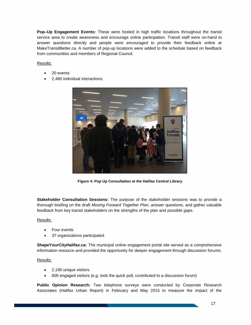
Pop–Up Engagement Events: These were hosted in high traffic locations throughout the transit
service area to create awareness and encourage online participation. Transit staff were on-hand to
answer questions directly and people were encouraged to provide their feedback online at
MakeTransitBetter.ca. A number of pop-up locations were added to the schedule based on feedback
from communities and members of Regional Council.
Results:
20 events
2,480 individual interactions
Stakeholder Consultation Sessions: The purpose of the stakeholder sessions was to provide a
thorough briefing on the draft Moving Forward Together Plan, answer questions, and gather valuable
feedback from key transit stakeholders on the strengths of the plan and possible gaps.
Results:
Four events
37 organizations participated
ShapeYourCityHalifax.ca: The municipal online engagement portal site served as a comprehensive
information resource and provided the opportunity for deeper engagement through discussion forums.
Results:
2,190 unique visitors
605 engaged visitors (e.g. took the quick poll, contributed to a discussion forum)
Public Opinion Research: Two telephone surveys were conducted by Corporate Research
Associates (Halifax Urban Report) in February and May 2015 to measure the impact of the
Figure 4: Pop Up Consultation at the Halifax Central Library
18
engagement program on public awareness of the changes and to assess the level of public support
for the proposed network redesign.
Results:
800 residents surveyed
65% awareness of proposed network changes (an increase of 14% over the 10-week
engagement period)
Twitter Town Halls: Twitter Town Halls are informal consultation sessions which allow interested
members of the public to engage in a Town Hall-style meeting online. Using the hashtag
#MakeTransitBetter, participants could “tweet” questions about the draft plan and have their
questions answered in real time by Halifax Transit staff. As part of the consultation strategy, two
Twitter Town halls were held in April 2015. These events facilitated direct engagement with residents
and allowed significant distribution of information to, and through, Halifax Transit’s more than 23,000
Twitter followers.
Results:
173 participants
486 tweets
550,000+ impressions
Written submissions: Stakeholder organizations were invited to make formal submissions on behalf
of their organizations, providing their detailed feedback on the draft plan.
Results:
Nine organizations made submissions by email at [email protected].
o Canada Revenue Agency
o CentreCorp Management Services
o Halifax Chamber of Commerce
o Halifax Cycling Coalition
o It’s More than Buses
o Main Street Business Improvement District
o Point Pleasant Child Care Centre
o Royal Nova Scotia Yacht Squadron
o St. Vladimir’s Christian Orthodox Church
Nearly one thousand emails were received from the general public
19
1.10 Feedback Summary The most common theme of public feedback during the engagement process was that the proposed
network would mean a lot of change, for a lot of people. The potential impacts of the proposed
changes on individuals’ use of transit drove much of the specific feedback offered on the Plan.
Overall, there was strong support for the strategic direction of the Plan among stakeholders and the
broader public. Stakeholders’ support was qualified with specific feedback regarding opportunities for
refinement of the Plan.
In addition, proposed service enhancements were very well received. Arguably best received was the
proposed introduction of 10 corridors routes forming the spine of the network, and expanded Express
(commuter-focused) service which were viewed as strengths.
The proposed reduction or elimination of service and the realignment of particular routes generated
considerable negative response among existing riders. While there were a number of changes that
generated this feedback, changes to Routes 1, 80 and 90 were mentioned most frequently.
1.10.1 Stakeholder Consultation
Stakeholder were asked to share their thoughts on how the draft Moving Forward Together Plan
aligned with the four Moving Forward Principles, arising from the 2013 consultation process and
endorsed by Regional Council. Approximately 72% indicated they felt the draft Plan was aligned with
the Moving Forward Principles.
The key strengths and gaps of the draft Moving Forward Together Plan were identified by
stakeholders as follows:
What Stakeholders Like About the Plan What’s Missing
Simpler and more understandable Doesn’t go far enough
Eliminates redundancies Doesn’t outline specific TPM measures
Corridor Routes as the backbone of the
network
Should have higher off-peak frequency on
Corridor routes
Priority given to high ridership areas Should have longer hours of service
Transfer-based system Should have more efficient transfers
Expanded Express service Shorter implementation timeframe
Infrastructure improvements & new terminal Opposition to service reductions/elimination
No opportunity to see the updated Plan
before it goes to Regional Council
20
1.10.2 Overview of Survey Findings
The online survey provided rich quantitative and qualitative rider and non-rider feedback on the plan.
Of 12,831 written comments relevant to this plan, 72% related to the impact of specific route changes,
19% pertained to frequency/hours of service and 11% were about transfers. The top reasons for
making individuals’ trips better or worse were identified as follows:
“These changes make my trip better” “These changes make my trip worse”
1. My trip is more direct 1. My service has been reduced or eliminated
2. I can travel more often 2. My trip is less direct
3. My route(s) run later or earlier 3. I have to transfer too much
4. Transfers give me more travel options
1.10.3 Public Opinion Research
Results from a telephone survey conducted by Corporate Research Associates in early May 2015
found a 73% level of public support for the proposed changes.
1.10.4 Petitions
Additionally, some communities organized to oppose proposed changes that would affect their level
of transit service, or to lobby for expanded service through organized feedback on the survey, emails
or petitions. Those included:
Route 1: West End Peninsula residents displeased with proposed changes to the Route 1.
Route 7: North End Peninsula residents displeased with proposed changes to the Route 7.
Route 15: Residents displeased with proposed elimination of service on Purcells Cove Road
between Williams Lake Road and York Redoubt.
Eastern Passage Connection – residents requesting a connection between Cole Harbour and
Eastern Passage via Caldwell Road.
Lawrencetown: Residents of Lawrencetown requesting transit service.
Route 400: Residents displeased with the proposed discontinuation of service between
Beaver Bank Villa and Kinsac Road along Beaver Bank Road.
Route 401: Residents of Porters Lake displeased with the proposed removal of service from
Grand Desert and Back Road.
21
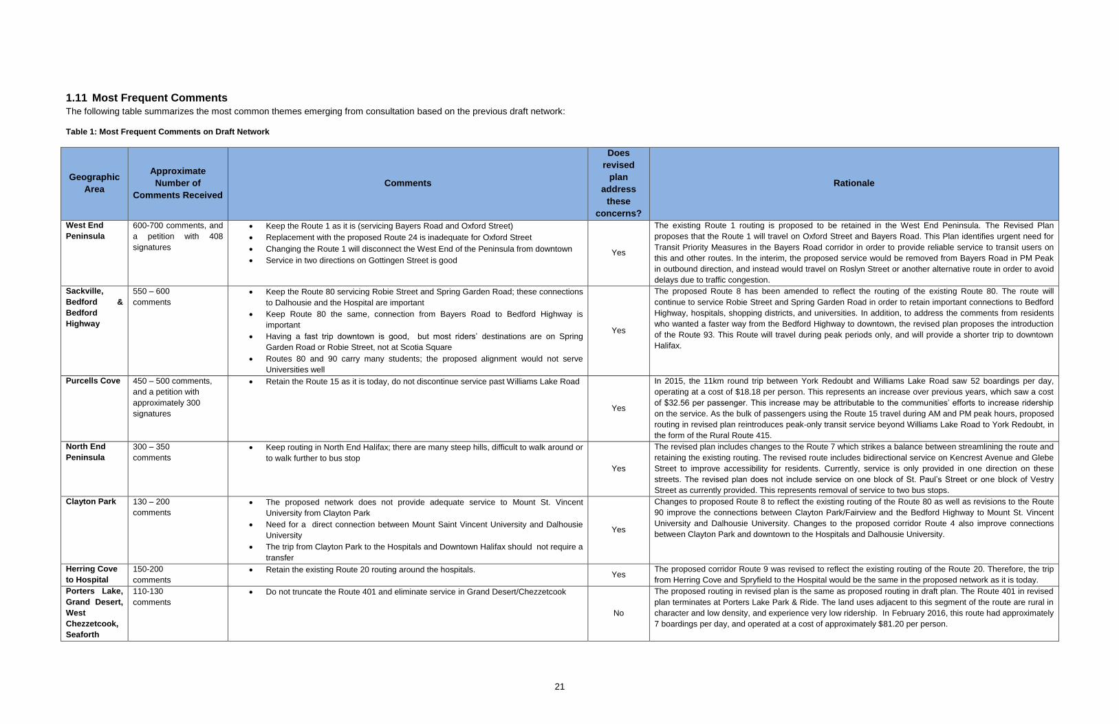
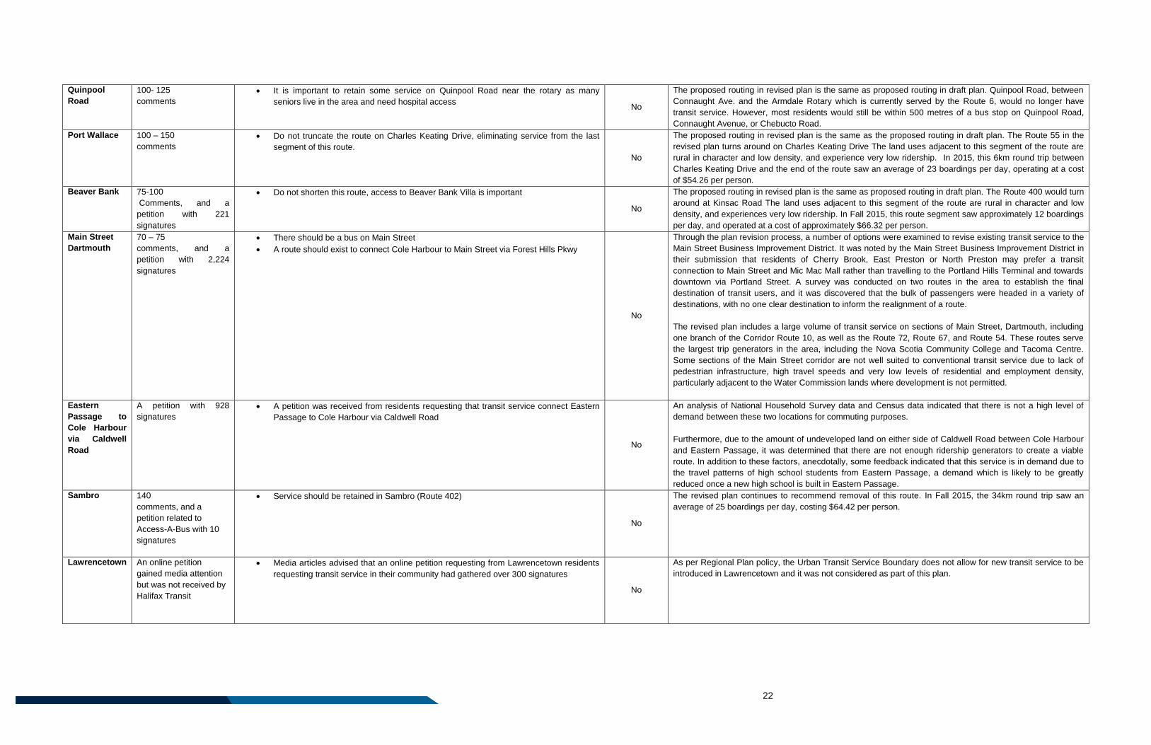
1.11 Most Frequent Comments
The following table summarizes the most common themes emerging from consultation based on the previous draft network:
Table 1: Most Frequent Comments on Draft Network
Geographic
Area
Approximate
Number of
Comments Received
Comments
Does
revised
plan
address
these
concerns?
Rationale
West End
Peninsula
600-700 comments, and
a petition with 408
signatures
Keep the Route 1 as it is (servicing Bayers Road and Oxford Street)
Replacement with the proposed Route 24 is inadequate for Oxford Street
Changing the Route 1 will disconnect the West End of the Peninsula from downtown
Service in two directions on Gottingen Street is good Yes
The existing Route 1 routing is proposed to be retained in the West End Peninsula. The Revised Plan
proposes that the Route 1 will travel on Oxford Street and Bayers Road. This Plan identifies urgent need for
Transit Priority Measures in the Bayers Road corridor in order to provide reliable service to transit users on
this and other routes. In the interim, the proposed service would be removed from Bayers Road in PM Peak
in outbound direction, and instead would travel on Roslyn Street or another alternative route in order to avoid
delays due to traffic congestion.
Sackville,
Bedford &
Bedford
Highway
550 – 600
comments
Keep the Route 80 servicing Robie Street and Spring Garden Road; these connections
to Dalhousie and the Hospital are important
Keep Route 80 the same, connection from Bayers Road to Bedford Highway is
important
Having a fast trip downtown is good, but most riders’ destinations are on Spring
Garden Road or Robie Street, not at Scotia Square
Routes 80 and 90 carry many students; the proposed alignment would not serve
Universities well
Yes
The proposed Route 8 has been amended to reflect the routing of the existing Route 80. The route will
continue to service Robie Street and Spring Garden Road in order to retain important connections to Bedford
Highway, hospitals, shopping districts, and universities. In addition, to address the comments from residents
who wanted a faster way from the Bedford Highway to downtown, the revised plan proposes the introduction
of the Route 93. This Route will travel during peak periods only, and will provide a shorter trip to downtown
Halifax.
Purcells Cove 450 – 500 comments,
and a petition with
approximately 300
signatures
Retain the Route 15 as it is today, do not discontinue service past Williams Lake Road
Yes
In 2015, the 11km round trip between York Redoubt and Williams Lake Road saw 52 boardings per day,
operating at a cost of $18.18 per person. This represents an increase over previous years, which saw a cost
of $32.56 per passenger. This increase may be attributable to the communities’ efforts to increase ridership
on the service. As the bulk of passengers using the Route 15 travel during AM and PM peak hours, proposed
routing in revised plan reintroduces peak-only transit service beyond Williams Lake Road to York Redoubt, in
the form of the Rural Route 415.
North End
Peninsula
300 – 350
comments
Keep routing in North End Halifax; there are many steep hills, difficult to walk around or
to walk further to bus stop
Yes
The revised plan includes changes to the Route 7 which strikes a balance between streamlining the route and
retaining the existing routing. The revised route includes bidirectional service on Kencrest Avenue and Glebe
Street to improve accessibility for residents. Currently, service is only provided in one direction on these
streets. The revised plan does not include service on one block of St. Paul’s Street or one block of Vestry
Street as currently provided. This represents removal of service to two bus stops.
Clayton Park 130 – 200
comments
The proposed network does not provide adequate service to Mount St. Vincent
University from Clayton Park
Need for a direct connection between Mount Saint Vincent University and Dalhousie
University
The trip from Clayton Park to the Hospitals and Downtown Halifax should not require a
transfer
Yes
Changes to proposed Route 8 to reflect the existing routing of the Route 80 as well as revisions to the Route
90 improve the connections between Clayton Park/Fairview and the Bedford Highway to Mount St. Vincent
University and Dalhousie University. Changes to the proposed corridor Route 4 also improve connections
between Clayton Park and downtown to the Hospitals and Dalhousie University.
Herring Cove
to Hospital
150-200
comments
Retain the existing Route 20 routing around the hospitals. Yes
The proposed corridor Route 9 was revised to reflect the existing routing of the Route 20. Therefore, the trip
from Herring Cove and Spryfield to the Hospital would be the same in the proposed network as it is today.
Porters Lake,
Grand Desert,
West
Chezzetcook,
Seaforth
110-130
comments
Do not truncate the Route 401 and eliminate service in Grand Desert/Chezzetcook
No
The proposed routing in revised plan is the same as proposed routing in draft plan. The Route 401 in revised
plan terminates at Porters Lake Park & Ride. The land uses adjacent to this segment of the route are rural in
character and low density, and experience very low ridership. In February 2016, this route had approximately
7 boardings per day, and operated at a cost of approximately $81.20 per person.
22
Quinpool
Road
100- 125
comments
It is important to retain some service on Quinpool Road near the rotary as many
seniors live in the area and need hospital access No
The proposed routing in revised plan is the same as proposed routing in draft plan. Quinpool Road, between
Connaught Ave. and the Armdale Rotary which is currently served by the Route 6, would no longer have
transit service. However, most residents would still be within 500 metres of a bus stop on Quinpool Road,
Connaught Avenue, or Chebucto Road.
Port Wallace 100 – 150
comments
Do not truncate the route on Charles Keating Drive, eliminating service from the last
segment of this route.
No
The proposed routing in revised plan is the same as the proposed routing in draft plan. The Route 55 in the
revised plan turns around on Charles Keating Drive The land uses adjacent to this segment of the route are
rural in character and low density, and experience very low ridership. In 2015, this 6km round trip between
Charles Keating Drive and the end of the route saw an average of 23 boardings per day, operating at a cost
of $54.26 per person.
Beaver Bank 75-100
Comments, and a
petition with 221
signatures
Do not shorten this route, access to Beaver Bank Villa is important
No
The proposed routing in revised plan is the same as proposed routing in draft plan. The Route 400 would turn
around at Kinsac Road The land uses adjacent to this segment of the route are rural in character and low
density, and experiences very low ridership. In Fall 2015, this route segment saw approximately 12 boardings
per day, and operated at a cost of approximately $66.32 per person.
Main Street
Dartmouth
70 – 75
comments, and a
petition with 2,224
signatures
There should be a bus on Main Street
A route should exist to connect Cole Harbour to Main Street via Forest Hills Pkwy
No
Through the plan revision process, a number of options were examined to revise existing transit service to the
Main Street Business Improvement District. It was noted by the Main Street Business Improvement District in
their submission that residents of Cherry Brook, East Preston or North Preston may prefer a transit
connection to Main Street and Mic Mac Mall rather than travelling to the Portland Hills Terminal and towards
downtown via Portland Street. A survey was conducted on two routes in the area to establish the final
destination of transit users, and it was discovered that the bulk of passengers were headed in a variety of
destinations, with no one clear destination to inform the realignment of a route.
The revised plan includes a large volume of transit service on sections of Main Street, Dartmouth, including
one branch of the Corridor Route 10, as well as the Route 72, Route 67, and Route 54. These routes serve
the largest trip generators in the area, including the Nova Scotia Community College and Tacoma Centre.
Some sections of the Main Street corridor are not well suited to conventional transit service due to lack of
pedestrian infrastructure, high travel speeds and very low levels of residential and employment density,
particularly adjacent to the Water Commission lands where development is not permitted.
Eastern
Passage to
Cole Harbour
via Caldwell
Road
A petition with 928
signatures
A petition was received from residents requesting that transit service connect Eastern
Passage to Cole Harbour via Caldwell Road
No
An analysis of National Household Survey data and Census data indicated that there is not a high level of
demand between these two locations for commuting purposes.
Furthermore, due to the amount of undeveloped land on either side of Caldwell Road between Cole Harbour
and Eastern Passage, it was determined that there are not enough ridership generators to create a viable
route. In addition to these factors, anecdotally, some feedback indicated that this service is in demand due to
the travel patterns of high school students from Eastern Passage, a demand which is likely to be greatly
reduced once a new high school is built in Eastern Passage.
Sambro 140
comments, and a
petition related to
Access-A-Bus with 10
signatures
Service should be retained in Sambro (Route 402)
No
The revised plan continues to recommend removal of this route. In Fall 2015, the 34km round trip saw an
average of 25 boardings per day, costing $64.42 per person.
Lawrencetown An online petition
gained media attention
but was not received by
Halifax Transit
Media articles advised that an online petition requesting from Lawrencetown residents
requesting transit service in their community had gathered over 300 signatures
No
As per Regional Plan policy, the Urban Transit Service Boundary does not allow for new transit service to be
introduced in Lawrencetown and it was not considered as part of this plan.
23
Part 2: Building on the Principles

24
25
2 Navigating the Route Ahead – Building on the Principles
The Moving Forward Together Plan is consistent with the Halifax Transit Mission Statement, as
described in section 1 above, and guided by the four Moving Forward Principles. The four principles
are at the heart of the plan, and are the foundation upon which all objectives, network changes, and
policies found within were created. Furthermore, they are intended to provide guidance to decision
making over the life of the plan.
Based on a comprehensive review of existing transit service and of current and expected travel
needs, these Principles were used to develop an improved transit network that will better serve
today’s demands and that will more effectively accommodate the Region’s growth.
So how do the Moving Forward Principles translate into real change in the Halifax Transit network?
This section describes how the Moving Forward Together Plan puts into practice the intent of the
Moving Forward Principles.
2.1 Principle 1: Increase the Proportion of Resources Allocated Towards
High Ridership Services. This principle speaks to the role of public transit in building a more socially, environmentally, and
economically sustainable community. Increasing the proportion of resources allocated to high
ridership services will help to reduce congestion, pollution, and the need to build, expand and
maintain additional roadway and parking infrastructure, while also making the service more cost
effective.
High ridership services are those that transport a large number of passengers relative to the level of
resources that are invested in the service. In this plan, when routes are carrying more than thirty
passengers per hour, they are considered high ridership. Low ridership services, or coverage
services, are those that typically carry fewer passengers, or require a higher level of resources to
provide, and as a result use resources less efficiently.
To achieve this Principle, resources must be reallocated towards services that have the highest
potential demand, and these services must be increased and improved to support higher ridership.
This means that areas or services with low demand may have minimal service, or no service at all.
The support for an increased focus on higher ridership services is consistent with the findings of the
Office of the Auditor General’s Report entitled A Systems-Level Performance Review of Metro
Transit’s Service Delivery. Completed in July 2013, this report states: “It is the view of the [Office of
the Auditor General that] the definition of success for Halifax Transit should [be] amended to focus on
increased ridership which would result in additional revenue.”
Although this principle emphasizes the importance of high ridership services and requires a shift in
resources towards high ridership services, some low ridership services will continue to have an
important role in the Halifax Transit network. Often, high ridership services or routes have periods of
time during the day, or on weekends, when ridership is low. It is important to the overall success of
these services that they operate throughout the day and evening and in some instances, high quality
service will still be maintained during lower ridership periods. Additionally, some routes have lower
ridership, but serve an important purpose by acting as “feeder routes” for higher ridership services.
These routes are important as they allow riders to circulate within their local communities, and
facilitate access to the rest of the network.
26
2.1.1 Achieving Principle 1: Increasing the Proportion of Resources Allocated Towards High
Ridership Services
Urban Transit Service Boundary
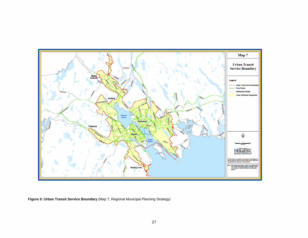
A significant step has already been taken to direct resources to high ridership areas by creating the
Urban Transit Service Boundary. The highest potential transit ridership exists within urban areas,
rather than rural communities where development is spread out over a larger area. Policy T-7 of the
2014 Regional Plan establishes an Urban Transit Service Boundary, within which resources and
improvements to transit service will be focused. The Urban Transit Service Boundary includes all
contiguous communities in Halifax which
currently have both municipal water and
municipal sewer, where homes are generally
closer together. Policy T-7 helps to focus
investment in the areas where transit service
can operate most efficiently, and also to set
clear expectations for residents and businesses
as to where new transit services will be added in
the future.
As a result, there will be no new or increased Halifax Transit services outside the Urban Transit
Service Boundary, with the exception of Regional Express services (identified as rural commuter
express service in the Regional Municipal Planning Strategy).
In rural areas, development densities are not sufficiently high to warrant municipally operated fixed
route transit service. Policy T-10 of the Regional Plan states that Council may consider programs to
encourage and assist communities with developing their own community based transit services in the
areas outside the Urban Transit Service Boundary. In August 2014, Regional Council adopted
Administrative Order 2014-012-ADM to support provision of the Rural Transit Funding Program.
Halifax Transit will support the development of community based transit services in rural areas that
are tailored to meet the specific needs of the community through the Rural Transit Funding Program.
Urban Transit Service Boundary by the numbers:
Population of HRM: 390,328
Population within Urban Transit Service
Boundary (UTSB): 290,376 or 74.4% of the
population of HRM
Nearly 99% of residents within the UTSB are
within 500 metres of a bus stop as outlined
in this plan
27
Figure 5: Urban Transit Service Boundary (Map 7, Regional Municipal Planning Strategy)
28
The Moving Forward Together Plan increases the proportion of resources allocated towards high
ridership services in four key ways:
1. Establishing Corridor Routes: Corridor Routes are high ridership transit routes that travel along
major corridors and form the spine of the transit network. This plan proposes ten Corridor Routes,
which account for almost 50% of Halifax Transit’s resources. They connect multiple
neighbourhoods with employment, educational centres, and shopping areas, and approximately
171,000 residents are within walking distance to these routes.
2. Expanded Express Service: This plan proposes to build on the success of the previous
MetroLink and Urban Express services and introduce a new service type. Express service is a
commuter focused service that is intended to move large volumes of passengers during peak
commuting periods, when transit can have the largest impact on congestion.
3. Providing Coverage Service in off-peak Periods: Although transit service is most efficient
during peak commuting periods when demand is highest and most directional, not all travel takes
place during these periods. To support Corridor and Express Routes, service must also be
operated during time periods when demand is lower to accommodate trips which do not take
place during traditional rush hour periods like trips to appointments, university classes, shopping
destinations, and social visits. It is important that residents are able to make these trips by bus in
order to live a car-free lifestyle.
Providing trips in off-peak periods can also increase ridership during peak periods, because
passengers know that they can rely on the service regardless of when they decide to make their
trip. This plan proposes to expand midday, evening, and weekend service on many routes to
meet this objective.
4. Reducing Low Ridership Services: In addition to reducing service levels on low ridership
routes, this plan proposes to eliminate existing underperforming routes, or segments of routes
that have consistently low ridership. It also outlines the removal of service during some periods of
the day on routes which do not sustain ridership during the off peak periods (evenings,
weekends, midday). The Plan proposes to remove service from:
Prospect Road between Ragged Lake Boulevard and Exhibition Park (currently serviced
by Route 22);
Some School Special Routes;
Waverley Road north of Charles Keating Drive (currently serviced by the Route 55);
Beaver Bank Road north of Kinsac Road (currently serviced by the Route 400);
Highway 207 beyond Porters Lake, to Seaforth and Back Road (currently serviced by
the Route 401);
Purcells Cove and Fergusons Cove during the off-peak period (currently serviced by
Route 15);
Portland Estates Boulevard & Portland Hills Drive during the off-peak period (currently
serviced by Route 57); and
Sambro (currently serviced by the Route 402).
29
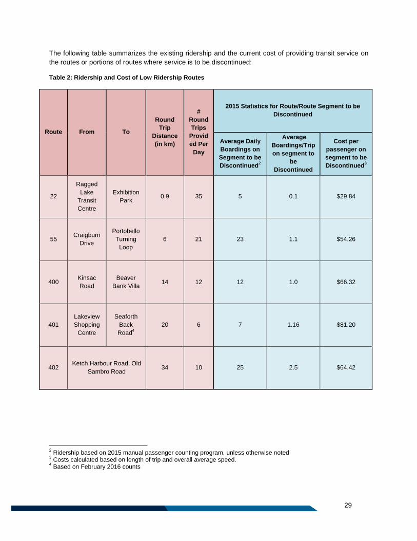
The following table summarizes the existing ridership and the current cost of providing transit service on
the routes or portions of routes where service is to be discontinued:
Table 2: Ridership and Cost of Low Ridership Routes
Route From To
Round
Trip
Distance
(in km)
#
Round
Trips
Provid
ed Per
Day
2015 Statistics for Route/Route Segment to be
Discontinued
Average Daily
Boardings on
Segment to be
Discontinued2
Average
Boardings/Trip
on segment to
be
Discontinued
Cost per
passenger on
segment to be
Discontinued3
22
Ragged
Lake
Transit
Centre
Exhibition
Park 0.9 35 5 0.1 $29.84
55 Craigburn
Drive
Portobello
Turning
Loop
6 21 23 1.1 $54.26
400 Kinsac
Road
Beaver
Bank Villa 14 12 12 1.0 $66.32
401
Lakeview
Shopping
Centre
Seaforth
Back
Road4
20 6 7 1.16 $81.20
402 Ketch Harbour Road, Old
Sambro Road 34 10 25 2.5 $64.42
2 Ridership based on 2015 manual passenger counting program, unless otherwise noted
3 Costs calculated based on length of trip and overall average speed.
4 Based on February 2016 counts
30
2.2 Principle 2: Build a Simplified Transfer Based Network. A network design with increased reliance on transfers can simplify the network and make it easier for
existing and potential transit riders to understand. It also can reduce the average length of routes in the
network, which can improve service reliability.
Transfers work best at locations where a number of routes can connect with each other to accommodate
travel made from a diverse set of passenger trip origins to a diverse set of passenger destinations. They
are also commonly used to provide connections between low demand areas and high ridership services
in major transportation corridors.
Where there is a high demand between one part of the network and a particular destination, on the other
hand, a direct service without transfer offering “single seat” trips can be provided. Such services, for
example downtown-oriented trips during weekday peak periods, are attractive to passengers and make
efficient use of bus and driver resources.
The Moving Forward Together Plan strikes a balance by providing direct trips without transfers within
major transportation corridors and to/from areas of high demand, and by employing transfer connections
to accommodate more dispersed travel patterns and travel during periods of lower transit demand.
2.2.1 Achieving Principle 2: Building a Simplified Transfer Based Network
The Moving Forward Together Plan works toward building a simplified transfer based network in
three key ways:
1. Facilitating Transfers: In order to meet the conditions of support for transfers identified through the
first round of public consultation, the redesigned transit network is built on a model of having regular,
frequent Corridor Routes along major transportation corridors that passengers can transfer onto to reach
their destination. All Local Routes outlined in this plan travel to transit terminals that provide connections
with Corridor Routes and provide weather-protected waiting facilities. As part of the plan, Express Routes
and Regional Express Routes will stop at key transfer locations to facilitate connections with other routes.
During peak commuting periods when there is the highest demand on our road network, and on our
transit service, Express Routes will exist to move large volumes of passengers to major employment
areas without requiring transferring. However, Express Routes will stop at terminals and major
destinations to allow passengers with different travel needs to transfer.
2. Making the Network Easier to Understand: Completing a comprehensive review and making
network wide changes allows the opportunity to re-schedule service with more consistency. In some
cases, routes have evolved over time to have uneven frequencies, and a variety of different routing
patterns depending on the time of day. This plan proposes that routes have regular, more predictable
frequencies, with less variation at different times of the day.
This plan also provides an opportunity to plan the network cohesively, with service types, levels of
service, and route numbers and names that are applied consistently, but still recognizing the unique
needs of different communities. Where variations of routes do exist, for clarity, letters will be used in
addition to the route number.
31
Although many routes proposed in this plan resemble in part a route that existed previously, most have
been simplified. The complexity of routes was reduced by straightening out circuitous routing where
possible, eliminating one way service where possible, or removing portions of routes that did not have
high ridership.
In addition, the number of routes that overlap has been reduced, particularly during the off-peak period.
On major transportation corridors, rather than providing a large number of routes, Corridor Routes will be
provided. These Corridor Routes will connect with Local Routes at terminals, so that passengers can
transfer to reach their destination. The geography and road network in Halifax make it impossible to
remove all overlap and redundant service while still providing a convenient transit trip, but a balance has
been struck that greatly reduces the complexity of the system, and makes the network easier to
understand.
3. Improving Passenger Amenities: This plan introduces a new classification system to measure and
improve the level of amenities at bus stops and terminals, with the intention of creating safe, comfortable
transfer locations throughout the network.
In addition, the planning process has identified the need for two new transit terminals to facilitate
transferring: the first at Wrights Cove in Burnside, and the second in West Bedford.
2.3 Principle 3: Invest in Service Quality and Reliability Investing in service quality and reliability means dedicating resources to maintain existing service in good
condition by addressing schedule adherence issues and overloads on an ongoing basis, as opposed to
prioritizing the introduction of new services.
Throughout all public consultation activities, participants consistently indicated that both the maintenance
of existing service and the introduction of new service were important, although most agreed that in the
short term, Halifax Transit should focus on improving the reliability of the existing service.
2.3.1 Achieving Principle 3: Investing in Service Quality and Reliability
The Moving Forward Together Plan invests in service quality and reliability in five key ways:
1. Addressing capacity, demand, frequency, and service span issues on existing routes: As noted
above, survey respondents wanted a larger percentage of resources spent on maintaining the quality
of existing routes, rather than service increases. With the implementation of new Automatic Vehicle
Location (AVL) and Automatic Passenger Count (APC)units on all Halifax Transit vehicles, more data
will be available than ever before to improve the scheduling and resource allocation to ensure a
higher quality of service on established routes.
The implementation of this plan focuses on phased restructuring of the existing transit network, prior
to the provision of service in newly developing areas. Through the implementation period of this plan,
each route will be scheduled using accurate running times obtained using the AVL data, in order to
ensure high levels of reliability for passengers. Running times will be will be adjusted as needed in
the future to accommodate for changes in traffic patterns and variations in running time.
2. Use Route Structures which Support Schedule Adherence and Shorter Travel Times: This plan
outlines a network which makes use of shorter Local Routes in suburban or rural areas, which are not
32
tied to service running towards the more congested urban centre. The exception to this is during peak
hours, when some Local Routes become Express Routes, providing a direct trip into Downtown in
order to carry passengers as directly and efficiently as possible. Where longer routes exist, this plan
has streamlined service to eliminate portions of routes with lower ridership demand.
3. Balance Fleet Recapitalization and Fleet Expansion: High quality of service, especially schedule
adherence, depends on the availability of reliable transit vehicles. As the Halifax Transit fleet ages, it
is important to continue to replace the oldest vehicles to ensure that they are safe and reliable for
passengers.. Halifax Transit will gradually be moving from an 18 year replacement cycle for transit
buses to a 14 year replacement cycle. Although this transition will take time and resources, this
shorter lifecycle for vehicles reduces lifetime maintenance costs and allows Halifax Transit to provide
customers with more reliable service. The plan acknowledges the need for the timely replacement of
aging vehicles and service increases are based on the resources remaining only after all necessary
replacement vehicles are accounted for.
4. Replace existing Regional Express (currently known as “MetroX”) vehicles with standard 40
foot vehicles: The smaller vehicles currently in use on some MetroX routes do not provide the
capacity required on some trips, and upon reaching their expected lifespan, they will be replaced by
standard forty foot vehicles. Replacing the shorter Regional Express vehicles will increase capacity
for passengers, and will also provide opportunities for scheduling efficiencies.
5. Apply Quality of Service Guidelines: This plan includes a number of quality of service guidelines
which Halifax Transit will strive to meet in order to improve the customer experience and the
efficiency and reliability of the transit network.
33
2.4 Principle 4: Give Transit Increased Priority in the Transportation Network.
Making transit faster and more reliable is important to make transit attractive to new riders, to increase
ridership, and to control operating costs. One of the best means do this is by reducing the impact that
traffic congestion and traffic signals have on transit vehicles.
Transit Priority Measures (TPMs) are tools that municipalities and transit agencies can use to reduce
these delays, improve reliability and reduce the average travel time of transit vehicles. There are many
different types of TPMs, and in many cases they are used together to create a city-wide network. Some of
the most common TPMs include:
- Traffic Signal Priority
- Queue Jumps
- Bus lanes
- Transit corridors that are separated from traffic
Regional Plan Policy T-8 reads “Transit priority measures, such as designated transit lanes, transit signal
priority, and queue jump lanes may be made to improve the reliability and travel time of public transit
vehicles.”
Overall, public consultation indicated strong support for the implementation of TPMs, with both regular
transit users and non-transit users agreeing that TPMs play a key role in increasing the reliability of
transit, and in making it more attractive and user-friendly. However, many participants recognized that
TPMs are not a “one size fits all” solution, and that each situation must be carefully considered to ensure
that the right measure is implemented in the right location.
Today, Halifax Transit vehicles make use of a network of 17 TPMs throughout the city, many of which
were introduced as part of MetroLink service in the 2005/2006 fiscal year.
2.4.1 Achieving Principle 4: Giving Transit Increased Priority in the Transportation Network
The Moving Forward Together Plan works to give transit increased priority in the transportation
network in five key ways:
1. Supporting implementation of TPM projects in the short term: A roster of possible TPMs was
compiled and evaluated to determine their potential impact on all road users and payback period.
Halifax Transit will work with other municipal departments to advance implementation of these
measures.
2. Creating a comprehensive TPM plan: A broad, comprehensive plan is required to inventory and
prioritize all opportunities for TPMs in the new transit network. This plan should build on the short
term plan currently being completed. This plan will establish a long term vision for TPMs in the Halifax
Transit network.
3. Prioritizing TPMs in key corridors: In the past, TPMs in the Halifax Transit network have largely
been introduced on transportation corridors frequented by peak only Urban Express Routes or
MetroLink routes. This focus will be shifted towards implementing TPMs for Corridor Routes, which
carry many transit vehicles throughout the entire day. This will provide transit riders with a faster and
34
more reliable trip all day, not just at rush hour. In the future, the Corridor Routes proposed in this
network could be candidates for Bus Rapid Transit (BRT) corridors. The potential for introducing
higher order transit service such as BRT, light rail or new ferry routes are not considered as part of
this plan, but will be explored through the Integrated Mobility Plan.
4. Seeking opportunities for low cost TPMs: Not all TPMs are costly and require significant capital
investment to build. In some cases it is possible to seize an opportunity presented by other municipal
work, for example a road realignment. Halifax Transit staff will engage with the Transportation &
Public Works and Planning & Development Municipal Business Units to identify potential
opportunities to integrate the construction of TPMs into larger ongoing projects.
5. Modifying routes to take advantage of existing and future TPMs: Within the Regional Centre,
where TPMs are of highest value, narrow road rights-of-way are common and space is often
unavailable for new infrastructure. In some cases it will be important to modify routes to travel on
streets where priority measures are achievable rather than struggling to implement measures on
routes that buses currently operate on. As TPMs are implemented, consideration must be given to the
realignment of existing routes in order to provide as many routes as possible with the benefits
provided by the faster and more reliable travel time.

35
Part 3: The Network

36
37
3 Transit Network Overview
The Moving Forward Together Plan includes a redesign of the transit route network. Many proposed
routes resemble a route that existed prior to the plan, but almost all have been shortened, straightened
out, or simplified, in alignment with the Moving Forward Principles. In addition, some new routes have
been proposed, and some routes which currently exist have reduced service, or have been removed from
the network map. The future network will be described in the following sections.
3.1 Service Types This section describes each of the transit service types outlined in this network, including their purpose,
span of service and service frequency guidelines.
The Halifax Transit network will consist of eight service types. In order to easily identify each route’s
service type, every service type will have a unique range of route numbers. This way, from the route
number alone, the service type and thus service day and minimum frequencies can be inferred for a
particular route.
The following lists all service types in the plan, and the route numbers assigned to each:
Corridor Routes (Routes 1 - 19)
Local Routes (Routes 20 – 99)
Express Routes (Routes 100 through 199)
Regional Express Routes (Route 300 – 399)
Rural Routes (Route 400 – 499)
Ferry Routes (Route 500- 599)
School Routes (Route 700-799)
Access-A-Bus
A detailed description of each service type is below.
3.2 Corridor Routes
3.2.1 Description of Corridor Routes
The purpose of Corridor Routes is to provide consistent, frequent, service on high demand corridors,
connecting residential areas or retail districts with regional destinations like shopping, employment,
schools, and services.
What differentiates Corridor Routes from other route types is the sustained demand for transit over the
course of the day, late into the evenings, and on weekends. These routes are well positioned to support
increased residential density along the corridors which will, in turn, will support increases in potential
ridership generated by adjacent land uses.
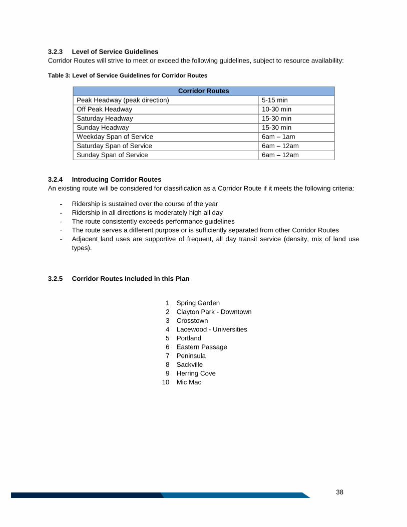
38
3.2.3 Level of Service Guidelines
Corridor Routes will strive to meet or exceed the following guidelines, subject to resource availability:
Table 3: Level of Service Guidelines for Corridor Routes
Corridor Routes
Peak Headway (peak direction) 5-15 min
Off Peak Headway 10-30 min
Saturday Headway 15-30 min
Sunday Headway 15-30 min
Weekday Span of Service 6am – 1am
Saturday Span of Service 6am – 12am
Sunday Span of Service 6am – 12am
3.2.4 Introducing Corridor Routes
An existing route will be considered for classification as a Corridor Route if it meets the following criteria:
- Ridership is sustained over the course of the year
- Ridership in all directions is moderately high all day
- The route consistently exceeds performance guidelines
- The route serves a different purpose or is sufficiently separated from other Corridor Routes
- Adjacent land uses are supportive of frequent, all day transit service (density, mix of land use
types).
3.2.5 Corridor Routes Included in this Plan
1 Spring Garden
2 Clayton Park - Downtown
3 Crosstown
4 Lacewood - Universities
5 Portland
6 Eastern Passage
7 Peninsula
8 Sackville
9 Herring Cove
10 Mic Mac
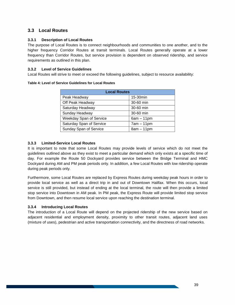
39
3.3 Local Routes
3.3.1 Description of Local Routes
The purpose of Local Routes is to connect neighbourhoods and communities to one another, and to the
higher frequency Corridor Routes at transit terminals. Local Routes generally operate at a lower
frequency than Corridor Routes, but service provision is dependent on observed ridership, and service
requirements as outlined in this plan.
3.3.2 Level of Service Guidelines
Local Routes will strive to meet or exceed the following guidelines, subject to resource availability:
Table 4: Level of Service Guidelines for Local Routes
Local Routes
Peak Headway 15-30min
Off Peak Headway 30-60 min
Saturday Headway 30-60 min
Sunday Headway 30-60 min
Weekday Span of Service 6am – 11pm
Saturday Span of Service 7am – 11pm
Sunday Span of Service 8am – 11pm
3.3.3 Limited-Service Local Routes
It is important to note that some Local Routes may provide levels of service which do not meet the
guidelines outlined above as they exist to meet a particular demand which only exists at a specific time of
day. For example the Route 50 Dockyard provides service between the Bridge Terminal and HMC
Dockyard during AM and PM peak periods only. In addition, a few Local Routes with low ridership operate
during peak periods only.
Furthermore, some Local Routes are replaced by Express Routes during weekday peak hours in order to
provide local service as well as a direct trip in and out of Downtown Halifax. When this occurs, local
service is still provided, but instead of ending at the local terminal, the route will then provide a limited
stop service into Downtown in AM peak. In PM peak, the Express Route will provide limited stop service
from Downtown, and then resume local service upon reaching the destination terminal.
3.3.4 Introducing Local Routes
The introduction of a Local Route will depend on the projected ridership of the new service based on
adjacent residential and employment density, proximity to other transit routes, adjacent land uses
(mixture of uses), pedestrian and active transportation connectivity, and the directness of road networks.
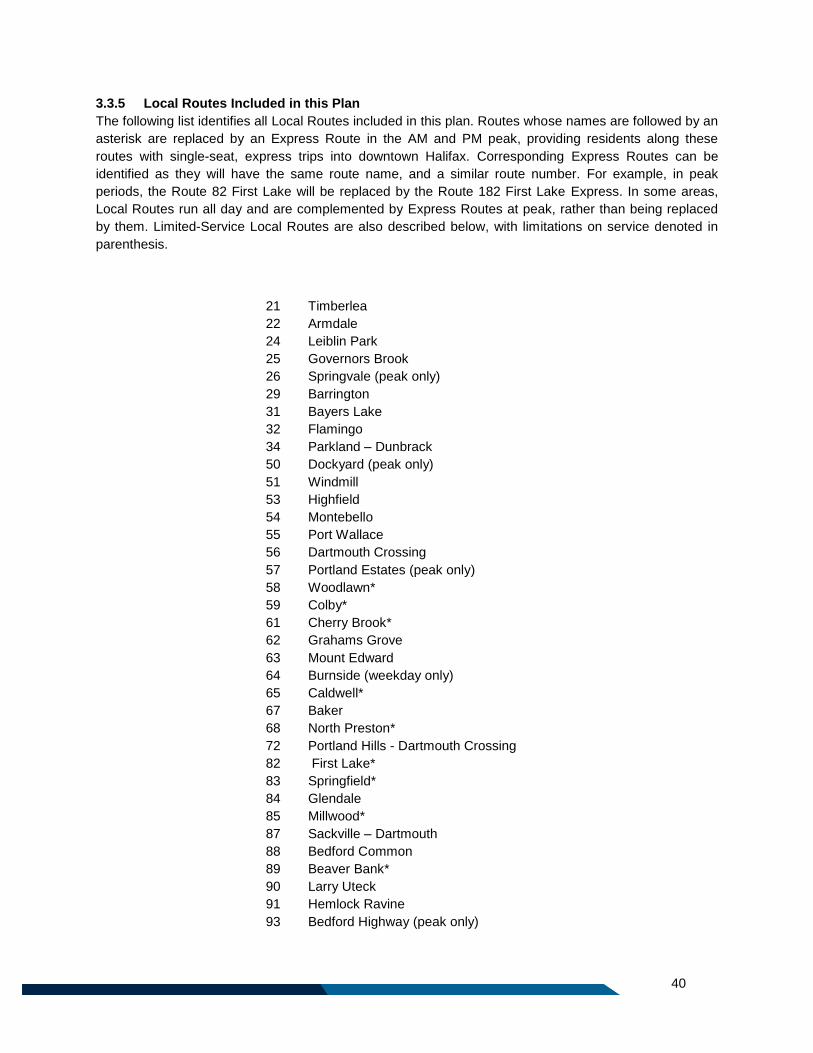
40
3.3.5 Local Routes Included in this Plan
The following list identifies all Local Routes included in this plan. Routes whose names are followed by an
asterisk are replaced by an Express Route in the AM and PM peak, providing residents along these
routes with single-seat, express trips into downtown Halifax. Corresponding Express Routes can be
identified as they will have the same route name, and a similar route number. For example, in peak
periods, the Route 82 First Lake will be replaced by the Route 182 First Lake Express. In some areas,
Local Routes run all day and are complemented by Express Routes at peak, rather than being replaced
by them. Limited-Service Local Routes are also described below, with limitations on service denoted in
parenthesis.
21 Timberlea
22 Armdale
24 Leiblin Park
25 Governors Brook
26 Springvale (peak only)
29 Barrington
31 Bayers Lake
32 Flamingo
34 Parkland – Dunbrack
50 Dockyard (peak only)
51 Windmill
53 Highfield
54 Montebello
55 Port Wallace
56 Dartmouth Crossing
57 Portland Estates (peak only)
58 Woodlawn*
59 Colby*
61 Cherry Brook*
62 Grahams Grove
63 Mount Edward
64 Burnside (weekday only)
65 Caldwell*
67 Baker
68 North Preston*
72 Portland Hills - Dartmouth Crossing
82 First Lake*
83 Springfield*
84 Glendale
85 Millwood*
87 Sackville – Dartmouth
88 Bedford Common
89 Beaver Bank*
90 Larry Uteck
91 Hemlock Ravine
93 Bedford Highway (peak only)
41
3.4 Express Routes
3.4.1 Description of Express Routes
Express Routes, as they appear in this plan, are a hybrid of the successful MetroLink and Urban Express
services familiar to the region. These are designed to provide commuters with a high quality, limited stop
transit service during peak hour periods, making transit more attractive to individuals currently commuting
for work and education during weekday peak periods.
Similar to the former Urban Express Routes, new Express Routes will provide local service in residential
areas (making regular local stops for pickups and drop offs). In some cases Express Routes will actually
replicate and replace Local Routes during AM and PM peak. Once the route departs the local area,
similar to MetroLink service, it will provide express (limited stop) service into Downtown. In addition to
servicing transit terminals, express routes may also service one or two major destinations on the way to
downtown Halifax, such as HMC Dockyard. A major destination could include a regional shopping centre,
large employer (more than 2,500 jobs), large universities or hospitals, or other regional attractions. Upon
arrival in Downtown Halifax more frequent stops will resume, allowing users to access their destinations
quickly and easily. Because of the volume of Express Routes travelling through Downtown Halifax during
peak periods, Express Routes will follow one of two potential routings.
The intent of this revised Express model is to attract peak period commuters to transit and to reduce
dependence on the existing Park & Ride facilities, which are extremely costly to build and maintain.
Express service will pick up more passengers near their home so it is no longer necessary to get into a
vehicle in order to access transit service. The new Express Route services will also still provide a high
level of service at transit terminals, allowing those who continue to choose to Park & Ride to retain a
similar, if not better, level of service as existed prior to this plan.
3.4.2 Level of Service Guidelines
Express Routes have no standard frequencies or spans of service. They operate during peak hours
Monday to Friday only, and the number of trips provided will vary based on demand. Some Express
Routes provide a high level of service during the entire peak period, and others have a limited number of
trips concentrated around a certain time. Express Routes provide service in the peak direction only (i.e.
towards Downtown during AM peak and out from Downtown during the PM peak). Due to the unique
nature of commuting trips, Express Routes don’t always need a consistent time interval between
successive buses, and in some cases could actually benefit from a cluster of trips to arrive at a
destination for the start of the work day, in some cases less than five minutes apart.
3.4.3 Introducing Express Routes
Express Routes may be considered when the following additional conditions are met:
If the introduction of an Express Route will reduce the need for a transfer for a common
commuting trip pattern (i.e. it can be shown that a high volume of individuals from one
neighbourhood work in the same employment district);
The travel time between the start and the end of the route is more than 30 minutes;
The Express Route can provide a noticeably shorter trip than local bus service; and
It is expected that the trip would carry a full seated load upon reaching the Regional Centre.
Express Routes may also be considered as introductory service in an area otherwise unserviced by local
transit, particularly in a primarily residential area with a low diversity of land uses where it is anticipated
that transit demand will be focused in the morning and afternoon peak periods. The above conditions
would still need to be met.
42
A new Express Route may be introduced with as few as two trips during each weekday peak period.
Additional trips may be considered if ridership grows.
3.4.4 Express Routes Included in this Plan
The following list identifies all Express Routes included in this plan. Routes whose names are followed by
an asterisk replace a Local Route in the AM and PM peak.
123 Timberlea Express
127 Cowie Hill Express
135 Flamingo Express
136 Farnham Express
137 Regency Park Express
138 Parkland Express
158 Woodlawn Express*
159 Colby Express*
161 Auburn / Cherry Brook Express*
165 Caldwell Express*
168 North Preston Express*
178 Cole Harbour to Woodside Ferry Express
179 Mount Edward to Woodside Ferry Express
182 First Lake Express*
183 Springfield Express*
185 Millwood Express*
186 Basinview Express
189 Beaver Bank Express*
192 Southgate Express
194 Bedford West Express
196 Starboard Express
43
3.5 Regional Express Routes
3.5.1 Description of Regional Express Routes
Regional Express Routes connect rural, outlying communities to the Regional Centre and other transit
services. The intent of Regional Express service is to allow residents of outlying communities the option
of using transit for regular commuting. Regional Express Routes will be subject to a premium fare.
Currently, the cost per ride for these services is $3.50 per person, $1.00 higher than the fare for other
service types.
The Regional Express service model is very similar to the MetroX service which it will supersede;
however, the new format will potentially allow one to three additional stops between the start and end of
the route, providing more flexibility for passengers. Any additional stops added to a Regional Express
route must occur inside the Urban Transit Service Boundary and not delay the trip beyond the existing
schedule.
3.5.2 Level of Service Guidelines
Regional Express Routes will strive to meet the following guidelines, subject to resource availability:
Table 5: Level of Service Guidelines for Regional Express Routes
Regional Express Routes
Peak Headway (peak direction) 10-30 min
Off Peak Headway One midday trip, one evening trip
Saturday Headway No Service
Sunday Headway No Service
Weekday Span of Service As needed according to demand
Weekend Span of Service No Service
Regional Express Routes are commuter focused, and the service is primarily in the peak direction. In
addition to peak service, there is one midday trip and one early evening trip. The number of trips provided
at peak is based on observed demand for service. These routes do not operate on weekends, with the
exception of the 320 Airport/ Fall River Regional Express which is discussed below.
3.5.3 Introduction of a new Regional Express Route
The Regional Municipal Planning Strategy limits the introduction of new Regional Express services to
areas identified in the Regional Plan as Rural District Growth Centres. As a result, only one future
Regional Express Route is proposed: the Route 310 Middle Sackville Regional Express between
Margeson Drive in Middle Sackville, and Downtown Halifax.
3.5.4 Regional Express Routes included in this Plan
310 Middle Sackville Regional Express
320 Airport / Fall River Regional Express
330 Tantallon/Sheldrake Lake Regional Express
370 Porters Lake Regional Express
3.5.5 Route 320 Airport/Fall River Regional Express Route
This Regional Express Routes provides a connection between Downtown Halifax and the Halifax
Stanfield International Airport. Due to the regional importance of the route from a tourism and economic
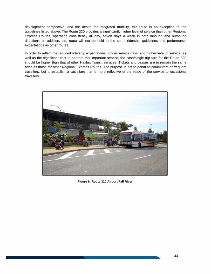
44
Figure 6: Route 320 Airport/Fall River
development perspective, and the desire for integrated mobility, this route is an exception to the
guidelines listed above. The Route 320 provides a significantly higher level of service than other Regional
Express Routes, operating consistently all day, seven days a week in both inbound and outbound
directions. In addition, this route will not be held to the same ridership guidelines and performance
expectations as other routes.
In order to reflect the reduced ridership expectations, longer service days, and higher level of service, as
well as the significant cost to operate this important service, the cash/single trip fare for the Route 320
should be higher than that of other Halifax Transit services. Tickets and passes are to remain the same
price as those for other Regional Express Routes. The purpose is not to penalize commuters or frequent
travellers, but to establish a cash fare that is more reflective of the value of the service to occasional
travellers.
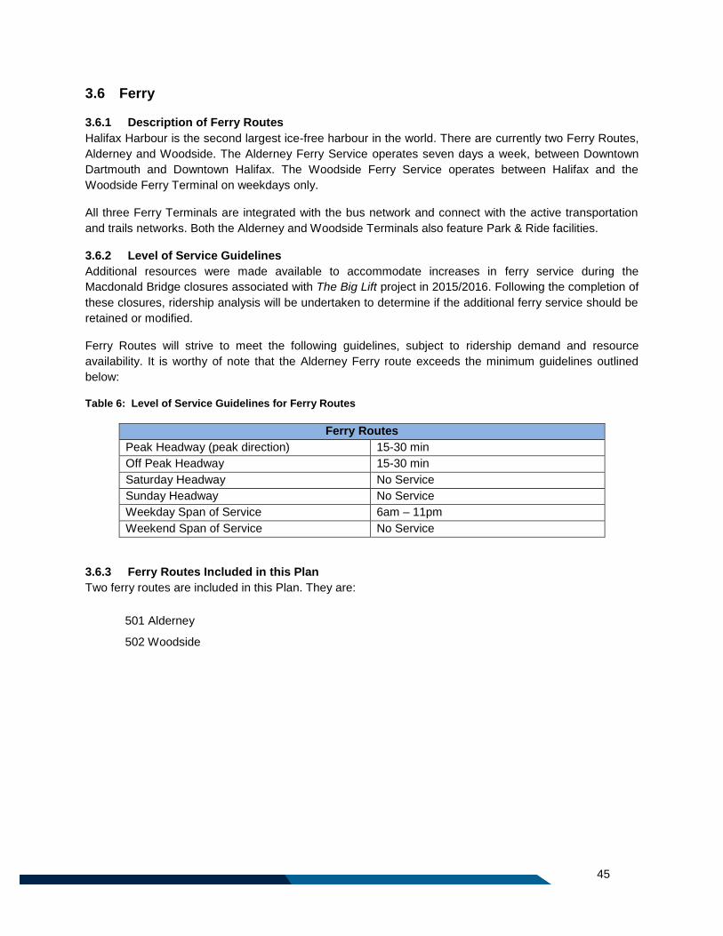
45
3.6 Ferry
3.6.1 Description of Ferry Routes
Halifax Harbour is the second largest ice-free harbour in the world. There are currently two Ferry Routes,
Alderney and Woodside. The Alderney Ferry Service operates seven days a week, between Downtown
Dartmouth and Downtown Halifax. The Woodside Ferry Service operates between Halifax and the
Woodside Ferry Terminal on weekdays only.
All three Ferry Terminals are integrated with the bus network and connect with the active transportation
and trails networks. Both the Alderney and Woodside Terminals also feature Park & Ride facilities.
3.6.2 Level of Service Guidelines
Additional resources were made available to accommodate increases in ferry service during the
Macdonald Bridge closures associated with The Big Lift project in 2015/2016. Following the completion of
these closures, ridership analysis will be undertaken to determine if the additional ferry service should be
retained or modified.
Ferry Routes will strive to meet the following guidelines, subject to ridership demand and resource
availability. It is worthy of note that the Alderney Ferry route exceeds the minimum guidelines outlined
below:
Table 6: Level of Service Guidelines for Ferry Routes
Ferry Routes
Peak Headway (peak direction) 15-30 min
Off Peak Headway 15-30 min
Saturday Headway No Service
Sunday Headway No Service
Weekday Span of Service 6am – 11pm
Weekend Span of Service No Service
3.6.3 Ferry Routes Included in this Plan
Two ferry routes are included in this Plan. They are:
501 Alderney
502 Woodside
46
3.7 Rural Routes
3.7.1 Description of Rural Routes
Rural Routes are those which serve to provide transit service to communities outside of the Urban Transit
Service Boundary (UTSB) and were established before the boundary was adopted. These routes provide
connections between rural communities and transit service in the urban area, by bringing passengers to
the nearest transit terminal.
3.7.2 Level of Service Guidelines
There are no service spans or frequency guidelines for Rural Routes, due to the adoption of the UTSB
which limits the amount of service available outside the boundary to that which currently exists.
Therefore, no additional service will be introduced outside of the UTSB. As with any public transit routes
or services, any service reductions will be based upon approved performance standards.
3.7.3 Introducing Rural Routes
No new Rural Routes will be introduced due to the limits in place under the UTSB and the Regional Plan.
Routes which currently operate outside the boundary can be modified, however, if there is no overall
increase in service as measured by in-service kilometers or budgeted service hours.
As noted at the outset of this plan, Policy T-10 of the Regional Plan states that Council may consider
programs to encourage and assist communities with developing their own community based transit
services in the areas outside the UTSB. At time of writing, Halifax Transit supports the operation of two
community transit service providers in Halifax’s rural communities through the Rural Transit Funding
Program.
3.7.4 Rural Routes Included in this Plan
401 Porters Lake
415 Purcells Cove (peak only)
433 Tantallon (peak only)
3.7.5 Route 400 Beaver Bank
The changes outlined in this plan for transit service to Beaver Bank result in the reclassification of the
former Route 400 Beaver Bank as a Local Route (Route 89 Beaver Bank). This is a result of the
truncation of the route to eliminate the low ridership segment beyond Kinsac Road. Because the route is
almost entirely contained within the UTSB, it is considered a Local Route in this plan, and will have a
higher level of service than the former Route 400 Beaver Bank.
47
3.8 School Routes
3.8.1 Description of School Routes
Regular Halifax Transit service is often used by school aged children to travel to and from school. In
some specific cases in the past, Halifax Transit has introduced modified transit routing to better meet the
needs of students, or provided an additional trip on an existing route that is aligned with school arrival and
departure times. These customized services, called “School Specials” were not published in the public
schedules as they were available only to students. The majority of the previous school routes have
become redundant, and have not evolved to meet the changing needs of schools or the growth in the
transit network. Few are well used, and the bulk of these services would be eliminated through the
Moving Forward Together Plan. Those which will be retained have established ridership, provide needed
capacity to a particular neighbourhood, and provide a service which is not duplicated by another transit
route.
As they are designed to meet the requirements of the academic calendar, School Routes only operate
from September until the end of June of each year. They do not operate on statutory holidays, school
holidays, or during the summer months. Regular fares apply on all School Routes, and any paying
customer is welcome to board, students or otherwise.
3.8.2 Level of Service Guidelines
Typically, a School Route has only one or two one way trips per day, intended to accommodate the arrival
of students, or the departure of students.
3.8.3 Introducing School Routes
The introduction of new School Routes will not be considered in the future and over the life of this Plan.
However, subject to resource availability and impact to public schedules, Halifax Transit will consider
scheduling additional trips or adjusting the schedule of trips on nearby transit routes at school arrival and
departure times to allow students to make use of transit.
3.8.4 School Routes Included in this Plan
701 Halifax West
726 Citadel
735 Clayton Park
48
3.9 Access-a-Bus
3.9.1 Description of Access-a-Bus Services
Halifax Transit's Access-A-Bus service is a shared ride, door-to-door, transit service for persons who are
unable to use the conventional transit system due to physical or cognitive disabilities and are declared
eligible through a registration process. Those eligible for Access-A-Bus services must be picked up and
dropped off within one kilometer of a fixed transit route. The Access-A-Bus service is meant to
supplement the Halifax Transit fixed route system.
3.9.2 Level of Service Guidelines
Access-A-Bus clients must book rides at least 24 hours ahead of a planned trip. Trip requests received
after the 24 hour booking window will be placed on a waiting list, on a first-come, first-served basis and
filled as vacancies become available. Access-A-Bus passengers are provided a 30-minute pick up
window at the time of trip confirmation. This window allows for more scheduling flexibility due to
unexpected traffic delays or detours, and to allow Halifax Transit to make more bookings.
3.9.3 Ridership Expectations
Access-A-Bus Service is not intended to be a high ridership service, but is available as a service for
members of the community who are unable to make use of conventional transit service, and who meet
the eligibility criteria. As a result, there is no ridership guideline for this service.

49
Part 4: Geographic Areas

50
51
4 Network Overview
This section describes the transit network in detail, broken down by geographic area and by service type,
listing each route which serves those looking to travel to, from, and through a particular area.
4.1 Regional Centre The Regional Centre is the urban core of the Halifax Regional Municipality, and is composed of the
Halifax Peninsula and Dartmouth within the Circumferential Highway. With a total land area of over 33
square kilometres, the Regional Centre is the focus of commerce, business, government, health care,
post-secondary education, and cultural and entertainment sectors for not only the Halifax Regional
Municipality, but for the entire Atlantic Region.
As there is large transit demand to and throughout the Regional Centre over the course of the day and on
evenings and weekends, this area is serviced by a large volume of transit service, including all ten
Corridor Routes, 24 Local Routes, 19 Express Routes, and two Ferry Routes.
Corridor Routes Serving the Regional Centre
The Regional Centre is served by all ten Corridor Routes:
1 Spring Garden
2 Clayton Park - Downtown
3 Crosstown
4 Lacewood - Universities
5 Portland
6 Eastern Passage
7 Peninsula
8 Sackville
9 Herring Cove
10 Mic Mac
These Corridor Routes provide a high level of service all day along major streets including Alderney
Drive, Portland Street, Victoria Road, Albro Lake Road, Wyse Road, Gottingen Street, Robie Street,
Quinpool Road, Windsor Street, Oxford Street, Spring Garden Road, Chebucto Road, North Street,
Barrington Street, South Street, South Park Street, and Inglis Street. They provide direct connections to
all of the terminals in the Halifax Transit network.
Local Routes Serving the Halifax Peninsula
The Peninsula is served by 10 Local Routes:
24 Leiblin Park
25 Governors Brook
26 Springvale (peak only)
29 Barrington
31 Bayers Lake
50 Dockyard (peak only)
84 Glendale
90 Larry Uteck
91 Hemlock Ravine
93 Bedford Highway (peak only)
These routes provide regular, all day circulation amongst neighbourhoods on the Peninsula, and connect
to communities such as Sackville, Mainland South, Bedford, Dartmouth, and Bayers Lake Business Park.
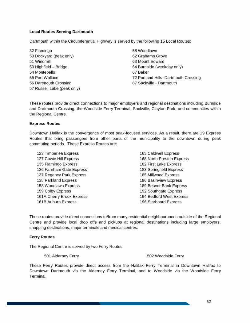
52
Local Routes Serving Dartmouth
Dartmouth within the Circumferential Highway is served by the following 15 Local Routes:
32 Flamingo
50 Dockyard (peak only)
51 Windmill
53 Highfield – Bridge
54 Montebello
55 Port Wallace
56 Dartmouth Crossing
57 Russell Lake (peak only)
58 Woodlawn
62 Grahams Grove
63 Mount Edward
64 Burnside (weekday only)
67 Baker
72 Portland Hills–Dartmouth Crossing
87 Sackville - Dartmouth
These routes provide direct connections to major employers and regional destinations including Burnside
and Dartmouth Crossing, the Woodside Ferry Terminal, Sackville, Clayton Park, and communities within
the Regional Centre.
Express Routes
Downtown Halifax is the convergence of most peak-focused services. As a result, there are 19 Express
Routes that bring passengers from other parts of the municipality to the downtown during peak
commuting periods. These Express Routes are:
123 Timberlea Express
127 Cowie Hill Express
135 Flamingo Express
136 Farnham Gate Express
137 Regency Park Express
138 Parkland Express
158 Woodlawn Express
159 Colby Express
161A Cherry Brook Express
161B Auburn Express
165 Caldwell Express
168 North Preston Express
182 First Lake Express
183 Springfield Express
185 Millwood Express
186 Basinview Express
189 Beaver Bank Express
192 Southgate Express
194 Bedford West Express
196 Starboard Express
These routes provide direct connections to/from many residential neighbourhoods outside of the Regional
Centre and provide local drop offs and pickups at regional destinations including large employers,
shopping destinations, major terminals and medical centres.
Ferry Routes
The Regional Centre is served by two Ferry Routes
501 Alderney Ferry 502 Woodside Ferry
These Ferry Routes provide direct access from the Halifax Ferry Terminal in Downtown Halifax to
Downtown Dartmouth via the Alderney Ferry Terminal, and to Woodside via the Woodside Ferry
Terminal.
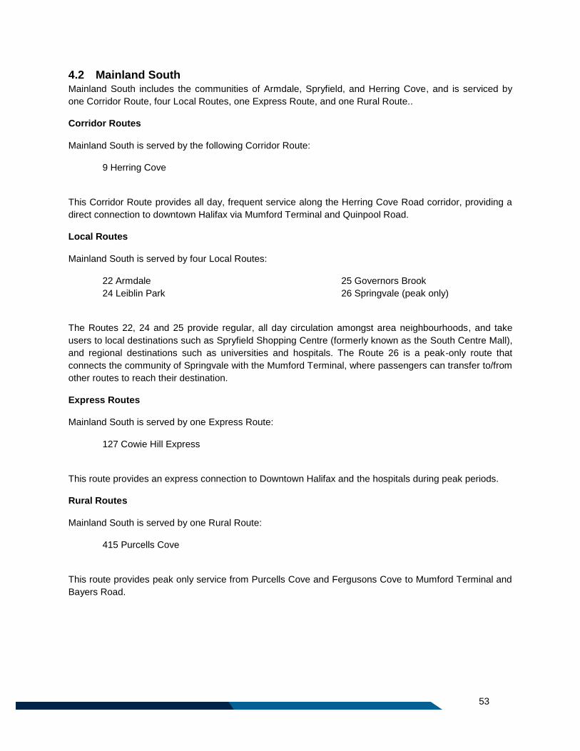
53
4.2 Mainland South Mainland South includes the communities of Armdale, Spryfield, and Herring Cove, and is serviced by
one Corridor Route, four Local Routes, one Express Route, and one Rural Route..
Corridor Routes
Mainland South is served by the following Corridor Route:
9 Herring Cove
This Corridor Route provides all day, frequent service along the Herring Cove Road corridor, providing a
direct connection to downtown Halifax via Mumford Terminal and Quinpool Road.
Local Routes
Mainland South is served by four Local Routes:
22 Armdale
24 Leiblin Park
25 Governors Brook
26 Springvale (peak only)
The Routes 22, 24 and 25 provide regular, all day circulation amongst area neighbourhoods, and take
users to local destinations such as Spryfield Shopping Centre (formerly known as the South Centre Mall),
and regional destinations such as universities and hospitals. The Route 26 is a peak-only route that
connects the community of Springvale with the Mumford Terminal, where passengers can transfer to/from
other routes to reach their destination.
Express Routes
Mainland South is served by one Express Route:
127 Cowie Hill Express
This route provides an express connection to Downtown Halifax and the hospitals during peak periods.
Rural Routes
Mainland South is served by one Rural Route:
415 Purcells Cove
This route provides peak only service from Purcells Cove and Fergusons Cove to Mumford Terminal and
Bayers Road.
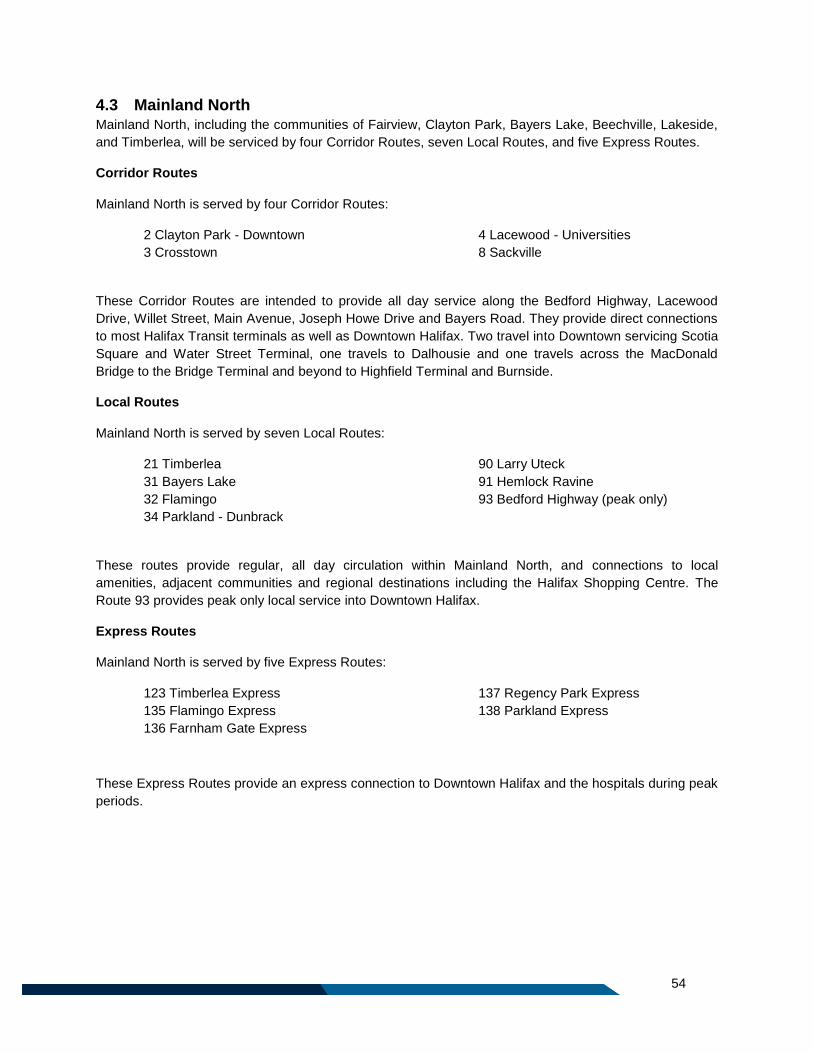
54
4.3 Mainland North Mainland North, including the communities of Fairview, Clayton Park, Bayers Lake, Beechville, Lakeside,
and Timberlea, will be serviced by four Corridor Routes, seven Local Routes, and five Express Routes.
Corridor Routes
Mainland North is served by four Corridor Routes:
2 Clayton Park - Downtown
3 Crosstown
4 Lacewood - Universities
8 Sackville
These Corridor Routes are intended to provide all day service along the Bedford Highway, Lacewood
Drive, Willet Street, Main Avenue, Joseph Howe Drive and Bayers Road. They provide direct connections
to most Halifax Transit terminals as well as Downtown Halifax. Two travel into Downtown servicing Scotia
Square and Water Street Terminal, one travels to Dalhousie and one travels across the MacDonald
Bridge to the Bridge Terminal and beyond to Highfield Terminal and Burnside.
Local Routes
Mainland North is served by seven Local Routes:
21 Timberlea
31 Bayers Lake
32 Flamingo
34 Parkland - Dunbrack
90 Larry Uteck
91 Hemlock Ravine
93 Bedford Highway (peak only)
These routes provide regular, all day circulation within Mainland North, and connections to local
amenities, adjacent communities and regional destinations including the Halifax Shopping Centre. The
Route 93 provides peak only local service into Downtown Halifax.
Express Routes
Mainland North is served by five Express Routes:
123 Timberlea Express
135 Flamingo Express
136 Farnham Gate Express
137 Regency Park Express
138 Parkland Express
These Express Routes provide an express connection to Downtown Halifax and the hospitals during peak
periods.
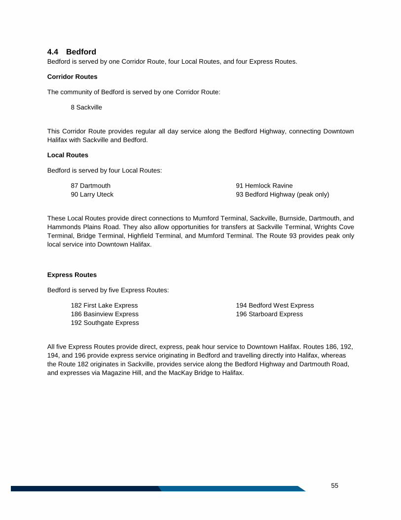
55
4.4 Bedford Bedford is served by one Corridor Route, four Local Routes, and four Express Routes.
Corridor Routes
The community of Bedford is served by one Corridor Route:
8 Sackville
This Corridor Route provides regular all day service along the Bedford Highway, connecting Downtown
Halifax with Sackville and Bedford.
Local Routes
Bedford is served by four Local Routes:
87 Dartmouth
90 Larry Uteck
91 Hemlock Ravine
93 Bedford Highway (peak only)
These Local Routes provide direct connections to Mumford Terminal, Sackville, Burnside, Dartmouth, and
Hammonds Plains Road. They also allow opportunities for transfers at Sackville Terminal, Wrights Cove
Terminal, Bridge Terminal, Highfield Terminal, and Mumford Terminal. The Route 93 provides peak only
local service into Downtown Halifax.
Express Routes
Bedford is served by five Express Routes:
182 First Lake Express
186 Basinview Express
192 Southgate Express
194 Bedford West Express
196 Starboard Express
All five Express Routes provide direct, express, peak hour service to Downtown Halifax. Routes 186, 192,
194, and 196 provide express service originating in Bedford and travelling directly into Halifax, whereas
the Route 182 originates in Sackville, provides service along the Bedford Highway and Dartmouth Road,
and expresses via Magazine Hill, and the MacKay Bridge to Halifax.
56
4.5 Sackville Sackville is served by one Corridor Route, seven Local Routes and four Express Routes.
Corridor Routes
The community of Sackville is served by one Corridor Route:
8 Sackville
This Corridor Route provides regular all day service along Sackville Drive, connecting Sackville with the
Bedford Highway and Downtown Halifax..
Local Routes
Sackville is served by seven Local Routes. Those marked with an asterisk are replaced by Express
Routes during peak periods in order to provide express service into and out of Downtown Halifax:
82 First Lake*
83 Springfield*
84 Glendale
85 Millwood*
87 Dartmouth
88 Bedford Common
89 Beaver Bank5*
These Local Routes provide direct connections to/from Halifax, Dartmouth, Bedford Commons, and the
communities of Springfield Lake, Millwood, and Beaver Bank. They also allow opportunities for transfers
at Cobequid Terminal, Sackville Terminal, Wrights Cove Terminal, Highfield Terminal, and Bridge
Terminal.
Express Routes
Sackville is served by four Express Routes, which replace routes 82 First Lake, 83 Springfield, 85
Millwood, and 89 Beaver Bank during peak periods:
182 First Lake Express
183 Springfield Express
185 Millwood Express
189 Beaver Bank Express
These four routes provide an express connection to Downtown Halifax and the hospitals during peak
periods.
5 This route will continue provide two trips to Monarch Public School (one in the morning and one in the afternoon). It
will no longer travel into the Woodbine Mobile Home Park.
57
4.6 Burnside & Dartmouth Crossing Burnside and Dartmouth Crossing are served by one Corridor Route, six Local Routes, and four Express
Routes:
Corridor Routes
Burnside Business Park is served by one Corridor Route:
3 Crosstown
This Corridor Route provides regular all day service from Lacewood Terminal through Mumford, Bridge
and Highfield Terminals before entering the Burnside Business Park and terminating at the new Wrights
Cove Terminal.
Local Routes
Burnside and Dartmouth Crossing are served by the following six Local Routes
51 Windmill (peak only)
56 Dartmouth Crossing
64 Burnside
72 Dartmouth Crosstown
84 Glendale
87 Sackville - Dartmouth
These Local Routes provide direct connections to the Bridge Terminal, Mic Mac Terminal, Highfield
Terminal, and Wrights Cove Terminal as well as the communities of Sackville, North Dartmouth, Crichton
Park, and Cole Harbour. Additionally, the Route 51 Windmill provides a peak period extension to Wrights
Cove Terminal.
Express Routes
Wrights Cove Terminal is served by the following routes during peak periods. It is important to note that
while none of these routes will circulate through Burnside, they will all service the Wrights Cove Terminal,
stopping either in the terminal, or at a stop along Windmill Road, allowing passengers to transfer to or
from a Local or Corridor route:
182 First Lake Express
183 Springfield Express
185 Millwood Express
189 Beaver Bank
58
4.7 Dartmouth, Woodside, Woodlawn, Eastern Passage, Cole Harbour, Cherry
Brook, Lake Loon, Westphal, and North Preston The communities outside of the Circumferential Highway in Dartmouth, including Dartmouth, Woodlawn,
Woodside, Eastern Passage, Cole Harbour, Cherry Brook, Lake Loon, Westphal, and North Preston are
served by three Corridor Routes, 11 Local Routes, seven Express Routes, and one Ferry Route.
Corridor Routes
This area is served by three Corridor Routes
5 Portland
6 Woodside
10 Micmac
Corridor Routes provide regular all day connections between Dartmouth and, the Halifax Peninsula, Cole
Harbour, Woodside, and Eastern Passage.
Local Routes
These communities are served by the following 11 Local Routes. Those marked with an asterisk are
replaced by Express Routes during peak periods in order to provide express service into and out of
Downtown Halifax:
54 Montebello
55 Port Wallace
57 Russell Lake (peak only)
58 Woodlawn*
59 Colby*
63 Mount Edward
65 Caldwell*
67 Baker
68 North Preston*
72 Portland Hills–Dartmouth Crossing
61 Cherry Brook*
These routes provide circulation within the communities they serve, and make connections at major
terminals such as Mic Mac Terminal, Woodside Ferry Terminal, Highfield Terminal, Penhorn Terminal,
and Portland Hills Terminal.
Express Routes
Cole Harbour, Woodlawn, North Preston, and Cherry Brook are served by five Express Routes into
Downtown Halifax. They are:
158 Woodlawn Express
159 Colby Express
161 Cherry Brook/Auburn Express
165 Caldwell Express
168 North Preston Express
These Express Routes replace Local Routes 58 Woodlawn, 59 Colby, 61 Cherry Brook, 65 Caldwell, and
68 North Preston respectively during peak periods, providing direct service to and from Downtown
Halifax.
Two additional Express Routes also operate in Cole Harbour. These are:
178 Mount Edward to Ferry Express 179 Cole Harbour to Ferry Express
These routes provide an express connection to the Woodside Ferry Terminal during peak periods.
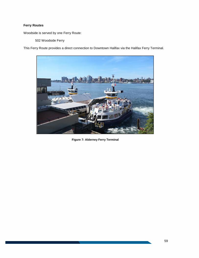
59
Ferry Routes
Woodside is served by one Ferry Route:
502 Woodside Ferry
This Ferry Route provides a direct connection to Downtown Halifax via the Halifax Ferry Terminal.
Figure 7: Alderney Ferry Terminal
60
4.8 Service outside the Urban Transit Service Boundary
Porters Lake, Lake Echo & East Preston
The communities of Porters Lake, Lake Echo, and East Preston will be served by one Rural Route and
one Regional Express:
401 Porters Lake 370 Porters Lake Regional Express
Rural Route 401 Porters Lake provides service from the Porters Lake Park & Ride and Lakeview
Shopping Centre to the Portland Hills Terminal on weekdays only.
The Route 370 Porters Lake Regional Express provides limited stop commuter service between the
Porters Lake Park & Ride and Downtown Halifax. It will not provide service to Lake Echo or East Preston.
Purcells Cove & Fergusons Cove
The communities of Fergusons Cove and Purcells Cove will be served by one Rural Route:
415 Purcells Cove
This route provides service between the Bayers Road Terminal, Mumford Terminal, and York Redoubt via
Purcells Cove Road. This route will provide weekday peak only service.
Tantallon/Sheldrake Lake
The community of Tantallon will be served by one Rural Route and one Regional Express:
433 Tantallon 330 Tantallon/ Sheldrake Lake Regional
Express
The Rural Route 433 Tantallon will provide a peak only, weekday service between Tantallon and
Lacewood Terminal, making local stops along Hammonds Plains Road, Bluewater Road, and Kearney
Lake Road.
The Route 330 Tantallon/Sheldrake Lake Regional Express provides limited stop commuter service
between the Tantallon Park & Ride, Sheldrake Lake Park & Ride and Downtown Halifax.
Fall River/Airport
Fall River and the Halifax Stanfield International Airport are serviced by one Regional Express:
320 Airport/Fall River Regional Express
This route provides all day service, seven days per week. The route 320 Airport/Fall River Regional
Express provides limited stop service between Downtown Halifax, Dartmouth, and the Aerotech Business
61
Park. Between the Aerotech Business Park and Halifax Stanfield International Airport, several local stops
are also serviced to provide connections for Business Park employees.
Middle Sackville
The portion of Middle Sackville outside of the Urban Transit Service Boundary is served by one Local
Route, one Express Route, and one Regional Express.
83 Springfield
183 Springfield Express
310 Middle Sackville Regional Express
The Route 83 Springfield will provide local service seven days a week, connecting Springfield Avenue to
Sackville Terminal via Sackville Drive, Margeson Drive, Hanwell Dive, Melham Drive, and Old Sackville
Road. The Route 183 Springfield Express replaces the Route 83 at rush hour, providing limited stop
service from Sackville Terminal to Downtown Halifax.
The Route 310 Middle Sackville Regional Express will serve a Park & Ride lot to be built off of Margeson
Drive near Highway 101, Exit 2A. This route will provide a limited stop, commuter focused service.

62
63
Part 5: Transit Infrastructure

64
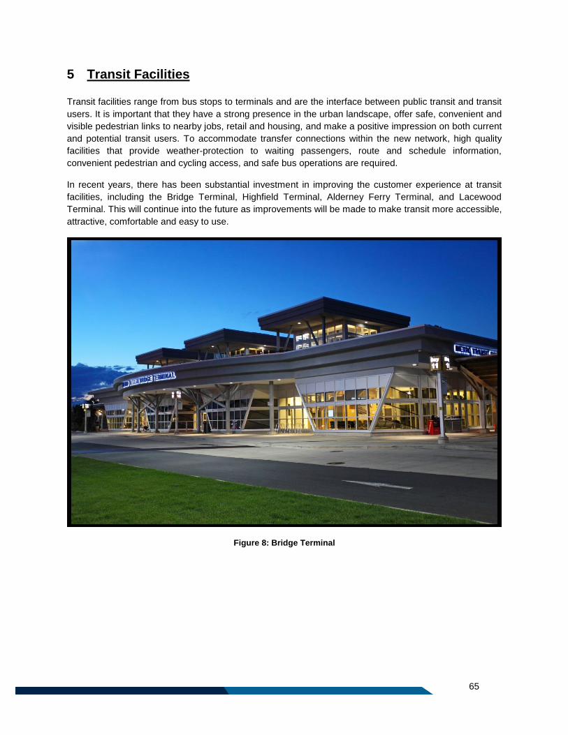
65
5 Transit Facilities
Transit facilities range from bus stops to terminals and are the interface between public transit and transit
users. It is important that they have a strong presence in the urban landscape, offer safe, convenient and
visible pedestrian links to nearby jobs, retail and housing, and make a positive impression on both current
and potential transit users. To accommodate transfer connections within the new network, high quality
facilities that provide weather-protection to waiting passengers, route and schedule information,
convenient pedestrian and cycling access, and safe bus operations are required.
In recent years, there has been substantial investment in improving the customer experience at transit
facilities, including the Bridge Terminal, Highfield Terminal, Alderney Ferry Terminal, and Lacewood
Terminal. This will continue into the future as improvements will be made to make transit more accessible,
attractive, comfortable and easy to use.
Figure 8: Bridge Terminal
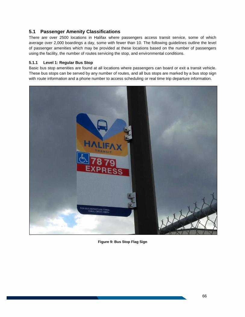
66
5.1 Passenger Amenity Classifications There are over 2500 locations in Halifax where passengers access transit service, some of which
average over 2,000 boardings a day, some with fewer than 10. The following guidelines outline the level
of passenger amenities which may be provided at these locations based on the number of passengers
using the facility, the number of routes servicing the stop, and environmental conditions.
5.1.1 Level 1: Regular Bus Stop
Basic bus stop amenities are found at all locations where passengers can board or exit a transit vehicle.
These bus stops can be served by any number of routes, and all bus stops are marked by a bus stop sign
with route information and a phone number to access scheduling or real time trip departure information.
Figure 9: Bus Stop Flag Sign

67
5.1.2 Level 2: Sheltered Stop
In addition to a marked bus stop, these locations include a concrete landing pad to facilitate passenger
boarding and alightings, and a shelter. A regular bus stop is a candidate to have a shelter installed if there
are more than 100 passenger boardings per day. Shelters may be considered in some circumstances
with lower volumes (i.e. stops with 50 – 99 boardings per day), such as when the stop is adjacent to a
seniors’ manor or community centre, or if environmental conditions warrant a passenger shelter (i.e. the
stop is located in a particularly exposed or windy location). Due to maintenance contracts, resource
availability, and space constraints, not all stops which meet these criteria will receive shelters.
5.1.3 Level 3: Enhanced Stop
Enhanced bus stops are typically found at major destinations and/or a transfer location for a large volume
of passengers. This classification represents a new level of investment in bus stops for Halifax Transit,
meant to facilitate the transfers required to
complete a trip in the transit network. A bus stop
is a candidate to become an enhanced bus stop
if there are more than 250 boardings per day,
and the stop is serviced by at least two routes
and/or is located at a regional destination or
intermodal transportation hub. Bus stops will be
upgraded to enhanced bus stops based on
resource availability.
The amenities at each enhanced bus stop will
vary based on site conditions, but in addition to a
shelter, they may be equipped with additional
seating, lighting, passenger information (route
maps or schedule information), waste
receptacles, or additional/larger shelters. An
example of a candidate to become an enhanced
bus stop is the bus stop on Joseph Howe Drive
at Dutch Village Road, which has on average
420 boardings per day. The photo to the left
shows one example of an Enhanced Stop layout, featuring a shelter, route maps and schedule
information, seating, and a garbage receptacle.
5.1.4 Level 4: Transit Hub
This level of bus stop amenity is often found at transit terminals that do not have indoor passenger waiting
areas, and also in other major transit terminals/transfer locations with more than 500 boardings per day.
This level of stop is a transfer node, and may also have a Park & Ride facility. In addition to Level 3
amenities, these locations could be candidates to be fitted with electronic message boards, bike racks,
and payphones, where space permits. Halifax Transit will also investigate the potential for heated shelters
at these locations. Examples of locations that could be considered for Level 4 amenities include Highfield
Terminal, Cobequid Terminal, Penhorn Terminal, Bayers Road Centre, Tacoma Centre, and major stops
adjacent to one of the colleges or universities.
5.1.5 Level 5: Transit Terminal with Interior Passenger Space
This level only exists at transit terminals that have interior passenger waiting space. In addition, these
terminals may include public washrooms, drinking fountains, availability of refreshments, and interior
seating. There are currently eight Halifax transit terminals that have interior passenger waiting space.
Figure 10: Example of Enhanced Stop
68
5.2 Transit Terminals The Halifax Transit network has 16 off-street transit facilities. Maintaining terminal and Park & Ride
facilities in a state of good repair is essential to providing a comfortable, convenient location for
passengers to access transit service, and to encouraging additional ridership.
Terminals/Park & Rides that are new, or that have been recently upgraded, include: Lacewood Terminal
(2015), Alderney Ferry Terminal (2014), Highfield Terminal (2014), Porters Lake Park & Ride (2013),
Bridge Terminal (2012), Sheldrake Lake Park & Ride (2012), Fall River Park & Ride (2012), Tantallon
Park & Ride (2009), Sackville Terminal (2006), Mic Mac Terminal (2005) and Portland Hills Terminal
(2005).
In addition, the Woodside Ferry Terminal and Halifax Ferry Terminal are expected to undergo extensive
renovations in the near future.
Halifax Transit does have several older facilities including the Mumford Terminal, Cobequid Terminal, and
Penhorn Terminal. The following outlines planned improvements to these facilities:
Mumford Terminal (2019-2022): The existing Mumford Terminal is over capacity, and needs to be
replaced before any additional service can be introduced beyond what is described by this plan. This
terminal is a key facility in the new network, and existing capacity constraints and minimal passenger
amenities reduce the desirability of transferring at this location. The terminal is tentatively scheduled for
replacement in 2020/21, with design work starting in 2019/20.
Cobequid & Penhorn Terminals (2020-2022): The existing Cobequid and Penhorn Terminals are
scheduled for rehabilitation work necessary to maintain the terminals in a state of good repair. The
Penhorn Terminal is scheduled for repair in 2020/2021, and the Cobequid Terminal is scheduled for
repair in 2021/2022.
Wrights Cove Terminal (tentatively 2020): Based on the network proposed in this plan, a new terminal
is required to facilitate transfers into the Burnside Business Park. This new terminal will be located on
Bancroft Lane near the intersection with Windmill Road. This will be a relatively small facility, featuring
four to six bus bays, layover space for vehicles, and passenger and bus operator amenities.
This is an operationally important location in order to reduce redundancy in the route network by
facilitating transfers for passengers from routes coming from Dartmouth or Sackville into Burnside
Business Park. It is also sited adjacent to a developing high density residential development, building a
community supportive of Transit Oriented Design principles.
This facility is slated to open in Fall 2020 to coincide with implementation of this plan.
West Bedford Park & Ride (tentatively 2020): This terminal will be located on Innovation Drive in West
Bedford, in the middle of a rapidly growing community. The site will be within 500 metres of approximately
8,800 people and also adjacent to the new CP Allen High School. This location can sustain a 350-400 car
Park & Ride, and a four bay bus platform. It is estimated that ridership could reach approximately 950
daily boardings at this location. Significant ridership origins are expected from west of Highway 102 from
the communities of West Bedford and Hammonds Plains. Transit service demand is expected to grow in-
step with these expanding communities, supporting demand for those travelling toward the regional
centre and also demand for increased transit service to the employment and nearby institutional
destinations in West Bedford. This facility is slated to open in Fall 2020, to coincide with the
implementation of this plan.
69
Margeson Drive Park & Ride (tentatively 2020): This facility is slated for construction in the 2019/2020
Fiscal Year, with service beginning in 2020/2021. Located adjacent to Margeson Drive in Middle
Sackville, just south of Highway 101, this terminal will include a Park & Ride lot with space for
approximately 500 vehicles and a small platform. This facility will be served by the Route 310 Middle
Sackville Regional Express.
5.3 Park & Rides
Today, Halifax Transit provides over 2,035 parking spaces at 14 locations, primarily at transit terminals.
Park & Ride facilities complement transit by providing an option for those who would like to travel by
transit but need a vehicle to complete some portion of their trip. These facilities are also important for
those who do not have another option to access transit service, for example those living outside the
Halifax Transit service area. As most Park & Ride passengers are travelling to downtown, Park & Rides
may help to manage roadway congestion and reduce vehicle emissions. However, the implementation of
new Park and Rides require careful consideration, for several reasons:
1. Reliance on Private Vehicles: The introduction of too much parking can detract from the
overarching goal of minimizing private vehicle use, and the introduction of high traffic volumes to
a new Park & Ride could have a negative impact on the local community. It could also have the
impact of reduced ridership on Local Routes.
2. Cost: Building and maintaining Park & Ride facilities often requires large capital investments,
typically ranging from $3,000-$9,000 per stall. This is costly, considering only about 3% of Halifax
Transit users make use of Park & Ride facilities.
3. Transit Oriented Design: In some cases, Park & Ride facilities are not the highest and best use
of land adjacent to transit terminals. Land near transit facilities is ideal for Transit Oriented Design
developments which would include a mixture of land uses, designed to support active
transportation and transit. This type of development can result in significantly higher transit
ridership than would be generated from a Park & Ride facility.
4. Commuting costs: Regular Park & Ride users are unlikely to reduce the number of cars they
own, whereas riders who walk or use bus connections can realize significant savings by foregoing
ownership of one or more vehicles. The potential for redirecting personal income from multiple
car ownership to other interests can be a further incentive for using public transit.
5.3.1 Introducing a new Park & Ride
Despite these drawbacks, carefully planned Park & Rides can have an important role in encouraging
sustainable transportation in key locations. The following outlines the conditions in which the creation of a
new Park & Ride facility may be considered:
New Regional Express Service: Regional Express services are designed to serve rural,
outlying communities in which no local Halifax Transit service exists. These commuter-
focused services are dependent on the Park & Rides to allow passengers to access them.
Near the Periphery of the Transit Service Area: New Park & Ride facilities may be
considered at or near the urban transit service boundary, as identified in the Regional Plan.
This will allow potential transit users the option of driving to a Park & Ride and boarding a
transit vehicle to complete their trip.
70
Adjacent to Higher Order Transit: New Park & Ride facilities may be considered adjacent
to a transit facility served by a higher order transit service such as ferry, rail, or Bus Rapid
Transit (BRT). Where a High Level of Transit Service is provided adjacent to the Proposed Location:
In addition to the conditions listed above, new Park & Rides will only be considered where a
high level of transit service is provided. As an Interim use Pending Transit Oriented Development: In some locations, a
temporary Park & Ride lot may help establish ridership on a new service, with a view to
developing the lot as a compact, walkable mixed-use neighbourhood in the longer term.

71
Part 6: Measuring Success

72

73
6 Performance Measures
The guidelines and measures outlined in this section are intended to provide direction related to the level
of ridership expected, and measuring the success of the routes described in this plan. These are intended
to be guidelines rather than strict standards, as any service changes will be considered on a case by case
basis. The application of these guidelines is subject to budget and resource availability.
6.1 Ridership Guidelines The following table summarizes ridership guidelines by service type. These metrics represent the
minimum expectations for ridership as it relates to the amount of service provided by Halifax Transit.
Table 7: Minimum Ridership Guidelines
Service Type AM &PM Peak Midday &
Saturday
Weekday Evening &
Sunday
Corridor Routes
25 passengers/hr 15 passengers/hr 10 passengers/hr Local Routes
Rural Routes
Express and School
Routes
20 passengers/trip N/A N/A
Regional Express Routes 15 passengers/trip N/A N/A
Corridor Routes, Local Routes, and Rural Routes are measured by the average number of passengers
per service hour provided in each time period. Express Routes, Regional Express Routes and School
Routes are measured by the average number of passengers per trip by period.
6.1.1 Services Exempt from Ridership Standards
The ferry represents a high capacity link connecting Downtown Dartmouth, Downtown Halifax, and
Woodside. Due to critical importance of the ferry to the regional transportation network, and its historic
and cultural heritage value, this plan does not propose any minimum ridership standards for either ferry
route.
In much the same way, the Route 320 Airport/Fall River provides an important connection between
Downtown Halifax and the Halifax Stanfield International Airport. Due to the regional significance of this
connection from a tourism and economic development perspective, service to the Halifax International
Airport is also exempt from minimum ridership guidelines.
6.1.2 Low Ridership Periods
During the midday, evenings, and late at night, it is possible that the minimum guidelines outlined above
will not be achieved. Although ridership is typically lower during these periods, Halifax Transit recognizes
that the availability of transit service is still important during these periods in order to provide access to
employment, and for meeting the recreational, social, and cultural needs of the city. If several trips within
a specific time period are underperforming, they will be retained so long as the collective performance of
all trips in the specific time period is achieving the ridership guideline outlined above.
If it is determined that service will not attain the target outlined above in a particular period, service spans
could be reduced. Underperforming trips, in isolation, will not be removed as this makes for irregular,
unpredictable service. However, should the first or last trips of the day underperform continually and

74
cause the service to fall below the guidelines above, those individual trips could be considered for
removal.
6.2 Operations below Ridership Guidelines When a route is not meeting the ridership guidelines as outlined above, Halifax Transit will consider
taking one or more of the following actions:
Modify the schedule where possible, and where it is anticipated that schedule changes could
result in increased ridership;
Reduce or eliminate off-peak service or reduce service span so the level of transit service
provided is more closely aligned with ridership demand;
Investigate planned developments or public amenities adjacent to the route and consider
changes to routing to achieve greater ridership;
Lead a promotional campaign to raise awareness about the route; or
If ridership is low over all periods of the day, consider service elimination.
6.2.1 Warrant for Expanding Service Day or Increasing Service Frequency
Any increase to service spans or increase to service frequency will be identified through evaluation of
ridership trends and overloads, and may be implemented as budget permits. The introduction of any new
service is dependent on the availability of staff and vehicle resources.
6.2.2 Evaluating New, Expanded or Increased Service
When a new route is introduced, it often takes time for ridership to grow to expected levels. Similarly,
when a route is subject to significant modifications, or service is introduced in a time period when it was
not offered before, there is often a transition period when ridership may decline before increasing, or
otherwise increase slowly.
As such, new or highly modified routes should be monitored for a minimum of two years, with interim
monitoring at 12 months and 18 months. At the 12 month term, a minimum of 33% of the ridership
guideline should be attained, and by 18 months, a minimum of 66% of the ridership guideline should be
attained. If the service change is substantial, or if significant adjacent development is anticipated, staff
may recommend a longer trial period at the introduction stage of the service. Routes displaying ridership
below the guidelines during this timeframe may be modified in an attempt to attract new riders, but should
not be significantly altered or discontinued.
75
6.3 Bus Stop Locations Halifax Transit considers a resident to be served by transit if they are within 500 metres of a transit stop,
or within 1000 metres of a transit terminal. Within the area served by transit, bus stops will be spaced to
ensure that a minimum of 90% of all residences will be within 500 metres of at least one transit stop.
6.3.1 Bus Stop Placement
Where possible, bus stops should be placed near intersections, adjacent to passenger generators or at
popular destinations. Generally speaking, stops should not be closer together than 250 metres, except in
downtown Halifax and within major trip generators where closer spacings may be warranted. Stops may
be further than 250 metres apart, provided that larger stops spacings still allow the majority of origins and
destinations to be within a 500 metre walk. In areas of lower density, stops should be approximately 500
metres apart. Where possible, stops should be sited adjacent to pedestrian infrastructure like sidewalks
and crosswalks.
6.4 Route Directness Guideline Halifax Transit strives to balance access to transit service with short travel times to help make transit
more competitive and attractive.
For the most part, Halifax Transit routes have been designed to operate on major, arterial streets.
However, there may be some situations in which a route deviates from the shortest, most direct
alignment. Such situations include a mid-route deviation to serve a particular trip generator or end of line
terminal loops.
When a deviation exists or is being considered, the gain in convenience to those passengers who are
boarding or alighting during the deviation must be balanced against the additional travel time for the
passengers travelling through. The following guidelines shall be applied to all route deviations and/or
terminal loops:
To the extent possible, two-way service shall be provided on the same street;
To the extent possible, mid-route loops will be avoided;
Express services shall be routed in the most direct manner possible once they depart the local
service area;
For safety reasons, route deviations through parking lots will not be considered; and
Deviations from the basic route alignment to serve activity centres will be made only when the
potential net increase in travel time for riders is less than the net reduction in travel time for those
who would benefit from the deviation.
76
6.5 Route Variation Guideline In some cases it is more efficient to serve an area with one route having several branches, rather than to
operate several different routes. In addition, some trips on a route may not travel the full length of the
route. These trips are called short turns. Short turns and branches are examples of variations, which can
make the network more difficult for current and potential transit users to understand and use. Therefore,
to provide as user-friendly a service as possible, the following guidelines for variations will apply:
Variations (short turns or branches) will be limited and only used when required for operational
purposes; and
All short turns, branches, or significant variations will be designated with a letter identifier (ex. the
route 6A)
6.6 Quality of Service Guidelines
The intent of service quality guidelines is to establish a level of customer convenience that Halifax Transit
users can expect from the transit network. These are a commitment to Halifax Transit passengers to
improve the quality of service over the life of this plan. The Moving Forward Together Plan’s Quality of
Service Guidelines include on-time performance, loading guidelines, and span of service.
6.6.1 On-Time Performance
While it is impossible to achieve and maintain 100% on-time performance due to traffic and weather
conditions, every effort will be made to ensure all Halifax Transit buses and ferries operate on time. To
ensure transit users have confidence that service will perform in accordance with public timetables, the
following on-time performance guidelines have been established:
No trips will depart from a published time point more than one minute ahead of schedule. A transit
vehicle is considered “on-time” when it departs its published time point at the advertised time or
up to three minutes after scheduled departure.
A vehicle is considered “late” when it departs more than three minutes after the scheduled
departure time.
Many transit agencies strive to meet a target of 90% schedule adherence, meaning that buses should be
“on time” 90% of the time. Through the introduction of new AVL technology in the next year, Halifax
Transit will analyze existing on-time performance across the network and establish a benchmark and
target for the minimum percentage of trips to depart on time.
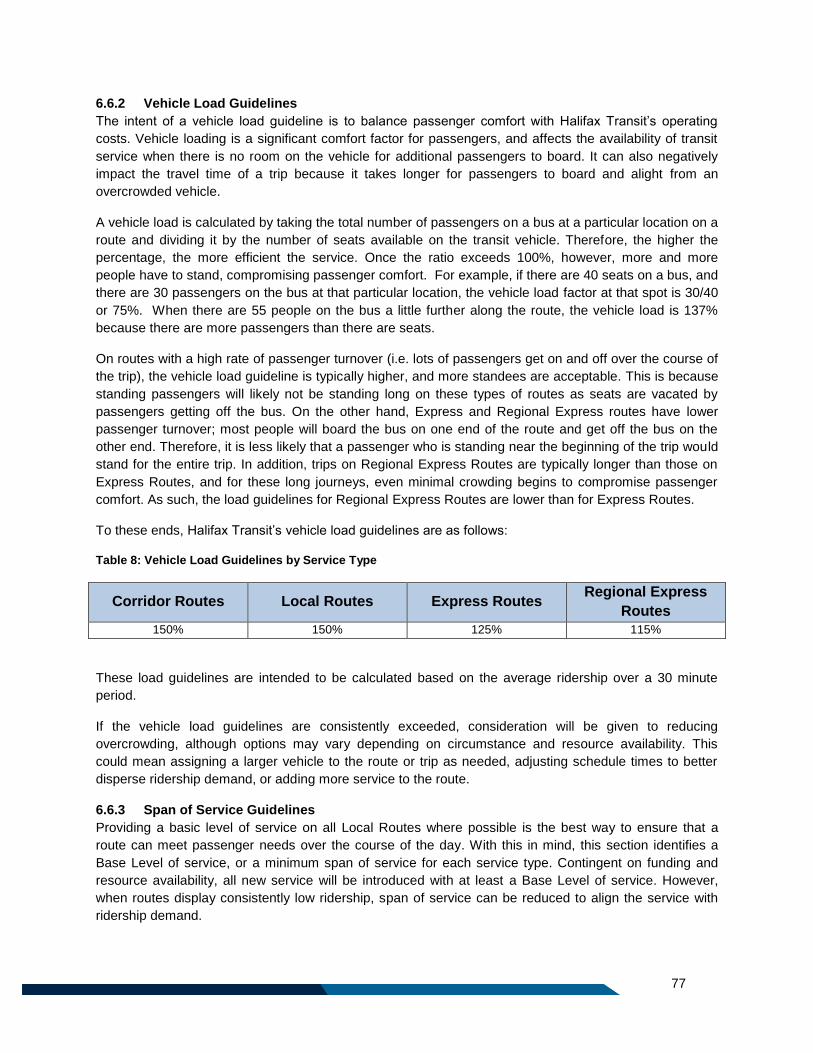
77
6.6.2 Vehicle Load Guidelines
The intent of a vehicle load guideline is to balance passenger comfort with Halifax Transit’s operating
costs. Vehicle loading is a significant comfort factor for passengers, and affects the availability of transit
service when there is no room on the vehicle for additional passengers to board. It can also negatively
impact the travel time of a trip because it takes longer for passengers to board and alight from an
overcrowded vehicle.
A vehicle load is calculated by taking the total number of passengers on a bus at a particular location on a
route and dividing it by the number of seats available on the transit vehicle. Therefore, the higher the
percentage, the more efficient the service. Once the ratio exceeds 100%, however, more and more
people have to stand, compromising passenger comfort. For example, if there are 40 seats on a bus, and
there are 30 passengers on the bus at that particular location, the vehicle load factor at that spot is 30/40
or 75%. When there are 55 people on the bus a little further along the route, the vehicle load is 137%
because there are more passengers than there are seats.
On routes with a high rate of passenger turnover (i.e. lots of passengers get on and off over the course of
the trip), the vehicle load guideline is typically higher, and more standees are acceptable. This is because
standing passengers will likely not be standing long on these types of routes as seats are vacated by
passengers getting off the bus. On the other hand, Express and Regional Express routes have lower
passenger turnover; most people will board the bus on one end of the route and get off the bus on the
other end. Therefore, it is less likely that a passenger who is standing near the beginning of the trip would
stand for the entire trip. In addition, trips on Regional Express Routes are typically longer than those on
Express Routes, and for these long journeys, even minimal crowding begins to compromise passenger
comfort. As such, the load guidelines for Regional Express Routes are lower than for Express Routes.
To these ends, Halifax Transit’s vehicle load guidelines are as follows:
Table 8: Vehicle Load Guidelines by Service Type
Corridor Routes Local Routes Express Routes Regional Express
Routes
150% 150% 125% 115%
These load guidelines are intended to be calculated based on the average ridership over a 30 minute
period.
If the vehicle load guidelines are consistently exceeded, consideration will be given to reducing
overcrowding, although options may vary depending on circumstance and resource availability. This
could mean assigning a larger vehicle to the route or trip as needed, adjusting schedule times to better
disperse ridership demand, or adding more service to the route.
6.6.3 Span of Service Guidelines
Providing a basic level of service on all Local Routes where possible is the best way to ensure that a
route can meet passenger needs over the course of the day. With this in mind, this section identifies a
Base Level of service, or a minimum span of service for each service type. Contingent on funding and
resource availability, all new service will be introduced with at least a Base Level of service. However,
when routes display consistently low ridership, span of service can be reduced to align the service with
ridership demand.
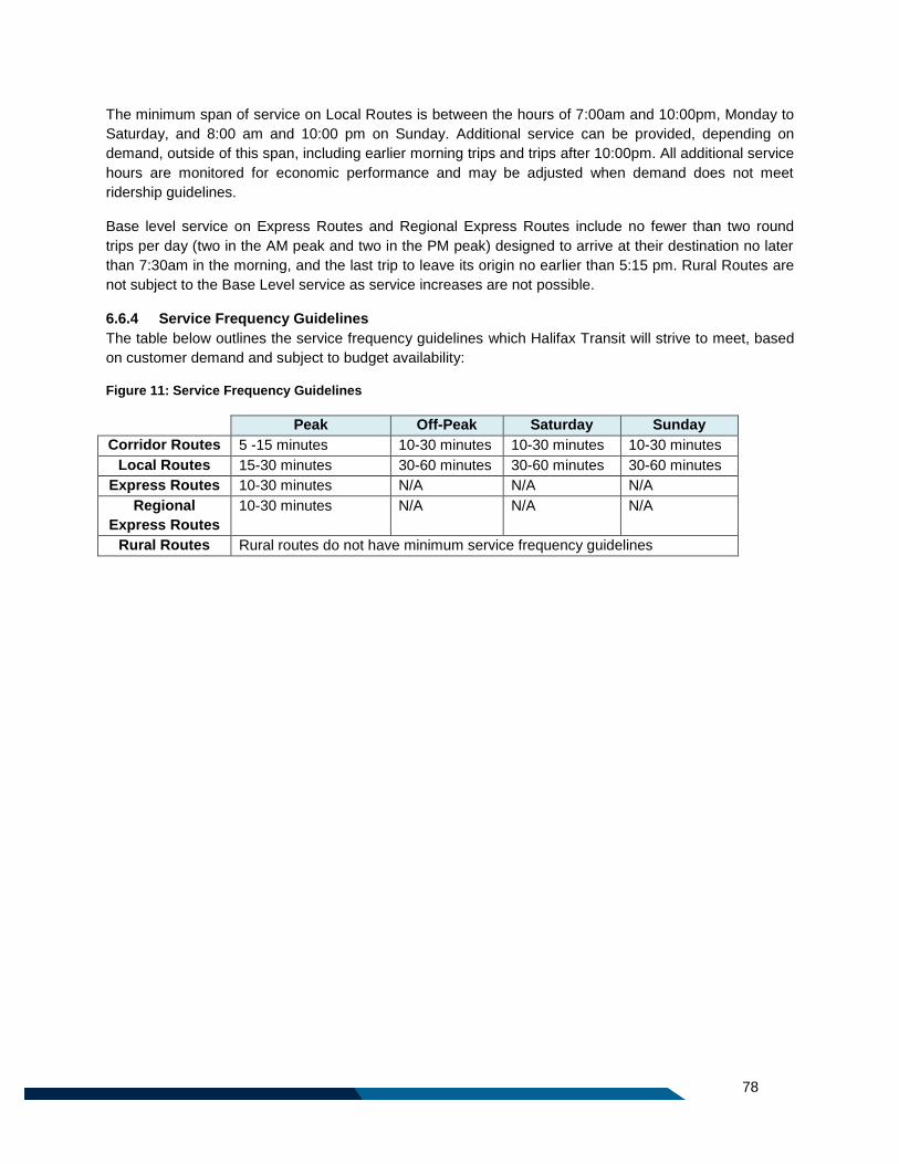
78
The minimum span of service on Local Routes is between the hours of 7:00am and 10:00pm, Monday to
Saturday, and 8:00 am and 10:00 pm on Sunday. Additional service can be provided, depending on
demand, outside of this span, including earlier morning trips and trips after 10:00pm. All additional service
hours are monitored for economic performance and may be adjusted when demand does not meet
ridership guidelines.
Base level service on Express Routes and Regional Express Routes include no fewer than two round
trips per day (two in the AM peak and two in the PM peak) designed to arrive at their destination no later
than 7:30am in the morning, and the last trip to leave its origin no earlier than 5:15 pm. Rural Routes are
not subject to the Base Level service as service increases are not possible.
6.6.4 Service Frequency Guidelines
The table below outlines the service frequency guidelines which Halifax Transit will strive to meet, based
on customer demand and subject to budget availability:
Figure 11: Service Frequency Guidelines
Peak Off-Peak Saturday Sunday
Corridor Routes 5 -15 minutes 10-30 minutes 10-30 minutes 10-30 minutes
Local Routes 15-30 minutes 30-60 minutes 30-60 minutes 30-60 minutes
Express Routes 10-30 minutes N/A N/A N/A
Regional
Express Routes
10-30 minutes N/A N/A N/A
Rural Routes Rural routes do not have minimum service frequency guidelines
79
Part 7: Transit Priority Measures

80
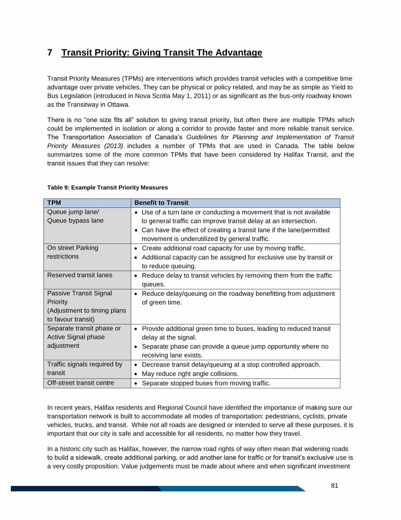
81
7 Transit Priority: Giving Transit The Advantage
Transit Priority Measures (TPMs) are interventions which provides transit vehicles with a competitive time
advantage over private vehicles. They can be physical or policy related, and may be as simple as Yield to
Bus Legislation (introduced in Nova Scotia May 1, 2011) or as significant as the bus-only roadway known
as the Transitway in Ottawa.
There is no “one size fits all” solution to giving transit priority, but often there are multiple TPMs which
could be implemented in isolation or along a corridor to provide faster and more reliable transit service.
The Transportation Association of Canada’s Guidelines for Planning and Implementation of Transit
Priority Measures (2013) includes a number of TPMs that are used in Canada. The table below
summarizes some of the more common TPMs that have been considered by Halifax Transit, and the
transit issues that they can resolve:
Table 9: Example Transit Priority Measures
TPM Benefit to Transit
Queue jump lane/
Queue bypass lane
Use of a turn lane or conducting a movement that is not available
to general traffic can improve transit delay at an intersection.
Can have the effect of creating a transit lane if the lane/permitted
movement is underutilized by general traffic.
On street Parking
restrictions
Create additional road capacity for use by moving traffic.
Additional capacity can be assigned for exclusive use by transit or
to reduce queuing.
Reserved transit lanes Reduce delay to transit vehicles by removing them from the traffic
queues.
Passive Transit Signal
Priority
(Adjustment to timing plans
to favour transit)
Reduce delay/queuing on the roadway benefitting from adjustment
of green time.
Separate transit phase or
Active Signal phase
adjustment
Provide additional green time to buses, leading to reduced transit
delay at the signal.
Separate phase can provide a queue jump opportunity where no
receiving lane exists.
Traffic signals required by
transit
Decrease transit delay/queuing at a stop controlled approach.
May reduce right angle collisions.
Off-street transit centre Separate stopped buses from moving traffic.
In recent years, Halifax residents and Regional Council have identified the importance of making sure our
transportation network is built to accommodate all modes of transportation: pedestrians, cyclists, private
vehicles, trucks, and transit. While not all roads are designed or intended to serve all these purposes, it is
important that our city is safe and accessible for all residents, no matter how they travel.
In a historic city such as Halifax, however, the narrow road rights of way often mean that widening roads
to build a sidewalk, create additional parking, or add another lane for traffic or for transit’s exclusive use is
a very costly proposition. Value judgements must be made about where and when significant investment
82
in Transit Priority Measures makes sense. The following section describes Halifax Transit’s process for
identifying strong candidates for Transit Priority Measures.
7.1 Investing Where it Makes Sense The primary focus of any significant capital investment in Transit Priority Measures should be along the
ten Corridor Routes. Due to the high level of service on Corridor Routes, these are the areas where TPMs
can have the most significant impact. Secondly, roadways with a high through-put of buses will be
considered, and thirdly any opportunities or partnerships for TPMs which could be implemented relatively
easily will be considered.
7.1.1 Corridor Routes
Corridor Routes are areas where transit plays a significant role in moving large volumes of people and,
given the opportunity, could move more. As such, these will be the focus of TPM investment. Roadways
serviced by Corridor Routes have a high through-put of buses of all service types, all day, and seven
days a week. These roadways experience heavy traffic (particularly during peak hours), carry high
volumes of transit passengers, service a variety of destinations and land uses, and are generally well
served by pedestrian infrastructure. Transit Priority Measures in these locations will raise the profile of
transit service and make a statement to other road users that transit belongs here, and that transit is an
important investment to build the sustainability and health of our communities.
In these areas, Transit Priority Measures will be implemented together in a cohesive way along the length
of the corridor planned, in order to provide the best advantage possible. It is worthy of note, however, that
as Corridor Routes are located on busy, well-travelled roadways throughout Halifax, it is expected that the
implementation of TPMs in these locations could have a significant capital cost, and may have a
significant impact on traffic both while under construction and once they are in operation.
TPMs Requiring Significant Capital Investment
Although this plan does not include an exhaustive list of large scale TPMs which could greatly benefit the
Halifax Transit network, two critical areas have been identified which require significant investment in
TPMs in order for Corridor Routes to function properly over the life of this plan. These are:
1. A TPM is required on Bayers Road in order to ensure reliable service on Corridor Routes 1 and 8,
as well as a number of other routes. This is particularly important during PM peak, when routes
can often be delayed for nearly a half hour. If no TPMs are introduced to address this issue, it will
be an operational necessity to realign the routings. In the interim, Route 1 service will be required
to travel along Roslyn Street in the PM peak in the outbound direction in order to maintain
schedule adherence.
2. A TPM is required to ensure transit vehicles can move reliably through traffic on Gottingen Street.
This plan calls for increased service on Gottingen Street, including two way service on Route 1.
Due to the high volume of buses on Gottingen Street, the installation of a TPM that allows buses
to navigate through the congestion in a more consistent and predictable way would have a
significant impact on service quality and reliability.
In order to meet the customer service guidelines related to schedule adherence as outlined in this plan,
these TPMs are necessary.
83
7.1.2 Roadways with High Throughput of Buses
The second priority for investment will be areas where there is a high throughput of buses. This will help
move a high volume of transit vehicles and passengers through our busiest roadways quickly and
efficiently at all times of the day.
7.1.3 Opportunity Investment
The third priority for investment will be the opportunities which arise from work being undertaken by other
departments, or projects which might require very little capital investment but could have a significant
impact on transit’s reliability. Some examples of this type of project could be:
The removal of parking on one side of the street during afternoon peak hours;
Posting a sign to permit transit vehicles to make a movement which is typically not permitted (i.e.
“Right Turn Only Except Buses”).
7.2 Implementing TPMs: Getting Started The two locations listed above (Bayers Road and Gottingen Street) are considered the key priority areas
where TPMs can have the most significant and immediate positive impact on the transit network. As such,
Halifax Transit intends to explore potential alternatives for TPMs in these locations. Due to the complexity
and investment required, it is anticipated that it may take several years to design and implement the
appropriate measures.
However, a recent study identified 11 possible easily implementable TPMs and evaluated them using the
equations outlined in Appendix E. One of those listed (#8, Main Street at Hartlen Street) was
implemented in Fall 2015. Based on a number of factors including payback period and scheduled road
maintenance, a phased implementation strategy was developed for a five year period. The TPMs
examined by this study are included on the table in the following page.
It is anticipated that over the five year implementation of the Moving Forward Together Plan, these TPMs
will be designed and implemented as resources allow, pending detailed design and costing, and approval
from other regulatory bodies

84
.
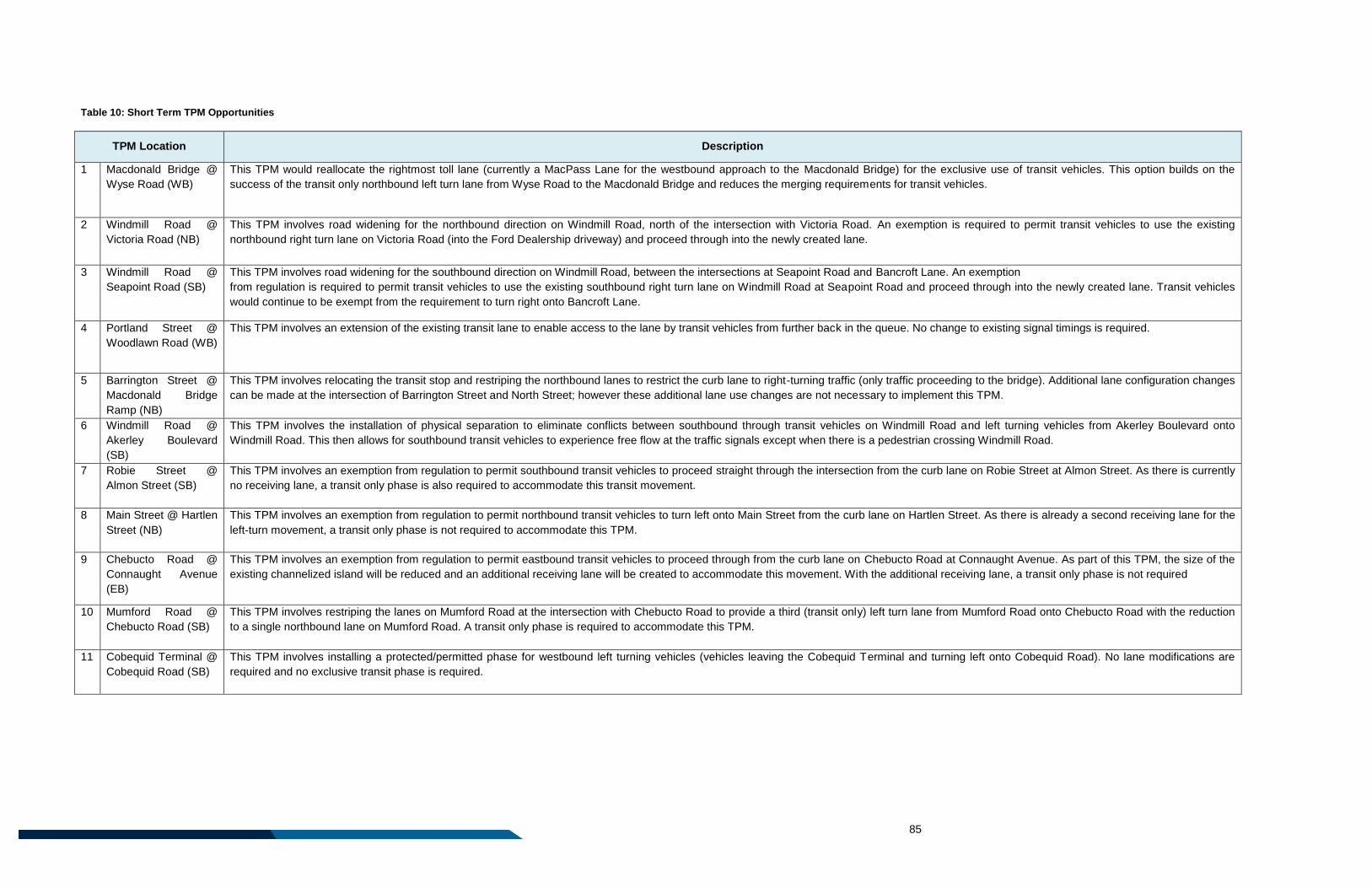
85
Table 10: Short Term TPM Opportunities
TPM Location Description
1 Macdonald Bridge @
Wyse Road (WB)
This TPM would reallocate the rightmost toll lane (currently a MacPass Lane for the westbound approach to the Macdonald Bridge) for the exclusive use of transit vehicles. This option builds on the
success of the transit only northbound left turn lane from Wyse Road to the Macdonald Bridge and reduces the merging requirements for transit vehicles.
2 Windmill Road @
Victoria Road (NB)
This TPM involves road widening for the northbound direction on Windmill Road, north of the intersection with Victoria Road. An exemption is required to permit transit vehicles to use the existing
northbound right turn lane on Victoria Road (into the Ford Dealership driveway) and proceed through into the newly created lane.
3 Windmill Road @
Seapoint Road (SB)
This TPM involves road widening for the southbound direction on Windmill Road, between the intersections at Seapoint Road and Bancroft Lane. An exemption
from regulation is required to permit transit vehicles to use the existing southbound right turn lane on Windmill Road at Seapoint Road and proceed through into the newly created lane. Transit vehicles
would continue to be exempt from the requirement to turn right onto Bancroft Lane.
4 Portland Street @
Woodlawn Road (WB)
This TPM involves an extension of the existing transit lane to enable access to the lane by transit vehicles from further back in the queue. No change to existing signal timings is required.
5 Barrington Street @
Macdonald Bridge
Ramp (NB)
This TPM involves relocating the transit stop and restriping the northbound lanes to restrict the curb lane to right-turning traffic (only traffic proceeding to the bridge). Additional lane configuration changes
can be made at the intersection of Barrington Street and North Street; however these additional lane use changes are not necessary to implement this TPM.
6 Windmill Road @
Akerley Boulevard
(SB)
This TPM involves the installation of physical separation to eliminate conflicts between southbound through transit vehicles on Windmill Road and left turning vehicles from Akerley Boulevard onto
Windmill Road. This then allows for southbound transit vehicles to experience free flow at the traffic signals except when there is a pedestrian crossing Windmill Road.
7 Robie Street @
Almon Street (SB)
This TPM involves an exemption from regulation to permit southbound transit vehicles to proceed straight through the intersection from the curb lane on Robie Street at Almon Street. As there is currently
no receiving lane, a transit only phase is also required to accommodate this transit movement.
8 Main Street @ Hartlen
Street (NB)
This TPM involves an exemption from regulation to permit northbound transit vehicles to turn left onto Main Street from the curb lane on Hartlen Street. As there is already a second receiving lane for the
left-turn movement, a transit only phase is not required to accommodate this TPM.
9 Chebucto Road @
Connaught Avenue
(EB)
This TPM involves an exemption from regulation to permit eastbound transit vehicles to proceed through from the curb lane on Chebucto Road at Connaught Avenue. As part of this TPM, the size of the
existing channelized island will be reduced and an additional receiving lane will be created to accommodate this movement. With the additional receiving lane, a transit only phase is not required
10 Mumford Road @
Chebucto Road (SB)
This TPM involves restriping the lanes on Mumford Road at the intersection with Chebucto Road to provide a third (transit only) left turn lane from Mumford Road onto Chebucto Road with the reduction
to a single northbound lane on Mumford Road. A transit only phase is required to accommodate this TPM.
11 Cobequid Terminal @
Cobequid Road (SB)
This TPM involves installing a protected/permitted phase for westbound left turning vehicles (vehicles leaving the Cobequid Terminal and turning left onto Cobequid Road). No lane modifications are
required and no exclusive transit phase is required.
86
7.3 Developing a Long Term Strategy While it is important to analyze the impact of an individual Transit Priority Measure on the adjacent
transportation network and road users, it is just as important to consider the cumulative impact of a
number of Transit Priority Measures when applied in one particular corridor.
For example, on Windmill Road in Dartmouth, the impact of the series of TPMs is more than the sum of
each measure’s savings. While each intervention seems small on its own – a queue jump lane or transit
signal priority – over the course of the corridor, buses save many minutes each day by getting around
traffic. When taken together, implementation of Transit Priority Measures across a corridor can have an
impact more than the sum of its parts, moving transit vehicles more efficiently and getting passengers to
their destination faster and more reliably.
Implementing a series of TPMs along a Transit Priority Way also does more than provide a competitive
advantage to transit vehicles. It raises the profile of transit service and creates a positive feedback loop:
when passengers or drivers of private vehicles see transit vehicles skipping past traffic snarls using
TPMs, they may be encouraged to take the bus in the future, boosting ridership and building the case for
further investment in more TPMs.
In addition to the list of TPMs summarized in the table on the preceding pages, it is important that a
comprehensive inventory of possible TPMs is compiled and evaluated. From this inventory a cohesive
implementation strategy for Transit Priority Ways will be created.
Transit Priority Ways along Corridor Routes can be the first step towards Bus Rapid Transit (BRT) in
Halifax. The potential for introducing higher order transit, including BRT, rail, or new ferry routes, was not
explored as part of this plan, but will be investigated as part of the Integrated Mobility Plan. It is
anticipated that the outcomes of the Integrated Mobility Plan will help to inform and guide investment in
TPMs in the long term future.

87

88
Part 8: Implementation

89
90
8 Plan Implementation
The Moving Forward Together Plan is intended to guide Halifax Transit service improvements for the next
20 years or more. In the short term, implementation of the Plan will be focused on reconfiguring the
existing route network to adopt the proposed redesigned network. This will take place over approximately
five years, in phases based loosely on geographic areas. In the longer term, implementation of the Plan
will consist of balancing investments in service quality and reliability with the introduction of new services,
both in developing areas, and within the existing network.
8.1 Annual Service Plans
The implementation of service changes proposed in this plan will be solidified and approved through the
preparation of Halifax Transit’s Annual Service Plans, coinciding with annual budget approval.
An Annual Service Plan is a one year action plan which identifies detailed route and service changes for
the forthcoming fiscal year and is developed consistent with the Moving Forward Together Plan. In the
development of Annual Service Plans, proposals for service changes are reviewed and prioritized.
Annual Service Plans also incorporate the results of several on-going activities, including:
Regular route assessments based on performance measures and including feedback from
employees and consideration of operational issues;
Review and evaluation of customer requests for new and/or changes to existing services; and
The effect of external influences such as land-use changes, development proposals and ridership
changes.
8.2 Five Year Plan Reviews To ensure that the Moving Forward Together Plan remains current and reflective of the existing needs of
Halifax residents, this Plan will be subject to a high level review approximately every five years, with the
first review beginning five years after the adoption of the Plan. This review will examine routings, service
levels, and other guidelines outlined in this document. The scope of this review will not include changes to
the Moving Forward Principles which are at the core of this plan.
In addition, should there be substantial changes to the transportation network that were not anticipated in
this Plan, a review should occur that is reflective of the scale of the change.
8.3 Routing Variability Images and maps in the Moving Forward Together Plan are for illustrative purposes, to demonstrate the
purpose of routes and connectivity. Proposed routing is subject to change during detailed implementation.
Minor modifications to routes based on operational needs, demand, or integration with land uses are
anticipated. More substantial modifications are not anticipated but may be necessary to accommodate a
significant change to the transportation network or change of circumstances, and will be outlined in each
year’s Annual Service Plan.
91
8.4 Stage I – Implementing the Network In keeping with Moving Forward Principle 3: Invest in Service Quality and Reliability, it is important that
the implementation of the new network is informed by data provided by Automatic Vehicle Location (AVL)
and Automatic Passenger Counter (APC) units. It is critical that as the plan is implemented, the
appropriate level of resources are allocated to ensure schedule reliability and the provision of quality
transit service to users. With that in mind, the implementation stages outlined here start with relatively
smaller changes to the network, before moving on to larger changes further out in the implementation
timeline, at which point significant data will have been collected to inform route and schedule changes.
The following represents a proposed schedule for the phased implementation of the Moving Forward
Together Plan, contingent on resource availability, and subject to change.
Fiscal Year 2016/2017: The first phase of implementation for the Moving Forward Together Plan
will be undertaken. As this year will also see the introduction of significant technology
advancements, including the launch of real time public interface delivery and stop
announcements, the resultant routing changes are necessarily minor to accommodate the staff
and resource availability. These changes include:
An additional trips on the Route 330 Tantallon; and
Changes to Route 56, discontinuing service to Portland Hills Terminal and
introducing a new connection to Bridge Terminal.
Fiscal Year 2017/2018: The second phase of implementation for the Moving Forward Together
Plan will be undertaken. This will also primarily include smaller changes, and will potentially
include the elimination and realignment of low ridership routes/route segments (Routes 402,
School Specials), the introduction of some additional express service (Route 186, 330), and
changes to several routes (Routes 6, 22, 7, 370).
Fiscal Year 2018/2019: The third phase of implementation for the Moving Forward Together Plan
will be undertaken. This will primarily include changes to routes in Clayton Park, Fairview,
Bedford, and Timberlea. This phase coincides with the expansion of the Burnside Transit Centre.
Fiscal Year 2019/2020: The fourth phase of implementation for the Moving Forward Together
Plan will be undertaken. This will primarily include implementation in Spryfield and parts of the
Halifax Peninsula.
Fiscal Year 2020/2021: The last phase of adopting the new transit network will be undertaken.
This will primarily include the implementation of routes in Sackville and Bedford. It also includes
the introduction of the Wrights Cove Terminal, West Bedford Park & Ride and the Margeson
Drive/Middle Sackville Park & Ride. It will also include the implementation of routes in Dartmouth,
Eastern Passage, and Cole Harbour.
92
External Factors
There are a number of factors external to the Moving Forward Together Plan which impact the timing and
phasing of network implementation. These include:
1. The Halifax Transit Technology Plan: This plan will see the installation of new Automatic
Vehicle Location/Computer Aided Dispatch units on all Halifax Transit vehicles in 2016. These
new AVL/CAD units will provide Halifax Transit staff with detailed information on ridership and
running times of routes over the course of the day. This data will inform the development and
refinement of schedules for routes adopted under the Moving Forward Together Plan.
2. The Big Lift: This project is being undertaken by Halifax Harbour Bridges to extend the life of the
Macdonald Bridge by replacing the bridge decking. This project includes continuous overnight
closures on the Macdonald Bridge, beginning March 1, 2015, and taking place five nights a week.
For the duration of the bridge redecking project, significant resources will be invested by Halifax
Transit to provide passengers travelling across the harbour with as seamless a trip as possible.
Modifications to routes that are to travel over the Macdonald Bridge in the evenings and are
impacted by The Big Lift will not occur until after the completion of this project, anticipated for
2017.
3. Wrights Cove Terminal Construction: A number of routes proposed as part of the Moving
Forward Together Plan rely on the existence of a transit terminal adjacent to the Burnside
Business Park. Changes to the proposed timeline for the construction of this terminal may impact
the implementation of the Plan.
4. Resource Availability: The implementation of the Moving Forward Together Plan requires
additional resources. Any reductions in anticipated funding levels could have a significant
detrimental impact on the ability of Halifax Transit to roll out this plan in the timeline described
above. As the plan relies on Regional Council approved budgets to proceed, annual budget
approval from Regional Council will steer the implementation of the plan.
93
8.5 Stage II – Expansion of the Network During the second stage of implementation, tentatively beginning in 2021, resources must be balanced
between re-investment in existing routes as needed to maintain the quality and reliability of the service,
and the introduction of new services. It is possible that, during Stage II, new and developing areas could
see new transit routes, and existing areas could see the introduction of new routes or services. Details
related to the potential service expansion described below will be detailed in the Five Year Review which
will take place upon the completion of Stage I implementation.
Building Frequency on Corridor Routes: Where resources are available to improve service frequency,
it is the intention of this plan that resources will be focused on increasing service on Corridor Routes first,
with the ultimate goal of providing a minimum of 15 minute headways on all Corridor Routes during the
service day, subject to ridership demand.
Service in Developing Areas: There are a number of growing and developing areas that may be
candidates for Halifax Transit service in the future, following the adoption of the redesigned transit
network. Transit service in these areas would be designed in alignment with the four Moving Forward
Principles, and subject to resource and road infrastructure availability.
Areas that are developing, or scheduled for further development, that were considered as part of this Plan
as potential candidates for future transit service include: Port Wallace, Regency Park Drive, Long Lake
Village, Brunello Estates, Seton Ridge, Bedford South (Moirs Mill/Nine Mile Drive), Millwood (currently
undeveloped portions), and Bayers Lake and Burnside Business Park expansions.
Future Express Routes – There are some areas that were identified in the preparation of this plan that
are considered potential candidates for future Express Routes. These areas could include:
Williams Lake Road to Downtown Halifax;
Washmill Lake Drive to Downtown Halifax;
Montebello to Downtown Halifax;
Sackville to Burnside;
North End Halifax to Burnside; and
Cole Harbour to Burnside.

A1
Appendix A: Network Maps

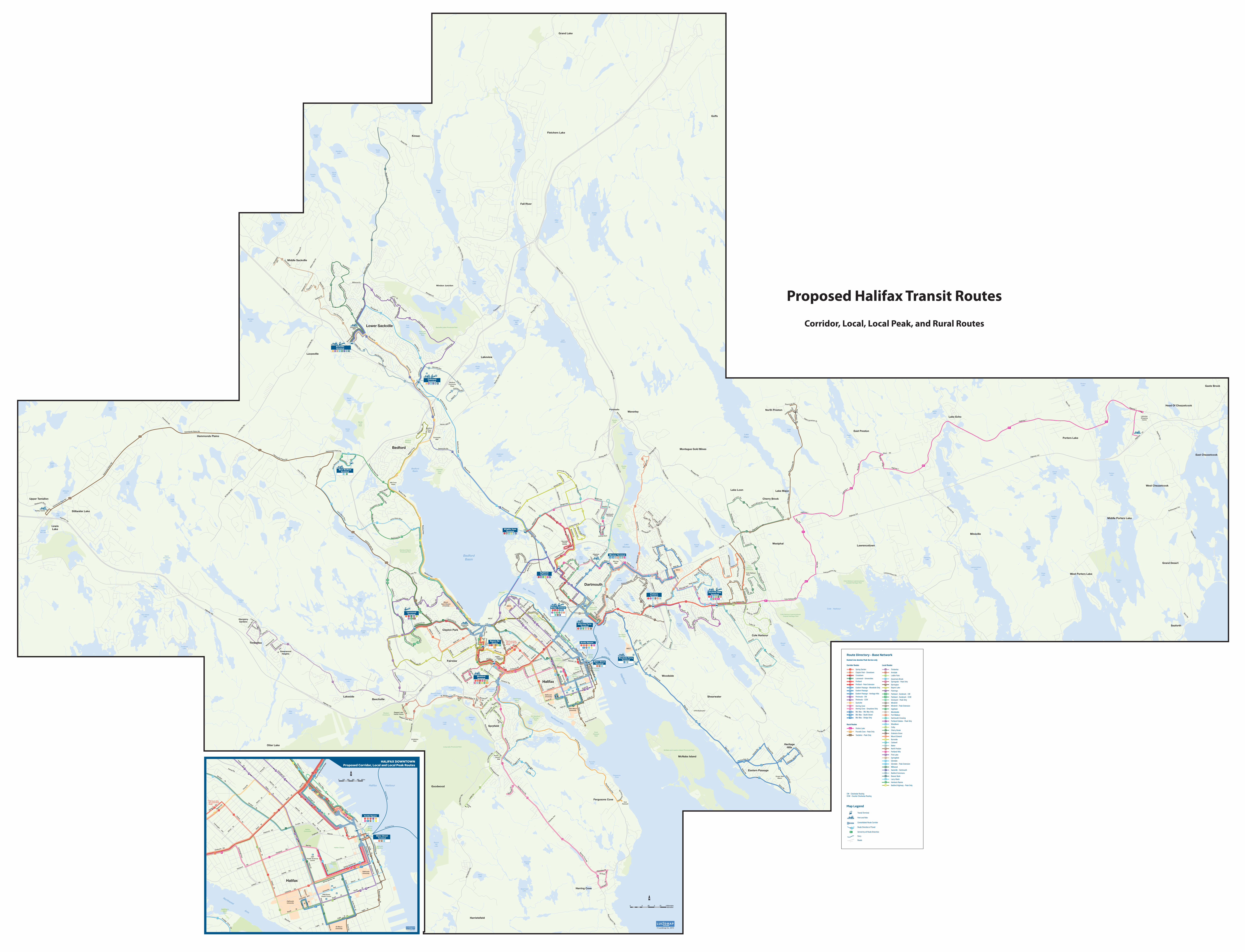
*PM Rush Only No Local Stops Made
*
1 4 859 84
1 5 9810 84
15
710
50
25
1029
50
9384
50
35
10
1
2
2
2
3
3
34
4
4
48
91
93 939190 9032 328
1 3
51
51
53
53
55
55
62 87
87
6254
2 90
53 64 72 87
1 2 5 9+884
84
67
575 58 6362 67
323
5
5
32 50 54
56
29
29
93
54 55 56
56
72
8 82 83 84 85 87
8 82 84 87 88 89
8988
2 4 21 3143334+
1 2 9+ 242225
2 298
91
91
31
31
3
3
3
2926
57 59 6168 72 401
5 5865
63
LacewoodTerminal
HighfieldTerminal
643
Wrights CoveTerminal
67
32
6+
6+
6+
10+
10+
10A 10B
7+
West BedfordTerminal
90 91
415
415
Bayers RdCentre
Halifax Harbour
ChocolateLake
BedfordBasin
BedfordBasin
AlbroLake
Martin’sLake
LakeMicmac
Cole Harbour
WilliamsLake
SpruceHill
Lake
FrogPond
WithrodLake
LongLake
First ChainLake
Second ChainLake
MaynardLake
LakeBanook
Oat Hill Lake
RussellLake
TopsailLake
LoonLake
LakeCharles
MorrisLake
BissettLake
CoxLake
PatientRossLake
LongLake
FrasersLake
SusiesLake
GovernorLake
OtterLake
QuarryLake
KearneyLake
RaggedLake
SandyLake
MarshLake
McCabeLake
TomahawkLake
FlatLake
FlatLake
SheldrakeLake
UpperSheldrake
Lake
Five IslandLake
Hubley BigLake
FrederickLake
HubleyMill Lake
StillwaterLake
TaylorLake
EchoLake
MartinLake
EagleLake
LongLake
PortersLake
PortersLake
CaribouLake
GrandLake
SnowLake
GooseLake
GammonLake
LawrencetownLake
PortersLake
LakeMajor
SoldierLake
FletchersLake
KinsacLake
LakeWilliam
RockyLake
AndersonLake
PowderMill
Lake
SecondLake
FirstLake
ThirdLake
EastLake
LakeThomas
MillerLake
HamiltonLake
TuckerLake
BeaverbankLake
SpringfieldLake
FenertyLake
HorseShoeLake
SquareLake
Northwest Arm
The Narrows
Purcell’sCove
FergusonsCove
GovernorsLake
DonovanPond
HenryLake
HalifaxCommons
HalifaxCitadel
WoodsideArea Park
DartmouthCommons
ShubiePark
ShubiePark
ShubiePark
ColeHarbour
Commons
Cole Harbour-Lawrencetown Coastal Heritage Park
Cole Harbour-Lawrencetown Coastal Heritage Park
FortNeedhamMemorial Park
PointPleasant
Park
Sir SandfordFleming
Park
WesternCommons
Long Lake Provincial Park
McNabs and Lawlors Island Provincial Park
MainlandCommons
Hemlock RavineProvincial Park
AdmiralsCovePark
SandyLakePark
Sackville Lakes Provincial Park
PublicGardens
First LakeRegional
Park
Africville
DeadmansIslandPark
BedfordBarrens
SackvilleLanding
NathanGreenSquare
Water StreetTerminal
Bridge Terminal
Alderney FerryTerminal
Woodside FerryTerminal
MumfordTerminal
Portland HillsTerminalPenhorn
Terminal
Micmac Terminal
CobequidTerminal
SackvilleTerminal
Scotia Square
Cogswell St
Mount
Hope Ave
Acad
ia St
Gaston Rd
Portland
St
Pleasant St
Pleasant S
t
Irvin
g
St
Peddars Way
Valour Way
Barrington St
Duffu
s StVe
stry
St
Leed
s
Kencrest
Nor
th R
idge
Rd
Ave
St
Robie St
Robie St
Agricola St
Agricola St
Sum
mer S
t
Robie S
t
Robie S
t
Tower R
d
Point Pleasant Dr
South P
ark St
Novalea Dr
Gottingen St
Gottingen St
Bell Rd
Windsor St
Oxford St
Connaught A
ve
Oxford S
tBeaufort Ave
Chebucto Rd
Quinpool Rd
North S
t
Almon
St
Bayers Rd
ScotSt
St
Titus
North S
t
Cornwall
is St
St Paul’sSt
Connaught Ave
Spring Garden Rd
Coburg Rd
Inglis St
South StMorris St
South St
Sackville St
George StDuke St
Rainnie Dr
Lower W
ater St
Hollis S
t
Barrington S
t
Brunsw
ick
Barrington
Ochte
rlone
y St
King St
Portland S
t
AlderneyDr
Alder
ney
Dr
Thist
leSt
Nantuck
e t A
ve
Wyse
Rd
Bolan
d Rd
Victoria Rd C
richt
on
Ave
Windmill Rd
St
Water St
Upper
Albem
arle
St
Sinc
lair
St
Hawthorne S
t
Devonshire Ave
St
Willett St
Dunbrack St
Bedford Hwy
Rosedale Ave
Main Ave
Willett St
Jose
ph
How
eD
rD
esm
ond
Ave
St. Margarets Bay Rd
Brentwood
Maplewood Dr
Cha
rles
Rd
Ave
Eisener
St
Lacewood Dr
Bedford Hwy
Farnham Gate Rd
Knightsr
idg
e
Dr
Thomas Raddall Dr
Re
gency Park Dr
Parkland D
r
Parkland D
r
Starboard Dr
Larry Uteck Blvd
Starboard Dr
Blu
ewat
er R
d Gar
y M
artin
Dr
Innovation
D
r
Ham
monds Plains Rd
Hammonds Plains Rd
Hammonds Plains Rd
Hammonds Plains Rd
Hamm
onds
Pla
ins
Rd
James St
Richard St
Fraser Rd
Forestglen Dr
Bea
ver B
ank
Rd
Glendale Dr
Glendale Dr
First Lake Dr
Co
be
qui
d R
d
Cobequid R
d
Glendale Ave
Met
ropo
litan
Ave
Nappan Dr
Nictaux Dr
Nordic Cres
Stokil Dr
Millwood Dr
Mill
wo
od
Dr
Sackville Dr
Sackville D
r
Beave
rban
k C
on
n
Sackville Dr
Sackville Dr
Rocky Lake Dr
Dartmouth Rd
Joseph Howe Dr
Rd
Quinpool
Gle
nmor
e
RdAv
Osb
orne
St
StK
elly
Rd
L akel
ands
Blv
d
Horseshoe Lake Dr
Hebridean Dr
Lancast er
Dr
St Pauls A
ve
Gle
be
St
Bayer
s Rd
Roslyn
Rd
Pro
spec
t R
d
Ridge Valley Rd
HighfieldSt
Dentith Rd
Old
Sam
bro R
d
Old
Sam
bro
Rd
Leib
lin D
r
Rockingstone Rd
Greyst o
ne D
r
Herring C
ove Rd
Herring Cove Rd
Ferg
uson
s C
ove
Rd
Purcells Cove Rd
Purcells Cove R
d
Purcells Co
ve Rd
Her
ring
Cov
e R
d
Cowie
Hill
Rd
Heritage H
ills D
r
Samuel D
anial Dr
Cow Bay Rd
Cow Bay Rd
Horne
s Rd
Caldw
ell Rd
Caldwell R
d
Shore Rd
Shore Rd
Cow Bay R
d
Franklyn St
Ever
ette
St
Pleasant St
Main Rd
Main Rd
Sherwood St
Brook
field
Ave
Caldwell R
d
Caldwell R
d
Astral Dr
Astral Dr
Colby Dr
Colby Dr
Colby D
r
Cum
berla
ndD
r
Portland Hills Dr
Portla
nd H
ills Dr
Po
rtla
ndRussell Lake
Dr
Eisener Blvd
Forest Hills P
ky
Merrima
c Dr
Arklow D
r
A rklow Dr
John Stew
art Dr
Pop
lar Dr
Circassion Dr
Auburn Dr
Auburn
D
r
Dorot
he
a Dr
Lucien Dr
Topsail Blvd
Plaza D
r
Belle Vista Dr
W
indward Ave
Ellenvale Ave Spring
Ave
Ashgrove
Av e
Cherry Brook Rd
Cherry Brook Rd
Lake
Loon Rd
Bro
oks
Dr
Highway 107
Lake
Maj
or
Rd
North
Pre
ston
Rd
No
rth Presto
n Rd
Johnson Rd
Clar
ence S
t
Cain St
Simmonds Rd
Upper Governor St
Hillsb
oro Dr
Montague R
d
Gregory Dr
Cranb
erry Cres
Moun
t Edward Rd
Fly
ing
Clo
ud
Dr
Forest Hills P
ky
G loria McCluskey Ave
Colford Ave
Joseph Zatzman D
r
Mosher Dr
Fielding Ave
Akerley Blvd
Wright Ave
Commodore Dr
Aker
ley
Blvd
Wrig
ht A
ve
Wright Ave
MacDonald Ave
Ilsley Ave
Ilsley Ave
Burnside D
rB
rownlow
Ave
Eileen S
tubbs Ave
Finl
ay D
r
Shubie Dr
Finnian Row
Gal
e Te
rr
Lam
o nt Terr
Cou
ntry
view
Dr
Com
m
odore Dr
Waverley Rd
Wav
erle
y R
d
Waverley R
d
Caled
onia R
d
Avenue d
u Po
rtage
Montebello D
r
C
olonnaPl
Appian WayLexington A
ve
Dumbarton Ave
Kincardine D
r
Inverary Dr
Strath
La
Raymoor Dr
Kennedy Dr
Booth St
Main St
Weyburn R
d
Woodlaw
n Rd
Princess Margaret Blvd
Wyse Rd
Albro
Lake
Rd
Albro
Lak
e Rd
Woo
dlan
d Ave
Cric
hton
Ave
Prince Albert Rd
Somer
set S
t
Penhorn DrBeaco
nSt
Harris Rd
Cry
stal Dr Leaman Dr
Sea King
Dr
Mic
m
ac Blvd
Woo
dlan
d
Highfield Park Dr
Pinecrest Dr
Primro
se
S
tVictoria
Rd
Bea
ver B
ank
Rd
Beaver B
ank Rd
Beaver B
ank Rd
Sackville Dr
Sprin
gfie
ldAv
e
Highway 101
Damascus Rd
Bedford By-Pass
Bed
ford
By-P
ass
Bedfo
rd H
wy
Bedford Hwy
Bed
ford H
wy
Bedford
Hw
y
Larry Uteck Blvd
Larry Uteck Blvd
Kearney Lake Rd
Kearney Lake Rd
Dunb
rack St
Dunbrack St
Lacewood Dr
Chain L
ake Dr
Lacewood Dr
Mumford
Lady
HammondRd
Baf
fin B
lvd
Baker D
r
Bak
er D
r
Lanca
ster Dr
M
ontague Rd
Forest Hills Ext
Forest Hills Ext
Fore
st H
ills
Ext
St Geo
rge
Blvd
Highway 118
Highw
ay 118
Highw
ay 118
Akerley Blvd
Roc
ky L
ake
Dr
Rocky La
ke
Dr
Cobequid Rd
Windgate Dr
Windsor Junctio
n Rd
Luca
sville
Rd
Luca
svill
e R
d
Highway 101
Highw
ay 1
03
Highway 103
Old
Sam
bro
Rd
W
illiams Lake Rd
North W
est Arm Dr
North West Arm
Dr
Washmill Lake Dr
Highway 103
Caldwell R
d
Hines Rd
Herring Cove R
d
Bissett Rd
Cole Harbour Rd
Cole Harbour Rd
Ro
ss Rd
Ross Rd
Lawrencetown RdLawrencetown Rd
Upper G
overnor St
Kinsac Rd
Rose
mar
y D
r
Wils
on L
ake
Dr
Ave
Est
ates
Blv
d W
Main St
Burnsid
e Dr
John Savage Ave
Windm
ill Rd
Windmill Rd
Victoria Rd
Windm
ill Rd
Highway 7
Highway 7
Hig
hway 7
Highway 7
JuniperCr
Highw
ay 111
Highway 111
Highw
ay 1
11
Grassy Lake D
r
Duke St
Polara Dr
Dutch V
illage
R
d
Chebucto Rd
Foth
erby A
ve
Bra
emar
Dr
Hartlen S
t
Wild
wo
od
Blvd
Killkee
Gate
Inglis St
Stoneh aven
Ragged Lake Blvd
Mon
tagu
e Rd
Flamingo
Dr
Bra
emar
Dr
Breeze Dr
Hammonds Plains Rd
Westwood Blvd
Highway 103
Pockwock Rd
Highway 7
Highw
ay 207Highway
107
Myra Rd
Highway 7
Up
per
P
artr
idge
River Rd
Highw
ay 207
Back Rd
Bellefontaine Rd
Highway 107
Mineville Rd
Ketch H
arbour Rd
East Lawrencetown
Lower Three Fathom Harbour
South Uniacke
Lower East Chezzetcoo
Three Fathom Harbour
Upper Sackville
Porters Lake
Conrod Settlement
Herring Cove
Musquodoboit Harbour
South Uniacke
YorkRedoubt
NSCC
MountSaint Vincent
University
Hubley Centre
Ocean ViewManor
Lier Rg
Pinegrove Dr
Theaksto
n Av
e
Alabaster Way
Royal Masts W
ay
Moirs Mill Rd
Oceanview Dr
Nine M
ile Dr
Amin St
Notti
ngham
S
t
Old Sackville Rd
Walker Ave
Verd
i Dr
Melham Dr
Old Sackville Rd
Hanwel
l Dr
Mar
geso
n D
r
Rossing Dr
Jackladder D
r
Beaver Bank Cro
ss Rd
Mou
ntai
n Rd
Tamarack D
r
Margaret Rd
Albert Walker Dr
W alterHavillDr
Downs Ave
Springvale Ave
Milsom
St
Winter
St
9A
1
11
1
1
2
2
2
22
3
3
3
3
3
3
3
3
3232
3232
29
4
4
7A7B
7A7B
7A 7B
7A7B
24 24
8
90
2929
29
84
84
9+
9+
21
9393
93
8
9034A
34A
88
4
31
31
31
31
25
433
91
63
63
56
50
50
32
5
5
72
5153
72
90
4
4
5
5
62
62
62
62
90
90
51
51 53
53
9+
9B
9+
25
25
25
24
24
68
68
68
68
68
68
61
61
61
61
61
61
57
57
65
65
65
59 59
83
82
82
84
84
85
85
8
8
24
2222
22
90
8
90
90
90
433
8
433
8
89
89
89
88
88
88
88
82
83
83
84
58
58
58
72
7254
55
401
401
401
401
401
401
401
9+
24
21
93
890
21
34A
34B
34B
34B
433
21
8
64
64
72
56
56
56
56
55
55
54
54
51
87
84
72
54
54
55
55
87
87
87
87
72
87
10B
10B
10B
87
64
64
64
72
72
21
84
59
22
24
22
84
84
87
433
433
91
91
91
91
91
91
91
91
93
93
32
67
67
67
67
67
63
6+
6C6B
6C
6C
6C 6C
6C
6B
6B
6B
6B
6B
63
29
2910+
10+
10A
10B
26
9A
9A
Woodside Ferry
Alderney Ferry
LewisLake
Fall River
Stillwater Lake
Fletchers LakeKinsac
Beaver Bank
Goffs
Windsor Junction
Grand Lake
Upper Tantallon
Lower Sackville
Middle Sackville
Upper Hammonds Plains
Hammonds Plains
DownsviewMall
ExhibitionPark
Westphal
Fergusons Cove
Mineville
Lakeview
Shearwater
West Porters Lake
Lawrencetown
Lake Echo
Middle Porters Lake
Halifax
Bedford
Gaetz Brook
East Chezzetcook
Goodwood
Cole Harbour
Lake Loon
Dartmouth
West Chezzetcook
Lucasville
Lake Major
Grand Desert
Montague Gold Mines
Beechville
Head Of Chezzetcook
Timberlea
GlengarryGardens
East Preston
McNabs Island
Otter Lake
Clayton Park
Cherry Brook
Fairview
Woodside
North Preston
Lakeside
Seaforth
Waverley
Saint Mary’sUniversity
DalhousieUniversity
Halifax Shopping Centre
SunnysideMall
Mill CovePlaza
BedfordPlaceMall
CentennialArena
Ragged LakeTransit Centre
Portobello
LakeviewShopping
Centre
Porters Lake
CFB Shearwater
BedfordCommons
Plaza
South Centre Mall
MaybankField
Eastern Passage
HeritageHills
Harrietsfield
Devils Island
GreenwoodHeights
Spryfield
Cow Bay
NSCC
NSCC
BurnsideTransitCentre
DartmouthCrossing
MicmacMall
Cole HarbourPlace
Hatchet Lake
Bayside
Hubley
Glen Margaret
NSCC
Proposed Halifax Transit Routes
Corridor, Local, Local Peak, and Rural Routes
Kilometrekilomètre
.5 0 .5 1.25 .75
34+
Route Directory - Base Network
Map Legend
Dashed Line denotes Peak Service only
Rural Routes
Corridor Routes Local Routes
58
Transit Terminal
Park and Ride
Consolidated Route Corridor
Route Direction of Travel
Served by all Route Branches
Ferry
Roads
Purcells Cove - Peak Only415
Tantallon - Peak Only433
Porters Lake401
24 Leiblin Park
67 Baker
29 Barrington
50 Dockyard - Peak Only
21 Timberlea
22 Armdale
53 Highfield
51 Windmill - Peak Extension
51 Windmill
55 Port Wallace
82 First Lake
83 Springfield
31 Bayers Lake
32 Flamingo
Parkland - Dunbrack - CCW
34A Parkland - Dunbrack - CW
84 Glendale - Peak Extension
84 Glendale
85 Millwood
56 Dartmouth Crossing
57 Portland Estates - Peak Only
58 Woodlawn
59 Colby
61 Cherry Brook
62 Grahams Grove
63 Mount Edward
65 Caldwell
68 North Preston
72 Portland Hills
87 Sackville - Dartmouth
88 Bedford Commons
89 Beaver Bank
90 Larry Uteck
64 Burnside
54 Montebello
Governors Brook25
Springvale - Peak Only26
Hemlock Ravine91
Bedford Highway - Peak Only93
CW - Clockwise RoutingCCW - Counter Clockwise Routing
1 Spring Garden
2 Clayton Park - Downtown
4 Lacewood - Universities
6A Eastern Passage - Woodside Only
Peninsula - CCW
7A Peninsula - CW
Herring Cove - Greystone OnlyHerring Cove
5 Portland
5 Portland - Peak Extension
8 Sackville
3 Crosstown
Mic Mac - Booth Street
10A Mic Mac - Mic Mac Only
Eastern Passage6B
Eastern Passage - Heritage Hills6C
9B
7B
10B
Mic Mac - Bridge Only10C
34B
9 10 84
9A
© Lucidmap Inc. 2015
Woodside Ferry
Alderney Ferry
1
1
1
1
1
1
1
2
2
2
2
3
3
4
7A
7B
7A
7B
7A7B
7A
7A
7B
7B
24
24
8
90
29
29
29
84
84
8484
9+
9+
93
93
8
50
50
50
5050
50
90
904
4
4
5
5
5
5
5
5
90
90
25
24
24
9+
8
29
29
10+
10+
10+
10+
10+
10+
8
8
9+
9+
29
*PM Rush Only No Local Stops Made
* 1
Water StreetTerminal
2 90
Scotia Square1 2 5
9+ 10+ 84
8
93
29
29
Cogswell S
t
Valour Way
Angu
s L
Mac
dona
ld B
ridge
Robie St
Robie St
Agricola St
Agricola St
Sum
mer S
t
Robie S
t
Robie S
t
Robie S
t
Tower R
d
South P
ark St
South P
ark St
Gottingen St
Gottingen St
North
Park St
Bell Rd
Windsor St
Windsor St
Oxford St
Oxford S
t
Oxford S
t
Beaufort
Ave
Chebucto Rd
Cunard St
Chebucto Rd
Quinpool Rd
Jubilee Rd
Jubilee Rd
Quinpool R
d
North
St
Almon
St
Almon
S
t
North
St
North
St
Cornwall
is
St
Connaught A
ve
Spring Garden Rd
Spring Garden Rd
Cobourg Rd
Inglis St
South St
South StMorris St
University Ave
University Ave
Seym
our St
Lemarchant
St
South St
South St
Inglis St
Inglis St
Sackville St
George StDuke S
tRainnieDr
Lower W
ater St
Hollis S
t
Hollis S
t
Barrington S
tB
arrington St
Barring
ton S
t
Barrington
Barrington St
St
Water St
Upper
Brunsw
ick St
Kempt Rd Youn
g St
Youn
g St
Bayers
Rd
Purcells Cove Rd
Connaught Ave
Roslyn
Rd
HalifaxCommons
Halifax Citadel
PublicGardens
DeadmansIslandPark
SackvilleLanding
NathanGreenSquare
Halifax Harbour
Northwest Arm
Halifax
St Mary’sUniversity
DalhousieUniversity
IWK/GraceHealth Centre
QEIIHealth Sciences
Centre
DalhousieUniversity
7+
HALIFAX DOWNTOWNProposed Corridor, Local and Local Peak Routes
© Lucidmap Inc. 2016
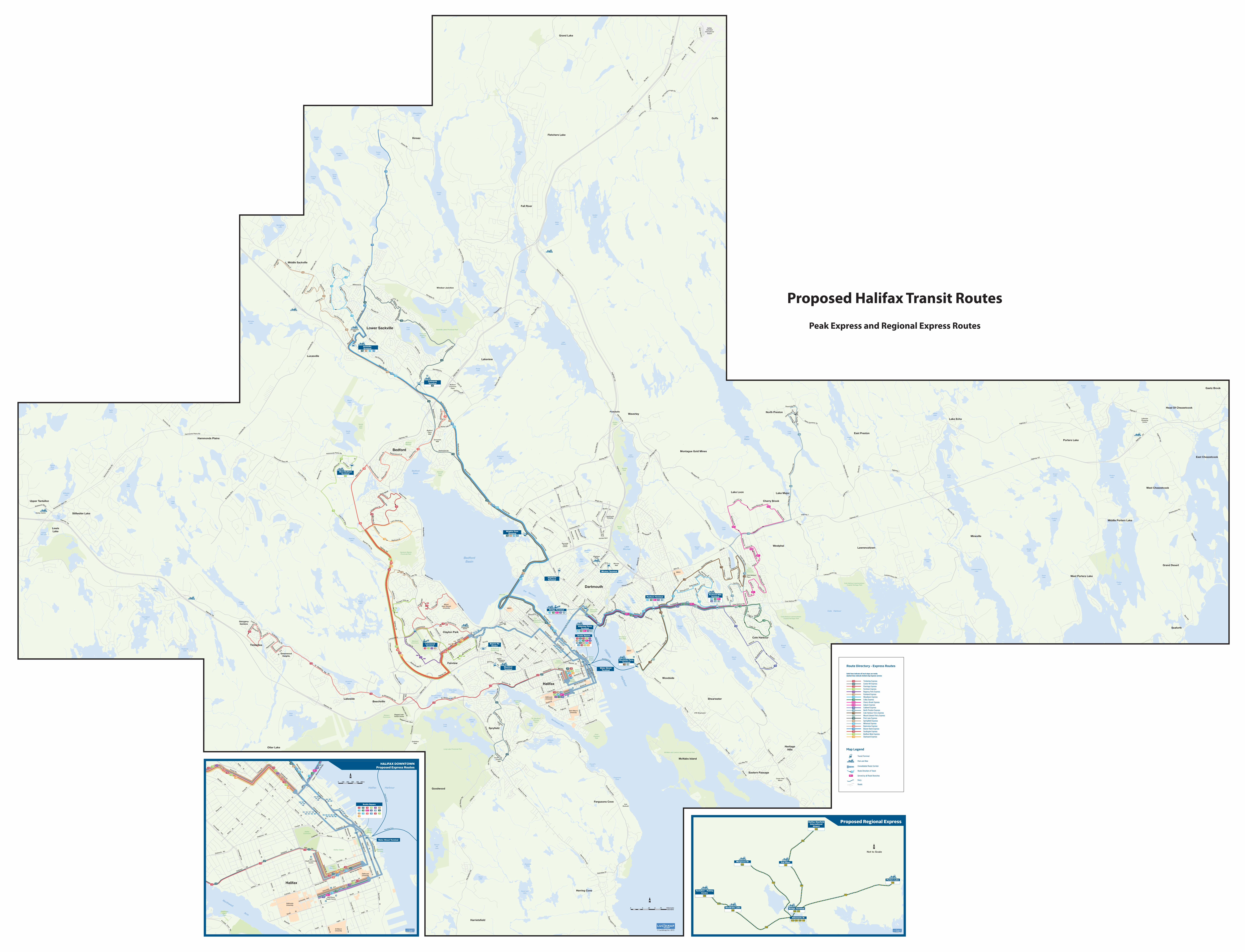
135
135
135
137
137
137
136
136138
138
138186
186
158
158
158
135136
137138
159
159
159
161
161
161
165
165
165
182183
168
168
186192
194196
185189
186192
192
192194194
194196 196196
SackvilleTerminal
183 185 189182
182
136135 138137
161+
179165159158168
161+
178 179
165159158 168
161+ 165159158 168
161+ 165159158168
161+ 165159158 168
123 135 136 137138
182 185 186189 192 194 196
Wrights CoveTerminal
Scotia Square
182 185 189183
194
West BedfordTerminal
Bridge Terminal
127
183
MaybankField
Halifax Harbour
ChocolateLake
BedfordBasin
BedfordBasin
AlbroLake
Martin’sLake
LakeMicmac
Cole Harbour
WilliamsLake
SpruceHill
Lake
FrogPond
WithrodLake
LongLake
First ChainLake
Second ChainLake
MaynardLake
LakeBanook
Oat Hill Lake
RussellLake
TopsailLake
LoonLake
LakeCharles
MorrisLake
BissettLake
CoxLake
PatientRossLake
LongLake
FrasersLake
SusiesLake
GovernorLake
OtterLake
QuarryLake
KearneyLake
RaggedLake
SandyLake
MarshLake
McCabeLake
TomahawkLake
FlatLake
FlatLake
SheldrakeLake
UpperSheldrake
Lake
Five IslandLake
Hubley BigLake
FrederickLake
HubleyMill Lake
StillwaterLake
TaylorLake
EchoLake
MartinLake
EagleLake
LongLake
PortersLake
PortersLake
CaribouLake
GrandLake
SnowLake
GooseLake
GammonLake
LawrencetownLake
PortersLake
LakeMajor
SoldierLake
FletchersLake
KinsacLake
LakeWilliam
RockyLake
AndersonLake
PowderMill
Lake
SecondLake
FirstLake
ThirdLake
EastLake
LakeThomas
MillerLake
HamiltonLake
TuckerLake
BeaverbankLake
SpringfieldLake
FenertyLake
HorseShoeLake
SquareLake
Northwest Arm
The Narrows
Purcell’sCove
FergusonsCove
GovernorsLake
DonovanPond
HenryLake
HalifaxCommons
HalifaxCitadel
WoodsideArea Park
DartmouthCommons
ShubiePark
ShubiePark
ShubiePark
ColeHarbour
Commons
Cole Harbour-Lawrencetown Coastal Heritage Park
Cole Harbour-Lawrencetown Coastal Heritage Park
FortNeedhamMemorial Park
PointPleasant
Park
Sir SandfordFleming
Park
WesternCommons
Long Lake Provincial Park
McNabs and Lawlors Island Provincial Park
MainlandCommons
Hemlock RavineProvincial Park
AdmiralsCovePark
SandyLakePark
Sackville Lakes Provincial Park
PublicGardens
First LakeRegional
Park
Africville
St AndrewsCentre Park
DeadmansIslandPark
BedfordBarrens
NathanGreenSquare
135136
137
138
159
Water StreetTerminal
Alderney FerryTerminal
Woodside FerryTerminal
Bayers RdCentre
MumfordTerminal
LacewoodTerminal
Portland HillsTerminalPenhorn Terminal
Micmac Terminal
HighfieldTerminal
CobequidTerminal
Cogswell St
Mount
Hope Ave
Gaston Rd
Portland St
Pleasant St
Pleasant S
t
Barrington St
Duffu
s St
Robie St
Robie St
Agricola St
Agricola St
Sum
mer S
t
Robie S
t
Robie S
t
Tower R
d
Point Pleasant Dr
South P
ark St
Novalea Dr
Gottingen St
Gottingen St
Bell Rd
Windsor St
Oxford St
Connaught A
ve
Oxford S
t
Beaufort Ave
Chebucto Rd
Quinpool Rd
Almon
St
Bayers Rd
Scot St
St
Titus
North S
t
Cornwall
is St
Connaught Ave
Spring Garden Rd
Coburg Rd
Inglis St
South St
Morris St
South St
Sackville St
Duke StRainnie Dr
Lower W
ater St
Hollis S
t
Barrington S
t
Brunsw
ick
Barrington
Ochte
rlone
y St
Portland S
t
AlderneyDr
Alder
ney
Dr
Thist
leSt
Nantuck
e t A
ve
Wyse
Rd
Bolan
d Rd
Victoria Rd
Windmill Rd
St
Water St
Upper
Albem
arle
St
Sinc
lair
St
Hawthorne S
t
Devonshire Ave
St
Willett St
Dunbrack St
Bedford Hwy
Rosedale Ave
Main Ave
Willett St
Jose
ph
How
e D
r
St. Margarets Bay Rd
Brentwood
Maplewood Dr
Cha
rles
Rd
Ave
Eisener
St
Lacewood Dr
Bedford Hwy
Farnham Gate Rd
Knightsr
idg
e
Dr
Re
gency Park Dr
Parkland D
r
Parkland D
r
Starboard Dr
Larry Uteck Blvd
Starboard Dr
Basinvi
ew D
r
Bas
invi
ew D
r Meadowbrook Dr
Blu
ewat
er R
d Gar
y M
artin
Dr Innovation
D
r
Ham
monds Plains Rd
Hammonds Plains Rd
Hammonds Plains Rd
Hammonds Plains Rd
Hamm
onds
Pla
ins
Rd
James St
Richard St
Fraser Rd
Forestglen Dr
Bea
ver B
ank
Rd
Glendale Dr
Glendale Dr
First Lake Dr
Co
beq
uid
Rd
Cobequid R
d
Glendale Ave
Met
ropo
litan
Ave
Nappan Dr
Nictaux Dr
Nordic Cres
Stokil Dr
Millwood Dr
Mill
wo
od
Dr
Sackville Dr
Sackville D
r
Beave
rban
k C
on
n
Sackville Dr
Sackville Dr
Rocky Lake Dr
Roc
kman
or DrR
iver
view
Cre
s
Dartmouth Rd
Joseph Howe Dr
Rd
Quinpool Rd
L akel
ands
Blv
d
Horseshoe Lake Dr
Hebridean Dr
Bayer
s Rd
Pro
spec
t R
d
Ridge Valley Rd
HighfieldSt
Dentith Rd
Old
Sam
bro R
d
Old
Sam
bro
Rd
Leib
lin D
r
Rockingstone Rd
Herring C
ove Rd
Herring Cove Rd
Purcells Cove Rd
Purcells Cove R
d
Purcells Co
ve Rd
Her
ring
Cov
e R
d
Co
wie
Hill
Rd
Cow Bay Rd
Cow Bay Rd
Caldw
ell Rd
Caldwell R
d
Shore Rd
Shore Rd
Cow Bay R
d
Pleasant St
Main Rd
Main Rd
Sherwood St
Brook
field
Ave
Caldwell R
d
Caldwell R
d
Astral Dr
Astral Dr
Colby Dr
Colby Dr
Colby D
r
Cum
berla
ndD
r
Forest Hills P
ky
Merrima
c Dr
Arklow D
r
A rklow Dr
John Stew
art Dr
Poplar Dr
Poplar Dr
Circassion Dr
Auburn Dr
Auburn
D
r
Dorot
he
a Dr
Lucien Dr
Topsail Blvd
Plaza D
r
Belle Vista Dr
W
indward Ave
Ellenvale Ave
Spring
Ave
Ashgrove
Av e
St Margarets Bay Rd
St Margarets Bay Rd
St Margarets Bay Rd
Cherry Brook Rd
Cherry Brook Rd
Lake
Loon Rd
Bro
oks
Dr
Highway 107
Lake
Maj
or R
dNor
th P
rest
on R
d
No
rth Presto
n Rd
Johnson Rd
Clar
ence S
t
Cain St
Simmonds Rd
Upper Governor St
Hillsb
oro Dr
Montague R
d
Gregory Dr
Cranb
erry Cres
Moun
t Edward Rd
Fly
ing
Clo
ud
Dr
Forest Hills P
ky
Fielding Ave
Akerley Blvd
Wright Ave
Commodore Dr
Aker
ley
Blvd
Wrig
ht A
ve
Wright Ave
MacDonald Ave
Ilsley Ave
Ilsley Ave
Burnside D
rB
rownlow
Ave
Eileen S
tubbs Ave
Finl
ay D
r
Shubie Dr
Finnian Row
Gal
e Te
rr
Lam
o nt Terr
Cou
ntry
view
Dr
Com
m
odore Dr
Waverley Rd
Wav
erle
y R
d
Waverley R
d
Caled
onia R
d
Montebello D
r
Main St
Woodlaw
n Rd
Woo
dlan
d Ave
Prince Albert Rd
Mic
m
ac Blvd
Woo
dlan
d
Victoria
Rd
Bea
ver B
ank
Rd
Beaver B
ank Rd
Beaver B
ank Rd
Sackville Dr
Sprin
gfie
ldAv
e
Highway 101
Damascus Rd
Bedford By-Pass
Bed
ford
By-P
ass
Bedfo
rd H
wy
Bedford Hwy
Bed
ford H
wy
Bedford
Hw
y
Larry Uteck Blvd
Larry Uteck Blvd
Kearney Lake Rd
Kearney Lake Rd
Dunb
rack St
Dunbrack St
Lacewood Dr
Chain L
ake Dr
Lacewood Dr
Mumford
Lady
HammondRd
Lanca
ster Dr
M
ontague Rd
Forest Hills Ext
Forest Hills Ext
Fore
st H
ills
Ext
St Geo
rge
Blvd
Highway 102
Highw
ay 102
Highway 102
Highw
ay 1
02
Highway 102
Highw
ay 1
02
Highway 118
Highw
ay 118
Highw
ay 118
Akerley Blvd
Roc
ky L
ake
Dr
Rocky La
ke
Dr
Cobequid Rd
Windgate Dr
Windsor Junctio
n Rd
Luca
sville
Rd
Luca
svill
e R
d
Highway 101
Highw
ay 1
03
Highway 103
Old
Sam
bro
Rd
W
illiams Lake Rd
North W
est Arm Dr
North West Arm
Dr
Washmill Lake Dr
Highway 103
Caldwell R
d
Herring Cove R
d
Bissett Rd
Cole Harbour Rd
Cole Harbour Rd
Ro
ss Rd
Ross Rd
Lawrencetown RdLawrencetown Rd
Upper G
overnor St
Kinsac Rd
Rose
mar
y D
r
Wils
on L
ake
Dr
Ave
Main St
Burnsid
e Dr
John Savage Ave
Windm
ill Rd
Windmill Rd
Victoria Rd
Windm
ill Rd
Highway 7
Highway 7
Hig
hway 7
Highway 7
Highw
ay 111
Highway 111
Highw
ay 1
11
Grassy Lake D
r
Duke St
Polara Dr
Dutch V
illage
R
d
Wild
wo
od
Blvd
Inglis St
Ragged Lake Blvd
Mon
tagu
e Rd
Flamingo
Dr
Bra
emar
Dr
Hammonds Plains Rd
Westwood Blvd
Highway 103
Pockwock Rd
Highway 7
Highw
ay 207Highway
107
Myra Rd
Highway 7
Highw
ay 207
Back Rd
Bellefontaine Rd
Highway 107
Mineville Rd
Ketch H
arbour Rd
East Lawrencetown
Lower Three Fathom Harbour
South Uniacke
Lower East Chezzetcoo
Three Fathom Harbour
Upper Sackville
Porters Lake
Conrod Settlement
Herring Cove
Musquodoboit Harbour
South Uniacke
YorkRedoubt
MountSaint Vincent
University
Hubley Centre
Ocean ViewManor
Royal Masts W
ay
Moirs Mill Rd
Oceanview Dr
Nine M
ile Dr
Amin St
Old Sackville Rd
Melham Dr
Old Sackville Rd
Hanwel
l Dr
Mar
geso
n D
r
Rossing Dr
Jackladder D
r
Beaver Bank Cro
ss Rd
Portland St
Bradorian D
r
183
183
183
183
183
183
183
183
183
185
185
189
182
182
182
182
186
186
186
186
186
194
194
194
192
192
192
138
136
136
135
135
196
196
186186
194
123
123
123
127
127
127
123
123
123
194
192
192
196
196
182
182
182
182
182
189
189
189
189
189
189
189
189
185
185
185
185
185
185
185
138
168
168
161+
161A
161A
161B
161+
161+
161+
161+
168
168
178
178
178
178
178
179
179
179 179 179
159
165
165
165
165
165
159159
159
158
158
158
158
168
168
168
168
186196
192194
AM
AM
AM
PM
AM
PM
PM
AM
PM
AM
PM
PM
AM
PM
137Woodside Ferry
Alderney Ferry
LewisLake
Fall River
Stillwater Lake
Fletchers LakeKinsac
Beaver Bank
Goffs
Windsor Junction
Grand Lake
Upper Tantallon
Lower Sackville
Middle Sackville
Upper Hammonds Plains
Hammonds Plains
DownsviewMall
ExhibitionPark
Westphal
Fergusons Cove
Mineville
Lakeview
Shearwater
West Porters Lake
Lawrencetown
Lake Echo
Middle Porters Lake
Halifax
Bedford
Gaetz Brook
East Chezzetcook
Goodwood
Cole Harbour
Lake Loon
Dartmouth
West Chezzetcook
Lucasville
Lake Major
Grand Desert
Montague Gold Mines
Beechville
Head Of Chezzetcook
Timberlea
GlengarryGardens
East Preston
McNabs Island
Otter Lake
Clayton Park
Cherry Brook
Fairview
Woodside
North Preston
Lakeside
Seaforth
Waverley
Saint Mary’sUniversity
DalhousieUniversity
Halifax Shopping Centre
SunnysideMall
BedfordPlaceMall
CentennialArena
Ragged LakeTransit Centre
Portobello
LakeviewShopping
Centre
Porters Lake
CFB Shearwater
BedfordCommons
Plaza
South Centre Mall
Eastern Passage
HeritageHills
Harrietsfield
Devils Island
GreenwoodHeights
Spryfield
Cow Bay
NSCC
NSCC
BurnsideTransitCentre
DartmouthCrossing
MicmacMall
Cole HarbourPlace
Hatchet Lake
Bayside
Hubley
Glen Margaret
NSCC
Aerot
ech Dr
Highw
ay 1
02
Old G
uy
sborough Rd
Sky B
lvd
Bennery Lake Rd
Barn
es D
r
Bell B
lvd
Silver D
art Dr
Prat
t and
Whi
tney
Dr
Hig
hway
102
Red Wing Dr
Pratt and
Whitney D
r
HalifaxStanfield
InternationalAirport
Proposed Halifax Transit Routes
Peak Express and Regional Express Routes
Kilometrekilomètre
.5 0 .5 1.25 .75
© Lucidmap Inc. 2015
Route Directory - Express Routes
Map Legend
Solid lines indicate all local stops are made;dashed lines indicate limited stop Express service
58
Transit Terminal
Park and Ride
Consolidated Route Corridor
Route Direction of Travel
Ferry
Served by all Route Branches
Roads
Timberlea ExpressCowie Hill ExpressFlamingo ExpressFarnham ExpressRegency Park ExpressParkland ExpressWoodlawn ExpressColby ExpressCherry Brook Express
Caldwell ExpressNorth Preston ExpressCole Harbour Ferry ExpressMount Edward Ferry ExpressFirst Lake ExpressSpringfield ExpressMillwood ExpressBasinview ExpressBeaver Bank ExpressSouthgate ExpressBedford West ExpressStarboard Express
159 161
185
135
194
136
137
138
159
183
182
189
Auburn Express165
158
168
186
196
192
127
123
178
179
161A
161B
161+
Woodside Ferry
Alderney Ferry
135 136 137 138
158 159161 165
182
182
182
183
183
183
168
158 159
158 159
161 165
161 165
168
168186 192 194 196
185
185
185
189
189
189
168
161+ 165159158 168
123 135 136 137 138
182
185 186 189 192 194
196
Scotia Square
Water Street Terminal
127
183
183
183
127
127
127
123
123
127123
123
182
182
189
189
185
185
161+165
158
168
186
196
192194
165
161+
159
158
159
138137
136135
196
194
192
186
138
137
136
135
196
194192
186
138137136
135
Cogswell St
C
ogswell St
Angu
s L
Mac
dona
ld B
ridge
Robie St
Robie St
Agricola St
Agricola St
Sum
mer S
t
Robie S
t
Robie S
t
Robie S
t
Tower R
d
South P
ark St
South P
ark St
Gottingen St
Gottingen St
North
Park St
Bell Rd
Bell Rd
Windsor St
Windsor St
Oxford St
Oxford S
t
Oxford S
t
Beaufort
Ave
Chebucto Rd
Cunard St
Chebucto RdQuinpool
Rd
Jubilee Rd
Jubilee Rd
Quinpool R
d
North
St
Almon
St
Almon
S
t
North
St
Cornwall
is
St
Connaught A
ve
Spring Garden Rd
Spring Garden Rd
Cobourg Rd
Inglis St
South St
Morris St
University Ave
University Ave
South St
Inglis St
Inglis St
Sackville St
Duke StRainnie
Dr
Lower W
ater St
Hollis S
t
Hollis S
t
Barrington S
t
Barrington S
t
Barring
ton S
t
Barrington
Barrington St
St
Water St
Upper
Brunsw
ick St
Albem
arle St
Kempt Rd Youn
g St
Youn
g St
Bayers
Rd
Purcells Cove Rd
Connaught AveHalifax
Commons
Halifax Citadel
PublicGardens
DeadmansIslandPark
SackvilleLanding
NathanGreenSquare
Halifax Harbour
Northwest Arm
Halifax
St Mary’sUniversity
DalhousieUniversity
IWK/GraceHealth Centre
QEIIHealth Sciences
Centre
DalhousieUniversity
HALIFAX DOWNTOWNProposed Express Routes
© Lucidmap Inc. 2016
320
320
330
330
370
Fall River
Halifax StanfieldInternational
Airport
Tantallon - HubleyCentre
Albemarle St
330
Sheldrake Lake330
Margeson Dr
Porters Lake370
320
320310
310
310
330 370
Bridge Terminal320 370
320
Proposed Regional Express
Not to Scale
© Lucidmap Inc. 2016

B1
Appendix B: Detailed Route Descriptions

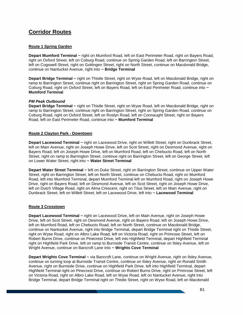
B1
Corridor Routes
Route 1 Spring Garden Depart Mumford Terminal ~ right on Mumford Road, left on East Perimeter Road, right on Bayers Road, right on Oxford Street, left on Coburg Road, continue on Spring Garden Road, left on Barrington Street, left on Cogswell Street, right on Gottingen Street, right on North Street, continue on Macdonald Bridge, continue on Nantucket Avenue, right into ~ Bridge Terminal Depart Bridge Terminal ~ right on Thistle Street, right on Wyse Road, left on Macdonald Bridge, right on ramp to Barrington Street, continue right on Barrington Street, right on Spring Garden Road, continue on Coburg Road, right on Oxford Street, left on Bayers Road, left on East Perimeter Road, continue into ~ Mumford Terminal PM Peak Outbound Depart Bridge Terminal ~ right on Thistle Street, right on Wyse Road, left on Macdonald Bridge, right on ramp to Barrington Street, continue right on Barrington Street, right on Spring Garden Road, continue on Coburg Road, right on Oxford Street, left on Roslyn Road, left on Connaught Street, right on Bayers Road, left on East Perimeter Road, continue into ~ Mumford Terminal Route 2 Clayton Park - Downtown Depart Lacewood Terminal ~ right on Lacewood Drive, right on Willett Street, right on Dunbrack Street, left on Main Avenue, right on Joseph Howe Drive, left on Scot Street, right on Desmond Avenue, right on Bayers Road, left on Joseph Howe Drive, left on Mumford Road, left on Chebucto Road, left on North Street, right on ramp to Barrington Street, continue right on Barrington Street, left on George Street, left on Lower Water Street, right into ~ Water Street Terminal Depart Water Street Terminal ~ left on Duke Street, right on Barrington Street, continue on Upper Water Street, right on Barrington Street, left on North Street, continue on Chebucto Road, right on Mumford Road, left into Mumford Terminal, depart Mumford Terminal left on Mumford Road, right on Joseph Howe Drive, right on Bayers Road, left on Desmond Avenue, left on Scot Street, right on Joseph Howe Drive, left on Dutch Village Road, right on Alma Crescent, right on Titus Street, left on Main Avenue, right on Dunbrack Street, left on Willett Street, left on Lacewood Drive, left into ~ Lacewood Terminal Route 3 Crosstown Depart Lacewood Terminal ~ right on Lacewood Drive, left on Main Avenue, right on Joseph Howe Drive, left on Scot Street, right on Desmond Avenue, right on Bayers Road, left on Joseph Howe Drive, left on Mumford Road, left on Chebucto Road, left on North Street, continue on Macdonald Bridge, continue on Nantucket Avenue, right into Bridge Terminal, depart Bridge Terminal right on Thistle Street, right on Wyse Road, right on Albro Lake Road, left on Victoria Road, right on Primrose Street, left on Robert Burns Drive, continue on Pinecrest Drive, left into Highfield Terminal, depart Highfield Terminal right on Highfield Park Drive, left on ramp to Burnside Transit Centre, continue on Ilsley Avenue, left on Wright Avenue, continue on Bancroft Lane into ~ Wrights Cove Terminal Depart Wrights Cove Terminal ~ via Bancroft Lane, continue on Wright Avenue, right on Ilsley Avenue, continue on turning loop at Burnside Transit Centre, continue on Ilsley Avenue, right on Ronald Smith Avenue, right on Burnside Drive, continue on Highfield Park Drive, left into Highfield Terminal, depart Highfield Terminal right on Pinecrest Drive, continue on Robert Burns Drive, right on Primrose Street, left on Victoria Road, right on Albro Lake Road, left on Wyse Road, left on Nantucket Avenue, right into Bridge Terminal, depart Bridge Terminal right on Thistle Street, right on Wyse Road, left on Macdonald
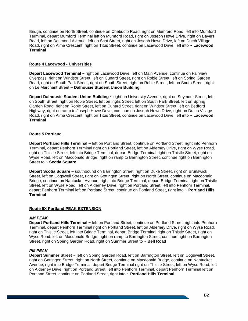
B2
Bridge, continue on North Street, continue on Chebucto Road, right on Mumford Road, left into Mumford Terminal, depart Mumford Terminal left on Mumford Road, right on Joseph Howe Drive, right on Bayers Road, left on Desmond Avenue, left on Scot Street, right on Joseph Howe Drive, left on Dutch Village Road, right on Alma Crescent, right on Titus Street, continue on Lacewood Drive, left into ~ Lacewood Terminal Route 4 Lacewood - Universities Depart Lacewood Terminal ~ right on Lacewood Drive, left on Main Avenue, continue on Fairview Overpass, right on Windsor Street, left on Cunard Street, right on Robie Street, left on Spring Garden Road, right on South Park Street, right on South Street, right on Robie Street, left on South Street, right on Le Marchant Street ~ Dalhousie Student Union Building Depart Dalhousie Student Union Building ~ right on University Avenue, right on Seymour Street, left on South Street, right on Robie Street, left on Inglis Street, left on South Park Street, left on Spring Garden Road, right on Robie Street, left on Cunard Street, right on Windsor Street, left on Bedford Highway, right on ramp to Joseph Howe Drive, continue on Joseph Howe Drive, right on Dutch Village Road, right on Alma Crescent, right on Titus Street, continue on Lacewood Drive, left into ~ Lacewood Terminal Route 5 Portland Depart Portland Hills Terminal ~ left on Portland Street, continue on Portland Street, right into Penhorn Terminal, depart Penhorn Terminal right on Portland Street, left on Alderney Drive, right on Wyse Road, right on Thistle Street, left into Bridge Terminal, depart Bridge Terminal right on Thistle Street, right on Wyse Road, left on Macdonald Bridge, right on ramp to Barrington Street, continue right on Barrington Street to ~ Scotia Square Depart Scotia Square ~ southbound on Barrington Street, right on Duke Street, right on Brunswick Street, left on Cogswell Street, right on Gottingen Street, right on North Street, continue on Macdonald Bridge, continue on Nantucket Avenue, right into Bridge Terminal, depart Bridge Terminal right on Thistle Street, left on Wyse Road, left on Alderney Drive, right on Portland Street, left into Penhorn Terminal, depart Penhorn Terminal left on Portland Street, continue on Portland Street, right into ~ Portland Hills Terminal Route 5X Portland PEAK EXTENSION AM PEAK Depart Portland Hills Terminal ~ left on Portland Street, continue on Portland Street, right into Penhorn Terminal, depart Penhorn Terminal right on Portland Street, left on Alderney Drive, right on Wyse Road, right on Thistle Street, left into Bridge Terminal, depart Bridge Terminal right on Thistle Street, right on Wyse Road, left on Macdonald Bridge, right on ramp to Barrington Street, continue right on Barrington Street, right on Spring Garden Road, right on Summer Street to ~ Bell Road PM PEAK Depart Summer Street ~ left on Spring Garden Road, left on Barrington Street, left on Cogswell Street, right on Gottingen Street, right on North Street, continue on Macdonald Bridge, continue on Nantucket Avenue, right into Bridge Terminal, depart Bridge Terminal right on Thistle Street, left on Wyse Road, left on Alderney Drive, right on Portland Street, left into Penhorn Terminal, depart Penhorn Terminal left on Portland Street, continue on Portland Street, right into ~ Portland Hills Terminal
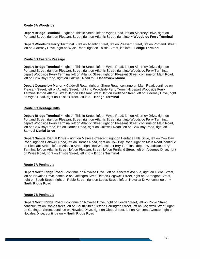
B3
Route 6A Woodside Depart Bridge Terminal ~ right on Thistle Street, left on Wyse Road, left on Alderney Drive, right on Portland Street, right on Pleasant Street, right on Atlantic Street, right into ~ Woodside Ferry Terminal Depart Woodside Ferry Terminal ~ left on Atlantic Street, left on Pleasant Street, left on Portland Street, left on Alderney Drive, right on Wyse Road, right on Thistle Street, left into ~ Bridge Terminal Route 6B Eastern Passage Depart Bridge Terminal ~ right on Thistle Street, left on Wyse Road, left on Alderney Drive, right on Portland Street, right on Pleasant Street, right on Atlantic Street, right into Woodside Ferry Terminal, depart Woodside Ferry Terminal left on Atlantic Street, right on Pleasant Street, continue on Main Road, left on Cow Bay Road, right on Caldwell Road to ~ Oceanview Manor Depart Oceanview Manor ~ Caldwell Road, right on Shore Road, continue on Main Road, continue on Pleasant Street, left on Atlantic Street, right into Woodside Ferry Terminal, depart Woodside Ferry Terminal left on Atlantic Street, left on Pleasant Street, left on Portland Street, left on Alderney Drive, right on Wyse Road, right on Thistle Street, left into ~ Bridge Terminal Route 6C Heritage Hills Depart Bridge Terminal ~ right on Thistle Street, left on Wyse Road, left on Alderney Drive, right on Portland Street, right on Pleasant Street, right on Atlantic Street, right into Woodside Ferry Terminal, depart Woodside Ferry Terminal left on Atlantic Street, right on Pleasant Street, continue on Main Road, left on Cow Bay Road, left on Hornes Road, right on Caldwell Road, left on Cow Bay Road, right on ~ Samuel Danial Drive Depart Samuel Danial Drive ~ right on Melrose Crescent, right on Heritage Hills Drive, left on Cow Bay Road, right on Caldwell Road, left on Hornes Road, right on Cow Bay Road, right on Main Road, continue on Pleasant Street, left on Atlantic Street, right into Woodside Ferry Terminal, depart Woodside Ferry Terminal left on Atlantic Street, left on Pleasant Street, left on Portland Street, left on Alderney Drive, right on Wyse Road, right on Thistle Street, left into ~ Bridge Terminal Route 7A Peninsula Depart North Ridge Road ~ continue on Novalea Drive, left on Kencrest Avenue, right on Glebe Street, left on Novalea Drive, continue on Gottingen Street, left on Cogswell Street, right on Barrington Street, right on South Street, right on Robie Street, right on Leeds Street, left on Novalea Drive, continue on ~ North Ridge Road Route 7B Peninsula Depart North Ridge Road ~ continue on Novalea Drive, right on Leeds Street, left on Robie Street, continue left on Robie Street, left on South Street, left on Barrington Street, left on Cogswell Street, right on Gottingen Street, continue on Novalea Drive, right on Glebe Street, left on Kencrest Avenue, right on Novalea Drive, continue on ~ North Ridge Road
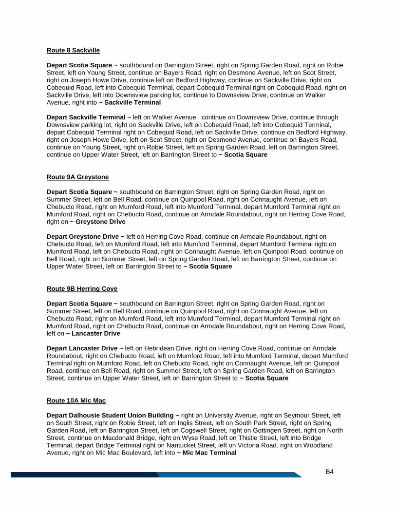
B4
Route 8 Sackville Depart Scotia Square ~ southbound on Barrington Street, right on Spring Garden Road, right on Robie Street, left on Young Street, continue on Bayers Road, right on Desmond Avenue, left on Scot Street, right on Joseph Howe Drive, continue left on Bedford Highway, continue on Sackville Drive, right on Cobequid Road, left into Cobequid Terminal, depart Cobequid Terminal right on Cobequid Road, right on Sackville Drive, left into Downsview parking lot, continue to Downsview Drive, continue on Walker Avenue, right into ~ Sackville Terminal Depart Sackville Terminal ~ left on Walker Avenue , continue on Downsview Drive, continue through Downsview parking lot, right on Sackville Drive, left on Cobequid Road, left into Cobequid Terminal, depart Cobequid Terminal right on Cobequid Road, left on Sackville Drive, continue on Bedford Highway, right on Joseph Howe Drive, left on Scot Street, right on Desmond Avenue, continue on Bayers Road, continue on Young Street, right on Robie Street, left on Spring Garden Road, left on Barrington Street, continue on Upper Water Street, left on Barrington Street to ~ Scotia Square Route 9A Greystone Depart Scotia Square ~ southbound on Barrington Street, right on Spring Garden Road, right on Summer Street, left on Bell Road, continue on Quinpool Road, right on Connaught Avenue, left on Chebucto Road, right on Mumford Road, left into Mumford Terminal, depart Mumford Terminal right on Mumford Road, right on Chebucto Road, continue on Armdale Roundabout, right on Herring Cove Road, right on ~ Greystone Drive Depart Greystone Drive ~ left on Herring Cove Road, continue on Armdale Roundabout, right on Chebucto Road, left on Mumford Road, left into Mumford Terminal, depart Mumford Terminal right on Mumford Road, left on Chebucto Road, right on Connaught Avenue, left on Quinpool Road, continue on Bell Road, right on Summer Street, left on Spring Garden Road, left on Barrington Street, continue on Upper Water Street, left on Barrington Street to ~ Scotia Square Route 9B Herring Cove Depart Scotia Square ~ southbound on Barrington Street, right on Spring Garden Road, right on Summer Street, left on Bell Road, continue on Quinpool Road, right on Connaught Avenue, left on Chebucto Road, right on Mumford Road, left into Mumford Terminal, depart Mumford Terminal right on Mumford Road, right on Chebucto Road, continue on Armdale Roundabout, right on Herring Cove Road, left on ~ Lancaster Drive Depart Lancaster Drive ~ left on Hebridean Drive, right on Herring Cove Road, continue on Armdale Roundabout, right on Chebucto Road, left on Mumford Road, left into Mumford Terminal, depart Mumford Terminal right on Mumford Road, left on Chebucto Road, right on Connaught Avenue, left on Quinpool Road, continue on Bell Road, right on Summer Street, left on Spring Garden Road, left on Barrington Street, continue on Upper Water Street, left on Barrington Street to ~ Scotia Square Route 10A Mic Mac Depart Dalhousie Student Union Building ~ right on University Avenue, right on Seymour Street, left on South Street, right on Robie Street, left on Inglis Street, left on South Park Street, right on Spring Garden Road, left on Barrington Street, left on Cogswell Street, right on Gottingen Street, right on North Street, continue on Macdonald Bridge, right on Wyse Road, left on Thistle Street, left into Bridge Terminal, depart Bridge Terminal right on Nantucket Street, left on Victoria Road, right on Woodland Avenue, right on Mic Mac Boulevard, left into ~ Mic Mac Terminal
B5
Depart Mic Mac Terminal ~ right on Mic Mac Boulevard, left on Woodland Avenue, left on Victoria Road, right on Thistle Street, right into Bridge Terminal, depart Bridge Terminal right on Thistle Street, right on Wyse Road, left on Macdonald Bridge, right on ramp to Barrington Street, continue right on Barrington Street, right on Spring Garden Road, left on South Park Street, right on Inglis Street, right on Robie Street, left on South Street, right on Le Marchant Street to ~ Dalhousie Student Union Building Route 10B Mic Mac – Booth Street Depart Dalhousie Student Union Building ~ right on University Avenue, right on Seymour Street, left on South Street, right on Robie Street, left on Inglis Street, left on South Park Street, right on Spring Garden Road, left on Barrington Street, left on Cogswell Street, right on Gottingen Street, right on North Street, continue on Macdonald Bridge, right on Wyse Road, left on Thistle Street, left into Bridge Terminal, depart Bridge Terminal right on Nantucket Street, left on Victoria Road, right on Woodland Avenue, right on Mic Mac Boulevard, left into Mic Mac Terminal, depart Mic Mac Terminal left on Mic Mac Boulevard, left on Mic Mac Boulevard, right on ramp to Circumferential Highway 111, continue right on Main Street, right on Hartlen Street, left on Tacoma Drive, right on Valleyfield Road, left on Spikenard Street, left on Woodlawn Road, right on Main Street, left on Booth Street, continue on Kennedy Drive, right on Caledonia Road, left on Dumbarton Avenue, left on Kincardine Drive, left on ~ Inverary Drive Depart Inverary Drive ~ right on Strath Lane, left on Raymoor Drive, right on Main Street, left on Weyburn Road, right on Spikenard Street, right on Valleyfield Road, left on Tacoma Drive, right on Hartlen Street, left on Main Street, continue on Circumferential Highway 111, right on ramp to Mic Mac Boulevard, left on Mic Mac Boulevard, right on Mic Mac Boulevard, left on Woodland Avenue, left on Victoria Road, right on Thistle Street, right into Bridge Terminal, depart Bridge Terminal right on Thistle Street, right on Wyse Road, left on Macdonald Bridge, right on ramp to Barrington Street, continue right on Barrington Street, right on Spring Garden Road, left on South Park Street, right on Inglis Street, right on Robie Street, left on South Street, right on Le Marchant Street to ~ Dalhousie Student Union Building Route 10C Bridge Depart Dalhousie Student Union Building ~ right on University Avenue, right on Seymour Street, left on South Street, right on Robie Street, left on Inglis Street, left on South Park Street, right on Spring Garden Road, left on Barrington Street, left on Cogswell Street, right on Gottingen Street, right on North Street, continue on Macdonald Bridge, right on Wyse Road, left on Thistle Street, left into ~ Bridge Terminal, Depart Bridge Terminal ~ right on Thistle Street, right on Wyse Road, left on Macdonald Bridge, right on ramp to Barrington Street, continue right on Barrington Street, right on Spring Garden Road, left on South Park Street, right on Inglis Street, right on Robie Street, left on South Street, right on Le Marchant Street to ~ Dalhousie Student Union Building
Local Routes
Route 21 Timberlea Depart Lacewood Terminal ~ left on Lacewood Drive, continue on Chain Lake Drive, right on Susie Lake Crescent, left on Horseshoe Lake Drive, left on Chain Lake Drive, right on Lakelands Boulevard, right on St. Margarets Bay Road, left on Brentwood Drive, right on Eisener Street, right on Maplewood Drive, left on St. Margarets Bay Road, left on James Street, right on Forestglen Drive, left on ~ Fraser Road
B6
Depart Fraser Road ~ left on Charles Road, right on James Street, right on St. Margarets Bay Road, right on Maplewood Drive, left on Eisener Street, left on Brentwood Drive, right on St. Margarets Bay Road, left on Lakelands Boulevard, left on Chain Lake Drive, right on Horseshoe Lake Drive, right on Susie Lake Crescent, left on Chain Lake Drive, continue on Lacewood Drive, right into ~ Lacewood Terminal Route 22 Armdale Depart Mumford Terminal ~ right on Mumford Road, right on Chebucto Road, continue on Armdale Roundabout, right on St. Margarets Bay Road, left on Quarry Road, left on Edgehill Road, right on Glenmore Avenue, left on Stonehaven Road, right on Alton Drive, left on Kelly Street, right on Osborne Street, right on Walter Havill Drive, continue on Albert Walker Drive, left on St. Margarets Bay Road, left on Prospect Road, right on Ragged Lake Boulevard, right on ~ Grassy Lake Drive Depart Grassy Lake Drive ~ Ragged Lake ramp, right on St. Margarets Bay Road, right on Albert Walker Drive, continue on Walter Havill Drive, left on Osborne Street, left on Kelly Street, right on Alton Drive, left on Stonehaven Road, right on Glenmore Avenue, left on Edgehill Road, right on Quarry Road, right on St. Margarets Bay Road, continue on Armdale Roundabout, right on Chebucto Road, left on Mumford Road, left into ~ Mumford Terminal Route 24 Leiblin Park Depart Leiblin Drive ~ left on Rockingstone Road, continue on Old Sambro Road, right on Dentith Road, left on Herring Cove Road, left on Highfield Street, right on Ridge Valley Road, right on Cowie Hill Road, left on Margaret Road, left on Mountain Road, right on Tamarack Drive, right on Osborne Street, continue on Mayo Street, continue on Withrod Drive, left on Herring Cove Road, continue on Armdale Roundabout, right on Joseph Howe Drive, right on Mumford Road, left Chebucto Road, right on Oxford Street, left on South Street, right on South Park Street, right on ~ Inglis Street Depart Inglis Street ~ right on Robie Street, left on South Street, right on Oxford Street, left on Chebucto Road, right on Mumford Road, left into Mumford Terminal, depart Mumford Terminal left on Mumford Road, left on Joseph Howe Drive, continue on Armdale Roundabout, right on Herring Cove Road, right on Withrod Drive, continue on Mayo Street, continue on Osborne Street, left on Tamarack Drive, left on Mountain Road, right on Margaret Road, right on Cowie Hill Road, left on Ridge Valley Road, left on Highfield Street, right on Herring Cove Road, right on Dentith Road, left on Old Sambro Road, continue on Rockingstone Road, right on Leiblin Drive, left on Juniper Crescent, right on ~ Leiblin Drive Route 25 Governors Brook Depart Mumford Terminal ~ right on Mumford Road, right on Chebucto Road, continue on Armdale Roundabout, right on Herring Cove Road, left on Purcells Cove Road, right on Williams Lake Road, left on Herring Cove Road, left on Pinegrove Drive, left on Theakston Avenue, right on Danforth Road, left on Katrina Crescent, continue to ~ Alabaster Way Depart Alabaster Way ~ right on Lier Ridge, right on Quartz Drive, left on Alabaster Way, continue on Katrina Crescent, right on Danforth Road, left on Theakston Avenue, right on Pinegrove Drive, right on Herring Cove Road, right on Williams Lake Road, left on Purcells Cove Road, right on Herring Cove Road, continue on Armdale Roundabout, right on Chebucto Road, left on Mumford Road, left into ~ Mumford Terminal
B7
Route 26 Springvale – PEAK ONLY Depart Mumford Terminal ~ left on Mumford Road, left on Joseph Howe Drive, right on Springvale Avenue, left on Winter Street, right on Downs Avenue, right on Milsom Street, right on Springvale Avenue, left on Joseph Howe Drive, right on Mumford Road, right into ~ Mumford Terminal Route 29 Barrington Depart Desmond Avenue ~ right on Bayers Road, left on Joseph Howe Drive, left on Mumford Road, left on East Perimeter Road, right on Bayers Road, left on Connaught Avenue, left on Windsor Street, right on Lady Hammond Road, continue on Duffus Street, right on Barrington Street, continue right on Barrington Street, left on George Street, left into Water Street Terminal, depart Water Street Terminal on Upper Water Street, left on Hollis Street, left on Barrington Street, continue on Inglis Street, left on Tower Road, continue to ~ Point Pleasant Park turning loop Depart Point Pleasant Park turning Loop ~ continue on Tower Road, right on Inglis Street, continue on Barrington Street, right on Hollis Street, right on Terminal Road, left on Lower Water Street, right into Water Street Terminal, depart Water Street Terminal left on Duke Street, right on Barrington Street, continue on Upper Water Street, right on Barrington Street, left on Duffus Street, continue on Lady Hammond Road, left on Windsor Street, right on Connaught Avenue, right on Bayers Road, left on East Perimeter Road, continue into Mumford Terminal, depart Mumford Terminal left on Mumford Road, right on Joseph Howe Drive, right on Scot Street, right on ~ Desmond Avenue Route 31 Bayers Lake Depart Lacewood Terminal ~ left on Lacewood Drive, continue on Chain Lake Drive, left on Washmill Lake Drive, left on North West Arm Drive, right on Main Avenue, right on Willett Street, left on Rosedale Avenue, right on Dutch Village Road, left on Joseph Howe Drive, right on Scot Street, right on Desmond Avenue, continue on Bayers Road, right on East Perimeter Road, continue into ~ Mumford Terminal Depart Mumford Terminal ~ right on Mumford Road, left on East Perimeter Road, left on Bayers Road, right on Desmond Avenue, left on Scot Street, left on Joseph Howe Drive, right on Dutch Village Road, left on Rosedale Avenue, right on Willett Street, left on Main Avenue, left on North West Arm Drive, right on Washmill Lake Drive, right on Chain Lake Drive, continue on Lacewood Drive, right into ~ Lacewood Terminal Route 32 Flamingo Depart Lacewood Terminal ~ left on Lacewood Drive, right on Parkland Drive, right on Farnham Gate Road, right on Dunbrack Street, left on Knightsridge Drive, right on Flamingo Drive, right on Bedford Highway, continue on Fairview Overpass, left to MacKay Bridge, right on MacKay Bridge, right on ramp to Victoria Road, left on Highfield Park Drive, right into Highfield Terminal, depart Highfield Terminal right on Pinecrest Drive, continue on Roberts Burns Drive, right on Primrose Street, left on Victoria Road, right on Boland Road, left on Wyse Road, left on Nantucket Avenue, right into ~ Bridge Terminal Depart Bridge Terminal ~ right on Thistle Street, right on Wyse Road, right on Boland Road, left on Victoria Road, right on Primrose Street, left on Robert Burns Drive, continue on Pinecrest Drive, left into Highfield Terminal, depart Highfield Terminal left on Highfield Park Drive, right on Victoria Road, right on ramp to MacKay Bridge, continue on MacKay Bridge, continue on Fairview Overpass, continue on Bedford Highway, left on Flamingo Drive, left on Knightsridge Drive, right on Dunbrack Street, left on Farnham Gate Road, left on Parkland Drive, left on Lacewood Drive, right into ~ Lacewood Terminal
B8
Route 34A Parkland - Dunbrack Depart Lacewood Terminal ~ right on Lacewood Drive, left on Dunbrack Street, continue on Kearney Lake Road, left on Parkland Drive, continue on Regency Park Drive, left on Thomas Raddall Drive, right on Lacewood Drive, right into ~ Lacewood Terminal Route 34B Parkland - Dunbrack Depart Lacewood Terminal ~ left on Lacewood Drive, left on Thomas Raddall Drive, right on Regency Park Drive, continue on Parkland Drive, right on Kearney Lake Road, continue on Dunbrack Street, right on Lacewood Drive, left into ~ Lacewood Terminal Route 50 Dockyard/Shipyard – PEAK ONLY AM PEAK Depart Bridge Terminal ~ right on Thistle Street, right on Wyse Road, left on Macdonald Bridge, right on ramp to Barrington Street, continue on Valour Way to Dockyard, right on Upper Water Street, right on Barrington Street, continue to ~ Niobe Gate Bridge, Halifax Shipyard PM PEAK Depart Niobe Gate Bridge, Halifax Shipyard ~ southbound on Barrington Street, left on Valour Way, left on Upper Water Street, right on Cogswell Street, right on Gottingen Street, right on North Street, continue on Macdonald Bridge, continue on Nantucket Avenue, right into ~ Bridge Terminal Route 51 Windmill Depart Bridge Terminal ~ right on Thistle Street, left on Wyse Road, right on Windmill Road, left on Princess Margaret Boulevard, left on Baffin Boulevard, right on Hudson Way, left on Princess Margaret Boulevard, continue on Killkee Gate, right on ~ Princess Margaret Boulevard Depart Princess Margaret Boulevard ~ left on Princess Margaret Boulevard, right on Windmill Road, left on Wyse Road, right on Thistle Street, left into ~ Bridge Terminal Route 51X Windmill PEAK EXTENSION Depart Bridge Terminal ~ right on Thistle Street, left on Wyse Road, right on Windmill Road, left on Princess Margaret Boulevard, left on Baffin Boulevard, right on Hudson Way, left on Princess Margaret Boulevard, continue on Killkee Gate, right on Princess Margaret Boulevard, left on Princess Margaret Boulevard, left on Windmill Road, left on Victoria Road, continue on Windmill Road, left on Bancroft Lane into ~ Wrights Cove Terminal Depart Wrights Cove Terminal ~ via Bancroft Lane, right on Windmill Road, continue right on Windmill Road, right on Princess Margaret Boulevard, left on Baffin Boulevard, right on Hudson Way, left on Princess Margaret Boulevard, continue on Killkee Gate, right on Princess Margaret Boulevard, left on Princess Margaret Boulevard, right on Windmill Road, left on Wyse Road, right on Thistle Street, left into ~ Bridge Terminal Route 53 Highfield Depart Alderney Gate ~ southbound on Alderney Drive, left on King Street, left on Queen Street, right on Alderney Drive, right on Wyse Road, right on Thistle Street, left into Bridge Terminal, depart Bridge
B9
Terminal right on Thistle Street, right on Wyse Road, right on Albro Lake Road, left on Leaman Drive, left on Crystal Drive, right on Pinecrest Drive, right into ~ Highfield Terminal Depart Highfield Terminal ~ left on Pinecrest Drive, left on Crystal Drive, right on Leaman Drive, right on Albro Lake Road, left on Wyse Road, left on Nantucket Avenue, right into Bridge Terminal, depart Bridge Terminal right on Thistle Street, left on Wyse Road, left on Alderney Drive to ~ Alderney Gate Route 54 Montebello Depart Bridge Terminal ~ right on Thistle Street, left on Wyse Road, left on Alderney Drive, left on King Street, right on Ochterloney Street, left on Crichton Avenue, right on Glen Manor Drive, left on Mic Mac Boulevard, right into Mic Mac Terminal, depart Mic Mac Terminal left on Mic Mac Boulevard, left on Mic Mac Boulevard, right on ramp to Circumferential Highway 111, continue on Main Street, right on Hartlen Street, left on Tacoma Drive, right on Valleyfield Road, left on Spikenard Street, left on Woodlawn Road, continue on Caledonia Road, right on Avenue du Portage, left on Madeline Place, left on Lexington Avenue, right on ~ Breeze Drive Depart Breeze Drive ~ left on Columbo Drive, left on Appian Way, right on Colonna Place, left on Montebello Drive, right on Caledonia Road, continue on Woodlawn Road, right on Spikenard Street, right on Valleyfield Road, left on Tacoma Drive, right on Hartlen Street, left on Main Street, continue on Circumferential Highway 111, right on ramp to Mic Mac Boulevard, left on Mic Mac Boulevard, right on Mic Mac Boulevard, right into Mic Mac Terminal, depart Mic Mac Terminal left on Mic Mac Boulevard, right on Glen Manor Drive, left on Crichton Avenue, right on Ochterloney Street, left on King Street, right on Queen Street, right on Alderney Drive, right on Wyse Road, right on Thistle Street, left into ~ Bridge Terminal Route 55 Port Wallace Depart Bridge Terminal ~ right on Thistle Street, left on Wyse Road, left on Alderney Drive, left on King Street, right on Ochterloney Street, left on Crichton Avenue, right on Glen Manor Drive, left on Mic Mac Boulevard, right into Mic Mac Terminal, depart Mic Mac Terminal left on Mic Mac Boulevard, left on Mic Mac Boulevard, right on ramp to Circumferential Highway 111, right on ramp to Waverly Road, continue on Braemar Drive, continue on Waverly Road, left on ~ Charles Keating Drive Depart Charles Keating Drive ~ left on Craigburn Drive, right on Waverly Road, continue on Braemar Drive, left on ramp to Circumferential Highway 111, right on ramp to Mic Mac Boulevard, left on Mic Mac Boulevard, right on Mic Mac Boulevard, right into Mic Mac Terminal, depart Mic Mac Terminal left on Mic Mac Boulevard, right on Glen Manor Drive, left on Crichton Avenue, right on Ochterloney Street, left on King Street, right on Queen Street, right on Alderney Drive, right on Wyse Road, right on Thistle Street, left into ~ Bridge Terminal Route 56 Dartmouth Crossing Depart Bridge Terminal ~ left on Thistle Street, right on Crichton Park Road, left on Crichton Avenue, right on Glen Manor Drive, left on Mic Mac Boulevard, right on Woodland Avenue, continue on Highway 118, right on ramp to Wright Avenue, left on Wright Avenue, right on ramp to Countryview Drive, continue on Gale Terrace, right on Finnian Row, right on Lamont Terrace, right on Commodore Drive, left on Countryview Drive, left on Shubie Drive, right on Finlay Drive, left on Wright Avenue, right on Wilkinson Avenue, left on Jennett Avenue, left on John Savage Avenue, right on Wright Avenue, continue on Bancroft Lane into ~ Wrights Cove Terminal Depart Wrights Cove Terminal ~ via Bancroft Lane, continue on Wright Avenue, left on John Savage Avenue, right on Jennett Avenue, right on Wilkinson Avenue, left on Wright Avenue, right on Finlay Drive,
B10
left on Shubie Drive, right on Countryview Drive, continue on Gale Terrace, right on Finnian Row, right on Lamont Terrace, right on Commodore Drive, left on Countryview Drive, right on Wright Avenue, right on Highway 118, continue on Woodland Avenue, left on Mic Mac Boulevard, left into Mic Mac Terminal, depart Mic Mac Terminal left on Mic Mac Boulevard, right on Glen Manor Drive, left on Crichton Avenue, right on Crichton Park Road, left on Thistle Street, right into ~ Bridge Terminal Route 57 Portland Estates PEAK ONLY Depart Portland Hills Terminal ~ left on Portland Street, left on Portland Hills Drive, continue on Portland Estates Boulevard West, right on Russell Lake Drive, left on Eisener Boulevard, left on Portland Street, right into ~ Penhorn Terminal Depart Penhorn Terminal ~ left on Portland Street, right on Eisener Boulevard, right on Russell Lake Drive, left on Portland Estates Boulevard West, continue on Portland Hills Drive, right on Portland Street, right into ~ Portland Hills Terminal Route 58 Woodlawn Depart Portland Hills Terminal ~ left on Portland Street, right on Regal Road, left on Collins Grove, right on Spring Avenue, right on Dorothea Drive, left on Lucien Drive, left on Windward Avenue, left on Lea Street, right on Topsail Boulevard, left on Plaza Drive, left on Belle Vista Drive, left on Spring Avenue, right on Ellenvale Avenue, right on Waltdale Drive, left on Belle Vista Drive, left on Woodlawn Road, right on Portland Street, right into ~ Penhorn Terminal Depart Penhorn Terminal ~ left on Portland Street, left on Woodlawn Road, right on Belle Vista Drive, right on Waltdale Drive, left on Ellenvale Avenue, left on Spring Avenue, right on Belle Vista Drive, right on Plaza Drive, right on Topsail Boulevard, left on Lea Street, right on Windward Avenue, right on Lucien Drive, right on Dorothea Drive, left on Spring Avenue, left on Collins Grove, right on Regal Road, left on Portland Street, right into ~ Portland Hills Terminal Route 59 Colby Depart Portland Hills Terminal ~ right on Portland Street, continue on Cole Harbour Road, right on Ashgrove Avenue, left on Colby Drive, continue on Cumberland Drive, left on Cole Harbour Road, continue on Portland Street, left into ~ Portland Hills Terminal Route 61 Cherry Brook Depart Portland Hills Terminal ~ right on Portland Street, continue on Cole Harbour Road, left on Forest Hills Parkway, right on Merrimac Drive, left on Arklow Drive, left on John Stewart Drive, right on Auburn Drive, right on Hillsboro Drive, continue on Montague Road, right on Lake Loon Road, left on ~ Cherry Brook Road Depart Cherry Brook Road ~ right on Highway 7, left on Hillsboro Drive, left on Auburn Drive, left on John Stewart Drive, right on Arklow Drive, right on Merrimac Drive, left on Forest Hills Parkway, right on Cole Harbour Road, continue on Portland Street, left into ~ Portland Hills Terminal Route 62 Grahams Grove Depart Bridge Terminal ~ right on Thistle Street, left on Wyse Road, left on Alderney Drive, left on King Street, right on Ochterloney Street, left on Crichton Avenue, right on Hawthorne Street, left on Sinclair
B11
Street, right on Prince Albert Road, continue right on Prince Albert Road, right on Harris Road, right on Beacon Street, left on Penhorn Drive, right on Somerset Street, left on Oathill Crescent, left on Peddars Way, left on Manor Drive, left on Portland Street, left into Penhorn Terminal, depart Penhorn Terminal right on Portland Street, left on Gaston Road, continue to ~ Gaston Road turning loop Depart Gaston Road turning loop ~ right on Portland Street, left into Penhorn Terminal, depart Penhorn Terminal right on Portland Street, right on Manor Drive, right on Peddars Way, right on Oathill Crescent, right on Somerset Street, left on Penhorn Drive, right on Beacon Street, left on Harris Road, left on Prince Albert Road, left on Sinclair Street, right on Hawthorne Street, left on Crichton Avenue, right on Ochterloney Street, left on King Street, right on Queen Street, right on Alderney Drive, right on Wyse Road, right on Thistle Street, left into ~ Bridge Terminal Route 63 Mount Edward Depart Penhorn Terminal ~ left on Portland Street, left on Woodlawn Road, continue on Mount Edward Road, right on Cranberry Crescent, continue on Wildwood Boulevard, right on Gregory Drive, left on Flying Cloud Drive, right on Forest Hills Parkway, right on Cole Harbour Road, continue on Portland Street, left into ~ Portland Hills Terminal Depart Portland Hills Terminal ~ right on Portland Street, continue on Cole Harbour Road, left on Forest Hills Parkway, left on second entrance to Flying Cloud Drive, right on Gregory Drive, left on Wildwood Boulevard, continue on Cranberry Crescent, left on Mount Edward Road, continue on Woodlawn Road, right on Portland Street, right into ~ Penhorn Terminal Route 64 Burnside – WEEKDAY ONLY Depart Highfield Terminal ~ right on Highfield Park Drive, continue on Burnside Drive, right on Commodore Drive, right on Brownlow Avenue, left on Eileen Stubbs Avenue, right on Commodore Drive, left on John Savage Avenue, left on Garland Avenue, continue on Williams Avenue, right on Frazee Avenue, left on John Savage Avenue, continue on Gloria McCluskey Avenue, left on Colford Avenue, right on Akerley Boulevard, left on Windmill Road, right on Bancroft Lane into ~ Wrights Cove Terminal Depart Wrights Cove Terminal ~ via Bancroft Lane, left on Windmill Road, right on Akerley Boulevard, left on Colford Avenue, right on Gloria McCluskey Avenue, continue on John Savage Avenue, right on Frazee Avenue, left on Williams Avenue, continue on Garland Avenue, right on John Savage Avenue, right on Commodore Drive, left on Eileen Stubbs Avenue, right on Brownlow Avenue, left on Commodore Drive, left on Burnside Drive, continue on Highfield Park Drive, left into ~ Highfield Terminal Route 65 Caldwell Depart Portland Hills Terminal ~ right on Portland Street, right on Caldwell Road, left on Astral Drive, right on Sherwood Street, right on Caldwell Road, right on Brookfield Avenue, left on Astral Drive, right on Caldwell Road, left on Portland Street, left into ~ Portland Hills Terminal
B12
Route 67 Baker Drive Depart Woodside Ferry Terminal ~ left on Atlantic Street, left on Pleasant Street, right on Acadia Street, left on Mount Hope Avenue, left on Baker Drive, left on Portland Street, right into Penhorn Terminal, depart Penhorn Terminal left on Portland Street, left on Woodlawn Road, left on Woodlawn Road, left on Spikenard Street, right on Valleyfield Rd, left on Tacoma Drive, right on Hartlen Street, left on Main Street, continue on Circumferential Highway 111, right on ramp to Mic Mac Boulevard, left on Mic Mac Boulevard, right on Mic Mac Boulevard, right into ~ Mic Mac Terminal Depart Mic Mac Terminal ~ left on Mic Mac Boulevard, left on Mic Mac Boulevard, right on ramp to Circumferential Highway 111, continue on Main Street, right on Hartlen Street left on Tacoma Drive, right on Valleyfield Road, left on Spikenard Street, right on Woodlawn Road, right on Woodlawn Road, right on Portland Street, right into Penhorn Terminal, depart Penhorn Terminal left on Portland Street, right on Baker Drive, right on Mount Hope Avenue, right on Acadia Street, left on Pleasant Street, right on Atlantic Street, right into ~ Woodside Ferry Terminal Route 68 North Preston Depart Portland Hills Terminal ~ right on Portland Street, continue on Cole Harbour Road, left on Otago Drive, right on Poplar Drive, right on Circassion Drive, left on Forest Hills Parkway, right on Highway 7, left on Lake Major Road, continue on North Preston Road, left on Simmonds Road, left into ~ North Preston Recreation Centre turning loop Depart North Preston Recreation Centre Loop ~ right on Simmonds Road, right on North Preston Road, right on Cain Street, left on Clarence Street, left on Johnson Road, right on North Preston Road, continue on Lake Major Road, right on Highway 7, left on Forest Hills Parkway, right on Circassion Drive, left on Poplar Drive, left on Otago Drive, right on Cole Harbour Road, continue on Portland Street, left into ~ Portland Hills Terminal Route 72 Portland Hills - Dartmouth Crossing Depart Portland Hills Terminal ~ left on Portland Street, right on Regal Road, left on Collins Grove, right on Spring Avenue, left on Ellenvale Avenue, right on Waltdale Drive, left on Belle Vista Drive, right on Woodlawn Road, left on Woodlawn Road, left on Spikenard Street, right on Valleyfield Road, left on Tacoma Drive, right on Hartlen Street, left on Main Street, continue on Circumferential Highway 111, right on ramp to Mic Mac Boulevard, left on Mic Mac Boulevard, right on Mic Mac Boulevard, continue on Lancaster Drive, left on Sea King Drive, continue on Albro Lake Road right on Pinecrest Drive, right into Highfield Terminal, depart Highfield Terminal right on Highfield Park Drive, left on ramp to Burnside Transit Centre, continue on Ilsley Avenue, right on Wright Avenue, right on Finlay Drive, left on Shubie Drive, right on Countryview Drive, continue on Gale Terrace, right on Finnian Row, right on Lamont Terrace, right on ~ Commodore Drive Depart Commodore Drive ~ left on Countryview Drive, left on Shubie Drive, right on Finlay Drive, left on Wright Avenue, left on Ilsley Avenue, left on Ronald Smith Avenue, right on Burnside Drive, continue on Highfield Park Drive, left into Highfield Terminal, depart Highfield Terminal left on Pinecrest Drive, left on Albro Lake Road, continue on Sea King Drive, right on Lancaster Drive, continue on Mic Mac Boulevard, left into Mic Mac Terminal, depart Mic Mac Terminal left on Mic Mac Boulevard, left on Mic Mac Boulevard, right on ramp to Circumferential Highway 111, continue on Main Street, right on Hartlen Street, left on Tacoma Drive, right Valleyfield Road, left on Spikenard Street, right on Woodlawn Road, right on Woodlawn Road, left on Belle Vista Drive, right on Waltdale Drive, left on Ellenvale Avenue, right on Spring Avenue, left on Collins Grove, right on Regal Road, left on Portland Street, right into ~ Portland Hills Terminal
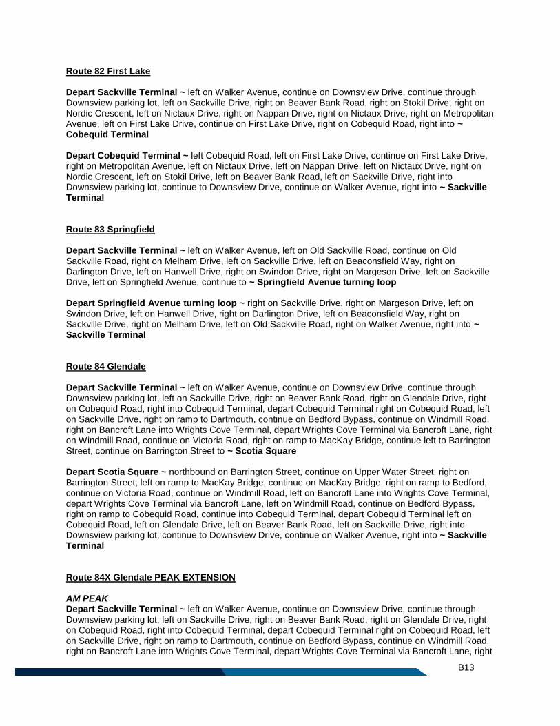
B13
Route 82 First Lake Depart Sackville Terminal ~ left on Walker Avenue, continue on Downsview Drive, continue through Downsview parking lot, left on Sackville Drive, right on Beaver Bank Road, right on Stokil Drive, right on Nordic Crescent, left on Nictaux Drive, right on Nappan Drive, right on Nictaux Drive, right on Metropolitan Avenue, left on First Lake Drive, continue on First Lake Drive, right on Cobequid Road, right into ~ Cobequid Terminal Depart Cobequid Terminal ~ left Cobequid Road, left on First Lake Drive, continue on First Lake Drive, right on Metropolitan Avenue, left on Nictaux Drive, left on Nappan Drive, left on Nictaux Drive, right on Nordic Crescent, left on Stokil Drive, left on Beaver Bank Road, left on Sackville Drive, right into Downsview parking lot, continue to Downsview Drive, continue on Walker Avenue, right into ~ Sackville Terminal Route 83 Springfield Depart Sackville Terminal ~ left on Walker Avenue, left on Old Sackville Road, continue on Old Sackville Road, right on Melham Drive, left on Sackville Drive, left on Beaconsfield Way, right on Darlington Drive, left on Hanwell Drive, right on Swindon Drive, right on Margeson Drive, left on Sackville Drive, left on Springfield Avenue, continue to ~ Springfield Avenue turning loop Depart Springfield Avenue turning loop ~ right on Sackville Drive, right on Margeson Drive, left on Swindon Drive, left on Hanwell Drive, right on Darlington Drive, left on Beaconsfield Way, right on Sackville Drive, right on Melham Drive, left on Old Sackville Road, right on Walker Avenue, right into ~ Sackville Terminal Route 84 Glendale Depart Sackville Terminal ~ left on Walker Avenue, continue on Downsview Drive, continue through Downsview parking lot, left on Sackville Drive, right on Beaver Bank Road, right on Glendale Drive, right on Cobequid Road, right into Cobequid Terminal, depart Cobequid Terminal right on Cobequid Road, left on Sackville Drive, right on ramp to Dartmouth, continue on Bedford Bypass, continue on Windmill Road, right on Bancroft Lane into Wrights Cove Terminal, depart Wrights Cove Terminal via Bancroft Lane, right on Windmill Road, continue on Victoria Road, right on ramp to MacKay Bridge, continue left to Barrington Street, continue on Barrington Street to ~ Scotia Square Depart Scotia Square ~ northbound on Barrington Street, continue on Upper Water Street, right on Barrington Street, left on ramp to MacKay Bridge, continue on MacKay Bridge, right on ramp to Bedford, continue on Victoria Road, continue on Windmill Road, left on Bancroft Lane into Wrights Cove Terminal, depart Wrights Cove Terminal via Bancroft Lane, left on Windmill Road, continue on Bedford Bypass, right on ramp to Cobequid Road, continue into Cobequid Terminal, depart Cobequid Terminal left on Cobequid Road, left on Glendale Drive, left on Beaver Bank Road, left on Sackville Drive, right into Downsview parking lot, continue to Downsview Drive, continue on Walker Avenue, right into ~ Sackville Terminal Route 84X Glendale PEAK EXTENSION AM PEAK Depart Sackville Terminal ~ left on Walker Avenue, continue on Downsview Drive, continue through Downsview parking lot, left on Sackville Drive, right on Beaver Bank Road, right on Glendale Drive, right on Cobequid Road, right into Cobequid Terminal, depart Cobequid Terminal right on Cobequid Road, left on Sackville Drive, right on ramp to Dartmouth, continue on Bedford Bypass, continue on Windmill Road, right on Bancroft Lane into Wrights Cove Terminal, depart Wrights Cove Terminal via Bancroft Lane, right
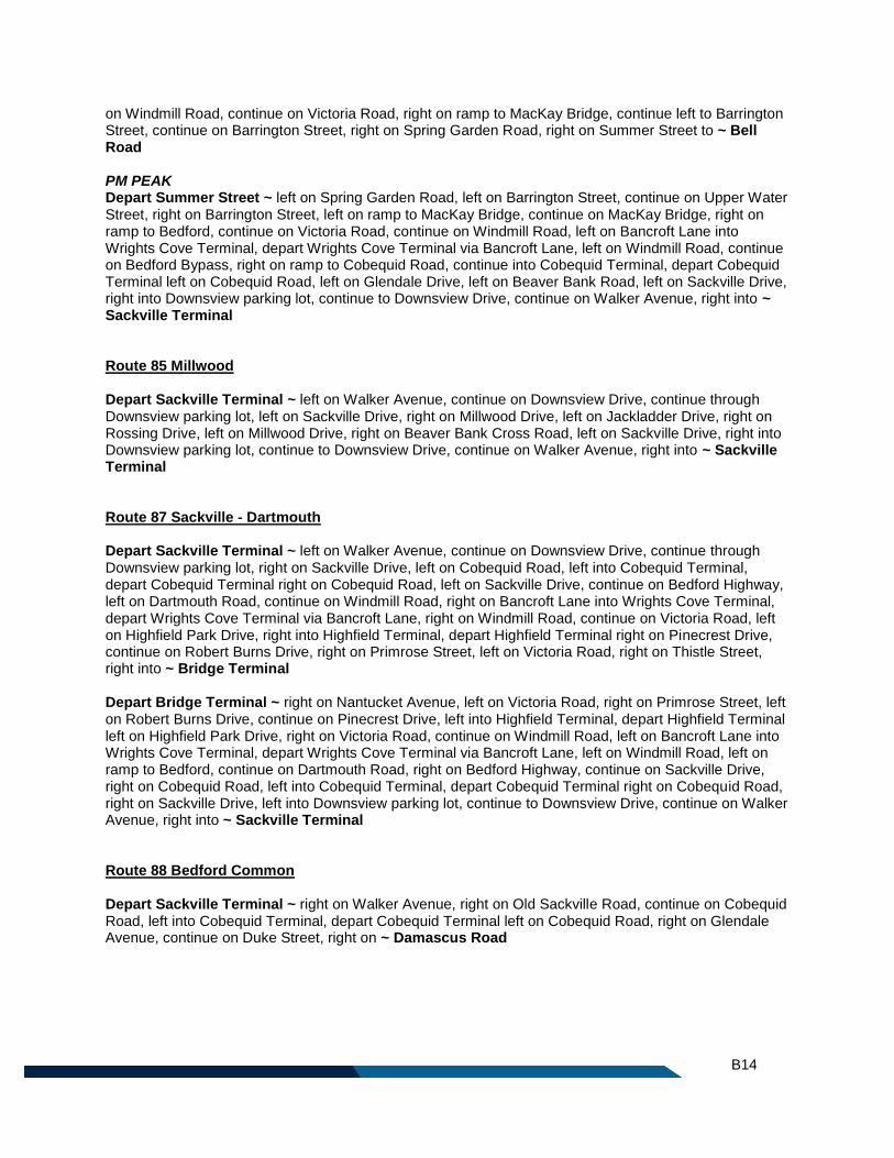
B14
on Windmill Road, continue on Victoria Road, right on ramp to MacKay Bridge, continue left to Barrington Street, continue on Barrington Street, right on Spring Garden Road, right on Summer Street to ~ Bell Road PM PEAK Depart Summer Street ~ left on Spring Garden Road, left on Barrington Street, continue on Upper Water Street, right on Barrington Street, left on ramp to MacKay Bridge, continue on MacKay Bridge, right on ramp to Bedford, continue on Victoria Road, continue on Windmill Road, left on Bancroft Lane into Wrights Cove Terminal, depart Wrights Cove Terminal via Bancroft Lane, left on Windmill Road, continue on Bedford Bypass, right on ramp to Cobequid Road, continue into Cobequid Terminal, depart Cobequid Terminal left on Cobequid Road, left on Glendale Drive, left on Beaver Bank Road, left on Sackville Drive, right into Downsview parking lot, continue to Downsview Drive, continue on Walker Avenue, right into ~ Sackville Terminal Route 85 Millwood Depart Sackville Terminal ~ left on Walker Avenue, continue on Downsview Drive, continue through Downsview parking lot, left on Sackville Drive, right on Millwood Drive, left on Jackladder Drive, right on Rossing Drive, left on Millwood Drive, right on Beaver Bank Cross Road, left on Sackville Drive, right into Downsview parking lot, continue to Downsview Drive, continue on Walker Avenue, right into ~ Sackville Terminal Route 87 Sackville - Dartmouth Depart Sackville Terminal ~ left on Walker Avenue, continue on Downsview Drive, continue through Downsview parking lot, right on Sackville Drive, left on Cobequid Road, left into Cobequid Terminal, depart Cobequid Terminal right on Cobequid Road, left on Sackville Drive, continue on Bedford Highway, left on Dartmouth Road, continue on Windmill Road, right on Bancroft Lane into Wrights Cove Terminal, depart Wrights Cove Terminal via Bancroft Lane, right on Windmill Road, continue on Victoria Road, left on Highfield Park Drive, right into Highfield Terminal, depart Highfield Terminal right on Pinecrest Drive, continue on Robert Burns Drive, right on Primrose Street, left on Victoria Road, right on Thistle Street, right into ~ Bridge Terminal Depart Bridge Terminal ~ right on Nantucket Avenue, left on Victoria Road, right on Primrose Street, left on Robert Burns Drive, continue on Pinecrest Drive, left into Highfield Terminal, depart Highfield Terminal left on Highfield Park Drive, right on Victoria Road, continue on Windmill Road, left on Bancroft Lane into Wrights Cove Terminal, depart Wrights Cove Terminal via Bancroft Lane, left on Windmill Road, left on ramp to Bedford, continue on Dartmouth Road, right on Bedford Highway, continue on Sackville Drive, right on Cobequid Road, left into Cobequid Terminal, depart Cobequid Terminal right on Cobequid Road, right on Sackville Drive, left into Downsview parking lot, continue to Downsview Drive, continue on Walker Avenue, right into ~ Sackville Terminal Route 88 Bedford Common Depart Sackville Terminal ~ right on Walker Avenue, right on Old Sackville Road, continue on Cobequid Road, left into Cobequid Terminal, depart Cobequid Terminal left on Cobequid Road, right on Glendale Avenue, continue on Duke Street, right on ~ Damascus Road
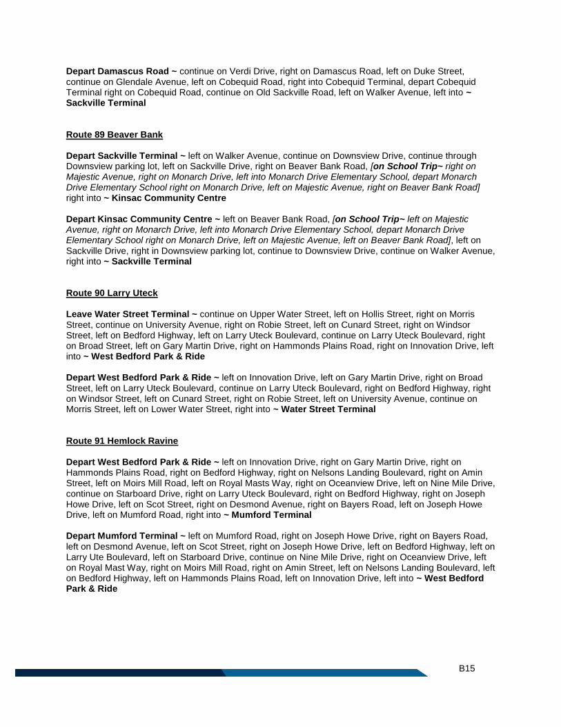
B15
Depart Damascus Road ~ continue on Verdi Drive, right on Damascus Road, left on Duke Street, continue on Glendale Avenue, left on Cobequid Road, right into Cobequid Terminal, depart Cobequid Terminal right on Cobequid Road, continue on Old Sackville Road, left on Walker Avenue, left into ~ Sackville Terminal Route 89 Beaver Bank Depart Sackville Terminal ~ left on Walker Avenue, continue on Downsview Drive, continue through Downsview parking lot, left on Sackville Drive, right on Beaver Bank Road, [on School Trip~ right on Majestic Avenue, right on Monarch Drive, left into Monarch Drive Elementary School, depart Monarch Drive Elementary School right on Monarch Drive, left on Majestic Avenue, right on Beaver Bank Road] right into ~ Kinsac Community Centre Depart Kinsac Community Centre ~ left on Beaver Bank Road, [on School Trip~ left on Majestic Avenue, right on Monarch Drive, left into Monarch Drive Elementary School, depart Monarch Drive Elementary School right on Monarch Drive, left on Majestic Avenue, left on Beaver Bank Road], left on Sackville Drive, right in Downsview parking lot, continue to Downsview Drive, continue on Walker Avenue, right into ~ Sackville Terminal Route 90 Larry Uteck Leave Water Street Terminal ~ continue on Upper Water Street, left on Hollis Street, right on Morris Street, continue on University Avenue, right on Robie Street, left on Cunard Street, right on Windsor Street, left on Bedford Highway, left on Larry Uteck Boulevard, continue on Larry Uteck Boulevard, right on Broad Street, left on Gary Martin Drive, right on Hammonds Plains Road, right on Innovation Drive, left into ~ West Bedford Park & Ride Depart West Bedford Park & Ride ~ left on Innovation Drive, left on Gary Martin Drive, right on Broad Street, left on Larry Uteck Boulevard, continue on Larry Uteck Boulevard, right on Bedford Highway, right on Windsor Street, left on Cunard Street, right on Robie Street, left on University Avenue, continue on Morris Street, left on Lower Water Street, right into ~ Water Street Terminal Route 91 Hemlock Ravine Depart West Bedford Park & Ride ~ left on Innovation Drive, right on Gary Martin Drive, right on Hammonds Plains Road, right on Bedford Highway, right on Nelsons Landing Boulevard, right on Amin Street, left on Moirs Mill Road, left on Royal Masts Way, right on Oceanview Drive, left on Nine Mile Drive, continue on Starboard Drive, right on Larry Uteck Boulevard, right on Bedford Highway, right on Joseph Howe Drive, left on Scot Street, right on Desmond Avenue, right on Bayers Road, left on Joseph Howe Drive, left on Mumford Road, right into ~ Mumford Terminal Depart Mumford Terminal ~ left on Mumford Road, right on Joseph Howe Drive, right on Bayers Road, left on Desmond Avenue, left on Scot Street, right on Joseph Howe Drive, left on Bedford Highway, left on Larry Ute Boulevard, left on Starboard Drive, continue on Nine Mile Drive, right on Oceanview Drive, left on Royal Mast Way, right on Moirs Mill Road, right on Amin Street, left on Nelsons Landing Boulevard, left on Bedford Highway, left on Hammonds Plains Road, left on Innovation Drive, left into ~ West Bedford Park & Ride
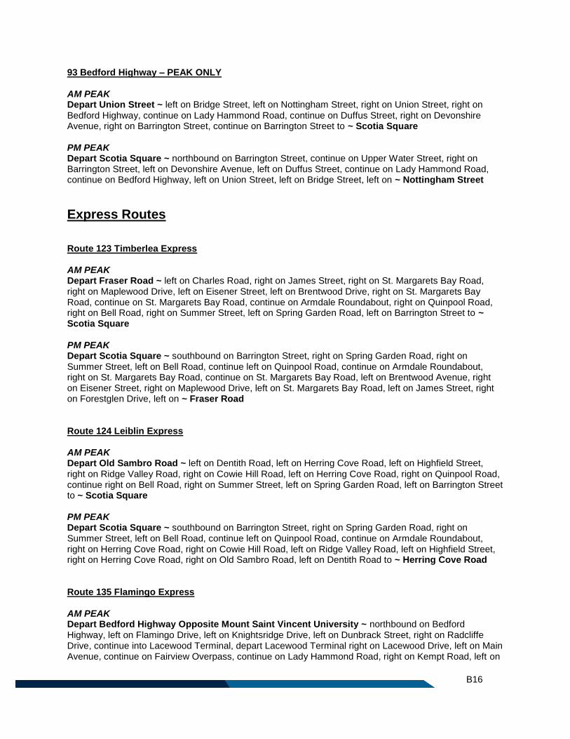
B16
93 Bedford Highway – PEAK ONLY AM PEAK Depart Union Street ~ left on Bridge Street, left on Nottingham Street, right on Union Street, right on Bedford Highway, continue on Lady Hammond Road, continue on Duffus Street, right on Devonshire Avenue, right on Barrington Street, continue on Barrington Street to ~ Scotia Square PM PEAK Depart Scotia Square ~ northbound on Barrington Street, continue on Upper Water Street, right on Barrington Street, left on Devonshire Avenue, left on Duffus Street, continue on Lady Hammond Road, continue on Bedford Highway, left on Union Street, left on Bridge Street, left on ~ Nottingham Street
Express Routes
Route 123 Timberlea Express AM PEAK Depart Fraser Road ~ left on Charles Road, right on James Street, right on St. Margarets Bay Road, right on Maplewood Drive, left on Eisener Street, left on Brentwood Drive, right on St. Margarets Bay Road, continue on St. Margarets Bay Road, continue on Armdale Roundabout, right on Quinpool Road, right on Bell Road, right on Summer Street, left on Spring Garden Road, left on Barrington Street to ~ Scotia Square PM PEAK Depart Scotia Square ~ southbound on Barrington Street, right on Spring Garden Road, right on Summer Street, left on Bell Road, continue left on Quinpool Road, continue on Armdale Roundabout, right on St. Margarets Bay Road, continue on St. Margarets Bay Road, left on Brentwood Avenue, right on Eisener Street, right on Maplewood Drive, left on St. Margarets Bay Road, left on James Street, right on Forestglen Drive, left on ~ Fraser Road Route 124 Leiblin Express AM PEAK Depart Old Sambro Road ~ left on Dentith Road, left on Herring Cove Road, left on Highfield Street, right on Ridge Valley Road, right on Cowie Hill Road, left on Herring Cove Road, right on Quinpool Road, continue right on Bell Road, right on Summer Street, left on Spring Garden Road, left on Barrington Street to ~ Scotia Square PM PEAK Depart Scotia Square ~ southbound on Barrington Street, right on Spring Garden Road, right on Summer Street, left on Bell Road, continue left on Quinpool Road, continue on Armdale Roundabout, right on Herring Cove Road, right on Cowie Hill Road, left on Ridge Valley Road, left on Highfield Street, right on Herring Cove Road, right on Old Sambro Road, left on Dentith Road to ~ Herring Cove Road Route 135 Flamingo Express AM PEAK Depart Bedford Highway Opposite Mount Saint Vincent University ~ northbound on Bedford Highway, left on Flamingo Drive, left on Knightsridge Drive, left on Dunbrack Street, right on Radcliffe Drive, continue into Lacewood Terminal, depart Lacewood Terminal right on Lacewood Drive, left on Main Avenue, continue on Fairview Overpass, continue on Lady Hammond Road, right on Kempt Road, left on
B17
Young Street, right on Gottingen Street, left on Cogswell Street, continue on Hollis Street, right on Morris Street, continue on ~ University Avenue PM PEAK Depart University Avenue ~ continue on University Avenue, continue on Morris Street, left on Lower Water Street, continue on Upper Water Street, left on Duke Street, right on Barrington Street, left on Cogswell Street, right on Gottingen Street, left on Young Street, right on Kempt Road, left on Lady Hammond Road, continue on Bedford Highway, right on ramp to Joseph Howe Drive, continue on Joseph Howe Drive, right on Dutch Village Road, right on Alma Crescent, right on Titus Street, continue on Lacewood Drive, left into Lacewood Terminal, depart Lacewood Terminal, continue on Radcliffe Drive, left on Dunbrack Street, right on Knightsridge Drive, right on Flamingo Drive, right on ~ Bedford Highway Route 136 Farnham Express AM PEAK Depart Farnham Gate Road at Dunbrack Street ~ left on Parkland Drive, left on Lacewood Drive, right into Lacewood Terminal, depart Lacewood Terminal right on Lacewood Drive, right on Willett Street, left on Rosedale Avenue, left on Dutch Village Road, continue right on Dutch Village Road, left on Joseph Howe Drive, right on ramp to Fairview Overpass, continue on Lady Hammond Road, right on Kempt Road, left on Young Street, right on Gottingen Street, left on Cogswell Street, continue on Hollis Street, right on Morris Street, continue on ~ University Avenue PM PEAK Depart University Avenue ~ continue on University Avenue, continue on Morris Street, left on Lower Water Street, continue on Upper Water Street, left on Duke Street, right on Barrington Street, left on Cogswell Street, right on Gottingen Street, left on Young Street, right on Kempt Road, left on Lady Hammond Road, continue on Bedford Highway, right on ramp to Joseph Howe Drive, continue on Joseph Howe Drive, right on Dutch Village Road, continue left on Dutch Village Road, left to stay on Dutch Village Road, right on Rosedale Avenue, right on Willett Street, left on Lacewood Drive, left into Lacewood Terminal, depart Lacewood Terminal left on Lacewood Drive, right on Parkland Drive, right on ~ Farnham Gate Road Route 137 Regency Park Express AM PEAK Depart Lacewood Terminal ~ left on Lacewood Drive, left on Regency Park Drive, left on Washmill Lake Drive, left on North West Arm Drive, right on Main Avenue, continue on Fairview Overpass, continue on Lady Hammond Road, right on Kempt Road, left on Young Street, right on Gottingen Street, left on Cogswell Street, continue on Hollis Street, right on Morris Street, continue on ~ University Avenue PM PEAK Depart University Avenue ~ continue on University Avenue, continue on Morris Street, left on Lower Water Street, continue on Upper Water Street, left on Duke Street, right on Barrington Street, left on Cogswell Street, right on Gottingen Street, left on Young Street, right on Kempt Road, left on Lady Hammond Road, continue on Bedford Highway, right on ramp to Joseph Howe Drive, continue on Joseph Howe Drive, right on Dutch Village Road, right on Alma Crescent, right on Titus Street, left on Main Avenue, left on North West Arm Drive, right on Washmill Lake Drive, right on Regency Park Drive, right on Lacewood Drive, right into ~ Lacewood Terminal
B18
Route 138 Parkland Express AM PEAK Depart Dunbrack Street at Wentworth Drive ~ continue on Dunbrack Street, continue on Kearney Lake Road, left on Parkland Drive, left on Lacewood Drive, right into Lacewood Terminal, depart Lacewood Terminal right on Lacewood Drive, right on Willett Street, right on Dunbrack Street, left on Main Avenue, continue on Fairview Overpass, continue on Lady Hammond Road, right on Kempt Road, left on Young Street, right on Gottingen Street, left on Cogswell Street, continue on Hollis Street, right on Morris Street, continue on ~ University Avenue PM PEAK Depart University Avenue ~ continue on University Avenue, continue on Morris Street, left on Lower Water Street, continue on Upper Water Street, left on Duke Street, right on Barrington Street, left on Cogswell Street, right on Gottingen Street, left on Young Street, right on Kempt Road, left on Lady Hammond Road, continue on Bedford Highway, right on ramp to Joseph Howe Drive, continue on Joseph Howe Drive, right on Dutch Village Road, right on Alma Crescent, right on Titus Street, left on Main Avenue, right on Dunbrack Street, left on Willett Street, left on Lacewood Drive, left into Lacewood Terminal, depart Lacewood Terminal left on Lacewood Drive, right on Parkland Drive, right on Kearney Lake Road, continue on ~ Dunbrack Street Route 158 Woodlawn Express AM PEAK Depart Portland Hills Terminal ~ left on Portland Street, right on Regal Road, left on Collins Grove, right on Spring Avenue, right on Dorothea Drive, left on Lucien Drive, left on Windward Avenue, left on Lea Street, right on Topsail Boulevard, left on Plaza Drive, left on Belle Vista Drive, left on Spring Avenue, right on Ellenvale Avenue, right on Waltdale Drive, left on Belle Vista Drive, left on Woodlawn Road, right on Portland Street, left on Alderney Drive, right on Wyse Road, right on Thistle Street, left into Bridge Terminal, depart Bridge Terminal right on Thistle Street, right on Wyse Road, left on Macdonald Bridge, right on ramp to Barrington Street, left on Hollis Street, right on Morris Street, continue on ~ University Avenue PM PEAK Depart University Avenue ~ continue on University Avenue, continue on Morris Street, left on Lower Water Street, continue on Upper Water Street, left on Duke Street, right on Barrington Street, left on Cogswell Street, right on Gottingen Street, right on North Street, continue on Macdonald Bridge, continue on Nantucket Avenue, right into Bridge Terminal, depart Bridge Terminal right on Thistle Street, left on Wyse Road, left on Alderney Drive, right on Portland Street, left into Penhorn Terminal, depart Penhorn Terminal left on Portland Street, left on Woodlawn Road, right on Belle Vista Drive, right on Waltdale Drive, left on Ellenvale Avenue, left on Spring Avenue, right on Belle Vista Drive, right on Plaza Drive, right on Topsail Boulevard, left on Lea Street, right on Windward Avenue, right on Lucien Drive, right on Dorothea Drive, left on Spring Avenue, left on Collins Grove, right on Regal Road, left on Portland Street, right into ~ Portland Hills Terminal Route 159 Colby Express AM PEAK Depart Portland Hills Terminal ~ right on Portland Street, continue on Cole Harbour Road, right on Ashgrove Avenue, left on Colby Drive, continue on Cumberland Drive, left on Cole Harbour Road, continue on Portland Street, left into Portland Hills Terminal, depart Portland Hills Terminal left on Portland Street, left on Alderney Drive, right on Wyse Road, right on Thistle Street, left into Bridge Terminal, depart Bridge Terminal right on Thistle Street, right on Wyse Road, left on Macdonald Bridge, right on ramp to Barrington Street, left on Hollis Street, right on Morris Street, continue on ~ University Avenue
B19
PM PEAK Depart University Avenue ~ continue on University Avenue, continue on Morris Street, left on Lower Water Street, continue on Upper Water Street, left on Duke Street, right on Barrington Street, left on Cogswell Street, right on Gottingen Street, right on North Street, continue on Macdonald Bridge, continue on Nantucket Avenue, right into Bridge Terminal, depart Bridge Terminal right on Thistle Street, left on Wyse Road, left on Alderney Drive, right on Portland Street, left into Penhorn Terminal, depart Penhorn Terminal left on Portland Street, right into Portland Hills Terminal, depart Portland Hills Terminal right on Portland Street, continue on Cole Harbour Road, right on Ashgrove Avenue, left on Colby Drive, continue on Cumberland Drive, left on Cole Harbour Road, continue on Portland Street, left into ~ Portland Hills Terminal Route 161A Cherry Brook Express AM PEAK Depart Portland Hills Terminal ~ right on Portland Street, continue on Cole Harbour Road, left on Forest Hills Parkway, right on Merrimac Drive, left on Arklow Drive, left on John Stewart Drive, right on Auburn Drive, right on Hillsboro Drive, continue on Montague Road, right on Lake Loon Road, left on Cherry Brook Road, right on Cherry Brook Road, right on Highway 7, left on Hillsboro Drive, left on Auburn Drive, left on John Stewart Drive, right on Arklow Drive, right on Merrimac Drive, left on Forest Hills Parkway, right on Cole Harbour Road, continue on Portland Street, left into Portland Hills Terminal, depart Portland Hills Terminal left on Portland Street, left on Alderney Drive, right on Wyse Road, right on Thistle Street, left into Bridge Terminal, depart Bridge Terminal right on Thistle Street, right on Wyse Road, left on Macdonald Bridge, right on ramp to Barrington Street, left on Hollis Street, right on Morris Street, continue on ~ University Avenue PM PEAK Depart University Avenue ~ continue on University Avenue, continue on Morris Street, left on Lower Water Street, continue on Upper Water Street, left on Duke Street, right on Barrington Street, left on Cogswell Street, right on Gottingen Street, right on North Street, continue on Macdonald Bridge, continue on Nantucket Avenue, right into Bridge Terminal, depart Bridge Terminal right on Thistle Street, left on Wyse Road, left on Alderney Drive, right on Portland Street, left into Penhorn Terminal, depart Penhorn Terminal left on Portland Street, right into Portland Hills Terminal, depart Portland Hills Terminal right on Portland Street, continue on Cole Harbour Road, left on Forest Hills Parkway, right on Merrimac Drive, left on Arklow Drive, left on John Stewart Drive, right on Auburn Drive, right on Hillsboro Drive, continue on Montague Road, right on Lake Loon Road, left on Cherry Brook Road, right on Cherry Brook Road, right on Highway 7, left on Hillsboro Drive, left on Auburn Drive, left on John Stewart Drive, right on Arklow Drive, right on Merrimac Drive, left on Forest Hills Parkway, right on Cole Harbour Road, continue on Portland Street, left into ~ Portland Hills Terminal Route 161B Auburn Express AM PEAK Depart Portland Hills Terminal ~ right on Portland Street, continue on Cole Harbour Road, left on Forest Hills Parkway, right on Merrimac Drive, left on Arklow Drive, left on John Stewart Drive, right on Auburn Drive, left on Bradorian Drive, right on Auburn Drive, left on John Stewart Drive, right on Arklow Drive, right on Merrimac Drive, left on Forest Hills Parkway, right on Cole Harbour Road, continue on Portland Street, left into Portland Hills Terminal, depart Portland Hills Terminal left on Portland Street, left on Alderney Drive, right on Wyse Road, right on Thistle Street, left into Bridge Terminal, depart Bridge Terminal right on Thistle Street, right on Wyse Road, left on Macdonald Bridge, right on ramp to Barrington Street, left on Hollis Street, right on Morris Street, continue on ~ University Avenue PM PEAK Depart University Avenue ~ continue on University Avenue, continue on Morris Street, left on Lower Water Street, continue on Upper Water Street, left on Duke Street, right on Barrington Street, left on
B20
Cogswell Street, right on Gottingen Street, right on North Street, continue on Macdonald Bridge, continue on Nantucket Avenue, right into Bridge Terminal, depart Bridge Terminal right on Thistle Street, left on Wyse Road, left on Alderney Drive, right on Portland Street, left into Penhorn Terminal, depart Penhorn Terminal left on Portland Street, right into Portland Hills Terminal, depart Portland Hills Terminal right on Portland Street, continue on Cole Harbour Road, left on Forest Hills Parkway, right on Merrimac Drive, left on Arklow Drive, left on John Stewart Drive, right on Auburn Drive, left on Bradorian Drive, right on Auburn Drive, left on John Stewart Drive, right on Arklow Drive, right on Merrimac Drive, left on Forest Hills Parkway, right on Cole Harbour Road, continue on Portland Street, left into ~ Portland Hills Terminal Route 165 Caldwell Express AM PEAK Depart Portland Hills Terminal ~ right on Portland Street, right on Caldwell Road, left on Astral Drive, right on Sherwood Street, right on Caldwell Road, left on Portland Street, left into Portland Hills Terminal, depart Portland Hills Terminal left on Portland Street, left on Alderney Drive, right on Wyse Road, right on Thistle Street, left into Bridge Terminal, depart Bridge Terminal right on Thistle Street, right on Wyse Road, left on Macdonald Bridge, right on ramp to Barrington Street, left on Hollis Street, right on Morris Street, continue on ~ University Avenue PM PEAK Depart University Avenue ~ continue on University Avenue, continue on Morris Street, left on Lower Water Street, continue on Upper Water Street, left on Duke Street, right on Barrington Street, left on Cogswell Street, right on Gottingen Street, right on North Street, continue on Macdonald Bridge, continue on Nantucket Avenue, right into Bridge Terminal, depart Bridge Terminal right on Thistle Street, left on Wyse Road, left on Alderney Drive, right on Portland Street, left into Penhorn Terminal, depart Penhorn Terminal left on Portland Street, right into Portland Hills Terminal, depart Portland Hills Terminal right on Portland Street, right on Caldwell Road, left on Astral Drive, right on Sherwood Street, right on Caldwell Road, left on Portland Street, left into ~ Portland Hills Terminal Route 168 North Preston Express AM PEAK Depart Portland Hills Terminal ~ right on Portland Street, continue on Cole Harbour Road, left on Otago Drive, right on Poplar Drive, right on Circassion Drive, left on Forest Hills Parkway, right on Highway 7, left on Lake Major Road, continue on North Preston Road, left on Simmonds Road, left into the North Preston Recreation Centre turning loop, depart North Preston Recreation Centre turning loop, right on Simmonds Road, right on North Preston Road, right on Cain Street, left on Clarence Street, left on Johnson Road, continue on North Preston Road, continue on Lake Major Road, right on Highway 7, left on Forest Hills Parkway, right on Circassion Drive, left on Poplar Drive, left on Otago Drive, right on Cole Harbour Road, continue on Portland Street, left into Portland Hills Terminal, depart Portland Hills Terminal left on Portland Street, left on Alderney Drive, right on Wyse Road, right on Thistle Street, left into Bridge Terminal, depart Bridge Terminal right on Thistle Street, right on Wyse Road, left on Macdonald Bridge, right on ramp to Barrington Street, left on Hollis Street, right on Morris Street, continue on ~ University Avenue PM PEAK Depart University Avenue ~ continue on University Avenue, continue on Morris Street, left on Lower Water Street, continue on Upper Water Street, left on Duke Street, right on Barrington Street, left on Cogswell Street, right on Gottingen Street, right on North Street, continue on Macdonald Bridge, continue on Nantucket Avenue, right into Bridge Terminal, depart Bridge Terminal right on Thistle Street, left on Wyse Road, left on Alderney Drive, right on Portland Street, left into Penhorn Terminal, depart Penhorn Terminal left on Portland Street, right into Portland Hills Terminal, depart Portland Hills Terminal right on Portland Street, continue on Cole Harbour Road, left on Otago Drive, right on Poplar Drive, right on
B21
Circassion Drive, left on Forest Hills Parkway, right on Highway 7, left on Lake Major Road, continue on North Preston Road, left on Simmonds Road, left into the North Preston Recreation Centre turning loop, depart North Preston Recreation Centre turning loop, right on Simmonds Road, right on North Preston Road, right on Cain Street, left on Clarence Street, left on Johnson Road, continue on North Preston Road, continue on Lake Major Road, right on Highway 7, left on Forest Hills Parkway, right on Circassion Drive, left on Poplar Drive, left on Otago Drive, right on Cole Harbour Road, continue on Portland Street, left into ~ Portland Hills Terminal Route 178 Mount Edward to Ferry Express AM PEAK Depart Gregory Drive ~ left on Flying Cloud Drive, right on Forest Hills Parkway, right on Flying Cloud Drive, left on Gregory Drive, left on Wildwood Boulevard, continue on Cranberry Crescent, left on Mount Edward Road, continue on Woodlawn Road, right on Portland Street, left on ramp to Circumferential Highway 111, right on Pleasant Street, left on Atlantic Street, right into ~ Woodside Ferry Terminal PM PEAK Depart Woodside Ferry Terminal ~ left on Atlantic Street, right on Pleasant Street, left on Circumferential Highway 111, right on ramp to Portland Street, left on Woodlawn Road, continue on Mount Edward Road, right on Cranberry Crescent, continue on Wildwood Boulevard, right on Gregory Drive, left on Flying Cloud Drive, right on Forest Hills Parkway, right on Flying Cloud Drive, left on ~ Gregory Drive Route 179 Cole Harbour to Ferry Express AM PEAK Depart Cole Harbour Road ~ continue on Cole Harbour Road, right on Ashgrove Avenue, right on Colby Drive, right on Cumberland Drive, left on Cole Harbour Road, continue on Portland Street, left into Portland Hills Terminal, depart Portland Hills Terminal left on Portland Street, left on ramp to Circumferential Highway 111, right on Pleasant Street, left on Atlantic Street, right into ~ Woodside Ferry Terminal PM PEAK Depart Woodside Ferry Terminal ~ left on Atlantic Street, right on Pleasant Street, left on Circumferential Highway 111, right on exit to Portland Street, continue on Portland Street, right into Portland Hills Terminal, depart Portland Hills Terminal right on Portland Street, continue on Cole Harbour Road, right on Ashgrove Avenue, right on Colby Drive, right on ~ Cumberland Drive Route 182 First Lake Express AM PEAK Depart Cobequid Terminal ~ left Cobequid Road, left on First Lake Drive, continue on First Lake Drive, right on Metropolitan Avenue, left on Nictaux Drive, left on Nappan Drive, left on Nictaux Drive, right on Nordic Crescent, left on Stokil Drive, left on Beaver Bank Road, left on Sackville Drive, right into Downsview parking lot, continue to Downsview Drive, continue on Walker Avenue, right into Sackville Terminal, left on Walker Avenue, continue on Downsview Drive, continue through Downsview parking lot, left on Sackville Drive, right on Beaver Bank Road, right on Stokil Drive, right on Nordic Crescent, left on Nictaux Drive, right on Nappan Drive, right on Nictaux Drive, right on Metropolitan Avenue, left on First Lake Drive, continue on First Lake Drive, right on Cobequid Road, right into Cobequid Terminal, depart Cobequid Terminal right on Cobequid Road, left on Sackville Drive, continue on Bedford Highway, left on Dartmouth Road, continue on Windmill Road, continue on Victoria Road, right on ramp to MacKay Bridge, continue on MacKay Bridge, continue left on ramp to Barrington Street, continue on Barrington Street, right on Spring Garden Road, right on Summer Street to ~ Bell Road
B22
PM PEAK Depart Summer Street ~ left on Spring Garden Road, left on Barrington Street, continue on Upper Water Street, right on Barrington Street, left on ramp to MacKay Bridge, continue on MacKay Bridge, right on Exit 2W to Bedford, continue on Windmill Road, continue left on ramp to Airport/Bedford, continue on Dartmouth Road, right on Bedford Highway, continue on Sackville Drive, right on Cobequid Road, left into Cobequid Terminal, depart Cobequid Terminal left on Cobequid Road, left on First Lake Drive, continue on First Lake Drive, right on Metropolitan Drive, left on Nictaux Drive, left on Nappan Drive, left on Nictaux Drive, right on Nordic Crescent, left on Stokil Drive, left on Beaver Bank Road, left on Sackville Drive, right into Downsview parking lot, continue to Downsview Drive, continue on Walker Avenue, right into Sackville Terminal, left on Walker Avenue, continue on Downsview Drive, continue through Downsview parking lot, left on Sackville Drive, right on Beaver Bank Road, right on Stokil Drive, right on Nordic Crescent, left on Nictaux Drive, right on Nappan Drive, right on Nictaux Drive, right on Metropolitan Avenue, left on First Lake Drive, continue on First Lake Drive, right on Cobequid Road, right into ~ Cobequid Terminal Route 183 Springfield Express AM PEAK Depart Sackville Terminal ~ left on Walker Avenue, left on Old Sackville Road, right on Melham Drive, left on Sackville Drive, left on Springfield Avenue, continue to Springfield Avenue turning loop, depart Springfield Avenue right on Sackville Drive, right on Melham Drive, left on Old Sackville Road, right on Walker Avenue, right into Sackville Terminal, depart Sackville Terminal left on Walker Avenue, left on Old Sackville Road, left on Beaver Bank Connector, continue on Highway 101, right on Exit 1F to Dartmouth, continue on the Bedford Bypass, continue on Windmill Road, continue on Victoria Road, right on ramp to MacKay Bridge, continue on MacKay Bridge, continue left to Barrington Street, continue on Barrington Street, right on Spring Garden Road, right on Summer Street to ~ Bell Road PM PEAK Depart Summer Street ~ left on Spring Garden Road, left on Barrington Street, continue on Upper Water Street, right on Barrington Street, left on ramp to MacKay Bridge, continue on MacKay Bridge, right on Exit 2W to Bedford, continue on Windmill Road, continue on the Bedford Bypass, continue on Highway 101, right on Exit 2 to Beaver Bank Road, continue on Beaver Bank Connector, right on Old Sackville Road, right on Walker Avenue, right into Sackville Terminal, depart Sackville Terminal left on Walker Avenue, left on Old Sackville Road, right on Melham Drive, left on Sackville Drive, left on Springfield Avenue, continue to Springfield Avenue turning loop, depart Springfield Avenue right on Sackville Drive, right on Melham Drive, left on Old Sackville Road, right on Walker Avenue, right into ~ Sackville Terminal Route 185 Millwood Express AM PEAK Depart Sackville Terminal ~ left on Walker Avenue, continue on Downsview Drive, continue through Downsview parking lot, left on Sackville Drive, right on Millwood Drive, left on Jackladder Drive, right on Rossing Drive, left on Millwood Drive, right on Beaver Bank Cross Road, left on Sackville Drive, right into Downsview parking lot, continue to Downsview Drive, continue on Walker Avenue, right into Sackville Terminal, depart Sackville Terminal left on Walker Avenue, left on Old Sackville Road, left on Beaver Bank Connector, continue on Highway 101, right on Exit 1F to Dartmouth, continue on the Bedford Bypass, continue on Windmill Road, continue on Victoria Road, right on ramp to MacKay Bridge, continue on MacKay Bridge, continue left to Barrington Street, continue on Barrington Street, right on Spring Garden Road, right on Summer Street to ~ Bell Road PM PEAK Depart Summer Street ~ left on Spring Garden Road, left on Barrington Street, continue on Upper Water Street, right on Barrington Street, left on ramp to MacKay Bridge, continue on MacKay Bridge, right on
B23
Exit 2W to Bedford, continue on Windmill Road, continue on the Bedford Bypass, continue on Highway 101, right on Exit 2 to Beaver Bank Road, continue on Beaver Bank Connector, right on Old Sackville Road, right on Walker Avenue, right into Sackville Terminal, depart Sackville Terminal left on Walker Avenue, continue on Downsview Drive, continue through Downsview parking lot, left on Sackville Drive, right on Millwood Drive, left on Jackladder Drive, right on Rossing Drive, left on Millwood Drive, right on Beaver Bank Cross Road, left on Sackville Drive, right into Downsview parking lot, continue to Downsview Drive, continue on Walker Avenue, right into ~ Sackville Terminal Route 186 Basinview Express AM PEAK Depart Rockmanor Drive ~ continue on Rockmanor Drive, left on Riverview Crescent, right on Rockmanor Drive, right on Rocky Lake Drive, left on Bedford Highway, right on Meadowbrook Drive, left on Basinview Drive, right on Hammonds Plains Road, left on ramp to Highway 102 Halifax, continue on Highway 102, right on Exit 1D to Dunbrack Street, left to Dunbrack Street, right on Main Avenue, continue on Fairview Overpass, continue on Lady Hammond Road, right on Kempt Road, left on Young Street, right on Gottingen Street, left on Cogswell Street, right on Barrington Street, right on Spring Garden Road, right on Summer Street to ~ Bell Road PM PEAK Depart Summer Street ~ left on Spring Garden Road, left on Barrington Street, left on Cogswell Street, right on Gottingen Street, left on Young Street, right on Kempt Road, left on Lady Hammond Road, continue on Bedford Highway, right on ramp to Joseph Howe Drive, continue on Joseph Howe Drive, right on Dutch Village Road, right on Alma Crescent, right on Titus Street, left on Main Avenue, left on North West Arm Drive, right on ramp to Highway 102, continue on Highway 102, right on Exit 3A to Bedford, continue on Hammonds Plains Road, left on Basinview Drive, right on Meadowbrook Drive, left on Bedford Highway, right on Rocky Lake Drive, left on Rockmanor Drive, left on Riverview Crescent, right on ~ Rockmanor Drive Route 189 Beaver Bank Express AM PEAK Depart Sackville Terminal ~ left on Walker Avenue, continue on Downsview Drive, continue through Downsview parking lot, left on Sackville Drive, right on Beaver Bank Road, continue on Beaver Bank Road, right into Kinsac Community Centre, depart Kinsac Community Centre left on Beaver Bank Road, continue on Beaver Bank Road, left on Sackville Drive, right into Downsview parking lot, continue to Downsview Drive, continue on Walker Avenue, right into Sackville Terminal, depart Sackville Terminal left on Walker Avenue, left on Old Sackville Road, left on Beaver Bank Connector, continue on Highway 101, right on Exit 1F to Dartmouth, continue on the Bedford Bypass, continue on Windmill Road, continue on Victoria Road, right on ramp to MacKay Bridge, continue on MacKay Bridge, continue left to Barrington Street, continue on Barrington Street, right on Spring Garden Road, right on Summer Street to ~ Bell Road PM PEAK Depart Summer Street ~ left on Spring Garden Road, left on Barrington Street, continue on Upper Water Street, right on Barrington Street, left on ramp to MacKay Bridge, continue on MacKay Bridge, right on Exit 2W to Bedford, continue on Windmill Road, continue on the Bedford Bypass, continue on Highway 101, right on Exit 2 to Beaver Bank Road, continue on Beaver Bank Connector, right on Old Sackville Road, right on Walker Avenue, right into Sackville Terminal, depart Sackville Terminal left on Walker Avenue, continue on Downsview Drive, continue through Downsview parking lot, left on Sackville Drive, right on Beaver Bank Road, continue on Beaver Bank Road, right into Kinsac Community Centre, depart Kinsac Community Centre left on Beaver Bank Road, continue on Beaver Bank Road, left on Sackville Drive, right into Downsview parking lot, continue to Downsview Drive, continue on Walker Avenue, right into ~ Sackville Terminal
B24
Route 192 Southgate Express AM PEAK Depart Larry Uteck Boulevard at Starboard Drive ~ continue on Larry Uteck Boulevard, left on Southgate Drive, left on Bedford Highway, left on Nelsons Landing Boulevard, right on Amin Street, left on Moirs Mill Road, left on Royal Masts Way, right on Oveanview Drive, left on Nine Mile Drive, right on Larry Uteck Boulevard, continue on Larry Uteck Boulevard West, exit roundabout on ramp to Highway 102 South to Halifax, continue on Highway 102, right on Exit 1D to Dunbrack Street, left to Dunbrack Street, right on Main Avenue, continue on Fairview Overpass, continue on Lady Hammond Road, right on Kempt Road, left on Young Street, right on Gottingen Street, left on Cogswell Street, right on Barrington Street, right on Spring Garden Road, right on Summer Street to ~ Bell Road PM PEAK Depart Summer Street ~ left on Spring Garden Road, left on Barrington Street, left on Cogswell Street, right on Gottingen Street, left on Young Street, right on Kempt Road, left on Lady Hammond Road, continue on Bedford Highway, right on ramp to Joseph Howe Drive, continue on Joseph Howe Drive, right on Dutch Village Road, right on Alma Crescent, right on Titus Street, left on Main Avenue, left on North West Arm Drive, right on ramp to Highway 102, continue on Highway 102, right on Exit 2B to Larry Uteck Boulevard, right on Larry Uteck Boulevard, left on Southgate Drive, left on Bedford Highway, left on Nelsons Landing Boulevard, right on Amin Street, left on Moirs Mill Road, left on Royal Masts Way, right on Oveanview Drive, left on Nine Mile Drive to ~ Larry Uteck Boulevard Route 194 Bedford West Express AM PEAK Depart West Bedford Park & Ride ~ left on Innovation Drive, left on Gary Martin Drive, right on Broad Street, left on Larry Uteck Boulevard, right on ramp to Highway 102 South to Halifax, continue on Highway 102, right on Exit 1D to Dunbrack Street, left to Dunbrack Street, right on Main Avenue, continue on Fairview Overpass, continue on Lady Hammond Road, right on Kempt Road, left on Young Street, right on Gottingen Street, left on Cogswell Street, right on Barrington Street, right on Spring Garden Road right on Summer Street to ~ Bell Road PM PEAK Depart Summer Street ~ left on Spring Garden Road, left on Barrington Street, left on Cogswell Street, right on Gottingen Street, left on Young Street, right on Kempt Road, left on Lady Hammond Road, continue on Bedford Highway, right on ramp to Joseph Howe Drive, continue on Joseph Howe Drive, right on Dutch Village Road, right on Alma Crescent, right on Titus Street, left on Main Avenue, left on North West Arm Drive, right on ramp to Highway 102, continue on Highway 102, right on Exit 2B to Larry Uteck Boulevard, left to Larry Uteck Boulevard West, continue to Kearney Lake Road/Larry Uteck Boulevard West, right on Broad Street, left on Gary Martin Drive, right on Hammonds Plains Road, right on Innovation Drive, left into ~ West Bedford Park & Ride Route 196 Starboard Express AM PEAK Depart Starboard Drive ~ continue on Starboard Drive, left on Larry Uteck Boulevard, continue to Larry Uteck Boulevard West, exit roundabout on ramp to Highway 102 South to Halifax, continue on Highway 102, right on Exit 1D to Dunbrack Street, left to Dunbrack Street, right on Main Avenue, continue on Fairview Overpass, continue on Lady Hammond Road, right on Kempt Road, left on Young Street, right on Gottingen Street, left on Cogswell Street, right on Barrington Street, right on Spring Garden Road right on Summer Street to ~ Bell Road
B25
PM PEAK Depart Summer Street ~ left on Spring Garden Road, left on Barrington Street, left on Cogswell Street, right on Gottingen Street, left on Young Street, right on Kempt Road, left on Lady Hammond Road, continue on Bedford Highway, right on ramp to Joseph Howe Drive, continue on Joseph Howe Drive, right on Dutch Village Road, right on Alma Crescent, right on Titus Street, left on Main Avenue, left on North West Arm Drive, right on ramp to Highway 102, continue on Highway 102, right on Exit 2B to Larry Uteck Boulevard, right on Larry Uteck Boulevard, right on Starboard Drive, left on Larry Uteck Boulevard to ~ Nine Mile Drive Route 310 Middle Sackville Regional Express Depart Margeson Park & Ride ~ right on Margeson Drive, exit roundabout to Highway 101 East to Halifax/Bedford, continue on Highway 101, right on Exit 1F to Dartmouth, continue on the Bedford Bypass, continue on Windmill Road, continue on Victoria Road, right on exit to MacKay Bridge, continue on MacKay Bridge, continue left to Barrington Street, continue on Barrington Street, right on Duke Street, right on ~ Albemarle Street Depart Albemarle Street ~ right on Cogswell Street, continue on Barrington Street, left on ramp to MacKay Bridge, continue on MacKay Bridge, right on Exit 2W to Bedford, continue on Windmill Road, continue on the Bedford Bypass, continue on Highway 101, right on Exit 2A to Middle Sackville, left through roundabout, continue on Margeson Drive, left into ~ Margeson Park & Ride Route 320 Airport / Fall River Regional Express Depart Albemarle Street ~ right on Cogswell Street, right on Barrington Street, right on Duke Street, continue on Gottingen Street, right on North Street, continue on Macdonald Bridge, right on Wyse Road, left on Thistle Street, left into Bridge Terminal, depart Bridge Terminal right on Nantucket Avenue, left on Victoria Road, right on Woodland Avenue, continue on Highway 118, right on Exit 14 Fall River, right on Perrin Drive, right on Falls Run, right into Fall River Park & Ride, depart Fall River Park & Ride left on Falls Run, left on Perrin Drive, right on ramp to Oakfield, exit roundabout to Highway 102 Airport/Truro, continue on Highway 102, right on Exit 5A to Aero Tech Business Park, right on Aerotech Drive, left on Pratt and Whitney Drive, right on Baldwin Drive, left on Barnes Drive, continue left on Bell Boulevard, left on ~ Silver Dart Drive Depart Silver Dart Drive ~ continue on Bell Boulevard, continue left to Red Wing Drive, continue on Red Wing Drive, right on Barnes Drive, right on Baldwin Drive, left on Pratt and Whitney Drive, right on Aerotech Drive, left on ramp to Highway 102 to Halifax, continue on Highway 102 keep right on Highway 102 to exit to Halifax, right on Exit 5 to Waverley, continue right on Highway 2, exit roundabout to Highway 118/Dartmouth, left on Perrin Drive, right on Falls Run, right into Fall River Park & ride, left on Falls Run, left on Perrin Drive, left on ramp to Highway 118 to Dartmouth, continue on Highway 118, continue on Woodland Avenue, left on Victoria Road, right on Thistle Street, right into Bridge Terminal, depart Bridge Terminal right on Thistle Street, right on Wyse Road, left on Macdonald Bridge, right on ramp to Barrington Street, continue on Barrington Street, right on Duke Street, right on ~ Albemarle Street Route 330 Tantallon Regional Express Trips Servicing Tantallon only Depart Albemarle Street ~ right on Cogswell Street, left on ramp to Barrington Street, left on North Street, right on Gottingen Street, left on Young Street, right on Kempt Road, left on Lady Hammond Road, continue on Bedford Highway, right on ramp to Joseph Howe Drive, continue on Joseph Howe Drive, right on Dutch Village Road, right on Alma Crescent, right on Titus Street, left on Main Avenue, left
B26
on North West Arm Drive, right on ramp to Highway 102, right on Exit 1A to Peggys Cove, continue on Highway 103, right on Exit 5 to Hammonds Plains Road, right on Hammonds Plains Road, left on Westwood Boulevard, left in parking lot, continue to ~ Hubley Centre Park & Ride Depart Hubley Centre Park & Ride ~ right on Hammonds Plains Road, left on ramp to Highway 103 Halifax, continue on Highway 103, right on Exit 1B to Halifax, continue on Highway 102, right on Exit 1D to Dunbrack Street, left to Dunbrack Street, right on Main Avenue, continue on Fairview Overpass, continue on Lady Hammond Road, right on Kempt Road, left on Young Street, right on Gottingen Street, left on Cogswell Street, right on Brunswick Street, left on Duke Street, left on ~ Albemarle Street Trips Servicing Sheldrake Lake only Depart Albemarle Street ~ right on Cogswell Street, left on ramp to Barrington Street, left on North Street, right on Gottingen Street, left on Young Street, right on Kempt Road, left on Lady Hammond Road, continue on Bedford Highway, right on ramp to Joseph Howe Drive, continue on Joseph Howe Drive, right on Dutch Village Road, right on Alma Crescent, right on Titus Street, left on Main Avenue, left on North West Arm Drive, right on ramp to Highway 102, right on Exit 1A to Peggys Cove, continue on Highway 103, right on Exit 4 to Hubley, right on Highway 3, right into ~ Sheldrake Lake Park & Ride Depart Sheldrake Lake Park & Ride ~ left on Highway 3, left on ramp to Highway 103 Halifax, continue on Highway 103, right on Exit 1B to Halifax, continue on Highway 102, right on Exit 1D to Dunbrack Street, left to Dunbrack Street, right on Main Avenue, continue on Fairview Overpass, continue on Lady Hammond Road, right on Kempt Road, left on Young Street, right on Gottingen Street, left on Cogswell Street, right on Brunswick Street, left on Duke Street, left on ~ Albemarle Street Trips Servicing both Sheldrake Lake & Tantallon Depart Albemarle Street ~ right on Cogswell Street, left on ramp to Barrington Street, left on North Street, right on Gottingen Street, left on Young Street, right on Kempt Road, left on Lady Hammond Road, continue on Bedford Highway, right on ramp to Joseph Howe Drive, continue on Joseph Howe Drive, right on Dutch Village Road, right on Alma Crescent, right on Titus Street, left on Main Avenue, left on North West Arm Drive, right on ramp to Highway 102, right on Exit 1A to Peggys Cove, continue on Highway 103, right on Exit 4 to Hubley, right on Highway 3, right into Sheldrake Lake Park & Ride, depart Sheldrake Lake Park & Ride left on Highway 3, continue right on ramp to Highway 103, continue on Highway 103, right on Exit 5 to Hammonds Plains Road, right on Hammonds Plains Road, left on Westwood Boulevard, left in parking lot, continue to ~ Hubley Centre Park & Ride Depart Hubley Centre Park & Ride ~ right on Hammonds Plains Road, left on ramp to Highway 103 Halifax, right on Exit 4 Ramp to Hubley, left on Highway 3, right into Sheldrake Lake Park & Ride, depart Sheldrake Lake Park & Ride left on Highway 3, left on ramp to Highway 103 Halifax, continue on Highway 103, right on Exit 1B to Halifax, continue on Highway 102, right on Exit 1D to Dunbrack Street, left to Dunbrack Street, right on Main Avenue, continue on Fairview Overpass, continue on Lady Hammond Road, right on Kempt Road, left on Young Street, right on Gottingen Street, left on Cogswell Street, right on Brunswick Street, left on Duke Street, left on ~ Albemarle Street Route 370 Porters Lake Regional Express Depart Albemarle Street ~ right on Cogswell Street, right on Barrington Street, right on Duke Street, continue on Gottingen Street, right on North Street, continue on Macdonald Bridge, right on Wyse Road, left on Thistle Street, left into Bridge Terminal, depart Bridge Terminal right on Nantucket Avenue, left on Victoria Road, right on Woodland Avenue, continue on Highway 118, right on Exit 11 to Highway 111/Main Street, continue on Circumferential Highway 111, continue on Main Street, continue on
B27
Highway 7, continue on Highway 107, right on Exit 20 Porters Lake, left on William Porter Connector, right on Inspiration Drive, right into ~ Porters Lake Park & Ride Depart Porters Lake Park & Ride ~ left on Inspiration Drive, left on William Porter Connector, right on exit to Highway 107 to Dartmouth, continue on Highway 107, continue on Highway 7, continue on Main Street, right on exit to Prince Albert Road, left on Braemar Drive, continue on Grahams Grove, continue on Prince Albert Road, continue on Ochterloney Street, right on Alderney Drive, right on Wyse Road, right on Thistle Street, left into Bridge Terminal, depart Bridge Terminal right on Thistle Street, right on Wyse Road, left on Macdonald Bridge, right on ramp to Barrington Street, continue on Barrington Street, right on Duke Street, right on ~ Albemarle Street 401 Porters Lake Depart Portland Hills Terminal ~ right on Portland Street, continue on Cole Harbour Road, left on Ross Road, right on Highway 7, left at Exit 17 to East Preston, left on Brooks Drive, right on Upper Partridge River Road, left on Highway 7, right into Lakeview Shopping Centre parking lot, depart Lakeview Shopping Centre left on Highway 7, left on William Porter Connector, left on Inspiration Drive, right into ~ Porters Lake Park & Ride Depart Porters Lake Park & Ride ~ left on Inspiration Drive, right on William Porter Connector, right on Highway 7, right into Lakeview Shopping Centre parking lot, depart Lakeview Shopping Centre left on Highway 7, right on Upper Partridge River Road, left on Brooks Drive, right on Highway 7, right to stay on Highway 7, left on Ross Road, right on Cole Harbour Road, continue on Portland Street, left into ~ Portland Hills Terminal 415 Purcells Cove Depart Desmond Avenue ~ right on Bayers Road, left on Joseph Howe Drive, left on Mumford Road, right into Mumford Terminal, Leave Mumford Terminal, right on Mumford Road, right on Chebucto Road, through the Roundabout, continue to Herring Cove Road, left on Purcells Cove Road, left on second Fergusons Cove Road, right in to ~ York Redoubt turning loop. Depart York Redoubt turning loop ~ left on Fergusons Cove Road, right on Purcells Cove Road, right on Herring Cove Road, through the Roundabout, continue to Chebucto Road, left on Mumford Road, left into Mumford Terminal. Leave Mumford Terminal, left on Mumford Road, right on Joseph Howe Drive, right on Scot Street, right on Desmond Avenue, continue ~ Bayers Road Shopping Centre. 433 Tantallon Depart Lacewood Terminal ~ right on Lacewood Drive, left on Dunbrack Street, continue on Kearney Lake Road, left on Larry Uteck Boulevard, right on Bluewater Road, left on Hammonds Plains Road, right on Westwood Boulevard, left in parking lot, continue to ~ Hubley Centre Park & Ride Depart Hubley Centre Park & Ride ~ left on Hammonds Plains Road, right on Bluewater Road, left on Larry Uteck Boulevard, right on Kearney Lake Road, continue on Dunbrack Street, right on Lacewood Drive, left into ~ Lacewood Terminal
B28
School Routes
701 Halifax West Depart Mumford Terminal ~ left on Mumford Road, right on Joseph Howe Drive, right on Bayers Road, left on Desmond Ave, left on Scot Street, right on Joseph Howe Drive, left on Dutch Village Road, left to stay on Dutch Village Road, right on Rosedale Avenue, right on Willett Street, left on Lacewood Drive, left into Lacewood Terminal, Depart Lacewood Terminal left on Lacewood Drive, left on Regency Park Drive, left on Thomas Raddall Drive, left into ~ Halifax West High School Depart Halifax West High School ~ right on Thomas Raddall Drive, right on Regency Park Drive, right on Lacewood Drive, right into Lacewood Terminal, depart Lacewood Terminal right on Lacewood Drive, right on Willett Street, left on Rosedale Avenue, left on Dutch Village Road, right to stay on Dutch Village Road, right on Joseph Howe Drive, left on Scot Street, right on Desmond Avenue, right on Bayers Road, left on Joseph Howe Drive, left on Mumford Road to ~ Mumford Terminal 726 Citadel Depart North Park Street roundabout ~ on Cogswell Street, continue on Quinpool Road, right on Chebucto Road, left on Mumford Road, left into Mumford Terminal, depart Mumford Terminal left on Mumford Road, left on Joseph Howe Drive, right on St. Margarets Bay Road, left on Fenwood Road, right on Stonehaven Road, right on Glenmore Avenue, left on Edgehill Road, right on Quarry Road, right on St. Margarets Bay Road, left on Joseph Howe Drive, right on Mumford Road, right on Chebucto Road, left on Quinpool Road, continue on Cogswell Street to ~ North Park Street roundabout 735 Clayton Park AM Depart Dunbrack Street ~ right on Kearney Lake Road, right on Bedford Highway, right on Flamingo Drive, left on Knightsridge Drive, left on Dunbrack Street, left on Willett Street, left on Glenforest Drive, left on Plateau Crescent, right into ~ Clayton Park Junior High PM Depart Clayton Park Junior High ~ right on Plateau Crescent, left on Clayton Park Drive, right on Dunbrack Street, right on Kearney Lake Drive, right on Bedford Highway, right on Flamingo Drive, left on Knightsridge Drive, continue to ~ Dunbrack Street
A1
Appendix C: Alternative Measures of Route Productivity

A1
Alternative Measures of Route Productivity
Through the roll out of the Halifax Transit Technology Plan, Halifax Transit will be able to gather more
information than ever before on route productivity and service utilization. The utilization rate (also known
as load factor) is another metric of evaluating the success of a route. This metric is a percentage
calculated by dividing the number of passenger kilometers provided by each trip by the number of seat
kilometers provided by each trip.
𝑆𝑢𝑚 𝑜𝑓 𝑘𝑖𝑙𝑜𝑚𝑒𝑡𝑒𝑟𝑠 𝑡𝑟𝑎𝑣𝑒𝑙𝑙𝑒𝑑 𝑏𝑦 𝑎𝑙𝑙 𝑝𝑎𝑠𝑠𝑒𝑛𝑔𝑒𝑟𝑠 𝑜𝑛 𝑎 𝑡𝑟𝑖𝑝
(𝑁𝑢𝑚𝑏𝑒𝑟 𝑜𝑓 𝑠𝑒𝑎𝑡𝑠 𝑜𝑛 𝑣𝑒ℎ𝑖𝑐𝑙𝑒 𝑥 𝐿𝑒𝑛𝑔𝑡ℎ 𝑜𝑓 𝑡𝑟𝑖𝑝 𝑖𝑛 𝑘𝑖𝑙𝑜𝑚𝑒𝑡𝑒𝑟𝑠) = 𝑈𝑡𝑖𝑙𝑖𝑧𝑎𝑡𝑖𝑜𝑛 𝑅𝑎𝑡𝑒
This is an excellent indicator of how much of the transit service being supplied is utilized by passengers.
This is a single metric that can be applied to all service types and buses of any capacity.
Productivity and Economic Measures While using ridership as an approximation of the success of a transit route is one industry standard, this
measure in itself does not capture a true picture of the route’s success as it does not incorporate its
financial viability. In order to provide a more complete picture of the success of a route, staff may use the
following composite measures to evaluate the overall productivity of a route as compared to other routes
of the same service type:
Measuring Productivity and Economic Measures
Ridership Productivity
Measure
Passenger boardings per revenue hour (Corridor Routes, Local Routes, Rural Routes)
The number of average daily boardings per route, divided by the daily number of revenue hours of service. The standard is calculated as the average of all routes in each service category.
Or
Passenger boarding per revenue trip (Express Routes, Regional Express Routes)
This measure is appropriate to measure the success of these route types, as they may vary significantly in route length and one way travel times. This measure is defined as the number of average daily boardings divided by the number of daily revenue trips. The standard is calculated as the average of all Express Routes’ passenger boardings per revenue trip
Economic Measure
Cost per passenger boarding (all service types)
The average cost of providing a route divided by the number of passenger boardings. The standard is calculated as the average of all routes in each service category.
These two measures may be evaluated for each route and indexed against the average for all routes in
that service type, generating a Ridership Productivity Index and an Economic Standard Index. These two
indices would be averaged to get the Combined Index, a well-rounded measure to evaluate the
performance of a route type against others in that service category. The table below provides a sample
output for three fictional routes:
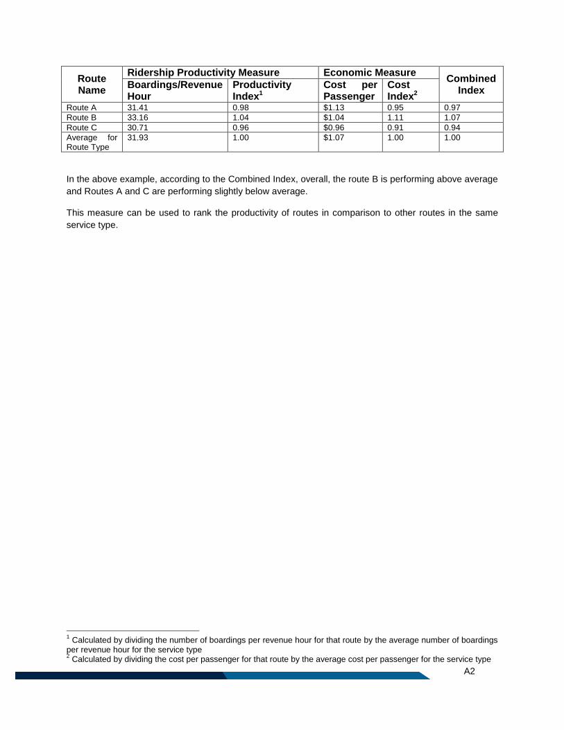
A2
Route Name
Ridership Productivity Measure Economic Measure Combined
Index Boardings/Revenue Hour
Productivity Index1
Cost per Passenger
Cost Index2
Route A 31.41 0.98 $1.13 0.95 0.97
Route B 33.16 1.04 $1.04 1.11 1.07
Route C 30.71 0.96 $0.96 0.91 0.94
Average for Route Type
31.93 1.00 $1.07 1.00 1.00
In the above example, according to the Combined Index, overall, the route B is performing above average
and Routes A and C are performing slightly below average.
This measure can be used to rank the productivity of routes in comparison to other routes in the same
service type.
1 Calculated by dividing the number of boardings per revenue hour for that route by the average number of boardings
per revenue hour for the service type 2 Calculated by dividing the cost per passenger for that route by the average cost per passenger for the service type
Appendix D: Frequency Guideline by Route

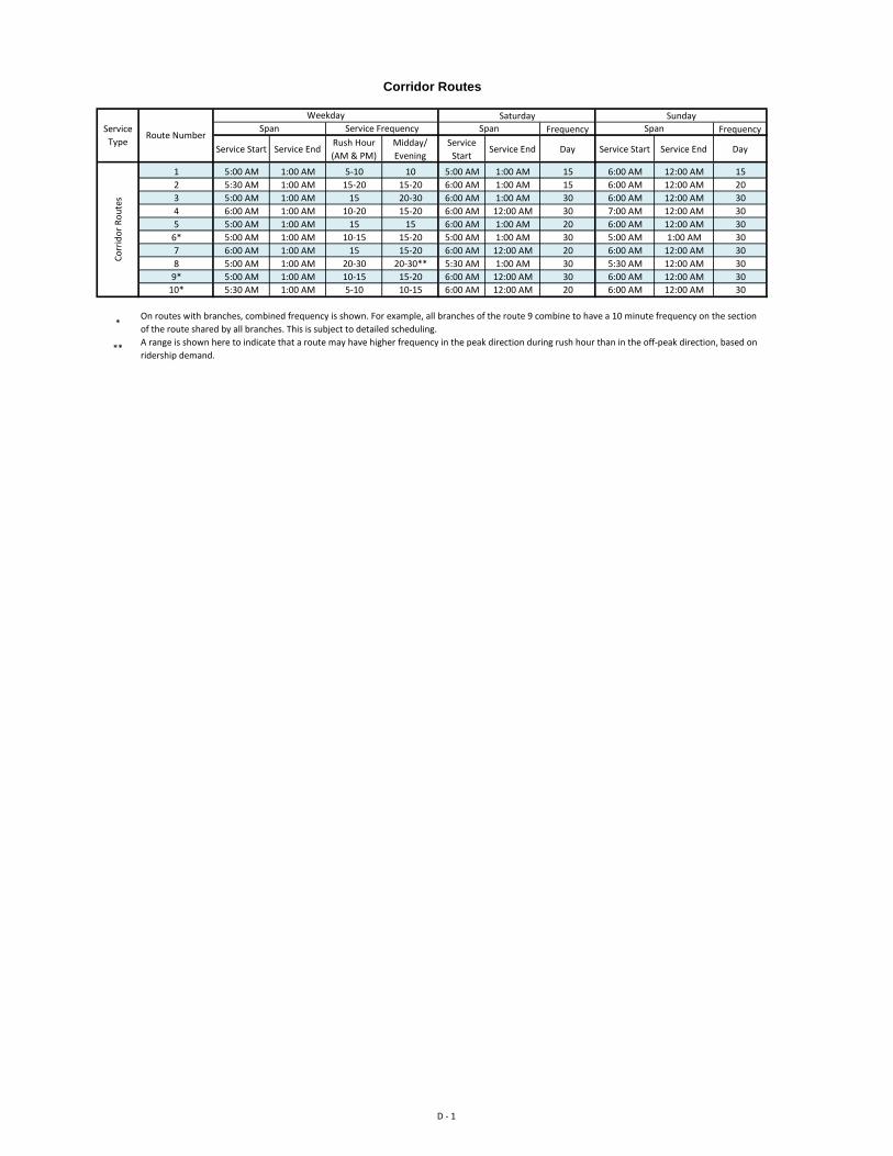
Frequency Frequency
Service Start Service EndRush Hour
(AM & PM)
Midday/
Evening
Service
StartService End Day Service Start Service End Day
1 5:00 AM 1:00 AM 5-10 10 5:00 AM 1:00 AM 15 6:00 AM 12:00 AM 15
2 5:30 AM 1:00 AM 15-20 15-20 6:00 AM 1:00 AM 15 6:00 AM 12:00 AM 20
3 5:00 AM 1:00 AM 15 20-30 6:00 AM 1:00 AM 30 6:00 AM 12:00 AM 30
4 6:00 AM 1:00 AM 10-20 15-20 6:00 AM 12:00 AM 30 7:00 AM 12:00 AM 30
5 5:00 AM 1:00 AM 15 15 6:00 AM 1:00 AM 20 6:00 AM 12:00 AM 30
6* 5:00 AM 1:00 AM 10-15 15-20 5:00 AM 1:00 AM 30 5:00 AM 1:00 AM 30
7 6:00 AM 1:00 AM 15 15-20 6:00 AM 12:00 AM 20 6:00 AM 12:00 AM 30
8 5:00 AM 1:00 AM 20-30 20-30** 5:30 AM 1:00 AM 30 5:30 AM 12:00 AM 30
9* 5:00 AM 1:00 AM 10-15 15-20 6:00 AM 12:00 AM 30 6:00 AM 12:00 AM 30
10* 5:30 AM 1:00 AM 5-10 10-15 6:00 AM 12:00 AM 20 6:00 AM 12:00 AM 30
*
**
Corridor Routes
Co
rrid
or
Ro
ute
s
On routes with branches, combined frequency is shown. For example, all branches of the route 9 combine to have a 10 minute frequency on the section
of the route shared by all branches. This is subject to detailed scheduling.
A range is shown here to indicate that a route may have higher frequency in the peak direction during rush hour than in the off-peak direction, based on
ridership demand.
Service
TypeRoute Number
Weekday Saturday Sunday
Span Service Frequency Span Span
D - 1
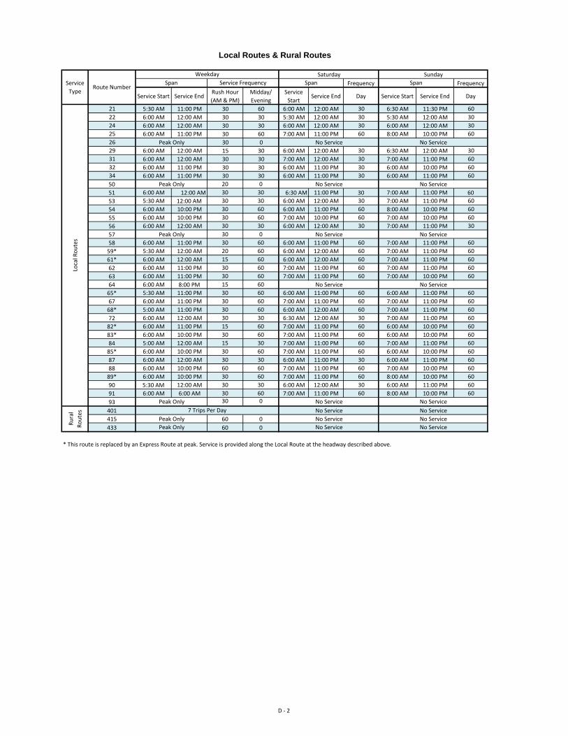
Frequency Frequency
Service Start Service EndRush Hour
(AM & PM)
Midday/
Evening
Service
StartService End Day Service Start Service End Day
21 5:30 AM 11:00 PM 30 60 6:00 AM 12:00 AM 30 6:30 AM 11:30 PM 60
22 6:00 AM 12:00 AM 30 30 5:30 AM 12:00 AM 30 5:30 AM 12:00 AM 30
24 6:00 AM 12:00 AM 30 30 6:00 AM 12:00 AM 30 6:00 AM 12:00 AM 30
25 6:00 AM 11:00 PM 30 60 7:00 AM 11:00 PM 60 8:00 AM 10:00 PM 60
26 30 0
29 6:00 AM 12:00 AM 15 30 6:00 AM 12:00 AM 30 6:30 AM 12:00 AM 30
31 6:00 AM 12:00 AM 30 30 7:00 AM 12:00 AM 30 7:00 AM 11:00 PM 60
32 6:00 AM 11:00 PM 30 30 6:00 AM 11:00 PM 30 6:00 AM 10:00 PM 60
34 6:00 AM 11:00 PM 30 30 6:00 AM 11:00 PM 30 6:00 AM 11:00 PM 60
50 20 0
51 6:00 AM 12:00 AM 30 30 6:30 AM 11:00 PM 30 7:00 AM 11:00 PM 60
53 5:30 AM 12:00 AM 30 30 6:00 AM 12:00 AM 30 7:00 AM 11:00 PM 60
54 6:00 AM 10:00 PM 30 60 6:00 AM 11:00 PM 60 8:00 AM 10:00 PM 60
55 6:00 AM 10:00 PM 30 60 7:00 AM 10:00 PM 60 7:00 AM 10:00 PM 60
56 6:00 AM 12:00 AM 30 30 6:00 AM 12:00 AM 30 7:00 AM 11:00 PM 30
57 30 0
58 6:00 AM 11:00 PM 30 60 6:00 AM 11:00 PM 60 7:00 AM 11:00 PM 60
59* 5:30 AM 12:00 AM 20 60 6:00 AM 12:00 AM 60 7:00 AM 11:00 PM 60
61* 6:00 AM 12:00 AM 15 60 6:00 AM 12:00 AM 60 7:00 AM 11:00 PM 60
62 6:00 AM 11:00 PM 30 60 7:00 AM 11:00 PM 60 7:00 AM 11:00 PM 60
63 6:00 AM 11:00 PM 30 60 7:00 AM 11:00 PM 60 7:00 AM 10:00 PM 60
64 6:00 AM 8:00 PM 15 60
65* 5:30 AM 11:00 PM 30 60 6:00 AM 11:00 PM 60 6:00 AM 11:00 PM 60
67 6:00 AM 11:00 PM 30 60 7:00 AM 11:00 PM 60 7:00 AM 11:00 PM 60
68* 5:00 AM 11:00 PM 30 60 6:00 AM 12:00 AM 60 7:00 AM 11:00 PM 60
72 6:00 AM 12:00 AM 30 30 6:30 AM 12:00 AM 30 7:00 AM 11:00 PM 60
82* 6:00 AM 11:00 PM 15 60 7:00 AM 11:00 PM 60 6:00 AM 10:00 PM 60
83* 6:00 AM 10:00 PM 30 60 7:00 AM 11:00 PM 60 6:00 AM 10:00 PM 60
84 5:00 AM 12:00 AM 15 30 7:00 AM 11:00 PM 60 7:00 AM 11:00 PM 60
85* 6:00 AM 10:00 PM 30 60 7:00 AM 11:00 PM 60 6:00 AM 10:00 PM 60
87 6:00 AM 12:00 AM 30 30 6:00 AM 11:00 PM 30 6:00 AM 11:00 PM 60
88 6:00 AM 10:00 PM 60 60 7:00 AM 11:00 PM 60 7:00 AM 10:00 PM 60
89* 6:00 AM 10:00 PM 30 60 7:00 AM 11:00 PM 60 8:00 AM 10:00 PM 60
90 5:30 AM 12:00 AM 30 30 6:00 AM 12:00 AM 30 6:00 AM 11:00 PM 60
91 6:00 AM 6:00 AM 30 60 7:00 AM 11:00 PM 60 8:00 AM 10:00 PM 60
93 30 0
401
415 60 0
433 60 0
* This route is replaced by an Express Route at peak. Service is provided along the Local Route at the headway described above.
Local Routes & Rural Routes
Ru
ral
Ro
ute
s 7 Trips Per Day No Service No Service
Peak Only No Service No Service
Peak Only No Service No Service
Loca
l Ro
ute
s
Peak Only No Service No Service
Peak Only No Service No Service
Peak Only No Service No Service
No Service No Service
Peak Only No Service No Service
Service
TypeRoute Number
Weekday Saturday Sunday
Span Service Frequency Span Span
D - 2
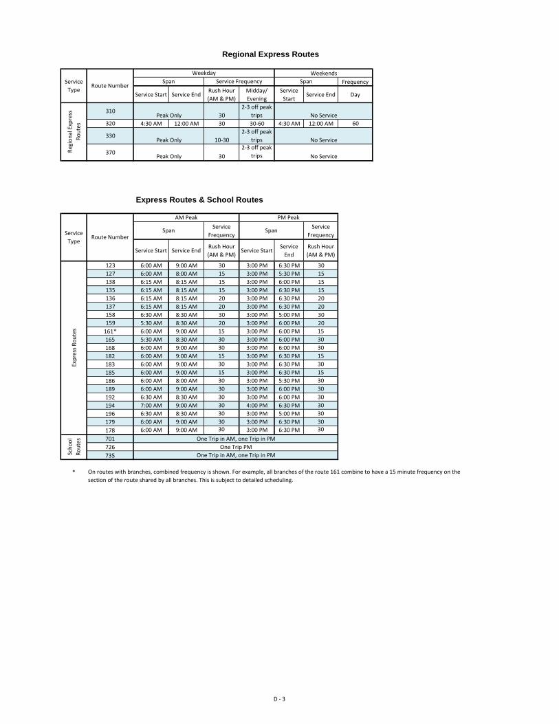
Frequency
Service Start Service EndRush Hour
(AM & PM)
Midday/
Evening
Service
StartService End Day
31030
2-3 off peak
trips
320 4:30 AM 12:00 AM 30 30-60 4:30 AM 12:00 AM 60
33010-30
2-3 off peak
trips
37030
2-3 off peak
trips
Service
Frequency
Service
Frequency
Service Start Service EndRush Hour
(AM & PM)Service Start
Service
End
Rush Hour
(AM & PM)
123 6:00 AM 9:00 AM 30 3:00 PM 6:30 PM 30
127 6:00 AM 8:00 AM 15 3:00 PM 5:30 PM 15
138 6:15 AM 8:15 AM 15 3:00 PM 6:00 PM 15
135 6:15 AM 8:15 AM 15 3:00 PM 6:30 PM 15
136 6:15 AM 8:15 AM 20 3:00 PM 6:30 PM 20
137 6:15 AM 8:15 AM 20 3:00 PM 6:30 PM 20
158 6:30 AM 8:30 AM 30 3:00 PM 5:00 PM 30
159 5:30 AM 8:30 AM 20 3:00 PM 6:00 PM 20
161* 6:00 AM 9:00 AM 15 3:00 PM 6:00 PM 15
165 5:30 AM 8:30 AM 30 3:00 PM 6:00 PM 30
168 6:00 AM 9:00 AM 30 3:00 PM 6:00 PM 30
182 6:00 AM 9:00 AM 15 3:00 PM 6:30 PM 15
183 6:00 AM 9:00 AM 30 3:00 PM 6:30 PM 30
185 6:00 AM 9:00 AM 15 3:00 PM 6:30 PM 15
186 6:00 AM 8:00 AM 30 3:00 PM 5:30 PM 30
189 6:00 AM 9:00 AM 30 3:00 PM 6:00 PM 30
192 6:30 AM 8:30 AM 30 3:00 PM 6:00 PM 30
194 7:00 AM 9:00 AM 30 4:00 PM 6:30 PM 30
196 6:30 AM 8:30 AM 30 3:00 PM 5:00 PM 30
179 6:00 AM 9:00 AM 30 3:00 PM 6:30 PM 30
178 6:00 AM 9:00 AM 30 3:00 PM 6:30 PM 30
701
726
735
*
Regional Express Routes
Express Routes & School Routes
Reg
ion
al E
xpre
ss
Ro
ute
s
Peak Only No Service
Peak Only No Service
Peak Only No Service
Service
TypeRoute Number
Weekday Weekends
On routes with branches, combined frequency is shown. For example, all branches of the route 161 combine to have a 15 minute frequency on the
section of the route shared by all branches. This is subject to detailed scheduling.
Exp
ress
Ro
ute
sSc
ho
ol
Ro
ute
s One Trip in AM, one Trip in PM
One Trip PM
One Trip in AM, one Trip in PM
Service
TypeRoute Number
AM Peak PM Peak
Span Span
Span Service Frequency Span
D - 3


E1
Appendix E: Cost/Benefit Analysis of Transit Priority Measures

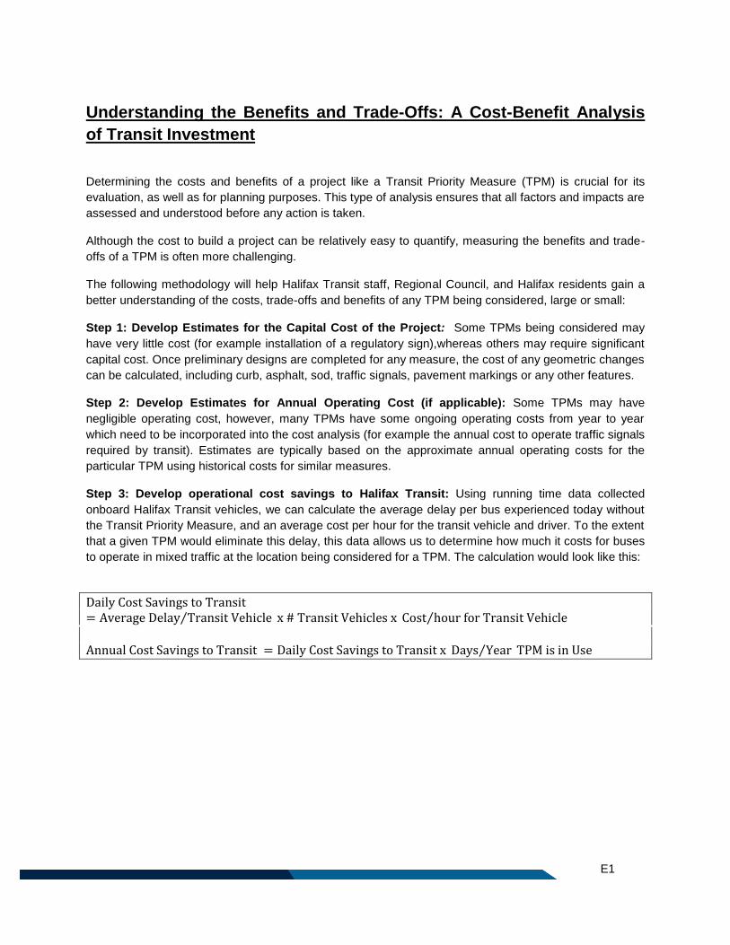
E1
Understanding the Benefits and Trade-Offs: A Cost-Benefit Analysis
of Transit Investment
Determining the costs and benefits of a project like a Transit Priority Measure (TPM) is crucial for its
evaluation, as well as for planning purposes. This type of analysis ensures that all factors and impacts are
assessed and understood before any action is taken.
Although the cost to build a project can be relatively easy to quantify, measuring the benefits and trade-
offs of a TPM is often more challenging.
The following methodology will help Halifax Transit staff, Regional Council, and Halifax residents gain a
better understanding of the costs, trade-offs and benefits of any TPM being considered, large or small:
Step 1: Develop Estimates for the Capital Cost of the Project: Some TPMs being considered may
have very little cost (for example installation of a regulatory sign),whereas others may require significant
capital cost. Once preliminary designs are completed for any measure, the cost of any geometric changes
can be calculated, including curb, asphalt, sod, traffic signals, pavement markings or any other features.
Step 2: Develop Estimates for Annual Operating Cost (if applicable): Some TPMs may have
negligible operating cost, however, many TPMs have some ongoing operating costs from year to year
which need to be incorporated into the cost analysis (for example the annual cost to operate traffic signals
required by transit). Estimates are typically based on the approximate annual operating costs for the
particular TPM using historical costs for similar measures.
Step 3: Develop operational cost savings to Halifax Transit: Using running time data collected
onboard Halifax Transit vehicles, we can calculate the average delay per bus experienced today without
the Transit Priority Measure, and an average cost per hour for the transit vehicle and driver. To the extent
that a given TPM would eliminate this delay, this data allows us to determine how much it costs for buses
to operate in mixed traffic at the location being considered for a TPM. The calculation would look like this:
Daily Cost Savings to Transit= Average Delay Transit Vehicle⁄ x # Transit Vehicles x Cost hour for Transit Vehicle⁄
Annual Cost Savings to Transit = Daily Cost Savings to Transit x Days Year⁄ TPM is in Use
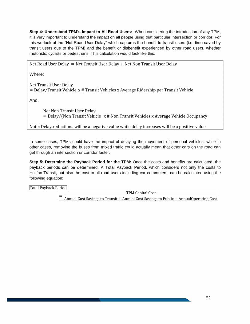
E2
Step 4: Understand TPM’s Impact to All Road Users: When considering the introduction of any TPM,
it is very important to understand the impact on all people using that particular intersection or corridor. For
this we look at the “Net Road User Delay” which captures the benefit to transit users (i.e. time saved by
transit users due to the TPM) and the benefit or disbenefit experienced by other road users, whether
motorists, cyclists or pedestrians. This calculation would look like this:
Net Road User Delay = Net Transit User Delay + Net Non Transit User Delay Where:
Net Transit User Delay= Delay Transit Vehicle⁄ x # Transit Vehicles x Average Ridership per Transit Vehicle And,
Net Non Transit User Delay= Delay (Non Transit Vehicle ⁄ x # Non Transit Vehicles x Average Vehicle Occupancy
Note: Delay reductions will be a negative value while delay increases will be a positive value.
In some cases, TPMs could have the impact of delaying the movement of personal vehicles, while in
other cases, removing the buses from mixed traffic could actually mean that other cars on the road can
get through an intersection or corridor faster.
Step 5: Determine the Payback Period for the TPM: Once the costs and benefits are calculated, the
payback periods can be determined. A Total Payback Period, which considers not only the costs to
Halifax Transit, but also the cost to all road users including car commuters, can be calculated using the
following equation:
Total Payback Period
= TPM Capital Cost
Annual Cost Savings to Transit + Annual Cost Savings to Public − AnnualOperating Cost
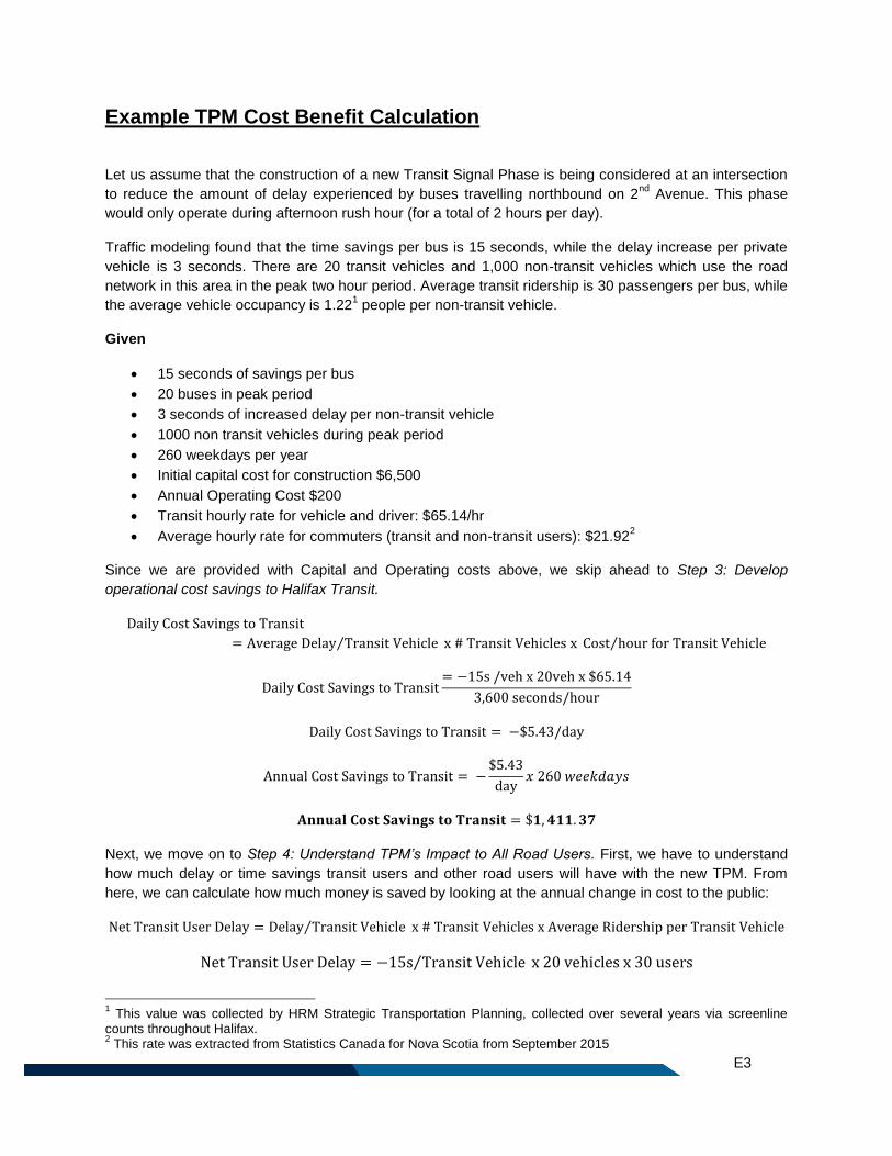
E3
Example TPM Cost Benefit Calculation
Let us assume that the construction of a new Transit Signal Phase is being considered at an intersection
to reduce the amount of delay experienced by buses travelling northbound on 2nd
Avenue. This phase
would only operate during afternoon rush hour (for a total of 2 hours per day).
Traffic modeling found that the time savings per bus is 15 seconds, while the delay increase per private
vehicle is 3 seconds. There are 20 transit vehicles and 1,000 non-transit vehicles which use the road
network in this area in the peak two hour period. Average transit ridership is 30 passengers per bus, while
the average vehicle occupancy is 1.221 people per non-transit vehicle.
Given
15 seconds of savings per bus
20 buses in peak period
3 seconds of increased delay per non-transit vehicle
1000 non transit vehicles during peak period
260 weekdays per year
Initial capital cost for construction $6,500
Annual Operating Cost $200
Transit hourly rate for vehicle and driver: $65.14/hr
Average hourly rate for commuters (transit and non-transit users): $21.922
Since we are provided with Capital and Operating costs above, we skip ahead to Step 3: Develop
operational cost savings to Halifax Transit.
Daily Cost Savings to Transit
= Average Delay Transit Vehicle⁄ x # Transit Vehicles x Cost hour for Transit Vehicle⁄
Daily Cost Savings to Transit= −15s /veh x 20veh x $65.14
3,600 seconds/hour
Daily Cost Savings to Transit = −$5.43/day
Annual Cost Savings to Transit = −$5.43
day𝑥 260 𝑤𝑒𝑒𝑘𝑑𝑎𝑦𝑠
𝐀𝐧𝐧𝐮𝐚𝐥 𝐂𝐨𝐬𝐭 𝐒𝐚𝐯𝐢𝐧𝐠𝐬 𝐭𝐨 𝐓𝐫𝐚𝐧𝐬𝐢𝐭 = $𝟏, 𝟒𝟏𝟏. 𝟑𝟕
Next, we move on to Step 4: Understand TPM’s Impact to All Road Users. First, we have to understand
how much delay or time savings transit users and other road users will have with the new TPM. From
here, we can calculate how much money is saved by looking at the annual change in cost to the public:
Net Transit User Delay = Delay Transit Vehicle⁄ x # Transit Vehicles x Average Ridership per Transit Vehicle
Net Transit User Delay = −15s Transit Vehicle⁄ x 20 vehicles x 30 users
1 This value was collected by HRM Strategic Transportation Planning, collected over several years via screenline
counts throughout Halifax. 2 This rate was extracted from Statistics Canada for Nova Scotia from September 2015
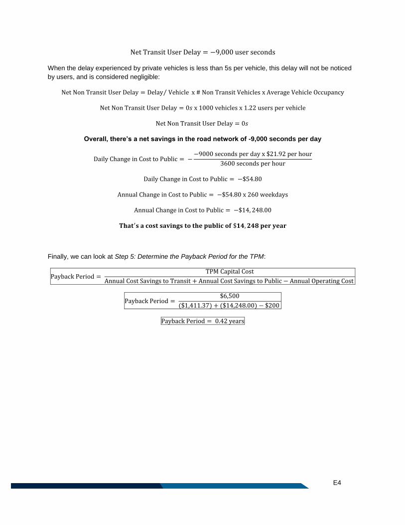
E4
Net Transit User Delay = −9,000 user seconds
When the delay experienced by private vehicles is less than 5s per vehicle, this delay will not be noticed
by users, and is considered negligible:
Net Non Transit User Delay = Delay Vehicle⁄ x # Non Transit Vehicles x Average Vehicle Occupancy
Net Non Transit User Delay = 0𝑠 x 1000 vehicles x 1.22 users per vehicle
Net Non Transit User Delay = 0𝑠
Overall, there’s a net savings in the road network of -9,000 seconds per day
Daily Change in Cost to Public = −−9000 seconds per day x $21.92 per hour
3600 seconds per hour
Daily Change in Cost to Public = −$54.80
Annual Change in Cost to Public = −$54.80 x 260 weekdays
Annual Change in Cost to Public = −$14, 248.00
𝐓𝐡𝐚𝐭′𝐬 𝐚 𝐜𝐨𝐬𝐭 𝐬𝐚𝐯𝐢𝐧𝐠𝐬 𝐭𝐨 𝐭𝐡𝐞 𝐩𝐮𝐛𝐥𝐢𝐜 𝐨𝐟 $𝟏𝟒, 𝟐𝟒𝟖 𝐩𝐞𝐫 𝐲𝐞𝐚𝐫
Finally, we can look at Step 5: Determine the Payback Period for the TPM:
Payback Period = TPM Capital Cost
Annual Cost Savings to Transit + Annual Cost Savings to Public − Annual Operating Cost
Payback Period = $6,500
($1,411.37) + ($14,248.00) − $200
Payback Period = 0.42 years