mosaic remote sensing - wmo.int · study of arctic climate . ... it is a rare case to observe the...
TRANSCRIPT

WMO Polar Space Task Group, 7th Session, Innsbruck, 12–13 December 2017 1
MOSAiC Status and Planed Satellite Remote Sensing Work
The International MOSAiC Consortium Presented by Gunnar Spreen

WMO Polar Space Task Group, 7th Session, Innsbruck, 12–13 December 2017
Overarching goal:
To improve the understanding and model representation of coupled atmosphere-ice-ocean-ecosystem processes
in the Central Arctic to support improved sea ice forecasting, regional weather forecasting, and climate predictions.
Multidisciplinary drifting Observatory for the
Study of Arctic Climate

WMO Polar Space Task Group, 7th Session, Innsbruck, 12–13 December 2017
General approach
Central Observatory: RV Polarstern
Distributed network of satellite stations
Operations of research aircrafts and helicopters
Extend vertical and geografical coverage
Drift fall 2019 to fall 2020
Rendezvous with icebreakers from MOSAiC partners
Broader geografic coverage & supply

WMO Polar Space Task Group, 7th Session, Innsbruck, 12–13 December 2017
Cruise Legs
Collaboration has been agreed with: • AARI • Rosmorport • State Oceanic Administration (SOA) • Oden
Helicopter / aircraft rotation of 20-40
Scientists

WMO Polar Space Task Group, 7th Session, Innsbruck, 12–13 December 2017
Source area
85°N/105°E
Source area Laptev Sea
Mean date of formation Dec. 7th ± 130 d
Velocity (km d-1) 6.8 km d-1
Mean drift distance 2856 ± 638 km
Mean ice age 418 d
Chance that ice originates from water depth < 60 m
53 %
Chance to access ice prior MOSAIC start from Cape Baranova between Mar - May 2019 (500 km flight range)
40 %
Pre-expedition in spring 2019 to probe ice in the source area (Laptev sea) ?
Thomas Krumpen

WMO Polar Space Task Group, 7th Session, Innsbruck, 12–13 December 2017
Setup on ice

WMO Polar Space Task Group, 7th Session, Innsbruck, 12–13 December 2017
Remote stations
WMO Polar Space Task Group, 7th Session, Innsbruck, 12–13 December 2017
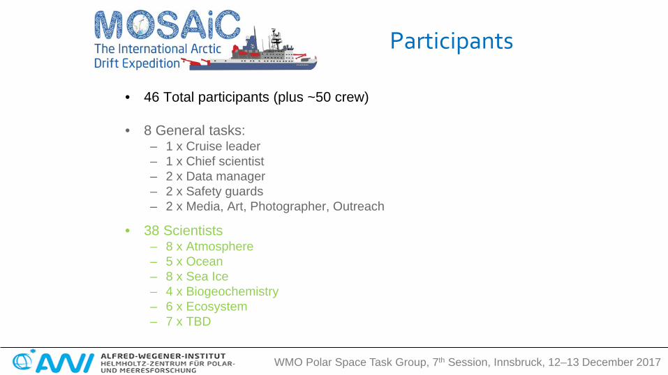
• 46 Total participants (plus ~50 crew)
• 8 General tasks: – 1 x Cruise leader – 1 x Chief scientist – 2 x Data manager – 2 x Safety guards – 2 x Media, Art, Photographer, Outreach
• 38 Scientists – 8 x Atmosphere – 5 x Ocean – 8 x Sea Ice – 4 x Biogeochemistry – 6 x Ecosystem – 7 x TBD
Participants

WMO Polar Space Task Group, 7th Session, Innsbruck, 12–13 December 2017 9
• Cross-cutting activity involving all themes
• Coordinated by o Ron Kwok
(JPL, Pasadena, USA)
o Gunnar Spreen (University of Bremen, Germany)
Remote Sensing
10 WMO Polar Space Task Group, 7th Session, Innsbruck, 12–13 December 2017
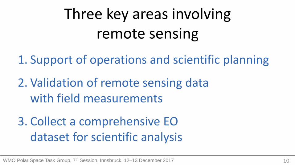
Three key areas involving remote sensing
1. Support of operations and scientific planning
2. Validation of remote sensing data with field measurements
3. Collect a comprehensive EO dataset for scientific analysis

11 WMO Polar Space Task Group, 7th Session, Innsbruck, 12–13 December 2017
Pre-Campaign Planning • Assessment of likely
drift trajectories from data of previous years
• When will we be where?
• What ice thickness can we expect? Can we reached
by icebreaker?
Ice drift: ASCAT/SSMIS (IFRENER) Ice thickness: CryoSat/SMOS (AWI/UHH)
Thomas Krumpen Gunnar Spreen

12 WMO Polar Space Task Group, 7th Session, Innsbruck, 12–13 December 2017
MapViewer on board of Polarstern Contact: Gerchow/Krumpen
• Getting Polarstern into the ice and finding the right floe
• Support for supply cruises and aircraft operations
• Layout of distributed network and buoy arrays
• Datasets: i. high resolution SAR imagery ii. ice drift with forecast iii. sea ice concentration and type iv. high resolution visual images
Scientific and Operational Planning Ice radar on board
RV Polarstern Geocoded TerraSAR-X L1b product
Near-real time SAR data from DLR
Suman Singha Paul Wachter
Worldview-2, 0.5m

13 WMO Polar Space Task Group, 7th Session, Innsbruck, 12–13 December 2017
Validation of remote sensing data with field measurements
MOSAiC provides ideal conditions for validation of satellite remote sensing observations:
(a) It is a rare case to observe the complete seasonal cycle including winter observations.
(b) The MOSAiC distributed grid of measurements covers the typical satellite footprint scales.
(c) The helicopter/aircraft campaigns will allow to bridge the gap between in situ and satellite observations.

14 WMO Polar Space Task Group, 7th Session, Innsbruck, 12–13 December 2017
ICESat-2 Evaluation • Laser altimeter with
6 beams • In-situ measurements
of ice and snow • Influence of snow
and melt ponds on ICESat-2 retrieval
• NASA Operation Icebridge overflight in 2020 planed Melinda Webster
Ron Kwok

ESA UNCLASSIFIED - For Official Use Tania Gil Duarte Casal | 03/10/2017 | Slide 15
ESA endorsed activities overview
1. Microwave scatterometer (Lead PI: Gunnar Spreen, Bremen Univ.)
2. Microwave radiometer (Lead PI: Lars Kaleschke, Hamburg Univ)
3. Ku-Ka ground penetrating radar (Lead PI: Robert Ricker, AWI)
4. GNSS Reflectometry (Lead PI: Manuel Martin-Neira, ESA)
5. One birth (one scientist TBD) for one leg (ideally the first but TBC)
6. Possible CryoVEX/KAREN joint flights with AWI in Spring 2020 (TBC)

16 WMO Polar Space Task Group, 7th Session, Innsbruck, 12–13 December 2017
Sea Ice Radar Altimetry
Sea Ice Thickness
Ku/Ka band radar
Sea Ice Range Measurement
Lead Range Measurement
CryoSat-2 | Sentinel-3 | ICESat-2
Robert Ricker Tânia Casal
• Altimeter validation
– Ice and snow thickness, properties, stratigraphy
– Surface topography and snow distribution
• Ku/Ka band radar transects – Snow penetration and
scattering

Sea ice thickness from SMOS and CryoSat2
Lars Kaleschke, Nick Rutter, Caro Gabarro et al.

18 WMO Polar Space Task Group, 7th Session, Innsbruck, 12–13 December 2017
Microwave Radiometer • Evaluation of SMOS and SMAP thin
ice and snow retrievals • Development of snow and ice
radiative transfer model • Microwave radiometer
– L-band onboard or fixed on ice (EMIRAD2 or ELBARA)
– Mobile P/L/C-band ARIEL system
• Higher frequencies for ice concentration evaluation missing
Lars Kaleschke Tânia Casal
EMIRAD
ELBARA ARIEL
Thin Ice Thickness

WMO Polar Space Task Group, 7th Session, Innsbruck, 12–13 December 2017 19
What are the expected outcomes?
● Measurements of the brightness temperature at multiple frequencies for snow covered ice across a long period of time under varying environmental conditions;
● Spatial variability of brightness temperatures ● Validation of RT models using collocated measurements
from remote sensing and in-situ ● Improved sea ice emissivity / radiative transfer models ● Improved retrieval algorithms for sea ice and snow
thickness for L-band missions ● New retrieval methods (e.g. for sea ice salinity) for future
satellite missions

20 WMO Polar Space Task Group, 7th Session, Innsbruck, 12–13 December 2017
Microwave Scatterometer • Evaluation of SAR (Sentinel-1,
TerraSAR-X, Radarsat-2, ALOS-2) and scatterometers (ASCAT)
• Multi-frequency (L/C/X/Ku), polarimetric scatterometer measurements snow and ice
• Snow and ice radiative transfer and scattering model
• Extensive in-situ snow and ice properties measurements
Gunnar Spreen Tânia Casal
Thin Ice Thickness
Claude Duguay University of Waterloo Randall Scharien University of Victoria John Yackel University of Calgary

ESA UNCLASSIFIED - For Official Use Tania Gil Duarte Casal | 03/10/2017 | Slide 21
GNSS-R Sensor Accommodation
● Proposed by M. Martin-Neira (ESA) and Estel Cardellach (Institute of Space Sciences, Barcelona)
● GNSS-R Electronics to be installed in an inner room of the boat ● GNSS-R Antennas to be installed over the bridge (see next slides) ● Distance between Electronics and Antennas < 10 m
GNSS-R Antennas (2 flat antennas of 50 cm x 25 cm x 2 cm +
1 standard GNSS antenna)
GNSS-R Electronics (in standard 19-inch rack x 70 cm high + laptop)

22 WMO Polar Space Task Group, 7th Session, Innsbruck, 12–13 December 2017
Optical Measurements • MODIS, Sentinel-3, VIIRS
medium and Sentinel-2, Landsat Pleiades high resolution
• Optical properties of snow and sea ice – Melt ponds – Albedo – Snow melt
Thin Ice Thickness
Photo: M. Nicolaus Photo: AWI Meereisphysik
Spectrometer
ROV
Melt Pond Fraction
Natascha Oppelt Larysa Istomina
Hyperspectral Camera

23 WMO Polar Space Task Group, 7th Session, Innsbruck, 12–13 December 2017
IR & Hyperspectral Camera • Infrared camera InfraTec
– 0.03 K precision, 2 K accuracy
• Hyperspectral camera – 400–1000 nm – Line-scanner camera
• Deployed at remote sensing validation site
• Monitor specific events – Thin ice in new leads – Melt pond development
Infrared Camera
Hyperspectral Camera
Photo: Adam LeWinter

24 WMO Polar Space Task Group, 7th Session, Innsbruck, 12–13 December 2017
Sea Ice Dynamics
• Sea ice drift and deformation from SAR • Buoy array • Ship radar
Jenny Hutchings Jari Haapala

25 WMO Polar Space Task Group, 7th Session, Innsbruck, 12–13 December 2017
On Ice Measurements • Remote
sensing validation site:
– Scatterometer – Radiometer – IR camera – hyperspectral
camera – GNSS-R
• monitor the same snow/ice surface
• In-situ snow/ice properties measured close by
• Specific requests?

26 WMO Polar Space Task Group, 7th Session, Innsbruck, 12–13 December 2017
Operation IceBridge
Airborne Campaign • Airborne campaigns
important for validation – Polar-5/6 – helicopter onboard – NASA Operation IceBridge – ESA CryoVal
• Grid measurements for better comparison
• Satellite underflights – CryoSat-2, SMOS – ICESat-2 can point to MOSAiC – Sentinel-1,3 and TerraSAR-X
Andreas Herber Gerit Birnbaum
ESA CryoVex

ESA UNCLASSIFIED - For Official Use Tania Gil Duarte Casal | 03/10/2017 | Slide 27
Ka-Band: KAREN
Ku-Band: ASIRAS
CryoVEx/KAREN 2017 Objectives • Verify upgraded CryoSat L1 and L2
processors • Support assessment of Ka- and Ku-band
altimetric mission concept Campaign details • DTU Space (DK), AWI (DE), BAS (UK),
Leeds Univ. (UK) and MetaSensing (NL) • First full-scale campaign flying a Ku-Ka
band radar simultaneously • Sea & land ice measurements (airborne &
ground) in Mar/Apr 2017
CryoVex/KAREN 2020? Possible joint flights with AWI

28 WMO Polar Space Task Group, 7th Session, Innsbruck, 12–13 December 2017
EO dataset for scientific analysis SAR ice type, ice drift
Altimeters ice thickness, (snow depth)
Radiometers ice area, drift, ice thick., snow
Optical melt ponds, leads, albedo, IST, gases
Scattero-meters ice type, ice drift, clouds
Atmosphere water vapor, surfaces fluxes, cloud properties
Sentinel-1 CryoSat-2 AMSR-2 MODIS ASCAT CALIPSO
Radarsat-2/ RCM
ICESat-2 SSMIS VIIRS CloudSat
ALOS-2 Sentinel-3 SMOS Sentinel-3 EarthCARE
TerraSAR-X SARAL/Altika SMAP AVHRR AIRS
TanDEM-X Sentinel-2 CERES
COSMO-Skymed
Landsat 8 GOME-2
SAOCOM Pléiades GOSAT
AMSU
• A large archive of satellite data for future analysis will be created
• For some satellites support already confirmed
• Need points of contact for other missions
• Data sharing is important