morphotectonic evolution of triangular facets and wine-glass valleys in the noakoh
TRANSCRIPT

Geomorphology 159-160 (2012) 37–49
Contents lists available at SciVerse ScienceDirect
Geomorphology
j ourna l homepage: www.e lsev ie r .com/ locate /geomorph
Morphotectonic evolution of triangular facets and wine-glass valleys in the Noakohanticline, Zagros, Iran: Implications for active tectonics
Shahram Bahrami ⁎Department of Physical Geography, Faculty of Geography and Environmental Science, Sabzevar Tarbiat Moalem University, Iran
⁎ Tel.: +98 5714003231; fax: +98 5714003270.E-mail addresses: [email protected], shahram_bah
0169-555X/$ – see front matter © 2012 Elsevier B.V. Aldoi:10.1016/j.geomorph.2012.03.003
a b s t r a c t
a r t i c l e i n f oArticle history:Received 29 September 2011Received in revised form 2 March 2012Accepted 4 March 2012Available online 9 March 2012
Keywords:Noakoh anticlineMorphometryTriangular facetsWine-glass valleysZagros
The Noakoh anticline is located in Kermanshah province and is part of the Simply Folded Belt of Zagros.Boundaries of 97 triangular facets and 67 wine-glass (W-G) valleys, which formed on anticline limbs, weredelineated using Quickbird satellite imagery. The strata dip (D), area (A), base length (BL), topographicslope (S) of facets, the maximum width (M), outlet width (O) and ratio of maximum width to outlet width(W index) of W-G valleys were analysed in detail. Noakoh anticline was subdivided into 9 tectonic zoneson the basis of dip, topographic slopes and width of limbs. Results show that there are strong positive corre-lations between means of D-BL and S-BL pairs. Poor positive correlations exist between means of D-A and S-Apairs. Among W-G valley metrics, the W index has strong relations with D and S parameters. Based on theresults, steep facets with long bases and well developed W-G valleys with narrow outlets and wide upperparts are associated with more rotated limbs having steep slopes. Facets on the northeastern slope havemore forest cover, micro-organism activity, karstic features and soil cover, whereas facets on relativelydrier southwestern slope are characterized by physical weathering processes and minor karstic landforms.This study demonstrates that, apart from tectonic activity as a major control on the morphometry of facetsand valleys, climate and slope aspect have also acted as secondary factors on the development of the studiedlandforms.
© 2012 Elsevier B.V. All rights reserved.
1. Introduction
Active tectonics in the uplifting anticlines of Zagros structuralzone, especially in Simply Folded Belt, has produced various land-forms. Quantitative measurements of such landforms help to identifyand to analyse tectonic deformation in an area. Some geomorphicindices such as hypsometric integral (Hi), stream length–gradientindex (SL), drainage basin asymmetry (Af), ratio of valley floorwidth to valley height (Vf), transverse topographic symmetry factor(T) and basin drainage shape (Bs) have been used extensively todetect tectonic displacements at different places around the world(Hack, 1973; Wells et al., 1988; Cox, 1994; Keller and Pinter, 2002;El Hamdouni et al., 2008; Dehbozorgi et al., 2010; Delcaillau et al.,2010; Figueroa and Knott, 2010; Delcaillau et al., 2011; Gioia et al.,2011). In recent decades, the availability of geographic informationsystems (GIS), Digital Elevation Models (DEM) and satellite imagesprovides useful information to carry out geomorphological studiesof active tectonics (Singh and Jain, 2009; Font et al., 2010).
Based on the above-mentioned geomorphic indices, El Hamdouniet al. (2008) developed the Iat index (index of relative activetectonics) and divided the southwest border of the Sierra Nevada(southern Spain) into four classes of relative tectonic activity. They
l rights reserved.
noted that areas with moderate to high and very high Iat index corre-spond with areas where prominent fault scarps, triangular facets,hanging valleys, deformed alluvial fan deposits, and deep narrowriver gorges incised near mountain fronts exist. Iat mapping has alsobeen used to study tectonic deformation in the Rudbar Lorestandam site in Iran (Alipoor et al., 2011). The study was carried outthrough integration of SL, Af, Hi, Vf, and T indexes in a GIS environ-ment using an analytic hierarchy process (AHP) (Saaty, 1977).
Drainage pattern and drainage density have the potential to re-cord information about the evolution of folds and faults, and may beparticularly useful in detecting the tilting, growth and propagation di-rection of anticlines (Delcaillau et al., 1998, 2006; Jackson et al., 1998;Delcaillau, 2001). Drainage evolution of Zagros mountains in Farsprovince has been used to study the lateral growth of anticlines inthe Iranian Zagros (Ramsey et al., 2008).
However, little work is available on the use of morphometry oftriangular facets andwine-glass valleys as indicators of active tectonics.Triangular facets are geomorphologic features frequently observed in avariety of tectonic settings, such as scarps of normal and thrust fault,and fronts of anticlines (Wells et al., 1988; Bull, 2007). Triangular facetsor faceted spurs are triangular to polyhedral shape landforms and liebetween two adjacent drainages within a given mountain frontescarpment (Wells et al., 1988). The triangular facets are formed dueto fluvial erosion concurrent with uplift of the mountain fronts(Zuchiewicz and McCaplin, 2000; Petit et al., 2009a).

38 S. Bahrami / Geomorphology 159-160 (2012) 37–49
The high proportion of continuous undissected escarpments, highpercentage of undissected facets and high values of faceting suggest arelatively rapid tectonic uplift (Wells et al., 1988; Ramírez-Herrera,1998). A preliminary study by Hamblin (1976) on triangular facetsalong the Wasatch fault in the ‘Basin and Range’ province in the north-ern and central Utah revealed that periods of vertical movement sepa-rated by periods of stability have resulted in the formation of threegenerations of triangular facets. Hamblin (1976) refers that the slopeangle of facets decreases as age of facets increases due to progressiveslope retreat. Menges' (1987) study in the Rio Grande rift of northernNew Mexico showed that major characteristics of basal triangularfacets, such as size and slope steepness, the degree of internal dissec-tion, the number and size of facet benches, and the thickness of colluvialmantles, correlate better with the position of the facet relative to faultsegments than other parameters such as bedrock lithology and pied-mont dissection. Menges (1990) suggested that tectonic activity is amajor control on the facet's height, steepness as well as on drainage de-velopment, and amount of colluviation and soil development on facets,while bedrock acts as a secondary control on facet and is related to out-crop patterns, size of colluvium, andmechanical and chemical weather-ing properties. DePolo and Anderson's (2000) study on facets in theGreat Basin, USA revealed that the height of facets is a function offault slip rate. Geometric analysis of faceted spurs on an active normalfault in the Central Wasatch Fault, Utah reveals that the height of facetsis a function of uplift and that facets are frequently modified by resis-tance to erosion and bedrock structure (Zuchiewicz and McCaplin,2000). Petit et al. (2009a) developed a simple coupled SPM (earth sur-face model) and tectonic model to determine the conditions of growthof faceted spurs at normal fault scarps on the central portion of theWeber segment of the Wasatch Fault, close to the Great Salt Lake.They showed that there is a strong dependence of facet slope angle onthrow rate for throw rates between 0.4 and 0.7 mm/a. Facet heightalso appears to be linearly dependent upon the fault throw rate. Petitet al. (2009b) determined long-term throw rates on normal faultsbased on height of faceted spurs in the North Baikal Rift (NBR), easternSiberia. Their study revealed that long-term throw rates of the NBRfaults range between 0.2 and 1.2 mm/yr.
Although triangular facets result from the combined effects of tec-tonics, climate and lithology, their characteristics are associated withactive tectonics in mountain fronts. Facets are large, steep, and less in-ternally dissected in tectonically active mountain fronts whereas theyare fewer, smaller and more internally dissected in less tectonicallyactive mountain fronts.
As streams dissect the range front they leave behind narrow W-Gvalleys between triangular facets or flat irons (Piccardi et al., 1999;Goldsworthy and Jackson, 2000; Monaco and Tortorici, 2000; Palumboet al., 2004; Hubert-Ferrari et al., 2007; Catalano et al., 2008). Most ofabove-mentioned studies on valley morphometry have been focusedon valley-floor width-to-height ratio and valley asymmetry. Fewerstudies have been carried out on the metrics of valleys such as ratio ofmaximum width to outlet width of valleys.
Erosion of triangular facets creates individual valleys that areknown as “wine-glass valleys” (W-G) due to their wide upper partsand narrow outlets (Burbank and Anderson, 2001). W-G valleys be-tween faceted spurs are often established by a combination of foot-wall uplift and fluvial incision (Benedetti et al., 1998; Goldsworthyand Jackson, 2000). Although W-G valleys are known as a tectoniclandform, a quantitative investigation of this landform is currentlylacking. This paper presents a systematic geomorphic analysis of tri-angular facets and W-G valleys in the Noakoh anticline, and high-lights role of active tectonics on landform characteristics.
2. Study area
The Noakoh anticline lies within Simple Folded Belt of Zagros. It issituated between the towns of Sarpol-e-Zahab and Kerend-e-Gharb in
Kermanshah Province, in western part of Iran. The study area coversan area of 195 km² and is located between 34° 10′ N to 34° 23′ N and45° 58′ E to 46° 14′ E. The highest elevation is about 2480 m a.s.l.,while the minimum elevation is about 800 m a.s.l. in the northwesternpart (Fig. 1). The climate of the study area is of semi-arid to Mediterra-nean type with cool winters and dry summers (Karimi et al., 2005).Mean annual precipitation and temperature of Noakoh anticline are re-spectively 580 mm and 12.8 °C. (Safari, 2008). Hydrologically, allstreams formed on anticline limbs are ephemeral except Kerend river,which is located on the Kerend syncline at northeastern part of studyarea.
2.1. Geology
Zagros belt is part of Arabia–Eurasia collision zone and extends for1500 km from the Taurus Mountains in southeast Turkey throughsouthwest Iran, and terminates near the Hormuz Strait at the mouthof the Persian Gulf. Berberian (1995) divided the Zagros belt intofive morphotectonic units on the basis of topography, seismicity andexposed stratigraphy. These five parallel units from northeast tosouthwest are the High Zagros Thrust Belt, the Simple Folded Belt,the Zagros Foredeep, the Zagros Coastal Plain and the Persian Gulf–Mesopotamian lowland. The Zagros belt is tectonically active andhas been shortening and uplifting (Berberian, 1995). Lees andFalcon (1952) showed that the course of a Sasanian canal on Shauranticline between shushes and Ahwas has been uplifted about 4 min 1700 years. It implies an uplift rate of 2.35 mm/yr in the Shauranticline.
Uplift is migrating from the suture zone (northeast) towards theforedeep or southwest (Berberian, 1995). GPS data suggest thatpresent-day NE–SW shortening across the central part of the SimpleFolded Zone of Zagros is c. 10 mm/yr (Tatar et al., 2002). Blanc et al.(2003) suggested that, if the Simple Folded Zone deformation hastaken place since c. 5 Ma, this corresponds to a shortening rate of c.10 mm/yrwhich is a substantial part of the present Arabia–Eurasia con-vergence rate. Based on a few stations located in the Zagros,Nilforoushan et al. (2003) and Vernant et al. (2004) showed that therate of shortening increases from 4±2mm/yr in the NW to 9±2 mm/yr in the SE Zagros. GPS measurements and analyses of the35 stations in and beside the Zagros Mountain belt also showed thatthe current rate of shortening across the SE Zagros is about 9±3 mm/yr, whereas in the NW Zagros it is about 5±3 mm/yr (Hessami et al.,2006).
The Zagros structural zone is one of themost seismically active belts,with frequent earthquakes of up to Ms 7 (Talebian and Jackson, 2004).Nevertheless, significant earthquakes of Zagros in the 20th centuryand the earlier historical record have been occurred on or near theMain Zagros Reverse Fault in the northeast edge (High Zagros ThrustBelt) of Zagros mountains (Talebian and Jackson, 2002). Tavakoli andGhafouri-Ashtiani (1999) prepared the seismic hazard zonation mapof Iran based on probabilistic seismic hazard computation using the his-torical earthquakes data, geology, tectonics, fault activity and seismicsource models. Based on their map, having low, medium, high andvery high classes of seismic hazard, the study area is located in a highclass of seismicity. Two ancient earthquakes in April 958 and April1150 have been reported by Ambraseys and Melville (1982) inSarpole-Zahab in the northwestern part of the study area.
The sedimentary column of the Zagros Simply Folded Beltcomprises a 12 km-thick section of lower Cambrian through Plio-cene strata (Falcon, 1969; Colman-Sadd, 1978). The stratigraphiccolumn of Zagros is divided into the five structural divisions(Colman-Sadd, 1978); the Basement group, the Lower Mobilegroup, the Competent group, the Upper Mobile group and the In-competent group (Fig. 2) (for stratigraphic details of Zagros, seeColman-Sadd, 1978; Alavi, 2004).

Fig. 1. Location map and SRTM DEM of the Noakoh anticline in the Zagros Folded Belt. A–B and C–D are topographic profiles along the fold crest, shown in Fig. 9. The lower caseletters show the location of photographs of Fig. 3.
39S. Bahrami / Geomorphology 159-160 (2012) 37–49
Evaluation of the morphometry of the drainage system and thegeomorphic indexes also reveals the effect of tectonic activity andits spatial differences in Zagros mountains (Ramsey et al., 2008;Dehbozorgi et al., 2010; Alipoor et al., 2011; Piraste et al., 2011). Al-though the northwestern part of Noakoh anticline is eroded andsome older lithologic units have been exposed, the study area hasonly one lithological unit (Asmari–Shahbazan; Limestone and Dolo-mite). The length of the anticline is 30 km and its width is 3100 min the southeast, 7500 m in the center and 7150 m in the northwest.It plunges towards the southeast and its southwestern limb is steeper
than northeastern limb. The southeastern nose has gentle-gradienttopographic slopes.
According to Colman-Sadd (1978), structures in the competent groupof Zagros Simply Folded Belt are typical of parallel folds formed by buck-ling and developed by a combination of flexural-slip and neutral-surfacemechanisms. In the Zagros folding, the maximum principal stress is nor-mal to the fold axes and tangential to the earth surface while the inter-mediate principal stress is parallel with the fold axes. In flexural slip,themaximum relativemovements of the layers and themaximum strainof the whole multilayered sequence occur in the fold limbs, and the

Fig. 2.Major stratigraphic units of Zagros Simply Folded Belt (Colman-Sadd, 1978; Cas-ciello et al., 2009).
40 S. Bahrami / Geomorphology 159-160 (2012) 37–49
minimum strain is in the hinges. Therefore, in asymmetric folds, thethrusts may form across the steepest limbs (e.g., southwestern limb ofNoakoh). In the neutral-surface mechanism, strain is greatest in thefold hinges and least in the fold limbs, and hence normal fault and ex-tensional fractures develop on the hinge. It is likely that northwesternparts of Noakoh anticline are consistent with the neutral-surface mecha-nism whereas southeastern nose (e.g., part with thrust fault) is compati-ble with flexural slip.
2.2. Geomorphology
The study area is an asymmetric anticline bordered by steep slopes,deeply incised by consequent streams. It is uplifted to a maximumheight of 1280 m above the Neghareh-kub synclinal plain locatedalong its southwestern border. The mountain front is characterized byflat irons or facets that are separated by W-G valleys. Due to the out-cropping of carbonate rocks, karstic features are the dominant land-forms of the study area. The most typical karstic features are karrens,dolines, poljes and caves. Although karrens are very frequent small-scale landforms over the whole area and in all elevation levels, theyare more frequent and larger in northeastern limb than southwesternone (Fig. 3a). Dolines have been developed on elevations between1800 and 2500 m a.s.l., which are more dominant on northeasternslopes (Fig. 3c). Field work in this study shows that a 2200 m-long
and 800 m-wide polje has been formed along the Noakoh hinge at1885 m a.s.l. (Fig. 3d). The existence of some very important springsin northern and northwestern borders of the study area, with meanflow rates up to 3300 l/s, indicates development of karstification pro-cess in the carbonate aquifers (Karimi et al., 2005). Caves with stalac-tites and stalagmites (Fig. 3e, f) are frequent in different elevations. Inaddition, physical weathering is also an important process, especiallyon drier southwestern slopes. Exposed rock surfaces have experiencedfrost action due to daily temperature changes, which has resulted vasttalus slopes with angular rock fragments on the southwestern limb(Fig. 3g).
Drainages are mainly oriented perpendicular to the fold hinge, al-though there are some minor southeastward flowing streams parallelto fold hinge. In the southeastern nose of anticline, streams are shortand developed in parallel pattern (Fig. 4). The steeper southwesternlimb consists of parallel and first order streams, while the northeast-ern limb has sub-parallel and second order streams. Towards thenorthwest, trellis and dendritic drainage patterns are common onsouthwestern limb, and a dendritic drainage pattern is developedon the northeastern limb.
From a phytogeographical point of view, the study area lies withinthe Kurdo-Zagrosian sector of the Irano-Turanian territory and isdominated by Quercetum Brantii (dominated by oak) in the forestand Artemisia in the highland steppes (Zohary, 1973: 199). Thesteppe-forest comprises two classes, namely (a) Quercetea Brantii,which occurs between 800 and 2000 m asl, and (b) Junipero-Pistacietea (Juniperus-Pistacia-Amigdalus steppe-scrub). The forestdensity of Noakoh anticline is dependent upon slope aspect so thatnortheastern aspects have denser trees than drier southwestern as-pect, receiving more solar energy (Fig. 3h, i). Slope aspect also has aconsiderable effect on the growth of microorganisms such as lichensand mosses. Lichen cover is greater in cooler, wetter and shadednortheast-facing slopes than in drier and sunny southwest-facingslopes (Fig. 3j).
3. Materials and methods
To evaluate the relationship between tectonics and morphometryof triangular facets and W-G valleys, the southeastern part of Noakohanticline with a single lithological unit was selected. A DEM of thestudy area was prepared using ILWIS (Integrated Land and Water In-formation System) software after digitizing 20-m contour lines from1:50,000 topographic maps of Iranian National Geography Organiza-tion. Geological data, such as lithology, faults and cross-sections,were derived from 1:100,000 geological maps of Geological Survey& Mineral Exploration of Iran.
Boundaries of 97 triangular facets were delineated on the Quick-bird satellite imagery, which was supported with field observations.Borders of triangular facets were imported into ILWIS software to es-timate the area of facets. Further, the DEM of the study area wassuperimposed with polygons of facets to calculate topographic slopeof triangular facets and subsequently the mean topographic slopefor each facet was obtained. Base length of triangular facets was alsomeasured as the length of straight line between two ends of facetbase (Fig. 5). For every facet, the dip of strata was measured at moun-tain front by clinometer.
Borders of 67 W-G valleys were identified by means of Quickbirdsatellite imagery. For each W-G valley, maximumwidth (M) and out-let width (O) were determined and measured. Based on M and O pa-rameters, the W index (M to O ratio) were established and calculatedfor everyW-G valley. The Noakoh anticline was subdivided into 9 tec-tonic zones based on dip of strata, topographic slope and width oflimbs. The means of base length, area, topographic slope and dip oftriangular facets and also means of M, O and W index parameterswere calculated in each zone, and subsequently linear relationshipsbetween means of these parameters were prepared.
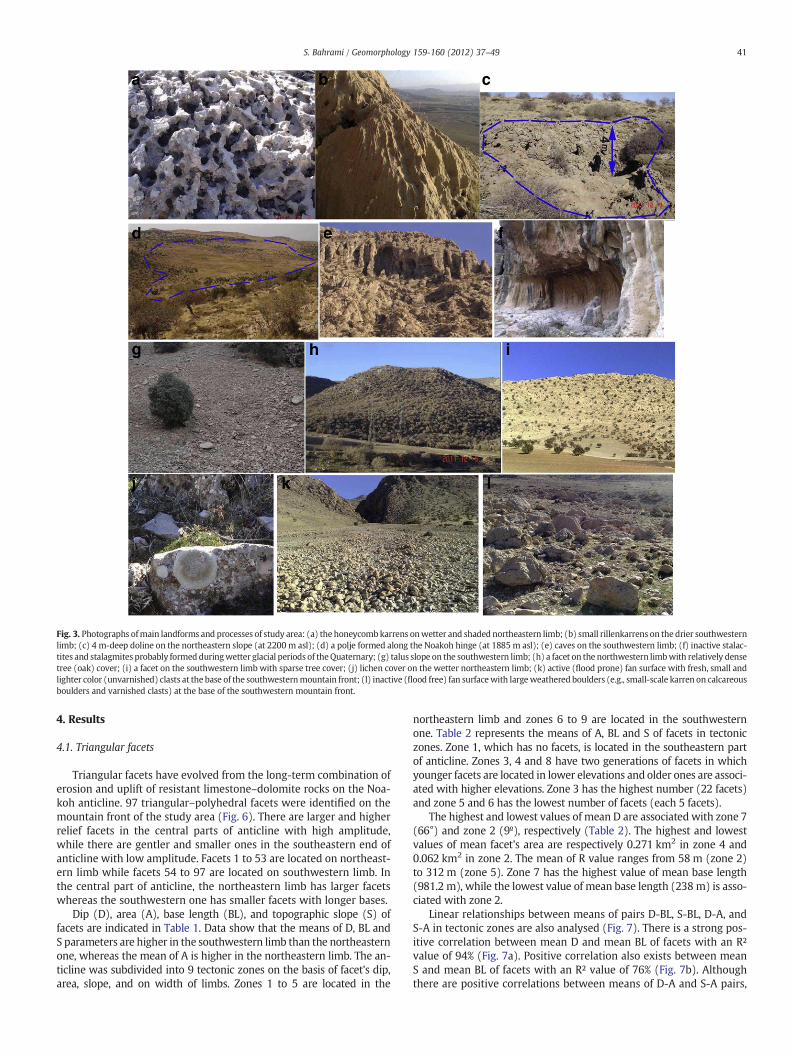
Fig. 3. Photographs ofmain landforms and processes of study area: (a) the honeycombkarrens onwetter and shaded northeastern limb; (b) small rillenkarrens on the drier southwesternlimb; (c) 4 m-deep doline on the northeastern slope (at 2200 m asl); (d) a polje formed along the Noakoh hinge (at 1885 m asl); (e) caves on the southwestern limb; (f) inactive stalac-tites and stalagmites probably formed duringwetter glacial periods of theQuaternary; (g) talus slope on the southwestern limb; (h) a facet on the northwestern limbwith relatively densetree (oak) cover; (i) a facet on the southwestern limb with sparse tree cover; (j) lichen cover on the wetter northeastern limb; (k) active (flood prone) fan surface with fresh, small andlighter color (unvarnished) clasts at the base of the southwesternmountain front; (l) inactive (flood free) fan surfacewith largeweathered boulders (e.g., small-scale karren on calcareousboulders and varnished clasts) at the base of the southwestern mountain front.
41S. Bahrami / Geomorphology 159-160 (2012) 37–49
4. Results
4.1. Triangular facets
Triangular facets have evolved from the long-term combination oferosion and uplift of resistant limestone–dolomite rocks on the Noa-koh anticline. 97 triangular–polyhedral facets were identified on themountain front of the study area (Fig. 6). There are larger and higherrelief facets in the central parts of anticline with high amplitude,while there are gentler and smaller ones in the southeastern end ofanticline with low amplitude. Facets 1 to 53 are located on northeast-ern limb while facets 54 to 97 are located on southwestern limb. Inthe central part of anticline, the northeastern limb has larger facetswhereas the southwestern one has smaller facets with longer bases.
Dip (D), area (A), base length (BL), and topographic slope (S) offacets are indicated in Table 1. Data show that the means of D, BL andS parameters are higher in the southwestern limb than the northeasternone, whereas the mean of A is higher in the northeastern limb. The an-ticline was subdivided into 9 tectonic zones on the basis of facet's dip,area, slope, and on width of limbs. Zones 1 to 5 are located in the
northeastern limb and zones 6 to 9 are located in the southwesternone. Table 2 represents the means of A, BL and S of facets in tectoniczones. Zone 1, which has no facets, is located in the southeastern partof anticline. Zones 3, 4 and 8 have two generations of facets in whichyounger facets are located in lower elevations and older ones are associ-ated with higher elevations. Zone 3 has the highest number (22 facets)and zone 5 and 6 has the lowest number of facets (each 5 facets).
The highest and lowest values of mean D are associated with zone 7(66°) and zone 2 (9º), respectively (Table 2). The highest and lowestvalues of mean facet's area are respectively 0.271 km2 in zone 4 and0.062 km2 in zone 2. The mean of R value ranges from 58 m (zone 2)to 312 m (zone 5). Zone 7 has the highest value of mean base length(981.2 m), while the lowest value of mean base length (238 m) is asso-ciated with zone 2.
Linear relationships between means of pairs D-BL, S-BL, D-A, andS-A in tectonic zones are also analysed (Fig. 7). There is a strong pos-itive correlation between mean D and mean BL of facets with an R²value of 94% (Fig. 7a). Positive correlation also exists between meanS and mean BL of facets with an R² value of 76% (Fig. 7b). Althoughthere are positive correlations between means of D-A and S-A pairs,

Fig. 4. Drainage map of the study area, locations of faults, and three geological cross-sections across Noakoh anticline. Two set of drainage orientations are trending NE–SW and NW–SE. Parallel drainage pattern is observed in southeastern nose, trellisand dendritic drainages are associated with the central and northwestern parts. Theblack rectangle shows asymmetric forked tributary patterns. The upper reaches ofdrainages are deflected towards the NW demonstrating the lateral growth of anticlinetowards the SE. (Source of geological data: 1:100,000 geologic map of Kerend (sheet5258). Geological Survey & Mineral Exploration of Iran (Azhdari and Shaverdi, 2005)).
42 S. Bahrami / Geomorphology 159-160 (2012) 37–49
poor R² values exist between aforementioned parameters of facets(Fig. 7c, d). R² values for means of D-A and S-A pairs are 33% and24%, respectively. Overall, results show that facet base lengths in thestudy area are affected by the dip and topographic slope of facets,while the facet areas are not strongly affected by facet dip and topo-graphic slope.
4.2. Wine-glass valleys
Borders of 67 W-G valleys on limbs of Noakoh anticline were de-lineated (Fig. 6). For every W-G valley, the maximumwidth (M), out-let width (O) and W index were measured. Table 3 represents the M,
Fig. 5. Illustration of Facet's border and base length, W-G valley's border, maximumwidth (M) and outlet width (O) on northeastern limb of Noakoh anticline.
O, W, D (dip of facets on the left hand side of valley) and A (topo-graphic slope of facet on the left hand side of valley) parameters.The morphometric characteristics of W-G valleys vary in differentparts of the anticline. Central parts with steeper limbs have largerand wider valleys. The highest and lowest values of M parameterare 3715 and 187 m, respectively. The widths of W-G valleys rangefrom 28 to 333 m. The minimum value of W parameter is 1.21,while the maximum value ofW is 68.2. Data analysis shows that char-acteristics of W-G valleys are different in the southwestern and thenortheastern limbs. The mean of the M parameter is 1006.1 m inthe southwestern limb, whereas it is 713.9 m in the northeasternlimb.
Means of O parameters in the northeastern and southwestern limbsare 103.2 m and 97.8 m, respectively. Because of the higher values ofthe M metric in southwestern limb, the mean of the W parameter ishigher in the southwestern limb (14.7) than the northeastern one(8.55). Table 4 represents the means of M, O and W parameters in tec-tonic zones of the study area. As Fig. 6 shows, there is noW-G valley inzone 1. W-G valleys are denser and narrower in zones 2, 3, 8 and 9 andwider in zones 7, 6, 5 and 4. Overall, in southwestern limb, W increasesfrom the southeastern end towards the central part of anticline. Also, inthe northeastern limb, the rate of W increases from the southeast to-wards the northwest (from zone 2 towards zone 5).
Fig. 8 shows the linear relationships between means of pairs D-W,S-W, D-M, S-M, D-O and S-O. The correlation between means D andW metrics is positive, with an R² of 88% (Fig. 8a). A positive relationwith an R² value of 83% also exists between mean S and mean W pa-rameters (Fig. 8b). There is a positive correlation between mean Dand M, with an R² value of 72% (Fig. 8, c). Also, a positive correlationexists between mean S and M with an R² of 67% (Fig. 8d). Negativecorrelations exist between means D and O as well as betweenmeans S and O, with poor R² values of 32% and 52%, respectively(Fig. 8e, f). Overall, the above relations reveal that among morpho-metric parameters of valleys the W index is more affected by thedip and topographic slope of facets.
5. Discussion
The asymmetric Noakoh anticline has probably been formed byshearing in a detachment zone (Hormoz evaporates), which has sep-arated the Competent group from the basement by a thinner mobilelayer (Colman-Sadd, 1978). Studies on Zagros Belt reveals that fault-bend and fault-propagation folding mechanisms can also develop inaddition to detachment folding (McQuarrie, 2004; Burberry et al.,2010). Fault propagation through the fold from the detachment sur-face may produce the asymmetry of many Zagros anticlines(McQuarrie, 2004). Unfortunately no seismic profiles are availablefor the study area to exactly determine the folding mechanism.
As Keller et al. (1999) noted, lateral propagation of a fold producescharacteristic geomorphic features in the direction of propagationsuch as the decrease in dip of the forelimb, the decrease in relief ofa topographic profile along the fold crest, the development of charac-teristic asymmetric drainage patterns, and the occurrence of a seriesof wind gaps with decreasing elevation in the propagation direction.The presence of at least two wind or wind and water gaps can bevery strong evidence of lateral propagation of a fold (Keller et al.,1999). The decrease in height of a topographic profile along thecrest (Fig. 9a) and the decrease in dip of limbs (Table 2) towardssoutheast demonstrate the lateral fold propagation of Noakoh to-wards southeast. The topographic profile along the divide shown inFig. 9b reveals the presence of a wind gap and a water gap in thesoutheastern nose of Noakoh anticline, showing the lateral growthof the anticline towards southeast. The formation of wind gaps de-pends on the balance between the tectonic uplift rates of growingfolds and the incision rate of the streams (Bretis et al., 2011). Thestream had sufficient power to incise and to temporarily maintain a

Fig. 6. Borders of triangular facets, W-G valleys and tectonic zones. The study area has been subdivided into 9 tectonic zones (zones 1 to 5 in the northeastern limb and zones 6 to 9in the southwestern limb) based on dip of strata, topographic slope, width of limb. Zone 1, with no facet and W-G valley, and zone 2 and 9, with small facets and valleys, are as-sociated with gentle-gradient slopes (southeastern plunge). Towards the northwest, zones have larger facets and valleys. Nevertheless, very steep facets with long bases and welldeveloped W-G valleys are characteristic of steep slopes or more rotated limb of anticline (zones 7), whereas large facets are associated with moderate-gradient slopes such aszones 4 and 5 (see Fig. 10 for explanation).
43S. Bahrami / Geomorphology 159-160 (2012) 37–49
channel at the nose of a fold, which resulted a gorge (water gap).When the fold started to propagate laterally and the incision rate ofthe river became smaller than the uplift rate of anticline, the riverwas diverted, leaving behind a dry valley (wind gap).
The development of distinctive asymmetric forked tributary pat-terns shows the direction of fold propagation (Ramsey et al., 2008;Bretis et al., 2011). The presence of asymmetric forked tributary pat-terns on the southeastern plunge suggests the lateral growth of anti-cline toward the southeast (Fig. 4). The higher reaches of drainagesare deflected northwestwards, signifying the growth of anticline to-wards the southeast.
The cores and northwestern parts of the Noakoh anticline havedendritic, trellis and deeply-incised drainages, representing moremature and older areas, whereas parallel and less-incised drainagesin the southeastern nose show a younger or recently uplifted part ofanticline.
Triangular facets of study area have evolved during tectonic upliftconcurrentwithmillions of years of erosion of limestone rocks. Previousstudies (e.g., Wells et al., 1988; Ramírez-Herrera, 1998) revealed thattectonically active mountain fronts display well developed, large facetswhereas less tectonically active mountain fronts contain fewer, smallerand more internally dissected facets, due to the combined effects of theformation of more drainages across the front, the internal entrench-ment of existing facets, and the lateral migration of drainages crossingthe front. In the study area, dip and topographic slopes of facets arehigher in the southwestern limb, particularly in zone 7, and lower innortheastern limb, especially in zone 2. The higher values of facet'sbase length and slope coincide with more rotated limbs, such as thoseof zones 7, 6 and 5. An increase in the dip of limb (D) causes the increase
in the BL and S of facets (Fig. 7). Although D and S are positively corre-lated with BL, the R² of the BL-D pair is higher than that of the BL-S pair.
Due to its gentle topographic slope, zone 1 has no facet. In thesoutheastern nose of the anticline, zones 2 and 9, with low values ofmean D and S, have the lowest values of mean BL, 238 and 244.5 mrespectively. The value of mean BL in the northeastern limb increasestowards the northwest due to increase in dip of strata or limb rota-tion. Among zones of the southwestern limb, the highest value ofmean BL is associated with zone 7 (981 m), with the highest valueof mean D (66°). Although the facet area increases with increasingD and S, there are poor R² values between certain parameters. It is ob-served that the facet with largest area (A) is not the one with largestdip and slope. It should be noted that, on the moderate-gradientslopes of the anticline, such as zones 4 and 5, facets have elongatedand therefore have more area in plan view (Fig. 10b). In the steepslopes of anticline (zones 6 and 7) the slope tends to become verticaland hence the area of a facet decreases in plan view (Fig. 10a).
For a better understanding of the tectonic effects on the formation offacets, 3 geological cross-sections of Noakoh anticline were prepared(Fig. 4). Cross-section A–B represents the southwestern limb (zone 7)is steeper than northeastern one (zone 5) in the northwestern part ofthe anticline. Facets in zone 7 with steeper slopes have lower area butlonger baseswhereas facets of zone 5 have lower area but shorter bases.
The left-hand side of cross-section C–D shows that a thrust fault hasbeen formed in the southwestern limb in zone 8 (Fig. 4). Two rows offacets have been formed, in which older facets have been developedabove the thrust line (hanging wall) and younger ones have beenformed under thrust line (footwall). The right-hand side of cross-section C–D reveals that a small flexure or minor fold has been

Table 1Values of dip (D), area (A), topographic slope (S) and base length (BL) of facets in the study area.
Facet no. A (km2) D degree S (%) BL (m) Facet no. A (km2) D degree S ( %) BL (m)
1 0.11 6 9.74 302 50 0.09 32 38.59 2972 0.03 8 12.10 150 51 0.28 39 47.62 7483 0.19 8 16.73 450 52 0.19 38 41.21 5844 0.025 9 10.87 132 53 0.31 43 53.01 8885 0.03 10 11.94 232 54 0.05 35 53.02 3876 0.04 10 14.62 257 55 0.06 36 65.00 5087 0.02 12 16.24 143 56 0.30 39 61.59 11008 0.07 19 17.45 288 57 0.09 40 44.19 6749 0.13 22 19.00 451 58 0.05 44 47.50 36510 0.07 25 32.69 430 59 0.22 52 64.85 123011 0.06 23 43.75 500 60 0.18 65 70.56 141012 0.17 28 56.82 660 61 0.09 78 46.25 70013 0.24 28 49.25 530 62 0.09 76 46.72 61014 0.17 30 48.80 724 63 0.12 80 71.43 110015 0.04 31 50.69 223 64 0.05 61 28.57 42416 0.06 33 58.82 463 65 0.11 65 40.59 5917 0.05 32 58.52 350 66 0.20 55 56.04 98518 0.03 28 31.00 229 67 0.44 64 78.59 162919 0.13 36 51.03 532 68 0.08 59 35.43 42420 0.04 34 38.99 206 69 0.29 62 82.11 130021 0.06 29 44.87 320 70 0.53 75 93.33 190422 0.04 17 17.90 308 71 0.17 20 33.37 39823 0.11 16 15.41 314 72 0.25 25 36.65 56924 0.06 17 19.64 373 73 0.06 23 20.27 20925 0.07 19 23.70 380 74 0.13 24 43.03 54826 0.10 22 31.30 380 75 0.07 19 28.76 44527 0.05 22 33.33 141 76 0.22 20 26.96 40728 0.09 23 34.25 224 77 0.17 20 28.39 40329 0.05 25 31.62 207 78 0.16 19 24.51 47930 0.30 29 36.26 749 79 0.04 19 31.79 17831 0.13 28 25.87 200 80 0.07 21 39.15 39132 0.03 30 29.05 250 81 0.03 19 37.81 11533 0.06 31 43.00 297 82 0.08 17 32.93 24834 0.17 33 53.14 628 83 0.02 19 22.77 17635 0.29 30 52.78 739 84 0.04 29 58.62 19036 0.29 34 50.32 610 85 0.04 23 34.22 17937 0.10 31 42.22 430 86 0.15 22 29.23 35838 0.13 29 27.41 634 87 0.04 22 34.96 14739 0.09 30 34.65 502 88 0.08 19 29.79 21540 0.20 33 34.21 661 89 0.07 18 33.79 32041 0.13 29 22.13 441 90 0.07 25 43.90 30042 0.14 30 38.50 650 91 0.07 23 44.37 26343 0.36 32 38.13 844 92 0.13 20 28.43 38744 0.06 25 21.46 220 93 0.06 19 29.96 8345 0.13 28 40.76 416 94 0.15 19 28.27 41046 1.47 27 42.35 1385 95 0.08 17 30.90 23247 0.66 30 34.52 868 96 0.05 16 24.54 17748 0.41 32 37.24 695 97 0.04 15 23.54 17849 0.22 35 40.79 754 - - - - -
44 S. Bahrami / Geomorphology 159-160 (2012) 37–49
developed. This small flexure in the northeastern limb of anticline hasresulted in the formation of two generations of facets in zones 3 and4. Cross-section E–F reveals that the southeastern end of anticline haslow-gradient slopes in which the southwestern limb (zone 9) is a littlebit steeper than the northeastern one (zone 1). It seems that the lack of
Table 2Number andmean values of dip (D), slope (S), area (A) and base length (BL) of facets intectonic zones of the study area.
Tectonic zone no. Number of facet D Degree S (%) A (km2) BL (m)
1 – – – – –
2 7 9 13.18 0.062 2383 22 25.4 36.77 0.085 374.234 19 30.1 37.05 0.271 590.475 5 37.4 44.24 0.220 654.26 5 38.8 54.26 0.111 606.87 12 66 59.54 0.199 981.258 21 21.2 34.06 0.096 311.339 6 17.7 27.61 0.085 244.5
facets in zone 1 is due to the gentle slopes while the presence of smallfacets in zone 9 is due to an increase in slope gradient.
Morphometry of W-G valleys are correlated with facet metrics.The widest W-G valleys (numbers 38, 40 and 44 valleys with highvalues of M) are located in the steeply-sloping southwestern limb.The smallest W-G valleys (numbers 65, 2, 64 and 59) are developedin the young southeastern end of anticline with low gradient slopes.Zones 6 and 7, with steeper slopes, have the wider valleys, whereaszones 9, 2 and 3, with low gradient slopes, have narrower valleys.Overall, the results demonstrate that widest valleys have been devel-oped on steep and more rotated limbs, coinciding with zone 7 and 6in southwestern limb.
The outlet width (O) of W-G valleys decreases with increase in thedip of strata (Fig. 8). The maximum width (M) and ratio of M to O(W) of W-G valleys increase with the increase in dip as well as in to-pographic slope. Nevertheless, the effect of strata dip on W, M and Oparameters is stronger than the effect of topographic slope.
Although valleys in the younger part of the anticline (southeasternnose) have wider, U-shaped outlets, compared to valleys with narrow,V-shaped outlets on steep slopes (Fig. 11), variation in valley's outlet

Fig. 7. Linear relationships between mean values of facet's metrics: (a) D and BL; (b) S and BL; (c) D and A; (d) S and A parameters.
45S. Bahrami / Geomorphology 159-160 (2012) 37–49
probably arises from differences in drainage basin size. For example, thelow value of mean O in zone 9 (56.2 m) is probably due to its shorterlimb and, hence, due to its small basins.
Table 3Values of maximum width (M), outlet width (O), ratio of maximum width to outlet widthvalleys in the study area.
W-G valley no. M (m) O (m) W D degree S (%)
1 358 193 1.85 6 9.742 207 171 1.21 8 12.13 1311 320 4.10 8 16.734 290 170 1.71 9 10.875 450 140 3.21 10 11.946 535 76 7.04 31 50.697 571 128 4.46 33 58.828 540 50 10.80 32 58.529 582 90 6.47 28 3110 472 87 5.43 36 51.0311 700 88 7.95 34 38.9912 533 77 6.92 29 44.8713 444 55 8.07 16 15.4114 303 52 5.83 17 17.915 565 80 7.06 17 19.6416 536 100 5.36 19 23.717 397 50 7.94 22 31.318 394 80 4.93 22 33.3319 715 109 6.56 29 36.2620 404 31 13.03 28 25.8721 917 73 12.56 30 29.0522 600 71 8.45 31 4323 759 73 10.40 33 53.1424 1177 48 24.52 30 52.7825 438 46 9.52 34 50.3226 1673 78 21.45 31 42.2227 1026 108 9.50 29 27.4128 461 74 6.23 30 34.6529 1606 333 4.82 33 34.2130 825 122 6.76 29 22.1331 782 139 5.63 30 38.532 2046 104 19.67 32 38.1333 493 89 5.54 35 40.7934 600 53 11.32 32 38.59
Results show that more rotated limbs (e.g., zones 7 and 6) have thehighest values of W index. It means that W-G valleys in high-gradientmountain fronts have wider upstream segments with narrow outlets
(W) of W-G valleys, topographic slope (S) and strata dip (D) of facets between W-G
W-G valley no. M (m) O (m) W D degree S (%)
35 1276 55 23.20 39 47.6236 2199 61 36.05 39 61.5937 1153 78 14.78 40 44.1938 3715 59 62.97 78 46.2539 1039 28 37.11 76 46.7240 2520 37 68.11 80 71.4341 914 45 20.31 61 28.5742 1441 120 12.01 65 40.5943 1035 107 9.67 55 56.0444 2513 87 28.89 64 78.5945 1430 85 16.82 59 35.4346 1631 51 31.98 62 82.1147 1484 80 18.55 75 93.3348 607 88 6.90 20 33.3749 1030 257 4.01 25 36.6550 613 65 9.43 23 20.2751 939 91 10.32 24 43.0352 1196 279 4.29 19 28.7653 435 98 4.44 20 26.9654 932 176 5.30 20 28.3955 538 120 4.48 19 24.5156 712 97 7.34 19 31.7957 494 87 5.68 21 39.1558 360 39 9.23 19 37.8159 288 88 3.27 17 32.9360 488 81 6.02 19 22.7761 466 322 1.45 29 58.6262 433 123 3.52 23 34.2263 465 72 6.46 20 28.4364 252 45 5.60 19 29.9665 187 52 3.60 19 28.2766 384 53 7.25 17 30.967 301 59 5.10 16 24.54– – – – – –

Table 4Number and mean values of M, O, W, S and D of W-G valleys in tectonic zones of thestudy area.
Tectonic zoneno.
Number of W-Gvalleys
M (m) O (m) W Dipdegree
S(%)
1 – – – – – –
2 5 523.2 198.8 2.42 8.2 12.33 13 505.5 77.9 6.79 25.8 36.54 14 559.2 100.6 11.36 28.4 37.75 3 789.6 65.6 13.35 35.3 42.36 2 1676 69.5 25.42 39.5 52.97 10 1772.2 69.9 30.64 67.5 57.98 15 635.4 134.07 5.71 21.1 33.39 5 317.8 56.2 5.6 18.2 28.4
46 S. Bahrami / Geomorphology 159-160 (2012) 37–49
and, hence, higher values of W index. The morphometry of valley 41,with a high value of W (20.3) on a high-gradient slope, and valley 67with low value of W (5.1) on a low-gradient slope are compared inFig. 12.
Althoughmost studies on facets (Menges, 1987; Wells et al., 1988;Menges, 1990; Ramírez-Herrera, 1998; Zuchiewicz and McCaplin,2000; Petit et al., 2009a, 2009b) have focused on tectonic controlson facet development, the combined effects of tectonic and climaticprocesses on facet characteristics along uplifting anticlines havebeen less studied. Bull (2007) suggested that climatic constraints pro-foundly affect the degradation and internal morphology of triangularfacets. For example, the minimal degradation of Saline Valley facets insoutheastern California is due to an arid, thermic, strongly seasonal
Fig. 8. Linear relationships between mean values of W-G valley's metrics: (a) D and W
climate, whereas deep dissected facets in the Southern Alps of NewZealand are because of an extremely humid, mesic, weakly seasonalclimate (Bull, 2007). The deformation and shortening in the SimplyFolded Belt of Zagros started between 8 Ma (Homke et al., 2004)and 5 Ma (Blanc et al., 2003). Tectonic uplift in conjunction withlong-term erosion processes has created special landforms on the Noa-kon anticline. However, some recent geomorphological landforms ofstudy area can be attributed to colder andwetter glacial periods of Qua-ternary. Brooks (1982) suggested that crenulated and steep cliffs, bed-rock slopes covered by taluses and continuous talus cones are relatedto cryonival process of colder glacial periods. Further, the most karsticlandforms in Zagros have been formed during colder glacial periods ofthe Quaternary (Brooks, 1982). As Fig. 3g shows, the extensive coverof talus on the southwestern limb, and different scale karstic landformsespecially on higher elevations and the northeastern limb can be attrib-uted to colder and wetter glacial conditions, coinciding with the Brooks(1982) study. It seems that the present-day semi-arid climate is unableto create large dolines, poljes, deeply entrenched and wide valleys onsouthwestern limb on the Noakoh anticline, hence the formation ofmost landforms can be assigned to climate changes and to previouscolder and wetter glacial periods.
Extensive development of alluvial fans has also been observed inthe field at the base of the southwestern mountain fronts. Most offans are characterized by inactive (flood free) surfaces. The develop-ment of small-scale karren on calcareous boulders and the presenceof varnished clasts are prevalent on these inactive surfaces (Fig. 3,l). The larger boulders on inactive parts of fans may represent a chan-ged hydrologic regime from more intense flooding in the past to the
; (b) S and W; (c) D and M; (d) S and M; (e) D and O; (f) S and O parameters.

Fig. 9. (a) Topographic profile along the fold crest of Noakoh anticline from the peak (A) towards southeast (B). (b) Topographic profile along the SE part of anticline (C–D) showinga wind gap and a water gap. Location of profiles is shown in Fig. 1.
47S. Bahrami / Geomorphology 159-160 (2012) 37–49
present-day lower magnitude flooding. Field observations alsorevealed that active parts (flood prone), having lighter color (unvar-nished) clasts with an absence of small-scale karren and pitting(Fig. 3k), are located on fan-heads near the mountain front. As longas the amounts of uplift exceed the amounts of river down-cutting,fan deposits will tend to be accumulated near the fan apex or adjacentto the mountain front (Bull, 1977). The development of the activepart of alluvial fans in the study area near the fan apex (Fig. 3k) can
Fig.10. Schematic representation of the impact of limb dip on facet area. The facet A,with a steep-gradient slope in the more rotated southwestern limb, tends to becomevertical and hence the area of a facet decreases in plan view. The Facet B, with agentle-gradient slope in the less rotated northeastern limb, is elongated and, therefore,is larger in plan view.
Fig. 11. (a) Narrow and V-shaped outlet of a valley in zone 7 with a steep slope andmore rotated limb. (b) Wide and U-shaped outlet of a valley in zone 1 with gentle-gradient slope.

Fig. 12. Comparison of W-G valleys of number 41 with higher values of M and W andnarrower outlet (O), and number 67 with lower values of M and W and larger outlet.
Fig.13. (a) Deep internal entrenchment of facet 69 (zone 7) in an earlier uplifted orolder part of anticline. (b) Fresh surface of facet 8 (zone 3) with minimal degradationin the young and recently uplifted southeastern nose.
48 S. Bahrami / Geomorphology 159-160 (2012) 37–49
be indicative of tectonically active mountain fronts, particularly thesouthwestern fronts. The extensive abandoned fan surfaces can be at-tributed to previous wetter periods of the Quaternary.
Due to the small-scale microclimate variations, there is a consider-able contrast between the northeastern slopes with relatively densetree cover, microorganisms such as lichens and mosses, and the south-western slopes having sparse tree cover, little or no lichens andmosses.Overall, the geomorphology of southwestern bare facets with steeperslopes is characterized by physical weathering processes producingrockfall and talus cones. Facets on the northeastern slope are character-ized by chemical, biological, and karstificaton processes, producingmore soil rather than talus. Therefore, micro-landforms and processeson the facet's surfaces can be attributed to microclimate differences as-sociated with slope aspect.
Earlier uplifting of northwestern segments of Noakoh and, hence,earlier exposure of rock surfaces to erosion, has resulted in the deepentrenchment and widening of W-G valleys and in more internal en-trenchment of facets (Fig. 13a) particularly in southwestern limb. Theyounger southeastern nose was later uplifted and exposed to erosion.Therefore, facets in the southeastern part have experienced less ero-sion and internal entrenchment (Fig. 13b) and W-G valleys are notwell developed.
6. Conclusions
This study has focused on the morphometry of triangular facetsand W-G valleys, and highlights their relation with tectonic activityof the asymmetric Noakoh anticline. The presence of a wind gapand a water gap in the southeastern nose, the development of asym-metric forked tributary patterns on the southeastern plunge, decreasein the dip of strata, and decrease in relief of the topographic profilealong the crest towards the southeast are suggestive of lateral growthof anticline toward southeast.
Findings from the study area confirm that dip and topographicslope are the most important controlling factors of facet characteris-tics, particularly the base length of facets. Very steep facets withlong bases are characteristic of the more rotated southwestern anti-cline limb. Large facets with moderate-gradient slope are associatedwith intermediate rotated limbs in the central parts, and facets withsmall and gentle-gradient slopes are observed in less rotated limbsin the southeastern nose.
W-G valleys are associated with more rotated limb, especially inthe southwestern one. Among morphometric indexes of W-G valleys,
the ratio of maximum width to outlet width (W) is strongly influ-enced by dip of strata.
The northeastern limb's facets are characterized by chemical, biolog-ical, and karstificaton processes, with thick soil cover, whereas barefacets of southwestern limb are characterized by physical disintegra-tion. Northwestern parts of anticline were earlier uplifted and exposedto erosion than the southeastern nose. Hence, facets of the northwest-ern part are more extensively eroded and internally entrenched thanthose of the southeastern ones. Moreover, the long-term erosion onW-G valleys in the earlier uplifted parts has resulted in lateral erosionand the upstream widening of valley. Therefore, the higher values of Windex on the steep slopes of the northwestern part of anticline can be at-tributed to the higher tectonic activity aswell as to long-term erosion. Re-sults reveal that, apart from tectonics (e.g., dip of strata) as amajor controlon the morphometry of facets and valleys, climate and slope aspect havealso acted as secondary factors on landform development.
Acknowledgments
The author would like to thank Dr. Reza Alipoor and Dr. VikrantJain for their helpful discussions about the work. Dr. Pedram Jam isthanked for his helpful and constructive comments. Thanks also toSadeq Bahrami and Shahriar Bahrami for their support to my researchin several field observations. I am highly indebted to the unknown re-viewers for their constructive suggestions for improvement of theearlier versions of the manuscript.
References
Alavi, M., 2004. Regional stratigraphy of the Zagros fold-thrust belt of Iran and its pro-foreland evolution. American Journal of Science 304, 1–20.
Alipoor, R., Poorkermani, M., Zare, M., El Hamdouni, R., 2011. Active tectonic assess-ment around Rudbar Lorestan dam site, High Zagros Belt (SW of Iran). Geomor-phology 128, 1–14.
Ambraseys, N.N., Melville, C.P., 1982. A history of Persian earthquakes. Cambridge Uni-versity Press, Cambridge. 219 pp.
Azhdari, A., Shaverdi, T., 2005. 1:100000 geologic map of Kerend (sheet 5258). Geolog-ical Survey & Mineral Exploration of Iran.

49S. Bahrami / Geomorphology 159-160 (2012) 37–49
Benedetti, L., Tapponnier, P., King, G.C.P., Piccardi, L., 1998. Surface rupture of the 1857southern Italian earthquake? Terra Nova 10, 206–210.
Berberian, M., 1995. Master ‘blind’ thrust faults hidden under the Zagros folds: activebasement tectonics and surface morphotextonics. Tectonophysics 241, 193–224.
Blanc, E.J.P., Allen, M.B., Inger, S., Hassani, H., 2003. Structural styles in the Zagros Sim-ple Folded Zone, Iran. Journal of the Geological Society of London 160, 401–412.
Bretis, B., Bartl, N., Grasemann, B., 2011. Lateral fold growth and linkage in the Zagrosfold and thrust belt (Kurdistan, NE Iraq). Basin Research 23, 615–630.
Brooks, I.A., 1982. Geomorphological evidence for climatic change in Iran during thelast 20000 Years. P. P. H. communities in the eastern Mediterranian region inlater prehistory. British Archeological Reports, International Series 133, 191–230.
Bull, W.B., 1977. The alluvial fan environment. Progress in Physical Geography 1, 222–270.Bull, W.B., 2007. Tectonic Geomorphology of Mountains: A New Approach to Paleoseis-
mology. Blackwell, Malden, USA. 316 pp.Burbank, D.W., Anderson, R.S., 2001. Tectonic geomorphology. Blackwell Science, Ox-
ford. 274 pp.Burberry, C.M., Cosgrove, J.W., Liu, J.G., 2010. A study of fold characteristics and defor-
mation style using the evolution of the land surface: Zagros Simply Folded Belt,Iran. In: Leturmy, P., Robin, C. (Eds.), Tectonic and Stratigraphic Evolution of Zagrosand Makran during the Mesozoic–Cenozoic: Geological Society, London, SpecialPublications, 330, pp. 139–154.
Casciello, E., Verges, J., Saura, E., Casini, G., Fernández, N., Blanc, E., Homke, S., Hunt, D.W.,2009. Fold patterns and multilayer rheology of the Lurestan Province, Zagros SimplyFolded Belt (Iran). Journal of the Geological Society of London 166, 947–959.
Catalano, S., De Guidi, G., Monaco, C., Tortorici, L., 2008. Active faulting and seismicityalong the Siculo–Calabrian Rift Zone (Southern Italy). Tectonophysics 453, 177–192.
Colman-Sadd, S.P., 1978. Fold development in Zagros simply folded belt, southwestIran. AAPG 62, 984–1003.
Cox, R.T., 1994. Analysis of drainage-basin symmetry as a rapid technique to identifyareas of possible Quaternary tilt-block tectonics: an example from the Mississippiembayment. Geological Society of America Bulletin 104, 571–581.
Dehbozorgi, M., Pourkermani, M., Arian, M., Matkan, A.A., Motamed, H., Hosseiniasl, A.,2010. Quantitative analysis of relative tectonic activity in the Sarvestan area, Cen-tral Zagros, Iran. Geomorphology 121, 329–341.
Delcaillau, B., 2001. Geomorphic response to growing fault-related folds: example fromthe foothills of central Taiwan. Geodinamica Acta 14, 265–287.
Delcaillau, B., Deffontaines, B., Angelier, J., De´ramond, J., Floissac, L., Souquet, P., Chu,H.T., 1998. Morphotectonic evidence from lateral propagation of an active frontalfold; the Pakuashan anticline, foothills of Taiwan. Geomorphology 24, 263–290.
Delcaillau, B., Carozza, J.M., Laville, E., 2006. Recent fold growth and drainage develop-ment: The Janauri and Chandigarh anticlines in the Siwalik foothills, northwestIndia. Geomorphology 76, 241–256.
Delcaillau, B., Laville, E., Amhrar, M., Dugué, O., Namous, M., Pedoja, K., 2010. Quaterna-ry evolution of the Marrakech High Atlas and morphotectonic evidences of the TiziN'Test Fault activity, Morocco. Geomorphology 118, 262–279.
Delcaillau, B., Amhrar, M., Namous, M., Laville, E., Pedoja, K., Dugué, O., 2011. Trans-pressional tectonics in the Marrakech High Atlas: insight by the geomorphic evolu-tion of drainage basins. Geomorphology 134, 344–362.
DePolo, C.M., Anderson, J.G., 2000. Estimating the slip rates of normal faults in theGreat Basin, USA. Basin Research 12, 227–240.
El Hamdouni, R., Irigaray, C., Fernández, T., Chacón, J., Keller, E.A., 2008. Assessment ofrelative active tectonics, southwest border of the Sierra Nevada (Southern Spain).Geomorphology 96, 150–173.
Falcon, N.L., 1969. Problems of the relationship between surface structure and deepdisplacements illustrated by the Zagros Range. In: Kent, P.E., Satterthwaite, G.E.,Spencer, A.M. (Eds.), Time and place in orogeny: London, Geological Society SpecialPublication, 3, pp. 9–22.
Figueroa, A.M., Knott, J.R., 2010. Tectonic geomorphology of the southern Sierra NevadaMountains (California): evidence for uplift and basin formation. Geomorphology123, 34–45.
Font, M., Amorèse, D., Lagarde, J.L., 2010. DEM and GIS analysis of the stream gradientindex to evaluate effects of tectonics: the Normandy intraplate area (NW France).Geomorphology 119, 172–180.
Gioia, D., Schiattarella, M., Mattei, M., Nico, G., 2011. Quantitative morphotectonics of thePliocene to Quaternary Auletta basin, southern Italy. Geomorphology 134, 326–343.
Goldsworthy, M., Jackson, J., 2000. Active normal fault evolution in Greece revealed bygeomorphology and drainage patterns. Journal of the Geological Society of London157, 967–981.
Hack, J.T., 1973. Stream-profile analysis and stream-gradient index. United States Geo-logical Survey Journal of Research 1, 421–429.
Hamblin,W.K., 1976. Patterns of displacement along theWasatch Fault. Geology 4, 619–622.Hessami, K., Nilforoushan, F., Talbot, C.J., 2006. Active deformation within the Zagros
Mountains deduced from GPS measurements. Journal of the Geological Society ofLondon 163, 143–148.
Homke, S., Vergés, J., Garcés, M., Emami, H., Karpuz, R., 2004. Magnetostratigraphy ofMiocene–Pliocene Zagros foreland deposits in the front of the Pusht-e Kuh arc(Lurestan Province, Iran). Earth and Planetary Science Letters 225, 397–410.
Hubert-Ferrari, A., Suppe, J., Gonzalez-Mieres, R., Wang, X., 2007. Mechanisms of activefolding of the landscape (southern Tian Shan, China). Journal of Geophysical Re-search 112. doi:10.1029/2006JB004362.
Jackson, J., Van Dissen, R., Berryman, K., 1998. Tilting of active folds and faults in theManawatu region, New Zealand: evidence from surface drainage patterns. NewZealand Journal of Geology and Geophysics 41, 377–385.
Karimi, H., Raeisi, E., Bakalowicz, M., 2005. Characterising the main karst aquifers of theAlvand basin, Northwest of Zagros, Iran, by a hydrogeochemical approach. Hydro-geology Journal 13, 787–799.
Keller, E.A., Pinter, N., 2002. Active tectonics: earthquakes, uplift, and landscape (sec-ond edition): Englewood Cliffs. Prentice Hall, New Jersey. 362 pp.
Keller, E.A., Gurrola, L., Tierney, T.E., 1999. Geomorphic criteria to determine directionof lateral propagation of reverse faulting and folding. Geology 27, 515–518.
Lees, G.M., Falcon, N.L., 1952. The geographical history of the Mesopotamian Plains. TheGeographical Journal 118, 24–39.
McQuarrie, N., 2004. Crustal scale geometry of the Zagros fold–thrust belt, Iran. Journalof Structural Geology 26, 519–535.
Menges, C.M., 1987. Temporal and spatial segmentation of the Pliocene-Quaternaryfault rupture along the western Sangre de Cristo mountain front, northern NewMexico. U.S. Geological Survey Open-File Report 87–673, pp. 203–222.
Menges, C.M., 1990. Soils and geomorphic evolution of bedrock facets on a tectonicallyactive mountain front, western Sangre de Cristo Mountains, New Mexico. Geomor-phology 3, 301–332.
Monaco, C., Tortorici, L., 2000. Active faulting in the Calabrian arc and eastern Sicily.Journal of Geodynamics 29, 407–424.
Nilforoushan, F., Masson, F., Vernant, P., et al., 2003. GPS network monitors the Arabia–Eurasia collision deformation in Iran. Journal of Geodesy 77, 411–422.
Palumbo, L., Benedetti, L., Bourles, D., Cinque, A., Finkel, R., 2004. Slip history of theMagnola fault (Apennines, Central Italy) from 36Cl surface exposure dating: evi-dence for strong earthquakes over the Holocene. Earth and Planetary Science Let-ters 225, 163–176.
Petit, C., Gunnell, Y., Gonga-Saholiariliva, N., Meyer, B., Seguinot, J., 2009a. Facetedspurs at normal fault scarps: insights from numerical modeling. Journal of Geo-physical Research 114, B05403. doi:10.1029/2008JB005955.
Petit, C., Meyer, B., Gunnell, Y., Jolivet, M., San'kov, V., Strak, V., Gonga-Saholiariliva, N.,2009b. Height of faceted spurs, a proxy for determining long-term throw rates onnormal faults: Evidence from the North Baikal Rift System, Siberia. Tectonics 28,TC6010. doi:10.1029/2009TC002555.
Piccardi, L., Gaudemer, Y., Tapponnier, P., Boccaletti, M., 1999. Active oblique extensionin the central Apennines (Italy): evidence from the Fucino basin. Geophysical Jour-nal International 139, 499–530.
Piraste, S., Pradhan, B., Rizvi, S.M., 2011. Tectonic process analysis in Zagros Mountainwith the aid of drainage networks and topography maps dated 1950–2001 inGIS. Arabian Journal of Geoscience 4, 171–180.
Ramírez-Herrera, M.T., 1998. Geomorphic assessment of active tectonics in the Acambaygraben, Mexican Volcanic Belt. Earth Surface Processes and Landforms 23, 317–332.
Ramsey, L.A., Walker, R.T., Jackson, J., 2008. Fold evolution and drainage developmentin the Zagros mountains of Fars province, SE Iran. Basin Research 20, 23–48.
Saaty, T.L., 1977. A scaling method for priorities in hierarchical structures. Journal ofMathematical Psychology 15, 231–281.
Safari, F., 2008. Comparative study of karst development in Parav-Bistoun range andNoakoh Anticline in Kermanshah Province. Master thesis. Department of PhysicalGeography, University of Tehran, Iran, 155 p.
Singh, T., Jain, V., 2009. Tectonic constraints on watershed development on frontalridges: Mohand Ridge, NW Himalaya, India. Geomorphology 106, 231–241.
Talebian, M., Jackson, J.A., 2002. Offset on the Main Recent Fault of NW Iran and impli-cation for the late Cenozoic tectonics of the Arabia–Eurasia collision zone. Geo-physical Journal International 150, 422–439.
Talebian, M., Jackson, J.A., 2004. A reappraisal of earthquake focal mechanisms and ac-tive shortening in the Zagros mountains of Iran. Geophysical Journal International156, 506–526.
Tatar, M., Hatzfeld, D., Martinod, J., Walpersdorf, A., Ghafori-Ashtiany, M., Che´ry, J.,2002. The present-day deformation of the central Zagros from GPS measurements.Geophysical Research Letters 29 101029/2002/GL015427.
Tavakoli, B., Ghafouri-Ashtiani, M., 1999. Seismic hazard assessment of Iran. Annali DiGeoficica 42, 1013–1021.
Vernant, P., Nilforoushan, F., Hatzfeld, D., et al., 2004. Present-day crustal deformationand plate kinematics in Middle East constrained by GPS measurements in Iran andnorthern Oman. Geophysical Journal International 157, 381–398.
Wells, S.G., Bullard, T.F., Menges, C.M., Drake, P.G., Karas, P.A., Kelson, K.I., Ritter, J.B.,Wesling, J.R., 1988. Regional variations in tectonic geomorphology along a segmentedconvergent plate boundary, Pacific coast of Costa Rica. Geomorphology 1, 239–265.
Zohary, M., 1973. Geobotanical foundations of the Middle East: Vol. 1&2, Gustav FisherVerlag, Stuttgart, Germany. 738 pp.
Zuchiewicz, W.A., McCaplin, J.P., 2000. Geometry of faceted spurs on an active normalfault: case study of the Central Wasatch Fault, Utah, U.S.A. Annals Societatis Geolo-gorum Poloniae 70, 231–249.