montour no. 10 · library after the montour railroad completed the library branch in 1918. lick run...
TRANSCRIPT
Montour No. 10 (Bob Ciminel ©2012)
As we continue eastward from Montour No. 4, we reach Library Junction at Mile post 35.08.
The west leg of the wye takes us onto the Library Branch. After crossing Library Viaduct we
reach Montour No. 10 Mine at the bottom of the hill on the north side of Brownsville Road.
Montour No. 10 is another mine with a long and varied history that came to a close in 1979.
The mine started life under a different name that coincided with the completion of the B&O’s
Pittsburgh-Wheeling route through Broughton in 1883. Shortly after the line opened, the
Keeling Coal Company began developing the Lick Run Mine in the coal outcrop on the west side
of the B&O line going down Lick Run to Snowden.
Lick Run Mine operated under Keeling’s ownership until 1901 when the Pittsburgh Coal
Company took over most of the small mining operations in western Pennsylvania. The Coal
Company operated the mine until 1919 when it opened the new Montour No. 10 Mine in
Library after the Montour Railroad completed the Library Branch in 1918. Lick Run Mine’s coal
reserves were assigned to Montour No. 10 and became the Lick Run Section of No. 10 Mine.
Before moving on to the details about Montour No. 10, we close the history of the Lick Run
Mine on a sad note. In the spring of 1930, a farmer was burning a pile of brush in a sinkhole on
his property. Unfortunately, the sinkhole was a collapsed section of the original workings of
Lick Run Mine and the brush ignited the coal remaining in the pillars that after the mine was
abandoned. The fire spread to adjoining farms and the farmer became so distraught that
several weeks later he tied explosives around his waist and blew himself up near the sinkhole.
The fire smoldered for 14 more years before the Bureau of Mines began efforts to extinguish
the fire using barriers and excavating the burning coal. A map of the mine fire is included in this
article.
Montour No. 10 was unique among the mines along the Montour Railroad because it mined
both sides of the Pittsburgh Seam along Piney Creek valley. Montour No. 10 was on the
western edge of the Amity Anticline (a subterranean hill) and the Pittsburgh Seam rose from
860 feet above sea level at the mine's western boundary to over 1,050 at its eastern boundary.
The Montour No. 10 tipple was built over the railroad right-of-way at 860 feet above sea level,
but the coal seam was 140 feet above the valley. This difference in elevation required the mine
trains to travel on trestles to reach the tipple. It also allowed water to drain from the mine
instead of being pumped. The valley formed by the McMurray Syncline and the hill formed by
the Amity Anticline are why Montour No. 4 was a shaft mine and Montour No. 10 was a drift
mine although they mined the same coal seam and abutted each other.

The following table lists some events that occurred while Montour No. 10 was in operation:
Oct. 1941 A fire occurred two miles inside when a roof fall dropped a trolley wire on to a loaded coal car. Fire fighters took four hours getting into the fire area and sealed the entry to extinguish the fire. The fire resulted in the layoff of 780 men.
Oct. 1944 A wildcat strike idled 740 men with a loss of 3,700 ton a day of coal production
May 1976 A 10-foot wide, 40-foot deep sinkhole opened in a parking lot at South Park when a section of roof collapsed in No. 10 mine.
1957 Montour No. 10 closed.
1970 Montour No. 10 reopened because of demand for low-sulfur coal. Estimated 3.5 million tons of coal remaining, good for 3 to 6 years of operation.
July 1979 Montour No. 10 put in standby status, 111 miners laid off.
Aug. 1979 Montour No. 10 reopened.
Dec. 1979 Montour No. 10 closed and sealed.
Production numbers for Montour No. 10 are impressive, with an average of over 4,000 tons per
day between 1931 and 1944.
Year Tons Days Worked Employees
1931 1,220,448 226 865
1932 958,123 229 980
1934 1,025,530 237 931
1936 1,105,939 245 941
1944 1,020,739 299 734
1972 281,053 120
1974 321,186
1975 316,182
1977 260,152
1978 284,987 133
1979 241,000 133
The maps and images below illustrate some of the history of Montour No. 10 Mine.

This Google Earth image shows some of the remaining features of Montour No. 10 Mine.

This 1906 topographic map shows the Library area before the Montour Railroad Library Branch
was completed. The Charleroi interurban line is now used by the Port Authority of Allegheny
County’s Light Rail System (T) Blue Line from Pittsburgh. Library is the last stop on the route.
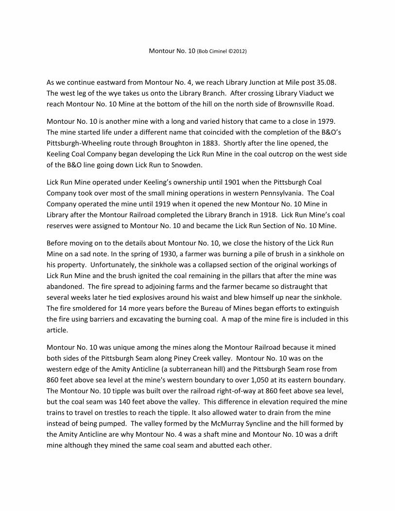
This topographic map shows the two drift entries and waste tramway used by Montour No. 10.
The north entry is located below the word “Library.” The south entry is located along Cardox
Road and is labeled “Mine.”

This photograph from 1922 shows the electrical substation at Montour No. 10 and was used to
illustrate how many mines were switching to purchased power from the local utility instead of
generating it on-site. The Pittsburgh Coal Company was a major investor in the West Penn
Power Company and converted all of its mines to off-site power. The transmission lines the
Coal Company had originally installed between its mines (many mines received power from
adjacent mines) were sold to West Penn Power.

This 1946 aerial photo was taken by the Pittsburgh & Lake Erie Railroad after it became a 50%
owner of the Montour Railroad along with the PRR. The view is toward the southeast and
shows the mine tracks curving around the hill to reach the southern portion of the mine. The
dumping station on the waste pile is also visible. Note the pile of mine props and mine cars in
the lower left and the tracks coming from the northern entry at center left. The additional coal
processing section on the right side of the tipple was the Champion No. 3 cleaning plant.

This 1938 aerial photo shows the tipple and mine tracks for No. 10 along with the various
miners’ village associated with the mine. Note the strings of hopper cars in the empty yard
waiting to be loaded.

Montour No. 10 was close when this 1957 photo was taken (no coal cars in either yard), but
was obviously not abandoned because the tipple was not razed. The coal cleaning plant has
also been removed from the western side of the tipple.

The mine is still closed in the this 1967 photo, and it looks as though they are scavenging waste
rock from the southern section of the old mine dump.
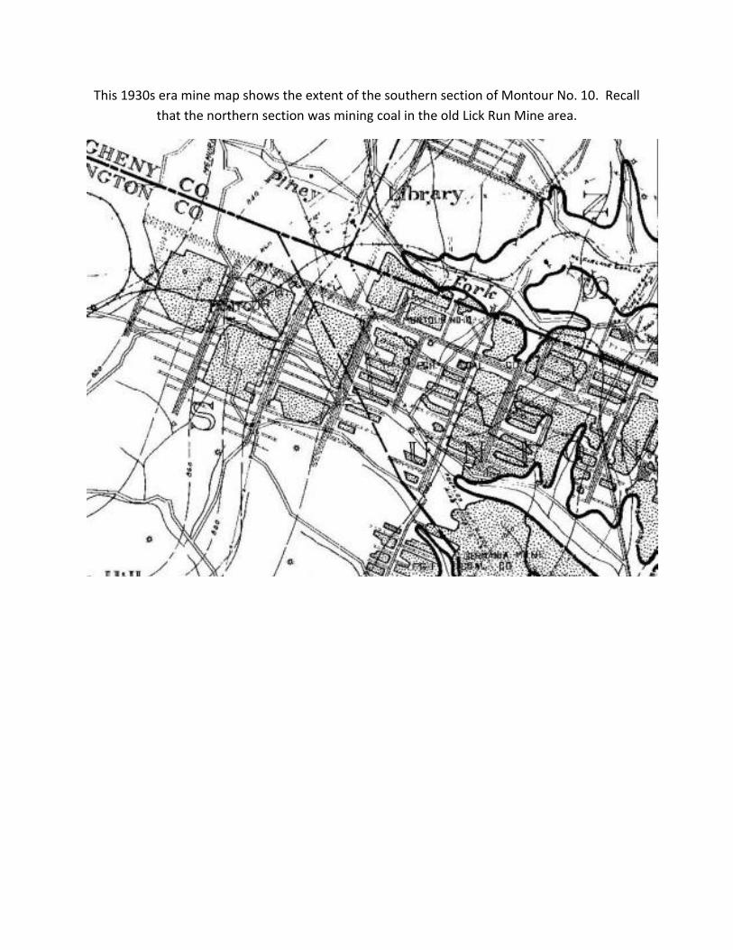
This 1930s era mine map shows the extent of the southern section of Montour No. 10. Recall
that the northern section was mining coal in the old Lick Run Mine area.

This larger map shows the northern section of Montour No. 10. The heavy black line is the
barrier pillar between Montour No. 10 and Coverdale No. 8 Mine on the northwest and
Pittsburgh Terminal No. 4 Mine on the northeast.

This diagram shows the overburden and strata above No. 10 mine. The average depth was
about 230 feet from the bottom of the coal seam to the surface. However, as stated earlier,
there was a point beneath South Park where the seam was only 40 feet below the surface. The
5.5-foot Pittsburgh coal was what the miners at No. 10 were after.

This diagram shows the mining layout at No. 10. Four face entries were driven in a north-south
direction. Butt entries were driven in an east-west direction to create blocks of coal 300 feet
wide and 2,000 feet long. Rooms 15 feet wide were then driven along the east-west axis to
remove the coal. Once the rooms were mined, the pillars were extracted in a diagonal
direction leaving a rib about 950 feet long.

This is the pumping station for the Montour No. 10 Mine treatment plant off of Cardox Road.
About 20% of Montour No. 10 is flooded, with the water level in the mine being maintained by
the Hahn AMD plant along Chartiers Creek.

This map shows the Lick Run Section of Montour No. 10 near Broughton. The Lick Run Mine fire
began about ½ mile north of the U.S. Bureau of Mines Experimental Station.