montana water supply outlook late spring 2020€¦ · on behalf of the governor's drought and...
TRANSCRIPT

P a g e | 1
Montana Water Supply Outlook – Late Spring 2020
Water Supply Overview:
On behalf of the Governor's Drought and Water Supply Advisory Committee, DNRC Water Planners have compiled this
Spring Water Supply Outlook. This report provides a synopsis of statewide conditions gleaned from multiple sources and
offers links to additional resources with more in-depth information. In partnership with other state and federal
agencies, DNRC staff gather this information from experts in climate science, snowpack, streamflow and other important
drought and flooding indicators.
Precipitation:
The 2019 water year closed with an exceptionally wet September followed by an exceptionally cold October that dashed
all hope for one of Montana’s famous Indian summers. October of 2019 ranked as Montana’s coldest on record across
much of the state with multiple daily lows that fell well below zero and averages for the month as much as 8 degrees
P a g e | 2
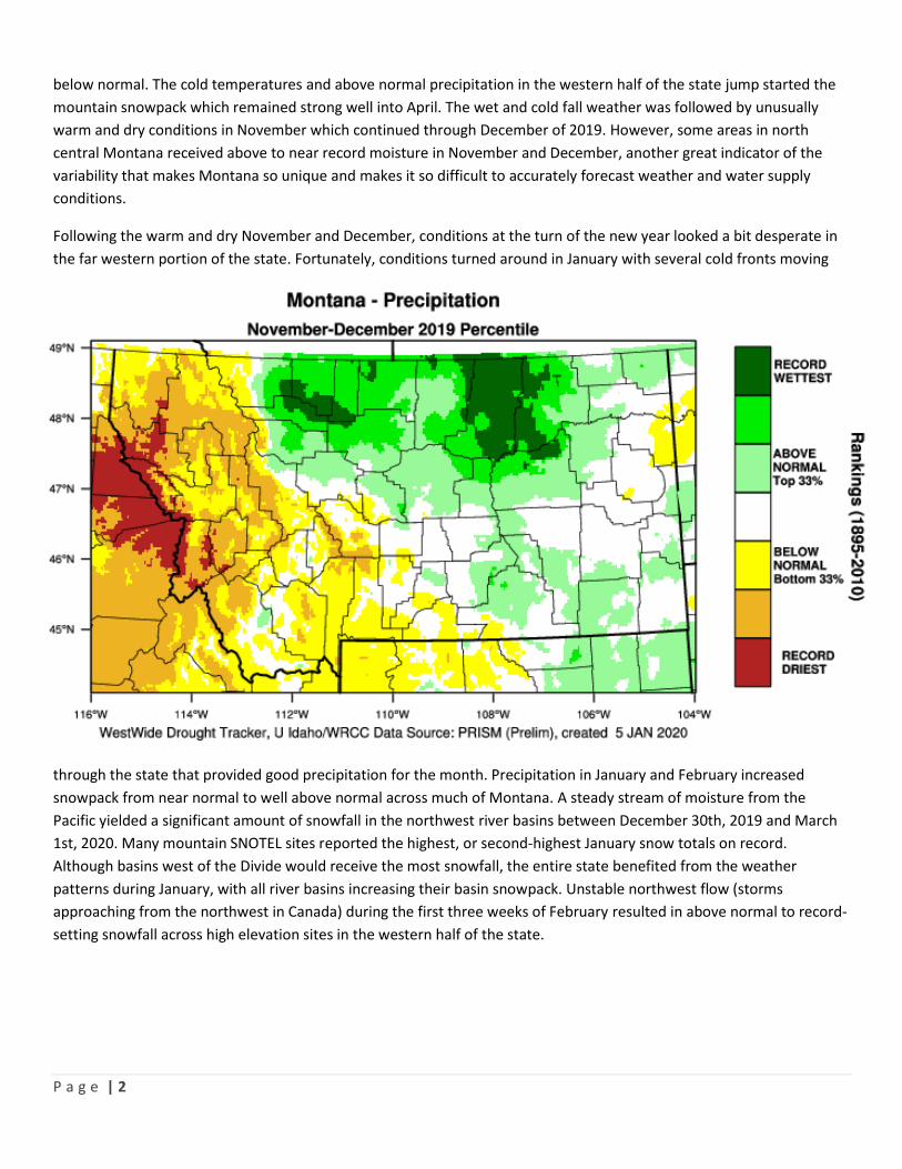
below normal. The cold temperatures and above normal precipitation in the western half of the state jump started the
mountain snowpack which remained strong well into April. The wet and cold fall weather was followed by unusually
warm and dry conditions in November which continued through December of 2019. However, some areas in north
central Montana received above to near record moisture in November and December, another great indicator of the
variability that makes Montana so unique and makes it so difficult to accurately forecast weather and water supply
conditions.
Following the warm and dry November and December, conditions at the turn of the new year looked a bit desperate in
the far western portion of the state. Fortunately, conditions turned around in January with several cold fronts moving
through the state that provided good precipitation for the month. Precipitation in January and February increased
snowpack from near normal to well above normal across much of Montana. A steady stream of moisture from the
Pacific yielded a significant amount of snowfall in the northwest river basins between December 30th, 2019 and March
1st, 2020. Many mountain SNOTEL sites reported the highest, or second-highest January snow totals on record.
Although basins west of the Divide would receive the most snowfall, the entire state benefited from the weather
patterns during January, with all river basins increasing their basin snowpack. Unstable northwest flow (storms
approaching from the northwest in Canada) during the first three weeks of February resulted in above normal to record-
setting snowfall across high elevation sites in the western half of the state.
P a g e | 3

P a g e | 4
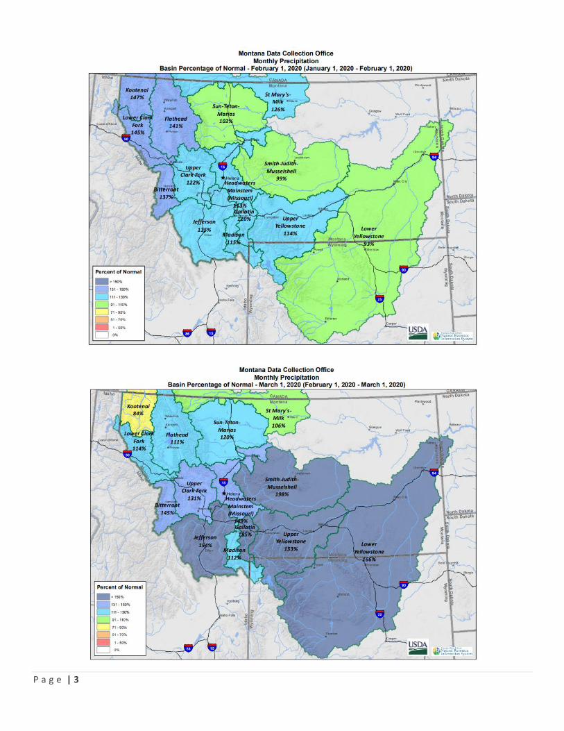
March and April didn’t yield the abundance of moisture to Montana as January and February. Storms during March
favored the southwest and south-central mountain ranges. In these areas, above normal monthly snow totals were
reported due to periods of southwest flow during mid-March. Other regions were left with below normal snow totals
and prolonged periods between reported snowfall. Weather patterns during the first three weeks of April were
dominated by dry, but cool, west-northwest flow. Although snowpack gains were below normal, the above to well above
normal snowpack in place on April 1st held strong through the end of the month due to the below-average
temperatures
March started on the warm side, with many mountain locations setting new records for the highest daily average
temperature on record at SNOTEL sites for March 6th (+/-25 years of history). The warm air moved out of the state for
the remainder of the month, with temperatures across the state remaining near to below average for the daily average
temperature through March to well below normal across the state during the first half of April at most locations.
P a g e | 5
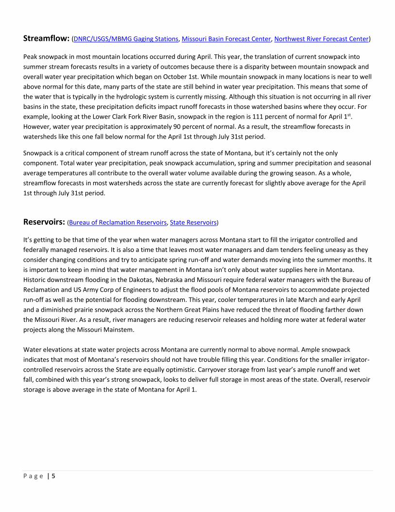
Streamflow: (DNRC/USGS/MBMG Gaging Stations, Missouri Basin Forecast Center, Northwest River Forecast Center) Peak snowpack in most mountain locations occurred during April. This year, the translation of current snowpack into
summer stream forecasts results in a variety of outcomes because there is a disparity between mountain snowpack and
overall water year precipitation which began on October 1st. While mountain snowpack in many locations is near to well
above normal for this date, many parts of the state are still behind in water year precipitation. This means that some of
the water that is typically in the hydrologic system is currently missing. Although this situation is not occurring in all river
basins in the state, these precipitation deficits impact runoff forecasts in those watershed basins where they occur. For
example, looking at the Lower Clark Fork River Basin, snowpack in the region is 111 percent of normal for April 1st.
However, water year precipitation is approximately 90 percent of normal. As a result, the streamflow forecasts in
watersheds like this one fall below normal for the April 1st through July 31st period.
Snowpack is a critical component of stream runoff across the state of Montana, but it’s certainly not the only
component. Total water year precipitation, peak snowpack accumulation, spring and summer precipitation and seasonal
average temperatures all contribute to the overall water volume available during the growing season. As a whole,
streamflow forecasts in most watersheds across the state are currently forecast for slightly above average for the April
1st through July 31st period.
Reservoirs: (Bureau of Reclamation Reservoirs, State Reservoirs)
It’s getting to be that time of the year when water managers across Montana start to fill the irrigator controlled and
federally managed reservoirs. It is also a time that leaves most water managers and dam tenders feeling uneasy as they
consider changing conditions and try to anticipate spring run-off and water demands moving into the summer months. It
is important to keep in mind that water management in Montana isn’t only about water supplies here in Montana.
Historic downstream flooding in the Dakotas, Nebraska and Missouri require federal water managers with the Bureau of
Reclamation and US Army Corp of Engineers to adjust the flood pools of Montana reservoirs to accommodate projected
run-off as well as the potential for flooding downstream. This year, cooler temperatures in late March and early April
and a diminished prairie snowpack across the Northern Great Plains have reduced the threat of flooding farther down
the Missouri River. As a result, river managers are reducing reservoir releases and holding more water at federal water
projects along the Missouri Mainstem.
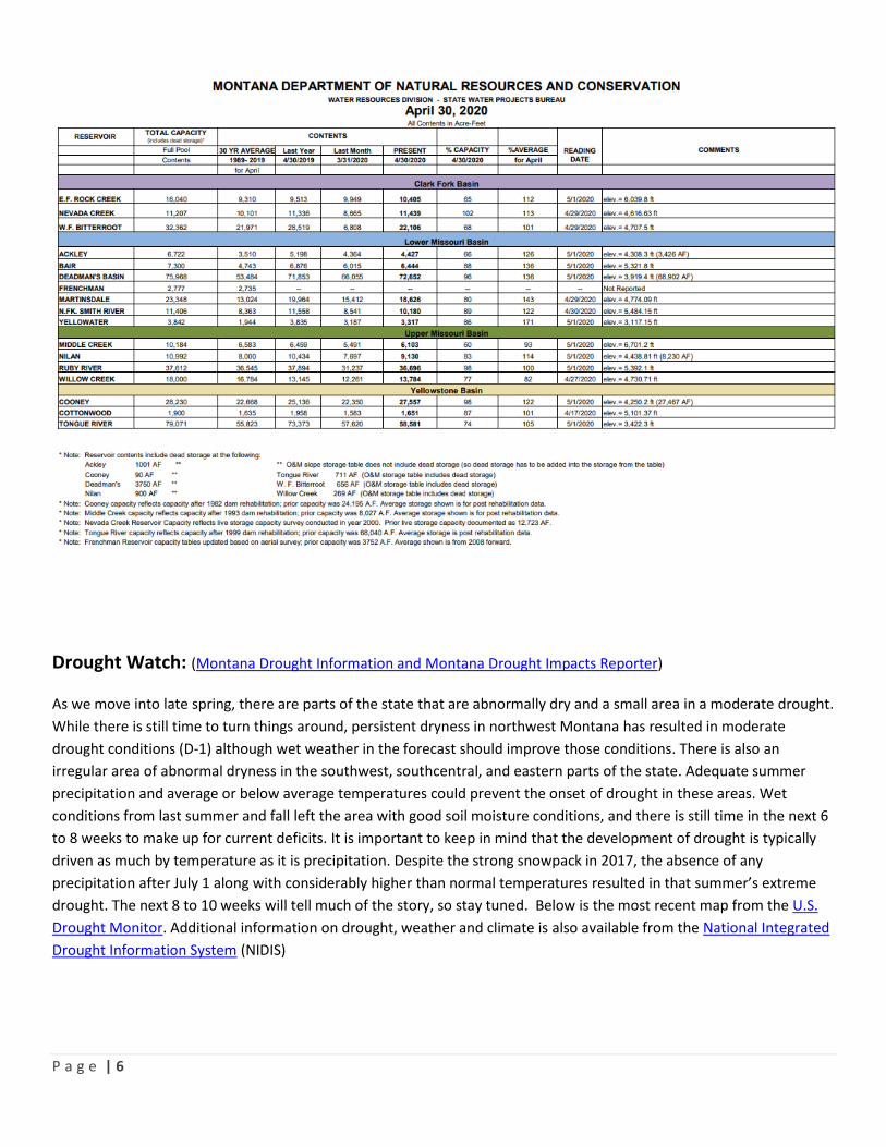
Water elevations at state water projects across Montana are currently normal to above normal. Ample snowpack
indicates that most of Montana’s reservoirs should not have trouble filling this year. Conditions for the smaller irrigator-
controlled reservoirs across the State are equally optimistic. Carryover storage from last year’s ample runoff and wet
fall, combined with this year’s strong snowpack, looks to deliver full storage in most areas of the state. Overall, reservoir
storage is above average in the state of Montana for April 1.
P a g e | 6
Drought Watch: (Montana Drought Information and Montana Drought Impacts Reporter) As we move into late spring, there are parts of the state that are abnormally dry and a small area in a moderate drought.
While there is still time to turn things around, persistent dryness in northwest Montana has resulted in moderate
drought conditions (D-1) although wet weather in the forecast should improve those conditions. There is also an
irregular area of abnormal dryness in the southwest, southcentral, and eastern parts of the state. Adequate summer
precipitation and average or below average temperatures could prevent the onset of drought in these areas. Wet
conditions from last summer and fall left the area with good soil moisture conditions, and there is still time in the next 6
to 8 weeks to make up for current deficits. It is important to keep in mind that the development of drought is typically
driven as much by temperature as it is precipitation. Despite the strong snowpack in 2017, the absence of any
precipitation after July 1 along with considerably higher than normal temperatures resulted in that summer’s extreme
drought. The next 8 to 10 weeks will tell much of the story, so stay tuned. Below is the most recent map from the U.S.
Drought Monitor. Additional information on drought, weather and climate is also available from the National Integrated
Drought Information System (NIDIS)

P a g e | 7
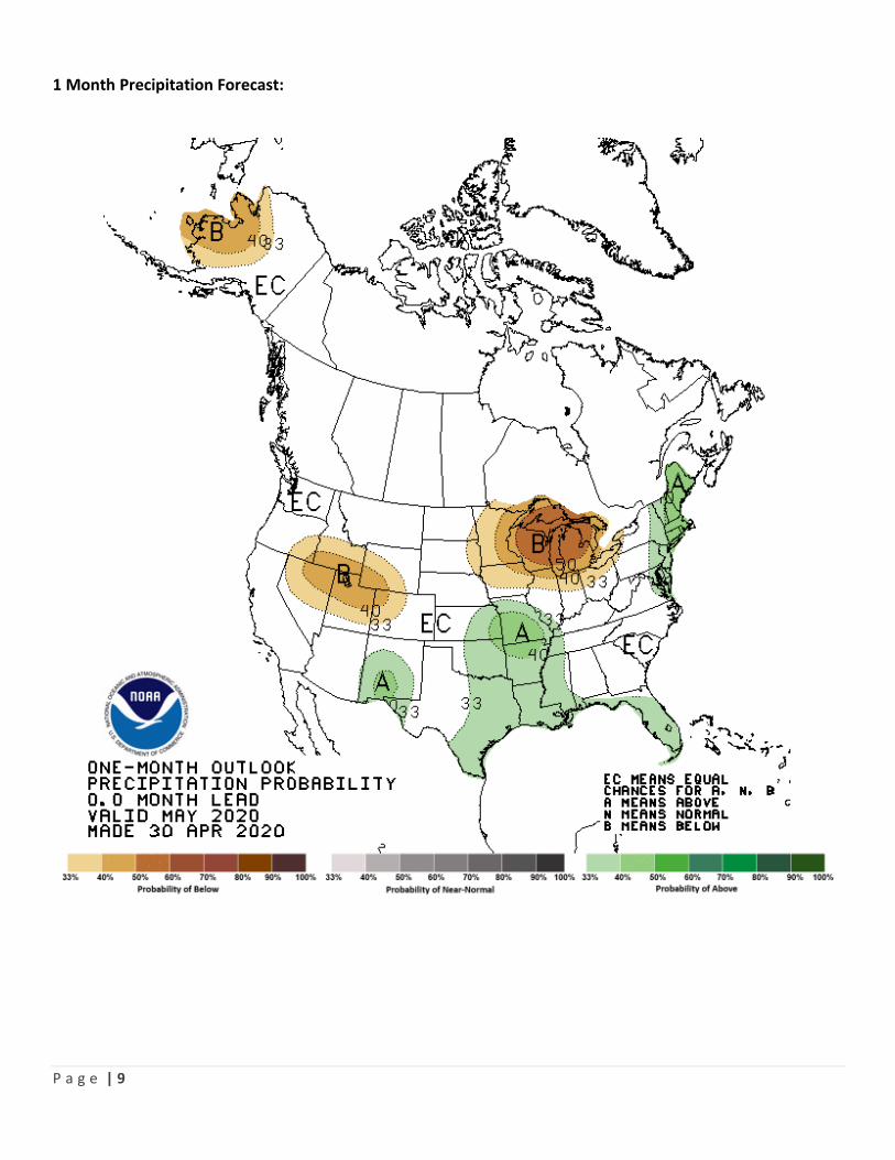
Long Term Forecast: The Climate Prediction Center, a division of the National Weather Service, provides long-term forecasts for the contiguous United States, Alaska and Hawaii. The current temperature outlook for May calls for 30% chance of above normal temperatures in western Montana, and there are not any clear signals on the horizon that indicate below average or above average temperatures in the rest of the state. The precipitation outlook does not show a clear indication in one direction or the other. The maps below show the 1-month forecast for both temperature and precipitation.

P a g e | 8
1 Month Temperature Forecast
P a g e | 9
1 Month Precipitation Forecast:
P a g e | 10
These combined indicators tell the current water supply story in Montana. As always, the ending may differ radically from this current outlook. DNRC can help answer questions about water resources in your area or provide information about water management tools like stream gages, near you. DNRC also provides planning assistance and technical support for local water supply planning for your community and in your watershed. Please don't hesitate to get in touch if you have any questions or feedback, and keep an eye out for the next update in late June. Contact the DNRC staff listed below for assistance or additional information. Lower Missouri Basin Yellowstone River Basin Upper Missouri River Basin Water Planner - Michael Downey Water Planner - Sara Meloy Water Planner - Ann Schwend Drought Monitoring Coordinator Clark Fork & Kootenai River Basins Water Planner – Valerie Kurth Much of the information contained in this report comes from the NRCS Water Supply Outlook Report, U.S. Drought
Monitor, Climate Prediction Center, National Integrated Drought Information System and others. This report would not
be possible without the ongoing participation and contributions of our local, university, state, tribal and federal
partners, some of which are listed below:
This report was developed by the MT DNRC on behalf of the Governor’s Drought & Water Supply Advisory Committee
pursuant to MCA 2-15-3308(5).