montana floodplain management assessment: strengthening...
TRANSCRIPT

1
Montana Floodplain Management Assessment:
Strengthening Policies and Programs
that Reduce Flood Risk and Protect Floodplains.
Sun River flooding, June 9, 2011. Photo by David Stallknecht, downloaded from KRTV web site.
Yellowstone River ice jam 20 miles east of Forsyth Montana, March 14, 2011. Courtesy of KULR-8 News.
Report Prepared by Association of State Floodplain Managers for Montana Department of Environmental Quality Contract #210144
Funded by US EPA Wetland Program Development Grant #CD97854301 July 15, 2011
2
Contents Executive Summary…………………………………………………………………………………………………….4
Problem Statement…………………………………………………………………………………………………..…5
Challenges to Protecting Floodplains in Montana…..…………………………………………………..6
Methods Used For This Assessment…………………………………………………………………………….8
Montana Floodplain Management Program.………………………………………………………………9
Recommendations to Enhance Montana Floodplain Management ………………………………12
Recommendation 1: Implement a Montana Floodplain Mapping Program. ................... 12
1a: Initiate and fund a comprehensive state mapping program .............................. 13
1b: Develop and pilot cost-effective large scale mapping methods ....................... 14
1c: Create a complete digital floodplain geospatial data layer for Montana. ......... 15
1d: Map areas susceptible to additional flood hazards ........................................... 16
1e: Create and document a mapping and data plan during flood events ………….….16 1f: Develop a mechanism to support community-developed mapping…… ............ 17
1g: Define the term “reasonable hydrologic certainty”. .......................................... 17
1h: Develop guidance for determining future conditions flood flows. .................... 18 Recommendation 2: Enhance Montana DNRC’s Existing Internal Processes. ................. 18
2a: Issue approval letters and archive a review checklist ......................................... 18
2b: Enhance the Montana Floodplain Study Reference Map ................................... 19
2c: Establish floodplains as a Montana Spatial Data Infrastructure layer ................ 19
Recommendation 3: Leverage Existing Program Capabilities and Authorities ............... 20
3a: MOU with FEMA on floodplain engineering study review and approval ........... 20
3b: Require equal encroachment cummulative impact analysis ............................ 21
3c: Convene an interagency workgroup regarding stream restoration ................... 22
3d: Coordinate disaster response procedures and planning …..................................23
3e: Assess floodplain programs for disincentives and conflicts ................................ 23
Recommendation 4: Incorporate No Adverse Impact (NAI) concepts into Montana’s Statutes, Administrative Rules and Model Floodplain Management Ordinance ............. 23
4a: Develop a guidebook and emphasize No Adverse Impact ................................. 24
4b: Provide NAI floodway concepts for managing new developments .................... 26
4c: Encourage easements for development that cause an increase in flooding ...... 27
4d: Identify floodplain management strategies for ESA and fish-friendly practice .. 27
4e: Provide guidance in the model floodplain management ordinance ................... 28
Recommendation 5. Enhance Floodplain Outreach and Education. ............................... 29
5a: Tailor flood risk reduction outreach programs to address different audiences. 29
5b: Provide flood mapping information to local communities . ............................. 29
5c: Create a Montana specific tool box of education and outreach materials ....... 30
Benefits of Implementing These Recommendations…………………………………………………….30
References and Resources……………………………………………………………………………………………31

3
Attachment 1. State of Wisconsin minimum requirements for a hydrologic/hydraulic study for determining the impact of proposed development in the Zone A/AE Floodplains..……33 Attachment 2. State of Wisconsin DNR Sample Flood Easement Form……………………………37
Attachment 3. Glossary of Frequently Used Terms………………………………………………………...40
Appendix A. Technical Advisory Committee…………………………………………………………………..45
Appendix B. Tools That Were Identified and Evaluated………………………………………………….47
Appendix C. Case Studies Used to Identify and Evaluate Issues……………………………………..51
Appendix D. List of Interviewees…………………………………………………………………………………….52
4
Executive Summary The purpose of this report is to evaluate tools (laws, policies, programs, and practices) that the State of Montana and local governments could use to reduce flood damages and protect the natural and beneficial functions of floodplains. These tools were evaluated and compared to best management practices, “No Adverse Impact” floodplain management, and highly effective programs from other states and local governments. Attention was paid to any existing regulations, rules, standards, and guidelines or other policies, programs, and practices that inadvertently incentivize development in floodplains or allow adverse impacts to the natural and beneficial functions of floodplains. The findings of this report include recommendations to improve floodplain management in Montana at both the state and local government levels. These recommendations build on strong existing resources including the Montana Department of Natural Resources and Conservation (DNRC) Floodplain Section; the Association of Montana Floodplain Managers (AMFM), whose mission is “ensuring the responsible management of Montana floodplains through communication, cooperation, and education”; and professionals across the state who work in diverse floodplain-related disciplines. Recommendations to enhance floodplain management in Montana include: 1. Implement a Montana floodplain mapping program, 2. Enhance Montana DNRC’s existing internal processes, 3. Leverage existing program capabilities and authorities, 4. Incorporate No Adverse Impact concepts into Montana floodplain ordinances, and 5. Enhance floodplain outreach and education. In assessing floodplain management in Montana, the Association of State Floodplain Managers (ASFPM) engaged a Technical Advisory Committee (TAC) (Appendix A), identified and evaluated tools (Appendix B), analyzed a number of case studies (Appendix C), and interviewed professionals working in floodplain management (Appendix D). ASFPM held meetings on March 8, 2011 in Lewistown as part of the AMFM annual meeting and on March 11 with the TAC and other stakeholders in Helena to discuss the draft recommendations. These meetings targeted the accuracy, focus, and utility of the ideas and recommendations presented in the draft report. Based on those meetings, ASFPM, and the Montana Department of Environmental Quality (DEQ) revised the report and recommendations for a final reviews and comments by the TAC. ASFPM produced this final report for a Wetland Program Development Grant funded by U.S. Environmental Protection Agency Region 8 and awarded to the Montana DEQ.

5
Problem Statement This project was initiated to address the question - what can state and local government best do with limited dollars to protect and maintain natural floodplain functions and resources, particularly in conjunction with flood loss reduction efforts? Montana has floodplain standards aimed at public health, safety, and welfare. One example of these standards is a prohibition on the building of new habitable structures in a designated floodway and a requirement that buildings in the floodplain be elevated two feet above the Base Flood Elevation (BFE). However, while three local governments have floodplain regulations prohibiting building in the 100-year floodplain, most of Montana’s homes and other structures continue to be built in flood prone areas. If a BFE had been established (currently about 1% of Montana’s rivers and streams), then those structures should have been built at least two feet above the BFE. An analysis by the Montana Legislative Service Division(1) of property in 17 counties found that from 1990 to 2005, more than 400 homes were built in the 100-year floodplain and that these new homes add to the existing inventory of about 3,800 homes within 100-year floodplains in those 17 counties. These actions present flood risks to homeowners while also affecting the natural and beneficial functions of floodplains. The critical functions and resources of floodplains are well-documented. They include flood storage that protects homes and communities, erosion attenuation, water quality filtration, groundwater recharge, natural habitat, recreational opportunities, and carbon sequestration. Despite the recent slowdown in the building sector, Montana is expected to increase in population by 15 percent over as many years. The added population will increase pressure to continue allowing development adjacent to Montana’s water resources and, in turn, continue to impact the natural and beneficial functions of floodplains along the state’s rivers and streams. The majority of flood hazard areas along Montana’s rivers and streams have not been mapped and this lack of information prevents sound decisions by land owners, the public, local governments, and other decision makers to protect public health, safety, and the welfare of property owners in these sensitive areas. Montana must also contend with ice jam induced flooding. Bridges across Montana’s unstable floodplains not only obstruct the natural meandering of the stream but create bottlenecks that block ice. The Governor’s Office of Community Service reports that Montana has the highest number of reported ice jams and ice jam related deaths in the lower 48 states. Ice jam events in Montana have been reported on 163 different streams and rivers and in 199 different locations. Maintaining infrastructure and providing emergency services to development in areas susceptible to flooding, ice jam-induced or otherwise, can be a major expense for communities and can put the state’s dedicated emergency response personnel at unnecessary risk.
6
Challenges to Protecting Floodplains in Montana There are several challenges to keeping people safe from floods and protecting the multiple values of floodplains. Here we identify three major challenges: 1) limited understanding of the importance of natural floodplains, 2) preference for living near water, and 3) lack of floodplain mapping for most of Montana’s rivers and streams and where there are maps, common Montana flood hazards (such as ice jam risk and channel migration) are not included. Limited understanding of the importance of natural floodplains The natural and beneficial functions of Montana’s floodplains and natural riverine processes are not universally recognized and understood. Flooding is a natural ecological process that forms and maintains floodplains. Floodplains are created and sized to accommodate the typical floods of the watershed and filling in those areas minimizes the capacity of the floodplain to accommodate high flows with detrimental effects. Most people are not aware of several key riverine processes, such as the tendency of streams to migrate laterally across their floodplains over time. Further, the multiple benefits of floodplains are also largely overlooked, including the water-holding capacity of floodplain during high runoff periods, and the slow release of water once the storm pulse has passed. Finally, floodplains provide valuable wildlife habitat (e.g. spawning areas for cut-throat trout and arctic grayling.) ASFPM recognizes two goals for floodplain management in the U.S.: (1) flood loss reduction, and (2) conservation and protection of the natural and beneficial functions of our water resources. (2) ASFPM asserts that “we need to marshal unprecedented forces to preserve and improve the natural functionality of our floodplains and coastal areas and protect the resources they provide. In doing so, we will also mitigate damage and losses that floods bring to society” (ASFPM, p. 2. Emphasis added.). Essentially, the “twin goals” that ASFPM cites are not conflicting but, rather, mutually reinforcing. A naturally functioning floodplain reduces flood risk. Montana’s floodplain and floodway management law(3) also outlines two purposes for floodplain management: (1) prevent and alleviate flooding threats to life and health, and (2) reduce private and public economic losses. Montana law explicitly captures the first ASFPM goal but not the second. However, the state’s floodplain management program is the responsibility of the Montana Department of Natural Resources Conservation – Water Resources Division. This Division is responsible for promoting and coordinating the beneficial use, conservation, protection and development of Montana's water resources, and by extension it performs its duties for the purpose of promoting the general welfare and economic and social prosperity of the people of Montana. As part of the DNRC Water
7
Resources Division, the Montana Floodplain Management Program has inherent responsibilities associated with the “conservation and protection of the natural and beneficial functions of the floodplain”. However, despite extensive outreach and training by the DNRC Floodplain Program, Montana Association of Conservation Districts, Governor’s Task Force for Riparian Protection, and others on the benefits of maintaining streamside vegetative riparian areas, the state’s floodplains remain largely undervalued and their natural and beneficial functions largely unprotected. Preference for living near water Montana’s beautiful streams and rivers attract people who enjoy living near water. The challenge is to ensure that people are aware of flood and erosion hazards so that they don’t build at risk to their lives, property, the resource, and neighboring properties. Once a stream-side building is in place, owners understandably want to protect their investment by anchoring the stream bank to stop channel migration and channel erosion. Stream bank anchoring is not always effective and can negatively impact neighboring properties by shifting erosive forces of the river to adjacent and downstream river banks, which puts property owners in those areas at increased risk. Ironically, these alterations can also increase flooding as the natural vegetated stream bank’s capacity for flood storage is reduced. Homes and other development in floodplains add to constriction of the floodplain, the loss of wetlands and other natural flood storage. Furthermore, the actual occupation of the floodplain space with structures creates impermeable surfaces increasing stormwater runoff and can add to the severity of flood events. These actions both increase the risk of flood damage to people and property and reduce the natural flood storage of floodplains. As Gilbert White, founder of floodplain management activities, stated, “Floods are ‘acts of God,’ but flood losses are largely acts of man.” (4) Some of the challenges are also due to the immigration of many newcomers who are unfamiliar with the dynamic nature of Montana’s streams. People tend to have a hard time imagining that a seemingly small late summer stream can at times be a raging torrent carrying snowmelt or runoff from severe mountain rains. Lack of floodplain mapping for most of Montana’s rivers and streams and where there are maps, common Montana flood hazards (such as ice jam risk and channel migration) are not included Montana has over 200,000 miles of streams, but only about 10,000 of these stream miles (5%) have FEMA Special Flood Hazard Area (SFHA) maps (which serve as the regulatory maps for Montana’s floodplains) and just 2,000 miles (1%) have FEMA Base Flood Elevation (BFEs) and floodways established. Furthermore, those few areas that do have FEMA flood-hazard mapping do not include additional flood hazards such as fluvial erosion hazards or ice jam risks on the maps.

8
In Montana, management of land use by local governments is explicitly authorized within mapped floodplains. In watersheds without mapped floodplains, no building permit is required and land use management is left largely to the individual property owner. Lack of funding has significantly limited Montana’s ability to adequately map floodplains to inform citizens and communities of the risks associated with development near the state’s rivers and streams. While Montana’s floodplain statute (see inset on page 13) stipulates that the state must initiate a program for delineation of floodplains and floodways, limited funding has hindered full implementation of the statute.
Methods Used For This Assessment This project had several components including a Technical Advisory Committee, evaluation of floodplain management tools, assessment of case studies, and interviews with floodplain professionals. ASFPM worked with the Montana DEQ and DNRC to develop a 19-member Technical Advisory Committee (TAC) composed of local, state, federal, and private resource professionals (in and out-of-state) to inform and provide review and feedback about the Montana Floodplain Management Assessment (Appendix A). The TAC participated in ten conference calls with ASFPM to provide input and expertise to the project. The TAC also attended a meeting in Helena with ASFPM to discuss the draft recommendations. ASFPM and the TAC developed a list of tools (laws, policies, programs, and practices—see Appendix B) used for floodplain management, land use planning, and regulations that affect both public health and safety and the natural and beneficial functions of floodplains. ASFPM researched, reviewed, and evaluated these resource management tools and their use in Montana, in comparison to best management practices, principles of “No Adverse Impact,” and progressive programs from other states and local governments. The TAC identified numerous case studies (Appendix C) in which the existing tools (laws, policies, programs, and practices) were utilized, but in which the natural and beneficial functions of the floodplain resource were not protected or application of these tools made protection of the resource problematic. ASFPM researched these case studies to illustrate problems associated with how the existing tools are utilized. These case studies were grouped into eight major categories as follows:
Critical Facilities
Mapping Issues (to include lack of mapping, changes in mapping, local mapping)
Safe and Dry Access
Extensive Floodplain - Small Fill Effect
9
Disaster/Flood Emergency Related
Pre-Rap Issues
Structural River Changes
Legal challenges involving state or local government efforts to manage/protect the floodplain
Finally, the TAC recommended that ASFPM interview 20 professionals (Appendix D), all of whom work in different areas of floodplain management. The TAC developed a list of interview questions to guide ASFPM. ASFPM conducted half-hour to hour-long telephone interviews with each of these professionals to gain additional insight into Montana’s floodplain management challenges and opportunities.
Montana Floodplain Management Program Montana has one of the premier floodplain management programs in the U.S. It is one of 16 states that require new construction in the floodplain to be built above the Base Flood Elevation. Montana is one of only eight states that have more stringent requirements than federal standards for mapping floodways. In addition, Montana law does not allow habitable structures in the floodway, and on-site waste disposal is not allowed within 100 feet of the floodplain. Holding tanks and sealed-pit privies must be located at least ten feet outside the floodplain and any opening must be at least two feet above the floodplain elevation. The Montana DNRC floodplain program has strong state floodplain management standards (see Table 1 below) administered by experienced technical staff. The staff includes a Floodplain Engineer, Community Assistance Coordinator, Floodplain Mapping Coordinator and an experienced program manager who is also responsible for dam safety. The DNRC also has six regional engineers and engineering specialists who provide technical assistance to communities in evaluating development proposals. The Montana State Floodplain Engineer and the six DNRC regional engineering staff provide a solid foundation for the Montana floodplain management program and community floodplain management efforts. These engineers also inspect dams and review stream alteration proposals to ensure the public trust obligations of the state are adequately addressed. Montana communities are fortunate to have experienced critical engineering support for floodplain management. The primary goal of the DNRC floodplain program is to provide up-to-date and accurate floodplain mapping information to Montana’s communities. In addition, the DNRC staff provides technical assistance to the 130 locally administered flood plain management programs throughout Montana, evaluates community performance in managing development in the floodplain, and provides outreach and training to help build state and community floodplain management expertise and capabilities.

10
Table 1 – Montana Rules compared to NFIP Minimum Requirements.(5)
Standard Montana Requirements NFIP Requirements
Freeboard 2 feet No freeboard required. Floodway Standards ½ foot surcharge allowed. 1 foot surcharge allowed. Floodway Uses Prohibits habitable
structures within the floodway.
Allows structures in the floodway with documentation of zero-rise.
Mobile Homes Requires all mobile homes to be elevated to the freeboard protection level.
Will allow for mobile home placed in an existing mobile home park to be elevated to 36” above the adjacent grade.
Septic systems In approved subdivisions, systems must be located 100’ outside the floodplain.
Allows systems in the floodplain. Not covered by flood insurance.
Several federal, state, and local programs complement the State’s floodplain management program. These include, but are not limited to:
FEMA flood hazard mitigation program,
National Flood Insurance Program,
Disaster and Emergency Services at both the state and local levels,
Clean Water Act Section 404 (regulates the discharge of dredged or fill material),
Montana Natural Streambed and Land Preservation Act (310 permits) which regulates proposed alterations to perennial streams by private landowners,
Montana Stream Protection Act (SPA 124 permits) which regulates proposed alterations to streams/tributaries by governmental entities,
the subdivision process,
the stormwater discharge program,
local building standards,
Total Maximum Daily Load (TMDL) and associated watershed water quality programs,
the wetland program and state 401 certification,
the Montana Water Use Act, and
the water quality standard program. “A Guide to Stream Permitting in Montana” provides an overview of many of these programs for permit applicants. http://dnrc.mt.gov/permits/streampermitting/guide.asp. A project to catalogue stream, floodplain, wetland, riparian area, land use, and other regulations and policies adopted by Montana local governments provides a quick reference of local approaches (updated July 31, 2009):
11
http://www.mtaudubon.org/issues/wetlands/planning4.html#3 However, while the aforementioned programs can complement the state’s floodplain management program, some of the guidance they suggest to the regulated public, relative to using bioengineering techniques for stream restoration projects, is inconsistent with the “harder” rock techniques stressed in floodplain regulation. This inconsistency in regulation is confusing to the regulated public and not effective in maintaining natural and beneficial floodplain functions. The various regulatory entities need to work on developing more consistent, predictable, and effective regulation. Based on the interviews conducted with floodplain professionals, it is apparent that the DNRC floodplain program conducts effective outreach associated with floodplain management and that communities appreciate the technical support they receive from the program. However, interviewees indicated that community floodplain managers have numerous other responsibilities and they have a relatively high turnover rate. Therefore, outreach remains a high-priority need.
12
Recommendations to Enhance Montana Floodplain Management
Recommendation 1: Implement a Montana Floodplain Mapping Program.
Map flood hazards before development is at-risk. Floods are the nation's most common and costly natural disaster. To reduce the ever-growing expense to the federal government related to flooding, Congress established the National Flood Insurance Program (NFIP) in 1968. The objective was to provide flood insurance for existing development and to map flood inundation areas so that new development would be reasonably protected from flood damages. Soon after creation of the National Flood Insurance Program in 1968, the Federal government began publishing Flood Hazard Boundary Maps (FHBM). FHBMs were developed using "approximate study techniques” that had no engineering models behind them. FHBMs were intended to provide an early warning for local officials that flooding could occur in their communities; however, they did not provide predicted flood water surface elevations. The original plan anticipated that engineering models would eventually be developed for these approximately-mapped streams. These floodplain engineering studies (called detailed Flood Insurance Studies) provide predicted water surface elevations that would be used to develop more accurate floodplain maps known as Flood Insurance Rate Maps (FIRMs) under the National Flood Insurance Program. Detailed Flood Insurance Studies (FIS) and FIRMs were produced throughout the 1970s and 80s for many communities across the country. However, the majority of existing FEMA flood mapping is still based upon approximate methods with no established flood elevations. Maps depicting flood hazard areas are not only the foundation of the National Flood Insurance Program, they are also the basis of floodplain management at the state and local levels of government. In most Montana communities, development permits are required only within the mapped floodplain. If an area is not mapped as a flood hazard area, communities often have insufficient basis to enforce building codes and/or to regulate new development even if that area is known locally to be flood-prone. Flood inundation mapping assists communities in guiding the construction of not only individual homes and buildings but also community infrastructure and critical facilities (e.g. emergency facilities, assisted care units, emergency shelter centers, transportation routes and public utilities). Most importantly, without adequate floodplain mapping people do not have the necessary information regarding where it is dangerous or risky to build a home or business. Too often, people fail to recognize that a small stream can become a destructive, raging torrent of water due to ice jams, spring rains, rain on snow events, and snow melt runoff. It is far preferable for people to know that their chosen construction site is in the floodplain before building their home rather than after.
13
1a: Initiate and fund a comprehensive state program for the delineation of designated floodplains and floodways for each watercourse and drainway in the state. Montana has passed legislation that provides a solid foundation for the development of a state floodplain mapping program (see inset box). However, interviewees for this assessment identified the lack of existing floodplain maps as a major limitation to effective floodplain management in Montana. As mentioned previously, the state has approximately 200,000 miles of streams. Only about 10,000 of these stream miles have floodplain maps and only 2,000 miles have established Base Flood Elevations and floodways. Limited funding has prevented the DNRC floodplain program from fully developing and implementing the comprehensive mapping program envisioned by state legislation. Mapping flood hazards in areas not yet developed helps make people who are purchasing land aware of potential flood hazards and helps prevent inappropriate monetary and personal investments in these areas. Flood hazard maps help ensure that people do not have misplaced and unrealistic expectations regarding the use of flood-prone property. Between the year 2000 and 2050, it is anticipated that the population of the United States will increase from 281 million to 460 million people and housing units will increase from 116 million to 200 million units. Many of these people and new homes are expected to settle in the “third coast”, the Rocky Mountain West. The U.S. Census Bureau interim population projections cite a 29.2 percent population increase for the U.S. overall from 2000 to 2030, and a 45.8 percent increase for the West. An August 2010 Smithsonian Magazine article highlights that trend: “The Internet has broken the traditional isolation of rural communities, and as mass communication
Montana Code Annotated 76-5-201. Program for delineation of flood plains and floodways. (1) The department shall initiate a comprehensive program for the delineation of designated floodplains and designated floodways for each watercourse and drainway in the state. It shall make a study relating to the acquiring of flood data and may enter into arrangements with the United States Geological Survey, the United States Army Corps of Engineers, or any other state or federal agency for the acquisition of data. 76-5-202. Designation of flood plains and floodways. (2) When sufficient data has been acquired, the department shall establish, by order after a public hearing, the designated floodway within which a political subdivision may establish land use regulation. (3) These designations must be based upon reasonable hydrological certainty.

14
improves, the migration of technology companies, business services and manufacturing firms to the heartland is likely to accelerate. “ The DNRC has made progress in developing floodplain mapping in Montana by becoming a Cooperating Technical Partner with FEMA to implement FEMA flood hazard mapping. Montana DNRC has developed a State Business Plan for implementing FEMA’s Flood Map Modernization and Risk MAP initiatives. DNRC has also worked with communities in Montana to develop a mapping needs listing. However, FEMA focuses its mapping on high population urban areas. Due to its relatively low population, depending solely on FEMA mapping will leave most of Montana with no flood hazard maps. To be comprehensive, Montana’s State Business Plan should be enhanced to address the development of flood hazard mapping for waterways and drainways in Montana that will likely not be mapped by FEMA, as well as include additional flood hazards prevalent in Montana that are not typically included on FIRMs (e.g. fluvial erosion hazards and ice jams).
1b: Develop and pilot cost-effective mapping methods such as the Nebraska Large Area Mapping Initiative approach.
The Montana Floodplain Management Program should develop and pilot flood mapping processes for a statewide mapping program that includes all streams in Montana. Cost-effective, very conservative processes (that include uncertainty) should be used when preparing maps that help with flood awareness and establish community floodplain management ordinance jurisdiction. The State of Nebraska has designed and implemented a statewide mapping program, known as the Large Area Mapping Initiative (see inset on page 15). Such maps could be used in Montana to “map floodplains ahead of development”, and should have a name that clearly identifies the mapping as something different from FEMA’s Flood Insurance Rate Maps (e.g. Montana Flood Inundation Mapsa). These maps could be used as a filter that triggers the need for more detailed floodplain maps. More traditional floodplain engineering study techniques could be used where extensive development has already encroached into unmapped floodplains.
a One possible term that could be used for these maps. This term will be used in subsequent
references to these maps in this report. However, it is not intended to imply that there is consensus regarding use of this term.
15
1c: Create a complete digital floodplain geospatial data layer for Montana.
Montana should use a FEMA digital Q3 floodplain type processb to convert existing hard copy FIRMs into a geospatial format. Q3 flood data were developed to support floodplain management and planning activities but do not replace the official paper FIRMs. These data are not suitable for engineering applications or site work. For any direct digital conversions, the digitizing error (root mean square error) should be recorded and the control points used in georeferencing should be bundled with the digital flood map data set. These GIS-based flood maps should be attributed with the date the FIRM was published and the date the map was digitized. Assigning a new date to an old map implies a level of map accuracy that is unwarranted and inappropriate. One of the framework data layers in Montana’s Spatial Data Infrastructure (MSDI) is structures (building footprints). ASFPM is aware of no other state in the nation that has a regularly- maintained, ongoing geospatial data layer of buildings. During the interviews for this report, Bozeman was identified as an area where development is occurring on streams that do not have floodplain maps. ASFPM conducted a sample assessment by estimating floodplain widths on four streams near Bozeman. ASFPM used the MSDI structures data layer to determine that within Bozeman’s planned growth area there were 300 buildings within 250 feet of these four unmapped streams. Of these 300 potentially vulnerable buildings, 85 were within the present city limits. If Montana had a complete data layer for all
mapped floodplains, an analysis could be conducted to determine the number and types of buildings that are in those floodplains. This analysis could be used in documenting the
b This is a process that FEMA used in the 1990s to digitize the basic flood inundation linework off of
FIRMs. It did not replace the FIRM and could be used for information purposes only. It did not require revalidation of any flood determinations.
Best Practice: The State of Nebraska has developed a large area floodplain mapping program to develop flood inundation mapping for all Nebraska streams including rural areas. In 1998, 53 of Nebraska’s 93 counties had no county-wide floodplain maps. To address this problem, the Nebraska Department of Natural Resources (NDNR) developed a process for using geographic information system (GIS) technology to map the floodplains of large rural unmapped areas, called the Nebraska Large Area Mapping Initiative (LAMI). Since the onset of this initiative, the State of Nebraska has mapped over 10,000 miles of rivers and streams at an average cost of $30 per mile. The goal is to develop flood inundation mapping and anticipated flood elevations for the 40 counties in the State that do not have county-wide flood hazard mapping (31 of which have no flood hazard mapping).

16
extent of development at risk and could be a performance measure associated with flood mitigation efforts and flood risk management.
1d: Map areas susceptible to additional flood hazards (e.g. ice jams, alluvial fans, and riverine erosion/channel migration zones).
Montana flood and fluvial erosion hazards include ice jams, alluvial fans and migrating streams. FEMA’s Guidelines and Specifications for Flood Hazard Mapping Partners, http://www.fema.gov/library/viewRecord.do?id=2206 provides guidance for ice jam and alluvial fan flood analyses. ASFPM Arid Regions Committee recommends that FEMA add directions for riverine erosion hazard detection in the above guidelines. http://www.floods.org/ace-files/documentlibrary/committees/Arid/Riverine_Erosion_Hazard_White_Paper.pdf This white paper points out that at least fifteen states or communities have developed specific methodologies for determining erosion hazard zones and that the State of Vermont has concluded that riverine erosion is their most expensive form of flood damage. Montana’s flood awareness mapping should include all of Montana’s flood hazards including ice jams, alluvial fans, and riverine erosion/channel migration zones (CMZ). Mapping historic stream channels would provide a foundation for the development of more comprehensive CMZ mapping. These historic channel maps could also be useful in outreach efforts. Like a historic photograph of flooding, historic stream channel locations help make communities and landowners aware of the lateral erosion hazard of rivers and streams.
1e: Create and document a mapping and data plan during flood events. In order to take advantage of floodplain mapping opportunities and program development during future flood events, DNRC should create a floodplain mapping and data collection plan for flood events. This plan would include several components: 1) information on the funding sources and costs for acquisition of aerial photographs of past flood events and funding plan for future flood image acquisition, 2) procedures and specifications for the collection of aerial photography and other remote sensing data, 3) contact information and process to facilitate the coordination of the flights and acquisition of aerial photography including the protocol for cataloguing and information analysis, 4) identification of potential opportunities for FEMA, USGS, or other programs to collect aerial imagery, high water marks, or other data and information useful to flood inundation assessments, and 5) procedures for recalibrating existing flood maps based on the new flood data. The procedures and specifications in this plan would help ensure inundation maps could be developed from the photographs and/or data collected and data collection could proceed in a timely fashion during and after a flood.
17
1f: Develop a mechanism to support community-developed flood and erosion hazard mapping.
Montana currently does not have formal guidance for locally-developed flood or erosion hazard mapping (such as CMZ mapping). Montana should evaluate methods and identify one or more recommended methodologies for flood and erosion hazard mapping. Mechanisms should be established to provide guidance on these methodologies as well as a process to review and approve these local mapping efforts. Legal authority for communities to adopt local flood maps and CMZs for land use management would be improved if a review and approval process was established. Sample language for managing land use in channel migration zones would help ensure consistent implementation across the state.
1g: Define the term “reasonable hydrologic certainty”.
Recognizing the state’s responsibility to protect life, health, public safety and the characteristics of Montana’s floodplains, the DNRC should work with stakeholders to define the term “reasonable hydrologic certainty” (MCA 76-5-202). Recorded flood flows that have in the past caused damaging floods are relatively certain within the recording error of the stream gauge. Historic stream channels document, with a degree of certainty, the width of a stream’s meander belt. Predicted flood flows using USGS regression
equationsc or engineering modeling are not as certain. Since life, health and public safety are at stake, conservative approaches are warranted. DNRC should assign a degree of uncertainty to the hydrologic flows approved. Decision makers can then determine if maps developed and Base Flood Elevations (BFEs) established need to be adjusted accordingly.
c USGS has developed regional regression equations by which flood discharges can be estimated
for non-gauged streams.
Best Practices: New Jersey developed flood hazard maps for communities to use for managing new development in the floodplain based upon the Q100 plus 25% to account for the likely increase in flood flows over time. Bavaria, Germany conducted climate studies of watersheds and determined that climate change will cause flood flows to increase from 13 to 33%. Bavaria has passed legislation requiring that uncertainty factors be used for mapping flood hazards and to determine the appropriate height of flood control structures be increased by 15% to help account for these anticipated increases in flood flows.
18
Applying a factor to address uncertainty when establishing the flows used for floodplain mapping could be justified, for examples, see the side bar page 17 about best practices. This would help ensure that new development is properly elevated both when it is built and for the life of that structure. DNRC should evaluate whether the protection of life, health and safety warrants adding the amount of uncertainty to the flood flows used to develop maps for managing new development in the floodplain.
1h: Develop guidance for determining future conditions flood flows.
Increases in impervious surfaces upstream and changes in the frequency and intensity in storms can increase flood flows over time. To adequately support community land use decision-making, DNRC should develop guidance for determining appropriate future conditions flood flows to ensure development is properly elevated to deal with the flood flows the structure will experience during its useful lifetime.
Recommendation 2: Enhance Montana DNRC’s existing internal processes.
Flood inundation mapping is developed using flood elevations from historic regional floods or from engineering models that predict flood elevations associated with hazardous flood eventsd, which FEMA calls Base Flood Elevations (BFEs). These BFEs are then matched against best available topographic data to map the area inundated. The flood inundation map is primarily used to determine the general area where flooding is a concern. Floodplain managers need a BFE to ensure that community infrastructure is adequately elevated and community residents do not build in high risk locations. The published flood inundation map is referenced in the community floodplain ordinance and identifies where the community has jurisdiction (where the floodplain ordinance applies). The BFE is needed for sound science-based floodplain management. Most of the FEMA Flood Insurance Rate Maps (FIRMs) in Montana do not have BFEs. In those areas (identified as A Zones on FEMA FIRMs) DNRC regional engineering specialists provide technical support to community floodplain managers in evaluating development proposals. They assist communities in reviewing and confirming BFEs for individual homeowner projects based on information provided through the local floodplain application.
2a: Issue approval letters and archive a review checklist that documents the extent of the hydrology, hydraulic and map review conducted.
d In the U.S. the hazardous flood event most often modeled is the 1 percent-annual-chance (100
year) flood.
19
The independent review of floodplain engineering studies is one of the activities included under FEMA’s Community Rating System (CRS). To determine if the state floodplain engineering review is comparable to the independent review conducted by its engineering contractors, FEMA requires a sample of the approval letters the state issues and a copy of their review checklist to evaluate the extent of the review. This certification by FEMA could potentially increase the credits in all CRS communities in Montana.
2b: Enhance the Montana Floodplain Study Reference Map by georeferencing and linking related data. The DNRC is developing a Montana Floodplain Study Reference Map that depicts the locations and extents of floodplain engineering studies and mapped floodplains along the rivers and lakes of Montana. Stream centerlines have been designated according to the three major floodplain study types (Detailed, Limited Detail, and Approximate). See page 3 of the following link for an article on the Floodplain Study Reference Maps. http://www.dnrc.mt.gov/wrd/forms_publications/highwater/highground_2010fall.pdf Linking approved flood flows and engineering models to the Montana Floodplain Study Reference Map would be a good next step in improving engineering staff effectiveness and public and community access to this information. While FEMA has these models, they are not readily accessible. This also would help to incrementally build a comprehensive set of Base Flood Elevations for Montana. Types of data that could be linked to this data layer include:
Qs - Hydrologic models
HEC-RAS files
BFEs established or approved by regional staff
historic flood photographs
documentation of riverine erosion and ice jams
high water marks, and
bridge cross-section data. Karl Christians (DNRC Floodplain Program 1990-2005) told of a public hearing at which people were complaining about the mapping – stating the common refrain “but that area has never flooded”. An elderly gentleman in the back of the room then piped up: “Don’t you folks read the paper?” He was holding up a local newspaper from 1952 with photographs showing the area in question under water. Public involvement could be enhanced by encouraging the use of social networking tools for sharing their historic flood photos and other media.
2c: Establish floodplains as a Montana Spatial Data Infrastructure framework layer.
20
Montana has a nationally-recognized Land Information Program which has established what it calls the Montana Spatial Data Infrastructure or MSDI. The federal government has identified eight geospatial "framework data layers" for the nation. In addition to these layers, Montana added six more to make up the MSDI. The MSDI contains 14 Framework layers that include: boundaries, cadastral, elevation, geodetic control, geology, administrative boundaries, hydrography, hydrologic units, land use/land cover, orthoimagery, soils, structures, transportation, and wetlands. Considering the public safety issues associated with flooding, floodplains are a data layer critical to the State of Montana. Since Hurricane Katrina, the Federal Department of Homeland Security has stressed the importance of keeping critical facilities, transportation corridors and evacuation routes out of or above flood waters. People unfamiliar with Montana’s dynamic spring stream flows put rescue personnel in jeopardy by building in hazardous locations. Establishing floodplains as a framework data layer of the MSDI would contribute to an improved GIS database and GIS online data viewer that would allow communities and the general public to view the locations of floodplains in relation to structures (including critical infrastructure), cadastral data, transportation networks, and environmental and natural resource information--all at one website. In addition, MSDI layers are integrated and supported by the Montana State Library Base Map Service Center.
Recommendation 3: Leverage Existing Program Capabilities and Authorities.
Montana DNRC has an established floodplain management program that has partnered with FEMA and been successful in capturing federal floodplain mapping funds in conjunction with FEMA’s Flood Map Modernization and Flood Risk Mapping Assessment and Planning initiatives. Opportunities exist to augment program resources and strengthen program effectiveness.
3a: Develop a MOU with FEMA on floodplain engineering study review and approval.
Montana should establish a Memorandum of Understanding (MOU) with FEMA regarding State review and approval of floodplain engineering studies associated with FEMA flood inundation mapping (new hydraulic and hydrology studies as well as map revisions).
Montana DNRC has a verbal agreement with FEMA such that the DNRC reviews and approves all hydrologic and hydraulic analyses conducted by FEMA contractors before FEMA develops flood inundation mapping (Siroky 2011, personal communication).
21
In addition, proposed development projects in the floodplain are reviewed and approved by Montana engineering staff. If these projects change the BFE, these proposals are required to be submitted to FEMA and approved as part of the flood map maintenance processe. Those that are submitted undergo another engineering review by a FEMA engineering contractor. Due to the familiarity of DNRC engineering staff with the watersheds in their respective regions and their long-term interest in scientifically sound BFEs in their areas, they have an incentive to conduct thorough reviews. A MOU with FEMA related to DNRC review of floodplain engineering studies would accomplish the following:
help to ensure that projects properly pass through the LOMR process and avoid potential sanctions for development violations, and
eliminate the possibility of a duplicative government engineering review.
3b: Require that development proposals conduct an equal degree of encroachment cumulative impact analysis, and provide guidance to regional engineers and communities on how to do this. Development proposals in mapped floodplains that do not have floodways are required to determine the amount of increase in flood elevations that would be caused by the development. The DNRC should develop written guidance on how to conduct an equal degree of encroachment cumulative impact analysis, provide training through their annual Montana Floodplain Resource Seminar, and provide this approach as an option in the Montana Model Floodplain Management Ordinance. The State of Wisconsin has developed minimum requirements for a hydrologic/hydraulic study for determining the impact of proposed development in the Zone A/AE Floodplains (Attachment 1). Chapter 4.2.H of the current (October 2006) Model Montana Floodplain Management Ordinance states:
When a regulatory floodway has not been designated, the Floodplain Administrator must require that no new construction, substantial improvements, or other development (including fill) shall be permitted within Zones A1-30 and AE on the community's FIRM, unless it is demonstrated that the cumulative effect of the proposed development, when combined with all other existing and anticipated development, will not increase the water surface elevation of the base flood more than one-half (0.5) foot at any point, or significantly increase the base flood velocity, within the community.
e The process requires that communities submit requests for what FEMA calls Letters of Map
Change (LOMC) when development will change BFEs. Based on the number of LOMCs submitted to FEMA for Montana, it appears that not all proposals in Montana that should be submitted to FEMA actually are.
22
http://dnrc.mt.gov/wrd/water_op/floodplain/pdfs/2006_interim_floodplain_ordinancepdf However, presently a developer is not required to ensure that the proposed development is outside of the regulatory floodway. In addition, unless there is certain knowledge of some other pending or anticipated development, the developer is allowed to evaluate the impact of the proposal in and of itself – without considering proximity to the stream and any other potential future development. Instead, cumulative impacts should be evaluated in accordance with FEMA’s Community Assistance Series No. 4 – The Floodway: A Guide for Community Permit Officials. The following is an excerpt from that guidance document:
The developer should provide information on the impact of the proposed development - along with similar future development assumed by the equal degree of encroachment rule. For example, if one structure is proposed 100 feet into the floodplain and approved, the engineer should assume that future structures in the area will also be allowed to encroach on floodplain to this degree. Thus the engineer should block out this area when performing the analysis, and assume there is more obstruction than is created by the one proposed structure. This assumption is based upon the legal difficulty a community would have denying similar proposals if it allowed the first one. The equal degree of encroachment rule provides a uniform legal basis for granting or denying a proposed development and all similar future developments.
http://www.arkansasfloods.org/afma/docs/cfm/Floodway-Guide-for-Permit-Officials.pdf
3c: Convene an interagency workgroup to develop more consistent and effective stream restoration regulation between programs. This recommendation addresses an issue raised on page 11 of this report regarding inconsistencies and sometimes conflicting regulatory requirements for stream restoration. All agencies that permit or otherwise are involved in stream restoration projects should have representation in the workgroup. Workgroup recommendations should include suggestions on how all programs involved in stream restoration can modify their processes to be more consistent with other programs, which would reduce the regulatory burden to the public and provide more streamlined program delivery. In addition, since several different agency programs affect floodplains in various ways, the interagency workgroup should explore opportunities to consolidate, coordinate, and leverage opportunities for reducing flood risk and protecting natural floodplain functions. This workgroup could be an extension of the 310 workgroup that periodically reviews and make changes to the existing Montana Joint Application.

23
3d: Coordinate disaster response procedures and planning with Disaster and Emergency Services, the US Army Corps of Engineers and Conservation Districts. In an emergency situation, the natural and beneficial functions of floodplains understandably take a lower priority to human safety and property protection. However, often emergency responses are not in the best interest of the river and maintaining and enhancing natural flood storage and floodplain resources. This recommendation encourages the DNRC Floodplain Program to work with Disaster and Emergency Services and the emergency permitting processes of the US Army Corps of Engineers and Montana Conservation Districts 310 permits to develop and plan for options that both respond to the emergency flood situation and are least disruptive to the natural and beneficial functions of floodplains and natural flood storage. This lowest impact approach is often also the least cost approach.
3e: Assess floodplain programs for disincentives and conflicting practices to the natural and beneficial functions of floodplains. Assess federal, state, and local floodplain management programs for: (1) disincentives to participation by landowners; and (2) practices that conflict with conservation of the natural and beneficial functions of floodplains. Work with local floodplain managers and other local officials to create proper incentives and promote more effective practices. ASFPM is carrying out this type of review of federal programs for the Interagency Floodplain Management Task Force. Montana should build off of the national study, evaluate the outcomes and recommendations from that work, and review its own state-specific and local programs.
Recommendation 4: Incorporate No Adverse Impact (NAI) concepts into Montana’s Statutes, Administrative Rules and Model Floodplain Management Ordinance.
No Adverse Impact (NAI) is an approach that ensures that the action of any community or property owner, public or private, does not adversely impact the property and rights of others. The NAI approach is also designed to avoid negative impacts on the natural floodplain system. Federal, state, and local floodplain management programs have generally focused on protecting existing development from flood damages and on regulating new construction and activities in floodplains. Current floodplain management allows construction in risk areas and compromises streams, through channelization, ignoring changing conditions, allowing adverse impacts to existing properties, and undervaluing natural floodplain functions. ASFPM observes that even if floodplain managers perfectly implement the current damage reduction standards of the National

24
Flood Insurance Program, flood damages will still increase. (See the following: http://www.floods.org/NoAdverseImpact/NAI_Toolkit_2003.pdf) NAI is a concept that broadens the focus from how to develop, to ensuring that no harm is caused by development choices. NAI supports property rights by protecting the property rights of those that would be negatively impacted by the actions of others. Montana DNRC can assist communities in becoming aware of NAI tools and how to utilize them, through enhanced training of local floodplain managers (and perhaps community hazard mitigation teams). While the DNRC, Montana Conservation Districts, the Governor’s Task Force for Riparian Protection and others may routinely emphasize the importance of natural and beneficial functions of the floodplain, there is a need for greater instruction and guidance on a range of techniques and options, possibly including higher regulatory requirements for certain areas. For instance, the DNRC Floodplain Resource Seminar could include regular trainings to increase awareness of riverine erosion and ice jam hazards and keep abreast of advances in technology.
4a: Develop a Guidebook and review checklist to accompany Montana’s Model Floodplain Management Ordinance that includes an emphasis on No Adverse Impact. The DNRC is revising their model ordinance that communities can adopt that meets state standards and that FEMA has agreed meets the minimum criteria of the NFIP. The draft sample ordinance and past versions (2006 and 1990) http://www.dnrc.mt.gov/wrd/water_op/floodplain/pdfs/2006_interim_floodplain_ordinance.pdf have included numerous NAI provisions such Section 1.4 and Section 4.2 referenced below. The DNRC should provide a review checklist and additional guidance to ensure that the community evaluates each of these components when reviewing development proposals. Guidance should address the importance of integrating the protection of natural and beneficial floodplain functions into the flood loss reduction methods. Section 4.1 METHODS OF REDUCING FLOOD LOSSES In order to accomplish its purposes, this ordinance uses the following methods: (1) Restrict or prohibit uses that are dangerous to health, safety or property in times of flood, or cause excessive increases in flood heights or velocities; (2) Require that uses vulnerable to floods, including facilities which serve such uses, be protected against flood damage at the time of initial construction;

25
(3) Regulate the alteration of natural floodplains, stream channels, and natural protective barriers, which are involved in the accommodation of flood waters; (4) Regulate filling, grading, dredging and other development which may increase flood damage; (5) Prevent or regulate the construction of flood barriers which will unnaturally divert flood waters or which may increase flood hazards to other lands. Section 4.2 DUTIES & RESPONSIBILITIES OF THE FLOODPLAIN ADMINISTRATOR J. Additional Factors – Floodplain development permits shall be granted or denied by the Floodplain Administrator on the basis of whether the proposed establishment, development, alteration, or substantial improvement of an artificial obstruction meets the requirements of these regulations. Additional factors that shall be considered for every permit application are:
1. The danger to life and property due to increased flood heights, increased floodwater velocities, backwater or alterations in the pattern of flood flow caused by the obstruction or encroachment;
2. The danger that the obstruction or encroachment may be swept onto other lands or downstream to the injury of others;
3. The water supply and /or sanitation system permits issues by Environmental Health should be obtained prior to the issuance of a floodplain permit.
4. The susceptibility of the proposed facility and its contents to flood damage and the effects of such damage on the individual owner;
5. The construction or alteration of the obstruction or encroachment in such manner as to lessen the flooding danger;
6. The importance of the services provided by the facility to the community; 7. The requirement of the facility for a waterfront location; 8. The availability of alternative locations not subject to flooding for the proposed use; 9. The compatibility of the proposed use with existing development and anticipated
development in the foreseeable future; 10. The relationship of the proposed use to the comprehensive plan and floodplain
management program for the area; 11. The safety of access to property in times of flooding for ordinary and emergency
services; 12. The request for fill for a residential or commercial building is not followed by a
request for a basement for the same residential or commercial building, which would put the finished floor of the building below the BFE, which would negate the purpose of the fill.
13. The proposed use shall comply with the existing zoning designation;

26
14. For projects involving bank stabilization, channelization, levees, floodwalls and/or diversions, off property impacts including increased flood peaks, flood stage, flood velocity, erosion and sedimentation, should be considered and found to be non-existent, neutral or able to be mitigated; and
15. Such other factors as are in harmony with the purposes of these regulations, the Montana Floodplain and Floodway Management Act, and the National Flood Insurance Program.
These floodplain management regulations are intended to provide for the safety of the residents living or working along the rivers, streams, and drainages in Montana by ensuring communities adopt common sense land use and building practices. However, as described earlier, in much of Montana, development permits are required only for mapped floodplains. Unfortunately, only about five percent of stream miles in Montana have floodplain maps and only about one percent has established BFEs and floodways.
4b: In the Montana model ordinance, provide communities the option of implementing NAI floodway concepts for managing new development. Give communities the option of either administering their floodplain ordinances based on the NAI (natural) floodway, or, increase the BFEs by the amount of surcharge (up to 0.5 feet) and map a larger floodplain for managing new development. Current FEMA minimum standards allow for a regulatory floodway based on an equal degree encroachment, with an allowable flood elevation increase of 1.0 foot. This standard was established in the 1950’s as a compromise between restricting encroachment into the floodplain while permitting some development in the floodplain. Some individual states and communities exceed this FEMA requirement by allowing less of an increase (0.01 to 0.5 feet). The State of Montana limits the increase to 0.5 feet. A major concern is that since FIRMs are used to set flood insurance rates, FEMA feels it cannot make maps and set BFEs for existing development based on potential future development and encroachments into the floodplain. However, to participate in the NFIP, FEMA requires communities to use their Flood Insurance Rate Maps to appropriately site new development. Thus, while a project that encroaches into the floodplain is allowed to raise flood elevations by up to one-half a foot, the BFE used to map the areas that will be inundated is not increased. Therefore, existing development not presently in the mapped floodplain could be flooded by a half a foot of water. One way to address this issue is to give communities the option of administering the state’s floodplain ordinance based on less than a half foot rise and that flood maps in these communities would reflect this lesser rise. Section 4.2.H of the (October 2006)
27
Montana Floodplain Management Ordinance could be modified to read “… when combined with all other existing and anticipated development, will not increase the water surface elevation of the base flood more than [insert value less than or equal to one-half (0.5) foot] at any point, or significantly increase the base flood velocity, within the community.” If there is mapping developed specifically for siting new development, regulatory flood elevations used to generate that mapping should include this allowable flood increase.
4c: Encourage communities to require any development that causes an increase in flooding to obtain an easement from impacted property owners. A basic property legal principle that dates back to ancient Justinian (Byzantine) law is Sic utere tuo ut alienum non laedas, or “so use your own property that you do not injure others”. Allowing new development that increases flood elevations and velocities on existing development injures others and therefore violates their property rights. Requiring easements from impacted property owners helps address that issue. This is a basic tenet of No Adverse Impact floodplain management. The Montana model floodplain management ordinance includes a provision that is also part of Montana’s joint floodplain application requirements - “Additional factors that shall be considered for every permit application are:
The danger to life and property due to increased flood heights, increased floodwater velocities, backwater or alterations in the pattern of flood flow caused by the obstruction or encroachment; and
The danger that the obstruction or encroachment may be swept onto other lands or downstream to the injury of others.”
Attachment 2 is a sample easement that the State of Wisconsin has successfully been using since the 1980s. (See also under ‘Sample Letters and Documents’ at: http://dnr.wi.gov/org/water/wm/dsfm/flood/communities.htm.) Requiring developers to obtain easements from impacted property owners could help ensure impacted property owners are aware of the additional flooding they are likely to experience and are properly compensated. In addition, requiring these easement may reduce community liability.
4d: Identify floodplain management strategies that promote compliance with the Endangered Species Act, reflect fish-friendly practices, and qualify for CRS habitat protection credits. Provide guidance to communities on implementation. The Endangered Species Act of 1973 (ESA) was enacted to protect plants and animals that are threatened with extinction. Many of these plants and animals live or breed in rivers or the adjacent riparian areas that are found in floodplains. FEMA has prepared a new NFIP-

28
ESA Model Ordinance that recommends regulatory provisions allowing communities to have one set of rules that meet the requirements of both the NFIP and the ESA. This model ordinance can be found at: http://www.fema.gov/about/regions/regionx/nfipesa.shtm. This model may offer a guide to “best practices” that protect both threatened and endangered species and fish populations more generally. NFIP regulations indicate that any floodplain management regulations adopted by a state or community which are more restrictive than the minimum criteria are encouraged and shall take precedence. [44 CFR 60.1.d, emphasis added] FEMA created the Community Rating System (CRS) to provide an insurance premium benefit for those communities that adopt or go beyond the minimum NFIP standards. Many communities around the country are receiving CRS credit for protecting natural areas from development and for regulations that are primarily aimed at protecting natural functions, but that have secondary flood protection benefits. Montana communities should be provided information on how others are protecting natural floodplain functions and guidance on how similar regulations could be implemented in their community.
4e: Provide guidance to communities in the Montana Model Floodplain Management Ordinance and Guidebook. This guidance would present existing floodplain management tools that reduce flood risk and maintain the natural and beneficial functions of floodplains, and includes:
Providing added education and training to local floodplain managers and others on the hydrologic, geomorphic, and biologic processes of floodplains, as well as ways to integrate conservation of the natural and beneficial functions of floodplains into their floodplain management programs.
Identifying and supporting programs, information, and tools to ultimately reduce flood risk and protect the natural and beneficial functions of floodplains by restricting certain types of development (e.g., structures and pre-rap) in the 100-year floodplain. Include this as an option in the sample ordinance.
Informing communities of additional ways to reduce costs related to flooding. The DNRC Floodplain Program prepared material for the Montana Association of Counties which indicated that one approach is to develop regulations that protect properties, structures and people from harm by limiting the amount of development or type of land uses in areas prone to flooding. This can be accomplished by utilizing public outreach activities to educate community members regarding the risks associated with building in areas prone to flooding and involving community members in determining what types of measures to adopt that will best suit the community’s needs and situations. DNRC, Montana Conservation Districts, the Governor’s Task Force for Riparian Protection, and
29
others continue to emphasize the importance of natural and beneficial functions of the floodplain. More specifically, local communities and counties should be encouraged to incorporate a fuller discussion of the importance of natural floodplain systems into their planning documents (e.g., watershed management plans and growth policies). In addition, the need for higher regulatory requirements to protect floodplain values and resources should be considered, and examples should be provided. Existing regulatory tools include zoning, subdivision, and floodplain regulations.
Recommendation 5. Enhance Floodplain Outreach and Education.
Floods are the nation’s most costly disaster. Much of the impact to human life and property from floods could be avoided by minimizing risk associated with activities in floodplains. As the 2011 flood damage in Montana demonstrate, enhanced public outreach programs are needed to educate Montanans about the need to make personal decisions that will both minimize flood damage and protect floodplains.
5a: Tailor flood risk reduction and floodplain protection outreach programs to address different audiences.
Audience-specific outreach is needed for numerous sectors including the government officials, land developers, home owners in floodprone areas, the general public, realtors, builders, bankers and others. The DNRC floodplain program should seek additional funding to research, develop, and offer multiple messages and approaches for flood risk reduction and enhanced protection of floodplain functions. Specific messages should be targeted to the needs and interests of different audiences. For example, Iowa received a $400,000 grant in 2010 titled “Education of Local Officials and Public on Floodplain Management”. http://www.extension.iastate.edu/news/2010/nov/080201.htm
5b: Provide flood mapping information to local communities as critical outreach material.
It’s difficult for local officials, land developers, and the public to manage or plan for events that are unknown. However flood awareness and flood inundation maps are intended to show relative risk and can be an extremely useful outreach tool. As mentioned earlier, most of Montana’s floodplains are currently not mapped. Education and outreach to local communities could be enhanced by providing accurate floodplain maps that show not only likely flood inundations, but also additional flood hazards such as ice jams, alluvial fans, and riverine erosion/channel migration zones. Montana DNRC should make a priority to increase mapping and make these maps available to local communities.
30
5c: Create a Montana specific tool box of education and outreach materials and a cadre of outreach providers.
Current Montana floodplain education and outreach material is based on the FEMA National Flood Insurance Program (NFIP) goals and missions. The NFIP outreach and education program is aimed at targeting flood insurance to those properties at elevated risk from flood inundation. Montana’s interest in floodplain management is much broader and includes flood risk reduction from inundation, riverine erosion, ice jams, and other hazards, and also to support and enhance the protection and restoration of the natural flood and erosion control functions of floodplains. In addition, there are several programs aimed at restoring and enhancing the natural resources of floodplains such as the NRCS floodplain easement program. DNRC should develop a tool box of education and outreach materials that address Montana’s needs for floodplain risk reduction and protection and restoration of natural flood and erosion control. In addition to the DNRC role, other state and federal agencies have an interest in floodplain management and floodplain education and outreach material. DNRC should work with these other agencies to put together a comprehensive tool box that also addresses other floodplain functions such as water quality maintenance, groundwater recharged, biological productivity, fish and wildlife habitat, harvest of wild and cultivated products, recreational opportunities, and areas for scientific study and education.
Benefits of Implementing These Recommendations. Implementation of the recommendations detailed in this report will require a concerted effort by many agencies and entities, but leadership by the DNRC Floodplain Management Program will be key. Implementing these recommendations provides Montana with a clear opportunity to:
1. Reduce flood risk and damages, and protect the natural and beneficial functions of floodplains.
2. Protect the property rights of existing residents by not allowing new development to cause additional flooding and/or erosion.
3. Prevent inappropriate community infrastructure and development in hazardous areas.
4. Reduce risk to emergency personnel attempting to rescue people in danger. 5. Protecting the unique and important fishery and other renewable resources of
Montana’s rivers and streams.
31
References and Resources
1. The Interim. Montana Legislative Service Division. October 2006. Volume XV, No.7. A Flood Story. J. Kolman.
2. Natural and Beneficial Floodplain Functions: Floodplain Management – More than Flood Loss Reduction. Adopted by ASFPM Board 09/16/08. http://www.floods.org/PDF/WhitePaper/ASFPM_NBF%20White_Paper_%200908.pdf
3. Montana Title 76. Land Resources and Use. Chapter 5. Flood Plain and Floodway Management Statute 76-5-101, et seq., MCA http://data.opi.mt.gov/bills/mca_toc/76_5_2.htm Rule ARM 36.15.101 - 903.
4. Gilbert F. White Human Adjustment to Floods. University of Chicago Department of Geography Research Paper No. 29. Chicago: Univ. of Chicago Dept of Geography.http://www.mtrules.org/gateway/chapterhome.asp?chapter=36.15
5. DNRC Floodplain Engineering 101 Seminar, March 2010. The Need for a Resource Conservation Ethic in Flood Risk Management. Doug Plasencia, P.E. CFM, Jacquelyn L. Monday. September 2009. ASFPM Foundation’s Symposium 1: Defining and Measuring Flood Risks and Floodplain Resources. http://www.asfpmfoundation.org/forum/The_Need_for_a_Resource_Management_Ethic_FINAL.pdf Floodplain Management: A New Approach for a New Era. 2009. Island Press. Bob Freitag, Susan Bolton, Frank Westerlund, J.L.S. Clarke. Riverine Erosion Hazards & Floodplain Management: A White Paper. ASFPM Arid Regions Committee (December 22, 2010) http://www.floods.org/ace-files/documentlibrary/committees/Arid/Riverine_Erosion_Hazard_White_Paper.pdf The Natural and Beneficial Function of Floodplains: Reducing Flood Losses By Protecting And Restoring The Floodplain Environment. June 2002. A Report For Congress By The Task Force On The Natural And Beneficial Functions Of The Floodplain. (FEMA 409). http://www.msema.org/documents/insurance/nfip-impact/Natural%20Functions%20of%20Floodplains%20FEMA%20409.pdf Assessing the Natural and Beneficial Functions of Floodplains: Issues and Approaches; Future Directions. 5/1/11 draft. ASWM. http://aswm.org/pdf_lib/nbf.pdf Floodplain Management 2050. A Report of the 2007 Assembly of the Gilbert F. White National Flood Policy Forum. Washington D.C. November 6-7, 2007. http://www.asfpmfoundation.org/forum/GFW_Forum_Report%202050.pdf

32
Protecting Floodplain Resource: A Guidebook for Communities. Federal Interagency Floodplain Management Task Force. June 1996. DNRC Floodplain Management Program: http://www.mtfloodplain.mt.gov/ Association of Montana Floodplain Managers (AMFM): http://www.mtfloods.org/ Association of State Floodplain Managers (ASFPM): http://www.floods.org/

33
DATE: 09/21/2010 FILE REF: 3550-1 TO: Water Management Engineers FROM: Meg Galloway WT/3 SUBJECT: NR116 Minimum requirements for a hydrologic/hydraulic study for determining the impact of proposed development in the Zone A/AE Floodplains
Background: Water Management Engineers have been allowed to determine, case by case, the level of detail and scope needed for determinations of flood elevations and floodway when a request is made from a local zoning administrator. Consistency is now needed in these decisions, statewide, given some changes in the last few years to our Statewide Floodplain Program: 1. Recent Workload analysis has established that all WME's will stop the practice of determining flood elevations/floodway on request from communities with development proposals and to start requiring an analysis be submitted, under the signature of a P.E., and meeting minimum standards., 2. The frequency of a FEMA request for 'State concurrence' on LOMR applications is becoming more routine for most of the WME's around the State. Consistency of our State review of submitted floodplain analyses with FEMA LOMR criteria is important to avoid costly changes to the submitted analyses and multiple submittals to both WDNR and FEMA for concurrent review. 3. A single property floodplain analysis should include potential changes to the published FEMA map and be consistent with the method used to develop the Zone A mapping in scope and methodology. (adequate reach studied and step backwater vs. a single XS 'Normal depth' analysis.) 4. LOMA applications are now being reviewed using the methods and models that were used to develop the 'effective FEMA map', which means that these LOMA determinations will now be consistent with the level of detail and scope of the floodplain analyses being submitted under the requirements of the local floodplain ordinance. THIS IS A MAJOR CHANGE FROM THE PAST 30 YEARS! We are seeing more and more cases where the model used to develop the map is being used as the 'BFE' for the LOMA determination. This guidance applies to: -- 1. An application for a land use permit submitted to a municipality to develop on property that is located in a mapped Zone A floodplain. An engineering analysis adequate to define both the 100 year flood elevation and the floodway on the property is required under the terms in the ordinance. OR ---2. An application for a land use permit submitted to a municipality to develop on property that is located in a mapped Zone AE floodway to determine the potential 'impact' of the development on flood levels. An analysis is required under the terms of the ordinance using the 'effective model' used to develop the published map.
State of Wisconsin CORRESPONDENCE/MEMORANDUM
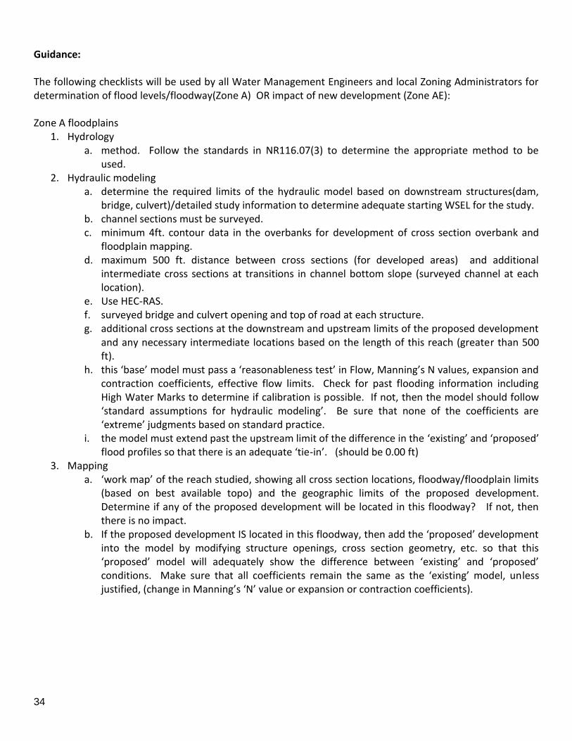
34
Guidance: The following checklists will be used by all Water Management Engineers and local Zoning Administrators for determination of flood levels/floodway(Zone A) OR impact of new development (Zone AE): Zone A floodplains
1. Hydrology a. method. Follow the standards in NR116.07(3) to determine the appropriate method to be
used. 2. Hydraulic modeling
a. determine the required limits of the hydraulic model based on downstream structures(dam, bridge, culvert)/detailed study information to determine adequate starting WSEL for the study.
b. channel sections must be surveyed. c. minimum 4ft. contour data in the overbanks for development of cross section overbank and
floodplain mapping. d. maximum 500 ft. distance between cross sections (for developed areas) and additional
intermediate cross sections at transitions in channel bottom slope (surveyed channel at each location).
e. Use HEC-RAS. f. surveyed bridge and culvert opening and top of road at each structure. g. additional cross sections at the downstream and upstream limits of the proposed development
and any necessary intermediate locations based on the length of this reach (greater than 500 ft).
h. this ‘base’ model must pass a ‘reasonableness test’ in Flow, Manning’s N values, expansion and contraction coefficients, effective flow limits. Check for past flooding information including High Water Marks to determine if calibration is possible. If not, then the model should follow ‘standard assumptions for hydraulic modeling’. Be sure that none of the coefficients are ‘extreme’ judgments based on standard practice.
i. the model must extend past the upstream limit of the difference in the ‘existing’ and ‘proposed’ flood profiles so that there is an adequate ‘tie-in’. (should be 0.00 ft)
3. Mapping a. ‘work map’ of the reach studied, showing all cross section locations, floodway/floodplain limits
(based on best available topo) and the geographic limits of the proposed development. Determine if any of the proposed development will be located in this floodway? If not, then there is no impact.
b. If the proposed development IS located in this floodway, then add the ‘proposed’ development into the model by modifying structure openings, cross section geometry, etc. so that this ‘proposed’ model will adequately show the difference between ‘existing’ and ‘proposed’ conditions. Make sure that all coefficients remain the same as the ‘existing’ model, unless justified, (change in Manning’s ‘N’ value or expansion or contraction coefficients).
35
Zone AE Floodplains
1. Hydrology a. If the Hydrology is proposed to change from the existing study, follow the standards in
NR116.07(3) to determine the appropriate method to be used.
2. Hydraulic model a. ‘Duplicate Effective’ model. The ‘duplicate effective’ model is a copy of the hydraulic analysis used
in the effective FIS, referred to as the ‘effective model’. The effective model should be obtained and then reproduced on the requester’s equipment to produce the duplicate effective model. This is required to ensure that the effective model’s input data has been transferred correctly to the requester’s equipment and to ensure that the revised data will be integrated into the effective data to provide a continuous FIS model upstream and downstream of the revised reach. If data from the effective model is available and the same modeling program is being used, the requester must generate models that duplicate the FIS profiles and the elevations shown in the Floodway Data Table in the FIS report to within 0.1 foot.
b. ‘Corrective Effective’ model. The Corrected Effective Model is the model that corrects any errors
that occur in the Duplicate Effective Model, adds any additional cross sections to the Duplicate Effective Model, or incorporates more detailed topographic information than that used in the current effective model. The Corrected Effective Model must not reflect any man-made physical changes since the date of the effective model. An error could be a technical error in the modeling procedures, or any construction in the floodplain that occurred prior to the date of the effective model but was not incorporated into the effective model. This should include importing the model in the most current version of HEC-RAS to facilitate the review of the model.
c. ‘Existing or Pre-Project Conditions’ model. The Duplicate Effective Model or Corrected Effective
Model is modified to produce the Existing or Pre-Project Conditions Model to reflect any modifications that have occurred within the floodplain since the date of the Effective model but prior to the construction of the project for which the revision is being requested. If no modification has occurred since the date of the effective model, then this model would be identical to the Corrected Effective Model or Duplicate Effective Model. The existing or pre-project model may be required to support conclusions about the actual impacts of the project associated with the revised or post-project model or to establish more up-to-date models on which to base the revised or post-project conditions model.
d. ‘Revised or Post-Project’ Conditions model. The Existing or Pre-Project Conditions Model (or
Duplicate Effective Model or Corrected Effective Model, as appropriate) is modified to reflect revised or post-project conditions. This model must incorporate any physical changes to the floodplain since the effective model was produced as well as the effects of the project. When the request is for a proposed project, this model must reflect proposed conditions.
e. All changes to the duplicate and subsequent models must be supported by certified topographic
information, bridge plans, construction plans, survey notes, etc.
f. Changes to the hydraulic models should be limited to the stream reach for which the revision is being requested. Cross sections upstream and downstream of the revised reach should be

36
identical to those in the effective model. If this is done, water surface elevations and topwidths computed by the revised models should match those in the effective models upstream and downstream of the revised reach as required. DO NOT TRUNCATE THE EFFECTIVE MODEL!
3. Mapping
a. There must be consistency between the revised hydraulic models, the revised floodplain and floodway delineations, the revised flood profiles, topographic work map, annotated FIRMs and/or Flood Boundary Floodway Maps (FBFMs), construction plans, bridge plans, etc.
b. A certified topographic map of suitable scale, contour interval, and plan metric map must be
submitted showing the applicable items indicated on the form. If a digital version of the map is available, it may be submitted so that the FIRM may be more easily revised.
c. Attach an annotated FIRM panel showing the revised 1% and 0.2% annual chance floodplains and
floodway boundaries. The revised boundaries must tie into the effective boundaries. Indicate if annotated FIRM and/or FBFM and digital mapping data (GIS or CADD) is submitted. If digital data is submitted, please include any supporting documentation or metadata with the data submission including relevant projection information. Current mapping standards utilize the Universal Transverse Mercator (UTM) projection and State Plane Coordinate System in accordance with FEMA mapping specifications. Also include the following on the map:
d. Cross Sections – All cross sections from the effective model must be on the map. Lettered cross
sections should be labeled in accordance with the effective map. There must also be a cross section lookup table to relate to the model input numbering scheme.
e. Floodway – Both the current and proposed floodways should be shown on the map.
f. Profile Baseline – The stream centerline, or profile baseline used to measure stream distances in the model should be visible on the map (or submitted as a separate shapefile).
4. CLOMR required Projects that will have construction within the floodway, which cause the BFEs to increase (equal to or greater than 0.01 feet) will require a Conditional Letter of Map Revision application be submitted to FEMA.
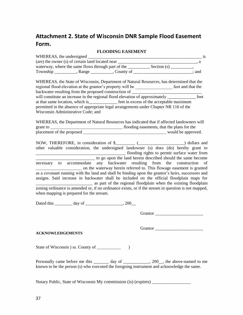
37
Attachment 2. State of Wisconsin DNR Sample Flood Easement Form. FLOODING EASEMENT WHEREAS, the undersigned ____________________________________________________ is
(are) the owner (s) of certain land located near ____________________________________, a
waterway, where the same flows through part of the __________ Section (s) __________,
Township __________, Range __________, County of ___________________________; and
WHEREAS, the State of Wisconsin, Department of Natural Resources, has determined that the
regional flood elevation at the grantor’s property will be _________________ feet and that the
backwater resulting from the proposed construction of ________________________________
will constitute an increase in the regional flood elevation of approximately _____________ feet
at that same location, which is_____________ feet in excess of the acceptable maximum
permitted in the absence of appropriate legal arrangements under Chapter NR 116 of the
Wisconsin Administrative Code; and
WHEREAS, the Department of Natural Resources has indicated that if affected landowners will
grant to _________________________________ flooding easements, that the plans for the
placement of the proposed ______________________________________ would be approved.
NOW, THEREFORE, in consideration of $_________ (_____________________) dollars and
other valuable consideration, the undersigned landowner (s) does (do) hereby grant to
_________________________________________ flooding rights to permit surface water from
___________________________ to go upon the land herein described should the same become
necessary to accommodate any backwater resulting from the construction of
_____________________ on the waterway herein referred to. This flowage easement is granted
as a covenant running with the land and shall be binding upon the grantor’s heirs, successors and
assigns. Said increase in backwater shall be included on the official floodplain maps for
__________________________ as part of the regional floodplain when the existing floodplain
zoning ordinance is amended or, if no ordinance exists, or if the stream in question is not mapped,
when mapping is prepared for the stream.
Dated this ________ day of _________________, 200__
Grantor ______________________
Grantor ______________________ ACKNOWLEDGEMENTS
State of Wisconsin ) ss. County of ___________ )
Personally came before me this _______ day of ____________, 200__, the above-named to me
known to be the person (s) who executed the foregoing instrument and acknowledge the same.
Notary Public, State of Wisconsin My commission (is) (expires) _________________
38
Attachment 3. Glossary of Frequently Used Terms.
The following terms are frequently used in the description of many floodplain mapping products and services.
One percent annual chance floodplain The boundary of a flood that has a one percent chance of being equaled or exceeded in any given year. Also known as the 100-year floodplain.
One percent annual chance water-surface elevation The height of a flood having a one percent chance of being equaled or exceeded in any given flood year (also known as the 100-year flood or the base flood).
100-year flood The flood having a one percent chance of being equaled or exceeded in any given year; also known as the base flood. The one percent annual chance flood, which is the standard used by most Federal and state agencies, is used by the National Flood Insurance Program (NFIP) as the standard for floodplain management and to determine the need for flood insurance. A structure located within a special flood hazard area shown on an NFIP map has a 26 percent chance of suffering flood damage during the term of a 30-year mortgage.
100-year floodplain The boundary of the flood that has a one percent chance of being equaled or exceeded in any given year. Officially termed the one percent annual chance floodplain.
500-year floodplain The boundary of the flood that has a 0.2 percent chance of being equaled or exceeded in any given year. Officially termed the 0.2 percent annual chance floodplain.
Base flood The flood having a one percent chance of being equaled or exceeded in any given year; also known as the 100-year flood. The base flood, which is the standard used by most Federal and state agencies, is used by the National Flood Insurance Program (NFIP) as the standard for floodplain management and to determine the need for flood insurance. A structure located within a Special Flood Hazard Area shown on an NFIP map has a 26 percent chance of suffering flood damage during the term of a 30-year mortgage.
Base Flood Elevation (BFE) The elevation of a flood having a one percent chance of being equaled or exceeded in any given year.
Channel Bank Stations Points that identify the extreme limits of the natural stream channel. These stations are

39
typically assigned at locations along a cross-section where a relatively flat area exists outside of the channel.
Community Rating System (CRS) A program developed by the FEMA Mitigation Division to provide incentives for those communities in the National Flood Insurance Program that have gone beyond the minimum floodplain management requirements to develop extra measures to provide protection from flooding.
Cooperating Technical Partner (CTP) Program The Cooperating Technical Partners (CTP) Program is an innovative approach to creating partnerships between FEMA and participating National Flood Insurance Program (NFIP) communities, regional agencies, and State agencies that have the interest and capability to become more active participants in the FEMA Flood Hazard Mapping Program.
Cross section A line developed from topographic information across a floodplain at which a computation of flood flow has been made to establish a potential flood elevation. Cross-sections are shown on the Flood Boundary Floodway Map, Flood Insurance Rate Map, and/or Flood Profiles of a Flood Insurance Study.
Cubic feet per second (cfs) Typical unit used to express the rate of flow of surface water in open channels. One cubic foot is approximately equal to 7.5 gallons per second.
Depth Maximum depth of water in the cross section as measured below the water surface elevation.
Detailed Study A flood hazard study that, at a minimum, results in the delineation of the floodplain boundaries for the one percent annual chance (100-year) flood and the determination of base flood elevations or flood depths.
Digital Flood Insurance Rate Map (DFIRM) A Flood Insurance Rate Map (FIRM) that has been prepared as a digital product, which may involve converting an existing manually produced FIRM to digital format, or creating a product from new digital data sources using a Geographic Information System environment. The DFIRM product allows for the creation of interactive, multi-hazard digital maps. Linkages are built into an associated database to allow users options to access the engineering backup material used to develop the DFIRM, such as hydrologic and hydraulic models, flood profiles, floodway data tables, digital elevation models, and structure-specific data, such as digital elevation certificates and digital photographs of bridges and culverts.

40
Discharge The volume of water that passes a given location within a given period of time. Usually expressed in cubic feet per second (cfs).
Equal Degree of Encroachment A concept particular to floodplain delineation and regulation that is based on the need to treat like-situated property owners equally. Strictly applied, it would require that the quantity of floodwaters conveyed in the overbank areas on both sides of a stream be reduced by an equal percentage when designating the encroached floodway. Deviations from this requirement can be permitted, however, and in many cases are even encouraged since property owners are seldom truly like-situated. Topography, existing development patterns, and comprehensive land-use plans frequently justify modifications to this concept in practice. Local officials should, however, make a reasonable attempt to ensure that the selected floodway does treat property owners as equally as possible.
Federal Emergency Management Agency (FEMA) The Federal Emergency Management Agency, a formerly independent agency that became part of the Department of Homeland Security in March 2003, is tasked with responding to, planning for, recovering from and mitigating against disasters. The agency's mission is: to lead America to prepare for, prevent, respond to and recover from disasters with a vision of "A Nation Prepared."
Flood (also Flooding) A general and temporary condition of partial or complete inundation of normally dry land areas. For flood insurance claim purposes, two or more structures must be inundated before flood damage will be covered.
Flood Data Table (FDT) The Floodway Data Table is found in the Flood Insurance Study for a community and gives details regarding the floodway at cross-sections of studied flooding sources in the community. The information provided includes: cross section, distance, floodway width, section area of floodway, mean velocity in the floodway, floodway surcharge and the base flood water surface elevations for the regulatory floodway, with and without floodway scenarios.
Flood Hazard Boundary Map (FHBM) Official map of a community issued by the Federal Insurance Administrator, where the boundaries of the flood, mudflow, and related erosion areas having special hazards have been designated. FHBMs were developed using “approximate study techniques” that had no engineering models behind them. FHBMs were intended to provide an early warning for local officials that flooding could occur in their communities; however, they did not provide predicted flood water surface elevations.
41
Flood Insurance Rate Map (FIRM) The insurance and floodplain management map produced by FEMA that identifies, based on detailed or approximate analyses, the areas subject to flooding during a one percent annual chance (100-year) flood event in a community. Flood insurance risk zones, which are used to compute actuarial flood insurance rates, also are shown. In areas studied by detailed analyses, the FIRM shows BFEs to reflect the elevations of the one percent annual chance flood. For many communities, when detailed analyses are performed, the FIRM also may show areas inundated by 0.2 percent annual chance (500-year) flood and regulatory floodway areas.
Flood Insurance Study (FIS) The examination, evaluation, and determination of flood hazards performed for a community. This report contains the information found during the study of the community's flooding sources including study methodology, source data, discharges, water surface elevations, flood profiles, and references.
Flood profile A cross-sectional drawing showing the contiguous cross-sections along a stream, with ground elevations and potential flood elevations plotted.
Floodplain management The operation of a program of corrective and preventative measures for mitigating flood damage, including, but not limited to, emergency preparedness plans, flood-control works, and floodplain management regulations.
Floodway Channel of a stream plus any adjacent floodplain areas that must be kept free of encroachment so that the 100-year flood discharge can be conveyed without increasing the elevation of the 100-year flood by more than a specified amount (one foot in most states).
HEC-RAS (Hydraulic Engineering Center – River Analysis System) A computer program that models the hydraulics of water flow through natural rivers and other channels. The program is one-dimensional, meaning that there is no direct modeling of the hydraulic effect of cross-section shape changes, bends, and other two- and three-dimensional aspects of flow. The program was developed by the U.S. Army Corps of Engineers in order to manage the rivers, harbors, and other public works under their jurisdiction; it has found wide acceptance since its public release in 1995.
Letter of Map Amendment (LOMA) An official determination by FEMA that a property has been inadvertently included in a Special Flood Hazard Area (SFHA) as shown on an effective FIRM and is not subject to inundation by the 1-percent-annual-chance flood. Generally, the property is located on

42
natural high ground at or above the BFE or on fill placed prior to the effective date of the first FIRM map designating the property as within an SFHA.
Letter of Map Change (LOMC) A LOMC is a letter which reflects an official revision to an effective National Flood Insurance Program (NFIP) map. LOMCs are issued in place of the physical revision and republication of the effective map.
Letter of Map Revision (LOMR) A letter issued by FEMA to revise the FIRM and/or FIS report for a community to change BFEs, floodplain and floodway boundary delineations, and coastal hazard areas.
Limited Detail Study The method of Special Flood Hazard Area (SFHA) identification that can be used if a Triangular Irregular Network (TIN) of Light Radar Detection and Ranging (LiDAR) data (or other digital elevation data) with break lines is available. Cross-sections and road data are obtained from these data. Openings of structures and Manning's "n" values may be estimated with limited field inspections. No new field survey is taken. A GIS-based tool may be used to create cross-section and structure data for the HEC-RAS program to determine the one percent annual chance water surface elevations. Because the 1-percent-annual-chance water-surface elevations are determined using approximate hydrologic and hydraulic methods with topographic and structural data, BFEs will not be shown on the FIRM, but will be provided to the community and may be used as 'best available data' for floodplain management regulatory purposes.
Map Repository The location where a community's flood maps are kept; usually the local zoning and planning office.
Montana Flood Awareness Maps A possible term used for planning level large scale maps such as those used in Nebraska’s Large Area Mapping initiative. The purpose of these maps are to “get out ahead of development” and could be used as a filter that triggers the need for more detailed floodplain maps.
National Flood Insurance Program (NFIP) Federal insurance program under which flood-prone areas are identified and flood insurance is made available to residents of participating communities that agree to adopt and enforce floodplain management ordinances to reduce future flood damage.
Orthophotograph Aerial photographs that have been rectified to produce an accurate image of the Earth by removing tilt and relief displacements that occurred when the photo was taken. An
43
orthophotograph has the same scale throughout and can be used as a base map for the DFIRM.
Q3 (Digital) Data Q3 Flood Data is a digital representation of certain features of FEMA's Flood Insurance Rate Maps, intended for use with desktop mapping and Geographic Information Systems technology. Digital Q3 Flood Data has been developed for many states (and parts thereof) by scanning the existing FIRM hardcopies and vectorizing a thematic overlay of flood risks. The vector Q3 Flood Data files contain only certain features from the existing FIRM hardcopy. Q100 The letter Q is used in engineering equations associated with hydrology and hydraulics to represent flow. The letter Q with a subscript number (e.g. Q100) refers to the flood associated with the 100 year (one percent annual chance) flood.
Redelineation This method of Special Flood Hazard Area (SFHA) identification can only be used for previously studied streams. Using this method, the SFHA boundary is redefined using the effective water surface elevations superimposed on updated topography. No changes are made to the currently effective model. This case involves situations for which new topographic data exists for a study reach or entire county. The new topographic data is more recent and of higher quality than the topographic data originally used in the effective study. When the original hydraulic model is not available digitally but the model is correct, the effective FEMA profile forms the basis of the redelineation. The appropriate vertical datum conversion is applied, and the revised flood boundaries are mapped on the new topographic source. In this case, the BFEs will be republished on the DFIRM. The deliverable will be digital flood boundaries that match best available topographic data, recreated flood profiles, and floodway data tables meeting FEMA's Guidelines and Specifications for Flood Hazard Mapping Partners.
Regulatory Floodway The channel of a river or other watercourse and the adjacent land areas that must be reserved in order to discharge the base flood (also known as the 100-year flood) without cumulatively increasing the water surface elevation more than a designated height. Communities must regulate development in these floodways to ensure that there are no increases in upstream flood elevations. For streams and other watercourses where FEMA has provided Base Flood Elevations (BFEs), but no floodway has been designated, the community must review floodplain development on a case-by-case basis to ensure that increases in water surface elevations do not occur, or identify the need to adopt a floodway if adequate information is available.
44
Special Flood Hazard Area (SFHA) The area delineated on a National Flood Insurance Program map as being subject to inundation by the base flood (also known as the 100-year flood). SFHAs are determined using statistical analyses of records of river flow, storm tides, and rainfall; information obtained through consultation with a community; floodplain topographic surveys; and hydrologic and hydraulic analyses.

45
Appendix A. Technical Advisory Committee. Celinda Adair Traci Sears, CFM Map Mod/Map Risk Coordinator CAP/NFIP Coordinator DNRC Floodplain Program DNRC Floodplain Program Helena, MT 59620-1601 Helena, MT 59620-1601 (406) 444-6656 (406) 444-6654 [email protected] [email protected] Laurence Siroky Karl Christians DNRC Water Resource Bureau Chief DNRC Conservation District Specialist 1424 9th Avenue 1424 9th Avenue Helena MT 59620 Helena MT 59620 (406) 444-6816 (406) 444-3022 [email protected] [email protected] Jeff Ryan Doris Fischer DEQ Water Protection Bureau FWP Land Use Planning Specialist 1520 East 6th Ave P.O. Box 52 402 South Main Helena MT 59620 Sheridan, MT 59749 (406) 444-4626 (406) 842-7467 [email protected] [email protected] Jerry Grebenc Todd S. Klietz, CFM, RS Manager, Community Tech Asst Prgm Floodplain Administrator Missoula County Department of Commerce, State of MT Missoula Office of Planning & Grants 301 S. Park Ave. PO Box 200523 435 Ryman Helena, MT 59620-0523 Missoula, MT 59802-4297 (406) 841-2598 (406) 258-4841 [email protected] [email protected] Sean O’Callaghan, CFM Jeffrey Tiberi Gallatin County Planning Department Executive Director 311 W. Main, Room 208 Montana Assoc. of Conservation Districts Bozeman, MT 59715 (406) 443-5711 (406) 582-3130 [email protected] [email protected] Todd N. Tillinger, P.E. Rick Bondy, P.E. Program Manager Civil Engineer Montana Regulatory Office 200 S. Harris US Army Corps of Engineers Helena MT 59601
46
10 West 15th Street Suite 2200 (406) 431-9446 Helena, Montana 59626 [email protected] (406) 441-1376 [email protected] Bill O. Wilen Jon Kusler, Esq. Federal Interagency Floodplain Associate Director Association of Management Task Force State Wetland Managers, Inc National Wetland Inventory 1434 Helderberg Trail U.S. Fish and Wildlife Service Berne, NY 12023 4401 N. Fairfax Drive, Room 400 (518) 872-1804 Arlington, VA 22203 [email protected] (703) 358-2278 [email protected] Jeff Opperman Dave Fowler Senior Advisor for Sustainable National Assoc of Floodplain Hydropower Managers Board Member TNC Global Freshwater Program Miwaukee Municipal Sewer District 91 Carriage Stone Drive (414) 277-6368 Chagrin Falls, OH mailto:[email protected] (530) 400-4847 [email protected] Alan R. Lulloff, P.E. CFM Lynda A. Saul, PWS Science Services Program Manager DEQ Wetland Program Coordinator Association of State Floodplain 1520 East 6th Ave Managers Helena MT 59601 2809 Fish Hatchery Rd. (406) 444-6652 Madison, WI 53713 [email protected] (608) 274-0123 [email protected]
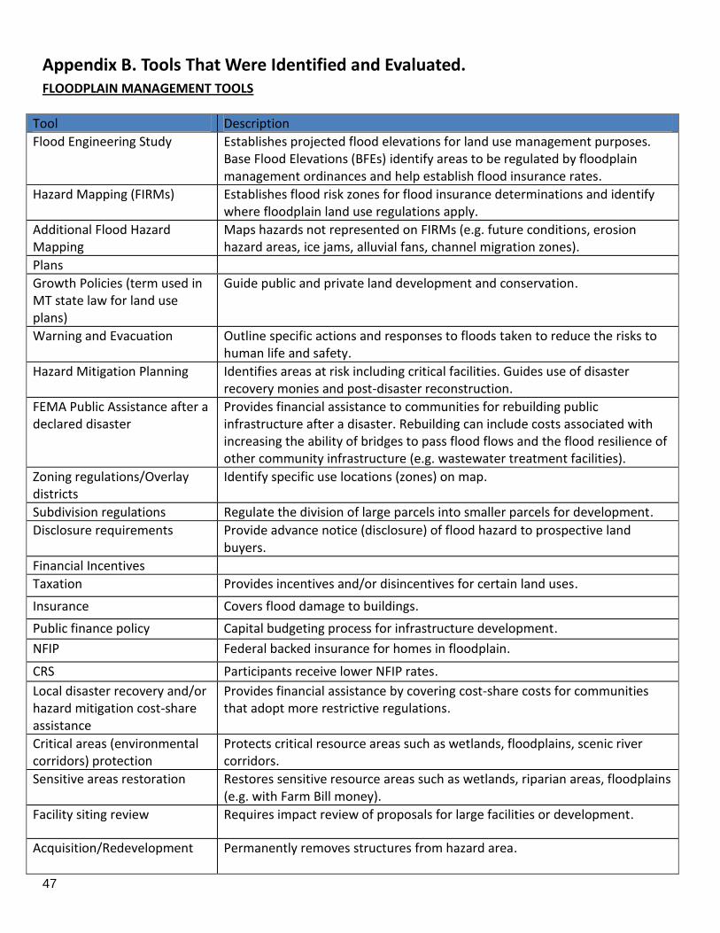
47
Appendix B. Tools That Were Identified and Evaluated. FLOODPLAIN MANAGEMENT TOOLS
Tool Description
Flood Engineering Study Establishes projected flood elevations for land use management purposes. Base Flood Elevations (BFEs) identify areas to be regulated by floodplain management ordinances and help establish flood insurance rates.
Hazard Mapping (FIRMs) Establishes flood risk zones for flood insurance determinations and identify where floodplain land use regulations apply.
Additional Flood Hazard Mapping
Maps hazards not represented on FIRMs (e.g. future conditions, erosion hazard areas, ice jams, alluvial fans, channel migration zones).
Plans
Growth Policies (term used in MT state law for land use plans)
Guide public and private land development and conservation.
Warning and Evacuation Outline specific actions and responses to floods taken to reduce the risks to human life and safety.
Hazard Mitigation Planning Identifies areas at risk including critical facilities. Guides use of disaster recovery monies and post-disaster reconstruction.
FEMA Public Assistance after a declared disaster
Provides financial assistance to communities for rebuilding public infrastructure after a disaster. Rebuilding can include costs associated with increasing the ability of bridges to pass flood flows and the flood resilience of other community infrastructure (e.g. wastewater treatment facilities).
Zoning regulations/Overlay districts
Identify specific use locations (zones) on map.
Subdivision regulations Regulate the division of large parcels into smaller parcels for development.
Disclosure requirements Provide advance notice (disclosure) of flood hazard to prospective land buyers.
Financial Incentives
Taxation Provides incentives and/or disincentives for certain land uses.
Insurance Covers flood damage to buildings.
Public finance policy Capital budgeting process for infrastructure development.
NFIP Federal backed insurance for homes in floodplain.
CRS Participants receive lower NFIP rates.
Local disaster recovery and/or hazard mitigation cost-share assistance
Provides financial assistance by covering cost-share costs for communities that adopt more restrictive regulations.
Critical areas (environmental corridors) protection
Protects critical resource areas such as wetlands, floodplains, scenic river corridors.
Sensitive areas restoration
Restores sensitive resource areas such as wetlands, riparian areas, floodplains (e.g. with Farm Bill money).
Facility siting review Requires impact review of proposals for large facilities or development.
Acquisition/Redevelopment Permanently removes structures from hazard area.
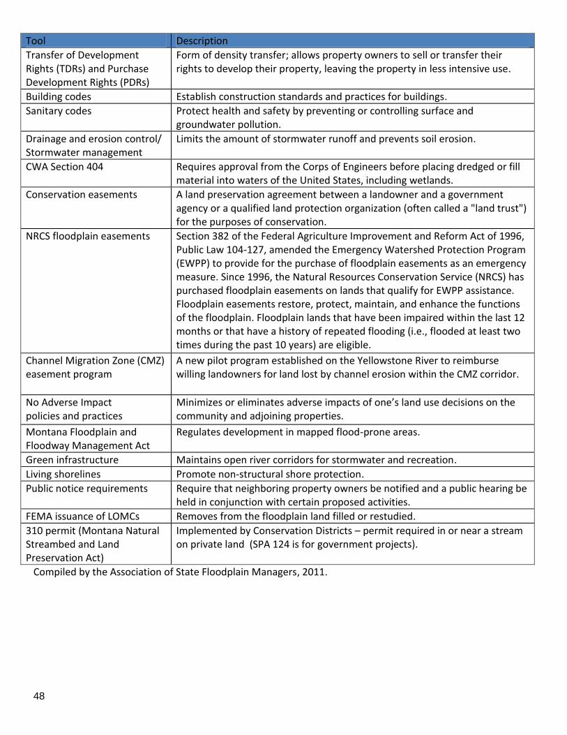
48
Tool Description
Transfer of Development Rights (TDRs) and Purchase Development Rights (PDRs)
Form of density transfer; allows property owners to sell or transfer their rights to develop their property, leaving the property in less intensive use.
Building codes Establish construction standards and practices for buildings.
Sanitary codes Protect health and safety by preventing or controlling surface and groundwater pollution.
Drainage and erosion control/ Stormwater management
Limits the amount of stormwater runoff and prevents soil erosion.
CWA Section 404 Requires approval from the Corps of Engineers before placing dredged or fill material into waters of the United States, including wetlands.
Conservation easements
A land preservation agreement between a landowner and a government agency or a qualified land protection organization (often called a "land trust") for the purposes of conservation.
NRCS floodplain easements
Section 382 of the Federal Agriculture Improvement and Reform Act of 1996, Public Law 104-127, amended the Emergency Watershed Protection Program (EWPP) to provide for the purchase of floodplain easements as an emergency measure. Since 1996, the Natural Resources Conservation Service (NRCS) has purchased floodplain easements on lands that qualify for EWPP assistance. Floodplain easements restore, protect, maintain, and enhance the functions of the floodplain. Floodplain lands that have been impaired within the last 12 months or that have a history of repeated flooding (i.e., flooded at least two times during the past 10 years) are eligible.
Channel Migration Zone (CMZ) easement program
A new pilot program established on the Yellowstone River to reimburse willing landowners for land lost by channel erosion within the CMZ corridor.
No Adverse Impact policies and practices
Minimizes or eliminates adverse impacts of one’s land use decisions on the community and adjoining properties.
Montana Floodplain and Floodway Management Act
Regulates development in mapped flood-prone areas.
Green infrastructure Maintains open river corridors for stormwater and recreation.
Living shorelines Promote non-structural shore protection.
Public notice requirements Require that neighboring property owners be notified and a public hearing be held in conjunction with certain proposed activities.
FEMA issuance of LOMCs Removes from the floodplain land filled or restudied.
310 permit (Montana Natural Streambed and Land Preservation Act)
Implemented by Conservation Districts – permit required in or near a stream on private land (SPA 124 is for government projects).
Compiled by the Association of State Floodplain Managers, 2011.

49
Appendix C. Case Studies Used to Identify and Evaluate Issues. 1. Critical Facilities:
a. Livingston Proposed Hospital Site – Critical facility being sited in 500-year floodplain along Yellowstone River in Livingston, Park County. Community does not regulate 500-year floodplain. County Contact: Barbara Woodbury, (406) 222-4142, [email protected]; Livingston Contact - Jim Woodhull, (406) 222-4903, [email protected].
b. Baker Fire Station – Critical facility located in 100-year floodplain, due to alternative location’s proximity to the railroad and the delayed response time that would result. City of Baker – Jessica Dinardi, (406) 778-8147, [email protected].
2. Mapping Issues (to include lack of mapping, change in mapping, local mapping):
a. Powder River Home – House built on the Powder River and experienced minor flooding before it was completed– lack of mapping allowed construction when community advised not to build there. Contact David Day, (406) 436-2975, [email protected].
b. Glendive McDonald’s – Substantial development on the dry side of a USCOE- built levee; now the levee hydrology including the ice-affected flood has been updated and the levee lacks adequate freeboard. Limits to improvements or additions to the existing homes and businesses are difficult issues for city and county government officials. Interviews of city and county officials are recommended. Structural mitigation of flood hazards has drawbacks, including changing technology and limited funding for upgrades and repairs. Contact the Dawson County FA, (406) 345-4139, [email protected]
c. Erosion at Lake Creek Home (Lincoln County) – Home located outside of floodplain. Lost access due to erosion and the home and property are now at risk. Contact Lisa Oedewaldt, Lincoln County FPA, (406) 293-7781 ext. 229, [email protected].
d. Wagner Lane Homes (Flathead County) – Boundary line adjustment allowed three buildable lots in erosion-prone area. Potential safe and dry access issues. Contact Bailey Minnich, CFM, Flathead County FPA, (406) 751-8200, [email protected].
e. Big Hole Subdivision - Subdivision built on/in Big Hole River. Subdivision shown within CMZ boundaries but not within the mapped floodplain. Contact Jen Boyer, Big Hole Land Use Planning Working Group, (406) 587-2974, [email protected].
f. Sewell Subdivision - Helena Valley, Silver Creek. The 82-home subdivision was built on the floodplain in the 1970s. The area also has a high water table. County rules adopted after the subdivision was approved don't allow septic system drainfields in a floodplain, as overwhelmed systems can pollute drinking water. In June, the City-County Health Board decided only holding tanks could replace failed septic systems in the Sewell subdivision. In addition, the health board recently revised its rules, now allowing sealed septic tanks adjacent to the floodplain. Some residents have protested, saying holding tanks were too expensive.
g. Miles City Remapping - a recent remapping substantially increased the floodway and flood fringe regulatory areas. Previously one-third of the city was in the designated floodplain area and now two‐thirds are mapped as floodplain.
h. Ennis Adopted Own Maps - The town has adopted its own flood hazard map based on local knowledge of historical floods and other information. It is not a FEMA- or DNRC-designated and delineated flood map from a standard floodplain study. A resolution may be to modify the existing statute to allow local emergency adoption of flood hazard maps without a formal state designation. Another solution is to complete a standard flood hazard study as soon as possible.
50
i. Madison County - The Madison County floodplain management ordinance was adopted about 13 years ago. The County could not afford the expense of drawing up maps of its 100-year floodplains (Ruby River and portions of the Beaverhead River, Jefferson River, South Boulder River, and Gallatin River). The adopted ordinance contains a set of "flood-prone areas" rather than 100-year floodplain maps. The flood-prone area maps were drawn with black markers, so boundaries are imprecise and the ordinance is difficult to implement in a way that protects the natural and beneficial functions of the floodplains. Contacts: Ralph Hamler, Madison County Sanitarian, [email protected]; Charity Fechter, Madison County Planning Director, [email protected].
3. Safe and Dry Access:
a. Big Hole Ice Jam House – House built out of the floodplain, but in an unmapped ice jam inundation area. First foundation was destroyed by an ice jam event. Owners continued to build the house – just before house was completed, it burned down. Owners rebuilt house and are in the process of selling it. Contact Jen Boyer, Big Hole Land Use Planning Working Group, (406) 587-2974, [email protected].
b. 9th street island at Livingston – Homes, trailer park, and business built on an island in the middle of Yellowstone River. Recently lost access to bridge in high water event. County Contacts: Barbara Woodbury, (406) 222-4142, [email protected]; Livingston contact is Jim Woodhull, (406) 222-4903, [email protected].
c. Beaverhead County - Two homes were proposed to be built along the Big Hole River, in compliance with both the county's floodplain management ordinance and the Big Hole River Conservation Development Standards (river "setback") ordinance. The county determined that it had no legal basis for denying the building permits, even though: (a) the homes would be perched within the 100-year floodplain and/or channel migration zone; (b) historically, ice jams in the winter have covered the two home sites; and (c) local emergency service personnel would be unable to access the homes safely in the event of an emergency that occurred during a flood or ice jam situation. Contacts: Larry Lakner, Beaverhead County Sanitarian, [email protected]; Rick Hartz, Beaverhead County Planner, [email protected].
4. Extensive Floodplain - Small Fill Effect:
a. Jefferson River house – New house constructed in the Jefferson River floodplain. The floodplain administrator is aware of the structure and a floodplain permit has been issued. The house is in the floodplain but is on a raised pad and is supported by several 8-inch diameter concrete/steel pilings. The septic is stored in a sealed tank and then pumped to another location for treatment/disposal. During high water the house will be an “island” in the Jefferson River. The house and access structures cause little change in the flood water levels because there is an extensive floodplain on the opposite (right) side of the main river channel. House built to floodplain code, but homeowners took all of the vegetation out and the structure is located in close proximity to the river. Contact Shawn Higley, Broadwater County FPA, (406) 443-3962, [email protected].
5. Disaster/Flood Emergency Related:
a. Flathead River Emergency Measure – During flood event the OES officer permitted river obstruction for flood fighting purposes. The obstruction is undercutting an MDT bridge yet removal of the obstruction is being prevented due to legal issues. Contact Karl Christians (see contact information in Appendix A or D).
b. Flathead River disagreement on emergency – In May 2002, the Army Corps of Engineers (COE) completed a bank stabilization project on the Flathead River - 1000 feet of riprap just upstream of the
51
Highway 35 crossing. Only under emergency conditions does COE have the authority to complete such a project. There was no emergency at this site and the bridge was not threatened. None of the local regulatory agencies (Flathead Conservation District, Flathead Floodplain Coordinator, MFWP, MDEQ, and the Helena office of COE) were contacted prior to construction.
6. Pre-Rap Issues:
a. Ravalli pre-riprap on Bitterroot – Property owner went outside of floodplain, dug pit and installed rip-rap in anticipation of river eroding up to the impacted area. Contact Larry Schock, Regional Engineer for State of Montana DNRC in that area, (406) 542-5885, [email protected].
b. Park County pre-riprap on Yellowstone – Property owner went outside of floodplain, dug pit and installed rip-rap in anticipation of river eroding up to the impacted area. Heart K Ranch near Livingston - project involved placement of about 2000 feet of rock in a trench set back from the river bank to avoid 404 permitting. It also involved construction of a 3-4 foot dike that was not permitted by the local floodplain administrator. Contact Barbara Woodsbury, FPA for Park County.
7. Structural River Changes:
a. Gallatin gravel bar - Land use in the Gallatin Valley has made it necessary to anchor the Gallatin River at certain points to facilitate use and maintenance of transportation and irrigation infrastructure and protect existing development. These anchor points have cut the Gallatin River off from historical flow paths and opened up additional land (relic gravel bars) to development. The 1970s to the 1990s saw substantial development along the Gallatin River corridor in the area generally west of Belgrade. New development on these properties is generally able to meet the letter of the law and obtain a floodplain permit, but in reality, although projects may be up to a half-mile from the active channel of the Gallatin River, access to structures will likely prove problematic during substantial flood events.
b. Libby - The city is located in an area with several alluvial fans as high mountain streams exit the surrounding mountains onto the nearby river plains. The existing floodplain maps illustrate the floodplain at the time of the study, though the creeks are constantly changing, especially with a recent ice jam-induced flood. Since existing homes and businesses suffer damage from nearly any flood, there are constant efforts to examine mitigation measures including local levees. Local governments and individuals have limited funding because of the downturn in logging, as well as EPA/asbestos issues in the area.
8. Legal challenge involving state or local government efforts to manage/protect the floodplain:
a. Christianson v. Gasvoda, where the County's denial of a subdivision application due to flooding concerns was upheld in court.
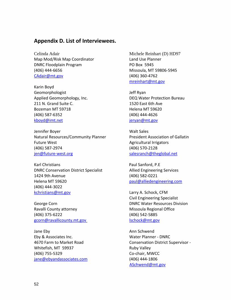
52
Appendix D. List of Interviewees. Celinda Adair Michele Reinhart (D) HD97
Map Mod/Risk Map Coordinator Land Use Planner DNRC Floodplain Program PO Box 5945 (406) 444-6656 Missoula, MT 59806-5945 [email protected] (406) 360-4762 [email protected] Karin Boyd Geomorphologist Jeff Ryan Applied Geomorphology, Inc. DEQ Water Protection Bureau 211 N. Grand Suite C. 1520 East 6th Ave Bozeman MT 59718 Helena MT 59620 (406) 587-6352 (406) 444-4626 [email protected] [email protected] Jennifer Boyer Walt Sales Natural Resources/Community Planner President Association of Gallatin Future West Agricultural Irrigators (406) 587-2974 (406) 570-2128 [email protected] [email protected] Karl Christians Paul Sanford, P.E DNRC Conservation District Specialist Allied Engineering Services 1424 9th Avenue (406) 582-0221 Helena MT 59620 [email protected] (406) 444-3022 [email protected] Larry A. Schock, CFM Civil Engineering Specialist George Corn DNRC Water Resources Division Ravalli County attorney Missoula Regional Office (406) 375-6222 (406) 542-5885 [email protected] [email protected] Jane Eby Ann Schwend Eby & Associates Inc. Water Planner - DNRC 4670 Farm to Market Road Conservation District Supervisor - Whitefish, MT 59937 Ruby Valley (406) 755-5329 Co-chair, MWCC [email protected] (406) 444-1806 [email protected]

53
Scott Gillilan Traci Sears, CFM Gillilan & Associates, Inc. NFIP/CAP Coordinator (406) 581-1597 DNRC Floodplain Program [email protected] Helena, MT 59620-1601 (406) 444-6654 Todd Klietz [email protected] Floodplain Administrator Missoula County Missoula Office of Planning & Grants Laurence Siroky 435 Ryman DNRC Water Resource Bureau Chief Missoula, MT 59802-4297 1424 9th Avenue (406) 258-4841 Helena MT 59620 [email protected] (406) 444-6816 [email protected] Nicole McClain, Coordinator Yellowstone River Conservation Todd Tillinger District Council (YRCDC) Montana Regulatory Office (406) 223-5702 U.S. Army Corps of Engineers [email protected] 10 West 15th Street, Suite 2200 Helena, MT 59626 Sean O’Callaghan, CFM (406) 441-1376 Gallatin County Planning Department [email protected] 311 W. Main, Room 208 Bozeman, MT 59715 (406) 582-3130 [email protected] Steve Story Montana Floodplain Engineer DNRC Floodplain Program Helena, MT 59620-1601 (406) 444-6656 [email protected]