monroe county year 2030 comprehensive plan
TRANSCRIPT

Monroe County
Year 2030
ComprehensivePlan
Policy Document
As Adopted by the Board of County Commissioners on April 13, 2016
Revision 5


Monroe County Comprehensive Plan Update
Introduction and Background 1 Keith and Schnars, P.A. Comprehensive Plan
Final Adopted Version April 13, 2016
1.0 INTRODUCTION & BACKGROUND
Introduction:
Monroe County includes the Mainland area and over 1,700 islands which lie along the Florida Straits, dividing the Atlantic Ocean to the east from the Gulf of Mexico to the west, and defining one edge of the Florida Bay. The mainland part of the County is made up of the Everglades National Park and the southern portion of Big Cypress National Preserve. The Florida Keys extend 233 miles southwestward in a gradual arc from Biscayne Bay to the Dry Tortugas in the Gulf of Mexico.
The Florida Keys, that are within Monroe County, are a chain of islands connected by 112 miles of US Highway 1, extending from Key Largo to Key West, representing the most southerly point of the continental United States. The surrounding water is designated as an Outstanding Florida Water and includes the Florida Keys National Marine Sanctuary, the second largest marine sanctuary in the United States.
As low lying islands (90 percent of the land mass is at five feet above sea level or less), the Florida Keys are particularly vulnerable to the impacts of sea level rise and storm surge. The tide gauge at Key West has been measuring sea levels since 1846; it shows the sea level rose 9 inches (22 cm) in Key West during the last 100 years.
The regional and statewide resources of the Florida Keys prompted its designation by the Administration Commission as an Area of Critical State Concern in December, 1975 and the Florida Legislature in 1979 (Section 380.0552, F. S.). The Florida Keys are the location of North America’s only coral reef and the third largest coral reef system in the world. The Keys are also home to over 30 species of threatened and endangered species and is one of the most ecologically diverse ecosystems in the United States. The designation is intended to protect environmental or natural resources of regional or statewide importance, the historical or archaeological resources and the major public facilities and area of major public investment.
Federal and State government involvement in Monroe County (the “County”) land use planning and decision‐making is extensive due to the presence of these aquatic and terrestrial resources that are of regional and national significance. This involvement has heavily influenced the County’s comprehensive planning process. Many of the County’s goals, objectives, and policies have been mandated by the State pursuant to the Area of Critical State Concern designation.
a. Florida Statutes:
In addition to those regulatory requirements established within Chapter 163, F.S., all planning and development within the Florida Keys must be consistent with Sections 380.05 and 380.0552(7), F. S., Principles for Guiding Development. These statutory requirements, cited below, were adopted by the Florida Legislature and are specific for the Florida Keys area.

Monroe County Comprehensive Plan Update
Introduction and Background 2 Keith and Schnars, P.A. Comprehensive Plan
Final Adopted Version April 13, 2016
380.0552(7), F. S. - PRINCIPLES FOR GUIDING DEVELOPMENT. State, regional, and local agencies and units of government in the Florida Keys Area shall coordinate their plans and conduct their programs and regulatory activities consistent with the principles for guiding development as specified in chapter 27F-8, Florida Administrative Code, as amended effective August 23, 1984, which is adopted and incorporated herein by reference. For the purposes of reviewing the consistency of the adopted plan, or any amendments to that plan, with the principles for guiding development, and any amendments to the principles, the principles shall be construed as a whole and specific provisions may not be construed or applied in isolation from the other provisions. However, the principles for guiding development are repealed 18 months from July 1, 1986. After repeal, any plan amendments must be consistent with the following principles:
(a) Strengthening local government capabilities for managing land use and development so
that local government is able to achieve these objectives without continuing the Area of Critical State Concern designation.
(b) Protecting shoreline and marine resources, including mangroves, coral reef formations, seagrass beds, wetlands, fish and wildlife, and their habitat.
(c) Protecting upland resources, tropical biological communities, freshwater wetlands, native tropical vegetation (for example, hardwood hammocks and pinelands), dune ridges and beaches, wildlife, and their habitat.
(d) Ensuring the maximum well-being of the Florida Keys and its citizens through sound economic development.
(e) Limiting the adverse impacts of development on the quality of water throughout the Florida Keys.
(f) Enhancing natural scenic resources, promoting the aesthetic benefits of the natural environment, and ensuring that development is compatible with the unique historic character of the Florida Keys.
(g) Protecting the historical heritage of the Florida Keys. (h) Protecting the value, efficiency, cost-effectiveness, and amortized life of existing and
proposed major public investments, including:
1. The Florida Keys Aqueduct and water supply facilities; 2. Sewage collection, treatment, and disposal facilities; 3. Solid waste treatment, collection, and disposal facilities; 4. Key West Naval Air Station and other military facilities; 5. Transportation facilities; 6. Federal parks, wildlife refuges, and marine sanctuaries; 7. State parks, recreation facilities, aquatic preserves, and other publicly owned
properties; 8. City electric service and the Florida Keys Electric Co-op; and 9. Other utilities, as appropriate.
(i) Protecting and improving water quality by providing for the construction, operation,
maintenance, and replacement of stormwater management facilities; central sewage

Monroe County Comprehensive Plan Update
Introduction and Background 3 Keith and Schnars, P.A. Comprehensive Plan
Final Adopted Version April 13, 2016
collection; treatment and disposal facilities; and the installation and proper operation and maintenance of onsite sewage treatment and disposal systems.
(j) Ensuring the improvement of nearshore water quality by requiring the construction and operation of wastewater management facilities that meet the requirements of ss. 381.0065(4)(l) and 403.086(10), as applicable, and by directing growth to areas served by central wastewater treatment facilities through permit allocation systems.
(k) Limiting the adverse impacts of public investments on the environmental resources of the Florida Keys.
(l) Making available adequate affordable housing for all sectors of the population of the Florida Keys.
(m) Providing adequate alternatives for the protection of public safety and welfare in the event of a natural or manmade disaster and for a post disaster reconstruction plan.
(n) Protecting the public health, safety, and welfare of the citizens of the Florida Keys and maintaining the Florida Keys as a unique Florida resource.
b. Rule 28.20-100 F.A.C. - The Florida Keys Carrying Capacity Study and Work Program: In 1996, the Governor issued Rule 28.20-100 (the “Rule”), a five-year work program for Monroe County (Florida Administration Commission Rule 28.20-100, 1996). The Rule required the completion of the Florida Keys Carrying Capacity Study (FKCCS) and its companion, the Carrying Capacity Impact Analysis Model (CCIAM). According to the Rule, the CCIAM was to be designed “. . . to determine the ability of the Florida Keys ecosystem and the various segments thereof, to withstand all impacts of additional land development activities.” The U.S. Army Corps of Engineers and the Florida Department of Community Affairs (currently, the State Land Planning Agency) jointly sponsored the development of the FKCCS. The FKCCS provided four main guidelines for future development in the Florida Keys:
1. Prevent encroachment into native habitat. A wealth of evidence shows that terrestrial habitats and species have been severely affected by development and further impacts would only exacerbate an already untenable condition.
2. Continue and intensify existing programs. Many initiatives to improve environmental conditions and quality of life exist in the Florida Keys. They include land acquisition programs, the wastewater and stormwater master plans, ongoing research and management activities in the Florida Keys National Marine Sanctuary, and restoration.
3. If further development is to occur, focus on redevelopment and infill. Opportunities for additional growth with small, potentially acceptable, additional environmental impacts may occur in areas ripe for redevelopment or already disturbed.
4. Increase efforts to manage the resources. Habitat management efforts in the Keys could increase to effectively preserve and improve the ecological values of remaining terrestrial ecosystems. efforts throughout the Keys

Monroe County Comprehensive Plan Update
Introduction and Background 4 Keith and Schnars, P.A. Comprehensive Plan
Final Adopted Version April 13, 2016
In 2001, the National Research Council (NRC) conducted a review of the CCIAM; the report: Florida Keys Carrying Capacity Study: Test Carrying Capacity Analysis Model, First Draft. The NRC noted that, “…the Committee does not believe that the current version of the CCAM is ready to be used ‘as an impact assessment tool to support regional land use policy decisions’ or to provide ‘an effective framework to determine whether scenarios fall within the carrying capacity of the Florida Keys, determined by a set of ecological, socioeconomic, and human infrastructure thresholds and criteria.’ However, the NRC report concluded that several of the modules can be used in their current state, or with moderate revisions, as tools to, “…help assess a limited set of environmental, socioeconomic, fiscal, and infrastructure impacts of land use change in the Florida Keys.” The report noted that for the Terrestrial Module, “…issues of terrestrial habitat and species richness appear to be reasonably well addressed…” As stated in the Final Report of the Florida Keys Carrying Capacity Study Implementation – Rule 28-20 Work Group, (2003), “…the terrestrial portion of the CCIAM was able to provide valid analyses and conclusions with respect to upland habitat. Science can forecast from previous data what the impacts of a trend would be into the future should things continue as they currently are and historically have been.” Habitat fragmentation was clearly identified as a concern and concluded that, “Any further development in the Florida Keys would exacerbate secondary and indirect impacts to remaining habitat.” The FKCCS noted the critical importance of preventing further destruction of terrestrial habitats, stating, “Any further encroachment into areas dominated by native vegetation would exacerbate habitat loss and fragmentation”, and concluded, “Development in the Florida Keys has surpassed the carrying capacity of upland habitats to maintain their ecological integrity.” The FKCCS also recommended the County continue its land acquisition and restoration programs and suggested the following actions to guide future development:
1. “Prevent encroachment into native habitat. 2. Continue and intensify existing land acquisition programs, wastewater
management, and restoration efforts. 3. If further development is to occur, focus on redevelopment and infill. 4. Increase efforts to manage the resources to effectively preserve and improve the
ecological values of the remaining terrestrial ecosystems.” The FKCCS included specific implementation strategies such as, establishing a development allocation system that protects the “unique character of the Florida Keys”, directs new development to areas with existing or planned wastewater systems, focuses upon infill and redevelopment, and ensures that the “…population should not exceed the ability of the community to have reasonable safety in the event of a major hurricane.” Over the years, the Rule has been amended (assigning new numbering each time) to recognize the progress made toward implementation of the tasks included within the initial Work Program. Currently, the tasks within Rule 28-20.140, F.A.C., focus upon continued implementation of the recommendations within the Carrying Capacity Study, and completion of Wastewater and Stormwater projects. In addition to the Work Program, the State has adopted reporting

Monroe County Comprehensive Plan Update
Introduction and Background 5 Keith and Schnars, P.A. Comprehensive Plan
Final Adopted Version April 13, 2016
requirements for the County. Beginning November 30, 2011, Monroe County and the State Land Planning Agency annually reports to the Administration Commission (Commission) documenting the degree to which the work program objectives for the work program year have been achieved. The Commission considers the findings and recommendations provided in those reports and determines whether progress has been achieved. Below are the Work Program tasks, as cited directly from the current (July, 2014) Rule: WORK PROGRAM. (a) Carrying Capacity Study Implementation.
1. By July 1, 2012, Monroe County shall adopt the conservation planning mapping (the Tier Zoning Overlay Maps and System) into the Comprehensive Plan based upon the recommendations of the Tier Designation Review Committee with the adjusted Tier boundaries.
2. By July 1, 2012, Monroe County shall adjust the Tier I and Tier IIIA (SPA) boundaries to more accurately reflect the criteria for that Tier as amended by Final Order DCA07-GM166 and implement the Florida Keys Carrying Capacity Study, utilizing the updated habitat data, and based upon the recommendations of the Tier Designation Review Committee Work Group.
3. By July 1, 2012, Monroe County shall create Goal 106 to complete the 10 Year Work Program found in Rule 28-20.110, F.A.C., and to establish objectives to develop a build-out horizon in the Florida Keys and adopt conservation planning mapping into the Comprehensive Plan.
4. By July 1, 2012, Monroe County shall create Objective 106.1 to adopt conservation planning mapping (Tier Maps) into the Monroe Comprehensive Plan based upon the recommendations of the Tier Designation Review Committee Work Group.
5. By July 1, 2012, Monroe County shall adopt Policy 106.1.1 to require the preparation of updated habitat data and establish a regular schedule for continued update to coincide with evaluation and appraisal report timelines.
6. By July 1, 2012, Monroe County shall adopt Policy 106.1.2 to establish the Tier Designation Work Group Review Committee to consist of representatives selected by the Florida Department of Community Affairs from Monroe County, Florida Fish & Wildlife Conservation Commission, United States Fish & Wildlife Service, Department of Environmental Protection and environmental and other relevant interests. This Committee shall be tasked with the responsibility of Tier designation review utilizing the criteria for Tier placement and best available data to recommend amendments to ensure implementation of and adherence to the Florida Keys Carrying Capacity Study. These proposed amendments shall be recommended during 2009 and subsequently coincide with the Evaluation and Appraisal report timelines beginning with the second Evaluation and Appraisal review which follows the adoption of the revised Tier System and Maps as required above adopted in 2011. Each evaluation and appraisal report submitted following the 2011 evaluation and appraisal report shall also include an analysis and recommendations based upon the process described above.

Monroe County Comprehensive Plan Update
Introduction and Background 6 Keith and Schnars, P.A. Comprehensive Plan
Final Adopted Version April 13, 2016
7. By July 1, 2012 and each July thereafter, Monroe County and the Monroe County Land Authority shall submit a report annually to the Administration Commission on the land acquisition funding and efforts in the Florida Keys to purchase Tier I and Big Pine Key Tier II lands and the purchase of parcels where a Monroe County building permit allocation has been denied for four (4) years or more. The report shall include an identification of all sources of funds and assessment of fund balances within those sources available to the County and the Monroe County Land Authority.
8. By July 1, 2012, Monroe County shall adopt Land Development Regulations to require that administrative relief in the form of the issuance of a building permit is not allowed for lands within the Florida Forever targeted acquisition areas or Tier I lands unless, after 60 days from the receipt of a complete application for administrative relief, it has been determined the parcel will not be purchased by any county, State, federal or any private entity. The County shall develop a mechanism to routinely notify the Department of Environmental Protection of upcoming administrative relief requests at least 6 months prior to the deadline for administrative relief.
9. By July 1, 2012, in order to implement the Florida Keys Carrying Capacity Study, Monroe County shall adopt a Comprehensive Plan Policy to discourage private applications for future land use changes which increase allowable density/intensity.
10. By July 1, 2011, Monroe County shall evaluate its land acquisition needs and State and federal funding opportunities and apply annually to at least one State or federal land acquisition grant program.
11. By July 1, 2012, Monroe County shall enter into a memorandum of understanding with the Department of Community Affairs, Division of Emergency Management, Marathon, Islamorada, Key West, Key Colony Beach, and Layton after a notice and comment period of at least 30 days for interested parties. The memorandum of understanding shall stipulate, based on professionally acceptable data and analysis, the input variables and assumptions, including regional considerations, for utilizing the Florida Keys Hurricane Evacuation Model or other models acceptable to the Department to accurately depict evacuation clearance times for the population of the Florida Keys.
12. By July 1, 2012, the Florida Keys Hurricane Evacuation Model shall be run with the agreed upon variables from the memorandum of understanding to complete an analysis of maximum build-out capacity for the Florida Keys Area of Critical State Concern, consistent with the requirement to maintain a 24-hour evacuation clearance time and the Florida Keys Carrying Capacity Study constraints. This analysis shall be prepared in coordination with the Department of Community Affairs and each municipality in the Keys.
13. By July 1, 2012, the County and the Department of Community Affairs shall update the data for the Florida Keys Hurricane Evacuation Model as professionally acceptable sources of information are released (such as the Census, American Communities Survey, Bureau of Economic and Business Research, and other studies). The County shall also evaluate and address appropriate adjustments to the hurricane evacuation model within each Evaluation and Appraisal Report.
14. By July 1, 2012, the Department of Community Affairs shall apply the derived clearance time to assess and determine the remaining allocations for the Florida Keys

Monroe County Comprehensive Plan Update
Introduction and Background 7 Keith and Schnars, P.A. Comprehensive Plan
Final Adopted Version April 13, 2016
Areas of Critical State Concern. The Department will recommend appropriate revisions to the Administration Commission regarding the allocation rates and distribution of allocations to Monroe County, Marathon, Islamorada, Key West, Layton and Key Colony Beach or identify alternative evacuation strategies that support the 24 hour evacuation clearance time. If necessary, the Department of Community Affairs shall work with each local government to amend the Comprehensive Plans to reflect revised allocation rates and distributions or propose rule making to the Administration Commission.
15. By July 1, 2013, if necessary, the Department of Community Affairs shall work with each local government to amend the Comprehensive Plan to reflect revised allocation rates and distribution or propose rule making to the Administration Commission.
(b) Wastewater Implementation.
1. By July 1, 2011, Monroe County shall annually evaluate and allocate funding for wastewater implementation. Monroe County shall identify any funding in the annual update to the Capital Improvements Element of the Comprehensive Plan.
2. By December 1, 2013, Monroe County shall work with the owners of wastewater facilities and onsite systems throughout the County and the Department of Health (DOH) and the Department of Environmental Protection (DEP) to fulfill the requirements of Sections 403.086(10) and 381.0065(3)(h) and (4)(l), F.S., regarding implementation of wastewater treatment and disposal. This will include coordination of actions with DOH and DEP to notify owners regarding systems that will not meet the 2015 treatment and disposal standards.
3. By July 1, 2011, Monroe County shall annually draft a resolution requesting the issuance of $50 million of the $200 million of bonds authorized under Section 215.619, F.S., and an appropriation of sufficient debt service for those bonds, for the construction of wastewater projects within the Florida Keys.
4. By July 1, 2011, Monroe County shall develop a mechanism to provide accurate and timely information and establish the County’s annual funding allocations necessary to provide evidence of unmet funding needs to support the issuance of bonds authorized under Section 215.619, F.S., and to assure the timely completion of work as necessary to fulfill any terms and conditions associated with bonds.
5. By July 1, 2011, Monroe County shall evaluate its wastewater needs and State and federal funding opportunities and apply annually to at least one State or federal grant program for wastewater projects and connections.
6. By July 1, 2011, Monroe County shall develop and implement local funding programs necessary to timely fund wastewater construction and future operation, maintenance and replacement of facilities.
7. By December 1, 2013, the County shall provide a report of addresses and the property appraiser’s parcel numbers of any property owner that fails or refuses to connect to the central sewer facility within the required timeframe to the Monroe County Health Department, Department of Environmental Protection, and the Department of Community Affairs. This report shall describe the status of the County’s enforcement action.

Monroe County Comprehensive Plan Update
Introduction and Background 8 Keith and Schnars, P.A. Comprehensive Plan
Final Adopted Version April 13, 2016
(c) Wastewater Project Implementation.
1. Key Largo Wastewater Treatment Facility. Key Largo Wastewater Treatment District is responsible for wastewater treatment in its service area and the completion of the Key Largo Wastewater Treatment Facility.
a. By July 1, 2012, Monroe County shall complete construction of the South
Transmission Line; b. By July 1, 2013, Monroe County shall complete design of Collection basin C, E, F,
G, H, I, J, and K; c. By July 1, 2012, Monroe County shall complete construction of Collection basins
E-H; d. By December 1, 2011, Monroe County shall schedule construction of Collection
basins I-K; e. By July 1, 2011, Monroe County shall complete construction of Collection basins I-
K; f. By July 1, 2011, Monroe County shall complete 50% of hook-ups to Key Largo
Regional WWTP; g. By July 1, 2012, Monroe County shall complete 75% of hook-ups to Key Largo
Regional WWTP; h. By July 1, 2013, Monroe County shall complete all remaining connections to Key
Largo Regional WWTP.
2. Hawk’s Cay, Duck Key and Conch Key Wastewater Treatment Facility.
a. By July 1, 2012, Monroe County shall complete construction of Hawk’s Cay WWTP upgrade/expansion, transmission, and collection system;
b. By July 1, 2013, Monroe County shall complete construction of Duck Key collection system;
c. By July 1, 2012, Monroe County shall initiate property connections to Hawk’s Cay WWTP;
d. By December 1, 2012, Monroe County shall complete 50% of hook-ups to Hawk’s Cay WWTP;
e. By July 1, 2013, Monroe County shall complete 75% of hook-ups to Hawk’s Cay WWTP; and
f. By July 1, 2014, Monroe County shall complete all remaining connections to Hawk’s Cay WWTP.
3. South Lower Keys Wastewater Treatment Facility (Big Coppitt Regional System).
a. By July 1, 2012, Monroe County shall complete 75% hookups to South Lower Keys
WWTP; and b. By July 1, 2013, Monroe County shall complete all remaining connections to the
South Lower Keys WWTP.

Monroe County Comprehensive Plan Update
Introduction and Background 9 Keith and Schnars, P.A. Comprehensive Plan
Final Adopted Version April 13, 2016
4. Cudjoe Regional Wastewater Treatment Facility.
a. By July 1, 2011, Monroe County shall complete planning and design documents for the Cudjoe Regional Wastewater Treatment Facility, the Central Area (Cudjoe, Summerland, Upper Sugarloaf) collection system and the Central Area Transmission Main;
b. By October 1, 2012, Monroe County shall initiate construction of Wastewater Treatment Facility, Central Area Collection System and Central Area Transmission Main;
c. By July 1, 2014, Monroe County shall initiate construction of Wastewater Treatment Facility, Central Area Collection System and Central Area Transmission Main;
d. By February 1, 2012, Monroe County shall complete construction of Wastewater Treatment, Outer Area Collection System and Transmission Main;
e. By February 1, 2015, Monroe County shall complete construction of Outer Area collection and transmission main;
f. By July 1, 2014, Monroe County shall initiate property connections – complete 25% of hook-ups to Cudjoe Regional WWTP;
g. By July 1, 2015, Monroe County shall complete 50% of hook-ups to Cudjoe Regional WWTP; and
h. By December 1, 2015, Monroe County shall complete remaining hook-ups to Cudjoe Regional WWTP.
(d) Stormwater Treatment Facilities.
1. By July 1, 2011, Monroe County shall evaluate and allocate funding for stormwater implementation. Monroe County shall identify any funding in the annual update to the Capital Improvements Element of the Comprehensive Plan.
2. By July 1, 2011, Monroe County shall apply for stormwater grants from the South Florida Water Management District.
3. By July 1, 2011, Monroe County shall complete Card Sound Road stormwater improvements.
<The remainder of this page intentionally left blank>
Monroe County Comprehensive Plan Update
Introduction and Background 10 Keith and Schnars, P.A. Comprehensive Plan
Final Adopted Version April 13, 2016
Background:
The Monroe County Year 2030 Comprehensive Plan is divided into three volumes: a Technical Document (data and analysis), Policy Document (Comprehensive Plan), and Map Atlas.
Technical Document: The 2030 Technical Document is intended to address the data, inventory, and analyses requirements of Chapter 163, Florida Statutes (F.S.). The data, inventory and analyses contained within the Technical document supports the development of goals, objectives, policies, and implementation programs established in the Policy Document component of the Monroe County 2030 Monroe County Comprehensive Plan. The Technical Document contains background information including the technical support data and analyses for the various elements of the plan. Comprehensive Plan: The Policy Document contains the goals, objectives and policies for each element, the capital improvements implementation program, and the Comprehensive Plan monitoring and evaluation procedures. Map Atlas: Section 163.3177 F.S. establishes the minimum required maps: Map Series 2-1 (Existing Land Use)
Map Series 2-3 (Future Land Use)
Map Series 3-1 (Soils)
Map Series 3-2 (Flood Zone)
Map Series 3-3 (Terrestrial Habitat)
Map Series 3-7 (Coastal High Hazard Area)
Map Series 4-1 (Road System)
Map Series 4-2 (Roadway Functional Classification)
Map Series 4-3 (Number of Through Lanes)
Map Series 4-4 (Roadway Level of Service)
Map Series 8-1 (Facilities Service Area – Potable Water)
Additionally, the Map Atlas contains maps depicting other background information for the various elements.

Monroe County Comprehensive Plan Update
Introduction and Background 11 Keith and Schnars, P.A. Comprehensive Plan
Final Adopted Version April 13, 2016
In accordance with the requirements of Chapter 163, F. S., Part II, the Policy Document contains the following sections of the Comprehensive Plan adopted by the Board of County Commissioners (BOCC):
1. The Goals, Objectives and Policies of the plan, as well as the requirements for capital improvements implementation, including the Five- Year Schedule of Capital Improvements, contained in Chapter 3.0;
2. The procedures for monitoring and evaluation of the plan, contained in Chapter 4.0; 3. The procedures for public participation and comment on the comprehensive planning
process, contained in Chapter 5.0; and 4. The map series included in the Map Atlas which depicts future conditions in Monroe
County: Future Land Use and Future Transportation also require adoption by the BOCC. [The remainder of the map series contained in the Map Atlas and the background data and analyses contained in the Technical Document do not require adoption by the BOCC.]
The Goals, Objectives and Policies contained in Chapter 3.0 are the primary mechanism for implementation of the Comprehensive Plan. Goals, Objectives and Policies are presented for the following elements:
1. Future Land Use 2. Conservation and Coastal Management 3. Traffic Circulation 4. Mass Transit 5. Ports, Aviation and Related Facilities 6. Housing 7. Potable Water 8. Solid Waste 9. Sanitary Sewer 10. Drainage 11. Natural Groundwater Aquifer Recharge 12. Recreation and Open Space 13. Intergovernmental Coordination 14. Capital Improvements 15. Energy and Climate
Monroe County Comprehensive Plan Update
Introduction and Background 12 Keith and Schnars, P.A. Comprehensive Plan
Final Adopted Version April 13, 2016
2.0 GENERAL Policy 1 Implementation of this Plan, particularly: A. Policies 102.4.1, 102.4.2 (land acquisition for permit allocation system), 102.1.1, 204.2.2
(100% open space ratio for salt marsh and buttonwood wetlands), and 204.3.1 (wetland acquisition); and
B. Implementation of Objectives 901.3 (sewer master plan) and 1001.1 (stormwater master
plan)
will require funding which exceeds the reasonable budgetary constraints of Monroe County. As an Area of Critical State Concern and site of unique natural resources of national importance, Monroe County should not be expected to bear the sole burden of implementing these policies without substantial financial assistance. The State of Florida has made a substantial commitment to provide, and actively assist in securing, financial assistance to implement these policies. Accordingly, Monroe County will pursue, in cooperation with the State Land Planning Agency, all available federal, state and private funding sources for implementation of these policies and for preparation of studies and master plans identified in the Plan. Monroe County will commit to no less than 35% of the Monroe County Land Authority annual budget to the acquisition of lands rendered unbuildable by this Plan, and, where feasible, will commit additional funds from other local revenue sources. When an implementation date cannot be met by reason of unavailability of sufficient funds that date will be extended by Plan amendment to the earliest date that is reasonably practical after receipt of sufficient funds. Policy 2 To provide specific interim criteria and standards pending the adoption and effective date of revisions to the land development regulations which are consistent with and further the policies set forth in this Plan, certain land development regulations in effect on the adoption date of this Plan have been incorporated by reference. Upon the effective date of revisions to the land development regulations which are required by and consistent with this Plan, all references in this Plan to prior land development regulations shall include or be superseded by such revisions. Policy 3 Monroe County shall be responsible to implement the Comprehensive Plan to the extent authorized by law. While all plan policies are contingent upon funding, many require substantial funds in order to be implemented. Therefore, the County shall be responsible to implement the objectives and policies enumerated in Policy 1 (a) and (b) above, to the extent that local funds for implementation are available, and to maintain and continue implementation to the extent that additional local funds or state and federal funds, become available. Further, the County, with the assistance of the State, shall determine the ultimate fiscal cost of implementing the plan and the federal, state and local fair share of implementation. The County with the assistance of its state and federal partners shall report to the Legislature the full fiscal cost of implementing the plan, the state and local shares of such implementation, and shall include recommendations for

Monroe County Comprehensive Plan Update
Introduction and Background 13 Keith and Schnars, P.A. Comprehensive Plan
Final Adopted Version April 13, 2016
funding initiatives and alternatives for implementation. The report shall include a full cost/benefit analysis relative to the cost of providing facilities and services to development in the county compared to the cost of acquiring the remaining undeveloped land. Policy 4 Monroe County is not required to increase property taxes in order to provide funds necessary to implement this Plan. It is, however, required to commit its reasonably available funds to funding what the State Land Planning Agency and Monroe County ultimately agree is Monroe County’s reasonable share of the cost of implementation. Policy 3 above, does not require Monroe County’s taxpayers to bear the entire financial burden imposed by the Monroe County 2030 Comprehensive Plan. Monroe County’s commitment is limited to its reasonable ability to fund only part of the cost of implementation. To the extent that the state should assist Monroe County and does not, Monroe County is not required to provide such funds. Policy 5 Florida’s Growth Management System, including rules promulgated by the Administration Commission, has created major mandates of state requirements for Monroe County with respect to the County’s designation as an area of critical state concern. These mandates, together with other federal statutes and programs, have created an interlocking partnership between the state, Monroe County and federal agencies to plan for and implement major environmental and growth management systems. This partnership entails responsibilities for the State, federal government, and County to work together in policy development and legal proceedings so responsibility for liabilities that arise from this partnership are fairly allocated.
<The remainder of this page intentionally left blank>
Monroe County Comprehensive Plan Update
Future Land Use Element 1 Keith and Schnars, P.A. Comprehensive Plan
Final Adopted Version April 13, 2016
3.0 GOALS, OBJECTIVES AND POLICIES 3.1 FUTURE LAND USE GOAL 101 Monroe County shall manage future growth to enhance the quality of life, ensure the safety of County residents and visitors, and protect valuable natural resources. [§163.3177(1), F.S.]
Objective 101.1 Monroe County shall ensure that all development and redevelopment taking place within its boundaries does not result in a reduction of the level-of-service requirements established and adopted by this comprehensive plan. Further, Monroe County shall ensure that comprehensive plan amendments include an analysis of the availability of facilities and services or demonstrate that the adopted levels of service can be reasonably met. [§163.3177 & 163.3180, F. S.]
Policy 101.1.1 Monroe County shall maintain level of service (LOS) standards for the following public facility types required by Chapter 163, F.S.: sanitary sewer, solid waste, drainage, and potable water. Additionally the County shall maintain LOS for roads, and parks and recreation. The LOS standards are established in the following sections of the Comprehensive Plan: 1. The LOS for roads is established in Traffic and Circulation Policy 301.1.1
and 301.1.2; 2. The LOS for potable water is established in Potable Water Policy 701.1.1; 3. The LOS for solid waste is established in Solid Waste Policy 801.1.1; 4. The LOS for sanitary sewer is established in Sanitary Sewer Policy 901.1.1; 5. The LOS for drainage is established in Drainage Policy 1001.1.1; and 6. The LOS for parks and recreation is established in Recreation and Open
Space Policy 1201.1.1. Policy 101.1.2 Monroe County shall maintain land development regulations which provide a Concurrency Management System (See Capital Improvements Policy 1401.4.5).
Policy 101.1.3
Facilities for potable water, sanitary sewer, solid waste and drainage shall be in place and available to serve new development no later than the issuance of the certificate of occupancy or its functional equivalent. If facility improvements are needed to ensure that the adopted level-of-service standards are achieved and maintained, prior to commencement of construction, a developer is required to

Monroe County Comprehensive Plan Update
Future Land Use Element 2 Keith and Schnars, P.A. Comprehensive Plan
Final Adopted Version April 13, 2016
enter into a binding and legally enforceable commitment to the County to assure construction or improvement of the facility. [163.3180, F. S.]
Policy 101.1.4
Parks and recreation facilities to serve new development shall be in place or under actual construction no later than one (1) year after issuance by the County of a building permit. The acreage (land) for such facilities shall be dedicated or be acquired by the County prior to issuance of a building permit, or funds in the amount of the developer's fair share shall be committed no later than the County’s approval to commence construction. If park and recreation facility improvements are needed to ensure that the adopted level-of-service standards are achieved and maintained, prior to commencement of construction, the developer is required to enter into a binding and legally enforceable commitment to the County to assure construction of the facilities.
Policy 101.1.5 Transportation facilities needed to serve new development shall be in place when the impacts of the development occur. If transportation facilities are needed to ensure that the adopted level-of-service standards are achieved and maintained, prior to commencement of construction, a developer is required to enter into a binding and legally enforceable commitment to the County to assure construction or improvement of proportionate share of required improvements, or to assure the provision of the proportionate share contribution of the costs for the necessary transportation facilities. The development of a single family residential unit shall be considered de minimis and shall not be subject to this requirement.
Policy 101.1.6
Prior to the approval of a building permit, Monroe County shall consult with the Florida Keys Aqueduct Authority (FKAA) to determine whether adequate water supplies to serve the new development will be available no later than the anticipated date of issuance by the County of a certificate of occupancy or its functional equivalent
<The remainder of this page intentionally left blank>
Monroe County Comprehensive Plan Update
Future Land Use Element 3 Keith and Schnars, P.A. Comprehensive Plan
Final Adopted Version April 13, 2016
Objective 101.2 As mandated by the State of Florida, pursuant to Section 380.0552, F.S. and Rule 28-20.140, F.A.C., and to maintain the public health, safety, and welfare, Monroe County shall maintain a maximum hurricane evacuation clearance time of 24 hours and will coordinate with the State Land Planning Agency relative to the 2012 Memorandum of Understanding that has been adopted between the County and all the municipalities and the State agencies. Policy 101.2.1 Monroe County shall maintain a memorandum of understanding with the State
Land Planning Agency, Division of Emergency Management, Marathon, Islamorada, Key West, Key Colony Beach, and Layton to stipulate, based on professionally acceptable data and analysis, the input variables and assumptions, including regional considerations, for utilizing the Florida Division of Emergency Management’s (DEM) Transportation Interface for Modeling Evacuations (“TIME”) Model to accurately depict evacuation clearance times for the population of the Florida Keys.
Policy 101.2.2 Monroe County shall coordinate with all the municipalities, the State Land
Planning Agency and Division of Emergency Management to update the variables and assumptions for the evacuation clearance time modeling and analyses of the build-out capacity of the Florida Keys Area of Critical State Concern based upon the release of the decennial Census data. Pursuant to the 2012 completed hurricane evacuation clearance time modeling by the State Land Planning Agency, which incorporates the 2010 Census data, the County may allocate 10 years’ worth of growth (197 x 10 = 1,970 allocations, 197 annual ROGO rate based on Rule 28-20.140, F.A.C.) through the year 2023, while maintaining an evacuation clearance time of 24 hours. The County will adopt a slower rate of annual allocations for market rate development to extend the allocation timeframe to 2033 without exceeding the total of 1,970 allocations (see Policy 101.3.2). The County shall reevaluate the annual ROGO allocation rate based on: 1) statutory changes for hurricane evacuation clearance time requirement standards; 2) new hurricane evacuation modeling by the State Land Planning Agency and Division of Emergency Management; and 3) a new or revised memorandum of understanding with the State Land Planning Agency, Division of Emergency Management, Marathon, Islamorada, Key West, Key Colony Beach and Layton (see Policy 101.2.1).
Policy 101.2.3 The County will consider capital improvements based upon the need for improved
hurricane evacuation clearance times. The County will coordinate with the FDOT, the state agency which maintains U.S.1, to ensure transportation projects that improve clearance times are prioritized.

Monroe County Comprehensive Plan Update
Future Land Use Element 4 Keith and Schnars, P.A. Comprehensive Plan
Final Adopted Version April 13, 2016
Policy 101.2.4 In the event of a pending major hurricane (Category 3-5) Monroe County shall implement the following staged/phased evacuation procedures to achieve and maintain an overall 24-hour hurricane evacuation clearance time for the resident population. 1. Approximately 48 hours in advance of tropical storm winds, a mandatory
evacuation of non-residents, visitors, recreational vehicles (RVs), travel trailers, live-aboard vessels (transient and non-transient), and military personnel from the Florida Keys shall be initiated. State parks and campgrounds should be closed at this time or sooner and entry into the Florida Keys by non-residents should be strictly limited.
2. Approximately 36 hours in advance of tropical storm winds, a mandatory
evacuation of mobile home residents, special needs residents, and hospital and nursing home patients from the Keys shall be initiated.
3. Approximately 30 hours in advance of tropical storm winds, a mandatory
phased evacuation of permanent residents by evacuation zone (described below) shall be initiated. Existing evacuation zones are as follows:
a) Zone 1 – Key West, Stock Island and Key Haven to Boca Chica Bridge
(MM 1-6)
b) Zone 2 – Boca Chica Bridge to West end of 7-mile Bridge (MM 6-40)
c) Zone 3 – West end of 7-Mile Bridge to West end of Long Key Bridge (MM 40-63)
d) Zone 4 – West end of Long Key Bridge to CR 905 and CR 905A
intersection (MM 63-106.5 and MM 1-9.5 of CR 905)
e) Zone 5 – 905A to, and including Ocean Reef (MM 106.5–126.5)
The actual sequence of the evacuation by zones will vary depending on the individual storm. The concepts embodied in this staged evacuation procedures should be embodied in the appropriate County operational Emergency Management Plans. The evacuation plan shall be monitored and updated on an annual basis to reflect increases, decreases and or shifts in population; particularly the resident and non-resident populations. For the purpose of implementing Policy 101.2.4, this Policy shall not increase the number of allocations to more than 197 residential units a year, except for affordable housing. Any increase in the number of allocations shall be for affordable housing.

Monroe County Comprehensive Plan Update
Future Land Use Element 5 Keith and Schnars, P.A. Comprehensive Plan
Final Adopted Version April 13, 2016
Objective 101.3 Monroe County shall regulate new residential development based upon the finite carrying capacity of the natural and man-made systems and the growth capacity while maintaining a maximum hurricane evacuation clearance time of 24 hours.
Policy 101.3.1 Monroe County shall maintain a Permit Allocation System for new residential development known as the Residential Rate of Growth Ordinance (ROGO) System. The Permit Allocation System shall limit the number of permits issued for new residential dwelling units The ROGO allocation system shall apply within the unincorporated area of the county, excluding areas within the county mainland and within the Ocean Reef planned development (Future development in the Ocean Reef planned development is based upon the December 2010 Ocean Reef Club Vested Development Rights Letter recognized and issued by the Department of Community Affairs). New residential dwelling units included in the ROGO allocation system include the following: affordable housing units; market rate dwelling units; mobile homes; and institutional residential units (except hospital rooms). Vessels are expressly excluded from the allocation system, as the vessels do not occupy a distinct location, and therefore cannot be accounted for in the County’s hurricane evacuation model. Under no circumstances shall a vessel, including live-aboard vessels, or associated wet slips be transferred upland or converted to a dwelling unit of any other type. Vessels or associated wet slips are not considered ROGO allocation awards, and may not be used as the basis for any type of ROGO exemption or TRE (Transfer of ROGO Exemption).
ROGO Allocations for rooms, hotel or motel; campground spaces; transient residential units; and seasonal residential units are subject to Policy 101.3.5. Policy 101.3.2 The number of permits issued for residential dwelling units under the Rate of Growth Ordinance shall not exceed a total of 1,970 new allocations for the time period of July 13, 2013 through July 12, 2023, plus any available unused ROGO allocations from a previous ROGO year. A ROGO year means the twelve-month period beginning on July 13. Market rate allocations shall not to exceed 126 residential units per year. Unused allocations for market rate shall be available for Administrative Relief. In 2012, pursuant to Rule 28-20.140, F.A.C., the Department of Economic Opportunity completed the hurricane evacuation clearance time modeling task and found that with 10 years’ worth of building permits, the Florida Keys would be at a 24 hour evacuation clearance time. This creates challenges for State of Florida and Monroe County as there are 8,168 privately owned vacant parcels [3,979 Tier I; 393 Tier II, 260 Tier III-A (SPA); 3,301 Tier III, and 235 No tier (ORCA, etc.)] and with 1,970 new allocations this may result in a balance of 6,198 privately held vacant parcels at risk of not obtaining permits in the future.

Monroe County Comprehensive Plan Update
Future Land Use Element 6 Keith and Schnars, P.A. Comprehensive Plan
Final Adopted Version April 13, 2016
In recognition of the possibility that the inventory of vacant parcels exceeds the total number of allocations which the State will allow the County to award, the County will consider adopting an extended timeframe for distribution of the ROGO allocations through 2033 with committed financial support from its State and Federal partners. This timeframe can provide a safety net to the County and provide additional time to implement land acquisition and other strategies to reduce the demand for ROGO allocations and help transition land into public ownership. The County is actively engaged in acquisitions and is requesting its State and Federal partners for assistance with implementing land acquisitions in Monroe County. The County will allocate the 1,970 new dwelling unit allocations over a 10 year timeframe. If substantial financial support is provided by July 12, 2018, the County will reevaluate the ROGO distribution allocation schedule and consider an extended timeframe for the distribution of market rate allocations (through a comprehensive plan amendment). Further, the State and County shall develop a mutually agreeable position defending inverse condemnation cases and Bert J. Harris, Jr. Private Property Rights Protection Act cases, with the State having an active role both directly and financially in the defense of such cases. The County shall distribute ROGO allocations by ROGO year, as provided in the table below.
ROGO Year Annual Allocation Market Rate Affordable Housing
July 13, 2013- July 12, 2014 126 71
July 13, 2014- July 12, 2015 126 71 July 13, 2015- July 12, 2016 126
568 total AFH (total available immediately)
July 13, 2016- July 12, 2017 126 July 13, 2017- July 12, 2018 126 July 13, 2018- July 12, 2019 126 July 13, 2019- July 12, 2020 126 July 13, 2020- July 12, 2021 126 July 13, 2021- July 12, 2022 126 July 13, 2022- July 12, 2023 126
TOTAL 1,260 710* *(includes two annual affordable ROGO allocations for the Big Pine Key/No Name Key subarea)
The State of Florida, pursuant to Administration Commission Rules, may modify the annual allocation rate. Monroe County will request a Rule change from the Administration Commission to authorize the above allocation timeframe and rate.

Monroe County Comprehensive Plan Update
Future Land Use Element 7 Keith and Schnars, P.A. Comprehensive Plan
Final Adopted Version April 13, 2016
Policy 101.3.3 Monroe County shall allocate at least 20% of the annual allocation, or as may be established by the State of Florida, pursuant to Administration Commission Rules, to affordable housing units as part of ROGO. Any portion of the allocations not used for affordable housing shall be retained and be made available for affordable housing from ROGO year to ROGO year. Affordable housing eligible for this separate allocation shall meet the criteria specified in Policy 601.1.4 and the Land Development Code, but shall not be subject to the competitive Residential Permit Allocation and Point System in Policy 101.6.4. Any parcel proposed for affordable housing shall not be located within an area designated as Tier I as set forth under Goal 105 or within a Tier III-A Special Protection Area as set forth in Policy 205.1.1. Policy 101.3.4 The Permit Allocation System (or Rate of Growth Ordinance) for new residential development shall specify procedures for: 1. establishing the annual number of permits for new residential units to be
issued during the next ROGO year based upon, but not limited to the following:
a. expired allocations and building permits in previous year; b. allocations available, but not allocated in previous year; c. number of allocations borrowed from future quarters; d. vested allocations; e. modifications required or provided by Administration Commission
Rules; f. modifications required or provided by this plan or agreement pursuant to
Chapter 380, Florida Statutes; and g. receipt or transfer of affordable housing allocations by
intergovernmental agreement; and h. receipt or transfer of allocations pursuant to the 2012 Hurricane
Evacuation Clearance Time Memorandum of Understanding. 2. allocation of affordable and market rate housing units in accordance with
Policy 101.3.3 and 3. timing of the acceptance of applications, evaluation and scoring of
applications, and issuance of permits for new residential development during the calendar year.
Policy 101.3.5 Due to the limited number of allocations and the State’s requirement that the County maintain a maximum hurricane evacuation clearance time of 24 hours, Monroe County shall prohibit new transient residential allocations for hotel or motel rooms, campground spaces, or spaces for parking a recreational vehicle or travel trailer until May 2022. Lawfully established transient units shall be entitled
Monroe County Comprehensive Plan Update
Future Land Use Element 8 Keith and Schnars, P.A. Comprehensive Plan
Final Adopted Version April 13, 2016
to one unit for each type of unit in existence before January 4, 1996 for use as a ROGO exemption. (Ordinance 024-2011) Policy 101.3.6 All public and institutional uses (except hospital rooms) that predominately serve the County’s non-transient population and which house temporary residents shall be subject to the Permit Allocation System for residential development, except upon factual demonstration that such transient occupancy is of such a nature so as not to adversely impact the hurricane evacuation clearance time of Monroe County. Policy 101.3.7 Monroe County may permit temporary emergency housing, not subject to the Permit Allocation System, for temporary occupancy by residents displaced by natural or manmade disaster damage; or for relief workers involved in reconstruction activities. Temporary emergency housing may be permitted subject to the following: • Temporary emergency housing means recreational vehicles (or similar
approved sheltering units) used for temporary occupancy in response to natural or manmade disasters, including, but not limited to, hurricanes and tropical storms, where such units are provided to residents and relief workers as part of emergency relief efforts.
• Building permits for temporary emergency housing for displaced residents on single family parcels shall be limited to one recreational vehicle (or similar approved sheltering unit) per lot, and occupancy shall not exceed 180 days, unless an extension of up to an additional 180 days is granted by the building official.
• Building permits for temporary emergency housing for displaced residents on nonresidential or mixed use sites shall not exceed 180 days, unless an extension of up to an additional 180 days is granted by the building official.
• Approval by the Board of County Commissioners (BOCC) of a resolution authorizing the placement and duration of temporary emergency housing for relief workers shall be required. Occupancy of temporary emergency housing for relief workers shall not exceed the duration specified by the BOCC resolution, but may only be extended at the discretion of the BOCC by an additional resolution.
Policy 101.3.8 Monroe County may permit temporary non-emergency housing, not subject to the Permit Allocation System, for temporary occupancy by workers undertaking a long-term capital improvement project to provide site security for the capital improvement project site; or to avoid delay in completing ongoing or future airport safety and capacity improvements on county airport properties.

Monroe County Comprehensive Plan Update
Future Land Use Element 9 Keith and Schnars, P.A. Comprehensive Plan
Final Adopted Version April 13, 2016
Temporary non-emergency housing may be permitted subject to the following: • Temporary non-emergency housing means recreational vehicles (or similar
approved sheltering units) used for temporary occupancy by employees in order to provide project site security for a long-term capital improvement project or to avoid delay in completing ongoing or future airport safety and capacity improvements.
• Approval by the Board of County Commissioners (BOCC) of a resolution authorizing the placement of a temporary non-emergency housing unit to provide site security for a capital improvement project shall be required. The BOCC resolution shall specify the location (placement of the unit at the project site) and the duration of the temporary housing unit, not to exceed 180 days. No more than one (1) temporary non-emergency housing unit shall be approved per project site. Occupancy may only be extended at the discretion of the BOCC by an additional resolution. When considering such placement, the BOCC shall take into account the number of times a parcel has been used for temporary non-emergency housing purposes for capital improvement projects and shall consider compatibility, complications, public comment and other circumstances that may require a site to be utilized for more than 365 consecutive days.
• Occupancy of temporary non-emergency housing necessary to avoid delay in completing ongoing or future airport safety and capacity improvements on county airport properties shall not exceed 30 days after the completion of the associated project, unless an extension is granted by the BOCC.
For all permitted temporary housing, upon expiration of relevant approvals and timeframes expressly set forth in the relevant authorization, the temporary housing shall be removed. Policy 101.3.9 For those ROGO applications and properties which have not received a ROGO award for four consecutive years and have applied for administrative relief, which are designated Tier I, II, or IIIA, the County or the State shall offer to purchase the property if funding for such is available. Refusal of the purchase offer shall not be grounds for granting a ROGO award.
Policy 101.3.10 Notwithstanding any other provision of the Plan, ROGO allocations utilized for affordable housing projects may be pooled and transferred between ROGO sub-areas, excluding the Big Pine/No Name Keys ROGO subarea, and between local government jurisdictions within the Florida Keys Area of Critical State Concern (ACSC). Any such transfer between local government jurisdictions must be accomplished through an interlocal agreement between the sending and receiving local governments.

Monroe County Comprehensive Plan Update
Future Land Use Element 10 Keith and Schnars, P.A. Comprehensive Plan
Final Adopted Version April 13, 2016
Policy 101.3.11 Monroe County may receive additional building permit allocations pursuant to the 2012 completed hurricane evacuation clearance time modeling and allocation recommendations by the State Land Planning Agency and the Administration Commission’s direction that the City of Key West would transfer annually (by July 15th) any remaining unused allocations for that year to the other Florida Keys’ local governments based upon the local governments’ ratio of vacant land. Any transferred allocations from the City of Key West to Monroe County shall be made available for Administrative Relief.
<The remainder of this page intentionally left blank>

Monroe County Comprehensive Plan Update
Future Land Use Element 11 Keith and Schnars, P.A. Comprehensive Plan
Final Adopted Version April 13, 2016
Objective 101.4 Monroe County shall regulate nonresidential development to maintain a balance of land uses to serve the needs of the future population of Monroe County.
Policy 101.4.1 Monroe County shall maintain a Permit Allocation System for new nonresidential floor area, known as the Nonresidential Rate of Growth Ordinance (NROGO) System. Monroe County shall maintain a balance between residential and nonresidential growth by limiting the floor area of new nonresidential development available within the County to maintain a maximum of 47,083 square feet of floor area per NROGO year. The nonresidential allocation allowed by this policy shall be distributed on an annual basis, pursuant to Policy 101.4.3. The NROGO allocation system shall apply within the unincorporated area of the county, excluding areas within the county mainland and within the Ocean Reef planned development (Future development in the Ocean Reef planned development is based upon the December 2010 Ocean Reef Club Vested Development Rights Letter recognized and issued by the Department of Community Affairs).
Policy 101.4.2 The Permit Allocation System for new nonresidential floor area (Nonresidential Rate of Growth Ordinance) shall specify procedures for: 1. Establishing the annual amount of new nonresidential floor area to be
allocated during the next NROGO year based upon, but not limited to:
a. the amount of previously allocated nonresidential floor area reclaimed during the preceding NROGO years due to the abandonment or expiration of approved development that received a NROGO allocation award;
b. the amount of nonresidential floor area available for allocations but not allocated in the previous NROGO year;
c. the amount of nonresidential floor area not made available for the previous NROGO year allocation by the BOCC;
d. modifications required or provided by this plan; e. modifications required or provided by Administration Commission
Rules; and f. receipt or transfer of floor area by intergovernmental agreement.
2. Timing of the acceptance of applications, evaluation and scoring of
applications, and issuance of permits for new nonresidential development during the NROGO year.
Policy 101.4.3 The amount of floor area available for the annual allocation period under NROGO shall be 47,083 square feet. Beginning NROGO Year 22 (July 13, 2013), this

Monroe County Comprehensive Plan Update
Future Land Use Element 12 Keith and Schnars, P.A. Comprehensive Plan
Final Adopted Version April 13, 2016
floor area shall be distributed to each of three subareas as provided in the following table:
ROGO subarea Annual NROGO allocation Upper 22,944 SF Lower 21,749 SF
Big Pine/No Name 2,390 SF Total 47,083 SF
Policy 101.4.4 Monroe County shall maintain a record of NROGO allocations that were not awarded in annual NROGO allocation periods. This shall be known as the NROGO bank. As of July 12, 2012 (NROGO Year 20), the NROGO bank for each ROGO subarea was as follows:
Big Pine Key and No Name Key ROGO subarea 4,339 square feet
Upper Keys & Lower Keys ROGO subareas 389,991 square feet
Commencing NROGO Year 22 (July 13, 2013 through July 12, 2014), the NROGO bank shall be proportionally distributed between the three ROGO subareas: 1) Upper Keys, 2) Lower Keys and 3) Big Pine/No Name Keys. The NROGO bank shall be maintained by an account per each ROGO subarea and a general account for the Upper and Lower Keys ROGO subarea. NROGO bank, means the cumulative total of a) NROGO allocations that were not awarded and thereby not allocated due to a lack of demand, b) nonresidential floor area not made available for the annual NROGO allocation by the board of county commissioners; and c) allocated nonresidential floor area reclaimed due to the abandonment or expiration of approved development that received a NROGO allocation award. Policy 101.4.5 The NROGO allocation system shall not apply to the following nonresidential developments: 1. Any area of the unincorporated County exempted from the residential
ROGO permit allocation system. 2. Public facilities and public/governmental uses (used either temporarily or
permanently), including capital improvements and public buildings. NOTE: All public and institutional uses (except hospital rooms) that predominately serve the County’s non-transient population and which house temporary residents shall be included in the Permit Allocation System for residential development, except upon factual demonstration that such transient
Monroe County Comprehensive Plan Update
Future Land Use Element 13 Keith and Schnars, P.A. Comprehensive Plan
Final Adopted Version April 13, 2016
occupancy is of such a nature so as not to adversely impact the hurricane evacuation clearance time of Monroe County.
3. De minimis expansion of or de minimis addition of new nonresidential floor
area of an individual property, not exceed 1,000 square feet of new nonresidential floor area.
4. Within Tier III designated areas, nonresidential development by federally
tax-exempt not-for-profit institutional uses (educational, scientific, research, health, social service, religious, cultural, and recreational organizations) shall be exempt upon a finding by the Planning Commission that such activity will predominately serve the County’s non-transient population.
5. Industrial uses in the Maritime Industries (MI) and the Industrial (I) land use
(zoning) districts. 6. Uses permitted in the Rockland Key Commercial Retail Center Overlay
District. 7. Agricultural and aquacultural uses. 8. Canopies. 9. Airport hangars. 10. Marine educational/research facilities and marine related science and
technology research facilities. 11. Commercial fishing uses, which are defined in the Land Development Code
and which are within a commercial fishing zoning category. 12. Recreational and commercial working waterfront uses, as defined by
§342.07, F.S., excluding transient uses. These exemptions shall not be available on lands designated as Tier I or, if clearing is proposed, designated as Tier III-A (SPA).
<The remainder of this page intentionally left blank>

Monroe County Comprehensive Plan Update
Future Land Use Element 14 Keith and Schnars, P.A. Comprehensive Plan
Final Adopted Version April 13, 2016
Objective 101.5 Monroe County shall regulate future development and redevelopment to maintain and enhance the character of the community and protect natural resources by providing for the compatible distribution of land uses consistent with the designations shown on the Future Land Use Map., [§163.3177(6)(a),F.S.]
FUTURE LAND USE CATEGORIES Policy 101.5.1 The principal purpose of the Residential Conservation (RC) future land use category is to encourage preservation of open space and natural resources while providing for very low-density residential development in areas characterized by a predominance of undisturbed native vegetation. Low-intensity public uses and utilities are also allowed. Policy 101.5.2 The principal purpose of the Residential Low (RL) future land use category is to provide for low-density residential development in partially developed areas with substantial native vegetation. Low intensity public and low intensity institutional uses are also allowed. Policy 101.5.3 The principal purpose of the Residential Medium (RM) future land use category is to recognize those portions of subdivisions that were lawfully established and improved prior to the adoption of this plan and to define improved subdivisions as those lots served by a dedicated and accepted existing roadway, have an approved potable water supply, and have sufficient uplands to accommodate the residential uses. Development on vacant land within this land use category shall be limited to one residential dwelling unit for each such platted lot or parcel which existed on or before January 4, 1996. Policy 101.5.4 The principal purpose of the Residential High (RH) future land use category is to provide for high-density single-family, multi-family, and institutional residential development, including mobile homes and manufactured housing, located near employment centers. Policy 101.5.5 Monroe County shall maintain Land Development Regulations which allow nonconforming nonresidential and transient uses in the RC, RL, RM and RH future land use categories that lawfully existed on such lands on January 4, 1996 to develop, redevelop, reestablish and/or substantially improve provided that the use is limited in density, intensity, floor area, and to the type of use that existed on January 4, 1996.

Monroe County Comprehensive Plan Update
Future Land Use Element 15 Keith and Schnars, P.A. Comprehensive Plan
Final Adopted Version April 13, 2016
Policy 101.5.6 The principal purpose of the Mixed Use/Commercial (MC) future land use category is to provide for the establishment of mixed use commercial land use (zoning) districts where various types of commercial retail and office may be permitted at intensities which are consistent with the community character and the natural environment. Employee housing and commercial apartments are also permitted. In addition, Mixed Use/Commercial land use districts are to establish and conserve areas of mixed uses, which may include maritime industry, light industrial uses, commercial fishing, transient and permanent residential, institutional, public, and commercial retail uses. This future land use category is also intended to allow for the establishment of mixed use development patterns, where appropriate. Various types of residential and nonresidential uses may be permitted; however, heavy industrial uses and similarly incompatible uses shall be prohibited. The County shall continue to take a proactive role in encouraging the preservation and enhancement of community character and recreational and commercial working waterfronts. In order to protect environmentally sensitive lands, the following development controls shall apply to all hammocks, pinelands, and disturbed wetlands within this land use category: 1. only low intensity commercial uses shall be allowed; 2. a maximum floor area ratio of 0.10 shall apply to nonresidential
development; and 3. maximum net residential density shall be zero. In order to preserve and promote recreational and commercial working waterfront uses, as defined by 342.07, F.S., the following criteria shall apply to all lands designated with the Maritime Industries (MI) land use (zoning) district within this land use category: 1. When a mixture of uses is proposed for parcels designated as MI land use
(zoning) district, working waterfront and water dependent uses, such as marina, fish house/market, boat repair, boat building, boat storage, or other similar uses but excluding transient uses, shall be preserved by maintaining a minimum of 35% of the upland area of the property for those uses.
To incentivize additional preservation of recreational and commercial working waterfront uses, the following shall be available:
i. For the preservation of 36-50% of the upland area of property for
working waterfront and water dependent uses, up to 20,000 sf. ft. of nonresidential floor area from the NROGO bank shall be provided to the property; and

Monroe County Comprehensive Plan Update
Future Land Use Element 16 Keith and Schnars, P.A. Comprehensive Plan
Final Adopted Version April 13, 2016
ii. For the preservation of 50% or more of the upland area of property for working waterfront and water dependent uses, the residential density on the property may be developed pursuant to the maximum net density standard without the use of TDRs.
2. Parcels within the MI zoning district that have existing wet slips shall
preserve at least 20% of the wet slips for vessels involved with recreational and commercial working waterfront uses, excluding live-aboard vessels solely used as a residence and not for navigation.
3. Parcels within the MI zoning district creating new wet slips shall preserve at
least 10% of the wet slips for vessels involved with recreational and commercial working waterfront uses, excluding live-aboard vessels solely used as a residence and not for navigation.
4. The preservation of dockage for recreational and commercial working
waterfront uses shall be documented on the final development plan and shall be a written condition of any permit approval.
5. For permanent residential development, parcels within the MI zoning
district shall be limited to commercial apartments or employee housing. Commercial apartment means an attached or detached residential dwelling unit located on the same parcel of land as a nonresidential use that is intended to serve as permanent housing for the owner or employees of that nonresidential use. The term does not include a tourist housing use or vacation rental use.
6. The preservation of a public access walkway, and a public access boat
launch if one already exists, shall be required for all parcels with direct access to the water. Consideration shall be given to security and the physical constraints of the parcel. The public access walkway shall be documented on the final development plan to link a continuous walkway and shall be a written condition of any permit approval.
7. Parcels within the MI zoning district shall be limited to commercial retail
uses of less than 5,000 square feet of floor area. (Ordinance 032-2012) Policy 101.5.7 The principal purpose of the Mixed Use/Commercial Fishing (MCF) future land use category is to provide for the maintenance and enhancement of commercial fishing and related traditional water-dependent and water-related uses such as retail, storage, and repair and maintenance which support the commercial fishing, sport fishing, and charter boats industry. Residential uses are also permitted. In order to protect environmentally sensitive lands, the following development controls shall apply to all hammocks, pinelands, and disturbed wetlands within this land use category:

Monroe County Comprehensive Plan Update
Future Land Use Element 17 Keith and Schnars, P.A. Comprehensive Plan
Final Adopted Version April 13, 2016
1. only low intensity commercial uses shall be allowed; 2. a maximum floor area ratio of 0.10 shall apply to nonresidential
development; and 3. maximum net residential density shall be zero. Policy 101.5.8 The principal purpose of the Commercial (COMM) future land use category is to provide for the establishment of commercial zoning districts where various types of commercial retail; highway-oriented sales and services; commercial recreation; light industrial; public, institutional and office uses may be permitted at intensities which are consistent with the community character and the natural environment. The commercial zoning districts established within this category are intended to serve the immediate vicinity or serve the Upper or Lower subarea. This category is not intended to accommodate transient or permanent residential development. In order to protect environmentally sensitive lands, the following development controls shall apply to all Tier I lands within this land use category: 1. only low intensity commercial uses shall be allowed; and 2. a maximum floor area ratio of 0.15 shall apply. (Ordinance 010-2013)
Policy 101.5.9 The principal purpose of the Industrial (I) future land use category is to provide for the development of industrial, manufacturing, and warehouse and distribution uses. Other commercial, public, residential, and commercial fishing-related uses are also allowed. Residential uses are limited to employee housing or commercial apartments. Policy 101.5.10 The principal purpose of the Agriculture/Aquaculture (A) future land use category is to encourage new, retention and expansion of existing agricultural and aquaculture uses. [§163.3177(6)(a) F.S.] Policy 101.5.11 The principal purpose of the Recreation (R) future land use category is to provide for public and private activity-based and resource-based recreational facilities. [§163.3177(6)(a) F.S.] Policy 101.5.12 The principal purpose of the Institutional (INS) future land use category is to provide for institutional uses by federally tax-exempt, nonprofit facilities, including, but not limited to, educational, scientific, religious, social service, cultural, health care, and recreational organizations. Related institutional
Monroe County Comprehensive Plan Update
Future Land Use Element 18 Keith and Schnars, P.A. Comprehensive Plan
Final Adopted Version April 13, 2016
residential and nonresidential uses, including student and employee housing, shall be allowed. [§163.3177(6)(a), F.S.] Policy 101.5.13 The principal purpose of the Educational (E) future land use category is to provide for public educational facilities. The County shall coordinate with the School Board to balance educational facility land requirements with other land use objectives. In recognition of Monroe County’s environment and the linear distribution of its population, the County shall encourage schools to accommodate building and facility requirements on existing sites. When new school sites are required, school shall be encouraged to locate proximate to urban residential areas and other public facilities. [§163.3177(6)(a)7., F.S.] Policy 101.5.14 The principal purpose of the Public Buildings/ Lands (PB) future land use category is to provide for public buildings and grounds owned by federal, state and local governments, which serve the population of the County. In order to serve the health care needs of the community, federally tax-exempt, non-profit institutional uses, limited to hospitals and their ancillary facilities, may also be permitted within the PB future land use districts. [§163.3177(6)(a), F.S.] Policy 101.5.15 The principal purpose of the Public Facilities (PF) future land use category is to provide for land owned by public and private utilities and service providers. In order to serve the health care needs of the community, federally tax-exempt, non-profit institutional uses, limited to hospitals and their ancillary facilities, may also be permitted within the PB future land use districts. [§163.3177(6)(a), F.S.] Policy 101.5.16 The principal purpose of the Military (M) future land use category is to provide for federally owned lands used for military purposes. Development densities and intensities are not subject to regulation by Monroe County. Military commanders will be requested to follow these recommended densities and intensities as specified in Policy 101.5.25, consistent with natural resource constraints as well as all County environmental design criteria. [§163.3177(6)(a)3.a., F.S.] Policy 101.5.17 The principal purpose of the Conservation (C) future land use category is to provide for publicly or privately owned lands held primarily for the preservation of natural and historic resources and compatible passive recreational uses. Public uses consistent with the purpose of this category shall be allowed. [§163.3177(6)(a)3.f., F.S.]

Monroe County Comprehensive Plan Update
Future Land Use Element 19 Keith and Schnars, P.A. Comprehensive Plan
Final Adopted Version April 13, 2016
Policy 101.5.18 The principal purpose of the Preservation (P) future land use category is to provide for publicly owned lands held exclusively for the preservation of natural resources. [§163.3177(6)(a)3.f., F.S.] Policy 101.5.19 The principal purpose of the Airport District (AD) future land use category is to facilitate the operations of airports and their compatible uses and to prohibit the development of residential uses (excluding temporary non-emergency housing), non-compatible educational uses (including but not limited to pre-K through high schools) and/or other uses which are characterized by the regular presence of large numbers of people within the hazard areas of civil and military airports. In addition to privately owned civil airports located within the unincorporated areas of the County, this Monroe County Future Land Use Map (FLUM) designation applies to the airports owned by the County within the cities of Key West and Marathon, and the County shall have review authority over all permit applications. [§163.3177(6)(a)3.b., F.S.] Policy 101.5.20 The principal purpose of the Mainland Native (MN) future land use category is to protect the undeveloped and environmentally sensitive character of land within Monroe County that is located on the mainland of the Florida peninsula. Very low density residential uses and low-intensity educational and research centers shall be allowed. All land in the mainland portion of Monroe County is hereby designated as Mainland Native. [§163.3177(6)(a)3.f., F.S.] OVERLAY CATEGORIES Policy 101.5.21 The principal purpose of the Historic (H) overlay category is to identify existing and potential historic districts for designation, protection, and preservation (See Goal 104 and supporting objectives and policies). Maximum permitted densities and intensities shall be in accordance with the underlying land use categories. [§163.3177(6)(a)3.f., F.S.] Policy 101.5.22 The principal purpose of the Community Center (CC) overlay is to identify a defined geographic development focal area according to each of the adopted Livable CommuniKeys Community Master Plans. The intent of this overlay is to implement the action items identified in the Livable CommuniKeys Community Master Plans, pursuant to Policy 101.19.2. Within three years of the adoption of the 2030 Comprehensive Plan, Monroe County shall adopt the Community Center overlays as identified by the Livable CommuniKeys Community Master Plans included in Policy 101.19.2 on the Future Land Use Map. Maximum permitted densities and intensities shall be in accordance with the underlying land use categories.

Monroe County Comprehensive Plan Update
Future Land Use Element 20 Keith and Schnars, P.A. Comprehensive Plan
Final Adopted Version April 13, 2016
Policy 101.5.23 The principal purpose of the Correctional Facility (CF) overlay category is to identify compatible areas for the development of a facility for the detention, confinement, treatment or rehabilitation of persons arrested or convicted for the violation of civil or criminal law. Such facilities include, but are not limited to, adult detention centers, juvenile delinquency centers, jails, and prisons. These facilities house prisoners who are in the custody of city/county/law enforcement and the facilities are typically government owned. Maximum permitted densities and intensities shall be in accordance with the underlying land use categories. Policy 101.5.24 Monroe County shall evaluate every Plan or future land use map amendment as it relates to urban sprawl, pursuant to the sprawl indicators identified in Chapter 163, Florida Statutes. The County shall assess all amendments for the presence of these indicators within the context of features and characteristics unique to each community. Policy 101.5.25 Monroe County hereby adopts the following density and intensity standards for the future land use categories, which are shown on the FLUM and described in Policies 101.5.1 - 101.5.20 [§163.3177(6)(a)1.,F.S.].
Future Land Use Densities and Intensities
Minimum Open Space
Ratio (c)
Future Land Use Category And Corresponding Zoning
Residential (l) Nonresidential
Allocated Density (a) (per upland acre)
Maximum Net Density (a) (b)
(per buildable acre)
Maximum Intensity (floor area ratio)
Agriculture/Aquaculture (A) (d) (no directly corresponding zoning)
0 du 0 rooms/spaces
N/A N/A
0.25 Per underlying
zoning
Airport (AD) (AD zoning)
0 du 0 rooms/spaces
N/A N/A
0.10 0.20
Commercial (COMM) (C1 and C2 zoning)
0 du 0 rooms/spaces
N/A N/A
0.15-0.50
0.20
Conservation (C) (CD zoning)
0 du 0 rooms/spaces
N/A N/A
0.05 0.90
Education (E) (d) (no directly corresponding zoning)
0 du
0 rooms/spaces
N/A
N/A
0.30 Per underlying
zoning
Industrial (I) (I and MI zoning)
1 du 0 rooms/spaces
2 du N/A
0.25-0.60 0.20
Institutional (INS) (d) (no directly corresponding zoning)
0 du
15 rooms/spaces
N/A
24 rooms/spaces
0.30
Per underlying
zoning
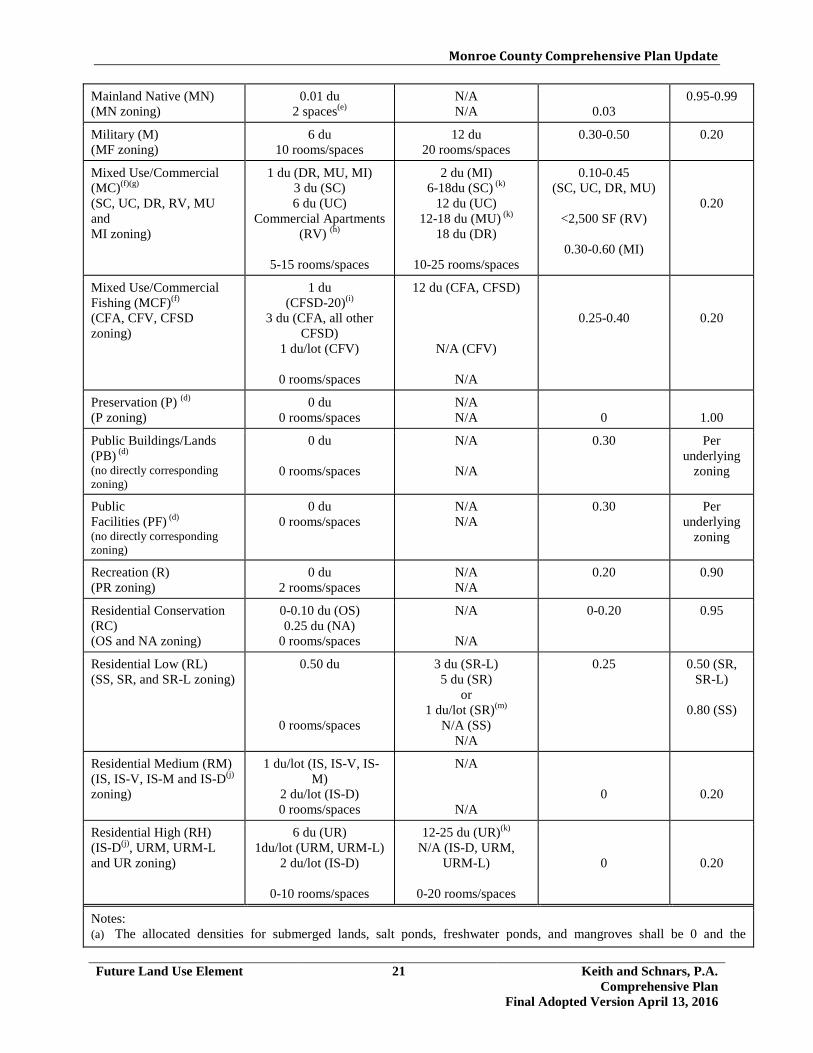
Monroe County Comprehensive Plan Update
Future Land Use Element 21 Keith and Schnars, P.A. Comprehensive Plan
Final Adopted Version April 13, 2016
Mainland Native (MN) (MN zoning)
0.01 du 2 spaces(e)
N/A N/A
0.03
0.95-0.99
Military (M) (MF zoning)
6 du 10 rooms/spaces
12 du 20 rooms/spaces
0.30-0.50 0.20
Mixed Use/Commercial (MC)(f)(g) (SC, UC, DR, RV, MU and MI zoning)
1 du (DR, MU, MI) 3 du (SC) 6 du (UC)
Commercial Apartments (RV) (h)
5-15 rooms/spaces
2 du (MI) 6-18du (SC) (k)
12 du (UC) 12-18 du (MU) (k)
18 du (DR)
10-25 rooms/spaces
0.10-0.45 (SC, UC, DR, MU)
<2,500 SF (RV)
0.30-0.60 (MI)
0.20
Mixed Use/Commercial Fishing (MCF)(f) (CFA, CFV, CFSD zoning)
1 du (CFSD-20)(i)
3 du (CFA, all other CFSD)
1 du/lot (CFV)
0 rooms/spaces
12 du (CFA, CFSD)
N/A (CFV)
N/A
0.25-0.40
0.20
Preservation (P) (d) (P zoning)
0 du 0 rooms/spaces
N/A N/A
0
1.00
Public Buildings/Lands (PB) (d) (no directly corresponding zoning)
0 du
0 rooms/spaces
N/A
N/A
0.30 Per underlying
zoning
Public Facilities (PF) (d) (no directly corresponding zoning)
0 du 0 rooms/spaces
N/A N/A
0.30 Per underlying
zoning
Recreation (R) (PR zoning)
0 du 2 rooms/spaces
N/A N/A
0.20 0.90
Residential Conservation (RC) (OS and NA zoning)
0-0.10 du (OS) 0.25 du (NA)
0 rooms/spaces
N/A
N/A
0-0.20 0.95
Residential Low (RL) (SS, SR, and SR-L zoning)
0.50 du
0 rooms/spaces
3 du (SR-L) 5 du (SR)
or 1 du/lot (SR)(m)
N/A (SS) N/A
0.25
0.50 (SR, SR-L)
0.80 (SS)
Residential Medium (RM) (IS, IS-V, IS-M and IS-D(j) zoning)
1 du/lot (IS, IS-V, IS-M)
2 du/lot (IS-D) 0 rooms/spaces
N/A
N/A
0
0.20
Residential High (RH) (IS-D(j), URM, URM-L and UR zoning)
6 du (UR) 1du/lot (URM, URM-L)
2 du/lot (IS-D)
0-10 rooms/spaces
12-25 du (UR)(k) N/A (IS-D, URM,
URM-L)
0-20 rooms/spaces
0
0.20
Notes: (a) The allocated densities for submerged lands, salt ponds, freshwater ponds, and mangroves shall be 0 and the

Monroe County Comprehensive Plan Update
Future Land Use Element 22 Keith and Schnars, P.A. Comprehensive Plan
Final Adopted Version April 13, 2016
maximum net density bonuses shall not be available. (b) The Maximum Net Density is the maximum density allowable with the use of TDRs, or for qualifying affordable
housing development. TDRs can be utilized to attain the density between the allocated density standard up to the maximum net density standard. Deed restricted affordable dwelling units may be built up to the maximum net density without the use of TDRs. “N/A” means that maximum net density bonuses shall not be available. Buildable acres means the portion of a parcel of land that is developable and is not required open space.
(c) Additional open space requirements may apply based on environmental protection criteria; in these cases, the most restrictive requirement shall apply.
(d) Future land use categories of Agriculture/Aquaculture, Education, Institutional, Preservation, Public Buildings/Lands, and Public Facilities, which have no directly corresponding zoning, may be used with new or existing zoning districts as appropriate.
(e) Within the Mainland Native future land use district, campground spaces and nonresidential buildings shall only be permitted for educational, research or sanitary purposes.
(f) For properties consisting of hammocks, pinelands or disturbed wetlands within the Mixed Use/ Commercial and Mixed Use/ Commercial Fishing future land use categories, the maximum floor area ratio shall be 0.10 and the maximum net density bonuses shall not be available.
(g) A mixture of uses shall be maintained for parcels designated as MI zoning district that are within the MC future land use category. Working waterfront and water dependent uses, such as marina, fish house/market, boat repair, boat building, boat storage, or other similar uses, shall comprise a minimum of 35% of the upland area of the property, adjacent to the shoreline, pursuant to Policy 101.5.6.
(h) In the RV zoning district, commercial apartments shall be allowed, not to exceed 10% of total spaces allowed or in existence on the site, whichever is less.
(i) The allocated density for the CFSD-20 zoning district (Little Torch Key) shall be 1 dwelling unit per acre, or 1 dwelling unit per parcel for those parcels existing as of September 15, 1986, whichever is less, and the maximum net density bonuses shall not be available. Residential density shall be allowed in addition to the permitted nonresidential uses and intensity (i.e., density and intensity shall not be counted cumulatively).
(j) Within IS subdivisions with primarily single family residential units, IS-D zoning may be used with a RM future land use designation for platted lots which have a duplex that was lawfully established prior to September 15, 1986.
(k) The maximum net density shall be 25 du/buildable acre for the UR zoning district and shall be 18 du/buildable acre for the MU and SC zoning district for development where all units are deed restricted affordable dwelling units. For the UR zoning district market rate housing may be developed as part of an affordable or employee housing project with a maximum net density not exceeding 18 du/buildable acre.
(l) Vessels, including live-aboard vessels, or associated wet slips are not considered dwelling units and do not count when calculating density.
(m) Within the Residential Low future land use category, the maximum net density for platted lots of less than 0.40 gross acres within the SR zoning district shall be 1 dwelling unit per platted lot, provided all of the following conditions are met: 1) The parcel must be one full platted lot shown on a plat approved by the County and duly recorded prior to
January 2, 1996; 2) The platted lot may not be identified for any other use or purpose on the plat (e.g., “park,” “common area,” etc.); 3) The platted lot must have a Tier designation of Tier III; 4) Notwithstanding Policy 101.13.2, the maximum net density may only be reached with the transfer of one (1) full
TDR to the SR lot, regardless of the size of the lot and the allocated density assigned to it; 5) The TDR must meet all requirements and procedures specified in Policy 101.13.3 and Section 130-160 of the
Land Development Code; 6) TDRs under this provision may not be transferred into noise zones of 65 DNL or greater; and 7) The subject parcel must comply with Policy 301.2.5 regarding legal access.
(Ord 032-2012 and 010-2013; Ord 004-2017)

Monroe County Comprehensive Plan Update
Future Land Use Element 23 Keith and Schnars, P.A. Comprehensive Plan
Final Adopted Version April 13, 2016
Policy 101.5.26 In order to continue to implement the Florida Keys Carrying Capacity Study, Monroe County shall promote the reduction in overall County residential density and the preservation of Monroe County’s native habitat by enacting legislation which implements the following policy statements for private applications for future land use map amendments which increase allowable residential allocated density. Private application(s) means those applications from private entities with ownership of the upland development and parcel(s) of land or includes private upland development on County-owned land. Private applications requesting future land use map designation amendments received after the effective date of this ordinance (Nov. 20, 2012), which propose increases in allocated residential density shall be required, upon amendment approval, to comply with either option (1) or (2) below: 1. For every acre of land, and/or fractions thereof, where there is a request to
increase residential density, a private applicant shall purchase and dedicate land to Monroe County for conservation that is a minimum of twice the size of the parcel subject to the proposed request and has a residential density development potential equal or greater to the density increase being requested. The following requirements apply:
• The dedicated land shall be designated as Tier I, Tier II or Tier III-A
Special Protection Area and be located on Big Pine Key/No Name Key or be within the same subarea of unincorporated Monroe County as the proposed increase in residential density. Dedicated land may also be used by an applicant for ROGO points.
• The dedicated land shall contain predominantly non-scarified native
upland habitat and/or undisturbed wetland habitat. The land shall be inspected by the Monroe County Biologist to assure it is acceptable for acquisition and donation.
• A restrictive covenant shall be recorded to extinguish the development
rights on the donated land.
• The Future Land Use Map Designation for the donated land may be designated by the County as Conservation (C) or Preservation (P).
2. For each requested additional unit of residential density, a private applicant
shall purchase and dedicate a lot designated as Improved Subdivision (IS) district on the Land Use (Zoning) District map to Monroe County to ensure the equivalent density requested is mitigated (excludes the dedication of lots for affordable housing). The following requirements apply:

Monroe County Comprehensive Plan Update
Future Land Use Element 24 Keith and Schnars, P.A. Comprehensive Plan
Final Adopted Version April 13, 2016
Private applicants shall provide IS lots pursuant to a 1:1 (1 unit: 1 lot) ratio to mitigate the request for increased allowable residential density, pursuant to option (a) or (b) below:
(a) The dedicated IS lot(s) shall be designated as Tier I, Tier II or Tier III-A
Special Protection Area and be located on Big Pine Key/No Name Key or be within the same subarea of unincorporated Monroe County as the proposed increase in residential density.
• The dedicated lot shall contain predominantly non-scarified native
upland habitat and/or undisturbed wetland habitat. The IS lot(s) shall be inspected by the Monroe County Biologist to assure it is acceptable for acquisition and donation.
• A restrictive covenant shall be recorded to extinguish the
development rights on the donated land.
• The dedicated IS lot(s) must still have 1 (one) unit of allocated density per lot (i.e., may not have sent density to another site via TDRs or have any other restriction on development rights via deed restriction or similar mechanism)
• The Future Land Use Map Designation for the donated land may be
designated by the County as Conservation (C).
(b) The dedicated IS lot(s) shall be designated as Tier III, must have 1 unit of allocated density per lot and must be within the same subarea of unincorporated Monroe County as the proposed increase in residential density.
• The IS lot(s) shall be dedicated to Monroe County for the retirement
of development rights; or • The IS lot(s) may be dedicated to Monroe County for affordable
housing projects. For options (1) and (2) described above, the parcel which is the subject of the request to increase its residential density must be designated as Tier III and have existing public facilities and services and available central wastewater facilities. Under this policy, no net increase in residential density will be permitted.
Example of
Option 1 12 acres requesting a FLUM amendment to increase density
Requires the donation of 24 acres of non-scarified native upland habitat and/or undisturbed wetland habitat, designated as Tier I, Tier II or Tier III-A. (12 acres x 2 = 24 acres)
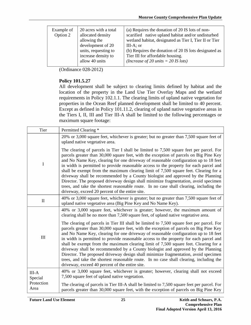
Monroe County Comprehensive Plan Update
Future Land Use Element 25 Keith and Schnars, P.A. Comprehensive Plan
Final Adopted Version April 13, 2016
Example of Option 2
20 acres with a total allocated density allowing the development of 20 units, requesting to increase density to allow 40 units
(a) Requires the donation of 20 IS lots of non-scarified native upland habitat and/or undisturbed wetland habitat, designated as Tier I, Tier II or Tier III-A; or (b) Requires the donation of 20 IS lots designated as Tier III for affordable housing. (Increase of 20 units = 20 IS lots)
(Ordinance 028-2012) Policy 101.5.27 All development shall be subject to clearing limits defined by habitat and the location of the property in the Land Use Tier Overlay Maps and the wetland requirements in Policy 102.1.1. The clearing limits of upland native vegetation for properties in the Ocean Reef planned development shall be limited to 40 percent. Except as defined in Policy 101.11.2, clearing of upland native vegetative areas in the Tiers I, II, III and Tier III-A shall be limited to the following percentages or maximum square footage:
Tier Permitted Clearing *
I
20% or 3,000 square feet, whichever is greater; but no greater than 7,500 square feet of upland native vegetative area.
The clearing of parcels in Tier I shall be limited to 7,500 square feet per parcel. For parcels greater than 30,000 square feet, with the exception of parcels on Big Pine Key and No Name Key, clearing for one driveway of reasonable configuration up to 18 feet in width is permitted to provide reasonable access to the property for each parcel and shall be exempt from the maximum clearing limit of 7,500 square feet. Clearing for a driveway shall be recommended by a County biologist and approved by the Planning Director. The proposed driveway design shall minimize fragmentation, avoid specimen trees, and take the shortest reasonable route. In no case shall clearing, including the driveway, exceed 20 percent of the entire site.
II 40% or 3,000 square feet, whichever is greater; but no greater than 7,500 square feet of upland native vegetative area (Big Pine Key and No Name Key).
III
40% or 3,000 square feet, whichever is greater; however, the maximum amount of clearing shall be no more than 7,500 square feet, of upland native vegetative area.
The clearing of parcels in Tier III shall be limited to 7,500 square feet per parcel. For parcels greater than 30,000 square feet, with the exception of parcels on Big Pine Key and No Name Key, clearing for one driveway of reasonable configuration up to 18 feet in width is permitted to provide reasonable access to the property for each parcel and shall be exempt from the maximum clearing limit of 7,500 square feet. Clearing for a driveway shall be recommended by a County biologist and approved by the Planning Director. The proposed driveway design shall minimize fragmentation, avoid specimen trees, and take the shortest reasonable route. In no case shall clearing, including the driveway, exceed 40 percent of the entire site.
III-A Special Protection Area
40% or 3,000 square feet, whichever is greater; however, clearing shall not exceed 7,500 square feet of upland native vegetation.
The clearing of parcels in Tier III-A shall be limited to 7,500 square feet per parcel. For parcels greater than 30,000 square feet, with the exception of parcels on Big Pine Key

Monroe County Comprehensive Plan Update
Future Land Use Element 26 Keith and Schnars, P.A. Comprehensive Plan
Final Adopted Version April 13, 2016
and No Name Key, clearing for one driveway of reasonable configuration up to 18 feet in width is permitted to provide reasonable access to the property for each parcel and shall be exempt from the maximum clearing limit of 7,500 square feet. Clearing for a driveway shall be recommended by a County biologist and approved by the Planning Director. The proposed driveway design shall minimize fragmentation, avoid specimen trees, and take the shortest reasonable route. In no case shall clearing, including the driveway, exceed 40 percent of the entire site.
*Clearing for palm or cactus hammock is limited to only 10% and the maximum amount of clearing shall be no more than 3,000 square feet.
(Ordinance 026-2012) Policy 101.5.28 Notwithstanding the clearing limits established in the Livable CommuniKeys Master Plans adopted by reference into the 2010 Comprehensive Plan by Policy 101.20.2, the permitted clearing established by Policy 101.5.27 shall control. (Ordinance 026-2012) Policy 101.5.29 Notwithstanding the density limitations set forth in Policy 101.5.25, land upon which a lawfully established residential dwelling unit exists shall be entitled to a density of one dwelling unit per each recognized lawfully established unit. Such lawfully-established dwelling unit(s) shall not be considered as nonconforming as to the density provisions of Policy 101.5.25 and the Monroe County Code. Policy 101.5.30 In order to preserve the existing community character and natural environment, Monroe County shall limit the height of structures including landfills to 35 feet. Height is defined as the vertical distance between grade and the highest part of any structure, including mechanical equipment, but excluding spires and/or steeples on structures used for institutional and/or public uses only; chimneys; radio and/or television antennas; flagpoles; solar apparatus; utility poles and/or transmission towers; and certain antenna supporting structures with attached antennas and/or collocations. However, in no event shall any of the exclusions enumerated above be construed to permit any habitable or usable space to exceed the applicable height limitations, except as specifically permitted in Policies 101.5.31, 101.5.32 and 101.5.33. In the case of airport districts, there shall be no exceptions to the 35-foot height limitation. (Ordinance 016-2017) Policy 101.5.31 For Ocean Reef, a gated master planned community which is inaccessible to the surrounding community, and has a distinct community character, buildings may include non-habitable architectural decorative features (such as finials, railings, widow’s walk, parapets) that exceed the 35-foot height limit in Policy 101.5.30, but such features shall not exceed 5 feet above the building’s roof-line. This exception shall not result in a building together with any architectural decorative feature with a height that would exceed 40 feet.

Monroe County Comprehensive Plan Update
Future Land Use Element 26-2 Keith and Schnars, P.A. Comprehensive Plan
Final Adopted Version April 13, 2016
As used in this policy, a master planned community means a planned community of 100 or more acres in area subject to a master plan or other development order approved by the county where public access is restricted and the community is operated and maintained by the community including the provision of comprehensive, private utilities and transportation facilities and services within its boundaries and a homeowners association or similar entity which regulates development standards and monitors development requests by its members. (Ordinance 016-2017) Policy 101.5.32 Within in 1 year of the effective date of this policy, Monroe County shall adopt Land Development Regulations which provide a Flood Protection Height Exception to Policy 101.5.30 to promote public health, safety and general welfare; allow adaptation to coastal flooding, storm surge and other hazards; protect property from flooding and minimize damages; minimize public and private losses due to flooding; minimize future expenditures of public funds for flood control projects and for recovery from flood events; and mitigate rising flood insurance premiums. A Flood Protection Height Exception of up to a maximum of five (5) feet above the 35-foot height limit shall be provided to allow lawfully existing buildings to be voluntarily elevated up to three (3) feet above FEMA base flood elevation; and a flood protection height exception of a maximum of three (3) feet above the 35-foot height limit shall be provided to allow new (new construction or substantially improved) buildings to voluntarily elevate up to three (3) feet above FEMA base flood elevation. These exceptions are in order to promote flood protection, minimize flood damage, reduce flood insurance premiums and minimize future expenditures of public funds for recovery from flood events. In no case shall a Flood Protection Height Exception result in a new building exceeding a maximum height of 38 feet or a lawfully existing building exceeding a maximum height of 40 feet. (Ordinance 016-2017) Policy 101.5.33 Within in 1 year of the effective date of this policy, Monroe County shall adopt Land Development Regulations which provide a Flood Protection Height Exception for lawfully established existing buildings which exceed the 35-foot height limit, to promote public health, safety and general welfare; allow adaptation to coastal flooding, storm surge and other hazards; protect property from flooding and minimize damages; minimize public and private losses due to flooding; minimize future expenditures of public funds for flood control projects and for recovery from flood events; and mitigate rising flood insurance premiums. A lawfully established existing building may be repaired, improved, redeveloped and/or elevated to meet required FEMA base flood elevation (BFE) provided the building does not exceed a total maximum building height of 40 feet, and the building is limited to the existing lawfully established intensity, floor area, building envelope (floor to floor height), density and type of use. For lawfully established existing buildings that are proposed to exceed a total height of 40 feet, a public hearing before the Planning Commission and the Board of County

Monroe County Comprehensive Plan Update
Future Land Use Element 26-3 Keith and Schnars, P.A. Comprehensive Plan
Final Adopted Version April 13, 2016
Commissioners shall be required to review and specify the maximum approved height prior to issuance of any county permit or development approval. The Planning Commission shall provide a recommendation to the BOCC on the maximum height of a building. The BOCC shall adopt a resolution specifying the maximum approved height. (Ordinance 016-2017)
<The remainder of this page intentionally left blank>

Monroe County Comprehensive Plan Update
Future Land Use Element 27 Keith and Schnars, P.A. Comprehensive Plan
Final Adopted Version April 13, 2016
Objective 101.6 Monroe County shall maintain and implement a Point System based primarily on the Tier system of land classification in accordance with Goal 105, which directs future growth in order to:
1. maintain and enhance the character of the community [§163.3177(6)(a)2.c.,F.S.];
2. protect natural resources [§163.3177(6)(a)3.f.,F.S.];
3. encourage a compact pattern of development [§163.3177(6)(a)2.h.,F.S.];
4. encourage the development of affordable housing;
5. direct future growth to appropriate infill areas and away from inappropriate locations
not suitable for development such as environmentally sensitive areas, Coastal Barrier Resource System (CBRS) Units, and V-zones; and
6. encourage development in areas served by central wastewater treatment systems. Policy 101.6.1 Monroe County shall maintain land development regulations which provide for a Point System for new residential (ROGO) and nonresidential (NROGO) development. Except for affordable housing, this Point System, as set forth in Policy 101.6.4 for residential development and Policy 101.6.5 for nonresidential development, shall be used as a basis for selecting the development applications which are to be issued permits through the Permit Allocation System pursuant to Policy 101.6.4 and Policy 101.6.5. For market rate housing units or nonresidential development to be awarded allocations under the Permit Allocation System the Point System shall specify positive point factors which shall be considered as assets and shall specify negative point factors which shall be considered as liabilities in the evaluation of applications for new residential and nonresidential development. Policy 101.6.2 In order to encourage a compact form of residential growth that results in infill development in platted, improved subdivisions, the Point System shall be primarily based on the Tier system of land classification as set forth under Goal 105. To discourage and limit further growth in Tier I designated areas, the annual maximum number of residential permit allocations that may be awarded in Tier I shall be no more than three (3) each in the Upper and Lower ROGO subareas. Other criteria and corresponding points are allocated to encourage development to the most appropriate locations and discourage development from inappropriate locations. In the Big Pine Key/No Name Key subarea the annual maximum number of residential permit allocations that may be awarded in Tier I shall be no more than one (1) every 2 years. This provision is subject to the issuing of an updated
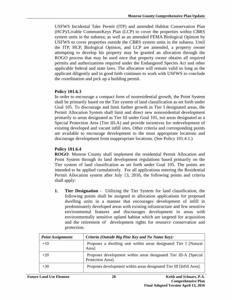
Monroe County Comprehensive Plan Update
Future Land Use Element 28 Keith and Schnars, P.A. Comprehensive Plan
Final Adopted Version April 13, 2016
USFWS Incidental Take Permit (ITP) and amended Habitat Conservation Plan (HCP)/Livable CommuniKeys Plan (LCP) to cover the properties within CBRS system units in the subarea; as well as an amended FEMA Biological Opinion by USFWS to cover properties outside the CBRS system units in the subarea. Until the ITP, HCP, Biological Opinion, and LCP are amended, a property owner attempting to develop his property may be granted an allocation through the ROGO process that may be used once that property owner obtains all required permits and authorizations required under the Endangered Species Act and other applicable federal and state laws. The allocation will remain valid so long as the applicant diligently and in good faith continues to work with USFWS to conclude the coordination and pick up a building permit.
Policy 101.6.3 In order to encourage a compact form of nonresidential growth, the Point System shall be primarily based on the Tier system of land classification as set forth under Goal 105. To discourage and limit further growth in Tier I designated areas, the Permit Allocation System shall limit and direct new nonresidential development primarily to areas designated as Tier III under Goal 105, not areas designated as a Special Protection Area (Tier III-A) and provide incentives for redevelopment of existing developed and vacant infill sites. Other criteria and corresponding points are available to encourage development to the most appropriate locations and discourage development from inappropriate locations. (See Policy 101.4.1.) Policy 101.6.4 ROGO: Monroe County shall implement the residential Permit Allocation and Point System through its land development regulations based primarily on the Tier system of land classification as set forth under Goal 105. The points are intended to be applied cumulatively. For all applications entering the Residential Permit Allocation system after July 13, 2016, the following points and criteria shall apply: 1. Tier Designation - Utilizing the Tier System for land classification, the
following points shall be assigned to allocation applications for proposed dwelling units in a manner that encourages development of infill in predominately developed areas with existing infrastructure and few sensitive environmental features and discourages development in areas with environmentally sensitive upland habitat which are targeted for acquisition and the retirement of development rights for resource conservation and protection.
Point Assignment: Criteria (Outside Big Pine Key and No Name Key): +10 Proposes a dwelling unit within areas designated Tier I [Natural
Area] +20 Proposes development within areas designated Tier III-A [Special
Protection Area]. +30 Proposes development within areas designated Tier III [Infill Area].
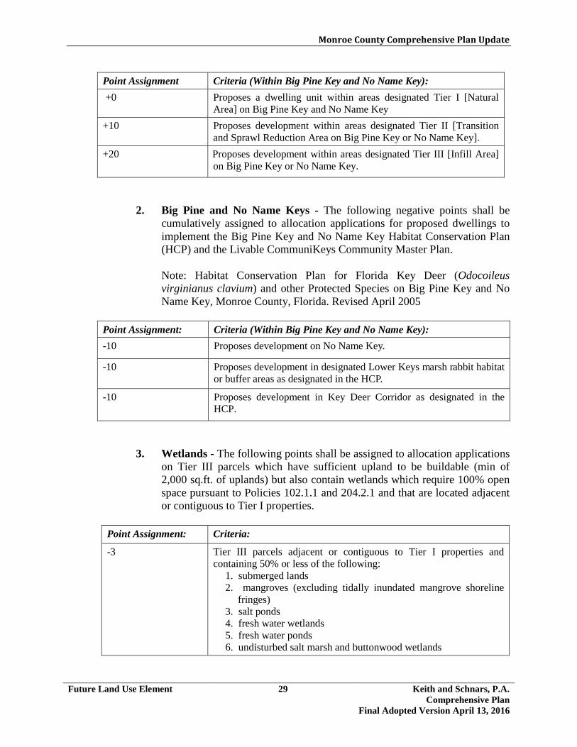
Monroe County Comprehensive Plan Update
Future Land Use Element 29 Keith and Schnars, P.A. Comprehensive Plan
Final Adopted Version April 13, 2016
Point Assignment Criteria (Within Big Pine Key and No Name Key): +0 Proposes a dwelling unit within areas designated Tier I [Natural
Area] on Big Pine Key and No Name Key +10 Proposes development within areas designated Tier II [Transition
and Sprawl Reduction Area on Big Pine Key or No Name Key]. +20 Proposes development within areas designated Tier III [Infill Area]
on Big Pine Key or No Name Key.
2. Big Pine and No Name Keys - The following negative points shall be
cumulatively assigned to allocation applications for proposed dwellings to implement the Big Pine Key and No Name Key Habitat Conservation Plan (HCP) and the Livable CommuniKeys Community Master Plan.
Note: Habitat Conservation Plan for Florida Key Deer (Odocoileus virginianus clavium) and other Protected Species on Big Pine Key and No Name Key, Monroe County, Florida. Revised April 2005
Point Assignment: Criteria (Within Big Pine Key and No Name Key): -10 Proposes development on No Name Key.
-10 Proposes development in designated Lower Keys marsh rabbit habitat or buffer areas as designated in the HCP.
-10 Proposes development in Key Deer Corridor as designated in the HCP.
3. Wetlands - The following points shall be assigned to allocation applications on Tier III parcels which have sufficient upland to be buildable (min of 2,000 sq.ft. of uplands) but also contain wetlands which require 100% open space pursuant to Policies 102.1.1 and 204.2.1 and that are located adjacent or contiguous to Tier I properties.
Point Assignment: Criteria:
-3 Tier III parcels adjacent or contiguous to Tier I properties and containing 50% or less of the following:
1. submerged lands 2. mangroves (excluding tidally inundated mangrove shoreline
fringes) 3. salt ponds 4. fresh water wetlands 5. fresh water ponds 6. undisturbed salt marsh and buttonwood wetlands

Monroe County Comprehensive Plan Update
Future Land Use Element 30 Keith and Schnars, P.A. Comprehensive Plan
Final Adopted Version April 13, 2016
-5
Tier III parcels adjacent or contiguous to Tier I properties and containing more than 50% of the following:
1. submerged lands 2. mangroves (excluding tidally inundated mangrove shoreline
fringes) 3. salt ponds 4. fresh water wetlands 5. fresh water ponds 6. undisturbed salt marsh and buttonwood wetlands
Notes: Adjacent means land sharing a boundary with another parcel of land. An intervening road, right-of-way, or easement shall not destroy the adjacency of the two parcels, except for U.S. 1. Contiguous means a sharing of a common border at more than a single point of intersection. Contiguity is not interrupted by utility easements.
Subsection (3) applies to new applications for Tier III parcels entering the permit allocation system after January 13, 2013. (Ordinance 030-2012)
4. Aggregation – The following points shall be assigned to allocation
applications to encourage the voluntary reduction of density, for the retirement of development rights through aggregation of parcels and for the purpose of retirement of development rights through aggregation of legally platted buildable lots.
Point Assignment: Criteria (Outside Big Pine Key and No Name Key): 1, 2, 3, 4
+3 per lot/parcel aggregated
Each additional contiguous vacant, legally platted lot which is aggregated in a designated Tier I area outside of Big Pine Key and No Name Key will earn additional points as specified. Each additional contiguous vacant parcel with a minimum of 2,000 square feet of uplands which is aggregated in a designated Tier I area outside of Big Pine Key and No Name Key that meets the aforementioned requirements will earn additional points as specified.
+4 per lot/parcel aggregated
Each additional contiguous vacant, legally platted lot which is aggregated in a designated Tier III-A (SPA) area outside of Big Pine Key and No Name Key will earn additional points as specified. Each additional contiguous vacant parcel with a minimum of 2,000 square feet of uplands which is aggregated in a designated Tier III-A (SPA) area outside of Big Pine Key and No Name Key that meets the aforementioned requirements will earn additional points as specified.
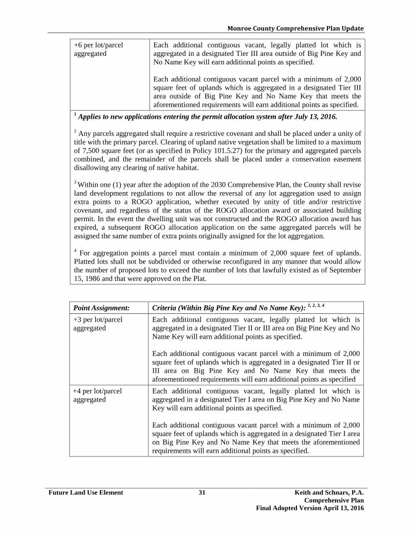
Monroe County Comprehensive Plan Update
Future Land Use Element 31 Keith and Schnars, P.A. Comprehensive Plan
Final Adopted Version April 13, 2016
Point Assignment: Criteria (Within Big Pine Key and No Name Key): 1, 2, 3, 4 +3 per lot/parcel aggregated
Each additional contiguous vacant, legally platted lot which is aggregated in a designated Tier II or III area on Big Pine Key and No Name Key will earn additional points as specified.
Each additional contiguous vacant parcel with a minimum of 2,000 square feet of uplands which is aggregated in a designated Tier II or III area on Big Pine Key and No Name Key that meets the aforementioned requirements will earn additional points as specified
+4 per lot/parcel aggregated
Each additional contiguous vacant, legally platted lot which is aggregated in a designated Tier I area on Big Pine Key and No Name Key will earn additional points as specified. Each additional contiguous vacant parcel with a minimum of 2,000 square feet of uplands which is aggregated in a designated Tier I area on Big Pine Key and No Name Key that meets the aforementioned requirements will earn additional points as specified.
+6 per lot/parcel aggregated
Each additional contiguous vacant, legally platted lot which is aggregated in a designated Tier III area outside of Big Pine Key and No Name Key will earn additional points as specified. Each additional contiguous vacant parcel with a minimum of 2,000 square feet of uplands which is aggregated in a designated Tier III area outside of Big Pine Key and No Name Key that meets the aforementioned requirements will earn additional points as specified.
1 Applies to new applications entering the permit allocation system after July 13, 2016. 2 Any parcels aggregated shall require a restrictive covenant and shall be placed under a unity of title with the primary parcel. Clearing of upland native vegetation shall be limited to a maximum of 7,500 square feet (or as specified in Policy 101.5.27) for the primary and aggregated parcels combined, and the remainder of the parcels shall be placed under a conservation easement disallowing any clearing of native habitat. 3 Within one (1) year after the adoption of the 2030 Comprehensive Plan, the County shall revise land development regulations to not allow the reversal of any lot aggregation used to assign extra points to a ROGO application, whether executed by unity of title and/or restrictive covenant, and regardless of the status of the ROGO allocation award or associated building permit. In the event the dwelling unit was not constructed and the ROGO allocation award has expired, a subsequent ROGO allocation application on the same aggregated parcels will be assigned the same number of extra points originally assigned for the lot aggregation. 4 For aggregation points a parcel must contain a minimum of 2,000 square feet of uplands. Platted lots shall not be subdivided or otherwise reconfigured in any manner that would allow the number of proposed lots to exceed the number of lots that lawfully existed as of September 15, 1986 and that were approved on the Plat.
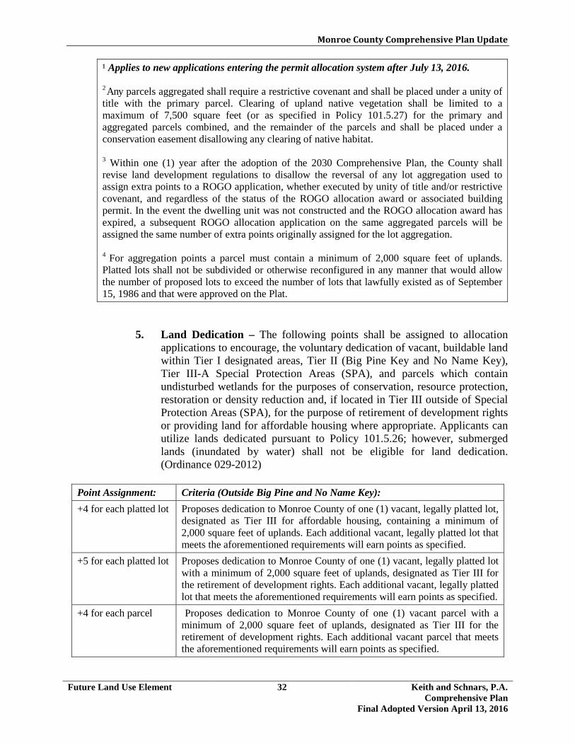
Monroe County Comprehensive Plan Update
Future Land Use Element 32 Keith and Schnars, P.A. Comprehensive Plan
Final Adopted Version April 13, 2016
¹ Applies to new applications entering the permit allocation system after July 13, 2016. 2 Any parcels aggregated shall require a restrictive covenant and shall be placed under a unity of title with the primary parcel. Clearing of upland native vegetation shall be limited to a maximum of 7,500 square feet (or as specified in Policy 101.5.27) for the primary and aggregated parcels combined, and the remainder of the parcels and shall be placed under a conservation easement disallowing any clearing of native habitat. 3 Within one (1) year after the adoption of the 2030 Comprehensive Plan, the County shall revise land development regulations to disallow the reversal of any lot aggregation used to assign extra points to a ROGO application, whether executed by unity of title and/or restrictive covenant, and regardless of the status of the ROGO allocation award or associated building permit. In the event the dwelling unit was not constructed and the ROGO allocation award has expired, a subsequent ROGO allocation application on the same aggregated parcels will be assigned the same number of extra points originally assigned for the lot aggregation. 4 For aggregation points a parcel must contain a minimum of 2,000 square feet of uplands. Platted lots shall not be subdivided or otherwise reconfigured in any manner that would allow the number of proposed lots to exceed the number of lots that lawfully existed as of September 15, 1986 and that were approved on the Plat.
5. Land Dedication – The following points shall be assigned to allocation applications to encourage, the voluntary dedication of vacant, buildable land within Tier I designated areas, Tier II (Big Pine Key and No Name Key), Tier III-A Special Protection Areas (SPA), and parcels which contain undisturbed wetlands for the purposes of conservation, resource protection, restoration or density reduction and, if located in Tier III outside of Special Protection Areas (SPA), for the purpose of retirement of development rights or providing land for affordable housing where appropriate. Applicants can utilize lands dedicated pursuant to Policy 101.5.26; however, submerged lands (inundated by water) shall not be eligible for land dedication. (Ordinance 029-2012)
Point Assignment: Criteria (Outside Big Pine and No Name Key): +4 for each platted lot Proposes dedication to Monroe County of one (1) vacant, legally platted lot,
designated as Tier III for affordable housing, containing a minimum of 2,000 square feet of uplands. Each additional vacant, legally platted lot that meets the aforementioned requirements will earn points as specified.
+5 for each platted lot Proposes dedication to Monroe County of one (1) vacant, legally platted lot with a minimum of 2,000 square feet of uplands, designated as Tier III for the retirement of development rights. Each additional vacant, legally platted lot that meets the aforementioned requirements will earn points as specified.
+4 for each parcel Proposes dedication to Monroe County of one (1) vacant parcel with a minimum of 2,000 square feet of uplands, designated as Tier III for the retirement of development rights. Each additional vacant parcel that meets the aforementioned requirements will earn points as specified.

Monroe County Comprehensive Plan Update
Future Land Use Element 33 Keith and Schnars, P.A. Comprehensive Plan
Final Adopted Version April 13, 2016
+1 for each platted lot Proposes dedication to Monroe County of a vacant, legally platted lot within a Tier I area, designated as Residential Low containing a minimum of 2,000 square feet of uplands. Each additional vacant, legally platted lot that meets the aforementioned requirements will earn points as specified.
+0.5 for each platted lot
Proposes dedication to Monroe County of one (1) vacant, legally platted lot within a Tier I area, designated as Residential Conservation containing a minimum of 2,000 square feet of uplands. Each additional vacant, legally platted lot that meets the aforementioned requirements will earn points as specified.
+2 for each parcel Proposes dedication to Monroe County of less than one (1) acre of vacant, unplatted land located within a Tier I area containing a minimum of 2,000 square feet of uplands. Each additional parcel with vacant, unplatted land that meets the aforementioned requirements will earn points as specified.
+4 for each acre Proposes dedication to Monroe County of at least one (1) acre of vacant, unplatted land located within a Tier I area containing a minimum of 2,000 square feet of uplands. Each additional one (1) acre of vacant, unplatted land that meets the aforementioned requirements will earn points as specified.
+2 for each platted lot Proposes dedication to Monroe County of one (1) vacant, legally platted lot which contains undisturbed wetlands. Each additional vacant, legally platted lot that meets the aforementioned requirements will earn points as specified.
+2.5 for each platted lot
Proposes dedication to Monroe County of one (1) vacant, legally platted lot, designated as Tier I, containing a minimum of 2,000 square feet of uplands and not designated as Residential Conservation or Residential Low. Each additional vacant, legally platted lot that meets the aforementioned requirements will earn points as specified.
+2 for each platted lot Proposes dedication to Monroe County of one (1) vacant, legally platted lot, designated as Tier III-A (Special Protection Area-SPA), containing a minimum of 2,000 square feet of uplands. Each additional vacant, legally platted lot that meets the aforementioned requirements will earn points as specified.
+2 for each parcel Proposes dedication to Monroe County less than one (1) acre of vacant, unplatted land located within a Tier III-A area containing a minimum of 2,000 square feet of uplands. Each additional parcel with vacant, unplatted land that meets the aforementioned requirements will earn points as specified.
+3 for each parcel Proposes dedication to Monroe County of at least one (1) acre of vacant, unplatted land located within a Tier III-A area containing a minimum of 2,000 square feet of uplands. Each additional parcel with vacant, unplatted land that meets the aforementioned requirements will earn points as specified.

Monroe County Comprehensive Plan Update
Future Land Use Element 34 Keith and Schnars, P.A. Comprehensive Plan
Final Adopted Version April 13, 2016
Additional Requirements A statutory warranty deed that conveys the dedicated property to the county
shall be approved by the Planning Director and County Attorney and recorded in the office of the clerk of the county prior to the issuance of any building permit pursuant to an allocation award. Other documents related to the approval of the land dedication may include, but are not limited to, affidavit of no encumbrance(s), entity affidavit, subject to the approval of the Planning Director and County Attorney and recorded in the office of the clerk of the county prior to the issuance of any building permit pursuant to an allocation award.
Point Assignment: Criteria (Within Big Pine Key and No Name Key): +2 for each platted lot Proposes dedication to Monroe County of one (1) vacant, legally platted lot,
designated as Tier I on Big Pine Key or No Name Key, containing a minimum of 2,000 square feet of uplands. Each additional vacant, legally platted lot that meets the aforementioned requirements will earn points as specified.
+4 for each acre Proposes dedication to Monroe County of at least one (1) acre of vacant, unplatted land located within a Tier I area on Big Pine Key or No Name Key, containing a minimum of 2,000 square feet of uplands. Each additional one (1) acre of vacant, unplatted land that meets the aforementioned requirements will earn points as specified.
+2 for each parcel Proposes dedication to Monroe County less than one (1) acre of vacant, unplatted land located within a Tier I area on Big Pine Key or No Name Key, containing a minimum of 2,000 square feet of uplands. Each additional parcel with vacant, unplatted land that meets the aforementioned requirements will earn points as specified.
+2 for each platted lot Proposes dedication to Monroe County of one (1) vacant, legally platted lot, designated as Tier II on Big Pine Key or No Name Key, containing a minimum of 2,000 square feet of uplands. Each additional vacant, legally platted lot that meets the aforementioned requirements will earn points as specified.
+3 for each acre Proposes dedication to Monroe County of at least one (1) acre of vacant, unplatted land located within a Tier II area on Big Pine Key or No Name Key, containing a minimum of 2,000 square feet of uplands. Each additional one (1) acre of vacant, unplatted land that meets the aforementioned requirements will earn points as specified.
+2 for each parcel Proposes dedication to Monroe County less than one (1) acre of vacant, unplatted land located within a Tier II area on Big Pine Key or No Name Key, containing a minimum of 2,000 square feet of uplands. Each additional parcel with vacant, unplatted land that meets the aforementioned requirements will earn points as specified.
+5 for each platted lot
Proposes dedication to Monroe County of one (1) vacant, legally platted lot, designated as Tier III on Big Pine Key or No Name Key, containing a minimum of 2,000 square feet of uplands. Each additional vacant, legally platted lot that meets the aforementioned requirements will earn points as specified.

Monroe County Comprehensive Plan Update
Future Land Use Element 35 Keith and Schnars, P.A. Comprehensive Plan
Final Adopted Version April 13, 2016
+4 for each parcel Proposes dedication to Monroe County of one (1) vacant parcel, designated as Tier III on Big Pine Key or No Name Key, containing a minimum of 2,000 square feet of uplands. Each additional vacant parcel that meets the aforementioned requirements will earn points as specified.
+2 for each platted lot
Proposes dedication to Monroe County of one (1) vacant, legally platted lot on Big Pine Key or No Name Key which contains undisturbed wetlands. Each additional vacant, legally platted lot that meets the aforementioned requirements will earn points as specified.
Additional Requirements A statutory warranty deed that conveys the dedicated property to the county
shall be approved by the Planning Director and County Attorney and recorded in the office of the clerk of the county prior to the issuance of any building permit pursuant to an allocation award. Other documents related to the approval of the land dedication may include, but are not limited to, affidavit of no encumbrance(s), entity affidavit, subject to the approval of the Planning Director and County Attorney and recorded in the office of the clerk of the county prior to the issuance of any building permit pursuant to an allocation award.
6. Market Rate Housing in Employee or Affordable Housing Development
- The following points shall be assigned to allocation applications for market rate housing units in an employee or affordable housing development:
Point Assignment: Criteria: +6 Proposes a market rate housing unit which is part of an affordable or
employee housing project; both affordable and employee housing shall meet the policy guidelines under Objective 601.1 and other requirements pursuant to the Land Development Code.
7. Special Flood Hazard Areas – The following points shall be assigned to
allocation applications for proposed dwelling unit(s) to provide a disincentive for locating within certain coastal high flood hazard areas:
Point Assignment: Criteria: -6 Proposes structures requiring an allocation within “V” zones on the FEMA
flood insurance rate maps. -4 An application for which development is proposed within a CBRS unit.
8. Central Wastewater System Availability* – The following points shall be
assigned to allocation applications to direct development to areas with central sewer:
*NOTE: See “Available” as defined within the Glossary.

Monroe County Comprehensive Plan Update
Future Land Use Element 36 Keith and Schnars, P.A. Comprehensive Plan
Final Adopted Version April 13, 2016
Point Assignment: Criteria: +4* Proposes development required to be connected to a central
wastewater treatment system that meets the AWT treatment standards established by Florida Legislature and Policy 901.1.1.
*These points shall not apply to parcels within a CBRS system unit.
9. Payment to the Land Acquisition Fund – Up to two (2) whole points shall
be awarded for a monetary payment by the applicant to the County’s land acquisition fund for the purchase of lands for conservation, and retirement of development rights. The monetary value of each point shall be set annually by the County based upon the estimated average fair market value of vacant, privately-owned, buildable IS/URM zoned, platted lots.
10. Energy and Water Conservation - The following points shall be assigned
to allocation applications on lands designated as Tier III to encourage the planting of native vegetation and promote water conservation and increased energy efficiency:
Point Assignment: Criteria: +3 Proposes a dwelling unit designed according to and certified to
the standards of a sustainable building rating or national model green building code.
+1 Dwelling unit includes installation of a permanent concrete cistern with a minimum capacity of 1,000 gallons.
+2 Dwelling unit includes the installation of a gray water reuse system, meeting the requirements of the Florida Building Code.
+1 Dwelling unit includes installation of a solar photovoltaic collection system, a minimum of 3KW in size or the equivalent in other renewable energy systems.*
+0.5 Dwelling unit includes installation of one or both of the following technologies:* a. Ductless air conditioning system. b. High efficiency chillers.
* The systems must be maintained for a minimum of five years from C.O. unless replaced with a system that provides a functional equivalent or increased energy or water savings.
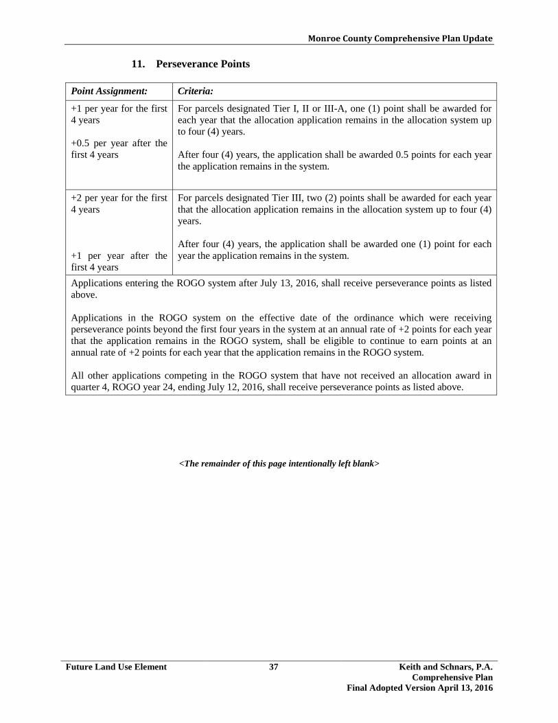
Monroe County Comprehensive Plan Update
Future Land Use Element 37 Keith and Schnars, P.A. Comprehensive Plan
Final Adopted Version April 13, 2016
11. Perseverance Points
Point Assignment: Criteria:
+1 per year for the first 4 years +0.5 per year after the first 4 years
For parcels designated Tier I, II or III-A, one (1) point shall be awarded for each year that the allocation application remains in the allocation system up to four (4) years. After four (4) years, the application shall be awarded 0.5 points for each year the application remains in the system.
+2 per year for the first 4 years +1 per year after the first 4 years
For parcels designated Tier III, two (2) points shall be awarded for each year that the allocation application remains in the allocation system up to four (4) years. After four (4) years, the application shall be awarded one (1) point for each year the application remains in the system.
Applications entering the ROGO system after July 13, 2016, shall receive perseverance points as listed above. Applications in the ROGO system on the effective date of the ordinance which were receiving perseverance points beyond the first four years in the system at an annual rate of +2 points for each year that the application remains in the ROGO system, shall be eligible to continue to earn points at an annual rate of +2 points for each year that the application remains in the ROGO system. All other applications competing in the ROGO system that have not received an allocation award in quarter 4, ROGO year 24, ending July 12, 2016, shall receive perseverance points as listed above.
<The remainder of this page intentionally left blank>

Monroe County Comprehensive Plan Update
Future Land Use Element 38 Keith and Schnars, P.A. Comprehensive Plan
Final Adopted Version April 13, 2016
Policy 101.6.5 NROGO: Monroe County shall implement the nonresidential Permit Allocation and Point System through its land development regulations based primarily on the Tier system of land classification pursuant to Goal 105. The points are intended to be applied cumulatively. For all applications entering the Nonresidential Permit Allocation system after July 13, 2016, the following points and criteria shall apply: 1. Tier Designation – Utilizing the Tier System for land classification, the
following points shall be assigned to allocation applications for proposed nonresidential development in a manner that encourages development of infill in predominately developed areas with existing infrastructure, commercial concentrations, and few sensitive environmental features, and discourages development in areas with environmentally sensitive upland habitat, which are targeted for acquisition and the retirement of development rights for resource conservation and protection:
Point Assignment: Criteria (Outside Big Pine Key and No Name Key): 0 Proposes new nonresidential development within an area designated Tier
I [Natural Area].
+4 Proposes expansion of an existing, lawfully established nonresidential development regardless of Tier, with no further clearing of any native upland vegetation.
+10 Proposes new nonresidential development that will result in the clearing of any upland native vegetation within a Special Protection Area in Tier III-A.
+20 Proposes new nonresidential development within an area designated Tier III [Infill Area].
Point Assignment: Criteria (Within Big Pine Key and No Name Key): 0 Proposes new nonresidential development within an area designated Tier I
[Natural Area] +10 Proposes new nonresidential development within an area designated Tier
II [Transition and Sprawl Reduction Area on Big Pine Key and No Name Key].
+20 Proposes new nonresidential development within an area designated Tier III on Big Pine Key and No Name Key.
+4 Proposes expansion of an existing, lawfully established nonresidential development regardless of Tier, with no further clearing of any native upland vegetation, located within the U.S. 1 Corridor Area and the commercial community center overlay in the Big Pine Key and No Name Key Livable CommuniKeys Community Master Plan.

Monroe County Comprehensive Plan Update
Future Land Use Element 39 Keith and Schnars, P.A. Comprehensive Plan
Final Adopted Version April 13, 2016
2. Wetlands - The following points shall be assigned to allocation applications on Tier III parcels which have sufficient upland to be buildable (min of 2,000 sq.ft. of uplands) but also contain wetlands which require 100% open space pursuant to Policies 102.1.1 and 204.2.2 and that are located adjacent or contiguous to Tier I properties.
Point Assignment: Criteria:
-3
Tier III parcels adjacent or contiguous to Tier I properties and containing 50% or less of the following:
1. submerged lands 2. mangroves (excluding tidally inundated mangrove shoreline fringes) 3. salt ponds 4. fresh water wetlands 5. fresh water ponds 6. undisturbed salt marsh and buttonwood wetlands
-5 Tier III parcels adjacent or contiguous to Tier I properties and containing more than 50% of the following:
1. submerged lands 2. mangroves (excluding tidally inundated mangrove shoreline fringes) 3. salt ponds 4. fresh water wetlands 5. fresh water ponds 6. undisturbed salt marsh and buttonwood wetlands
Notes: Adjacent means land sharing a boundary with another parcel of land. An intervening road,
right-of-way, or easement shall not destroy the adjacency of the two parcels, except for U.S. 1.
Contiguous means a sharing of a common border at more than a single point of intersection. Contiguity is not interrupted by utility easements.
Subsection (2) applies to new applications for Tier III parcels entering the permit allocation system after January 13, 2013. (Ordinance 030-2012)
3. Land Dedication - The following points shall be assigned to allocation applications to encourage the voluntary dedication of vacant, buildable land within Tier I, Tier II (Big Pine Key and No Name Key) designated areas, Tier III-A (Special Protection Areas-SPA), and parcels which contain undisturbed wetlands for the purposes of conservation, resource protection, restoration or density reduction and, if located in Tier III outside of Special Protection Areas (SPA), for the purpose of providing land for the retirement of development rights or affordable housing where appropriate. Applicants can utilize lands donated pursuant to Policy 101.5.26; however, submerged lands (inundated by water) shall not be eligible for land dedication. (Ordinance 029-2012)

Monroe County Comprehensive Plan Update
Future Land Use Element 40 Keith and Schnars, P.A. Comprehensive Plan
Final Adopted Version April 13, 2016
+4 for each acre Proposes dedication to Monroe County of at least one (1) acre of vacant, unplatted land located within a Tier I area containing a minimum of 2,000 square feet of uplands. Each additional one (1) acres of vacant, unplatted land that meets the aforementioned requirements will earn points as specified.
+2 for each platted lot Proposes dedication to Monroe County of one (1) vacant, legally platted lot which contains undisturbed wetlands. Each additional vacant, legally platted lot that meets the aforementioned requirements will earn points as specified
Point Assignment: Criteria (Outside Big Pine Key and No Name Key): +4 for each platted lot Proposes dedication to Monroe County of one (1) vacant, legally platted
lot, designated as Tier III for affordable housing, containing a minimum of 2,000 square feet of uplands. Each additional vacant, legally platted lot which meets the aforementioned requirements will earn the additional points as specified.
+5 for each platted lot Proposes dedication to Monroe County of one (1) vacant, legally platted lot, designated as Tier III containing a minimum of 2,000 square feet of uplands. Each additional vacant, legally platted lot that meets the aforementioned requirements will earn points as specified.
+4 for each parcel Proposes dedication to Monroe County of one vacant parcel with a minimum of 2,000 square feet of uplands, designated as Tier III for the retirement of development rights. Each additional vacant parcel that meets the aforementioned requirements will earn points as specified.
+1 for each platted lot Proposes dedication to Monroe County of a vacant legally platted lot within a Tier I area, designated as Residential Low and containing a minimum of 2,000 square feet of uplands. Each additional vacant, legally platted lot, that meets the aforementioned requirements will earn points as specified.
+0.5 for each platted lot
Proposes dedication to Monroe County of one (1) vacant, legally platted lot within a Tier I area, designated as Residential Conservation, containing a minimum of 2,000 square feet of uplands. Each additional vacant, legally platted lot that meets the aforementioned requirements will earn points as specified.
+2.5 for each platted lot
Proposes dedication to Monroe County of one (1) vacant, legally platted lot, within a Tier I area and containing a minimum of 2,000 square feet of uplands and not designated as Residential Conservation or Residential Low. Each additional vacant, legally platted lot that meets the aforementioned requirements will earn points as specified.
+2 for each parcel Proposes dedication to Monroe County less than one (1) acre of vacant, unplatted land located within a Tier I area containing a minimum of 2,000 square feet of uplands. Each additional parcel with vacant, unplatted land that meets the aforementioned requirements will earn points as specified.

Monroe County Comprehensive Plan Update
Future Land Use Element 41 Keith and Schnars, P.A. Comprehensive Plan
Final Adopted Version April 13, 2016
+2 for each platted lot Proposes dedication to Monroe County of one (1) vacant, legally platted lot, designated as Tier III-A (Special Protection Area-SPA) containing a minimum of 2,000 square feet of uplands. Each additional vacant, legally platted lot that meets the aforementioned requirements will earn points as specified.
+2 for each parcel Proposes dedication to Monroe County less than one (1) acre of vacant, unplatted land located within a Tier III-A area containing a minimum of 2,000 square feet of uplands. Each additional parcel with vacant, unplatted land that meets the aforementioned requirements will earn points as specified.
+3 for each parcel Proposes dedication to Monroe County of at least one (1) acre of vacant, unplatted land located within a Tier III-A area containing a minimum of 2,000 square feet of uplands. Each additional parcel with vacant, unplatted land that meets the aforementioned requirements will earn points as specified.
Additional Requirements: A statutory warranty deed that conveys the dedicated property to the
county shall be approved by the Planning Director and County Attorney and recorded in the office of the clerk of the county prior to the issuance of any building permit pursuant to an allocation award. Other documents related to the approval of the land dedication may include, but are not limited to, affidavit of no encumbrance(s), entity affidavit, subject to the approval of the Planning Director and County Attorney and recorded in the office of the clerk of the county prior to the issuance of any building permit pursuant to an allocation award.
Point Assignment: Criteria (Within Big Pine Key and No Name Key): +2 for each platted lot Proposes dedication to Monroe County of one (1) vacant, legally platted
lot, designated as Tier I on Big Pine Key and No Name Key, containing a minimum of 2,000 square feet of uplands. Each additional vacant, legally platted lot that meets the aforementioned requirements will earn points as specified.
+4 for each acre Proposes dedication to Monroe County of at least one (1) acre of vacant, unplatted land located within a Tier I area on Big Pine Key or No Name Key, containing a minimum of 2,000 square feet of uplands. Each additional one (1) acre of vacant, unplatted land that meets the aforementioned requirements will earn points as specified.
+2 for each parcel Proposes dedication to Monroe County less than one (1) acre of vacant, unplatted land located within a Tier I area on Big Pine Key or No Name Key, containing a minimum of 2,000 square feet of uplands. Each additional parcel with vacant, unplatted land that meets the aforementioned requirements will earn points as specified.
+2 for each platted lot Proposes dedication to Monroe County of one (1) vacant, legally platted lot, designated as Tier II on Big Pine Key and No Name Key, containing a minimum of 2,000 square feet of uplands. Each additional vacant, legally platted lot that meets the aforementioned requirements will earn points as specified.

Monroe County Comprehensive Plan Update
Future Land Use Element 42 Keith and Schnars, P.A. Comprehensive Plan
Final Adopted Version April 13, 2016
4. Special Flood Hazard Area - The following points shall be assigned to
allocation applications to discourage development within high risk special flood hazard zones:
Point Assignment: Criteria: -6 Proposes a structure requiring an allocation within a “V” zone on the
FEMA Flood Insurance Rate Map.
-4 An application for which development is proposed within a CBRS unit.
+3 for each acre Proposes dedication to Monroe County of at least one (1) acre of vacant, unplatted land located within a Tier II area on Big Pine Key or No Name Key, containing a minimum of 2,000 square feet of uplands. Each additional one (1) acre of vacant, unplatted land that meets the aforementioned requirements will earn points as specified.
+2 for each parcel Proposes dedication to Monroe County less than one (1) acre of vacant, unplatted land located within a Tier II area on Big Pine Key or No Name Key, containing a minimum of 2,000 square feet of uplands. Each additional parcel with vacant, unplatted land that meets the aforementioned requirements will earn points as specified.
+5 for each platted lot Proposes dedication to Monroe County of one (1) vacant, legally platted lot, designated as Tier III on Big Pine Key or No Name Key, containing a minimum of 2,000 square feet of uplands. Each additional vacant, legally platted lot that meets the aforementioned requirements.
+4 for each parcel Proposes dedication to Monroe County of one vacant parcel with a minimum of 2,000 square feet of uplands, designated as Tier III for the retirement of development rights. Each additional vacant parcel that meets the aforementioned requirements will earn points as specified.
+2 for each platted lot Proposes dedication to Monroe County of one (1) vacant, legally platted lot on Big Pine Key or No Name Key which contains undisturbed wetlands. Each additional vacant, legally platted lot that meets the aforementioned requirements will earn points as specified.
Additional Requirements: A statutory warranty deed that conveys the dedicated property to the
county shall be approved by the Planning Director and County Attorney and recorded in the office of the clerk of the county prior to the issuance of any building permit pursuant to an allocation award. Other documents related to the approval of the land dedication may include, but are not limited to, affidavit of no encumbrance(s), entity affidavit, subject to the approval of the Planning Director and County Attorney and recorded in the office of the clerk of the county prior to the issuance of any building permit pursuant to an allocation award.

Monroe County Comprehensive Plan Update
Future Land Use Element 43 Keith and Schnars, P.A. Comprehensive Plan
Final Adopted Version April 13, 2016
5. Perseverance Points -
Point Assignment: Criteria: +1 per year for the first 4 years +0.5 per year after the first 4 years
For parcels designated Tier I, II or III-A, one (1) point shall be awarded for each year that the allocation application remains in the allocation system up to four (4) years. After four (4) years, the application shall be awarded 0.5 points for each year the application remains in the system.
+2 per year for the first 4 years +1 per year after the first 4 years
For parcels designated Tier III, two (2) points shall be awarded for each year that the allocation application remains in the allocation system up to four (4) years. After four (4) years, the application shall be awarded one (1) point for each year the application remains in the system.
Applications entering the NROGO system after July 13, 2016, shall receive perseverance points as listed above.
6. Highway Access - The following points shall be assigned to allocation applications to encourage connections between commercial uses and reduction of the need for trips and access onto U.S. Highway 1:
Point Assignment: Criteria: +3 The development eliminates an existing driveway on or access-way to U.S.
Highway 1.
+2 The development provides no new driveway or access-way on U.S. Highway 1 and provides a connection between commercial uses.
7. Landscaping, Energy and Water Conservation - The following points shall be assigned to allocation applications on lands designated as Tier III to encourage the planting of native vegetation and promote water conservation and increased energy efficiency:
Point Assignment: Criteria: +1 The project provides a total of two hundred percent (200%) of the number
of native landscape plants on its property required by the Land Development Code within landscaped bufferyards and parking areas.
+1 Twenty-five percent (25%) of the native plants provided to achieve the point award above or provided to meet the landscaped bufferyard and parking area requirements of the Land Development Code are listed as threatened or endangered plants native to the Florida Keys.

Monroe County Comprehensive Plan Update
Future Land Use Element 44 Keith and Schnars, P.A. Comprehensive Plan
Final Adopted Version April 13, 2016
+1 Project landscaping is designed for water conservation including the, collection and direction of rainfall to landscaped areas, or the application of re-used wastewater for watering landscape plants.
+3 Proposes a commercial structure designed according to and certified to the standards of a sustainable building rating or national model green building code.
+1 Includes installation of a solar photovoltaic collection system, a minimum of 3KW in size or the equivalent in other renewable energy systems.*
+0.5 Includes installation of one or both of the following technologies:* a. Ductless air conditioning system. b. High efficiency chillers.
+1 Includes installation of a permanent concrete cistern with a minimum capacity of 2,000 gallons.
+2 Includes the installation of a gray water reuse system, meeting the requirements of the Florida Building Code.
* The systems must be maintained for a minimum of five years from C.O. unless replaced with a system that provides a functional equivalent or increased energy or water savings.
8. Central Wastewater System Availability* – The following points shall be assigned to allocation applications to direct development to areas with central sewer:
*NOTE: See “Available” as defined within the Glossary.
Point Assignment: Criteria: +4* Proposes development required to be connected to a central wastewater
treatment system that meets the AWT treatment standards established by Florida Legislature and Policy 901.1.1.
*These points shall not apply to parcels within a CBRS system unit.
9. Employee Housing – The following points, up to a maximum of four (4), shall be assigned to allocation applications, including new employee housing units:
Point Assignment: Criteria: +2 Proposes a new employee housing unit which is located on the same parcel
with a nonresidential use.
10. Payment to the Land Acquisition Fund – Up to two (2) whole points shall
be awarded for a monetary payment by the applicant to the County’s land

Monroe County Comprehensive Plan Update
Future Land Use Element 45 Keith and Schnars, P.A. Comprehensive Plan
Final Adopted Version April 13, 2016
acquisition fund for the purchase of lands for conservation, and retirement of development rights. The monetary value of each point shall be set annually by the County based upon the estimated average fair market value of vacant, privately-owned, buildable IS/URM zoned, platted lots.
11. Community Centers – The following points shall be assigned to allocation
applications to encourage, nonresidential development within an area designated as a Community Center in an adopted Livable CommuniKeys Plan.
Point Assignment: Criteria: +5 Proposes nonresidential development within an area designated as a
Community Center.
Policy 101.6.6 The ROGO and NROGO Systems shall be monitored through the evaluation and appraisal review statutory process and shall be revised as necessary based on new studies and data in a manner that is consistent with and furthers the goals, policies, and objectives of this plan. Policy 101.6.7 Monroe County shall allow for the development of residential developments with multiple units within the Permit Allocation System. If a project ranks high enough in the Point System for a portion of the development to receive an allocation award, but the project includes more units than are available during an allocation period, the entire project may receive allocation awards if the excess allocation is reduced from the next allocation period(s).
Policy 101.6.8 Monroe County shall maintain a Transfer of ROGO Exemption (TRE) program, that allows for the transfer off-site of dwelling units, hotel rooms, campground/recreational vehicle spaces and/or mobile homes to another site in the same ROGO subarea, provided that they are lawfully existing and can be accounted for in the County’s hurricane evacuation model. Dwelling units may be transferred as follows:
a. between sites in the Upper Keys ROGO subarea; b. between sites in the Lower Keys ROGO subarea; c. between sites in the Big Pine Key and No Name Key ROGO subarea;
i. units from the Big Pine Key and No Name Key ROGO subarea may also be transferred to the Lower Keys ROGO subarea.
No sender units may be transferred to an area where there are inadequate facilities and services.

Monroe County Comprehensive Plan Update
Future Land Use Element 46 Keith and Schnars, P.A. Comprehensive Plan
Final Adopted Version April 13, 2016
Sender Site Criteria: 1. Contains a documented lawfully-established sender unit recognized by the
County; and 2. Located in a Tier I, II, III-A, or III designated area; including any tier within
the County’s Military Installation Area of Impact (MIAI) Overlay.
Receiver Site Criteria: 1. The Future Land Use category and Land Use (Zoning) District must allow
the requested use; 2. Must meet the adopted density standards; 3. Includes all infrastructure (potable water, adequate wastewater treatment
and disposal wastewater meeting adopted LOS, paved roads, etc.); 4. Located within a Tier III designated area; and 5. Structures are not located in a velocity (V) zone or within a CBRS unit. Policy 101.6.9 Nonresidential development on Big Pine Key and No Name Key will be allocated pursuant to the following additional criteria: Development must be: 1. Infill in existing commercial areas in Tier II and Tier III lands, mainly along
the U. S. 1 corridor on Big Pine Key. 2. All new nonresidential development will be limited to disturbed or scarified
lands. 3. Allocation awards shall be allowed to exceed 2,500 square feet per site if
located within the designated Community Center Overlay as designated by Action Item 4.1.5.
4. New allocations shall be awarded moderate positive points to applicants who fulfill the additional criterion set forth in Strategy 4.2 of the Livable CommuniKeys Master Plan for Big Pine Key and No Name Key.
Development that is exempt from NROGO will not be subject to criteria 1 through 4 above.

Monroe County Comprehensive Plan Update
Future Land Use Element 47 Keith and Schnars, P.A. Comprehensive Plan
Final Adopted Version April 13, 2016
Objective 101.7 Monroe County shall establish policies to provide for the purchase of land from property owners who have not been awarded building permit allocations in the Permit Allocation System.
Policy 101.7.1 Monroe County, the state, or other acquisition agency shall, upon a property owner's request, offer to purchase the property for fair market value or permit the minimum reasonable economic use of the property, if the property owner meets the following conditions: 1. they have been denied an allocation award for four successive years in the
Residential (ROGO) or Nonresidential (NROGO) Permit Allocation System;
2. their proposed development otherwise meets all applicable county, state, and federal regulations;
3. their allocation application has not been withdrawn; 4. they have complied with all the requirements of the Residential or
Nonresidential Permit Allocation System; and 5. they follow the procedures for administrative relief contained in the land
development regulations. As used in this Policy, "minimum reasonable economic use" shall mean, as applied to any residentially zoned parcel of record which was buildable immediately prior to the effective date of the Plan, no less than a single-family residence. A purchase offer is the preferred option for administrative relief, if the subject permit is for development located within:
1. a designated Tier I area or within the Florida Forever (or its successor) targeted acquisition areas (unless, after 60 days from the receipt of a complete application for administrative relief, it has been determined no county, state or federal agency or any private entity is willing to offer to purchase the parcel);
2. a designated Tier II or III-A (Special Protection Area); or,
3. a designated Tier III area on a non-waterfront lot for affordable housing. Refusal of the purchase offer by a property owner shall not be grounds for the granting of a ROGO or NROGO allocation award.

Monroe County Comprehensive Plan Update
Future Land Use Element 48 Keith and Schnars, P.A. Comprehensive Plan
Final Adopted Version April 13, 2016
Policy 101.7.2 Monroe County recommends that the Monroe County Land Authority dedicate a minimum of 35 percent of its annual budget each year for the purpose of acquiring land from qualified property owners as defined by Policy 101.7.1. Funds accumulated from this source shall be reserved for the acquisition of land from qualified property owners, but may also be used to acquire other properties when deemed appropriate by the Land Authority. Policy 101.7.3 Monroe County shall preclude the granting of administrative relief in the form of the issuance of a building permit for lands within the Florida Forever targeted acquisition or Tier I lands areas unless, after 60 days from the receipt of a complete application for administrative relief, it has been determined the parcel cannot be purchased for conservation purposes by any county, state or federal agency or any private entity. The County shall routinely notify Department of Environmental Protection of upcoming administrative relief request at least six (6) months prior to the deadline for administrative relief.
<The remainder of this page intentionally left blank>

Monroe County Comprehensive Plan Update
Future Land Use Element 49 Keith and Schnars, P.A. Comprehensive Plan
Final Adopted Version April 13, 2016
Objective 101.8 Monroe County shall eliminate or reduce the frequency of uses which are inconsistent with the applicable provisions of the land development regulations, zoning districts, Future Land Use categories and the Future Land Use Map. In Monroe County, some nonconforming uses are an important part of the community character and the County desires to maintain such character and protect these lawfully established, nonconforming uses and allow them to be repaired or replaced. [§163.3177 (6)a.2.e.]
Policy 101.8.1 Monroe County shall prohibit the expansion of nonconforming uses. Policy 101.8.2 Monroe County shall prohibit a nonconforming use to be changed to any other use unless the new use conforms to all applicable provisions of the Future Land Use category and zoning district in which it is located. Policy 101.8.3 Monroe County shall prohibit the relocation of a structure in which a non-conforming use is located unless the use thereafter conforms to the provisions of the Future Land Use category and zoning district in which it is located. Policy 101.8.4 With the exception of nonconforming uses located in the Mixed Use/Commercial Fishing Future Land Use category or within a Community Center Overlay, if a structure in which a nonconforming use is located is damaged or destroyed so as to require substantial improvement, then the structure shall be repaired or restored only for uses which conform to the provisions of the Future Land Use category and zoning district in which it is located. Improvements to historic sites, and improvements to meet health, sanitary or safety code specifications are not considered substantial improvements. Policy 101.8.5 Lawful nonconforming uses existing as of September 15, 1986 and located within the Mixed Use/Commercial Fishing category or within a Community Center Overlay, as indicated on the Future Land Use Map, may be rebuilt if damaged or destroyed, provided that they are rebuilt to the preexisting use, building footprint and configuration without increase in density or intensity of use. Policy 101.8.6 Monroe County shall prohibit the re-establishment of nonconforming uses which have been discontinued or abandoned. Policy 101.8.7 Monroe County shall maintain Land Development Regulations which allow nonconforming nonresidential and transient uses in the RC, RL, RM and RH future land use categories that lawfully existed on such lands on January 4, 1996 to develop, redevelop, reestablish and/or substantially improve provided that the

Monroe County Comprehensive Plan Update
Future Land Use Element 50 Keith and Schnars, P.A. Comprehensive Plan
Final Adopted Version April 13, 2016
use is limited in density/intensity, floor area, and to the type of use that existed on January 4, 1996.
Policy 101.8.8 Any nonconforming use may be subject to compulsory termination when it is found detrimental to the conservation of the value of surrounding land and improvements, or to future development of surrounding lands, and therefore is tending to deteriorate or blight the neighborhood. In ordering the compulsory termination of a nonconforming use, the BOCC will establish a definite and reasonable amortization period during which the nonconforming use may continue while the investment value decrement resulting from termination is amortized. Determination of the amount to be amortized shall be based on the value and condition of the land and improvements for the nonconforming use less their value and condition for a conforming use, and such other reasonable costs as the termination may cause. The rate of amortization shall be in accordance with reasonable economic practice.
Policy 101.8.9 Accessory uses or structures associated with a lawful nonconforming principal use may be permitted if in compliance with the LDC.
<The remainder of this page intentionally left blank>

Monroe County Comprehensive Plan Update
Future Land Use Element 51 Keith and Schnars, P.A. Comprehensive Plan
Final Adopted Version April 13, 2016
Objective 101.9 Monroe County shall eliminate or reduce the frequency of structures which are inconsistent with the applicable provisions of the land development regulations, zoning districts, Future Land Use categories and the Future Land Use Map. In Monroe County, some nonconforming structures are an important part of the community character and the County desires to maintain such character and protect these lawfully established, nonconforming structures and allow them to be repaired or replaced. [§163.3177(6)(a)2.e., F.S.]
Policy 101.9.1 Substantial improvement is defined as any repair, reconstruction or improvement of a structure, the cost of which equals or exceeds fifty percent of the pre-destruction market value of the structure. Improvements to historic structures, and improvements to meet health, sanitary or safety code specifications are not considered substantial improvements. Policy 101.9.2 Enlargements and extensions to lawful nonconforming structures outside of the Mixed Use Commercial Fishing District or a Community Center Overlay shall be allowed, provided that: 1. the improvement does not constitute a substantial improvement; 2. a nonconforming use is not located in the nonconforming structure; and 3. the nonconformity is not further violated.
Policy 101.9.3 A nonconforming structure, other than a locally or nationally registered historic structure, shall not be moved unless it thereafter shall conform to the applicable provisions of the Monroe County Code. Policy 101.9.4 With the following exception, nonconforming structures which are damaged or destroyed so as to require substantial improvement shall be repaired or restored in conformance with all applicable provisions of the current Monroe County Code. Substantial improvement or reconstruction of nonconforming single-family homes shall comply with the setback provisions of the Monroe County Land Development Code except where strict compliance would result in a reduction in lot coverage as compared to the pre-destruction footprint of the house. In such cases, the maximum shoreline setback shall be maintained and in no event shall the shoreline setback be less than ten (10) feet from mean high water. Policy 101.9.5 Existing manufactured homes which are damaged or destroyed so as to require substantial improvement shall be required to meet the most recent HUD standards, and the floodplain management standards set forth by FEMA.

Monroe County Comprehensive Plan Update
Future Land Use Element 52 Keith and Schnars, P.A. Comprehensive Plan
Final Adopted Version April 13, 2016
Policy 101.9.6 If a nonconforming structure is abandoned, then such structure shall be removed or converted to a conforming structure.
Policy 101.9.7
Any nonconforming structure may be subject to compulsory termination when it is found detrimental to the conservation of the value of surrounding land and improvements, or to future development of surrounding lands, and therefore is tending to deteriorate or blight the neighborhood. In ordering the compulsory termination of a nonconforming structure, the BOCC will establish a definite and reasonable amortization period during which the nonconforming structure may continue while the investment value decrement resulting from termination is amortized. Determination of the amount to be amortized shall be based on the value and condition of the land and improvements for the nonconforming structure less their value and condition for a conforming structure, and such other reasonable costs as the termination may cause. The rate of amortization shall be in accordance with reasonable economic practice.
<The remainder of this page intentionally left blank>
Monroe County Comprehensive Plan Update
Future Land Use Element 53 Keith and Schnars, P.A. Comprehensive Plan
Final Adopted Version April 13, 2016
Objective 101.10 Monroe County shall provide for drainage and stormwater management so as to protect real and personal property and to protect and improve water quality. [§163.3177(6)(c), F.S.]
Policy 101.10.1 Monroe County shall maintain the level of service standards for stormwater management established in Drainage Policy 1001.1.1. These level of service standards ensure that at the time a certificate of occupancy is issued, adequate stormwater management facilities are available to support the new development concurrent with the impacts of such development. Existing development, except single family residential built prior to November 16, 1992 shall, to the greatest extent possible, meet the County’s best management practices for stormwater management. (See Drainage Objective 1001.1 and related policies.) Policy 101.10.2 Monroe County shall maintain a five-year schedule of capital improvement needs for drainage facilities as part of the Capital Improvement Program. This schedule shall be updated annually. (See Drainage Objective 1001.2 and related policies.) Policy 101.10.3 Monroe County shall maintain stormwater management regulations, which shall require that all improvements for replacement, expansion or increase in capacity of drainage facilities conform with the adopted level of service standards pursuant to Policy 1001.1.1. The County shall use the adopted Stormwater Management Master Plan, and subsequent updates, as a guide for stormwater management to protect personal property and to protect and improve water quality.
<The remainder of this page intentionally left blank>

Monroe County Comprehensive Plan Update
Future Land Use Element 54 Keith and Schnars, P.A. Comprehensive Plan
Final Adopted Version April 13, 2016
Objective 101.11 Monroe County shall work cooperatively with Miami-Dade County and other appropriate agencies to encourage land use planning and development controls which shall protect the recharge area of the Florida City Wellfield from potential sources of groundwater contamination, saltwater intrusion, and over-extraction.
Policy 101.11.1 Protection of the Florida City Wellfield shall be accomplished through continued implementation of the Miami-Dade County Wellfield Protection Ordinance and the water supply policies of the SFWMD. Policy 101.11.2 Within one (1) year after the adoption of the 2030 Comprehensive Plan, Monroe County shall review, update as necessary, and maintain the interlocal agreement with Miami-Dade County and other appropriate agencies. This agreement shall provide Monroe County with an opportunity to comment on land use and regulatory issues related to the Florida City Wellfield, aquifer and aquifer recharge area. It shall set forth procedures for review of land use and regulatory activities identified as having potentially significant impacts on the aquifer recharge and water supply systems. Criteria for determination of significant impacts shall be included in the interlocal agreement.
<The remainder of this page intentionally left blank>

Monroe County Comprehensive Plan Update
Future Land Use Element 55 Keith and Schnars, P.A. Comprehensive Plan
Final Adopted Version April 13, 2016
Objective 101.12 Monroe County shall ensure that sufficient acreage is available for utilities and public facilities, required to support proposed development and redevelopment. [§163.3177(6)(a) F.S.]
Policy 101.12.1 Monroe County, during the preparation of the Concurrency Management Report for water, sewer, roads, parks and recreation and solid waste, shall coordinate with the utility providers serving unincorporated Monroe County to determine the acreage and location of land needed to accommodate projected service expansions. Policy 101.12.2 Monroe County shall require that the following analyses be undertaken prior to finalizing plans for the siting of any new County public facility, excluding electricity over which the Public Services Commission of the State of Florida exercises jurisdiction, or the significant expansion (greater than 25 percent) of an existing public facility, excluding electricity over which the Public Services Commission of the State of Florida exercises jurisdiction: 1. assessment of needs; 2. evaluation of alternative sites and design alternatives for the alternative
sites; and, 3. assessment of direct and secondary impacts on surrounding land uses and
natural resources. The assessment of impacts on surrounding land uses and natural resources will evaluate the extent to which the proposed public facility involves public expenditures in the coastal high hazard area and within environmentally sensitive areas, including disturbed salt marsh and buttonwood wetlands, undisturbed beach berm areas, units of the Coastal Barrier Resources System, undisturbed uplands (particularly high quality hammock and pinelands), habitats of species considered to be threatened or endangered by the state and/or federal governments, offshore islands, and designated Tier I areas. Except for passive recreational facilities on publicly-owned land, no new public facilities other than water distribution and sewer collection lines, or pump/vacuum/lift stations, cluster systems, or small package plants/treatment facilities shall be allowed within Tier I designated areas or Tier III Special Protection Area unless it can be accomplished without clearing of hammock or pinelands. Exceptions to this requirement may be made to protect the public health, safety, and welfare, if all the following criteria are met:
1. No reasonable alternatives exist to the proposed location; and 2. The proposed location is approved by a supermajority of the Board of
County Commissioners.

Monroe County Comprehensive Plan Update
Future Land Use Element 56 Keith and Schnars, P.A. Comprehensive Plan
Final Adopted Version April 13, 2016
The site of the Key Largo Wastewater Treatment Facility (located at mile marker 100.5) with an allowed clearing of up to 4.2 acres shall not be subject to this policy. Policy 101.12.3 Monroe County shall coordinate the siting of new public facilities with the appropriate local, state and federal agencies to resolve potential regulatory conflicts and ensure compliance with all applicable state and federal regulations.
<The remainder of this page intentionally left blank>

Monroe County Comprehensive Plan Update
Future Land Use Element 57 Keith and Schnars, P.A. Comprehensive Plan
Final Adopted Version April 13, 2016
Objective 101.13 Monroe County shall maintain land development regulations which implement a Transferable Development Rights (TDR) program.
Policy 101.13.1 Monroe County shall monitor the existing TDR program and maintain land development regulations which address identified deficiencies in the program and evaluate the following: 1. criteria for designation of sender and receiver sites pursuant to Policy
101.13.3; 2. mechanisms to enhance the value and marketability of TDRs such as
assigning density bonuses to receiver sites; 3. the status of sites which have transferred development rights, including the
possible requirements that sender sites be dedicated as public or private open space through conservation easement or other mechanism. The LDRs shall continue to require that a restrictive covenant be recorded on the sender site deed at the time of the building permit issuance for the receiver site; and
4. management and accounting system to track TDRs.
Policy 101.13.2 The Maximum Net Density is the maximum density allowable with the use of TDRs, and shall not exceed the maximum densities established in this Plan. TDRs may be utilized to attain the density between the allocated density standard up to the maximum net density standard. Deed restricted affordable dwelling units may be developed up to the maximum net density without the use of TDRs. The assignment of TDRs to Big Pine Key, No Name Key, and North Key Largo from other areas of the County shall be prohibited. Policy 101.13.3 Transfer of Development Rights program sender and receiver sites are subject to the following transfer conditions: Sender Site Criteria: 1. Property has development rights to transfer, and 2. Located in a Tier I, II, III-A, or III designated area; including any tier within
the County’s Military Installation Area of Impact (MIAI) Overlay. Receiver Site Criteria: 1. The Future Land Use category and Land Use (Zoning) District must allow
the requested use; • Liveable CommuniKeys Community Centers shall be encouraged as
receiving areas for transfer of development rights.

Monroe County Comprehensive Plan Update
Future Land Use Element 58 Keith and Schnars, P.A. Comprehensive Plan
Final Adopted Version April 13, 2016
2. Must have an adopted maximum net density standards; 3. Includes all infrastructure (potable water, adequate wastewater treatment
and disposal wastewater meeting adopted LOS, paved roads, etc.) 4. Located within a Tier III designated area; and 5. Is not located within a designated CBRS unit.
<The remainder of this page intentionally left blank>

Monroe County Comprehensive Plan Update
Future Land Use Element 59 Keith and Schnars, P.A. Comprehensive Plan
Final Adopted Version April 13, 2016
Objective 101.14 Monroe County shall maintain land development regulations which direct future growth away from areas within the Coastal High Hazard Area (CHHA).
Policy 101.14.1 Monroe County shall discourage developments proposed within the CHHA. Policy 101.14.2 Monroe County shall prohibit the placement of mobile homes within the CHHA except on an approved lot within an existing mobile home park or URM Subdivision.
<The remainder of this page intentionally left blank>

Monroe County Comprehensive Plan Update
Future Land Use Element 60 Keith and Schnars, P.A. Comprehensive Plan
Final Adopted Version April 13, 2016
Objective 101.15 Monroe County shall enforce and maintain the existing sign regulations in order to maintain and improve the visual character of the County and protect adjacent land uses.
Policy 101.15.1 Monroe County shall continue to eliminate illegal signage. Monroe County shall continue to eliminate nonconforming signs if damaged more than fifty percent of the pre-destruction market value of the sign.
<The remainder of this page intentionally left blank>

Monroe County Comprehensive Plan Update
Future Land Use Element 61 Keith and Schnars, P.A. Comprehensive Plan
Final Adopted Version April 13, 2016
Objective 101.16 Monroe County shall maintain guidelines and criteria consistent with nationally recognized standards and tailored to local conditions which provide for safe and convenient on-site traffic flow, adequate pedestrian ways and sidewalks, and sufficient on-site parking for both motorized and non-motorized vehicles.
Policy 101.16.1 Monroe County shall maintain land development regulations which provide for safe and convenient on-site traffic flow, adequate pedestrian ways and sidewalks, and sufficient on-site parking for both motorized and non-motorized vehicles.
<The remainder of this page intentionally left blank>

Monroe County Comprehensive Plan Update
Future Land Use Element 62 Keith and Schnars, P.A. Comprehensive Plan
Final Adopted Version April 13, 2016
Objective 101.17 Monroe County shall protect established rights of landowners affected by the provisions of this Plan or the land development regulations; and, therefore adopts the following policies for the determination of vested rights and beneficial use.
Policy 101.17.1 VESTED RIGHTS 1. Nothing in the Plan or the land development regulations shall be construed
to affect unexpired vested rights established by a prior vested rights determination of the County or by a court of competent jurisdiction.
2. The land development regulations shall set forth standards and procedures for making administrative determinations of vested rights, in accordance with applicable state and federal law.
3. It shall be the duty and responsibility of a person alleging the existence of vested rights to demonstrate affirmatively the legal requisites of vested rights, in accordance with the standards and procedures in the land development regulations.
4. Property owners shall have one (1) year from the effective date of the Comprehensive Plan or from a land development regulation, or an amendment thereto, to apply for a determination of vested rights.
5. For purposes of this policy, a vested right is defined as a development right
acquired by a property owner where the owner (1) has relied in good faith (2) upon some representation, act or omission of Monroe County and (3) has detrimentally changed his position based on the reliance to the extent that it would be highly inequitable and unjust to destroy the right he acquired. In determining or otherwise considering vested rights, the County may consider all common law limitations and exceptions to the doctrine of vested rights.
Policy 101.17.2 A vested rights determination shall not preclude the County from subjecting the proposed development to County land development regulations in effect on the date of the vested rights determination or adopted subsequent to the vested rights determination unless the development is shown to be vested with regard to the subject matter addressed by a prior development order and the specific requirements pursuant to the procedures and criteria of 101.17.1. Policy 101.17.3 A vested rights determination shall specify an expiration date by which all building permits necessary for development shall have been issued. The expiration date shall be reasonable and in no event later than the date specified in the original development order.

Monroe County Comprehensive Plan Update
Future Land Use Element 63 Keith and Schnars, P.A. Comprehensive Plan
Final Adopted Version April 13, 2016
Policy 101.17.4 BENEFICIAL USE 1. It is the policy of Monroe County to ensure that neither the provisions of
this Plan nor the LDC shall result in an unconstitutional taking of private property. Accordingly, Monroe County shall adopt a beneficial use procedure to provide a means to resolve a landowner's claim that a land development regulation or comprehensive plan policy has had an unconstitutional effect on property in a nonjudicial forum. For the purpose of this policy, beneficial use shall mean the minimum use of the property necessary to avoid the finding of a regulatory taking under current land use case law.
2. The relief to which an owner shall be entitled may be provided through the
use of one or a combination of the following:
a) granting of a permit for development which shall be deducted from the Permit Allocation System;
b) granting of use of transferable development rights (TDRs);
c) Government purchase offer of all or a portion of the lots or parcels upon
which there is no beneficial use. This alternative shall be the preferred alternative when beneficial use has been deprived by application of Chapter 138 of the Land Development Code. This alternative shall be the preferred alternative for Tier I, II, or III-A(SPA) lands;
d) such other relief as the County may deem appropriate and adequate.
The relief granted shall be the minimum necessary to avoid the finding of a regulatory taking of the property under state and federal law. With respect to the relief granted pursuant to this policy or Policy 101.7.1 (Administrative Relief), a purchase offer shall be the preferred form of relief for any land within Tier I and Tier II, or Tier III-A (SPA).
3. Development approved pursuant to a beneficial use determination shall be
consistent with all other objectives and policies of the Plan and LDC unless specifically exempted from such requirements in the final beneficial use determination.
4. This policy is not intended to provide relief related to regulations
promulgated by agencies other than the county or to provide relief for claims that are not cognizable in court at the time of application of this policy. Further, the procedures established for this policy are not intended, nor do they create, a judicial cause of action.
5. The land development regulations shall establish standards, procedures, and
remedies for an administrative determination of beneficial use.

Monroe County Comprehensive Plan Update
Future Land Use Element 64 Keith and Schnars, P.A. Comprehensive Plan
Final Adopted Version April 13, 2016
Objective 101.18 Monroe County recognizes that there presently exists a significant excess of platted residential subdivision lots relative to the County's carrying capacity based upon hurricane evacuation, traffic circulation, water quality and marine resources, and other level of service standards. The County further recognizes that lot owners who are unaware that they will be subject to the County's land development regulations may have unrealistic expectations concerning their ability to receive building permits. In order to avoid, to the extent possible, further unrealistic development expectations, Monroe County shall not approve a preliminary or final plat unless development of the plat would meet all of the requirements of Monroe County's land development regulations, and shall not exceed the maximum density of the future land use category or the land use district, whichever is less. Monroe County shall limit its approval of plats to those which only create buildable lots; areas of wetlands may be included in a plat as conservation areas.
Policy 101.18.1 The County shall not approve plats for residential use unless a review of the proposed plat shows that the plat will meet all requirements of the comprehensive plan and land development regulations. Policy 101.18.2 Monroe County shall require that, upon approval, all plats include the following notice: NOTICE TO LOT PURCHASERS AND ALL OTHER CONCERNED INDIVIDUALS Purchase of a platted lot shown hereon confers no right to build any structure on such lot, nor to use the lot for any particular purpose, nor to develop the lot. The development or use of each lot is subject to, and restricted by, the goals, objectives, and policies of the adopted comprehensive plan and land development regulations implementing the plan; therefore, no building permits shall be issued by the County unless the proposed development complies with the comprehensive plan and land development regulations. Policy 101.18.3 Within the IS, IS-D, URM, URM-L and CFV land use districts (zoning), parcels platted as of September 15, 1986 shall not be further subdivided in a way that creates more net lots than the original plat.

Monroe County Comprehensive Plan Update
Future Land Use Element 65 Keith and Schnars, P.A. Comprehensive Plan
Final Adopted Version April 13, 2016
Objective 101.19 Monroe County shall address local community needs while balancing the needs of all Monroe County communities. These efforts shall focus on the human crafted environment and shall be undertaken through the Livable CommuniKeys Planning Program.
Policy 101.19.1 Monroe County shall develop, maintain, and update periodically, as appropriate, with public input, the Livable CommuniKeys Community Master Plans. Community Master Plans will be maintained in accordance with the following principles:
1. Each Community Master Plan will contain a framework for future development and redevelopment including the designation of growth boundaries and future acquisition areas for public spaces and environmental conservation;
2. Each Community Master Plan will include an Implementation Strategy
composed of action items, an implementation schedule, and a monitoring mechanism to provide accountability to communities;
3. Each Community Master Plan will be consistent with existing Federal and
State requirements and overall goals of the 2030 Comprehensive Plan to ensure legal requirements are met. While consistency with the goals of the 2030 Comprehensive Plan is paramount, the 2030 Plan will be updated and amended where appropriate;
4. Each Community Master Plan will be closely coordinated with other
community plans and other jurisdictions to ensure development or redevelopment activities will not adversely impact those areas;
5. Each Community Master Plan will include appropriate mechanisms
allowing citizens continued oversight and involvement in the implementation of their plans. Through the Community Master Plans, programs for ongoing public involvement, outreach, and education will be developed;
6. Each Community Master Plan will include a Capital Improvements program
to provide certainty that the provision of public facilities will be concurrent with future development;
7. Each Community Master Plan will contain an environmental protection
element to maintain existing high levels of environmental protection as required in the 2030 Comprehensive Plan;
8. Each Community Master Plan will include a community character element
that will address the protection and enhancement of existing residential

Monroe County Comprehensive Plan Update
Future Land Use Element 66 Keith and Schnars, P.A. Comprehensive Plan
Final Adopted Version April 13, 2016
areas and the preservation of community character through site and building guidelines. Design guidelines for public spaces, landscaping, streetscaping, buildings, parking lots, and other areas will be developed through collaborative efforts of citizens, the Planning Department, and design professionals reinforcing the character of the local community context;
9. Each Community Master Plan will include an economic development
element addressing current and potential diversified economic development strategies including tourism management. The preservation and retention of valued local businesses, existing economies, and the development of economic alternatives will be encouraged through the process;
10. Each Community Master Plan will contain a Transportation Element
addressing transportation needs and possibilities including circulation, safe and convenient access to goods and services, and transportation alternatives that will be consistent with the overall integrity of the transportation system not resulting in negative consequences for other communities; and
11. Each Community Master Plan will be based on knowledge of existing
conditions in each community. The Planning Department will compile existing reports, databases, maps, field data, and information from other sources supplemented by community input to document current conditions; and
12. Each Community Master Plan will simplify the planning process providing
clarity and certainty for citizens, developers, and local officials by providing a transparent framework for a continuing open dialogue with different participants involved in planning issues.
Policy 101.19.2 The Community Master Plans shall be incorporated into the 2030 Comprehensive Plan as a part of the plan and be implemented as part of the Comprehensive Plan. The following Community Master Plans have been completed in accordance with the principles outlined in this section and adopted by the Board of County Commissioners: 1. The Master Plan for Future Development of Big Pine Key and No Name
Key, dated August 2004 and adopted by the Board of County Commissioners on August 18, 2004 is incorporated by reference into the 2010 Comprehensive Plan. The term Strategies in the Master Plan is equivalent to the term Objectives in the Comprehensive Plan and the term Action Item is equivalent to the term Policy; the meanings and requirements for implementation are synonymous. Adopted by Ordinance 029-2004. Amended by Ordinance 020-2009.
2. The Livable CommuniKeys Master Plan for Tavernier Creek to Mile
Marker 97 dated February 11, 2005 and adopted by the Board of County

Monroe County Comprehensive Plan Update
Future Land Use Element 67 Keith and Schnars, P.A. Comprehensive Plan
Final Adopted Version April 13, 2016
Commissioners on February 16, 2005 is incorporated by reference into the 2010 Comprehensive Plan. The term Strategies in the Master Plan is equivalent to the term Objective in the Comprehensive Plan and the term Action Item is equivalent to the term Policy; the meanings and requirements for implementation are synonymous. Adopted by Ordinance 002-2005.
3. The Stock Island/Key Haven Livable CommuniKeys Plan Volume I is
incorporated by reference into the 2010 Comprehensive Plan. Only the Strategies denoted with a green checkmark in this Master Plan have been adopted and approved as equivalent to the term Objectives in the Comprehensive Plan. Only the Action Items denoted with a green checkmark in this Master Plan have been adopted equivalent to the term Policy in the Comprehensive Plan. Strategies and Action Items without a green checkmark next to them are not considered to be consistent with the definitions of “Objective” and “Policy” and therefore do not serve as equivalents. Adopted by Ordinance 010-2007.
4. Volume Two (2) of the Stock Island and Key Haven Livable CommuniKeys
Master Plan titled Harbor Preservation/Redevelopment and Corridor Enhancement Plan dated November 2005 and incorporated by reference into the 2010 Comprehensive Plan. Only the Strategies denoted with a green checkmark in this Master Plan have been adopted and approved as equivalent to the term Objectives in the Comprehensive Plan. Only the Action Items denoted with a green checkmark in this Master Plan have been adopted equivalent to the term Policy in the Comprehensive Plan. Strategies and Action Items without a green checkmark next to them are not considered to be consistent with the definitions of “Objective” and “Policy” and therefore do not serve as equivalents. Adopted by Ordinance 011-2007.
5. The Key Largo Livable CommuniKeys Master Plan is incorporated by
reference into the 2010 Comprehensive Plan. Only the Strategies denoted with a green checkmark in this Master Plan have been adopted and approved as equivalent to the term Objectives in the Comprehensive Plan. Only the Action Items denoted with a green checkmark in this Master Plan have been adopted equivalent to the term Policy in the Comprehensive Plan. Strategies and Action Items without a green checkmark next to them are not considered to be consistent with the definitions of “Objective” and “Policy” and therefore do not serve as equivalents. Adopted by Ordinance 012-2007.
6. Lower Keys: The Lower Keys Livable CommuniKeys Master Plan is
incorporated by reference into the Monroe County Comprehensive Plan. Adopted By Ordinance 031-2012.

Monroe County Comprehensive Plan Update
Future Land Use Element 68 Keith and Schnars, P.A. Comprehensive Plan
Final Adopted Version April 13, 2016
GOAL 102 Monroe County shall direct future growth to lands which are most suitable for development and shall encourage conservation and protection of environmentally sensitive lands (wetlands, beach berm and tropical hardwood hammock). [§163.3177(6)(a), F.S.]
Objective 102.1 Monroe County shall require new development to comply with environmental standards and environmental design criteria which will protect wetlands, native upland vegetation and beach/berm areas.
Policy 102.1.1 The County shall protect submerged lands and wetlands. The open space requirement shall be one hundred (100) percent of the following types of wetlands: 1. submerged lands 2. mangroves 3. salt ponds 4. fresh water wetlands 5. fresh water ponds 6. undisturbed salt marsh and buttonwood wetlands
Allocated density (dwelling units per acre) shall be assigned to freshwater wetlands and undisturbed salt marsh and buttonwood wetlands only for use as transferable development rights (TDRs) away from these habitats. Submerged lands, salt ponds, freshwater ponds, and mangroves shall not be assigned any density or intensity.
<The remainder of this page intentionally left blank>

Monroe County Comprehensive Plan Update
Future Land Use Element 69 Keith and Schnars, P.A. Comprehensive Plan
Final Adopted Version April 13, 2016
Objective 102.2 Monroe County shall maintain Environmental Standards (Section 118-1) and Environmental Design Criteria (Section 118-6) of the Land Development Code. These regulations will require new development to further protect wetlands, native upland vegetation and beach/berm areas.
Policy 102.2.1 Monroe County shall maintain environmental standards and environmental design criteria as indicated in Conservation and Coastal Management Policy 204.2.5 that eliminate the net loss of disturbed wetlands. Mitigation for wetland impacts shall be in accordance with State requirements. In instances where mitigation is required by the U.S. Army Corps of Engineers but not by FDEP or SFWMD, Federal mitigation requirements shall apply. Policy 102.2.2 Monroe County shall maintain environmental standards and environmental design criteria as indicated in policies adopted pursuant to Conservation and Coastal Management Objective 205.2 that protects native upland vegetation and promotes restoration of habitat values of native upland communities, including hardwood hammocks and pinelands. Policy 102.2.3 Monroe County shall maintain environmental standards and environmental design criteria as indicated in policies adopted pursuant to Conservation and Coastal Management Objective 210.1 that will protect beach/berm resources by addressing permitted uses, siting of structures, disturbances, removal of invasive vegetation, and restoration of native vegetation in beach/berm areas.
<The remainder of this page intentionally left blank>

Monroe County Comprehensive Plan Update
Future Land Use Element 70 Keith and Schnars, P.A. Comprehensive Plan
Final Adopted Version April 13, 2016
Objective 102.3 Monroe County shall maintain land development regulations which will direct new development to areas having appropriate topography and soil conditions and to where site disturbance and man's activities will have fewer adverse effects on natural vegetation, terrestrial wildlife, natural landforms and marine resources. [§163.3177(6)(a)3.e., F.S.]
Policy 102.3.1 The Permit Allocation System (See Future Land Use Objectives 101.6 and related policies) shall have the following environmental protection goals: 1. to reduce the exposure of residents to natural hazards; 2. to reduce disturbances to natural vegetation resource areas; 3. to reduce disturbances to terrestrial wildlife resources areas; 4. to reduce impacts of new development on nearshore waters; 5. to protect environmentally sensitive lands appropriate for conservation and
resource protection; 6. to encourage infill development where existing lands are already
substantially developed, served by complete infrastructure facilities and within close proximity to established commercial areas and that do not contain significant areas of wetlands or native upland plant communities;
7. to ensure that the ecological integrity of natural areas is protected when land
is developed; 8. to steer growth to the most appropriate areas and away from inappropriate
areas; and 9. to reduce adverse impacts on endangered and threatened species. Accordingly, the Point System, which shall be used as the basis for the annual allocation of permits, shall assign negative and/or positive points to development applications that help to achieve the above environmental protection goals. (See Future Land Use Objective 101.6 and related policies for a list of positive and negative factors to be included in the Permit Allocation System.) Policy 102.3.2 Monroe County shall require development clustering so as to avoid impacts on sensitive habitats and to provide for the preservation of all required open space in a contiguous, non-fragmented condition by requiring the following:

Monroe County Comprehensive Plan Update
Future Land Use Element 71 Keith and Schnars, P.A. Comprehensive Plan
Final Adopted Version April 13, 2016
1. when a parcel proposed for development contains more than one (1) habitat type, all development shall be clustered on the least sensitive portion(s) of the parcel: and
2. development permitted on the least sensitive portion(s) of a parcel shall be
clustered within that portion(s) of the parcel. (See Conservation and Coastal Management Policy 205.2.3). [§163.3177(6)(a), F.S.]
<The remainder of this page intentionally left blank>

Monroe County Comprehensive Plan Update
Future Land Use Element 72 Keith and Schnars, P.A. Comprehensive Plan
Final Adopted Version April 13, 2016
Objective 102.4 Monroe County shall maintain a Land Acquisition Master Plan containing strategies for securing funding and containing non-purchase options and strategies.
Policy 102.4.1 The Monroe County Land Acquisition Master Plan shall be maintained and implemented by the Monroe County Land Authority in cooperation with the Growth Management Division and other responsible federal and state agencies. Monroe County shall encourage the State to target the acquisition of Tier I designated lands within the state’s acquisition boundaries. Monroe County shall encourage the federal government to target the acquisition of lands containing suitable habitat for species listed under the Endangered Species Act.
Policy 102.4.2 The Land Authority and the Growth Management Division shall identify the types of lands which shall be considered for acquisition. These shall include the following priorities for acquisition: Priority One* • Lands designated as Tier I (Natural Areas) • Lower Keys marsh rabbit habitat and buffer area, as adopted with the Big Pine
Key & No Name Key (BPK/NNK) Habitat Conservation Plan (Figure 2.2) and Incidental Take Permit
• Lands containing known populations of federally-designated wildlife species Priority Two* • Lands designated as Tier II (BPK/NNK) • Lands designated as Tier III-A • Lands designated as Tier III for the retirement of development rights &
hurricane evacuation clearance times • Lower Keys marsh rabbit focus area & buffer (excluding BPK/NNK)¹ (Permit
Referral Process required by USFWS and FEMA) • Silver rice rat focus area & buffer¹ (Permit Referral Process required by
USFWS and FEMA) Priority Three* • Lands designated as Tier III for employee and affordable housing • Lands with areas of deteriorated infrastructure where the cost of maintaining
and/or repairing the infrastructure exceeds the value of private lands (developed or undeveloped)
• Lands for potential recreational/park development & expansion (public access)
• Lands within the FEMA “V” Zones (purchase parcels within V Zone to encourage growth away from more vulnerable areas) [see NOTE]
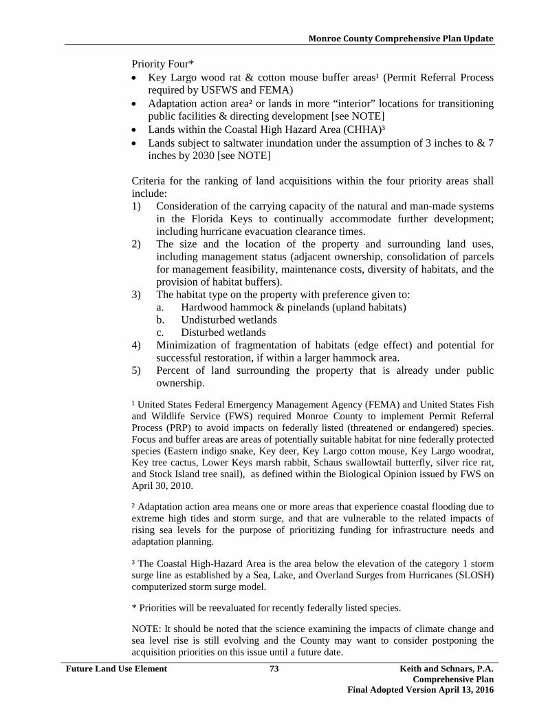
Monroe County Comprehensive Plan Update
Future Land Use Element 73 Keith and Schnars, P.A. Comprehensive Plan
Final Adopted Version April 13, 2016
Priority Four* • Key Largo wood rat & cotton mouse buffer areas¹ (Permit Referral Process
required by USFWS and FEMA) • Adaptation action area² or lands in more “interior” locations for transitioning
public facilities & directing development [see NOTE] • Lands within the Coastal High Hazard Area (CHHA)³ • Lands subject to saltwater inundation under the assumption of 3 inches to & 7
inches by 2030 [see NOTE] Criteria for the ranking of land acquisitions within the four priority areas shall include: 1) Consideration of the carrying capacity of the natural and man-made systems
in the Florida Keys to continually accommodate further development; including hurricane evacuation clearance times.
2) The size and the location of the property and surrounding land uses, including management status (adjacent ownership, consolidation of parcels for management feasibility, maintenance costs, diversity of habitats, and the provision of habitat buffers).
3) The habitat type on the property with preference given to: a. Hardwood hammock & pinelands (upland habitats) b. Undisturbed wetlands c. Disturbed wetlands
4) Minimization of fragmentation of habitats (edge effect) and potential for successful restoration, if within a larger hammock area.
5) Percent of land surrounding the property that is already under public ownership.
¹ United States Federal Emergency Management Agency (FEMA) and United States Fish and Wildlife Service (FWS) required Monroe County to implement Permit Referral Process (PRP) to avoid impacts on federally listed (threatened or endangered) species. Focus and buffer areas are areas of potentially suitable habitat for nine federally protected species (Eastern indigo snake, Key deer, Key Largo cotton mouse, Key Largo woodrat, Key tree cactus, Lower Keys marsh rabbit, Schaus swallowtail butterfly, silver rice rat, and Stock Island tree snail), as defined within the Biological Opinion issued by FWS on April 30, 2010. ² Adaptation action area means one or more areas that experience coastal flooding due to extreme high tides and storm surge, and that are vulnerable to the related impacts of rising sea levels for the purpose of prioritizing funding for infrastructure needs and adaptation planning. ³ The Coastal High-Hazard Area is the area below the elevation of the category 1 storm surge line as established by a Sea, Lake, and Overland Surges from Hurricanes (SLOSH) computerized storm surge model. * Priorities will be reevaluated for recently federally listed species. NOTE: It should be noted that the science examining the impacts of climate change and sea level rise is still evolving and the County may want to consider postponing the acquisition priorities on this issue until a future date.

Monroe County Comprehensive Plan Update
Future Land Use Element 74 Keith and Schnars, P.A. Comprehensive Plan
Final Adopted Version April 13, 2016
Policy 102.4.3 Monroe County shall maintain and implement a land acquisition program in recognition of the critical need for the County to aggressively address the imbalance between development expectations of private property owners and the finite carrying capacity of the natural and man-made systems in the Florida Keys. Pursuant to Section 380.0552, F.S. and Rule 28-20.140, F.A.C., this policy recognizes the public safety concern of maintaining a maximum hurricane evacuation clearance time of 24 hours.
Policy 102.4.4 The Monroe County Land Acquisition Master Plan shall contain an acquisition financing plan which identifies sources of funding for acquisition of lands on the Priority List. Land acquisition will be a coordinated effort between the state and federal governments and the County. The County shall annually petition the state and federal government to accept primary responsibility for acquisition of Tier I, conservation and natural lands and lands containing species listed under the Endangered Species Act. Monroe County shall support the efforts of federal agencies, state agencies, and private non-profit conservation organizations, to acquire land for conservation purposes. Policy 102.4.5 Lands acquired through the Monroe County Land Acquisition Program shall be managed to restore, preserve, and protect the conservation, recreation, safety, hazard reduction, density reduction and affordability purposes for which the lands were acquired. (See Recreation and Open Space Objective 1201.7 and related policies.) Policy 102.4.6 Within one year of the adoption of the 2030 Comprehensive Plan, Monroe County, in cooperation with the Land Authority, shall create a program to provide a monetary incentive to private property owners to deed restrict their privately-owned adjacent, vacant parcels to restrict residential development on the vacant parcels.
<The remainder of this page intentionally left blank>

Monroe County Comprehensive Plan Update
Future Land Use Element 75 Keith and Schnars, P.A. Comprehensive Plan
Final Adopted Version April 13, 2016
Objective 102.5 Development of the mainland area of Monroe County shall be controlled so as to reduce public expenditures and to preserve the natural, cultural and historic resources of the mainland area. [§163.3177(6)(a)3.f., F.S.]
Policy 102.5.1 Monroe County shall maintain land development regulations pertaining to the Mainland Native Area District which: 1. prohibit construction of any roads or canals in mainland Monroe County that
would permit new access into the mainland wilderness area or would alter the natural flow regimes of the Everglades or Big Cypress Swamp; and
2. prohibit development that would introduce human activities or habitations
into the undisturbed portions of Everglades National Park or Big Cypress Swamp National Preserve. [§163.3177(6)(a)3.f., F.S.]
<The remainder of this page intentionally left blank>

Monroe County Comprehensive Plan Update
Future Land Use Element 76 Keith and Schnars, P.A. Comprehensive Plan
Final Adopted Version April 13, 2016
Objective 102.6 Monroe County shall regulate land use activities on offshore islands within the legal boundaries of Monroe County. [§163.3177(6)(a)3.f., F.S.]
Policy 102.6.1 Within one (1) year of the adoption of the Plan, Monroe County shall adopt land development regulations which will further restrict the activities permitted on offshore islands. These shall include the following: 1. development shall be prohibited on offshore islands (including spoil islands)
which have been documented as an established bird rookery or nesting area based on resource agency best available data or surveys (See Conservation and Coastal Management Policy 206.1.2.);
2. new resource extraction pits shall be prohibited on offshore islands; 3. campgrounds and marinas shall not be permitted on offshore islands;
however, temporary primitive camping by the owner, in which no land clearing or other alteration of the island occurs, shall be the only use of an offshore island which may occur without necessity of a permit;
4. the use of any motorized vehicles including, but not limited to, trucks, carts,
buses, motorcycles, all-terrain vehicles and golf carts shall be prohibited on offshore islands that do not contain any development;
5. planting with native vegetation shall be encouraged whenever possible on
spoil islands; and 6. County public facilities and services, excluding electricity over which the
Public Services Commission of the State of Florida exercises jurisdiction, shall not be extended to offshore islands. The extension of public facilities shall be required to comply with Policy 101.12.2.
Policy 102.6.2 Monroe County shall discourage developments proposed on offshore islands by methods including, but not limited to, designating offshore islands as Tier I Lands.
<The remainder of this page intentionally left blank>

Monroe County Comprehensive Plan Update
Future Land Use Element 77 Keith and Schnars, P.A. Comprehensive Plan
Final Adopted Version April 13, 2016
Objective 102.7 Monroe County shall take actions to discourage new private development in areas designated as units of the Coastal Barrier Resources System (CBRS).
Policy 102.7.1 Monroe County shall discourage new developments which are proposed in units of the CBRS, including the assignment of negative points in the permit allocation system. Policy 102.7.2 Monroe County shall not create new access via new bridges, new causeways, new paved roads or new commercial marinas to or on units of the CBRS. This does not preclude the maintenance, repair and replacement of existing bridges, causeways, paved roads and lawful commercial marinas. Policy 102.7.3 Shoreline hardening structures, including seawalls, bulkheads, groins, rip-rap, etc., shall not be permitted along shorelines of CBRS units. Policy 102.7.4 Privately-owned undeveloped land located within the CBRS units shall be considered for acquisition by Monroe County for conservation purposes. Policy 102.7.5 Monroe County shall discourage the extension of public facilities and services provided by the FKAA and private providers of electricity and telephone service to undeveloped CBRS units by providing each of the utility providers with: 1. a map of the areas of Monroe County which are included in CBRS units; 2. a copy of the Executive Summary in Report to Congress: Coastal Barrier
Resources System published by the U.S. Department of the Interior, Coastal Barriers Study Group, which specifies restrictions to federally subsidized development in CBRS units; and
3. Monroe County policies regarding local efforts to discourage both private
and public investment in CBRS units.
<The remainder of this page intentionally left blank>

Monroe County Comprehensive Plan Update
Future Land Use Element 78 Keith and Schnars, P.A. Comprehensive Plan
Final Adopted Version April 13, 2016
Objective 102.8 Together with other responsible state and federal agencies, Monroe County shall continue to implement a cooperative land management program for publicly owned conservation lands. [§163.3177(6)(a)3.f. F.S.]
Policy 102.8.1 Monroe County shall discourage developments which are proposed in Tier I through the permit allocation system and the LDC. Policy 102.8.2 Monroe County, in cooperation with appropriate state and/or federal agencies, shall continue to develop overall management strategies for publicly owned conservation lands. Changes in specific management strategies may be modified as acquisitions continue and new information becomes available through biological research or monitoring.
<The remainder of this page intentionally left blank>

Monroe County Comprehensive Plan Update
Future Land Use Element 79 Keith and Schnars, P.A. Comprehensive Plan
Final Adopted Version April 13, 2016
GOAL 103 Monroe County shall implement regulations and programs to address the special environmental protection and/or traffic circulation needs of those areas of Big Pine Key, and North Key Largo. [§163.3177(6)(a)3.f. F.S.]
Objective 103.1 Monroe County shall regulate future development and coordinate the provision of public facilities on Big Pine Key and No Name Key, consistent with the Goals, Objectives, and Policies of this Comprehensive Plan, the Livable CommuniKeys Master Plan and the Habitat Conservation Plan, for Big Pine Key and No Name Key in order to:
1. protect the Key deer (Odocoileus virginianus clavium); 2. preserve and enhance the habitat of the Key deer; 3. limit the number of additional vehicular trips from other islands to Big Pine
Key and No Name Key; 4. maintain the rural, suburban, and open space character of Big Pine Key and
No Name Key; and 5. prevent and reduce adverse secondary and cumulative impacts on Key deer. Policy 103.1.1 Monroe County shall identify Key deer habitat areas as acquisition sites for conservation purposes, pursuant to Policy 102.4.2. Emphasis shall be placed upon acquisition of movement corridors, sources of fresh water, and undisturbed native vegetation areas which are located within Improved Subdivisions and which are outside of the acquisition areas identified by the USFWS (for the National Key Deer Refuge), FDEP (for the Coupon Bight CARL Project), and SFWMD (for the Big Pine Key Save Our Rivers project). (See Objective 102.4 and related policies.) Policy 103.1.2 Monroe County shall support, wherever possible, the efforts of federal agencies, state agencies, and private non-profit conservation organizations, to acquire land for conservation purposes within habitat areas of the Key deer. Policy 103.1.3 Monroe County, in conjunction with the USFWS, shall implement activities to prohibit the destruction of the federally-designated endangered Key deer and to protect its habitat by addressing: 1. enforcement of animal control laws; 2. incorporation of management guidelines into development orders;
Monroe County Comprehensive Plan Update
Future Land Use Element 80 Keith and Schnars, P.A. Comprehensive Plan
Final Adopted Version April 13, 2016
3. construction of fences; 4. roadside management techniques; 5. feeding laws; 6. speed limit enforcement; 7. removal of invasive plants; 8. distribution of management guidelines to private landowners; 9. attainment of Key deer management objectives; (See Conservation and
Coastal Management Objective 206.4 and supporting policies.) and 10. secondary and cumulative impacts by, among other things, adopting and
implementing appropriate land development regulations.
<The remainder of this page intentionally left blank>

Monroe County Comprehensive Plan Update
Future Land Use Element 81 Keith and Schnars, P.A. Comprehensive Plan
Final Adopted Version April 13, 2016
Objective 103.2 Monroe County, in coordination with the USFWS, shall regulate future development and coordinate the provision of public facilities in North Key Largo consistent with the Goals, Objectives and Policies of this Comprehensive Plan in order to maintain the rural and open space character of North Key Largo, as well as to preserve and enhance the habitat of animals listed as endangered under the Endangered Species Act, including, but not limited to the American crocodile (Crocodylus acutus), the Key Largo wood rat (Neotoma floridana smalli), the Key Largo cotton mouse (Peromyscus gossypinus allapaticola), and the Schaus swallowtail butterfly (Heraclides aristodemus ponceanus). North Key Largo is defined as that portion of Key Largo Located between the junction of State Road 905 and U.S. Highway 1 and the Miami-Dade County boundary at Angelfish Creek. [§163.3177(6)(a)3.f., F.S.]
Policy 103.2.1 Monroe County shall implement methods including, but not limited to, designating known habitat of the Schaus swallowtail butterfly as Tier I. [§163.3177(6)(a)3.f., F.S.] Policy 103.2.2 Monroe County shall maintain land development regulations pertaining to development siting and clustering so as to avoid impacts to sensitive habitat and to provide for the retention of contiguous open space by requiring the following: 1. when a parcel proposed for development contains more than one (1) habitat
type, all development shall be clustered on the least sensitive portion(s) of the parcel (as is currently required); and
2. development permitted on the least sensitive portion(s) of a parcel shall be
clustered within that portion(s) of the parcel. (See Conservation and Coastal Management Policy 205.2.3.)
Policy 103.2.3 Monroe County shall require that the following analyses be undertaken prior to finalizing plans for the siting of any new public facilities, excluding electricity over which the Public Services Commission of the State of Florida exercises jurisdiction, or the significant expansion (greater than 25 percent) of existing public facilities, excluding electricity over which the Public Services Commission of the State of Florida exercises jurisdiction: 1. assessment of needs; 2. evaluation of alternative sites and design alternatives for the selected sites;
and 3. assessment of impacts on surrounding land uses and natural resources.

Monroe County Comprehensive Plan Update
Future Land Use Element 82 Keith and Schnars, P.A. Comprehensive Plan
Final Adopted Version April 13, 2016
The assessment of impacts on surrounding land uses and natural resources will evaluate the extent to which the proposed public facility involves public expenditures in the coastal high hazard area and within environmentally sensitive areas, including disturbed salt marsh and buttonwood wetlands, undisturbed beach/berm areas, units of the Coastal Barrier Resources System, undisturbed uplands (particularly high quality hammocks and pinelands), habitats of species considered to be threatened or endangered by the state and/or federal governments, offshore islands, and Conservation Land Protection Areas. Monroe County shall require that public facilities be developed on the least environmentally sensitive lands and shall discourage the location of public facilities on North Key Largo, unless no feasible alternative exists and such facilities are required to protect the public health, safety, or welfare. Policy 103.2.4 Monroe County shall implement activities to protect the habitat and prohibit the destruction of the: 1. American crocodile (See Conservation and Coastal Management Objective
206.5 and supporting policies); 2. Schaus swallowtail butterfly (See Conservation and Coastal Management
Objective 206.7 and related policies); 3. the Key Largo wood rat and the Key Largo cotton mouse (See Conservation
and Coastal Management Objective 206.9 and related policies.) and 4. known locations of Stock Island tree snail (See Conservation and Coastal
Management Objective 206.8 and related policies). [§163.3177(6)(a)3.f F.S.]
Policy 103.2.5 Monroe County shall identify native upland habitats used by the Schaus swallowtail butterfly and the Key Largo wood rat and the Key Largo cotton mouse as acquisition sites for conservation purposes, pursuant to Policy 102.4.2. Emphasis shall be placed upon acquisition of native upland sites which are located within Improved Subdivisions and which are outside of the acquisition areas identified by other resource agencies. Policy 103.2.6 Monroe County shall support, wherever possible, the efforts of federal agencies, state agencies, and private non-profit conservation organizations, to acquire land for conservation purposes within North Key Largo. [§163.3177(6)(a)3.f., F.S.]

Monroe County Comprehensive Plan Update
Future Land Use Element 83 Keith and Schnars, P.A. Comprehensive Plan
Final Adopted Version April 13, 2016
Policy 103.2.7 Monroe County shall take immediate actions to discourage private development in areas designated as units of the CBRS. (See Objective 102.7 and related policies.) Policy 103.2.8 Monroe County, in conjunction with the USFWS, shall implement activities to prohibit the destruction of the federally-designated threatened and endangered species and to protect its habitat by addressing: 1. enforcement of animal control laws; 2. construction of fences; 3. roadside management techniques; 4. feeding laws; 5. speed limit enforcement; 6. removal of invasive plants; 7. distribution of management guidelines to private landowners; and 8. attainment of endangered species management objectives.
<The remainder of this page intentionally left blank>

Monroe County Comprehensive Plan Update
Future Land Use Element 84 Keith and Schnars, P.A. Comprehensive Plan
Final Adopted Version April 13, 2016
GOAL 104 Monroe County shall recognize, designate, protect, and preserve its historic resources. [§163.3177(6)(a)3.f., F.S.]
Objective 104.1 Monroe County shall maintain a comprehensive inventory of historical and archaeological resources within unincorporated Monroe County.
Policy 104.1.1 The Monroe County Growth Management Division shall maintain an inventory of all known historical and archaeological resources through use of the Florida Master Site File maintained by Florida’s Division of Historical Resources, as documented in the “Future Land Use Element” of the Monroe County Comprehensive Plan Technical Document Update, May 2010. Policy 104.1.2 The Monroe County Growth Management Division shall update the inventory of historical and archaeological resources as new historical and archaeological resources are identified, by completing and submitting necessary documentation to the Division of Historical Resources for new resources’ inclusion in the Florida Master Site File. Landowners and other interested parties may also add historical and archaeological resources to the inventory.
<The remainder of this page intentionally left blank>
Monroe County Comprehensive Plan Update
Future Land Use Element 85 Keith and Schnars, P.A. Comprehensive Plan
Final Adopted Version April 13, 2016
Objective 104.2 Monroe County shall formally recognize significant historical and archaeological resources by designating them as local historic, cultural and/or archaeological landmarks/districts on the Florida Keys Historic Register and/or supporting the nomination of appropriate resources to the National Register of Historic Places.
Policy 104.2.1 Monroe County shall maintain land development regulations which define the procedures for designating resources as local historic, cultural and archaeological landmarks/districts on the Florida Keys Historic Register. The Land Development Code shall: 1. authorize a Florida Keys Historic Register to which local historic, cultural
and archaeological landmarks/districts are named; 2. authorize a review committee and provide for an historic/archaeological
review of resources nominated to the Florida Keys Historic Register; 3. list the criteria and procedure for selecting a review committee; 4. specify criteria and procedures for designating significant historic and
archaeological resources as local historic, cultural and archaeological landmarks on the Florida Keys Historic Register, guided by the criteria for designation to the National Register of Historic Places;
5. include procedures for designation of local historic districts and Historic (H)
overlay zones on the FLUM; and 6. provide for the documentation and protection of sites which are not
designated as local historic, cultural and archaeological landmarks but are discovered through the development process or otherwise discovered.
Policy 104.2.2 Annually, all historical and archaeological resources that are listed on the National Register of Historic Places shall be considered by the review committee for designation as local historic, cultural and/or archaeological landmarks on the Florida Keys Historic Register. Policy 104.2.3 The Monroe County Growth Management Division shall provide information and technical assistance to property owners who wish to prepare nominations to the Florida Keys Historic Register. Policy 104.2.4 Monroe County may nominate or support nominations of additional historic resources to the National Register of Historic Places as needed. [§163.3177(6)(a)3.f., F.S.]

Monroe County Comprehensive Plan Update
Future Land Use Element 86 Keith and Schnars, P.A. Comprehensive Plan
Final Adopted Version April 13, 2016
Objective 104.3 Monroe County shall adopt and implement measures for the protection and preservation of designated local historic, cultural and archaeological landmarks/districts.
Policy 104.3.1 Monroe County shall maintain land development regulations that provide protection for designated local historic, cultural and archaeological landmarks/districts listed on the Florida Keys Historic Register. The adopted LDC shall: 1. authorize a historic/archaeological review board to review development
proposals which impact designated local historic, cultural and archaeological landmarks/districts;
2. list the qualifications and selection criteria for review board members; 3. specify the restrictions on archaeological sites resulting from local
designation. Establish standards to address the siting and design of proposed developments to minimize impacts on archaeological resources, and the proper documentation and recording of the site including retrieving of artifacts;
4. specify the restrictions on the demolition and alteration of historic structures
resulting from local designation. Establish standards to evaluate alterations to historic structures which are consistent with the U.S. Department of the Interior's "Standards for Rehabilitation";
5. specify the restrictions on historic districts resulting from local designation.
Establish exterior architectural standards to evaluate development proposals within designated historic districts with the intent of encouraging compatibility with the architectural features of historic significance to the particular district;
6. establish a procedure for reviewing development and redevelopment
proposals which impact designated local historic, cultural and archaeological landmarks/districts ;
7. specify procedures where development activities uncover unknown
archaeological resources; 8. provide procedures for enforcement and consequences of non-compliance; 9. provide incentives such as transfer of development rights, tax credits, tax
relief, special property tax assessments, building code waivers, building application fee exemptions, zoning variances, and FEMA exemptions to encourage the conservation and rehabilitation of privately-owned designated local historic, cultural or archaeological landmarks; and

Monroe County Comprehensive Plan Update
Future Land Use Element 87 Keith and Schnars, P.A. Comprehensive Plan
Final Adopted Version April 13, 2016
10. specify permitting and review procedures that reconcile redevelopment of
designated local historic, cultural and archaeological landmarks with their potential nonconforming status.
Policy 104.3.2 Monroe County shall establish architectural guidelines for each designated historic district listed on the Florida Keys Historic Register. These guidelines shall be drafted by the nominating agency, and shall be approved by a qualified historic preservation professional. The guidelines shall be reviewed and approved by Monroe County within one year of acceptance of the district on the Florida Keys Historic Register.
<The remainder of this page intentionally left blank>

Monroe County Comprehensive Plan Update
Future Land Use Element 88 Keith and Schnars, P.A. Comprehensive Plan
Final Adopted Version April 13, 2016
Objective 104.4 Monroe County shall adopt and implement measures for the protection and preservation of historic resources on public lands. [§163.3177(6)(a)3.f., F.S.]
Policy 104.4.1 Monroe County shall coordinate with the lessee of Pigeon Key to ensure that the renovation and use of the County-owned island retains the historical and architectural character of the site, and allows a reasonable amount of public access. Policy 104.4.2 Monroe County shall coordinate with county, state and federal agencies to identify, monitor and protect historic resources located on public lands (See Future Land Use Objective 102.8 and related policies). [§163.3177(6)(a)3.f., F.S.] Policy 104.4.3 Development plans on County-owned lands which contain designated local historic, cultural and archaeological landmarks listed on the Florida Keys Historic Register shall be subject to review by the historic/archaeological review board established pursuant to Policy 104.3.1(1). [§163.3177(6)(a)3.f., F.S.] Policy 104.4.4 Monroe County shall increase its participation in the resource planning of federal and state owned parks, wildlife refuges, military installations and other state or federal properties. Monroe County shall review resource plans, development plans and master plans prepared for these areas, evaluate impacts on historic resources, and submit comments to the appropriate agencies. [§163.3177(6)(a)3.f., F.S.] Policy 104.4.5 Through a lease agreement, Monroe County shall require that the lessee of Pigeon Key or any other County-owned local historic, cultural or archaeological landmark designated on the Local or National Register: 1. conform, at a minimum, to the Secretary of the Interior's Standards for
Rehabilitation for any permanent or temporary development of the site; and 2. retain the historical, architectural, and/or archaeological integrity of the site,
as approved by a professional who meets the appropriate Professional Qualifications specified in the Code of Federal Regulations, Section 61, Number 36. [§163.3177(6)(a)3.f., F.S.]
Policy 104.4.6 Before the County may sell Pigeon Key, Monroe County shall develop and adopt architectural guidelines for this National Register Historic District.

Monroe County Comprehensive Plan Update
Future Land Use Element 89 Keith and Schnars, P.A. Comprehensive Plan
Final Adopted Version April 13, 2016
Objective 104.5 Monroe County shall seek to increase public awareness and appreciation of the historic resources and historic preservation activities in the County. [§163.3177(6)(a)3.f., F.S.]
Policy 104.5.1 Monroe County shall coordinate with the following organizations and individuals to identify opportunities for joint public education and funding efforts: 1. Local preservation groups in unincorporated Monroe County; 2. The Key West historic preservation planner and other historic preservation
leaders; 3. Historic Florida Keys Foundation; 4. Federal agencies including the National Park Service, U.S. Fish and Wildlife
Service, and NOAA; 5. State Agencies including the FDEP Division of Parks and Recreation, and
Division of Historical Resources; 6. Florida Trust for Historic Preservation; 7. Monroe County School Board; and 8. Local libraries. Policy 104.5.2 Monroe County shall continue to seek funding from the Tourist Development Council to create and implement a historic marker program and a historic map/guide to increase public awareness and appreciation of the County's history and historic resources. Policy 104.5.3 Monroe County shall promote public knowledge of local, state and federal programs and incentives designed to assist owners of historic properties. [§163.3177(6)(a)3.f., F.S.] Policy 104.5.4 Monroe County shall identify community leaders with an interest in historic preservation and provide technical assistance for the formation of new citizen-based historic preservation groups. These groups will aid the County in generating interest and raising funds for local historic preservation activities.

Monroe County Comprehensive Plan Update
Future Land Use Element 90 Keith and Schnars, P.A. Comprehensive Plan
Final Adopted Version April 13, 2016
Objective 104.6 Monroe County shall coordinate with public agencies and non-profit organizations to protect, preserve and increase awareness of historic resources. [§163.3177(6)(a)3.f., F.S.]
Policy 104.6.1 Monroe County shall involve local historic preservation groups in the planning process. The County will apprise groups of historic preservation planning efforts, request their comments and solicit their support. Policy 104.6.2 Monroe County shall include archaeological sites identified by local historic preservation groups on the priority list of Natural Heritage and Park acquisition sites. Policy 104.6.3 Monroe County shall encourage and facilitate acquisition of historic sites suitable for cultural, tourism, recreation or conservation uses by federal, state and local agencies, non-profit historic preservation groups, and non-profit conservation organizations Policy 104.6.4 Monroe County shall assist property owners of historically or architecturally significant structures in applying for and utilizing state and federal assistance programs.
<The remainder of this page intentionally left blank>

Monroe County Comprehensive Plan Update
Future Land Use Element 91 Keith and Schnars, P.A. Comprehensive Plan
Final Adopted Version April 13, 2016
GOAL 105 Monroe County shall maintain a comprehensive land acquisition program and smart growth initiatives in conjunction with its Livable CommuniKeys Program in a manner that recognizes the finite capacity for new development in the Florida Keys by providing economic and housing opportunities for residents without compromising the biodiversity of the natural environment and the continued ability of the natural and man-made systems to sustain livable communities in the Florida Keys for future generations.
Objective 105.1 Monroe County shall continue to implement smart growth initiatives in conjunction with its Livable CommuniKeys and Land Acquisition Programs which promote innovative and flexible development processes to preserve the natural environment, maintain and enhance the community character and quality of life, redevelop blighted commercial and residential areas, remove barriers to design concepts, reduce sprawl, and direct future growth to appropriate infill areas. [§163.3177(6)(a)2.e., F.S.]
Policy 105.1.1 Monroe County shall create an economic development framework for a sustainable visitor-based economy, not dependent on growth in the absolute numbers of tourists that respects the unique character and outdoor recreational opportunities available in the Florida Keys. Within three (3) years after the adoption of the 2030 Comprehensive Plan, the County will, with input from the business community and other stakeholders, develop an Economic Sustainability Element, which focuses upon and promotes redevelopment, considers the increasing cost of climate adaptation and the protection of property. Policy 105.1.2 Monroe County shall enforce the design guidelines established within the Livable CommuniKeys Plans and its land development regulations which ensure that future uses and development are compatible with scenic preservation and maintenance of the character of the casual island village atmosphere of the Florida Keys. Policy 105.1.3 Monroe County shall, through its development standards and Land Development Code, continue to foster the retention and redevelopment of small businesses on the U.S.1. Policy 105.1.4 Within one (1) year after the adoption of the 2030 Comprehensive Plan, Monroe County shall prepare redevelopment standards and within one year afterwards, shall amend the LDC to address the large number of nonconforming commercial structures that are non-compliant as to on-site parking, construction and shoreline setbacks, stormwater management, landscaping and buffers. By identifying the existing character and constraints of the different island communities, regulations can be adopted that provide incentives for redevelopment and permit the continuance of businesses while moving towards an integrated streetscape.

Monroe County Comprehensive Plan Update
Future Land Use Element 92 Keith and Schnars, P.A. Comprehensive Plan
Final Adopted Version April 13, 2016
Policy 105.1.5 Monroe County shall maintain a residential permit allocation system that directs the preponderance of future residential development to areas designated as Tier III in accordance with Policy 105.6.4.
<The remainder of this page intentionally left blank>

Monroe County Comprehensive Plan Update
Future Land Use Element 93 Keith and Schnars, P.A. Comprehensive Plan
Final Adopted Version April 13, 2016
Objective 105.2 Monroe County shall maintain, with assistance of the state and federal governments, a 20-year Land Acquisition Program to: 1) secure funding for environmentally sensitive lands; 2) retire development rights on privately-owned vacant lands to limit further sprawl and equitably balance the rights of property owners with the long-term sustainability of the Keys man-made and natural systems; and, 3) secure and retain lands suitable for affordable housing. This objective recognizes the finite limits of the carrying capacity of the natural and man-made systems in the Florida Keys to continually accommodate further development and the need for the significant expansion of the public acquisition of vacant developable lands and development rights to equitably balance the rights and expectations of property owners. This includes the recognition that Monroe County must ensure public safety through the ability to maintain a 24-hour hurricane evacuation clearance time.
Policy 105.2.1 Monroe County shall designate all lands outside of mainland Monroe County, except for the Ocean Reef planned development, into three general categories for purposes of its Land Acquisition Program and smart growth initiatives in accordance with the criteria in Policy 205.1.1. These three categories are: Natural Area (Tier 1); Transition and Sprawl Reduction Area (Tier II) on Big Pine Key and No Name Key only; and Infill Area (Tier III). The purposes, general characteristics, and growth management approaches associated with each tier are as follows: 1. Natural Area (Tier I): Any defined geographic area where all or a significant
portion of the land area is characterized as environmentally sensitive by the policies of this Plan and applicable habitat conservation plan, is to be designated as a Natural Area. New development on vacant land is to be severely restricted and privately owned vacant lands are to be acquired or development rights retired for resource conservation and passive recreation purposes. However, this does not preclude provisions of infrastructure for existing development. Within the Natural Area designation are typically found lands within the acquisition boundaries of federal and state resource conservation and park areas, including isolated platted subdivisions; and privately-owned vacant lands with sensitive environmental features outside these acquisition areas.
2. Transition and Sprawl Reduction Area (Tier II): Any defined geographic area on Big Pine Key and No Name Key, where scattered groups and fragments of environmentally sensitive lands, as defined by this Plan, may be found and where existing platted subdivisions are not predominately developed, not served by complete infrastructure facilities, or not within close proximity to established commercial areas, is to be designated as a Transition and Sprawl Reduction Area. New development is to be discouraged and privately owned vacant lands acquired or development rights retired to reduce sprawl, ensure that the Keys carrying capacity is not exceeded, and prevent further encroachment on sensitive natural resources. Within a Transition and Sprawl Reduction Area are typically found:

Monroe County Comprehensive Plan Update
Future Land Use Element 94 Keith and Schnars, P.A. Comprehensive Plan
Final Adopted Version April 13, 2016
scattered small nonresidential development and platted subdivisions with less than 50 percent of the lots developed; incomplete infrastructure in terms of paved roads, potable water, or electricity; and scattered clusters of environmentally sensitive lands, some of which are within or in close proximity to existing platted subdivisions.
3. Infill Area (Tier III): Any defined geographic area, where a significant portion of land area is not characterized as environmentally sensitive as defined by this Plan, except for dispersed and isolated fragments of environmentally sensitive lands of less than four acres in area, where existing platted subdivisions are substantially developed, served by complete infrastructure facilities, and within close proximity to established commercial areas, or where a concentration of nonresidential uses exists, is to be designated as an Infill Area. New development and redevelopment are to be highly encouraged, except within tropical hardwood hammock or pineland patches of an acre or more in area, where development is to be discouraged. Within an Infill Area are typically found: platted subdivisions with 50 percent or more developed lots situated in areas with few sensitive environmental features; full range of available public infrastructure in terms of paved roads, potable water, and electricity; and concentrations of commercial and other nonresidential uses within close proximity. In some Infill Areas, a mix of nonresidential and high-density residential uses (generally 8 units or more per acre) may also be found that form a Community Center.
Policy 105.2.2 Monroe County shall maintain overlay map(s) designating geographic areas of the County as one of the Tiers in accordance with the guidance in Policy 105.2.1, which shall be incorporated as an overlay on the zoning map(s) with supporting text amendments in the Land Development Regulations. These maps are to be used to guide the Land Acquisition Program and the smart growth initiatives in conjunction with the Livable CommuniKeys Program (Policy 101.19.1). Policy 105.2.3 The priority for acquisition of lands and development rights under the County’s Land Acquisition Program shall follow the priority categories within Policy 102.4.2. Policy 105.2.4 The preferred method for acquisition of environmentally sensitive privately owned vacant non-platted lands shall be fee simple purchase, donation, or dedication or the retirement of development rights through transfer of development rights or similar mechanisms.

Monroe County Comprehensive Plan Update
Future Land Use Element 95 Keith and Schnars, P.A. Comprehensive Plan
Final Adopted Version April 13, 2016
Policy 105.2.5 The preferred method for acquisition of vacant platted lots shall be fee simple
purchase, donation, or dedication or the retirement of development rights thorough transfer of development rights or similar mechanisms; however, wherever appropriate, platted lots may be purchased in partnership with adjoining property owner(s) subject to a conservation easement that may allow limited residential accessory uses. Policy 105.2.6 Monroe County shall, in coordination with private sources, federal and state agencies, implement a land acquisition program to acquire lands which enhance public access to the shoreline and water-dependent uses, such as beaches, marinas, docks and lands; however, Monroe County Land Authority funds shall not be used for this purpose. Policy 105.2.7 In implementing this Land Acquisition Program, Monroe County is only committed or financially obligated to the extent that local, state, and federal funds are available. Monroe County shall petition the federal and state governments to aggressively pursue the acquisition of all remaining privately-owned vacant lands within their park and conservation acquisition boundaries and to expand existing acquisition boundaries to include other lands in close proximity with similar environmentally sensitive features. Policy 105.2.8 With respect to the relief granted pursuant to Policy 101.7 (Administrative Relief) or Policy 101.17.4 (Beneficial Use), a purchase offer shall be the preferred form of relief for any land within Tier I and Tier II, Tier III-A or any land within Tier III in accordance with the criteria in Policy 101.7.1. Policy 105.2.9 By May 2015, the County shall explore additional funding sources for land acquisition. Monroe County is only committed or financially obligated to the extent that local, state, and federal funds are available. Policy 105.2.10 Monroe County shall identify and secure possible local sources to yield a steady source of funds and secure increased funding from state and federal, and/or private sources for the Land Acquisition Program and the management and restoration of acquired resource conservation lands. With the uncertainty concerning the County’s ability to successfully secure sufficient funding from state and federal governments for their fair share of the financial support for the Land Acquisition Program and the demands placed on the County’s limited financial resources to address wastewater and other critical issues, it is recognized that the Land Acquisition Program may extend well beyond 20 years.

Monroe County Comprehensive Plan Update
Future Land Use Element 96 Keith and Schnars, P.A. Comprehensive Plan
Final Adopted Version April 13, 2016
GOAL 106 Monroe County shall continue to maintain the Tier System to ensure growth initiatives recognize the natural and man-made systems in the Florida Keys, the carrying capacity to accommodate further development, the need for the significant expansion of the public acquisition of vacant developable lands, and to equitably balance the rights and expectations of private property owners.
Objective 106.1 Monroe County shall adjust the tier boundaries and implement the Florida Keys Carrying Capacity Study, utilizing updated habitat data and recommendations of the Tier Designation Review Committee (TDRC) Work Group. [Note: As amended by Final Order DCA07-GM166, parcels included in the challenge with Tier I and Tier IIIA (SPA) boundaries have been adjusted to reflect the amended Tier Criteria resulting from the DOAH Case 06-2449(GM)].
Policy106.1.1 Monroe County shall update habitat data and the Land Development Code Tier (Zoning) Overlay District Maps to coincide with the State comprehensive plan evaluation and appraisal schedule (May 1, 2021). Policy 106.1.2 Monroe County shall establish a Tier Designation Review Committee (TDRC) Work Group to consist of representatives selected by the Florida Department of Economic Opportunity (DEO) from Monroe County, Florida Fish & Wildlife Conservation Commission, United States Fish & Wildlife Service, Department of Environmental Protection and environmental and other relevant interests. The TDRC shall be tasked with the responsibility of tier designation review utilizing the criteria for tier placement and best available data to recommend amendments to ensure implementation of and adherence to the Florida Keys Carrying Capacity Study. These proposed Land Development Code Tier (Zoning) Overlay District Map amendments shall coincide with the State comprehensive plan evaluation and appraisal schedule (May 1, 2021). Each comprehensive plan evaluation and appraisal submitted shall also include an analysis and recommendations based upon the TDRC review process. Policy 106.1.3 Prior to Monroe County processing updates to the Land Development Code Tier (Zoning) Overlay District Map, the County shall evaluate the listed threatened and endangered species (as of 2021) and the criteria included in Policy 205.1.1 to determine if amendments are required to further protect and enhance native upland vegetation. Any Tier (Zoning) Overlay District Map amendment completed prior to May 1, 2021 shall be processed according to state law and the Land Development Code.

Monroe County Comprehensive Plan Update
Future Land Use Element 97 Keith and Schnars, P.A. Comprehensive Plan
Final Adopted Version April 13, 2016
REAL ESTATE NUMBER
TOTAL ACREAGE
ACRES FLUM
DESIGNATION
CONSERVATION EASEMENT ACREAGE
BERM TO BE LOCATED ON
PARCEL0.79 N/A N/A
8.46Ramrod Key
Mixed Use Area 1
N/A x
8.87 RC 8.87
00114150-000400 2.6 2.6Ramrod Key
Mixed Use Area 1
0
00114150-000000 18.12
GOAL 107 Monroe County shall regulate land use and development activities of scarified portions of property with 50 percent or more environmentally sensitive land that contains an existing nonconforming use by the enactment of area-specific regulations that allow development to occur subject to limitations and conditions designed to protect natural resources. For this Goal to be used, scarified portions of property shall not have been created purposefully without benefit of permit(s) as evidenced by pictorial aerial examination and/or other means available to the Growth Management Division. (Ordinance 023-2011)
Objective 107.1 Monroe County shall coordinate land use with the elements of the Comprehensive Plan through Future Land Use Element subarea policies solely applicable to a specific geographic area. These subarea policies identify parcels of land that require narrowly-tailored regulation in order to confine development potential to an area or extent less than the maximum development potential allowed by its underlying Future Land Use Map category. The development parameters established for each subarea shall be based either on an inventory of uses and facilities established on the parcel or by data and analysis supporting the specific subarea limitations. Environmentally sensitive areas shall be preserved through the application of such methods as conservation easements that require mandatory eradication of exotic invasive vegetation. (Ordinance 023-2011)
Policy 107.1.1 Reserved Policy 107.1.2 Ramrod Key Mixed Use Area 1 Only the land uses listed in paragraphs 1-4 below shall be allowed on the parcels shown in the table following as Ramrod Key Mixed Use Area 1:
And on which a concentration of non-residential uses exists, including approximately 15,325 square feet of commercial floor area devoted to the uses listed below.

Monroe County Comprehensive Plan Update
Future Land Use Element 98 Keith and Schnars, P.A. Comprehensive Plan
Final Adopted Version April 13, 2016
1. Storage, warehousing, and processing of equipment and materials utilized or generated in construction, demolition and land clearing, together with ancillary activities, including, but not limited to: a. Administrative offices. b. Workshops and equipment maintenance areas, outdoors and within
structures. c. Garages and outdoor parking for construction and demolition equipment
and machinery. d. Outdoor and covered storage and processing of demolition debris and
construction materials. e. Storage buildings. f. Above-ground fuel tanks.
2. An antenna supporting structure with accessory building. 3. Residential uses consistent with the former RL future land use map
designation and with SS zoning. Single family residences shall be limited to the existing (including any replacement thereof) and no more than four (4) additional single family residences.
4. Outdoor storage, refinishing, repair and/or rebuilding of vehicles, boats and trailers that do not constitute a heavy industrial use.
Development of the Ramrod Key Mixed Use Area 1 shall be subject to the restrictions set out below:
1. Wetlands and hammock areas adjacent to outdoor storage shall be protected
by:
a. Recordation of a conservation easement prohibiting all development activities on the approximately 8.87 acres of wetlands within the Easterly portion of parcel 00114150-000000. The area to be conserved is delineated on the map below.
b. Construction and maintenance of a berm, no less than 3 feet in height, on
scarified land along the Westerly edge of the wetlands portion of parcel 00114150-000000 as depicted on the map below, to protect the wetlands from stormwater runoff. Prior to issuing any permit for berm construction, Monroe County shall require submission of a stormwater management plan adequate to protect the wetlands portion of the parcel from degradation attributable to stormwater runoff from the adjacent scarified portion utilized for outdoor storage, construction, and demolition activities.

Monroe County Comprehensive Plan Update
Future Land Use Element 99 Keith and Schnars, P.A. Comprehensive Plan
Final Adopted Version April 13, 2016
2. Development shall be contingent on any required coordination and/or approval from the United States Fish & Wildlife Service. (Ord. 028-2010).
Policy 107.1.3 Specific Limitations on Key Largo Mixed Use Area 1
The Key Largo Mixed Use Area 1 has a concentration of nonresidential uses currently existing, including approximately 2,968ft2 of commercial floor area. The current Real Estate Parcel number is 00440100.000000, contains 0.62 acres and is legally described as:
Lots 13, 14, 15, 16, 17 and 18, , Block 2, THOMPSONS SUBDIVISION, Section “A”, according to the plat thereof, as recorded in Plat Book 1, at Page 147, of the Public Records of Monroe County, Florida; and the East 10 feet of that portion of Fisherman’s Trail, adjacent and contiguous to the West boundary line of Lots 15 and 16, Block 2, lying between the North Line of Sailfish Trail and the Southeasterly Right-of-Way line of Old State Road 4A, in Thompsons Subdivision, Section “A”, according to the plat thereof, as recorded in Plat Book 1, at Page 147, of the Public Records of Monroe County, Florida.
Development in the Key Largo Mixed Use Area 1 shall be subject to regulations applicable to the Mixed Use/Commercial (MC) Future Land Use Designation as well as the additional restrictions set out below: 1. The maximum commercial floor area ratio of 0.30. 2. There shall be no residential units. (Ord. 021-2010).

Monroe County Comprehensive Plan Update
Future Land Use Element 100 Keith and Schnars, P.A. Comprehensive Plan
Final Adopted Version April 13, 2016
Policy 107.1.4 Paradise Pit Subarea 1 - Specific Limitations on the Industrial and Conservation Area in Key Largo The Paradise Pit Industrial and Conservation Area in Key Largo has a concentration of nonresidential uses currently existing, including a lawful light industrial use. The parcel’s current real estate number is 00087100.000500. The parcel has a Tier Designation of Tier I and the parcel is 59.01 acres, including a 9.71 acre borrow pit (water). Pursuant to this subarea policy, the parcel shall have Future Land Use Map (FLUM) designations as follows:
In order to balance the protection of environmental resources, historical resources and support a sound and diverse economic base, development shall be subject to the Industrial Future Land Use Map Designation and the Conservation Future Land Use Map Designation as well as the additional site-specific regulations and restrictions set out below:

Monroe County Comprehensive Plan Update
Future Land Use Element 101 Keith and Schnars, P.A. Comprehensive Plan
Final Adopted Version April 13, 2016
Industrial FLUM Area Conservation FLUM Area
Residential development shall not be permitted. Residential development shall not be permitted.
Any proposed nonresidential development shall be limited to the existing cleared area adjacent to the borrow pit (5.2 acres of scarified area) and the existing cleared area in the NW corner of the parcel (1.7 acres of scarified area).
-Existing cleared areas are identified on the map above.
Archeological/Historical resource shall be fenced.
Both the Industrial FLUM Area and the Conservation FLUM Area
Wetland and Upland vegetative communities shall be protected by: -No industrial activities shall be expanded into the native vegetation. -The creation and maintenance of a 20ft buffer vegetated with native vegetation around the perimeter of the borrow pit. -The maintenance of signage every 100 feet along the perimeter of the scarified areas to ensure no further encroachment into the adjacent native vegetation.
The existing carport structure (labeled with the letter “C” on the map above) shall be allowed to continue only for the use of parking vehicles associated with lawful uses on the site. No further clearing around the carport structure shall be permitted. Reasonable ingress and egress to the industrial area shall be permitted, including the maintenance of the “road” around the borrow pit provided there are no impacts to the required vegetated buffer or cause further encroachment into the native habitat. Clearing for an access drive of reasonable configuration up to 18 feet in width is permitted to provide reasonable access to the cleared (scarified) portion in the NW corner of the property and shall be exempt from the maximum clearing limit. The access drive shall be configured to follow the previously cleared drive as closely as possible.
(Ordinance 007-2014)

Monroe County Comprehensive Plan Update
Future Land Use Element 102 Keith and Schnars, P.A. Comprehensive Plan
Final Adopted Version April 13, 2016
Policy 107.1.5 Specific Limitations on Key Largo Mixed Use Area 2 Development in the Key Largo Mixed Use Area 2 shall be subject to regulations applicable to the Mixed Use/Commercial (MC) Future Land Use Designation as well as the additional restriction set out below: Consistent with Policy 101.4.20, in order to implement the Florida Keys Carrying Capacity Study, maintain the overall County density and the preservation of native habitat, this site/property shall not increase its allocated density and allowable development potential for permanent residential units. The following development controls shall apply:
1. The allocated density for permanent residential uses on the site shall remain 0.50 dwelling units per acre.
The Key Largo Mixed Use Area 2, having Real Estate Numbers 00091000.000000 and 00091020.000000, is approximately 2.28 acres of land and is legally described as: A tract of land 48.9 feet wide, and part of Lot 10 according to George McDonald’s Plat of part of Section 5, Township 62, Range 39, on Key Largo as recorded in Plat Book 1, at Page 59 of the Public Records of Monroe County, Florida, more particularly described as follows; From the dividing line between Lots 10 and 11, according to said Plat Book 1, Page 59, run Southwesterly along the Northwesterly right of way line of State Road 5 (Overseas Highway) a distance of 515 feet to the Point of Beginning of the tract hereafter described, thence Northwesterly at right angles to said Northwesterly right of way line a distance of 487.7 feet, more or less to the shore of Florida Bay, thence along the shore of Florida Bay in the Northeasterly right of way line, distance of 48.9 feet to the point of beginning, and A tract of land 95 feet wide and part of Lot 10 according to George McDonald’s Plat of part of Section 5, Township 62, Range 39, on Key Largo as recorded in Plat Book 1, at Page 59 of the Public Records of Monroe County, Florida, more particularly described as follows; From the dividing line between Lots 10 and 11, according to said Plat Book 1, Page 59, run Southwesterly along the Northwesterly right of way line of State Road 5 (Overseas Highway) a distance of 515 feet to the Point of Beginning of the tract hereafter described, thence continue Southwesterly along the Northwesterly right of way line of State Road No. 5, a distance of 95 feet, thence northwesterly at right angles 695.1 feet, thence Northeasterly along a bulkhead line to a point 687.7 feet North of the Point of Beginning, thence Southeasterly 687.7 feet to the Pont of Beginning. (Ordinance 011-2016)

Monroe County Comprehensive Plan Update
Future Land Use Element 103 Keith and Schnars, P.A. Comprehensive Plan
Final Adopted Version April 13, 2016
Policy 107.1.6 Big Coppitt Mixed Use Area 1 -To Provide Limitations on Development and Specific Restrictions Development in the Big Coppitt Mixed Use Area 1 shall be subject to regulations applicable to the Mixed Use/Commercial (MC) Future Land Use Designation as well as an additional restriction set out below: 1. Residential units developed on the Big Coppitt Mixed Use Area 1 shall be
restricted to affordable housing only (with a minimum mix of at least 10% median and at least a 20% combination of low and very low income categories) and subject to affordable housing regulations pursuant to Section 130-161 of the Monroe County Code of Ordinances.
2. There shall be no nonresidential uses. Accessory uses to the residential development, such as a club house or recreational facilities are permitted.
3. There shall be no market rate or transient residential units. 4. There shall be no dredging. 5. All habitable buildings located within the 65-69 DNL (Day-Night Average
Sound Level) noise contour pursuant to the 2013 Navy Environmental Impact Statement shall be sound attenuated to achieve an indoor Noise Level Reduction of at least 25 decibels.
6. No residential buildings shall be located within the 70-74 DNL. 7. Any development located within the Big Coppitt Mixed Use Area 1 shall not
utilize Puerta Drive for ingress and egress. 8. All habitable buildings located within the 70-74 DNL noise contour pursuant
to the 2013 Navy Environmental Impact Statement shall be sound attenuated to achieve an indoor Noise Level Reduction of at least 30 decibels.
9. A development agreement shall be required for any proposed development of an affordable housing project within the Big Coppitt Mixed Use Area 1 and to evaluate the ingress and egress of the development proposal.
The Big Coppitt Mixed Use Area 1, with Real Estate No. 00120940-000100 is approximately 14.8 acres of vacant land and is legally described as: PARCEL "A" A parcel of land as described in Official Records Book 1884, Page 1226 of the Public Records of Monroe County, Florida being a part of Government Lot 1, Section 21, Township 67 South, Range 26 East on Big Coppitt Key, Monroe County, Florida described as follows: BEGIN at the southwest corner of Block 9 of "GULFREST PARK PLAT NO. 2" according to the plat thereof as recorded in Plat Book 4 at Page 157 of the Public Records of Monroe County, Florida and run thence South a distance of 390 feet; thence run West for a distance of 300 feet; thence run North for a distance of 1004.13 feet; thence run East for a distance of 300 feet to a point; thence run South for a distance of 614.13 feet back to the POINT OF BEGINNING.

Monroe County Comprehensive Plan Update
Future Land Use Element 104 Keith and Schnars, P.A. Comprehensive Plan
Final Adopted Version April 13, 2016
TOGETHER WITH: PARCEL "B" A parcel of land as described in Official Records Book 1884, Page 1226 of the Public Records of Monroe County, Florida being a part of Government Lot 1, Section 21, Township 67 South, Range 26 East on Big Coppitt Key, Monroe County, Florida described as follows: BEGIN at the southwest corner of Block 9 of "GULFREST PARK PLAT NO. 2" according to the plat thereof as recorded in Plat Book 4 at Page 157 of the Public Records of Monroe County, Florida and run thence East a distance of l85 feet to a point; thence South 45 degrees, 00 minutes, 00 seconds West a distance of 70.71 feet to a point; thence West a distance of 135 feet to a point; thence at right angles North 50.0 feet to the said southwest corner of said Block 9 and the POINT OF BEGINNING. TOGETHER WITH: PARCEL "C" A parcel of land as described in Official Records Book 2237, Page 2259 of the Public Records of Monroe County, Florida being a part of Government Lot 1, Section 21, Township 67 South, Range 26 East on Big Coppitt Key, Monroe County, Florida described as follows: COMMENCE at the southwest corner of Block 9 of "GULFREST PARK Plat No. 2" according to the plat thereof as recorded in Plat Book 4 at Page 157 of the Public Records of Monroe County, Florida and run thence North for a distance of 614.13 feet to the POINT OF BEGINNING of the parcel of land herein being described; thence run West for a distance of 300 feet to a point; thence run North for a distance of 1063 feet, more or less to a point on the north boundary line of T.I.I.F. Deed #24002; thence run East along the said north boundary line of said T.I.I.F. Deed #24002 for a distance of 100 feet to the north boundary line of said Government Lot 1; thence run Southeasterly along the north boundary line of said Government Lot 1 for a distance of 233 feet, more or less to the northwest corner of the said Block 9; thence run South along the west boundary line of the said Block 9 for a distance of 942.78 feet back to the POINT OF BEGINNING. TOGETHER WITH: PARCEL "D" A parcel of land lying adjacent to the lands described in T.I.I.F. Deed #24002 on the Gulf of Mexico in Government Lot 1, Section 21, Township 67 South, Range 26 East, on Big Coppitt Key, Monroe County, Florida, said parcel being more particularly described by metes and bounds as follows: COMMENCE at the southwest corner of Block 9 of "GULFREST PARK PLAT NO. 2" according to the plat thereof as recorded in Plat Book 4 at Page 157 of the Public Record: of Monroe County; Florida, and run thence North and along the westerly boundary line of the said Block 9 for a distance of 614.13 feet: thence run West for a distance of 300.00 feet; thence run North for a distance of 1062.78

Monroe County Comprehensive Plan Update
Future Land Use Element 105 Keith and Schnars, P.A. Comprehensive Plan
Final Adopted Version April 13, 2016
feet to a point on the north boundary line of T.I.I.F. Deed #24002 as described in Official Records Book 346 at Page 580, of the said Public Records, said point being the POINT OF BEGINNING; thence run West and along the north line of said T.I.I.F. Deed #24002 for a distance of 1331.95 feet; thence run North for a distance of 186 feet, more or less, to a point on the waterward boundary line as of July 1, 1975; thence meander said waterward boundary the following twenty-four (24) courses: N 88°53'56" E, for a distance of 39.47 feet; N 65°36'56" E, a distance of 71.66 feet; S 88°16'57" E, for a distance of 75.93 feet; N 77°38'10" E, a distance of 44.29 feet; S 76°11'41" E, for a distance of 76.54 feet; N 88°33'56" E, a distance of 82.11 feet; N 85°40'47" E, for a distance of 103.42 feet; S 75°35'07" E, a distance of 43.33 feet; N 77°23'10" E, for a distance of 41.16 feet; S 84°42'40" E, a distance of 110.45 feet; S 87°26'54" E, for a distance of 85.16 feet; S 79°07'09" E, for a distance of 28.70 feet; N 79°46'31" E, for a distance of 73.24 feet; S 77°57'45" E, for a distance of 41.56 feet; N 77°13'36" E, for a distance of 53.90 feet; S 84°23'12" E, for a distance of 121.58 feet; N 80°09'47" E, for a distance of 54.28 feet; S 82°09'00" E, for a distance of 63.88 feet; S 79°34'01" E, for a distance of 42.16 feet; N 86°10'05" E, for a distance of 98.91 feet; N 88°42'12" E, for a distance of 49.04 feet; S 82°47'37" E, for a distance of 59.12 feet; S 84°16'22" E, for a distance of 85.04 feet; S 47°39'01" E, for a distance of 15.58 feet to a point, said point being the Point of Terminus of the Waterward boundary line as of July 1, 1975; thence S 29°03'59" E and leaving the said Waterward boundary line as of July 1, 1975 for a distance of 197.97 feet to a point, said point being 200.00 feet East of the POINT OF BEGINNING of the said T.I.I.F. Deed #24002; thence run West and along the North line of said T.I.I.F. Deed #24002 and Easterly extension thereof for a distance of 300.00 feet back to the POINT OF BEGINNING. ALSO DESCRIBED AS: (Description to incorporate current Mean High Water Line as located on May 16, 2013) A parcel of land being a part of Government Lot 1, Section 21, Township 67 South, Range 26 East on Big Coppitt Key, Monroe County, Florida described as follows: BEGINNING at the southwest corner of Block 9 of "GULFREST PARK PLAT NO. 2" according to the plat thereof as recorded in Plat Book 4 at Page 157 of the Public Records of Monroe County, Florida; thence S 89°46'50" W along the south line of said Block 9 and its easterly extension being the south right-of-way line of Puerta Drive, said bearing referenced to the North American Datum of 1983 (NAD 83), of the Florida State Plane Coordinate System, East Zone with all subsequent bearings referenced thereto, a distance of 185.00 feet; thence S 45°13'01" W, 70.71 feet; thence N 89°46'50" W, 135.00 feet; thence S 00°13'10" W, 340.00 feet; thence N 89°46'50" W, 300.00 feet; thence N 00°13'10" E, 2067.13 feet to the north line of the Trustees of the Internal Improvement Trust Fund (T.I.I.T.F.) Deed Number 24002; thence N 89°46'50" W along said north line, 1331.95 feet; thence N 00°13'10" E, 199.38 feet to the Mean High Water Line of the Gulf of Mexico, being coincident with the boundary of the State of Florida sovereign lands as located on May 16, 2013, having an elevation of (-) 0.1

Monroe County Comprehensive Plan Update
Future Land Use Element 106 Keith and Schnars, P.A. Comprehensive Plan
Final Adopted Version April 13, 2016
feet of the North American Vertical Darum of 1988 (NAVD 88); thence meandering along said Mean High Water Line for the following forty-three courses and distances: S 75°10'03" E, 17.09 feet; thence N 78°39'05" E, 68.25 feet; thence N 89°30'17" E, 15.01 feet; thence N 75°15'14" E, 51.14 feet; thence S 86°12'34" E, 48.68 feet; thence N 86°18'20" E, 42.61 feet; thence S 78°03'36" E, 20.90 feet; thence N 82°55'14" E, 20.68 feet; thence S 79°58'18" E, 26.68 feet; thence N 82°01'16" E, 34.71 feet; thence S 88°07'27" E, 19.05 feet; thence S 81°24'47" E, 18.37 feet; thence N 83°19'58" E, 37.65 feet; thence N 88°17'12" E, 46.14 feet; thence N 37°19'14" E, 3.92 feet; thence S 82°12'13" E, 41.59 feet; thence N 81°17'41" E, 29.36 feet; thence S 72°56'29" E, 14.22 feet; thence N 85°48'46" E, 48.07 feet; thence S 89°00'58" E, 37.88 feet; thence S 74°00'33" E, 20.67 feet; thence S 88°24'32" E, 37.19 feet; thence S 84°06'55" E, 54.34 feet; thence N 48°34'35" E, 8.07 feet; thence S 63°55'33" E, 23.21 feet; thence N 85°06'05" E, 80.97 feet; thence S 87°42'46" E, 28.25 feet; thence S 87°37'50" E, 46.30 feet; thence N 62°58'49" E, 26.73 feet; thence S 84°54'29" E, 51.82 feet; thence S 74°52'34" E, 59.48 feet; thence N 58°22'57" E, 39.76 feet; thence S 70°02'44" E, 30.75 feet; thence S 89°09'25" E, 36.47 feet; thence S 81°04'00" E, 76.75 feet; thence S 55°35'02" E, 9.83 feet; thence N 87°43'55" E, 100.88 feet; thence N 79°34'18" E, 60.39 feet; thence S 30°05'11" E, 16.62 feet; thence N 88°49'49" E, 23.02 feet; thence S 86°06'33" E, 23.01 feet; thence N 84°46'41" E, 25.37 feet; thence S 72°52'03" E, 47.43 feet; thence S 28°54'25" E departing said Mean High Water Line, 214.32 feet; thence N 89°46'50" W along the easterly extension of said T.I.I.T.F. Deed Number 24002, a distance of 200.00 feet to the Point of Beginning of said Deed, said point also being on the north line of Government Lot 1; thence S 58°46'14" E along said north line, 233.35 feet to the northwest corner of said Block 9, thence S 00°13'10" W along the west line of said Block 9, a distance of 1556.91 feet to the POINT OF BEGINNING. Said lands lying and being in Government Lot 1, Section 21, Township 67 South, Range 26 East on Big Coppitt Key, Monroe County, Florida containing 952,363 square feet (21.86 acres) more or less.
Monroe County Comprehensive Plan Update
Future Land Use Element 107 Keith and Schnars, P.A. Comprehensive Plan
Final Adopted Version April 13, 2016
GOAL 108 The compatibility of lands adjacent to or closely proximate to the Boca Chica airfield of Naval Air Station Key West (NASKW) pursuant to Sections 163.3175 and 163.3177, Florida Statutes, shall be achieved through the implementation of the Objectives and Policies, incorporated herein. Achieved is defined as being consistent with the Objectives and Policies, incorporated herein. (Ord. 012-2012, DEO 12-1ACSC-NOI-4401-(A)-(I), Effective date of July 19, 2012)
Objective 108.1 Naval Air Station Key West and Monroe County shall exchange information to encourage effective communication and coordination concerning compatible land uses as defined herein. (Ord. 012-2012, DEO 12-1ACSC-NOI-4401-(A)-(I), Effective date of July 19, 2012)
Policy 108.1.1 Monroe County shall transmit to the commanding officer of Naval Air Station Key West information relating to proposed changes to comprehensive plans, plan amendments, Future Land Use Map amendments and proposed changes to land development regulations which, if approved, would affect the intensity, density, or use of the land adjacent to or in close proximity to the Naval Air Station Key West (within the Military Installation Area of Impact (MIAI)). Pursuant to statutory requirements, Monroe County shall also transmit to the commanding officer copies of applications for development orders requesting a variance or waiver from height requirements within areas defined in Monroe County’s comprehensive plan as being in the MIAI. Monroe County shall provide the military installation an opportunity to review and comment on the proposed changes. (Ord. 012-2012, DEO 12-1ACSC-NOI-4401-(A)-(I), Effective date of July 19, 2012) Policy 108.1.2 Monroe County shall coordinate with Naval Air Station Key West and the Department of Economic Opportunity (State Land Planning Agency) to review Best Practices and provide guidance on recommended sound attenuation options to be identified in development orders for optional implementation in new construction and redevelopment of existing structures in areas located within the MIAI. The list of recommended sound attenuation options may be based on the level of noise exposure, level of sound protection, and the type of residential construction or manufactured housing that is proposed. Monroe County and the Naval Air Station Key West will coordinate with the Department of Economic Opportunity to identify state and federal housing programs, and to develop informational literature to inform qualified homeowners of the availability of potential funds for sound attenuation. (Ord. 012-2012, DEO 12-1ACSC-NOI-4401-(A)-(I), Effective date of July 19, 2012) Policy 108.1.3 Within 30 days from the date of receipt from Monroe County of proposed changes, the Naval Air Station Key West commanding officer or his or her designee may provide comments to Monroe County on the impact proposed
Monroe County Comprehensive Plan Update
Future Land Use Element 108 Keith and Schnars, P.A. Comprehensive Plan
Final Adopted Version April 13, 2016
changes may have on the mission of the military installation. Monroe County shall forward a copy of any comments regarding comprehensive plan amendments to the state land planning agency. The commanding officer’s comments, underlying studies, and reports shall not be binding on Monroe County. Monroe County shall take into consideration any comments provided by the Naval Air Station Key West commanding officer or his or her designee and shall also be sensitive to private property rights and not be unduly restrictive on those rights. (Ord. 012-2012, DEO 12-1ACSC-NOI-4401-(A)-(I), Effective date of July 19, 2012) Policy 108.1.4 Monroe County shall include a representative of Naval Air Station Key West as an ex officio, nonvoting member of Monroe County’s Planning Commission. The NASKW ex officio member represents all military interests in Monroe County. (Ord. 012-2012, DEO 12-1ACSC-NOI-4401-(A)-(I), Effective date of July 19, 2012) Policy 108.1.5 Monroe County shall notify the Naval Air Station Key West commanding officer or his or her designee of any development proposals that are scheduled for the Development Review Committee (DRC) at the earliest date possible. NASKW may provide comments on proposals to the DRC. Ord. 012-2012, DEO 12-1ACSC-NOI-4401-(A)-(I), Effective date of July 19, 2012) Policy 108.1.6 The Navy issued a Record of Decision on October 31, 2013, for the Final Environmental Impact Statement (EIS) for Naval Air Station Key West Airfield Operations for future airfield operations at Naval Air Station Key West. Monroe County shall work closely with the Navy throughout the life of the EIS and shall discourage the Navy from increasing its operations at NASKW that negatively impact the surrounding community. Ord. 012-2012, DEO 12-1ACSC-NOI-4401-(A)-(I), Effective date of July 19, 2012) Policy 108.1.7 In order to protect the value, efficiency, cost-effectiveness, and amortized life of NASKW, pursuant to Section 380.0552 (7)(h)4., F.S., protect the public health, safety, and welfare of the citizens of the Florida Keys, pursuant to Section 380.0552 (7)(n), F.S., and encourage compatibility, Monroe County will encourage the Navy to acquire all land it is impacting with its operations and noise within any geographic area with 80+ Day-Night Average Sound Level (DNL), and any areas where an aircraft mishap could occur. Ord. 012-2012, DEO 12-1ACSC-NOI-4401-(A)-(I), Effective date of July 19, 2012)

Monroe County Comprehensive Plan Update
Future Land Use Element 109 Keith and Schnars, P.A. Comprehensive Plan
Final Adopted Version April 13, 2016
Objective 108.2 Monroe County shall consider the protection of public health, safety and welfare as a principal objective of compatible land use planning on lands adjacent to or closely proximate to the Boca Chica airfield of NASKW. (Ord. 012-2012, DEO 12-1ACSC-NOI-4401-(A)-(I), Effective date of July 19, 2012)
Policy 108.2.1 Monroe County shall adopt an overlay to the Future Land Use Map Series identifying the Military Installation Area of Impact (MIAI) to define the zone of influence of NASKW; within which growth management policies shall guide land use activities and uses in areas exposed to impacts generated by Navy operations. (Ord. 012-2012, DEO 12-1ACSC-NOI-4401-(A)-(I), Effective date of July 19, 2012) Policy 108.2.2 Density and intensity standards and land uses established by the Future Land Use Element and Future Land Use Map, on the effective date of this policy, for properties located within the MIAI overlay shall be recognized and allowed to develop to the maximum development potential pursuant to the standards existing on the effective date of this policy. (Ord. 012-2012, DEO 12-1ACSC-NOI-4401-(A)-(I), Effective date of July 19, 2012) Policy 108.2.3 Monroe County and Naval Air Station Key West (NASKW) recognize the existing density and intensity, as of the effective date of this policy, established by the Future Land Use Element and Future Land Use Map for property adjacent to or closely proximate to NASKW. NASKW has indicated that it will not object to the issuance of development orders, within the MIAI, if properties have development rights on Future Land Use Map, Land Use District (Zoning) Map, approved development agreements or Section 380.032, F.S. agreements with the State Land Planning Agency. NASKW may provide comments and suggest measures to mitigate potential impacts. (Ord. 012-2012, DEO 12-1ACSC-NOI-4401-(A)-(I), Effective date of July 19, 2012) Policy 108.2.4 Existing development located within the MIAI overlay shall be recognized and allowed to redevelop. Further, the property’s established density and intensity standards and land uses provided by the Future Land Use Element and Future Land Use Map shall be recognized and allowed to redevelop to the maximum development potential pursuant to the standards existing on the effective date of this policy. (Ord. 012-2012, DEO 12-1ACSC-NOI-4401-(A)-(I), Effective date of July 19, 2012) Policy 108.2.5 Monroe County will maintain the Future Land Use Map (FLUM) designations, for any application received after the effective date of this policy, for properties located within the MIAI overlay. FLUM amendments that increase density and/or

Monroe County Comprehensive Plan Update
Future Land Use Element 110 Keith and Schnars, P.A. Comprehensive Plan
Final Adopted Version April 13, 2016
intensity within the MIAI overlay received after the effective date of this policy, are not permitted unless Monroe County transmits the requested FLUM amendment to NASKW, pursuant to Policy 108.1.1. Within 30 days of receipt, the NASKW commanding officer or his or her designee may provide comments on the proposed amendment, based on appropriate data and analysis, to Monroe County indicating whether the property is located within a noise zone or land use incompatibility zone and whether the proposed density and/or intensity increase is incompatible with NASKW. If NASKW indicates the property is within a land use incompatibility zone, the Board of County Commissioners shall adopt a resolution providing a finding determining whether the property is subject to the restrictions of increasing density and/or intensity for the application filed for the property within the MIAI boundary. Monroe County will maintain the FLUM designations for properties adjacent to or closely proximate to military installations for which NASKW provided data and analysis, which meets the requirements of Section 163.3177(1)(f), F.S., as of the effective date of this policy, which supports a determination that the property is within a land use incompatibility zone. Additionally, for FLUM amendments requesting an increase of density and/or intensity within a land use incompatibility zone, Monroe County shall encourage the Navy to acquire these lands, pursuant to Policy 108.1.7, for the protection of the public health, safety, and welfare of the citizens of the Florida Keys. If NASKW indicates the property is within a noise zone, Monroe County may consider Future Land Use Map amendments requesting an increase in density and/or intensity within the MIAI overlay, with consideration of comments and accompanying data and analysis, provided by the Naval Air Station Key West commanding officer or his or her designee.
• The Board of County Commissioners shall adopt a resolution providing a
finding determining whether the property, within the MIAI boundary, is or is not subject to the restrictions on increasing density and/or intensity for the application filed.
• After 90 days of the adoption of the Board of County Commission resolution, Monroe County will schedule the required public hearings for the FLUM application requesting an increase in density and/or intensity, filed for the property within the MIAI boundary.
The Board of County Commissioners may condition a granting of a resolution on a waiver of liability against or indemnification of the County by the requesting property owner for any cause of action or claim based upon the current or future uses and operations at NASKW. (Ord. 012-2012, DEO 12-1ACSC-NOI-4401-(A)-(I), Effective date of July 19, 2012) Policy 108.2.6 For any application received after the effective date of this policy, within the MIAI overlay, Monroe County will not approve NEW land uses, as demonstrated

Monroe County Comprehensive Plan Update
Future Land Use Element 111 Keith and Schnars, P.A. Comprehensive Plan
Final Adopted Version April 13, 2016
on the MIAI Land Use Table (permitted uses shown in Column #2), through a Future Land Use Map, Text, overlay or LUD map amendment. The MIAI Land Use Table provides the Future Land Use Map (FLUM) Categories (Column 1) as of the effective date of this policy and includes the permitted uses (Column 2), allocated density per acre (Column 3), maximum net density per buildable acre (Column 4), the floor area ratio (Column 5), and corresponding zoning category (Column 6) within each FLUM category located within the MIAI boundary. Further the MIAI Land Use Table provides land uses located within the 65-69 DNL Noise Zone 2 and NASKW’s suggested land use compatibility within this noise zone. The table includes land uses allowed (Column 7), land uses allowed with restrictions (Column 8), land uses that are generally incompatible but allowed with exceptions (Column 9) and the land uses that are not compatible and should be prohibited. Column 11 provides notes associated with Columns 7, 8, 9 and 10 and indicates that additional land uses may be permitted based upon existing the provisions adopted within the Comprehensive Plan. (Ord. 012-2012, DEO 12-1ACSC-NOI-4401-(A)-(I), Effective date of July 19, 2012) [MIAI Land Use Table on following pages]
<The remainder of this page intentionally left blank>

Monroe County Comprehensive Plan Update
Future Land Use Element 112 Keith and Schnars, P.A. Comprehensive Plan
Final Adopted Version April 13, 2016
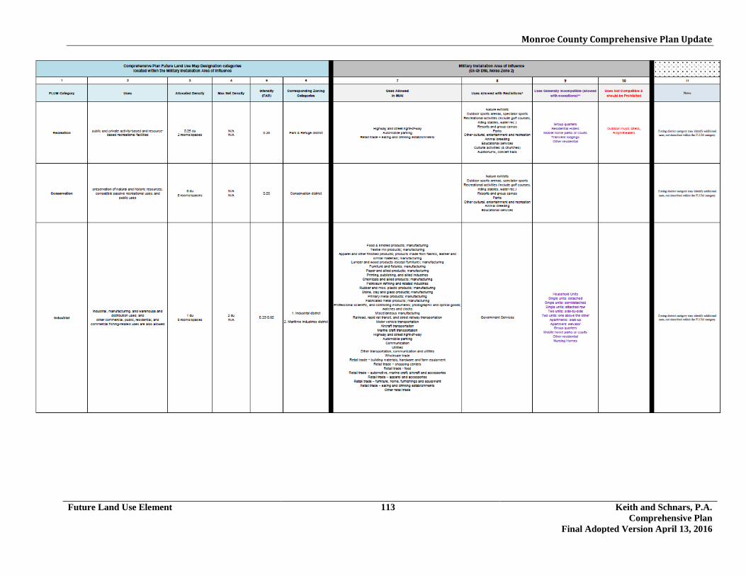
Monroe County Comprehensive Plan Update
Future Land Use Element 113 Keith and Schnars, P.A. Comprehensive Plan
Final Adopted Version April 13, 2016

Monroe County Comprehensive Plan Update
Future Land Use Element 114 Keith and Schnars, P.A. Comprehensive Plan
Final Adopted Version April 13, 2016

Monroe County Comprehensive Plan Update
Future Land Use Element 115 Keith and Schnars, P.A. Comprehensive Plan
Final Adopted Version April 13, 2016
2007 AICUZ Study Table 6-2 notes: *Uses Allowed with Restrictions. The land use and related structures are generally compatible. Note 1 a) Although local conditions regarding the need for housing may require residential use in these Zones, residential use is discouraged in DNL 65-69 and strongly discouraged in DNL 70-74. The
absence of viable alternative development options should be determined and an evaluation should be conducted locally prior to local approvals indicating that a demonstrated community need for the residential use would not be met if development were prohibited in these Zones.
b) Where the community determines that these uses must be allowed, measures to achieve and outdoor to indoor Noise Level Reduction (NLR) of at least 25 dB in DNL 65-69 and NLR of 30 dB in DNL 70-74 should be incorporated into building codes and be in individual approvals; for transient housing a NLR of at least 35 dB should be incorporated in DNL 75-79.

Monroe County Comprehensive Plan Update
Future Land Use Element 116 Keith and Schnars, P.A. Comprehensive Plan
Final Adopted Version April 13, 2016
c) Normal permanent construction can be expected to provide a NLR of 20 dB, thus the reduction requirements are often stated as 5, 10 or 15 dB over standard construction and normally assume mechanical ventilation, upgraded Sound Transmission Class (STC) ratings in windows and doors and closed windows year round. Additional consideration should be given to modifying NLR levels based on peak noise levels or vibrations.
d) NLR criteria will not eliminate outdoor noise problems. However, building location and site planning, design and use of berms and barriers can help mitigate outdoor noise exposure NLR particularly from ground level sources. Measures that reduce noise at a site should be used wherever practical in preference to measures that only protect interior spaces.
Note 7 Land use compatible provided special sound reinforcement systems are installed. Note 8 Residential buildings require a NLR of 25 Note 25, 30 or 35 The numbers refer to Noise Level Reduction levels. Land Use and related structures generally compatible however, measures to achieve NLR of 25, 30 or 35 must be incorporated into design and
construction of structures. However, measures to achieve an overall noise reduction do not necessarily solve noise difficulties outside the structure and additional evaluation is warranted. Also, see notes indicated by superscripts where they appear with one of these numbers.
**Uses Generally Incompatible (allowed with exceptions). The land use and related structures are generally incompatible. Note 1 a) Although local conditions regarding the need for housing may require residential use in these Zones, residential use is discouraged in DNL 65-69 and strongly discouraged in DNL 70-74. The
absence of viable alternative development options should be determined and an evaluation should be conducted locally prior to local approvals indicating that a demonstrated community need for the residential use would not be met if development were prohibited in these Zones.
b) Where the community determines that these uses must be allowed, measures to achieve and outdoor to indoor Noise Level Reduction (NLR) of at least 25 dB in DNL 65-69 and NLR of 30 dB in DNL 70-74 should be incorporated into building codes and be in individual approvals; for transient housing a NLR of at least 35 dB should be incorporated in DNL 75-79.
c) Normal permanent construction can be expected to provide a NLR of 20 dB, thus the reduction requirements are often stated as 5, 10 or 15 dB over standard construction and normally assume mechanical ventilation, upgraded Sound Transmission Class (STC) ratings in windows and doors and closed windows year round. Additional consideration should be given to modifying NLR levels based on peak noise levels or vibrations.
d) NLR criteria will not eliminate outdoor noise problems. However, building location and site planning, design and use of berms and barriers can help mitigate outdoor noise exposure NLR particularly from ground level sources. Measures that reduce noise at a site should be used wherever practical in preference to measures that only protect interior spaces.
NLR (Noise Level Reduction) Noise Level Reduction (outdoor to indoor) to be achieved through incorporation of noise attenuation into the design and construction of the structure.

Monroe County Comprehensive Plan Update
Future Land Use Element 117 Keith and Schnars, P.A. Comprehensive Plan
Final Adopted Version April 13, 2016

Monroe County Comprehensive Plan Update
Future Land Use Element 118 Keith and Schnars, P.A. Comprehensive Plan:
Final Adopted Version April 13, 2016
Policy 108.2.7 Nonresidential land uses expressly allowed within the residential Future Land Use Categories (see Column 11 MIAI Land Use Table) as land uses permitted in the Land Development Regulations that were in effect immediately prior to the institution of the 2010 Comprehensive Plan (pre-2010 LDR’s), and that lawfully existed on such lands on January 4, 1996, shall be recognized through a “Letter of Development Rights Determination” process and transmitted to the State Land Planning Agency. (Ord. 012-2012, DEO 12-1ACSC-NOI-4401-(A)-(I), Effective date of July 19, 2012) Policy 108.2.8 Within the MIAI overlay, Monroe County may consider requests from property owners for reduction in density and/or intensity or changes in uses that reduce incompatibility of land uses with Goal 108 and associated Objectives and Policies. (Ord. 012-2012, DEO 12-1ACSC-NOI-4401-(A)-(I), Effective date of July 19, 2012)
<The remainder of this page intentionally left blank>

Monroe County Comprehensive Plan Update
Conservation and Coastal Management Element 1 Keith and Schnars, P.A. Comprehensive Plan
Final Adopted Version April 13, 2016
3.2 CONSERVATION AND COASTAL MANAGEMENT GOAL 201 To ensure that air quality is maintained at the highest levels, Monroe County shall continue to meet all attainment standards set by the State of Florida and the U.S. Environmental Protection Agency (EPA). [§163.3177(6)d.2.a., F.S.]
Objective 201.1 Monroe County shall continue to maintain existing ambient air quality levels in compliance with the National Ambient Air Quality Standards (NAAQS). [§163.3177(6)d.2.a., F.S.]
Policy 201.1.1 Monroe County, in coordination with local Florida Department of Environmental Protection (FDEP) representatives, shall review the annual air quality monitoring data for Monroe County. Any violations of the NAAQS or trends in ambient air quality shall be reported to the BOCC. [§163.3177(6)d.2.a., F.S.] Policy 201.1.2 Development Orders shall requiref that land areas exposed during construction be treated with mulch, spray, grass or other appropriate methods in order to minimize air pollution. [§163.3177(6)d.2.a., F.S.] Policy 201.1.3 All resource extraction activities shall comply with FDEP standards designed to minimize point sources of air pollution. [§163.3177(6)d.2.a., F.S.] Policy 201.1.4 Monroe County shall support state government programs to regulate petroleum and gasoline storage facilities with an emphasis on controlling VOC emissions. [§163.3177(6)d.2.a., F.S.]
<The remainder of this page intentionally left blank>

Monroe County Comprehensive Plan Update
Conservation and Coastal Management Element 2 Keith and Schnars, P.A. Comprehensive Plan
Final Adopted Version April 13, 2016
GOAL 202 The environmental quality of Monroe County's estuaries, nearshore waters (canals, harbors, bays, lakes and tidal streams,) and associated marine resources shall be maintained and, where possible, improved or restored. [§163.3177(6)d.2.b., F.S; §163.3177(6)d.2.e., F.S.]
Objective 202.1 Monroe County shall continue to work cooperatively with the U.S. Environmental Protection Agency (EPA), the FDEP, the South Florida Water Management District (SFWMD), and the National Oceanic and Atmospheric Administration (NOAA) to implement the Water Quality Protection Program (WQPP) for the Florida Keys National Marine Sanctuary. [§163.3177(6)d.2.b., F.S; §163.3177(6)d.2.e., F.S.]
Policy 202.1.1 Monroe County shall continue to coordinate with EPA, FDEP, SFWMD and NOAA to document pollutant loads for Florida Keys waters. [§163.3177(6)d.2.b., F.S; §163.3177(6)d.2.e., F.S.]
Policy 202.1.2 Monroe County shall maintain and implement permitting, inspection, and enforcement procedures designed to reduce pollutant discharges into ground and surface waters from on-site disposal systems and wastewater treatment plants. (See Goal 901 and related objectives and policies.) [§163.3177(6)d.2.b., F.S; §163.3177(6)d.2.b.,2.e., F.S.] Policy 202.1.3 Recognizing impaired water quality in many canal systems in the Florida Keys, Monroe County shall work cooperatively with FDEP, EPA, the Florida Keys National Marine Sanctuary (FKNMS) and the U.S. Army Corps of Engineers (USACE) to identify any water quality issues and permitting assistance and recommendations related to the use of aerators, bubble curtains, pumping from front to back in canals, partial backfilling to make the canals shallower, flow improvement culverts in dead end canals to connect with other canals or near shore waters, flow improvement in plugged canals that are not currently open to tidal flow, and utilization of weed restriction devices in canal systems. [§163.3177(6)d.2.b., F.S; §163.3177(6)d.2.e., F.S.]
<The remainder of this page intentionally left blank>

Monroe County Comprehensive Plan Update
Conservation and Coastal Management Element 3 Keith and Schnars, P.A. Comprehensive Plan
Final Adopted Version April 13, 2016
Objective 202.2 Monroe County shall develop and implement permitting, inspection, and enforcement procedures designed to reduce pollutant discharge into surface waters.
Policy 202.2.1 Monroe County shall maintain regulations in the Monroe County Code pertaining to the disposal of fish and shellfish by-products from seafood processing facilities, including the following: 1. by-products shall not be dumped into surface waters or wastewater
disposal systems;
2. by-products shall be disposed of as solid waste; and
3. consideration shall be given to suitable reuse of by-products. [§163.3177(6)d.2.b., F.S; §163.3177(6)d.2.e., F.S.]
Policy 202.2.2 Within one (1) year after adoption of the 2030 Comprehensive Plan, Monroe County shall evaluate options for reducing the amount of fish and lobster cleaning offal that is discharged into canals. This evaluation should include public facilities such as marinas and private areas such as private backyard docks. Options to be considered shall include, but not be limited to:
(a) encouraging carcasses be macerated for chum (put in bags and frozen for a
subsequent trip), deposited in an air-tight container for routine refuse pickup, or hauled away by a commercial chum or trap fisherman on contract; and
(b) encouraging the public through an educational signage and awareness
program on water quality.
<The remainder of this page intentionally left blank>

Monroe County Comprehensive Plan Update
Conservation and Coastal Management Element 4 Keith and Schnars, P.A. Comprehensive Plan
Final Adopted Version April 13, 2016
Objective 202.3 Monroe County shall support existing vessel discharge regulations, including the No Discharge Zone regulations of the Florida Keys National Marine Sanctuary, and encourage use and expansion of sewage pump-out facilities throughout Monroe County to reduce pollutant discharges into nearshore surface waters from live-aboard vessels. [§163.3177(6)d.2].b., F.S; §163.3177(6)d.2.e., F.S.]
Policy 202.3.1 Within one (1) year after the adoption of the 2030 Comprehensive Plan, Monroe County shall adopt and maintain regulations pertaining to docked or moored to land live-aboard vessels which: 1. prohibit living on board vessels and floating structures of any type except at
marine facilities, including marinas, and within commercial fishing areas and commercial fishing special districts, with fixed pump-out facilities; and
2. require that new and existing marine facilities, including marinas, with ten
slips or more, or one live-aboard slip, provide a fixed pump-out station; and
3. require all marinas, regardless of size, to provide signage conspicuously posted at dockage sites educating the live-aboard public about the importance of pumping out and giving clear directions to the nearest pump-out stations. [§163.3177(6)d.2.b., F.S; §163.3177(6)d.2.e., F.S.]
Policy 202.3.2 Existing marine facilities, including marinas, which do not have an on-site pumpout station, as identified through the Monroe County Marine Facility Survey or other best available data sources, shall be notified in writing of the requirements for on-site pumpout facilities and signage (and any available funding assistance, such as the DEP Clean Vessel Act grant program) within 18 months after the adoption of the 2030 Comprehensive Plan. Such marine facilities and marinas shall have 12 months from the written notification to provide an on-site pumpout station and associated signage. All marine facilities and marinas which are required to provide on-site pumpout stations are required to keep those pumpout stations operational, and ensure that pumpout service is available to the patrons of those marine facilities and marinas. Policy 202.3.3 Development of the management recommendations for live-aboard vessels shall be coordinated with NOAA to ensure consistency with recommendations of the Florida Keys National Marine Sanctuary Revised Management Plan. [§163.3177(6)d.2.b., F.S; §163.3177(6)d.2.e., F.S.]

Monroe County Comprehensive Plan Update
Conservation and Coastal Management Element 5 Keith and Schnars, P.A. Comprehensive Plan
Final Adopted Version April 13, 2016
Policy 202.3.4 Within one (1) year after the adoption of the 2030 Comprehensive Plan, Monroe County shall adopt revisions to the Monroe County Code pertaining to live-aboard vessels, either in mooring fields or free-anchored, which establish the following (regulations pertaining to free-anchored vessels may require additional authorization by state statute):
1. Minimum depth criteria; 2. Availability of appropriate shoreside access (except for short-term recreational
mooring sites - See Policy 203.5.2); 3. Pumpout service availability; 4. Availability or provision of shoreside facilities (such as parking and solid
waste disposal); 5. Registration and fee structure for live-aboard mooring fields; and 6. Impact fee provisions for long-term free-anchored live-aboards.
[§163.3177(6)d.2.b., F.S.; and §163.3177(6)d.2.e., F.S.] Policy 202.3.5 Within one (1) year after the adoption of the 2030 Comprehensive Plan, Monroe County will evaluate the need to develop a plan for providing pump-out services at county-owned facilities. [§163.3177(6)d.2.b., F.S; §163.3177(6)d.2.e., F.S.] Policy 202.3.6 The County shall encourage new and existing redeveloping or expanding marinas to adopt Best Management Practices as recommended by Florida Department of Environmental Protection’s Clean Marina Program.
<The remainder of this page intentionally left blank>
Monroe County Comprehensive Plan Update
Conservation and Coastal Management Element 6 Keith and Schnars, P.A. Comprehensive Plan
Final Adopted Version April 13, 2016
Objective 202.4 Monroe County shall maintain land development regulations which implement county policies controlling pollutant discharges into surface waters from dredge and fill activities. [§163.3177(6)d.2.b., F.S; §163.3177(6)d.2.e., F.S.]
Policy 202.4.1 Monroe County shall support state and federal policies and regulations concerning the permitting of dredge and fill activity, except in those instances where more stringent regulations adopted by Monroe County shall be maintained. [§163.3177(6)d.2.b., F.S; §163.3177(6)d.2.e., F.S.] Policy 202.4.2 No new dredging shall be permitted in Monroe County. [§163.3177(6)d.2.b., F.S; §163.3177(6)d.2.e., F.S.] Policy 202.4.3 No maintenance dredging shall be permitted within areas vegetated with seagrass beds or characterized by hardbottom communities except for maintenance in public navigation channels. [§163.3177(6)d.2.b., F.S; §163.3177(6)d.2.e., F.S.] Policy 202.4.4 In order to prevent degradation of bottom vegetation, maintenance dredging in artificial waterways shall not exceed depths greater than minus six (-6) feet mean low water. This policy does not apply to the entrance channels into Key West Harbor and Safe Harbor. [§163.3177(6)d.2.b., F.S; §163.3177(6)d.2.e., F.S.] Policy 202.4.5 All dredged spoil resulting from maintenance dredging shall be placed on permitted upland sites where drainage can be contained on-site. [§163.3177(6)d.2.b., F.S; §163.3177(6)d.2.e., F.S.] Policy 202.4.6 Due to the physical structure, depth, and orientation of existing canals, water quality problems have been caused which cannot be improved with wastewater treatment and stormwater management practices alone. To implement the 2013 Monroe County Canal Management Master Plan and improve water quality in artificial canals, the County is developing canal restoration projects to improve tidal flushing, increase dissolved oxygen concentrations as identified in the surface water quality criteria in Ch. 62-302.530, F.A.C., and remove accumulated nutrients and decomposing organic material. Canal restoration projects, developed to determine the effectiveness of water quality strategies of the Florida Keys National Marine Sanctuary Water Quality Protection Program, which are performed or funded by public entities (County, State, or Federal) for organic material removal and backfilled to a depth of 6ft - 8ft, or an alternative depth as determined by best available scientific data and

Monroe County Comprehensive Plan Update
Conservation and Coastal Management Element 7 Keith and Schnars, P.A. Comprehensive Plan
Final Adopted Version April 13, 2016
authorized by the state and federal permitting agencies, from artificial canals characterized as having poor or fair water quality within the 2013 Monroe County Canal Management Master Plan are exempt from the provisions in Policy 202.8.4. Two (2) demonstration pilot canal restoration projects will remove decomposing organic material from previously dredged artificial canals (down to the bedrock) without backfilling. To evaluate the effectiveness of this removal strategy, without any backfilling, and to determine if water quality can be restored and maintained, water quality monitoring of these two (2) organic removal pilot projects shall be conducted at a two (2) year point of time and a ten (10) year point of time after completion of the pilot projects. After the two (2) year and ten (10) year monitoring, the County shall request a water quality report from the Water Quality Protection Program (WQPP) to determine the pilot projects’ effectiveness in improving dissolved oxygen concentrations, as identified in the surface water quality criteria in Ch. 62-302.530, F.A.C., in the two (2) organic removal pilot projects canals. If the WQPP does not provide the water quality report, the County shall fund and conduct the water quality report. If the water quality report for the two (2) year monitoring indicates improved water quality, additional canal restoration projects, beyond the two (2) pilot projects, to perform organic material removal to depths greater than minus six (-6) feet mean low water without backfilling to 6ft-8ft may proceed. Upon determination of the two (2) pilot projects’ effectiveness and an amendment to this Policy, the exemption to the provisions in Policy 202.8.4 may be expanded beyond public entities (County, State, or Federal) for organic material removal of previously dredged artificial canals characterized as having poor or fair water quality within the 2013 Monroe County Canal Management Master Plan. The organic material removal shall be allowed to depths greater than minus six (-6) feet mean low water, if permitted by Florida Department of Environmental Protection or the Water Management District and the Army Corp of Engineers. For this policy, hydraulic (vacuum) dredging shall be considered the preferred means of removal of the organic material. If hydraulic dredging is not proposed to accomplish the organic material removal, a public hearing before the Board of County Commissioners (BOCC) shall be required prior to issuance of a county permit. The BOCC shall hold a public hearing on the request to use an alternative dredging methodology and shall consider the cost, rationale, compatibility, complications and public comments. The public hearing shall provide the applicant the opportunity to address the issues regarding the proposed canal restoration project, including but not limited to, sediment size, logistical/accessibility limitations, obstructions and/or equipment constraints. The BOCC may grant, grant with conditions or deny the request to use an alternative dredging methodology. [Ordinance 001-2015, 15-2ACSC-NOI-4401-(A)-(I)]

Monroe County Comprehensive Plan Update
Conservation and Coastal Management Element 8 Keith and Schnars, P.A. Comprehensive Plan
Final Adopted Version April 13, 2016
Policy 202.4.6 No "after-the-fact" permits shall be issued that violate Monroe County dredge and fill regulations. All illegal structures and fill shall be removed and damages mitigated. [§163.3177(6)d.2.b., F.S; §163.3177(6)d.2.e., F.S.]
<The remainder of this page intentionally left blank>
Monroe County Comprehensive Plan Update
Conservation and Coastal Management Element 9 Keith and Schnars, P.A. Comprehensive Plan
Final Adopted Version April 13, 2016
Objective 202.5 Monroe County shall continue to coordinate with other local governments and with state and federal agencies to address existing and regional water management practices on the Florida mainland which may affect:
1. the conservation, use and protection of water quality, marine benthic
communities, and fisheries in Florida Bay; and
2. the wetlands, unique vegetative communities, and species of special status on mainland Monroe County. [§163.3177(6)d.2.b., F.S; §163.3177(6)d.2.e., F.S.; §163.3177(6)d.2.g., F.S.]
Policy 202.5.1 Monroe County shall meet periodically with agencies and local governments in the region to discuss water management practices and potential issues related to: 1. the delivery of water, both in terms of quantity and quality, to Card Sound,
Barnes Sound and Florida Bay; and
2. alternatives to offshore disposal of waste.
These agencies and local governments may include:
1. National Park Service;
2. Florida Department of Environmental Protection;
3. South Florida Water Management District;
4. Miami-Dade County;
5. Collier County;
6. South Florida Regional Planning Council; and
7. Environmental Protection Agency. [§163.3177(6)d.2.b., F.S; §163.3177(6)d.2.e., F.S.; §163.3177(6)d.2.g., F.S.]
Policy 202.5.2 Monroe County shall monitor and provide input on future revisions to the following plans: 1. Surface Water Improvement and Management Plan for the Everglades;
2. Surface Water Improvement and Management Plan for Biscayne Bay;

Monroe County Comprehensive Plan Update
Conservation and Coastal Management Element 10 Keith and Schnars, P.A. Comprehensive Plan
Final Adopted Version April 13, 2016
3. any additional Surface Water Improvement and Management Plans which may be completed for Monroe County waters;
4. Everglades National Park General Management Plan; and
5. Big Cypress National Preserve General Management Plan.
[§163.3177(6)d.2.b., F.S; §163.3177(6)d.2.e., F.S.; §163.3177(6)d.2.g., F.S.]
<The remainder of this page intentionally left blank>

Monroe County Comprehensive Plan Update
Conservation and Coastal Management Element 11 Keith and Schnars, P.A. Comprehensive Plan
Final Adopted Version April 13, 2016
GOAL 203 The health and integrity of living marine resources and marine habitat, including mangroves, seagrasses, coral reefs, other hard bottom communities and fisheries, shall be protected and, where possible, restored and enhanced. [§163.3177(6)d.2.d., F.S.; §163.3177(6)d.2.e., F.S.; §163.3177(6)d.2.j., F.S.]
Objective 203.1 Monroe County shall protect its mangrove wetlands by continuing to implement regulations which will further reduce disturbances to mangroves and which will mitigate the direct and indirect impacts of development upon mangroves. [§163.3177(6)d.2.d., F.S.; §163.3177(6)d.2.e., F.S.; §163.3177(6)d.2.j., F.S.]
Policy 203.1.1 The open space requirement for mangrove wetlands shall be one hundred (100) percent. No fill or structures shall be permitted in mangrove wetlands except for elevated, pile-supported walkways, docks, piers and utility pilings. [§163.3177(6)d.2.d., F.S.; §163.3177(6)d.2.e., F.S.; §163.3177(6)d.2.j., F.S.] Policy 203.1.2 Monroe County shall require minimum vegetated setbacks of fifty (50) feet to be maintained as an open space buffer for development occurring adjacent to all types of wetlands except for tidally inundated mangrove fringes and as provided for in Policy 204.2.3, 204.2.4 and 204.2.5. If a 50-foot setback results in less than 2,000 square feet of principal structure footprint of reasonable configuration, then the setback may be reduced to allow for 2,000 square feet of principal structure footprint of reasonable configuration, provided that the setback is not reduced to less than twenty-five (25) feet. On properties classified as scarified adjacent to wetlands, the wetland setback may be reduced to twenty-five (25) feet, without regard to buildable area, if the entire setback is managed in accordance with County regulations approved by the County Biologist and is placed under conservation easement. [§163.3177(6)d.2.d., F.S.; §163.3177(6)d.2.e., F.S.; §163.3177(6)d.2.j., F.S.]
<The remainder of this page intentionally left blank>

Monroe County Comprehensive Plan Update
Conservation and Coastal Management Element 12 Keith and Schnars, P.A. Comprehensive Plan
Final Adopted Version April 13, 2016
Objective 203.2 Monroe County shall protect submerged lands vegetated with seagrasses by maintaining regulations which further reduce direct and indirect disturbances to seagrasses. [§163.3177(6)d.2.d., F.S.; §163.3177(6)d.2.e., F.S.]
Policy 203.2.1 Monroe County shall continue to prohibit the location of mooring sites over submerged land which is vegetated with seagrasses or characterized by a hard-bottom community, regardless of water depth, except as may be permitted by the FDEP. This prohibition shall not apply to mooring fields, if there is an overriding public interest or benefit. Applicants for mooring fields shall provide data and analysis demonstrating environmental, social, and economic benefits which would accrue to the public at large as a result of a proposed facility. [§163.3177(6)d.2.d., F.S.; §163.3177(6)d.2.e., F.S.] Policy 203.2.2 Monroe County shall continue to prohibit the termination of docking facilities and piers over submerged land which is vegetated with seagrasses or characterized by a hard-bottom community, regardless of water depth, except as may be permitted by the FDEP. Design criteria to permit sunlight to reach the bottom shall be maintained. No boat shelters or gazebos shall extend over submerged lands vegetated with seagrasses or over hardbottom communities. [§163.3177(6)d.2.d., F.S.; §163.3177(6)d.2.e., F.S.] Policy 203.2.3 Monroe County shall continue to: 1. prohibit new dredging in the Florida Keys; and
2. prohibit maintenance dredging within areas vegetated with seagrass beds
except for maintenance dredging in public navigation channels and as provided in Policy 202.4.3 for canals. (See Objective 202.4 and related policies.) [163.3177(6)d.2.d., F.S.; §163.3177(6)d.2.e., F.S.]
Policy 203.2.4 Monroe County shall continue to support the public education program for users of the Florida Keys National Marine Sanctuary as outlined in the Florida Keys National Marine Sanctuary Revised Management Plan (U.S. Dept. of Commerce, NOAA). This program promotes user education related to, among other items, seagrass bed conservation and navigational safety in nearshore waters. [§163.3177(6)d.2.d., F.S.; §163.3177(6)d.2.e., F.S.]

Monroe County Comprehensive Plan Update
Conservation and Coastal Management Element 13 Keith and Schnars, P.A. Comprehensive Plan
Final Adopted Version April 13, 2016
Objective 203.3 Monroe County shall continue to support state and federal agencies in development and implementation of management measures designed to protect coral reefs and other hardbottom communities located in the waters off the Florida Keys. [§163.3177(6)d.2.d., F.S.; §163.3177(6)d.2.e., F.S.]
Policy 203.3.1 Monroe County shall continue to support the public education program for users of the Florida Keys National Marine Sanctuary as outlined in the Florida Keys National Marine Sanctuary Revised Management Plan (U.S. Dept. of Commerce, NOAA). This program promotes user education related to, among other items, coral reef conservation and navigational safety. [§163.3177(6)d.2.d., F.S.; §163.3177(6)d.2.e., F.S.; §163.3177(6)d.2.f., F.S.] Policy 203.3.2 Monroe County shall continue to protect, preserve, and enhance the coral reefs and other hardbottom communities through its land development regulations which address water quality (See Conservation and Coastal Management Element Goal 202 and related objectives and policies), including efforts to: 1. limit the location of water-dependent activities to locations that will not have a
significant adverse impact on the offshore resources of hard coral bottoms and other hardbottom communities;
2. control and regulate land and water activities in the vicinity of coral and other
hardbottom communities as identified in the Florida Keys Coastal Management Study in an effort to arrest further deterioration; and
3. include the strategies identified in the Florida Keys National Marine
Sanctuary Revised Management Plan. [§163.3177(6)d.2.d., F.S.; §163.3177(6)d.2.e., F.S.; §163.3177(6)d.2.f., F.S.]
Policy 203.3.3 Monroe County shall support the objectives and action steps of the Florida Reef Resilience Program Climate Change Action Plan for the Florida Reef System. In addition to supporting actions to protect coral reefs, the County shall also support the actions as they may apply to other hardbottom communities. This includes the following actions identified in that Plan: Action 1.2.4: Protect species and habitats that are highly vulnerable to climate change (e.g. corals, marine turtles, mangroves, etc.) from non-climate pressures (e.g. direct damage from divers, fishing gear, anchors or boats, beach nourishment, coastal construction impacts, land-based sources of pollution). Action 1.2.6: Prohibit any new dredging or other direct destruction of coral reefs.
Monroe County Comprehensive Plan Update
Conservation and Coastal Management Element 14 Keith and Schnars, P.A. Comprehensive Plan
Final Adopted Version April 13, 2016
Action 1.3.3: Consider limiting certain kinds of development that are at risk from sea level rise. Action 1.4.4: Work through the proposed Florida Reef System Management Council (or other appropriate venue) to revise regulations on coastal development and beach nourishment projects to minimize sedimentation, storm water runoff, and other water quality impacts to the Florida reef system. Action 1.6.3: Work with local fishing, boating, and diving industries to promote minimum impact reef use activities (e.g. appropriate fishing gear, catch-and-release fishing, trip-rigged anchors and manual anchor placement in sand) and voluntary avoidance of bleached, diseased or otherwise stressed coral reefs. Action 2.2.2: Involve community members, elected officials, visitors and Florida diving, fishing, and other maritime industries in climate change science and monitoring efforts on the Florida Reef System. Action 2.3.4: Identify, support, and showcase “climate smart” coastal/marine organizations and businesses (including reef-based industries, ports and harbors, local governments and individuals) that increase sustainability of reef-related activities and reduce greenhouse gas emissions, such as energy and water efficiency, alternative energy and carbon offsets.
<The remainder of this page intentionally left blank>

Monroe County Comprehensive Plan Update
Conservation and Coastal Management Element 15 Keith and Schnars, P.A. Comprehensive Plan
Final Adopted Version April 13, 2016
Objective 203.4 Monroe County shall support state and federal agencies in development and implementation of management measures designed to protect the fisheries of the Florida Keys. [§163.3177(6)d.2.d., F.S.; §163.3177(6)d.2.e., F.S.; §163.3177(6)d.2.f., F.S.; §163.3177(6)d.2.g., F.S.]
Policy 203.4.1 Monroe County shall periodically coordinate with FWC and other applicable agencies to encourage best practices to protect natural habitats in regards to commercial and recreational fishing gear and methods. . Policy 203.4.2 Monroe County shall continue to propose actions for consideration by the Florida Fish & Wildlife Conservation Commission Division of Marine Fisheries Management and the National Marine Fisheries Service designed to reduce adverse impacts of the Spiny Lobster Sport Season on the lobster fishery and sensitive marine resources of the Florida Keys. [§163.3177(6)d.2.e., F.S.] Policy 203.4.3 Monroe County shall periodically meet with the Florida Fish and Wildlife Conservation Commission Division of Marine Fisheries Management, State and federal agencies, and research organizations to assess measures which could be implemented by Monroe County to protect the fisheries of the Florida Keys. To the extent practicable, Monroe County shall take steps to implement such protection measures as may be identified through this cooperative effort. [§163.3177(6)d.2.e., F.S.] Policy 203.4.4 Monroe County shall support the efforts of the agencies having jurisdiction to implement the Florida Keys National Marine Sanctuary Revised Management Plan . [§163.3177(6)d.2.e., F.S.; ] Policy 203.4.5 Monroe County shall continue to support scientific studies regarding stresses on seagrass, coral and other hardbottom community ecosystems in the Florida Keys region. [§163.3177(6)d.2.e., F.S.] Policy 203.4.6 Monroe County shall encourage private and non-profit groups, as well as public agencies, in promoting aquaculture which augments fisheries, limits stress on fisheries, and/or replaces depleted stock in the Florida Keys. [§163.3177(6)d.2.e., F.S.]
Monroe County Comprehensive Plan Update
Conservation and Coastal Management Element 16 Keith and Schnars, P.A. Comprehensive Plan
Final Adopted Version April 13, 2016
Objective 203.5 Monroe County shall continue to review the recommendations and options identified in The Boating Impacts Management Plan Final Report (1992); Keys-Wide Mooring Field System Preliminary Planning Document (2002); and Development of a Boating Management Plan for the Boca Chica Harbor Area (2008), which are designed to reduce adverse impacts on water quality and living marine resources associated with recreational boating. [§163.3177(6)d.2.e., F.S.]
Policy 203.5.1 Monroe County shall maintain criteria for marina siting which shall meet or exceed state standards. (See Objective 212.3 and related policies.) [§163.3177(6)d.2.b., F.S.; §163.3177(6)d.2.e., F.S.;§163.3177(6)d.2.i., F.S.] Policy 203.5.2 Monroe County shall maintain a plan for mooring buoy sites, including:
1. live-aboard mooring sites (See Policy 202.3.4); and
2. short-term recreational mooring sites. Identification of mooring sites shall be undertaken in coordination with NOAA and FDEP, and shall be consistent with recommendations of the Florida Keys National Marine Sanctuary Management Plan. [§163.3177(6)d.2.b., F.S.; §163.3177(6)d.2.e., F.S.;§163.3177(6)d.2.i., F.S.] Policy 203.5.3 Monroe County shall support a boater education program in coordination with the Cooperative Extension Service, Florida Sea Grant, FDEP, FWC, FKNMS, federal and State agencies, NOAA and research organizations. [§163.3177(6)d.2.b., F.S.; §163.3177(6)d.2.e., F.S.;§163.3177(6)d.2.i., F.S.]
<The remainder of this page intentionally left blank>

Monroe County Comprehensive Plan Update
Conservation and Coastal Management Element 17 Keith and Schnars, P.A. Comprehensive Plan
Final Adopted Version April 13, 2016
GOAL 204 The health and integrity of Monroe County's marine and freshwater wetlands shall be protected and, where possible, restored and enhanced.
Objective 204.1 Monroe County shall identify potential wetland restoration sites and identify high quality wetland sites for possible future acquisition by the County, State and/or private non-profit conservation organizations. [§163.3177(6)d.2.j., F.S.; §163.3177(6)d.2.k., F.S.]
Policy 204.1.1 Monroe County may coordinate with other agencies in developing and administering a wetlands restoration program. Policy 204.1.2 Monroe County shall work cooperatively with the USACE, EPA, FWS, FDEP and FWC, and others as appropriate, to determine funding sources to support a wetlands restoration program. [§163.3177(6)d.2.j., F.S.; §163.3177(6)d.2.k., F.S.] Policy 204.1.3 Monroe County shall coordinate with the FWC to update as needed and maintain the existing freshwater wetlands and disturbed wetlands mapping.
<The remainder of this page intentionally left blank>
Monroe County Comprehensive Plan Update
Conservation and Coastal Management Element 18 Keith and Schnars, P.A. Comprehensive Plan
Final Adopted Version April 13, 2016
Objective 204.2 Monroe County shall not allow the loss of undisturbed wetlands or the net loss of disturbed wetlands. [§163.3177(6)d.2.j., F.S.; §163.3177(6)d.2.k., F.S.]
Policy 204.2.1 Monroe County shall utilize the Wetlands Evaluation Procedure (KEYWEP) to determine the functional capacity of wetlands and Uniform Mitigation Assessment Method (UMAM) to determine mitigation requirements for impacts to wetlands. [§163.3177(6)d.2.j., F.S.; §163.3177(6)d.2.k., F.S.] Policy 204.2.2 To protect submerged lands and wetlands, the open space requirement shall be 100 percent of the following types of wetlands: 1. submerged lands;
2. mangroves;
3. salt ponds;
4. freshwater wetlands;
5. freshwater ponds; and
6. undisturbed salt marsh and buttonwood wetlands. Allocated density (dwelling units per acre) shall be assigned to freshwater wetlands and undisturbed salt marsh and buttonwood wetland only for use as transferable development rights away from these habitats. Submerged lands, salt ponds, freshwater ponds and mangroves shall not be assigned any density or intensity. Within one (1) year after the adoption of the 2030 Comprehensive Plan, the County shall revise the LDC to include a prohibition of development in salt ponds. [§163.3177(6)d.2.j., F.S.; §163.3177(6)d.2.k., F.S.] Policy 204.2.3 No structures shall be permitted in submerged lands, mangroves, salt ponds, or wetlands, except for elevated, pile-supported walkways, docks, piers, and utility pilings. No fill shall be permitted in submerged lands, mangroves, salt ponds, or wetlands except; 1. as specifically allowed by Objective 212.5 and subsequent Policies;

Monroe County Comprehensive Plan Update
Conservation and Coastal Management Element 19 Keith and Schnars, P.A. Comprehensive Plan
Final Adopted Version April 13, 2016
2. to fill a manmade excavated water body, such as a canal, boat ramp, or swimming pool if the Director of Environmental Resources determines that such filling will not have a significant adverse impact on marine or wetland communities; or
3. as needed for shoreline stabilization or beach renourishment projects with a
valid public purpose that furthers the goals of the Monroe County Comprehensive Plan, as determined by the County.
Policy 204.2.4 No fill or structures shall be permitted in mangroves or wetlands except as allowed by Policy 204.2.3 (as amended) and for bridges extending over mangroves or wetlands that are required to provide automobile or pedestrian access to dwelling units located on upland areas within the same property for which there is no alternative means of access. Such bridges shall be elevated on pilings such that the natural movement of water, including volume, rate, and direction of flow shall not be disrupted or altered. Upland areas shall include disturbed wetlands that have been lawfully converted into uplands through filling. [§163.3177(6)d.2.j., F.S.; §163.3177(6)d.2.k., F.S.] Policy 204.2.5 Monroe County shall maintain environmental standards and environmental design criteria which provide minimum vegetated setbacks of fifty (50) feet to be maintained as an open space buffer for development occurring adjacent to all types of wetlands except for tidally inundated mangrove fringes and as provided for in Policies 204.2.3, and 204.2.4. The setback is measured from the landward extent of the wetlands as determined pursuant to 62-340.300 F.A.C. If a 50-foot setback results in less than 2,000 square feet of principal structure footprint of reasonable configuration, then the setback may be reduced to allow for 2,000 square feet of principal structure footprint of reasonable configuration, provided that the setback is not reduced to less than twenty-five (25) feet. On properties classified as scarified adjacent to wetlands, the wetland setback may be reduced to twenty-five (25) feet, without regard to buildable area, if the entire setback area is planted and maintained in native vegetation with a site-suitable stormwater management plan in accordance with County regulations and approved by the County Biologist and placed under conservation easement. “Development” shall include all activities as currently defined in the F.S. 380.05. [§163.3177(6)d.2.j., F.S.; §163.3177(6)d.2.k., F.S.]
Policy 204.2.6 Within one (1) year after the adoption of the 2030 Comprehensive Plan, the County shall evaluate revising the LDC to modify the definition of disturbed wetlands to include those wetlands that receive a KEYWEP total functional index of 5.5 or less.
Monroe County Comprehensive Plan Update
Conservation and Coastal Management Element 20 Keith and Schnars, P.A. Comprehensive Plan
Final Adopted Version April 13, 2016
Policy 204.2.7 Within one (1) year after the adoption of the 2030 Comprehensive Plan Update, Monroe County shall revise the LDC to provide a definition of wetlands that is consistent with the State definition contained in 62-340.200 (373.019(17) F.S.). Policy 204.2.8 Monroe County shall attempt to ensure that dredge and fill activities that require permits from federal, state, regional, and county regulatory authorities are done through a coordinated interagency review process. (HB530) Policy 204.2.9 No "after-the-fact" permits shall be issued that violate Monroe County dredge and fill regulations. All illegal structures and fill shall be removed and damages mitigated. Policy 204.2.10 Monroe County shall maintain, and update as necessary, a schedule of monetary penalties that provides for fair and equitable penalties for all dredge and fill violations. Penalty revenues shall be paid to the Monroe County Environmental Land Management and Restoration Fund or set aside and used specifically for water quality enhancement projects or wetland restoration or enhancement projects.
<The remainder of this page intentionally left blank>

Monroe County Comprehensive Plan Update
Conservation and Coastal Management Element 21 Keith and Schnars, P.A. Comprehensive Plan
Final Adopted Version April 13, 2016
Objective 204.3 Monroe County shall maintain a program for acquiring or restoring high quality wetlands. (See Future Land Use Objective 102.4 and related policies.) [§163.3177(6)d.2.e., F.S.; §163.3177(6)d.2.j., F.S.]
Policy 204.3.1 The Monroe County Growth Management Division in coordination with the Monroe County Land Authority and other federal and state agencies will continue with wetlands acquisition through the Florida Forever program, and other funding mechanisms such as the Monroe County Land Acquisition Fund. Priority wetland acquisition sites shall include the following: 1. wetlands having the greatest functional value as determined by KEYWEP;
2. wetlands which are documented habitat of species of special status; and/or
3. undisturbed and disturbed wetlands located within the Improved Subdivision
(IS) zoning district. [§163.3177(6)d.2.e., F.S.; §163.3177(6)d.2.j., F.S.]
<The remainder of this page intentionally left blank>

Monroe County Comprehensive Plan Update
Conservation and Coastal Management Element 22 Keith and Schnars, P.A. Comprehensive Plan
Final Adopted Version April 13, 2016
GOAL 205 The health and integrity of Monroe County's native upland vegetation shall be protected and, where possible, enhanced. [§163.3177(6)d.2.d., F.S.; §163.3177(6)d.2.h., F.S.]
Objective 205.1 Monroe County shall maintain the Tier Overlay District Maps as required in Policy 105.2.2. [§163.3177(6)d.2.d., F.S.; §163.3177(6)d.2.h., F.S.]
Policy 205.1.1 The County shall establish the following criteria, at a minimum, to use when designating Tiers: [§163.3177(6)d.2.d., F.S.; §163.3177(6)d.2.h., F.S.] 1. Land located outside of Big Pine Key and No Name Key shall be designated
as Tier I based on following criteria:
• Natural areas including old and new growth upland native vegetated areas, above 4 acres in area.
• Vacant land which can be restored to connect upland native habitat patches and reduce further fragmentation of upland native habitat.
• Lands required to provide an undeveloped buffer, up to 500 feet in depth, if indicated by appropriate special species studies, between natural areas and development to reduce secondary impacts; canals or roadways, depending on size may form a boundary that removes the need for the buffer or reduces its depth.
• Lands designated for acquisition by public agencies for conservation and natural resource protection.
• Known locations of threatened and endangered species. • Lands designated as Conservation and Residential Conservation on the
Future Land Use Map or within a buffer/restoration area as appropriate. • Areas with minimal existing development and infrastructure.
2. Lands on Big Pine Key and No Name Key designated as Tier I, II, or III shall
be in accordance with the wildlife habitat quality criteria as defined in the Habitat Conservation Plan for those islands.
3. Lands located outside of Big Pine Key and No Name Key that are not
designated Tier I shall be designated Tier III.
4. Designated Tier III lands located outside of Big Pine Key and No Name Key with tropical hardwood hammock or pinelands of one acre or greater in area shall be designated as Special Protection Areas.
5. Lands within the Ocean Reef planned development shall be excluded from
any Tier designation.

Monroe County Comprehensive Plan Update
Conservation and Coastal Management Element 23 Keith and Schnars, P.A. Comprehensive Plan
Final Adopted Version April 13, 2016
Objective 205.2 To implement Goal 105 of this Plan and the recommendations in the Florida Keys Carrying Capacity Study (FKCCS), Monroe County shall maintain land development regulations which further protect and provide for restoration of the habitat values of upland native vegetated communities, including hardwood hammocks and pinelands. [§163.3177(6)d.2.d., F.S.; §163.3177(6)d.2.h., F.S.]
Policy 205.2.1 Monroe County shall maintain the boundaries of the tier system overlay based on the criteria in Policy 205.1.1. Policy 205.2.2 Monroe County shall discourage developments in Tier I and within tropical hardwood hammock or pinelands of one acre or more in area to protect areas of native upland vegetation (See Policy 101.6.4). [§163.3177(6)d.2.d., F.S.; §163.3177(6)d.2.h., F.S.] Policy 205.2.3 Monroe County shall maintain clustering requirements as follows: 1. when a parcel proposed for development contains more than one (1) habitat
type, development shall be:
a) clustered on the least sensitive portion of the parcel, until the maximum allowable density is reached;
b) if further development occurs, it shall be clustered on the next least
sensitive portion of the parcel, until maximum allowable density is reached, etc.; and
2. development permitted on the least sensitive portion(s) of a parcel shall be
clustered within that portion(s) of the parcel.
For the purpose of this policy, the relative sensitivity of separate habitat types shall be as listed below with 1 (freshwater wetlands) being the most sensitive and 16 (disturbed with exotics) the least sensitive.
1. Freshwater wetlands; 2. Salt marsh and/or buttonwood association wetlands; 3. Cactus hammock; 4. Palm hammock; 5. Beach/berm; 6. Pinelands 7. High Hammock 8. Low hammock 9. Disturbed beach/berm;

Monroe County Comprehensive Plan Update
Conservation and Coastal Management Element 24 Keith and Schnars, P.A. Comprehensive Plan
Final Adopted Version April 13, 2016
10. Disturbed with freshwater wetlands; 11. Disturbed with salt marsh and/or buttonwood association wetlands; 12. Disturbed with slash pines; 13. Disturbed with high hammock; 14. Disturbed with low hammock; 15. Disturbed; and 16. Disturbed with exotics.
Policy 205.2.4 Bulk regulations and development standards shall be reviewed and revised so as to allow greater flexibility for clustering. Policy 205.2.5 Existing Conditions Reports shall include identification of measures for protecting native upland vegetation. Successful implementation of these measures shall be required as a condition of issuance of a certificate of occupancy. [§163.3177(6)d.2.d.] Policy 205.2.6 The allowable amount of permitted clearing of native upland vegetation communities shall be defined by habitat and the location of the property in the tier overlay district maps. Clearing of upland native vegetation communities in the Tiers I, II, III and III-A (SPA) shall be limited for the portion of the property containing upland native vegetation in accordance with Policy 101.5.27.* [§163.3177(6)d.2.d., F.S.] *Clearing on Big Pine Key and No Name Key is limited to the provisions in the USFWS issued Incidental Take Permit (ITP) TE083411-0.
<The remainder of this page intentionally left blank>

Monroe County Comprehensive Plan Update
Conservation and Coastal Management Element 25 Keith and Schnars, P.A. Comprehensive Plan
Final Adopted Version April 13, 2016
Policy 205.2.7 Clearing of native vegetation shall be limited to the percentage and maximum allowed in Policy 101.5.27. For applications that receive points for lot aggregation under the Permit Allocation System for residential development, clearing of upland native vegetation shall be limited to a maximum of 7,500 square feet, or as specified in Policy 101.5.27. The immediate development area shall include the area of approved clearing shown on the approved site plan. The immediate development area shall be fenced throughout the duration of construction. During construction, there shall be no disturbances of the ground surface and vegetation within areas of native upland vegetation not approved for clearing. [§163.3177(6)d.2.d., F.S.] (Ordinance 026-2012) Policy 205.2.8 Development shall not disturb the following vegetation: 1. champion trees; 2. specimen trees (diameter at breast height that is greater than seventy-five (75)
percent of the record tree of the same species for the State of Florida); and 3. plant species listed by the USFWS as threatened and endangered.
[§163.3177(6)d.2.d., F.S.; §163.3177(6)d.2.h., F.S.] Policy 205.2.9 Development shall be sited so as to avoid or minimize impacts to the following plants: 1. species listed by the Florida Department of Agriculture and Consumer
Services as threatened, endangered or commercially exploited (excluding those specifically protected by Policy 205.2.8);
2. other locally rare native species (See Policy 205.3.1); and
3. native trees with diameter at breast height (dbh) of four (4) inches or greater. In those instances where an applicant can demonstrate that avoidance of such species or trees is not possible by clustering or by an alternate design approach, then the following options shall be considered by the County Biologist: (1) Successful transplantation of affected plants/individuals ("successful
transplantation” shall be defined as one-hundred (100) percent survival after a period of one (1) year); or
(2) Where the probability of survivability of transplanted plants is low or when
there is no suitable planting area on the subject site (as determined in writing

Monroe County Comprehensive Plan Update
Conservation and Coastal Management Element 26 Keith and Schnars, P.A. Comprehensive Plan
Final Adopted Version April 13, 2016
by the County Biologist), then the applicant shall be required to make a payment into the Monroe County Land Management and Restoration Fund (See Goal 209 and related objectives and policies). Payments into this Fund for this purpose shall be calculated as follows: Payments shall be equal to the replacement cost at a rate of 2:1 for all native trees over four inches dbh; all listed species of any size; and all locally rare native species.[§163.3177(6)d.2.d., F.S.]
Policy 205.2.10 Invasive exotic vegetation shall be removed from the development parcel as a condition for issuance of a Certificate of Occupancy. [§163.3177(6)d.2.d., F.S.] Policy 205.2.11 A list of invasive exotic upland plants shall be maintained by the County biologist and made available to the general public. [§163.3177(6)d.2.d., F.S.] Policy 205.2.12 Monroe County shall use the "December 1985 Habitat Classification Aerial Photographs," as a general guide to habitat characteristics, supplemented by recent aerial photography and existing site analysis to determine any increases and/or losses in the amount of upland native vegetated areas. The County biologist shall review the best available data for the review of habitat areas. Policy 205.2.13 Monroe County shall require, in the Land Development Code, an Existing Conditions Report including a vegetation survey for any development that may disturb native upland vegetation. At a minimum the report shall include an analysis of the potential impacts of the proposed development on native upland habitats, a description of the measures designed to reduce identified adverse impacts including clustering.
<The remainder of this page intentionally left blank>

Monroe County Comprehensive Plan Update
Conservation and Coastal Management Element 27 Keith and Schnars, P.A. Comprehensive Plan
Final Adopted Version April 13, 2016
Objective 205.3 Monroe County shall maintain the existing program for identification and protection of plant species of special status. These shall include plants designated as threatened and endangered by the FWS and those designated as threatened, endangered, or commercially exploited by the Florida Department of Agriculture. [§163.3177(6)d.2.d., F.S. ; §163.3177(6)d.2.e., F.S.]
Policy 205.3.1 Monroe County shall maintain a list of locally rare plant species. This list shall include species which are rare within the Florida Keys but which do not have special status. [§163.3177(6)d.2.d., F.S. ; §163.3177(6)d.2.e., F.S.] Policy 205.3.2 Monroe County shall maintain maps showing occurrences of the following species: 1. plant species designated by the FWS as threatened and endangered;
2. plant species designated by the Florida Department of Agriculture as
threatened, endangered or commercially exploited; and
3. plant species designated as locally rare. Information shall be obtained from the Florida Natural Areas Inventory database, which shall be entered into the County's GIS. To the extent possible, the historic occurrence data shall be plotted on specific parcels for which the occurrences were recorded. The GIS data base shall be updated annually. [§163.3177(6)d.2.d., F.S. ; §163.3177(6)d.2.e., F.S.] Policy 205.3.3 Monroe County shall participate in the Florida Champion Tree Program of the Florida Department of Agriculture. [§163.3177(6)d.2.d., F.S.; §163.3177(6)d.2.e., F.S.] Policy 205.3.4 Monroe County shall work cooperatively with the FWS to promote the recovery of plant species designated by the federal government as threatened and endangered. Related activities shall include: 1. identification of sites in the Keys with key tree-cactus (Polosocereus
polygonus), Small's milkpea (Galactia smallii), and Garber's spurge (Chamaesyce garberi);
2. notification to the FWS when development proposals are received for sites
having historic and/or current occurrences of federally-designated plant species list in (1.) above;

Monroe County Comprehensive Plan Update
Conservation and Coastal Management Element 28 Keith and Schnars, P.A. Comprehensive Plan
Final Adopted Version April 13, 2016
3. cooperation with the FWS in locating potential introduction sites for federally-
designated plant species; and
4. technical assistance, and where possible, financial assistance, with acquisition of:
a) sites having known populations of federally-designated plant species; or
b) sites deemed highly suitable as re-introduction sites for such species.
[§163.3177(6)d.2.d., F.S.; §163.3177(6)d.2.e., F.S.]
<The remainder of this page intentionally left blank>

Monroe County Comprehensive Plan Update
Conservation and Coastal Management Element 29 Keith and Schnars, P.A. Comprehensive Plan
Final Adopted Version April 13, 2016
Objective 205.4 Monroe County, together with private, state, and federal agencies, shall maintain a program for acquiring and maintaining native upland habitat to implement Goal 105 and the recommendations in the FKCCS. (See Future Land Use Objective 102.4 and related policies). [§163.3177(6)d.2.d., F.S.; §163.3177(6)d.2.e., F.S.]
Policy 205.4.1 The Monroe County Division of Growth Management shall work cooperatively with the Monroe County Land Authority and other responsible state and federal agencies in developing and administering the acquisition program. Acquisition shall be undertaken to implement the Monroe County Land Acquisition Master Plan (Objective 102.4). [§163.3177(6)d.2.d., F.S.; §163.3177(6)d.2.e., F.S.] Policy 205.4.2 Monroe County shall support the acquisition of native upland habitat for conservation within areas designated Tier I, Tier II, Tier III-A (SPA), and Florida Forever project boundaries. [§163.3177(6)d.2.h., F.S.] Policy 205.4.3 Monroe County shall continue to restore and maintain native upland vegetation systems on County-owned lands. [§163.3177(6])d.2.d., F.S.; §163.3177(6)d.2.e., F.S.]
<The remainder of this page intentionally left blank>

Monroe County Comprehensive Plan Update
Conservation and Coastal Management Element 30 Keith and Schnars, P.A. Comprehensive Plan
Final Adopted Version April 13, 2016
GOAL 206 Monroe County shall protect and conserve existing wildlife and wildlife habitats. [§163.3177(6)d.2.e., F.S.]
Objective 206.1 Monroe County shall continue to enforce land development regulations which protect wildlife and wildlife habitat from adverse impacts of development.
Policy 206.1.1 An Existing Conditions Report (ECR) shall be required for land development projects that impact or propose removal of native habitat. As part of the ECR, the applicant shall be required to provide the following information related to wildlife and wildlife habitat: 1. a vegetation survey that identifies the distribution and quality of native
habitats;
2. an assessment of any endangered/threatened or protected species (which is known to occur or for which potential suitable habitat occurs) within the parcel or lot proposed to be developed; and
3. identification of measures that will avoid or lessen the identified wildlife
impact. Monroe County shall, when deemed appropriate, incorporate wildlife impact avoidance measures as stipulations for the land development order. Policy 206.1.2 Development shall be prohibited on offshore islands (including spoil islands) which have been documented as an established bird rookery, based on resource agency best available data or survey. Policy 206.1.3 Clustering requirements shall be revised so as to reduce habitat fragmentation (See Policy 205.2.3). Policy 206.1.4 Monroe County shall implement a “Permit Referral Process” for review of all development that occurs within areas designated as “Species Focus Areas (SFAs)” or “Species Buffer Areas (SBAs)”. The SFAs or SBAs are areas identified by the U.S. Fish and Wildlife Service (USFWS) which contain potentially suitable habitat for nine federally protected species including: Eastern Indigo Snake, Key Deer, Key Largo Cotton Mouse, Key Largo Woodrat, Key Tree-Cactus, Lower Keys Marsh Rabbit, Schaus Swallowtail Butterfly, Silver Rice Rat, and Stock Island Tree Snail.

Monroe County Comprehensive Plan Update
Conservation and Coastal Management Element 31 Keith and Schnars, P.A. Comprehensive Plan
Final Adopted Version April 13, 2016
Monroe County shall work cooperatively with USFWS and the Federal Emergency Management Agency (FEMA) to review permit applications for compliance with the Federal Endangered Species Act through the “Permit Referral Process” within the floodplain regulations. The purpose of the “Permit Referral Process” is to implement regulations that will assure, consistent with the 10th Amendment to the U.S. Constitution, state and county regulations, proper record retention, coordination, and notification of FEMA and USFWS regarding permit applications filed with or issued by Monroe County. Policy 206.1.5 Monroe County shall work cooperatively with USFWS in requiring any development permit application within Critical Habitat or designated potentially suitable habitat for federally listed threatened and endangered species that are not included in the USFWS April 30, 2010 Biological Opinion, and/or are not included in the species addressed under the “Permit Referral Process” in Policy 206.1.4 above, to consult directly with USFWS and provide authorization from USFWS to Monroe County before commencement of development.
<The remainder of this page intentionally left blank>

Monroe County Comprehensive Plan Update
Conservation and Coastal Management Element 32 Keith and Schnars, P.A. Comprehensive Plan
Final Adopted Version April 13, 2016
Objective 206.2 Monroe County shall provide guidance to private landowners to reduce disturbances to wildlife species designated by the FWS as threatened or endangered.
Policy 206.2.1 Monroe County shall distribute management guidelines (if available) for wildlife species designated as threatened and endangered by the state and federal governments. The guidelines shall provide public education to residents and prospective developers within critical habitat areas regarding activities disruptive or harmful to specific wildlife species. As appropriate for each species, the guidelines may address items such as feeding, free-roaming domestic pets, invasive exotic species, noise, traffic, fencing, pesticide applications, etc. Policy 206.2.2 Monroe County shall make the management guidelines for designated wildlife species available to the general public. Policy 206.2.3 Monroe County may, as appropriate, incorporate specific management guidelines for federally-designated wildlife species as conditions for development orders.
<The remainder of this page intentionally left blank>

Monroe County Comprehensive Plan Update
Conservation and Coastal Management Element 33 Keith and Schnars, P.A. Comprehensive Plan
Final Adopted Version April 13, 2016
Objective 206.3 Monroe County shall protect native wildlife species, especially state- and federally-designated species, from disturbance and predation by free-roaming domestic pets, particularly cats and dogs.
Policy 206.3.1 Big Pine and No Name Keys shall be areas where the County shall strive to control free-roaming cats and dogs. Policy206.3.2 The control of free-roaming cats and dogs shall be of continuing interest for the following at risk listed species: Key Largo Cotton Mouse, Key Largo Woodrat, Lower Keys Marsh Rabbit, and the Silver Rice Rat.
<The remainder of this page intentionally left blank>
Monroe County Comprehensive Plan Update
Conservation and Coastal Management Element 34 Keith and Schnars, P.A. Comprehensive Plan
Final Adopted Version April 13, 2016
Objective 206.4 Monroe County shall protect its native wildlife populations from invasive exotic wildlife species.
Policy 206.4.1 To limit negative impacts to native fish and wildlife, Monroe County shall support Federal, State and non-governmental programs designed to avoid the introduction and establishment of, and to encourage the removal of, exotic invasive species; including but not limited to, supporting lionfish derbies.
<The remainder of this page intentionally left blank>

Monroe County Comprehensive Plan Update
Conservation and Coastal Management Element 35 Keith and Schnars, P.A. Comprehensive Plan
Final Adopted Version April 13, 2016
Objective 206.5 Monroe County shall continue to discourage the destruction of, and work toward the recovery of, the federally-designated Key deer (Odocoileus virginianus clavium) and to protect its habitat; through the implementation of the policies incorporated herein.
Policy 206.5.1 Monroe County shall regulate future development and coordinate the provision of public facilities on Big Pine Key and No Name Key, consistent with the Goals, Objectives and Policies of this Comprehensive Plan and, the Incidental Take Permit (ITP) and Habitat Conservation Plan (HCP) for Florida Key Deer and other Protected Species on Big Pine Key and No Name Key to: 1. protect the Key deer;
2. preserve and enhance the habitat of the Key deer; and
3. maintain the rural, suburban, and open space character of Big Pine Key. (See
Future Land Use Objective 103.1 and related policies.) Policy 206.5.2 Monroe County shall continue to designate Key deer habitat areas as acquisition sites for conservation purposes, pursuant to Policy 102.4.2 and in accordance with the HCP & ITP. (See Future Land Use Objective 102.4 and related policies). Policy 206.5.3 Big Pine Key and No Name Key shall be high priority areas for enforcement of animal control laws. Policy 206.5.4 Monroe County shall continue to meet with the FWS to determine measures which can be taken by the County to support the FWS in enforcing existing no feeding laws pertaining to the Key deer. Policy 206.5.5 On an ongoing basis, Monroe County shall strictly enforce speed limits on roads on Big Pine, No Name, Big Torch, Middle Torch, Cudjoe and Summerland and Sugarloaf Keys. Speed limits, traffic calming devices and other measures shall be applied to lower the probability of vehicle collisions with Key deer and Lower Keys marsh rabbits on County roads.

Monroe County Comprehensive Plan Update
Conservation and Coastal Management Element 36 Keith and Schnars, P.A. Comprehensive Plan
Final Adopted Version April 13, 2016
Objective 206.6 Monroe County shall implement activities to prohibit the destruction of, and work toward the recovery of, the Florida manatee (Trichechus manatus), American Crocodile (Crocodylus acutus), and marine turtles, as well as to protect the habitat of these species. Species of marine turtles to be protected shall include the Atlantic Loggerhead Turtle (Caretta caretta), Leatherback Turtle (Dermochelys coriacea), Atlantic Hawksbill Turtle (Eretmochelys imbricata), Green Turtle (Chelonia mydas), and Kemp’s ridley Turtle (Lepidochelys kempi).
Policy 206.6.1 Monroe County shall maintain land development regulations pertaining to permitted uses, siting of structures, disturbances, removal of invasive vegetation, and restoration of native vegetation in beach/berm areas. (See Objective 210.1 and related policies). Policy 206.6.2 Monroe County shall continue to restore and maintain disturbed beach/berm areas on Monroe County owned or managed public lands. (See Objectives 210.1 and 210.2). Policy 206.6.3 Monroe County shall maintain the turtle protection ordinance and shall periodically amend the ordinance to reflect current Florida Fish & Wildlife Conservation Commission sea turtle lighting guidelines. (62B-55 FAC; 161.163 F.S.) Regulations of this ordinance apply to existing and new development and generally accomplish the following: 1. prohibit activities disruptive to marine turtles;
2. maintain standards for preventing interior lighting from illuminating nesting
areas during the nesting season;
3. maintain standards for mechanical beach cleaning; and
4. protect marine turtles from predation.
Policy 206.6.4 Monroe County shall continue to protect marine turtles, crocodiles, and alligators from land development activities. Regulations shall generally accomplish the following: 1. restrict existing and prohibit new beachfront outdoor lighting in the vicinity of
nesting areas;
2. prohibit structures within fifty (50) feet of the crest of the beach/berm for any beach which is known to serve as an active nesting area;

Monroe County Comprehensive Plan Update
Conservation and Coastal Management Element 37 Keith and Schnars, P.A. Comprehensive Plan
Final Adopted Version April 13, 2016
3. establish general standards for coastal construction in the vicinity of active
nesting areas; and
4. require removal of invasive exotic vegetation from development sites in beach/berms as a condition of development approval for adjacent uplands.
Policy 206.6.5 Monroe County staff may attend routine training sessions in marine turtle handling. This training shall qualify staff to handle marine turtles and their eggs, as appropriate, when they are observed during beach site inspections.
<The remainder of this page intentionally left blank>

Monroe County Comprehensive Plan Update
Conservation and Coastal Management Element 38 Keith and Schnars, P.A. Comprehensive Plan
Final Adopted Version April 13, 2016
Objective 206.7 Monroe County shall implement measures intended to protect the critical nesting and resting sites of its bird populations, including permanent and transient species.
Policy 206.7.1 Monroe County shall maintain regulations which limit land uses and establish protection measures for nesting areas, including artificial nesting areas, of wading birds, hawks, falcons, seabirds, shorebirds, and any bird species federally or state-listed as endangered, threatened, or a species of special concern. Policy 206.7.2 Monroe County shall include nesting areas, or other critical habitat of bird species federally or state-listed as endangered, threatened, or a species of special concern. as potential acquisition sites for conservation purposes. (See Future Land Use Objective 102.4 and related policies.)
<The remainder of this page intentionally left blank>

Monroe County Comprehensive Plan Update
Conservation and Coastal Management Element 39 Keith and Schnars, P.A. Comprehensive Plan
Final Adopted Version April 13, 2016
Objective 206.8 Monroe County shall implement activities to prohibit the destruction of, and work toward the recovery of, the federally-designated Schaus swallowtail butterfly (Heraclides aristodemus ponceanus) and the Miami blue butterfly (Cyclargus thomasi bethunebakeri).
Policy 206.8.1 Monroe County shall encourage the planting of larval food and nectaring plants within the range of the Schaus swallowtail butterfly habitat. Restoration sites shall be re-vegetated, in part, with torchwood and other plants upon which this species depends. Tree donations for replacement of impacted potentially suitable habitat for the Schaus swallowtail butterfly shall include plants upon which this species depends. Policy 206.8.2 Monroe County shall encourage the planting (in suitable habitats) of the types of plants upon which the Miami blue butterfly depends.
<The remainder of this page intentionally left blank>

Monroe County Comprehensive Plan Update
Conservation and Coastal Management Element 40 Keith and Schnars, P.A. Comprehensive Plan
Final Adopted Version April 13, 2016
Objective 206.9 Monroe County shall implement activities to prohibit the destruction of, and work toward the recovery of, the federally-designated Stock Island tree snail (Orthalicus reses).
Policy 206.9.1 The Monroe County Biologist shall coordinate with USFWS and other resource agencies to obtain periodic population counts for the Stock Island tree snail. Policy 206.9.2 Monroe County shall coordinate with the Florida Keys Mosquito Control District to take actions to direct spraying of mosquito control pesticides away from known populations and critical habitat of the Stock Island Tree Snail. Policy 206.9.3 Monroe County shall cooperate with the USFWS in locating potential introduction sites for the Stock Island Tree Snail. Policy 206.9.4 Potential introduction sites for the Stock Island Tree Snail, which are not currently in public ownership, shall be designated as acquisition sites for conservation purposes, pursuant to Policy 102.4.2. Acquisition shall be considered through the Florida Forever program and other funding mechanisms such as the Monroe County Land Acquisition Fund.
<The remainder of this page intentionally left blank>

Monroe County Comprehensive Plan Update
Conservation and Coastal Management Element 41 Keith and Schnars, P.A. Comprehensive Plan
Final Adopted Version April 13, 2016
Objective 206.10 Monroe County shall implement activities to protect the habitat of, and to prohibit the destruction of, and work toward the recovery of, the federally-designated eastern indigo snake (Drymachron corais couperi), Key Largo wood rat (Neotoma floridana smalli), silver rice rat (Orzomys argentatus), Key Largo cotton mouse (Peromyscus gossypinus allapaticola), American crocodile (Crocodylus acutus), and the Lower Keys marsh rabbit (Sylvilagus palustris hefneri).
Policy 206.10.1 Monroe County, in cooperation with the FWS and FWC, shall identify wetland and native upland habitats which are potentially suitable habitat for the following: 1. eastern indigo snake (Drymachron corais couperi) (sites from No Name Key
to Sugarloaf Key, on Big Torch Key, Middle Torch Key, Big Pine Key and Plantation Key);
2. silver rice rat (Orzomys argentatus) (sites on Cudjoe, Summerland, Big Torch,
Middle Torch, Saddlebunch, Little Pine, Raccoon, Water, and Johnson Keys);
3. Lower Keys marsh rabbit (Sylvilagus palustris hefneri) (sites on Sugarloaf, Welles, Annette, Boca Chica, Big Pine and Hopkins Keys);
4. Key Largo wood rat (Neotoma floridana smalli) (on Key Largo);
5. Key Largo cotton mouse (Peromyscus gossypinus allapaticola) (on Key
Largo); and
6. American crocodile (Crocodylus acutus).
Policy 206.10.2 Sites identified pursuant to Policy 206.10.1 shall be identified as priority acquisition sites for conservation purposes. Particular emphasis shall be placed upon acquisition of identified wetland and native upland sites which are located within Improved Subdivisions. Acquisition shall be considered through the Florida Forever program and other funding mechanisms such as the Monroe County Land Acquisition Fund.
<The remainder of this page intentionally left blank>
Monroe County Comprehensive Plan Update
Conservation and Coastal Management Element 42 Keith and Schnars, P.A. Comprehensive Plan
Final Adopted Version April 13, 2016
Objective 206.11 Monroe County shall implement activities to protect the habitat of, and to prohibit the destruction of, and work toward the recovery of, the federally-designated American alligator (Alligator mississippiensis).
Policy 206.11.1 Monroe County shall maintain land development regulations which establish the open space requirement for freshwater ponds and freshwater wetlands at one-hundred (100) percent (Monroe County BOCC, 1990). (See Policy 204.2.2) Policy 206.11.2 Monroe County shall continue to protect the freshwater lens systems and associated recharge areas on Big Pine Key and adjacent keys. Special measures shall be implemented to protect the quantity and quality of groundwater recharge to the freshwater lenses.
<The remainder of this page intentionally left blank>

Monroe County Comprehensive Plan Update
Conservation and Coastal Management Element 43 Keith and Schnars, P.A. Comprehensive Plan
Final Adopted Version April 13, 2016
GOAL 207 Monroe County shall protect, conserve, and appropriately use its soil and mineral resources. [§163.3177(6)d.2.d., F.S.]
Objective 207.1 Within one (1) year after the adoption 2030 Comprehensive Plan, Monroe County shall adopt revisions to the land development regulations which establish additional health, safety, and environmental protection standards for the extraction or use of mineral resources.
Policy 207.1.1 New resource extraction activities and expansions to existing resource extraction operations shall be prohibited. Oil and gas exploration, extraction and production in Monroe County shall be prohibited. Monroe County shall also oppose oil, gas and mineral exploration, extraction and production in the Florida Keys National Marine Sanctuary. Policy 207.1.2 Existing resource extraction operations may continue in accordance with the specific limitations of their current permits. All existing resource extraction operations shall be required to utilize methods to prevent permanent groundwater and surface water contamination during resource extraction operations. These shall include but not be limited to the following: 1. the first flush of runoff from the resource extraction site shall be retained on-
site;
2. turbidity controls shall be used to prevent contamination of adjacent off-site surface waters; and
3. all point sources of pollution shall be managed in accordance with applicable
regulations of the FDEP and the U.S. Army Corps of Engineers. When an application for annual permit for existing resource extraction operations is proposed, the requirement for groundwater and surface water quality protection measures shall be attached as permit conditions. Monitoring shall be required to determine compliance with state water quality standards. In the event that water quality standards are violated as a result of a mining operation, the mining activity shall be stopped, and relevant fines and required mitigation of habitat impacts shall be fulfilled. Policy 207.1.3 Monroe County shall prohibit blasting for natural resource extraction.

Monroe County Comprehensive Plan Update
Conservation and Coastal Management Element 44 Keith and Schnars, P.A. Comprehensive Plan
Final Adopted Version April 13, 2016
Policy 207.1.4 Resource extraction activities shall not involve extraction below sixty (60) feet. Policy 207.1.5 As a condition of renewal for operating permits, existing resource extraction operators shall submit the following plans: 1. stormwater management plan;
2. soil erosion and sedimentation control plan;
3. fugitive dust control plan;
4. reclamation plan (consistent with standards adopted pursuant to Policy
207.1.8); the reclamation plan shall be approved by Monroe County;
5. survey information documenting maximum depth of excavation and;
6. proof of financial responsibility including a reclamation guarantee to ensure monies will be available to complete the reclamation.
Policy 207.1.6 Monroe County shall periodically inspect permitted sites to verify compliance with provisions of the control plans and reclamation plan upon which the annual operating permit is conditioned. Policy 207.1.7 No permit renewals for resource extraction shall be issued for uses that are not conforming to the LDC. Policy 207.1.8 Monroe County shall encourage reclamation in accordance with the LDC; the FDEP standards contained in F.S. Chapter 378 Part IV; FDEP Rule 62C-36 (Limestone Reclamation Requirements); and FDEP Rule 62C-39 (Reclamation Requirements for Solid Resource other than Phosphate, Limestone, Heavy Minerals, and Fullers’ Earth); whichever is most stringent.
<The remainder of this page intentionally left blank>

Monroe County Comprehensive Plan Update
Conservation and Coastal Management Element 45 Keith and Schnars, P.A. Comprehensive Plan
Final Adopted Version April 13, 2016
Objective 207.2 Within one (1) year after adoption of the 2030 Comprehensive Plan, Monroe County shall prepare an inventory of active and abandoned mining sites.
Policy 207.2.1 Monroe County shall inventory active and abandoned resource extraction pits in the Florida Keys. The inventory shall include, at a minimum, the location, ownership, parcel and pit size, general assessment of remaining permitted resource potential, description of existing site conditions, environmental problems for each pit, a description of the reclamation plan, and a description of any financial assurances for reclamation.
<The remainder of this page intentionally left blank>
Monroe County Comprehensive Plan Update
Conservation and Coastal Management Element 46 Keith and Schnars, P.A. Comprehensive Plan
Final Adopted Version April 13, 2016
Objective 207.3 Within one (1) year after the adoption of the 2030 Comprehensive Plan, Monroe County shall develop a plan for the reclamation and productive reuse of active and abandoned resource extraction sites.
Policy 207.3.1 Monroe County shall work cooperatively with FDEP and South Florida Water Management District (SFWMD) to identify alternatives for adaptive reclamation and productive reuse of resource extraction pits in the Florida Keys. Policy 207.3.2 Monroe County shall develop and implement a strategy for encouraging reclamation and productive reuse of active and abandoned resource extraction sites. This shall include resource extraction sites presently exempted from reclamation. The strategy shall encourage owners of resource extraction sites, and encourage adjacent property owners, to implement strategies for reclamation and productive reuse.
<The remainder of this page intentionally left blank>

Monroe County Comprehensive Plan Update
Conservation and Coastal Management Element 47 Keith and Schnars, P.A. Comprehensive Plan
Final Adopted Version April 13, 2016
GOAL 208 Monroe County shall discourage private land uses on its mainland, offshore islands and undeveloped coastal barriers, and shall protect existing conservation lands from adverse impacts associated with private land uses on adjoining lands. [§163.3178(2)(f), F.S.]
Objective 208.1 Development of the mainland area of Monroe County and on the islands in the surrounding waters of Florida Bay, Hawk Channel, and other waters within the legal boundaries of Monroe County shall be controlled so as to reduce County public expenditures and to preserve the natural, cultural and historic resources of these areas. (See Future Land Use Objective 102.5 and related policies.) [§163.3177(6)d.2.g., F.S.; §163.3178(2)(f), F.S.]
Policy 208.1.1 Monroe County shall maintain land development regulations which control land use activities on the mainland area and the islands within the legal boundaries of Monroe County. [§163.3178(2)(f), F.S.]
Policy 208.1.2
Monroe County shall continue to discourage new private development in undeveloped areas designated as units of the Coastal Barrier Resources System (CBRS). (See Future Land Use Objective 102.7 and related policies.) [§163.3178(2)(f), F.S.]
<The remainder of this page intentionally left blank>

Monroe County Comprehensive Plan Update
Conservation and Coastal Management Element 48 Keith and Schnars, P.A. Comprehensive Plan
Final Adopted Version April 13, 2016
GOAL 209 Monroe County shall continue to maintain and restore, as needed, and as funding is available, native habitat including marine, wetland, beach/berm, and native upland systems on County-owned or managed conservation lands. [§163.3177(6)d.2.d., F.S.; §163.3177(6)d.2.e., F.S.;§163.3178(2)(e), F.S.]
Objective 209.1 As funding is available, Monroe County shall continue to restore and maintain marine, wetland, beach/berm and native upland systems on Monroe County owned or managed conservation lands. [§163.3177(6)d.2.e.; §163.3177(6)d.2.j., F.S.; §163.3178(2)(e), F.S.]
Policy 209.1.1 Within one (1) year after the adoption of the 2030 Comprehensive Plan, a list of invasive exotic plants shall be prepared by the Monroe County Land Steward. This list shall be updated as necessary and shall be made available to the public. Policy 209.1.2 Priority wetland restoration sites shall be those disturbed wetlands having the greatest functional value as determined through quantitative wetland assessment. [§163.3177(6)d.2.d., F.S.; §163.3177(6)d.2.e., F.S.;§163.3178(2)(e), F.S.; §163.3178(2)(f), F.S.] Policy 209.1.3 Priority upland restoration sites shall be identified on the basis of findings of the general evaluation of upland vegetation (See Objective 205.1 and related policies). Priority sites shall be those disturbed areas whose restoration will result in the greatest habitat benefit at the least cost. [§163.3177(6)d.2.d., F.S.] Policy 209.1.4 Monroe County shall continue the program to remove invasive exotic vegetation from County-owned or managed conservation lands. The County shall also continue to actively participate in the Florida Keys Invasive Exotics Task Force. Policy 209.1.5 The restoration of County-owned beach/berm areas shall be a priority of the County’s Land Management Program. [§163.3178(2(e), F.S.] Policy 209.1.6 Restoration priorities shall be developed by Monroe County in consultation with agencies of the federal and state government owning lands in the Florida Keys, and with appropriate federal and state regulatory agencies. Policy 209.1.7 Restoration projects shall be completed as funding becomes available. Local, state and federal funding sources shall be used to support restoration projects.

Monroe County Comprehensive Plan Update
Conservation and Coastal Management Element 49 Keith and Schnars, P.A. Comprehensive Plan
Final Adopted Version April 13, 2016
Policy 209.1.8 Monroe County shall continue to utilize the Monroe County Environmental Land Management and Restoration Fund for the management of County-owned and County-managed conservation lands. The Fund may only be used for restoration and management activities of public resource protection and conservation lands. Policy 209.1.9 Monroe County shall support the efforts of state and federal agencies and private groups that buy land for conservation purposes to remove invasive exotic vegetation from acquisition sites.
<The remainder of this page intentionally left blank>

Monroe County Comprehensive Plan Update
Conservation and Coastal Management Element 50 Keith and Schnars, P.A. Comprehensive Plan
Final Adopted Version April 13, 2016
GOAL 210 The health and integrity of Monroe County’s beach/berm resources shall be protected and, when possible, restored and enhanced.
Objective 210.1 Monroe County shall protect beach/berm resources by maintaining regulations that protect beach/berm resources.
Policy 210.1.1 Permitted uses within the shoreline setback along natural shorelines characterized by beach/berm vegetation shall be limited to docks and walkways. Access shall be restricted to dune walkover structures which, in the absence of a dock, shall terminate at the waterward toe of the dune. All structures shall be elevated on pilings or other supports. Policy 210.1.2 No beach/berm material shall be excavated or removed and no fill shall be deposited on a beach/berm. Policy 210.1.3 Clearing of beach/berm vegetation in the area landward of the shoreline setback shall be limited to the minimum clearing required to allow development of a permitted use. Prior to commencement of construction, the immediate area required for construction shall be enclosed with fencing. No vehicular or pedestrian traffic shall be permitted outside the fenced areas for the duration of the construction period. All areas disturbed during construction shall be managed to avoid the introduction and/or establishment of invasive exotic species. Policy 210.1.4 Beach/berm areas disturbed during construction shall be immediately restored to stable condition. Restoration techniques shall be designed to achieve the maximum stability possible. Native plants shall be used exclusively in re-vegetation. Invasive exotic vegetation shall be removed from the development site as a condition for issuance of a Certificate of Occupancy. Policy 210.1.5 Existing and new outdoor lighting shall be restricted or prohibited, as appropriate, so as to avoid adverse impacts on beach nesting areas (See Policies 206.6.3 and 206.6.4). Policy 210.1.6 Seawalls shall be prohibited on any beach or open water (unaltered) shoreline.
Monroe County Comprehensive Plan Update
Conservation and Coastal Management Element 51 Keith and Schnars, P.A. Comprehensive Plan
Final Adopted Version April 13, 2016
Policy 210.1.7 Monroe County shall maintain a program to restore and maintain disturbed beach/berm resource areas on public lands. Policy 210.1.8 Within one (1) year after the adoption of the 2030 Comprehensive Plan, Monroe County shall prepare beach management plans for all publicly-owned beaches (See Recreation and Open Space Objective 1201.7 and related policies). Plans shall be maintained to be consistent with the current County Restoration Plan.
<The remainder of this page intentionally left blank>

Monroe County Comprehensive Plan Update
Conservation and Coastal Management Element 52 Keith and Schnars, P.A. Comprehensive Plan
Final Adopted Version April 13, 2016
Objective 210.2 Monroe County shall maintain a program for acquiring undisturbed beach/berm resource areas (See Future Land Use Objective 102.4 and related policies). [§163.3178(2(e), F.S.]
Policy 210.2.1 The County, in cooperation with the Monroe County Land Authority shall continue to develop and administer a beach/berm acquisition program. [§163.3178(2(e), F.S.] Policy 210.2.2 Monroe County shall support the acquisition of undisturbed beach/berm resource areas for conservation within areas designated Tier I, Tier II, Tier III-A, and the Florida Forever project boundaries. Priority beach/berm acquisition sites shall include those that: 1. are documented nesting sites for state- and federally- designated species;
and/or
2. can accommodate public recreation uses without adverse impacts on sensitive natural resources (See Parks and Open Space Element Policy 1201.2.4); and/or
3. are located within Improved Subdivisions (IS) zoning districts.
[§163.3178(2(e), F.S.]
<The remainder of this page intentionally left blank>

Monroe County Comprehensive Plan Update
Conservation and Coastal Management Element 53 Keith and Schnars, P.A. Comprehensive Plan
Final Adopted Version April 13, 2016
GOAL 211 Monroe County shall conserve and protect potable water resources and cooperate with regional efforts to ensure the continued availability of high quality potable water. [§163.3177(6)d.2.b., F.S.; §163.3177(6)d.2.c., F.S.]
Objective 211.1 Monroe County shall encourage the use of water conservation strategies, including, but not limited to cisterns, on-site stormwater collection systems used for irrigation and bio-swales, and work cooperatively with FKAA and Miami-Dade County to encourage water conservation efforts and assure that land use planning and development controls are maintained which protects the recharge area of the Florida City Wellfield from potential sources of groundwater contamination and saltwater intrusion. (See Potable Water Objective 701.3 and related policies). [§163.3177(6)d.2.b., F.S.; §163.3177(6)d.2.c., F.S.]
Policy 211.1.1 Monroe County shall continue to assist the FKAA with water conservation efforts, including implementing the FKAA's Water Conservation Plan, consistent with SFWMD's Water Shortage Plan and Water Consumption Guidelines, and shall implement measures to further conserve potable water. (See Potable Water Objective 701.5 and related policies). [§163.3177(6)d.2.b., F.S.; §163.3177(6)d.2.c., F.S.] Policy 211.1.2 Monroe County has identified the freshwater lens system and associated recharge areas of the Florida Keys as noted within Water Resources of Big Pine Key, Florida, (Hanson, 1980). Within one (1) year after the adoption of the 2030 Comprehensive Plan, the County shall adopt land development regulations that regulate the storage and use of hazardous materials in recharge areas, prohibiting new water withdrawals, and phasing out existing water withdrawals to protect freshwater lenses. [§163.3177(6)d.2.b., F.S.; §163.3177(6)d.2.i., F.S.]
<The remainder of this page intentionally left blank>

Monroe County Comprehensive Plan Update
Conservation and Coastal Management Element 54 Keith and Schnars, P.A. Comprehensive Plan
Final Adopted Version April 13, 2016
GOAL 212 Monroe County shall prioritize shoreline land uses and establish criteria for shoreline development in order to preserve and enhance coastal resources and to ensure the continued economic viability of the County. [§163.3178(2)(g), F.S.]
Objective 212.1 Within one (1) year after the adoption of the 2030 Comprehensive Plan, Monroe County shall develop and implement measures for regulating shoreline uses. Such measures shall reflect the following order of priorities:
1. water-dependent uses;
2. water-related uses;
3. water-enhanced uses; and
4. uses and activities that are not water-dependent, water-related, or water-enhanced, but for which there is no practicable upland alternative to meet the public need for the use or activity, shall receive the lowest priority for a coastal location. [§163.3178(2)(g), F.S.]
Policy 212.1.1 Within five (5) years after the adoption of the 2030 Comprehensive Plan, Monroe County shall develop a Shoreline Use Priorities Plan which shall provide for siting of uses consistent with the following order of priority: 1) water-dependent uses, 2) water-related uses, 3) water-enhanced uses, and 4) uses that are not dependent upon or related to shoreline access. The plan shall accomplish the following: 1. establish performance standards for shoreline development, consistent with
criteria for marina siting (See Objective 212.3 and related policies);
2. identify environmentally suitable waterfront areas and recommend strategies for reserving such areas for water-dependent, water-related, and water-enhanced development sites consistent with estimated need;
3. analyze conflicts among existing shoreline uses and recommend strategies for
reducing or eliminating such conflicts; and
4. identify strategies for encouraging appropriate mixed use development that includes water-dependent, water-related, and water-enhanced uses and is compatible with existing land uses. [§163.3178(2)(g), F.S.]

Monroe County Comprehensive Plan Update
Conservation and Coastal Management Element 55 Keith and Schnars, P.A. Comprehensive Plan
Final Adopted Version April 13, 2016
Policy 212.1.2 Within one (1) year after the preparation of the Shoreline Use Priorities Plan, Monroe County shall: 1. adopt an amendment to the Comprehensive Plan that incorporates
recommendations of the Shoreline Use Priorities Plan; and
2. adopt land development regulations that regulate existing and new shoreline development consistent with the recommendations of the Shoreline Use Priorities Plan, within one year of the adoption of the amendment proscribed above. [§163.3178(2)(g), F.S.]
Policy 212.1.3 Monroe County shall maintain existing (January 4, 1996 - the effective date of the Monroe County Year 2010 Comprehensive Plan) commercial fishing operations as conforming uses. [§163.3178(2)(g), F.S.]
<The remainder of this page intentionally left blank>

Monroe County Comprehensive Plan Update
Conservation and Coastal Management Element 56 Keith and Schnars, P.A. Comprehensive Plan
Final Adopted Version April 13, 2016
Objective 212.2 Monroe County shall adopt minimum performance standards designed to reduce the stormwater runoff impacts, aesthetic impacts, and hydrologic impacts of shoreline development. [§163.3178(2)(g), F.S.]
Policy 212.2.1 Within one (1) year after the adoption of the 2030 Comprehensive Plan, Monroe County shall evaluate the minimum shoreline setbacks currently in use in Monroe County in coordination with DEO, FDEP and FWC. Setbacks shall be identified which will accomplish the following: 1. protect natural shoreline vegetation;
2. protect marine turtle nesting beaches;
3. protect water quality
4. protect structures from the effects of long-term sea level rise;
5. protect beaches and shorelines from erosion; and
6. allow redevelopment of existing waterfront commercial structures consistent
with the existing community character and preserve overwater views.
Policy 212.2.2 Within one (1) year after completion of the evaluation in Policy 212.2.1, the existing setbacks in the Land Development Code may be revised as deemed appropriate based upon findings of this review. The setbacks currently in use may be relaxed only through the Special Approval process in Policy 212.2.4. Existing setbacks are as follows: 1. twenty (20) feet from the mean high water (MHW) line of manmade water
bodies and/or lawfully altered shorelines of natural water bodies;
2. fifty (50) feet from natural water bodies with unaltered shorelines or unlawfully altered shorelines, measured from the landward limit of mangroves, if any, and where mangroves do not exist, from the mean high water (MHW) line; and
3. fifty (50) feet from any shoreline area which is known to serve as an active
nesting or resting area for marine turtles, crocodiles, terns, gulls and other birds. [§163.3178(2)(g), F.S.]

Monroe County Comprehensive Plan Update
Conservation and Coastal Management Element 57 Keith and Schnars, P.A. Comprehensive Plan
Final Adopted Version April 13, 2016
Policy 212.2.3 The definitions for the terms "altered shoreline" and "unaltered shoreline" are as follows: 1. altered shorelines are generally located directly along dredged canals, basins
and channels and/or have been filled or vertically bulkheaded to such a degree that the original natural slope landward of the water is no longer present.
2. unaltered shorelines are generally located along natural non-dredged
waterways and open water and have a sloping profile typical of the original natural conditions of the shoreline even though fill or riprap may be present.
Policy 212.2.4 Permitted uses and performance standards within the shoreline setback shall be as follows:
Except as provided herein, principal structures shall be set back as follows: 1. Along lawfully altered shorelines including manmade canals, channels, and
basins, principal structures shall be set back at least twenty (20) feet as measured from the mean high water (MHW) line;
2. Along lawfully altered shorelines including manmade canals, channels, and
basins, for parcels less than 4,000 square feet that are developed with a lawfully established principal use, the required setback may be reduced to a minimum of ten (10) feet provided that the structure is sited so as to protect community character and minimize environmental impacts by maintaining open space and protecting shoreline vegetation.
3. Along open water shorelines not adjacent to manmade canals, channels, or
basins, and which have been altered by the legal placement of fill:
a. Where a mangrove fringe of at least ten (10) feet in width occurs across the entire shoreline of the property, principal structures shall be set back at least thirty (30) feet as measured from the mean high water (MHW) line or the landward extent of the mangroves, whichever is further inland.
b. Where no mangrove fringe exists, principal structures shall be set back at
least thirty (30) feet from the mean high water (MHW) line, provided that native vegetation exists or is planted and maintained in a ten (10) foot width across the entire shoreline as approved by the County Biologist, and is placed under conservation easement; otherwise the setback shall be fifty (50) feet as measured from the mean high water (MHW) line.
c. On infill lots surrounded by significant development where principal
structures are set back less than fifty (50) feet from mean high water
Monroe County Comprehensive Plan Update
Conservation and Coastal Management Element 58 Keith and Schnars, P.A. Comprehensive Plan
Final Adopted Version April 13, 2016
(MHW) or the landward extent of mangroves, the Director of Planning and Environmental Resources may evaluate the community character, the presence or absence of environmental features, and the setbacks on adjacent developed properties within two parcels on either side of proposed development, and may allow principal structures to be set back as far as practicable or in line with adjacent principal structures. In no event shall the setback be less than twenty (20) feet. On shorelines where the existing pattern of setback is greater than thirty (30) feet, the greater setback shall apply.
4. Along unaltered and unlawfully altered shorelines, principal structures shall be set back fifty (50) feet as measured from the mean high water (MHW) line or the landward extent of the mangroves, whichever is further landward;
Accessory structures within the shoreline setback shall be designed to meet the following criteria: 1. Along altered shorelines, including manmade canals, channels, and basins:
a. In no event shall the total, combined area of all structures occupy more than sixty (60) percent of the upland area of the shoreline setback;
b. Accessory structures, including, pools and spas shall be set back a minimum of ten (10) feet, as measured from the mean high water (MHW) line;
2. Along open water shorelines which have been altered by the legal placement
of fill, and where a mangrove fringe of at least ten (10) feet in width occurs across the entire shoreline of the property:
a. In no event shall the total, combined area of all structures occupy more
than thirty (30) percent of the upland area of the shoreline setback;
b. Accessory structures other than docks and erosion control structures shall be set back a minimum of fifteen (15) feet, as measured from the mean high water (MHW) line or the landward extent of the mangroves, whichever is further landward;
3. Along unaltered shorelines:
a. In no event shall the total, combined area of all structures occupy more than thirty (30) percent of the upland area of the shoreline setback;
b. Accessory structures other than docks and erosion control structures shall be set back a minimum of twenty-five (25) feet, as measured from the
Monroe County Comprehensive Plan Update
Conservation and Coastal Management Element 59 Keith and Schnars, P.A. Comprehensive Plan
Final Adopted Version April 13, 2016
mean high water (MHW) line or the landward extent of the mangroves, whichever is further landward;
4. Any proposed development within the shoreline setback shall include a site-
suitable stormwater management plan for the entire developed parcel which meets the requirements of the land development regulations;
5. All structures within the shoreline setback shall be located such that the open
space ratios for the entire parcel and all scenic corridors and bufferyards are maintained;
6. Structures shall be located in existing cleared areas before encroaching into
native vegetation. The remaining upland area of the shoreline setback shall be maintained as native vegetation or landscaped areas that allow infiltration of stormwater runoff;
7. Side yard setbacks must be maintained for all structures in the shoreline
setback except for docks, sea walls, fences, retaining walls, and boat shelters over existing boat ramps;
8. No enclosed structures, other than a dock box of five (5) feet in height or
less, a screened gazebo, and a screen enclosure over a pool or spa, shall be allowed within the shoreline setback. Gazebos must be detached from any principal structure on the parcel. No decks or habitable spaces may be constructed on the roof of any gazebo in the shoreline setback;
9. Pools, spas, fish cleaning tables, and similar pollutant sources may not
discharge directly into surface waters. Where no runoff control structures are present, berms and vegetation shall be used to control runoff. Native vegetation shall not be removed to install berms or runoff control structures;
10. All boat ramps shall be confined to existing scarified shoreline areas of
manmade canals, channels, and basins with little or no native vegetation, and shall be located and designed so as not to create a nonconformity for other structures set back from the new mean high water (MHW) line created by the boat ramp; and
11. The roof and supporting members of a boat shelter constructed in compliance
with Section 118-10 of the Land Development Code, as amended (hereby incorporated by reference), may extend two (2) feet into the shoreline setback around the perimeter of a boat basin or ramp. This area shall be subtracted from the total area allowed for all structures within the shoreline setback.
12. Shoreline structures shall be designed to protect tidal flushing and circulation
patterns. Any project that may produce changes in circulation patterns shall be approved only after sufficient hydrographic information is available to

Monroe County Comprehensive Plan Update
Conservation and Coastal Management Element 60 Keith and Schnars, P.A. Comprehensive Plan
Final Adopted Version April 13, 2016
allow an accurate evaluation of the possible impacts of the project. Previously existing manmade alterations shall be evaluated so as to determine whether more hydrological benefits will accrue through their removal as part of the project.
13. No development other than pile supported docks and walkways designed to
minimize adverse impacts on marine turtles shall be allowed within fifty (50) feet of any portion of any beach berm complex which is known to serve as a nesting area for marine turtles:
a. The fifty (50) foot setback shall be measured from either the landward toe
of the most landward beach berm or from fifty (50) feet landward of MHW, whichever is less. The maximum total setback will be one hundred (100) feet from MHW.
b. Structures designed to minimize adverse impacts on marine turtles shall
have a minimum horizontal distance of four (4) feet between pilings or other upright members and a minimum clearance of two (2) feet above grade. The entire structure must be designed to allow crawling turtles to pass underneath it moving only in a forward direction. Stairs or ramps with less than the minimum two (2) feet clearance above grade are discouraged. If built, these portions of the structure shall be enclosed with vertical or horizontal barriers no more than two (2) inches apart, to prevent the entrapment of crawling turtles.
c. Beaches known to serve as nesting areas for marine turtles are those areas
documented as such on the County's threatened and endangered species maps and any areas for which nesting or nesting attempts ("crawls") have been otherwise documented. Within mapped nesting areas, the Director of Planning and Environmental Resources may, in cooperation with FDEP, determine that specific segments of shoreline have been previously, lawfully altered to such a degree that suitable nesting habitat for marine turtles is no longer present. In such cases, the Director may recommend reasonable measures to restore the nesting habitat. If such measures are not feasible, the Director will waive the setback requirements of this paragraph. Restoration of suitable nesting habitat may be required for unlawfully altered beaches.
14. Special Approvals:
a. For structures serving commercial uses, public uses, or more than three
dwelling units, the Planning Commission may approve deviations from the above standards as a major or minor conditional use. Such approval may include additional structures or uses provided that such approval is consistent with any permitted uses, densities, and intensities of the land use district, furthers the purposes of this section, is consistent with the general
Monroe County Comprehensive Plan Update
Conservation and Coastal Management Element 61 Keith and Schnars, P.A. Comprehensive Plan
Final Adopted Version April 13, 2016
standards applicable to all uses, and the proposed structures are located in a disturbed area of an altered shoreline. Such additional uses are limited to waterfront dining areas, pedestrian walkways, public monuments or statues, informational kiosks, fuel or septic facilities, and water-dependent marina uses. Any such development shall make adequate provision for a water quality monitoring program for a period of five (5) years after the completion of the development.
b. For structures serving three or fewer dwelling units, the Director of
Planning and Environmental Resources may approve designs that address unique circumstances such as odd shaped lots, even if such designs are inconsistent with the above standards. Such approval may be granted only upon the Director's written concurrence with the applicant's written finding that the proposed design furthers the purpose of this section and the goals of the Monroe County Comprehensive Plan. Only the minimum possible deviation from the above standards will be allowed in order to address the unique circumstances. No such special approval will be available for after-the-fact permits submitted to remedy a Code Enforcement violation.
c. All structures lawfully existing within the shoreline setback along manmade
canals, channels, or basins, or serving three or fewer dwelling units on any shoreline, may be rebuilt in the same footprint provided that there will be no adverse impacts on stormwater runoff or navigation.
d. Docks or docking facilities lawfully existing along the shoreline of
manmade canals, channels, or basins, or serving three or fewer dwelling units on any shoreline, may be expanded or extended beyond the size limitations contained in this section in order to reach the water depths specified for docking facilities in Policy 212.4.2. Any dock or docking facility so enlarged must comply with each and every other requirement of this Policy and Section 118-12 of the Land Development Code, as amended (hereby incorporated by reference). [§163.3178(2)(g), F.S.]
Policy 212.2.5 Stormwater management criteria applicable to the shoreline setbacks shall encourage Best Management Practices (BMPs) which utilize natural berms and vegetation to control runoff from waterfront property. Berms shall not be installed where shoreline vegetation is present. Where berms are used along artificial waterways, they shall be raised so that there is a gradual slope away from the canal edge. In any case, all stormwater management criteria shall conform to adopted level of service standards for water quality and quantity (See Drainage Element Objective 1001.1 and related policies).

Monroe County Comprehensive Plan Update
Conservation and Coastal Management Element 62 Keith and Schnars, P.A. Comprehensive Plan
Final Adopted Version April 13, 2016
Objective 212.3 Marina facility development and redevelopment shall be consistent with the marine resource constraints, be located in areas where maximum physical advantages exist and where no unreasonable or excessive impacts are foreseen on natural resources and other significant resource. [§163.3178(2)(g), F.S.]
Policy 212.3.1 Monroe County shall maintain data on marine facilities (as available), including existing recreational and commercial marinas, such as: 1. number of wet and dry slips;
2. usage rates of wet and dry slips;
3. breakout of slips by boat size;
4. on-site amenities including the number of parking spaces;
5. surrounding uses and any known or potential compatibility problems;
6. availability for public use (recreational marinas only);
7. number of boat ramps provided and the boat lanes for each ramp;
8. condition of facilities;
9. location and condition of adjacent navigational aids;
10. availability of pump-out facilities; and
11. controlling depth.. [§163.3178(2)(g), F.S.] Policy 212.3.2 The development of new marina facilities shall be located in areas where maximum physical advantages exist and where no unreasonable or excessive impacts are foreseen on marine resources. Proposed new marina facilities shall meet the following requirements: 1. Benthic Vegetation and Hardbottom Communities. Siting of marinas in areas
of seagrass or hardbottom (including hard and soft corals) should be avoided. Boat mooring sites (slips or docks) shall not be located over a seagrass bed community or hardbottom community regardless of water depth. No impacts to seagrass beds or hardbottom communities should result from the construction or use of new marina development.

Monroe County Comprehensive Plan Update
Conservation and Coastal Management Element 63 Keith and Schnars, P.A. Comprehensive Plan
Final Adopted Version April 13, 2016
2. Adequacy of Circulation and Tidal Flushing. The proposed marina site shall exhibit adequate circulation and tidal flushing. The waterway upon which the marina is proposed to be sited shall meet or exceed State water quality standards, and must currently have “Good” water quality as indicated in the County’s most current canal inventory and assessment data. New marina development shall not adversely impact the quality of water during construction or use.
3. Adequate Water Depth and Access. There shall be a minimum of four (4)
foot of water depth at mean low water at the marina site (including the mooring slips, turning basin, and access channels), and the water depth shall be continuous to open water over a channel width of twenty (20) feet. Water depth shall be adequate for the proposed vessel use such that there be a minimum of one (1) foot clearance between the deepest draft of the vessel and the bottom at mean low water. Greater water depths shall be required for those facilities proposed for accommodating vessels having greater than a three (3) foot draft. Sites shall not require dredging or filling to provide access.
4. Minimal Shoreline Modification. Marinas shall not be sited adjacent to
unaltered shorelines as defined in Sec. 101-1 of the Land Development Code. Minimal modification to the shoreline shall be permitted per County Land Development Code Section 118-1, 118-12(m), and (o).
5. Quality of Upland Areas and Degree of Alteration Necessary. Marinas shall
not be sited on lands designated as Tier I or Tier III-A, if clearing is proposed. Marina development shall not adversely impact the upland area of, or adjacent to, a proposed marina site. Additionally, marinas shall not be permitted on offshore islands or on units of the Coastal Barrier Resources System (CBRS).
6. Propeller Dredging Problem Areas. Siting of marinas in areas of seagrass
propeller scarring should be avoided. Marinas shall not be located adjacent to areas of severe seagrass scarring, based on the most current data available from the Florida Fish and Wildlife Research Institute.
7. Impact of Boats on Florida Manatee, American Crocodile, and Sea Turtles.
Marinas shall be sited so as to prevent impacts to the Florida Manatee, American Crocodile, and marine turtles and protect their habitat by avoiding areas of known American Crocodile range, areas with high watercraft Florida Manatee mortality, or areas that include a beach known to be used for marine turtle nesting. Site characteristics can be assessed using current data from the Florida Fish and Wildlife Conservation Commission.
8. Other Significant Resources. No adverse impact shall be permitted on
archaeological or historic resources/sites.

Monroe County Comprehensive Plan Update
Conservation and Coastal Management Element 64 Keith and Schnars, P.A. Comprehensive Plan
Final Adopted Version April 13, 2016
Applicants for new marina development shall be responsible for providing existing physical and environmental site data specific to the proposed site to demonstrate the marina siting criteria described above is met. Policy 212.3.3 Applicants for development approval of marinas with three (3) or more slips shall meet the following: 1. Monroe County's marina siting criteria (See Policy 212.3.2);
2. Monroe County's dock siting criteria (See Objective 212.4 and related
policies); and
3. criteria of Rules 62-312 and 18-21.0041, F.A.C. and §163.3178(2)(g), F.S.
Policy 212.3.4 Applicants for development approval of docking facilities for fewer than three (3) slips shall meet the following criteria: 1. Monroe County's dock siting criteria (See Objective 212.4 and related
policies); and
2. criteria of Rules 62-312 and 18-21.0041, F.A.C. Policy 212.3.5 Applicants proposing a new marina facility shall obtain necessary permits from all applicable state and federal regulatory agencies
<The remainder of this page intentionally left blank>
Monroe County Comprehensive Plan Update
Conservation and Coastal Management Element 65 Keith and Schnars, P.A. Comprehensive Plan
Final Adopted Version April 13, 2016
Objective 212.4 Monroe County shall maintain land development regulations pertaining to mooring fields and structures built over water (including, but not limited to, boat docks, fishing piers, swimming piers and observation decks). [§163.3178(2)(g), F.S.]
Policy 212.4.1 Monroe County shall support state policies and regulations concerning the permitting of marinas, docks and piers, except in those instances where more stringent regulations adopted by Monroe County shall be maintained. [§163.3178(2)(g), F.S.] Policy 212.4.2 Except as provided herein, siting of single family docks, boat ramps, and boat slips on manmade water bodies shall require minus four (-4) feet mean low water (MLW) depths at the terminal end. These structures must have continuous access to open water at depths of minus four (-4) feet (MLW) or greater over a channel width of twenty (20) feet, or access to open water via a marked, federally and state approved navigation channel. 1. Docking facilities may be developed on any shoreline if there is a mean low
water (MLW) depth of a least minus four (-4) feet at the terminal end of the docking facility, and continuous access to open water, or
2. Docking facilities may be developed on the shoreline of lots in a subdivision
if the docking facility is located in a channel or canal or basin that connects five or more contiguous lots which was dredged before 1986, and if there is a mean low water (MLW) depth of at least minus four (-4) feet at the terminal end of the docking facility.
For purposes of this policy “open water” means the portion of the straits of Florida, Florida Bay, the Gulf of Mexico, or the Atlantic Ocean which consists of an uninterrupted expanse of water deeper than four (4) feet at mean low water (MLW) and “continuous access” means a natural passage or an existing manmade channel no shallower than four (4) feet at mean low water (MLW) and no narrower than twenty (20) feet. Policy 212.4.3 The minimum water depth requirement at the mooring site shall be minus four (-4) feet mean low water. Policy 212.4.4 The following restrictions shall apply to all structures built over or adjacent to water (including but not limited to boat docks, fishing piers, swimming piers and observation decks):
Monroe County Comprehensive Plan Update
Conservation and Coastal Management Element 66 Keith and Schnars, P.A. Comprehensive Plan
Final Adopted Version April 13, 2016
1. the maximum permitted length of docks shall be commensurate with the shoreline width of the land parcel at which the dock is located, subject to a maximum length of 100 feet from the mean low water line;
2. the length of docks shall not exceed ten (10) percent of the width of the
waterbody as measured laterally across the waterbody from the proposed location of placement and from the point of mean low water to the opposing point of mean low water (exception to this shall be made in cases where adequate depth at the terminal end of the dock pursuant to Policies 212.4.2 and 212.4.3 is not available; in such cases the dock may be shortened only enough to allow the centerline of an average width vessel to lie in four feet of water at mean low water);
3. no dock together with a moored boat shall preempt more than twenty-five (25)
percent of the navigable portion of a man-made waterbody. This should allow for a structure built over water on either side of the waterbody to have a moored boat and room for free passage of two boats down the center of the waterbody;
4. all fishing, swimming, and other piers and observation decks shall conform to
design criteria to be adopted in the land development regulations which prohibit their use as a dock.
A special exception procedure shall be included in the Land Development Code to allow the minimum relaxation of the above restrictions which is necessary to provide the upland owner reasonable access to adjacent waters for recreational use. That special exception procedure shall incorporate, among other criteria, requirements that such structures not be inconsistent with community character, not interfere with public recreational uses in or on adjacent waters, and pose no navigational or safety hazard. Policy 212.4.5 Monroe County shall continue to prohibit the location of mooring sites over submerged land which is vegetated with seagrasses or characterized by a hard-bottom community, regardless of water depth, except as may be permitted by the FDEP. This prohibition shall not apply to mooring fields, if there is an overriding public interest or benefit. Applicants for mooring fields shall provide data and analysis demonstrating environmental, social, and economic benefits which would accrue to the public at large as a result of a proposed facility. [§163.3178(2)(g), F.S.]
Monroe County Comprehensive Plan Update
Conservation and Coastal Management Element 67 Keith and Schnars, P.A. Comprehensive Plan
Final Adopted Version April 13, 2016
Policy 212.4.6 Docking facilities and piers shall not terminate on submerged land which is vegetated with seagrasses or characterized by a hard-bottom community, regardless of water depth, except as may be permitted by the FDEP. Design criteria to permit sunlight to reach the bottom shall be adopted. No boat shelters or gazebos shall extend over submerged lands vegetated with seagrasses or over hard-bottom communities. Policy 212.4.7 Monroe County shall establish, evaluate and identify potential sites for the installation of mooring fields and maintain policies and regulations pertaining to mooring fields, which specifically address the following (some sections may not apply to short-term recreational mooring fields): 1. Siting criteria;
2. Mooring design criteria based on seagrass protection as permitted by FDEP;
3. Recommendations or standards for management from shore-side facilities; and
4. Provision of vessel pump-out services; and [§163.3178(2)(g), F.S.]
5. Current need for moorings and projected use.
<The remainder of this page intentionally left blank>
Monroe County Comprehensive Plan Update
Conservation and Coastal Management Element 68 Keith and Schnars, P.A. Comprehensive Plan
Final Adopted Version April 13, 2016
Objective 212.5 Monroe County shall maintain land development regulations pertaining to shoreline stabilization. [§163.3178(2)(e), F.S.]
Policy 212.5.1 No new bulkheads, seawalls or other hardened vertical shoreline structures shall be permitted on open water (unaltered shorelines). [§163.3178(2)(e), F.S.] Policy 212.5.2 In lieu of bulkheads, seawalls or other hardened vertical shoreline structures, residential canals and altered shorelines shall be stabilized by maintaining native vegetation. When it can be demonstrated that native vegetation will not prevent erosion, then riprap or sloping rock revetments shall be permitted. [§163.3178(2)(e), F.S.] Policy 212.5.3 Bulkheads, seawalls or other hardened vertical shoreline structures shall be permitted on residential canals and altered shorelines only in the following situations: 1. to replace an existing deteriorated bulkhead or seawall; or
2. to stabilize a severely eroding shoreline area. [§163.3178(2)(e), F.S.] Policy 212.5.4 Shoreline structures shall be designed to protect tidal flushing and circulation patterns. Any project which may produce changes in circulation patterns shall be approved only after sufficient hydrographic information is available to allow an accurate evaluation of the possible impacts of the project. Previously existing manmade alterations shall be evaluated so as to determine whether more hydrological benefits will accrue through their removal as part of the project. [§163.3178(2)(e), F.S.]
<The remainder of this page intentionally left blank>

Monroe County Comprehensive Plan Update
Conservation and Coastal Management Element 69 Keith and Schnars, P.A. Comprehensive Plan
Final Adopted Version April 13, 2016
GOAL 213 Monroe County shall ensure adequate public access to the beach or shoreline. [§163.3178(2)(g), F.S.]
Objective 213.1 Monroe County shall maintain and increase the amount of public access to the beach or shoreline consistent with the estimated public need and environmental constraints. [§163.3178(2)(g), F.S.]
Policy 213.1.1 Within three (3) years after the adoption of the 2030 Comprehensive Plan, Monroe County shall complete a Public Access Plan for unincorporated Monroe County. The Public Access Plan shall estimate the existing capacity of and need for the following types of public access facilities which are available to the general public: 1. public access points to the beach or shoreline through public lands;
2. public access points to the beach or shoreline through private lands;
3. parking facilities for beach or shoreline access;
4. coastal roads and facilities providing scenic overlooks;
5. marinas;
6. boat ramps;
7. public docks;
8. fishing piers; and
9. traditional shoreline fishing areas. [§163.3178(2)(g), F.S.] Policy 213.1.2 Monroe County shall maintain or replace physical public access to beaches and shorelines, including reclaiming public access through county owned land that has been encroached upon by neighboring property owners, in accordance with provisions of the appropriate park master plans and current management plans for County-owned beaches. (See Recreation and Open Space Objectives 1201.3 and 1201.7 and related policies.) [§163.3178(2)(g), F.S.]

Monroe County Comprehensive Plan Update
Conservation and Coastal Management Element 70 Keith and Schnars, P.A. Comprehensive Plan
Final Adopted Version April 13, 2016
GOAL 214 Monroe County shall provide the necessary services and infrastructure to support existing and new development proposed by the Future Land Use Element while limiting County public expenditures which result in the loss of or adverse impacts to environmental resources in the Coastal Zone. [§163.3178(2)(f), F.S.; §163.3178(2)(i),
Objective 214.1 County public expenditures for infrastructure in the Coastal Zone shall be phased in accordance with a capital improvements schedule to maintain the adopted level of service (LOS) standards established in the Comprehensive Plan. [§163.3178(2)(f),F.S.; §163.3178(2)(i)]
Policy 214.1.1 Monroe County shall maintain level of service standards (LOS) for the following public facility types: roads, sanitary sewer, solid waste, drainage, potable water, parks and recreation, and mass transit. The LOS standards are established in the following sections of the Comprehensive Plan: 1. The LOS for roads is established in Traffic Circulation Policy 301.1.1 and
301.1.2;
2. The LOS for potable water is established in Potable Water Policy 701.1.1;
3. The LOS for solid waste is established in Solid Waste Policy 801.1.1;
4. The LOS for sanitary sewer is established in Sanitary Sewer Policy 901.1.1;
5. The LOS for drainage is established in Drainage Policy 1001.1.1; and
6. The LOS for parks and recreation is established in Recreation and Open Space Policy 1201.1.1.
Policy 214.1.2 Monroe County shall maintain land development regulations which provide a Concurrency Management System (See Capital Improvements Policy 1401.4.5). The Concurrency Management System shall ensure that no permits will be issued for new development unless adequate public facilities needed to support the development at the adopted LOS standards are available concurrent with the impacts of development. [§163.3178(2)(f), F.S.; §163.3178(2)(i)] Policy 214.1.3 Monroe County shall limit public expenditure on the mainland to the repair and maintenance of existing public facilities and infrastructure. [§163.3178(2)(f), F.S.; §163.3178(2)(i)]

Monroe County Comprehensive Plan Update
Conservation and Coastal Management Element 71 Keith and Schnars, P.A. Comprehensive Plan
Final Adopted Version April 13, 2016
GOAL 215 Monroe County shall provide for hurricane evacuation, shelters and refuges, and communication capabilities to promote safeguarding of the public against the effects of hurricanes and tropical storms. [§163.3178(2)(d), F.S.]
Objective 215.1 Monroe County shall maintain a maximum hurricane evacuation clearance time of 24 hours. [§163.3178(2)(d), F.S.]
Policy 215.1.1 Monroe County shall continue to work cooperatively with the municipalities and DEO to complete the tasks within Rule 28-20.140 F.A.C, related to hurricane evacuation modeling. [§163.3178(2)(d), F.S.] Policy 215.1.2 During a hurricane evacuation, Monroe County shall designate US 1 and Card Sound Road as evacuation routes as directed by the Department of Emergency Management. [§163.3178(2)(d), F.S.] Policy 215.1.3 Monroe County shall annually identify and establish staffing and equipment need priorities which are directly related to increasing efficiency during hurricane evacuation, including, but not limited to, communication systems, emergency coordination personnel, public education personnel, and development review personnel. Opportunities for fulfilling the deficiencies with reliable interagency support shall be identified and interlocal agreements initiated. [§163.3178(2)(d), F.S.] Policy 215.1.4 In the event of a pending major hurricane (category 3-5) Monroe County shall implement the following staged/phased evacuation procedures to achieve and maintain an overall 24-hour hurricane evacuation clearance time for the resident population. 1. Approximately 48 hours in advance of tropical storm winds, a mandatory
evacuation of non-residents, visitors, recreational vehicles (RV’s), travel trailers, live-aboards (transient and non-transient), and military personnel from the Keys shall be initiated. State parks and campgrounds should be closed at this time or sooner and entry into the Florida Keys by non-residents should be strictly limited.
2. Approximately 36 hours in advance of tropical storm winds, a mandatory evacuation of mobile home residents, special needs residents, and hospital and nursing home patients from the Keys shall be initiated.
3. Approximately 30 hours in advance of tropical storm winds, a mandatory phased evacuation of permanent residents by evacuation zone (described below) shall be initiated. Existing evacuation zones are as follows:

Monroe County Comprehensive Plan Update
Conservation and Coastal Management Element 72 Keith and Schnars, P.A. Comprehensive Plan
Final Adopted Version April 13, 2016
a) Zone 1 – Key West, Stock Island and Key Haven to Boca Chica Bridge
(MM 1-6) b) Zone 2 – Boca Chica Bridge to West end of 7-mile Bridge (MM 6-40) c) Zone 3 – West end of 7-Mile Bridge to West end of Long Key Bridge
(MM 40-63) d) Zone 4 – West end of Long Key Bridge to CR 905 and CR 905A
intersection (MM 63-106.5 and MM 1-9.5 of CR 905) e) Zone 5 – 905A to, and including Ocean Reef (MM 106.5–126.5)
The actual sequence of the evacuation by zones will vary depending on the individual storm. The concepts embodied in this staged evacuation procedures should be embodied in the appropriate County operational Emergency Management Plans.
The evacuation plan shall be monitored and updated on an annual basis to reflect data from actual evacuation events and increases, decreases and or shifts in population; particularly the resident and non-resident populations. [§163.3178(2)(d), F.S.] This Policy shall not increase the number of allocations to more than 197 residential units a year, except for affordable housing. Any increase in the number of allocations shall be for affordable housing only. Policy 215.1.5 In accordance with the Monroe County Hurricane Preparedness Evacuation and Shelter Plan, special needs populations shall be identified by the Monroe County Department of Emergency Management. Monroe County shall implement the procedures contained in the Plan for the safe evacuation of these populations. [§163.3178(2)(d), F.S.] Policy 215.1.6 Within one (1) year after the adoption of the 2030 Comprehensive Plan, Monroe County shall adopt land development regulations which require that all new and redeveloped marinas provide a hurricane contingency plan for review and approval before permits can be issued. [§163.3178(2)(d), F.S.] Policy 215.1.7 Monroe County shall establish separate dedicated funds to accommodate future technological advances in hurricane analyses and communication systems for the Emergency Management and Emergency Communications Department. [§163.3178(2)(d), F.S.]
Monroe County Comprehensive Plan Update
Conservation and Coastal Management Element 73 Keith and Schnars, P.A. Comprehensive Plan
Final Adopted Version April 13, 2016
Policy 215.1.8 During a hurricane evacuation, Monroe County shall implement the procedures contained in the Monroe County Hurricane Preparedness Evacuation and Shelter Plan for modifying normal bridge openings including coordination with the U. S. Coast Guard and Florida Department of Transportation. [§163.3178(2)(d), F.S.] Policy 215.1.9 Monroe County shall maintain a Post-Disaster Recovery Plan which will include a structured procedure aimed at debris removal preparedness during hurricane evacuation and re-entry (See Objective 216.2 and related policies). [§163.3178(2)(d), F.S.] Policy 215.1.10. Monroe County shall coordinate with the Florida Department of Transportation (FDOT) to ensure that US 1 roadway capacity improvements necessary to maintain hurricane evacuation clearance time at 24 hours are completed. [§163.3178(2)(d), F.S.] Policy 215.1.11 Monroe County shall continue to evaluate programs to reduce the number of evacuating vehicles including, but not limited to programs to encourage ride-sharing and transit usage and, consistent with applicable law, evacuating vehicle registration requirements. [§163.3178(2)(d), F.S.] Policy 215.1.12 Reduced evacuation clearance times which may result from adjustments to evacuation model variables, programs to reduce the number of evacuating vehicles or increased roadway facility capacity, shall not be used to increase development expectations beyond the growth allocations provided herein, except to the extent that a hurricane evacuation clearance time of 24 hours can be maintained. Any necessary reduction in hurricane clearance times shall be accomplished by a plan amendment within 180 days of the re-assessment. Policy 215.1.13 For the purposes of hurricane evacuation clearance time modeling purposes, clearance time shall begin when the Monroe County Emergency Management Coordinator issues the evacuation order for permanent residents for a hurricane that is classified as a Category 3-5 wind event or Category C-E surge event. The termination point shall be U.S. Highway One and the Florida Turnpike in Homestead/Florida City. (Rule 28-20.140 5/1/2011)

Monroe County Comprehensive Plan Update
Conservation and Coastal Management Element 74 Keith and Schnars, P.A. Comprehensive Plan
Final Adopted Version April 13, 2016
Objective 215.2 Monroe County shall continue to address existing and projected shelter deficiencies for Category 1 and 2 storms. [§163.3178(2)(d), F.S.]
Policy 215.2.1 Monroe County shall monitor the need for in-county shelters on an annual basis. [§163.3178(2)(d), F.S.] Policy 215.2.2 Monroe County shall coordinate with State and Federal agencies to evaluate the potential establishment of a dedicated Category 5 Emergency Operations Center.
<The remainder of this page intentionally left blank>
Monroe County Comprehensive Plan Update
Conservation and Coastal Management Element 75 Keith and Schnars, P.A. Comprehensive Plan
Final Adopted Version April 13, 2016
Objective 215.3 Monroe County shall continue to seek to provide additional shelter spaces outside Monroe County for all county residents who will require shelter from a Category 3 or greater hurricane. [§163.3178(2)(d), F.S.]
Policy 215.3.1 Monroe County shall continue to coordinate with the Florida Division of Emergency Management, the South Florida Regional Planning Council, Miami-Dade County, the Red Cross and other appropriate agencies to identify sufficient approved shelter spaces (including pet-friendly shelter space) outside of Monroe County for all county residents who will require shelter from a Category 3 or greater hurricane. Priority consideration shall be given to expansion of the currently designated shelter at Florida International University in order to consolidate Monroe County shelter spaces in one location. [§163.3178(2)(d), F.S.] Policy 215.3.2 Monroe County shall maintain an intergovernmental agreement with Miami-Dade County and other appropriate agencies (e.g., Board of Regents, American Red Cross) in an attempt to provide sufficient approved spaces outside of Monroe County for all county residents who will seek shelter from a Category 3 or greater hurricane. (See Policy 1301.7.4) [§163.3178(2)(d), F.S.]
<The remainder of this page intentionally left blank>
Monroe County Comprehensive Plan Update
Conservation and Coastal Management Element 76 Keith and Schnars, P.A. Comprehensive Plan
Final Adopted Version April 13, 2016
GOAL 216 Monroe County shall maintain a program of hazard mitigation and post-disaster redevelopment to increase public safety and reduce damages and public expenditures. [§163.3178(2)(d), F.S.; §163.3178(2)(h), F.S.]
Objective 216.1 Monroe County shall maintain a program of hazard mitigation in the Coastal High Hazard Area (CHHA) which reduces floodplain alteration and damage or loss due to natural disasters. [§163.3178(2)(h), F.S.]
Policy 216.1.1 Monroe County shall define the CHHA as the area below the elevation of the category 1 storm surge line as established by a Sea, Lake, and Overland Surges from Hurricanes (SLOSH) computerized storm surge model. The CHHA shall be shown on the Future Land Use Map. [§163.3178(2)(h), F.S.] Policy 216.1.2 Monroe County shall require that all new or replacement sanitary sewage systems in the CHHA meet the following requirements:
a) All new or replacement sanitary sewage systems shall be designed and constructed to minimize or eliminate infiltration of floodwaters into the system and discharge from the system into floodwaters. Joints between sewer drain components shall be sealed with caulking, plastic or rubber gaskets, and all manhole covers shall be sealed in a similar manner.
b) All new or replacement sanitary sewage systems shall be located and
constructed to minimize or eliminate damage to them and contamination from them during flooding. [§163.3178(2)(h), F.S.]
Policy 216.1.3 Monroe County shall coordinate with the FKAA (FKAA) in the continued development of an Aquifer Storage Recovery System to supply emergency potable water in the event that the transmission lines from the mainland are disrupted during a natural disaster. The County shall encourage FKAA to provide emergency service during electric power outages and hurricanes. Monroe County endorses burying the potable water transmission lines to reduce their exposure to natural disasters where economically feasible. Policy 216.1.4 Monroe County shall continue its policy of reviewing the current Building Code and, as appropriate, adopting structural standards and site alteration restrictions that meet or exceed the minimum FEMA requirements. The Building Code shall be reviewed and revised at least every five years. The recommendations of the applicable interagency hazard mitigation report shall be considered in revisions to the Code. [§163.3178(2)(d), F.S.]
Monroe County Comprehensive Plan Update
Conservation and Coastal Management Element 77 Keith and Schnars, P.A. Comprehensive Plan
Final Adopted Version April 13, 2016
Policy 216.1.5 Monroe County shall continue to participate in the National Flood Insurance Program (NFIP) Community Rating System (CRS) to the maximum extent possible and shall seek to improve its current CRS Class rating. [§163.3178(2)(d), F.S.] Policy 216.1.6 Monroe County shall continue to enforce federal, state and local setback and elevation requirements to promote the protection and safety of life and property. Revisions to the existing setback requirements contained in the land development regulations shall be considered as a means of reducing property damage caused by storms. [§163.3178(2)(d), F.S.] Policy 216.1.7 Monroe County shall consider floodplain management and CHHA issues in making public acquisition decisions. [§163.3178(2)(h), F.S.] Policy 216.1.8 Monroe County shall require that, to the greatest extent practicable, development activity, such as land clearing, grading and filling will not disturb natural drainage patterns.
<The remainder of this page intentionally left blank>

Monroe County Comprehensive Plan Update
Conservation and Coastal Management Element 78 Keith and Schnars, P.A. Comprehensive Plan
Final Adopted Version April 13, 2016
Objective 216.2 Monroe County shall maintain a Post-Disaster Redevelopment Plan which addresses priorities for immediate recovery and long-term redevelopment including reducing the exposure of human life to natural hazards. [§163.3178(2)(d), F.S.]
Policy 216.2.1 As provided by its Hurricane Preparedness Evacuation and Shelter Plan, Monroe County shall annually coordinate post-disaster recovery operations to clarify the roles and responsibilities of county departments, state and federal agencies, private and public utilities, and other applicable entities. Deficiencies shall be identified and Monroe County shall immediately initiate interlocal agreements or interdepartmental directives as necessary to remedy the existing deficiencies. [ [§163.3178(2)(d), F.S.] Policy 216.2.2 Monroe County shall maintain a Post-Disaster Redevelopment Plan which specifies procedures for implementing programs for immediate repair, replacement, and cleanup, and long-term rebuilding and redevelopment. The plan shall also include procedures for the identification of damaged infrastructure and consideration of alternatives to its repair or replacement in the CHHA. [§163.3178(2)(d), F.S.] Policy 216.2.3 The Post-Disaster Redevelopment Plan shall identify areas particularly susceptible to damage within the CHHA such as the FEMA designated V-zones and repetitive loss areas as defined by FEMA and shall specify procedures for relocating or replacing public infrastructure away from them, where feasible. [§163.3178(2)(d), F.S.] Policy 216.2.4 Monroe County shall update the Post-Disaster Redevelopment Plan and coordinate with Emergency Management to include in the Local Mitigation Strategy considerations for repetitive loss and severe repetitive loss structures and limits to redevelopment in areas within the CHHA particularly susceptible to repeated damage. [§163.3178(2)(d), F.S.] Policy 216.2.5 In no event shall emergency declarations before, during or following hurricane disaster negate the requirements of these policies and goals, or any regulations derived from them except following a public health menace declaration. Policy 216.2.6 Following the update of the Post-Disaster Redevelopment Plan, guidelines contained therein for development after a natural disaster shall be incorporated within the Comprehensive Plan by plan amendment. Such amendment shall be processed at the next available plan amendment cycle following completion of the redevelopment plan.

Monroe County Comprehensive Plan Update
Conservation and Coastal Management Element 79 Keith and Schnars, P.A. Comprehensive Plan
Final Adopted Version April 13, 2016
Objective 216.3 Monroe County shall maintain land development regulations which directs future growth away from the Coastal High Hazard Area (CHHA [§163.3178(2)(h), F.S.]
Policy 216.3.1 Monroe County shall prohibit the construction of mobile homes within the CHHA except on an approved lot within an existing mobile home park or subdivision zoned for such use as of the effective date of this plan.
<The remainder of this page intentionally left blank>

Monroe County Comprehensive Plan Update
Conservation and Coastal Management Element 80 Keith and Schnars, P.A. Comprehensive Plan
Final Adopted Version April 13, 2016
Objective 216.4 County public expenditures within the CHHA shall be limited to the restoration or enhancement of natural resources and parklands, expenditures required to serve existing development such as the maintenance or repair of existing infrastructure, and expenditures necessary for public health and safety. The following exceptions may be considered:
1. County public expenditures within the CHHA may be permitted where
required to meet adopted level of service standards or to maintain or reduce hurricane evacuation clearance times and where no feasible alternatives to siting the required facilities within the CHHA exist.
2. County public expenditures within the CHHA may be permitted for
improvements and expansions to existing public facilities, if improvements or expansions are designed to minimize risk of damage from flooding. [§163.3178(2)(h), F.S.]
Policy 216.4.1 Monroe County shall limit County public expenditures in the CHHA by requiring consideration of feasible siting and design alternatives for public facilities and infrastructure. [§163.3178(2)(h), F.S.] Policy 216.4.2 No County public expenditures shall be made for new or expanded public facilities in areas designated as units of the Coastal Barrier Resources System, undisturbed saltmarsh and buttonwood wetlands, or offshore islands not currently accessible by road, with the exception of expenditures for wastewater facilities, conservation and parklands consistent with natural resource protection, and expenditures necessary for public health and safety. [§163.3178(2)(h), F.S.]
<The remainder of this page intentionally left blank>

Monroe County Comprehensive Plan Update
Conservation and Coastal Management Element 81 Keith and Schnars, P.A. Comprehensive Plan
Final Adopted Version April 13, 2016
GOAL 217 The coastal area of Monroe County shall be managed to promote public access to the marine and coastal waters, to balance the protection of recreational and commercial working waterfront and commercial fishing uses and the preservation and protection of coastal and natural resources and the community character. [§163.3178(2)(g), F.S.]
Objective 217.1 Monroe County shall adopt and implement incentives and criteria to encourage the preservation of 1) public access to the navigable waters of the State, 2) commercial fishing uses and 3) recreational and commercial working waterfront uses, as defined by Section 342.07, F.S., excluding transient uses. [§163.3178(2)(g), F.S.]
Policy 217.1.1 The strategy to preserve and protect commercial fishing and recreational and commercial working waterfront uses shall include the following: 1. Exemptions from the requirements of the Permit Allocation System for new
nonresidential development, pursuant to Policy 101.4.5;
2. Providing for the preservation of recreational and commercial working waterfront uses within the Mixed Use Commercial and Mixed Use Commercial Fishing Future Land Use categories, pursuant to Policy 101.5.6 and Policy 101.5.7;
3. Maintaining land development regulations to allow lawfully established
water-dependent and water-related commercial uses which are identified as a source of economic sustainability within a Livable CommuniKeys Plan to be rebuilt, even if 100% destroyed, providing they meet the replacement criteria established in the adopted LCP, are rebuilt to the preexisting use, and are registered and recognized by the Planning & Environmental Resources Department as lawful nonconforming uses and structures; and
4. Implementation of marina siting criteria for new marinas. [§163.3178(2)(g),
F.S.]
<The remainder of this page intentionally left blank>

Monroe County Comprehensive Plan Update
Traffic Circulation Element 1 Keith and Schnars, P.A. Comprehensive Plan
Final Adopted Version April 13, 2016
3.3 TRAFFIC CIRCULATION GOAL 301 To provide a safe, convenient, efficient, and environmentally-compatible motorized and non-motorized transportation system for the movement of people and goods in Monroe County. [§163.3177(6)(b), F.S.] Objective 301.1
Monroe County shall establish level of service (LOS) standards for all paved roads in Monroe County for the purpose of determining existing and future roadway needs. [§163.3177(6)(b), F.S.]
Policy 301.1.1 For all County roads, Monroe County hereby adopts a minimum peak hour level of service (LOS) standard of D, measured by the methodology identified in the most recent edition of the Highway Capacity Manual, as necessary to determine proposed development impacts. The County shall maintain the level of service on County roads within five percent (5%) of LOS D. Policy 301.1.2 For U.S. 1, Monroe County hereby adopts a level of service (LOS) standard of C, as measured by the methodology established by the U.S. 1 LOS Task Force and adopted by the Board of County Commissioners in August 1991. The level of service on U.S. 1 shall be maintained within five percent (5%) of LOS C.[§163.3177(6)(b)1.a., F.S.] Policy 301.1.3 Monroe County shall coordinate with municipalities in the review of the systematic traffic monitoring program to monitor traffic volumes and travel speeds of U.S. 1 as well as on each of the 24 study segments on U.S.1. The County and municipalities shall coordinate with FDOT to evaluate segments with deficiencies of LOS to determine necessary improvements and strategies to address any degradation and/or deficiencies. Policy 301.1.4 Monroe County shall update its Long Range Transportation Plan to include roadway improvements on County owned roads designed to improve the LOS on U.S. 1.
<The remainder of this page intentionally left blank>
Monroe County Comprehensive Plan Update
Traffic Circulation Element 2 Keith and Schnars, P.A. Comprehensive Plan
Final Adopted Version April 13, 2016
Objective 301.2 Monroe County shall ensure that all paved roads have sufficient capacity to serve development at the adopted LOS standards concurrent with the impact of said development. [§163.3177(6)(b)1.a., F.S.]
Policy 301.2.1 Monroe County, in coordination with the FDOT, shall continue the systematic traffic monitoring program initiated in March 1991, to monitor peak season traffic volumes at permanent count stations and travel speeds on the overall length of U.S.1 and on each of 24 study segments of U.S. 1, and to determine the cumulative impact of development and through traffic. Monroe County shall use the methodology developed by the U.S. 1 LOS Task Force composed of representatives from Monroe County, FDOT, and the Department of Economic Opportunity (DEO) for conducting this analysis and shall request that the Task Force update and refine the methodology's assumptions on a periodic basis when new data becomes available. [§163.3177(6)(b)1.b., F.S.] Policy 301.2.2 Monroe County shall utilize the results of the systematic traffic monitoring program for development approval process and to evaluate any potential degradation in LOS and the need for improvements in order to achieve and maintain the adopted LOS standard. Policy 301.2.3 Monroe County shall not permit new development which would significantly degrade the LOS below the adopted LOS standards on U.S. 1 (overall) unless the proportionate share of the impact is mitigated. The development of one single family residential unit, on a single parcel, shall be considered de minimis and shall not be subject to this requirement. A five percent projected decrease in travel speeds, below LOS C, is a significant degradation in the level of service on U.S. 1. Traffic volume which exceeds the LOS D standard by more than five percent is a significant degradation in the level of service on any other County road. [§163.3177(6)(b)1.e., F.S.]
Policy 301.2.4
As approved by the County Commission on a case by case basis, Monroe County shall provide funding from gas taxes, impact fees, and any other legally available sources to expedite local projects. Policy 301.2.5 In order to proceed with development, a parcel shall have legal access to public or private roads, rights of way or easements or such access shall be established. Policy 301.2.6 Monroe County shall continue to review and evaluate FDOT surplus property opportunities for the implementation of traffic circulation policies and goals.

Monroe County Comprehensive Plan Update
Traffic Circulation Element 3 Keith and Schnars, P.A. Comprehensive Plan
Final Adopted Version April 13, 2016
Objective 301.3 Monroe County shall encourage a multi-modal transportation system that is safe, convenient, and efficient, with complementary facilities to support non-motorized users. [§163.3177(6)(b)1., F.S.]
Policy 301.3.1 Annually, Monroe County shall update the Capital Improvement Plan to include coordinated bicycle path and pedestrian way improvements, where appropriate, emphasizing access to schools, parks, shopping centers, waterfront and tourist attractions, and other significant features identified in the Livable CommuniKeys Community Master Plan for the area. Coordination efforts should include affected citizens, local municipalities and the State.
Policy 301.3.2 The County shall require that any development, occurring on or adjacent to the location of a planned bicycle or pedestrian facility as identified by the County, provide for the construction of that portion of the facility occurring within or adjacent to the development. If the facility has already been built, or if it will be constructed by an external agency, the development shall be connected to the facility in a safe and convenient manner to ensure that it is part of the development’s overall transportation system. For state owned bicycle or pedestrian facilities a connection permit shall be required.
<The remainder of this page intentionally left blank>

Monroe County Comprehensive Plan Update
Traffic Circulation Element 4 Keith and Schnars, P.A. Comprehensive Plan
Final Adopted Version April 13, 2016
Objective 301.4 Monroe County shall plan for an intermodal transportation system that incorporates vehicles and alternative modes such as mass transit, and bicycle/pedestrian facilities. The County shall coordinate with other agencies and entities responsible for mass transit, bicycle/pedestrian and vehicle transportation improvements occurring County-wide. Policy 301.4.1
Monroe County shall complete a Transportation Strategy Master Plan, through its Long Range Transportation Plan, by May 2021, incorporating an intermodal transportation system and considerations of climate change implications. This date coincides with the Evaluation and Appraisal review which follows the adoption of the revised Comprehensive Plan.
<The remainder of this page intentionally left blank>

Monroe County Comprehensive Plan Update
Traffic Circulation Element 5 Keith and Schnars, P.A. Comprehensive Plan
Final Adopted Version April 13, 2016
Objective 301.5 In order to coordinate the traffic circulation system with the future land uses shown on the Future Land Use Map, Monroe County shall implement the following policies. [§163.3177(6)(b)1.d., F.S.]
Policy 301.5.1 The capacity of U.S. 1 in unincorporated Monroe County shall be limited to four lanes. Densities and intensities on the Future Land Use Map and allowed by the permit allocation system shall not exceed those that can be accommodated by the four lane limitation on U.S. 1. Policy 301.5.2 By May 2021, Monroe County shall complete the County’s Long Range Transportation Plan incorporating the considerations of climate change implications.
<The remainder of this page intentionally left blank>
Monroe County Comprehensive Plan Update
Traffic Circulation Element 6 Keith and Schnars, P.A. Comprehensive Plan
Final Adopted Version April 13, 2016
Objective 301.6 Monroe County shall provide a transportation system that facilitates scenic corridor enhancement and beautification within the Florida Keys.
Policy 301.6.1 The Land Development Code shall continue to ensure that development along the US-1 Florida Keys Scenic Highway Corridor provides the landscaping and setbacks necessary to minimize impacts on the visual environment.
Policy 301.6.2 The Land Development Code shall continue to include regulations to minimize sign clutter.
Policy 301.6.3 Monroe County supports the Vision, Goals, Objectives and Strategies of the Florida Scenic Highway Corridor Management Plan and the recommendations of the Florida Scenic Highway Interpretive Master Plan in its transportation planning. (Ord. 022-2009)
<The remainder of this page intentionally left blank>
Monroe County Comprehensive Plan Update
Traffic Circulation Element 7 Keith and Schnars, P.A. Comprehensive Plan
Final Adopted Version April 13, 2016
Objective 301.7 Monroe County shall ensure the County's transportation plan are coordinated with the plans and programs of appropriate State agencies and local governments and are consistent with State and federal regulations. [§163.3177(6)(b), F.S.]
Policy 301.7.1 Each year, prior to the update of the FDOT District Six Five-Year Transportation Plan, Monroe County staff shall meet with officials from FDOT District 6 to review FDOT proposals for and recommend additional improvements to U.S. 1 to ensure County priorities are identified and incorporated. Policy 301.7.2 In recognition of the physical and environmental constraints that may affect the widening of U.S. 1 to four lanes, Monroe County shall coordinate with FDOT on those portions of U.S. 1 that are shown as two lanes on the Future Traffic Circulation Map to maintain them as two lanes for the planning horizon. This policy shall not be construed so as to prohibit the addition of a third lane to be used as a continuous two-way turn lane for those segments with a demonstrated public safety risk, if the third lane has been demonstrated to be the safest alternative. [§163.3177(6)(b)1., F.S.] Policy 301.7.3 Monroe County shall maintain interlocal agreements with Key West, Key Colony Beach, Marathon, Islamorada and Layton addressing coordination of concurrency management with oversight by the South Florida Regional Planning Council. Policy 301.7.4 Monroe County supports the recommendations of the Florida Keys Overseas Heritage Trail Master Plan in its transportation planning. (Ord. 022-2009)
<The remainder of this page intentionally left blank>
Monroe County Comprehensive Plan Update
Traffic Circulation Element 8 Keith and Schnars, P.A. Comprehensive Plan
Final Adopted Version April 13, 2016
Objective 301.8 Monroe County shall provide for the protection of existing and future rights-of-way (ROW).
Policy 301.8.1 Monroe County staff shall participate in right-of-way planning and preservation efforts including, but not limited to, participating in updates to the FDOT corridor-wide master plan for District 6. Policy 301.8.2 Monroe County shall maintain land development regulations which prohibit unauthorized use of County public ROWs. [§163.3177(6)(b)1., F.S.]
<The remainder of this page intentionally left blank>

Monroe County Comprehensive Plan Update
Traffic Circulation Element 9 Keith and Schnars, P.A. Comprehensive Plan
Final Adopted Version April 13, 2016
Objective 301.9 Monroe County shall promote a safe, convenient, and efficient, multi-modal transportation system. [§163.3177(6)(b), F.S.]
Policy 301.9.1 Monroe County shall maintain revisions to the Land Development Code to include guidelines and criteria consistent with nationally-recognized standards which provide for safe and convenient on-site traffic flow, interconnectivity between sites, adequate pedestrian ways and sidewalks, as well as sufficient on-site parking for both motorized and non-motorized vehicles.
<The remainder of this page intentionally left blank>
Monroe County Comprehensive Plan Update
Mass Transit Element 1 Keith and Schnars, P.A. Comprehensive Plan
Final Adopted Version April 13, 2016
3.4 MASS TRANSIT GOAL 401 Monroe County shall support the development of a coordinated surface transportation system for residents, visitors and transportation disadvantaged people within Monroe County in coordination with the City of Key West Department of Transportation (KWDOT) and Miami-Dade Transit (MDT).
Objective 401.1 Monroe County shall encourage the provision of transit service for all visitors and residents to major trip generators. [§163.3177(6)(b) and 3.a., F.S.]
Policy 401.1.1 Within one (1) year of the adoption of the 2030 Comprehensive Plan, Monroe County shall adopt land development regulations requiring retail shopping facilities, offices and similar uses generating over two thousand (2,000) trips per day be built to accommodate mass transit by being designed to include such features as adequate turning radii for large vehicles, direct access to sheltered areas with seating that can serve as a bus stop and pedestrian access to adjacent properties. Policy 401.1.2 Within one (1) year of the adoption of the 2030 Comprehensive Plan, Monroe County shall adopt land development regulations to encourage developers of major trip generators to provide transit facilities, pedestrian/bicycle paths, bicycle racks and parking, and carpool facilities.
Policy 401.1.3 Monroe County shall continue to seek funds for the transportation disadvantaged and other transit and paratransit operations from all applicable federal, State, and other sources and shall continue to provide gas tax revenues to public transit and/or paratransit services. Policy 401.1.4 Due to the very narrow geography of the Florida Keys, limited U.S. 1 right-of-way and exclusive mass transit corridors, and limited rate of growth, Monroe County may establish measures for the acquisition and preservation of transit rights-of-way and exclusive mass transit corridors.

Monroe County Comprehensive Plan Update
Mass Transit Element 2 Keith and Schnars, P.A. Comprehensive Plan
Final Adopted Version April 13, 2016
Objective 401.2 Monroe County's Transportation Disadvantaged Program shall provide for services to the transportation disadvantaged and shall work in conjunction with Key West Transit, the Designated Official Planning Agency (DOPA) and the Florida Department of Transportation in coordinating the provision of paratransit services.
Policy 401.2.1 Monroe County shall continue the Monroe County Disadvantaged Transportation Program for operating transportation programs in coordination with the Local Coordinating Board (LCB), Key West Transit, and the Florida Department of Transportation. Policy 401.2.2 Monroe County shall work with the LCB, however shall not assume the designation of a Community Transportation Coordinator or DOPA due to the limited mission of the Monroe County Transportation Disadvantaged Program. Policy 401.2.3 Monroe County shall continue to seek funds for the transportation disadvantaged from all applicable federal, State, regional and other sources in order to provide service and maintain a modern fleet of paratransit vehicles. Policy 401.2.4 Monroe County shall, through the Monroe County Transportation Disadvantaged Program, annually review the FDOT District Six Five-Year Transportation Plan for potential improvements to facilitate additional in transit services. Policy 401.2.5 Monroe County shall strive to continue to provide service to the transportation disadvantaged eight (8) hours each weekday upon twenty-four (24) hours of notice.
<The remainder of this page intentionally left blank>

Monroe County Comprehensive Plan Update
Mass Transit Element 3 Keith and Schnars, P.A. Comprehensive Plan
Final Adopted Version April 13, 2016
Objective 401.3 Monroe County shall plan and develop an intermodal transportation system that incorporates vehicles and alternative transportation modes such as mass transit and bicycle/pedestrian facilities. The County shall coordinate with other agencies and entities responsible for mass transit, bicycle/pedestrian and vehicle transportation improvements occurring County-wide.
Policy 401.3.1 By May 2021, Monroe County shall complete a Transportation Strategy Master Plan, through its Long Range Transportation Plan to enhance mass transit for all residents and visitors, in coordination with the municipalities and Miami-Dade County. Policy 401.3.2 Monroe County shall continue to encourage the operation of the Lower Keys Shuttle Bus Service.
<The remainder of this page intentionally left blank>

Monroe County Comprehensive Plan Update
Ports, Aviation and Related Facilities Element 1 Keith and Schnars, P.A. Comprehensive Plan:
Final Adopted Version April 13, 2016
3.5 PORTS, AVIATION AND RELATED FACILITIES GOAL 501 Monroe County shall provide aviation facilities in a manner that maximizes safety, convenience, economic benefit, environmental compatibility and consistency with other elements of the comprehensive plan, including exercising its planning and land use authorities on County-owned airport properties within incorporated areas of the County. [§ 163.3177(6)(b)3.b., F.S.]
Objective 501.1 Because of the Florida Key's unique nature as an archipelago, Monroe County shall promote the preservation of existing airports, airstrips, and related activities.
Policy 501.1.1 Monroe County shall maintain aviation related land uses adjacent to the public airports and additionally prohibit intrusion into all airport zones. Policy 501.1.2 Monroe County shall continue to prohibit structures and activities that interfere with the operation of aircraft at airports and airstrips whether public or private. Such structures and activities include but are not limited to tall structures, smoke, tall trees, and electromagnetic radiation. Policy 501.1.3 Monroe County shall consider adopting an ordinance regulating incompatible uses such as the operation of ultralights, balloons, parachutes, kites, banner towing, model airplanes and similar activities within the proximity of the public airports or private airstrips to the extent legally possible. Policy 501.1.4 Monroe County shall continue to include existing airports and airstrips in airport land use districts that only permit airport related land uses including those the County owns and operates within incorporated areas of the County. Policy 501.1.5 Monroe County shall encourage the development of aviation facilities and activities that relieve the traffic on U.S. 1 or serve as an alternative to U.S. 1 as a means of delivering goods and services to the community.
Policy 501.1.6 Monroe County shall provide space at public airports for a wide variety of aviation activities in order to provide a wide variety of services to the community. Policy 501.1.7 Figure 6-2, "Key West Airspace Plan" and Figure 6-3, "Florida Keys Marathon Airport" Airspace Plan, in the Technical Document of this Plan, are hereby incorporated by reference.

Monroe County Comprehensive Plan Update
Ports, Aviation and Related Facilities Element 2 Keith and Schnars, P.A. Comprehensive Plan:
Final Adopted Version April 13, 2016
Objective 501.2 The expansion of existing or new airport and airstrip facilities shall be coordinated with the future land use, coastal management, and conservation elements.
Policy 501.2.1 The development and expansion of aviation and related facilities shall be consistent with the future land use, coastal management and conservation elements. Policy 501.2.2 The Marathon and Key West airports shall be expanded to be consistent with the needs identified in the updated master plan as approved by the Board of County Commissioners. [§ 163.3177(6)(b)4., F.S.] Policy 501.2.3 Development activities to construct or expand airport or airstrip facilities shall not take place in environmentally sensitive areas unless a viable alternative is not available. Mitigation and restoration shall occur when there is no other alternative than to disturb environmentally sensitive areas.
<The remainder of this page intentionally left blank>

Monroe County Comprehensive Plan Update
Ports, Aviation and Related Facilities Element 3 Keith and Schnars, P.A. Comprehensive Plan:
Final Adopted Version April 13, 2016
Objective 501.3 Airports and airstrips shall operate in the manner to maximize safety and least adverse impact on the community.
Policy 501.3.1 Monroe County shall maintain the existing hammock along Aviation Boulevard as a buffer between the Marathon Airport and the residences to the north. Policy 501.3.2 Monroe County shall maintain and update the Key West International and Marathon Noise Exposure Maps and implement measures to minimize the adverse impacts of noise on the surrounding community. Policy 501.3.3 Facilities at public airports shall be built to meet or exceed federal, state, and local safety regulations as applicable.
<The remainder of this page intentionally left blank>

Monroe County Comprehensive Plan Update
Ports, Aviation and Related Facilities Element 4 Keith and Schnars, P.A. Comprehensive Plan:
Final Adopted Version April 13, 2016
Objective 501.4 Monroe County shall coordinate surface transportation access to existing and new public airport facilities with the traffic circulation system shown on the traffic circulation maps.
Policy 501.4.1 Expansion of airport or airstrip facilities or proposed facilities shall be coordinated with the necessary expansions to the traffic circulation system by requiring the access points to highways to be built to minimize adverse impacts on traffic operations. Policy 501.4.2 Access points to public airports shall be built to the specifications of Florida Department of Transportation and Monroe County Public Works Division, as applicable.
<The remainder of this page intentionally left blank>

Monroe County Comprehensive Plan Update
Ports, Aviation and Related Facilities Element 5 Keith and Schnars, P.A. Comprehensive Plan:
Final Adopted Version April 13, 2016
Objective 501.5 Monroe County shall coordinate all aviation or related facilities with the plans of the Federal Aviation Administration, military services, resource planning and management plan prepared pursuant to Chapter 380, Florida Statutes and approved by the Governor and Cabinet, the Florida Department of Transportation (FDOT) District Six Five-Year Transportation Plan, and the Continuing Florida Aviation System Planning Process (CFASPP) as adopted.
Policy 501.5.1 Monroe County shall continue to participate in the development of the (FDOT) District Six Five-Year Transportation Plan, and the CFASPP. Policy 501.5.2 Monroe County shall continue to maintain and update a master plan, and the Airport Layout Plan for each public airport pursuant to the rules of the Federal Aviation Administration. [§ 163.3177(6)(b)4., F.S.] Policy 501.5.3 All development on and expansions of existing public airports shall be done in accordance with the updated Master Plan of the airport and shall be subject to all applicable policies of this Plan and the County Land Development Code.[§ 163.3177(6)(b)4., F.S.] Policy 501.5.4 Monroe County shall coordinate expansions and operation of the Key West airport with the U.S. Navy. Policy 501.5.5 Monroe County shall seek joint use of the Boca Chica Naval Air Station or its preservation as a public airport if the U.S. Navy ceases to operate the base.
<The remainder of this page intentionally left blank>

Monroe County Comprehensive Plan Update
Ports, Aviation and Related Facilities Element 6 Keith and Schnars, P.A. Comprehensive Plan:
Final Adopted Version April 13, 2016
Objective 501.6 Access routes to airports or related facilities shall be integrated with other modes of surface transportation.
Policy 501.6.1 Monroe County shall provide space at public airports for surface transportation including but not limited to buses, limousines, taxi cabs, automobile rentals, and parking of private cars.
<The remainder of this page intentionally left blank>

Monroe County Comprehensive Plan Update
Ports, Aviation and Related Facilities Element 7 Keith and Schnars, P.A. Comprehensive Plan:
Final Adopted Version April 13, 2016
Objective 501.7 The publicly owned airports shall be financially supported without requiring the support of general property taxes.
Policy 501.7.1 Monroe County shall work with the Florida Department of Transportation and Federal Aviation Administration to secure airport improvement grants.
<The remainder of this page intentionally left blank>
Monroe County Comprehensive Plan Update
Ports, Aviation and Related Facilities Element 8 Keith and Schnars, P.A. Comprehensive Plan:
Final Adopted Version April 13, 2016
Objective 501.8 All services to the public shall be provided at the lowest cost possible by encouraging business competition.
Policy 501.8.1 The manager of each public airport shall control surface transportation to assure adequate access to all companies and modes of transportation and thus encourage competition. Policy 501.8.2 Monroe County shall seek to have at least three airlines operating at each public airport. Policy 501.8.3 Monroe County shall consider the cost to consumers of goods and services when considering the issuance of monopolistic concessions at public airports.
<The remainder of this page intentionally left blank>

Monroe County Comprehensive Plan Update
Ports, Aviation and Related Facilities Element 9 Keith and Schnars, P.A. Comprehensive Plan:
Final Adopted Version April 13, 2016
GOAL 502 All existing and future residents and visitors of Monroe County shall be served with ports in a manner that maximizes safety, convenience, economic benefit, environmental compatibility and consistency with other elements of the comprehensive plan.
Objective 502.1 Because of the Florida Keys’ unique nature as an archipelago, Monroe County shall promote the preservation and enhancement of the existing ports and port related activities.
Policy 502.1.1 Monroe County shall maintain land development regulations and the Land Use District Maps for existing ports which permit ports and port-related facilities, including but not limited to, commercial and industrial water dependent uses, marine businesses, commercial fishing, marinas, restaurants and employee housing. Policy 502.1.2 Monroe County shall encourage and facilitate the renovation and adaptation of existing port and related facilities to meet new maritime needs by seeking grants from available sources. Policy 502.1.3 Monroe County shall facilitate port facilities that relieve traffic on U.S. 1 or serve as an alternative to U.S. 1 for delivering goods and services. Policy 502.1.4 Monroe County shall support a proposal to amend the Coastal Barrier Resources System Map adopted by the Coastal Barrier Improvement Act of 1990, to delete the improved port property along the Safe Harbor entrance channel from the system unit, FL 57. Policy 502.1.5 By May 1, 2017, Monroe County shall prepare a list of all marinas for potential use during emergencies and shall consider further study for their use as emergency ports.
<The remainder of this page intentionally left blank>

Monroe County Comprehensive Plan Update
Ports, Aviation and Related Facilities Element 10 Keith and Schnars, P.A. Comprehensive Plan:
Final Adopted Version April 13, 2016
Objective 502.2 The expansion of existing or new port facilities shall be coordinated with the future land use, coastal management, and conservation elements.
Policy 502.2.1 The development, expansion or renovation of ports and related facilities shall be consistent with the future land use, coastal management and conservation elements. Policy 502.2.2 Monroe County shall mitigate the adverse structural and nonstructural impacts from ports or related facilities upon adjacent natural resources and land uses by: 1. Working with the United States Coast Guard to assure the channels into the
Safe Harbor/Peninsular area on Stock Island are maintained with lighted buoys so as to protect adjacent shallow areas.
2. Requiring the provision of pollution control devices and plans at all ports and
by seeking funds to retrofit existing private and public facilities. Whenever possible Monroe County shall expedite the granting of permits for these or other facilities designed to improve or protect the environment.
3. Requiring the restoration of the environment and elimination of pollution
sources during development, expansion, or renovation of ports and related facilities.
Policy 502.2.3 Development activities to construct or expand port facilities shall be directed away from environmentally sensitive areas.
<The remainder of this page intentionally left blank>

Monroe County Comprehensive Plan Update
Ports, Aviation and Related Facilities Element 11 Keith and Schnars, P.A. Comprehensive Plan:
Final Adopted Version April 13, 2016
Objective 502.3 Monroe County shall coordinate surface transportation access to port facilities with the traffic circulation system shown on the traffic circulation maps.
Policy 502.3.1 Expansion of port facilities or proposed facilities shall be coordinated with the necessary expansions to the traffic circulation system. Policy 502.3.2 Monroe County shall improve and maintain stormwater facilities on Fourth, Fifth, and Peninsular Avenues on Stock Island in order to prevent flooding. Policy 502.3.3 Monroe County shall support efforts to maintain the entrance channel into Safe Harbor.
<The remainder of this page intentionally left blank>

Monroe County Comprehensive Plan Update
Ports, Aviation and Related Facilities Element 12 Keith and Schnars, P.A. Comprehensive Plan:
Final Adopted Version April 13, 2016
Objective 502.4 Monroe County shall coordinate all port or related facilities with the plans of the U.S. Army Corps of Engineers; the Resource Planning and Management Program which was prepared pursuant to Chapter 380, Florida Statutes and approved by the Governor and Cabinet; and the FDOT District Six Five-Year Transportation Plan as adopted.
Policy 502.4.1 Monroe County shall coordinate with FDOT and participate in the development of the FDOT District Six Five-Year Transportation Plan. Policy 502.4.2 Monroe County shall coordinate port related developments with the Key West Department of Transportation (Port Operations) by designating a member of the staff of the Planning Department to act as a liaison. Policy 502.4.3 Monroe County shall participate in developing pollution response plans and facilities.
<The remainder of this page intentionally left blank>

Monroe County Comprehensive Plan Update
Housing Element 1 Keith and Schnars, P.A. Comprehensive Plan:
Final Adopted Version April 13, 2016
3.6 HOUSING GOAL 601 Monroe County shall adopt programs and policies to facilitate access by residents to adequate and affordable housing that is safe, decent, and structurally sound, and that meets the needs of the population based on type, tenure characteristics, unit size and individual preferences. [§163.3177(6)(f)1. and 3., F.S.]
Objective 601.1 Monroe County shall implement the following defined policies to reduce estimated affordable housing need for households in the very low, low, median and moderate income classifications. [§163.3177(6)(f)1., F.S.]
Policy 601.1.1 Monroe County shall maintain land development regulations, in conjunction with the Permit Allocation System, for apportioning future affordable housing development on an annual basis. Policy 601.1.2 Monroe County shall expand its participation in Federal and State housing assistance programs to rehabilitate owner and rental housing for very low, low, median, and moderate income residents by seeking grants, loans, and technical assistance in conjunction with the Monroe County Housing Authority by May 1, 2021. [§163.3177(6)(f)3., F.S.] Policy 601.1.3 The Monroe County Land Authority shall maintain a list of buildable properties owned or targeted for acquisition by the Land Authority which potentially could be donated or made available for affordable housing. This list will be updated annually and made available to the public. The guidelines established in Policies 601.1.10 and 601.1.11 shall be considered in the formulation of this list. Policy 601.1.4 All affordable housing projects which receive development benefits from Monroe County, including but not limited to ROGO allocation award(s) reserved for affordable housing, maximum net density, or donations of land, shall be required to maintain the project as affordable for a period of 99 years pursuant to deed restrictions or other mechanisms specified in the Land Development Code, and administered by Monroe County or the Monroe County Housing Authority. Policy 601.1.5 If Monroe County funding or County-donated land is to be used for any affordable housing project, alternative sites shall be assessed according to the following guidelines:

Monroe County Comprehensive Plan Update
Housing Element 2 Keith and Schnars, P.A. Comprehensive Plan:
Final Adopted Version April 13, 2016
1. The location of endangered species habitat. Sites within known, probable, or potentially suitable threatened or endangered species habitat shall be avoided.
2. The environmental sensitivity of the vegetative habitat. The habitat sensitivity
shall be determined according to the ranking specified in the Environmental Design Criteria section of the Land Development Code. Disturbed sites shall be selected, unless no feasible alternative is available.
3. Sites located within V-Zones, on offshore islands, or within CBRS units shall
be avoided.
4. The level of service provided in the vicinity for all public facilities. Areas which are at or near capacity for one or more public facility should be avoided.
5. Proximity to employment and retail centers. Sites within five miles of
employment and retail centers shall be preferred. Policy 601.1.6 Monroe County shall identify funding sources that could be made available to support community-based non-profit organizations such as Habitat for Humanity in their efforts to provide adequate affordable housing. Policy 601.1.7 Monroe County shall continue to participate in the State Housing Incentives Partnership program as specified in the 1992 William Sadowski Affordable Housing Act. Monroe County shall also continue to maintain a Local Housing Assistance Plan and Affordable Housing Incentive Strategies as specified in the Act and recommended by the Monroe County Affordable Housing Advisory Committee. Policy 601.1.8 Monroe County shall allocate at least 20% of the annual ROGO allocation, or as may be established by the State of Florida, pursuant to Administration Commission Rules, to affordable housing units, as specified in Policy 101.3.3. Affordable housing eligible for this separate allocation must meet the criteria established in the Land Development Code. Policy 601.1.9 Monroe County shall maintain land development regulations which may include density bonuses, impact fee waiver programs, and other possible regulations to encourage affordable housing.

Monroe County Comprehensive Plan Update
Housing Element 3 Keith and Schnars, P.A. Comprehensive Plan:
Final Adopted Version April 13, 2016
Policy 601.1.10 The Land Authority may acquire land for affordable housing projects if they are deemed appropriate and acceptable by the Land Authority as meeting the intent of: 1. the affordable housing provisions in the Land Authority's enabling legislation;
2. the goals, objectives and policies of this Plan; and
3. the land use designations specified on the Future Land Use Map and in the Monroe County Land Development Regulations.
Policy 601.1.11 The Land Authority shall not list or acquire lands as potential affordable housing sites if the lands exhibit any of the following characteristics: 1. Any portion of the land lies within a known, probable, or potentially suitable
threatened or endangered species habitat.
2. The land has a Tier designation other than Tier III.
3. The land is located in a V-Zone, on an offshore island or within a CBRS unit.
Policy 601.1.12 Monroe County shall annually monitor the eligibility of the occupants of housing units which have received special benefits, including but not limited to those issued under the affordable housing provisions specified in the Land Development Code or those issued through the Permit Allocation System. If occupants no longer meet the eligibility criteria specified in the Plan and in the Land Development Code, and their eligibility period has not expired, then Monroe County may take any one or a combination of the following actions: 1. require the payment of impact fees, if they were waived;
2. proceed with remedial actions through the Department of Code Compliance, as a violation of the Monroe County Code;
3. take civil court action as authorized by statute, common law, or via agreement between an applicant and the County; and/or
4. require the sale or rental of the unit(s) to eligible occupants. Policy 601.1.13 Monroe County shall maintain land development regulations on inclusionary housing and shall evaluate expanding the inclusionary housing requirements to include or address nonresidential and transient development and redevelopment based on specific data and analysis.

Monroe County Comprehensive Plan Update
Housing Element 4 Keith and Schnars, P.A. Comprehensive Plan:
Final Adopted Version April 13, 2016
Objective 601.2 Monroe County shall adopt programs and policies to encourage housing of various types, sizes and price ranges to meet the demands of current and future residents [§163.3177(6)(f)1. and 3, F.S.],
Policy 601.2.1 Public-private partnerships shall be encouraged to improve coordination among participants involved in housing production. In these efforts, the County will establish a comprehensive central depository for housing information located at the Monroe County Housing Authority and Growth Management Division for the coordination and cooperation among public and private agencies which collect and use housing data.
<The remainder of this page intentionally left blank>

Monroe County Comprehensive Plan Update
Housing Element 5 Keith and Schnars, P.A. Comprehensive Plan:
Final Adopted Version April 13, 2016
Objective 601.3 Monroe County shall continue implementation efforts to eliminate substandard housing and to preserve, conserve and enhance the existing housing stock, including historic structures and sites. [§163.3177(6)(f)1. and 3, F.S.]
Policy 601.3.1 Monroe County shall coordinate with other County agencies to monitor housing conditions. Standards for evaluation of the structural condition of the housing stock are summarized below:
Sound: Most housing units in this category are in good condition and have no visible defects. However, some structures with slight defects are also included.
Deteriorating: A housing unit in this category needs more repair than would be provided in the course of regular maintenance, such as repainting. A housing unit is classified as deteriorating when its deficiencies indicate a lack of proper upkeep.
Dilapidated (Substandard): A housing unit in this category indicates that the unit can no longer provide safe and adequate shelter or is of inadequate original construction including being constructed below the minimum required elevation by FEMA or the County’s Floodplain Regulations.
Policy 601.3.2 The County Code Compliance Office and Building Department will enforce building code regulations and County ordinances governing the structural condition of the housing stock, to ensure the provision of safe, decent and sanitary housing and stabilization of residential neighborhoods. Policy 601.3.3 Monroe County shall encourage expanded use of U.S. Department of Housing and Urban Development (HUD) rental rehabilitation programs by the Monroe County Housing Authority and State and Federal Floodplain or Hazard Mitigation programs to facilitate increased private reinvestment in housing by providing information, technical assistance in applications for federal and State funding, or provide local public funds for rehabilitation purposes. Policy 601.3.4 Monroe County shall encourage identification and improvement of historically significant housing through the coordination of public information programs defining benefits and improvement funding sources.

Monroe County Comprehensive Plan Update
Housing Element 6 Keith and Schnars, P.A. Comprehensive Plan:
Final Adopted Version April 13, 2016
Objective 601.4 Monroe County shall maintain land development regulations which allow group homes and foster care facilities licensed or funded by the Florida Department of Health (DOH), as well as subsidized housing for elderly residents of the County, to be located in residential areas as appropriate.
Policy 601.4.1 Monroe County shall maintain land development regulations which permit group homes and foster care facilities (homes of six or fewer residences which otherwise meet the definition of Community Residential Home pursuant to §419.001(1)(a), F.S.) licensed or funded by the DOH in all land use categories which permit residential development where consistent with other goals, objectives, and policies of this Comprehensive Plan. Policy 601.4.2 The County shall identify and evaluate alternative strategies to expand subsidized housing programs for elderly residents of Monroe County through coordination with the Monroe County Housing Authority, and encourage their development by private, community-based non-profit, or public entities, as well as public/private partnerships.
<The remainder of this page intentionally left blank>
Monroe County Comprehensive Plan Update
Housing Element 7 Keith and Schnars, P.A. Comprehensive Plan:
Final Adopted Version April 13, 2016
Objective 601.5 The County shall provide uniform and equitable treatment for persons and businesses displaced by state and local government programs, consistent with F.S. 421.55.
Policy 601.5.1 By May 1, 2017, Monroe County shall adopt uniform relocation standards for displaced households.
<The remainder of this page intentionally left blank>

Monroe County Comprehensive Plan Update
Potable Water Element 1 Keith and Schnars, P.A. Comprehensive Plan:
Final Adopted Version April 13, 2016
3.7 POTABLE WATER GOAL 701 Monroe County shall support FKAA in the fulfillment of their statutory obligation and authority to provide for a safe, high quality and adequate supply, treatment, distribution, and conservation of potable water to meet the needs of present and future residents. [§163.3177(6)(c), F.S., §163.3177(6)(c)2., F.S.]
Objective 701.1 Monroe County shall ensure that at the time a certificate of occupancy or its functional equivalent is issued, adequate potable water supply, treatment, and distribution facilities are available to support the development at the adopted level of service standards. [§163.3177(6)(c), F.S.,]
Policy 701.1.1 Monroe County hereby adopts the following level of service standards to achieve Objective 701.1 and shall use these standards as the basis for determining facility capacity and the demand generated by a development. [§163.3180(1)(b)., F.S., §163.3180(2)., F.S., §163.3177(3)(a)3., F.S.] Level of Service Standards 1. Quantity:
100 gal./capita/day* *Note: Based on historical data through December 2011; provided by FKAA, December 2012.
2. Minimum Pressure:
20 PSI at customer service 3. Minimum Potable Water Quality:
Shall be as defined by Chapter 62-550 F.A.C.
Policy 701.1.2 Monroe County shall maintain land development regulations which provide a Concurrency Management System (See Capital Improvements Policy 1401.4.5). The Concurrency Management System shall ensure that no certificate of occupancy or its functional equivalent will be issued for new development unless adequate potable water supply, treatment, and distribution facilities needed to support the development at the adopted level of service standards are available. [§163.3180(1)(b)., F.S., §163.3180(2)., F.S., §163.3177(3)(a)3., F.S., §163.3177(6)(c)., F.S.]

Monroe County Comprehensive Plan Update
Potable Water Element 2 Keith and Schnars, P.A. Comprehensive Plan:
Final Adopted Version April 13, 2016
Policy 701.1.3 The Concurrency Management System adopted in accordance with Policy 701.1.2 shall specify procedures for updating facility demand and capacity information, utilizing data provided by the FKAA as potable water facilities are installed or upgraded. [§163.3180(2)., F.S.] Policy 701.1.4 Monroe County shall implement a concurrency management system that is consistent with the South Florida Water Management District Lower East Coast Regional Water Supply Plan and Florida Keys Aqueduct Authority 20-year Water System Capital Improvement Master Plan. (Ord. 022-2009) Policy 701.1.5 Monroe County shall prepare and maintain a 10-year Water Supply Work Plan that identifies alternative water supply projects, traditional water supply projects, conservation, and reuse necessary to meet the Monroe County Unincorporated Area water supply needs, consistent with the South Florida Water Management District Lower East Coast Regional Water Supply Plan and the Florida Keys Aqueduct Authority 20-year Water System Capital Improvement Master Plan. (Ord. 022-2009) [§163.3177(6)(c)3., F.S. ] Policy 701.1.6 Monroe County adopts the Monroe County 10-Year Water Supply Facilities Work Plan update, dated March, 2016, by reference, into the Comprehensive Plan. Monroe County shall update the 10-year Water Supply Work Plan every 5 years or within 18 months after the governing board of the South Florida Water Management District approves an updated regional water supply plan. (Ord. 022-2009, Ordinance 007-2016) [§163.3177(6)(c)3., F.S.]
<The remainder of this page intentionally left blank>

Monroe County Comprehensive Plan Update
Potable Water Element 3 Keith and Schnars, P.A. Comprehensive Plan:
Final Adopted Version April 13, 2016
Objective 701.2 Monroe County shall work cooperatively with the FKAA, South Florida Water Management District (SFWMD), Miami-Dade County, and the Cities of Layton, Key Colony Beach, Marathon, Key West and the Village of Islamorada to ensure the protection and availability of an adequate raw water supply at the Florida City Wellfield to meet the needs of Monroe County through the year 2030. [§163.3177(6)(h)1., F.S.]
Policy 701.2.1 Monroe County shall work closely with FKAA in their renewal of the Florida City Wellfield consumptive use permit issued by SFWMD. Policy 701.2.2 Monroe County shall encourage the use of alternative water sources such as reverse osmosis, cisterns and water re-use, and shall evaluate the feasibility of using such alternative sources in the event that the necessary withdrawals from the Biscayne Aquifer are limited. Policy 701.2.3 Monroe County shall coordinate with the FKAA for the consumptive use permitting process. This coordination shall include providing information regarding future land use growth patterns, population trends, growth management policies and demand projections to ensure consistency between the FKAA permitting process and the Monroe County Comprehensive Plan. Policy 701.2.4 Monroe County shall annually supply FKAA and SFWMD with the Public Facilities Capacity Report prepared in accordance with Capital Improvements Policy 1401.4.9. These annual reports shall include the latest information on land use, population trends, and growth management policies as well as facility capacity analyses using data supplied by service providers. Policy 701.2.5 Monroe County shall coordinate and provide comments on the SFWMD plans, such as water supply, cost, needs and sources, and water conservation plans, as they are developed. Policy 701.2.6 Monroe County shall continue to coordinate with the Cities of Layton, Key Colony Beach, Marathon, Key West, the Village of Islamorada, and FKAA as necessary to facilitate system-wide compatibility on such potable water-related issues as potable water levels of service, consumption projections, water conservation programs, and emergency management.
Monroe County Comprehensive Plan Update
Potable Water Element 4 Keith and Schnars, P.A. Comprehensive Plan:
Final Adopted Version April 13, 2016
Objective 701.3 Monroe County shall work cooperatively with Miami-Dade County to encourage land use planning and development controls which shall protect the recharge area of the Florida City Wellfield from potential sources of groundwater contamination, saltwater intrusion and overextraction. [§163.3177(6)(c)., F.S., §163.3177(6)(h)1., F.S.]
Policy 701.3.1 Protection of the Florida City Wellfield shall be accomplished through the Miami-Dade County Wellfield Protection Ordinance and the SFWMD Water Supply Policy Document. Policy 701.3.2 Monroe County shall maintain an interlocal agreement with FKAA and Miami-Dade County. This agreement shall provide Monroe County with an opportunity to comment on land use and regulatory issues related to the Florida City Wellfield, aquifer and aquifer recharge area. It shall set forth procedures for review of land use and regulatory activities identified as having potentially significant impacts on the aquifer recharge and water supply systems especially concerning hazardous waste generation. Criteria for determination of significant impacts shall be included in the interlocal agreement.
<The remainder of this page intentionally left blank>
Monroe County Comprehensive Plan Update
Potable Water Element 5 Keith and Schnars, P.A. Comprehensive Plan:
Final Adopted Version April 13, 2016
Objective 701.4 Monroe County shall continue to coordinate with FKAA to ensure adequate capacity is available to provide for fire flows for protection of the public health, welfare and safety. [§163.3177(3)(a)3., F.S.]
Policy 701.4.1 Monroe County shall coordinate with the FKAA, in accordance with its Capital Improvements Program, to continue upgrading the distribution system toward the goal of providing fire flow capabilities throughout Florida Keys as funds and land are available. Fire flows shall meet the provisions of the Florida Fire Prevention Code. All commercial facilities not along U.S. 1 shall provide "on site" fire abatement, unless identified in the Agreement Between Monroe County and the Florida Keys Aqueduct Authority for Installation and Maintenance of Fire Hydrants in Unincorporated Monroe County. Policy 701.4.2 Monroe County shall require that at the time a construction permit is issued, adequate fire flow is supplied to the site in accordance with the Florida Fire Prevention Code.
<The remainder of this page intentionally left blank>
Monroe County Comprehensive Plan Update
Potable Water Element 6 Keith and Schnars, P.A. Comprehensive Plan:
Final Adopted Version April 13, 2016
Objective 701.5 Monroe County shall continue to assist the FKAA with water conservation efforts and assist in implementing the FKAA's Water Conservation Plan consistent with SFWMD's Water Shortage Plan and Comprehensive Water Conservation Program. The County shall implement Policies 701.5.1 to further conserve potable water use.
Policy 701.5.1 Within one (1) year of the adoption of the 2030 Comprehensive Plan, Monroe County shall implement a landscape ordinance consisting of water conservation measures which may include Florida Friendly provisions. Policy 701.5.2 During the development of updated land development regulations, Monroe County shall coordinate with the FKAA to evaluate building codes, utility regulations, landscaping ordinances, and public education programs for implementation of water conservation measures. [§163.3177(6)(c), F.S.] Policy 701.5.3 Monroe County shall coordinate with the FKAA in accordance with their Water Conservation Plan to implement a leak detection program and a conservation rate structure. Monroe County shall coordinate with the FKAA, the SFWMD, and other affected organizations, to formulate and initiate implementation of a joint public education program for water conservation. Policy 701.5.4 Monroe County shall continue to comply with SFWMD water use restrictions including all Phase I and Phase I (modified) water use restrictions when water shortages are declared by the SFWMD. Policy 701.5.5 Monroe County shall coordinate with the Florida Department of Health (DOH) to permit utilization of reclaimed water storage systems and utilization for all exterior irrigation and flushing purposes. Upon receipt of authorization, policies shall be developed to implement the use of reclaimed water storage systems where economically feasible. Policy 701.5.6 Monroe County shall permit and encourage rainwater capture for all non-potable uses and for safe household potable uses. [§163.3177(6)(c)., F.S.] Policy 701.5.7 Within one (1) year of adoption of the 2030 Comprehensive Plan, Monroe County shall evaluate the permit allocation and point system to consider assigning a positive point rating to developments utilizing alternative water collection systems which conserve potable water supply.
Monroe County Comprehensive Plan Update
Potable Water Element 7 Keith and Schnars, P.A. Comprehensive Plan:
Final Adopted Version April 13, 2016
Policy 701.5.8 As the water conservation measures set forth in Policies 701.5.1 through 701.5.7 are implemented, Monroe County shall re-evaluate the adopted potable water levels of service through the evaluation and appraisal report process.
<The remainder of this page intentionally left blank>

Monroe County Comprehensive Plan Update
Potable Water Element 8 Keith and Schnars, P.A. Comprehensive Plan:
Final Adopted Version April 13, 2016
Objective 701.6 In coordination with the FKAA, Monroe County shall continue to maximize the use of existing facilities and discourage urban sprawl. [§163.3177(6)(c)2., F.S.]
Policy 701.6.1 Monroe County shall annually evaluate proposed FKAA capital improvements for inclusion in the annual update of the County’s CIE Schedule. Policy 701.6.2 Existing facilities shall be maximized by encouraging capital developments in already developed areas and discouraging extension of facilities to undeveloped areas.
<The remainder of this page intentionally left blank>
Monroe County Comprehensive Plan Update
Solid Waste Element 1 Keith and Schnars, P.A. Comprehensive Plan:
Final Adopted Version April 13, 2016
3.8 SOLID WASTE GOAL 801 Monroe County shall provide for the adequate collection, disposal and resource recovery of solid waste in an environmentally sound and economically feasible manner to meet the needs of present and future County residents [§163.3180(1)(b), F.S.], [§163.3177(6)(c)., F.S.]
Objective 801.1 Monroe County shall ensure that solid waste collection service and disposal capacity is available to serve development at the adopted level of service standards. [§163.3180(1)(b)., F.S.], [§163.3180(2)., F.S.]
Policy 801.1.1 Monroe County hereby adopts the following level of service standards to achieve Objective 801.1, and shall use these standards as the basis for determining facility capacity and the demand generated by a development. [§163.3180(1)(b)., F.S.], [§163.3180(2)., F.S.]
Level of Service Standards: Disposal Quantity: 11.41 pounds per capita per day
Policy 801.1.2 Monroe County shall maintain land development regulations which provide a Concurrency Management System (See Capital Improvements Policy 1401.4.5). The Concurrency Management System shall ensure that no certificate of occupancy or its functional equivalent will be issued for new development unless adequate solid waste collection and disposal facilities needed to support the development at the adopted level of service standards are available concurrent with the impacts of development. [§163.3180(1)(b)., F.S.], [§163.3180(2)., F.S.] Policy 801.1.3 All improvements for replacement, expansion or increase in capacity of solid waste collection and disposal facilities shall be compatible with the adopted level of service standards for the facilities.
<The remainder of this page intentionally left blank>

Monroe County Comprehensive Plan Update
Solid Waste Element 2 Keith and Schnars, P.A. Comprehensive Plan:
Final Adopted Version April 13, 2016
Objective 801.2 Monroe County shall maintain a five-year schedule of capital needs for solid waste collection and disposal as part of the County Capital Improvements Program, identify responsible parties and agencies, and identify time frames for improvement/completion. This program shall be updated annually consistent with Capital Improvements Policy 1401.1.2 and in conjunction with the County's annual budget process to ensure economic feasibility.
Policy 801.2.1 Projects to correct existing deficiencies shall be undertaken in accordance with the Five-Year Schedule of Capital Improvements provided in the Capital Improvements Element, and shall be given priority in the formulation and implementation of the annual work programs of the County.
<The remainder of this page intentionally left blank>
Monroe County Comprehensive Plan Update
Solid Waste Element 3 Keith and Schnars, P.A. Comprehensive Plan:
Final Adopted Version April 13, 2016
Objective 801.3 Monroe County shall continue to implement solid waste disposal methods which meet the projected demands for disposal. These disposal demands shall be met either by continuation of the County's current haul out contract or by other means as determined by the County.
Policy 801.3.1 The Cudjoe Expansion landfill shall remain open for emergency landfilling capabilities or future use.
<The remainder of this page intentionally left blank>

Monroe County Comprehensive Plan Update
Solid Waste Element 4 Keith and Schnars, P.A. Comprehensive Plan:
Final Adopted Version April 13, 2016
Objective 801.4 Monroe County shall achieve a 75 percent diversion rate of the municipal solid waste stream by 2020 through recycling.
Policy 801.4.1 Monroe County shall continue to assess collection practices, net material recovery, program costs and public participation, and rates of curbside collection pilot programs. The results of this assessment shall be considered in the design and implementation of a subsequent, county-wide, mandatory recycling program for residential and commercial locations. Policy 801.4.2 Within three (3) years after the adoption of the 2030 Comprehensive Plan, Monroe County shall implement a county-wide, mandatory recycling program for residential and commercial locations, including programs implemented with funds other than County tax dollars. Policy 801.4.3 At select locations, the County shall continue to implement and expand, as necessary, drop-off collection programs, electronic waste and household hazardous waste collection, which shall supplement the curbside collection program, and facilitate participation by properties which are not equipped to participate in the curbside collection programs. Policy 801.4.4 Monroe County shall continue to furnish holding areas for abandoned autos and white goods, and contract out for the crushing, baling and transport of abandoned autos and white goods out of the County. Franchise haulers are licensed to recover Freon from white goods. Policy 801.4.5 Monroe County shall strive to achieve separation of at least 50 percent of its construction and demolition debris. Policy 801.4.6 Monroe County shall assess the implementation options for creating or contracting out a yard waste program, including mulching and composting, by September 30, 2016. Policy 801.4.7 Monroe County shall develop a commercial solid waste recycling and waste reduction program and ordinance within two years of adoption of the Year 2030 Comprehensive Plan. Such a program and ordinance will provide a mechanism to encourage commercial entities to handle solid waste in a means consistent with Monroe County’s 75% landfill diversion goal and will identify means to address litter resulting from retail sales of disposable containers and styrofoam.

Monroe County Comprehensive Plan Update
Solid Waste Element 5 Keith and Schnars, P.A. Comprehensive Plan:
Final Adopted Version April 13, 2016
Objective 801.5 Monroe County shall undertake activities which support existing state and federal laws pertaining to the handling, transportation and disposal of hazardous wastes.
Policy 801.5.1 The Monroe County Pollution Control and the Department of Environmental Management shall continue to identify the location of all hazardous materials in the County and shall have plans prepared, such as the Monroe County Peacetime Emergency Plan, for containment, cleanup, public notification, and fire control, consistent with federal, state, and county mandates. Policy 801.5.2 Inspection measures shall continue to be utilized at Monroe County transfer facilities to eliminate household generated hazardous wastes from the waste stream. Policy 801.5.3 The Monroe County Building Department will continue to distribute copies of the certificates of occupancy to the Department of Planning and Environmental Resources and the Monroe County Fire Department to notify them when buildings or sites become occupied by hazardous materials users and potential hazardous waste generators, as identified on the County’s listing, are issued certificates of occupancy. Policy 801.5.4 Monroe County shall continue to review the potential of inclusion in a Region-wide hazardous waste program consistent with the SFRPC Strategic Regional Policy Plan for South Florida.
<The remainder of this page intentionally left blank>

Monroe County Comprehensive Plan Update
Solid Waste Element 6 Keith and Schnars, P.A. Comprehensive Plan:
Final Adopted Version April 13, 2016
Objective 801.6 Monroe County shall increase intergovernmental coordination efforts with the Department of Economic Opportunity (DEO), the Department of Environmental Protection (FDEP), the South Florida Regional Planning Council (SFRPC), and the County's municipalities to develop and implement the most cost-effective and environmentally sound methods of regional solid waste management.
Policy 801.6.1 Monroe County shall continue to manage the collection, transportation, recycling and disposal of solid waste for the unincorporated areas and cities with the exception of Key West and the Village of Islamorada, as stipulated in the County's long-term interlocal agreements with these cities. In the event that the City of Key West's waste reduction and on-site disposal facilities no longer fulfill the City's solid waste needs, Monroe County shall negotiate with the City of Key West regarding consolidation of the City and County solid waste management processes. Policy 801.6.2 Monroe County shall continue coordination efforts with the Department of Environmental Protection (FDEP) and other involved federal and state agencies to pursue funding for the implementation of the goals, objectives, and policies of this element.
<The remainder of this page intentionally left blank>

Monroe County Comprehensive Plan Update
Solid Waste Element 7 Keith and Schnars, P.A. Comprehensive Plan:
Final Adopted Version April 13, 2016
Objective 801.7 Monroe County shall continue to promote public awareness of the initiatives to recycle and reduce the solid waste stream.
Policy 801.7.1 Monroe County shall continue its long-term recycling goals and programs, including public participation and educational programs. Policy 801.7.2 Monroe County shall continue to promote waste reduction and recycling by the retail sector and hospitality industry by conducting recycling audits and Business Recycling Workshops.
<The remainder of this page intentionally left blank>

Monroe County Comprehensive Plan Update
Sanitary Sewer Element 1 Keith and Schnars, P.A. Comprehensive Plan:
Final Adopted Version April 13, 2016
3.9 SANITARY SEWER GOAL 901 Monroe County shall provide for the adequate, economically sound collection, treatment, and disposal of sewage which meets the needs of present and future residents while ensuring the protection of public health, and the maintenance and protection of ground, nearshore, and offshore water quality. [§163.3177(6)(c), F.S., §163.3180(2), F.S.; §381.0065, F.S.,; §403.086, F.S.; Chapter 99-395, Laws of Florida]
Objective 901.1 Monroe County shall ensure that, at the time a certificate of occupancy, or its functional equivalent is issued, adequate sanitary wastewater treatment and disposal facilities, including wastewater treatment facilities and onsite sewage treatment and disposal systems, are available to support the development at the adopted level of service standards, and annually update the five-year schedule of capital needs accordingly. [§163.3180(1)(b), F.S., §163.3180(2)., F.S., §163.3177(6)(c), F.S.]
Policy 901.1.1 Monroe County shall ensure that at the time a certificate of occupancy, or its functional equivalent is issued, adequate sanitary wastewater treatment and disposal facilities are available to support the development at the adopted level of service standards. [§163.3180(1)(b), F.S., §163.3180(2), F.S., §163.3177(6)(c)2., F.S.] December 31, 2015 Level of Service Standards (A) The permanent level of service standards for wastewater treatment in Monroe
County are as follows: Mg/L
BOD TSS TN TP On-site Sewage Treatment and Disposal Systems 10 10 10 1 Design flows less than 100,000 gpd (BAT) 10 10 10 1 Design flows greater than or equal to 100,000 gpd (AWT) 5 5 3 1
Source: Monroe County Sanitary Wastewater Master Plan, 2000. BOD: Biochemical Oxygen Demand TSS: Total Suspended Solids TN: Total Nitrogen TP: Total Phosphorus BAT: Best Available Technology AWT: Advanced Wastewater Technology (B) The County shall support State and Federal educational programs to reduce
demand for phosphate products. (C) The capacity level of service standard: 167 gallons per day per EDU.

Monroe County Comprehensive Plan Update
Sanitary Sewer Element 2 Keith and Schnars, P.A. Comprehensive Plan:
Final Adopted Version April 13, 2016
Policy 901.1.2 Monroe County shall maintain land development regulations which provide a Concurrency Management System (See Capital Improvements Policy 1401.4.5). The Concurrency Management System shall ensure that a certificate of occupancy or its functional equivalent will not be issued for new development unless adequate sanitary wastewater treatment and disposal facilities needed to support the development at the adopted level of service standards are available. [§163.3180(2), F.S., §163.3177(6)(c), F.S.] Policy 901.1.3 All improvements for replacement, expansion, or increase in capacity of sanitary wastewater treatment and disposal facilities shall be compatible with the adopted level of service standards for the facilities. [§163.3177(6)(c)2., F.S.] Policy 901.1.4 The Permit Allocation and Point System shall award positive points for development proposed to be connected to a central wastewater treatment system that meets the AWT treatment standards established by Florida Legislature and Policy 901.1.1. Policy 901.1.5 Monroe County shall maintain level of service standards for package treatment plants and on-site sewage disposal systems (OSDS) based on the requirements established in §403.086. F.S. and shall amend the Land Development Code (LDC) to include these standards. [§163.3177(6)(c)2., F.S.] Policy 901.1.6 Monroe County shall maintain a five-year schedule of capital needs for wastewater treatment and disposal as part of the County Capital Improvements Program. This program shall be updated annually consistent with Capital Improvements Policy 1401.1.2 and in conjunction with the County's annual budget process to ensure economic feasibility. Policy 901.1.7 Monroe County, in conjunction with the Florida Department of Health (DOH), shall correct existing facility deficiencies by requiring the elimination of cesspools and septic tanks and package treatment plants as necessary to meet State and County standards.

Monroe County Comprehensive Plan Update
Sanitary Sewer Element 3 Keith and Schnars, P.A. Comprehensive Plan:
Final Adopted Version April 13, 2016
Objective 901.2 Monroe County shall follow-up on the recommendations to overcome fiscal impacts suggested in the Monroe County Sanitary Wastewater Master Plan and implement central wastewater systems called for by the master plan by 2015.
Policy 901.2.1 Monroe County shall continue coordination with EPA, FDEP, SFWMD and NOAA regarding the scope of studies required to document pollutant loads from OSDS, cesspits, package treatment plants, and other point and non-point sources on the Florida Keys into surrounding waters and updates to the Monroe County Sanitary Wastewater Master Plan (See Conservation and Coastal Management Policy 202.1.1.) [9J-5.011(2)(c)1] Policy 901.2.2 In coordination with the appropriate agencies, Monroe County shall prepare and distribute annual reports indicating the status of the Monroe County Sanitary Wastewater Master Plan.
<The remainder of this page intentionally left blank>

Monroe County Comprehensive Plan Update
Sanitary Sewer Element 4 Keith and Schnars, P.A. Comprehensive Plan:
Final Adopted Version April 13, 2016
Objective 901.3 Monroe County shall regulate land use and development to conserve potable water, and protect the functions of natural drainage features and groundwater from the impacts of sewer systems. [§163.3177(6)(c)2., F.S.]
Policy 901.3.1 The County shall use the adopted Monroe County Sanitary Wastewater Master Plan, as amended, as a guide for implementation of central sewer projects. Policy 901.3.2 Monroe County shall ensure that wastewater treatment facilities are designed and constructed in accordance with the adopted levels of service, so as to limit the discharge or introduction of pollutants into nearshore waters.
Policy 901.3.4 Monroe County, as part of the Monroe County Sanitary Wastewater Master Plan shall continually investigate the potential for reuse/recycling of treated wastewater. Monroe County shall encourage all sewage treatment plants to provide for wastewater reuse whenever feasible. Policy 901.3.5 Monroe County, in conjunction with appropriate federal, state and regional agencies, shall continue to support programs which minimize or eliminate the use of products which contain phosphorous in the County. Policy 901.3.6 Monroe County shall revise the Land Development Code to incorporate the conclusions and recommendations of the EPA's water quality protection program as those findings become available. Policy 901.3.7 Notwithstanding the standards for a variance, the minimum required setbacks, as specified in the Land Development Code, may be waived to accommodate wastewater treatment plant expansion where it can be demonstrated that: 1. the expansion is required to bring an existing plant up to current state and
county standards or is required to resolve a violation of either of these standards; and
2. there is no other practical alternative.

Monroe County Comprehensive Plan Update
Drainage Element 1 Keith and Schnars, P.A. Comprehensive Plan:
Final Adopted Version April 13, 2016
3.10 DRAINAGE GOAL 1001 Monroe County shall provide a stormwater management system which protects real and personal properties, public health and safety, and which promotes and protects groundwater and nearshore water quality [§163.3177(6)(c), F.S.]
Objective 1001.1 Monroe County shall ensure that at the time a certificate of occupancy or its functional equivalent is issued, adequate stormwater management facilities are available to support the development at the adopted level of service standards. [§163.3177(6)(c), F.S.]
Policy 1001.1.1 Water Quality Level of Service Standards - Minimum Water Quality: All projects shall be designed so that the discharges will meet Florida State Water Quality/Quantity Standards as set forth in Chapters 62-3 and 62-302.530, F.A.C, incorporated herein by reference. All projects should be designed in accordance with the Florida Department of Transportation and South Florida Water Management District standards and taking into account projections for climate change. [§163.3177(6)(c), F.S.]
Every three years, after the adoption of the 2030 Comprehensive Plan, Monroe County shall review the standards for detention and retention volumes for surface water to ensure they achieve minimum water quality standards.
Policy 1001.1.2 Monroe County shall maintain land development regulations which provide a Concurrency Management System (See Capital Improvements Policy 1401.4.5). The Concurrency Management System shall ensure that no certificate of occupancy or its functional equivalent will be issued for new development unless adequate stormwater management facilities needed to support the development at the adopted level of service standards are available concurrent with the impacts of development. [§163.3180(1)(b)., F.S., §163.3180(2)., F.S., §163.3177(3)(a)3., F.S.] Policy 1001.1.3 Monroe County shall maintain, implement, review and update, as necessary, the County’s stormwater management regulations and Stormwater Master Plan. All improvements for replacement, expansion or increase in capacity of drainage facilities shall conform to the adopted level of service criteria pursuant to Policy 1001.1.1. [§163.3177(3)(a)3., F.S.]

Monroe County Comprehensive Plan Update
Drainage Element 2 Keith and Schnars, P.A. Comprehensive Plan:
Final Adopted Version April 13, 2016
Policy 1001.1.4 Within three (3) years of the adoption of the 2030 Comprehensive Plan, Monroe County shall adopt stormwater management regulations consistent with the National Pollution Elimination Discharge System Best Practices and Low Impact Development principles. Policy 1001.1.5 Monroe County shall maintain land development regulations which ensure County review of all development permits for compliance with adopted stormwater management design criteria. [§163.3177(3)(a)3., F.S.] Policy 1001.1.6 Within three years of the adoption of the 2030 Comprehensive Plan, Monroe County shall evaluate the need to complete an inventory and analysis of existing public drainage facilities within the County and associated flooding issues. [§163.3177(6)(c)1] 2. F.S.]
<The remainder of this page intentionally left blank>

Monroe County Comprehensive Plan Update
Drainage Element 3 Keith and Schnars, P.A. Comprehensive Plan:
Final Adopted Version April 13, 2016
Objective 1001.2 The County shall maintain a five-year schedule of capital improvement needs for drainage facilities as part of the County Capital Improvements Program. This program shall be updated annually consistent with Capital Improvements Policy 1401.1.2 and in conjunction with the County's annual budget process to ensure economic feasibility. [§163.3177(3)(a)1., F.S., §163.3177(3)(a)4., F.S.]
Policy 1001.2.1 Proposed stormwater capital improvements projects shall be evaluated as follows, with special attention to the position of the project in the Monroe County Seven Year Roadway and Bicycle Path Plan: a) Whether the project is needed to protect public health and safety, to fulfill the
County's legal commitment to provide facilities and services, to protect sensitive environmental areas from documented or anticipated adverse impacts, or to preserve or achieve full use of existing facilities.
b) Whether the project increases efficiency of use of existing facilities, prevents
or reduces future improvement costs, provides service to developed areas lacking full service, or promotes infill development.
c) Whether the project represents a logical extension of facilities and services
within a designated service area. Policy 1001.2.2 Projects needed to correct existing deficiencies shall be given priority in the formulation and implementation of the annual work program for the responsible County department. Specific priority will be given to those existing drainage problems which are determined to have the greatest adverse effect on 1) public health and safety; 2) groundwater and nearshore waters or areas designated as Outstanding Florida Waters; and 3) access. [§163.3177(3)(a)1., F.S.]
<The remainder of this page intentionally left blank>

Monroe County Comprehensive Plan Update
Drainage Element 4 Keith and Schnars, P.A. Comprehensive Plan:
Final Adopted Version April 13, 2016
Objective 1001.3 Monroe County shall continue to coordinate with the appropriate regional agencies and adjacent local governments to address regional drainage issues.
Policy 1001.3.1 Monroe County shall, as necessary, enter into interlocal agreements with Key West, Marathon, Key Colony Beach, Layton, Islamorada, Miami-Dade, Broward and Collier Counties, and with agencies having regional oversight over drainage issues, such as FDOT, SFWMD and the ACOE. These agreements shall be designed to: 1. protect the functions of natural drainage features that impact the quality of the
waters surrounding the Florida Keys; and
2. coordinate the extension or increase in capacity of any interjurisdictional drainage facilities which are necessary to meet the future needs of Monroe County.
Policy 1001.3.2 Prior to any revision of drainage policies and ordinances, Monroe County shall meet with the SFWMD and the SFRPC to ensure that the local regulatory framework is consistent with the planning objectives and regulations of the region.
<The remainder of this page intentionally left blank>

Monroe County Comprehensive Plan Update
Natural Groundwater Aquifer Recharge Element 1 Keith and Schnars, P.A. Comprehensive Plan:
Final Adopted Version April 13, 2016
3.11 NATURAL GROUNDWATER AQUIFER RECHARGE GOAL 1101 Monroe County shall protect the quality and quantity of water in the potable water aquifer and in the freshwater lens systems so as to ensure public health, conserve the public water supply, and preserve ecosystems dependent upon freshwater. [§163.3177(6)(c), F.S.]
Objective 1101.1 Monroe County shall work cooperatively with Miami-Dade County to encourage land use planning and development controls which shall protect the recharge area of the Florida City Wellfield from potential sources of groundwater contamination, saltwater intrusion and over-extraction. (See Potable Water Objective 701.4 and related policies.) [§163.3177(6)(d), F.S.]
<The remainder of this page intentionally left blank>

Monroe County Comprehensive Plan Update
Natural Groundwater Aquifer Recharge Element 2 Keith and Schnars, P.A. Comprehensive Plan:
Final Adopted Version April 13, 2016
Objective 1101.2 Monroe County shall provide for the protection of groundwater within the unincorporated areas.
Policy 1101.2.1 Monroe County shall undertake activities which shall reduce pollutant entry into groundwater, summarized as follows: 1. Monroe County shall develop and implement permitting, inspection and
enforcement procedures designed to reduce pollutant discharges into groundwater from:
a) on-site disposal systems (See Sanitary Sewer Goal 901 and related
objectives and policies);
b) secondary sewage treatment plants and injection wells (See Sanitary Sewer Goal 901 and related objectives and policies);
c) stormwater runoff (See Drainage Element Objective 1001.1 and related
policies);
d) pesticides used for mosquito control – Monroe County shall coordinate with the Florida Keys Mosquito Control District to promote mosquito control techniques which will reduce the entry of pollutants from aerial pesticide applications into groundwater);
e) fuel storage tanks – Monroe County shall coordinate with the Department
of Health (DOH) to continue undertaking activities designed to reduce pollutant discharges into ground and surface waters from aboveground and underground fuel storage tanks (See Conservation and Coastal Management Objective 202.12 and related policies); and
f) hazardous wastes – Monroe County shall continue to undertake activities which support existing state and federal laws pertaining to the handling, transportation and disposal of hazardous wastes (See Solid Waste Objective 801.5 and related policies.)
Policy 1101.2.2 Monroe County shall continue to restrict the percentage of impervious surfaces on development sites through application of the Open Space Requirements in the Land Development Code. These regulations shall be met or exceeded in order to minimize impervious areas and to protect freshwater lens recharge areas. [§163.3177(6)(c), F.S.]
Monroe County Comprehensive Plan Update
Natural Groundwater Aquifer Recharge Element 3 Keith and Schnars, P.A. Comprehensive Plan:
Final Adopted Version April 13, 2016
Policy 1101.2.3 Monroe County shall consider altering the minimum required open space ratios, and other development regulations, to protect the quantity and quality of groundwater in the freshwater lens systems. [§163.3177(6)(c), F.S.]
Policy 1101.2.4 Monroe County shall maintain land development regulations that prevent groundwater contamination during resource extraction operations. Such regulations shall require onsite retention, and point source pollution controls meeting FDEP and ACOE requirements.
<The remainder of this page intentionally left blank>

Monroe County Comprehensive Plan Update
Recreation and Open Space Element 1 Keith and Schnars, P.A. Comprehensive Plan:
Final Adopted Version April 13, 2016
3.12 RECREATION AND OPEN SPACE GOAL 1201 Monroe County shall provide a recreation and open space system to conserve valuable natural resources and to provide recreational opportunities adequate to serve the present and future population of Monroe County, including residents and visitors. [§163.3177(6)(e), F.S]
Objective 1201.1 Monroe County shall ensure that at the time a development permit is issued, adequate park and recreation lands and facilities are available to serve the development at the adopted level of service standards concurrent with the impacts of such development.
Policy 1201.1.1 Monroe County hereby adopts the following level of service standards to achieve Objective 1201.1, and shall use these standards as the basis for determining recreation land and facility capacity: Level of Service Standards for Neighborhood and Community Parks: 1. 1.5 acres per 1000 functional population of passive, resource-based
neighborhood and community parks; and
2. 1.5 acres per 1000 functional population of activity-based neighborhood and community parks within each of the Upper Keys, Middle Keys, and Lower Keys subareas.
Policy 1201.1.2 Monroe County hereby adopts the following Recreational Guidelines as goals. They shall be used as advisory guidelines only, and shall not be used for concurrency purposes. Goals for Recreational Facilities:
1. one (1) baseball/softball field for every 5,000 functional population;
2. one (1) tennis court for every 2,000 functional population;
3. one (1) equipped play area for every 10,000 functional population;
4. one (1) picnic area for every 6,000 functional population;
5. one (1) mile of recreational (sandy) beach shoreline for every 100,000 functional population;
6. one (1) football/rugby/soccer field for every 6,000 functional population;

Monroe County Comprehensive Plan Update
Recreation and Open Space Element 2 Keith and Schnars, P.A. Comprehensive Plan:
Final Adopted Version April 13, 2016
7. one (1) basketball court for every 5,000 functional population;
8. one (1) volleyball court for every 6,000 functional population;
9. one (1) racquetball/handball court for every 10,000 functional population;
10. one (1) nine hole golf facility for every 25,000 population and eighteen hole golf facility for every 50,000 functional population;
11. one (1) swimming pool for every 25,000 functional population;
12. one (1) boat ramp for every 5,000 functional population;
13. one (1) mile bicycling for every 5,000 functional population;
14. one (1) acre of camping area for every 6,750 functional population;
15. 800 linear feet of non-boat fishing for every 5,650 functional population;
16. one (1) physical exercise course for every 15,000 functional population; and
17. one (1) mile hiking/nature trails for every 6,750 functional population. Policy 1201.1.3 Monroe County shall periodically review and revise the level of service standards and advisory Recreational Guidelines in policies 1201.1.1 and 1201.1.2 based on the most recent survey of community preferences.
<The remainder of this page intentionally left blank>

Monroe County Comprehensive Plan Update
Recreation and Open Space Element 3 Keith and Schnars, P.A. Comprehensive Plan:
Final Adopted Version April 13, 2016
Objective 1201.2 Monroe County shall secure additional acreage for use and/or development of resource-based and activity-based neighborhood and community parks consistent with the adopted level of service standards.
Policy 1201.2.1 Land required to eliminate existing deficiencies in neighborhood and community parks shall be made available through one or a combination of the following mechanisms: 1. development of park and recreation facilities on land which is already owned
by the County but which is not being used for park and recreation purposes;
2. acquisition of new park sites on a limited basis;
3. interlocal agreements with the Monroe County School Board for use of existing school-based park facilities by county residents;
4. interlocal agreements with incorporated cities within Monroe County for use of existing city-owned park facilities by county residents;
5. intergovernmental agreements with agencies of the state and federal governments for use of existing publicly-owned lands or facilities by county residents; and
6. long-term lease arrangements or joint use agreements with private entities for use of private park facilities by county residents.
The same mechanisms shall be used for purposes of providing adequate land to satisfy the demand for parks and recreation facilities resulting from future residential development. Monroe County shall not rely upon joint use facilities to eliminate existing deficiencies or meet future LOS requirements until interlocal, intergovernmental, or private joint use agreements are executed which demonstrate that the facilities will be available for general use to Monroe County residents to meet peak season, weekend, or time of day recreation demands. Policy 1201.2.2 Monroe County shall continue to identify potential sites which could be used for the provision of park and recreation facilities. These shall include: 1. sites which could be used to correct or improve existing parks and recreation
deficiencies; and
2. sites which could be used for development of future neighborhood and community parks to serve the anticipated needs of the future population.

Monroe County Comprehensive Plan Update
Recreation and Open Space Element 4 Keith and Schnars, P.A. Comprehensive Plan:
Final Adopted Version April 13, 2016
Candidate sites shall include neighborhood and community parks already owned by Monroe County and sites as listed above in Policy 1201.2.1. Policy 1201.2.3 Priority shall be given to locating new neighborhood and community parks in communities which demonstrate the greatest deficiencies in parks and recreation. Policy 1201.2.4 In selecting sites for future activity-based neighborhood and community parks, Monroe County shall give priority to sites which have been previously disturbed or scarified. The County shall avoid acquiring sites for activity-based parks which will result in potential disturbances to sensitive natural resources including but not limited to: 1. high quality undisturbed pineland and hammock vegetation;
2. documented habitat of species designated as rare or endangered by the state and federal governments;
3. undisturbed beach/berm; and
4. undisturbed mangrove, salt marsh, buttonwood and freshwater wetlands. When park sites are acquired which include sensitive natural resources, then the park plan (See Policy 1201.3.5 and 1201.3.7) and the park management plan (See Policy 1201.7.1 and 1201.7.2) shall designate such areas for passive recreation and shall avoid potential adverse impacts of park development and use upon those resources. Policy 1201.2.5 Funding for land acquisition for county-owned neighborhood and community parks shall be obtained from a combination of federal, State and local funding sources, including but not limited to: 1. Florida Recreation Development Assistance Program;
2. Florida Forever;
3. Florida Communities Trust;
4. Land and Water Conservation Fund;
5. Urban Parks and Recreation Recovery Grants;
6. Federal Highway Administration National Scenic Byways Program;

Monroe County Comprehensive Plan Update
Recreation and Open Space Element 5 Keith and Schnars, P.A. Comprehensive Plan:
Final Adopted Version April 13, 2016
7. local funds made available from fair share community park user and impact fees for growth-related needs (paid pursuant to the Monroe County Land Development Code); and
8. local funds as may be made available through special appropriation by the BOCC.
<The remainder of this page intentionally left blank>

Monroe County Comprehensive Plan Update
Recreation and Open Space Element 6 Keith and Schnars, P.A. Comprehensive Plan:
Final Adopted Version April 13, 2016
Objective 1201.3 Monroe County shall make available adequate and accessible active recreation facilities at county-owned resource-based and community-based neighborhood and community parks consistent with the adopted level of service standards and the Recreational Guidelines.
Policy 1201.3.1 Programming for active recreation facilities at neighborhood and community parks shall reflect the needs and desires of residents living within the service areas of such parks. Public input into facilities programming shall be solicited through neighborhood public participation programs designed to identify local preferences for specific types of recreational facilities. Policy 1201.3.2 Priority shall be given to developing active recreation facilities at neighborhood and community parks which are not currently served with such facilities. Policy 1201.3.3 A park plan shall be completed for all new neighborhood and community parks within one (1) year following the acquisition of real property or rights therein for purposes of outdoor recreation. Exceptions shall occur when park plans are required as a condition of an intergovernmental agreement, interlocal agreement, joint use agreement or long-term lease arrangement; in such instances the park plan shall be prepared prior to acquisition of property rights to serve outdoor recreation. Policy 1201.3.4 Park plans shall be consistent with the goals, objectives and policies established in the following: 1. the Monroe County Parks and Recreation Master Plan (upon its adoption by
the BOCC); and
2. the Future Land Use and Conservation and Coastal Management Elements of the Monroe County Comprehensive Plan.
Policy 1201.3.5 Park plans shall address the following issues: 1. public uses and facilities;
2. public access;
3. compatibility with adjacent land uses;
4. waterways[§163.3177(6)(e)., F.S];

Monroe County Comprehensive Plan Update
Recreation and Open Space Element 7 Keith and Schnars, P.A. Comprehensive Plan:
Final Adopted Version April 13, 2016
5. types of recreational uses;
6. protection of sensitive natural resources; and
7. restoration of disturbed lands. Policy 1201.3.6 For parks which include beaches and shoreline areas, park plans shall provide for the maintenance and/or improvement of existing levels of beach and shore access, and be addressed in the parks and recreation management and maintenance plan. (See Conservation and Coastal Management Objective 214.1.1) Policy 1201.3.7 Park plans shall be designed so as to avoid and/or mitigate adverse impacts of park use upon sensitive natural resources. Such areas include, but are not limited to the following: 1. high quality undisturbed pineland and hammock vegetation;
2. documented habitat of species designated as rare or endangered by the state
and federal governments;
3. undisturbed beach/berm; and
4. undisturbed mangrove, salt marsh, buttonwood and freshwater wetlands. Public use shall be directed away from or minimized in such areas through controlled access and limitations on permitted activities. Policy 1201.3.8 Park plans shall:
1. identify areas of disturbed wetlands as potential wetlands mitigation sites;
2. include provisions for the removal of invasive, exotic vegetation; and
3. specify the use of native vegetation for landscaping and for restoration of
areas from which invasive, exotic vegetation is removed.
Policy 1201.3.9 Monroe County shall continue to ensure access to publicly-owned recreation and open space areas and accessible facilities, including beach and shoreline areas, for all Monroe County residents and visitors.

Monroe County Comprehensive Plan Update
Recreation and Open Space Element 8 Keith and Schnars, P.A. Comprehensive Plan:
Final Adopted Version April 13, 2016
Objective 1201.4 Monroe County shall implement an ongoing coordination program with community groups and commercial enterprises owning private recreational facilities to make available such facilities for use by county residents. [§163.3177(6)(e), F.S]
Policy 1201.4.1 Monroe County shall encourage the use of privately-owned parks and recreation facilities for public recreation purposes. Policy 1201.4.2 Monroe County shall encourage, and provide planning assistance to, community groups and commercial enterprises to develop and maintain private recreational facilities consistent with County guidelines. County assistance efforts shall be directed to areas where: 1. there is an existing deficit of activity-based neighborhood and community
parks; and
2. there are no future opportunities for public recreation sites.
<The remainder of this page intentionally left blank>

Monroe County Comprehensive Plan Update
Recreation and Open Space Element 9 Keith and Schnars, P.A. Comprehensive Plan:
Final Adopted Version April 13, 2016
Objective 1201.5 Monroe County shall implement an ongoing coordination program with other city, state and federal governmental agencies to make city, state and federally-owned parks and recreational facilities available for use by county residents. [§163.3177(6)(e), F.S]
Policy 1201.5.1 Monroe County shall enter into and/or maintain interlocal agreements, as necessary, with the Monroe County School Board to provide for the use of school-based recreation areas by county residents when students are not present. These agreements shall set forth responsibilities for maintenance, expansion and operating hours at school-based facilities which will be made available for use by county residents, and shall be reviewed on an annual basis. Policy 1201.5.2 Monroe County shall continue to coordinate with State and federal entities for the potential use of State and federal lands. Policy 1201.5.3 Monroe County will assist the Florida Keys Scenic Corridor Management entity and the Florida Department of Transportation in the implementation of the Florida Keys Scenic Highway Corridor Management Plan. (Ord. 022-2009)
<The remainder of this page intentionally left blank>

Monroe County Comprehensive Plan Update
Recreation and Open Space Element 10 Keith and Schnars, P.A. Comprehensive Plan:
Final Adopted Version April 13, 2016
Objective 1201.6 Within two (2) years after the adoption of the 2030 Comprehensive Plan, Monroe County shall update and adopt a parks and recreation master plan.
Policy 1201.6.1 The Monroe County Parks and Recreation Master Plan shall update the following:
1. inventory of recreation lands and facilities;
2. demand for recreation lands and facilities;
3. level of service standards and recreational guidelines;
4. development and acquisition;
5. public surveys;
6. public participation programs; and
7. public access.
<The remainder of this page intentionally left blank>

Monroe County Comprehensive Plan Update
Recreation and Open Space Element 11 Keith and Schnars, P.A. Comprehensive Plan:
Final Adopted Version April 13, 2016
Objective 1201.7 Monroe County shall manage all park and recreation facilities for which it has assumed management responsibility.
Policy 1201.7.1 Within five (5) years after the adoption of the 2030 Comprehensive Plan, Monroe County shall prepare a Parks and Recreation Master Maintenance and Management Plan (MMP). The MMP shall evaluate and incorporate, among other factors, the following: 1. Proper management techniques consistent with the updated Future Land Use,
Recreation and Open Space and Conservation and Coastal Management Elements ;
2. Restoration of disturbed wetland areas; 3. The removal of exotic species; 4. Regular evaluation of recreation sites including planting and maintenance of
native species; 5. Regular evaluation of recreation facilities including recreational equipment and
amenities; and 6. General maintenance requirements and costs. Policy 1201.7.2 The MMP shall include provisions to avoid and/or mitigate adverse impacts of park use upon sensitive natural resources. Such areas include, but are not limited to the following: 1. high quality undisturbed pineland and hammock vegetation; 2. documented habitat of species designated as rare or endangered by the state
and federal governments; 3. undisturbed beach/berm (particularly turtle nesting beaches); and 4. undisturbed mangrove, salt marsh, buttonwood and freshwater wetlands. Public use shall be directed away from or minimized in such areas through controlled access and limitations on permitted activities. Policy 1201.7.3 For parks which include beaches and shoreline areas, the MMP shall provide for the maintenance and/or improvement of existing levels of beach and shore access.

Monroe County Comprehensive Plan Update
Recreation and Open Space Element 12 Keith and Schnars, P.A. Comprehensive Plan:
Final Adopted Version April 13, 2016
Policy 1201.7.4 The MMP shall include provisions for removal of invasive, exotic vegetation. (See Conservation and Coastal Management Element Objective 210.1 and policies.) Policy 1201.7.5 The MMP shall specify the use of native vegetation for landscaping and for restoration of areas from which invasive, exotic vegetation is removed.
<The remainder of this page intentionally left blank>
Monroe County Comprehensive Plan Update
Intergovernmental Coordination Element 1 Keith and Schnars, P.A. Comprehensive Plan:
Final Adopted Version April 13, 2016
3.13 INTERGOVERNMENTAL COORDINATION GOAL 1301 Monroe County shall promote and encourage intergovernmental coordination and collaboration between the County; the municipalities of Key West, Key Colony Beach, Islamorada, Layton and Marathon; the Counties of Miami-Dade and Collier; regional, State, and federal governments; providers of utility services; and private entities in order to anticipate and resolve present and future concerns and conflicts. [§163.3177(6)(h)1., F.S.]
Objective 1301.1 Monroe County shall establish or maintain coordination mechanisms to ensure that full consideration is given to the impacts of development allowed by the Monroe County Comprehensive Plan upon the plans of adjacent municipalities, adjacent counties of Miami-Dade and Collier, the region, the State and the federal governments, as well as the impacts of those entities' plans on the County. [§163.3177(4)(a), §163.3177(6)(h)1., §163.3177(6)(h)3.a., and b., F.S.]
Policy 1301.1.1 Monroe County shall coordinate with Miami-Dade County, Florida Department of Environmental Protection (FDEP), and the South Florida Water Management District (SFWMD) on all land and water management plans affecting Card Sound. Policy 1301.1.2 Monroe County shall resolve conflicts with Broward, and Miami-Dade Counties, the municipalities of Key West, Key Colony Beach, Marathon, Islamorada and Layton, and the State of Florida through the South Florida Regional Planning Council's Regional Dispute Resolution Process (RDRP)[§163.3177(6)(h)1.b., F.S.] Policy 1301.1.3 Monroe County shall update as necessary, and maintain the interlocal agreement with Miami-Dade County providing for notification and review procedures in order to provide a mechanism for Monroe County comments on land use and regulatory issues concerning the potable water wellfield, aquifer, and aquifer recharge areas. [§163.3177(6)(h)3.a., F.S] Policy 1301.1.4 Monroe County shall work cooperatively with the Florida Keys Aqueduct Authority (FKAA), the SFWMD and Miami-Dade County to ensure the protection and availability of an adequate raw water supply to meet Monroe County needs through 2030 from the Florida City wellfield.

Monroe County Comprehensive Plan Update
Intergovernmental Coordination Element 2 Keith and Schnars, P.A. Comprehensive Plan:
Final Adopted Version April 13, 2016
Policy 1301.1.5 Monroe County shall coordinate with the Community Services, Public Works and Planning offices of each municipality within Monroe County regarding the following topics: 1. Land Use/Development Impact Review 2. Transportation Management 3. Affordable Housing 4. Public Facilities 5. Public Safety 6. Solid Waste (to include recycling) 7. Recreation and Open Space 8. Potable Water 9. Drainage 10. Natural Groundwater Aquifer Recharge 11. Conservation 12. Coastal Management 13. Permit Allocation 14. Hurricane Evacuation and Recovery §163.3177(6)(h)3.a., F.S Policy 1301.1.6 Monroe County will continue to coordinate with FKAA on the evaluation and appraisal of the Monroe County Comprehensive Plan, adopted levels of service, annual public facility capacity analysis, and the Consumptive Use Permit. Policy 1301.1.7 Within two (2) years after the adoption of the 2030 Comprehensive Plan, Monroe County shall establish a complete list of existing and planned intergovernmental and interagency agreements, which shall be updated annually. Policy 1301.1.8 Monroe County shall continue to participate wherever possible in SFWMD planning and management activities. Monroe County shall continue to review and comment on SFWMD’s proposed plans and regulation amendments. Monroe County shall also seek, through County Commission resolution, to maintain equal representation on the SFWMD Governing Board. Policy 1301.1.9 Monroe County shall coordinate with the FKAA to confirm the availability of water supply prior to the issuance of a building permit. (Ord. 022-2009)
Monroe County Comprehensive Plan Update
Intergovernmental Coordination Element 3 Keith and Schnars, P.A. Comprehensive Plan:
Final Adopted Version April 13, 2016
Policy 1301.1.10 Monroe County shall maintain an interlocal agreement with the FKAA which establishes a mechanism whereby the FKAA and the County identify the availability of water supply needed to serve existing and new development within the Unincorporated Area, monitor the utilization of water supply, and implement such alternative water supply projects, traditional water supply projects, conservation projects, and reuse necessary to meet Monroe County’s water supply needs. (Ord. 022-2009) Policy 1301.1.11 Within one (1) year after the adoption of the 2030 Comprehensive Plan, Monroe County shall coordinate with FWC and other applicable agencies to encourage best practices to protect natural habitats in regards to commercial and recreational fishing gear and methods.
<The remainder of this page intentionally left blank>
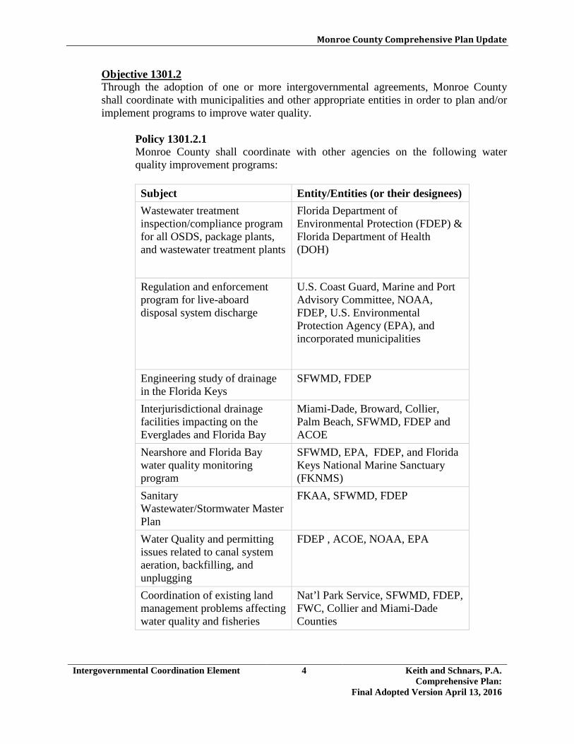
Monroe County Comprehensive Plan Update
Intergovernmental Coordination Element 4 Keith and Schnars, P.A. Comprehensive Plan:
Final Adopted Version April 13, 2016
Objective 1301.2 Through the adoption of one or more intergovernmental agreements, Monroe County shall coordinate with municipalities and other appropriate entities in order to plan and/or implement programs to improve water quality.
Policy 1301.2.1 Monroe County shall coordinate with other agencies on the following water quality improvement programs: Subject Entity/Entities (or their designees) Wastewater treatment inspection/compliance program for all OSDS, package plants, and wastewater treatment plants
Florida Department of Environmental Protection (FDEP) & Florida Department of Health (DOH)
Regulation and enforcement program for live-aboard disposal system discharge
U.S. Coast Guard, Marine and Port Advisory Committee, NOAA, FDEP, U.S. Environmental Protection Agency (EPA), and incorporated municipalities
Engineering study of drainage in the Florida Keys
SFWMD, FDEP
Interjurisdictional drainage facilities impacting on the Everglades and Florida Bay
Miami-Dade, Broward, Collier, Palm Beach, SFWMD, FDEP and ACOE
Nearshore and Florida Bay water quality monitoring program
SFWMD, EPA, FDEP, and Florida Keys National Marine Sanctuary (FKNMS)
Sanitary Wastewater/Stormwater Master Plan
FKAA, SFWMD, FDEP
Water Quality and permitting issues related to canal system aeration, backfilling, and unplugging
FDEP , ACOE, NOAA, EPA
Coordination of existing land management problems affecting water quality and fisheries
Nat’l Park Service, SFWMD, FDEP, FWC, Collier and Miami-Dade Counties

Monroe County Comprehensive Plan Update
Intergovernmental Coordination Element 5 Keith and Schnars, P.A. Comprehensive Plan:
Final Adopted Version April 13, 2016
Objective 1301.3 Level of service standards established by the Comprehensive Plan shall be reviewed with the entity actually responsible for providing the facilities to ensure that adequate capacity is available to meet the needs of existing and future residents. §163.3177(6)(h)3.b., F.S.]
Policy 1301.3.1 When conflicts with other local governments arise, including but not limited to the following topics: 1. establishing when, how and which public facilities' LOS standards shall be
measured across jurisdictional lines;
2. evaluating the impact on levels of service caused by development within each jurisdiction, to ensure concurrency, and to assess the development's impacts on land use;
3. allocating the relative proportions of future development;
4. establishing a system to monitor future development within the jurisdictions;
and
5. mediating disputes between the jurisdictions regarding the allocation of future development.
Monroe County shall initiate and utilize the South Florida Regional Planning Council's (SFRPC) Regional Dispute Resolution Process (RDRP) to resolve conflicts. [§163.3177(6)(h)1.b., F.S.] Policy 1301.3.2 Monroe County shall, through its development review process, consider the impacts of proposed developments on the LOS standards of adjacent local governments and the Counties of Miami-Dade and Collier. Policy 1301.3.3 As part of the planning process, Monroe County shall consider the impacts of projected development on the comprehensive plans of incorporated communities within the County. [§163.3177(6)(h)1., F.S.] Policy 1301.3.4 Within one (1) year after the adoption of the Plan, Monroe County shall coordinate with Miami-Dade County to evaluate the impact of development on levels of service within one mile of County borders, and ensure concurrency and assess impacts on existing and proposed land use.
Monroe County Comprehensive Plan Update
Intergovernmental Coordination Element 6 Keith and Schnars, P.A. Comprehensive Plan:
Final Adopted Version April 13, 2016
Objective 1301.4 Establish or maintain coordination mechanisms to ensure transportation related programs, plans, and facility improvements are fully considered by the appropriate federal, State, regional or local agency. [§163.3177(6)(h)3.b., F.S.]
Policy 1301.4.1 Monroe County shall continue operating the Monroe County Transportation Disadvantaged Program and coordinating the program with Key West Transit, and the Florida Department of Transportation. [§163.3177(6)(h)3.b., F.S.] Policy 1301.4.2 Monroe County shall coordinate with Miami-Dade Transit (MDT) and Key West Transit to better coordinate transit service between Key West and Miami-Dade County. Policy 1301.4.3 Monroe County shall coordinate development proposals for port and related facilities with the requirements of the United States Army Corps of Engineers and the FDOT District Six Five-Year Transportation Plan as adopted. [§163.3177(6)(h)3.b., F.S.] Policy 1301.4.4 Monroe County shall coordinate port related improvements with Key West Transit (KWT) by designating a member of the staff of the Planning Department to act as a liaison with KWT [§163.3177(6)(h)3.b., F.S.] Policy 1301.4.5 Monroe County shall coordinate all County-owned aviation or related facilities with the plans of the Federal Aviation Administration, military services, the Florida Department of Transportation 5-Year Plan, and the Continuing Florida Aviation System Planning Process as adopted. [§163.3177(6)(h)3.b., F.S.] Policy 1301.4.6 Monroe County shall maintain and update a master plan for each public airport pursuant to the rules of the Federal Aviation Administration. Policy 1301.4.7 Monroe County shall work with the FDOT and Federal Aviation Administration to secure airport improvement grants. Policy 1301.4.8 Monroe County shall coordinate with the cities of Key West and Marathon for the County to review land development permit applications related to the Key West International Airport and the Florida Keys Marathon Airport, as the County’s Airport District Future Land Use applies to these airports.

Monroe County Comprehensive Plan Update
Intergovernmental Coordination Element 7 Keith and Schnars, P.A. Comprehensive Plan:
Final Adopted Version April 13, 2016
Policy 1301.4.9 Monroe County shall coordinate expansions and operation of the Key West airport with the U.S. Navy.
Policy 1301.4.10 Monroe County shall continue to coordinate with the FDOT to ensure that U.S. 1 roadway capacity improvements are placed on FDOT's District Six Five-Year Transportation Plan to reduce and maintain hurricane evacuation clearance times to 24 hours. [§163.3177(6)(h)3.b., F.S.] Policy 1301.4.11 Monroe County shall coordinate with FDOT on future U.S.1 roadway projects as they relate to the existing visions and goals of the Livable CommuniKeys Plans. Policy 1301.4.12 Monroe County, will assist the designated corridor management entity and the FDOT to support the implementation of the Vision, Goals, Objectives and Strategies of the Florida Scenic Highway Corridor Master Plan and the recommendations of the Florida Scenic Highway Interpretive Master Plan. (Ord. 022-2009) Policy 1301.4.13 Monroe County will assist the Florida Department of Environmental Protection (FDEP) and FDOT to support the implementation of the Florida Keys Overseas Heritage Trail Master Plan. (Ord. 022-2009)
<The remainder of this page intentionally left blank>
Monroe County Comprehensive Plan Update
Intergovernmental Coordination Element 8 Keith and Schnars, P.A. Comprehensive Plan:
Final Adopted Version April 13, 2016
Objective 1301.5 Ensure that implementation, monitoring, and evaluation of the Monroe County Comprehensive Plan is coordinated with the plans and programs of:
The Land Authority of Monroe County The Monroe County Property Appraiser's Office The District School Board of Monroe County The Florida Department of Transportation The South Florida Regional Planning Council The South Florida Water Management District The Florida Department of Environmental Protection The Florida Keys Aqueduct Authority The Florida Department of Health The Monroe County Sheriff's Department Monroe County Housing Authority Key West Transit Florida Department of Economic Opportunity Naval Air Station – Key West [§163.3177(6)(h)1., F.S.] Policy 1301.5.1 Monroe County, in updating its drainage policies and ordinances, shall meet with the SFWMD to ensure that the local regulatory framework is consistent with the planning objectives and regulations of the region. [§163.3177(6)(h)3.b., F.S.] Policy 1301.5.2 Monroe County shall work with the County Housing Authority to encourage development of elderly and institutional housing and identify funding sources for community-based non-profit organizations to provide affordable housing for low-income residents. Policy 1301.5.3 Monroe County shall coordinate with the District School Board of Monroe County on the siting and expansion of required facilities. Policy 1301.5.4 Monroe County shall, during the preparation of the Concurrency Management Report, coordinate with the applicable municipalities and utility providers to determine the acreage and location of land needed to accommodate projected service expansions. [§163.3177(6)(h)1., F.S.] Policy 1301.5.5 Monroe County shall, coordinate with hospitals in the County to ensure the availability of adequate land to meet hospital expansion and improvement requirements.

Monroe County Comprehensive Plan Update
Intergovernmental Coordination Element 9 Keith and Schnars, P.A. Comprehensive Plan:
Final Adopted Version April 13, 2016
Objective 1301.6 Monroe County shall implement mechanisms to identify and resolve intergovernmental coordination needs pertaining to environmental issues and natural resource protection.
Policy 1301.6.1 Monroe County shall continue to coordinate with applicable State agencies to promote utilization of reclaimed water storage systems and utilization for all exterior irrigation and flushing purposes. Policy 1301.6.2 Monroe County, in coordination with FDEP and EPA representatives, shall review the annual air quality monitoring data for Monroe County. Any violations of the NAAQS or trends in ambient air quality shall be reported to the Board of County Commissioners. Policy 1301.6.3 The County shall coordinate its upland habitat mapping and evaluation efforts with the U.S. Environmental Protection Agency, U.S. Army Corps of Engineers, USFWS, FDEP, South Florida Water Management District (SFWMD), Florida Fish and Wildlife Conservation Commission (FWC), and the National Audubon Society (Research Department). Policy 1301.6.4 Monroe County shall coordinate its boating impacts management activities with those of the Florida Keys National Marine Sanctuary (FKNMS), the FDEP, the Coast Guard, and the USFWS. Policy 1301.6.5 Monroe County shall work cooperatively with the USFWS, FKNMS, and the National Park Service to promote their efforts for the recovery of plant species designated by the federal government as threatened and endangered. Policy 1301.6.6 Monroe County shall continue to support the FKNMS Management Program. This program includes management strategies for the protection of living marine resources in the waters of the Florida Keys. The County shall: 1. participate in the updates or revisions of the management plan; 2. recommend updated management strategies; 3. review the updates to the management plan to assess the common goals and
policies between the FKNMS management plan and this comprehensive plan;

Monroe County Comprehensive Plan Update
Intergovernmental Coordination Element 10 Keith and Schnars, P.A. Comprehensive Plan:
Final Adopted Version April 13, 2016
4. coordinate with NOAA and other appropriate agencies to minimize redundancy and increase efficiency in the effort to accomplish common goals; and
5. enter into a memorandum of understanding, as necessary, with NOAA and/or
other agencies to specify which policies will be implemented by each agency. Monroe County shall implement those portions of the FKNMS Management Plan:
a) which are consistent with the goals, objectives, and policies of this
comprehensive plan;
b) which are within the County's jurisdiction; and
c) for which funding is available.
Policy 1301.6.7 Monroe County shall coordinate with other applicable agencies and counties to address existing and potential land management problems in the region which may affect the conservation, use and protection of unique vegetative communities and species of special status on mainland Monroe County. Policy 1301.6.8 Monroe County shall continue to implement the following species of special status identification and protection programs in coordination and cooperation with all pertinent agencies and organizations, including but not limited to the following: Subject Coordination Entity/Entities Prepare management guidelines for federally-designated wildlife species
FDEP, FWC, and USFWS
Maintain a list of undesirable exotic wildlife populations
FWC and USFWS
Identify probable concentrated range of wildlife species of special status
FDEP, The Nature Conservancy, FWC, and USFWS
Promote recovery of threatened and endangered species by coordinating development review and protection.
FWC and USFWS

Monroe County Comprehensive Plan Update
Intergovernmental Coordination Element 11 Keith and Schnars, P.A. Comprehensive Plan:
Final Adopted Version April 13, 2016
Subject Coordination Entity/Entities Maintain the list of offshore island rookeries and nesting areas where development shall be prohibited
FDEP, National Audubon Society, USFWS, NOAA, and FWC
Maintain protection and habitat preservation measures to assist with recovery of the Eastern Indigo Snake, Key Deer, Key Largo Wood Rat, Silver Rice Rat, Key Largo Cotton Mouse, Key Tree Cactus, Schaus Swallowtail Butterfly, Stock Island Tree Snail, and the Lower Keys Marsh Rabbit
USFWS and FWC
Policy 1301.6.9 Monroe County shall work cooperatively with the FDEP and SFWMD to identify alternatives for adaptive reclamation and productive reuse of resource extraction pits in the Florida Keys. Policy 1301.6.10 Monroe County shall initiate discussions with the FKAA and providers of electricity and telephone service to assess the measures which could be taken to discourage extension of facilities and services to undeveloped Coastal Barrier Resource Systems (CBRS) units. Policy 1301.6.11 Monroe County shall coordinate with FDEP and encourage total acquisition of North Key Largo under the Florida Forever Program. Policy 1301.6.12 Monroe County shall continue to solicit comments from and offer comments to FDEP, NOAA, SFWMD, USFWS, FWC, ACOE and DEO on permitting, planning, regulatory revisions, and other agency-related issues. Policy 1301.6.13 Monroe County shall encourage coordination with the appropriate agencies to develop a natural disasters response plan pertaining to beach restoration and natural area clean-up.
<The remainder of this page intentionally left blank>

Monroe County Comprehensive Plan Update
Intergovernmental Coordination Element 12 Keith and Schnars, P.A. Comprehensive Plan:
Final Adopted Version April 13, 2016
Objective 1301.7 Monroe County shall continue to initiate the necessary interlocal coordination mechanisms to improve hurricane evacuation times and assure the provision of an adequate number of shelter facilities for evacuating Monroe County residents.
Policy 1301.7.1 Pursuant to Rule 28-20.140(5)(a)11., Monroe County shall continue to coordinate and maintain the memorandum of understanding (MOU) with the Department of Economic Opportunity (DEO), Division of Emergency Management, Marathon, Islamorada, Key West, Key Colony Beach and Layton. The MOU was executed by all parties and has an effective date of November 5, 2012. Policy 1301.7.2 Monroe County shall consider developing a plan which will identify the appropriate agencies required for coordination and funding of one Category 5 Emergency Operations Center (EOC), in each of the three EOC districts. Policy 1301.7.3 Monroe County shall continue to coordinate with the Florida Division of Emergency Management, the South Florida Regional Planning Council, and Miami-Dade County to identify sufficient approved shelter spaces (including pet-friendly shelters) outside of Monroe County for all county residents who will require shelter from a Category 3 or greater hurricane. Policy 1301.7.4 Within one (1) year after the adoption of the Plan, Monroe County shall enter into an interlocal agreement with Miami-Dade County and other appropriate agencies (e.g., the Board of Regents) to provide sufficient additional approved spaces outside of Monroe County capable of withstanding Category 3 or stronger hurricanes and their associated surges for all county residents who will require shelter from a Category 3 or greater hurricane. Policy 1301.7.5 Monroe County shall continue to coordinate with the U.S. Coast Guard to identify areas of mutual concern during a hurricane evacuation and identify the appropriate coordination mechanisms and procedures.
<The remainder of this page intentionally left blank>
Monroe County Comprehensive Plan Update
Intergovernmental Coordination Element 13 Keith and Schnars, P.A. Comprehensive Plan:
Final Adopted Version April 13, 2016
Objective 1301.8 Monroe County shall increase intergovernmental coordination efforts with the Department of Economic Opportunity (DEO), the Florida Department of Environmental Protection (FDEP), the South Florida Regional Planning Council (SFRPC), and the County's municipalities to develop and implement the most cost-effective and environmentally sound methods of regional solid and hazardous waste management.
Policy 1301.8.1 Monroe County shall continue to negotiate an interlocal agreement with the Cities of, Key Colony Beach, Marathon and Layton for the consolidated handling, processing and disposal of solid waste. Policy 1301.8.2 Within three (3) years after the adoption of the 2030 Comprehensive Plan, Monroe County shall implement a county-wide, mandatory recycling program for residential and commercial locations, including programs implemented with funds other than County tax dollars.
<The remainder of this page intentionally left blank>

Monroe County Comprehensive Plan Update
Intergovernmental Coordination Element 14 Keith and Schnars, P.A. Comprehensive Plan:
Final Adopted Version April 13, 2016
GOAL 1302 Monroe County shall increase the participation of the citizens of the County and government related entities that operate within the County in the comprehensive planning and growth management process.
Objective 1302.1 Monroe County shall provide for and facilitate public participation and awareness in the comprehensive planning process. Pursuant to Section 163.3181, F.S., Monroe County shall maintain procedures designed to provide effective public participation and to provide real property owners with notice of all official actions which will regulate the use of their property.
Policy 1302.1.1 Monroe County shall continue to utilize an information exchange program, including the full utilization of an updated mailing list, to provide for the communication of issues in summary form between the County and all interested parties. Policy 1302.1.2 Monroe County shall develop public awareness of the Comprehensive Plan by providing for public education programs designed to promote a widespread understanding of the Plan's purpose and intent. Further, the adopted comprehensive plan shall be maintained on the County website. Policy 1302.1.3 Government and government related entities shall receive a copy of this comprehensive plan within six weeks after final approval by the State Land Planning Agency. Policy 1302.1.4 Within one (1) year after the adoption of the 2030 Comprehensive Plan, Monroe County shall adopt land development regulations creating a required community meeting to emphasize the importance of citizen participation as early as possible in the planning and development review process. The following shall be considered for inclusion:
• Applicants requesting a Major Conditional Use permit, development agreement, Land Use District (Zoning) Map amendment, Land Use District (Zoning) Map Overlay amendment, or Future Land Use Map amendment shall provide for community participation.
• Between 45 and 120 days prior to any required public hearing(s) a community meeting shall be held at a location close to the project site.
• This meeting shall be noticed to surrounding property owners and advertised by the applicant at least 10 days before the community meeting, in a newspaper of general circulation.
• The applicant shall pay the cost of the public notice and advertising for the community meeting.

Monroe County Comprehensive Plan Update
Intergovernmental Coordination Element 15 Keith and Schnars, P.A. Comprehensive Plan:
Final Adopted Version April 13, 2016
• This meeting shall be facilitated by a representative from the Monroe County Growth Management Division and the applicant shall be present at the meeting.
Policy 1302.1.5 Within one (1) year after the adoption of the 2030 Comprehensive Plan, Monroe County shall adopt land development regulations creating a required community meeting to emphasize the importance of citizen participation as early as possible in the planning process. The following shall be considered for inclusion:
• Proposals by the County or a private applicant to amend the text of the Land Development Code and/or Comprehensive Plan, with a county-wide impact, shall require a community meeting at least three months prior to any required public hearing.
• A private applicant shall pay the cost of the public notice and advertising for the community meeting.
• This meeting shall be noticed and advertised by the County at least 10 days before the community meeting, in a newspaper of general circulation.
• This meeting shall be facilitated by a representative from the Monroe County Growth Management Division and the applicant shall be present at the meeting.
Policy 1302.1.6 Within one (1) year after the adoption of the 2030 Comprehensive Plan, Monroe County shall adopt land development regulations requiring a private applicant submitting an application for an amendment to the text of the Land Development Code and/or Comprehensive Plan to participate in a concept meeting with the Planning and Environmental Resources Department. Private proposals to amend the text of the Land Development Code and/or Comprehensive Plan, shall also require a public meeting with the Board of County Commissioners to be held in Marathon whereby County staff will identify county-wide policy impacts, based upon the concept meeting, for the Board of County Commissioners in a written document. This initial public meeting will allow the public to have input. A private applicant shall pay the costs of the concept meeting and for the public notice and advertising required for the Board of County Commissioners meeting. Policy 1302.1.7 Pursuant to Section 163.3181, F.S., if Monroe County denies a property owner’s request for an amendment to the Comprehensive Plan which is applicable to the property of the owner, Monroe County shall provide an opportunity for informal mediation or other alternative dispute resolution. The costs of the mediation or other alternative dispute resolution shall be borne equally by Monroe County and the property owner. If the property owner requests mediation, the time for bringing a judicial action is tolled until the completion of the mediation or 120 days, whichever is earlier.

Monroe County Comprehensive Plan Update
Capital Improvements Element 1 Keith and Schnars, P.A. Comprehensive Plan:
Final Adopted Version April 13, 2016
3.14 CAPITAL IMPROVEMENTS GOAL 1401 Monroe County shall provide and maintain, in a timely and efficient manner, adequate public facilities for both existing and future populations, consistent with available financial resources and the other elements of the Comprehensive Plan. [§163.3177(3)(a), F.S.]
Objective 1401.1 Monroe County shall provide the capital improvements necessary to correct existing deficiencies, to accommodate projected future growth, and to replace obsolete and worn-out facilities, in accordance with an adopted Capital Improvements Program. [§163.3177(3)(a)1., F.S.]
Policy 1401.1.1 Monroe County shall update annually the existing County Capital Improvements Program to incorporate the improvements identified in the Five-Year Schedule of Capital Improvements Table4.1. [§163.3177(3)(a)5.(b), F.S.] Policy 1401.1.2 Monroe County shall annually update the Comprehensive Plan Five-Year Schedule of Capital Improvements. Proposed revisions to the Schedule, including those addressing the replacement and renewal of capital facilities, shall be evaluated and updated in accordance with the following considerations (not listed in order of priority): 1. consistency with the relevant elements of the Comprehensive Plan;
2. the elimination of public hazards;
3. consider sea level rise projections as they relate to transportation and bridging
projects in particular;
4. the County’s need for financial expenditures for infrastructure improvements within or proximate to vulnerable areas;
5. the elimination of existing deficiencies;
6. financial feasibility including the impact on the annual operating and capital
budgets;
7. the location in relation to the Future Land Use Map;
8. accommodation of the demands from redevelopment and new development;
Monroe County Comprehensive Plan Update
Capital Improvements Element 2 Keith and Schnars, P.A. Comprehensive Plan:
Final Adopted Version April 13, 2016
9. the consistency of the improvement relative to the plans of state agencies and the South Florida Water Management District; and
10. the availability of other revenue sources including, but not limited to, FDOT
Project funding and FDOT Traffic Operations funds from District Dedicated Revenue (DDR) sources.
Revisions to the schedule shall be incorporated into the Capital Improvements Program on an annual basis. [§163.3177(3)(a)5.(b), F.S.] Policy 1401.1.3 Capital improvement projects required to correct existing facility deficiencies shall receive priority over those projects required to serve future development. [§163.3177(3)(a)1., F.S.]
<The remainder of this page intentionally left blank>

Monroe County Comprehensive Plan Update
Capital Improvements Element 3 Keith and Schnars, P.A. Comprehensive Plan:
Final Adopted Version April 13, 2016
Five-Year Schedule of Capital Improvements Table (Adopted by BOCC January 20, 2016)

Monroe County Comprehensive Plan Update
Capital Improvements Element 4 Keith and Schnars, P.A. Comprehensive Plan:
Final Adopted Version April 13, 2016

Monroe County Comprehensive Plan Update
Capital Improvements Element 5 Keith and Schnars, P.A. Comprehensive Plan:
Final Adopted Version April 13, 2016
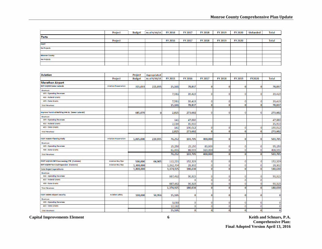
Monroe County Comprehensive Plan Update
Capital Improvements Element 6 Keith and Schnars, P.A. Comprehensive Plan:
Final Adopted Version April 13, 2016

Monroe County Comprehensive Plan Update
Capital Improvements Element 7 Keith and Schnars, P.A. Comprehensive Plan:
Final Adopted Version April 13, 2016

Monroe County Comprehensive Plan Update
Capital Improvements Element 8 Keith and Schnars, P.A. Comprehensive Plan:
Final Adopted Version April 13, 2016

Monroe County Comprehensive Plan Update
Capital Improvements Element 9 Keith and Schnars, P.A. Comprehensive Plan:
Final Adopted Version April 13, 2016

Monroe County Comprehensive Plan Update
Capital Improvements Element 10 Keith and Schnars, P.A. Comprehensive Plan:
Final Adopted Version April 13, 2016
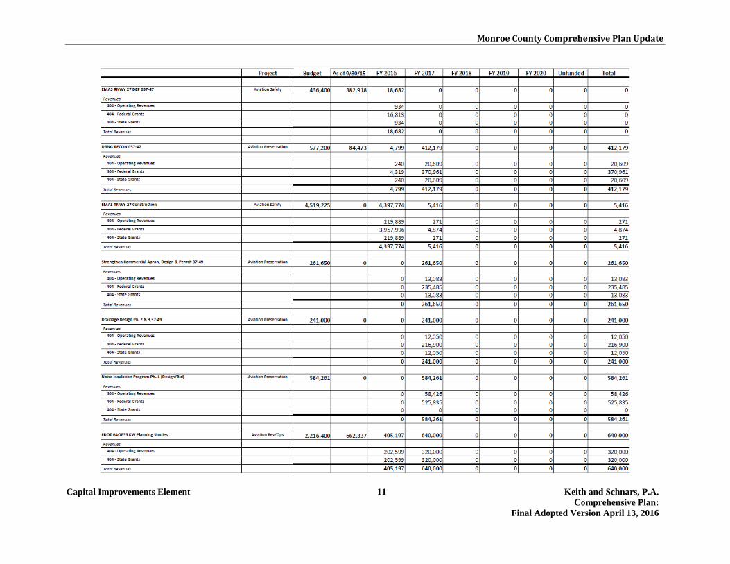
Monroe County Comprehensive Plan Update
Capital Improvements Element 11 Keith and Schnars, P.A. Comprehensive Plan:
Final Adopted Version April 13, 2016

Monroe County Comprehensive Plan Update
Capital Improvements Element 12 Keith and Schnars, P.A. Comprehensive Plan:
Final Adopted Version April 13, 2016
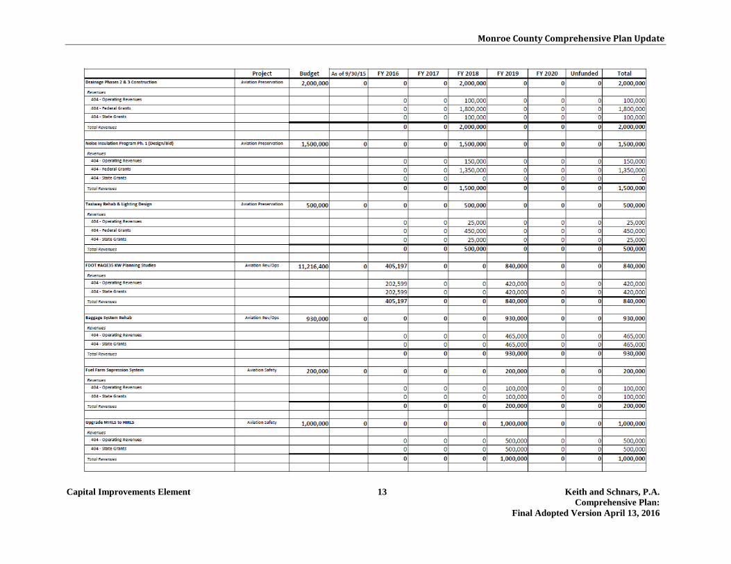
Monroe County Comprehensive Plan Update
Capital Improvements Element 13 Keith and Schnars, P.A. Comprehensive Plan:
Final Adopted Version April 13, 2016
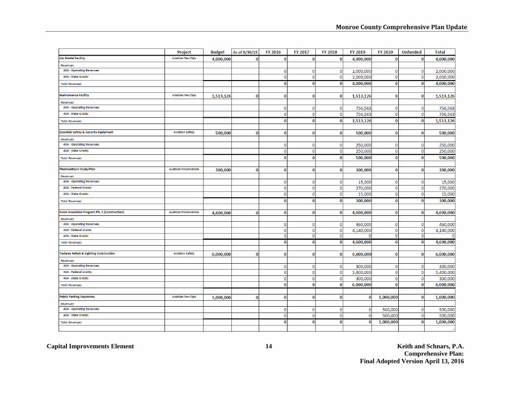
Monroe County Comprehensive Plan Update
Capital Improvements Element 14 Keith and Schnars, P.A. Comprehensive Plan:
Final Adopted Version April 13, 2016

Monroe County Comprehensive Plan Update
Capital Improvements Element 15 Keith and Schnars, P.A. Comprehensive Plan:
Final Adopted Version April 13, 2016

Monroe County Comprehensive Plan Update
Capital Improvements Element 16 Keith and Schnars, P.A. Comprehensive Plan:
Final Adopted Version April 13, 2016

Monroe County Comprehensive Plan Update
Capital Improvements Element 17 Keith and Schnars, P.A. Comprehensive Plan:
Final Adopted Version April 13, 2016

Monroe County Comprehensive Plan Update
Capital Improvements Element 18 Keith and Schnars, P.A. Comprehensive Plan:
Final Adopted Version April 13, 2016

Monroe County Comprehensive Plan Update
Capital Improvements Element 19 Keith and Schnars, P.A. Comprehensive Plan:
Final Adopted Version April 13, 2016

Monroe County Comprehensive Plan Update
Capital Improvements Element 20 Keith and Schnars, P.A. Comprehensive Plan:
Final Adopted Version April 13, 2016

Monroe County Comprehensive Plan Update
Capital Improvements Element 21 Keith and Schnars, P.A. Comprehensive Plan:
Final Adopted Version April 13, 2016

Monroe County Comprehensive Plan Update
Capital Improvements Element 22 Keith and Schnars, P.A. Comprehensive Plan:
Final Adopted Version April 13, 2016

Monroe County Comprehensive Plan Update
Capital Improvements Element 23 Keith and Schnars, P.A. Comprehensive Plan:
Final Adopted Version April 13, 2016

Monroe County Comprehensive Plan Update
Capital Improvements Element 24 Keith and Schnars, P.A. Comprehensive Plan:
Final Adopted Version April 13, 2016

Monroe County Comprehensive Plan Update
Capital Improvements Element 25 Keith and Schnars, P.A. Comprehensive Plan:
Final Adopted Version April 13, 2016

Monroe County Comprehensive Plan Update
Capital Improvements Element 26 Keith and Schnars, P.A. Comprehensive Plan:
Final Adopted Version April 13, 2016

Monroe County Comprehensive Plan Update
Capital Improvements Element 27 Keith and Schnars, P.A. Comprehensive Plan:
Final Adopted Version April 13, 2016

Monroe County Comprehensive Plan Update
Capital Improvements Element 28 Keith and Schnars, P.A. Comprehensive Plan:
Final Adopted Version April 13, 2016
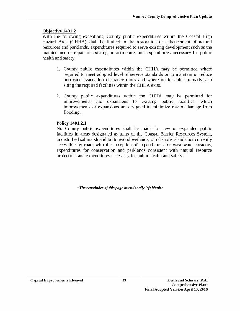
Monroe County Comprehensive Plan Update
Capital Improvements Element 29 Keith and Schnars, P.A. Comprehensive Plan:
Final Adopted Version April 13, 2016
Objective 1401.2 With the following exceptions, County public expenditures within the Coastal High Hazard Area (CHHA) shall be limited to the restoration or enhancement of natural resources and parklands, expenditures required to serve existing development such as the maintenance or repair of existing infrastructure, and expenditures necessary for public health and safety:
1. County public expenditures within the CHHA may be permitted where required to meet adopted level of service standards or to maintain or reduce hurricane evacuation clearance times and where no feasible alternatives to siting the required facilities within the CHHA exist.
2. County public expenditures within the CHHA may be permitted for
improvements and expansions to existing public facilities, which improvements or expansions are designed to minimize risk of damage from flooding.
Policy 1401.2.1 No County public expenditures shall be made for new or expanded public facilities in areas designated as units of the Coastal Barrier Resources System, undisturbed saltmarsh and buttonwood wetlands, or offshore islands not currently accessible by road, with the exception of expenditures for wastewater systems, expenditures for conservation and parklands consistent with natural resource protection, and expenditures necessary for public health and safety.
<The remainder of this page intentionally left blank>

Monroe County Comprehensive Plan Update
Capital Improvements Element 30 Keith and Schnars, P.A. Comprehensive Plan:
Final Adopted Version April 13, 2016
Objective 1401.3 Monroe County shall ensure that future development pays its proportionate share of the costs of improvements necessary to serve new development at the adopted level of service standards. [§163.3177(3)(a)3., F.S.]
Policy 1401.3.1 Monroe County shall revise and update the Land Development Code to update the County's current expenditure procedures and proportional share assessment of impact fees, in accordance with the adopted levels of service referenced in Policy 1401.4.1. The revised Land Development Code shall also include provisions for the collection of impact fees to offset the public costs of public facilities and services.
<The remainder of this page intentionally left blank>
Monroe County Comprehensive Plan Update
Capital Improvements Element 31 Keith and Schnars, P.A. Comprehensive Plan:
Final Adopted Version April 13, 2016
Objective 1401.4 Monroe County shall coordinate land use decisions and fiscal resources with a schedule of capital improvements in order to maintain the adopted level of service (LOS) standards for both issued development orders and future development. [§163.3177(3)(a)3., F.S.]
Policy 1401.4.1 Monroe County shall adopt and maintain level of service (LOS) standards for the following public facility types: roads, sanitary sewer, solid waste, drainage, potable water, and parks and recreation. The LOS standards are established in the following sections of the Comprehensive Plan: 1. The LOS for roads is established in Traffic Circulation Policies 301.1.1 and
301.1.2;
2. The LOS for potable water is established in Potable Water Policy 701.1.1;
3. The LOS for solid waste is established in Solid Waste Policy 801.1.1;
4. The LOS for sanitary sewer is established in Sanitary Sewer Policy 901.1.1;
5. The LOS for drainage is established in Drainage Policy 1001.1.1; and
6. The LOS for parks and recreation is established in Recreation and Open Space Policy 1201.1.1.
Policy 1401.4.2 Monroe County shall adopt a Capital Budget at the same time it adopts its Annual Operating Budget. The Capital Budget shall include those projects necessary to maintain the adopted levels of service referenced in Policy 1401.4.1. Policy 1401.4.3 To the extent allowed by Florida Statutes, Monroe County supports the use of tourist-related charges to offset tourist-related impacts on public facilities. Monroe County supports the use of Tourist Development Council funds to provide public facilities that will serve both tourists and residents. Policy 1401.4.4 Public facilities and services needed to support development shall be available in accordance with the adopted levels of service referenced in Policy 1401.4.1. Development approval may be phased to allow the provision of public facilities and services necessary to maintain the adopted levels of service. Policy 1401.4.5 Monroe County hereby adopts a Concurrency Management System to ensure that facilities and services needed to support development are available concurrent with the impact of development. The Concurrency Management System shall

Monroe County Comprehensive Plan Update
Capital Improvements Element 32 Keith and Schnars, P.A. Comprehensive Plan:
Final Adopted Version April 13, 2016
ensure that the County shall issue no development order or permit which results in a reduction in the level of service (LOS) below the adopted LOS standards referenced in Policy 1401.4.1 for those public facilities that are subject to the system. The guidelines established in Policies 1401.4.6, 1401.4.7, 1401.4.8, 1401.4.9, and 1401.4.10 shall ensure that concurrency is successfully implemented. Policy 1401.4.6 The following guidelines identify the stages in the development review process when the test for concurrency must be met. 1. Preliminary Development Order Stage - A preliminary development order is a
development order that precedes the issuance of a building permit, such as a subdivision plat, development plan, certificate of compliance, conditional use permit, or development of regional impact development order. A proposed development must receive a conditional concurrency determination prior to receiving a preliminary development order.
2. Final Development Order Stage - A final development order is a building
permit or any other development permit authorizing the construction or expansion of a structure, an increase in development intensity, or a change of use requiring a new certificate of occupancy. A proposed development must receive a final concurrency determination prior to receiving a final development order.
Policy 1401.4.7 The following guidelines identify the effect of a concurrency determination: 1. A Conditional Concurrency Determination shall indicate that adequate public
facilities are available at the time the determination is issued, but shall not guarantee the adequacy or availability of public facilities at subsequent stages of development review.
2. A Final Concurrency Determination shall indicate that adequate public
facilities will be available at all subsequent stages of development stages of development review, subject to certain limitations such as elapsed time and the payment of fees.
Policy 1401.4.8 The following guidelines identify the minimum criteria necessary to meet the concurrency requirements of each public facility type. 1. The concurrency requirements for potable water, solid waste, sanitary sewer,
and drainage facilities and services shall be satisfied if one or more of the following conditions are met:

Monroe County Comprehensive Plan Update
Capital Improvements Element 33 Keith and Schnars, P.A. Comprehensive Plan:
Final Adopted Version April 13, 2016
a) the necessary facilities and services are in place at the time a development permit is issued; or
b) the necessary facilities and services are in place at the time a certificate of
occupancy, or its functional equivalent is issued.
2. The concurrency requirements for recreational facilities shall be satisfied if one or more of the following conditions are met:
a) conditions 1(a) or 1(b) listed above or, in the case of acreage for parks and
recreational facilities, which shall be dedicated to or acquired by the County prior to issuance of a building permit, or funds in the amount of the developer’s fair share are committed no later than the approval to commence construction; or
b) an enforceable development agreement guarantees that the necessary
facilities and services will be in place with the issuance of the applicable development permit. An enforceable development agreement may include, but is not limited to, development agreements pursuant to section 163.3220, F.S., or an agreement or development order issued pursuant to Chapter 380, F.S.
3. The concurrency requirements for roads shall be satisfied if one or more of the following conditions are met:
a) conditions 1(a) or 1(b) listed above; or
b) a binding executed contract is in place at the time the development permit
is issued which provides for the commencement of the actual construction of the required facilities or provision of services; or
c) an enforceable development agreement guarantees that the necessary
facilities and services will be in place with the issuance of the applicable development permit. An enforceable development agreement may include, but is not limited to, development agreements pursuant to section 163.3220, F.S., or an agreement or development order issued pursuant to Chapter 380, F.S.
Policy 1401.4.9 The following guidelines identify the minimum components of the County's concurrency monitoring system. 1. The County shall maintain a database of permitting data that includes the
amount of development for which final development orders have been issued, development for which final development orders have expired, development which is under construction, and development which has been constructed.

Monroe County Comprehensive Plan Update
Capital Improvements Element 34 Keith and Schnars, P.A. Comprehensive Plan:
Final Adopted Version April 13, 2016
2. The County shall maintain a database of public facility data that includes the
capacity of existing public facilities, the additional capacity created by facility improvements, the impacts of existing development, and the impacts anticipated due to committed development.
3. The County shall prepare a Public Facilities Capacity Report assessing the
capacities of all public facilities subject to the Concurrency Management System. The Concurrency Management Report shall be used to monitor changes in the capacity of public facilities and the levels of service provided by the facilities based upon development activities and capital improvement projects completed
Policy 1401.4.10 Monroe County shall use the following guidelines for interpreting and applying level of service standards to development order applications. For the purposes of this policy, reserve capacity refers to the capacity of existing public facilities plus the capacity of public facilities which do not exist but which meet the applicable requirements of Policy 1401.4.7, less the existing demand for those facilities and the demand expected to be created for those facilities by approved but unbuilt development as determined by the databases in Policy 1401.4.9. 1. Potable Water- The County shall not render a final concurrency determination
unless the quantity of water available under the FKAA Consumptive Use Permit meets or exceeds the estimated water demand of the proposed development together with the estimated water demand of all existing and committed development.
2. Solid Waste- The County shall not render a final concurrency determination
unless capacity available at solid waste facilities under contract with Monroe County meets or exceeds the estimated daily solid waste generation of the proposed development together with the estimated daily solid waste generation of all existing and committed development for a period of three (3) years from development approval.
3. Sanitary Sewer- The County shall not render a final concurrency
determination unless the proposed development will be served by a treatment plant permitted by the FDEP with adequate reserve capacity to accommodate the impact of the proposed development or an on-site sewage disposal system permitted by the DOH.
4. Drainage- The County shall not render a final concurrency determination
unless the proposed development will be served by stormwater management facilities approved by the South Florida Water Management District; or has received an individual construction permit or written authorization to proceed pursuant to a general permit from the South Florida Water Management
Monroe County Comprehensive Plan Update
Capital Improvements Element 35 Keith and Schnars, P.A. Comprehensive Plan:
Final Adopted Version April 13, 2016
District. If the proposed development requires a permit from the South Florida Water Management District, such permit must be obtained prior to the final concurrency determination or the applicant’s drainage plans must be consistent with Monroe County’s stormwater management requirements.
5. Parks- The County shall not render a final concurrency determination unless
the park facilities either in existence or programmed within the next year will meet or exceed the estimated park demand of the proposed development together with the estimated park demand of all existing and committed development. Within each impact area for park facilities, the County shall determine the population capacity of both resource-based and activity-based facilities by multiplying the level of service standard by the number of acres of existing or programmed parks.
6. Roads- The County will not render a final concurrency determination unless
the estimated traffic impacts of the proposed development, together with the estimated traffic impacts of all existing and committed development, will not exceed the level of service of U.S. 1, as determined by the U.S. 1 Level of Service Task Force methodology. The trip assignment for proposed developments with an estimated trip generation rate of more than 10 trips per day shall be based on a traffic impact report prepared by the developer based on a professionally accepted methodology. The trip assignment for proposed developments with a trip generation rate of 10 trips or less (such as a single family home) shall be limited to the segment of U.S. 1 most directly impacted by the development.
Policy 1401.4.11 Annual debt service on Monroe County's direct debt shall not exceed the following annual median ratios for medium size counties published by Moody's Investment Services: 1. debt to operating revenue;
2. debt to assessed valuation; and
3. debt per capita. Moody's Investment Services, a bond rating agency, publishes annual medians depicting local governments' debt service as a percentage of population, operating revenue, and assessed valuation. Policy 1401.4.12 Monroe County shall revise the Comprehensive Plan Five-Year Schedule of Capital Improvements and the County Capital Improvements Program annually to include funding for any improvements required to provide for solid waste disposal
Monroe County Comprehensive Plan Update
Capital Improvements Element 36 Keith and Schnars, P.A. Comprehensive Plan:
Final Adopted Version April 13, 2016
after expiration of the current solid waste haul out contract (See Solid Waste Objective 801.3 and related policies). Policy 1401.4.13 Monroe County shall revise the Comprehensive Plan Five-Year Schedule of Capital Improvements and the County Capital Improvements Program annually to include funding for the improvements identified in the Sanitary Wastewater/Stormwater Management Master Plan.
<The remainder of this page intentionally left blank>

Monroe County Comprehensive Plan Update
Capital Improvements Element 37 Keith and Schnars, P.A. Comprehensive Plan:
Final Adopted Version April 13, 2016
Objective 1401.5 Monroe County shall provide public facilities sufficient to maintain adopted level of service standards that are within the ability of the County to fund, or within the County's authority to require others to provide. Evaluation of funding alternatives for improvements identified in other plan elements will include consideration of improvements required by existing versus future development in order to ensure a fair-share allocation of costs. [§163.3177(3)(a), F.S.]
Policy 1401.5.1 The estimated capital expenditures for all needed public facilities shall not exceed conservative estimates of revenues from sources that are available to the County pursuant to current law, and which have not been rejected by referendum, if referendum is required to enact a source of revenue. Policy 1401.5.2 Monroe County shall not provide a public facility, nor shall it accept the provision of a public facility by others, if it is unable to pay for the subsequent annual operating and maintenance costs of the facility. Policy 1401.5.3 Monroe County's Capital Improvements Program shall be monitored in conjunction with the development review process to ensure that the County is not required to construct improvements beyond its financial capacity.
<The remainder of this page intentionally left blank>

Monroe County Comprehensive Plan Update
Energy and Climate Element 1 Keith and Schnars, P.A. Comprehensive Plan:
Final Adopted Version April 13, 2016
3.15 ENERGY AND CLIMATE GOAL 1501 Monroe County shall coordinate with the municipalities of Key West, Key Colony Beach, Islamorada, Layton and Marathon; regional, State, and federal government agencies, nongovernmental organizations and private organizations to exchange data and develop coordinated strategies to address energy conservation and impacts from climate change. Objective 1501.1
Monroe County shall coordinate and collaborate with municipalities and other public and private entities to address energy conservation strategies and unique climate change impacts, including adaptation and mitigation strategies.
Policy 1501.1.1 Monroe County shall maintain existing mechanisms for exchange of ideas and data, and participate in new forums, to facilitate comprehensive and coordinated strategies promoting energy conservation and addressing climate change impacts. Policy 1501.1.2 Monroe County will participate in cooperative efforts such as the Southeast Florida Regional Climate Change Compact in order to maximize efforts to facilitate the exchange of ideas and data and coordinate policies promoting energy conservation and climate change resilience. Policy 1501.1.3 Monroe County will continue to coordinate with, and seek the support of, other counties and State agencies such as the South Florida Water Management District, South Florida Regional Planning Council, and State partners, to ensure that the latest data and approaches to energy conservation and climate change resilience are available to the County. Policy 1501.1.4 Monroe County shall seek the support of agencies, such as the National Oceanic and Atmospheric Administration (NOAA), U.S. Geological Survey (USGS), Federal Emergency Management Agency (FEMA), the U.S. Department of Interior, the U.S. Army Corps of Engineers (ACOE), as well as universities and not-for-profit organizations to coordinate support for updating, exchanging and analyzing data regarding potential changes in climate change vulnerability. Policy 1501.1.5 Monroe County will support local and regional modeling and monitoring programs, as resources permit, to assure the most current locally specific data is considered in the 2030 Comprehensive Plan and Land Development Code updates. This may include but is not be limited to programs designed to monitor surface water quality (including temperature), sea level rise, hydrologic and
Monroe County Comprehensive Plan Update
Energy and Climate Element 2 Keith and Schnars, P.A. Comprehensive Plan:
Final Adopted Version April 13, 2016
geologic conditions, groundwater quality and levels, precipitation and groundwater withdrawals from resources that the County depends upon (including those outside County lines). The County shall make such data available to the public.
<The remainder of this page intentionally left blank>

Monroe County Comprehensive Plan Update
Energy and Climate Element 3 Keith and Schnars, P.A. Comprehensive Plan:
Final Adopted Version April 13, 2016
Objective 1501.2 Recognizing the critical role of Monroe County to promote awareness on energy and climate issues, the County shall encourage collaborative intergovernmental practices that serve as a model for the municipalities and other entities to reduce greenhouse gas emissions (GHGEs) by at least 20% below the 2005 levels by 2020. Monroe County shall measure progress towards achieving reductions for its own facilities and operations every five years.
Policy 1501.2.1 Monroe County shall promote the adoption of policies and strategies across all County departments to reduce GHGEs and become more resilient to the impacts of climate change. Monroe County shall employ such strategies as establishing video conferencing capabilities to allow residents and employees to participate in meetings without having to drive long distances; evaluating the feasibility for installation of renewable energy systems on County owned facilities; and increasing the use of alternatively fueled vehicles. Policy 1501.2.2 Within one (1) year after the adoption of the 2030 Comprehensive Plan, Monroe County shall develop a procurement policy that incorporates energy saving principles for its own buildings, facilities and services. Policy 1501.2.3 Monroe County shall share information and technical data regarding the most efficient technologies to minimize GHGEs with other agencies and utilities operating within Monroe County.
<The remainder of this page intentionally left blank>

Monroe County Comprehensive Plan Update
Energy and Climate Element 4 Keith and Schnars, P.A. Comprehensive Plan:
Final Adopted Version April 13, 2016
GOAL 1502 Monroe County shall incorporate the best available data and science, into its policy and planning decisions for infrastructure, recognizing the uncertainty associated with long range climate change predictions. Objective 1502.1
In conjunction with future updates to the 2030 Comprehensive Plan and land development regulations, the County shall update the data and assumptions related to climate change impacts to infrastructure based on the latest scientific predictions and observed (monitored) impacts. Monroe County shall also consider climate change impacts such as increased temperatures, sea level rise, potentially shifting habitat and ecosystem types and the need to withstand increased storm surge in evaluating public infrastructure decisions.
Policy 1502.1.1 Prior to incorporating a new project to the Capital Improvements Element, Monroe County shall assure that it is reviewed for recommendations to increase resiliency and account for the impacts from climate change, including but not limited to, sea level rise and storm surge. Monroe County shall evaluate financial expenditures to fund repairs, reconditioning of deteriorating infrastructure and new infrastructure improvements within or proximate to vulnerable areas to manage public investments appropriately. Monroe County shall focus on level of service standards, as one of the points of analysis, to assure that infrastructure useful life and service expectations can be met in the face of climate change impacts.
Policy 1502.1.2 In the capital improvements planning process infrastructure decisions shall consider the most energy efficient technologies available. This analysis shall include the useful life of the infrastructure and the cost savings related to reduced energy needs, operations and maintenance saved from such efficiency goals. Policy 1502.1.3 Within five (5) years after the adoption of the 2030 Comprehensive Plan, Monroe County shall identify actions to promote and support increased energy efficiency measures and the proportion of electricity generated by alternative and renewable energy, including, but not limited to solar, wind, biofuels and other sources. Monroe County shall incorporate these actions into its facilities and operations as well as its fleet. Monroe County shall coordinate with Florida Keys Electric Cooperative and Keys Energy. Policy 1502.1.4 Within five (5) years after the adoption of the 2030 Comprehensive Plan, Monroe County shall identify criteria to define adaptation action areas (AAA), or a similar concept to be defined by the County, which may include infrastructure. Within five (5) years after the adoption of the 2030 Comprehensive Plan, Monroe County

Monroe County Comprehensive Plan Update
Energy and Climate Element 5 Keith and Schnars, P.A. Comprehensive Plan:
Final Adopted Version April 13, 2016
shall identify proposed adaptation action areas (AAA), or a similar concept to be defined by the County. Pursuant to Chapter 163, F.S., AAA are those areas that experience coastal flooding due to extreme high tides and storm surge, and that are vulnerable to the related impacts of rising sea levels for the purpose of prioritizing funding for infrastructure needs and adaptation planning. In the AAAs, strategies will be developed to address vulnerabilities from these effects as well as the rate of impact and available adaptation options. In conjunction with later updates to the 2030 Comprehensive Plan, Monroe County shall update existing, or map new, potential impacts of sea-level rise for consideration in long-term planning decisions. Policy 1502.1.5 Within five (5) years after the adoption of the 2030 Comprehensive Plan, Monroe County shall initiate an inventory of existing and planned infrastructure up to the 2030 horizon, based upon the vulnerability mapping identified in Policy 1502.1.4, for capacity to accommodate projected sea-level rise over the life expectancy of that infrastructure. Monroe County shall identify the infrastructure within those areas, its useful life and any retrofits or capital projects necessary to address the impacts of sea level rise. These strategies may include defense, accommodation, or and retreat projects, or not building planned infrastructure in vulnerable locations, to address the impacts of sea level rise. Monroe County will consider developing design criteria, in conjunction with a broader asset management planning process. Policy 1502.1.6 Within five (5) years after the adoption of the 2030 Comprehensive Plan, Monroe County shall consider incorporating a planning, design and permitting standard for infrastructure and public facilities that may include a sea level rise assumption of 3”-7” by 2030 as developed by the Southeast Regional Climate Compact. The County shall review and update sea level rise projections when new and pertinent data is available. (The 3”-7” by 2030 is based on a 2010 baseline -- if adjusted to a 1992 baseline it would result in 6” to 10” by 2030 above the 1992 mean sea level) Policy 1502.1.7 Monroe County shall ensure that new, renovated and replacement public facilities and infrastructure, such as streets and bridges, water and wastewater treatment plants, police stations and fire stations, and any other public facilities that the County has authority over, are designed in a manner which considers the useful life of public facilities and infrastructure. The County shall also consider the potential impacts from climate change, including rising sea levels and shoreline stabilization needs, on its infrastructure and public facilities.

Monroe County Comprehensive Plan Update
Energy and Climate Element 6 Keith and Schnars, P.A. Comprehensive Plan:
Final Adopted Version April 13, 2016
Policy 1502.1.8 Monroe County shall exchange data regarding locally-specific vulnerable areas and land use strategies/policies with the Florida Department of Transportation, the U.S. Department of Transportation and the Federal Highway Administration relative to ferry, airport, transit, bridges and transportation systems. Policy 1502.1.9 Monroe County shall coordinate with appropriate agencies to monitor changes to minimum road elevation standards which may be specific to Monroe County due to its unique exposure to climate change and sea level rise impacts. This could also include enhanced stormwater management requirements and resurfacing requirements for certain transportation segments. Policy 1502.1.10 Within five (5) years after the adoption of the 2030 Comprehensive Plan, Monroe County shall review land development regulations that address stormwater management considerations for sea level rise impacts. To the extent practicable, Monroe County shall incorporate green infrastructure or passive alternatives that maximize land preservation over impervious or “active” infrastructure. Such alternatives could include the reconditioning and reuse of septic tanks, increased use of rainwater harvesting techniques, such as cisterns and other water storage techniques. Monroe County shall determine if land development regulation amendments are needed to address increased retention requirements and other topographic or infiltration considerations which may influence stormwater management requirements. Monroe County shall also consider the ability to meet water quality requirements related to stormwater management regulations and if there are any impacts from climate change that may jeopardize the County’s ability to meet those requirements.
<The remainder of this page intentionally left blank>

Monroe County Comprehensive Plan Update
Energy and Climate Element 7 Keith and Schnars, P.A. Comprehensive Plan:
Final Adopted Version April 13, 2016
GOAL 1503 Monroe County shall address energy and climate issues in the built environment by: encouraging green development practices; reducing waste; enhancing transportation choices; and educating the community about the need to reduce energy use and prepare for climate change impacts. Objective 1503.1
To address the impacts of GHGEs and climate change, Monroe County shall promote energy efficiency across all sectors of energy use, public and private sector, in the built environment.
Policy 1503.1.1 Within five (5) years after the adoption of the 2030 Comprehensive Plan, Monroe County shall include more energy efficiency requirements into the Land Development Code as appropriate. These practices may include climate change impacts as a factor in determining appropriate levels of development in vulnerable areas. Policy 1503.1.2 Within seven (7) years after the adoption of the Comprehensive Plan, Monroe County may include climate change impacts as a factor in determining appropriate levels of development. Policy 1503.1.3 Within (5) years after the adoption of the 2030 Comprehensive Plan, Monroe County shall update the Land Development Code to increase bicycle and pedestrian-friendly development with more transportation options and increase the construction of energy efficient and climate resilient structures. Policy 1503.1.4 Monroe County shall review the most updated FEMA maps within one (1) year of their release and evaluate floor elevation requirements, as necessary, for all new construction in vulnerable areas. Policy 1503.1.5 Consistent with the Lower East Coast Regional Water Supply Plan, Monroe County shall encourage FKAA to continue expanding water auditing programs to increase the scope of the audits and identify opportunities to reduce system leaks and promote water conservation retrofitting. Policy 1503.1.6 Within one (1) year after the adoption of the 2030 Comprehensive Plan, Monroe County shall develop policies to increase water conservation, which may include the adoption of a recognized standard such as the South Florida Water Management District’s “Water Star” or EPA’s “Water Sense” programs.

Monroe County Comprehensive Plan Update
Energy and Climate Element 8 Keith and Schnars, P.A. Comprehensive Plan:
Final Adopted Version April 13, 2016
Policy 1503.1.7 Within five (5) years after the adoption of the 2030 Comprehensive Plan, Monroe County shall determine the appropriate climate change considerations (including but not limited to, emergency management, flood risk, storm surge, threats to potable water supply, the potential for changing habitat and landscapes, the need for shoreline stabilization and the potential impacts to infrastructure necessary to serve proposed uses) to evaluate when reviewing land use amendments. Policy 1503.1.8 Within five (5) years after the adoption of the 2030 Comprehensive Plan, Monroe County shall develop a shoreline stabilization strategy to protect and enhance the built and natural environments from erosion and sea level rise impacts prioritizing natural green infrastructure approaches. Monroe County shall assure shoreline stabilization strategies are found to be in the public interest in light of that area’s vulnerability to climate change impacts. Monroe County shall also consider public access to beaches, minimizing adverse impacts to coastal processes and resources, impacts to neighboring properties, and the values and functions of beaches and coastal/marine systems, relative to shoreline stabilization strategies.
<The remainder of this page intentionally left blank>

Monroe County Comprehensive Plan Update
Energy and Climate Element 9 Keith and Schnars, P.A. Comprehensive Plan:
Final Adopted Version April 13, 2016
Objective 1503.2 Monroe County shall work cooperatively with municipalities and transportation agencies to identify and evaluate transportation strategies to address energy and climate issues.
Policy 1503.2.1 Within five (5) years after the adoption of the 2030 Comprehensive Plan, Monroe County shall evaluate the need and opportunities for additional policies to reduce vehicle miles traveled (“VMT”) by 2030. Such policies could include offering a range of transportation choices in new development or redevelopment projects; incentivizing connectivity between differing modes of transportation to increase modal split and linking residential and employment center land uses to reduce the need for single vehicle trips. Policy 1503.2.2 Within five (5) years after the adoption of the 2030 Comprehensive Plan, Monroe County shall determine Upper and Lower Keys publicly accessible locations appropriate for electric vehicle charging stations and encourage a mix of alternative fuel sources such as electricity and biodiesel for vehicles. Monroe County shall also encourage the inclusion of such charging stations in appropriate zoning categories. Policy 1503.2.3 Monroe County shall continue to coordinate with the City of Key West to increase ridership and reduce wait times on the Lower Keys Shuttle with the goal of promoting energy conservation and reducing GHGEs.
<The remainder of this page intentionally left blank>

Monroe County Comprehensive Plan Update
Energy and Climate Element 10 Keith and Schnars, P.A. Comprehensive Plan:
Final Adopted Version April 13, 2016
Objective 1503.3 With the objective of becoming more resilient to climate impacts and promoting new green industries, Monroe County shall promote public awareness of the relationship between energy conservation and addressing climate impacts and economic benefits derived from them.
Policy 1503.3.1 Monroe County shall work with the construction industry to assure input on green and energy efficiency standards so that local contractors are informed and can participate in their implementation through development, redevelopment and public infrastructure projects. The County will seek opportunities to partner with other local governments and agencies to implement this policy. Policy 1503.3.2 Within one (1) year after the adoption of the 2030 Comprehensive Plan, Monroe County shall incorporate appropriate green building or climate resilient specifications into competitive bids which may include sustainable building or green building code accredited individuals on design teams and incorporation of green building practices, as appropriate, for all projects relying upon County funds. Policy 1503.3.3 Monroe County shall seek ways to enhance sustainable business development opportunities focusing on sustainable tourism, educational and institutional research-based tourism, green technologies and construction strategies.
<The remainder of this page intentionally left blank>

Monroe County Comprehensive Plan Update
Energy and Climate Element 11 Keith and Schnars, P.A. Comprehensive Plan:
Final Adopted Version April 13, 2016
Objective 1503.4 In coordination with the next update to the County’s emergency management policies, Monroe County shall coordinate with municipalities, the Florida Division of Emergency Management, and other applicable agencies to further review and incorporate sea-level rise considerations and climate change.
Policy 1503.4.1 Within five (5) years after the adoption of the 2030 Comprehensive Plan, Monroe County shall review its post-disaster redevelopment plan and land development regulations to include, as appropriate, consideration of climate change impacts, repetitive loss structures and shoreline stabilization needs. Policy 1503.4.2 In coordination with the next update to emergency management policies, Monroe County shall determine any impacts to hurricane evacuation timeframes exacerbated by a 3”-7” increase in sea-level rise by 2030 on transportation facilities.
<The remainder of this page intentionally left blank>

Monroe County Comprehensive Plan Update
Energy and Climate Element 12 Keith and Schnars, P.A. Comprehensive Plan:
Final Adopted Version April 13, 2016
GOAL 1504 Monroe County shall further protect natural systems and habitats by incorporating climate adaptation and mitigation strategies in its land acquisition policies. This goal will include consideration of the need to address natural resource protection and restoration requirements, the likelihood of natural resource impacts such as shifting habitats from a rising sea, potential threats and loss of marine ecosystems and habitat, ecosystem-based approaches to exotic species and vegetation management and the need to protect, manage and restore native habitat. Objective 1504.1 Within five (5) years after the adoption of the 2030 Comprehensive Plan, the County
shall revise its land acquisition and preservation policies to consider the climate change-related values of natural areas for sequestering carbon and providing climate adaptation and mitigation benefits such as the resource’s strategic capacity to absorb floodwaters and address coastal ecosystem migration.
Policy 1504.1.1
Within five (5) years after the adoption of the 2030 Comprehensive Plan, Monroe County shall identify and evaluate natural resources, including coastal and marine environmental, resources that may be vulnerable to climate change impacts and consider mitigation and adaptation management strategies to address those vulnerabilities.
Policy 1504.1.2 Within five (5) years after the adoption of the Plan, Monroe County shall determine if any additional or revised land acquisition or land development regulations are needed to implement land acquisition or preservation programs that prioritize the benefits gained from protecting and enhancing natural lands in mitigating the impacts of erosion of shorelines. Monroe County shall encourage the state and federal government to acquire lands which provide natural resource protection for listed species and which address natural resource impacts such as shifting habitats from a rising sea.
Policy 1504.1.3 Recognizing the unique impacts that climate change has on the County’s reef system, primarily warming ocean temperatures, ocean acidification and changes in marine estuaries and brackish systems affecting juvenile species, Florida’s reef fish and invertebrate populations and associated fisheries, Monroe County shall coordinate on an ongoing basis with Federal, state, regional and research agencies and organizations responsible for monitoring impacts to coral reefs. Monroe County shall work with these agencies to implement land-based strategies to mitigate those impacts such as minimizing sedimentation, storm water runoff, and other water quality impacts to the Florida reef system. The County will also participate in updates to existing programs and strategies (e.g. Florida Keys National Marine Sanctuary Water Quality Protection Program and the existing marine protected areas in the Florida Reef System) to optimize their effectiveness

Monroe County Comprehensive Plan Update
Energy and Climate Element 13 Keith and Schnars, P.A. Comprehensive Plan:
Final Adopted Version April 13, 2016
and make them more robust in the context of creating resilience to climate change.
Policy 1504.1.4 In coordination with relevant agencies, including the Florida Keys National Marine Sanctuary, the County will contribute to and participate in the development and implementation of a marine zoning plan(s) or other appropriate tool(s) which incorporate resilience-based concepts to provide maximum protection for all reef types and associated habitats in the Florida Reef System with consideration of the connectivity between reefs and their associated nursery habitats.
Policy 1504.1.5 Within five (5) years after the adoption of the 2030 Comprehensive Plan, Monroe County shall consider revising its natural resource restoration policies based on identification of vulnerable areas to encourage planting and proper long-term maintenance of native flora throughout the County. This will include, but not be limited to, a review of current County buffer requirements within the Land Development Code to encourage a balance of trees, understory, shrubs, and groundcover, reducing pea-rock and turf grass on rights of way whenever possible and utilizing native ground cover, plants, and trees.
<The remainder of this page intentionally left blank>

Monroe County Comprehensive Plan Update
Glossary 1 Keith and Schnars, P.A. Comprehensive Plan
Final Adopted Version April 13, 2016
GLOSSARY General If definitions sought are not within this section, the County shall utilize the adopted definitions of its LDC and, secondly, refer to the Florida Statutes. If a definition is not provided in these documents, the County shall utilize the term as commonly used. Acronyms ACSC: Area of Critical State Concern AWT: Advanced Wastewater Treatment BOCC: Monroe County Board of County Commissioners CHHA: Coastal High Hazard Area CBRS: Coastal Barrier Resources System DEO: Department of Economic Opportunity DNL: Day/Night Average Sound Level DOH: Florida Department of Health DU: Dwelling Unit EPA: Environmental Protection Agency FAR: Floor Area Ratio FDEP: Florida Department of Environmental Protection FDOT: Florida Department of Transportation FEMA: Federal Emergency Management Agency FKAA: Florida Keys Aqueduct Authority FKNMS: Florida Keys National Marine Sanctuary FLUM: Future Land Use Map FWC: Florida Fish and Wildlife Conservation Commission GHGEs: Greenhouse Gas Emissions HUD: U.S. Department of Housing and Urban Development KEYWEP: Keys Wetland Evaluation Procedure LDC: Land Development Code LOS: Level of Service LPA: Local Planning Agency MHWL: Mean High Water Line MIAI: Military Installation Area of Impact MLWL: Mean Low Water Line MMP: Maintenance and Management Plan NASKW: Naval Air Station Key West NOAA: National Oceanic and Atmospheric Administration NROGO: Nonresidential Rate of Growth Ordinance OSDS: On-Site Sewage Disposal System ROGO: Rate of Growth Ordinance ROSPA: Recreation and Open Space Planning Area

Monroe County Comprehensive Plan Update
Glossary 2 Keith and Schnars, P.A. Comprehensive Plan
Final Adopted Version April 13, 2016
ROW: Right of Way SFWMD: South Florida Water Management District TDR: Transferable Development Rights TRE: Transfer of ROGO Exemption UKROSPA: Upper Keys Recreation and Open Space Planning Area USACE: United States Army Corps of Engineers USFWS: United States Fish and Wildlife Service Defined Terms A Abandoned means the voluntary discontinuation of a use. When the use of a property has ceased and the property has been vacant for 18 months, abandonment of use will be presumed unless the owner can show that a diligent effort has been made to sell, rent, or use the property for a legally permissible use. This excludes temporary or short-term interruptions to a use or activity during periods of remodeling, maintaining, or otherwise improving or rearranging a facility, or during normal periods of vacation or seasonal closure. Accessory Use or Accessory Structure means a use or structure that:
(1) Is subordinate to and serves an existing principal use or principal structure; and (2) Is subordinate in area, extent and purpose to an existing principal use or principal
structure served (for this definition docks, pools, pool decks, driveways are excluded from total area); and
(3) Contributes to the comfort, convenience or necessity of occupants of the principal use or principal structure served; and
(4) Is located on the same lot/parcel or on a lot/parcel that is under the same ownership as the lot/parcel on which the principal use or principal structure is located; and
(5) Is located on the same lot/parcel or on a contiguous lot/parcel as an existing principal use or principal structure, excluding accessory docking facilities that may be permitted on adjacent lots/parcels pursuant to section 118-12 of the County’s LDC; and
(6) Is located in the same land use (zoning) district as the principal use or principal structure, excluding off-site parking facilities pursuant to section 114-67 of the County’s LDC.
Active Recreation means recreational uses that require facilities or facility types such as, but not limited to: athletic fields; buildings or structures for recreational activities, concessions, or festivals; fitness courses; playing or courts; playgrounds; dog play areas; or bike paths. Adaptation Action Area or Adaptation Area means an area prioritized for adaptation planning because it is subject to coastal flooding due to extreme high tides and/or storm surge, and that is vulnerable to the related impacts of rising sea levels. This term is used herein for the purpose of prioritizing adaptation planning.

Monroe County Comprehensive Plan Update
Glossary 3 Keith and Schnars, P.A. Comprehensive Plan
Final Adopted Version April 13, 2016
Adjacent means land sharing a boundary with another parcel of land at one or more points of intersection. An intervening road, right-of-way or easement shall not destroy the adjacency of the two parcels, except for U.S. 1.
Administrative Relief means actions taken by the County granting the owner of real property relief from the continued application of the rate of growth ordinance restrictions provided they meet the criteria established in the Land Development Code.
Affordable Housing means residential dwelling units that meet the following requirements:
a. Meet all applicable requirements of the United States Department of Housing and Urban Development minimum property standards as to room sizes, fixtures, landscaping and building materials, when not in conflict with applicable laws of the County; and
b. Have a sale price or rental amount that is within the financial means of County households, as defined in the Land Development Code; and
c. Meet the income requirements, as defined in the Land Development Code
Agriculture means the science and art of production of plants and animals useful to humans, including to a variable extent the preparation of these products for human use, and includes aquaculture, horticulture, floriculture, viticulture, mariculture/aquaculture, forestry, dairy, livestock, poultry, and any and all forms of farm products and farm production.
Airport means any area of land or water, or any manmade object or facility located thereon, which is used, or intended for use, for the landing and takeoff of aircraft, and any appurtenant areas that are used, or intended for use, for airport buildings or other airport facilities or rights-of-way, together with all airport buildings and facilities located thereon. There are both public and private airports, which are differentiated as follows:
(a) A public airport is publicly or privately owned, meets minimum safety and service standards, and is open for use by the public; and
(b) A private airport is publicly or privately owned, and is available for use by invitation of the licensee. Services may be provided if authorized by the Florida Department of Transportation.
Amendment means any action of the County which has the effect of amending, adding to, deleting from or changing an adopted comprehensive plan element or map or map series, including an action affecting a prior plan or plan amendment adoption ordinance, but shall not mean a legislative act which only codifies County legislation or makes corrections, updates and modifications of the capital improvements element concerning costs, revenue sources, acceptance of facilities or facility construction dates consistent with the plan. Archaeological Resource means a place and/or material remains where remnants of a past culture or society survive in a physical context.

Monroe County Comprehensive Plan Update
Glossary 4 Keith and Schnars, P.A. Comprehensive Plan
Final Adopted Version April 13, 2016
Arterial Road means a route providing service which is relatively continuous and of relatively high traffic volume, long average trip length, high operating speed, and high mobility importance. U.S.1 is an arterial road. Available (as applied to a publically-owned or investor-owned sewerage system), means that the sewerage system is capable of being connected to the plumbing of an establishment or residence, is not under a department of environmental protection moratorium, and has adequate permitted capacity to accept the sewage to be generated by the establishment or residence. B Beach means the zone of unconsolidated material that extends landward from the mean low water line to the place where there is marked change in material or physiographic form, or to the line of permanent vegetation, usually the effective limit of storm waves. “Beach,” as used in the Conservation and Coastal Management element, is limited to oceanic and estuarine shorelines. Beach Berm means a bare, sandy shoreline with a mound or ridge of unconsolidated sand that is immediately landward of, and usually parallel to, the shoreline and beach. The sand is calcareous material that is the remains of marine organisms such as corals, algae and mollusks. The berm may include forested, coastal ridges and may be colonized by hammock vegetation. Beekeeping means the raising, caring for, and breeding of honeybees at an apiary site. Beneficial Use means the use of property that allows an owner to derive a benefit or profit in the exercise of a basic property right. Bird Rookery means a communal nesting ground for gregarious birds. Boat Barn means a structure enclosing and/or covering boat storage racks with a roof and one or more sides and used for the storage of vessels and associated equipment not associated with retail sales of boats. Boat barns within marinas may be considered as the principal building or structure, but the marina remains the principal use. Buffer/Bufferyard means a land area of specified minimum width, together with required planting and landscaping consisting of native vegetation or other species included on an approved species list used to visibly separate one use from another, or to shield or block noise, lights, or other nuisances. A bufferyard may also contain a barrier such as a berm, wall, or fence, designed to provide screening. Buildable Acre means the upland portion of a parcel that is not required open space. Also referred to as Buildable Area. Building means a structure that is located on land or water and which can be used for housing, business, commercial, agricultural, storage or office purposes, either temporarily or permanently.

Monroe County Comprehensive Plan Update
Glossary 5 Keith and Schnars, P.A. Comprehensive Plan
Final Adopted Version April 13, 2016
Built Environment means all structures and spaces that are created or modified by people, including utilities and transportation systems. C Cactus Hammock means a low hammock with understories and/or ground covers with an abundance of cacti of the genera Optunia and Cereus. Common species in cactus hammocks include Barbed Wire Cactus (Cereus pentagonus) and Prickly Pear Cactus (Optunia stricta var. dillenii). Rare species include Tree Cactus (Cereus robinii) and Prickly Apple Cactus (Cereus gracilis). Campground means any parcel of land, whether improved or unimproved, used for tent camping, including pop-ups, for tenancies of less than six months. Canal means a manmade trench, the bottom of which is normally covered by water with the upper edges of its sides normally above water. Capital Budget means the portion of the County’s budget which reflects capital improvements scheduled for a fiscal year. Capital Improvement means the physical assets constructed or purchased to provide, improve or replace a public facility and which are large scale and high in cost. The cost of a capital improvement is generally nonrecurring and may require multi-year financing. Physical assets which have been identified as existing or projected needs in the individual comprehensive plan elements are capital improvements. Carrying Capacity means the level of use which can be accommodated and continued without irreversible impairment and degradation of natural resource productivity, the ecosystem, or the quality of air, land, or water resources.
Certificate of Occupancy means the written certification issued by the County that a building is ready for occupancy for its intended use. A setup or tie-down permit issued for a mobile home shall be considered a Certificate of Occupancy for the purposes of this article.
Channel means a trench, the bottom of which is normally covered entirely by water, with the upper edges of its sides normally below water.
Coastal High Hazard Area (CHHA) means the area below the elevation of the Category 1 storm surge line as established by a Sea, Lake, and Overland Surges from Hurricanes (SLOSH) computerized storm surge model. Collector Road means a roadway providing service which is of relatively moderate traffic volume, moderate trip length, and moderate operating speed. Collector roads collect and distribute traffic between local roads and arterial roads.

Monroe County Comprehensive Plan Update
Glossary 6 Keith and Schnars, P.A. Comprehensive Plan
Final Adopted Version April 13, 2016
Commercial Recreation means a use designed and equipped for the conduct of sports and leisure-time activities (indoor and outdoor), operated as a business.
Commercial Apartment means an attached or detached residential dwelling unit, located on the same parcel of land as a nonresidential use, that is intended to serve as permanent housing for the owner or employees of that nonresidential use. The term does not include a tourist housing use or vacation rental use.
Commercial Fishing means the catching, landing, processing and/or packaging of seafood for commercial purposes; the storage, mooring and docking of commercial fishing vessels and/or the manufacture, assembly, repair, maintenance and storage of traps and other commercial fishing equipment; and the term includes charter boat uses and sport diving uses. Commercial Retail Use means an occupation or service providing primarily for the sale of consumer goods, products, merchandise or services. Community Center means a defined geographic development focal area as identified within each of the Livable CommuniKeys Plans.
Community Character means the image and perception of a community as defined by the recognizable natural and built landmarks, boundaries and features that provide a sense of place and orientation and the interrelationship of all these characteristics. Compatibility means a condition in which land uses or conditions can coexist in relative proximity to each other in a stable fashion over time such that no use or condition is unduly negatively impacted directly or indirectly by another use or condition. Comprehensive Plan means the compilation of goals, objectives, policies, and maps for the physical, social, and economic development within the County, adopted by ordinance pursuant to Chapter 163, Part II, Florida Statutes, as amended and containing all statutorily-required elements. Concept Meeting means a meeting a private applicant must attend with the Planning and Environmental Resources Department with the submission of an application for amendment to the text of the Land Development Code and/or Comprehensive Plan to explain and identify county-wide policy impacts for the Board of County Commissioners and the public. Concurrency means that the necessary public facilities and services to maintain the adopted level of service standards are available when the impacts of development occur. Concurrency Management System means the procedures and/or process that the County will utilize to assure that development orders and permits are not issued unless the necessary facilities and services are available concurrent with the impacts of development.

Monroe County Comprehensive Plan Update
Glossary 7 Keith and Schnars, P.A. Comprehensive Plan
Final Adopted Version April 13, 2016
Contiguous means a sharing of a common border at more than a single point of intersection. Contiguity is not interrupted by utility easements. County means, as used in this comprehensive plan, unincorporated Monroe County, Florida. D
De Minimis Traffic Impact means an impact that would have a minimal or very minor effect upon the adopted levels of service.
Density means an objective measurement of the magnitude of residential use on a site. Density is measured and expressed as the number of dwelling units/rooms/spaces per acre of upland.
Density, Allocated means the number of dwelling units or rooms/spaces which may be permitted to be developed per gross acre of upland without the use of Transferable Development Rights (TDRs).
Density, Maximum Net means the maximum number of dwelling units or rooms/spaces which may be permitted to be developed per buildable acre, with the use of Transferable Development Rights (TDRs) or for affordable housing.
Detention means the temporary delay of stormwater runoff by a structure, for water quantity and quality improvements, prior to discharge into receiving waters Developed Area means an area with significant site improvements, such as utility installations, paving, and the construction of one or more structures has occurred. Development means the carrying out of any building activity or mining operation, the making of any material change in the use or appearance of any structure or land, or the dividing of land into three or more parcels. The following activities or uses shall be taken for the purposes of this Comprehensive Plan to involve “development,” as defined in this glossary:
a) A reconstruction, alteration of the size, or material change in the external
appearance of a structure on land. b) A change in the intensity of use of land, such as an increase in the number of
dwelling units in a structure or on land or a material increase in the number of businesses, manufacturing establishments, offices, or dwelling units in a structure or on land.
c) Alteration of a shore or bank of a seacoast, river, stream, lake, pond, or canal, including any “coastal construction” as defined in s. 161.021, F.S.
d) Commencement of drilling, except to obtain soil samples, mining, or excavation on a parcel of land.
Monroe County Comprehensive Plan Update
Glossary 8 Keith and Schnars, P.A. Comprehensive Plan
Final Adopted Version April 13, 2016
e) Demolition of a structure. f) Clearing of land as an adjunct of construction. g) Deposit of refuse, solid or liquid waste, or fill on a parcel of land.
The following operations or uses shall not be taken for the purpose of this Comprehensive Plan to involve “development” as defined in this glossary:
a) Work by a highway or road agency or railroad company for the maintenance or
improvement of a road or railroad track, if the work is carried out on land within the boundaries of the right-of-way.
b) Work by any utility and other persons engaged in the distribution or transmission of gas, electricity, or water, for the purpose of inspecting, repairing, renewing, or constructing on established rights-of-way any sewers, mains, pipes, cables, utility tunnels, power lines, towers, poles, tracks, or the like. This provision conveys no property interest and does not eliminate any applicable notice requirements to affected land owners.
c) Work for the maintenance, renewal, improvement, or alteration of any structure, if the work affects only the interior or the color of the structure or the decoration of the exterior of the structure.
d) The use of any structure or land devoted to dwelling uses for any purpose customarily incidental to enjoyment of the dwelling.
e) The use of any land for the purpose of growing plants, crops, trees, and other agricultural or forestry products; raising livestock; or for other agricultural purposes.
f) A change in use of land or structure from a use within a category specified in an ordinance or rule to another use in the same category.
g) A change in the ownership or form of ownership of any parcel or structure. h) The creation or termination of rights of access, riparian rights, easements, covenants
concerning development of land, or other rights in land.
Development Order means any order granting, denying, or granting with conditions an application for a development permit. Development Permit means any building permit, plat approval, conditional use permit, subdivision approval, rezoning, variance, special exception, or any other official action of Monroe County having the effect of permitting the development of land. Disturbed Land means land that manifests signs of environmental disturbance that has had an observable effect on the structure and function of the natural community. Disturbed Salt Marsh and Buttonwood Wetlands means salt marsh or buttonwood wetland habitat with environmental disturbance that has had an observable effect on the structure and function of the natural community.

Monroe County Comprehensive Plan Update
Glossary 9 Keith and Schnars, P.A. Comprehensive Plan
Final Adopted Version April 13, 2016
Drainage Facilities means a system of man-made structures designed to collect, convey, hold, divert, or discharge stormwater, and includes stormwater sewer, canals, detention structures, and retention structures.
Dredging means excavation below water level or in wetlands.
Ductless air conditioning means a system used to cool a structure that does not require duct work and consists of two separate components: an outdoor condenser, and an indoor evaporator (does not include a window air conditioner which is self-contained, or one piece).
Dune means a mound, bluff, or ridge of loose sediment, usually sand-sized sediment, lying landward of the beach and deposited by any wind or ocean current or artificial mechanism. Dwelling Unit means one or more rooms physically arranged for occupancy by one household sharing common living, cooking, and toilet facilities. E Easement means a grant of one or more of the property rights by the property owner to and/or for the use by the public, the County, a public or private utility, a corporation, or another person or entity. Element means a major division or chapter of the comprehensive plan. The required elements, per Florida Statutes, are: Future Land Use, Transportation (including Traffic Circulation, Mass Transit, and Ports, Aviation and Related Facilities sub-elements), Infrastructure (including Sanitary Sewer, Solid Waste, Drainage, Potable Water, and Natural Groundwater Aquifer Recharge sub-elements), Conservation, Coastal Management, Recreation and Open Space, Housing, Intergovernmental Coordination, and Capital Improvements. Environmentally Sensitive Lands means areas of native habitat requiring special management attention to protect important fish and wildlife resources and other natural systems or processes. Environmentally sensitive lands typically include wetlands and other surface waters, tropical hardwood hammocks and pinelands. For the purposes of the Tier Overlay District (Policy 105.2.1) Environmentally Sensitive Lands means areas of native upland habitat (hammock and pinelands). Expansion of Nonconforming Use means extending a nonconforming use to occupy a greater amount of area beyond that which it occupied on the date the use became nonconforming.
F
Family means a person living alone, or people living together as a single household and sharing common living, cooking, and toilet facilities:

Monroe County Comprehensive Plan Update
Glossary 10 Keith and Schnars, P.A. Comprehensive Plan
Final Adopted Version April 13, 2016
(1) Any number of people related by blood, marriage, adoption, guardianship, or duly authorized custodial relationship;
(2) three unrelated people; (3) two unrelated people and any children related to either of them.
Floodplain means any land area susceptible to being inundated by flood waters from any source. (FEMA definition) Floor Area means the sum of the gross horizontal areas of each story of a building, measured from the exterior walls or from the centerline of party walls, including the floor area of accessory uses and of accessory buildings and structures. Floor Area Ratio (FAR) means a measurement of the intensity of building development on a site. A floor area ratio is the relationship between the gross floor area on a site and the gross upland area. The FAR is calculated by adding together the gross floor areas of all buildings on the site and dividing by the gross upland area. For example, the FAR of a 10,000 total square foot structure on a one acre upland site equals: 10,000 square feet ÷ 43,560 square feet (1 acre) = a FAR of 0.23. Future Land Use Map (FLUM) means a graphic representation of the land use categories used in the County and their placement on the land adopted as part of the comprehensive plan and used as the regulatory map for implementation of the comprehensive plan and land development regulations. G Goal means the long-term end toward which programs or activities are ultimately directed.
Grade means the highest natural elevation of the ground surface, prior to construction, next to the proposed walls of a structure, or the crown or curb of the nearest road directly adjacent to the structure, whichever is higher.
Gray water reuse mean reusing wastewater from residential, commercial and industrial bathroom sinks, bath tub shower drains, and clothes washing equipment drains for reuse onsite, typically for toilet flushing.
Greenhouse Gas Emissions (GHGEs) means those emissions regulated under the Kyoto Protocol, including: carbon dioxide (CO2), methane (CH4), nitrous oxide (N2O), hydrofluorocarbons (HFCs), perfluorocarbons (PFCs), and sulfur hexafluoride (SF6). Direct GHGEs are emissions from sources that are owned or controlled by the reporting entity such as energy use for the electricity generation by utilities. Indirect GHGEs are emissions that are a consequence of the activities of the reporting entity, but occur at sources owned or controlled by another entity.
Monroe County Comprehensive Plan Update
Glossary 11 Keith and Schnars, P.A. Comprehensive Plan
Final Adopted Version April 13, 2016
Green Infrastructure means strategically planned and managed networks of natural lands, working landscapes and other open spaces that conserve ecosystem values and functions and provide associated benefits to human populations.
H Habitable Space mean any structure equipped for human habitation such as, but not limited to, office, workshop, kitchen, dining, living, laundry, bathroom, bedroom, den, family or recreational room; professional studio or commercial occupancy including all interior hallways, corridors, stairways and foyers connecting these areas. Garages, exterior stairs and open decks and patios are not considered habitable structures. Hazardous Waste (or Materials) means solid waste which, because of its quantity, concentration, or physical, chemical, or infectious characteristics, may pose a substantial present or potential hazard to human health and safety or to the environment when improperly transported, disposed of, stored, treated, or otherwise managed.
Height means the vertical distance between grade and the highest part of any structure, including mechanical equipment, but excluding the following: spires and/or steeples on structures used for institutional and/or public uses only; chimneys; radio and/or television antenna; flagpoles; solar apparatus; utility poles and/or transmission towers; and certain antenna supporting structures with attached antenna and/or collocations as permitted in the Land Development Code. However, in no event shall any of the exclusions enumerated in this definition be construed to permit any habitable or usable space to exceed the maximum height limitation. In the case of airport districts, the height limitations therein shall be absolute and the exclusions enumerated in this definition shall not apply.
Historic, Cultural or Archaeological Landmark means a structure, district, or site designated by BOCC Resolution as a historically, architecturally, or archaeologically significant landmark on the Florida Keys Historic Register. Historical Resource means a structure, district, or site listed on the Florida Master Site File, the National Register of Historic Places, or designated by the BOCC as a local Historic or Archaeological Landmark. Historically Significant Housing means a dwelling unit that is designated as a local historic, cultural and/or archaeological landmark on the Florida Keys Historic Register, or is listed on the National Register of Historic Places.
Hotel/Motel means a building containing individual units for the purpose of providing overnight lodging facilities for periods not exceeding 30 days to the general public for compensation with or without meals, and which has common facilities for reservations and cleaning services, combined utilities and on-site management and reception.

Monroe County Comprehensive Plan Update
Glossary 12 Keith and Schnars, P.A. Comprehensive Plan
Final Adopted Version April 13, 2016
Household means all the people who occupy a housing unit. A household includes the related family members and all the unrelated people, if any, such as lodgers, foster children, wards, or employees who share the housing unit. A person living alone in a housing unit, or a group of unrelated people sharing a housing unit such as partners or roomers, is also counted as a household.
Household Income means all wages, assets, regular cash or noncash contributions or gifts from persons outside the household, and such other resources and benefits as may be determined to be income by the United States Department of Housing and Urban Development, adjusted for family size, less deductions allowable under Section 62 of the Internal Revenue Code. Also known as Adjusted Gross Income.
I Immediate Vicinity means a distance of less than 5 miles. Impact Fee means charges assessed against new development or redevelopment which partially or wholly cover the cost of providing capital facilities needed to serve the development.
Impervious Surface means a surface that does not allow, or minimally allows, the penetration of water; examples include building roofs, concrete and asphalt pavements, set pavers, and some fine-grained soils, such as clays. Industrial Use means a use devoted to the manufacture, warehousing, assembly, packaging, processing, fabrication, storage or distribution of goods and materials whether new or used or the substantial refinishing, repair and/or rebuilding of vehicles or boats. Infrastructure means those man-made structures which service the common needs of the population, such as: sewage disposal systems; potable water systems and wells; solid waste disposal sites or retention areas; stormwater systems; utilities; piers; docks; wharves; breakwaters; bulkheads; seawalls; bulwarks; revetments; causeways; marinas; navigation channels; bridges; and roadways.
Institutional-Residential Use means temporary or permanent housing associated with an institutional organization, such as a group home, foster care facility, convent, nursing facility, student housing, life care/elderly housing, or scientific research facility.
Institutional Use means a use that serves the religious, educational, cultural, scientific, research, social service, or health needs of the community, including, but not limited to, educational and scientific research facilities that serve the region and day care and preschool facilities.
Intensity means an objective measurement of the magnitude of nonresidential use on a site. Intensity is measured and expressed as a floor area ratio (FAR) (see definition of Floor Area Ratio).
Monroe County Comprehensive Plan Update
Glossary 13 Keith and Schnars, P.A. Comprehensive Plan
Final Adopted Version April 13, 2016
K Keys Wetland Evaluation Procedure (KEYWEP) means a specific wetlands evaluation procedure developed for wetlands in the Florida Keys. It includes a scoring procedure used to determine wetland mitigation requirements. It was developed as part of the Advanced Identification of Wetlands Program. L
Land means the earth, at or below the surface that lies above high tide for lands subject to tidal inundation and mean high water for freshwater bodies of water.
Land Development Code (LDC) means ordinances enacted by the County for the regulation of any aspect of development as defined herein. Level of Service means an indicator or the extent or degree of service provided by, or proposed to be provided by a facility based on and related to the operational characteristics of the facility. Level of service indicates the capacity per unit of demand for each public facility. Live-Aboard Vessel means (a) Any vessel used solely as a residence and not for navigation; (b) Any vessel represented as a place of business or a professional or other commercial
enterprise; or (c) Any vessel for which a declaration of domicile has been filed pursuant to s. 222.17, F.S. A commercial fishing boat is expressly excluded from the term live-aboard vessel. Live-aboard vessels are expressly excluded from the allocation system, as the vessels do not occupy a distinct location, and therefore cannot be accounted for in the County’s hurricane evacuation model. Under no circumstances shall a vessel or associated wet slips be transferred upland or converted to a dwelling unit of any other type. Vessels or associated wet slips are not considered ROGO allocation awards, and may not be used as the basis for any type of ROGO exemption or TRE. Local Planning Agency means the agency designated to prepare a comprehensive plan or plan amendment pursuant to the Community Planning Act. (aka: Planning Commission) Low Impact Development (LID) means an approach to land development that works with nature to manage stormwater as close to its source as possible using various land planning and design practices and technologies. Some common LID practices include:
• Vegetated swales, buffers and strips • Permeable pavers • Green roofs • Rain gardens and bioretention
Monroe County Comprehensive Plan Update
Glossary 14 Keith and Schnars, P.A. Comprehensive Plan
Final Adopted Version April 13, 2016
• Tree or natural area preservation • Rain gardens, rain barrels or cisterns • In-ground infiltration and storage • Green build programs such as Florida Water StarSM
M Maintenance Dredging means the removal of shoaling and/or sedimentation in channels, basins, canals, and harbors necessary to return such areas to their previous configurations, dimensions and depths. Maintenance dredging is subject to specific conditions and limitations (e.g., natural resource restrictions and dredged spoil disposal methods). Major Trip Generator means facilities generating over two thousand (2,000) trips per day. Marina means a facility for the storage, launching and mooring of vessels and/or live-aboard vessels, together with accessory retail and/or service uses, including but not limited to commercial retail, restaurants, vessel rentals, charter vessels, vessel repair, sport diving operations, and the provision of fuel. The term marina does not include docks accessory to a land-based dwelling unit limited to the use of owners or occupants of the dwelling unit.
Marine Educational/Research Facility means a building or place that provides marine education and research services, including, but not limited to, classrooms, libraries, auditoriums, laboratories, museums, ocean energy or coral reef management test sites, and dockage. Mitigation (as related to wetlands) means a wetland enhancement, restoration, creation and/or preservation project that serves to offset unavoidable wetland impacts associated with development. Mitigation (as related to climate change) means an intervention to reduce the causes of changes in climate, such as reducing emissions of greenhouse gases in the atmosphere. Mobile Home means a structure, transportable in one or more sections, which is 8 body feet or more in width and over 35 feet in length and which is built on an integral chassis and designed to be used as a dwelling when connected to the required utilities. Expandable recreational vehicles, known as "park models," designed and built as permanent residences, are considered mobile homes as well. N Native Upland Vegetation/Habitat (also Upland Native Vegetation/Habitat) means native plant species, either new growth or mature, occurring within native upland plant communities including pinelands, cactus hammocks, palm hammocks or tropical hardwood hammocks. Within pineland habitats, the dominant canopy consists of slash pines (Pinus elliottii var. densa). Many of the species include:

Monroe County Comprehensive Plan Update
Glossary 15 Keith and Schnars, P.A. Comprehensive Plan
Final Adopted Version April 13, 2016
Native Upland Vegetation/Habitat Species Common Name Scientific Name/Species Habitat Bahama Nightshade Solanum bahamense Hardwood Hammock Big Pine partridge pea; Florida Keys senna; key cassia Cassia keyensis Pinelands
Black Bead Pithecellobium guadalupense Hardwood Hammock Black Ironwood Krugiodendron ferreum Hardwood Hammock Black Torch Erithalis fruticosa Hardwood Hammock Blodgett's silverbush Argythamnia blodgettii Pinelands Buttonwood Conocarpus erectus Hardwood Hammock Cockspur Pisonia rotundata Hardwood Hammock Crabwood Gymnanthes lucida Hardwood Hammock Darling Plum Reynosia septentrionalis Hardwood Hammock Everglades Velvetseed Guettarda elliptica Hardwood Hammock
Florida five-petalled leafflower Phyllanthus pentaphyllys var. floridanus Pinelands
Florida Keys noseburn Tragia saxicola Pinelands Florida Keys wedge sandmat Chamaesyce deltoidea var. serpyllum Pinelands Garber’s spurge; Garber’s sandmat Chamaesyce garberi Pinelands, hammocks, sand
dunes Gumbo Limbo Bursera simaruba Hardwood Hammock Indigo Berry Randia aculeata Hardwood Hammock Jamaican Dogwood Piscidia piscipula Hardwood Hammock Keys hairy-podded spurge Chamaesyce porteriana var. keyensis Pinelands, sand dunes Lancewood Ocotea coriacea Hardwood Hammock Limber Caper Capparis flexuosa Hardwood Hammock Locustberry Brysonima cuneata Hardwood Hammock Long Stalked Stopper Psidium longipes Hardwood Hammock Mahogany Swietenia mahogoni Hardwood Hammock Maidenbush Savia bahamensis Hardwood Hammock Marlberry Ardisia escallanioides Hardwood Hammock Milkbark Drypetes diversifolia Hardwood Hammock Myrsine Myrsine floridana Hardwood Hammock Pigeon Plum Coccoloba diversifolia Hardwood Hammock Poisonwood Metopium toxiferum Hardwood Hammock Porter’s spurge Chamaesyce porteriana var. scoparia Pinelands

Monroe County Comprehensive Plan Update
Glossary 16 Keith and Schnars, P.A. Comprehensive Plan
Final Adopted Version April 13, 2016
Common Name Scientific Name/Species Habitat Saffron Plum Sideroxylon celastrinum Hardwood Hammock Sand croton Croton arenicola Pinelands, sand dunes Sand flax Linum arenicola Pinelands Silky bluestem Schizachyrium sericatum Pinelands Silver dwarf morning-glory Evolvulus sericeus var. averyi Pinelands Small-leaf squarestem Melanthera parvifolia Pinelands Snowberry Chiococca alba Hardwood Hammock Spanish Stopper Eugenia foetida Hardwood Hammock Spicewood Calyptranthes pallens Hardwood Hammock Tallowwood Ximenia americana Hardwood Hammock Tenlobe false foxglove Gerardia keyensis (Agalinis) Pinelands Torchwood Amyris elemifera Hardwood Hammock White Stopper Eugenia axillaris Hardwood Hammock Wild Cinnamon Canella winterana Hardwood Hammock Wild Coffee Psychotria nervosa Hardwood Hammock Wild Dilly Manilkara jaimiqui sub. emarginata Hardwood Hammock Wild Lantana Lantana involucrata Hardwood Hammock Wild Lime Zanthoxylum fagara Hardwood Hammock Wild Tamarind Lysiloma latisiliquum Hardwood Hammock Willow Bustic Bumelia salicifolia Hardwood Hammock Natural Drainage Features means the naturally occurring features of an area which accommodate the flow of stormwater, e.g., streams, rivers, lakes, and wetlands.
Natural Resources means the air, water, water recharge areas, wetlands, waterwells, estuarine marshes, soils, beaches, shores, flood plains, rivers, bays, lakes, harbors, forests, fisheries and wildlife, marine habitat, minerals, and other environmental resources. Nesting Areas (for birds) means those areas that birds use for nesting. This applies to wading birds, hawks, falcons, seabirds, shorebirds, and any bird species federally or state-listed as endangered, threatened, or a species of special concern. This definition does not apply to non-native invasive or nuisance species. Nonconforming Structure, as used in the Comprehensive Plan and LDC, means a structure which does not conform to a current provision or regulation provided in the Comprehensive Plan and/or LDC.
Nonconforming Structure, Lawful, as used in the Comprehensive Plan and LDC, means a structure which does not conform to a current provision or regulation provided in the
Monroe County Comprehensive Plan Update
Glossary 17 Keith and Schnars, P.A. Comprehensive Plan
Final Adopted Version April 13, 2016
Comprehensive Plan and/or LDC, but was permitted, or otherwise in existence lawfully, prior to the effective date of the ordinance adopting the current provision or regulation that rendered the structure nonconforming. Nonconforming Use means a use which does not conform to a current provision or regulation provided in the Comprehensive Plan and/or LDC.
Nonconforming Use, Lawful means a use which does not conform to a current provision or regulation provided in the Comprehensive Plan and/or LDC, but was permitted, or otherwise in existence lawfully, prior to the effective date of the ordinance adopting the current provision or regulation that rendered the use nonconforming. NROGO Subarea means the division of the unincorporated area of the county, outside of the county mainland, for the Permit Allocation and Point System, as follows:
(1) Upper Keys: the unincorporated area of the county north of Tavernier Creek and corporate limits of the Village of Islamorada (approximately mile marker 90).
(2) Lower Keys: the unincorporated area of the county from the corporate limits of the Village of Islamorada (approximately mile marker 72) south to the corporate limits of the City of Key West at Cow Key Bridge on U.S. Highway 1 (approximately mile marker 4), excluding Big Pine Key and No Name Key.
(3) Big Pine Key and No Name Key: the islands of Big Pine Key and No Name Key.
O Objective means a specific, measurable, intermediate end that is achievable and marks progress toward a goal. Open Space means (in relation to recreation) undeveloped lands that are suitable for passive recreation, landscape, preservation, or conservation uses. Open Space means (in relation to open space ratio calculations) that portion of any parcel or area of land or water that is required to be maintained such that the area within its boundaries is open and unobstructed from the ground to the sky. (This definition is not intended to exclude vegetation). P Palm hammock means a low hammock where one out of every five of the dominant canopy plants is a native palm characterized by the state thatch palm, Thrinax radiata.

Monroe County Comprehensive Plan Update
Glossary 18 Keith and Schnars, P.A. Comprehensive Plan
Final Adopted Version April 13, 2016
Paratransit means a form of public transportation characterized by the flexible routing and scheduling of small vehicles (taxis, vans, or small buses) to provide shared occupancy, doorstep, or curbside personalized transportation service. Park means an active or passive recreational facility operated for the benefit of the general public by a public or quasi-public agency. Passive Recreation means non-motorized recreational activities that have a low impact on natural resources such as hiking, photography, or nature studies, and if specifically designated, bicycling, picnicking, or fishing. Plat means an official subdivision approved by the Board of County Commissioners. Policy means the way in which programs and activities are conducted to achieve an identified goal.
Port means a place alongside navigable water with facilities for the loading and unloading of vessels and cargo.
Principal Use means the primary land use established on a parcel.
Public Facilities means major capital improvements, including transportation, sanitary sewer, solid waste, drainage, potable water, educational, parks and recreational facilities.
Public Interest means demonstrable environmental, social, and economic benefits which would accrue to the public at large as a result of a proposed action. Public Navigation Channel means a channel that was constructed or is maintained by a public entity, such as a federal or State agency, Monroe County or other local government for the purpose of transporting people or goods for commerce, recreation or other purposes. Public Water Access means public access to the waterfront, including but not limited to beaches, shorelines, marinas, boat ramps or other water-oriented facilities. Access may be pedestrian or by bicycle, vehicle or vessel. Public water access may also mean access to the upland from the water. Public Recreation Site means a site owned or leased by a federal, state, regional, or County agency for purposes of recreational use by the public. R Reclamation means the filling, backfilling, restructuring, reshaping, and/or revegetation within and around a land excavation or filling area to a safe and aesthetic condition.

Monroe County Comprehensive Plan Update
Glossary 19 Keith and Schnars, P.A. Comprehensive Plan
Final Adopted Version April 13, 2016
Recreational and Commercial Working Waterfront means a parcel or parcels of real property that provide access for water-dependent commercial activities, including hotels and motels as defined in the Florida Statutes, or provide access for the public to the navigable waters of the state. Recreational and commercial working waterfronts require direct access to or a location on, over, or adjacent to a navigable body of water. The term includes water-dependent facilities that are open to the public and offer public access by vessels to the waters of the state or that are support facilities for recreational, commercial, research, or governmental vessels. These facilities include public lodging establishments, docks, wharfs, lifts, wet and dry marinas, boat ramps, boat hauling and repair facilities, commercial fishing facilities, boat construction facilities, and other support structures over the water. As used in this definition, the term “vessel” has the same meaning as in the Florida Statutes. Seaports are excluded from the definition. Recreation and Open Space Planning Area (ROSPA) means the four geographical planning areas within Monroe County established for the purposes of inventory of existing facilities, and calculation of Level of Service and needs for recreation and open space areas and facilities. The ROSPAs include the incorporated cities and their facilities which may service a population that extends beyond an individual city’s boundaries, e.g., Monroe County School District schools serve populations beyond the city boundaries, as well as the unincorporated County as a whole. The four designated areas and their boundaries are:
1. Mainland ROSPA (MROSPA): The MROSPA encompasses the south and southwest tip of Florida. Although the MROSPA is connected to the Keys portion of the County by roads, these roads actually travel through Dade County, Florida.
2. Upper Keys ROSPA (UKROSPA): The northernmost limit of the UKROSPA is MM
112 which is the southern limit of Dade County. The UKROSPA continues southeast and then south to MM 73 and includes a portion of the Keys on Key Largo along SR 905 to Ocean Reef. The UKROSPA contains the incorporated city of the Village of Islamorada.
3. Middle Keys ROSPA (MKROSPA): The MKROSPA extends west-southwest from
MM 73 to MM 38.5 which is the south end of the Seven Mile Bridge. The MKROSPA contains the incorporated cities of Layton, Key Colony Beach and Marathon.
4. Lower Keys ROSPA (LKROSPA): The LKROSPA extends west from MM 38.5 to
MM 0 and includes the non-land linked Keys of the Dry Tortugas, the Sand Keys, and the Marquesas Keys. Key West, the County seat and the largest city, is included in the LKROSPA.
Recycling is minimizing waste generation by recovering and reprocessing usable products that might otherwise become waste (i.e., recycling of aluminum cans, paper and bottles, etc.). Redevelopment means the rehabilitation, improvement, and/or demolition and replacement of existing development on a site.

Monroe County Comprehensive Plan Update
Glossary 20 Keith and Schnars, P.A. Comprehensive Plan
Final Adopted Version April 13, 2016
Resident (Permanent) Population means inhabitants counted in the same manner utilized by the United States Bureau of the Census, in the category of total population. Resident population does not include seasonal population.
Resilience (in relation to climate change) means the capability to anticipate, prepare for, respond to, and recover from significant multi-hazard threats with minimum damage to social well-being, the economy and the environment.
Resource-Based Recreation means recreational activities that typically are dependent on natural resources and the natural outdoor environment. These activities have little, if any, adverse impact on a site and are compatible with natural and/or cultural resource protection. Retention means the storage of a specific volume of stormwater runoff within a defined area having no direct discharge into receiving waters; included as examples are systems which discharge through percolation, filtered bleed-down and evaporation processes. Reuse (in relation to resource extraction sites) means the planned activity or activities that are intended for the land excavation or filling area and/or abutting land after the excavation or filling ceases and reclamation is completed. Right-of-Way means land acquired and owned by the state, a county, a municipality, or utility and reserved, dedicated, or required for public use. Rip-Rap means a permanent erosion-resistant ground cover consisting of loosely placed pieces of natural stone or clean concrete rubble six (6) inches to three (3) feet in diameter (average dimensions), which is free of attached sediments or reinforcing rods or other similar protrusions. ROGO Subarea means the division of the unincorporated area of the county, outside of the county mainland, for the residential Permit Allocation and Point System, as follows:
(1) Upper Keys: the unincorporated area of the county north of Tavernier Creek and corporate limits of the Village of Islamorada (approximately mile marker 90).
(2) Lower Keys: the unincorporated area of the county from the corporate limits of the Village of Islamorada (approximately mile marker 72) south to the corporate limits of the City of Key West at Cow Key Bridge on U.S. Highway 1 (approximately mile marker 4), excluding Big Pine Key and No Name Key.
(3) Big Pine Key and No Name Key: the islands of Big Pine Key and No Name Key within unincorporated the county.
Room, Hotel or Motel, means a unit consisting of a room or rooms in a public lodging establishment as defined by Florida Statutes, intended for transient lodging only for periods not exceeding 30 days. Transient occupancy shall conform to the definition contained in Florida Statutes. For the purposes of density restriction:

Monroe County Comprehensive Plan Update
Glossary 21 Keith and Schnars, P.A. Comprehensive Plan
Final Adopted Version April 13, 2016
(1) Hotel or motel unit may be a single bedroom and 1½ bathrooms or a hotel/motel unit may be a suite which may include a kitchenette but no more than 1½ bathrooms and one bedroom and one other living area.
(2) Suites containing more than one bedroom and 1½ baths may be constructed; however, each bedroom/full bath combination shall be considered a hotel/motel unit.
(3) All entrances to a hotel or motel unit shall share the same key or means of controlling access so that the hotel or motel unit as defined herein is not divisible into separately rentable units.
S
Salt Marsh and Buttonwood Wetlands means two plant associations that are sometimes collectively or individually referred to as the "transitional wetland zone." The salt marsh community is a wetland area subject to tidal influence, and the vegetation is dominated by nonwoody groundcovers and grasses. The vegetation may include, but is not limited to, the following nonwoody species:
Salt Marsh Community Species
Common Name Scientific Name Chestnut sedge Fimbristylis castanea Cordgrass Spartina spartinae Dropseed Sporobolus virginicus Glasswort Salicornia spp. Key grass Monanthochloe Salt grass Distichlis spicata Saltwort Batis maritima Sea purslane Sesuvium portulacastrum
Woody vegetation that may be present includes the three species of mangroves, as well as buttonwood (Conocarpus erectus); however, the salt marsh community is distinguished by the dominance of nonwoody plants, and the woody species have a coverage of less than 40 percent. The salt marsh community may be associated and intermixed with areas of almost bare ground on which the vegetation may be limited to masts of periphyton.
The buttonwood wetland is a wetland that is usually present in the more landward zone of the transitional wetland area, and may intermix with more upland communities. The vegetation may include, but is not limited to, the following species:
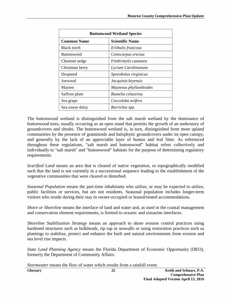
Monroe County Comprehensive Plan Update
Glossary 22 Keith and Schnars, P.A. Comprehensive Plan
Final Adopted Version April 13, 2016
Buttonwood Wetland Species
Common Name Scientific Name Black torch Erithalis fruticosa Buttonwood Conocarpus erectus Chestnut sedge Fimbristylis castanea Christmas berry Lycium Carolinianum Dropseed Sporobolus virginicus Joewood Jacquinia keyensis Mayten Maytenus phyllanthoides Saffron plum Bumelia celastrina Sea grape Coccoloba uvifera Sea oxeye daisy Borrichia spp.
The buttonwood wetland is distinguished from the salt marsh wetland by the dominance of buttonwood trees, usually occurring as an open stand that permits the growth of an understory of groundcovers and shrubs. The buttonwood wetland is, in turn, distinguished from more upland communities by the presence of graminoids and halophytic groundcovers under its open canopy, and generally by the lack of an appreciable layer of humus and leaf litter. As referenced throughout these regulations, "salt marsh and buttonwood" habitat refers collectively and individually to "salt marsh" and "buttonwood" habitats for the purpose of determining regulatory requirements.
Scarified Land means an area that is cleared of native vegetation, or topographically modified such that the land is not currently in a successional sequence leading to the establishment of the vegetative communities that were cleared or disturbed. Seasonal Population means the part-time inhabitants who utilize, or may be expected to utilize, public facilities or services, but are not residents. Seasonal population includes longer-term visitors who reside during their stay in owner-occupied or leased/rented accommodations. Shore or Shoreline means the interface of land and water and, as used in the coastal management and conservation element requirements, is limited to oceanic and estuarine interfaces. Shoreline Stabilization Strategy means an approach to shore erosion control practices using hardened structures such as bulkheads, rip rap or seawalls or using restoration practices such as plantings to stabilize, protect and enhance the built and natural environments from erosion and sea level rise impacts. State Land Planning Agency means the Florida Department of Economic Opportunity (DEO), formerly the Department of Community Affairs. Stormwater means the flow of water which results from a rainfall event.

Monroe County Comprehensive Plan Update
Glossary 23 Keith and Schnars, P.A. Comprehensive Plan
Final Adopted Version April 13, 2016
Stormwater Facilities mean manmade structures that are part of a stormwater management system designed to collect, convey, hold, divert, or discharge stormwater, and may include stormwater sewers, canals, detention facilities and retention facilities.
Structure means anything constructed, installed or portable, the use of which requires a location on a parcel of land. It includes a movable building that can be used for housing, business, commercial, agricultural or office purposes, either temporarily or permanently. The term also includes but is not limited to, buildings, roads, walkways of impervious materials, paths, fences, swimming pools, sport courts, poles, utility lines, signs, cisterns, sewage treatment plants, sheds, docks, and other accessory construction.
Subdivision (or Subdivide) means the division of land into three or more lots, parcels, tracts, tiers, blocks, sites, units, or any other division of land.
Submerged Land means the area situated below the mean high water line of a standing body of water, including ocean, estuary, lake, pond, river or stream. For the purpose of this definition, drainage detention areas created as a function of development that are recorded on an approved final site plan or other authorized development order action of the County, and wetlands landward of the mean, shall not be considered submerged land.
Sustainable Building Rating or National Model Green Building Code means a rating system established by the United States Green Building Council (USGBC) Leadership in Energy and Environmental Design (LEED) rating system, the International Green Construction Code (IGCC), the Green Building Initiative’s Green Globes rating system, the Florida Green Building Coalition standards, or a nationally recognized, high-performance green building rating system as approved by the department.
T
Temporary Housing, Emergency or Non-Emergency, means recreational vehicles (or similar approved sheltering units) used for temporary occupancy.
Threatened and Endangered Species means plant or animal species listed as such under the provisions of the Endangered Species Act, and/or Florida Statutes, and the Florida Endangered and Threatened Special Act.
Tourist means those part-time inhabitants who utilize, or may be expected to utilize, public facilities or services, but are not residents. Tourist population includes short-term visitors who reside during their stay in transient accommodations. Transient Unit means a dwelling unit used for transient occupancy such as a hotel or motel room, seasonal residential unit, or space for parking a recreational vehicle or travel trailer.

Monroe County Comprehensive Plan Update
Glossary 24 Keith and Schnars, P.A. Comprehensive Plan
Final Adopted Version April 13, 2016
Transit means transportation services available to the public on a regular basis by bus, rail, or other vehicle, and usually on a fare-paying basis. Transit may be provided by either public, private or non-profit entities.
Transit Facility means the property, equipment, and improvements of whatever nature owned, used, constructed, maintained, controlled, or operated to provide mass transportation for passengers or to provide for the movement of people, including park-and-ride lots, transfer stations, bus stops, shelters, benches, signs, structures, and other improvements.
Transportation Disadvantaged means those persons who because of physical or mental disability, income status, or age are unable to transport themselves or to purchase transportation and are, therefore, dependent upon others to obtain access to health care, employment, education, shopping, social activities, or other life-sustaining activities.
Tropical Hardwood Hammock means an upland hardwood forest community consisting of broad-leafed trees, shrubs, and vines, nearly all of which are native to the West Indies. Characteristic tropical plants include strangler fig, gumbo-limbo, mastic, bustic, lancewood, ironwoods, poisonwood, pigeon plum, Jamaica dogwood, and Bahama lysiloma. U Undeveloped Area means an area upon which the land remains in its natural state. Upland means the area of a site landward of mean high water, excluding submerged lands and tidally inundated mangroves. Upland Native Vegetation/Habitat (see Native Upland Vegetation/Habitat) Useful Life means the period during which an asset or property is expected to be usable for the purpose it was acquired. It may or may not correspond with the item's actual physical life or economic life. Utility means facilities such television cable, telephone exchanges, electric generation plants, stormwater collection systems, high power transmission lines and substations, gas distribution lines and sewage treatment collections systems and disposal plants. V Vessel means every description of watercraft, barge, seaplane and airboat, used or capable of being used as a means of transportation on water. Vulnerability to Climate Change means the exposure, sensitivity, and adaptive capacity of systems to climate change.
Monroe County Comprehensive Plan Update
Glossary 25 Keith and Schnars, P.A. Comprehensive Plan
Final Adopted Version April 13, 2016
W
Wastewater Treatment Collection System means the use of land and its above ground installed appurtenances related to the collection and transmission of wastewater to a treatment facility located on another lot or parcel.
Wastewater Treatment Facility means the use of land and its appurtenances for the treatment of wastewater collected predominately from other lots or parcels.
Water-Dependent Use means a use that must physically be located in, on, over, or adjacent to water in order to conduct its primary purpose and which, therefore, cannot be located inland. (for example, marinas, docks, wharfs, lifts, boat ramps, boat hauling, repair, and construction facilities, commercial fishing facilities, and other support structures on, over, or adjacent to navigable bodies of water) Water-Enhanced Use means a use that is not water-dependent or water-related uses but benefits economically or aesthetically by its location adjacent to or on the waterfront. The term includes dock side bars, restaurants, hotels, motels, and residential uses. Water-Related Use means an activity not dependent on direct access to water in order to conduct its primary purpose, but which provides goods or services directly related to water-dependent uses. (for example, marine supplies, boat dealers, boat maintenance and repair) Wetlands means those areas that are inundated or saturated by surface water or groundwater at a frequency and a duration sufficient to support, and under normal circumstances do support, a prevalence of vegetation typically adapted for life in saturated soils. Soils present in wetlands generally are classified as hydric or alluvial, or possess characteristics that are associated with reducing soil conditions. The prevalent vegetation in wetlands generally consists of facultative or obligate hydrophytic macrophytes that are typically adapted to areas having soil conditions described above. These species, due to morphological, physiological, or reproductive adaptations, have the ability to grow, reproduce, or persist in aquatic environments or anaerobic soil conditions. (Florida Keys wetlands include freshwater marsh, salt marsh, buttonwood, salt ponds, freshwater lenses, mangroves, and some areas of tropical hardwood hammocks and pinelands). Wetland Boundary means the landward extent of wetlands dominated by plant species, soils and other hydrologic evidence indicative of regular and periodic inundation or saturation.

Monroe County Comprehensive Plan Update
Monitoring and Evaluation Procedures 1 Keith and Schnars, P.A. Comprehensive Plan:
Final Adopted Version April 13, 2016
4.0 MONITORING AND EVALUATION PROCEDURES This section specifically stipulates procedures for implementing the required procedures for monitoring, updating and evaluating the Comprehensive Plan (the Plan) every seven (7) years pursuant to §163.3191, F.S. An explanation of these implementation programs follows: MONITORING AND EVALUATION PROCESS In order to effectively monitor implementation of the plan and to maintain the plan as an effective and pertinent planning tool, the supporting inventories and analyses will need to be updated. Dependent upon the application of the data, updating may be continuous, annual, or at less frequent intervals. Responsibilities for Monitoring and Evaluating the Comprehensive Plan The Planning & Environmental Resources Department will be responsible for preparing the evaluation and appraisal report of the Plan. The Planning Commission, acting as the Local Planning Agency (LPA), shall formally review and recommend the Evaluation and Appraisal Report (EAR) to the Board of County Commissioners (BOCC). The BOCC, as the elected body, will approve and adopt the EAR and any EAR-based plan amendments. The Planning Commission, as the designated LPA pursuant to 163.3174, F.S., will monitor and oversee the effectiveness and status of the Plan and recommend to the BOCC such changes in the Plan as may from time to time be required. Evaluation and Appraisal Report Evaluation and appraisal reports are required pursuant to Chapter 163.3191, Florida Statutes, and must be completed by the County every seven (7) years in order to assess if plan amendments are necessary to reflect changes to Chapter 163, Part II, since the last update of the Plan, and notify the state land planning agency as to its determination. The statute also encourages each jurisdiction to “…comprehensively evaluate and, as necessary, update comprehensive plans to reflect changes in local conditions.” The EAR must be prepared and adopted following similar procedures as for adoption of the Plan, as provided in Chapter 163, Florida Statutes. Growth Management Concurrency Management Report The Planning & Environmental Resources Department will produce a public facilities capacity assessment report. This report will evaluate Transportation Facilities, Potable Water, Sanitary Sewer Facilities, Solid Waste Facilities and Parks and Recreation Facilities. The assessment shall be based on standard analytical methodologies and include a projection of the amount of residential and non-residential growth that can be accommodated in each of the service areas
Monroe County Comprehensive Plan Update
Monitoring and Evaluation Procedures 2 Keith and Schnars, P.A. Comprehensive Plan:
Final Adopted Version April 13, 2016
(Upper, Middle, and Lower Keys) without exceeding safe and efficient provision of essential public services. Capital Improvements Element Update In addition to completion of an assessment report, the Capital Improvements Element (CIE) must be reviewed in coordination with the County's annual budget process. This Element identifies the need for public facilities, Level of Service standards, cost of facilities, revenue sources, and a schedule for the funding and construction of improvements for a five (5) year period. The annual evaluation will review capital improvement priorities, costs, revenue concerns and implementation schedules, as determined within the support data and the County’s Capital Improvements Program.
<The remainder of this page intentionally left blank>

Monroe County Comprehensive Plan Update
Public Participation and Comment 1 Keith and Schnars, P.A.
Comprehensive Plan: Final Adopted Version April 13, 2016
5.0 PUBLIC PARTICIPATION AND COMMENT These public participation procedures are developed to meet the requirements of Chapter 163.3181, Florida Statutes, as amended. This section of State law requires adoption of public participation procedures designed to provide effective public participation in the comprehensive planning process and providing real property owners with notice of all official actions that will regulate the use of their property. The following public participation procedures, in addition to any other procedures required by statute, may be followed when an amendment to the Comprehensive Plan (the Plan) is proposed:
• Assure advertisements are placed in local newspapers and other media in accordance with State law;
• Provide flyers at the Government Centers and other prominent public locations; • Provide sign-up sheets at meetings to create a database of meeting attendees for future
email communication; • Provide opportunities for written comments from citizens and other interested parties; • Prepare newspaper articles and press releases; • Post information through social media; • Assure draft documents are made available at the Government Centers and on the County
website; • Post applications on the County website; and • Facilitate public meetings to discuss Plan amendments.
Location of Documents and Maps All comprehensive planning and related documents, reports, studies, and agendas shall be made readily available for public viewing pursuant to Chapter 119, Florida Statutes, and other applicable laws. All draft and final Plan amendments or support documents scheduled for discussion or presentation at public workshops, public work sessions, public meetings, or public hearings will be available in the Planning & Environmental Resources Department for viewing and be available on the applicable agenda (agenda item) on the County website. Public Hearings All public hearings shall be advertised and conducted as required by State law including, but not limited to, applicable sections of Part II, Chapters 163 and 125.66, Florida Statutes. Additional advertisements may be published, although not legally required, when it is determined by the Planning Director that such additional advertisements would likely enhance public participation or otherwise significantly benefit the public. The applicant shall be responsible for all advertising costs associated with a plan amendment application.

Monroe County Comprehensive Plan Update
Public Participation and Comment 2 Keith and Schnars, P.A.
Comprehensive Plan: Final Adopted Version April 13, 2016
Each public hearing of the Board of County Commissioners (BOCC) shall be conducted in a manner so as to constitute a presentation of the proposals and recommendations being considered in the Plan amendment process. The opportunity for public comment at any workshop or work session of the BOCC is at the discretion of the BOCC. Public Inquiries and Comment The public may contact the Planning & Environmental Resources Department staff, as well as other appropriate County personnel, to answer inquiries and provide information relating to comprehensive planning and related matters. During the Plan amendment process, any person representing himself, a property owner, or an organization in Monroe County may present comments, requests, or inquiries. Requirements for Public Notice Public notice for all public hearings, meetings, workshops, or work sessions of all boards, commissions, and committees shall be posted on the Monroe County website. The notices shall contain, at a minimum, the date, time, place, and general subject matter of the meeting. Unless otherwise provided by law, failure to post such notices shall not affect the validity of any actions taken at a public hearing, meeting, workshop, or work session. Public Hearings and Optional Workshops (1) Local Planning Agency:
a) An optional workshop for the consideration of any Plan amendment.
b) At least one (1) public hearing pursuant to Chapter 163, Florida Statutes, for any Plan amendment.
(2) Board of County Commissioners:
a) An optional work session for the consideration of any Plan amendment.
b) At least one transmittal public hearing for any Plan amendment pursuant to the requirements of Chapter 163, Florida Statutes.
c) At least one adoption public hearing for any Plan amendment pursuant to the
requirements of Chapter 163, Florida Statutes.