monitoring status 2014 and strategy - butterfly conservation
TRANSCRIPT

VC17 Monitoring Status 2014 and Strategy
Page 1 of 27 Butterfly monitoring © Harry E. Clarke 2015
Monitoring Status 2014 and Strategy Introduction A large number of UKBMS transects are walked within VC17 – Surrey every year. However, are these
transects monitoring what needs to be monitored? This is the question that this paper attempts to address,
by analysing what species need to be monitored, and what locations need to be monitored.
Resources are limited, so transects need to be located where they will achieve the greatest benefit. Priority
should be given to monitoring different habitats within VC17, protected areas, and species that are a priority
for conservation. However, it is recognised that volunteers will want to walk transects that are close to
where they live, and that are good habitats for butterflies. It is recognised that this can result in difficulties in
trying to monitor particular areas because of their remoteness, or maybe restricted butterfly abundance.
Habitats Natural England has defined 159 National Character Areas (NCAs) which share similar landscape
characteristics, and which follow natural lines in the landscape rather than administrative boundaries,
making them a good decision-making framework for the natural environment.
There are ten NCAs that occur within the boundaries of VC17 – Surrey, although three of these, North Kent
Plain, Hampshire Downs and the High Weald, are only very partially within the boundaries of VC17. Thames
Valley is mostly outside of VC17, but includes important sites such as Richmond Park and Wimbledon
Common so are included. Only the Thames Basin Lowlands is nearly all contained within VC17, a significant
proportion of the other NCAs occur outside of the county.
There are three principal habitats that occur within VC17 that effect the butterfly populations found within
them
Chalk represented by the North Downs
Sand, which provide heath habitats are represented by the Thames Basin Heaths and Wealden
Greensand
Clay are represented by the Thames Basin Lowlands and Low Weald
Canopy Butterflies The following species are canopy butterflies, which are widespread throughout VC17 – Surrey, but are hard
to monitor by traditional means:
Brown Hairstreak
Purple Emperor
Purple Hairstreak
White-letter Hairstreak
VC17 Monitoring Status 2014 and Strategy
Page 2 of 27 Butterfly monitoring © Harry E. Clarke 2015
Monitoring Strategy 1. Ensure each NCA is monitored in the west, centre and east of VC17 (where applicable)
2. Ensure all conservation priority species in each NCA are monitored at least two sites
3. Ensure that key sites within each NCA is monitored.
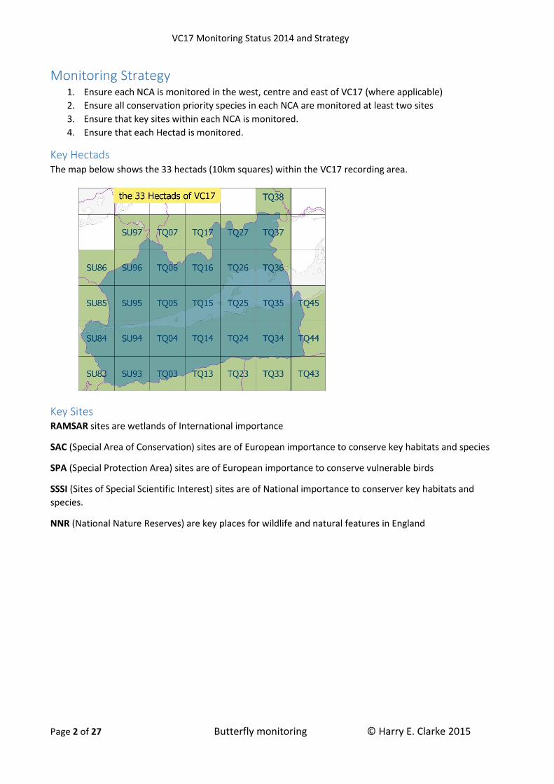
4. Ensure that each Hectad is monitored.
Key Hectads The map below shows the 33 hectads (10km squares) within the VC17 recording area.
Key Sites RAMSAR sites are wetlands of International importance
SAC (Special Area of Conservation) sites are of European importance to conserve key habitats and species
SPA (Special Protection Area) sites are of European importance to conserve vulnerable birds
SSSI (Sites of Special Scientific Interest) sites are of National importance to conserver key habitats and
species.
NNR (National Nature Reserves) are key places for wildlife and natural features in England

VC17 Monitoring Status 2014 and Strategy
Page 3 of 27 Butterfly monitoring © Harry E. Clarke 2015
Priority Species The table below shows the Surrey butterflies that have protection under the Schedule 5 of the Wildlife &
Countryside Act 1981 from harm or sale. Section 41 of the Natural Environment & Rural Communities Act
2006 lists those species which are of principal importance for conserving biodiversity in England (also known
as BAP species). JNCC’s Red List of Butterflies for Great Britain, 2010 provides the list of butterflies at risk
from extinction, EN=Endangered, VU=Vulnerable, NT=Near Threatened, with butterflies of LC=Least Concern
being excluded.
Butterfly Wildlife &
Countryside Act
Sect.41 Action
List
JNCC Red List
Adonis Blue Sch5 NT
Brown Hairstreak Sch5 Medium VU
Chalkhill Blue Sch5 NT
Dingy Skipper Low VU
Glanville Fritillary Sch5 Low EN
Grayling Low VU
Grizzled Skipper Low VU
Purple Emperor Sch5 NT
Silver-spotted Skipper Sch5 Medium NT
Silver-studded Blue Sch5 VU
Small Blue Sch5 Medium NT
Small Heath Low NT
White Admiral Low VU
White-letter Hairstreak Sch5 Medium EN
Wood White Sch5 Medium EN

VC17 Monitoring Status 2014 and Strategy
Page 4 of 27 Butterfly monitoring © Harry E. Clarke 2015
Inner London
Character 100% urbanised with a population of 3m+ (2001 census). The soils are alluvial gravels overlying London Clay.
Rivers within VC17 part of Inner London are the Thames and Wandle.
Main Hectads Eastern Hectads – TQ27, TQ37
Key Locations SAC & NNR – Richmond Park (most of the park is in Thames Valley)
SAC – Wimbledon Common (part in Thames Valley)
Priority Species Purple Emperor
Small Heath
White Admiral
White-Letter Hairstreak
VC17 Monitoring Status 2014 and Strategy
Page 5 of 27 Butterfly monitoring © Harry E. Clarke 2015
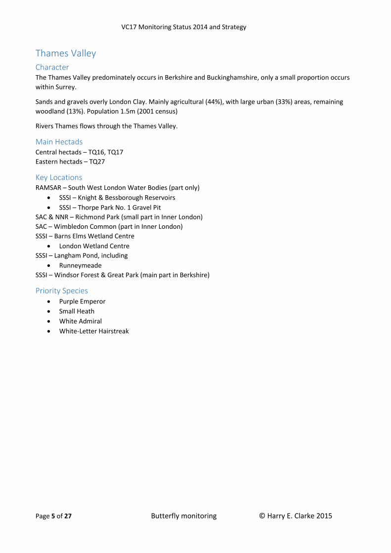
Thames Valley
Character The Thames Valley predominately occurs in Berkshire and Buckinghamshire, only a small proportion occurs
within Surrey.
Sands and gravels overly London Clay. Mainly agricultural (44%), with large urban (33%) areas, remaining
woodland (13%). Population 1.5m (2001 census)
Rivers Thames flows through the Thames Valley.
Main Hectads Central hectads – TQ16, TQ17
Eastern hectads – TQ27
Key Locations RAMSAR – South West London Water Bodies (part only)
SSSI – Knight & Bessborough Reservoirs
SSSI – Thorpe Park No. 1 Gravel Pit
SAC & NNR – Richmond Park (small part in Inner London)
SAC – Wimbledon Common (part in Inner London)
SSSI – Barns Elms Wetland Centre
London Wetland Centre
SSSI – Langham Pond, including
Runneymeade
SSSI – Windsor Forest & Great Park (main part in Berkshire)
Priority Species Purple Emperor
Small Heath
White Admiral
White-Letter Hairstreak
VC17 Monitoring Status 2014 and Strategy
Page 6 of 27 Butterfly monitoring © Harry E. Clarke 2015
Thames Basin Lowlands
Character London Clay, 59% urbanised, population <1m (2001 census), oak woodlands (13%), and remaining 33%
agricultural.
Rivers Wey, Mole, Hogsmill and Wandle flow through the NCA.
Main Hectads Western hectads – SU95
Central hectads – TQ05, TQ15, TQ16
Eastern hectads – TQ26, TQ36
Key Locations SSSI – Epsom and Ashtead Commons
NNR – Ashstead Common
SSSI – Esher Commons, including:
Fairmile Common
SSSI – Bookham Common
Priority Species Brown Hairstreak
Purple Emperor (key)
Silver-studded Blue (Fairmile Common)
Small Blue
Small Heath
White Admiral
White-Letter Hairstreak

VC17 Monitoring Status 2014 and Strategy
Page 7 of 27 Butterfly monitoring © Harry E. Clarke 2015
Thames Basin Heaths
Character Sands and gravels, which allow heathland to flourish. Agricultural (63%), woodland (18%), urban (13%).
Population <0.8m (2001 census)
Rivers Wey, Mole, Blackwater and Bourne, and the Basingstoke canal all flow though the Thames Basin
Heaths.
Main Hectads Western hectads – SU95, SU96
Central hectads – TQ05, TQ06
Key Locations SAC – Thursley, Ash, Pirbright & Chobham (part), consisting of:
SSSI & NNR – Chobham Common
SSSI - Colony Bog and Bagshot Heath, including
o Brentmoor Heath
SSSI - Ash to Brookwood Heaths
SPA – Thames Basin Heaths, includes all those in the SAC
SSSI – Whitmoor Common
SSSI – Basingstoke Canal
SSSI – Horsell Common
SSSI – Ockham & Wisley Commons
SSSI – Smarts & Prey Heaths
SSSI - Papercourt
Priority Species Grayling
Grizzled Skipper (one site only)
Purple Emperor
Silver-studded Blue
Small Heath
White Admiral
White-Letter Hairstreak

VC17 Monitoring Status 2014 and Strategy
Page 8 of 27 Butterfly monitoring © Harry E. Clarke 2015
North Downs
Character Chalk Hills topped with clay, giving rise to Beech woodlands on the slopes and oak woodlands on the clay.
Key habitat are the chalk grasslands
Predominately agricultural (80%), urban (9%) and woodland (1%). Population <0.6m (2001 census)
Rivers Wey and Mole bisect the North Downs
Main Hectads Western hectads – SU84, SU94
Central hectads – TQ04, TQ05, TQ15
Eastern hectads – TQ25, TQ35, TQ36
Key Locations SAC - Mole Gap to Reigate Escarpment, includes the following sites:
Norbury Park
Box Hill
Headley Warren
Headly heath
Brookham
Betchworth
Buckland Hills
Colley Hill
SSSI - Mole Gap to Reigate Escarpment, includes SAC sites and
Wingate Hill
SSSI – Wey Hill Meadows
SSSI – Colyers Hanger
SSSI – Combe Bottom
SSSI – Sheapleas
SSSI – Hackhurst & White Downs, including:
Hackhurst
White Downs
Blatchford Down
Denbies Hillside
SSSI – Ranmore Common
SSSI – Banstead Downs
SSSI – Chipstead Downs, includes
Banstead Wood
Park Downs
SSSI – Farthings Downs & Happy Valley
SSSI – Quary Hangers
SSSI – Riddlesdown
SSSI – Woldingham & Oxted Downs
Priority Species Adonis Blue
Brown Hairstreak

VC17 Monitoring Status 2014 and Strategy
Page 9 of 27 Butterfly monitoring © Harry E. Clarke 2015
Chalk Hill Blue
Dingy Skipper
Glanville Fritillary (Hutchnison Bank only)
Grizzled Skipper
Purple Emperor
Silver-spotted Skipper
Small Blue
Small Heath
White Admiral
White-Letter Hairstreak

VC17 Monitoring Status 2014 and Strategy
Page 10 of 27 Butterfly monitoring © Harry E. Clarke 2015
Wealden Greensand
Character Sandy Soils to loam. Heathlands are dominant to the west. Predominately agricultural (70%), woodland
(25%) and urban (7%). Population is >0.6m (2001 census)
Rivers Wey and Mole flow through the area.
Main Hectads Western hectads – SU84, SU93, SU94
Central hectads – TQ04, TQ14
Eastern hectads – TQ25, TQ35 (possibly)
Key Locations RAMSAR - Thursley & Ockley Bogs (also a SAC and SPA)
SAC - Thursley, Ash, Pirbright & Chobham, consisting of the following sites
NNR – Thursley Common
Hankley Common
Frensham Common
Ockley Common
Witley Common
Tildford Common
SPA – Thursley, Hankley & Frensham Commons (part, area is also part of the SAC)
SPA – Wealden Heaths Phase II (part), consisting of the following sites
SSSI – Devil’s Punch Bowl, includes
o Hinhead Common
SSSI – Puttenham & Corooksbury Common
SSSI – Charterhouse & Eashing
SSSI – Wey Valley Meadows
SSSI – Blackheath
SSSI – Leith Hill
SSSI – Reigate Heath
SSSI – Titsey Woods
Priority Species Brown Hairstreak
Grizzled Skipper (one site only)
Grayling
Purple Emperor
Silver-studded Blue
Small Heath
White Admiral

VC17 Monitoring Status 2014 and Strategy
Page 11 of 27 Butterfly monitoring © Harry E. Clarke 2015
Low Weald
Character Low lying clay vale. Mostly agricultural (83%), woodland (16%) and urban (3%). Population <0.5m (2001
census).
Rivers Mole and Eden flow through the Low Weald
Main Hectads Western hectads – SU93
Central hectads – TQ03, TQ04, TQ13, TQ14
Eastern hectads – TQ24, TQ34
Key Locations SSSI – Chiddingfold Forest
SSSI – Smokejack Clay Pit
SSSI – Vann Lake & Ockley Woods
SSSI – Clock House Brickworks
SSSI – Glovers Wood
SSSI – Blindley Heath
SSSI – Staffhusrt Wood
Priority Species Brown Hairstreak
Dingy Skipper
Grizzled Skipper
Purple Emperor (key)
Small Heath
White Admiral
White-Letter Hairstreak
Wood White

VC17 Monitoring Status 2014 and Strategy
Page 12 of 27 Butterfly monitoring © Harry E. Clarke 2015
UKBMS Transects
Transect Status UKBMS Transects sorted by National Character Area and Hectad.
Site Name Grid Ref. Hectad NCA Protection Years
Cole Kitchen TQ085488 TQ04 Downs none 9
Hackhurst Down TQ093485 TQ04 Downs SSSI 26
Pewley Down TQ008489 TQ04 Downs none 10
Sheepleas TQ088515 TQ05 Downs SSSI 15
Blatchford Down TQ106486 TQ14 Downs SSSI 2
Denbies Landbarn TQ135498 TQ14 Downs none 11
Denbies Landbarn B TQ134498 TQ14 Downs none 13
White Down TQ103487 TQ14 Downs SSSI 18
Box Hill: Dukes TQ185511 TQ15 Downs SAC 14
Box Hill: Viewpoint TQ179510 TQ15 Downs SAC 20
Box Hill: Zig Zag TQ177520 TQ15 Downs SAC 19
Brockham Lime Kilns TQ198510 TQ15 Downs SAC 2
Denbies Hillside TQ150500 TQ15 Downs SSSI 27
Headley Heath TQ195533 TQ15 Downs SAC 24
Headley Warren TQ190540 TQ15 Downs SAC 11
Norbury Park grassland TQ153539 TQ15 Downs SAC 1
Norbury Park woodland TQ151538 TQ15 Downs none 1
Nower Wood TQ195548 TQ15 Downs none 5
Betchworth Quarry NR TQ205513 TQ25 Downs SAC 4

VC17 Monitoring Status 2014 and Strategy
Page 13 of 27 Butterfly monitoring © Harry E. Clarke 2015
Site Name Grid Ref. Hectad NCA Protection Years
Juniper Hill TQ222572 TQ25 Downs none 11
Park Downs TQ267584 TQ25 Downs SSSI 17
Wingate Hill TQ266524 TQ25 Downs SSSI 12
Banstead Downs TQ257615 TQ26 Downs SSSI 29
Howell Hill TQ239619 TQ26 Downs none 13
Priest Hill, Ewell TQ230613 TQ26 Downs none 1
Coulsdon Common TQ325571 TQ35 Downs none 25
Dollypers Hill, Coulsdon/Kenley TQ315584 TQ35 Downs none 1
Farthing Downs TQ300576 TQ35 Downs SSSI 25
Happy Valley, Coulsdon TQ308568 TQ35 Downs SSSI 15
Kenley Common TQ333585 TQ35 Downs none 24
New Hill, Coulsdon TQ305576 TQ35 Downs none 11
Nore Hill TQ377572 TQ35 Downs none 15
Oxted Downs, Grangers Hill TQ375542 TQ35 Downs SSSI 12
Oxted Downs, Whistlers Steep TQ385542 TQ35 Downs SSSI 12
Quarry Hangers NR TQ317536 TQ35 Downs SSSI 7
Riddlesdown Quarry TQ337594 TQ35 Downs SSSI 15
Chapel Bank TQ386605 TQ36 Downs none 7
Featherbed Lane Roadside verge The Gallops TQ376621 TQ36 Downs none 7
Hutchinson's Bank TQ382615 TQ36 Downs none 18
Riddlesdown NR TQ331600 TQ36 Downs SSSI 25
Hill Park, Tatsfield TQ422560 TQ45 Downs none 1
Devils Punch Bowl SU891373 SU83 Greensand SPA 3
Hinhead Common SU894351 SU83 Greensand SPA 2
Bealeswood Common SU823409 SU84 Greensand none 7
Frensham SU859415 SU84 Greensand SAC 2
Frensham Common SU844403 SU84 Greensand SAC 4
Frensham Common (Little Pond) SU855418 SU84 Greensand SAC 6
Hydon Heath SU978395 SU93 Greensand none 7
Swan Barn Farm SU913327 SU93 Greensand none 13
Thursley Common SU907405 SU94 Greensand SAC 3
Witley Common SU926403 SU94 Greensand SAC 10
Prey Heath SU989555 SU95 Heaths SSSI 9
Smarts Heath SU985558 SU95 Heaths SSSI 9
Brentmoor Heath SU936612 SU96 Heaths SAC 20

VC17 Monitoring Status 2014 and Strategy
Page 14 of 27 Butterfly monitoring © Harry E. Clarke 2015
Site Name Grid Ref. Hectad NCA Protection Years
Chobham Common NE SU974657 SU96 Heaths SAC 11
Chobham Common South SU974633 SU96 Heaths SAC 13
Wandsworth Common Woodland TQ272734 TQ27 London none 5
Wimbledon Common TQ230728 TQ27 London SAC 10
Sydenham Hill Woods & Cox's Walk TQ344726 TQ37 London none 5
Farnham Park SU841480 SU84 Lowlands none 10
Tice's Meadow, Badshot Lea SU869488 SU84 Lowlands none 1
Ashtead Common A TQ180594 TQ15 Lowlands SSSI 17
Ashtead Common B TQ179592 TQ15 Lowlands SSSI 13
Epsom Common TQ188606 TQ16 Lowlands SSSI 6
Fairmile Common TQ118617 TQ16 Lowlands SSSI 9
Horton CP TQ187619 TQ16 Lowlands none 3
Hogsmill LNR. Ewell TQ209636 TQ26 Lowlands none 1
Mitcham Common A TQ286679 TQ26 Lowlands none 20
Mitcham Common B TQ294675 TQ26 Lowlands none 19
Morden Hall Park TQ261688 TQ26 Lowlands none 1
Warren Farm, Ewell TQ232629 TQ26 Lowlands none 1
Roundshaw Downs TQ308628 TQ36 Lowlands none 8
South Norwood CP TQ353683 TQ36 Lowlands none 17
Runnymeade, Egham TQ004718 TQ07 Valley SSSI 1
Richmond Park TQ194740 TQ17 Valley SAC 12
London Wetland Centre TQ226768 TQ27 Valley SSSI 19
Oaken Wood SU991338 SU93 Weald none 20
Wallis Wood TQ121388 TQ13 Weald none 2
Holmwood Common TQ178458 TQ14 Weald none 5
Earlswood Common TQ273486 TQ24 Weald none 7
Mynhurst TQ228454 TQ24 Weald none 1
Lingfield Wildlife Area A TQ387442 TQ34 Weald none 11
Lingfield Wildlife Area B TQ387441 TQ34 Weald none 2
Key Hectads The table below shows the number of UKBMS Transects per Hectad
Hectad UKBMS Transects
Walked 2014
SU84 7 3
SU93 3 3
SU94 2 2
SU95 2 2
SU96 2 2
TQ03 0 0
TQ04 3 2
TQ05 1 0

VC17 Monitoring Status 2014 and Strategy
Page 15 of 27 Butterfly monitoring © Harry E. Clarke 2015
TQ06 0 0
TQ07 1 1
TQ13 1 0
TQ14 5 3
TQ15 12 10
TQ16 3 3
TQ17 1 1
TQ24 2 0
TQ25 5 2
TQ26 8 7
TQ27 4 2
TQ34 2 1
TQ35 11 9
TQ36 6 5
TQ37 1 1
TQ44 0 0
TQ45 1 1
Protected Sites
National Nature Reserves All three NNRs were monitored within VC17 during 2014
Thames Valley – Richmond Park (1 transect)
Thames Basin Lowlands – Ashstead Common (1 transect
Thames Basin Heaths – Chobham Common (2 transects)

VC17 Monitoring Status 2014 and Strategy
Page 16 of 27 Butterfly monitoring © Harry E. Clarke 2015
RAMSAR Neither of the two RAMSAR sites within VC17 are monitored.
Thames Valley – South West London Water Bodies
Wealden Greensand – Thursley & Ockley Bogs
Special Area of Conservation All five SAC sites within VC17 were monitored during 2014
Inner London – Wimbledon Common (1 transect)
Thames Valley – Richmond Park (1 transect)
Thames Basin Heaths – Thursley, Ash, Pirbright & Chobham Common (2 transects)
North Downs – Mole Gap to Reigate Escarpment (7 transects)
Wealden Greensand – Thursley, Ash, Pirbright & Chobham Common (2 transects)
Special Protection Area Only two of the three SPA sites within VC17 were monitored during 2014
Thames Basin Heaths – Thames Basin Heaths (2 transects)
Wealden Greensand – Thursley, Hankley & Frensham Commons (2 transects)
Wealden Greensand – Wealden Heaths Phase II
Sites of Special Scientific Interest The 48 SSSI sites within VC17 were monitored by 31 transects during 2014, with 11 transects in just two
SSSIs. The table below shows the statistics for each National Character Area
NCA SSSIs UKBMS Transects SSSIs not monitored % SSSIs monitored
Inner London 1 1 0 100%
Thames Valley 6 3 3 50%
Thames Basin Lowlands 3 3 1 67%
Thames Basin Heaths 9 4 7 22%
North Downs 13 18 6 54%
Wealden Greensand 9 2 8 11%
Low Weald 7 0 7 0%
1. Inner London – Wimbledon Common (1 transect)
2. Thames Valley – Richmond Park (1 transect)
3. Thames Valley – Barns Elms Wetland Centre (1 transect)
4. Thames Valley – Langham Pond (1 transect)
5. Thames Valley – Knight & Bessborough Reservoirs
6. Thames Valley – Thorpe Park No. 1 Gravel Pit
7. Thames Valley – Windsor Forest & Great Park
8. Thames Basin Lowlands – Epsom and Ashstead Commons (2 transects)
9. Thames Basin Lowlands – Esher Commons (1 transect)
10. Thames Basin Lowlands – Bookham Commons
11. Thames Basin Heaths – Chobham Common (2 transects)
12. Thames Basin Heaths – Colony Bog and Bagshot Heath
13. Thames Basin Heaths – Ash to Brookwood Heaths
14. Thames Basin Heaths – Whitmoor Common
15. Thames Basin Heaths – Basingstoke Canal

VC17 Monitoring Status 2014 and Strategy
Page 17 of 27 Butterfly monitoring © Harry E. Clarke 2015
16. Thames Basin Heaths – Horsell Common
17. Thames Basin Heaths – Ockham & Wisley Commons
18. Thames Basin Heaths – Smarts and Prey Heaths (2 transects)
19. Thames Basin Heaths – Papercourt
20. North Downs – Mole Gap to Reigate Escarpment (7 transects)
21. North Downs – Wey Hill Meadows
22. North Downs – Colyers Hanger
23. North Downs – Combe Bottom
24. North Downs – Sheapleas
25. North Downs – Hackhurst & White Downs (4 transects)
26. North Downs – Ranmore Common
27. North Downs – Banstead Downs (1 transect)
28. North Downs – Chipstead Downs (2 transects)
29. North Downs – Farthings Downs & Happy Valley (2 transects)
30. North Downs – Quary Hangers (1 transect)
31. North Downs – Riddlesdown (2 transects)
32. North Downs – Woldingham & Oxted Downs
33. Wealden Greensand – Thursley, Hankley & Frenshamd Commons (2 transects)
34. Wealden Greensand – Devils Punch Bowl
35. Wealden Greensand – Puttenham & Corooksbury Common
36. Wealden Greensand – Charterhouse & Eashing
37. Wealden Greensand – Wey Valley Meadows
38. Wealden Greensand – Blackheath
39. Wealden Greensand – Leith Hill
40. Wealden Greensand – Reigate Heath
41. Wealden Greensand – Titsey Woods
42. Low Weald – Chiddingfold Forest
43. Low Weald – Smokejack Clay Pit
44. Low Weald – Vann Lake & Ockley Woods
45. Low Weald – Clock House Brickworks
46. Low Weald – Glovers Wood
47. Low Weald – Blindley Heath
48. Low Weald – Staffhusrt Wood
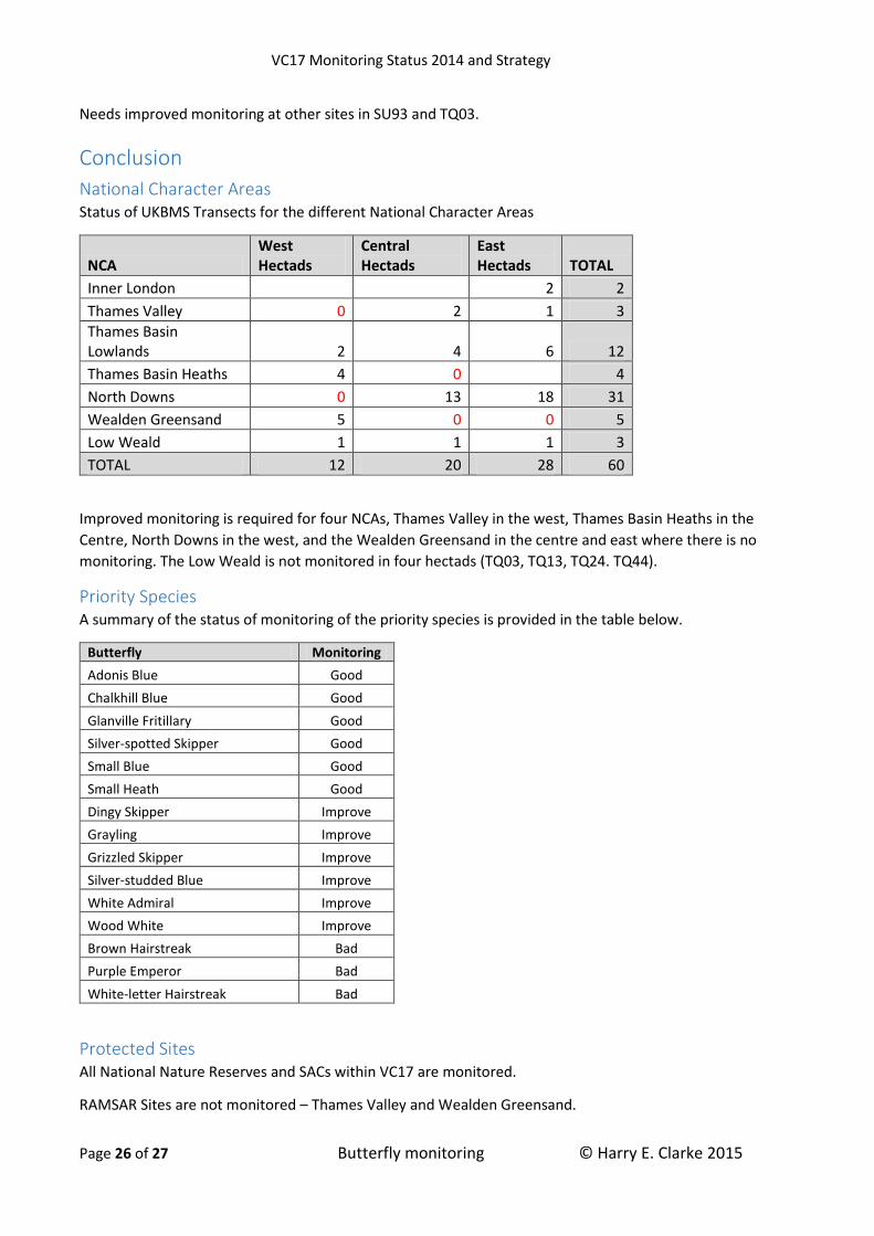
National Character Areas Status of UKBMS Transects for the different National Character Areas
NCA West Hectads
Central Hectads
East Hectads TOTAL
Inner London 2 2
Thames Valley 0 2 1 3
Thames Basin Lowlands 2 4 6 12
Thames Basin Heaths 4 0 4
North Downs 0 13 18 31
Wealden Greensand 5 0 0 5
Low Weald 1 1 1 3
TOTAL 12 20 28 60
VC17 Monitoring Status 2014 and Strategy
Page 18 of 27 Butterfly monitoring © Harry E. Clarke 2015
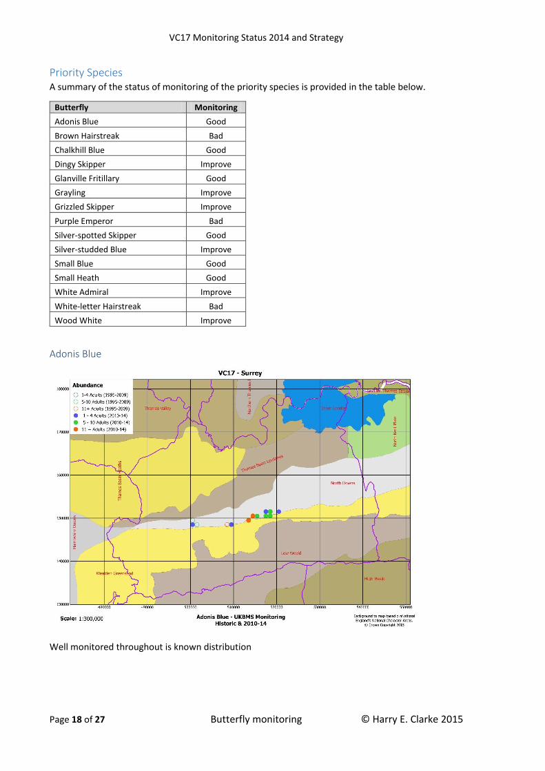
Priority Species A summary of the status of monitoring of the priority species is provided in the table below.
Butterfly Monitoring
Adonis Blue Good
Brown Hairstreak Bad
Chalkhill Blue Good
Dingy Skipper Improve
Glanville Fritillary Good
Grayling Improve
Grizzled Skipper Improve
Purple Emperor Bad
Silver-spotted Skipper Good
Silver-studded Blue Improve
Small Blue Good
Small Heath Good
White Admiral Improve
White-letter Hairstreak Bad
Wood White Improve
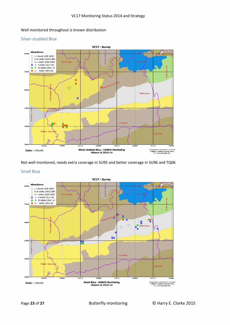
Adonis Blue
Well monitored throughout is known distribution

VC17 Monitoring Status 2014 and Strategy
Page 19 of 27 Butterfly monitoring © Harry E. Clarke 2015
Brown Hairstreak
Traditional UKBMS transects are inappropriate for monitoring this butterfly which is reflected the results. A
widespread species wherever Blackthorn grows.
Chalkhill Blue
Well monitored throughout is known distribution
VC17 Monitoring Status 2014 and Strategy
Page 20 of 27 Butterfly monitoring © Harry E. Clarke 2015
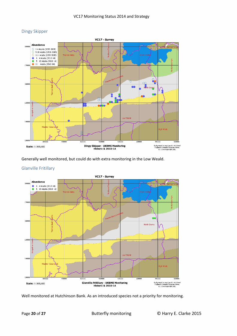
Dingy Skipper
Generally well monitored, but could do with extra monitoring in the Low Weald.
Glanville Fritillary
Well monitored at Hutchinson Bank. As an introduced species not a priority for monitoring.

VC17 Monitoring Status 2014 and Strategy
Page 21 of 27 Butterfly monitoring © Harry E. Clarke 2015
Grayling
Not well monitored, needs extra coverage in SU95 and better coverage in SU96 and TQ06
Grizzled Skipper
Generally well monitored, but could do with extra monitoring in the Low Weald.

VC17 Monitoring Status 2014 and Strategy
Page 22 of 27 Butterfly monitoring © Harry E. Clarke 2015
Purple Emperor
Traditional UKBMS transects are inappropriate for monitoring this butterfly which is reflected the results.
Key sites appear to be Chiddingfold Forest (SU9833 & SU9834), Smokejacks Brickworks (TQ1137), Bookham
Commons (TQ1256) and Ashtead Common (TQ1759), and potentially others.
Silver-spotted Skipper
VC17 Monitoring Status 2014 and Strategy
Page 23 of 27 Butterfly monitoring © Harry E. Clarke 2015
Well monitored throughout is known distribution
Silver-studded Blue
Not well monitored, needs extra coverage in SU95 and better coverage in SU96 and TQ06
Small Blue

VC17 Monitoring Status 2014 and Strategy
Page 24 of 27 Butterfly monitoring © Harry E. Clarke 2015
Well monitored throughout is known distribution
Small Heath
Well monitored, but could do with increased monitoring in the Low Weald.
White Admiral

VC17 Monitoring Status 2014 and Strategy
Page 25 of 27 Butterfly monitoring © Harry E. Clarke 2015
Not monitored at its key sites in SU93. TQ14 and TQ15
White-letter Hairstreak
Traditional UKBMS transects are inappropriate for monitoring this butterfly which is reflected the results. A
widespread species wherever mature Elms grows.
Wood White
VC17 Monitoring Status 2014 and Strategy
Page 26 of 27 Butterfly monitoring © Harry E. Clarke 2015
Needs improved monitoring at other sites in SU93 and TQ03.
Conclusion
National Character Areas Status of UKBMS Transects for the different National Character Areas
NCA West Hectads
Central Hectads
East Hectads TOTAL
Inner London 2 2
Thames Valley 0 2 1 3
Thames Basin Lowlands 2 4 6 12
Thames Basin Heaths 4 0 4
North Downs 0 13 18 31
Wealden Greensand 5 0 0 5
Low Weald 1 1 1 3
TOTAL 12 20 28 60
Improved monitoring is required for four NCAs, Thames Valley in the west, Thames Basin Heaths in the
Centre, North Downs in the west, and the Wealden Greensand in the centre and east where there is no
monitoring. The Low Weald is not monitored in four hectads (TQ03, TQ13, TQ24. TQ44).
Priority Species A summary of the status of monitoring of the priority species is provided in the table below.
Butterfly Monitoring
Adonis Blue Good
Chalkhill Blue Good
Glanville Fritillary Good
Silver-spotted Skipper Good
Small Blue Good
Small Heath Good
Dingy Skipper Improve
Grayling Improve
Grizzled Skipper Improve
Silver-studded Blue Improve
White Admiral Improve
Wood White Improve
Brown Hairstreak Bad
Purple Emperor Bad
White-letter Hairstreak Bad
Protected Sites All National Nature Reserves and SACs within VC17 are monitored.
RAMSAR Sites are not monitored – Thames Valley and Wealden Greensand.

VC17 Monitoring Status 2014 and Strategy
Page 27 of 27 Butterfly monitoring © Harry E. Clarke 2015
SPAs are partially monitored, with 2 out 3 sites. Wealden Greensand is not monitored.
SSSIs are partially monitored with 16 out of 48 sites. Two SSSIs are over monitored with a total of 11
transects (Mole Gap to Reigate Escarpment and Hackhurst & White Downs). While thirty-two SSSIs (67% of
all SSSIs) have no monitoring.
The table below shows the statistics for each National Character Area
NCA SSSIs UKBMS Transects SSSIs not monitored % SSSIs monitored
Inner London 1 1 0 100%
Thames Valley 6 3 3 50%
Thames Basin Lowlands 3 3 1 67%
Thames Basin Heaths 9 4 7 22%
North Downs 13 18 6 54%
Wealden Greensand 9 2 8 11%
Low Weald 7 0 7 0%
Hectads There is over- monitoring in two hectads (TQ15 and TQ35) with a total of 19 transects walked in 2014, all but
one on the North Downs. While six hectads had no monitoring at all in 2014, particularly in the Low Weald.
Hectad National Character Area
TQ03 Low Weald
TQ05 Thames Basin Lowlands Thames Basin Heaths
TQ06 Thames Basin Heaths
TQ13 Low Weald
TQ24 Low Weald
TQ44 Low Weald