monitoring report for years 1 & 2 (2016-2017), harris
TRANSCRIPT

Harris Creek Fish Passage Restoration Project Monitoring Report for Years 1 & 2 (2016-2017)
Prepared by: Joshua Latterell, Stephen Conroy, and Laura Hartema.
April 24 2018
Project Timeline: Constructed: Summer 2015 Planted: Winter 2016 Monitored: 2015-2020
Project Team: Project Supervisor: Will Mansfield, P.E. Project Manager and Engineer: Carolyn Butchart, P.E. Engineer of Record: Will Mansfield, P.E. Ecologists: Stephen Conroy, Ph.D. and Cindy Young WRIA 7 Watershed Steward: Mary Maier
Funding: King Conservation District ($57,000) King County Surface Water Management Funding ($250,000)
Permits & Agency Contacts: United States Army Corps of Engineers: NWS-2014-977; Jonathan Smith; Wash. Dept. of Ecology Rebekah Padgett; Washington Department of Fish and Wildlife Hydraulic Project Approval (HPA), #2014-4-234+01; Stewart Reinbold
Project Location: 47.72166 N Lat., -121.88959 W Long. King County Parcel 2226079036. Intersection of NE Stossel Creek Way and NE 138th Place south of Duvall, WA.
Suggested Citation: King County, 2018. Harris Creek Fish Passage Restoration Project Monitoring Report for Years 1 & 2 (2016-2017). Prepared by J.J. Latterell, S. Conroy, and L. Hartema. King County Dept. of Natural Resources and Parks, Seattle, WA.

Water and Land Resources Division
2
Executive Summary
What is this report about?
This report presents the post-project
monitoring results for the Harris Creek
Fish Passage Restoration Project. The
monitoring period for this report is from
2016-2017, Years 1 and 2. Monitoring will
continue to Year 5 (2020) and interim
reports will be produced at Years 3 (2018)
and 5 (2020).
Where is the project?
The project is located on Harris Creek, at
approximately River Mile 4, where it crosses
beneath NE Stossel Creek Way, south of
Duvall, WA. Harris Creek continues
upstream approximately three miles,
through large wetland complexes.
What was the purpose?
The goal of the project was to remove a
concrete fishway that was impeding fish
passage, and rebuild a roughened stream
channel to provide fish passage through a
variety of slow-velocity pathways.
The project addressed high priority needs
for the salmonids in the Puget Sound
Salmon Recovery Plan (2007) and for
threatened steelhead and other species.
1 Jonathan Smith 2 Alison O’Sullivan
What actions were taken?
King County removed the concrete structure
from the stream and replaced it with a
roughened channel segment approximately
90 feet long. The roughened channel was
constructed from large wood, cobbles, and
boulders. The floodplain surrounding the
channel was elevated using the same
material.
Is the project meeting its goals?
Based on the first two years of
observations, it appears that the Harris
Creek project is partially successful at
achieving its goal. Performance standards
were set for fish passage criteria through
consultations with the U.S. Army Corps of
Engineers1 and Suquamish Tribe2:
Hydraulic drops >0.8 ft. are not present
during low flow. Migration pathways were
present during most of the year, but during
low flow, surface flows were intermittent in
the roughened channel for 62-108 days.
Riffle depths were not >0.8 ft. deep3 and
were shallower than downstream reaches
during low flow. No head cutting or changes
in the hydraulic control at the mouth of the
road culvert have been noted. No major
scour has occurred at the outlet and bed
and bank materials appear stable. Plant
survival was low and re-planting is needed.
3 This is a problematic performance standard that is probably only achievable under high flow, even while the project is properly functioning.

Water and Land Resources Division
3
What lessons were learned?
The lack of scour indicates that the
substrate mix and large wood placed were
adequately-sized to remain stable and
persistent. However, the roughened channel
is lacking fine sediments that might have
prevented or reduced intermittent stream
flows during late summer.
Given the geomorphic setting of the project,
it is likely that the roughened channel will
remain coarse over the long-term, and may
pose ongoing problems with interimittent
flow and related fish passage issues. In the
future, we may avoid using steep,
roughened channel segments where there
is no upstream sediment source.
Summary
The project is functioning as intended
except during late summer when surface
flows in the roughened channel are
intermittent. Intermittent surface flows may
delay upstream adult salmon passage until
October rains increase flow.
Given that a lack of sand and fine gravel
appear to result in intermittent surface flows,
and given that the extensive low gradient
wetlands upstream from the site are not
likely to export sand and gravel to the
project site over time, King County should
investigate the feasibility of methods to
reduce the intermittency of the
roughened channel. For example, could
adding additional sediment to the
streambed help to reduce intermittent
flows? Future projects should capitalize on
the lessons learned to ensure continuous
improvement in project design.

Water and Land Resources Division
4
1. Project Description
The project is located south of Duvall, WA, in the Snoqualmie watershed (Water Resource
Inventory Area 7). The project is in King County Parcel 2226079036, at the intersection of NE
Stossel Creek Way and NE 138th Place.
Figure 1. Vicinity map.
Prior to the project, a concrete fishway (see
inset photo) blocked upstream fish passage to
approximately three miles of salmon and
steelhead spawning and rearing habitat in
Harris Creek. The fishway was a complete
barrier to juvenile fish upstream passage and a
partial barrier to adult salmon and trout
migration. For these reasons, its removal was
identified as a high restoration priority.

Water and Land Resources Division
5
1.1. Goal
The goal of the project was to remove a concrete fishway that was impeding fish passage, and
rebuild a roughened stream channel to provide fish passage through a variety of slow-velocity
pathways. The project was expected to promote natural channel processes with minimal, if any,
maintenance to allow for fish passage over the short and long-term
The roughened channel was expected to attenuate the 4.5-foot drop through the existing
fishway over a longer distance, which will reduce the risk of head-cutting or channel adjustment
that might jeopardize fish passage through, and stability of, the existing culvert. Fish were
expected to be capable of moving through the roughened channel due to the various velocities
within the bed substrate; allowing for fish to find the slowest velocity through a multitude of
different pathways. As flows change, the pathways were expected to change, producing a
dynamic system with a wide distribution of velocities.
1.2. Design and Construction
In 2015, King County removed the concrete structure from the stream and replaced it with a
roughened channel segment approximately 90 feet long (Figure 2). The roughened channel was
constructed from large wood, cobbles, and boulders. The floodplain surrounding the channel
was elevated using the same material.
Roughened channel: The outfall drop from the existing hydraulic control for the road culvert
and the native stream bed downstream of the fishway was 4.5 feet. The design concept for
restoring fish passage was to make up this 4.5 foot drop over a roughened channel segment
extending approximately 93-feet downstream of the culvert outlet
Large wood: Wood scaled to the landscape was incorporated into the bed, banks, channel
and flood plain to improve habitat, stabilize the bed and mimic the surrounding channel.
Substrate: The cobbles, boulders and wood were sized and configured to provide a stable
matrix that can withstand the 100-year flood with a margin of safety of two. The flood plain
was also be elevated to accommodate the raised channel elevation with the same stable
matrix. Part of the elevated flood plain was confined between two road prisms, minimizing
the amount of fill needed to raise the flood plain.

Water and Land Resources Division
6
Figure 2. Grading Plan and Profile.
Water and Land Resources Division
7
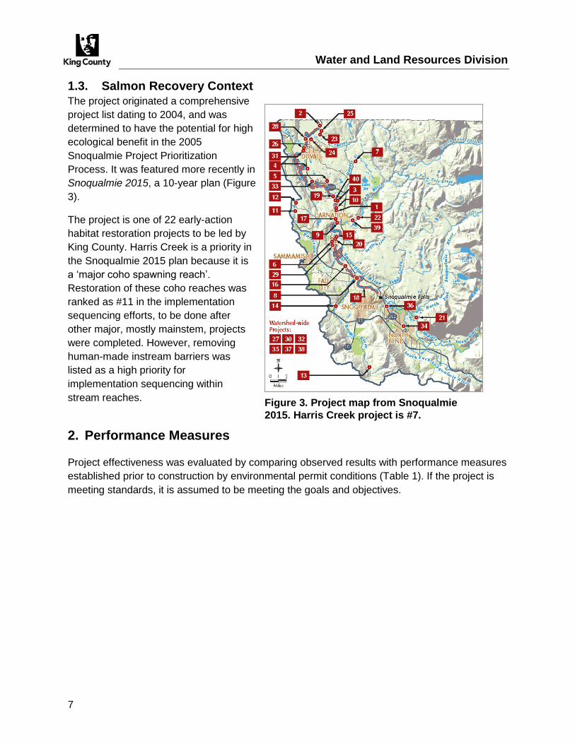
1.3. Salmon Recovery Context
The project originated a comprehensive
project list dating to 2004, and was
determined to have the potential for high
ecological benefit in the 2005
Snoqualmie Project Prioritization
Process. It was featured more recently in
Snoqualmie 2015, a 10-year plan (Figure
3).
The project is one of 22 early-action
habitat restoration projects to be led by
King County. Harris Creek is a priority in
the Snoqualmie 2015 plan because it is
a ‘major coho spawning reach’.
Restoration of these coho reaches was
ranked as #11 in the implementation
sequencing efforts, to be done after
other major, mostly mainstem, projects
were completed. However, removing
human-made instream barriers was
listed as a high priority for
implementation sequencing within
stream reaches.
2. Performance Measures
Project effectiveness was evaluated by comparing observed results with performance measures
established prior to construction by environmental permit conditions (Table 1). If the project is
meeting standards, it is assumed to be meeting the goals and objectives.
Figure 3. Project map from Snoqualmie
2015. Harris Creek project is #7.

Water and Land Resources Division
8
Table 1. Permit conditions, reporting, and methods.
Permit Conditions With Monitoring Implications Reporting Requirements
Expires
USACE NWS-2014-977
The permittee shall comply with provisions of the Harris Creek Fish Passage Restoration Monitoring and Maintenance Plan, dated January 16, 2015 to ensure compliance with National General Condition 2 (Aquatic Life Movements): No activity may substantially disrupt the necessary life cycle movements of those species of aquatic life indigenous to the waterbody, including those species that normally migrate through the area, unless the activity's primary purpose is to impound water. All permanent and temporary crossings of waterbodies shall be suitably culverted, bridged, or otherwise designed and constructed to maintain low flows to sustain the movement of those aquatic species.
None March 18, 2017
WDFW HPA 2014-4-234+01
Condition 10. The pool-riffle complex correction shall be maintained by the owner(s) per RCW 77.57.030 to ensure continued, unimpeded fish passage. If the system becomes a hindrance to fish passage, the owner(s) shall be responsible for obtaining a Hydraulic Project Approval and providing prompt repair. Financial responsibility for maintenance and repairs shall be that of the owner(s).
None December 31, 2017
Goal: Remove a concrete fishway impeding fish passage, and rebuild a roughened
stream channel to provide fish passage through a variety of slow-velocity pathways.
The monitoring period for instream changes is twice annually for a period of at least five years, and until two approximately 2-yr recurrence-interval floods have occurred or for a maximum of 10 years, whichever period of time is shorter. Vegetation monitoring shall occur in Year 3. Reports are not required by permits.
Performance Standards for Hydraulic Drops Documentation
In Years 1 through 5, the project reach contains no channel-spanning drops >0.8 feet tall present at approx. 30 cfs or at August/September low flow (after 7d no rain)
Number of contiguous (channel-spanning) hydraulic drops >0.8 ft. present at high and low flow.
Protocol for Measuring Hydraulic Drops
Visual inspections/stream profile. Twice annually; once at approximately 30 cfs and once in
August-September after 7 days with no precipitation.

Water and Land Resources Division
9
Performance Standard for Migration Pathways Documentation
In Years 1 through 5, flow paths suitable for upstream and downstream dispersal by fish are visible in the project reach at approx. 30 cfs (January 10-percent exceedance flow). Suitable flow paths will be devoid of white water and be of low turbulence.
Assessment of flow paths at high flow.
In Years 1 through 5, during low flow the wetted channel is similar to downstream riffles4.
Protocol for Measuring Migration Pathways
Visual inspections. Once annually at approximately 30 cfs.
Performance Standard for Riffle Depths Documentation
In Years 1 through 5, during August/September low flow (after 7d with no rain), continuous surface flow is present throughout the project reach when downstream riffles also have continuous surface flow5.
Remote camera recordings of the presence/absence of surface flow at the project site and at a downstream riffle6.
Protocol for Measuring Riffle Depths
Equidistant measurements of thalweg depth within project reach, and in up to three locations in
reaches upstream and/or downstream. Once annually in August-Sept after 7 days with no
precipitation.
Performance Standard for Stream Profile Documentation
The upstream reach (above NE Stossel Creek Way culvert) does not have head cutting propagating further upstream than existing conditions.
Thalweg profile, slope.
The elevation of the hydraulic control at the downstream mouth of the culvert is maintained to within ± 0.5 feet of the ‘as-built’ condition.
Downstream reach does not have uncontrolled scouring, formation of a plunge pool, inundation by fine materials, or surface roughening.
4 The original performance standard stated that, “In Years 1 through 5, during low flow the wetted channel is similar to upstream or downstream reaches of similar gradient”. Revision was needed because reaches of similar gradient do not exist in the project vicinity. 5 The original performance standard stated that, “In Years 1 through 5, during August/September low flow (after 7d with no rain), thalweg depths within channel the project reach are either >0.8 feet deep or similar to upstream and downstream reaches with similar gradient, whichever is less.” Revisions were needed for the reasons stated in footnote 4. 6 The original documentation was to be “Average, maximum, and minimum depth of thalweg at low flow in project reach and adjacent stream reaches of similar slope.” This had to be revised for reasons stated in footnote 4.

Water and Land Resources Division
10
Protocol for Measuring Stream Profiles
Traditional Survey. Immediately after construction, then up to twice in the entire monitoring
period, after two 2-year floods (242 cfs at KC gauge 22A), or after one flood and at five years.
Performance Standard for Scour near Structures Documentation
In Years 1 through 5, no major scour at the outlet of the upstream culvert or near roughness elements that would lead to dislodgement of installed bed or bank materials or structures.
Comparison of cross-sections over time, visual assessment of change via photographs.
Protocol for Measuring Scour near Structures
Cross-sections to coincide with traditional survey (above). Photopoints two times per year
during high and low flow.
Performance Standard for Plant Survival Documentation
Plants shall be installed at a maximum interval of three feet on center and maintained as necessary for three years to ensure 80% survival.
Average survival and spacing interval in planted areas at Year 3.
Protocol for Measuring Plant Survival
Live stem tally within 2-m wide belt transects at systematic intervals throughout planted area in
Year 3 (2018).
3. Year 1 & 2 Results
This section summarizes the performance of the Harris Creek Fish Passage Restoration Project
and compliance with permit conditions. For reference, 2-year floods have occurred twice since
construction (i.e., 284 cfs on 12/9/2015 and 246 cfs on 2/9/2017).
Goal: Remove a concrete fishway that was impeding fish passage, and rebuild a
roughened stream channel to provide fish passage through a variety of slow-velocity
pathways.
Performance Standards for Hydraulic Drops Results
In Years 1 through 5, the project reach contains no channel-spanning drops >0.8 feet tall present at approx. 30 cfs or at August/September low flow (after 7d no rain)
Target met with high Confidence No channel-spanning hydrologic drops exceeding 0.8 ft. at high flow.
Results for Hydraulic Drops
Field inspections were conducted in September 13, 2016 and on April 4, August 14th, and
October 22nd, 2017. No channel spanning drops exceeding 0.8 feet tall were observed. A time-

Water and Land Resources Division
11
lapse camera was installed to document the range of flow conditions, particularly if and when
the creek goes dry in the summer. The camera is near the upstream end of the project site and
points downstream. Photos taken at 30 cfs indicate that two locations in the channel had high
surface turbulence, but no hydraulic drops were observed (Figure 4).
Performance Standard for Migration Pathways Results
In Years 1 through 5, flow paths suitable for upstream and downstream dispersal by fish are visible in the project reach at approx. 30 cfs (January 10-percent exceedance flow). Suitable flow paths will be devoid of white water and be of low turbulence.
Target met with high confidence At normal and high flows, the entire stream channel appeared to be passable to salmon and trout. Numerous flow paths were present, including fast and slow water.
In Years 1 through 5, during low flow the wetted channel is similar to downstream riffles7.
Target unmet with high confidence In September 13, 2016, and October 22nd, 2017, the wetted channel was subsurface. This target will be re-evaluated in 2018.
Figure 4. Conditions at 30 cfs (May 7th, 2017).
7 The original standard stated, “In Years 1 through 5, during low flow the wetted channel is similar to upstream or downstream reaches of similar gradient.”. This had to be revised per Footnote 4.

Water and Land Resources Division
12
Results for Migration Pathways
Using the camera, we determined that the project reach displays intermittent surface flow when
the discharge drops below approximately 0.8 cfs at King County stream flow gauge 22A
(Figures 5-7). Assuming the relationship was constant since the project was constructed, we
can re-construct the number of days in which the project reach has lacked continuous surface
flow. We tallied the number of days, by month, in 2015, 2016, and 2017 in which discharge was
less than 0.8 cfs at gauge 22A (Figure 5). Flows were intermittent at the project site between
approximately 62 and 108 days, depending on the year. Another camera will be deployed at a
downstream riffle in 2018 to determine whether these conditions exist elsewhere or are unique
to the roughened channel.
0 20 40 60 80 100 120
2015
2016
2017
Intermittent flows
June July August September October
Days the project reach lacks continuous surface flow
Figure 5. Frequency of intermittent flows in the project reach by year. Future reports will compare the project reach with a downstream reach to see if these conditions exist
elsewhere.

Water and Land Resources Division
13
Figure 6. Moderate flow in April 2017 (51 cfs at KC gauge 22A).
Figure 7. Low flow in September 2017 (0.4 cfs at KC gauge 22A).

Water and Land Resources Division
14
Performance Standard for Riffle Depths Results
In Years 1 through 5, during August/September low flow (after 7d with no rain), continuous surface flow is present throughout the project reach when downstream riffles also have continuous surface flow8.
Target unmet with high confidence
Average thalweg depth was 0.34 ft., ranging from a maximum of 0.38 ft. at the culvert, to zero in two places where there was no flow on the streambed surface. This target will be re-evaluated in 2018.
Results for Riffle Depths
Equidistant measurements of thalweg depth were made on September 13th, 2016 (0.4 cfs)
within project reach (Figure 8). Thalweg depths were not measured in locations upstream and/or
downstream. The stream was intermittent—dry on the streambed surface—in two locations in
2016. Average depth was >0.3 ft., which was less than the performance standard for riffle
depths.
8 The original standard stated, “In Years 1 through 5, during August/September low flow (after 7d with no rain), thalweg depths within channel the project reach are either >0.8 feet deep or similar to upstream and downstream reaches with similar gradient, whichever is less.”. This had to be revised per Footnote 4.
0.0
0.5
1.0
1.5
0 20 40 60 80 100
Downstream distance from road crossing (ft)
Thalweg depthDepth (ft) from the water surface, Sept. 13, 2016 (Avg. 0.3 ft)
Figure 8. Thalweg depth at Harris Creek during low flow.

Water and Land Resources Division
15
Performance Standard for Stream Profile
Results
The upstream reach (above NE Stossel Creek Way culvert) does not have head cutting propagating further upstream than existing conditions.
Target met with high confidence No thalweg profile was surveyed in 2016 or 2017, but no indication of head cutting was visible during site visits.
The elevation of the hydraulic control at the downstream mouth of the culvert is maintained to within ± 0.5 feet of the ‘as-built’ condition.
Target met with low confidence Elevation of the hydraulic control was not measured—they will be during the land survey in 2018—but it appeared similar to the as-built condition.
Downstream reach does not have uncontrolled scouring, formation of a plunge pool, inundation by fine materials, or surface roughening.
Target partially met with medium confidence No uncontrolled scouring or plunge pool formation was detected. No inundation by fine materials. Possible surface roughening. Streambed substrate was dominated by cobbles and boulders. Little to no gravels present and virtually no sand or silt in the interstitial spaces.
Results for Stream Profiles
Traditional Survey. Immediately after construction, then up to twice in the entire monitoring
period, after two 2-year floods, or after one flood and again at five years.
Performance Standard for Scour near Structures Results
In Years 1 through 5, no major scour at the outlet of the upstream culvert or near roughness elements that would lead to dislodgement of installed bed or bank materials or structures.
Target met with high confidence Comparison of cross-sections over time, visual assessment of change via photographs.
Results for Scour near Structures
On April 4th, 2017, we observed one area of pronounced erosion on the left bank, sufficient to
partially expose one of the embedded logs. Lateral migration distance appeared to be
approximately 5-10 feet, extending roughly 10-20 feet in length. The log did not to be unstable
as a result, however. No cross-sections were surveyed in 2016 or 2017.
Performance Standard for Plant Survival
Results
Plants shall be installed at a maximum interval of three feet on center and maintained as necessary for three years to ensure 80% survival.
Interim target unmet with high confidence Tree, shrub, and herbaceous planting survival averaged 54%, 34%, and 18% in 2016 (Year 1). Supplemental planting is warranted in Year 3, including at least 17 trees, 121 shrubs, and 106 herbaceous plants.

Water and Land Resources Division
16
Results for Plant Survival
Not applicable until 2018.
4. Discussion
Is the project goal being met?
The project is functioning as intended for most of the year, except while surface flows in the
roughened channel are intermittent, during late summer. Intermittent flows may delay upstream
adult salmon passage until October rains increase flow levels.
Fish passage is not impeded by hydraulic drops, and migration pathways were present
during most of the year.
But during low flow, surface flows were intermittent in the roughened channel and riffle
depths were shallower than expected, temporarily preventing fish passage for adult
salmon into early October.
Bed and bank materials appear stable; there was no head cutting or change in the
hydraulic control at the mouth of the road culvert, and the outlet has not scoured.
Plant survival rate is relatively low and re-planting may be necessary.
What critical lessons were learned?
Preliminary results suggest that the substrate mix and large wood were stable and persistent,
but perhaps lacking in fine sediments. Having a greater quantity of fine sediments might have
helped to seal gaps within the streambed. If so, this may have prevented or reduced intermittent
stream flows during late summer. However, without an upstream source of sediments, the fine
sediments placed at construction would likely be winnowed away over time, leading to
coarsening of the bed over the long term. Given the geomorphic setting of the project, it is likely
that the roughened channel will remain coarse over the long-term, and may pose ongoing
problems with interimittent flow and related fish passage issues. In the future, we may avoid
using steep, roughened channel segments where there is no upstream sediment source.
Alternatively, the use other methods to sustain surface flows may have to be investigated if
landscape conditions are present that are similar to those encountered in this project. Those
methods might include the use of impervious liners installed below the stream bed or the use of
heavily compacted sub-surface gravel mixtures containing a high proportion of fines. The
frequency at which sites with adverse sediment supply conditions occur is low, but not rare, and
so the development of construction methods to help reduce the low flow impacts of winnowing
would be useful.
Plant survival might have been improved with soil amendments or regular watering, but it was
not cost-effective to irrigate this small and remote site. The preferred method for dealing with
low survival at this site was to re-plant as needed to achieve the Year 3 performance target.

Water and Land Resources Division
17
Recommendations
1. Consider the feasibility of methods to reduce intermittent surface flows, such as
periodically adding sediments to the streambed: Given that a lack of sand and fine
gravel appear to contribute to intermittent surface flows, and that the extensive wetlands
upstream from the site are not likely to export sand and gravel to the project site over
time, we are considering whether to add sand and fine gravel to the roughened channel.
If the additional material helps reduces intermittent flows, this adaptive management
action could help the project to achieve salmon recovery goals in the Snoqualmie River,
at least temporarily. However, this strategy is likely to be costly and unsustainable.
Future projects should consider that roughened channels are likely to be problematic in
reaches downstream from large, natural sediment sinks like wetlands or impoundments
or in cases where the upstream gradient is substantially lower than the gradient at the
project site.
2. Re-plant the project site: Approximately 600 plants were installed after construction. At
least 350 of these have died. In order to reach the 80% survival target, we recommend
installing at least 250 plants in late 2018 or early 2019; approximately 20 trees, 120
shrubs, and 110 ferns.