monitoring infrastructure and activities of great lakes
TRANSCRIPT

Monitoring Infrastructure and
Activities of Great Lakes Connecting
Waters: An Assessment and
Recommendations
A report submitted to the
International Joint commission by the
Science Advisory Board
Research Coordination Committee
July 2021

i
Acknowledgements
The International Joint Commission Great Lakes Science Advisory Board-Research
Coordination Committee acknowledge the efforts of the Great Lakes Connecting Waters
Work Group and the contract work by Dr. John Bratton and his team at LimnoTech for the
2020 report “Assessment of Great Lakes Connecting Channels and their Monitoring
Infrastructure” (Appendix 1) that provides the source material for this report. We
acknowledge the guidance of International Joint Commission liaisons Victor Serveiss (US)
and Robert Phillips (Canada) in the completion of this report.
Primary Authors
Michael Twiss, PhD, Work Group Co-chair and Professor of Biology, Clarkson University
Jeffrey Ridal, PhD, Work Group Co-chair and Executive Director, St. Lawrence River Institute
of Environmental Sciences
Rebecca Rooney, PhD, Research Coordination Committee member and Department of
Biology, University of Waterloo
Science Advisory Board-Research Coordination Committee Work Group Members
Gavin Christie, Fisheries and Oceans Canada Great Lakes Laboratory for Fisheries and
Aquatic Sciences
Sandra Eberts, US Geological Survey Water Resources Mission Area, Office of Planning and
Programming
Deborah Lee, National Oceanic and Atmospheric Administration Great Lakes Environmental
Research Laboratory
Science Advisory Board-Science Priority Committee Work Group Member
Robert Hecky, University of Minnesota-Duluth Large Lakes Observatory
International Joint Commission Staff
Lizhu Wang, Great Lakes Regional Office Windsor, ON
Robert Phillips, Canadian Section Office, Ottawa, ON
Victor Serveiss, US Section Office, Washington, DC
Cover image: Traditional fish harvest, circa 1902, St. Marys River. Detroit Publishing Co.
[public domain] via Wikimedia Commons.

ii
Table of Contents
Acknowledgements .......................................................................................................................... i List of Acronyms ............................................................................................................................ ii 1.0 Study Rationale ..........................................................................................................................1
2.0 Study Purpose ............................................................................................................................3
3.0 Study Process .............................................................................................................................4
4.0 Primary Issues ............................................................................................................................4
5.0 Gaps and Needs..........................................................................................................................5
6.0 Conclusions, Recommendations and Advice .............................................................................6
6.1 Specific changes to the Great Lakes Water Quality Agreement ..........................................6
6.2 Enhanced coordination, funding and infrastructure .............................................................7
6.3 Monitoring and research ......................................................................................................7
6.4 Education, outreach, communication and coordination .......................................................8
7.0 References ..................................................................................................................................9
7.0 Appendix 1 ...............................................................................................................................10
List of Acronyms
CSMI Cooperative Science and Management Initiative
GLWQA Great Lakes Water Quality Agreement
IJC International Joint Commission
LAMP Lakewide Action and Management Plan

1
1.0 Study Rationale
The rivers, strait and fluvial lake that connect and naturally drain the Great Lakes-St. Lawrence River system are referred herein as connecting waters. Connecting waters are natural meeting places for biota and people and all are main transportation corridors; accordingly, all connecting waters have ceded and unceded Indigenous territory. Each connecting water that is a major river has a binational Area of Concern (Great Lakes Water Quality Agreement Annex 1), reflecting the past and present industrial activity that gravitated to these regions. Vast and biodiverse wetlands and important fish spawning areas exist in most of these regions, yet they are under tremendous stresses (Environment and Climate Change Canada and US Environmental Protection Agency, 2009; Jenny et al. 2020). These connecting waters are sensitive to changes in water levels which in turn affects water quality, and they have more intimate contact with the nearshore environment than the larger lakes. Connecting waters serve as important ecological, social and economic intersections in the Great Lakes ecosystem, yet they have not received the same degree of attention as the lakes.
The term “connecting channels” was used in the past Great Lakes Water Quality Agreement1 (GLWQA) in reference to the naturally-occurring rivers that drain the various lake basins within the Great Lakes system. The present 2012 Protocol of the GLWQA uses the term “connecting rivers systems” instead of “connecting channels.” The GLWQA states that for the purpose of Lakewide Action and Management Plans (LAMPs), Lake Huron is to include the St. Marys River; Lake Erie is to include the St. Clair River, fluvial Lake St. Clair, and the Detroit River; and Lake Ontario is to include the Niagara River and the St. Lawrence River to the international boundary (GLWQA Annex 2.C). Here we include the Straits of Mackinac, the waterbody that provides exchange of water between the basins of lakes Michigan and Huron and has several characteristics that compel its inclusion as a connecting water.2
Integral to meeting the objectives in the LAMPs is the Cooperative Science and Monitoring Initiative (CSMI),3 a rotational five-year cycle of intensive field study on each lake (Annex 2.C). However, the connecting waters receive considerably less attention than the respective affiliated lake, e.g., the “International Section of the St. Lawrence River” (Twiss 2007). The historical lack of coordinated and sustained monitoring of the connecting waters is a major gap in our current surveillance and monitoring system. This requires redress not only because of their critical function in connecting the lakes biologically, chemically and hydrologically, but also because the connecting waters are indicators of the ecological integrity of upstream contributing areas, tributaries and the Great Lakes proper.
1 1972-1987 2 Due to the same lake surface elevation above sea level, Lake Huron and Lake Michigan constitute one lake
comprised of two principal basins; the Straits of Mackinac is not mentioned in the 2012 GLWQA Protocol and
is managed under the jurisdiction of Lake Michigan per Great Lakes Water Quality Agreement Article 3.B.1.a. 3 Based on GLWQA Annex 10.E.

2
Large fluvial systems are a challenge to study.4 Although each connecting water has had various levels of intensive study in the recent past, e.g., the International Joint Commission (IJC) led Upper Great Lakes Study (International Joint Commission 2012), and the Lake Ontario-St. Lawrence River Study (International Joint Commission 2014), none are subject to annual routine detailed surveillance and monitoring by the federal government agencies of Canada and the United States, as obligated by the GLWQA, such as that occurring solely for the lakes. A notable exception is the bi-national St. Clair-Detroit River System Initiative (established 2004) that involves several levels of governments (Federal, Tribal and First Nations, State, Provincial) to focus on filling the needed gap in environmental monitoring and remediation in this heavily impacted connecting water.
Initiating appropriate surveillance and monitoring activities for the connecting waters may require institutional change regarding infrastructure, coordination and highly qualified personnel. For example, the principal research and survey vessels of the US Environmental Protection Agency (R/V Lake Guardian) and Canadian Coast Guard (CCGS Limnos) are not well suited or equipped for sampling in large rivers. Personnel trained and experienced in river limnology are not as prevalent in agencies as those adept at working in and on lakes. Moreover, since connecting waters have received less attention in the past there may be a cultural impediment to leading the required programs in addition to real fiscal restraints. Surveillance and monitoring in connecting waters will require adoption of new technologies, coordinated approaches to sampling design and execution, and improved data standardization and sharing.
4 “We know very little about large rivers…defined as those which are large enough to intimidate researchers.”
Dodge, D.P., 1989, cited in Kalff, J., 2002 Limnology: Inland Water Ecosystems. Prentice-Hall, Inc. Upper
Saddle River, NJ. ISBN 0-13-033775-7.

3
2.0 Study Purpose
The purpose of this study is to assess the status of current monitoring infrastructure and activities in the connecting waters of the St. Marys River, Straits of Mackinac, St. Clair River-Lake St. Clair-Detroit River, Niagara River and St. Lawrence River. Since there was existing concern that connecting waters lack adequate government agency effort to meet CSMI and LAMP priorities, an investigation to determine what currently hinders effective ecological monitoring and surveillance of connecting waters was conducted. The target users for this report are those responsible for the research and monitoring coordination that is required to extend LAMP activities to satisfy the mandates of 2012 GLWQA with respect to connecting waters of the Great Lakes system.
This document provides a high-level summary of the study outcomes and enumerates current gaps in our understanding of the connecting waters. The contractor’s report1 contains a suite of specific suggestions that highlights gaps in our capacity to effectively monitor connecting waters in the Great Lakes system, particularly emphasizing needs around improved coordination and collaboration in monitoring. Additional input from the Great Lakes connecting waters work group augmented the contractor’s report. The suggestions are used herein to support recommendations for the IJC to provide direction for LAMP research and guidance for monitoring agencies to take action. These recommendations include suggested changes to the language of the GLWQA to attribute responsibility more clearly for monitoring our connecting waters. They also include recommendations for the IJC to call on stakeholders, including the Parties, to: improve coordination and cooperation in surveillance and monitoring of the connecting waters; provide stable funding sources to support monitoring; and promote the adoption of novel technologies to enhance surveillance and monitoring.
1 In 2021 the contractor, LimnoTech, provided the Science Advisory Board-Research Coordination Committee
with their final report, Assessment of Great Lakes Connecting Channels and their Monitoring Infrastructure.
The report is attached as Appendix 1.

4
3.0 Study Process
The information gathered in the contractor’s report draws upon a literature review, interviews with experts (from agencies, academics and Indigenous communities) and an inventory synthesis based on existing infrastructure for ecosystem monitoring. The literature review (conducted in 2018) focused on publications and reports from the last 20 years and particularly from the last 10 years. A list of major monitoring programs in the connecting waters was developed from expert knowledge, interview information and internet searches. The contractor’s report (Appendix 1) fully describes the study, including results and detailed recommendations. The key findings and actionable recommendations based on the scientific evidence are summarized below.
4.0 Primary Issues
The connecting waters are vital links in the economic and ecological network of the Great Lakes-St. Lawrence River system, but they are threatened by multiple stressors and current monitoring is insufficient to adequately inform their management. Because connecting waters are intersections, conflict arises when disharmonious activities meet.
Each of the connecting waters that are rivers have Areas of Concern. Combined sewer overflows from shoreline cities endangers water quality with elevated contaminants and nutrients. Nonpoint sources of nutrients and contaminants result from agricultural land use adjacent to connecting waters. Disruption by dam construction, channelization and water level regulation related to hydropower production, together with nearshore hardening to mitigate shipping impacts, has reduced habitat diversity particularly for the upper St. Lawrence River. Navigation hazards abound in the connecting waters due to heavy shipping activity in the presence of cables and pipelines on the bottom of these rivers and the Straits of Mackinac. In fact, there were several shipping accidents in these intersections during the short course of this study.
The capacity for, and intensity of, surveillance and monitoring differ among the connecting waters, resulting in differences in environmental knowledge of each. Yet, common impediments to monitoring exist for all the connecting waters. Increased investment in connecting waters monitoring and research will likely provide substantial environmental and economic dividends.

5
5.0 Gaps and Needs
There are several institutional impediments to addressing the many challenges facing the connecting waters, including: inadequate coordination of monitoring among institutions, agencies, and governments; insufficient funding for sustained monitoring and analysis; and a lack of sampling and monitoring equipment and vessels optimized for sampling connecting waters across the Great Lakes system. This requires greater standardization and sharing of data on the state of our connecting waters and more effective communication of monitoring results and numerical model output to resource managers.
Current technological limitations and gaps in scientific understanding are highly relevant to monitoring connected waters. Application of novel monitoring technologies is needed to solve some of the challenges we face in monitoring large rivers, together with the availability of effective real-time decision support and associated tools. Standardization is also needed in the development of sampling and analysis methods (e.g., for emerging contaminants like per- and polyfluoroalkyl substances, microplastics, personal care products and pharmaceuticals) that are suitable for large rivers. Studies are needed to understand the impacts and mobility of emerging and legacy contaminants in connecting waters.
One key issue is the low hydraulic residence times of connecting waters. Unlike lake monitoring that is surveillance based, seasonal monitoring is probably not adequate to meaningfully assess trends or status, at least from the perspective of water column monitoring. Benthic monitoring or year-round water quality monitoring may be more appropriate to assess ecosystem status in these environments.
Other connecting water-specific science gaps identified by the study include challenges of selective fish passage, the effects of climate change and extreme high or low water levels, and the engineering and safety of submerged utilities (e.g., pipelines or cables) represented by recent incidents and risk analyses. Additionally, areas in need of more research include: in-river habitat use by resident and transient species; restoration trajectories of habitats and biological populations; influences of water level and flow regulation on habitats; and ice dynamics in rivers.

6
6.0 Conclusions, Recommendations and
Advice
The connecting waters throughout the Great Lakes are vital corridors where people, biota and the lakes themselves intersect. As evidenced in the contractor’s report (Appendix 1), the connecting waters throughout the Great Lakes region face many threats. Yet, for the reasons summarized above, inadequate monitoring and surveillance hampers the stewardship and management of these connecting waters.
Importantly, there needs to be better coordination of monitoring in connecting waters to make more effective use of existing resources and infrastructure. There needs to be new investments, and the creation of stable funding structures, to support continued monitoring in these technically challenging environments. There needs to be scientifically grounded targets for connecting waters monitoring, including parameters of interest, spatial coverage and monitoring frequency. There is the need for improved data sharing and management of connecting waters monitoring data, with publication in common formats inclusive of appropriate metadata. These challenges will require coordination and cooperation among connecting waters stakeholders including scientists, wildlife and habitat managers, dam and hydropower operators, shipping and navigation entities, water utilities, industries and municipal governments with assistance from the IJC and other regional commissions and organizations.
The IJC Science Advisory Board-Research Coordination Committee’s primary recommendations to the IJC fall into two categories. First, technical changes to the language of the GLWQA Protocol to underscore the importance of the connecting waters and make clear the lines of responsibility in their monitoring. Second, the Research Coordination Committee recommends that the IJC call on the Parties to address certain gaps in coordination, funding and infrastructure detailed above. Recommendations I, II and III (below) are priority recommendations for the IJC Commissioners to consider conveying to the Parties. The remaining seven conclusions fall under the categories of ‘monitoring, research and education,’ and ‘outreach, communication and coordination.’ These are proposed as advice specific to meeting the expectations of the Parties for maintaining water quality in the connecting waters and can help address Recommendation III.
6.1 Specific changes to the Great Lakes Water Quality Agreement
The following two recommendations are not discussed in the contractor’s report (Appendix 1) but are proposed by the work group to address an inherent gap in the GLWQA that inhibits the advance of research and monitoring in the connecting waters. The text of the GLWQA Protocol of 2012 should be modified as part of the next review of the Agreement, which will follow the release of the IJC’s third Triennial Assessment of Progress, expected in 2023 (per GLWQA Article 5.4), to include language about the importance of the connecting waters and relevant monitoring.

7
Recommendation I: In particular, changes should specify that: (i) the Straits of Mackinac are a connecting water and part of Lake Michigan because they are entirely in the waters of the United States; and (ii) for the purposes of GLWQA Annex 2.C, the Niagara River should be shared between Lake Erie (from the head of the river to the Niagara Falls precipice) and Lake Ontario (from the base of the falls to Lake Ontario) and not be solely in the jurisdiction of Lake Ontario. These actionable changes will assign clear responsibility for monitoring these connecting waters to appropriate lakewide management groups.
Recommendation II: Further, similar changes be made to GLWQA Annex 2.C that describes the LAMPs. This section states that the “…Parties shall document and coordinate these management actions through the development of Lakewide Action and Management Plans (LAMP) for each Great Lake” and follows with the jurisdiction of each lake to include a connecting water. Notwithstanding Recommendation I above, there is a need to have concrete incorporation of each connecting waters in a respective LAMP to ensure they are genuine components of the “Lake-Specific Science and Monitoring Activities” described in GLWQA Annex 10.E. These activities currently manifest as the yearlong CSMIs that occur on a five-year cycle for each lake and may be implemented in the next cycle. These actionable changes will promote the allocation of consistent attention and resources to connecting waters and their explicit integration into the CSMI cycle. They will also obligate the LAMP committees to guide connecting waters research and monitoring that should help address the knowledge and science gaps mentioned above and detailed in the contractor’s report (Appendix 1).
6.2 Enhanced coordination, funding and infrastructure
The study revealed deficiencies in scientific training, culture and institutions that currently hinder optimal management, surveillance and monitoring of the Great Lakes connecting waters. The conclusions of the detailed contractor’s report (Appendix 1) should be presented to the Parties for redress. The breadth in scope of these recommendations present inherent challenges.
Recommendation III: The IJC requests that the Parties develop a concerted and well-thought-out plan for connecting waters surveillance and monitoring that corresponds to the next five-year cycle of the CSMI. The timeframe of recommendations includes current efforts and those occurring within a maximum of five years.
6.3 Monitoring and research
The following advice derive from the findings of the contractor’s report (Appendix 1).
Advice I: For continuity of data and long-term trend analysis for informed management decisions, current connecting waters surveillance and monitoring programs by all governments should be maintained and enhanced. This includes sample archives, data access and management through an interactive, standardized database, well-equipped and staffed research vessels, appropriate sampling gear, and shore-based university and agency laboratories.

8
Advice II: For physical, biological and chemical monitoring parameters, a mix of long-term reference stations and experimental or opportunistic and event-based monitoring should be maintained by federal and state/provincial agencies, and academics, respectively.
Advice III: Within the next five-year cycle, the same organizations should develop and maintain more real-time monitoring systems (and seek avenues to include other evolving technologies to complement their monitoring outlined in recommendation I and II). In conjunction with this, research programs should be continued or developed to address identified knowledge gaps and emerging threats so as to adapt and develop emerging technologies for connecting waters uses (e.g., unmanned submarine and aerial vehicles, autonomous sensor platforms, Earth Observation platforms).
Advice IV: Within the next one to three years, First Nations and Tribal technical capacity for environmental monitoring and management should be financed and enhanced in connecting waters so that traditional ecological knowledge and positivist (‘Western’) science are used to collectively improve ecological and human health knowledge and management in a more coordinated fashion.
6.4 Education, outreach, communication and coordination
Advice V: Federal, state and provincial governments should be informed of the current need for better educational programs at all levels (K-16, graduate, professional and public) to improve environmental literacy and train future scientists and managers about connecting waters.
Advice VI: Within the next two years, monitoring results should be communicated more effectively to resource managers and linked more closely to numerical modeling in connecting waters. Coordination and cooperation should be improved among connecting waters stakeholders including scientists, wildlife and habitat managers, dam and hydropower operators, shipping and navigation entities, water utilities and municipal governments, with assistance from the IJC and other regional commissions and organizations.
Advice VII: Within the next five-year cycle, the LAMPs and committees should focus more consistent attention and resources on connecting waters, including calling for intensive surveys and process studies within the construct of the CSMI’s five-year cycle.

9
7.0 References
Environment and Climate Change Canada and US Environmental Protection Agency, 2009. State of the Great Lakes 2009. ISBN 978-1-100-14102-2; EPA 905-R-09-031; Cat No. En161-3/1-2009E-PDF. Accessed at https://binational.net/wp-content/uploads/2014/11/En161-3-1-2009E.pdf, April 18, 2021.
International Joint Commission, 2012. International upper Great Lakes study – Lake Superior regulation: addressing uncertainty in upper Great Lakes water levels summary of findings and recommendations. ISBN: 978-1-100-20444-4-PDF. Accessed at https://legacyfiles.ijc.org/tinymce/uploaded/IUGLS_Summary_Report.pdf, April 22, 2021.
International Joint Commission, 2014. Lake Ontario-St. Lawrence River Plan 2014: protecting against extreme water levels, restoring wetlands and preparing for climate changeISBN: E95-2/18-2014E-PDF. Accessed at: https://ijc.org/sites/default/files/IJC_LOSR_EN_Web.pdf, March 22, 2021.
Jenny, J.P., Anneville, O., Baulaz, Y., Bouffard, B., Domaizon, I., Bocaniov, S.A., Chèvre, N., Dittrich, M., Dorioz, J.-M., Dunlop, E., Dur, G., Guillard, J., Guinaldo, T., Jacquet, S., Jamoneau, A., Jawed, Z., Jeppesen, E., Krantzberg, G., Lenters, J., Leoni, B., Meybeck, M., Nava, V., Nõges, T., Nõges, P., Patelli, M., Pebbles, V., Perga, M.E., Rasconi, S., Ruetz, C.R., Rudstam, L., Salmaso, N., Sapna, S., Straile, D., Tammeorg, O., Twiss, M.R., Uzarski, D.G., Ventela, A.-M., Vincent, W.F., Wilhelm, S.W., Wängberg, S.Å., Weyhenmeyer, G.A., 2020. Scientists' warning to humanity: rapid degradation of the world's large lakes. J. Great Lakes Res. 46(4), 686-702. DOI: 10.1016/j.jglr.2020.05.006.
Twiss, M.R., 2007. Wither the Saint Lawrence River? J. Great Lakes Res. 33(3), 693-698. DOI: 10.3394/0380-1330(2007)33[693:WTSLR]2.0.CO;2.

10
7.0 Appendix 1
Appendix 1 contains the contractor’s report by LimnoTech, upon which this study is based. The page numbers that follow in this Appendix are original to the report provided to the IJC Science Advisory Board-Research Coordination Committee in March 2020.

Assessment of Great Lakes Connecting Channels and their Monitoring Infrastructure
March 28, 2020
Prepared for: International Joint Commission Science Advisory Board Work Group on Great Lakes Connecting Channels

Great Lakes Connecting Channels and Monitoring Infrastructure March 28, 2020
Cover images, clockwise from upper left: LimnoTech vessel filled with monitoring equipment,
Niagara River at Niagara Falls-Horseshoe Falls (U.S. Army Corps of Engineers), Thousand Islands
Bridge crossing the St. Lawrence River (Ad Meskens), and the St. Marys River at the Soo Locks (U.S.
Army Corps of Engineers).
TABLE OF CONTENTS
1. EXECUTIVE SUMMARY ...................................................................................... 1
Findings .................................................................................................................... 1
Gaps ......................................................................................................................... 2
Recommendations .................................................................................................. 2
2. INTRODUCTION ................................................................................................ 3
. .................................................................................................................................................................4
3. APPROACH ....................................................................................................... 8
Literature review ..................................................................................................... 8
Monitoring and Surveillance Inventory ................................................................. 8
Interviews ................................................................................................................ 9
4. CRITICAL ISSUES FACING THE CONNECTING CHANNELS ................................... 9
Water and Sediment Quality ................................................................................ 10
Combined Sewer Overflows .................................................................................................................. 10 Areas of Concern .................................................................................................................................... 12 Nutrients ................................................................................................................................................ 14
Habitat ................................................................................................................... 14
Wetlands ................................................................................................................................................ 14 Nearshore benthic habitats ................................................................................................................... 15 Fish migration, feeding, and spawning ................................................................................................ 15 Bird migration, feeding, and nesting .................................................................................................... 16
Water level and flow changes .............................................................................. 16
Navigation and related topics .............................................................................. 17
5. CONNECTING CHANNEL MONITORING, SURVEILLANCE, AND RESEARCH ........ 20
Overview of monitoring and surveillance by channel ......................................... 20
St. Marys River (SMR) ......................................................................................................................... 20 Straits of Mackinac (SMC) ................................................................................................................... 20 St. Clair-Detroit River System (SCR, LSC, DTR) ................................................................................. 21 Niagara River (NAR) ............................................................................................................................ 22 St. Lawrence River (SLR) ..................................................................................................................... 22 Connecting channel maps .....................................................................................................................23
Overview of monitoring and surveillance by program........................................ 30

Great Lakes Connecting Channels and Monitoring Infrastructure March 28, 2020
Federal ................................................................................................................... 30
Environment and Climate Change Canada (ECCC) - SCR, NAR, SLR .............................................. 30 Great Lakes Fisheries Commission (GLFC) – all channels ................................................................ 30 National Oceanic and Atmospheric Administration (NOAA) – all channels .................................... 30 United States Army Corps of Engineers (USACE) – SMR, SCR, DTR, NAR .................................... 30 United States Environmental Protection Agency (EPA) – SCR, DTR, NAR ...................................... 31 United States Fish and Wildlife Service (FWS) – all channels ........................................................... 31 United States Geological Survey (USGS) – SMR, SCR, DTR, NAR, SLR ........................................... 31
First Nations/Tribes/Métis .................................................................................... 32
Aamjiwnaang First Nation (AFN) – SCR .............................................................................................33 St. Regis Mohawk Tribe (SRMT) – SLR ...............................................................................................33 Mohawk Council of Akwesasne (MCA) – SLR .....................................................................................33 Métis Nation of Ontario (MNO) – SMR, SMC .....................................................................................33
Provincial/State ..................................................................................................... 34
Ontario Ministry of the Environment, Conservation, and Parks – SMR, HEC, SLR ....................... 34 Michigan Department of Environment, Great Lakes, and Energy (EGLE) - SMR, HEC ................. 34 New York State Department of Environmental Conservation (DEC) – NAR, SLR .......................... 34
Local ....................................................................................................................... 34
Conservation Authorities (CAs) – LSC, DTR, NAR, SLR ................................................................... 34 Huron-Erie Corridor Real-time Drinking Water Protection Network (HECDWPN) ........................ 35 Great Lakes Observing System (GLOS) – SMR, SMC, HEC, NAR, SLR ............................................ 35 Municipalities ........................................................................................................................................ 35 Citizen Science and Non-Governmental Organizations ...................................................................... 35 Universities and Research Centers ....................................................................................................... 35 Private Industry .................................................................................................................................... 36
Institutional infrastructure: organizations, facilities, and data........................... 36
6. SYNTHESIS OF CONNECTING CHANNEL MONITORING STATUS, FUTURE NEEDS,
AND GOVERNANCE ............................................................................................ 42
Current state of monitoring and research ........................................................... 42
Future needs ......................................................................................................... 42
Governance ........................................................................................................... 43
7. SUMMARY ...................................................................................................... 44
Findings .................................................................................................................. 45
Gaps ....................................................................................................................... 45
Recommendations ................................................................................................ 46
8. REFERENCES ................................................................................................... 46
APPENDIX A – MONITORING AND SURVEILLANCE TABLES
APPENDIX B – INTERVIEW QUESTIONS AND SUMMARIES

Great Lakes Connecting Channels and Monitoring Infrastructure March 28, 2020
LIST OF FIGURES Figure 1. 1988 multi-agency binational report on the St. Marys River and the Huron-Erie Corridor. ........ 4
Figure 2. Map showing five Great Lakes connecting channels that were the focus of this study. Yellow
boxes show the boundaries of enlarged maps in later figures, and blue-shaded areas are watershed
areas that drain directly to the channels. ................................................................................................ 5
Figure 3. The map and graphs show population growth in connecting channel cities over approximately
100 years, including the larger metro area in later data. Although some urban populations peaked
several decades ago (e.g., Detroit), the overall trends are still upward on the longer timescale. ....... 11
Figure 4. Map of Great Lakes Areas of Concern from USEPA (May 2019, U.S. and binational sites only).13
Figure 5. Great Lakes nesting sites where herring gull eggs have been collected and analyzed by Canadian
Wildlife Service and ECCC, with some collections dating back to the 1960s (de Solla et al., 2016).
Connecting channel sites include Fighting Island (DTR), Weseloh Rocks (NAR), Snake Island (SLR),
and Strachan Island (SLR). ..................................................................................................................... 16
Figure 6. Map of Great Lakes water level stations. ......................................................................................... 17
Figure 7. Michigan Tech staff deploy a monitoring buoy on the west side of the Mackinac Bridge in the
Straits of Mackinac, with support from a NOAA-GLERL research vessel and crew, and funding from
Enbridge, Inc. (credit: Sarah Bird, Michigan Tech). ............................................................................. 21
Figure 8. Clarkson University research vessel from the Great Rivers Center supporting St. Lawrence River
wetland and main channel research by a graduate student and a summer intern from the Mohawk
Nation at Akwesasne. ............................................................................................................................. 23
Figure 9. Map of the St. Marys River connecting channel. Garden River First Nation, also known as
Ketegaunseebee, is shown by the hatched areas (No. 14) near Sault Ste. Marie, Ontario. Part of
Batchewana First Nation of Ojibways is situated at Rankin Location (15D). ..................................... 24
Figure 10. Map of the Straits of Mackinac. Most pipeline and cable crossings are located between the
bridge and the line of GLATOS stations on the west side of the straits. Dashed white lines are ferry
routes. ...................................................................................................................................................... 25
Figure 11. Map of Huron-Erie Corridor connecting channel. Bkejwanong First Nation lands are hatched in
the St. Clair Delta/Walpole Island area. The Aamjiwnaang First Nation reservation is located just
south of Sarnia, Ontario. ........................................................................................................................ 26
Figure 12. Map of Niagara River connecting channel. .................................................................................. 27
Figure 13. Map of upstream section of Upper St. Lawrence River connecting channel; downstream section
on next page. ........................................................................................................................................... 28
Figure 14. Map of downstream section of Upper St. Lawrence River connecting channel. ........................ 29
Figure 15. Map of upstream section of Upper St. Lawrence River connecting channel; downstream section
on next page. ........................................................................................................................................... 29

Great Lakes Connecting Channels and Monitoring Infrastructure March 28, 2020
LIST OF TABLES Table 1. Great Lakes connecting channel characteristics. ................................................................................. 6
Table 2. Task Descriptions .................................................................................................................................. 7
Table 3. Submerged utility crossings beneath Great Lakes connecting channels ......................................... 18
Table 4. Summary of connecting channel monitoring. ................................................................................... 38
Table 5. Research infrastructure that supports connecting channel studies.* .............................................. 39
LIST OF ACRONYMS
ACOE See USACE AOC Area of Concern ADCP Acoustic Doppler Current Profiler BUI Beneficial Use Impairment CA Conservation Authority (Ontario) CIGLR NOAA Cooperative Institute for Great Lakes Research CO-OPS NOAA Center for Operational Oceanographic Products and Services COR Contracting Officer's Representative CSMI Cooperative Science and Monitoring Initiative CSO Combined Sewer Outfall (or Overflow) CSS Combined Sewer System CWMP Coastal Wetland Monitoring Program CWS Canadian Wildlife Service DDT Dichloro-diphenyl-trichloroethane (banned insecticide) DFO Fisheries and Oceans Canada (a.k.a., Department of Fisheries and Oceans) DNR Department of Natural Resources (agency in several U.S. states) DWPN See HECDWPN ECCC Environment and Climate Change Canada EGLE See MEGLE EnviroDIY Do-it-Yourself Environmental Science and Monitoring EPA See USEPA FWS U.S. Fish and Wildlife Service GLAHF Great Lakes Aquatic Habitat Framework GLANSIS Great Lakes Aquatic Nonindigenous Species Information System GLATOS Great Lakes Acoustic Telemetry Observation System GLERL NOAA Great Lakes Environmental Research Laboratory GLFC Great Lakes Fishery Commission GLIER University of Windsor Great Lakes Institute for Environmental Research GLNPO USEPA Great Lakes National Program Office GLOS Great Lakes Observing System GLRI Great Lakes Restoration Initiative GLSC USGS Great Lakes Science Center GLWQA Great Lakes Water Quality Agreement HEC Huron-Erie Corridor HECDWPN HEC Drinking Water Protection Network IAGLR International Association for Great Lakes Research IJC International Joint Commission LAMP Lakewide Action and Management Plan LSSU Lake Superior State University LTCP Long Term Control Plan MECP See OMECP MEGLE Michigan Department of Environment, Great Lakes, and Energy MNRF See OMNRF

Great Lakes Connecting Channels and Monitoring Infrastructure March 28, 2020
MTU Michigan Technological University (a.k.a. Michigan Tech) NCCA USEPA National Coastal Condition Assessment NCCOS NOAA National Centers for Coastal Ocean Science NGWOS Next Generation Water Observing System NLDI Network Linked Data Index NOAA National Oceanic and Atmospheric Administration NWS NOAA National Weather Service NYSDEC New York State Department of Environmental Conservation OMECP Ontario Ministry of the Environment, Conservation, and Parks OMNRF Ontario Ministry of Natural Resources and Forestry ORD USEPA Office of Research and Development PCB Polychlorinated biphenyl PCPP Pharmaceuticals and Personal Care Products PFAS Per- and Polyfluoroalkyl Substances POTW Publicly Owned Treatment Works (a.k.a., Sewage or Wastewater Treatment Plant) RAEON Real-time Aquatic Ecosystem Observation Network RCC Research Coordination Committee SCDRSI St. Clair-Detroit River System Initiative SEAS University of Michigan School of Environment and Sustainability SPC Science Priority Committee SRMT St. Regis Mohawk Tribe SUNY-ESF State University of New York-College of Environmental Science and Forestry T-RUST Wayne State University Transformative Research in Urban Sustainability Training TEK Traditional Ecological Knowledge USACE U.S. Army Corps of Engineers USEPA U.S. Environmental Protection Agency USGS U.S. Geological Survey WSC USGS Water Science Center WSU Wayne State University YOY Young-of-Year
WORK GROUP MEMBERS Michael Twiss, Clarkson University, co-chair Jeff Ridal, River Institute, co-chair Sandra Eberts, USGS Robert Hecky, University of Minnesota-Duluth Deborah Lee, NOAA Gavin Christie, DFO
Lizhou Wang, IJC Robert Phillips, IJC Victor Serveiss, IJC
CONTRACTOR AUTHORS
John Bratton, LimnoTech, project manager and lead author
Tad Slawecki, LimnoTech
Chelsie Boles, LimnoTech
Shanna Rucker, LimnoTech
Nathan Jacobson, LimnoTech
Brian Lord, LimnoTech
Doug Bradley, LimnoTech

Great Lakes Connecting Channels and Monitoring Infrastructure March 28, 2020
P a g e | 1
1. EXECUTIVE SUMMARY This assessment provides a critical review of water and habitat quality issues facing the Great Lakes
connecting channels, as well as a review of current monitoring and research in the channels. The report
constitutes a synthesis of knowledge of environmental aspects of the connecting channels, an assessment
of institutional capacity for connecting channel monitoring, and a determination of needed infrastructure
to facilitate future monitoring to inform management decisions. The study was conducted for a Work
Group of the International Joint Commission’s Science Advisory Board Research Coordination Committee
(SAB-RCC). The focus of the assessment is on five channels: the St. Marys River, the Straits of Mackinac,
the Huron-Erie Corridor (a.k.a. the St. Clair-Detroit River System), the Niagara River, and the Upper St.
Lawrence River from Lake Ontario to the international border near Cornwall, Ontario. The assessment
included expert interviews and review of reports and peer-reviewed literature developed in the last 20
years. The status of Areas of Concern (AOCs) and restoration activities, authorities responsible for
monitoring the connecting channels, challenges for channel monitoring, and infrastructure needs were
considered for each channel.
Major findings, gaps, and recommendations are listed below. The report is intended to provide a
summary of recent connecting channel research and current monitoring for the benefit of resource
managers, research and monitoring managers, the IJC, and stakeholders. The connecting channels
provide important habitat and are major conduits of fish and wildlife movement, as well as shipping. Two
of the channels are highly urbanized and provide drinking water, as well as aesthetic and recreational
value to residents and visitors. They also carry water and pollutants downstream to receiving waters, so
understanding their status and dynamics is essential to informed Great Lakes management. There is a
perception that the channels are not as well studied or monitored as the lakes themselves, which was one
of the drivers of this study.
Findings
• Primary issues impacting most of the connecting channels include: legacy contaminants, especially
associated with AOCs; combined sewer overflows; legacy habitat degradation, particularly due to
shoreline modification and dredging; inadequate flow measurement and load calculations, especially
for nutrients. Impediments to addressing these challenges include inadequate coordination and data
sharing among monitoring programs, and uneven management roles and integration of First Nations
and Tribes in governance of these waters (e.g., unclear roles in management of some connecting
channel islands, limited environmental monitoring capacity impacting ability to engage with other
programs and decision-making processes).
• Environmental knowledge about these five connecting channels varies by channel and discipline, with
some information being outdated. Interesting new discoveries have been reported related to acoustic
fish tracking (e.g., sturgeon, walleye) and habitat restoration (e.g., spawning reefs, wetlands). Recent
advances include improved hydrodynamic modeling of the Straits of Mackinac, the Huron-Erie
Corridor, the Upper Niagara River, and the Upper St. Lawrence River. New monitoring results for
nutrients are available for the Huron-Erie Corridor and adjacent watersheds, and the Niagara River.
All connecting channels, particularly the St. Lawrence River, have been impacted by higher water
levels and high flows since approximately 2017.
• Capacity for and intensity of surveillance and monitoring is greatest in the Huron-Erie Corridor, but
relatively strong regional institutions and networks exist in most other channels, with growing

Great Lakes Connecting Channels and Monitoring Infrastructure March 28, 2020
P a g e | 2
capacity and investment. Multiple academic institutions in the region have strong education
programs for aquatic ecology, limnology, and water resource engineering; most connecting channels
have at least one university or research institute with appropriate infrastructure located adjacent to or
near the channel.
• There are common concerns related to coordination of monitoring across agencies and countries.
Data management is generally fair to good, but improvements could be made in overall data
accessibility and in reducing the lag time between data collection and release.
• Increased investment in connecting channel monitoring and research will likely provide substantial
environmental and economic dividends, including informing adaptive management related to current
binational efforts to restore ecosystem services and protect human health. Examples of current
investments in the channels include contaminated sediment removals, wastewater and stormwater
upgrades, habitat restoration, and waterfront redevelopment, at a cost of millions of dollars.
Gaps
• Knowledge gaps identified in connecting channels include: in-channel habitat usage by resident and
transient species; restoration trajectories of habitats and populations; influences of water level and
flow regulation on habitats; and ice dynamics in channels. Needs for better understanding of effective
decision support for resource management, and for more effective and sustainable designs for
sampling and monitoring systems were also identified.
• Emerging water quality issues include: impacts of new or newly recognized contaminants and
associated mobility (e.g., PFAS, microplastics, pharmaceuticals and personal care products);
challenges of selective fish passage; climate change and current high water levels; engineering and
safety of submerged utilities based on recent incidents and risk analyses (e.g., pipelines, cables); and
availability of effective real-time decision support and associated tools.
• Institutional impediments include inadequate coordination of monitoring among institutions,
agencies, and governments; insufficient funding for sustained monitoring and analysis; and a lack of
sampling and monitoring equipment and vessels that are optimized for channel sampling.
Recommendations
• Connecting channel surveillance and monitoring programs should be maintained and enhanced
including well-equipped and staffed research vessels, appropriate sampling gear, and shore-based
university and agency laboratories. There is also a need for more sample archives, better data
management and access, and additional educational programs at all levels (K-16, graduate,
professional, public) to improve environmental literacy and train future scientists and managers.
• For physical, biological, and chemical monitoring parameters, a mix of long-term reference stations
and experimental or opportunistic and event-based monitoring should be maintained by
federal/state-provincial agencies, and academics, respectively. The same organizations should
develop and maintain more real-time monitoring systems. Monitoring results should be
communicated more effectively to resource managers, and linked more closely to numerical modeling
in channels.
• Improve capability to detect and respond to spills and new invasive species occurrences in all
channels.
• Research programs should be continued or developed to address knowledge gaps identified above,
and to adapt and develop emerging technologies for connecting channel uses (e.g., unmanned aerial
vehicles and autonomous sensor platforms).

Great Lakes Connecting Channels and Monitoring Infrastructure March 28, 2020
P a g e | 3
• Lakewide Action and Management Plans and committees should focus more consistent attention and
resources on connecting channels, including calling for intensive surveys and process studies as part
of the Cooperative Science and Monitoring Initiative’s five-year cycle. Coordination and cooperation
should be improved among connecting channel stakeholders including scientists, wildlife and habitat
managers, dam and hydropower operators, shipping and navigation entities, water utilities, and
municipal governments, with assistance from IJC and other regional commissions and organizations.
• First Nations and Tribal technical capacity for environmental monitoring and management should be
enhanced, as well as roles in governance of connecting channel issues, to build their ability to improve
ecological and human health related to contaminants and other environmental issues.
2. INTRODUCTION The waters of the Great Lakes are connected by a series of straits and
rivers that create a uniquely linked and interconnected ecosystem that
represents approximately 20 percent of the world’s fresh water. These
“connecting channels”, as they are called in the Great Lakes Water
Quality Agreement, are unusual natural systems in that they that they
behave somewhat like large rivers with generally unidirectional flow
(except in the Straits of Mackinac), but they do not experience the
degree of variation in flow, stage, or temperature that typical large
rivers do, because most rivers consolidate flow from many smaller
tributaries. The water quality in these large Great Lakes lotic (river,
strait) systems closely reflects that of their lentic (lake) headwaters,
with some modification by inputs and conditions along their flow paths,
depending on length, development, and size of their watersheds and
tributaries. Generally, research and monitoring conducted in the
connecting channels have been linked more closely to lake-related
questions than to assessing them as distinct ecosystems. As a result,
there is uncertainty in scientific understanding of the status and trends
of water quality and ecosystems in Great Lakes connecting channels, as
well as inadequate awareness and coordination of monitoring programs
in the channels. This can impair effective restoration of ecosystem
functions and services both in channels and in adjacent lakes. The
channels themselves, excluding upstream lake areas, generally have
small watersheds, with the exception of the Huron-Erie Corridor and
the U.S. side of the Upper St. Lawrence (see map, next page).
The International Joint Commission (IJC) has responsibility for assessing the progress made by the
governments towards protecting and restoring the Great Lakes, including the connecting channels. The
SAB-RCC has determined the importance of identifying water and habitat quality issues, and efforts to
better understand processes related to these issues and to monitor ecosystem conditions in connecting
channels, with particular emphasis on five connecting channels: (1) St. Marys River; (2) Straits of
Mackinac; (3) St. Clair River/Lake St. Clair/Detroit River, also known as the Huron-Erie Corridor or the
St. Clair-Detroit River System; (4) Niagara River, and (5) Upper St. Lawrence River. An additional need
was identification of additional research, surveillance, and monitoring activities that are required to fill
knowledge gaps. Other channels in the Great Lakes, particularly engineered canals and narrow passages
Water body
abbreviations
used in this report:
Lakes
LSU = Lake Superior
LMI = Lake Michigan
LHU = Lake Huron
LSC = Lake St. Clair
LER = Lake Erie
LON = Lake Ontario
Strait and corridor
SMC = Straits of Mackinac
HEC = Huron-Erie
Corridor (i.e., SCR-LSC-
DTR; or St. Clair-Detroit
River System: SCDRS)
Rivers
SMR = St. Marys River
SCR = St. Clair River
DTR = Detroit River
NAR = Niagara River
SLR = St. Lawrence River

Great Lakes Connecting Channels and Monitoring Infrastructure March 28, 2020
P a g e | 4
in the northern Lake Huron/Georgian Bay region are recognized as sharing some features of the
connecting channels, but they are not addressed in detail in this assessment.
One of the last comprehensive reviews of connecting channel issues and status in the upper Great Lakes
(St. Marys River and Huron-Erie Corridor) was the multi-agency binational study reported in three
volumes in 1988 (see Figure 1, cover image of second volume). The study included detailed findings about
pollutants in all media, ecosystem status, monitoring results, numerical modeling elements, and research
and management recommendations. Other IJC-funded studies related to connecting channels have been
published in 2006 (HEC spills), 2014 (SLR water levels), 2017 (assessment of progress), 2018a (HEC
fertilizer), and 2018b (crude oil transport, including connecting channel pipeline crossings).
The Great Lakes Water Quality Agreement (GLWQA) Protocol of 2012 refers to Great Lakes connecting
channels as the naturally occurring rivers that drain the various lake basins within the Great Lakes-St.
Lawrence River System (Figure 2, Table 1). Appendix 2.c of the GLWQA indicates that the connecting
channels (rivers; not including the Straits of Mackinac) should be addressed in the corresponding
downstream Lakewide Action and Management Plans (LAMPs), except for the St. Lawrence River, which
empties into the Atlantic Ocean and is included with the upstream Lake Ontario LAMP. The Straits of
Mackinac, the focus of several recent
studies based on the threats posed by
submerged pipelines and cables, is
shared by the Lake Michigan and Lake
Huron LAMPs. Engineered navigation
channels or canals such as the Chicago
Area Waterway System, Welland Canal,
Trent-Severn Waterway, and Erie Canal
can serve as direct or indirect (e.g.,
ballast water) conduits for invasive
species (e.g., Asian carp, sea lamprey,
Eurasian ruffe) that can affect natural
connecting channels from downstream
or upstream direction.
.
Figure 1. 1988 multi-agency binational report on the St.
Marys River and the Huron-Erie Corridor.

Great Lakes Connecting Channels and their Monitoring Infrastructure March 28, 2020
P a g e | 5
Figure 2. Map showing five Great Lakes connecting channels that were the focus of this study. Yellow boxes show the boundaries of
enlarged maps in later figures, and blue-shaded areas are watershed areas that drain directly to the channels.

Great Lakes Connecting Channels and their Monitoring Infrastructure March 28, 2020
P a g e | 6
Table 1. Great Lakes connecting channel characteristics.
Channel Fed By: Flows To:
Typical
Elev.
Drop
Approx.
Length Cities Land Use
Notable
Features
St. Marys
River
Lake
Superior
Georgian
Bay, Lake
Huron
23 ft/
7 m
50 mi/
80 km
Sault Ste.
Marie
Forest,
some urban
Soo Locks,
dams,
hydropower
Straits of
Mackinac
Lake
Michigan
Lake
Huron 0 ft/m
6 mi/
10 km
Mackinaw
City, St.
Ignace
Forest
Mackinac
Bridge,
petroleum
pipelines
St. Clair-
Detroit
River
System
Lake Huron Lake Erie 6 ft/
2 m
82 mi/
132 km
Sarnia,
Windsor,
Port Huron,
Detroit
Urban along
shore,
agricultural
watershed
Lake St. Clair,
St. Clair Delta
Niagara
River Lake Erie
Lake
Ontario
325 ft/
99 m
32 mi/
52 km
Buffalo,
Niagara Falls
Urban and
agricultural
(Grand
Island),
gorge below
falls
Niagara Falls,
hydropower
St.
Lawrence
River
Lake
Ontario
Gulf of St.
Lawrence,
Atlantic
Ocean
1 ft/
0.3 m at
first lock,
83 ft/ 25
m at 2nd
pair of
locks
112 mi/
180 km
Kingston,
Cornwall,
Ogdensburg
Forest and
agriculture,
Adirondack
Mtns. (U.S.)
Thousand
Islands area,
dams, locks,
hydropower
Topics of interest related to the connecting channels, consistent with the project’s Scope of Work (Table 2,
Tasks 2 and 5), include Areas of Concern, wetland health, fish spawning, water level and flow changes and
management, water quality changes through time, and benthic habitat and ecology. One LAMP-related
program that has not consistently addressed connecting channels in the past, but which is required to
include these waterways (cf., GLWQA, Appendix 2.c.), is the Cooperative Science and Monitoring
Initiative (CSMI), which intensively samples and synthesizes data for each lake in a five-year rotation. As
part of this project, we have outlined surveillance and monitoring activities for the connecting channels,
including institutional components and binational policy recommendations.
The project included the following tasks (Table 2), performed in coordination with the members of the
Work Group and its leadership, as well as supporting IJC staff, and interviewees from across the Great
Lakes Basin. This report represents a draft of the Task 5 deliverable, building from the outline drafts,
bibliography, and interview status memo delivered previously.

Great Lakes Connecting Channels and their Monitoring Infrastructure March 28, 2020
P a g e | 7
Table 2. Task Descriptions
Task Description
1
Critical Review of Water and Habitat Quality Issues to Identify and Describe Critical Issues Facing the Connecting Channels.
• Conduct a literature review of water and habitat quality issues facing the connecting channels across the Great Lakes-St. Lawrence River System. This review was based on review and synthesis of reports, meeting/workshop/symposium outputs, peer-reviewed publications, along with survey and interview results (as described in next bullet).
• Develop questionnaires and conduct telephone interviews of 15-20 scientists, managers, and policy makers (identified by the workgroup and COR) who work on the Great Lakes connecting channels to identify and describe critical water and habitat quality issues facing the connecting channels.
• Synthesize and summarize literature review, survey and interview results to generate a list of critical water and habitat quality issues facing the connecting channels.
2
Synthesis of Current Knowledge and Assessment of Existing Monitoring and Research Initiatives:
• Synthesize the current knowledge and assess existing surveillance, monitoring, and research initiatives of connecting channels that address the critical water and habitat quality issues facing the connecting channels.
• The synthesis shall be based on 1) review of connecting channel studies and databases, and 2) contacting scientists, managers, and policy makers who work on the Great Lakes connecting channels (this shall be part of the questionnaires and interviews process described under the second bullet of Task 1). This task shall include development of an annotated bibliography of connecting channel studies that were conducted since 1997.
3
Assess Current Institutional Capacity to Design and Implement Connecting Channel Surveillance and Monitoring Programs. • Identify and describe current federal, state, and provincial organizations, and other
authorities responsible for monitoring the connecting channels and implementing their respective monitoring programs.
• Identify and describe institutional impediments to connecting channel surveillance and monitoring.
4
Identify and Describe the Needed Infrastructure to Facilitate Future Connecting Channel Surveillance and Monitoring Programs • Physical Monitoring. • Biological Monitoring.
• Chemical Monitoring. • Rapid Response.

Great Lakes Connecting Channels and their Monitoring Infrastructure March 28, 2020
P a g e | 8
Task Description
5
Write a 40-100 Page Draft Report
• Describe in detail how each of the tasks has been carried out. • Summarize the critical water and habitat quality issues facing the connecting channels. • Summarize the current connecting channel surveillance and monitoring initiatives including
Areas of Concern and restoration activities. • Summarize prior connecting channel studies and databases developed within the last 20
years with annotated bibliography.
• List and briefly describe current federal, state, provincial, and other authorities responsible for monitoring the connecting channels; identified current monitoring programs; and identified institutional impediments and solutions to research, surveillance, and monitoring needs.
• List and briefly describe infrastructure needed to facilitate future connecting channel surveillance and monitoring programs that include physical monitoring, biological monitoring, chemical monitoring, and rapid response.
• Make recommendations on how the governments of Canada and U.S. should address the infrastructure needs for facilitating future connecting channel surveillance and monitoring programs.
6 Revise Draft Report Based on Comments and Develop Final Report • Revise the draft report based on comments provided on the Draft Report by the COR and
develop final report
3. APPROACH Conference calls with the Work Group and IJC staff, telephone interviews of experts, review of published
literature, and internet searches and resource review (e.g., accessing monitoring databases and data
portals) were used to develop this report. This project has not included a workshop or in-person Work
Group meeting. The primary approaches to gathering of information are described below.
Literature review
An initial literature compilation was developed in 2018 using keyword searches and citations in newer
journal articles. The focus was on publications and reports from the last 20 years and especially from the
last 10 years. Work Group members provided additional references and new 2018 and 2019 publications
were added to the list on an ongoing basis. References cited in this report are included in an alphabetical
reference section with some annotations. A larger annotated list of references sorted by channel was
provided to the Work Group as an interim product.
Monitoring and Surveillance Inventory
A listing of major monitoring programs in the connecting channels was developed from expert knowledge,
interview information, and internet searches. Where appropriate, monitoring and surveillance locations
were mapped by type for each channel, along with important channel features. More detailed information
for each channel is presented in Appendix A spreadsheets, and is summarized in a table in the body of the
report below.

Great Lakes Connecting Channels and their Monitoring Infrastructure March 28, 2020
P a g e | 9
Interviews
LimnoTech staff conducted formal interviews of 18 scientists, managers, and policy makers as part of this
project. Additional specific information was collected from other experts via informal calls and emails.
Interview questions and summaries of each of the formal interviews are included in Appendix B. Along
with a general concern for greater binational coordination in monitoring and management of connecting
channels, the following critical habitat issues, water quality issues, monitoring needs, and related
concerns were identified in interviews:
• Better design of monitoring methods and programs that incorporates the unique behavior of the
connecting channels as neither rivers nor lakes, and which captures their variability as well as long
term trends in averages and extremes associated with climate change;
• Challenges regarding safety during sampling (currents, active shipping channels), collecting and
analyzing representative samples (cross-channel and depth variability), assuring consistency in
analyses, and in developing and maintaining specialized channel sampling expertise and equipment;
• The need for the laboratory capabilities of large research vessels or land-based labs paired with the
agility of smaller vessels was identified;
• Inadequate monitoring and understanding of connecting channel habitat state and dynamics,
including fish production, wetland status and health, benthos, and invasive species. This aspect of
channel biology is distinct from usage of channels as migratory routes for fish, which has been
monitored reasonably well by acoustic telemetry in recent years;
• Inadequate monitoring of real-time and continuous conditions in channels that capture dynamics of
flow, ice, water quality (including spills, especially in the Huron-Erie Corridor and in the Straits of
Mackinac), and associated loads of nutrients and contaminants, as well as channel bed and shoreline
dynamics (erosion and deposition, infrastructure conditions). There is also a need to integrate flow
variations due to hydropower, dam, and lock operations, as well as changes caused by navigation
dredging, into monitoring and modeling of natural flows in channels;
• Priorities for protection of human health including coordinated monitoring and management of
contaminants in fish, adequate consideration of communities with greater reliance on fish for
subsistence (e.g., Indigenous and immigrant groups), protection of drinking water intakes from spills
by better real-time monitoring, and improved approaches to AOC mitigation and monitoring; and
• A desire for greater participation by Indigenous elders, especially women, in governance and
decision-making regarding connecting channel water issues, consistent with cultural roles of
Indigenous women in many communities as guardians of water.
4. CRITICAL ISSUES FACING THE CONNECTING CHANNELS A synthesis is presented here that identifies and summarizes the state of knowledge of critical water and
habitat quality issues facing the channels. The synthesis is based on review of connecting channel studies
and databases, as compiled in the references and bibliography sections of this report, and results of
formal and informal interviews of subject matter experts. Although some issues such as invasive species
and development impacts are common across all connecting channels, the specific geography, history,
hydrology, climate, habitat, and human uses of the channels also result in unique features for each.

Great Lakes Connecting Channels and their Monitoring Infrastructure March 28, 2020
P a g e | 10
Water and Sediment Quality
Due to impacts of urban and industrial development along many of the connecting channels (Figure 3),
water quality and sediment quality have been degraded by historical and modern discharges of microbial
pathogens, toxic substances, and excess sediment and nutrients in runoff and wastewater.
Combined Sewer Overflows There are 184 combined sewer systems (CSS) on the U.S. side of the Great Lakes Basin designed to collect
and transmit both wastewater and stormwater to a publicly owned treatment works (POTW) through a
single network of pipes; many of these systems discharge to connecting channels. Wet weather events can
cause combined sewer overflows (CSO) when the stormwater entering the CSS exceeds the capacity of the
collection system. CSO events can be detrimental to human health and the environment because they
introduce pathogens, bacteria and other pollutants to receiving waters, causing beach closures,
contaminating drinking water supplies, and impairing water quality. Fish and other aquatic populations
also can be impacted by the depleted oxygen levels that can be caused by biological oxygen demand from
CSO discharges. Connecting channel CSS communities on the U.S. side include one on the St. Marys
River, two on the Niagara River, three on the St. Lawrence River, and more than 10 along the Huron-Erie
Corridor (USEPA, 2016). Combined sewers also exist in Ontario at Sault Ste. Marie on the SMR, Sarnia
and Windsor on the SCR and DTR, at Niagara Falls, and at Kingston on the SLR. The Straits of Mackinac
have no CSS communities.
USEPA recently prepared a report to Congress (USEPA, 2016) that presented an assessment of the
implementation status of CSO long-term control plans (LTCPs) in the Great Lakes Basin, including
connecting channels, as well as a summary of existing data on the CSO discharge volume in the basin
during calendar year 2014. The LTCPs include actions such as engineered separation of sewers,
reductions in stormwater inflow via green infrastructure projects and other means, reduction of
groundwater infiltration to sewers, diversion of stormwater flows to holding basins or interceptor tunnels,
and modification of CSO discharge structures.

Great Lakes Connecting Channels and their Monitoring Infrastructure March 28, 2020
P a g e | 11
Figure 3. The map and graphs show population growth in connecting channel cities over approximately 100 years, including the larger metro area
in later data. Although some urban populations peaked several decades ago (e.g., Detroit), the overall trends are still upward on the longer
timescale.

Great Lakes Connecting Channels and their Monitoring Infrastructure March 28, 2020
P a g e | 12
Areas of Concern Forty-three sites of substantial legacy contamination and degradation were designated Areas of Concern
in the 1980s and formalized in the 1987 GLWQA as follows: 26 U.S. sites, 12 Canadian sites, and 5
binational sites (see Figure 4 map). Since then, at least 10 sites have either been delisted or had
management actions designated as complete (Child et al., 2018). Multiple beneficial use impairments
have been removed at most of the remaining sites. The five remaining binational/multi-national sites are
all on connecting channels, with two additional channel sites on the U.S. side in Lake St. Clair and Detroit
River tributaries. Bibliographic citations are provided below for the five binational connecting channel
AOCs. The seven total connecting channel AOCs consist of the following:
• St. Marys River AOC (binational) (Mahmood et al., 2014; Zeemering, 2018); expected
management actions complete by 2019 for delisting, based on GLRI Action Plan II (see:
https://www.michigan.gov/documents/ogl/Delisting_Guidance_-
_Revised_2018_623668_7.pdf)
• St. Clair River AOC (binational) (Richman et al., 2018); expected management actions complete
by 2019 for delisting, based on GLRI Action Plan II
• Clinton River AOC (U.S. only); expected management actions complete by 2019 for delisting,
based on GLRI Action Plan II
• Detroit River AOC (binational) (Szalinska et al., 2006)
• Rouge River AOC (U.S. only)
• Niagara River AOC (binational) (Burniston et al., 2015; Ecology & Environment, 2016; Haynes et
al., 2016; Marvin et al., 2007; Samara et al., 2006)
• St. Lawrence River AOC at Massena/Akwesasne (U.S. side) and St. Lawrence River (Cornwall)
(Canada side); the Mohawk Nation of Akwesasne is also impacted by this AOC (Baldigo et al.,
2012; Delongchamp et al., 2010; Duffy et al. 2016)
Toxic and persistent elements and compounds that are present in sediments in many of the connecting
channel AOCs include mercury, PCBs, petroleum hydrocarbons, heavy metals (lead, copper, chromium),
pesticides, dioxins, and furans (Dove et al., 2012; Venier et al., 2014; Yang et al., 2011 and 2012).
Important remaining beneficial use impairments (8 of 14 possible impaired uses; BUI 15 only applies to
SLR) that require ongoing monitoring at multiple channel sites are:
• Restrictions on Fish and Wildlife Consumption (also present at many non-AOC sites due
to regional atmospheric deposition of mercury); as of February 2019, this BUI applies to DTR,
SCR, SMR, Clinton River, and Rouge River in Michigan:
https://www.michigan.gov/documents/ogl/AOC_BUI_Matrix_627688_7.pdf; NAR (fish only);
NAR; SLR
• Degraded Fish and Wildlife Populations (may reflect non-AOC population impacts); as of
February 2019, this BUI applies to DTR, SMR, Clinton River, and Rouge River in Michigan; NAR;
SLR (likely)
• Fish Tumors or Other Deformities (fish lesions can be bacterial or viral, but immune
systems may be compromised by AOC toxins); as of February 2019, this BUI applies to DTR,
SMR, and Rouge River in Michigan; SLR (likely)
• Bird or Animal Deformities or Reproductive Problems (can be caused by regional
contaminants and vitamin deficiencies as well as AOC contaminants); as of February 2019, this
BUI applies to DTR in Michigan

Great Lakes Connecting Channels and their Monitoring Infrastructure March 28, 2020
P a g e | 13
• Degradation of Benthos (often impacted by invasive mussels and other species, as well as
toxics); as of February 2019, this BUI applies to DTR in Michigan/Ontario; NAR: SLR (likely)
• Restrictions on Dredging Activities; as of February 2019, this BUI applies to DTR, Clinton
River, and Rouge River in Michigan
• Eutrophication or Undesirable Algae (impacted by watershed nutrient loading conditions);
as of February 2019, this BUI applies to the Clinton River and Rouge River in Michigan
• Beach Closings (often impacted by combined sewer overflows rather than channel conditions
themselves); as of February 2019, this BUI applies to DTR and tributaries Clinton River and
Rouge River in Michigan; NAR
• Transboundary Impacts (BUI 15): only applies to St. Lawrence River AOC at
Massena/Akwesasne
Guidance for delisting Michigan’s AOCs, including the of the seven connecting channel or channel
tributary AOCs, was released in 2018: https://www.michigan.gov/documents/ogl/Delisting_Guidance_-
_Revised_2018_623668_7.pdf Once management actions have been completed for delisting AOCs,
monitoring is required to evaluate recovery prior to actual delisting. After delisting, monitoring is also
appropriate at many sites to document continued recovery, to support sustainable management, and to
detect new threats or problematic shifts in environmental conditions.
Figure 4. Map of Great Lakes Areas of Concern from USEPA (May 2019, U.S. and binational sites only).

Great Lakes Connecting Channels and their Monitoring Infrastructure March 28, 2020
P a g e | 14
Nutrients Nutrient loads from connecting channels, particularly from the Thames River to Lake St. Clair and from
the Detroit River to Lake Erie, and from the Niagara River to Lake Ontario, have contributed to
eutrophication of downstream embayments and lakes, and are a focus of the GLWQA Annex 4
Subcommittee and ongoing research (Maccoux et al., 2016; Bocaniov and Scavia, 2018; Burniston et al.,
2018). Recent research has shown that upstream nutrient inputs from southern Lake Huron through the
HEC to Lake Erie, and Eastern Lake Erie through the Niagara River to Lake Ontario may have been
underestimated in previous studies (Howell and Dove, 2017). Current or recent activities related to
nutrient load reduction from connecting channels and open lake tributaries include preparation of U.S.
and Canadian Domestic Action Plans to reduce nutrient loads by 40%, whole-lake modeling of Lake Erie
and Lake Ontario, and upgrades to wastewater treatment plants (notably in Detroit). Thames/Detroit
River loads appear to be more important for driving hypoxia in Lake Erie’s Central Basin than for driving
harmful algal blooms in the Western Basin (Maccoux et al., 2016; Burniston et al., 2018), although the
Thames does drive blooms in Lake St. Clair (Davis et al., 2014). Niagara River nutrient loads have been
linked to nuisance macroalgae blooms along Lake Ontario shorelines (Howell and Dove, 2017). The toxic
and nuisance cyanobacteria, Lyngbya, has been found in the St. Lawrence River (Lajeunesse et al., 2012)
and in Lake St. Clair (Vijayavel et al., 2013). Nuisance benthic algal blooms of non-toxic Didymo
(Didymosphenia geminata) have been observed in the St. Marys River in recent years, although the driver
for this is not known—excess nutrients are not suspected.
Habitat
Although much connecting channel habitat has been heavily modified by dredging, filling, shoreline
hardening, urbanization, utility line and bridge construction, hydropower and flow control dams, and
locks for navigation, much valuable habitat remains and much is being restored. The channels include
long stretches of shoreline that are sheltered from the wave energy of the open lakes, thereby reducing or
eliminating beaches and bringing onshore vegetation closer to the water or enhancing the conditions that
favor wetland formation. Phytoplankton and zooplankton species and abundances in the connecting
channels can vary significantly from open lake communities and even within different channel zones
(Twiss and Smith, 2012; Twiss et al., 2010).
Wetlands Coastal wetland areas are shown on connecting channel maps later in this report. Especially significant
wetlands include island areas in several connecting channels, the St. Clair Delta, and Niagara River
corridor wetlands, which were declared a Wetland of International Importance under the Ramsar
Convention in 2019. The GLRI has funded the binational Great Lakes Coastal Wetland Monitoring
Program (CWMP), led by Central Michigan University, since 2010
(https://www.greatlakeswetlands.org/Home.vbhtml). The program includes connecting channel
wetlands, with the exception of the St. Lawrence River, and is described as follows: “monitoring…coastal
wetland biota, habitat, and water quality to provide information on coastal wetland condition using fish,
birds, calling anurans, wetland vegetation, aquatic macroinvertebrates, and water quality.” The program
also includes a decision support tool.
Efforts are underway to restore more natural water level fluctuations in Lake Ontario and the Upper St.
Lawrence River under Plan 2014 (IJC, 2014), although recent high water levels have impacted the ability
to implement parts of the plan. Plan 2014 has a primary objective of reverting approximately 29 percent

Great Lakes Connecting Channels and their Monitoring Infrastructure March 28, 2020
P a g e | 15
of emergent Typha marsh to wetland meadow and submerged aquatic vegetation. The IJC Great Lakes-
St. Lawrence River Adaptive Management (GLAM) Committee is monitoring this impact using adaptive
management principles, consistent with GLWQA Article 1. Recent research by Brahmstedt et al. (2019)
suggests that water level fluctuations under Plan 2014 may result in mobilization of mercury from some
wetlands in the St. Lawrence River.
Nearshore benthic habitats Benthic habitats in nearshore areas of connecting channels can be less disturbed than in navigation
channels due to dredging and strong currents in deeper water (Ball et al., 2018). Shorelines are often
partially or completely modified by rip rap and bulkheads, however, and wakes from passing ships can
impact shoreline habitats significantly under current high-water conditions. Groundwater is also likely to
discharge near shore (Gillespie and Dumouchelle, 1989), which can introduce contaminants to benthic
habitats in these areas. GLRI and other restoration efforts have invested heavily in dredging of
contaminated sediments from connecting channel hotspots in harbors and tributary mouths, and in
rebuilding of more naturalized shorelines and channel beds. Dreissenid mussels are less common in some
connecting channel areas than in open lake settings, which allows channel areas to serve as refuges for
native freshwater mussels. Rocky rip rap along channel and island margins is a favored habitat of invasive
round gobies (Burkett and Jude, 2015), as well as the large hellbender salamanders (Cryptobrachus
alleganiensis, a.k.a., mudpuppies), which are a species of concern that is especially abundant in the
Huron-Erie Corridor (Stapleton et al., 2018). Monitoring of mayfly larvae and other invertebrates in
channel sediments has been used as an indicator of sediment quality (George et al., 2016; Schloesser et
al., 1991). Connecting channels are also important introduction and migration pathways for new invasive
species (Kapuscinski et al., 2015), in both upstream and downstream directions. For example, the invasive
Eurasian ruffe appeared in the St. Louis River in Duluth-Superior in 1987, and has slowly spread eastward
through the St. Marys River to northern Lake Huron and through the Straits of Mackinac to western Lake
Michigan.
Fish migration, feeding, and spawning Several of the connecting channels are sites of large annual fish migrations and important spawning
habitat (Delavan et al., 2017; Fischer et al., 2015; Hondorp et al., 2017; Manny et al., 2015; McCullough et
al., 2015; Schaeffer et al., 2017; Tucker et al., 2018). Lake sturgeon spawn in the St. Marys, Huron-Erie
Corridor, Upper and Lower Niagara, and in the St. Lawrence (Bauman et al., 2011; Biesinger et al., 2014;
Bruestle et al., 2018; Caswell et al., 2004; Chiotti et al., 2013; Golder Associates, 2011; Hondorp et al.,
2014; Jacobs et al., 2017; Kessel et al., 2018; Neuenhoff et al., 2018; Roseman et al., 2018; Zollweg et al.,
2003). The Huron-Erie population is the largest in the Great Lakes and numbers in the tens of thousands;
the other three are only in the hundreds, with the smallest near the Upper Niagara at Buffalo. Stocking of
the Maumee River with juvenile sturgeon began in 2018; some of these may eventually mix with the
Huron-Erie Corridor population.
Important game fish runs in the spring include walleye and white bass in the Detroit River. American eels
(Anguilla rostrate) migrate from the Sargasso Sea up the St. Lawrence River to live in Lake Ontario
(almost exclusively females), and back down the St. Lawrence River through two hydropower dams
(Moses-Saunders, Beauharnois) to the Sargasso Sea to spawn, but populations are heavily impacted by
turbine mortality at dams (20-30% mortality with each passage (Verreault and Dumont, 2003). Eel
ladders at the Moses-Saunders Power Dam are operated by Ontario Power Generation (OPG) and New
York Power Authority (NYPA). Trophy game fish such as muskellunge are common in the St. Marys River,
Lake St. Clair, the Upper Niagara River, and the St. Lawrence River (Crane et al., 2015). Sea lamprey are

Great Lakes Connecting Channels and their Monitoring Infrastructure March 28, 2020
P a g e | 16
abundant in the St. Marys River (Robinson et al., 2016) and are the target of extensive control actions
throughout the Great Lakes tributaries, including some that discharge to the St. Marys and the Straits of
Mackinac area. A total of 93 streams received lampricide applications in 2017 throughout the basin
(http://www.glfc.org/pubs/slcp/annual_reports/ANNUAL_REPORT_2017.pdf).
Bird migration, feeding, and nesting The connecting channels serve as important migration corridors for birds on their way from the U.S. to
Canada in the spring and back to the U.S. in the fall. The narrow channels are favored by birds that do not
like to cross the open waters of the Great Lakes, or are unable to do so. Examples include raptors,
warblers, waterfowl, and shorebirds (Rush et al., 2015). Migrating monarch butterflies also follow these
flyways. Some species use the channels as stopover points in their migration, or as seasonal nesting sites
or year-round habitat. Diving ducks and bald eagles congregate at connecting channel sites such as the
Detroit River during especially cold winters due to access to open water from channel flow and
icebreaking, which permits diving and catching fish. Connecting channel islands are important nesting
sites for many species of colonial birds, including terns and gulls, the eggs of which are used for
contaminant monitoring at upper piscivore trophic levels (Figure 5; Cuthbert and Wires, 2013; Wyman et
al., 2014; de Solla et al., 2016; Letcher et al., 2015; Su et al., 2015; Weseloh et al., 2006).
Figure 5. Great Lakes nesting sites where herring gull eggs have been collected and analyzed by
Canadian Wildlife Service and ECCC, with some collections dating back to the 1960s (de Solla et al.,
2016). Connecting channel sites include Fighting Island (DTR), Weseloh Rocks (NAR), Snake Island
(SLR), and Strachan Island (SLR).
Water level and flow changes
Flow is regulated at only two points in the Great Lakes: at control structures located above the St. Marys
Rapids at Sault Ste. Marie, Michigan and Ontario, and at control structures located at Cornwall,
Ontario/Massena, New York on the St. Lawrence River. Flow is also diverted from the Niagara to drive
turbines on both sides of Niagara Falls (Tahseen et al., 2018). The Niagara River operations are protected

Great Lakes Connecting Channels and their Monitoring Infrastructure March 28, 2020
P a g e | 17
by a seasonal ice boom to trap lake ice near Buffalo and reduce downstream impacts on hydropower
operations (Shen et al., 1997). Ice jams are an annual concern in the HEC system due to flooding and
navigation issues (Kolerski et al., 2010). Record low lake levels in 2013 resulted in corresponding low
flows in connecting channels. Flows in 2017 were unusually high in the St. Lawrence, and 2019 lake levels
and flows were at or above record highs in most of the lakes and channels, resulting in shoreline flooding
and erosion. Flow control structures can do relatively little to impact these high lake levels. Sustained
winds can also affect flow in some parts of the connecting channels, particularly the Straits of Mackinac,
Lake St. Clair, the Lower Detroit River, the Upper Niagara River (Lake Erie seiche impacts), and the St.
Lawrence River, which has the Iroquois Dam as a control structure to prevent over-topping of the Moses-
Saunders dam (Anderson et al., 2010; Anderson and Schwab, 2011, 2013, 2017; Schertzer and Simons,
2018). Water levels (Figure 6) are monitored by the Canadian Department of Fisheries and Oceans
(https://www.waterlevels.gc.ca/C&A/bulletin-eng.html) and by NOAA
(https://www.glerl.noaa.gov/data/wlevels/#monitoringNetwork).
Figure 6. Map of Great Lakes water level stations.
Navigation and related topics
Federal navigation channels are marked and maintained through all of the connecting channels except the
Niagara River, this is by-passed by the Welland Canal in Ontario, which crosses the Niagara Escarpment
with a series of locks. Organizations involved in operating, maintaining, and supporting border security
and marine safety in the channel navigation system include the St. Lawrence Seaway Development
Corporation and St. Lawrence Seaway Management Corporation, port authorities located in the channels,
U.S. and Canadian Coast Guards (including icebreaking missions), and the U.S. Army Corps of Engineers.
The Great Lakes Carriers Association and the lake pilot associations represent shipping interests in the
lakes, and advocate for dredging, infrastructure investments, and favorable policies and legislation. Water
levels and flows are modulated at three points in the channels: at the Soo Locks, Compensating Works,
and hydropower facilities at the head of the St. Marys River, at the hydropower facilities on the Niagara
River at Niagara Falls, and at the locks, hydropower facilities, and Long Sault Dam at Cornwall, Ontario
on the St. Lawrence River. Flows in the Straits of Mackinac and the Huron-Erie Corridor are unregulated.

Great Lakes Connecting Channels and their Monitoring Infrastructure March 28, 2020
P a g e | 18
Historical creation and maintenance over time of navigation channels, especially via dredging in Lake St.
Clair and the St. Clair Delta, has substantially modified benthic habitats, islands, and mainland shoreline
areas where dredged material has been disposed. Both maintenance dredging and environmental
dredging to remove contaminated sediments have resulted in cleaner sediments over time, and some
recovery of benthic invertebrates and fish. Wakes and prop wash from passing vessels erode shorelines
and impact benthic and shoreline habitats in many channel areas, particularly under the current high
water level conditions. The U.S. and Canadian Seaway Corporations have implemented reduced ship
speeds in narrow and erosion-prone areas of the St. Lawrence River due to the high water levels, stronger
currents, and safety concerns.
Much recent attention has been focused on utility crossings in the connecting channels, particularly the
oil pipelines and cables in the Straits of Mackinac, and other pipelines in the Huron-Erie Corridor. Recent
incidents that have heightened awareness and concern included a major 2010 pipeline rupture near
Marathon, Michigan that impacted the Kalamazoo River, a 2018 anchor drag incident in the Straits of
Mackinac that severed submarine cables and dented the Line 5 oil pipeline, and a 2019 emergency anchor
drop incident in the Detroit River that came close to damaging submerged propane and liquid ethane
pipelines.
Table 3 below was constructed by reviewing NOAA nautical charts for the connecting channels, and lists
individual submarine cables and pipelines shown on the charts, along with areas that may contain more
than one cable or pipeline. Most cables and pipelines are buried where they transition to land or in
narrower channels, but many cable and pipeline segments, especially in wider and deeper channels such
as the Straits of Mackinac, are exposed on the lake floor, with or without anchors or concrete mats to keep
them from being moved by currents and scour. Plans are currently being developed to replace the two
Line 5 oil pipelines in the Straits of Mackinac with a new pipeline that will run through a tunnel to be
constructed under the Straits. Rail and automobile tunnels currently exist beneath the St. Clair and
Detroit Rivers.
Table 3. Submerged utility crossings beneath Great Lakes connecting channels
Channel and Crossings Crossing Locations
Niagara River Crossings
Cable area Lake Erie mouth
Cable Submarine Lines (6 lines) East of Unity Island
Cable Submarine Line East of Grand Island (1/2 river to Motor Island)
Cable Submarine Line East of Grand Island
Cable Submarine Lines (5 lines) East of Grand Island - East of Tonawanda Island
Pipeline Area Near Stella Niagara, NY
St Lawrence River Crossings
Cable Submarine Line (2 lines) Near Lake Ontario Mouth, East of Wolfe Island
Cable Submarine Line East of Carleton Island
Cable Submarine Line (12 lines) Near Lake Ontario Mouth, West of Wolfe Island
Cable Submarine Lines (Many) Thousand Islands area and the rest of the Upper SLR has
Cable Submarine Lines to most islands that do not appear on nautical charts

Great Lakes Connecting Channels and their Monitoring Infrastructure March 28, 2020
P a g e | 19
Channel and Crossings Crossing Locations
…………. NOAA charts do not extend beyond Morristown; other crossings likely
St Clair River Crossings
Tunnel Area Near Port Huron, MI
Pipeline Area Near Marysville, MI
Cable Submarine Line (3 lines) Near Corunna, ON, East of Stag Island
Pipeline Area Near St. Clair, MI
Pipeline Area Near Courtright, ON
Pipeline Area Near East China, MI
Cable Submarine Line East of Fawn Island
Cable Submarine Line (2 lines) North Channel
Pipeline Area North Channel
Cable Submarine Line (2 lines) Middle Channel
Cable Area Middle Channel
Cable Submarine Line South Channel
Cable Submarine Line Bassett Channel
Detroit River Crossings
Cable Submarine Line Lake St. Clair mouth
Cable Submarine Line US Side of Belle Isle
Pipeline Area (2 areas) US Side of Belle Isle
Cable Area US Side of Belle Isle
Tunnel (vehicle) Detroit-Windsor
Tunnel (rail) Detroit-Windsor
Cable Submarine Line (2 lines) Near Zug Island
Submarine Pipeline River Rouge
Cable Submarine Line (3 lines) Fighting Island
Submarine Pipeline (3 pipelines) Fighting Island
Pipeline Area (3 areas) West of Grosse Ile
Cable Area (2 areas) West of Grosse Ile
Cable Submarine Line West of Grosse Ile
Cable Submarine Line (4 lines) East of Grosse Ile
Cable Area (2 areas) Bois Blanc Island
Cable Submarine Line Bois Blanc Island
St. Marys River Crossings
Cable Submarine Line Lake Superior mouth, Canadian side
Cable Submarine Line (11 lines) West of Sugar Island
Cable Submarine Line North of Neebish Island
Cable Submarine Line (4 lines) West of Neebish Island
Cable Submarine Line North of Squirrel Island

Great Lakes Connecting Channels and their Monitoring Infrastructure March 28, 2020
P a g e | 20
Channel and Crossings Crossing Locations
Straits of Mackinac Crossings
Cable & Pipeline Area West of Mackinac Bridge
Buried Pipeline/Pipe (2 pipelines) West of Mackinac Bridge
Cable Submarine Line West of Mackinac Bridge
5. CONNECTING CHANNEL MONITORING, SURVEILLANCE, AND RESEARCH An overview of monitoring and surveillance is presented here, first for each channel, followed by maps
showing monitoring locations and other features. This is followed by descriptions of programs or
organizations that are active in connecting channel monitoring and research.
Overview of monitoring and surveillance by channel
The overall status of monitoring for each connecting channel is summarized here. More details about
monitoring programs and parameters is presented in Section 5. Channel maps follow the summary
narratives. The subjective assessment of the relative state of monitoring considers the channel length,
complexity, and likely variation in conditions over its length.
St. Marys River (SMR)
The St. Marys River, which connects Lake Superior to Lake Huron, has a moderate amount of long-term
monitoring, when compared to other channels. Water levels are measured by USACE and DFO at hourly
or higher resolution, while USACE also collects continuous velocity measurements and semiannual
discharge estimates. Water chemistry is monitored regularly by the Bay Mills Indian Community, MEGLE
(monthly during ice-free periods), and OMECP (three times per year). Bacteria data are collected by the
Bay Mills Indian Community and/or coordinated by EPA.
Sediment quality is assessed by USACE in conjunction with dredging activities, which take place roughly
every five years in easterly shipping channels, though the assessment may consist simply of grain size
distribution for most samples, with only a few being tested for metals or organics. Sediment quality has
also been assessed by EPA as part of the initial 2014-2016 National Coastal Conditions Assessment
(NCCA) of Great Lakes connecting channels, which also considered water quality, benthos, fish tissue
contamination, and bacteria. The NCCA is expected to repeat every five years.
Benthos are evaluated every 3-5 years by ECCC and were reported roughly annually by MEGLE for 2004-
2014. Surveillance of invasive and native biota is performed biannually by FWS along with sturgeon
assessments. MEGLE monitors for fish tissue contaminants monthly (ice-out through November), while
GLFC performs lamprey assessments on the main channel and tributaries, and administers GLATOS
receivers that detect and record the presence of tagged fish.
Straits of Mackinac (SMC) The fewest regularly-collected, long-term datasets were identified for the Straits of Mackinac. Water levels
and temperature are monitored at a NOAA CO-OPS station, and there are multiple GLATOS acoustic

Great Lakes Connecting Channels and their Monitoring Infrastructure March 28, 2020
P a g e | 21
telemetry receivers in the area that detect the presence of tagged fish of varying species (see map). EPA’s
National Coastal Conditions Assessment program visited a number of nearshore locations for the first
time in 2014-2016 as part of its Lake Michigan assessment, and is expected to return every five years
going forward to monitor water and sediment quality, benthos, fish tissue contamination, and bacteria.
Finally, a single buoy measuring water and air conditions has been deployed seasonally by Enbridge, Inc.
and Michigan Technological University since 2014 (Figure 7).
St. Clair-Detroit River System (SCR, LSC, DTR)
The Huron-Erie Corridor or SCDRS is the most intensively monitored Great Lakes connecting channel.
This is likely the result of factors including the high population density on U.S. and Canadian shores, the
extensive reliance on the corridor to supply drinking water for more than six million residents, the
presence of nearby research universities and agency research stations, the presence of multiple AOCs
within the corridor, the presence of multiple urban beaches on the shoreline of the corridor, the existence
of multiple combined sewer overflow discharges, and the presence of major wildlife refuges in the St. Clair
Delta and the Detroit River (international refuge). The corridor also supports the largest population of
lake sturgeon in the Great Lakes and important sport fish stocks including walleye and muskellunge.
Besides being extensive, the monitoring in the corridor is also reasonably well coordinated. Monitoring
includes a real-time sensor network for water quality parameters to support drinking water management,
as well as the needs of a a larger user community via a public-facing information portal maintained by
Wayne State University (WSU). This network was originally developed after multiple spills from
Figure 7. Michigan Tech staff deploy a monitoring buoy on the west side of the Mackinac Bridge in the
Straits of Mackinac, with support from a NOAA-GLERL research vessel and crew, and funding from
Enbridge, Inc. (credit: Sarah Bird, Michigan Tech).

Great Lakes Connecting Channels and their Monitoring Infrastructure March 28, 2020
P a g e | 22
petrochemical processing facilities in Sarnia, Ontario took place in the early 2000s, affecting downstream
water plant intakes. Researchers at Wayne State University are actively engaged in the analysis of per- and
polyfluoroalkyl substances (PFAS) throughout the length of the corridor through support from the Great
Lakes Water Authority and WSU’s Healthy Urban Waters. Many other federal (ECCC, USGS, USFWS),
state/provincial (Michigan, Ontario), and academic (e.g., University of Windsor) research and monitoring
programs are active in the corridor.
Niagara River (NAR)
The Niagara River connects Lake Erie to Lake Ontario and supports a wetland corridor that was declared
a Wetland of International Importance under the Ramsar Convention in 2019. The river has a moderately
strong set of long-term monitoring programs. Water levels are measured by USACE at hourly or higher
resolution, which also measures discharge semi-annually. Water chemistry is monitored regularly by
ECCC (approximately monthly) and OMECP (three times per year). Also, NYSDEC visits stations along
the Niagara River every five years as part of its Rotational Integrated Basin Study Program to assess water
and sediment quality. EPA’s NCCA program began visiting the Niagara River in 2015, and is expected to
also return every five years for assessment of sediment and water quality, benthos, fish tissue
contamination, and bacteria.
Surveillance of invasive and native biota is performed biannually by FWS along with sturgeon
assessments. NYSDEC monitors for fish tissue, while GLFC performs lamprey assessments on the main
channel and tributaries, and administers GLATOS receivers that detect and record the presence of tagged
fish. NYSDEC also performs young-of-year studies every 5-10 years to assess organic and PCPP levels in
tissues.
St. Lawrence River (SLR)
The Upper St. Lawrence River (Lean, 2000; Marty et al., 2010; Twiss and Ridal, 2011), which is the outlet
of the Great Lakes, is considered to run from the mouth of Lake Ontario to the international border near
Cornwall, Ontario. This portion of the river has a moderate set of long-term monitoring programs,
although its length results in relatively wide spacing of stations. Water levels are measured by DFO at
hourly resolution, while water chemistry is monitored regularly by ECCC (approximately every two weeks)
in the mouth and river, and OMECP collects biweekly samples from three water intakes and also collects
samples from river stations three times a year. Research is conducted on the St. Lawrence River by the
River Institute, SUNY-ESF, Cornell University Biological Station, and Clarkson University (Figure 8),
among others.
SUNY-ESF at Syracuse, in conjunction with Cornell University Biology Station, maintains a long-term
dataset on water quality and ecological monitoring in the Thousand Islands region of the river. More
recently (since 2014), the River Institute at Cornwall, in partnership with the Mohawks of Akwesasne, has
established a nearshore monitoring program (young-of-the-year fish, benthic invertebrates, water quality)
and wetland assessment survey on the Canadian side of the river.
Water quality sondes have been deployed since 2014 inside of Moses Saunders Dam by Clarkson
University, and since 2017 by the River Institute on the Canadian side, to collect high temporal resolution
measurements; grab samples are collected every 2-3 weeks for calibration and general measurement. In
addition, the Saint Regis Mohawk Tribe collects water chemistry data at 16 stations annually, and
NYSDEC visits stations along the St. Lawrence every five years as part of its Rotational Integrated Basin

Great Lakes Connecting Channels and their Monitoring Infrastructure March 28, 2020
P a g e | 23
Study Program to assess water and sediment quality. ECCC and MECP collaborate with local partners on
a program to assess sediment quality, benthic conditions, and contaminants in young-of-the-year fish at
Cornwall.
Surveillance of invasive and native biota is performed biannually by FWS along with sturgeon
assessments, and NYSDEC performs young-of-year studies every 5-10 years to assess organic and PCPP
levels in fish tissue. The USGS New York Water Science Center periodically examines fish tissue in
coordination with water and sediment quality, and GLFC administers GLATOS receivers that detect and
record the presence of tagged fish in the river.
NYSDEC and Ontario Ministry of Environment, Conservation, and Parks collaborate on fish monitoring
collections for contaminant analysis every two years. Canadian Wildlife Service monitors contaminants in
herring gull eggs taken from colonies on Strachan Island near Cornwall/Massena (Figure 5).
Connecting channel maps
The following figures (9-14) show details of each connecting channel, including width, islands, Tribal and
First Nations land, navigation channels, wetlands, parks, urban areas, and a subset of identified
monitoring sites. Monitoring locations shown represent some of the stations on the channel that are
currently active or have been recently active, and have been generally been sampled or monitored over a
relatively long timescale. Locations of arrays of sensors (e.g., acoustical fish telemetry receivers) are also
shown. Communities that have combined sewer outfalls (CSOs) are shown, but with a single symbol per
community, rather than showing each CSO. Each channel is shown by a single figure, except for the St.
Lawrence River, where the channel has been split into upstream (Figure 13) and downstream (Figure 14)
sections due to its length.
Figure 8. Clarkson University research vessel from the Great Rivers Center supporting St. Lawrence
River wetland and main channel research by a graduate student and a summer intern from the Mohawk
Nation at Akwesasne.

Great Lakes Connecting Channels and their Monitoring Infrastructure March 28, 2020
P a g e | 24
Figure 9. Map of the St. Marys River connecting channel. Garden River First Nation, also known as
Ketegaunseebee, is shown by the hatched areas (No. 14) near Sault Ste. Marie, Ontario. Part of
Batchewana First Nation of Ojibways is situated at Rankin Location (15D).

Great Lakes Connecting Channels and their Monitoring Infrastructure March 28, 2020
P a g e | 25
Figure 10. Map of the Straits of Mackinac. Most pipeline and cable crossings are located between the
bridge and the line of GLATOS stations on the west side of the straits. Dashed white lines are ferry routes.

Great Lakes Connecting Channels and their Monitoring Infrastructure March 28, 2020
P a g e | 26
Figure 11. Map of Huron-Erie Corridor connecting channel. Bkejwanong First Nation lands are
hatched in the St. Clair Delta/Walpole Island area. The Aamjiwnaang First Nation reservation is
located just south of Sarnia, Ontario.

Great Lakes Connecting Channels and their Monitoring Infrastructure March 28, 2020
P a g e | 27
Figure 12. Map of Niagara River connecting channel.

Great Lakes Connecting Channels and their Monitoring Infrastructure March 28, 2020
P a g e | 28
Figure 13. Map of upstream section of Upper St. Lawrence River connecting channel; downstream section on next page.

Great Lakes Connecting Channels and their Monitoring Infrastructure March 28, 2020
P a g e | 29
Figure 14. Map of downstream section of Upper St. Lawrence River connecting channel.

Great Lakes Connecting Channels and their Monitoring Infrastructure
P a g e | 30
Overview of monitoring and surveillance by program
Narrative overviews of the chief monitoring programs in the connecting channels of the Great Lakes,
along with summary tables of parameters and infrastructure, are provided below. The narratives describe
monitoring programs that are generally under the aegis of federal, First Nations/Tribes/Métis, or
state/provincial agencies that also have an extensive history of regular sampling at consistent locations,
and an established intent to continue monitoring into the future. A subset of monitoring locations are
shown on channel maps. More details on monitoring programs are included in the summary table below
(Table 4) and in Appendix A. Agencies, locations, and monitoring parameters are changing constantly
based on management priorities, budgets, staff, and conditions in the monitored waterways, and it is
difficult to maintain current information across programs and geographies. The information in this
section was acquired by a combination of interviews, website and database reviews, and professional
knowledge gained in the process of conducting other projects, especially prior work on the Enterprise
Architecture and the Data Management and Communications components of the Great Lakes Observing
System, as well as prior IJC advisory board projects.
Federal
Environment and Climate Change Canada (ECCC) - SCR, NAR, SLR ECCC has regularly sampled water quality in the St. Clair River, Niagara River, and the St. Lawrence River
since 1975. Samples are analyzed monthly for trace metals and organics, and biweekly for nutrients for the
St. Clair River at Point Edward and Port Lambton, and at Wolfe Island at the head of the St. Lawrence
River, but not downstream. Samples are analyzed biweekly for trace metals and organics, and weekly for
nutrients for the Niagara River at Niagara-on-the-Lake and Fort Erie. ECCC also deploys a buoy with real-
time sensors and water quality sondes on Lake St. Clair. Canada also maintains several wetland properties
that constitute the St. Clair National Wildlife Area in and near the St. Clair Delta.
Great Lakes Fisheries Commission (GLFC) – all channels GLFC established the Great Lakes Acoustic Telemetry Observation System as an acoustic telemetry
collaborative for fisheries researchers. Several hundred of the 10,000+ receiver deployments over the past
10 years have been in the connecting channels (Brooks et al., 2017); GLATOS provides a mechanism for
identifying the project and researcher/manager associated with each receiver.
The GLFC also coordinates monitoring activities for sea lamprey under the aegis of the Sea Lamprey
Control Board (Jones et al., 2015)). These activities include monitoring for juvenile lamprey in the St.
Clair River.
National Oceanic and Atmospheric Administration (NOAA) – all channels NOAA’s National Ocean Service maintains real-time monitoring stations in each of the connecting
channels measuring water level and temperature along with air pressure and temperature as part of its
Water Level Observation Network. The National Weather Service has a weather station on Lake St. Clair.
United States Army Corps of Engineers (USACE) – SMR, SCR, DTR, NAR Data on water levels (sub-daily), velocity and flows are collected regularly on the St. Marys, St. Clair,
Detroit, Niagara, and St. Lawrence Rivers by the USACE, with sub-daily water level and velocity
measurements taken at multiple points. Discharge measurements on the Detroit and St. Clair Rivers have

Great Lakes Connecting Channels and their Monitoring Infrastructure
P a g e | 31
been done 2-3 times per year since the late 1990s, and on the Niagara and St. Marys Rivers 1-2 times per
year; prior measurements have been made for many decades and calculated estimates from water budgets
are also available (Quinn et al., 2020; Gronewold et al., 2020). Bathymetry data are collected periodically
(every few years) along parts of the connecting channels to support detailed hydraulic monitoring, and
testing is done on some of the sediments collected to support dredging operations. Tests measure physical
parameters (e.g. grain size) and occasionally chemical (e.g., PCBs, PAHs, metals) characteristics.
Dredging operations take place approximately annually in the Detroit River, every 2-3 years in the St.
Clair River, and every five years or so in the St. Marys River.
United States Environmental Protection Agency (EPA) – SCR, DTR, NAR EPA’s role in monitoring the connecting channels is generally oriented towards funding and coordination
of the activities of others, particularly through the AOC, CSMI, and GLRI programs, although annual
spring and summer sampling throughout all five Great Lakes from the EPA’s R/V Lake Guardian does
involve transits of all channels except the Niagara River, and some relevant data collection. EPA collects
additional environmental data in the connecting channels through the National Coastal Condition
Assessment (NCCA), a probabilistic survey using statistically random sampling sites to characterize the
condition of nearshore waters. NCCA surveys are performed every five years. EPA Consent Decrees
require that regulated utilities and municipalities collect monitoring data associated with CSOs in
connecting channel reaches where they are present.
United States Fish and Wildlife Service (FWS) – all channels Since 2014, FWS's Great Lakes Conservation Offices have been implementing a strategic framework for
early detection of aquatic invasive species. The framework includes annual to semi-annual sampling in the
St. Marys, St. Clair, Detroit, Niagara, and St. Lawrence Rivers, and, more recently, Lake St. Clair. The
sampling, currently funded by GLRI, employs a number of different techniques, including fyke nets, gill
nets, electrofishing, and juvenile seines. FWS also performs sampling on the St. Marys, St. Clair, Detroit,
and Niagara Rivers for lake sturgeon, and monitors endangered species and habitats on islands and
shoreline areas around the Straits of Mackinac.
Detroit River International Wildlife Refuge, Harbor Island National Wildlife Refuge (near STM), and the
St. Lawrence Wetland and Grassland Management District are FWS refuges or districts along or near the
connecting channels. These refuges support limited monitoring for management purposes. Other non-
federal refuges and parks, such as the St. Clair Flats State Wildlife Area, maintained in the St. Clair Delta
by the State of Michigan, also provide important habitat for waterfowl, fish, amphibians, aquatic
mammals, and reptiles.
United States Geological Survey (USGS) – SMR, SCR, DTR, NAR, SLR The Great Lakes Science Center conducts a variety of studies in the connecting channels and their
watersheds. The studies include a long-term annual multi-season fish egg sampling program on the SMR,
SCR, and DTR to identify productive fish spawning habitat, and complementary zooplankton and
hydraulics studies. USGS staff are also responsible for supporting the GLFC-sponsored GLATOS acoustic
telemetry network, and are partners in the design, construction, and ongoing monitoring of new artificial
spawning reefs in the Huron-Erie Corridor. In addition, USGS supports many of the AOC monitoring
programs in the connecting channels.
USGS Water Science Centers monitor discharge, in cooperation with ECCC and USACE, on the SMR,
SCR, DTR, NAR (2 stations) and SLR. The USGS operates real-time gages on the SMR, SCR, and DTR
that continuously monitor discharge. The USACE and ECCC work with the USGS to review and finalize
the data. USGS has also supported up to 8 water quality stations on the NAR, and 5 on the SLR, with a

Great Lakes Connecting Channels and their Monitoring Infrastructure
P a g e | 32
subset of these still active. The USGS started monitoring water quality on the Detroit River just
downstream of the confluence on the Rouge River in 2018. The work is expected to continue through
GLRI funding. At this sampling site, the USGS is monitoring major nutrients, chloride, and suspended
sediment and collects samples bi-monthly. In addition to water quality, the USGS also collects an Acoustic
Doppler Current Profiler (ADCP) measurement during sampling to get an accurate understanding of flow
and discharge. The goal for this project is to better understand the Detroit River's contribution to Lake
Erie and its potential contribution to harmful algal blooms in Lake Erie. All of the data collected at this
site can be viewed at the following link:
https://nwis.waterdata.usgs.gov/nwis/inventory/?site_no=04168557&agency_cd=USGS
USGS is implementing NextGen station pages (e.g., Detroit River station at Ft.
Wayne: https://waterdata.usgs.gov/monitoring-location/04165710/) that link data to upstream and
downstream sites. The USGS Network Linked Data Index (NLDI) system
(https://waterdata.usgs.gov/blog/nldi-intro/) is enabling multiple types of data from multiple data
providers to be connected. The USGS is developing a Next Generation Water Observing System (NGWOS)
that includes innovation sites that are being used to advance emerging monitoring technologies, including
non-contact methods for monitoring large rivers. Although the NGWOS is currently (2020) not operating
in the Great Lakes Basin, the technological advances being developed by the program are relevant to the
connecting channels (see https://pubs.usgs.gov/fs/2019/3046/fs20193046.pdf ).
First Nations/Tribes/Métis
Indigenous communities have had a strong presence in and near all Great Lakes connecting channels for
centuries, and they continue to maintain lands, natural resources, subsistence and commercial harvests,
and treaty rights in these areas. These groups retain Traditional Ecological Knowledge (TEK), which
complements Scientific Ecological Knowledge (SEK) collected by their own natural resources
management staff and others. Indigenous communities seek to integrate TEK and SEK in their
management of resources. Few public sources of either TEK or SEK monitoring data from First Nations or
Tribes were identified in this review, but this was not unexpected given that much of this knowledge is
retained within the communities for their own use and transmitted in oral form. Short descriptions of the
environmental programs of many of the Tribal and First Nation communities that are present in the
connecting channels are provided here. Note that many of these groups collaborate with larger Tribal
confederations and inter-Tribal commissions, and consist of multiple bands that manage resources within
the connecting channels but also in the Great Lakes themselves and parts of their watersheds. Because of
this, Indigenous TEK and SEK that is relevant to the connecting channels can be broadly distributed
among multiple individuals, repositories, and outlets. The 2019 Progress Report of the Parties identifies a
2017 to 2019 Priority for Action as, “Increase understanding of Traditional Ecological Knowledge and
opportunities for application to [GLWQ] Agreement activities” (https://binational.net/wp-
content/uploads/2019/06/Final-2019-PROP-English-June-7.pdf).
Ketegaunseebee and Batchewana First Nations - SMR
Ketegaunseebee First Nation, also known as Garden River First Nation, is an Ojibwa band located
primarily at Garden River 14 Reservation near Sault Ste. Marie, Ontario along the north side of the
connecting channel. Batchewana First Nation of Ojibways controls land just west of the Garden River
lands. The Batchewana Natural Resources Department oversees commercial fishing, fish and wildlife,
environmental assessment, field monitoring, water management, and natural resources research.

Great Lakes Connecting Channels and their Monitoring Infrastructure
P a g e | 33
Sault Ste. Marie Tribe of Chippewa Indians – SMR
The Sault Tribe’s Environmental Department provides programs and services including surface water
quality monitoring, St. Marys River water and sediment cleanup management, and fish contaminant
studies. The department also supports the Inter-Tribal Fisheries and Assessment Program, and the
Chippewa Ottawa Resource Authority under the Chippewa-Ottawa Treaty of 1836. This treaty includes the
areas of the St. Marys River and the Straits of Mackinac, among other areas in LSU, LHU, and LMI.
Aamjiwnaang First Nation (AFN) – SCR AFN is located south of Sarnia, Ontario on the St. Clair River. The AFN Environment Department engages
in activities and projects including environmental assessments, traditional land use studies, St. Clair Area
of Concern management, sediment management, Great Lakes Water Quality Agreement annexes,
assessments of species at risk, beach water quality, and interactions with the Sarnia petrochemical
industry.
Bkejwanong or Walpole Island First Nation (WIFN) – SCR, LSC
WIFN, located in the St. Clair Delta, consists of Walpole Island, Squirrel Island, St. Anne Island, most of
Seaway Island, Bassett Island, and Potawatomi Island. WIFN has collaborated with Western University in
London, Ontario and other researchers in recent studies of environmental and human impacts of mercury
and organic pollutants from chemical manufacturing in the SCR and LSC environmental media and food
webs, which included consideration of traditional ecological knowledge (Beckford et al., 2010).
Tuscarora Nation – NAR
The Tuscarora Nation reservation, which lost 550 acres (2.2 square kilometers) of land to construction of
the Niagara River’s Lewiston Power Reservoir, has served as a trustee for the Natural Resource Damage
Assessment of the Buffalo River, and supported habitat restoration efforts for Fish Creek, a Niagara River
tributary.
St. Regis Mohawk Tribe (SRMT) – SLR SRMT administers U.S. Clean Water Act programs under the delegated Authority of USEPA Region 2. The
tribe has sampled for water quality at 16 sites in the St. Lawrence River and vicinity since 1997, and for
bacteria since 2008. Some fish data are collected on an opportunistic basis and made available for access
through NYSDEC’s fisheries data system. The tribe also collaborates with the Mohawk Council of
Akwesasne Department of Environment.
Mohawk Council of Akwesasne (MCA) – SLR Mohawk Council of Akwesasne Environment Program is involved in activities in their region of the SLR
including the following topics: contaminants, environmental education, environmental assessments,
fisheries management, wetlands management, and implementation of the St. Lawrence River Remedial
Action Plan. MCA collaborates with other Tribal, state, provincial, federal, and academic monitoring and
research programs. Canadian IJC Commissioner, Dr. Henry Lickers, is the Environmental Science Officer
for MCA.
Métis Nation of Ontario (MNO) – SMR, SMC One of seven officially recognized historic MNO groups is the Sault Ste. Marie Historic Métis Community,
which encompasses the areas of Batchewana, Goulais Bay, Garden River, Bruce Mines, Desbarates, Bar
River, St. Joseph's Island, Sugar Island and parts of Northern Michigan. MNO signed a Framework

Great Lakes Connecting Channels and their Monitoring Infrastructure
P a g e | 34
Agreement on Métis Harvesting on May 3, 2018 with the Ontario Ministry of Natural Resources and
Forestry (MNRF) that advances the recognition of Métis rights in the province and commits the MNO to
sharing data collected about the Métis harvest with MNRF. This data sharing protocol is reportedly the
‘first-of-its-kind’ with an Indigenous community in Ontario (http://www.metisnation.org/news-
media/news/harvesting-agreement/).
Provincial/State
Ontario Ministry of the Environment, Conservation, and Parks – SMR, HEC, SLR OMECP’s recurring monitoring programs include water chemistry (primarily nutrients and metals)
collected approximately three times a year in Lake St. Clair and the St. Marys, St. Clair, Detroit, and St.
Lawrence Rivers. Sediment chemistry (metals, organics) has been collected approximately triennially
from 2001 to 2010 in Lake St. Clair and the St. Clair and Detroit Rivers. The Ontario Benthos
Biomonitoring Network also samples for invertebrates in connecting channel tributaries of the St. Marys
River, Huron-Erie Corridor, Niagara River, and St. Lawrence River.
Michigan Department of Environment, Great Lakes, and Energy (EGLE) - SMR, HEC The Fish Contaminant Monitoring Program performs fish collections and contaminant analysis, including
mercury, PCBs, DDT, and other chlorinated contaminants as well as some dioxins and PFAS. The analysis
contributes to annual fish advisories. Data are available from 1983 on, with 148 analyses performed in the
St. Marys, St. Clair, and Detroit Rivers, and an additional 127 analyses from Lake St. Clair. Sites are
revisited approximately quadrennially.
The Water Chemistry Monitoring Program collects at upstream and downstream sites on each river about
eight times a year (typically monthly April to November). Data, including nutrients, trace metals,
turbidity, TSS, alkalinity, pH and mercury, and limited PFAS, are available from 1992 to present.
New York State Department of Environmental Conservation (DEC) – NAR, SLR DEC’s regular connecting channel monitoring consists of water chemistry and fish monitoring. The
Niagara River mouth and tributaries were sampled annually until 2014. DEC’s Rotating Integrated Basins
Studies Program now visits stations in the Niagara and St. Lawrence Rivers every five years. Data
collected includes water column, sediment, and organism tissue chemistry and biological assessment of
water quality using macroinvertebrate community analysis and toxicity testing.
DEC has also been conducting young-of-year (YOY) fish studies to monitor contaminant residues from
New York’s Great Lakes basin since the 1980s. Sampling is dependent on the availability of funding and
occurs every 5-10 years. The number of locations sampled, as well as the contaminants analyzed, has
varied over time; in 2018, samples were taken at 55 sites, including nine locations in or near the St.
Lawrence River and 12 locations in or near the Niagara River.
Local
Conservation Authorities (CAs) – LSC, DTR, NAR, SLR Ontario’s Conservation Authorities work in conjunction with MECP and ECCC to collect data
characterizing contributing watersheds such as the Sault Ste. Marie, St. Clair, Essex, Niagara, and
Cataraqui Region CAs. For example, the Essex Region CA publishes a quinquennial Watershed Report

Great Lakes Connecting Channels and their Monitoring Infrastructure
P a g e | 35
Card summarizing “the state of […] forests, wetlands, and water resources” throughout the CA, including
areas flowing into the Detroit River. The reports typically look at nutrients, oxygen, bacteria, and benthic
invertebrate communities.
Huron-Erie Corridor Real-time Drinking Water Protection Network (HECDWPN) The HECDWPN is a regional monitoring system with 14 continuous monitoring sites at drinking water
plants along the St. Clair River, Lake St. Clair, and the Detroit River (Xu et al., 2018). The sites support
early warning for spills affecting source waters for the plants, and have been in operation since 2006, with
a recent revitalization in 2018.
Great Lakes Observing System (GLOS) – SMR, SMC, HEC, NAR, SLR GLOS provides alternative access to selected NOAA and ECCC data – primarily real-time continuous
monitoring – in the Great Lakes connecting channels through its Data Portal and Great Lakes Buoys
Portal. This access is based on open web standards, and supports ready discovery, download, and use
(Read et al., 2010). GLOS also maintains an ISO 19115-compliant metadata catalog.
Municipalities Many municipalities that are located along connecting channels maintain or support monitoring
programs for a variety of objectives including protecting public health (swimming beaches and drinking
water [see HECDWPN above]), protecting the environment (monitoring for permit compliance associated
with wastewater and stormwater discharges; monitoring AOC sediments; monitoring biodiversity and
habitat quality of municipal conservation areas and parks), and maintaining infrastructure such as
bridges and docks. Examples of cities that generate such data are Detroit, Michigan; Windsor, Ontario;
Buffalo, New York; and Cornwall, Ontario. Municipalities collect data using their own staff, as well as
contract staff from consulting firms, conservation authorities, watershed councils, or university faculty
and students. Much of the data generated is used internally by the municipalities to inform management
decisions, and submitted to state, provincial or federal regulatory programs. Some of these data could be
of broader use outside the municipal governments and regulatory agencies if they were more accessible.
Citizen Science and Non-Governmental Organizations Additional monitoring is conducted by citizen scientists, often in coordination with non-governmental
environmental or educational organizations, in most of the connecting channels. Examples of such
organizations include Waterkeeper Alliance, The Nature Conservancy, Sierra Club, National Wildlife
Federation, Trout Unlimited, and the National Audubon Society. This type of monitoring is a growing
source of information for use by professional resource managers. Examples include beach water quality
monitoring, migratory and winter bird counts, angler reporting of invasive species, algal bloom
monitoring, and weather watching. As monitoring technology such as drones and smartphone-linked and
EnviroDIY sensors becomes cheaper and more reliable, and web-based portals for data input and viewing
proliferate, this sector of connecting channel monitoring is expected to continue to expand.
Universities and Research Centers Short-term environmental research and technology development projects also contribute channel
monitoring data. Some of these projects evolve into long-term monitoring programs as follow-on projects
extend the duration of initial measurements, or prototype monitoring platforms mature and are upgraded
through time. A new program that may fit this model is the Real-time Aquatic Ecosystem Observation
Network (RAEON), based at the University of Windsor's Great Lakes Institute for Environmental
Research. Another program that may benefit connecting channel monitoring is the proposed U.S. Coast

Great Lakes Connecting Channels and their Monitoring Infrastructure
P a g e | 36
Guard (USCG) National Center for Expertise on the Great Lakes, which will focus on oil spill response
research. USCG does not currently perform monitoring in connecting channels, but relies on monitoring
by others, especially real-time monitoring for rapid response. Lake Superior State University (LSSU), with
facilities located on a channel of the St. Marys River in Sault Ste. Marie, Michigan, has expressed interest
in hosting the oil spill center due to its proximity to the SMC and its history of aquatic ecological research.
LSSU is also a CIGLR member institution. Clarkson University and the River Institute collaborate on the
River Environment and Sensor Observational Network (REASON) project, which has installed flow-
through sensor systems on the SLR dam at Cornwall, Ontario. Wayne State University (WSU), another
CIGLR member, has developed water monitoring programs and public-facing data platforms through the
Healthy Urban Waters program ( huw.wayne.edu) for water quality measurements in the Huron-Erie
corridor. Analytes include PFAS, pharmaceuticals and personal care products, and other endocrine-
disrupting compounds. WSU focuses on urban Great Lakes water quality efforts (Barkach et al., 2020;
Faust et al., 2015; and Vasquez et al., 2016 and 2017).
Private Industry Shore-based facilities on connecting channels such as power plants and manufacturing centers often
monitor water quality in association with their use of cooling water from the channels, and as a
requirement of their process effluent discharge permits. Enbridge, Inc. has funded Michigan
Technological University to maintain a monitoring buoy in the Straits of Mackinac near its pipeline
crossing since 2015 (Figure 7). Commercial cargo vessels, ferries, and support vessels such as tugs and
Canadian and U.S. Coast Guard icebreakers monitor connecting channel conditions visually on a daily
basis. Sometimes these vessels are equipped with additional equipment such as water quality sensors on
their hulls or installed in flow-through water systems (e.g., “ferry boxes”), often in collaboration with
researchers or other agencies. As with municipalities, some of these data from industrial and shipping
sources could be of broader use outside the companies and regulatory agencies if they were more
accessible.
Institutional infrastructure: organizations, facilities, and data
This section presents entities identified during the course of this project that have relevance to connecting
channel research and monitoring due to organizational focus, resources, and potential for acting as a
nexus for coordination. One of the best examples of organizations that serve as a nexus for coordination is
the St. Clair-Detroit River System Initiative (SCDRSI). The SCDRS Initiative is a bi-national collaborative
partnership consisting of more than 30 organizations: U.S. and Canadian natural resource-related
agencies, First Nations, units of local government, industry and university partners, non-profits, and
interested citizens. The initiative has cultivated effective working relationships among the organizations
by coordinating meetings and other venues and tools for information exchange and networking. The
SCDRS Science and Monitoring Database captures important information for many current and past
research projects in this area, and may provide a model for other connecting channels to emulate for
understanding observation efforts in their own areas of interest.
Another example is the River Symposium and its associated network. The annual symposium series began
in 1993 as a means to bring scientists and communities together to discuss freshwater issues, with a focus
on the Upper St. Lawrence River. It has been organized and hosted by the St. Lawrence River Institute of
Environmental Sciences (the River Institute) in Cornwall, Ontario since its inception. A third organization
that facilitates exchange of information among connecting channel researchers, within a broader mission,
is the International Association for Great Lakes Research (IAGLR). IAGLR publishes the Journal of Great
Lakes Research and coordinates an annual meeting in late spring or early summer that typically
alternates between U.S. and Canadian sites. IAGLR also organizes State of the Lake meetings that cycle

Great Lakes Connecting Channels and their Monitoring Infrastructure
P a g e | 37
through each Great Lake and include connecting channel presentations. These meetings began with a
Lake Michigan meeting in 2017, and continued with a Lake Superior meeting in 2018, and a Lake Huron
meeting in October of 2019.

Great Lakes Connecting Channels and their Monitoring Infrastructure
P a g e | 38
Table 4. Summary of connecting channel monitoring.
Notes:
Short-term monitoring (<3 yrs), sample collection or sensor deployment for research projects, and permit-based monitoring (municipal, industrial) are generally not included here.
Second value is frequency of visits; RT represents continuous, real-time data
"1 x 3" indicates one site visited three times per year
"1 /3" indicates one site visited every three years
Italicized entries indicate program is not confirmed as ongoing
ND = monitoring is or was performed, but details were not determined
St. Marys River Straits of Mackinac St. Clair River Lake St. Clair Detroit River Niagara River St. Lawrence River
Federal Phys Chem Bio Sed Phys Chem Bio Sed Phys Chem Bio Sed Phys Chem Bio Sed Phys Chem Bio Sed Phys Chem Bio Sed Phys Chem Bio Sed
DFO ND ND ND ND ND ND ND ND mixed mixed mixed ND mixed mixed mixed ND mixed mixed mixed ND ND ND ND ND ND ND ND ND
ECCC 2 x 10+ 2 x 10+ 1 x RT 1 x RT 2 x 20+ 2 x 20+ 1 x 10+ 1 x 10+
USEPA ND ND ND ND 1 / 5 1 / 5 1 / 5 1 / 5 1 / 5 1 / 5 1 / 5 1 / 5 1 / 5 1 / 5 1 / 5 1 / 5 1 / 5 1 / 5 1 / 5 1 / 5 1 / 5 1 / 5 1 / 5 1 / 5
USFWS 1 x 2 1 x 2 1 x 2 1 x 2 1 x 2
NOAA 2 x RT 1 x RT 3 x RT 1 x RT 3 x RT 1 x RT
USGS 1 x RT 1 x 12 ND ND ND ND ND ND 1 x RT ND ND ND ND ND varies ND 1 x RT RT & 1 x 6 varies ND 2 x RT 8 x ? varies varies 1 x RT + 3 5 x ? varies varies
State/Prov.
MI-DEQ ? X 8 ? X 8 ? X 8
MI-DNR sturgeon many X 11 Musky eggs
OMECP 4 x 3 4 x 3 ND ND 1 x 3 1 x 3 ND 1 / 3 2 x 3 2 x 3 ND 1 / 3 1 x 3 1 x 3 ND 1 / 3 ND ND ND ND 3 x 3 3 x 3 ND ND
MI-EGLE 2 x 8 2 x 8 1 x 0.25 ND ND ND ND ND 2 x 8 2 x 8 1 / 4 ND ND ND 1 / 4 ND 2 x 8 2 x 8 1 / 4 ND
NYSDEC 1 / 5 1 / 5 1 / 5 1 / 5 1 / 5 1 / 5 1 / 5 1 / 5
OMNR ? X 12 ? X 12 ? X 12
Other
RCAs ND ND ND ND ND ND ND ND ND ND ND ND ND ND ND ND ND ND ND ND ND ND ND ND
AOCs ND ND ND ND ND ND ND ND ND ND ND ND ND ND ND ND ND ND ND ND ND ND ND ND
HECDWPN 6 x RT 6 x RT 4 x RT 4 x RT 3 x RT 3 x RT
Notes:
Short-term monitoring (<3 yrs), sample collection or sensor deployment for research projects, and permit-based monitoring (municipal, industrial) are generally not included here.
Second value is frequency of visits; RT represents continuous, real-time data
"1 x 3" indicates one site visited three times per year
"1 /3" indicates one site visited every three years
Italicized entries indicate program is not confirmed as ongoing
ND = monitoring is or was performed, but details were not determined

Great Lakes Connecting Channels and their Monitoring Infrastructure
P a g e | 39
Table 5 below summarizes information about some of the primary research programs and some
monitoring programs that include connecting channel studies. Additional detail on monitoring programs
is included in Section 5. The largest consortium of academic research institutions and private partners
that supports connecting channel research is the NOAA Cooperative Institute for Great Lakes Research
(CIGLR), which includes 12 universities (11 U.S. and 1 Canadian [Windsor]) and seven private sector
commercial and non-governmental organizations, administered by the University of Michigan. Table 5
only includes CIGLR member schools individually that perform substantial connecting channel research
or monitoring. Much of the data produced from these programs is made available through their websites,
through GLOS, and in data supplements to peer-reviewed publications and technical reports. The table
below is not exhaustive--additional important research on connecting channels is conducted by individual
scientists or small groups of scientists located at academic institutions, government research labs, and
environmental non-governmental organizations not explicitly named here, including institutions that
conduct substantial Great Lakes research but that do not focus on the connecting channels.
Table 5. Research infrastructure that supports connecting channel studies.*
Organization and Primary
Channels
Research Vessels
Fixed Stations,
Buoys and/or Mobile
Platforms
Analytical and/or
Experimental Laboratories
Notes
Great Lakes Observing System (GLOS): SMR, SMC, HEC, NAR SLR
No Yes No
Supports some connecting channel monitoring stations and buoys via contracts and grants; serves and archives real-time monitoring data and model output through Data Management and Communications subsystem
USEPA-GLNPO: SMR, SMC, HEC
Yes No Yes Laboratories are shipboard on the 180-foot R/V Lake Guardian
USEPA-ORD, Duluth and Cincinnati Labs
Yes Yes Yes
Focus on ecotoxicology; Duluth lab recently renamed the Great Lakes Toxicology and Ecology Division (GLTED), hosting student trainee partnership program with UW-Madison from 2019-2021
USGS Water Science Centers and Great Lakes Science Center (GLSC, biology): SMR, SMC, HEC, NAR, SLR
Yes Yes Yes
Focus on fish ecology, 5 field stations including Cheboygan, MI near SMC (with FWS); also state water resources programs, stream gages, regional and national labs (National Water Quality Laboratory, Denver); microbiology lab (Lansing, MI), invasive species control lab (LaCrosse, WI); water quality sampling in HEC and NAR including nutrients; active in GLATOS
Lake Superior State Univ.: SMR
Yes No Yes
Focus on fish ecology and ecotoxicology; fundraising for new Center for Freshwater Research and Education underway; will include public exhibits

Great Lakes Connecting Channels and their Monitoring Infrastructure
P a g e | 40
Organization and Primary
Channels
Research Vessels
Fixed Stations,
Buoys and/or Mobile
Platforms
Analytical and/or
Experimental Laboratories
Notes
Central Michigan University: SMR, SMC, HEC
Yes No Yes
Great Lakes Coastal Wetland Monitoring Program, field station on Beaver Island in Lake Michigan, DTR native mussel studies
Michigan Tech-GLRC: SMR, SMC, HEC (Figure 7)
Yes Yes Yes
Fleet of vessels and shore labs on Lake Superior, active in technology development (e.g., drone surveys) and remote sensing at Ann Arbor lab (MTRI)
Wayne State Univ.: HEC
No No Yes
Ecotoxicology, geochemistry, environmental engineering strengths; T-RUST urban sustainability program
Univ. of Windsor-GLIER: HEC
Yes Yes Yes Host for RAEON program and active in GLATOS research
Univ. of Michigan Water Center, CIGLR, SEAS: HEC, SMC, SMR
No Yes Yes
Recent focus on watershed and nutrient studies, including modeling; also food web, ice, and hydrodynamic modeling; HABs research
Great Lakes Sea Grant Network
No No No
Maintains GLANSIS invasives database and supports GLAHF geospatial studies; many public education programs; conducts and funds research in 8 states
NOAA-GLERL, NOAA-NCCOS: SMC, HEC (Figure 7)
Yes Yes Yes
HABs and benthos monitoring, flow and ice modeling, remote sensing research and products (CoastWatch); vessel base and shore labs at field station on Lake Michigan; seasonal vessels and buoys deployed in all lakes except L. Ontario
Michigan DNR: HEC
Yes No Yes Lake St. Clair Fisheries Research Station; focus on walleye and yellow perch
U.S. Army Corps of Engineers, Detroit and Buffalo Districts, ERDC: SMR, HEC, NAR, SLR
Yes Yes Yes Focus on hydrology, dredging, sediment management, wetlands, and coastal engineering
SUNY-Buffalo State College: NAR
Yes No Yes Great Lakes Center laboratories and field station; focus on invasive species and sturgeon
River Institute: SLR
Yes Yes Yes
Focus on water and sediment quality, ecotoxicology, education; fixed stations at dam (REASON project) and unmanned aerial vehicles

Great Lakes Connecting Channels and their Monitoring Infrastructure
P a g e | 41
Organization and Primary
Channels
Research Vessels
Fixed Stations,
Buoys and/or Mobile
Platforms
Analytical and/or
Experimental Laboratories
Notes
Clarkson Univ.: SLR (Figure 8)
Yes Yes Yes
Focus on SLR biology, geochemistry, education; fixed stations at dam (REASON project); hosts Great Rivers Center
SUNY-ESF: SLR Yes No Yes Thousand Islands Biological Station, focus on ecological research and education
Wayne State University – Healthy Urban Waters: HEC
No Yes Yes
Focus on urban water resources and One Health of the Huron-Erie Corridor with field stations at Lake St. Clair Metropark, Belle Isle, and Water Works Park Treatment Plant
Canada Center for Inland Waters – ECCC and DFO: SMR, HEC, NAR, SLR
Yes Yes Yes
Labs in Burlington, Ontario and field stations, vessels included Canadian Coast Guard’s 44-meter R/V Limnos; focus on ecotoxicology, fisheries, water and sediment chemistry, modeling
Ontario MECP and MNRF: SMR, HEC, NAR, SLR
Yes Yes Yes
Labs and shops in Toronto; focus on monitoring of water quality and fish stocks, wetlands, and nearshore conditions
NYSDEC: NAR, SLR
Yes No Yes
Focus on fish stocks, water quality, benthic invertebrates in tributaries (SLR); Cape Vincent Fisheries Station
U.S. Fish and Wildlife Service: SMR, SMC, HEC, NAR, SLR
Yes No Yes
Field offices with satellites at Alpena, MI (SMC, SMR, HEC) and Basom, NY (NAR, SLR); active in GLATOS; focus on invasives, migratory birds and fish, threatened and endangered species, habitat preservation (National/International Wildlife Refuges at SMR, HEC, SLR) and restoration, Tribal trust issues
Canadian
Wildlife Service
(branch of
ECCC)
Yes Yes Yes
Focus on wildlife contaminants (e.g.,
herring gull eggs); colonial bird
populations, amphibians, turtles
* See list of acronyms at the beginning of this report.

Great Lakes Connecting Channels and their Monitoring Infrastructure
P a g e | 42
6. SYNTHESIS OF CONNECTING CHANNEL MONITORING STATUS,
FUTURE NEEDS, AND GOVERNANCE As described above in Table 5 and Section 5, substantial resources are currently available to support
research and monitoring of the Great Lakes connecting channels. These resources, however, are not
evenly distributed among connecting channels and could be employed more effectively with increased
coordination and more stable funding in many cases, including funding for data management and
communication systems. Data access can be a challenge. For example, connecting channel data that are
sometimes collected at part of CSMI activities on a five-year rotation are not reported through any
consistent outlet. Also, data collected as part of particular regulatory requirements by connecting channel
cities and industries are not generally shared with researchers or the public without specific requests and
justifications. The current state, future needs, and governance of research and monitoring in the
connecting channels are summarized below.
Current state of monitoring and research
Monitoring in the connecting channels is broadly driven by regulatory and management priorities.
Fishery management and water quality management associated with urban and industrial wastewater and
stormwater discharges are two of the leading historical drivers of connecting channel monitoring.
More recent investments in ecosystem restoration through the Great Lakes Restoration Initiative, AOC-
related remediation of sediments, and waterfront redevelopment and park projects have also driven
monitoring program enhancements with an eye toward adaptive management needs in these programs.
As described above, the relative intensity of monitoring in connecting channels at present, without any
weighting for degree of urban and industrial development along the channel, would place HEC
monitoring at the top, SMC monitoring at the bottom, and the other three channels (SMR, NAR, SLR)
somewhere in the middle.
Current research intensity would be similarly distributed, although the Straits of Mackinac have received
a burst of recent attention associated with the controversial pipeline crossing and cable damage incident
from an anchor drag in 2018. Recent projects including a risk analysis, environmental damage estimate
for a worst case spill (MTU, 2018), and geotechnical studies beneath the Straits in preparation for
construction of a pipeline tunnel.
Future needs
As connecting channel ecosystems continue to change and evolve in the face of ongoing and emerging
threats and restoration investments, associated monitoring and research infrastructure will also need to
adapt. Technological innovation, including new technologies for data collection and dissemination (Twiss
and Stryszowska, 2016), has resulted in improving access to information about environmental conditions
in Great Lakes connecting channels, and this trend is likely to continue. Some of the needs for investment
to take advantage of this dynamic natural and technological landscape are described here.
Needed infrastructure for future monitoring and surveillance programs includes appropriate research
vessels, sampling gear, continuous flow and water quality sensors on buoys and fixed structures,
laboratories, sample collection programs and archives, data management and access, and operational
numerical modeling programs. Corresponding educational and training programs at all levels (K-16,
graduate, professional, public) will continue to be needed to support environmental literacy, citizen
science, and the next generation of connecting channel scientists and engineers.

Great Lakes Connecting Channels and their Monitoring Infrastructure
P a g e | 43
Although all of these elements exist to varying degrees in the connecting channels, all could be better
integrated, coordinated, and optimized. Ongoing investments to maintain, upgrade, and expand these
components will be required, including investments in development of new sensors, vessel-based
technologies, autonomous sensor and sampling platforms, remote sensing satellite systems and
algorithms, and analytical methods. Metagenomics studies and use of environmental DNA and RNA for
detecting rare species or new invasive species are likely to continue to expand in importance.
Optimization of physical, biological, and chemical monitoring parameters (collected as time series) and
development of methods for these parameters is needed. An optimized system will require a mix of
consistent reference stations in each channel, and experimental or opportunistic and event-based
monitoring. Emerging technologies and reduced costs of mature technologies and data transmission
systems (e.g., cellular and radio frequency) may help fill the identified need for more real-time monitoring
in the connecting channels. Better disciplinary integration, and better linkage of monitoring program
design and data communication to managers and societal drivers, rather than just serving academic needs
and interests, is needed in the future to support the most effective ecosystem preservation, enhancement,
and restoration. Emerging contaminants such as PFAS, microplastics, and personal care products and
pharmaceuticals, also merit ongoing research and monitoring in the channels (Arnnok et al., 2017;
Codling et al., 2018; Environment Canada, 2009; Fogarty, 2007).
Rapid response requires improved capability to detect and respond to spills and new invasive species
occurrences in all channels, including better baseline habitat maps for comparing pre-spill or pre-invasion
conditions with impacted conditions (Riseng et al., 2018; Wheaton et al., 2017). Real-time monitoring is
critical for rapid response. The CSMI program can promote surveying and monitoring activities in the
associated connecting channels to provide baseline information to support rapid response activities, as
well as providing sustained support for channel research on a five-year rotation.
Governance
Given the jurisdictional complexity among private, municipal, state/provincial, binational federal, and
Tribal/First Nation authorities present in four of the five connecting channels (Straits of Mackinac
channel governance is simpler), a corresponding complexity in monitoring program planning, funding,
and execution exists. A 2011 review explored the idea of regional governance of the St. Lawrence River
(Twiss and Ridal, eds., 2011), which could be developed into a model for other connecting channels, if
implemented. Several opportunities for improving the governance of connecting channel monitoring and
research were identified in review of reports, Work Group discussions, and expert interviews. These
opportunities included the following:
• More empowerment of LAMP committees to guide connecting channel research and monitoring,
including integration of channel priorities into the corresponding five-year CSMI cycle;
• Creation or enhancement of connecting channel organizations or boards by governments and
boundary organizations that promote coordination of research and monitoring among scientists,
wildlife/habitat managers, water quality regulators, and dam/hydropower entities, navigation
interests, and operators of vessels and infrastructure (U.S./Canadian Coast Guard, shipping industry
and Seaway authorities [Research and Traffic Group, 2013], water utilities, municipal governments,
power generators, manufacturers);
• Creation of resilient and stable funding structures such as endowments and bonds that can support
monitoring programs through unfavorable political and economic cycles; and
• Assessment and enhancement of First Nations and Tribal technical capacity, and expanded roles in
channel governance, possibly through participation in LAMP groups.

Great Lakes Connecting Channels and their Monitoring Infrastructure
P a g e | 44
As discussed previously, monitoring in the connecting channels provides insight into the health of the
channels themselves as well as of the upstream contributing areas, water bodies, and channel tributaries.
The value of this monitoring is perhaps not as apparent to the Great Lakes regulatory and scientific
community as it should be, so the IJC may want to work to increase appreciation of its importance and to
enhance its effectiveness.
Measures that the IJC and its boards and staff could undertake to help accomplish this may include
partially funding and working with the following:
• Organizers of meetings such as IAGLR's Annual and State of the Lake Conferences and the Great
Lakes AOC Conference to raise the profile of connecting channels activities by:
o Developing sessions focused on connecting channels issues, including monitoring, (e.g.,
Duluth 2011 IAGLR Annual Meeting theme session and proposed 2020 session, “Current
status and assessment of Great Lakes connecting channels”) or,
o Highlighting in the program/agenda of IAGLR and AOC conferences all presentations and
sessions that are tied to connecting channels;
• CSMI program managers to emphasize the relevance of and to promote monitoring activities in the
associated connecting channel(s);
• Leaders of various AOCs in the connecting channels to help them recognize their importance as focal
points for monitoring efforts in the connecting channels, and to raise their awareness of their
potential role in long-term sustainability of monitoring activities;
• Representatives of the Parties to explicitly include more language about the importance of the
connecting channels and relevant monitoring in the next update of the GLWQA and the Progress
Report of the Parties;
• Members of the regulatory and scientific communities to define both necessary and desirable targets
for monitoring (parameters of interest, spatial coverage, and frequency of monitoring);
• Managers from the monitoring community to improve discoverability (through prompt release of
appropriate metadata) and accessibility (through publication of monitoring data using common
formats); and
• Developing the economic case for the value of increased investment in connecting channel
monitoring, surveillance, and research.
7. SUMMARY The Great Lakes connecting channels discussed in this report include the St. Marys River, the Straits of
Mackinac, the Huron-Erie Corridor, the Niagara River, and the Upper St. Lawrence River from Lake
Ontario to the international border. The assessment included a synthesis of current knowledge of the
connecting channels, an assessment of monitoring and research initiatives, an assessment of institutional
capacity for connecting channel monitoring, and a determination of needed infrastructure to facilitate
future monitoring. The assessment included expert interviews and review of reports and peer-reviewed
literature developed in the last 20 years. The status of Areas of Concern (AOCs) and restoration activities,
authorities responsible for monitoring the connecting channels, challenges for channel monitoring, and
infrastructure needs were considered for each channel. Major findings, gaps, and recommendations are
listed below.

Great Lakes Connecting Channels and their Monitoring Infrastructure
P a g e | 45
Findings
• Primary issues impacting most of the connecting channels include: legacy contaminants, especially
associated with AOCs; combined sewer overflows; legacy habitat degradation, particularly due to
shoreline modification and dredging; inadequate flow measurement and load calculations, especially
for nutrients. Impediments to addressing these challenges include inadequate coordination and data
sharing among monitoring programs, and uneven management roles and integration of First Nations
and Tribes in governance of these waters (e.g., unclear roles in management of some connecting
channel islands, limited environmental monitoring capacity impacting ability to engage with other
programs and decision-making processes).
• Environmental knowledge about these five connecting channels varies by channel and discipline, with
some information being outdated. Interesting new discoveries have been reported related to acoustic
fish tracking (e.g., sturgeon, walleye) and habitat restoration (e.g., spawning reefs, wetlands). Recent
advances include improved hydrodynamic modeling of the Straits of Mackinac, the Huron-Erie
Corridor, the Upper Niagara River, and the Upper St. Lawrence River. New monitoring results for
nutrients are available for the Huron-Erie Corridor and adjacent watersheds, and the Niagara River.
All connecting channels, particularly the St. Lawrence River, have been impacted by higher water
levels and high flows since approximately 2017.
• Capacity for and intensity of surveillance and monitoring is greatest in the Huron-Erie Corridor, but
relatively strong regional institutions and networks exist in most other channels, with growing
capacity and investment. Multiple academic institutions in the region have strong education
programs for aquatic ecology and limnology; most connecting channels have at least one university or
research institute with appropriate infrastructure located adjacent to or near the channel.
• There are common concerns related to coordination of monitoring across agencies and countries.
Data management is generally fair to good, but improvements could be made in overall data
accessibility and in reducing the lag time between data collection and release.
• Increased investment in connecting channel monitoring and research will likely provide substantial
environmental and economic dividends, including informing adaptive management related to current
binational efforts to restore ecosystem services and protect human health. Examples of current
investments in the channels include contaminated sediment removals, wastewater and stormwater
upgrades, habitat restoration, and waterfront redevelopment, at a cost of millions of dollars.
Gaps
• Knowledge gaps identified in connecting channels include: in-channel habitat usage by resident and
transient species; restoration trajectories of habitats and populations; influences of water level and
flow regulation on habitats; and ice dynamics in channels. Needs for better understanding of effective
decision support for resource management, and for more effective and sustainable designs for
sampling and monitoring systems were also identified.
• Emerging water quality issues include: impacts of new or newly recognized contaminants and
associated mobility (e.g., PFAS, microplastics, pharmaceuticals and personal care products);
challenges of selective fish passage; climate change and current high water levels; engineering and
safety of submerged utilities based on recent incidents and risk analyses (e.g., pipelines, cables); and
availability of effective real-time decision support and associated tools.
• Institutional impediments include inadequate coordination of monitoring among institutions,
agencies, and governments; insufficient funding for sustained monitoring and analysis; and a lack of
sampling and monitoring equipment and vessels that are optimized for channel sampling.

Great Lakes Connecting Channels and their Monitoring Infrastructure
P a g e | 46
Recommendations
• Connecting channel surveillance and monitoring programs should be maintained and enhanced
including well-equipped and staffed research vessels, appropriate sampling gear, and shore-based
university and agency laboratories. There is also a need for more sample archives, better data
management and access, and additional educational programs at all levels (K-16, graduate,
professional, public) to improve environmental literacy and train future scientists and managers.
• For physical, biological, and chemical monitoring parameters, a mix of long-term reference stations
and experimental or opportunistic and event-based monitoring should be maintained by federal/state
agencies, and academics, respectively. The same organizations should develop and maintain more
real-time monitoring systems. Monitoring results should be communicated more effectively to
resource managers, and linked more closely to numerical modeling in channels.
• Improve capability to detect and respond to spills and new invasive species occurrences in all
channels.
• Research programs should be continued or developed to address knowledge gaps identified above,
and to adapt and develop emerging technologies for connecting channel uses (e.g., unmanned aerial
vehicles and autonomous sensor platforms).
• Lakewide Action and Management Plans and committees should focus more consistent attention and
resources on connecting channels, including calling for intensive surveys and process studies as part
of the Cooperative Science and Monitoring Initiative’s five-year cycle. Coordination and cooperation
should be improved among connecting channel stakeholders including scientists, wildlife and habitat
managers, dam and hydropower operators, shipping and navigation entities, water utilities, and
municipal governments, with assistance from IJC and other regional commissions and organizations.
• First Nations and Tribal technical capacity for environmental monitoring and management should be
enhanced, as well as roles in governance of connecting channel issues, to build their ability to improve
ecological and human health related to contaminants and other environmental issues.
8. REFERENCES Anderson, E.J. and Schwab, D.J., 2011. Relationships between wind-driven and hydraulic flow in Lake St.
Clair and the St. Clair River Delta. Journal of Great Lakes Research, 37(1), pp.147-158.
Anderson, E.J. and Schwab, D.J., 2013. Predicting the oscillating bi-directional exchange flow in the Straits of Mackinac. Journal of Great Lakes Research, 39(4), pp.663-671.
Anderson, E.J., and D.J. Schwab, 2017. Meteorological influence on summertime baroclinic exchange in the Straits of Mackinac, J. Geophysical Research – Oceans, doi:10.1002/2016JC012255
Anderson, E.J., Schwab, D.J. and Lang, G.A., 2010. Real-time hydraulic and hydrodynamic model of the St. Clair River, Lake St. Clair, Detroit River system. Journal of Hydraulic Engin., 136(8), pp.507-518.
Arnnok, P., Singh, R.R., Burakham, R., Pérez-Fuentetaja, A. and Aga, D.S., 2017. Selective uptake and bioaccumulation of antidepressants in fish from effluent-impacted Niagara River. Environmental Science & Technology, 51(18), pp.10652-10662.
Baldigo, B.P., Duffy, B.T., Nally, C.J. and David, A.M., 2012. Toxicity of waters from the St. Lawrence River at Massena Area-of-Concern to the plankton species Selenastrum capricornutum and Ceriodaphnia dubia. Journal of Great Lakes Research, 38(4), pp.812-820.
Ball, E.E., Smith, D.E., Anderson, E.J., Skufca, J.S., and Twiss, M.R. 2018. Water velocity modeling can delineate nearshore and main channel plankton environments in a large river. Hydrobiologia. 815(1), pp.125-140.

Great Lakes Connecting Channels and their Monitoring Infrastructure
P a g e | 47
Barkach, J. H., C. J. Miller, J.P. Selegean, and E.A. Bradley. 2020. Comparison of watershed sediment delivery estimates of 60 Michigan rivers using the USACE Great Lakes regional trendline and the Syvitski and Milliman global BQART equation. Journal of Hydrology 582, p.124460 . https://doi.org/10.1016/j.jhydrol.2019.124460
Bauman, J.M., Moerke, A., Greil, R., Gerig, B., Baker, E. and Chiotti, J., 2011. Population status and demographics of lake sturgeon (Acipenser fulvescens) in the St. Marys River, from 2000 to 2007. Journal of Great Lakes Research, 37, pp.47-53.
Beckford, C.L., Jacobs, C., Williams, N. and Nahdee, R., 2010. Aboriginal environmental wisdom, stewardship, and sustainability: Lessons from the Walpole Island First Nations, Ontario, Canada. The Journal of Environmental Education, 41(4), pp.239-248.
Biesinger, Z., Gorsky, D., Jacobs, G.R., Sweka, J.A., Webb M.A.H. and Talbott, M. 2014. Population Assessment of Lake Sturgeon in the Lower Niagara River. In 2013 Annual report, Bureau of Fisheries Lake Ontario Unit and St. Lawrence River Unit to the Great Lakes Fishery Commission’s Lake Ontario Committee. Section 25. NY State Dept. Environ. Conserv., Albany, NY, USA.
Bocaniov, S.A. and Scavia, D., 2018. Nutrient loss rates in relation to transport time scales in a large shallow lake (Lake St. Clair, USA—Canada): Insights from a three‐dimensional model. Water Resources Research, 54(6), pp.3825-3840.
Brahmstedt, E.S., Zhou, H., Eggleston, E.M., Holsen, T.M. and Twiss, M.R., 2019. Assessment of mercury mobilization potential in Upper St. Lawrence River riparian wetlands under new water level regulation management. Journal of Great Lakes Research, 45(4), pp.735-741.
Brooks, J.L., Boston, C., Doka, S., Gorsky, D., Gustavson, K., Hondorp, D., Isermann, D., Midwood, J.D., Pratt, T.C., Rous, A.M. and Withers, J.L., 2017. Use of Fish Telemetry in Rehabilitation Planning, Management, and Monitoring in Areas of Concern in the Laurentian Great Lakes. Environmental management, 60(6), pp.1139-1154.
Bruestle, E.L., Karboski, C., Hussey, A., Fisk, A.T., Mehler, K., Pennuto, C. and Gorsky, D., 2018. Novel trophic interaction between lake sturgeon (Acipenser fulvescens) and non-native species in an altered food web. Canadian Journal of Fisheries and Aquatic Sciences, (999), pp.1-9. [Niagara River]
Burkett, E.M. and Jude, D.J., 2015. Long-term impacts of invasive round goby Neogobius melanostomus on fish community diversity and diets in the St. Clair River, Michigan. Journal of Great Lakes Research, 41(3), pp.862-872.
Burniston, D., Dove, A., Backus, S. and Thompson, A., 2018. Nutrient concentrations and loadings in the St. Clair River–Detroit River Great Lakes Interconnecting Channel. Journal of Great Lakes Research, 44(3), pp.398-411.
Burniston, D.A., Klawunn, P., Hill, B. and Marvin, C.H., 2015. Polychlorinated dibenzo-p-dioxins and dibenzofurans in Niagara River suspended sediments. Chemosphere, 123, pp.71-78.
Caswell, N. M., Peterson, D.L., Manny, B.A., and Kennedy, G.W., 2004. Spawning by Lake Sturgeon (Acipenser fulvescens) in the Detroit River. J. Appl. Ichthyol. 20,1-6.
Child, M., Read, J., Ridal, J.J., and Twiss, M.R. 2018. Symmetry and solitude: Status and lessons learned from binational Areas of Concern. Aquatic Ecosystem Health and Management, in press All binational AOCs are in connecting channels; not all are successful; governance issues and concerns
Chiotti, J., L. Mohr, M. Thomas, J. Boase, and B. Manny. 2013. Lake Sturgeon Population Demographics in the Huron Erie Corridor, 1996-2012. Oral presentation at the International Sturgeon Symposium, Nanaimo, Canada, July 21-25, 2013
Codling, G., Sturchio, N.C., Rockne, K.J., Li, A., Peng, H., Timothy, J.T., Jones, P.D. and Giesy, J.P., 2018. Spatial and temporal trends in poly-and per-fluorinated compounds in the Laurentian Great Lakes Erie, Ontario and St. Clair. Environmental Pollution, 237, pp.396-405.
Crane, D.P. and Farrell, J.M., 2015. Muskellunge egg incubation habitat in the upper Niagara River. Journal of Great Lakes Research, 41(2), pp.448-453.

Great Lakes Connecting Channels and their Monitoring Infrastructure
P a g e | 48
Cuthbert, F.J. and L. Wires. 2013. The fourth decadal U.S. Great Lakes colonial waterbird survey (2007-2010): Results and recommendations to improve the scientific basis for conservation and management (Final Report). University of Minnesota.
Davis, T.W., Watson, S.B., Rozmarynowycz, M.J., Ciborowski, J.J.H., McKay, R.M., Bullerjahn, G.S., 2014. Phylogenies of microcystin-producing cyanobacteria in the Lower Laurentian Great Lakes suggest extensive genetic connectivity. PLoS ONE 9(9): e106093. doi:10.1371/journal.pone.0106093
de Solla SR, Weseloh DVC, Hughes KD, Moore DJ. 2016. 40 year decline of organic contaminants in eggs of herring gulls (Larus argentatus) from the great lakes, 1974 to 2013. Waterbirds. 39: 171-180.
Delavan, S.K., Sood, S., Pérez-Fuentetaja, A. and Hannes, A.R., 2017. Anthropogenic turbulence and velocity barriers for upstream swimming fish: A field study on emerald shiners (Notropis atherinoides) in the Upper Niagara River. Ecological Engineering, 101, pp.91-106.
Delongchamp, T.M., Ridal, J.J., Lean, D.R., Poissant, L. and Blais, J.M., 2010. Mercury transport between sediments and the overlying water of the St. Lawrence River area of concern near Cornwall, Ontario. Environmental Pollution, 158(5), pp.1487-1493.
Dove, A., Hill, B., Klawunn, P., Waltho, J., Backus, S. and McCrea, R.C., 2012. Spatial distribution and trends of total mercury in waters of the Great Lakes and connecting channels using an improved sampling technique. Environmental Pollution, 161, pp.328-334.
Duffy, Brian T., Barry P. Baldigo, Alexander J. Smith, Scott D. George, Anthony M. David, 2016. Assessing condition of macroinvertebrate communities and sediment toxicity in the St. Lawrence River at Massena Area-of-Concern, Journal of Great Lakes Research, 42(4), pp.910-919.
Ecology & Environment. 2016. Summary of Delisting Criteria and Status for New York State Areas of Concerns (Update). Albany, NY
Environment Canada. Perfluoroalky Compounds in Sediments of Tributaries and Open Waters of the Great Lakes. 2009 ISBN No. 978-1-100-14025-4
Faust, K.M., Abraham, D.D., McElmurry, S.P. 2015. Sustainability of water and wastewater infrastructure in shrinking cities. Public Works Management & Policy, 21 (2), pp.128-156.
Fischer, J.L., Bennion, D., Roseman, E.F. and Manny, B.A., 2015. Validation of a spatial model used to locate fish spawning reef construction sites in the St. Clair–Detroit River system. Journal of Great Lakes Research, 41(4), pp.1178-1184.
Fogarty, L.R., 2007. Bacteria and emerging chemical contaminants in the St. Clair River/ Lake St. Clair Basin, Michigan: U.S. Geological Survey Open-File Report 2007-1083, 10 p.
George, S.D., Baldigo, B.P. and Duffy, B.T., 2016. Toxicity of bed sediments from the Niagara River Area of Concern and tributaries, New York, to Chironomus dilutus and Hyalella azteca, 2014-15. U.S. Geological Survey, Data Series 1016, 16 p.
Gillespie, J.L. and Dumouchelle, D.H., 1989. Ground-water flow and quality near the Upper Great Lakes connecting channels, Michigan. U.S. Geological Survey, Water-Resources Investigations Report 88-4232, 82 p.
Golder Associates Ltd., 2011. Recovery Strategy for Lake Sturgeon (Acipenser fulvescens) – Northwestern Ontario, Great Lakes-Upper St. Lawrence River and Southern Hudson Bay-James Bay populations in Ontario. Ontario Recovery Strategy Series. Prepared for the Ontario Ministry of Natural Resources, Peterborough, Ontario. vii + 77 pp.
Gronewold, A.D., Smith, J.P., Read, L. and Crooks, J.L., 2020. Reconciling the water balance of large lake systems. Advances in Water Resources, p.103505.
Haynes, J.M., Wellman, S.T. and Marsocci, A.R., 2016. BUI Delisting Studies in the Niagara River AOC, 2014-2015. Technical Reports, 165. https://digitalcommons.brockport.edu/tech_rep/165 [mink]
Hondorp, D.W., Bennion, D.H., Roseman, E.F., Holbrook, C.M., Boase, J.C., Chiotti, J.A., Thomas, M.V., Wills, T.C., Drouin, R.G., Kessel, S.T. and Krueger, C.C., 2017. Use of navigation channels by Lake

Great Lakes Connecting Channels and their Monitoring Infrastructure
P a g e | 49
Sturgeon: Does channelization increase vulnerability of fish to ship strikes? PloS One, 12(7), p.e0179791.
Hondorp, D.W., Roseman, E.F. and Manny, B.A., 2014. An ecological basis for future fish habitat restoration efforts in the Huron-Erie Corridor. Journal of Great Lakes Research, 40, pp.23-30.
Howell, E.T. and Dove, A., 2017. Chronic nutrient loading from Lake Erie affecting water quality and nuisance algae on the St. Catharines shores of Lake Ontario. Journal of Great Lakes Research, 43(5), pp.899-915.
IJC, 2006. Report on Spills in the Great Lakes Basin with a Special Focus on the St. Clair–Detroit River Corridor, 59 p., ISBN 1-894280-58-X, https://legacyfiles.ijc.org/publications/ID1594.pdf
IJC, 2014. Lake Ontario - St. Lawrence River Plan 2014: Protecting against extreme water levels, restoring wetlands and preparing for climate change. 98 p., ISBN: E95-2/18-2014E-PDF https://legacyfiles.ijc.org/tinymce/uploaded/LOSLR/IJC_LOSR_EN_Web.pdf
IJC, 2017. First Triennial Assessment of Progress Report on Great Lakes Water Quality: Technical Appendix, 280 p., https://legacyfiles.ijc.org/tinymce/uploaded/GLWQA/TAP_TA.pdf
IJC, 2018a. Fertilizer Application Patterns and Trends and Their Implications for Water Quality in the Western Lake Erie Basin, 89 p., ISBN: E95-2/30-2018E, https://legacyfiles.ijc.org/tinymce/uploaded/Publications/IJC_FertReport.pdf
IJC, 2018b. Potential Ecological Impacts of Crude Oil Transport in the Great Lakes Basin, 73 p.
Jacobs, G.R., Bruestle, E.L., Hussey, A., Gorsky, D. and Fisk, A.T., 2017. Invasive species alter ontogenetic shifts in the trophic ecology of Lake Sturgeon (Acipenser fulvescens) in the Niagara River and Lake Ontario. Biological Invasions, 19(5), pp.1533-1546.
Jones, M.L., Brenden, T.O. and Irwin, B.J., 2015. Re-examination of sea lamprey control policies for the St. Marys River: completion of an adaptive management cycle. Canadian Journal of Fisheries and Aquatic Sciences, 72(10), pp.1538-1551.
Kapuscinski, K.L., Farrell, J.M. and Wilkinson, M.A., 2015. Abundance, biomass, and macrophyte consumption by rudd in Buffalo Harbor and the Niagara River, and potential herbivory by grass carp. Journal of Great Lakes Research, 41(2), pp.387-395.
Kessel, S.T., Hondorp, D.W., Holbrook, C.M., Boase, J.C., Chiotti, J.A., Thomas, M.V., Wills, T.C., Roseman, E.F., Drouin, R. and Krueger, C.C., 2018a. Divergent migration within lake sturgeon (Acipenser fulvescens) populations: Multiple distinct patterns exist across an unrestricted migration corridor. Journal of Animal Ecology, 87(1), pp.259-273.
Kolerski, T. and Shen, H.T., 2010. St. Clair River ice jam dynamics and possible effect on bed changes. In Proceedings of the 20th IAHR International Symposium on Ice, p. 14-18, http://riverice.civil.ualberta.ca/IAHR%20Proc/20th%20Ice%20Symp%20Lahti%202010/Papers/084_Kolerski1.pdf
Lajeunesse, A., Segura, P.A., Gélinas, M., Hudon, C., Thomas, K., Quilliam, M.A., and Gagnon, C., 2012. Detection and confirmation of saxitoxin analogues in freshwater benthic Lyngbya wollei algae collected in the St. Lawrence River (Canada) by liquid chromatography–tandem mass spectrometry. J. Chromatogr.A 1219: 93-103.
Lean, D. R., 2000. Some secrets of a great river: an overview of the St. Lawrence River supplement. Canadian Journal of Fisheries and Aquatic Sciences, 57(S1), 1-6.
Letcher RJ, Su G, Moore JN, Williams LL, Martin PA, de Solla SR, Bowerman WW. 2015. Perfluorinated sulfonate and carboxylate compounds and their precursors in recent eggs of herring gulls from across the Laurentian Great Lakes of North America: distribution and exposure implications. Sci Total Environ. 538: 468-477
Maccoux, M.J., Dove, A., Backus, S.M. and Dolan, D.M., 2016. Total and soluble reactive phosphorus loadings to Lake Erie: A detailed accounting by year, basin, country, and tributary. Journal of Great Lakes Research, 42(6), pp.1151-1165.
Great Lakes Connecting Channels and their Monitoring Infrastructure
P a g e | 50
Mahmood, M., Blukacz-Richards, E.A., Baumann, P.C., McMaster, M., Hossain, M. and Arhonditsis, G.B., 2014. A Bayesian methodological framework for setting fish tumor occurrence delisting criteria: A case study in St. Marys River area of concern. Journal of Great Lakes Research, 40, pp.88-101.
Manny, B.A., Roseman, E.F., Kennedy, G., Boase, J.C., Craig, J.M., Bennion, D.H., Read, J., Vaccaro, L., Chiotti, J., Drouin, R. and Ellison, R., 2015. A scientific basis for restoring fish spawning habitat in the St. Clair and Detroit Rivers of the Laurentian Great Lakes. Restoration ecology, 23(2), pp.149-156.
Marty, J., Twiss, M.R., Ridal, J.J., de Lafontaine, Y. and Farrell, J.M., 2010. From the Great Lakes flows a Great River: overview of the St. Lawrence River ecology supplement. Hydrobiologia, 647, pp.1-5.
Marvin, C.; Williams, D.; Kuntz, K., Klawunn, P., Backus, S., Kolic, T., Lucaciu, C.; MacPherson, K.; Reiner, E. Temporal Trends in polychlorinated dibenzo-p-dioxins and dibenzofurans, dioxin-like PCBs, and polybrominated diphenyl ethers in Niagara River suspended sediment. Chemosphere 2007 67 1808-1815
McCullough, D.E., Roseman, E.F., Keeler, K.M., DeBruyne, R.L., Pritt, J.J., Thompson, P.A., Ireland, S., Ross, J.E., Bowser, D., Hunter, R.D. and Castle, D., 2015. Evidence of the St. Clair-Detroit River System as a dispersal corridor and nursery habitat for transient larval burbot. Hydrobiologia, 757(1), pp.21-34.
MTU, 2018. Independent Risk Analysis for the Straits Pipeline: A Multi-Organizational Initiative Led by Michigan Technological University for the State of Michigan, Project ID: 1801011, 395 p. + appendices, https://mipetroleumpipelines.com/document/risk-analysis-straits-pipelines
Neuenhoff, R.D., Withers, J.L., Davis, L.A., Markley, N.D., Dowell, S., Bartron, M.L., Gorsky D., Sweka, J.A., 2018. Discovery of an undocumented Lake Sturgeon spawning site in the headwaters of the Niagara River. Journal of Fish and Wildlife Management 9(1):266–273; e1944-687X. doi: 10.3996/102017-JFWM-087
Quinn, F.H., Clites, A.H. and Gronewold, A.D., 2020. Evaluating estimates of channel flow in a continental-scale lake-dominated basin. Journal of Hydraulic Engineering, 146(3), p.05019008.
Read, J., Klump, V., Johengen, T., Schwab, D., Paige, K., Eddy, S., Anderson, E. and Manninen, C., 2010. Working in freshwater: the Great Lakes observing system contributions to regional and national observations, data infrastructure, and decision support. Marine Technology Society Journal, 44(6), pp.84-98.
Research and Traffic Group, 2013. Environmental and Social Impacts of Marine Transport in the Great Lakes-St. Lawrence Seaway Region. Prepared for Chamber of Marine Commerce, 144 p., http://www.marinedelivers.com/sites/default/files/documents/impacts-full.pdf
Richman, L., Milani, D. and Marvin, C., 2018. Trends in suspended sediment quality in the upper St. Clair River: Assessment of large-scale remediation of contaminated sediments in a dynamic riverine environment. Aquatic Ecosystem Health & Management, 21(1), pp.93-106.
Riseng, C.M, KE Wehrly, L Wang, ES Rutherford, JE McKenna, Jr., LB Johnson, LA Mason, C Castiglione, TP Hollenhorst, BL Sparks-Jackson, SP Sowa, 2018. Ecosystem classification and mapping of the Laurentian Great Lakes. Canadian Journal of Fisheries and Aquatic Sciences, https://doi.org/10.1139/cjfas-2017-0242
Robinson, J.M., Wilberg, M.J., Adams, J.V. and Jones, M.L., 2016. Tradeoff between assessment and control of aquatic invasive species: a case study of Sea Lamprey management in the St. Marys River. North American Journal of Fisheries Management, 36(1), pp.11-20.
Roseman, E.F., Manny, B., Boase, J., Child, M., Kennedy, G., Craig, J., Soper, K. and Drouin, R., 2011. Lake sturgeon response to a spawning reef constructed in the Detroit River. Journal of Applied Ichthyology, 27, pp.66-76.
Rush, S.A., C. Pekarik, D.V.C. Weseloh, F.C. Cuthbert, D.J. Moore and L.R. Wires. 2015. Changes in heron and egret populations on the Laurentian Great Lakes and connecting channels, 1977-2009. Avian Conservation and Ecology 10(1): 7. http://dx.doi.org/10.5751/ACE-00742-100107

Great Lakes Connecting Channels and their Monitoring Infrastructure
P a g e | 51
Samara, F., Tsai, C.W. and Aga, D.S., 2006. Determination of potential sources of PCBs and PBDEs in sediments of the Niagara River. Environmental Pollution, 139(3), pp.489-497.
Schaeffer, J.S., Bowen, A.K. and Fielder, D.G., 2017. Community stability within the St. Marys River fish community: Evidence from trawl surveys. Journal of Great Lakes Research, 43(2), pp.399-404.
Schertzer, W.M. and Simons, T.J., 2018. Hydrodynamical Models of Lake St. Clair. In Modeling Marine Systems, pp. 233-262. CRC Press.
Schloesser, D.W., Edsall, T.A., Manny, B.A. and Nichols, S.J., 1991. Distribution of Hexagenia nymphs and visible oil in sediments of the upper Great Lakes connecting channels. Hydrobiologia, 219(1), pp.345-352.
Shen, H.T., Lu, S. and Crissman, R.D., 1997. Numerical simulation of ice transport over the Lake Erie-Niagara River ice boom. Cold Regions Science and Technology, 26(1), pp.17-33.
Stapleton, M.M., D.A. Mifsud, K. Greenwald, et al., 2018. Mudpuppy Assessment along the St. Clair-Detroit River System. Herpetological Resource and Management Technical Report, 11 pp.
Su G, Letcher RJ, Moore JN, Williams LL, Martin PA, de Solla SR, Bowerman WW. 2015. Spatial and temporal comparisons of legacy and emerging flame retardants in herring gull eggs from colonies spanning the Laurentian Great Lakes of Canada and United States. Environmental Research. 142: 720-730.
Szalinska, E., Drouillard, K.G., Fryer, B. and Haffner, G.D., 2006. Distribution of heavy metals in sediments of the Detroit River. Journal of Great Lakes Research, 32(3), pp.442-454.
Tahseen, S., Drake, J. and Karney, B.W., 2018. Increased hydropower potential at Niagara: a scenario-based analysis. Canadian Journal of Civil Engineering, 45(8), pp.676-683.
Tucker, T.R., Roseman, E.F., DeBruyne, R.L., Pritt, J.J., Bennion, D.H., Hondorp, D.W. and Boase, J.C., 2018. Long-term assessment of ichthyoplankton in a large North American river system reveals changes in fish community dynamics. Canadian Journal of Fisheries and Aquatic Sciences, 75(12), pp.2255-2270. [Huron-Erie corridor]
Twiss, M.R. 2007. Wither the St. Lawrence River? Journal of Great Lakes Research, 33, pp.693-698.
Twiss, M.R., and J.J. Ridal (eds.), 2011. The Saint Lawrence River: Flowing towards regional governance. Great Lakes Research Review, vol. 8, 55 p. https://www.esf.edu/glrc/documents/GLRR2011_vol8.pdf
Twiss, M.R. and Smith, D.E. 2012. Size-fractionated phytoplankton growth and microzooplankton grazing rates in the upper St. Lawrence River. River Research and Applications, 28, pp.1047-1053.
Twiss, M.R. and Stryszowska, K.M. 2016. State of emerging technologies for assessing aquatic condition in the Great Lakes-St. Lawrence River system. Journal of Great Lakes Research, 42, pp.1470-1477.
Twiss, M.R., Ulrich, C., Kring, S., Harold, J., and Williams, M.R. 2010. Plankton dynamics along a 180 km reach of the Saint Lawrence River from its headwaters in Lake Ontario. Hydrobiologia, 647: 7-20.
USEPA, 2016. Report to Congress: Combined Sewer Overflows into the Great Lakes Basin, EPA 833-R-16-006, 104 p., https://www.epa.gov/sites/production/files/2016-05/documents/gls_cso_report_to_congress_-_4-12-2016.pdf Vasquez, A.A., M.S. Qazazi, A. J. Failla, S. Rama, J. L. Ram. 2017. Molecular barcodes of water mites (Hydrachnidiae) from the Toledo Harbor region of Western Lake Erie U.S.A. International Journal of Acarology 43: 494-498.
Vasquez, A.A., P. L. Hudson, K. Keeler, P. M. Armenio, M. Fujimoto and J.L. Ram. 2016. Eurytemora carolleeae in the Laurentian Great Lakes revealed by phylogenetic and morphological analysis. J. Great Lakes Res 42: 802-811.
Venier, M., A. Dove, K. Romanak, S. Backus and R. Hites. 2014. Flame Retardants and Legacy Chemicals in Great Lakes Waters. Environmental Science and Technology 48(16): 9563−9572. http://dx.doi.org/10.1021/es501509r

Great Lakes Connecting Channels and their Monitoring Infrastructure
P a g e | 52
Verreault, G. and Dumont, P. 2003. An estimation of American eel escapement from the upper St. Lawrence River and Lake Ontario in 1996 and 1997. In Dixon, D. G. (ed), Biology, Management, and Protection of Catadromous Eels. American Fisheries Society Symposium 33: 243–251.
Vijayavel, K., Sadowsky, M.J., Ferguson, J.A., and Kashian, D.R., 2013. The establishment of the nuisance cyanobacteria Lyngbya wollei in Lake St. Clair and its potential to harbor fecal indicator bacteria. J. Great Lakes Res 39(4): 560-568.
Weseloh D.V.C., Pekarik C. and S.R. de Solla. 2006. Spatial patterns and rankings of contaminant concentrations in herring gull eggs from 15 sites in the Great Lakes and connecting channels, 1988-2002. Environ Monitor Assess.113: 265-284.
Wheaton, T.J., Griffiths, R.W. and Hudson, P.L., 2017. Review of habitat classification schemes appropriate to streams, rivers, and connecting channels in the Great Lakes drainage basin. In, The Development of an Aquatic Habitat Classification System for Lakes (pp. 85-120). CRC Press.
Wyman, K.E., Wires, L.R. and Cuthbert, F.J., 2014. Colonial waterbird site occupancy dynamics reflect variation in colony site environments in the US Great Lakes. Journal of Great Lakes Research, 40(4), pp.956-963.
Xu, L., Miller, C.J., Olson, J. and Beaulac, M., 2018. Huron-to-Erie water quality data platform. Environmental Processes, 5(3), pp.465-481.
Yang, Ruigiang; Wei, Hua; Guo, Jiehong and An Li, 2012. Emerging brominated flame retardants in the sediment of the Great Lakes. Environ. Sci. Technol., 46, 3119-3126.
Yang, Ruigiang; Wei, Hua; Guo, Jiehong; McLeod, Colin; Li, An; Sturchio, Neil C. Historically and currently used dechloranes in the sediments of the Great Lakes. Environ. Sci. Technol. 2011, 45 5156-5163.
Zeemering, E.S., 2018. Comparing Governance and Local Engagement in the St. Marys River Area of Concern. American Review of Canadian Studies, 48(1), pp.20-40.
Zollweg, E.C., Elliott, R.F., Hill, T.D., Quinlan, H.R., Trometer, E., and Weisser, J.W. (eds.). 2003. Great Lakes Lake Sturgeon Coordination Meeting. In Proceedings of the December 11-12, 2002 Workshop, Sault Ste. Marie, MI.

Great Lakes Connecting Channels and their Monitoring Infrastructure
P a g e | 53
Image source: Saffron Blaze, https://commons.wikimedia.org/wiki/File:3Falls_Niagara.jpg
APPENDIX A: MONITORING AND SURVEILLANCE TABLES
ITORING AND SURVEILLANCE TABLES

Great Lakes Connecting Channels and their Monitoring Infrastructure
P a g e | 54
S
t. M
arys
Riv
er
S
trai
ts o
f M
acki
nac
S
t. C
lair
Riv
er
L
ake
St.
Cla
ir
D
etro
it R
iver
N
iag
ara
Riv
er
U
pp
er S
t. L
awre
nce
Riv
er
Name of Data or
Program Description Parameter(s) Temporal Extent Frequency
Key datasets
● ● USACE
https://www.lre.usace.army.mil/Missions/Great-Lakes-Information/Great-Lakes-Water-Levels/Water-Level-Forecast/Connecting-Channels-Forecast/
See https://binational.net//wp-content/uploads/2017/10/LO_AR_2017_English.pdf "Precise measurements of the amount of water flowing through Lake Ontario’s connecting rivers are essential to calculating the amount of nutrients, sediment, and contaminants entering and leaving the lake. A cooperative U.S. Geological Survey and U.S. Army Corps of Engineers effort is establishing state-ofthe-art flow measurement stations on the lower Niagara River and the upper St. Lawrence River. The new stations use Acoustic Doppler Velocity Meters (ADVMs), hydroacoustic current meters very similar to sonar, which measure water

Great Lakes Connecting Channels and their Monitoring Infrastructure
P a g e | 55
S
t. M
arys
Riv
er
S
trai
ts o
f M
acki
nac
S
t. C
lair
Riv
er
L
ake
St.
Cla
ir
D
etro
it R
iver
N
iag
ara
Riv
er
U
pp
er S
t. L
awre
nce
Riv
er
Name of Data or
Program Description Parameter(s) Temporal Extent Frequency
current velocities using the Doppler effect of sound waves scattered back from particles within the water column. The ADVM sites are strategically located on the lower Niagara River just before entering Lake Ontario and on the upstream St. Lawrence River, just downstream from Wolfe Island where the river constricts into one channel. The increased accuracy of these flow meters will benefit a range of binational efforts dealing with water quality and quantity. "
● Bay Mills Beach Monitoring
E. coli, physical characteristics
2008-2018 ~115 sampling events
●
Bay Mills Surface Water Quality Monitoring (BMSWQ)
Water quality, fish, E.coli, habitat, plankton, benthic macroinvertebrates
2005-2018 ~31 sampling events
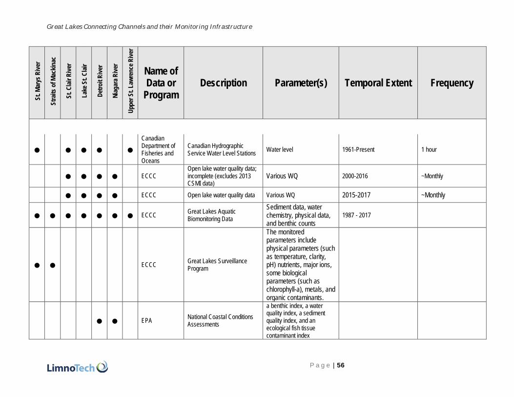
Great Lakes Connecting Channels and their Monitoring Infrastructure
P a g e | 56
S
t. M
arys
Riv
er
S
trai
ts o
f M
acki
nac
S
t. C
lair
Riv
er
L
ake
St.
Cla
ir
D
etro
it R
iver
N
iag
ara
Riv
er
U
pp
er S
t. L
awre
nce
Riv
er
Name of Data or
Program Description Parameter(s) Temporal Extent Frequency
● ● ● ● ● Canadian Department of Fisheries and Oceans
Canadian Hydrographic Service Water Level Stations
Water level 1961-Present 1 hour
● ● ● ● ECCC Open lake water quality data; incomplete (excludes 2013 CSMI data)
Various WQ 2000-2016 ~Monthly
● ● ● ● ECCC Open lake water quality data Various WQ 2015-2017 ~Monthly
● ● ● ● ● ● ● ECCC Great Lakes Aquatic Biomonitoring Data
Sediment data, water chemistry, physical data, and benthic counts
1987 - 2017
● ● ECCC Great Lakes Surveillance Program
The monitored parameters include physical parameters (such as temperature, clarity, pH) nutrients, major ions, some biological parameters (such as chlorophyll-a), metals, and organic contaminants.
● ● EPA National Coastal Conditions Assessments
a benthic index, a water quality index, a sediment quality index, and an ecological fish tissue contaminant index

Great Lakes Connecting Channels and their Monitoring Infrastructure
P a g e | 57
S
t. M
arys
Riv
er
S
trai
ts o
f M
acki
nac
S
t. C
lair
Riv
er
L
ake
St.
Cla
ir
D
etro
it R
iver
N
iag
ara
Riv
er
U
pp
er S
t. L
awre
nce
Riv
er
Name of Data or
Program Description Parameter(s) Temporal Extent Frequency
● ● ● ●
EPA - NCAA Connecting Channels Pilot Project
Connecting channels were normally excluded from NCCA
Huron-Erie in 2014, 2015 and St. Marys in 2015, 2016
● ● ● ● EPA Beach Act Project
E. coli 2007-2011 ~803 sampling events
● ● ●
EPA National Aquatic Resource Surveys (NARS)
National Rivers and Streams Assessment (NRSA)
Benthic macroinvertebrates, algae, fish community, water quality, physical habitat, E. coli, fish tissue, algal toxins
2004-2205, 2008-2009, 2013-2014
● ● ● ● ● ● FWS Invasive and native biota surveillance
2013 - Biannual
● ● ● ● ● ● ● GLATOS Great Lakes Acoustic Telemetry Observation System (GLATOS)
● ● ● ● ● ● ● GLSEA - Great Lakes Surface Environmental Analysis
Lake Erie surface temperature estimates
Water temp 1995-2017 Daily
● ●
Great Lakes Water Quality Monitoring and Aquatic Ecosystem Health Data -> Great Lakes Connecting Channels
Great Lakes Water Quality Monitoring and Aquatic Ecosystem Health Data
110 parameters 1975 to 1999, 2000 to 2019 (dates in Eur. format)
from the 2000 data on, 749 to 2200 data points per year over 110 parameters

Great Lakes Connecting Channels and their Monitoring Infrastructure
P a g e | 58
S
t. M
arys
Riv
er
S
trai
ts o
f M
acki
nac
S
t. C
lair
Riv
er
L
ake
St.
Cla
ir
D
etro
it R
iver
N
iag
ara
Riv
er
U
pp
er S
t. L
awre
nce
Riv
er
Name of Data or
Program Description Parameter(s) Temporal Extent Frequency
Monitoring and Surveillance Data
● ● ● HEC drinking water
● ● ● ●
MDEQ Water Chemistry Monitoring Project (WCMP)
Water quality 1998-2016 ~66 sampling events
● ● ● ● ● ● ●
National Water Level Observation Network (NWLON)
Atmospheric Pressure, Air Temp, Water Temp, Water Level.
Each connecting channel has at least one station that goes back to the at least the 1960s and continues through the present day.
Depending on collection date, water level can be either mean daily, hourly, or six-minute frequency
●
New York State Rotational Integrated Basin Study (RIBS)
Water quality, sediment 2008-2013 ~23 sampling events

Great Lakes Connecting Channels and their Monitoring Infrastructure
P a g e | 59
S
t. M
arys
Riv
er
S
trai
ts o
f M
acki
nac
S
t. C
lair
Riv
er
L
ake
St.
Cla
ir
D
etro
it R
iver
N
iag
ara
Riv
er
U
pp
er S
t. L
awre
nce
Riv
er
Name of Data or
Program Description Parameter(s) Temporal Extent Frequency
● New York State Rotational Integrated Basin Study (RIBS)
Water quality, sediment 1997-2014 ~16 sampling events
● ● ● ● ● ● ● NOAA NOS CO-OPS Water Level Stations
Great Lakes Water Levels Monitoring Network
Water level, temperature 1900-Present 6 min
● NYSDEC - FCAs
● ● ● ● ● OMECP - sediment chemistry
Sediment chemistry (Great Lakes nearshore areas)
variety of organics, nutrients, and metals
2000-2015 Stations visited 1-2x per sampled year.
● ● ● ● ● OMECP - water chemistry
Water chemistry (Great Lakes nearshore areas)
variety of organics, nutrients, and metals as well as algae
2000-2015 Stations visited 3-4x per sampled year.
● ● ● Reef Restoration Monitoring
Pre- and post-reef construction monitoring
Adult fish use of the area, egg deposition, larval fish production and physical conditions
2004-Present Pre- and post-construction
● Saint Regis Mohawk Tribe Water Quality 106 Sampling
Water quality 1997-2018 ~114 sampling events
● Saint Regis Mohawk Tribe Water Quality PIB Sampling
E. coli 2008-2015 ~141 sampling events

Great Lakes Connecting Channels and their Monitoring Infrastructure
P a g e | 60
S
t. M
arys
Riv
er
S
trai
ts o
f M
acki
nac
S
t. C
lair
Riv
er
L
ake
St.
Cla
ir
D
etro
it R
iver
N
iag
ara
Riv
er
U
pp
er S
t. L
awre
nce
Riv
er
Name of Data or
Program Description Parameter(s) Temporal Extent Frequency
● Standard MDEQ Biosurveys
Benthic macroinvertebrates
2004-2014 ~9 sampling events
● ● ● USGS Michigan Water Science Center
Water quality, sediment 1970-2019 ~2 sampling events
● USGS New York Water Science Center
Water quality, sediment, fish tissue
2014-2019 ~7 sampling events
● USGS New York Water Science Center
Water quality, sediment, fish tissue
1955-2019 ~31 sampling events
Supporting programs
● ● ● ● ● ● ● GLRI https://www.usgs.gov/centers/glri/data-tools
● ● CSMI
Cooperative Science and Monitoring Initiative (CSMI), a long-term sampling effort that investigates questions relevant to one Great Lake each year. After 2009, connecting channels were addressed with their downstream lake.
benthic fish (bottom trawls), pelagic fish (hydroacoustics), mysis, zooplankton, benthos, and nutrients
2009 to present
Each lake sampled once per five years. Within sampling year, frequency varies by type of sample being collected

Great Lakes Connecting Channels and their Monitoring Infrastructure
P a g e | 61
S
t. M
arys
Riv
er
S
trai
ts o
f M
acki
nac
S
t. C
lair
Riv
er
L
ake
St.
Cla
ir
D
etro
it R
iver
N
iag
ara
Riv
er
U
pp
er S
t. L
awre
nce
Riv
er
Name of Data or
Program Description Parameter(s) Temporal Extent Frequency
AOC program Varies
LAMPs
Science/monitoring sections of plans that talk about needs. The Lake Huron LAMP document includes a map with ECCC Surveillance stations.
● ● ● ● Lake Erie Millenium Network - 2017 meeting
The 2017 LEMN meeting had an entire session called "Connecting Channels: St. Clair Detroit River System & Niagara River". Included was the NCCA Connecting Channels Pilot Project.
cyanobacteria, vegetation sampling, electrofishing, fyke net sampling, velocity, direction, turbidity, chl-a, temperature, conductivity, PAR, whole water mercury, sediment mercury, PCBs, dioxin, fish health, aquatic indicator species
some presentations highlighted single day sampling runs and others showed real-time water quality data results

Great Lakes Connecting Channels and their Monitoring Infrastructure
P a g e | 62
S
t. M
arys
Riv
er
S
trai
ts o
f M
acki
nac
S
t. C
lair
Riv
er
L
ake
St.
Cla
ir
D
etro
it R
iver
N
iag
ara
Riv
er
U
pp
er S
t. L
awre
nce
Riv
er
Name of Data or
Program Description Parameter(s) Temporal Extent Frequency
● Detroit River Canadian Cleanup
The Detroit River Canadian Cleanup implements the Remedial Action Plan on behalf of a community-based partnership working together to protect, restore and enhance the Detroit River ecosystem. The federal, provincial and municipal government, local industries, scientific researchers, local environmental organizations and many dedicated citizens are key partners and play an important role in the cleanup process. The DRCC’s member organizations provide leadership in identifying partnerships and funding opportunities to support and implement clean up goals.
sediment chemistry and benthos data, phytoplankton, zooplankton, snapping turtle monitoring, tree swallow monitoring, creel survey, fish habitat study, river shoreline assessments, and black crowned heron study
Studies began in 2009 and continue. Not every parameter/study type listed is surveyed in every year.

Great Lakes Connecting Channels and their Monitoring Infrastructure
P a g e | 63
S
t. M
arys
Riv
er
S
trai
ts o
f M
acki
nac
S
t. C
lair
Riv
er
L
ake
St.
Cla
ir
D
etro
it R
iver
N
iag
ara
Riv
er
U
pp
er S
t. L
awre
nce
Riv
er
Name of Data or
Program Description Parameter(s) Temporal Extent Frequency
● ● ● SCDRS Initiative
Vision: restoration of [areas of interest] to a thriving ecosystem with science-based management and broad social support that provides environmental services for the region and the Great Lakes basin
Richness of larval or spawning adults, peak density of whitefish larvae, total native intolerant fish species counts, small-mouth bass/walleye/ yellow perch/ muskellunge/lake sturgeon population, wetland fish counts, wetland area, native mussel density, dreissena density, emergent and submergent vegetation distribution, plant presence/absence data, mean densities of rotifers, copepods, and cladoc-erans, amphibian status, marsh bird status, macro invertebrate status, hexagenia density, phragmites coverage, fish load (PCBs/mercury), TDS, Nitrogen, TP, cladophora, HAB extents

Great Lakes Connecting Channels and their Monitoring Infrastructure
P a g e | 64
S
t. M
arys
Riv
er
S
trai
ts o
f M
acki
nac
S
t. C
lair
Riv
er
L
ake
St.
Cla
ir
D
etro
it R
iver
N
iag
ara
Riv
er
U
pp
er S
t. L
awre
nce
Riv
er
Name of Data or
Program Description Parameter(s) Temporal Extent Frequency
Additional datasets
● ECCC Detroit River nutrient conc. and loading
TP, TFP, SRP, NO23, TKN, NH, Cl, F, SO4
2014-2015 Annual
● ● ●
Pearsall et al., 2012a. Michigami: Great Water. Strategies to Conserve the Biodiversity of Lake Michigan; and Pearsall et al., 2012b. Returning to a Healthy Lake: Lake Erie Biodiversity Conservation Strategy
The Lake Michigan Biodiversity Conservation Strategy (LMBCS) is a multi‐agency initiative designed to identify specific strategies and actions to protect and conserve the native biodiversity of Lake Michigan. It is the product of a two‐year planning process involving roughly 170 individuals from 79 agencies and organizations from around the lake. The Lake Erie Biodiversity Conservation Strategy (LEBCS) is a binational initiative designed to support the efforts of the Lake Erie LaMP by identifying specific strategies and actions to protect and conserve the native biodiversity of Lake Erie. It is the product of a two-year planning process involving 87 agencies and organizations around the basin.
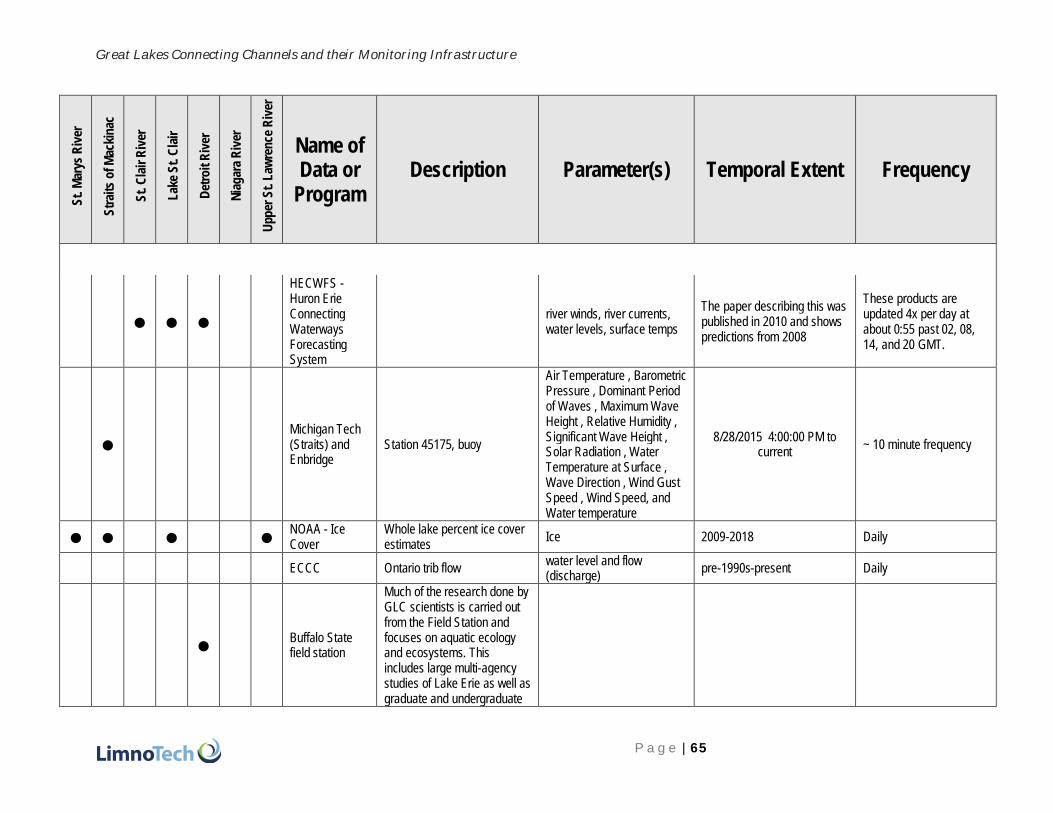
Great Lakes Connecting Channels and their Monitoring Infrastructure
P a g e | 65
S
t. M
arys
Riv
er
S
trai
ts o
f M
acki
nac
S
t. C
lair
Riv
er
L
ake
St.
Cla
ir
D
etro
it R
iver
N
iag
ara
Riv
er
U
pp
er S
t. L
awre
nce
Riv
er
Name of Data or
Program Description Parameter(s) Temporal Extent Frequency
● ● ●
HECWFS - Huron Erie Connecting Waterways Forecasting System
river winds, river currents, water levels, surface temps
The paper describing this was published in 2010 and shows predictions from 2008
These products are updated 4x per day at about 0:55 past 02, 08, 14, and 20 GMT.
● Michigan Tech (Straits) and Enbridge
Station 45175, buoy
Air Temperature , Barometric Pressure , Dominant Period of Waves , Maximum Wave Height , Relative Humidity , Significant Wave Height , Solar Radiation , Water Temperature at Surface , Wave Direction , Wind Gust Speed , Wind Speed, and Water temperature
8/28/2015 4:00:00 PM to current
~ 10 minute frequency
● ● ● ● NOAA - Ice Cover
Whole lake percent ice cover estimates
Ice 2009-2018 Daily
ECCC Ontario trib flow water level and flow (discharge)
pre-1990s-present Daily
● Buffalo State field station
Much of the research done by GLC scientists is carried out from the Field Station and focuses on aquatic ecology and ecosystems. This includes large multi-agency studies of Lake Erie as well as graduate and undergraduate

Great Lakes Connecting Channels and their Monitoring Infrastructure
P a g e | 66
S
t. M
arys
Riv
er
S
trai
ts o
f M
acki
nac
S
t. C
lair
Riv
er
L
ake
St.
Cla
ir
D
etro
it R
iver
N
iag
ara
Riv
er
U
pp
er S
t. L
awre
nce
Riv
er
Name of Data or
Program Description Parameter(s) Temporal Extent Frequency
research projects.The Great Lakes Center has several monitoring efforts ranging from a continuously monitoring buoy, to a biweekly lower trophic level sample in Lake Erie, to an intensive benthic sampling trip that spans all five Great Lakes. Some of our research focuses on conservation of threatened freshwater species. Sasha Karatayev and Lyubov Burlakova are working on projects aimed at identifying threatened populations and genetic diversity of native freshwater mussels in Texas. We also completed a project aimed at understanding the habitat use and feeding ecology of the lake sturgeon in the Lower Niagara River. The Great Lakes Center conducts research to study the effects of species that have already invaded the Great Lakes and their

Great Lakes Connecting Channels and their Monitoring Infrastructure
P a g e | 67
S
t. M
arys
Riv
er
S
trai
ts o
f M
acki
nac
S
t. C
lair
Riv
er
L
ake
St.
Cla
ir
D
etro
it R
iver
N
iag
ara
Riv
er
U
pp
er S
t. L
awre
nce
Riv
er
Name of Data or
Program Description Parameter(s) Temporal Extent Frequency
tributaries, as well as to identify species which have the potential to invade.
● ● ● Canadian RCAs
● Clinton River watershed
CWMP - Great Lakes Coastal Wetland Monitoring Program
Daily temp data and lots of fisheries data
● ● ● Friends of the St. Claire
● ● ● ● ● GLFC Lamprey monitoring, mostly tributaries
● GLFC St Marys River Fisheries Task Group
Great Lakes Sediment Surveillance Program

Great Lakes Connecting Channels and their Monitoring Infrastructure
P a g e | 68
S
t. M
arys
Riv
er
S
trai
ts o
f M
acki
nac
S
t. C
lair
Riv
er
L
ake
St.
Cla
ir
D
etro
it R
iver
N
iag
ara
Riv
er
U
pp
er S
t. L
awre
nce
Riv
er
Name of Data or
Program Description Parameter(s) Temporal Extent Frequency
● ● ● Lake St. Clair study of rare species
● Lake Superior State University
● ● ● Michigan population assessment
●
Nature Conservancy and University of Michigan
●
River Inst. (RI) - American Eel Habitat Characterization in the Upper St. Lawrence River
Fish biologist Matt Windle combines GIS mapping with population surveys and radio-telemetry to characterize and map critical habitat of American Eels in the Upper St. Lawrence River. They have a web tool for reporting American Eel sightings as well.

Great Lakes Connecting Channels and their Monitoring Infrastructure
P a g e | 69
S
t. M
arys
Riv
er
S
trai
ts o
f M
acki
nac
S
t. C
lair
Riv
er
L
ake
St.
Cla
ir
D
etro
it R
iver
N
iag
ara
Riv
er
U
pp
er S
t. L
awre
nce
Riv
er
Name of Data or
Program Description Parameter(s) Temporal Extent Frequency
●
RI - Assessing the Effects of Contaminants on Yellow Perch Health in Lake St. Francis
This project is an initiative of the River Institute’s Fish Health Assessment Laboratory. Goal is to assess whether YP collected along Cornwall's waterfront accumulate contaminants and examine the health status of YP from the St. Lawrence River AOC. They do lab analysis, fish collections, and fish health surveys.
● RI - Fish Identification Nearshore Survey
FINS was started in 2015 as a research partnership between the River Institute and the Mohawk Council of Akwesasne, to address concerns over the state of minnows and other small fish communities in the Upper St. Lawrence River. The project aims to collect baseline information on the status of these nearshore fish communities and aquatic habitats of the river, and to fill in knowledge gaps on the distribution and habitat
environmental health indicators for the Upper St. Lawrence River
looks like 2015 to 2018

Great Lakes Connecting Channels and their Monitoring Infrastructure
P a g e | 70
S
t. M
arys
Riv
er
S
trai
ts o
f M
acki
nac
S
t. C
lair
Riv
er
L
ake
St.
Cla
ir
D
etro
it R
iver
N
iag
ara
Riv
er
U
pp
er S
t. L
awre
nce
Riv
er
Name of Data or
Program Description Parameter(s) Temporal Extent Frequency
associations of species at risk.
●
RI - Identification and Characterization of Spawning Habitat of the Cutlip Minnow
no further description available on main landing page
●
RI - Lake St. Francis Nearshore Water Quality Monitoring and Assesment
no further description available on main landing page

Great Lakes Connecting Channels and their Monitoring Infrastructure
P a g e | 71
S
t. M
arys
Riv
er
S
trai
ts o
f M
acki
nac
S
t. C
lair
Riv
er
L
ake
St.
Cla
ir
D
etro
it R
iver
N
iag
ara
Riv
er
U
pp
er S
t. L
awre
nce
Riv
er
Name of Data or
Program Description Parameter(s) Temporal Extent Frequency
●
RI - Monitoring of Mercury Concentrations of Fish from the St. Lawrence River Along Cornwall’s Waterfront
This project is an initiative of the River Institute’s Fish Health Assessment Laboratory.
●
RI - Sediment Mapping in support of the Sediment Mangement Strategy for the St. Lawrence River at Cornwall
no further description available on main landing page
●
RI - The Northern Pike Project: Assessing Northern Pike General Condition and Habitat Quality
This project is an initiative of the River Institute’s Fish Health Assessment Laboratory. They do habitat quality assessments, fish collections, and fish health surveys.
● ● ● Boase et al.'s adult lake
Boase is a co-author on several of the studies cited in literature review.

Great Lakes Connecting Channels and their Monitoring Infrastructure
P a g e | 72
S
t. M
arys
Riv
er
S
trai
ts o
f M
acki
nac
S
t. C
lair
Riv
er
L
ake
St.
Cla
ir
D
etro
it R
iver
N
iag
ara
Riv
er
U
pp
er S
t. L
awre
nce
Riv
er
Name of Data or
Program Description Parameter(s) Temporal Extent Frequency
sturgeon surveys
● ● Healthy Urban Waters - Wayne State Univ.
Promotes and delivers research, education, technology development and public engagement on water resources in the urban environment; 3 field stations
Focus on endocrine disruptors and emerging contaminants (PFAS, PPCPs)
● ● ● ● ● ● ● FWS
From literature review - info on sturgeon from: St. Marys, lower Niagara, Detroit Riv, Huron-Erie, upper St. Lawrence, and Upper Niagara River

Great Lakes Connecting Channels and their Monitoring Infrastructure
P a g e | 73
APPENDIX B: INTERVIEW QUESTIONS AND SUMMARIES
B:

Great Lakes Connecting Channels and their Monitoring Infrastructure
P a g e | 74
Interview Questions
1. What is your background and experience related to research, monitoring, or management of
the five Great Lakes connecting channels (St Marys River, Straits of Mackinac, Huron-Erie
Corridor, Niagara River, and/or St. Lawrence River)?
2. What are some of the most important concerns and current environmental issues and
policy discussions related to connecting channels?
3. What are some of the most important federal, provincial, state, or Tribal/First Nations
environmental regulations, treaties, and programs that have bearing on the connecting
channels?
4. What are the most important current or planned connecting channel monitoring programs?
Have any been discontinued that should be started again? Should any ongoing monitoring
programs be modified, and if so, how? What is not being monitoring that should be, and who
should do it?
5. What differences exist between the U.S. and Canada or particular states and provinces in their
approaches to monitoring and management of the connecting channels?
6. What examples of best practices and challenges/lessons learned/mistakes can you
provide for past or current connecting channel management actions? Are you aware of any
publicly-available documentation on these lessons learned or successes (reports, presentations,
papers etc.)?
7. What research is being conducted by your organization related to connecting channels (or by
others, of which you are aware or in which you are involved)? Are research project plans or
results and data publicly available? If so, where? What research is not being done but should be
done to improve scientific understanding of the connecting channels?
8. What are the primary data repositories for information related to connecting channels? How
could the usefulness of these repositories be improved? What important historical data should be
made available in updated formats (e.g., online)?
9. What are the primary forums for environmental information exchange related to
connecting channel research, monitoring, and management?
10. What, according to you, should be priorities in advancing the understanding and management
of Great Lakes connecting channels to protect human health and the environment (e.g.,
regulatory changes, investments, research)?
11. Who else should we be speaking to about this topic?

Great Lakes Connecting Channels and their Monitoring Infrastructure
P a g e | 75
Interview Summaries
Interview #1: Eric Anderson – NOAA-GLERL researcher – 4/5/19
Summary: The interviewee’s interests in monitoring the connecting channels come from the perspective of building computer models to simulate currents and water levels and occasionally temperature. The interviewee is most familiar with the Straits of Mackinac, but has developed forecasting models for the St. Marys, Niagara, and Upper St. Lawrence River. The interviewee emphasized that there is not enough good flow data. Without good flow data, it is hard to model and understand how things are distributed and can even lead to debates about what the true flows are. A major concern for the interviewee is contaminant and nutrient transport. Oil and other contaminants can move quickly, and the ability to forecast flows is limited. Real-time or at least near real-time flow data are needed. In Canada, the availability of data is even more limited than in the U.S. According to the interviewee, there are fewer observation points and more limited infrastructure, which impacts the verification of models. Identifying changes in flow is a major data gap, as data are not available for flow going through hydropower plants or locks, or when gates are open or closed. The interviewee sees the reluctance of the hydropower industry to provide data as a major challenge. To protect human health and the environment, the interviewee believes focus should be placed on oil spill response and establishing more real-time points of observations. Since there are stretches of connecting channels with no data, there needs to be increased availability so there are some stations on each connecting channel. In addition to flows, the interviewee mentioned other data gaps like updated bathymetry, ice jamming and ridging information for channels, and substrate information. ………………………………………………
Interview #2: Joe Atkinson – University at Buffalo, Director, Great Lakes Program –
4/11/19
Summary: Joe Atkinson’s connecting channels work is limited to modeling for the Niagara River, and a little in the St. Lawrence. In the past he has looked at transport properties in the Niagara. More recently he has worked with the Army Corps looking at fish migration in the upper river. For him, an important environmental concern is phosphorus loading and the transport and measurement of phosphorus. On the policy side, he also mentioned that more attention is needed for fish passage and that there is an ongoing question of whether the ice boom causes ecological issues for the Niagara by preventing ice from moving down the river. Joe referred to the upstream-downstream monitoring on the Niagara. He appreciates this as a source of historic data from the 90s, but thinks that the frequency of samples can be improved. The Niagara does not respond to rain like many other rivers, so not being able to capture peaks is not as much of an issue. However, since sampling only happens every two weeks, there is the possibility of missing short-term events such as chemical discharges. To protect human health, he believes emerging contaminants and continued monitoring of fish contaminant loads should be priorities. For ecological health, water levels and issues related to climate change should be priorities. ………………………………………………
Interview #3: Barry Baldigo - USGS-Biology (NY) – 3/26/19
Summary: Barry Baldigo has over 30 years of monitoring experience in New York. Since 2011, Barry has provided technical support to NYSDEC and EPA both indirectly and directly to remedial action committees for St. Lawrence and Niagara River BUIs. Based on his experiences, he is concerned about the differences in the way some of the BUIs are being handled at each AOC. With very little cross-border interaction between the U.S. and Canada, there is no standardization of methods as well as other potential implications. Particularly when it comes to protecting human health and the environment, there are no standardized consumption advisories across the different nations and agencies. Barry feels that the BUIs he has been involved with have generally had sufficient short term monitoring. However, the need for long-term monitoring can have a lot of natural variability. Long-term monitoring supported by the EPA is fairly limited. If an AOC is delisted, any kind of long-term monitoring goes away. This ends up creating disincentives for the completion of remediation for fear of losing funding. At the USGS, their mission

Great Lakes Connecting Channels and their Monitoring Infrastructure
P a g e | 76
includes a mandate to make sure that all data gathered are made available to the public. While NWIS is already an excellent resource, there may be potential to better handle biological and flow data. He also notes that accessing historic archives can be a challenge and that there should be more transparent information sources. ………………………………………………
Interview #4: Aaron Fisk – University of Windsor – GLIER (fish biology and ecology) – 3/21/19
Summary: During the interview, Aaron voiced his concerns about connecting channels not getting enough attention. He noted that the impact of climate change is the #1 environmental issue he sees for connecting channels, particularly for habitats in the area. Anthropogenic factors that affect habitat degradation, as well as factors such as variability of flows, precipitation, and snowpack are concerns. In terms of policy issues, Aaron sees the lag in funding in Canada as a major concern. He also believes that there is a more interdisciplinary need when it comes to the Great Lakes and connecting channels. Datasets from various sources need to be brought together in order to understand how they interact. A way to improve data repositories is to make it easier for people to provide data. For example, by working closely with GLOS, the data input process can be made more seamless by using automatic integration to prevent format/data issues and inconsistencies. Aaron leads the Real-time Aquatic Ecosystem Observation Network (RAEON), which is a $15.9 million CAN project to create a network of real-time sensors, autonomous sub-surface vehicles, and an extensive collection of independent instruments to monitor Canadian waters and support experiments, including work in the connecting channels. ………………………………………………
Interview #5: Darryl Hondorp - USGS-Biology (MI) – 3/21/19
Summary: The interviewee has some work exposure to most of the connecting channels, but primarily
has first-hand experience in the Huron-Erie Corridor, where he has been working in various capacities since 2010. His work in the Huron-Erie Corridor is typically to support management and policy decisions and is often related to how different fish species move in and through the corridor. The interviewee had clear ideas about where research gaps lie. One of the ultimate gaps that need to be addressed involve the question of ‘What is the overall importance of connecting channel systems in terms of fish production?’ Although it is widely held that the connecting channels are habitats used by many fish species and are important to fisheries, how much production channels yield and how much fishable biomass is derived compared to other river and lake areas is unknown. Work is being done to look at the movement of larval fish, but there is not a good way to identify adult fish produced in the channel. A second connecting
channel research gap mentioned is related to the question, ‘How should these bodies of water be treated in the context of other fishery management programs?” It is often a struggle to describe and frame these systems. For example, the channels are often described as large rivers, but their behavior and ecology classification do not fit this description. When it comes to reef building and restoration projects, the interviewee spoke about their need to be predicated on answering well-defined scientific questions rather
than being on a more trial and error basis. Looking at restoration projects simply from a pre- and post- perspective is not as informative because our knowledge of what a system is like beforehand is incomplete. Asking specific questions linked to particular design features will allow for more knowledge on what sort of designs work in what contexts. Even if a restoration project does not go as planned, it can still be informative and important for future work.
………………………………………………
Interview #6: Stan Skrobialowski, Hydrologist, USGS-Reston, VA, 3/22/19
Summary: Stan is responsible for coordination for training, especially for the USGS large river sampling class. He formerly worked at the USGS Louisiana Water Science Center until about 10 years ago. He is in the USGS Office of Water Quality, and works as a surface water quality field methods specialist, now in the hydrologic networks branch. He has taught 2-week classes in Denver for surface water sampling
methods, and started teaching a large river sampling class 5 or 6 years ago. The class began following 2011

Great Lakes Connecting Channels and their Monitoring Infrastructure
P a g e | 77
large scale flooding on the Mississippi River, and concentrated on use of samplers weighing 200-300 pounds (D-96 and D-99), but only 3 or 4 existed in USGS. More were fabricated more and pre-positioned for sampling during flooding events, but USGS realized that staff had not been trained in their use. Training is conducted in Vicksburg, MS, and covers basic theory, safety, infrastructure (boats, booms,
reels), and includes two days of field training (suspended and bottom sediment), issues related to particular sites of the trainees, and some data interpretation. Discharge measurements are made prior to
sampling, including no less than 4 river increments. Various other aspects include sediment compositing, bag sampling, boat handling (typically 24-foot with twin 200-HP engines), bottom sampling, winch operations, and velocity measurement. Training is mostly of federal employees, cooperators (with active agreements), state contractors, state employees, and some foreign students and professionals (e.g., Brazil, South Korea, and Canada). Stan stated that 200-lb samplers are probably needed in Great Lakes
connecting channels, deployed using a variable speed winch. He sent a course agenda, synopsis, and references. Training is typically in January and he will be conducting it for at least 3 more years. The program has no connection with the Tuscaloosa National Water Center. USGS has a new initiative called the Next Generation Water Observing Systems program, NGWOS, incorporating a dense network for temperature and specific conductance sensing along with flow. The Delaware River basin is a pilot site, and a similar basin out west is planned as a second pilot for next year.
………………………………………………
Interview #7: Sharilyn Johnston – Aamjiwnaang First Nation – 4/3/19
Summary: Sharilyn has worked in the First Nation community for over 10 years, and has previous work experience with the Ministry of the Environment. Her work is not in monitoring or management of connecting channels, but rather focuses on community priorities and commitments with respect to water
and its spiritual value. She was able to speak to the cultural and historical significance of the connecting channels, particularly the St. Clair. She spoke of how the connecting channels were once a gathering place for First Nations in both Canada and the U.S., since it was an easier place to cross. However, how the connecting channels are used now is a completely different experience. Sharilyn expressed frustration related to the many environmental concerns of the St. Clair River and feels that provincial and federal governments are not putting measures in places to resolve these issues. She points to historic mercury
contamination that has not been cleaned up and contamination from the 70s that closed down fisheries,
but that currently still exists. Other concerns include nutrients, invasive species, emerging contaminants, plastics, and personal care products. Sharilyn asserts that the provincial and federal governments need to look at how things are being governed and be more sincere about it. Because they are afraid to upset certain groups that may be hard lobbyists, it takes a long time to make policy and any real impacts get watered down. She notes that there is more regulatory accountability in the U.S. and improvements are needed in Canada. Sharilyn also stated that more cultural understanding is needed and First Nations need more representation in decision making roles. In her culture, since women are responsible for water, she
feels that inviting a First Nation elder woman to be present for Commission meetings would go a long way towards showing that IJC respects the spiritual aspects of the First Nations. She also feels that Councilors from First Nations should be on IJC boards and other bodies, helping to make water decisions.
………………………………………………
Interview #8: Guy Meadows – Michigan Tech, Director, Great Lakes Research Center – 4/10/19
Summary: Guy Meadows has been working on Great Lakes issues since the 1970s, primarily from the hydrodynamic side of things, and is most familiar with the Straits of Mackinac. Forecasting and modeling the Great Lakes cannot be done correctly without getting the connecting channels right, and he feels that monitoring in the Straits is one of the most critical issues because of the threat of oil spills. Guy was involved in an independent risk analysis that demonstrated that if a spill were to occur, it would move incredibly quickly through the Straits. Therefore, he feels that the Straits needs to be monitored more

Great Lakes Connecting Channels and their Monitoring Infrastructure
P a g e | 78
intensively. Monitoring through the winter months, has been particularly challenging for the Straits. Currently devices can be put on the bottom, but an answer cannot be retrieved until they are later pulled back up. He sees the need for remote sensing, like high frequency radars, moving forward. Guy views GLOS as a great data repository. He feels that GLOS is the appropriate holder of the Great Lakes data, but
it is very poorly funded in the Great Lakes region compared to ocean counterparts in IOOS.
………………………………………………
Interview #9 (group of 6): Ontario Ministry of Environment, Conservation, and Parks; Environmental Monitoring and Reporting Branch – 4/5/19
• Ngan Diep – Great Lakes unit
• Todd Howell – Great Lakes unit • Jim Martherus – Supervisor of Great Lakes unit • Mary Thorburn – Great Lakes unit • Satyendra Bhavsar – fish contamination monitoring • Claire Holeton – biology group, algae and nutrients Summary: This MECP branch has a presence in all Great Lakes connecting channels on the Canadian
side. A majority of their work in the connecting channels is for the AOCs. They also do ambient
monitoring in the connecting channels and long-term monitoring near the channels. Sediment contamination and its historical consequences is an environmental concern that came up repeatedly throughout the interview, as well as confirmation and abatement of sources, and fish contamination. Concerns were voiced about the lack of research in Lake St. Clair to understand its unique environment and how the conditions are not improving in the lake unlike in other areas. Many of the programs within
their agency are under a lot of pressure to increase their temporal and spatial coverage. With competing priorities and limited resources, moving in one direction tends to be at the expense of another area. The challenge they face is finding the balance in evaluating what is changing and making sure everything is covered. Relying on partnerships and sharing plans and information is thought to be a way to alleviate some of these pressures. There was also mention of the need to innovate and evolve in order to increase capacity, especially for long-term monitoring in AOCs. A general issue the group faces is determining the
placement of stations to achieve effective results despite spatially and temporally dynamic conditions. The
Niagara River is one area pointed to for lessons learned, and can serve as an example of changing frequencies and types of analyses. During the discussions, the use of real-time data was emphasized as a way to develop good surveys and explain observed variability. It was also noted that the connecting channels are not just conduits but also ecosystems themselves, and that the strong environmental stressors on the system need to be understood, and that the climate change aspect needs to be built into the monitoring system.
………………………………………………
Interview #10: Ashley Moerke – Lake Superior State University, Director, Center for Freshwater Research and Education – 4/11/19
Summary: Ashley Moerke has 14 years of experience focused primarily on invasive species and fisheries
management for the St. Marys River, and is the director of a freshwater resource center. She spoke of two important environmental concerns: 1) habitat protection and preservation (particularly in the lower
channel where a lot of shoreline development is expected in the next decade), and 2) issues related to an active navigation channel, such as dredging and impacts on invasives and wetlands. In addition, Ashley emphasized the need for formal coordination efforts across the connecting channels as a top priority. She notes that there are efforts in each of the connecting channels handled by different agencies with different focuses, but the results are not comparable. She envisions a framework with standardized surveys that allows for collaboration and locally connected groups to be involved in work in their own back yard. Additional concerns mentioned were the need for early detection and response to invasives; impacts
Great Lakes Connecting Channels and their Monitoring Infrastructure
P a g e | 79
related to changes in water level; freighter impacts, such as erosion and vegetation displacement; fish spawning success; and invertebrate community composition and dynamics.
………………………………………………
Interview #11: Todd Nettesheim – USEPA-GLNPO – 4/4/2019
Summary: Throughout the interview, Todd emphasized the importance of nutrient loading and boundary conditions (particularly for the Detroit, Niagara, and St. Lawrence) by using lake partnerships
to identify data gaps and priorities. This is critical for whole- lake modeling that is required under water quality agreements. However, sampling is very challenging because the connecting channels are very dynamic. He shared that the EPA has effectively sampled the Detroit River by teaming with smaller boats
to collect samples and deliver them to the docked R/V Lake Guardian for processing in the ship’s laboratories. He feels that assessments of work being done are needed to evaluate whether routines need to be revised. Todd is knowledgeable about a long list of various monitoring efforts for the connecting channels. However, he feel that any perception that there is not as much monitoring in the connecting channels as in the lakes is inaccurate. To address this issue, he suggests making a compendium of work that is ongoing or has been done and also a list of contacts for the network of people who know what exists. In terms of data repositories, he mentioned a large, multi-year effort that is currently underway to
develop electronic records that will support old work that was not appropriately captured electronically.
At GLNPO, there is a strong push to make all data freely discoverable.
………………………………………………
Interview #12: Jeff Ridal – River Institute, Cornwall, Ontario – 5/31/2019
Notes (partial interview):
1. What is your background and experience related to research, monitoring, or management of the five Great Lakes connecting channels (St. Marys River, Straits of Mackinac, Huron-Erie Corridor, Niagara River, and/or St. Lawrence River)?
>>>Some experience with Upper St. Lawrence River, Little with Niagara River, Don’t know much
about rest of connecting channels; St. Lawrence is primary focus
2. What are some of the most important concerns and current environmental issues and policy discussions related to connecting channels?
>>>Water level management and control, other key issues: connectivity, fragmentation, finding
adaptive approaches and technologies to improve connectivity, especially related to fish
migration, eel populations great concern (declined precipitously in last few decades); migration
around two main dams; other species affecting, nearshore water quality & habitats where people
live and interact (relates to upstream and tributaries); shoreline erosion; Individual property
damage function of higher water levels, shipping, transport, rec vehicle use, poor landowner
practices; eutrophication; oil spills.
All issues relevant to the Great Lakes also apply here, but modified for St. Lawrence; don’t take
one size fits all approach; unique characters of rivers; uniquely manifested.
3. What are some of the most important federal, provincial, state, or Tribal/First Nations environmental regulations, treaties, and programs that have bearing on the connecting channels?
>>> Great Lakes Water Quality Agreement

Great Lakes Connecting Channels and their Monitoring Infrastructure
P a g e | 80
• LAMP and AOC programs; LAMPs have not fully realized their envisioned roles; LAMPs
could better incorporate connecting channels
• Canada/Quebec agreement – programs overlap
• All regulations related to environmental protection
• First Nations – land use claims and expectations – in St. Lawrence First Nations have
jurisdiction over islands in river, on Canadian side lack resources; tend to adopt most
stringent of U.S. or Canada regulations; falls under their environmental offices; they’re
monitoring, have initiatives to make sure they are onsite on the islands, lease-holding
agreements with people residing on islands; clarity on what their regulations are is
needed; they have these responsibilities but don’t have financial capacity other than a
couple visits to each island over the course of a summer
• National-biodiversity strategy
• Water protection programs – address future threats
4. What are the most important current or planned connecting channel monitoring programs? Have any been discontinued that should be started again? Should any ongoing monitoring programs be modified, and if so, how? What is not being monitoring that should be, and who should do it?
>>>Not best person to speak on this; typically think of large government long-term projects;
programs to track and communicate contamination and fish trends; NY Dep of Health; Environ
Canada – wildlife programs, monitoring herring gull eggs, waterfowl survey (contaminants in
colonies), water quality monitoring (has been scaled back but would like to see it expanded; new
contaminants of concerns); CSMI – focus every 5 years, should continue – usually focuses
entirely on lakes, but should include St. Lawrence and other channels – more attention is needed;
Thousand Islands Biological Station through SUNY – connects to River institute work, looks at
small fish communities (minnows and forage fish), done in cooperation with Mohawk (good
example of collaboration); Ontario government program for intakes (long-term once a year) for
drinking water quality (lots of data); Tributary restoration conservation programs – both sides of
St. Lawrence (ALICE?) very resource limited, funding varies from government to government,
Ontario government funding very choppy, current government notified conservation orgs should
return to core goal of flood protection; can’t separate nearshore health from tributary restoration
– government needs this vision; tributary restoration program of St. Lawrence/Lake St. Francis
(was discontinued, should be reinstated)
Grey zone of where border ends in St. Lawrence – overlapping monitoring

Great Lakes Connecting Channels and their Monitoring Infrastructure
P a g e | 81
Interview #13: John Farrell – State University of New York, College of Environmental
Science and Forestry; Director of Thousand Islands Biological Station, Clayton, New York
– 5/31/2019
Summary: John Farrell has 32 years of experience working on the St. Lawrence River. In his work
related to monitoring, he has noticed that in recent years that there has been increased improvement in valuable monitoring due to increased activity with the IJC and the Plan 2014 water level studies. John has also noticed more nearshore and wetland monitoring than ever before. However, he emphasized the importance of connecting channels because of their unique characteristics and high heterogeneity. Given this, he feels that nearshore and wetland areas, as well as fish consumption advisories, can still receive more attention. John also noted that standardized sampling is not conducted as much in Canada. The NYSDEC has run a fisheries monitoring program since the early 1970s. There once was a Canadian program that matched the New York side, but it was unfortunately discontinued. Although assumptions can be made that the two sides of the river behave the same way, having data on both sides and the ability to index the data would be invaluable. In the St. Lawrence, there is a network of NGOs, citizen scientists, and advocacy groups that are critical to keeping an eye on the river. John believes this grass roots
initiative involving the advocacy, education, and monitoring groups represents three legs of a stool for the
stability of environmental management. John also has first-hand experience with adaptive management and witnessing how this collaboration can lead to the spread of monitoring programs. For example, the implementation of a fish habitat conservation strategy with established protocols for monitoring has extended to multiple other programs, including programs in Canada. In general, greater coordination is needed among groups. John feels that a clearinghouse for schedules and meetings related to connecting channels would be very useful. He also feels that a clearinghouse for research and monitoring activities around connecting waters should be a funded initiative.