moneypoint ash storage area development
TRANSCRIPT

Copyright © ESB International Limited, all rights reserved.
ESB International, Stephen Court, 18/21 St Stephen’s Green, Dublin 2, Ireland.
Phone +353 (0)1 703 8000
www.esbi.ie
Moneypoint Ash Storage Area Development
ESB Power Generation and Wholesale Markets
Environmental Impact Statement
QS-000132-01-R001
Date: 13/06/2014
For
insp
ectio
n pur
pose
s only
.
Conse
nt of
copy
right
owne
r req
uired
for a
ny ot
her u
se.
EPA Export 25-10-2016:02:12:32

Moneypoint Ash Storage Area Development
QS-000132-01-R001 i
File Reference:
Client / Recipient: ESB Power Generation and Wholesale Markets
Project Title: Moneypoint Ash Storage Area Development
Report Title: Environmental Impact Statement
Report No.: QS-000132-01-R001
Volume: 1 of 1
Prepared by: Mairead Hogan Date:23 April 2014
Title: Consultant
Verified by: Paddy Kavanagh Date:13 June 2014
Title: Senior Consultant
Approved by: Neil Quinn Date: 14 June 2014
Title: Manager Predevelopment Group
Copyright © ESB International Limited
All rights reserved. No part of this work may be modified, reproduced or copied in any form or by any means - graphic, electronic or mechanical, including photocopying, recording,taping or used for any purpose other than its designated purpose, without the written permission of ESB International Limited.
Template Used: T-020-007-ESBI Report Template
Change History of Report
Date New Revision Author Summary of Change
For
insp
ectio
n pur
pose
s only
.
Conse
nt of
copy
right
owne
r req
uired
for a
ny ot
her u
se.
EPA Export 25-10-2016:02:12:32

Moneypoint Ash Storage Area Development
QS-000132-01-R001 ii
NON TECHNICAL SUMMARY
Introduction
This non technical summary (NTS) and Environmental Impact Statement (EIS) has been prepared to accompany an application by ESB Generation and Wholesale Markets (G&WM) to Clare County Council for full planning permission to increase the storage capacity of the existing ash storage area at the site of Moneypoint Generating Station. The station operates under the EPA Integrated Pollution Prevention and Control (IPPC) Licence P-0605-03.
The combustion of coal generates ash as a by-product, both furnace bottom ash (FBA) and pulverised fly ash (PFA). Bottom ash is transferred to the ash storage area. The existing ash storage area will reach its storage capacity by the end of 2014 and additional capacity must be provided to ensure the continued operation of Moneypoint station.
The EIS has been prepared in accordance with the provisions of the European Communities (Environmental Impact Assessment) Regulations. Categories in the EIS are grouped under the headings Human Beings, Noise, etc. which is in accordance with current guidelines. The EIS comprises the following: non technical summary, main EIS volume, EIS appendices and photomontages. A separate assessment with the application under Article 6 of the EU Habitats Directive has also been provided with the application.
As part of the consultation process, a scoping report was prepared and issued to key stakeholders including government bodies, interest groups, environmental organisations and local authorities.
Description of the Project
Moneypoint is located on the northern shore of the Shannon Estuary in Co. Clare, approximately 3 km west of Killimer and 6 km south-east of Kilrush.
Moneypoint Ash Storage Area (ASA) will be developed by ESB Generation and Wholesale Markets (ESB G&WM), which is the part of the ESB organisation that is dedicated to energy generation. The station has been in service since 1985 and has three 305 mega watts (MW) rated units. The site itself is approximately 180 hectares (ha) and comprises lands on either side of the Kilrush – Killimer road (N67).
Due to changes in legislation in 2002 and subsequently to the stations IPPC Licence, air emission control equipment was fitted on the three boilers as part of the Moneypoint Environmental Retrofit Project (MERP). Since the retrofit project, flue gas desulphurisation (FGD) by-product has been generated, which is stabilised and landfilled in the stations FGD landfill. FGD by-product will be used in admixture with fly ash and cement to construct the embankments for the ASA.
For
insp
ectio
n pur
pose
s only
.
Conse
nt of
copy
right
owne
r req
uired
for a
ny ot
her u
se.
EPA Export 25-10-2016:02:12:32

Moneypoint Ash Storage Area Development
QS-000132-01-R001 iii
Combustion of bituminous coals generates ash as a by-product. Ash comprises furnace bottom ash (FBA) and PFA. At Moneypoint PFA is removed and stored in dry form, being conveyed pneumatically to storage silos from where it is sold as a substitute for other materials in the construction industry or is transferred to the Ash Storage Area (ASA). Fly ash which is not sold is either stored in the ash storage area or used in an FGD by-product mix as part of the landfilling of FGD by-product on site. The ASA footprint covers approximately 25 ha. Access to it from the main site is via an internal roadway, which passes under the N67.
The potential for metals for leach from coal ash depend on the chemical state of the metals within the fly ash, the permeability and infiltration rate of rainwater through the ash body and the likelihood for the ash to hydrate and display cement like properties. Testing carried out by ESB indicates that the coal ash within the ash storage area has a permeability classed as low. Leachate analysis is also carried out in accordance with the IPPC Licence.
The total estimated cumulative quantity of waste deposited on the ASA site is 2.788 million m3 (Section 10.7 of the AER 2012 relates to the Annual Landfill Report required by the EPA). The remaining capacity of the current ash landfill is estimated at 212,000 m3 with an estimated total capacity of 3.0 million m3. The date in which the ASA will reach its full capacity cannot be predicted accurately as ash is sold commercially off site and hence quantity of deposited ash and therefore capacity usage is dictated by the ash market. However it is likely that the existing ash storage area capacity will be fully utilised within two years.
The construction proposal is to create the Storage Area in stages in a series of lifts. The proposed development will occur in four stages:
1. Stage 1: Ash Storage
• Existing Stone Berms
• Construct external Berm B (1st Stage), from Ash and FGD by product.
• Infill on a cellular basis to form level contour surface, each working cell to be completed and capped temporarily with soil / or membrane
Stage 1 will accommodate 432,366 m3 of coal ash, inclusive of internal ash bunds used to construct the landfill stage 1 in cells.
2. Stage 2: Ash Storage
• Construct external berm B (2nd stage), from ash and FGD by product
• The temporary capping will be removed on a cell by cell basis and stored for reuse
• Infill on a cellular basis to form level contour surface, each working cell to be completed and capped temporarily with soil / or membrane
• Cells to comprise bund walls made of Ash
Stage 2 will accommodate 652,637 m3 of coal ash, inclusive of internal ash bunds used to construct the landfill stage 2 in cells.
For
insp
ectio
n pur
pose
s only
.
Conse
nt of
copy
right
owne
r req
uired
for a
ny ot
her u
se.
EPA Export 25-10-2016:02:12:32

Moneypoint Ash Storage Area Development
QS-000132-01-R001 iv
3. Stage 3: Ash Storage
• Remove temporary cell capping layer and store for reuse.
• Infill on a cellular basis to form level contour surface, each working cell to be completed and capped temporarily with soil / or membrane
• Cells to comprise bund walls made of Ash
• Contour to final contour level
Stage 3 will accommodate 557,500m3 of ash inclusive of internal bunds.
4. Stage 4: Capping Layer
• Remove temporary cell capping layer and store for reuse.
• Infill on a cellular basis to form level contour surface, each working cell to be completed and capped temporarily with soil / or membrane
• Impermeable barrier layer of 0.6m; comprised of FGD By-products, ash, cement mix
• Drainage layer; 0.5m of stone infill
• Topsoil and subsoil Layer is 1.0m in depth
Stage 4 will accommodate 131,000m3 of ash inclusive of internal bunds.
In general the ASA will be capped with an impermeable construction comprised of, for example, FGD by product, drainage stone, subsoil and seeded topsoil to give a grassland and natural finish to the surface.
A drainage system will be installed at the interface of the ash and the impermeable barrier where the majority of the associated run-off will be collected and recycled through the station for subsequent reuse by way of drainage channels, settlement ponds and associated pump house.
It is proposed that all partially completed stages will be covered either with a minimal layer of topsoil or a synthetic cover to minimise airborne dust.
The scheduling and phasing of the construction works is unknown at this stage as this will be controlled by outside factors such as energy demand and demand for fly ash in the construction industry. However, development of the landfill is likely to occur in the next ten year period.
Moneypoint operates an Environmental Management System (EMS) certified to ISO14001. The management of the environmental aspects of the complete Moneypoint site including the Ash Storage Area complies with this EMS.
Alternatives
A number of alternative options for disposal of the coal fly ash have been considered. Two main alternatives considered are: reuse of coal fly ash in the
For
insp
ectio
n pur
pose
s only
.
Conse
nt of
copy
right
owne
r req
uired
for a
ny ot
her u
se.
EPA Export 25-10-2016:02:12:32

Moneypoint Ash Storage Area Development
QS-000132-01-R001 v
construction related industry and alternative landfilling options of Moneypoint coal fly ash.
With the fall off in the construction industry in Ireland, the demand for construction related materials and hence the potential for reuse of coal fly ash has decreased, leading to increased deposition of fly ash in the Moneypoint ash storage area. The future reuse of coal ash will be determined by the rate of return to overall national growth and development and associated increasing demand for such products. Storage of the ash has been designed to allow future extraction of coal fly ash from the landfill.
Alternative landfill site options were also examined. Four main options are available as follows:
• Extend the existing ash storage area in a north easterly direction into the valley area north of Moneypoint Power Generation Plant
• Develop an external landfill not adjacent to Moneypoint Power Generation Plant.
• Utilise the planning approved FGD by-product landfill areas for co-disposal of ash and FGD by-product l
• Develop the existing landfill to provide additional storage capacity.
The proposed development of the existing ash storage area, to provide additional ash storage capacity required to maintain Moneypoint operational, offers the best alternative option.
Policy & Planning
A number of policies and plans relate to the Moneypoint generation station. The National Climate Change Strategy 2007 - 2012 stresses the importance of operating Moneypoint at maximum efficiency and confirms the importance of the site for energy generation from coal combustion into the future.
The Clare County Development Plan is a framework document for guiding and controlling future developments in County Clare, which includes the proposed Moneypoint Ash Storage Area Project.
A Strategic Integrated Framework Plan (SIFP) for the Shannon Estuary 2013 has been commissioned by Clare County Council, Kerry County Council, Limerick City and County Councils, Shannon Development and the Shannon Foynes Port Company. The plan will be incorporated into Development Plans for County and City Authorities. The SIFP strategy is based on sustainable estuarine management involving the integration of economic, social and key environmental objectives into the overall plan and seeking to protect and, where feasible, restore the key ecosystem of the Lower Shannon Estuary which will see essential benefits for all sectors. Moneypoint power station is part of Strategic Site B in the plan.
For
insp
ectio
n pur
pose
s only
.
Conse
nt of
copy
right
owne
r req
uired
for a
ny ot
her u
se.
EPA Export 25-10-2016:02:12:32
Moneypoint Ash Storage Area Development
QS-000132-01-R001 vi
Moneypoint power generation station and ash storage area is located within the West Clare Local Area and the provisions of the West Clare Local Area Plan 2012 – 2018 are considerations in the determination of applications for planning permission.
The proposed capacity increase in the ash storage area, necessary for the continued operation of Moneypoint, is governed by the requirement of the IPPC licence also and, as such, will comply fully with the County Development and Local Plan objectives.
Significant Impacts of the Development
Noise
Moneypoint Generating Station reports annually to the Environmental Protection Agency (EPA) on compliance with noise limit values which are stated in its Licence, results of which are included in the stations Annual Environmental Report (AER).
Recent noise monitoring was carried out at noise sensitive locations from the 4th – 5th September 2012. The noise climate in the vicinity of the power station is typically rural with higher noise levels recorded during the day due to traffic on the N67. Apart from local traffic, the N67 is an important national route, linking counties Clare and Kerry. Due to the cyclical nature of the Killimer to Tarbert car ferry, traffic tends to peak coinciding with ferry times. This results in peaks and valleys in traffic noise.
Impact on the development will include noise from construction activity, including machinery associated with earth moving, grading, excavations and the import of drainage and capping materials. During the construction and operational stages of development, the site must be in compliance with noise limits stated in the IPPC licence.
Mitigation measures will ensure that no unnecessary noise occurs from plant machinery or equipment at the site.
The proposed development will not result in significant adverse environmental impacts.
Ecology
The ash storage area is located adjacent to the Lower Shannon Estuary cSAC which is an important habitat for the protected species the Bottlenose Dolphin. The area is bounded to the southwest by the estuary, and to the south by N67. A local road with a hedgerow forms the northern and western bounds of the site, with agricultural grassland to the east.
For
insp
ectio
n pur
pose
s only
.
Conse
nt of
copy
right
owne
r req
uired
for a
ny ot
her u
se.
EPA Export 25-10-2016:02:12:32

Moneypoint Ash Storage Area Development
QS-000132-01-R001 vii
Both a desktop review and ecological surveys were carried out to identify features of ecological importance within the proposed site and its immediate environs. A review of the extent of designated conservation sites was carried out by consulting the National Parks and Wildlife Service (NPWS) website. These included Special Areas of Conservation, Special Protection Areas for birds (both internationally important) and proposed Natural Heritage Areas (of national importance). A review of the published literature was undertaken in order to collate data on the receiving environment, including species and habitats of conservation concern in the study area. The following bodies provided information for this report (through consultation, scoping exercise or via publicly available documents):
• Environmental Protection Agency (EPA);
• Clare County Council;
• Kerry County Council;
• Irish Whale and Dolphin Group;
• Inland Fisheries Ireland (IFI);
• National Parks and Wildlife Service (NPWS);
• Water Framework Directive;
• National Biodiversity Data Centre (NBDC);
The landfill, which is a plateau slightly above the surrounding landscape and above the estuary, has largely been capped with soil and grasslands are present in these areas. Some areas where the capping is thinner hold colonising vegetation, and cover is less than 50% vegetation. The grasslands are periodically mowed (usually every two years), although some small areas of encroaching willow are present. There are a number of tracks through the site to allow machinery access to the deposition site.
A substantial area of immature woodland is present to the northwest of the site, comprised primarily of oak, although some blackthorn and willow are present. There is also substantial cover here of briar and nettle. More mature planted woodland is present on the east of the site, but this is relatively modified with sycamore present. These areas will not be impacted by the proposed development.
The habitats presently found at the site are outlined in Table 0.1.
Table 0.1: Summary table of habitat types and areas.
Fossitt Code
Data Quality
Fossitt Name Area (ha)
GS2 S Dry meadows and grassy verges 13.71
GS2/ED3 S Dry meadows/re-colonising bare ground 9.42
ED2 S Spoil and Bare Ground 12.40
FL8 V Other artificial lakes and ponds 0.54
For
insp
ectio
n pur
pose
s only
.
Conse
nt of
copy
right
owne
r req
uired
for a
ny ot
her u
se.
EPA Export 25-10-2016:02:12:32

Moneypoint Ash Storage Area Development
QS-000132-01-R001 viii
FS1 V Reed and large sedge swamps 0.23
GA2 S Amenity Grassland 2.68
GS2/WS2 S Grassy verge with immature woodland 0.69
WD1 S (Mixed) broadleaved woodland 5.82
WS2 S Immature Woodland 7.48
TOTAL 52.26
Fossitt Code
Data Quality
Fossitt Name Length (m)
BL3 S Buildings and artificial surfaces 1169
WL1 S Hedgerows 771
FW4 S Drainage ditch 374
From Smith et al. 2011, Data Quality: S=Surveyed, V=Validated.
The grasslands, while not of Annex I quality, are of high value and are locally important. Areas where the ash is currently being deposited by machine are located to the south of the site, and are composed of mostly bare ground and large mounds of ash. While the ash is being actively landfilled it is wetted to prevent dust. Leachate from the ash storage area is directed by a drainage system which was installed when the landfill was first developed. The drainage is collected to a mixing chamber and is discharged to the Molougha stream which is culverted beneath the ash before discharge to the Shannon Estuary .
It is proposed that the operation methods currently used and approved by the EPA will be continued and that the ash landfill will be confined to its current footprint. It will, however, be elevated in height. The operation of the landfill of the ash storage area will remain similar to that occurring at present.
There are two designated sites in the vicinity of the site. The Lower Shannon River (Site code: 002165) is a designated Special Area of Conservation (SAC) under the Habitats Directive (92/43/EEC) and is also a proposed Natural Heritage Area (NHA) under the Wildlife (Amendment) Act and the River Shannon and Fergus SPA (Site 004077). This site is the most important site for wintering waterfowl in Ireland, with Whooper Swan, light-bellied Brent Goose, Lapwing, Dunlin, Black-tailed Godwit and Redshank occurring in internationally important numbers. Species occurring in nationally important numbers are cormorant, Mute Swan, Greylag Goose, Shelduck, Wigeon, Gadwall, Teal, Pintail, Shoveler, Scaup, Ringed Plover, Golden Plover, Grey Plover, Knot, Bar-tailed Godwit, Curlew and Greenshank.
There are three further proposed Natural Heritage Areas (pNHA) sites within 5km of the site – St Senans Lough (Site 001025), Scattery Island (Site 001911) and Ballylongford Bay (Site 001332), but these are some distance from the proposed ash storage extension area, or are not hydrologically connected, and so are considered outside the zone of impact.
The main potential impact on Natura 2000 sites within the vicinity is cumulative and in-combination impact on the water quality of the estuary Lower River Shannon SAC (Site 002165). However, the conditions of the operational licence include
For
insp
ectio
n pur
pose
s only
.
Conse
nt of
copy
right
owne
r req
uired
for a
ny ot
her u
se.
EPA Export 25-10-2016:02:12:32

Moneypoint Ash Storage Area Development
QS-000132-01-R001 ix
discharge monitoring and meeting limits outlined by the EPA which is rigorously adhered to.
Two habitats will be directly impacted – the open grassland which is presently on the capped landfill and a drainage ditch which dries out in summer. Some habitat clearance will be required at the outset of opening a new landfill cell. This will involve the cutting or stripping back of vegetation in the section of the cell. The enlargement of the ash storage area will be upwards with an additional 10-12m of ash to be landfilled on top of the current landfill area. This will be completed in sections or cells – when the active landfilling occurs to the required height and the cell is then capped and seeded. There will be no traditional construction phase in this project, rather the continuation of current operations. This will result in a periodic change in the active or open area of the landfill, and the roads leading to that section. As a cell is opened the grassland which is currently capping the landfill will be stripped away and subsequently reinstated when the cell is completed. The operations of the ash storage area will remain similar to what is occurring at present with machinery transporting, moving and piling the ash, and wetting occurring to prevent dust.
Meeting the requirements of the IPPC licence P605-03 will ensure that there is an Insignificant Negative Impact from the ash storage extension on the adjoining SAC and SPA, and on the qualifying interests of the designated sites utilising the estuary such, as bottlenose dolphin and wildfowl.
General mitigation measures proposed include:
• Working on a cell by cell basis. Each cell will be capped and seeded as it is finished, thus making habitat loss a short-term impact. • Disturbance will be minimised by working on a cell by cell basis • Disturbance will be minimized by opening or capping of a new cell outside the bird nesting season where possible (priority mitigation measure) • There will be no felling of trees or removal of hedgerows • Reducing activity as the new turbine is installed, where possible • Continuation of current good operation practices at the landfill • Capping and reseeding with a local seed mix (ideally sourced from on-site)
Some temporary habitat loss on site is unavoidable, but building the landfill in cells will help to reduce the open active area and retain much of the habitat on the site. The dry grassland is locally important both botanically and as nectar source and is a good example of this habitat. Restored landfill sites may provide good examples of semi-natural and diverse habitats comparable with SAC designated sites, especially in a predominantly agricultural landscape.
Continuation of the good operational practices will ensure that the grassland will be maintained, and the water quality of the estuary will not be impacted.
The numbers of waterfowl potentially impacted at Moneypoint are very small. The numbers of birds recorded in the surveys during 2010/2011 and 2013/2014 are
For
insp
ectio
n pur
pose
s only
.
Conse
nt of
copy
right
owne
r req
uired
for a
ny ot
her u
se.
EPA Export 25-10-2016:02:12:32

Moneypoint Ash Storage Area Development
QS-000132-01-R001 x
relatively small in extent given the numbers of birds that the SPA supports as a whole. No birds use the Moneypoint site exclusively and there is no significant impact apparent for any species recorded during the surveys. However it is important to note that the grassland present is a rich and productive habitat for bird species and those species that do nest there must be protected during the deposition process and mitigation has been proposed to allow this.
It is concluded that the proposed development will not impact adversely on waterfowl numbers either in the immediate area of Moneypoint, or in the bays subject to SPA designation at Clonderalaw, Poulnasherry, Ballylongford and Tarbert. Provided the mitigation measures are adhered to, no significant negative impacts on the qualifying interests of the SPA or any local population of birds is anticipated as a result of the continuation of the ASA development.
A standalone Natura Impact Statement has been produced, in accordance with the requirements of the EU Habitats Directive and the European Communities (Birds and Habitats) Regulations 2011, that considers designated sites proximal to the Moneypoint site.
Landscape
The ash storage area is located immediately to the north west of Moneypoint Generating Station adjacent to the N67 within a naturally occurring depression in the topography of the site. The physical landscape character study area extends to northern County Kerry, western County Limerick and southern County Clare and details landuse, topography, scale and exposure of the site from these areas.
County Development plans, and NPWS Environmental Ecological sites were considered in the Moneypoint Ash Storage Landscape assessment.
Landscape character types and landscape character areas located in the study area include:
Landscape Character Type Landscape Character Area
Farmed Rolling Hill Shannon Estuary Farmland
Farmed Lowland Ridges Kilrush Farmland
Coastal Plain and Dunes Loop Head
Flat Estuarine Farmland and Islands Living Landscape Types
Seascape Character Areas
Landscape types which are described in the County Kerry Renewable Energy Strategy 2012 and part of the study area include Ballylongford Creek, Tarbert Pastures and Inner River Plan. The County Limerick County Development Plan lists the Shannon Integrated Coastal Management Zone as part of the study area.
The NPWS online viewer was used as the most up to date information on designated ecological sites.
For
insp
ectio
n pur
pose
s only
.
Conse
nt of
copy
right
owne
r req
uired
for a
ny ot
her u
se.
EPA Export 25-10-2016:02:12:32
Moneypoint Ash Storage Area Development
QS-000132-01-R001 xi
Proposed Natural Heritage Areas (pNHAs)
• Site Code: 001911 – Scattery Island
• Site Code: 000065 – Poulnasherry Bay
• Site Code: 001025 – St. Senan’s Lough
• Site Code: 000027 – Clonderalaw Bay
• Site Code: 001332 – Ballylongford Bay
• Site Code: 001386 – Tarbert Bay
Special Protection Areas (SPAs)
• Site Code: 004077 – River Shannon and River Fergus Estuaries
Special Areas of Conservation (SACs)
• Site Code: 002165 – Lower River Shannon
A number of scenic routes within the study area identified in Development Plans of the three counties include:
• 19: Coast road south east of Cappagh to Carrowdotia South
• K1: From Carrig along Ballylongford Creek crossing the bridge to Carrig island, looking east and northeast overlooking the estuary and to Carrigafoule Castle
• K2: Road from Killomeerhoe north to Larha, looking east
• K3: From the townland of Acres along the coast road to the townland of Leansaghane, overlooking the lower Shannon Estuary to the northeast, north and west
• L1: Shannon Estuary from Foynes to Glin, which is incorporated into the River Shannon Estuary Integrated coastal Management Zone
Walking routes identified within the study area include; County Clare: Killimer Slí, Kilrush Slí, Kilrush Multi-Access, Riverside Walk and Woodland Loop and Wild Atlantic Way. County Kerry’s walking routes include Wild Atlantic Way, John F Leslie Walk, The Shannon Way, and County Limerick also includes the Wild Atlantic Way.
Impacts of the Development include the identification of potential landscape and visual effects arising from the proposed development The proposed extension to the ash storage area will add to the intensification of industrial use of the landscape in this location, and the increase in height of the current ash storage site berms. The coastal location means that the receiving environment is sensitive; however this particular part of the coast has been transformed by existing industrial use, as recognised by the description in the Clare County Development Plan of this area as a “Working Landscape”.
On completion of the mound and restoration to grassland, the proposed ash storage area will result in a new topographical element, a low mound in a currently
For
insp
ectio
n pur
pose
s only
.
Conse
nt of
copy
right
owne
r req
uired
for a
ny ot
her u
se.
EPA Export 25-10-2016:02:12:32

Moneypoint Ash Storage Area Development
QS-000132-01-R001 xii
flat landscape. This change in topography will be discernable but not significant when experienced from a lower level along the shoreline, but would be more significant when viewed from above. The overall landscape impact is considered moderate.
Areas that would experience visibility of the ash storage areas include:
• Open views from an approximate 2 km stretch of the N67 immediately to the south of the application site
• Open views from an approximate 1.5 km stretch of local road to the north of the site
• Intermittent views from approximately 2 km of local roads to the north of the site.
Activity at the ash storage site and future final mound would be visible from these roads, as well as from houses along these roads. It is unlikely that site activity and final capping would have a discernible visual effect from distant views.
Short-term cumulative impacts on the extension to the Ash Storage Area, the existing Moneypoint Generating Station and powerlines and the permitted wind farm will have a significance effect of moderate adverse. However, in the longer-term, the completion and restoration of the ash storage area, along with wind turbines from permitted wind farm, will have a significance effect of minor adverse.
The proposed development will only have an effect in the Landscape Character Area and Landscape Character Type in which it is located. There will be no effects on other Landscape Character Areas or Landscape Character Types.
In regard to ecological designated sites, views of the proposed site would be possible from the water and a small part of Special Protection Area, River Shannon and River Fergus Estuaries. There would be no effect on any other of these sites.
While the location of the site is potentially visible from part of the Views and Prospects and Secondary Amenity Area in the vicinity of Carrig Castle in Co. Kerry, it is unlikely that there would be any significant visibility of the proposed ash storage area at this distance of approximately 6km. No other identified scenic routes would experience visibility of the proposal
The proposed workings will be visible from a part of the Wild Atlantic Way (Scattery Island, the ferry route and Carrig Castle) described as having “continuous scenic views.” These views at present include views of the existing ash storage area, Moneypoint Power Station and the two 400kV powerlines leading north from the station and will unlikely be adversely affected by the proposed development.
Key mitigation measures during the operation of the ash storage area include:
• Control of dust
• Capping and seeding of levels as they are completed
• Retention of boundary screening berms
o Minimising traffic movements
For
insp
ectio
n pur
pose
s only
.
Conse
nt of
copy
right
owne
r req
uired
for a
ny ot
her u
se.
EPA Export 25-10-2016:02:12:32

Moneypoint Ash Storage Area Development
QS-000132-01-R001 xiii
• Phasing to minimise adverse visual effects on identified sensitive viewpoints
Final contours of the ash storage mound will be natural in appearance, which will be planted to replicate the nature of vegetation in the surrounding landscape.
The residual landscape effect of this proposal will be the introduction of a new, large but naturally appearing grassed mound in a coastal location adjacent to power generation structures. The general residual visual effects are therefore considered minor adverse for the wider area and moderate adverse for localised areas identified.
For
insp
ectio
n pur
pose
s only
.
Conse
nt of
copy
right
owne
r req
uired
for a
ny ot
her u
se.
EPA Export 25-10-2016:02:12:32

Moneypoint Ash Storage Area Development
QS-000132-01-R001 xiv
Photomontages
Photomontage - Viewpoint Location 1
Existing view
Proposed view
For
insp
ectio
n pur
pose
s only
.
Conse
nt of
copy
right
owne
r req
uired
for a
ny ot
her u
se.
EPA Export 25-10-2016:02:12:32

Moneypoint Ash Storage Area Development
QS-000132-01-R001 xv
Photomontage - Viewpoint Location 2
Existing view
Proposed view
For
insp
ectio
n pur
pose
s only
.
Conse
nt of
copy
right
owne
r req
uired
for a
ny ot
her u
se.
EPA Export 25-10-2016:02:12:32

Moneypoint Ash Storage Area Development
QS-000132-01-R001 xvi
Water
The Moneypoint ash storage area is located adjacent to the Shannon Estuary. The main channel of the Shannon Estuary extends for approximately 105 km from the limit of the tidal rise at the Ardnacrusha power station to the mouth, which is bounded by Loop Head and Kerry Head. Measurements undertaken at Foynes have shown that sea water makes up some 88% of the water mix within the estuary at that point.
The Ash Storage Area (ASA) is located within the Shannon International River Basin District (SHIRBD) as defined under the European Communities (Water Policy) Regulations, 2003. This is the enabling legislation of the EC Water Framework Directive. The SHIRBD covers the natural drainage basin of the Shannon itself, stretching from its source to the tip of the Dingle peninsula. A full description of the river basin and its characteristics as well as the WFD objectives can be found on www.wfdireland.ie and on www.shirbd.com. The River Shannon is Ireland’s major river.
An objective of the Shannon International River Basin District Management Plan is to maintain water status for High and Good status waters and to restore all waters to at least Good status. The current classification of the Lower Shannon Estuary transitional water body is “Moderate” which is below the “Good” status requirement. The objective for the Lower Shannon Estuary water body is to achieve at least Good Status by 2021.
Prior to development of Moneypoint Power Station ash storage area in 1985, the valley in which it is located was drained by the Molougha River that discharged to the Shannon at Ballymacrinan Bay. The development of the existing ASA required the construction of stone embankments to contain the ash. Land drains were constructed across the valley floor draining to the Molougha River that was culverted beneath the ASA. At the northeast end of the ASA a lagoon was constructed to capture and regulate the flow of the Molougha River before passing into the culvert, this lagoon is used to regularise water flows and as a source of water for dust suppression.
A toe drain was constructed around the ASA, this together with the culvert water discharges to a collection chamber. The collection chamber is an open concrete tank with sluice gates to prevent tidal ingress. The combined discharge of the collection chamber is via culvert beneath the public road (N67) to the Shannon Estuary at Ballymacrinan Bay
Rainfall falling on the existing ASA and other water used in the area, such as dust suppression water, slowly percolate through the consolidated ash layers to the underlying land drains. The deposited ash is compacted and it can form a cementitous layer on the surface, potentially resulting in very low infiltration rates.
The increased storage capacity of the proposed ASA extension will be achieved by increasing the overall existing ash storage area height and will be homogeneous with the existing stored material. As the proposal does not constitute an increase in the footprint there will be no increase in surface water runoff, allowing the existing
For
insp
ectio
n pur
pose
s only
.
Conse
nt of
copy
right
owne
r req
uired
for a
ny ot
her u
se.
EPA Export 25-10-2016:02:12:32
Moneypoint Ash Storage Area Development
QS-000132-01-R001 xvii
ASA drainage regime to continue to operate effectively. It is likely that the additional material will provide a greater retention of rainwater - due to the longer flow path distance between the ASA surface and the underlying land drains - and reduce the discharge volumes.
It is, however, proposed to provide a settlement pond in conjunction with the proposed extension with the purpose of collecting surface water runoff for re-use in the operation of Moneypoint Power Station. Where practical, surface water generated in the ASA will be collected and routed through this pond. The location of the pond will be transitory and determined in conjunction with the filling of cells as the ASA extension progresses. A caisson pump sump will be the discharge point from the pond.
When the capacity of the extended ASA is reached, it is proposed to cap it with an impermeable barrier layer. This will underlay a stone drainage layer, subsoil layer and topsoil layer. The existing surface water drainage regime will be significantly altered due to the provision of a barrier layer and drainage layer and the surface water runoff volumes will ultimately be increased. However, as the discharge is to an estuary and outside of the zone of influence on fluvial river levels, there will be no adverse effects arising from the increased discharge volumes. Consequently there is no benefit or requirement to attenuate surface water discharge. Once rainwater filters through the topsoil and subsoil layer, the stone drainage layer will convey surface water to the extremities of the ASA where this water will again be collected in lagoons for re-use within the Moneypoint Power Station. Any overspill from these ponds/ lagoons will be redirected to the existing drainage network and in turn discharged to the Shannon Estuary.
The expansion of the ASA will be constructed and operated in accordance with landfill and waste regulations as agreed with the EPA. As the project is the expansion of an existing ASA within the same operational footprint, it is not expected that any significant risks would arise during operation and development of the landfill, nor would additional risk arise with respect to water during closure.
During operation of the project, working faces and uncovered areas of ash would be minimised to reduce the area available for rain water infiltration and the need for dust suppression, although it must be noted that permeability of the ash is moderate to low and rejection of infiltration would be high in any case. Work areas will be constructed with internal drainage that will direct surface water to ponds to allow deposition of suspended solids before discharge to the existing collection tank. The toe drain around the site will be maintained with water directed to the existing collection tank.
Boron, cadmium, chromium, molybdenum and selenium contamination of water is found in groundwater at the existing site associated with the leaching of ash. Waters contaminated with these metals are currently discharged to the Shannon Estuary. Assessment indicates that there is unlikely to be a significant impact on the Shannon Estuary from these metals due to their natures, relative concentrations and assimilative capacity of the Shannon Estuary itself.
For
insp
ectio
n pur
pose
s only
.
Conse
nt of
copy
right
owne
r req
uired
for a
ny ot
her u
se.
EPA Export 25-10-2016:02:12:32

Moneypoint Ash Storage Area Development
QS-000132-01-R001 xviii
Past operation of the ASA have not given rise to high levels of particulates in discharge from the ASA, and with improvements in operational practice such risk will reduce further.
No specific mitigation are considered to be required for the proposed development to manage risk to waters, but improving operational practice and drainage controls in the closure plan would minimise any residual risks.
Roads and Traffic
The receiving environment reflects the presence of Moneypoint Generating Station since its first unit was commissioned in 1985.
Access to the Moneypoint area is via the N67 Killimer - Kilrush and the N68 Kilrush – Ennis National Secondary Routes. Immediate access to the site is from the N67, which is an important route that links Co. Clare and Co. Kerry via the Killimer - Tarbert car ferry service.
The data received from the NRA permanent traffic counter in the locality indicates that traffic on the roads in the vicinity of the site is very much less than their design capacity.
Currently traffic entering the site comprises mainly of:
• Staff Transport: (140 trips)
• Ash Export Transport (20 trips)
• Consumables For Station Operation (20 trips)
• Other Activities, Contractors, Visitors etc. (70 trips)
The majority of the vehicles associated with the proposed development will be internal to the site boundary and will not be travelling on public roads, as this will involve the transport of ash from the generating station to the proposed ash storage areas over the internal road network.
It is envisaged that the amount of material required for drainage material and capping material will be approximately 375,000m3, some of which could be sourced from within the site, from the excavation of the existing embankments from on site pre-decommissioning and from the generation of suitable material from pre-decommissioning works, but for the purpose of traffic analysis it is assumed all material will be sourced externally. The import of drainage material will account for approximately 12,500 trucks and is assumed to be required for the last 7 years of the ash storage area operation and the import of capping material will account for approximately 25,000 trucks again assumed to be required for the last 7 years of the ash storage area operation.
Planning approval has been granted for the construction of a Windfarm on the Moneypoint Site. It is envisaged that the construction of the Windfarm will be complete prior to any works commencing on the construction of the ash storage
For
insp
ectio
n pur
pose
s only
.
Conse
nt of
copy
right
owne
r req
uired
for a
ny ot
her u
se.
EPA Export 25-10-2016:02:12:32

Moneypoint Ash Storage Area Development
QS-000132-01-R001 xix
area cap. It is therefore predicted that there will be no cumulative impact on traffic arising from this proposal.
The potential maximum additional HGV traffic resulting from the proposed development is calculated as being 25 trips per day over a minimum 7 year period which will not have any impact on the current carrying capacity of the N67.
As the traffic on the N67 in the vicinity of the Moneypoint area is cyclical and can increase significantly during the summer months with the use of the Killimer – Tarbert car ferry, the following mitigation is proposed.
The supply of drainage and capping material generally will be co-incident with the completion of each ash storage area cell. It is not seen as an activity which will require a constant flow of vehicles to the site. Therefore deliveries of drainage material and capping material will be phased in such a way so as not to coincide with station shift start and finish times, local school opening and closing times and with peak tourist traffic to and from the Killimer car ferry during the construction phase. They will be undertaken during off-peak periods in order to minimise impact on other road users. The use of existing ash transport vehicles for importation of capping material will also be utilised to minimise impact on other road users.
A pre construction and post construction road condition survey will be carried out on the N67 in conjunction with Clare Count Council to monitor and evaluate any damage that may be caused to the structure of the road pavement and to ensure a remediation process is agreed and in place prior to commencement of deliveries of capping materials.
Air Quality & Climate
Air emissions emitted from Moneypoint power station are governed under the stations Integrated Pollution Prevention and Control Licence (IPPC). The IPPC Licence for Moneypoint Generating Station was originally granted on 30/10/2002 (P0605-01). It was subsequently reviewed and replaced by Licence P0605-02 (02/04/2004) which incorporated changes due to the Moneypoint Environmental Retrofit Project, and further replaced by IPPC Licence P0605-03 which was granted on the 08/03/2013.
As Moneypoint power station is an IPPC licensed facility, emissions are reported via the national pollutant release and transfer register (PRTR), established by the Environmental Protection Agency (EPA).
Air emissions are also governed under the European Union (Industrial Emissions) Regulations 2013, S.I. 138 of 2013. The Industrial Emission Directive (IED) is a recast of seven existing Directives, those concerning integrated pollution prevention and control (2008/1/EC), large combustion plants (2001/80/EC), waste incineration (2000/76/EC, solvent emissions (1999/13/EC) and three directives concerning the titanium dioxide industry which Ireland does not have.
Carbon dioxide, sulphur oxides, nitrogen oxides and dust are all produced during coal combustion with the quantity emitted related to the level of electricity
For
insp
ectio
n pur
pose
s only
.
Conse
nt of
copy
right
owne
r req
uired
for a
ny ot
her u
se.
EPA Export 25-10-2016:02:12:32

Moneypoint Ash Storage Area Development
QS-000132-01-R001 xx
generation in a given year. Carbon dioxide contributes to the greenhouse gas effect in the atmosphere and to Ireland’s overall CO2 emissions. In 2012 Ireland complied with the requirements of the Kyoto agreement in terms of meeting its carbon dioxide emission targets thereby limiting the potential impact on climate change.
Long-range atmospheric transport of sulphur dioxide (SO2) and nitrogen oxides (NOx) can contribute to regional problems of acidification and eutrophication of soils and waters and to air pollution over a wide area. SO2 and NOx emissions are transported over long distances and undergo chemical transformations in the atmosphere. The Government has entered into agreements at EU and international level to control national emissions of SO2 and NOx. These agreements specify obligations to reduce total emissions of these gases.
ESB have invested significantly in abatement technology for SO2, NOx and dust which has led to significant reductions in emission of these air pollutants. Air emissions are reported in the Moneypoint Generating Stations Annual Environmental Report (AER). The AER for 2013 indicates that the station’s mass emissions were within the total emission limits as set out in the IPPC licence and also within the national emissions reduction plan (NERP) limits as set out in 2008 NERP national agreement. The NERP provides flexibility for plant operators to identify the most cost effective abatement options available, across a portfolio of plant, while still achieving the environmental objective of directive 2001/80/EC
Dust monitoring at eight sites situated within the station grounds at Moneypoint indicated full compliance with the stations IPPC Licence requirements.
No specific mitigation is proposed.
Soils & Geology
The site is located upon an existing coal by-product disposal facility, which is underlain by glacial till and sedimentary bedrock. The bedrock does not contain a significant groundwater resource and this is not indicated to be abstracted in the vicinity of the site. There is no geological heritage or resources identified at or adjacent to the site. The EPA/GSI matrix for groundwater protection responses indicate that the site is acceptable for this development.
The proposed development does not pose plausible risks to soil or geology and will be designed, operated and closed in accordance with landfill and waste regulations in agreement with the EPA. The principal risk associated with soil and geology is failure of enclosing embankment. This risk has been assessed and is considered to be minimum for the proposed design and no impact will occur.
Material Assets
The proposed development of the ash storage area is not anticipated to have any negative impacts on tourism. The development is proposed in an industrial location
For
insp
ectio
n pur
pose
s only
.
Conse
nt of
copy
right
owne
r req
uired
for a
ny ot
her u
se.
EPA Export 25-10-2016:02:12:32

Moneypoint Ash Storage Area Development
QS-000132-01-R001 xxi
where ash storage is already taking place. The final landscaping of the ash storage area will be compatible with existing surrounding areas.
The proposal will assist in meeting increases in electricity demand nationally by exporting electricity into the deregulated electricity market. It will contribute to ensuring that adequate electricity supplies are available to support economic activity and growth in a manner fully compatible with Government energy and environmental policies.
The proposed development will provide sufficient ash storage on the site to enable continued power generation at the station for a minimum further 10 year period. Maintaining Moneypoint in an operational capacity will provide a strategic alternative source of energy production for Ireland.
There are no implications for air navigation and there will be no impact on the safety of air traffic.
Cultural Heritage
There will be no impact on cultural heritage arising from the project
Interaction of Impacts
Interaction of impacts does occur to some extent, but the level of such interaction does not significantly magnify the primary impacts as described.
Conclusion
The main benefit from this project will be the maintenance of Moneypoint Generating station as a strategic alternative for conventional energy generation required to meet the existing and future electricity demand for Ireland.
The proposed development comprises an extension of an existing activity on the site with no change in the footprint of the ash storage area but with an increase in the overall height. The most significant potential environmental impacts from the project have been examined and no significant adverse impacts on the environment arising from the development have been identified.
For
insp
ectio
n pur
pose
s only
.
Conse
nt of
copy
right
owne
r req
uired
for a
ny ot
her u
se.
EPA Export 25-10-2016:02:12:32

Moneypoint Ash Storage Area Development
QS-000132-01-R001 xxii
Table of Contents
NON TECHNICAL SUMMARY ii
Introduction ii
Description of the Project ii
Alternatives iv
Policy & Planning v
Significant Impacts of the Development vi
Noise vi
Ecology vi
Landscape x
Water xvi
Roads and Traffic xviii
Air Quality & Climate xix
Soils & Geology xx
Material Assets xx
Cultural Heritage xxi
Interaction of Impacts xxi
Conclusion xxi
For
insp
ectio
n pur
pose
s only
.
Conse
nt of
copy
right
owne
r req
uired
for a
ny ot
her u
se.
EPA Export 25-10-2016:02:12:32
Moneypoint Ash Storage Area Development
QS-000132-01-R001 xxiii
1 Introduction 1
1.1 Scope 1
1.2 Methodology & Format 1
1.3 Scoping and Consultation 4
2 Description of the Project 9
2.1 The Developer 9
2.2 Site History 9
2.3 Location of Development 15
2.4 Planning History at Moneypoint 17
2.5 Description of the Proposed ASA Development 18
2.6 Detailed Description of Scheme 19
2.7 Project Construction 26
2.8 Operation, Maintenance and Decommissioning 29
3 Alternatives 37
3.1 Alternative Processes Considered 37
3.2 Reuse of coal fly ash 37
3.3 Landfill Alternatives 38
4 Policy & Planning 42
4.1 National Climate Change Strategy 2007 – 2012 42
4.2 Planning Policy – Clare County Development Plan 42
5 Human Beings 52
5.1 Receiving Environment 52
5.2 Impacts of the Development 55
5.3 Mitigation 55
5.4 Conclusions 56
6 Noise 57
6.1 Receiving Environment 57
6.2 Impacts of the Development 59
6.3 Mitigation 60
6.4 Conclusions 60
7 Ecology 61
7.1 Introduction 61
7.2 Approach and Methodology 62
For
insp
ectio
n pur
pose
s only
.
Conse
nt of
copy
right
owne
r req
uired
for a
ny ot
her u
se.
EPA Export 25-10-2016:02:12:33

Moneypoint Ash Storage Area Development
QS-000132-01-R001 xxiv
7.3 Receiving Environment 69
7.4 Potential Impacts of the Development 92
7.5 Mitigation Measures 103
7.6 Conclusion 110
8 Landscape 114
8.1 Receiving Environment 114
8.2 Characteristics of the proposal 125
8.3 Impacts of the Development 126
8.4 Mitigation 135
8.5 Residual Effects 135
9 Water 140
9.1 Approach and Methodology 140
9.2 Receiving Environment 140
9.3 Impacts of the Development 143
9.4 Mitigation 150
9.5 Conclusions 150
10 Roads & Traffic 153
10.1 Receiving Environment 153
10.2 Impacts of the Development 154
10.3 Mitigation 156
10.4 Conclusions 156
11 Air Quality & Climate 157
11.1 Receiving Environment 157
11.2 Impacts of the Development 161
11.3 Mitigation 163
11.4 Conclusions 163
12 Soils & Geology 164
12.1 Receiving Environment 164
12.2 Impacts of the Development 169
12.3 Mitigation 171
12.4 Conclusions 171
13 Material Assets 177
13.1 Tourism & Amenity 177
For
insp
ectio
n pur
pose
s only
.
Conse
nt of
copy
right
owne
r req
uired
for a
ny ot
her u
se.
EPA Export 25-10-2016:02:12:33

Moneypoint Ash Storage Area Development
QS-000132-01-R001 xxv
13.2 Electricity Supply 180
13.3 Air Navigation 181
14 Cultural Heritage 183
14.1 Receiving Environment 183
14.2 Impacts of the Development 184
14.3 Mitigation 184
14.4 Conclusions 184
15 Interactions of Impacts 186
15.1 Approach and Methodology 186
15.2 Interaction of Impacts Conclusion 189
16 Conclusion 190
For
insp
ectio
n pur
pose
s only
.
Conse
nt of
copy
right
owne
r req
uired
for a
ny ot
her u
se.
EPA Export 25-10-2016:02:12:33

Moneypoint Ash Storage Area Development
QS-000132-01-R001 xxvi
List of Tables
Table 0.1: Summary table of habitat types and areas. vii
Table 1.1: Responses received to Scoping Request 5
Table 2.1: Main Components of FGD By‐product 11
Table 2.2: Typical Trace Metal Contents in FGD By‐product 12
Table 2.3: Water Solubilities of FGD By‐product Components (g/l) 12
Table 2.4: Ash at Moneypoint 13
Table 2.5: Typical Metal Content of Coal Combustion Bottom Ash (mg/kg) 13
Table 2.6: Typical Metal Content of Coal Combustion Pulverised Fly Ash 14
Table 2.7: Planning Permissions at Moneypoint (Clare County Council References only) 18
Table 2.8: Estimated Ash Storage Volumes 28
Table 3.1: Coal Ash Reuse/Disposal 37
Table 5.1: Population Trends 52
Table 5.2: Moneypoint electricity output 2008 – 2012 54
Table 6.1: AER Noise Results 2013 57
Table 7.1: Ecology Relevant consultees and Responses Received 63
Table 7.2: Summary table of habitat types and areas. 72
Table 7.3: Moneypoint Total Species List for Winter 2013/2014 Survey 90
Table 7.4: Summary of Impact Significance prior to mitigation 102
Table 7.5: Summary of Potential Effects and Mitigation Measures 106
Table 7.6: Summary Table of residual impacts post mitigation measures 109
Table 9.1: Predicted metal concentrations in Shannon Estuary from ash storage area groundwater
discharge 149
Table 10.1: NRA Traffic Data 153
Table 10.2: Traffic Associated with Generating Station 154
Table 11.1: Greenhouse Gas Emissions in Ireland (in Mt of C02 equivalent) 158
Table 11.2: Other Emissions 159
Table 11.3: Environmental Retrofit Project – Annual Emission Reductions 160
Table 11.4: Annual Emission Limits in tonnages 161
Table 11.5: Mass emissions 2013 (tonnes per annum) 162
Table 11.6: Dust Deposition 2013 (mg/m²/day) 163
Table 13.1: Overseas Visits (Thousands) to Ireland 178
Table 14.1: Surrounding Archaeological Sites 183
Table 14.2: Surrounding Architectural Heritage Sites 184
Table 15.1: Potential interaction of effects 187
List of Figures
Figure 1‐1: Moneypoint Ash Storage Area Site Location Map 8
Figure 2‐1: Stage 1 22
Figure 2‐2: Stage 2 23
Figure 2‐3: Stage 3 24
Figure 2‐4: Stage 4 25
Figure 6‐1: Noise Sensitive Locations 58
Figure 7‐1: Location of Moneypoint Ash Storage Area in relation to Natura 2000 sites 70
Figure 7‐2: Moneypoint Ash Storage Area Habitat Survey Map 73
For
insp
ectio
n pur
pose
s only
.
Conse
nt of
copy
right
owne
r req
uired
for a
ny ot
her u
se.
EPA Export 25-10-2016:02:12:33

Moneypoint Ash Storage Area Development
QS-000132-01-R001 xxvii
Figure 7‐3: Moneypoint Ash Storage Area Mammal Survey Map 81
Figure 7‐4: Percentage of individual bats recorded on the Moneypoint site 82
Figure 8‐1: Landscape Designations, Photomontage locations visual impact 137
Figure 8‐2: Landscape Character Areas 138
Figure 8‐3: Landscape Character Types 139
Figure 9‐1: Groundwater and surface water monitoring locations 152
Figure 12‐1: GSI Soils Map 172
Figure 12‐2: GSI Bedrock Map 173
Figure 12‐3. GSI Ground Water Resource 174
Figure 12‐4: Groundwater Vulnerability Map 175
Figure 12‐5:Borehole and Trial Pit Locations 176
Figure 14‐1: Cultural heritage Sites 185
Appendices
Appendix 1A: Scoping Report
Appendix 1B: Scoping Responses
Appendix 2: Conservation Objectives – Site Synopses
Appendix 3: Ecology Site Photos
Appendix 4: Avifauna Report
Appendix 5: URS Ash Storage Area Assessment Report
Appendix 6: Landscape and Visual Impact Assessment Methodology
Appendix 7: Water Monitoring Data
Appendix 8: Geotechnical Stability Study
For
insp
ectio
n pur
pose
s only
.
Conse
nt of
copy
right
owne
r req
uired
for a
ny ot
her u
se.
EPA Export 25-10-2016:02:12:33

Moneypoint Ash Storage Area Development
QS-000132-01-R001 1
1 Introduction 1.1 Scope
This Environmental Impact Statement (EIS) has been prepared to accompany an application by ESB Generation and Wholesale Markets (ESB G&WM) to Clare County Council for full planning permission to increase the storage capacity of the existing ash storage area at the site of Moneypoint Generating Station, Killimer, Kilrush, Co. Clare, the location of which is shown in Figure 1-1.
The ESB Generating Station at Moneypoint generates electricity through thermal combustion of coal in accordance with its EPA IPPC operating Licence P-0605-03. The licence covers generation, flue gas desulphurisation and ash storage area activities. It is a strategic electricity generating plant underpinning the country’s energy security through fuel diversification and contributing significantly to the national and local economies. The project requires that the existing IPPC Licence be amended with respect to the ash storage area.
Combustion of bituminous coals generates ash as a by-product, both furnace bottom ash (FBA) and pulverised fly ash (PFA). At Moneypoint PFA is sold as a substitute for other materials in the construction industry or is transferred to the Ash Storage Area (ASA). Bottom ash is transferred to the ash storage area. The existing ash storage area will reach its maximum current design storage capacity by the end of 2014 – early 2015 and additional capacity must be provided to ensure the continued operation of Moneypoint as a strategic site for energy generation.
The proposed development comprises an increase in storage capacity of the existing ash storage area serving the station with the provision of approximately 1,800,000m3 of additional ash storage volume being provided. The increased storage capacity will be achieved by increasing the overall existing ash storage area height to an average height of 23m Above Ordinance datum (AOD) and with a maximum elevation of 28.4m AOD. The proposed development will provide the required ash storage area to ensure the operation of Moneypoint Power Station for an additional 10 – 20 years in an economic and environmentally sustainable manner.
1.2 Methodology & Format The EIS has been prepared in accordance with the provisions of the European Communities (Environmental Impact Assessment) Regulations. These give effect to Council Directive 85/337/EEC and Council Directive 97/11/EC amending Directive 85/337/EEC on the assessment of the effects of certain public and private projects on the environment.
The EIS has been conducted in the grouped-format structure with each category (Human Beings, Noise, etc.) being considered under the separate headings: Description of Existing Environment; Impact of the Development; Mitigation (where appropriate); and Conclusions (where appropriate).
For
insp
ectio
n pur
pose
s only
.
Conse
nt of
copy
right
owne
r req
uired
for a
ny ot
her u
se.
EPA Export 25-10-2016:02:12:33

Moneypoint Ash Storage Area Development
QS-000132-01-R001 2
It reflects the Advice Note on Current Practice (in the preparation of Environmental Impact Statements) and the Guidelines on the Information to be contained in Environmental Impact Statements issued by the Environmental Protection Agency (EPA). The order of presentation has been adjusted to aid comprehension.
Information and data from the above has been adapted as appropriate to reflect developments in the interim.
Attention has been paid throughout the EIA to the following:
• EU Council Directive 1999/31/EC of 26 April 1999 on the landfill of waste
• Waste Management Act, 1996
• Landfill Directive, originally transposed into Irish Legislation through the Waste Management Licencing Regulations in 2000 and as amended in 2002. The 2000 Regulation and its amendments were revoked by the following statutory instruments:
o S.I. No. 395 of 2004 - Waste Management (Licensing) Regulations, 2004; and
o S.I. No. 350 of 2010 - Waste Management (Licensing) (Amendment) Regulations, 2010.
• EPA Landfill Manuals:
o Landfill Site and Design, EPA 2000
o Landfill Operational Practices, EPA 1997
o Landfill Restoration and Aftercare, EPA 1999
• Shannon International River Basin Management Plan, 2010
• South Clare/Shannon Estuary Water Management Unit Action Plan
• Clare County Development Plan 2011 to 2017
• West Clare Local Area Plan 2012 - 2018
• Strategic Integrated Framework Plan for the Shannon Estuary
1.2.1 Presentation This Environmental Impact Statement comprises the following
• Non- Technical Summary
• Main EIS Volume
• EIS Appendices
• Photomontages
A separate assessment under Article 6 of the EU Habitats Directive has also been provided and is provided separately.
Appropriate methodologies have been used to assess the effects relating to each of the environmental topics that have been investigated as part of the EIA. These
For
insp
ectio
n pur
pose
s only
.
Conse
nt of
copy
right
owne
r req
uired
for a
ny ot
her u
se.
EPA Export 25-10-2016:02:12:33

Moneypoint Ash Storage Area Development
QS-000132-01-R001 3
methodologies are based on recognised good practice and guidelines specific to each subject area, details of which are provided within each individual technical section.
The Regulations require a description of the likely significant effects of the development on the environment, which should cover the direct effects and any indirect, secondary, cumulative, short, medium and long-term, permanent and temporary, positive and negative effects of the development.
Within this EIS, significance is generally determined through combining the sensitivity of a receptor to an effect and the magnitude of the predicted change. This is generally undertaken through:
• Identifying baseline conditions of the site and its environs.
• Identifying the sensitivity of receptors that may be affected by changes in the baseline conditions.
• Predicting the magnitude of likely changes to the baselines.
• Assessing the significance of effect taking into account sensitivity of receptors and magnitude of effect.
• Identifying of appropriate mitigation measures.
• Assessing the significance of residual effects, taking account of any mitigation measures.
Mitigation is defined within the Regulations as measures designed “to prevent, reduce or where possible offset any significant adverse effects on the environment”. Within this EIS the following approach has been taken to mitigation:
• So far as possible mitigation measures are embedded within the development by design, for example through use of appropriate low permeability materials for embankment construction and through incorporation of best practice approaches and construction techniques.
• Where mitigation measures are identified to prevent, reduce or offset likely significant adverse environmental effects, the mechanism through which such mitigation measures can be secured is identified.
The EIA considers the construction, operation and decommissioning of the ash storage area.
Every effort has been made in the preparation of the document to keep it as concise as possible while also ensuring that relevant material is adequately covered. The method of presentation can be summarised as follows:
• Section 1 provides an introduction to the project, describing the method of preparation and identifying those responsible and consultation which has taken place.
• Section 2 provides a description of the proposed development in terms of the site and the construction, operation and decommissioning of the scheme.
For
insp
ectio
n pur
pose
s only
.
Conse
nt of
copy
right
owne
r req
uired
for a
ny ot
her u
se.
EPA Export 25-10-2016:02:12:33

Moneypoint Ash Storage Area Development
QS-000132-01-R001 4
• Section 3 considers alternatives to the proposed development in terms of alternative ash storage area options.
• Section 4 outlines the policy context at national and local level and the planning policy context in which the proposed development will take place.
• Sections 5 – 14 consider the environmental impacts of the proposed development with detailed focus on the issues considered to be of potential significance.
• Section 15 considers the possible interaction of impacts outlined in Sections 5 – 14.
The EIA was prepared by ESBI Engineering & Facility Management Limited, Stephen Court, 18-21 St. Stephen's Green, Dublin 2, Ireland and the following companies contributed to the preparation:
• Inis Environmental Services Ltd (Ecology)
• URS (Landscape)
No significant difficulties arising from lack of information were encountered in the EIA process.
1.3 Scoping and Consultation The issues to be examined in the EIS were identified through the following:
• Scoping exercise;
• Consultation of and experience with previous EISs of a similar nature; and
• The requirements of the Planning and EIA Regulations.
1.3.1 Scoping Scoping is a process that determines the particular issues which need to be examined in an Environmental Impact Statement. A brief Scoping Document was prepared and issued to key stakeholders. A copy of the Scoping Document is attached in Appendix 1A.
The purpose of the Scoping Report is to:
• Identify any concerns about the project and any recommendations to inform the preparation of the Environmental Impact Statement;
• Ensure that such concerns are effectively mitigated by design in the early stages of the project;
• Take account of the knowledge and expertise of statutory bodies, local expertise and interest groups and incorporate this in to the EIS; and
• Ensure the participatory process.
The Scoping Document was sent to the following consultees:
For
insp
ectio
n pur
pose
s only
.
Conse
nt of
copy
right
owne
r req
uired
for a
ny ot
her u
se.
EPA Export 25-10-2016:02:12:33

Moneypoint Ash Storage Area Development
QS-000132-01-R001 5
• An Taisce, the National Trust for Ireland;
• Development Applications Unit;
• Inland Fisheries Ireland, Shannon IRBD;
• Environmental Protection Agency (EPA);
• Department of Agriculture, Food & the Marine;
• Failte Ireland;
• Shannon Foynes Port Company;
• Clare Tourist Council;
• Irish Whale & Dolphin Group;
• Irish Wildbird Conservancy;
• Irish Aviation Authority (IAA);
• Clare County Council;
• Kilrush Town Council;
• Limerick County Council;
• Limerick City Council; and
• Kerry County Council.
The scoping opinion was issued in October 2013 to relevant consultees Copies of the correspondence received in response to the Scoping Report are provided in Appendix 1B. Table 1.1 also contains a summary of the areas of concern raised by these interested bodies.
Table 1.1: Responses received to Scoping Request
Address 1 Response
An Taisce, the National Trust for Ireland
The progressive long term storage of ash at Moneypoint is not sustainable and is an outmoded 19th century concept. Before development of additional storage site area is considered alternative treatment of ash is required. We request your consideration on this and what international research you have carried out on power plant ash by‐product use.
Development Application Unit
Your consultation has been referred to NPWS. In the event of observations, you will receive a response from Development Applications Unit (DAU) as soon as possible. This office issues all responses by email only.
For
insp
ectio
n pur
pose
s only
.
Conse
nt of
copy
right
owne
r req
uired
for a
ny ot
her u
se.
EPA Export 25-10-2016:02:12:33

Moneypoint Ash Storage Area Development
QS-000132-01-R001 6
Address 1 Response
Under Section 177 of the Planning and Development Act, 2000, as amended, the responsibility for screening a proposed development for appropriate assessment rests with the planning authority. It is noted that appropriate assessment is deemed necessary for the proposed development by ESBI. This is likely to necessitate the submission of an NIS with any planning application or IPPC licence review
Inland Fisheries Ireland, Shannon IRBD No response
Environmental Protection Agency No response
Department of Agriculture, Food & the Marine
Acknowledge receipt of letter. " I will bring your correspondence to the Ministers attention at the next practical juncture. In the interim I have forwarded your correspondence for the attention of relevant Department Officials".
Failte Ireland
I wish to acknowledge receipt of your recent letter to Fáilte Ireland in relation to carrying out an EIA for the Proposed Ash Storage Area, Moneypoint, Killimer, Co. Clare. I attach a copy of the Fáilte Ireland Guidelines for the treatment of tourism in an EIS, which we recommend should be taken into account in preparing the EIS.
Shannon Foynes Port Company No response
Clare Tourist Council No response
Irish Whale and Dolphin Group
As you are aware the Lower River Shannon is a very important site for a small genetically discrete population of bottlenose dolphins and no disturbance or degradation of the dolphin’s habitat should occur. I do not see the proposed development having any significant negative impact on the dolphin habitat.
Irish Wildbird Conservancy No response
Irish Aviation Authority No comment
Clare County Council ‐ Environment Section
Clare County Council ‐ Planning Section
We acknowledge receipt of your letter, the planning authority is considering the matter and a reply will issue to you in due course.
Letter received 27th of November ‐ generic
Kilrush Town Council No Response
For
insp
ectio
n pur
pose
s only
.
Conse
nt of
copy
right
owne
r req
uired
for a
ny ot
her u
se.
EPA Export 25-10-2016:02:12:33

Moneypoint Ash Storage Area Development
QS-000132-01-R001 7
Address 1 Response
Limerick County Council ‐ Environment Section No response
Limerick County Council ‐ Planning Section No response
Limerick City Council ‐ Environment Section No response
Limerick City Council ‐ Planning Section No response
Kerry County Council ‐ Environment Section Kerry County Council ‐ Planning Section
Kerry County Council does not have any comments or observations to make in relation to the Scoping Report.
1.3.2 Consultation Consultation in the form of meetings was undertaken with the following key consultees:
• Consultation with Clare County Council; and
• Consultation with the EPA.
On-going consultation will continue during the project development phase.
For
insp
ectio
n pur
pose
s only
.
Conse
nt of
copy
right
owne
r req
uired
for a
ny ot
her u
se.
EPA Export 25-10-2016:02:12:33

Moneypoint Power Station
DRAWN BY VERIFIED BY APPROVED BY REVISION APPROVED DATE
CLIENT REF. NO. OF SHEETS SHEET SIZE SCALE
MAP REFERENCE
Rev Revision Description Date
COPYRIGHT © ESBI ENGINEERING & FACILITY MANAGEMENT Ltd.All rights reserved. No part of this work may be modified or reproduced or copied in any form or by any means - graphics, electronic or mechanical, including photocopying, recording, taping or information-and-retrieval system, or used for any purpose than its designated purpose, without the written permission of ESBI Engineering & Facility Management Ltd.
ESB International,Stephen Court, 18-21 St. Stephen's Green,
Dublin 2, Ireland Tel: +353 (0) 1 703 8000 Fax: +353 (0) 1 703 8088
Email: [email protected] Web: www.esbi.ie
ESB International, is a trading name of ESBI Engineering and Facility Management Ltd.
Registered Office: as above, Registered in Ireland: No. 155249
Client Title
Production UnitProject
ESB Power Generation & Wholesale Markets
Moneypoint Ash Storage AreaSite Location Map
Civil Building & EnvironmentMoneypoint Ash Storage Area Development
CF
FIGURE 1.1
MH PK 0
1 A3
18/06/2014
1:50,000
¯
LegendESB Boundary
Inset Map
Moneypoint Power Station
¯
Ordnance Survey Licence No. EN 0023709-14Copyright Ordnance Survey Ireland
Government of Ireland
For
insp
ectio
n pur
pose
s only
.
Conse
nt of
copy
right
owne
r req
uired
for a
ny ot
her u
se.
EPA Export 25-10-2016:02:12:33

Moneypoint Ash Storage Area Development
QS-000132-01-R001 9
2 Description of the Project The proposed development comprises an extension of the existing ash storage capacity at the Moneypoint ash storage area. There will be no increase in the overall footprint of the ash storage area site itself and the increased storage capacity will be achieved by increasing the overall height of the facility. This will be undertaken in accordance with the requirements of the stations IPPC Licence .
2.1 The Developer Moneypoint Ash Storage Area will be developed by ESB Generation and Wholesale Markets (ESB G&WM), which is the part of the ESB organisation that is dedicated to energy generation. ESB was established in 1927 as a statutory corporation in the Republic of Ireland under the Electricity (Supply) Act 1927. With a holding of 95%, ESB is majority owned by the Irish Government. The remaining 5% is held by an Employee Share Ownership Trust.
ESB is a strong, diversified, vertically integrated utility, operating across the electricity market: from generation, through transmission and distribution to supply. In holds a regulatory asset base (RAB) of approximately €8.3 billion, 43% of total electricity generation capacity in the all-island market and supplies electricity to approximately 1.5 million customers throughout the island of Ireland. ESB employs approximately 8,000 people.
As a company ESB contributed €18 billion to the Irish economy in 2012 through purchases from Irish suppliers, taxes, rates, wages and dividends.
2.2 Site History The ESB Power Generating Station at Moneypoint has had a long history of association with County Clare. The Moneypoint site was acquired by ESB in the late-1970s to develop a coal fired power plant as part of its strategy to diversify from oil dependent electricity generation. The station’s three 305 MW rated units went into service in 1985, 1986 and 1987 respectively.
2.2.1 Power Stations Operations Moneypoint Generating Station is regarded as one of the most efficient generating stations of its type in the world, with all its operations computerised and automated. Its current complement of full-time staff is approximately 235.
Environmental management is fully integrated into all aspects of management at the station. In 1998 it was the first generating station in Ireland to be awarded the prestigious ISO 14001 certification for its environmental management system and has been re-accredited since then.
For
insp
ectio
n pur
pose
s only
.
Conse
nt of
copy
right
owne
r req
uired
for a
ny ot
her u
se.
EPA Export 25-10-2016:02:12:33

Moneypoint Ash Storage Area Development
QS-000132-01-R001 10
The station operates in accordance with the conditions of an Integrated Pollution Prevention and Control (IPPC) Licence (Register No. 605-03) issued by the Environmental Protection Agency (EPA). The licence regulates the station’s environment emissions.
The station also holds a Greenhouse Gas Emissions Permit (Register No. IE-GHG070-04)
2.2.2 Flue Gas Desulphurisation (FGD) Moneypoint Generating Station has continually strived to operate the plant to the highest of environmental standards. Changes to its IPPC Licence, issued in 2002 which reflected the Large Combustion Plant Directive required a reduction in emissions to air of sulphur dioxide (SO2) and oxides of nitrogen (NOx). Air emission control equipment was subsequently fitted on the three boilers at Moneypoint (Moneypoint Environmental Retrofit Project) bringing the station into compliance with the EU Large Combustion Plant Directive. In addition to simultaneously replacing and upgrading numerous components and systems within the plant, Moneypoint Environmental Retrofit Project (MERP) included the following main elements:
• Installation of Flue Gas Desulphurisation (FGD) equipment on each boiler to reduce emissions of sulphur dioxide (SO2).
• Installation of Selective Catalytic Reduction (SCR) equipment to reduce nitrous oxides (NOx) emissions.
• Construction of engineered landfill areas, within the boundaries of the Moneypoint site, for disposal of the solid by-product produced by the FGD process.
This MERP project extended over a five year period, and significant resources were used in the construction and installation of the equipment. The station now operates to stricter emission limits with air emissions of SOx and NOx reduced by more than 85%.
MERP generates approximately 100,000 t of FGD by-product annually (92,274 t in 20121) which is landfilled at separate locations to the ash storage area. The FGD
1 ESB Energy International. Moneypoint Generating station, Annual Environmental Report, 2012
For
insp
ectio
n pur
pose
s only
.
Conse
nt of
copy
right
owne
r req
uired
for a
ny ot
her u
se.
EPA Export 25-10-2016:02:12:33

Moneypoint Ash Storage Area Development
QS-000132-01-R001 11
by-product is stabilised by mixing with water and pulverised fuel ash (PFA), which is generated at Moneypoint in the removal of particulates from the coal combustion flue gases by electrostatic precipitators. Pending development of commercial outlets for beneficial reuse, this material is currently landfilled at the station, with Landfill A currently in operation and Landfill B awaiting development until filling of Landfill A is completed.
Landfill A, which comprise three cells and covers an area of approximately 14 ha, is in the unused strategic coal store to the east of the station and Landfill B, which will comprise eight cells and cover approximately 27 ha, will be in the unused area to the west of the station. As part of development of the latter, the current main access road within the site from the public road to the station main building will be realigned to run parallel to the shoreline.
A mixture of FGD by-product, fly ash , cement and water has been used to create a low permeability barrier layer and external embankments in the FGD Landfill Area A. Landfill area A will be capped with a similar composition barrier layer and subsoil/soil mix.
A similar barrier layer and embankments will be constructed as part of landfill area B as it develops.
2.2.2.1 FGD By-product Composition
The solid by-product produced by the FGD process is classed as a non-hazardous material. In the European Waste List/Hazardous waste list (2000/532/EC, 2001/573/EC) it is classified under code 10 01 05 : calcium-based reaction wastes from flue gas desulphurisation in solid form. FGD by-product will be used in admixture with fly ash and cement to construct the embankments for the ASA.
Scrubbing of SO2 using the FGD process commenced in 2009 generating FGD by-product and since that time it has been disposed off to the FGD landfill Site A within the station confines with annual quantities from 32,400 t to 92,274 t during the period 2009 – 2012.
The range and typical composition of this FGD by-product from combustion of coal and reaction with SO2 is as follows (Table 2.1).
Table 2.1: Main Components of FGD By-product
Main Component
Fly ash/lime inerts
CaSO4 CaSO3 Ca(OH)2 CaCO3 CaCl2 Moisture (free)
Typical range (%)
3 - 10 40 - 70 5 - 15 2 - 10 5 - 15 1 - 4 1 - 3
Additionally, there will be a trace metal content in the by-product. This is generally comparable to that of PFA and similar to that of soil. Because of its dense and alkaline nature, the FGD by-product exhibits low leaching properties.
For
insp
ectio
n pur
pose
s only
.
Conse
nt of
copy
right
owne
r req
uired
for a
ny ot
her u
se.
EPA Export 25-10-2016:02:12:33

Moneypoint Ash Storage Area Development
QS-000132-01-R001 12
The following ranges of trace metal contents in FGD by-product are typical (Table 2.2):
Table 2.2: Typical Trace Metal Contents in FGD By-product
Trace Metal
As Cd Co Cr Hg Ni Se Pb
mg/kg (ppb)
1 - 50 0.1 – 5.0
0.5 – 60
60 – 100
0.1 – 5.0
1 - 100 3 - 30 10 - 60
Physical Characteristics
Particle size distribution is similar to that of fly ash, i.e. 5 - 60 m, with a mass mean
size of 10 - 15 m. The larger sizes are agglomerates.
The total solubility of the dry FGD by-product in water is very low; typical solubilities (g/l H2O) at 18 – 25 °C are shown in Table 2.3. With the exception of CaCl2, the components are sparingly soluble to insoluble.
Table 2.3: Water Solubilities of FGD By-product Components (g/l)
CaSO3 CaSO4 (as gypsum)
Ca(OH)2 CaCO3 CaCl2
0.043 2.1 1.5 0.014 Soluble
At ambient air conditions calcium sulphite (CaSO3) will slowly oxidise to calcium sulphate (gypsum) and calcium hydroxide will be converted to CaCO3 by CO2 in the air.
2.2.2.2 Coal Combustion By-products
Combustion of bituminous coals generates ash as a by-product. Ash comprises furnace bottom ash (FBA) and PFA. At Moneypoint PFA is removed and stored in dry form, being conveyed pneumatically to storage silos from where it is sold as a substitute for other materials in the construction industry or is transferred to the Ash Storage Area (ASA). The composition of coal ash is primarily dependant on::
• Chemical composition of the coal;
• Coal combustion process; and
• Nature of any additives used during the combustion process.
The ash content of coal used at Moneypoint varies with its type and source. During the period 1990 - 2012, the ash content of coals used ranged between 5.8% and 12.5%, with an annual average in the range of 7.7 – 9.1%. Details regarding ash for the period 2008 - 2012 are presented in Table 2.4.
For
insp
ectio
n pur
pose
s only
.
Conse
nt of
copy
right
owne
r req
uired
for a
ny ot
her u
se.
EPA Export 25-10-2016:02:12:33

Moneypoint Ash Storage Area Development
QS-000132-01-R001 13
Table 2.4: Ash at Moneypoint
Ash Produced Ash Sold Ash Stored
43,750 – 144,750 0 - 107,208 t 43,750 – 117,310 t
Fly ash which is not sold is either stored in the ash storage area or used in an FGD by-product mix as part of the landfilling of FGD by-product on site. A total of 100,037 t of fly ash were deposited in the ash storage area in 2012 with 17, 276 t being used in the FGD by-product landfill1. A total of 17,273 t of bottom ash/slag were disposed of to the ash storage area also. The ASA footprint covers approximately 25 ha. Access to it from the main site is via an internal roadway, which passes under the N67.
Coal for Moneypoint is sourced internationally on the open market and comes from a variety of countries including South Africa, Australia, Columbia, Indonesia and the US. Hence, there will be significant variation in its composition and metal content.
The potential for such metals to leach from coal ash also depends on several factors including:
• The chemical state of the metals within the fly ash
• The permeability and infiltration rate of rainwater through the ash body
• The pozzalonic properties of the ash (i.e. likelihood for the ash to hydrate and display cement like properties).
Testing carried out by ESB indicates that the coal ash within the ash storage area has a permeability classed as low (hydraulic conductivity approximately 1.3 x10⁻⁷ m/s).
Studies on the mobility of metals in fly ash indicate that, in general, boron, molybdenum, cadmium, selenium and vanadium show the highest mobility (i.e. most likely to leach) and the metals barium, cobalt, nickel, lead and zinc show the lowest mobility (i.e. least likely to leach) .
As per Schedule C.3 Waste Monitoring of the IPPC Licence, analysis of the metal composition of bulk coal ash is undertaken quarterly by the ESB, see Table 2.5 and Table 2.6. At least one batch leaching test is also required under this condition.
Table 2.5: Typical Metal Content of Coal Combustion Bottom Ash (mg/kg)
Parameter
National Soils Database Range2
Maximum Minimum Median Mean
Natural Moisture Content
% No value 51 9.5 20.5 22.7
Aluminium mg/kg 6.65 27990 1770 4880 7242
Arsenic Low Level
mg/kg 21.9 8 <0.5 3.6 3.97
For
insp
ectio
n pur
pose
s only
.
Conse
nt of
copy
right
owne
r req
uired
for a
ny ot
her u
se.
EPA Export 25-10-2016:02:12:33

Moneypoint Ash Storage Area Development
QS-000132-01-R001 14
Parameter
National Soils Database Range2
Maximum Minimum Median Mean
Barium mg/kg 454.5 1175 29 139 251.3
Cadmium Low Level
mg/kg 1.652 1.33 <0.2 0.26 0.40
Chromium mg/kg 86.8 35 4 13.2 14.6
Copper mg/kg 45.9 55.1 1 8.62 12.94
Iron mg/kg 3.8 31710 4 14010 14327
Lead mg/kg 61.9 33.9 <0.7 2.4 4.18
Mercury Low Level
mg/kg 0.237 1.19 <0.14 0.14 0.49
Molybdenum mg/kg 3.29 5 0.132 1.72 1.62
Nickel mg/kg 50 26 3 10.85 10.60
Selenium mg/kg 2.67 4.67 <0.5 3.16 3.02
Tin mg/kg 4.72 8.97 0.24 0.367 1.55
Zinc mg/kg 144.7 487 6 17 37.19
Water Soluble Boron
mg/kg No value 75 <1 4.5 16.2
pH pH Units
No value 10.1 7.5 8.9 8.9
Table 2.6: Typical Metal Content of Coal Combustion Pulverised Fly Ash
Parameter Maximum Minimum Median Mean
Natural Moisture Content % 31 0.2 14.2 15.0
Aluminium mg/kg 29270 4212 21755 21482
Arsenic Low Level mg/kg 61 <0.5 23.6 25.7
Barium mg/kg 1922 100 560.0 666.7
Cadmium Low Level mg/kg 1.96 <0.5 1.2 1.1
Chromium mg/kg 193 5 49.0 50.3
Copper mg/kg 73 2 29.0 28.3
Iron mg/kg 34100 28 26940 25030
Lead mg/kg 81 <1 11.0 16.1
Mercury Low Level mg/kg 1.42 <0.14 0.2 0.4
Molybdenum mg/kg 30 1 7.0 10.2
For
insp
ectio
n pur
pose
s only
.
Conse
nt of
copy
right
owne
r req
uired
for a
ny ot
her u
se.
EPA Export 25-10-2016:02:12:33

Moneypoint Ash Storage Area Development
QS-000132-01-R001 15
Parameter Maximum Minimum Median Mean
Nickel mg/kg 116 5 28.1 29.5
Selenium mg/kg 39 <0.5 17.2 18.8
Tin mg/kg 30 0.294 1.9 5.9
Zinc mg/kg 721 15 67.2 97.2
Water Soluble Boron mg/kg 432 8 97.1 122.9
pH 12.35 8.43 9.6 9.9
The Metal concentrations in both the bottom and fly ash can be compared to the natural range in Irish soils. Range values are derived from the Irish National Soils Database reflecting the Moneypoint area of County Clare2. Bulk concentrations of aluminium and iron in both fly ash and bottom ash were several orders of magnitude above their respective EPA background soil values. There were also several instances where concentrations of barium, molybdenum and selenium were above the background soil values. For the remainder of metals, recorded bulk concentrations were largely in line with background soil values.
2.3 Location of Development
2.3.1 The Site Moneypoint is located on the northern shore of the Shannon Estuary in Co. Clare, approximately 3 km west of Killimer and 6 km south-east of Kilrush.
The Estuary area is a multi-functional zone, with the waters and adjoining lands supporting a range of functions, uses and activities. These include: port functions, aquaculture / fishing, marine tourism, recreation / leisure activities, industry / business, energy generation, fuel storage, aviation, agriculture, valuable habitats / landscape and architectural heritage.
2 Fay, D. Zhang, C. "Towards a National Soil Database". Associated datasets and digitial information objects connected to this resource are available at: Secure Archive For Environmental Research Data (SAFER) managed by Environmental Protection Agency Ireland http://erc.epa.ie/safer/resource?id=c265bb3f-2cec-102a-b1da-b128b41032cc (Last Accessed: 2013-08-29)
For
insp
ectio
n pur
pose
s only
.
Conse
nt of
copy
right
owne
r req
uired
for a
ny ot
her u
se.
EPA Export 25-10-2016:02:12:33

Moneypoint Ash Storage Area Development
QS-000132-01-R001 16
The Moneypoint site was acquired by ESB in the late-1970s to develop a coal fired power plant as part of its strategy to diversify from oil dependent electricity generation. The station’s three 305 MW rated units went into service in 1985, 1986 and 1987.
The area of the site is approximately 180 hectares (ha) and comprises lands on either side of the Kilrush-Killimer road (N67). The Ash Storage Area is located in the area on the northern side of the road. The two areas are inter-connected by a service road running beneath the N67. The main station site (130 ha) is located on the south side and the ash storage area (50 ha) is located to the north-west on the landward side of the N67 where it adjoins the shoreline of Ballymacrinan Bay. Approximately 24 ha of the lands to the south of the N67 were created by reclamation from the Estuary during site development.
The power station layout arises from the functional relationship of the main elements of the plant to associated ancillary plant and buildings, adjacent to the deep sheltered water of the estuary.
The main features of the site include:
• Station main building up to 64.5 m high housing boiler and turbo-alternator units;
• Jetty for coal unloading having two 90 m high ship unloaders and a capacity to accept vessels up to 250,000 dwt and;
• Coal yard with capacity for storage of approximately 600,000 t of coal;
• Oil storage comprising two 25,000 t capacity tanks;
• Coal handling system comprising coal unloaders, covered conveyors, transfer towers and stacker / reclaimers;
• Cooling water system comprising pump house, culverts and outfall;
• Reservoir for holding domestic quality water and water treatment plant;
• Electrostatic precipitators;
• Ash handling system comprising silos, dewatering tanks and settling ponds;
• Two 225 m high reinforced concrete chimneys tapering from 17 m at their base to approximately 8 m at their top;
• Barge landing facility;
• Generator transformers and 400 kV switchgear building;
• Ash storage area;
• Flue Gas Desulphurisation (FGD) towers and
• FGD by-product landfill areas to the east and west of the station main building.
Supporting facilities include fire protection pump house, fuel oil pump houses, auxiliary boilers, diesel generators, compressor building, electro chlorination plant,
For
insp
ectio
n pur
pose
s only
.
Conse
nt of
copy
right
owne
r req
uired
for a
ny ot
her u
se.
EPA Export 25-10-2016:02:12:33

Moneypoint Ash Storage Area Development
QS-000132-01-R001 17
chemicals storage tanks, chemical laboratory, stores, administration block and canteen.
2.3.2 Surrounding Area The general surrounding area is gently rolling agricultural countryside with almost all land under grass. The landscape is predominantly rural, with small residential farms creating a relatively uniform pattern of low hedgerows and bank-enclosed fields. Additional residences, predominantly single-storey, are also dispersed throughout the area either clustered around original farms or as roadside ribbon development.
Labasheeda lies 12 km to the east of the site, Kilmihil 14 km to the northeast and Doonbeg 15 km to the northwest. Tarbert, Co. Kerry lies approximately 5 km to the southeast at Tarbert Bay on the southern shore of the River Shannon Estuary and Ballylongford 7.5 km to the southwest. Glin lies approximately 10 km to the southeast in Co. Limerick and the village of Loghill 15 km lies to the southeast.
The Shannon Ferry between Killimer Ferry Terminal and Tarbert Island links the N67 north and south of the River Shannon Estuary. The route continues south of the estuary on Tarbert Island and joins the N69 at Tarbert. Killimer village and the ferry landing are the only more concentrated settlements within the district around the site. A currently disused small concrete mixing and products plant just off the N67 at the west corner of the ash storage area and a caravan park at Moyne Bay 3 km west of the station are the only other obvious significant non-farming land uses, in addition to the generating station itself.
The Kilrush-Ennis road (N68) runs approximately 5km to the northwest and there is a network of regional roads comprising the R473, R483, R484, R485 and R486 at the north of the site. The R551 runs approximately 5km from the site towards the southwest. The R524 starts at Glin approximately 10km from the site and continues south. The R552 starts at Ballylongford approximately 7km from the site and continues south.
ESB has had a long history of responsible operation of power plants in the Shannon Estuary and is mindful of its obligations in regard to environmental protection.
2.4 Planning History at Moneypoint The planning history at Moneypoint that is relevant to the proposed development at the site is as follows (Table 2.7)
For
insp
ectio
n pur
pose
s only
.
Conse
nt of
copy
right
owne
r req
uired
for a
ny ot
her u
se.
EPA Export 25-10-2016:02:12:33

Moneypoint Ash Storage Area Development
QS-000132-01-R001 18
Table 2.7: Planning Permissions at Moneypoint (Clare County Council References only)
Ref. Description
P8/13759 To erect an electricity generating station & ancillary works.
P8/23179 To retain the construction quay and change of use of part of the coal store to allow screening and grading of coal and transport of coal by water
P8/22368 To change use of part of the coal store to allow screening and grading of coal and transport of coal from the site by road.
P8/24408 To construct a reception building, security building and car park.
P8/27018 To change use of part of the ash handling facility to allow transport of ash from the site by road for sale in bulk.
91/1102 To construct single storey security building and stores
92/777 To construct single storey extension to existing administration building
P93/860 To construction of an extension to the administration block
93/659 To construct a Conveyor Housing and Vehicle Building
99/797 To construct an Ash Beneficiation Process Plant, ash storage silos, compressor building, access roadway
99/1390 To erect an anemometer mast at the site
01/1538 To erect a wind farm development comprising nine wind turbines at the site
03/625 To construct an Environmental Retrofit Project
06/935 To construct a new canteen building
07/2701 To erect a chain link fence at Mechanical and Electrical Workshop Building
08/1849 To erect a 30 m high, free standing lattice type communication structure
11/457 To develop the electrical transmission infrastructure at and adjacent to the 400kV substation
12/74 To develop a five wind turbine project in substitution of a previously permitted nine wind turbine project
2.5 Description of the Proposed ASA Development Moneypoint Ash Storage Area is located within the station property on the north side of the N67 Kilrush – Killimer road in a naturally occurring depression in the topography of the site. It occupies an area of 387,000 m2. The ash storage area has been in operation since the first 305 MW unit commenced power generation in 1985.. The total estimated cumulative quantity of waste deposited on the site is 2.854 million m3 (Section 10.7 of the AER 2013 relates to the Annual Landfill Report required by the EPA). The remaining capacity of the current ash landfill is estimated at 145,000 m3 with an estimated total capacity of 3.0 million m3. The date in which the ASA will reach its full capacity cannot be predicted accurately as ash is sold commercially off site and hence quantity of deposited ash and therefore
For
insp
ectio
n pur
pose
s only
.
Conse
nt of
copy
right
owne
r req
uired
for a
ny ot
her u
se.
EPA Export 25-10-2016:02:12:33

Moneypoint Ash Storage Area Development
QS-000132-01-R001 19
capacity usage is dictated by the ash market. However it is likely that the existing ash storage area capacity will be fully utilised within two years.
The Ash Storage Area (ASA) at Moneypoint Power Generation Plant is an integral part of the power plant operational aspect storing coal combustion by-products in the form of bottom ash and pulverised fly ash. The ASA has been in operation for approximately 28 years. Historically, up to 100,000 tons of fly ash has been sold annually off site to the cement industry with the balance landfilled in the ASA. Fly ash is deposited in the ASA in a manner which allows recovery for future sale and is generally segregated from bottom ash which may also be recovered.
The ash storage area development and final closure must comply with the EPA’s IPPC Licence Conditions (P0605-03 issued on the 8th March 2013). This requires the ash storage area landfill to be fully in compliance with the EU Landfill Directive (Directive 1999/3 1/EC on the landfill of waste) and the Landfill Operational Plan must incorporate all relevant requirements of the Directive regarding the design, construction, operation and aftercare management of the landfills. The capacity of the ash storage landfill also needs to be increased to ensure continued operation of the Moneypoint Power Generation Station which is strategic for fuel diversity of the country.
Compliance with the EPA IPPC Licence requirement and ash storage requirement will necessitate increasing the overall ash storage area capacity, providing details of its final contouring and design and stating its final capacity. The proposed change to the existing landfill design incorporates an increased capacity of the ash storage area but not its overall footprint, hence it will result in an increase in elevation of the ash storage area to an average height of 23 m AOD m with an approximate maximum height of 28.4m AOD at the highest point of the proposed landfill. The landfill will be developed in cells and will be finally contoured and capped as required by the IPPC Licence. This proposed change will require planning permission from Clare County Council and an amendment to the existing IPPC licence.
The proposed development comprises an increase in storage capacity of the existing ash storage area serving the station with the provision of approximately 1.8 million m3 of additional storage volume being provided.
2.6 Detailed Description of Scheme The proposed development will occur in four stages
2.6.1 Stage 1 Ash stored in Stage 1 (red layer)
As part of stage 1 the first process is to complete the existing ash contour level which involves building ash up to the existing ground level as shown on Drawing QS-00132-X-020, this is the ash stored in the base (green) see Figure 2-1.
To complete the existing ash storage area an external berm A made from Ash and Flue Gas Desulphurisation (FGD) by-product will be constructed comprising
For
insp
ectio
n pur
pose
s only
.
Conse
nt of
copy
right
owne
r req
uired
for a
ny ot
her u
se.
EPA Export 25-10-2016:02:12:33

Moneypoint Ash Storage Area Development
QS-000132-01-R001 20
50,500m3 of ash and FGD by-product. Infill with Ash / FGD by-product to existing contour level, green infill on Figure 2-1. The infill green area will accommodate 254,500 m3 of ash material.
The final contour created by completing the existing ash contour will provide a base on which to develop sequential ash storage layers.
Subsequent to this, external berms (B) , comprising ash and FGD by-product combined to form an impermeable bund will be constructed on top of thee finished level of the existing landfill . The external berm B will be constructed from ash and FGD by-product mix and will occupy a volume of 125,000m3
Note that there is an option to increase the overall footprint of external berm B by using a mixture of fly ash and FGD by-product to infill the area behind the existing stone berm and beneath the proposed berm B. This would utilise a volume of 130,500m3 of material. If this option is not followed then this volume would be infilled with coal ash.
Stage 1 will accommodate 423,366 m3 of coal ash (red layer), inclusive of internal ash bunds used to construct the landfill stage 1 in cells.
2.6.2 Stage 2 Ash stored in Stage 2 (blue layer)
Once Stage 1 has been completed and capped temporarily with soil or a membrane the development of stage 2 will begin, see Figure 2-3.
The development will comprise construction of external berm B (2nd stage) from ash and FGD by product. The temporary capping will be removed on a cell by cell basis and stored for reuse . Ash will be infilled on a cellular basis to form a level contour surface, with each working cell completed and capped temporarily with soil / or membrane. The internal bund walls of the cells will be constructed of ash.
The external berm B 2nd stage will be constructed from ash and FGD by-product mix and will occupy a volume of 72,000m3 Stage 2 will accommodate 652,637 m3 of coal ash(blue layer), inclusive of internal ash bunds used to construct the landfill stage 2 in cells.
2.6.3 Stage 3 Ash Stored in Stage 3 (grey layer)
No new external bunds will be developed as part of stage 3 . At this stage the final contour of the landfill will begin to emerge, see Figure 2-3. Again cells will be filled on a cellular basis and temporarily capped off with soil or a membrane. Temporary cell capping layers will be removed and stored for reuse. Cells will be created and infilled to form a contour surface. Each working cell to be completed and capped temporarily with soil / or membrane. Cells will comprise bund walls made of Ash
For
insp
ectio
n pur
pose
s only
.
Conse
nt of
copy
right
owne
r req
uired
for a
ny ot
her u
se.
EPA Export 25-10-2016:02:12:33

Moneypoint Ash Storage Area Development
QS-000132-01-R001 21
Stage 3 will accommodate 557,500m3 (grey layer) of ash inclusive on internal bunds.
2.6.4 Stage 4 Ash Stored in Stage 4 - Capping Layer - (orange layer)
Stage 4 of the landfill development will include the final ash storage and the final capping of the landfill in accordance with they IPPC Licence and Landfill Directive, see Figure 2-4. Temporary cell capping layers will be removed and stored for reuse. Cells will be created and infilled to form a contour surface. Each working cell to be completed and capped temporarily with soil / or membrane. Cells will comprise bund walls made of Ash.
For final capping an impermeable barrier layer of 0.6m; comprised of FGD By-products, ash, cement mix will be deposited. On top of this a drainage layer comprising 0.5m of stone infill or equivalent will be placed followed by a layer of topsoil and subsoil to a depth of 1.0m
Stage 4 will accommodate 131,000m3 (orange layer) of ash inclusive of internal bunds.
For
insp
ectio
n pur
pose
s only
.
Conse
nt of
copy
right
owne
r req
uired
for a
ny ot
her u
se.
EPA Export 25-10-2016:02:12:33

Moneypoint Ash Storage Area Development
QS-000132-01-R001 22
Figure 2-1: Stage 1
For
insp
ectio
n pur
pose
s only
.
Conse
nt of
copy
right
owne
r req
uired
for a
ny ot
her u
se.
EPA Export 25-10-2016:02:12:33

Moneypoint Ash Storage Area Development
QS-000132-01-R001 23
Figure 2-2: Stage 2
For
insp
ectio
n pur
pose
s only
.
Conse
nt of
copy
right
owne
r req
uired
for a
ny ot
her u
se.
EPA Export 25-10-2016:02:12:33

Moneypoint Ash Storage Area Development
QS-000132-01-R001 24
Figure 2-3: Stage 3
For
insp
ectio
n pur
pose
s only
.
Conse
nt of
copy
right
owne
r req
uired
for a
ny ot
her u
se.
EPA Export 25-10-2016:02:12:33

Moneypoint Ash Storage Area Development
QS-000132-01-R001 25
Figure 2-4: Stage 4
For
insp
ectio
n pur
pose
s only
.
Conse
nt of
copy
right
owne
r req
uired
for a
ny ot
her u
se.
EPA Export 25-10-2016:02:12:33

Moneypoint Ash Storage Area Development
QS-000132-01-R001 26
2.7 Project Construction
2.7.1 Construction Method & Sequence
2.7.1.1 General Construction Information
The construction proposal is to create the Ash Storage Area in stages in a series of lifts as outlined in Section 2.6.1 above. Each stage will consist of new and extended retaining embankments constructed from an appropriate mix of Ash, Cement and FGD by product (ratios to be agreed) and infilling with ash to a level below the proposed finished profile.
The finished profile of the proposed Ash Storage Area development is shown on drawing QS-000132-P-002. Sections are shown on Drawing QS-000132-P-005. Depth of fill material is shown on Drawing QS-000132-P-006.
The landfill is classed as non-hazardous and the final capping will be in accordance with the EPA IPPC licence for the site which requires the following:
10.7.1 The final capping shall be in accordance with the requirements of Council Directive 1999/3 1/EC on the landfill of waste.
10.7.2The final capping shall, as and where appropriate, be designed and constructed to facilitate the future recovery of ash deposited in the landfills.
10.7.3 Unless otherwise agreed by the Agency, the final capping shall consist of the following:
(i) Top soil (150-300 mm);
(ii) Subsoils, such that total thickness of top soil and subsoils is at least lm;
(iii) Drainage layer of 0.5 m thickness having a minimum hydraulic conductivity of Ixl0-4 m/s or a geosynthetic material that provides equivalent transmissivity;
(iv) Compacted mineral layer of a minimum 0.6 m thickness with a permeability of less than 1 x 10⁻⁹ m/s or a geosynthetic material (e.g. LLDPE) or similar that provides equivalent protection.
10.8 No material or object that is incompatible with the proposed restoration of the landfill facilities shall be present within lm of the final soil surface levels.
10.9 All soils shall be stored to preserve the soil structure for future use.
In general the ASA will be capped with an impermeable construction comprised of for example FGD by product, drainage stone, subsoil and seeded topsoil to give a grassland and natural finish to the surface.
A drainage system will be installed at the interface of the ash and the impermeable barrier where the majority of the associated run-off will be collected and recycled through the station for subsequent reuse by way of drainage channels, settlement ponds and associated pump house.
It is proposed that all partially completed stages will be covered either with a minimal layer of topsoil or a synthetic cover to minimise airborne dust.
For
insp
ectio
n pur
pose
s only
.
Conse
nt of
copy
right
owne
r req
uired
for a
ny ot
her u
se.
EPA Export 25-10-2016:02:12:33
Moneypoint Ash Storage Area Development
QS-000132-01-R001 27
The scheduling and phasing of the construction works is unknown at this stage as this will be controlled by outside factors such as energy demand and demand for fly ash in the construction industry. However, development of the landfill is likely to occur mainly in the next ten year period but could extend for a further 10 year period.
2.7.1.2 Proposed Construction Sequence
The proposed ash storage area will be developed in a series of phased lifts as follows:
• The remaining capacity in the existing ASA will be fully utilised (estimated at 254,500 m3)
• Construction of Berm A with a suitable Ash and FGD mix. (Drawings QS-000132-X-017) Estimated volume 50,500m³
• Raising of existing levels to proposed working base level with ash only (Drawing QS-000132-X-017 & QS-000132-X-018) Estimated volume 254,500m³ . Note that an option is provided to extend the base areas underpinning Berm B by using a mix of FGD by-product and fly ash rather than just infilling with ash (Drawing QS-000132-X-020 – shaded grey areas , estimated volume 100,000m3)
• Construction of Berm B (1st Stage), Internal Berms (1st Stage) and infill of ash (1st Stage) all to be constructed simultaneously as materials become available. (Drawing QS-000132-X-019 & QS-000132-X-020) Estimated volume 548,000m³ including internal and external berms.
• Raising of Berm B (2nd Stage), Internal Berms (2nd Stage) and infill of ash (2nd Stage) and associated drainage, estimated volume 724,000m³, including internal and external berms.
• Internal Berms (3rd Stage) and infill of ash (3rd Stage) and associated drainage, estimated volume 724,000m³.
• Internal Berms (4th Stage) and infill of ash (4th Stage) and associated drainage, will be constructed in sequence starting form the North East corner and working systematically towards the permanent settlement pond and pump house in the South West Corner, Estimated volume 132,000m³.
• The above figures include materials which may be required for capping totalling 525,000 m³ of barrier layer, drainage layer and topsoil layer.
• Capping will be undertaken according to the requirements of the EPA.
o If the EPA class the ASA as a Non Hazardous landfill a capping system comprising a barrier layer (suitable mix of FGD by product, ash and cement) drainage stone, subsoil and seeded topsoil could be used as the works progress (Drawing QS-000132-X-006 and QS-000132-X-020). Estimated barrier layer volume 150,000m³ Estimated drainage layer 125,000m³ and estimated CAP 250,000m³). It is assumed that a gas drainage layer will not be required as per the case of the FGD By-product landfill Area A.
For
insp
ectio
n pur
pose
s only
.
Conse
nt of
copy
right
owne
r req
uired
for a
ny ot
her u
se.
EPA Export 25-10-2016:02:12:33

Moneypoint Ash Storage Area Development
QS-000132-01-R001 28
• During stage developments surface run-off water will be collected to a temporary settlement pond and pumped back to the station for recycling. Once the ASA landfill is fully completed and capped the surface run-off water will be collected in a permanent settlement pond and pumped back to the station for recycling.
The timing of the ASA stage developments will be dependent on the rate of coal combustion by-product to be landfilled annually.
2.7.1.3 Summary of Ash Storage Volume
The Ash Storage Volumes are estimated in Table 2.8.
The available ash storage volume in the existing ASA to completion and capping is estimated at 274,500 m3 (including external berm A) based on site survey in June 2012.
The proposal will provide an additional 1,023,387 m3 if internal berms are constructed from a 50:50 mix of FGD and Ash or 1,159,137 if internal berms are constructed from ash only.
Possible extension to Berm B would result in 50,000 m3 of ash displaced by FGD.
If a barrier layer is required then approximately 75,000 m3 of ash would be displaced unless the overall height is raised by 600mm.
Table 2.8: Estimated Ash Storage Volumes
Element Volume Materials m3
Volume Ash Stored (Note 1)
Volume Ash Stored (Note 2)
External Berm A 50,500 25,250 25,250 Ash Stored in base (Green) including volume in extension to berm B Stage 1 385,000 385,000 385,000 Existing landfill volume to completion 435,500 410,250 410.250
External Berm B 125,000 62,500 62,500
Ash Stored in 1st Stage (Red) 340,000 340,000 340,000
Internal Berms 1st Stage 82,500 41250 82,500
Volume 1st Stage 547,500 443,750 485,000
External Berm B 2nd Stage 72,000 36,000 36,000
Ash Stored in 2nd Stage (Blue) 510,000 510,000 510,000
Internal Berms 2nd Stage 143,000 71,500 143,000
Volume 2nd Stage 725,000 617,500 689,000
Ash Stored in 3rd Stage (Grey) 428,500 428,500 428,500
Internal Berms 3rd Stage 129,000 64,500 129,000
Volume 3rd Stage 557,500 493,000 557,500
For
insp
ectio
n pur
pose
s only
.
Conse
nt of
copy
right
owne
r req
uired
for a
ny ot
her u
se.
EPA Export 25-10-2016:02:12:33

Moneypoint Ash Storage Area Development
QS-000132-01-R001 29
Element Volume Materials m3
Volume Ash Stored (Note 1)
Volume Ash Stored (Note 2)
Ash Stored in 4th Stage (Orange) 109,000 109,000 109,000
Internal Berms 4th Stage 22,000 11,000 22,000
Volume 3rd Stage 131,000 120,000 131,000
Barrier Layer 150,000
Drainage Layer 125,000
Topsoil/subsoil layer 250,000
Total Volume 2,396,500 2,084,500 2,272,750 Increase in ash storage over existing ASA capacity (Excl. 435,500 to proposed finished level of existing landfill) 1,649,000 1,837,250
Note 1: Assumes 50:50 mix FGD and Flyash50:50 Mix
Note 2: Assumes 100% ash in internal berms
Note 3: Possible extension to Berm B would result in 50,000 m3 of ash displaced by FGD Note 4: If a barrier layer is required then approximately 75,000 m3 of ash would be displaced unless the overall height is raised by 600mm
Barrier layer, drainage layer and topsoil layer volumes are included in overall figures
2.8 Operation, Maintenance and Decommissioning
2.8.1 Site Management and Responsibility. The Bulk Materials Operations Manager is responsible for activities in the Ash Storage Area. Day to day operations are controlled by a foreman reporting to the Bulk Materials Operations Supervisor who reports to the Bulk Materials Operations Manager.
2.8.2 Project Lifetime The ash storage area will be developed over the lifespan of operation of the Moneypoint Generating Station. The quantities of coal combusted and associated ash generation will be determined by the future contribution of the plant towards meeting the actual future total electricity requirement of the country over the next 10 to 20 years. The national total energy requirement will change depending on changes in economic factors and the rate of increasing demand for electricity. For example the Total Electricity Requirement for Ireland to 2022 is set out in the SONI – EirGrid All Island Capacity Statement 2013 – 2022 for a number of scenarios.
For
insp
ectio
n pur
pose
s only
.
Conse
nt of
copy
right
owne
r req
uired
for a
ny ot
her u
se.
EPA Export 25-10-2016:02:12:33

Moneypoint Ash Storage Area Development
QS-000132-01-R001 30
This projects an electricity demand forecast (that is the total electricity requirement projected for 2022) of 29,734 Gigawatt hours with a projected transmission peak of 5,333 MW for the median scenario.. Although a target of 40% of this is to be achieved from renewable energy sources the balance must come from conventional power generation.
The rate of generation of coal ash will be dependent on the extent to which Moneypoint contributes to meeting the total electricity requirement going forward. Many factors will influence this, including commercial competitiveness in the open electricity market and future regulatory controls. This in turn will reflect the rate of deposition of ash in the ash storage area. Moneypoint Generating Station is expected to continue to contribute to meeting the national electricity demand up to 2025 and possibly longer to 2035.
2.8.3 Operation and Maintenance
2.8.3.1 Operation.
Moneypoint operates an Environmental Management System certified to ISO14001. The management of the environmental aspects of the complete Moneypoint site including the Ash Storage Area complies with this EMS. As part of the Environmental Management Programme objectives and targets are set to deal with all potential emissions from Moneypoint Site including the Ash Storage Area.
The guiding principle in operation of the Ash Storage Area is to deposit ash with due care to safety and the environment in compliance with all relevant regulations. Should there be a breach of this principle, (e.g. fugitive emissions being generated) depositing of ash will be halted and an immediate investigation will be carried out.
2.8.3.2 Operational Procedures
General
No material or liquid other than ash or ash slurry is to be deposited in the station’s ash area, except for grass or seaweed.
Grass and seaweed can be placed in the designated compost area.
Sewage sludge can be spread on the re-seeded area of the storage area as agreed with Clare Co. Council.
Under no circumstances can excessive lift off of ash dust or contamination of the river by ash dust be tolerated. If either is detected, then offending operations must be shut down until the problem can be rectified or contained.
2.8.3.3 Ash storage area:
The ASA will be worked in such a manner so as to prevent any dust lift off, with sufficient means of dust suppression employed at all times required.
All ash deposition in the ASA must have prior approval from the Bulk Materials Operations Supervisor.
For
insp
ectio
n pur
pose
s only
.
Conse
nt of
copy
right
owne
r req
uired
for a
ny ot
her u
se.
EPA Export 25-10-2016:02:12:33

Moneypoint Ash Storage Area Development
QS-000132-01-R001 31
The Bulk Materials Operations Supervisor will clearly designate to the relevant foreman / supervisor the location to be used for each ash deposition operation, and will stipulate whether additional water sprays will be required.
Only areas that are sign posted and maintained for deposition of ash will be used.
No dumping of ash should take place outside of the designated areas
All quantities of ash stored in the ASA will be recorded. Where disposal is carried out by sections other than Bulk Materials Operations, then a completed certificate of disposal must be forwarded by the relevant Supervisor to the Bulk Materials Operations supervisor as stipulated by the Environmental Waste Regulations.
Bulk Materials Operations section will layer each completed area with topsoil and arrange for that area to be reseeded when final layer is placed, as directed by Bulk Materials Operations Manager.
During dry spells, ash haul roads will be kept damped down in order to prevent lift off of dust. If means of carrying this out are not available, (e.g. Automatic Dust Suppression System, GSS water bowers), then all ash disposal operations must cease.
2.8.3.4 Waste Analysis.
Waste that is disposed of in the Ash Storage Area consists of the following:
• Ash including boiler washings.
• Seaweed removed from band screens at the cooling water pump house.
• Grass cuttings arising from maintenance of station lands.
• All other waste is removed off site for disposal.
Ash comprises furnace bottom ash (FBA) and pulverised fuel ash (PFA). Of the total ash arising from the combustion of coal, approximately 15% is FBA. For operational purposes the elemental ash constituents are determined from the load port analysis of the coal delivered to Moneypoint. The seaweed and grass cuttings deposited are not analysed.
Details of the frequency and parameters of Moneypoint's waste analysis of its PFA and FBA are given in Schedule 3(iii) of the IPPCL.
2.8.3.5 Waste Handling, Placement and Sequencing.
The method of waste handling is dependent on the waste stream. The following waste streams apply:
• Pulverised Fuel Ash
• Furnace bottom ash
• Seaweed / Grass cuttings
Pulverised Fuel Ash
Ash is taken from the silos in trucks to the Ash Storage Area. While loading the trucks the ash is mixed with approximately 15% water to prevent fugitive emissions. The ash is deposited in the active area of the ash storage area. This area is sign-
For
insp
ectio
n pur
pose
s only
.
Conse
nt of
copy
right
owne
r req
uired
for a
ny ot
her u
se.
EPA Export 25-10-2016:02:12:33

Moneypoint Ash Storage Area Development
QS-000132-01-R001 32
posted. Here it is compacted using dozing equipment. Moisture, as required, is sprayed (or from rainfall) to again prevent fugitive emissions.
Ash is deposited in layers approximately 2 metres in depth. Undisturbed areas, once wetted, form crusts preventing fugitive emissions. These areas are occasionally wetted to ensure the integrity of the crusts formed. Once a layer has been completed it is covered with topsoil/membrane to prevent ash lift-off in the longer term. Prior to the next layer being applied the topsoil/membrane is reclaimed for reapplication when that layer is completed.
Pulverised fuel ash is also sold to other industries for various uses. All ash disposed of by this means is taken off site in sealed container trucks.
Furnace Bottom Ash (FBA)
FBA is a clinker type ash with irregular clinkers to 50mm maximum size. An ash/water mixture containing the FBA is conveyed from the base of each boiler to one of three 500t capacity dewatering bins. Excess water is detrained from the ash in these bins until it is approx. 15% water. The ash is transported to the ash storage as per the pulverised fuel ash. A segregated area of the ash storage area is used to store furnace bottom ash. There is potential to recycle this type of ash in the future and therefore it is kept separate to facilitate its separate recovery.
Small quantities of FBA are removed from site for use in community projects and amenities e.g. by Duchas. This ash is removed in covered open back trucks or in dumper trailers attached to tractors .
Seaweeds and Grass Cuttings
A separate area of the ash storage area is set aside as a compost area. The seaweeds and grass cutting waste streams are disposed of in this area.
2.8.3.6 Dust Control.
Dust is controlled in the ash storage area by:
• Conditioning of the ash on exit from the silos.
• Wetting of the active ash storage areas by
• Water bowser, or
• Mobile dust suppression reels, or
• Fixed spray heads, or
• Natural Precipitation
• Temporary cover using soil/membrane
The mobile dust suppression reels can be transported to any section of the ASA. These are fed from various landing valves and once set up, automatically cover a fixed path with suppressant water sprays. Temporary dust suppressant pipe work is available that can be connected into the permanent ring main and laid out to provide short-term suppressant cover for the area of the ASA currently being worked. This system is usually employed during prolonged periods of adverse weather
For
insp
ectio
n pur
pose
s only
.
Conse
nt of
copy
right
owne
r req
uired
for a
ny ot
her u
se.
EPA Export 25-10-2016:02:12:33

Moneypoint Ash Storage Area Development
QS-000132-01-R001 33
conditions. Additional water bowsers are also available on site for use with the ash handling machinery during adverse weather conditions.
All of the dust suppressant water is fed to the ring main / canons and landing valves from a pump house within the ASA. The pump house draws water from a naturally occurring lagoon on site. Inflows to the lagoon come from an off site stream and surface water run off.
Once an area is completed it is covered with topsoil for both short term and long-term dust control.
Historical results from dust monitoring are well below the value of 100-150mg/m2/day that is commonly used for setting limit values at the boundary fence for licensing of quarrying and mining activities. The annual monthly average is under 50 mg/m2/day
2.8.3.7 Surface Water Management and Protection.
All surface water drains to one of two central locations, i.e. the "lagoon" at the east end of the ash storage area or the discharge point (SW1). All waters (other than that used for dust suppression) collected in the lagoon are piped under the ash storage area to SW1.
Open field drains within the area were piped. Rainfall occurring inside the bunded area, together with any non-evaporated sprinkler water that is used for dust suppression, percolates through the consolidated ash layers to the system of inter-linked land drains. These drains are connected to a collection chamber, where the run-off water and any leachate are mixed with the culverted stream discharge in a mixing chamber prior to discharge to the estuary.
The deposited ash is compacted and it can form a cementitous layer on the surface, resulting in very low infiltration. The high gradients within the operational area also contribute to low infiltration
2.8.3.8 Site Drainage
The increased storage capacity of the proposed ASA extension will be achieved by increasing the overall existing ash storage area height and will be homogeneous with the existing stored material. As the proposal does not constitute an increase in the footprint there will be no increase in surface water runoff, allowing the existing ASA drainage regime to continue to operate effectively. It is likely that the additional material will provide a greater retention of rainwater - due to the longer flow path distance between the ASA surface and the underlying land drains - and reduce the discharge volumes.
It is, however, proposed to provide a settlement pond in conjunction with the proposed extension with the purpose of collecting surface water runoff for re-use in the operation of Moneypoint Power Station. Where practical, surface water generated in the ASA will be collected and routed through this pond. The location of the pond will be transitory and determined in conjunction with the filling of cells as the ASA extension progresses. A caisson pump sump will be the discharge point from the pond.
For
insp
ectio
n pur
pose
s only
.
Conse
nt of
copy
right
owne
r req
uired
for a
ny ot
her u
se.
EPA Export 25-10-2016:02:12:33

Moneypoint Ash Storage Area Development
QS-000132-01-R001 34
When the capacity of the extended ASA is reached it is proposed to cap it with an impermeable barrier layer. This will underlay a stone drainage layer, subsoil layer and topsoil layer. The existing surface water drainage regime will be significantly altered due to the provision of a barrier layer and drainage layer and the surface water runoff volumes will ultimately be increased. However, as discharge is to an estuary and outside of the zone of influence on fluvial river levels, there will be no adverse effects arising from the increased discharge volumes. Consequently there is no benefit or requirement to attenuate surface water discharge. Once rainwater filters through the topsoil and subsoil layer, the stone drainage layer will convey surface water to the extremities of the ASA where this water will again be collected in lagoons for re-use within the Moneypoint Power Station. Any overspill from these ponds/ lagoons will be redirected to the existing drainage network and in turn discharged to the Shannon Estuary.
2.8.3.9 Groundwater Management and Protection.
A collection system operates to minimise leachate infiltration to the general groundwater. Results of previous analysis on the Ash Storage Area effluent indicate that the effluent is non-toxic, with Tu values of less than 3.1.
Leachate Management and Protection.
Leachate that does arise is collected in a series of land drains that are directed to a holding chamber (settling tank) through a low-level pipe protected by a penstock. From the holding chamber the leachate enters a mixing chamber via a penstock. Within the chamber, leachate is mixed with water from part of the flow of the stream at the northern site boundary. The discharge to the foreshore is via three pipes.
2.8.3.10 Development Programme.
Storage of ash commenced in 1985 and the filling operation started at the northeast corner. Storage was implemented initially by placing alternate layers of PFA and FBA with different thickness. Current practice is to store PFA and FBA in separate areas with a view to future retrieval of the FBA for recycling.
2.8.3.11 Landscaping / Screening
The Ash Storage Area is restored to grass as sections within it reach their final level. This reduces the possibility of wind erosion of the consolidated ash. It also improves the visual appearance by blending in with the background vegetation.
2.8.3.12 Operational Plant Fuels and oils management
All operational fuels and oils are stored in bunded areas within the station site. A mobile van fills heavy operational plant as required.
2.8.3.13 Site Security
There are two access routes to the site. The active entrance to the site is from within Moneypoint site. Moneypoint site is fenced about its perimeter with access through a single main entrance that is manned on a 24-hour basis. There is another unused entrance direct to the N67. A permanently locked gate secures this entrance.
For
insp
ectio
n pur
pose
s only
.
Conse
nt of
copy
right
owne
r req
uired
for a
ny ot
her u
se.
EPA Export 25-10-2016:02:12:33

Moneypoint Ash Storage Area Development
QS-000132-01-R001 35
2.8.3.14 Environmental Monitoring Programme
(References to schedules in the following refer to schedules of Moneypoint's IPPC Licence).
This operational plan details how Moneypoint intends to minimise the environmental impact of the Ash Storage Area. Our monitoring program will help identify the effectiveness of the plan in achieving its aims. The monitoring program covers surface water, groundwater, leachate, ash analysis and volume, and dust emissions.
Analysis of ash deposited will be monitored as per schedule C Control amend Monitoring. Surface water discharge monitoring at SW1 will follow schedule C2.2. The range of metals to be sampled at SW1 includes barium, boron, arsenic, cadmium, chromium, copper, iron, lead, mercury, lead, molybdenum, nickel, selenium, tin and zinc. Groundwater will be monitored as per schedule C4. The procedures followed to comply with the monitoring program are detailed in EMS 8 of Moneypoint's Environmental Management System.
No specific monitoring of voids or landfill stability are required in the ash storage area. Ash levels are monitored annually. Meteorological reference data will be taken from reference data for Shannon.
2.8.3.15 Adverse Conditions
Operation of the Ash Storage Area during adverse conditions is governed by the operational principles already described. If fugitive emissions are suspected ash deposition is halted. During periods of very high winds and dry conditions the potential for fugitive emissions increases. An area has been retained within the site that is in a hollow for use during particular adverse conditions. Silo and hopper storage exists for approximately 2 to 3 days of ash production. This storage can be used if required.
2.8.3.16 Status Report
An annual status report as defined in schedule F of Moneypoint's IPPC Licence will be issued. Moneypoint considers all areas as active at present because as detailed earlier ash is deposited in layers
2.8.4 Decommissioning The IPPC Licence in accordance with Section 10.1 requires that
Following termination, or planned cessation for a period greater than six months, of use or involvement of all or part of the site in the licensed activity, the licensee shall, to the satisfaction of the Agency, decommission, render safe or remove for disposal/recovery any soil, subsoil, buildings, plant or equipment, or any waste, materials or substances or other matter contained therein or thereon, that may result in environmental pollution.
Section 10.2 of the IPPC Licence sets out the requirements for a Decommissioning Management Plan (DMP) and Closure, Restoration and Aftercare Management Plan (CRAMP)
For
insp
ectio
n pur
pose
s only
.
Conse
nt of
copy
right
owne
r req
uired
for a
ny ot
her u
se.
EPA Export 25-10-2016:02:12:33
Moneypoint Ash Storage Area Development
QS-000132-01-R001 36
10.2.1 The licensee shall maintain, to the satisfaction of the Agency, a fully detailed and costed plan (DMP) for the decommissioning or closure of the site or part thereof, other than landfill areas in which waste has been deposited.
The licensee shall prepare and maintain, to the satisfaction of the Agency, a fully detailed and costed plan (CRAMP) for the closure, restoration and aftercare management of the on-site landfills or part thereof. Restoration
The DMP and CRAMP have been prepared and submitted to the EPA for approval. No significant aftercare management is predicted. Aftercare will essentially consist of ongoing monitoring.
For
insp
ectio
n pur
pose
s only
.
Conse
nt of
copy
right
owne
r req
uired
for a
ny ot
her u
se.
EPA Export 25-10-2016:02:12:33

Moneypoint Ash Storage Area Development
QS-000132-01-R001 37
3 Alternatives Alternatives considered relate principally to the choice of process and landfill siting.
3.1 Alternative Processes Considered A number of alternative options for disposal of the coal fly ash have been considered. Two main alternatives considered are:
• Reuse of coal fly ash in the construction related industry
• Alternative landfilling options of Moneypoint coal fly ash
These are discussed in the following sections.
3.2 Reuse of coal fly ash Coal fly ash has historically been exported from Moneypoint for reuse in the construction related materials industry such as Irish Cement and CEMEX for example. With the fall off in the construction industry in Ireland, post the boom period, the demand for construction related materials and hence the potential for reuse of coal fly ash has decreased leading to increased deposition of fly ash in the Moneypoint ash storage area, see Table 3.1
Coal fly ash is also used to condition the flue gas desulphurisation by-product prior to landfilling of this material in the FGD by-product landfill area.
This is indicated by the quantities of ash generated between 2008 and 2013 and there reuse or disposal destinations
Table 3.1: Coal Ash Reuse/Disposal
Coal Fly Ash Bottom Ash
Year
Reused in materials related
construction industry
Deposited Ash Storage Area
FGD By-product conditioning
Deposited in Ash Storage
Area
2008 107,208 34,000 - 9,750
2009 73,108 46,000 32,400 12,000
2010 57,844 37,421 19,179 12,716
2011 49,228 39,909 52,144 13,772
2012 0 100,037 27,465 17,273
2013 0 105,580 14,003 16,736 Note: Data obtained from the Annual Environmental reports 2008 - 2013
The future reuse of coal ash by the construction related industry sector in Ireland will be determined by the rate of return to overall national growth and development and associated increasing demand for such products. The ash storage area
For
insp
ectio
n pur
pose
s only
.
Conse
nt of
copy
right
owne
r req
uired
for a
ny ot
her u
se.
EPA Export 25-10-2016:02:12:34
Moneypoint Ash Storage Area Development
QS-000132-01-R001 38
development and management has been designed to allow for the future extraction of coal fly ash from the landfill to meet such anticipated demand in the future. The requirement to ensure this is set out in the EPA IPPC Licence for the site under section 8.19 which states
“Bottom ash and fly ash deposited in the landfills shall be appropriately segregated and their locations recorded to facilitate future recovery”.
Although it is an objective of ESB Moneypoint to maximise the potential for reuse of coal ash from the site to the extent possible it is recognised that not all coal ash can be reused and the potential for this is very much dependent on future economic growth and available markets for this material. There will still be a need to maintain and operate an ash storage area which will be capable of storing the maximum quantities of coal ash for the continued operating lifespan of Moneypoint Generating Station.
3.3 Landfill Alternatives Alternative landfill site options were also examined. Four main options are available as follows:
• Extend the existing ash storage area in a north easterly direction into the valley area north of Moneypoint Power Generation Plant
• Develop an external landfill not adjacent to Moneypoint Power Generation Plant.
• Utilise the planning approved FGD by-product landfill areas for co-disposal of ash and FGD by-product l
• Develop the existing landfill to provide additional storage capacity.
3.3.1 Extending the ash storage area adjacent to the ESB Moneypoint Generation Plant The possibility of extending the existing landfill footprint into adjacent lands which are located in a small valley to the north and east would require additional external land take of up to 100 ha of land to allow for adequate screening and development. The development of such a site would have the following main potential impacts
New land take comprising the use of approximately 100 ha of agricultural land which would allow for the landfill development and adequate appropriate screening of the site
Potential impacts on residential amenity may occur during the construction and operation of this option; these would include noise, dust and aesthetic impacts. The use of dust suppression technologies would minimise airborne particle losses. Therefore, aesthetic and noise impacts are likely to be of primary concern for development in agricultural areas with respect to residential amenity.
For
insp
ectio
n pur
pose
s only
.
Conse
nt of
copy
right
owne
r req
uired
for a
ny ot
her u
se.
EPA Export 25-10-2016:02:12:34

Moneypoint Ash Storage Area Development
QS-000132-01-R001 39
Potential impacts on the existing river draining the area could occur. The lower section of this river, which drains to the Shannon Estuary is already culverted under the existing ash storage area. The development of a new ash storage area landfill would likely require additional culverting of the river and additional drainage works to manage the change in hydrology of the catchment which would occur.
Hydrogeological impacts could occur on groundwater in the general area.
There would be potential loss of habitat and disturbance to wildlife arising from this proposed development.
The site could be accessed using the internal road network within the Moneypoint Generating Station itself avoiding the need to utilise the N67 or N68 road networks in the area.
3.3.2 Develop an external landfill not adjacent to Moneypoint Power Generation Plant. The development of an external landfill site would require a site of up to 100 ha of land to allow for adequate screening and development. The development of such a site would have the following main potential impacts
New land take comprising the use of approximately 100 ha of agricultural land which would allow for the landfill development and adequate appropriate screening of the site
Potential impacts on residential amenity may occur during the construction and operation of a waste disposal facility; these would include noise, dust and aesthetic impacts. The use of dust suppression technologies would minimise airborne particle losses. Therefore, aesthetic and noise impacts are likely to be of primary concern for development in agricultural areas with respect to residential amenity.
There would be potential loss of habitat and disturbance to wildlife at any proposed external landfill site.
Both surface water quality and groundwater impacts could potentially occur..
An external site would require annual transportation of coal ash from Moneypoint to the new proposed landfill. This would likely be along the N67 to the N68 passing through the Kilrush urban area and would give rise to potentially significant traffic and transport issues
3.3.3 Utilise the planning approved FGD by-product landfill areas for co-disposal of ash and FGD by-product l Planning permission has already been granted for two flue gas desulphurisation by-product landfill areas on the Moneypoint Site.
FGD by-product landfill Site A is located to the east of the station adjacent to the power plant coal yard and is currently in operation. This FGD by-product landfill is near its design capacity and will be closed in accordance with the requirements of
For
insp
ectio
n pur
pose
s only
.
Conse
nt of
copy
right
owne
r req
uired
for a
ny ot
her u
se.
EPA Export 25-10-2016:02:12:34

Moneypoint Ash Storage Area Development
QS-000132-01-R001 40
the Moneypoint IPPC Licence. It will not be available for any additional disposal activities
FGD by-product landfill Site B is located to the west of the main station buildings and is situated on the former construction lay down area for the plant. This site could potentially be used for co-disposal of both FGD by-product and coal ash. However, this could have the following impacts:
• All transport associated with coal ash disposal would be internal to the site
• There would be only limited loss of habitat which exists within the site
• The site is already heavily modified
• However, it would result in reduced potential for recovery and reuse of the coal ash material due to the fact it would be in contact with the FGD by-product. Mixtures of FGD by-product and fly ash are reactive and can form pozzolanic or cement like materials rendering the ash material unsuitable for recovery.
• The use of the landfill site B for segregated coal ash disposal would reduce the landfill capacity for FGD by-product disposal. This would necessitate the development of a new landfill for FGD by-product which would need to be external to the Moneypoint site.
3.3.4 Develop the existing landfill to provide additional storage capacity. The potential to extend the footprint of the ash storage area at the current location was considered. This would entail encroaching on the native woodland areas to the north and south east of the ash storage area and has been ruled out on ecological impact grounds.
In contrast, the proposed development of the existing ash disposal area landfill, through increasing the overall height, offers the following significant advantages to the other alternative options examined:
• There would be no additional land take requirements for landfill development purposes as there will be no increase in the footprint of the ash storage area.
• There will be no additional potential impact on either surface water or groundwater as the proposed development would occur on top of the existing ash storage area and studies have shown that this existing ash storage area does not impact in any significant way on the receiving water in the area.
• There will be no significant loss of habitat as the site is already in existence as a landfill site.
• Use of the existing ash storage area landfill will avoid the need for offsite transport as the existing access to the site from the generating station will continue to be utilised.
For
insp
ectio
n pur
pose
s only
.
Conse
nt of
copy
right
owne
r req
uired
for a
ny ot
her u
se.
EPA Export 25-10-2016:02:12:34

Moneypoint Ash Storage Area Development
QS-000132-01-R001 41
• The proposed development will allow the final ash storage landfill contouring and capping to be undertaken in accordance with the Landfill Directive and the requirements of the Moneypoint IPPC Licence.
3.3.5 Conclusion on Alternatives The proposed development of the existing ash storage area, to provide additional ash storage capacity required to maintain Moneypoint operational, offers the best alternative option.
It utilises the existing ash disposal area footprint with no requirement for additional external land take, thereby minimising the potential for impacts on habitats and wildlife, residential amenity, water quality and material transport requirements.
For
insp
ectio
n pur
pose
s only
.
Conse
nt of
copy
right
owne
r req
uired
for a
ny ot
her u
se.
EPA Export 25-10-2016:02:12:34

Moneypoint Ash Storage Area Development
QS-000132-01-R001 42
4 Policy & Planning
4.1 National Climate Change Strategy 2007 – 2012 The National Climate Change Strategy, Chapter 3 Energy, identifies the ESB Moneypoint Coal Fired power station as the single largest source of greenhouse gas emissions in the State. However, its strategic importance to the country and national economy is also acknowledged:
“.. its continued operation is fundamental to maintaining an appropriate level of diversity in the national fuel mix for electricity generation so as to ensure security of electricity supply”.
The strategy stresses the importance of operating Moneypoint at maximum efficiency when measured against best available technologies and confirms the importance of the site for energy generation from coal combustion into the future:
“The scope for the introduction of clean coal technologies and the potential for the use of carbon capture and storage, whether in new plant or by way of refitting existing plant, will be pursued in the period to 2020, in line with the pace and scale of technological and commercial development, as well as planning frameworks, in relation to these technologies”.
Energy generation from coal combustion will continue to generate combustion by-products (fly ash and bottom ash) which will require landfilling to enable the plant continue to operate.
4.2 Planning Policy – Clare County Development Plan The project area is located within the administrative area of Clare County Council. Planning Authorities are obliged to make Development Plans for their functional area every six years under Part II Chapter 1 of the Local Government Planning and Development Act, 2000. The Clare County Development Plan 2011 – 2017 is the framework document for guiding and controlling future developments in the county including the proposed Moneypoint Ash Storage Area Project.
Comprising seven volumes in total it is the main policy document for the County governing the future planning, growth and development of County Clare. Key goals with strategic aims and objectives are identified in the plan.
4.2.1 Development Plan: Volume 1 – Written Statement The core strategy set out in Chapter 2 of the plan identifies how the County works with respect to the its main geographical areas; settlement hierarchy and existing transportation, energy, communication and waste infrastructure and also its relationship to adjoining regions.
Moneypoint and Ardnacrusha and associated power lines are identified as critical elements of the state electricity generating and supply network.
For
insp
ectio
n pur
pose
s only
.
Conse
nt of
copy
right
owne
r req
uired
for a
ny ot
her u
se.
EPA Export 25-10-2016:02:12:34

Moneypoint Ash Storage Area Development
QS-000132-01-R001 43
Chapter 6, Section 6.3.6 on Energy states that:
“County Clare’s ability to continue to attract and retain high levels of foreign direct investment and to provide a supportive environment for industry will depend on its capacity to deliver a competitive, secure and uninterrupted energy supply. County Clare has had a long and proud tradition of energy production, with the construction of Ardnacrusha in the late 1920s and Moneypoint in 1979”.
The planning policy response of Clare County Council to achieve its vision identifies key goals that are supported by strategic aims and objectives. The key goals relate to ensuring sustainable development within County Clare in harmony with the environmental goals and objectives set out in the plan.
Chapter 9 of the plan focuses on protection of the environment. With respect to the proposed development the key objectives relating to the protection of water and water resources are as follows:
CDP Development Plan Objective:
9.1 Water Framework Directive
It is an objective of the Development Plan:
a To facilitate the implementation of the Shannon River Basin Management Plan and the Western River Basin Management Plan for ground, surface, estuarine, coastal and transitional waters in the Plan area as part of the implementation of the EU Water Framework Directive; as a means of attracting inward investment to the County and the Mid-West region;
b To consider proposals for development where it can be clearly demonstrated that the development will meet the requirements of the relevant River Basin Management Plan.
The proposed development is located within the Shannon River Basin Management Plan area and must meet the River Basin Management Plan requirements.
With respect to the protection of water resources Objective 9.2 states as follows:
CDP Development Plan Objective:
9.2 Protection of Water Resources
It is an objective of the Development Plan:
To permit development where it can be clearly demonstrated that the proposal would not have an unacceptable impact on the water environment, including surface water, groundwater quality and quantity, designated source protection areas, river corridors and associated wetlands, estuarine waters, coastal and transitional waters.
For
insp
ectio
n pur
pose
s only
.
Conse
nt of
copy
right
owne
r req
uired
for a
ny ot
her u
se.
EPA Export 25-10-2016:02:12:34

Moneypoint Ash Storage Area Development
QS-000132-01-R001 44
The ESB Moneypoint Electricity Generation plant and associated infrastructure is operated in accordance with the EPA’s IPPC Licence Number P-0605-03, which sets emission limit values to the aquatic environment in line with the requirements of the Water Framework Directive and the Shannon River Basin Management Plan. Moneypoint Electricity Generating plant operates in compliance with this licence.
With respect to noise pollution the plan’s stated objective is as follows:
CDP Development Plan Objective:
9.9 Noise Pollution
It is an objective of the Development Plan:
a To ensure that all proposals for development with regard to transportation infrastructure shall comply with the provisions of the Clare Noise Action Plan (2008);
b To seek to minimise noise pollution.
Proposals for development will be required to demonstrate that there will be no unacceptable disturbance to the amenities of the area or to farm livestock and wildlife
In relation to noise the plan also states that
“It is not intended that objectives set out will unreasonably constrain the operations of Shannon Airport nor of other regionally important industrial activity in the County”.
Moneypoint Electricity Generating Station operates under the noise limits set out in its IPPC licence and as the operation of the ash storage area under the proposed project will be in accordance with the licence no unacceptable noise disturbance is foreseen.
With respect to air pollution the plan objective is as follows:
CDP Development Plan Objective:
9.9 Air Pollution
It is an objective of the Development Plan:
a To implement the provisions of national policy and air pollution legislation, in conjunction with other agencies as appropriate
Again Moneypoint operates in accordance with its IPPC Licence and no significant air pollution impact is foreseen.
Section 9.3.3 of the plan identifies the ESB Generating Station at Moneypoint as a Seveso Directive Site in accordance with the European Communities (Control of
For
insp
ectio
n pur
pose
s only
.
Conse
nt of
copy
right
owne
r req
uired
for a
ny ot
her u
se.
EPA Export 25-10-2016:02:12:34

Moneypoint Ash Storage Area Development
QS-000132-01-R001 45
Major Accident Hazards involving Dangerous Substances) Regulations, 2000. The plan objective in relation to Seveso listed sites is as follows:
CDP Development Plan Objective:
9.12 Major Accidents Directive
It is an objective of the Development Plan:
a To control the following for the purposes of reducing the risk or limiting the consequences of a major accident (regard will be had to the provisions of the Major Accidents Directive and any regulations, under any enactment, giving effect to that Directive)
The siting of Major Accident Hazard sites;
The modification of an existing Major Accident Hazard site; or
Specified development in the vicinity of a Major Accident Hazard
The proposed development would constitutes a modification of a Major Accident Site and as such a planning application in respect of this requires Clare County Council to seek technical advice from the Health and Safety Authority,
“the Central Competent Authority in relation to “any planning application directly pertaining to a Seveso site or within “consultation distance” of these establishments”.
Chapter 14 of the Plan deals specifically with the Shannon Estuary. The plan recognises the strategic value of the estuary identifying it to be a location supporting a range of functions, uses and activities. These include: port functions; aquaculture /fishing; marine tourism; recreation/leisure activities; industry/business; energy generation; fuel storage; aviation; agriculture; valuable habitats/landscape and architectural heritage, many of which have significant potential for growth. It also recognises that the entire Estuary is designated as a Special Area of Conservation (SAC) of both National and European importance with large areas also designated as Special Protection Areas (SPA), requiring strict controls to ensure that plans and projects will not adversely effect its ecology. It stated goal is
“…to manage the estuarine and natural environment in full conformance with the requirements of the Habitat’s Directive”
The Strategic aims set out in the plan are
• “To diversify the economy through the promotion, along the Shannon Estuary, of industry/business and employment opportunities, environmentally friendly aquaculture, maritime activities, water related recreation and tourism industries in a sustainable manner;
• To properly protect, manage and enhance the natural coastal environment, cultural and built heritage of the Estuary area;
For
insp
ectio
n pur
pose
s only
.
Conse
nt of
copy
right
owne
r req
uired
for a
ny ot
her u
se.
EPA Export 25-10-2016:02:12:34

Moneypoint Ash Storage Area Development
QS-000132-01-R001 46
• To support and expand the existing economic base, including port and harbour facilities and related activities.”
Moneypoint Generating Station, located on the Shannon Estuary, forms an important part of the economic base of the county and therefore fits within the strategic aims of the plan.
As the estuary also lies within the administrative areas of a number of local authorities the county Development Plan identifies the need for its future development to occur in an integrated manner as set out in:
CDP Development Plan Objective:
14.1 Integrated Development of Shannon Estuary
It is an objective of the Development Plan:
To co-operate with the relevant agencies to facilitate, encourage and promote development and economic growth and employment in environmentally suitable areas along the Shannon Estuary.
To facilitate the realisation of the Development Plan Objective CDP 14.1: Integrated Development of Shannon Estuary –
“Clare County Council shall facilitate the carrying out of an inter-jurisdictional Strategic Integrated Framework Plan (SIFP) – which shall include environmental assessments on the capacity of the Shannon Estuary to sustainably accommodate development, economic growth and employment”.
The SIFP will:
• identify the conservation objectives, qualifying interests and sustaining resources relevant to all parts of the Estuary;
• establish the likely range of types of economic activity that are likely to take place within the reasonably foreseeable future – including energy, transportation, industry, tourism and services;
• establish the needs of such uses in terms of land condition, holdings, infrastructure and sustaining services;
• estimate the likely range of environmental effects that would arise from the development and existence of such activities;
• identify measures – including identification of sites to be zoned, infrastructure to be reserved or developed and the conditions to be attached thereto;
• assess the impacts of likely developments using the methods stipulated by Habitats Directive Assessment (HDA);
• provide the basis for relevant agencies and authorities to adopt and approve policies, plans and projects that are shown not to have effects on the integrity of Natura 2000 sites.
For
insp
ectio
n pur
pose
s only
.
Conse
nt of
copy
right
owne
r req
uired
for a
ny ot
her u
se.
EPA Export 25-10-2016:02:12:34

Moneypoint Ash Storage Area Development
QS-000132-01-R001 47
Section 14.3.6 identifies Moneypoint as one of Ireland’s largest electricity generation stations and also acknowledges the national importance of Moneypoint and the economic and energy potential of the site. The plan’s specific objective for Moneypoint is:
CDP Development Plan Objective:
14.4 Moneypoint
It is an objective of Clare County Council:
a To facilitate the development of the energy infrastructure at the Moneypoint site and work with others to ensure that the potential to diversify is supported, if required – ensuring in particular that all such developments shall not adversely affect species and habitats designated by the Habitats Directive;
b To facilitate the potential to develop additional complementary sea-related industrial activities at the Moneypoint site – ensuring in particular that all such developments shall not adversely affect species and habitats designated by the Habitats Directive.
In terms of protecting the landscape the objectives required to sustainably manage change are outlined in Section 16. The Shannon Estuary is one of two Working Landscapes identified in the county with following objective:
CDP Development Plan Objective:
16.4 Shannon Estuary Working Landscape
It is an objective of the Development Plan:
a To permit development in these areas that will sustain economic activity of regional and national significance – especially through the protection of resources to sustain large scale energy projects, logistics, large-scale manufacturing and associated infrastructure. All such developments shall be required to conform to relevant management and conservation objectives for designated and protected habitats and species within the Estuary;
b that selection of appropriate sites in the first instance within this landscape, together with consideration of the details of siting and design, are directed towards reducing visual impact and that residual visual impacts are minimized;
c That particular regard should be given to avoiding intrusions on scenic routes and on ridges or shorelines;
Developments in these areas will be required to demonstrate:
I That sites have been selected to avoid visually prominent locations wherever feasible;
II That site layouts avail of existing topography and vegetation to reduce
For
insp
ectio
n pur
pose
s only
.
Conse
nt of
copy
right
owne
r req
uired
for a
ny ot
her u
se.
EPA Export 25-10-2016:02:12:34

Moneypoint Ash Storage Area Development
QS-000132-01-R001 48
visibility from scenic routes, walking trails, public amenities and roads;
III That design for buildings and structures reduce visual impact through careful choice of form, finish and colours and that any site works seek to reduce visual impact of the development.
Moneypoint is an exiting industry within the working landscape of the Shannon Estuary and the proposed development will occur within the Moneypoint site. The proposed increase in height of the ash storage area will be contoured to fit into the existing industrial landscape of the area.
The need to manage the unique natural heritage of County Clare in a sustainable manner, in the context of planning and development, is set out in Chapter 17 of the plan. In particular the objectives relating to Natura 2000 sites and the Habitats Directive Assessments, which are very relevant to the proposed project, are set out in the following objectives:
CDP Development Plan Objective:
17.3 Natura 2000 Sites
It is an objective of the Development Plan:
a To afford the highest level of protection to all designated Natura 2000 sites in accordance with the relevant Directives and legislation on such matters;
b To require all planning applications for development within, adjacent to, or with the potential to affect a Natura 2000 site to submit a Natura Impact Statement in accordance with the Habitats Directive (1992);
c To recognise and afford appropriate protection to any new or modified SPAs or SACs that are identified during the lifetime of this Plan.
CDP Development Plan Objective:
17.4 Requirement for Appropriate Assessment under the Habitats Directive (1992)
It is an objective of the Development Plan:
To implement Article 6(3) of the Habitats Directive (1992) and to ensure that Habitats Directive Assessment is carried out in relation to works, plans and projects likely to impact on Natura 2000 sites (SAC and SPA), whether directly or indirectly or in combination with any other plan(s) or project(s) and to have regard to the DoEHLG Guidance Appropriate Assessment of Plans and Projects in Ireland (2009) and any updated version.
Moneypoint is located adjacent to the Lower Shannon Estuary cSAC and therefore the proposed development has potential to impact on the designated area. A
For
insp
ectio
n pur
pose
s only
.
Conse
nt of
copy
right
owne
r req
uired
for a
ny ot
her u
se.
EPA Export 25-10-2016:02:12:34

Moneypoint Ash Storage Area Development
QS-000132-01-R001 49
separate Habitat’s Directive Assessment has been undertaken for the proposed development.
4.2.2 Strategic Integrated Framework Plan (SIFP) for the Shannon Estuary 2013 - 2020 The Strategic Integrated Framework Plan (SIFP) for the Shannon Estuary 2013 – 2020 has been commissioned by Clare County Council, Kerry County Council, Limerick City and County Councils, Shannon Development and the Shannon Foynes Port Company, http://www.shannonestuarysifp.ie/node/6.
The final Strategic Integrated Framework Plan (SIFP) for the Shannon Estuary has now been published following an extensive public consultation process. The SIFP was launched on the 22nd of November 2013 by Jan O'Sullivan, TD, Minister of State for Housing and Planning. It is intended that the SIFP will be incorporated into the relevant County/City Development Plans in the coming months.
The plan area encompasses both the marine area of the estuary and its fringe lands. The SIFP will be adopted into the relevant County and City Development Plans by way of a variation that will apply the relevant policies and objectives to the appropriate functional area. Once adopted, the SIFP will provide statutory planning and environmental guidance for development proposals within the SIFP Study Area including the Energy Generation sector.
The SIFP strategy is based on sustainable estuarine management involving the integration of economic, social and key environmental objectives into the overall plan and seeking to protect and where feasible restore the key ecosystem of the Lower Shannon Estuary which will see essential benefits for all sectors.
Key development sites have been identified in the SIFP using an ecosystem approach with an objective of focusing development within key areas that are already part of an existing industrial or developed site or which will not give rise to a significant impact on a Natura 2000 site. Two key clusters, significant to the region, have been identified, one of which centres on the major power generating bases of Moneypoint and Tarbert.
In particular Moneypoint is listed as part of Strategic Site B.
“This site comprises 335.3 hectares in close proximity to Kilrush Town in County Clare. It accommodates the ESB major coal-fired generating station together with undeveloped land adjacent and outside the ownership of ESB that also has access to the coastline. A marine area of 46.6ha is included in the site.”
In relation to energy strategy for the Shannon Estuary the strategic aim of the draft SIFP relates to securing energy supply as follows:
SIFP ERG 1.1 Securing Energy Supply
To ensure that the Shannon Estuary fulfils its optimum role in contributing to the diversity and security of energy supply and to harness the potential of the Estuary for the appropriate development of renewable energy sources to assist in meeting renewable energy targets, ensuring that all developments shall comply with the requirements of the Habitats Directive, Water
For
insp
ectio
n pur
pose
s only
.
Conse
nt of
copy
right
owne
r req
uired
for a
ny ot
her u
se.
EPA Export 25-10-2016:02:12:34

Moneypoint Ash Storage Area Development
QS-000132-01-R001 50
Framework Directive and all other relevant EC Directives.
The strategic importance of Moneypoint as an energy hub and in respect of energy security is recognised in Section 4.6.3.1 Strategic Energy Sites which states:
“There are three sites within the Shannon Estuary that are of strategic significance in national and regional terms relative to their contribution to the security and diversity of energy supply and their further economic and energy potential. The status of these sites needs to be safeguarded allied to facilitating development of energy infrastructure and supporting the potential to diversify and develop additional complementary sea- related industrial activities.
Priority will be given to proposals that reinforce the status of the sites as strategic national and regional energy sites”.
and
“Moneypoint makes a very significant contribution to the local economy and the facility continues to be strategically important regionally and nationally in terms of capacity, diversity and security of supply, providing critical energy storage in an increasingly volatile global energy market. The Moneypoint site is therefore a strategic asset that should be safeguarded to ensure the continuation of core power generation, transmission and distribution functions and to ensure that future expansion and re-development requirements in this area are not compromised by inappropriate neighbouring land uses or activities”.
The proposed ash storage area development will provide additional storage capacity to accommodate the combustion by-products associated with the generation of electricity on site thereby facilitating continued operation of the site in an economic manner and underpinning its core power generating strategic importance.
4.2.3 Planning Policy – West Clare Local Area Plan 2012 – 2018 The Planning and Development Act 2000 (as amended) introduced a tiered and plan led system, setting out the framework for the provision of Local Area Plans (LAPs) to give more detailed and localised effect to the policies and objectives of the County Development Plan. West Clare is one of four sub-areas within the county requiring a Local Area Plan.
Local Area Plans are required to be amended no later than one year following the making of the County Development Plan (Planning and Development (Amendment) Act 2010) so that their objectives are consistent with the objectives of the County Development Plan. Thus, where any provision of any Local Area Plan conflicts with the provisions of this Development Plan, the provision of the Local Area Plan cease to have effect.
The West Clare Local Area Plan is compliant with the requirements of the Strategic Environmental Assessment, Habitats, Water Framework and Floods Directives as and where appropriate. It also complies with the National Spatial Strategy 2002-
For
insp
ectio
n pur
pose
s only
.
Conse
nt of
copy
right
owne
r req
uired
for a
ny ot
her u
se.
EPA Export 25-10-2016:02:12:34

Moneypoint Ash Storage Area Development
QS-000132-01-R001 51
2020 and National Development Plan 2007-2013, as well as with relevant national environmental legislation and planning guidelines with regard to the proper planning and sustainable development of the West Clare Local Area Plan area. All development proposals must be consistent with the objectives of these higher level plans, programmes, strategic plans and guidelines.
Moneypoint power generation station and ash storage area is located within the West Clare Local Area and the provisions of the West Clare Local Area Plan 2012 – 2018 are considerations in the determination of applications for planning permission.
The West Clare Local Area Plan, (Section 1.8) makes reference to the Shannon Estuary Strategic Integrated Framework Plan, (see Section 4.2.2 above), which will provide an integrated approach to facilitating economic growth and promoting environmental management within and adjacent to the Shannon Estuary.
4.2.4 Conclusions The ESB Power Generating station at Moneypoint in County Clare is identified as an important strategic asset in the National Climate Change Strategy providing for diversification of fuel supply for energy generation and energy security with a vision towards developing future clean coal related electricity production on the site as technological developments occur. The current Clare County Development Plan also identifies it as strategic and an asset of high economic importance to County Clare. It is seen as a key area for continued energy generation in the Shannon Estuary and is listed as part of Strategic Site B in the Strategic Integrated Framework Plan for the Shannon Estuary. The development plan objectives support future development at specific locations on the Shannon estuary provided such developments are compliant with protection of the environment and in particular the requirements of the Habitats and Birds Directives. Located on the Shannon Estuary in the West Clare Local Area Plan Region the Moneypoint facility operates fully in compliance with its IPPC Licence which takes account of the requirements of the Water Framework Directive and designated areas. The proposed capacity increase in the ash storage area, necessary for the continued operation of Moneypoint is governed by the requirement of the IPPC licence also and as such will comply fully with the County Development and Local Plan objectives.
For
insp
ectio
n pur
pose
s only
.
Conse
nt of
copy
right
owne
r req
uired
for a
ny ot
her u
se.
EPA Export 25-10-2016:02:12:34

Moneypoint Ash Storage Area Development
QS-000132-01-R001 52
5 Human Beings
5.1 Receiving Environment
5.1.1 Population Over the last 10 - 15 years, population trends in Ireland changed dramatically. Until about the mid-1990s, these trends were largely determined by labour market conditions in Ireland and in the countries to which Irish people migrated. Overall, there had been a long-term trend towards significant levels of emigration. However, the trend towards emigration reversed for a significant period, becoming a strong trend towards net in-migration, fuelled by very strong domestic economic growth rates. A downturn in economic activity has seen a partial return to the former trend.
The site is located in the District Electoral Division of Killimer in the Kilrush Rural District of Co. Clare. The populations of each from Census of Ireland data produced by the Central Statistics Office are shown in Table 5.1.
Table 5.1: Population Trends
Area 2002 2006 2011 Change (02-11)
State 3,917,336 4,234,925 4,581,269 + 17.0 %
Co. Clare 103,333 110,800 116,885 + 13.1 %
Kilrush Rural District 10,344 10,742 10,652 + 2.9 %
Killimer 495 481 498 + 0.6 %
Following a decrease in the period 1986-1991, the population of Co. Clare has been increasing steadily since then, with the increase up until 2006 being almost directly in line with population growth nationally. Subsequent growth has been at lower level than nationally. However, the increase has not been uniform throughout the county and population numbers in Kilrush Rural District as a whole have effectively been static since 1991 with a drop being recorded over the recent five-year period. A significant decline occurred in the mid-1980s following completion of construction of Moneypoint Generating Station.
A lower increase or decline in population in rural areas is reflective of a number of processes at work. These influences include the decrease in the number of farmers and the consequent increase in farm sizes, lack of locally based employment opportunities, lack of access to services and the movement of population, particularly younger persons, towards the larger urban centres.
Although there is no residential component associated directly with the development approximately half of the station staff at Moneypoint resides in Kilrush and the surrounding area and the presence of large numbers of ESB employees has a positive impact on maintaining local populations.
For
insp
ectio
n pur
pose
s only
.
Conse
nt of
copy
right
owne
r req
uired
for a
ny ot
her u
se.
EPA Export 25-10-2016:02:12:34

Moneypoint Ash Storage Area Development
QS-000132-01-R001 53
5.1.2 Socio Economics In 2012 ESB contributed €1.8 billion to the Irish economy through purchases from Irish suppliers, taxes, rates, wages and dividends.
At a local level Moneypoint Generating Station is a unique feature in the socio-economic structure of Co. Clare. It is one of the largest employers in the county and is the largest employer in the Kilrush area. The station’s current complement of full-time staff is approximately 235. The number on site can increase to over 500 during major overhauls. Major overhauls occur nearly annually, with each of the station’s three units receiving a major overhaul every four years.
In addition to providing direct benefits to the area in respect of employment, there are further benefits associated with the injection into the local economy through the purchase of goods and services by the plant itself and by the workforce.
The station has a major impact on the industrial rate base in Co. Clare, paying a significant annual contribution in rates and water charges to Clare County Council. Up to 12-14 loads of coal are delivered to Moneypoint by ship every year and port dues paid by Moneypoint constitute a significant element of the revenues of the Shannon Foynes Port Authority. Light dues are paid, via Trinity House in London, to the Commissioners for Irish Lights. Each delivery of coal also involves revenues for local shipping agents, towage, pilotage and stevedore charges.
Agriculture is an important industry throughout Co. Clare, with the industry generating significant additional employment in related activities and services, such as cattle marts, meat factories, creameries, etc. The three most important activities are dry cattle production, dairying and sheep rearing.
There is a continuing decline in agricultural employment and this is brought about through natural wastage, as those currently engaged in agriculture age, and through young persons deciding not to enter farming. Changes in agricultural practice and policies have resulted in a large shift in population from the rural areas of the county to the larger settlements for off-farm employment. Decreases in population in rural areas generally are attributed to this decline.
5.1.3 Energy Supply Demand for electricity is a key indicator of performance and growth in the national economy, with growth in demand for electricity actually surpassing national economic growth. Sustained economic growth requires that adequate electricity generating capacity be available.
The Total Energy Requirement for Ireland to 2022 is set out in the SONI – EirGrid All Island Capacity Statement 2013 – 2022. This states that
“For both Ireland and Northern Ireland, the recession has led to a drop in demand in recent years. Although an increase was observed in 2010, this was believed to be due to the extremely cold winters that affected both the beginning and the end of 2010.”
For
insp
ectio
n pur
pose
s only
.
Conse
nt of
copy
right
owne
r req
uired
for a
ny ot
her u
se.
EPA Export 25-10-2016:02:12:34

Moneypoint Ash Storage Area Development
QS-000132-01-R001 54
“The forecast of Total Electricity Requirement (TER) for Ireland shows a relatively slow recovery compared to the growth rates seen over the last two decades. It is expected that demand will not return to 2008 levels until 2018 in the median forecast. “
The all island capacity statement indicates the following demand forecast to the period 2022
The demand forecast (that is the total electricity requirement projected for 2020) is stated as being 29,734 Gigawatt hours for the median scenario.
Although 40% of this demand is targeted to be met from renewable and alternative forms of electricity production, such as wind, in line with Government strategy, reliable high efficiency plant operating at base load is also required to maintain and meet current demand. Moneypoint plays a key role in meeting the energy demand in Ireland as indicated by the stations electricity output over the period 2008 to 2013, see Table 5.2.
Table 5.2: Moneypoint electricity output 2008 – 2012
Year MW hrs Generated
2008 4,658,220
2009 3,738,840
2010 3,823,400
2011 3,882,000
2012 4,869,180
2013 4,577,112
5.1.4 Health & Safety The ash material to be deposited is classed as a non hazardous waste material and is managed strictly in accordance with the EPA IPPC Licence P605-03 for the site. .
The European Communities (Control of Major Accident Hazards Involving Dangerous Substances) Regulations, 2006 (S.I. No. 74 of 2006) implement in Ireland the EC COMAH Directive 96/82/EC as amended by Directive 2003/105/EC, also known as the Seveso II Directive. The Seveso II Directive is aimed at preventing major accidents involving dangerous substances and limiting the consequences in the event of such a major accident. The Directive defines major-accident hazard sites as those that store or can generate quantities of dangerous substances in excess of specified thresholds.
Moneypoint Generating Station does not present a major accident risk.
Safety is fully integrated into all aspects of management at the station. The station complies with and constantly aims to exceed all applicable legal and regulatory Health and Safety requirements and all other appropriate guidelines.
For
insp
ectio
n pur
pose
s only
.
Conse
nt of
copy
right
owne
r req
uired
for a
ny ot
her u
se.
EPA Export 25-10-2016:02:12:34

Moneypoint Ash Storage Area Development
QS-000132-01-R001 55
5.2 Impacts of the Development
5.2.1 Population, Economics & Socio - Economics
5.2.1.1 Local Level
As the proposed development contains no residential component, it is unlikely to have any significant direct impact on the composition of the population in the immediate area.
The extension of the ASA landfill will have no impact on the operation of Moneypoint Generating Station or levels of employment there.
However, it will help maintain the local population in the area as up to 50% of the Moneypoint staff reside in the general Kilrush area.
The continued use of the ash storage area will ensure the continued operation of Moneypoint for at least a further 10 years extending potentially up to 20 years with its associated employment.
There will also be a requirement for the haulage to site of significant quantities of material for the drainage and capping layer. This will give rise to local employment in the transport industry and also in the quarrying industry.
It is envisaged that such materials will be transported to site over a prolonged period during the lifetime of operation of the ash storage area and employment associated with the delivery of these materials will also be spread out over this period.
5.3 Mitigation Mitigation of impacts on human beings has been considered in the context of mitigation of other aspects of this development in the relevant sections of the EIS.
5.3.1 Health & Safety Safety is a core value in power station operations at ESB Moneypoint. Its management and continual improvement are an integral part of the station’s activities and this will extend to construction and maintenance of the ash storage area.
The station complies with, and constantly aims to exceed, all applicable legal and regulatory Health and Safety requirements and all other appropriate guidelines.
Site access will be restricted to authorised construction personnel only.
A secure site will be maintained at all times with restricted areas being clearly marked.
All appropriate safety regulation signage will be displayed at the site entrance and elsewhere as appropriate.
For
insp
ectio
n pur
pose
s only
.
Conse
nt of
copy
right
owne
r req
uired
for a
ny ot
her u
se.
EPA Export 25-10-2016:02:12:34

Moneypoint Ash Storage Area Development
QS-000132-01-R001 56
All construction works will be to codes of practice and certified standards set by the various construction trades, such as electricians, excavators, transportation, etc.
It is the intention that the project will be built, operated and maintained to the highest standards of safety. All relevant legislation will be fully adhered to during all stages of development. Any risks that might be associated with this project will be minimised by the use of recognised best practice and technology.
5.4 Conclusions In summary, the proposed development will not result in significant adverse impacts on human beings and will ensure continued employment at Moneypoint Power Generating Station with additional short term employment associated with materials haulage.
For
insp
ectio
n pur
pose
s only
.
Conse
nt of
copy
right
owne
r req
uired
for a
ny ot
her u
se.
EPA Export 25-10-2016:02:12:34

Moneypoint Ash Storage Area Development
QS-000132-01-R001 57
6 Noise
6.1 Receiving Environment
6.1.1 Annual Noise Measurements As required by its Integrated Pollution Prevention Control (IPPC) Licence (No. 605-03 - previously 605-02 and 605-01), Moneypoint Generating Station reports annually to the EPA on compliance with limit values in the Licence, as part of its Annual Environmental Report (AER).
The AER for 2013 reported the following results of noise measurements at three designated noise sensitive locations (NSLs) external to the station.
Table 6.1: AER Noise Results 2013
Location NSL1 dB NSL2 NSL3
Period Day Evening Night Day Evening Night Day Evening Night
Noise LAeq30 49.7 47.1 46.5 54.5 44.5 52.2 55.3 49.7 47.4
Noise LA90 41.6 38.8 40.3 34.6 37.3 48.2 46.4 40.4 41.4
The above results show that the station is compliant with the requirements of its IPC Licence limits.
6.1.2 Ambient Noise Conditions Noise monitoring was undertaken in order to establish the existing noise environment at three NSLs around the site.
• NSL1 North East of Power Station - Residential
• NSL2 North of Power Station - Residential
• NSL3 North East of Power Station at Y junction - Residential
The locations of these NSLs are shown in Figure 6-1. Measurements were undertaken on the 19th November 2013.
The precise noise monitoring locations were chosen according to the guidelines in Guidance Note for Noise: NG4 (Reference 1) and ISO 1996: Acoustics – Description and Measurement of Environmental Noise (Reference 2). In all cases, the sound level meter (SLM) was mounted on a tripod at 1.5m above ground level and at least 3.5m away from any sound reflecting surfaces. The SLM was oriented towards the facility of interest for each measurement taken.
A Bruel and Kjaer UA-1650 windshield with auto detect was placed on the microphone to reduce any wind interference during measurements. The
For
insp
ectio
n pur
pose
s only
.
Conse
nt of
copy
right
owne
r req
uired
for a
ny ot
her u
se.
EPA Export 25-10-2016:02:12:34

Moneypoint Ash Storage Area Development
QS-000132-01-R001 58
measurements were made using a Bruel and Kjaer Type 2250 Sound Level Meter (SLM) which measures simultaneously in every 1/3rd octave frequency band from 12.5Hz to 20 kHz. The SLM was calibrated before, during and after the noise monitoring survey was carried out using a Bruel and Kjaer acoustic calibrator. The Bruel and Kjaer Type 2250 SLM is a Class 1 instrument in accordance with IEC 61672 regulations. The Time Weighting used was Fast and the Frequency Weighting was A-weighted as per IEC 61672.
Figure 6-1: Noise Sensitive Locations
The noise climate in the vicinity of the power station is typically rural with higher values of LAeq recorded during the day due to traffic on the N67. Apart from local traffic, the N67 is an important national route, linking counties Clare and Kerry. Due to the cyclical nature of the Killimer-to Tarbert car ferry, traffic tends to peak coinciding with ferry times. This results in peaks and valleys in traffic noise.
The LA90 noise level, which is the noise level exceeded for 90% of the time, is considered to give a more accurate description of background noise than LAeq noise levels, which is the equivalent continuous noise level. This is because the use of LAeq noise measurements allows corruption from relatively loud transitory noise events.
There is a significant difference between the recorded LA90 and LAeq noise levels, particularly at NSL 1 and NSL 2. The noise associated with operation of the power station is predominantly a steady state noise source and, while station operations inevitably make a contribution, a significant portion of this difference is accounted for by traffic noise from the N67.
It is considered that the LAeq levels presented in Table 6.1 overstate noise solely associated with the power station operations and the actual LAeq may be significantly lower that the noise levels measured.
For
insp
ectio
n pur
pose
s only
.
Conse
nt of
copy
right
owne
r req
uired
for a
ny ot
her u
se.
EPA Export 25-10-2016:02:12:34

Moneypoint Ash Storage Area Development
QS-000132-01-R001 59
6.2 Impacts of the Development
6.2.1 Landfill Development Noise The landfill development will occur as part of the normal operation of Moneypoint Generating Station and as such noise emissions will be governed by the conditions of the IPPC licence (P605-03) issued by the EPA.
Construction activity will comprise standard construction techniques using standard equipment. Construction works will effectively be limited to earth moving, grading and excavations and the import of drainage and capping materials.
Noise will be associated with the equipment used in the above activities.
6.2.2 Operational Noise
6.2.2.1 Noise Limits
It is a requirement of the EPA to ensure that IPPC licensed sites does not cause unacceptable impact on the environment. This includes noise impact on the human environment.
EPA noise limits are normally set to control fixed noise level sources and, therefore, fixed noise limits are appropriate. The noise limits that apply at Moneypoint Generating Station under IPPC Licence Reg. No. 605-03 are as follows:
4.5 Noise from the installation shall not give rise to sound pressure levels (Leq,T) measured at the specified noise sensitive locations which exceed the limit values by more than 2dB(A).
6.13.2 Activities on-site shall not give rise to noise levels off-site, at noise sensitive locations which exceed the following sound pressure limits (Leq,30min) subject to Condition 4 of this licence:
Daytime: 55 dB(A),
Night-time: 45 dB(A).
6.13.3 There shall be no clearly audible tonal component or impulsive component in the noise emission from the activity at any noise sensitive location.
Annual reporting of noise levels indicates that the station is in compliance with the above limit values.
All operations within EPA licensed sites are required to meet the conditions of the licence including those of the ash storage area development
For
insp
ectio
n pur
pose
s only
.
Conse
nt of
copy
right
owne
r req
uired
for a
ny ot
her u
se.
EPA Export 25-10-2016:02:12:34

Moneypoint Ash Storage Area Development
QS-000132-01-R001 60
6.3 Mitigation
6.3.1 Landfill Development Mitigation measures will include the following:
• Compliance with the noise conditions set out in the IPPC Licence for the site
• All vehicles and mechanical plant will be fitted with effective exhaust silencers and maintained in good working order.
• Compressors will be of the ‘sound reduced’ models fitted with properly lined and sealed acoustic covers which will be kept closed whenever the machines are in use.
• All ancillary pneumatic tools shall be fitted with suitable silencers.
• Machines that are used intermittently will be shut down or throttled back to a minimum during periods when they are not in use.
• Any plant, such as generators or pumps that are required to work outside of the hours 07:00 – 19:00 will be surrounded by an acoustic enclosure.
6.3.2 Operation In order to maintain compliance with specified noise limits, a range of noise control measures will be employed including:
• Localised acoustic enclosures for pumps, fans, compressors, etc.
• Proprietary acoustic attenuators on fan intakes and exhausts directly affecting the external environment.
6.4 Conclusions The proposed development will not result in significant adverse environmental impacts.
For
insp
ectio
n pur
pose
s only
.
Conse
nt of
copy
right
owne
r req
uired
for a
ny ot
her u
se.
EPA Export 25-10-2016:02:12:34

Moneypoint Ash Storage Area Development
QS-000132-01-R001 61
7 Ecology
7.1 Introduction This report assesses the implications of the proposed capacity increase to the already existing ash storage area (referred to as ASA from herein) at Moneypoint power station, County Clare on Terrestrial and Aquatic Ecology. The report also considers areas designated for nature conservation.
A standalone Natura Impact Statement has been produced, in accordance with the requirements of the EU Habitats Directive and the European Communities (Birds and Habitats) Regulations 2011, which considers designated sites proximal to the Moneypoint site and should be read in conjunction with this ecological impact assessment
Moneypoint Power Station is located on the Shannon estuary in the townlands of Carrowdotia North and Ballymacrinan (approximate central co-ordinates of the Subject Site are 503520, 651803 - OS Sheet: 64, 1:50000). The Power Station has the capability to combust approximately 2,000,000 tonnes of coal each year for power generation at its full output.. The ash storage area has been used for the storage of fly ash and bottom ash from the chimneys since 1985.. The fly ash and bottom ash are also landfilled in different areas of the ash landfill as depending on market conditions fly ash may be excavated and reused in the construction industry for making cement.
The ash landfill is a plateau slightly above the surrounding landscape and above the estuary. Much of the landfill has been capped with soil and grasslands are present in these areas. These grasslands, while not of Annex I quality, are of high value and are locally important. Areas where the ash is currently being deposited by machine are located to the south of the site, and are composed of mostly bare ground and large mounds of ash. While the ash is being actively landfilled it is wetted to prevent dust. Leachate from the ash storage area is directed by a drainage system which was installed when the landfill was first developed. The drainage is collected to a mixing chamber and is discharged to the Molougha stream which is culverted beneath the ash before discharge to the Shannon Estuary .
It is proposed that the operation methods currently used and approved by the EPA will be continued and that the ash landfill will be confined to its current footprint. It will, however, be elevated in height. The operation of the landfill of the ash storage area will remain similar to what is occurring at present. Cumulative impacts are considered in this report from continued operations.
This section assesses the impact of the enlargement of the ash storage area capacity of Moneypoint Power Station through continuing current operations. Moneypoint Power Station also has planning approval for an onsite windfarm (PL. 12/74). One of the five turbines of this windfarm will be located on the ash storage area. In combination impacts are also considered in this section.
For
insp
ectio
n pur
pose
s only
.
Conse
nt of
copy
right
owne
r req
uired
for a
ny ot
her u
se.
EPA Export 25-10-2016:02:12:34

Moneypoint Ash Storage Area Development
QS-000132-01-R001 62
7.2 Approach and Methodology
7.2.1 Desktop Review A desktop review was carried out to identify features of ecological importance within the proposed site and its immediate environs. The desktop study concentrated on two main areas of information; firstly the available ecological information for the site locality and the cSAC (including all of its qualifying interests) and secondly the potential water quality impact on the receiving estuary from the proposed enlargement of the ash storage area.
A number of ecological surveys have been undertaken at Moneypoint Power Station in recent years. As well as prior habitat, bird and mammal surveys detailed in Sections 7.2.2, and 7.2.3 the following ecological reports undertaken at Moneypoint were reviewed:
• Proposed Five Turbine Wind Farm at Moneypoint Power Station, Co. Clare, Appropriate Assessment. (INISa, 2013).
• Proposed Five Turbine Wind Farm at Moneypoint Power Station, Co. Clare, Ecological Impact Assessment. (INISb, 2013).
• Further reviewed documents relating to the Moneypoint site include:
• Ash Storage Area Assessment, September 2011, URS Ireland
• ESB Energy International Moneypoint Generating Station IPPC licence Review form for the purposes of EC Environmental Objectives (Landfill Directive) Regulations 1999/31/EC
• Annual Environmental Returns (2008-2013)
• Moneypoint IPPC Licence P0605-03
A review of the extent of designated conservation sites was carried out by consulting the National Parks and Wildlife Service (NPWS) website. These included Special Areas of Conservation, Special Protection Areas for birds (both internationally important) and proposed Natural Heritage Areas (of national importance). A review of the published literature was undertaken in order to collate data on the receiving environment, including species and habitats of conservation concern in the study area. The following bodies provided information for this report (through consultation, scoping exercise or via publicly available documents):
• Environmental Protection Agency (EPA);
• Clare County Council;
• Kerry County Council;
• Irish Whale and Dolphin Group;
• Inland Fisheries Ireland (IFI);
• National Parks and Wildlife Service (NPWS);
• Water Framework Directive;
For
insp
ectio
n pur
pose
s only
.
Conse
nt of
copy
right
owne
r req
uired
for a
ny ot
her u
se.
EPA Export 25-10-2016:02:12:34

Moneypoint Ash Storage Area Development
QS-000132-01-R001 63
• National Biodiversity Data Centre (NBDC);
• Bat Conservation Ireland (BCI);
• Strategic Integrated Framework Plan (SIFP) for the Shannon Estuary
• Archaeology Ireland.
The relevant Development Plan under the Planning and Development Act, 2000 is the Clare County Council Development Plan 2011-2017. This has been reviewed as part of this Ecological Impact Assessment. The following maps were utilised for this assessment:
• Ordnance Survey of Ireland, Discovery Series 1:50,000. Sheet 64
• INIS Habitat Map (updated 2014), Figure 7-2
• Geological Survey of Ireland (GSI) Bedrock type Maps
• EPA Water Point Pressure Maps
• EPA Water Courses Maps
• EPA Soil and Subsoil type Maps
• Shannon International River Basin Management Plan 2009 – 2015
ESB Moneypoint holds an Integrated Pollution Prevention Control (IPPC) Licence (P0605-03) which permits the following restricted activities:
• Combustion installations with a rated thermal input exceeding 50MW
• Landfills receiving more than 10 tonnes per day or with a total capacity exceeding 25,000 tonnes, excluding landfills of inert waste.
Consultation responses received to date are presented in Table 7.1.
Table 7.1: Ecology Relevant consultees and Responses Received
Consultee Summary of Response
Department of Arts, Heritage and the Gaeltacht
Letter dated 26/11/13 - Prepare an NIS for the project to assess any likely significant effects on designated sites and their qualifying interests
Clare County Council Letter dated 27/11/13 - Prepare an in-depth EcIA for the project to encompass all ecological receptors including birds, habitats and mammals.
Irish Whale and Dolphin Group Letter dated 13/12/13 - IWDG state that they do not foresee any significant negative impact on the dolphin’s habitat as a result of the proposal.
Kerry County Council Letter dated 06/11/13 - No comments or observations
Inland Fisheries Ireland No reply
For
insp
ectio
n pur
pose
s only
.
Conse
nt of
copy
right
owne
r req
uired
for a
ny ot
her u
se.
EPA Export 25-10-2016:02:12:34

Moneypoint Ash Storage Area Development
QS-000132-01-R001 64
7.2.2 Habitat Assessment The habitats presently found at the site are outlined in Table 7.2. The distribution of these habitat types is shown in Figure 7-2.
7.2.2.1 Woodland
As part of previous reports relating to the site for a planned 5 turbine wind farm (Planning Ref No. 12/74) the site was surveyed in August and September 2010 for habitats. Previous ecological assessment work was also carried out at Moneypoint in 2001 in connection with an approved wind farm development (Ref. PL. 03.130164) and in 2003 in connection with the Environmental Retrofit Project by Ecological Consultant Ms. Eleanor Mayes (Mayes, 2001).
Woodland at Moneypoint had previously been surveyed as part of the National Survey of Native Woodland in 2007 (site ref: 1520, Carrowdotia South), as the woodland has been present in the area prior to the 1840s. The following was noted at the site: “The area of woodland surveyed was an area of modified WN1 oak-birch-holly woodland (Quercus petraea, Betula pubescens and Ilex aquifolium) with beech (Fagus sylvatica) frequent throughout. The herb layer generally has low diversity, a consequence of the closed beech canopy in places. Hedera helix dominates large areas of the field layer. However, the rare grass Milium effusum was recorded on the site. A relatively new mixed plantation has been planted along the northern boundary of the native woodland site. This site is located within the Moneypoint ESB generation plant.” In the above report the site received a Conservation rating and score of Poor.
Further the wood is noted in the provisional inventory of ancient woodland in Ireland (Perrin et al. 2010), as possible ancient woodland, but excluded it from further field based research on as it is quite modified and is classified as WD1 ((Mixed) broadleaved woodland) rather than WN1 (Oak-birch-holly woodland). It is noted that none of this woodland will be affected by the present proposal.
Habitat assessments were carried out on 27th June 2013 and again on March 5th 2014. The purpose of these assessments was to identify all habitats in the receiving environment, create a comprehensive species list and to accurately map out the nature and extent of all habitats onsite. The habitats within the site were defined in relation to the habitat classification scheme published by the Heritage Council in A Guide to Habitats in Ireland (Fossitt, 2000). Habitat mapping follows Smith et al. 2011.
7.2.2.2 Grassland
Grassland has formed over the fly-ash landfill and the bottom ash landfills in the completed cells. The site was commissioned between 1985 and 1987, and the accumulated ash from this time was landfilled cell by cell. As cells were finished in the landfill these were capped with soil, and grassland established on this. Around 22ha of established grassland is present on the site (calculated from ArcGIS, see Table 7.2).
The grassland was surveyed in 2010 as part of INIS Flora and Fauna Ecological Assessment (INIS 2010) which formed part of the EIS for the successful
For
insp
ectio
n pur
pose
s only
.
Conse
nt of
copy
right
owne
r req
uired
for a
ny ot
her u
se.
EPA Export 25-10-2016:02:12:34

Moneypoint Ash Storage Area Development
QS-000132-01-R001 65
Moneypoint Wind Farm application (PL. Ref 12/74). Using Fossitt (2007) this identified areas of Improved Agricultural Grassland (GA2) and Amenity Grassland (GA2) in mosaic with Spoil and Bare Ground (ED2), where vegetation did not exceed 50%.
The IPPC Licence for Moneypoint requires a capping layer comprising subsoil and topsoil to a depth of 1m overall. This will be seeded with grass to provide a finished grass surface. Restored landfill sites can operate as long-term wildlife habitat areas within the wider agricultural environment, and grassland sites can provide important nectar sources for pollinators and improve local populations as well as being floristically diverse.
Restored landfill sites have been shown to have comparable flowering plant and insect diversity when compared with reference sites such as Local Nature Reserves (LNRs) or Sites of Special Scientific Interest (SSSI) (Tarrant et al. 2012) though reference sites had significantly higher mean frequencies of native plants, nationally decreasing species and perennial species (Tarrant et. al. 2013). They may also provide important floral resources provision in the autumn when compared to LNRs or SSSI (Tarrant et. al. 2012). Restored landfill sites should be managed to provide floral resources earlier in the season also to benefit flower-visiting insects, by paying attention to mowing regimes and also sowing suitable early flowering plants (Tarrant et. al. 2012). It is recommended that management of these capped landfill sites should be targeted towards specific community types to meet conservation targets (Tarrant et al. 2013). Restored landfill sites can improve local pollinator numbers, particularly if they are connected to fields via hedgerows that can serve as conduits to pollinating bumblebees (Cranmer et al. 2011).
7.2.2.3 Mammals
Coinciding with the habitat assessment, a terrestrial mammal survey was undertaken in June 2013. The aims of the survey were to determine the types of mammals using the proposed wind farm site and adjoining habitats. Transects through the proposed ash storage area were walked and any mammal tracks or signs e.g. holts, dens, scat etc. were noted. In addition to the site visit, a number of online data sources were accessed to investigate the array of plants, mammals, invertebrate and fish present in the vicinity. These include but are not limited to the National Parks and Wildlife Service online map viewer, Bat Conservation Ireland, the EPA online map viewer, the National Biodiversity Data Centre and the Irish Wildlife Series reports published by the National Parks and Wildlife Service.
Mammal assessment information (Mayes, 2001) carried out for the site has also been consulted as part of this assessment and the 2010 Flora and Fauna Ecological Assessment (INIS 2010) also informed this assessment. There are records from the vicinity (2 and 10km level, NBDC) for fox (Vulpes vulpes), badger (Meles meles) and otter (Lutra Lutra).
7.2.2.4 Bats:
A bat survey was conducted over three nights in late June 2013 to assess usage of the site by bat species. Each individual bat recorded during site visits was noted and listed, and areas of usage and commuting routes were also recorded.
For
insp
ectio
n pur
pose
s only
.
Conse
nt of
copy
right
owne
r req
uired
for a
ny ot
her u
se.
EPA Export 25-10-2016:02:12:34

Moneypoint Ash Storage Area Development
QS-000132-01-R001 66
A bat survey was also conducted over two nights during late-August and early-September 2010 to assess usage of the site by bat species. The results of this survey are discussed within this report.
There are records for the following bat species in the vicinity of the ash storage area: Daubenton’s Bat (Myotis daubentonii), Lesser Noctule (Nyctalus leisleri), Pipistrelle (Pipistrellus pipistrellus), Soprano Pipistrelle (Pipistrellus pygmaeus), Brown Long-eared Bat (Plecotus auritus) (10km resolution, NBDC).
7.2.3 Avifauna: The site has been studied in depth for avifauna on a number of occasions with details of bird numbers, behaviour and usage at and surrounding the site in Spring, Autumn and Winter with a number of reports produced.
• Flora and Fauna Report for a proposed windfarm at Moneypoint, prepared by Eleanor Mayes in March 2001.
• Bird Movements in the Vicinity of the Moneypoint Power Station, prepared by John N. Murphy in December 2001.
• INIS Flora and Fauna Ecological Assessment (2010) which forms part of the EIS for the planning approved Moneypoint Wind Farm (PL. Ref 12/74).
• INIS Moneypoint Windfarm EIS, Chapter 9 Avifauna, 2012.
• INIS Avifauna Monitoring Report, Spring 2010.
• INIS Avifauna Monitoring Report, Autumn 2010.
• INIS Avifauna Monitoring Report, Winter 2010/2012.
• INIS Avifauna Monitoring Report, Spring 2013.
• INIS Avifauna Monitoring Report, Winter 2013/2014.
Bird surveys were used to examine which species were present on site. Bird surveys were carried out onsite in the spring of 2013 and during the winter of 2013/14 to examine which species were present on or proximal to the proposed development area. Survey methods included Breeding Bird Transects following Countryside Bird Survey Methodology and a Vantage Point Survey to observe wildfowl movements over the site. All methodologies followed current best practice.
7.2.3.1 Spring survey
The objective of the survey was to assess the interactions of the terrestrial early breeding bird population within the Moneypoint site using standard line transect methodology for bird census (Bibby et al. 2000). This was a modification on the Countryside Bird Survey (CBS) methodology using linear transects which allowed sampling of all habitats present on site. These transects were located sufficiently apart in order to minimise the risk of double counting birds. Birds were identified by direct observation and by recognition of calls or songs. For the purposes of the study, all records of birds within 100 m of each transect were totalled per species per visit. The maximum number of each species was then extracted from each visit
For
insp
ectio
n pur
pose
s only
.
Conse
nt of
copy
right
owne
r req
uired
for a
ny ot
her u
se.
EPA Export 25-10-2016:02:12:34

Moneypoint Ash Storage Area Development
QS-000132-01-R001 67
in order to give an overall early breeding season (relative) abundance figure. The percentage of the four survey transects in which each of the bird species was recorded was calculated. In this manner, a taxa list of the birds present in the area, together with an estimate of their relative abundance, was generated.
7.2.3.2 Winter survey
Vantage point surveys were carried out over the winter of 2013/2014 (November to February) with all methodologies following current best practice to ensure capture of all relevant flight data for birds in proximity to the Subject Site.
Three vantage points were employed for the site with two watches of three hours duration being carried every month.
The primary objective was to monitor flight paths for all species moving over the site. Vantage point methodology employed during this survey has been used for many years by ecological fieldworkers / researchers and relate specifically to the hen harrier, but can readily applied to other species. Flight lines of every species seen, including gulls, waders, corvids and raptors, were noted on maps.
The following were recorded for each vantage point watch: Vantage point number, Date of Watch, Watch Period and Weather Conditions.
The survey methodology used for the study was based on the National Parks and Wildlife Service recommended standard methodologies and based on the Scottish Natural Heritage Survey Methods for use in assessing the Impacts of Onshore Windfarms on Bird Communities (SNH 2005).
The conservation status of each bird species recorded by the study was assessed. ‘Birds of Conservation Concern in Ireland’ (BoCCI) are classified into three separate lists, namely Red listed species of high conservation concern, Amber listed species of medium conservation concern and Green listed species of no conservation concern (see Lynas et al. 2007). To date, three BoCCI lists have been published, where the current list by Lynas et al. (2007) replaced the former by Newton et al. (1999) in December 2007 and this list was then replaced by the current list published in Coulhoun et al. (January 2014). The EU Birds Directive (79/409/EEC) also has a list of high priority bird species, known as Annex I listed species.
7.2.3.3 Water Quality Assessment
Moneypoint is located on the Lower Shannon Estuary on transitional waters (see Figure 2). Molougha Stream is culverted under the ASA site. Under the terms of Moneypoint's IPPC Licence the leachate from the ash storage area goes to a mixing chamber and from there is combined with the stream and discharged to the estuary (IPPC 2013). There are 13 water emission points on the site, of which nine are comprised fully or partially of process effluents. Emission point (SW1) relates to a former Molougha stream which was ducted beneath the ash storage landfill area and contains the leachate from the landfill on the site. Leachate is collected and discharged to this stream via a purposefully designed chamber whereby the leachate is fully mixed with the stream flow before discharge to the estuary. The monitoring location is located in the purposefully designed collection chamber , but prior to being combined with the culverted stream in the same chamber. As part of
For
insp
ectio
n pur
pose
s only
.
Conse
nt of
copy
right
owne
r req
uired
for a
ny ot
her u
se.
EPA Export 25-10-2016:02:12:34

Moneypoint Ash Storage Area Development
QS-000132-01-R001 68
the EPA Licence a number of parameters at SW1 are monitored on a quarterly basis: pH, conductivity, COD, TOC, Suspended Solids, Total Nitrogen (TN), Orthophosphates, Chlorides and Sulphates. Toxicity tests and Metals tests are carried out annually. A visual inspection is carried out on a weekly basis. Metal analysis is provided in Chapter 9 Water.
Trace metals, although forming a very small fraction of the composition of fly ash, are of particular interest due to potential cumulative build up and toxicity to the environment. Factors such as coal source and power plant configuration mean that metal levels will depend on circumstances. A full assessment of water quality has been completed and is presented within the Water Chapter of the EIS.
7.2.4 Criteria for Evaluating Impact The impact significance is a combined function of the value of the affected feature (its ecological importance), the type of impact and the magnitude of the impact. It is necessary to identify the value of ecological features within the study area in order to evaluate the significance and magnitude of possible impacts.
The proposed enlargement area has been assessed in terms of habitat types present and using the National Roads Authority Guidelines for the Ecological Assessment of Road Schemes (2004) report. This system is given in Appendix II of the NRA Guidelines. This Appendix outlines criteria for assessing the impact significance on both terrestrial and aquatic sites.
7.2.4.1 Significance Criteria
An impact’s significance is measured bearing in mind the site’s evaluation for nature conservation. An impact of severe significance is one which is likely to cause a considerable drop in the biodiversity value of a site that is extremely important for nature conservation. An impact of major significance will also impinge on an important nature conservation site or species but the impact will be less marked. An impact of moderate significance will cause a significant loss in biodiversity on a site but is unlikely to impinge on statutory sites or species. A minor impact will have only a very limited impact on biodiversity whereas an impact that is termed negligible/not significant is one that is most unlikely to impact in any way on biodiversity. CIEEM (2006) define an ecologically significant impact as an impact (negative or positive) on the integrity of a defined site or ecosystem and/or the conservation status of habitats or species within a given geographic area. The integrity of a site is the coherence of its ecological structure and function, across its whole area, which enables it to sustain the habitat, complex of habitats and/or the levels of populations of the species for which it was classified (CIEEM, 2006). Best scientific professional judgment has been used in some cases, to assess the significance of predicted effects.
For
insp
ectio
n pur
pose
s only
.
Conse
nt of
copy
right
owne
r req
uired
for a
ny ot
her u
se.
EPA Export 25-10-2016:02:12:34

Moneypoint Ash Storage Area Development
QS-000132-01-R001 69
7.3 Receiving Environment The ASA site is located on the Shannon estuary in the townlands of Carrowdotia North and Ballymacrinan. It is composed primarily of an area of Moneypoint Power Station which has been used for the landfilling of non hazardous fly ash and bottom ash from the chimneys over the past 29 years. Flue gas desulphurisation by-product from the scrubbing of sulphur oxides from the flue gas are landfilled in the FGD by-product landfills elsewhere on the Moneypoint Power Station site. The ASA is bounded southwest by the estuary, and to the south by N67. A local road with a hedgerow forms the northern and western bounds of the site, with agricultural grassland to the east.
The landfill, which is a plateau slightly above the surrounding landscape and above the estuary. has largely been capped with soil and grasslands are present in these areas. Some areas where the capping is thinner hold colonising vegetation, and cover is less than 50% vegetation. The grasslands are periodically mowed (usually every two years), although some small areas of encroaching willow are present. There are a number of tracks through the site to allow machinery access to the deposition site.
A substantial area of immature woodland is present to the northwest of the site, comprised primarily of oak, although some blackthorn and willow are present.. There is also substantial cover here of briar and nettle. More mature planted woodland is present on the east of the site, but this is relatively modified with sycamore present. These areas will not be impacted by the proposed development
A detailed habitat map is presented in Figure 7-2 of this document.
7.3.1 Designated Sites There are two designated sites in the vicinity of the site – Lower River Shannon cSAC (Site 002165) and River Shannon and Fergus SPA (Site 004077), see Figure 7-1. There are three further pNHA sites within 5km of the site – St Senans Lough (Site 001025), Scattery Island (Site 001911) and Ballylongford Bay (Site 1332), but these are some distance from the proposed ash storage extension area, or are not hydrologically connected and so are considered outside the zone of impact.
For
insp
ectio
n pur
pose
s only
.
Conse
nt of
copy
right
owne
r req
uired
for a
ny ot
her u
se.
EPA Export 25-10-2016:02:12:34

Moneypoint Ash Storage Area Development
QS-000132-01-R001 70
Figure 7-1: Location of Moneypoint Ash Storage Area in relation to Natura 2000 sites, Lower River Shannon SAC and River Shannon and River Fergus SPA. Not to
scale, for illustration purposes only.
7.3.1.1 Lower River Shannon SAC
This very large site stretches along the Shannon valley from Killaloe to Loop Head/ Kerry Head, a distance of some 120 km. The site is a candidate SAC selected for lagoons and alluvial wet woodlands, both habitats listed on Annex I of the E.U. Habitats Directive. The site is also selected for floating river vegetation, Molinia meadows, estuaries, tidal mudflats, Atlantic salt meadows, Mediterranean salt meadows, Salicornia mudflats, sand banks, perennial vegetation of stony banks, sea cliffs, reefs and large shallow inlets and bays all habitats listed on Annex I of the E.U. Habitats Directive. The site is also selected for the following species listed on Annex II of the same directive – Bottle-nosed Dolphin, Sea Lamprey, River Lamprey, Brook Lamprey, Freshwater Pearl Mussel, Atlantic salmon and Otter.
The Shannon Estuary is one of the most important sites for the conservation of cetaceans in Ireland. It is home to the only known resident group of bottlenose dolphins, who breed there every year. The bottlenose dolphin population that occurs in the Shannon is one of only six known resident European populations (Rogan et. al. 2000). There is a critical area for the species identified around Moneypoint and Tarbert/Killimer which is a deep part of the estuary within fast tidal currents (Ingram and Rogan 2002).
Domestic and industrial wastes are discharged into the Shannon, but water quality is generally satisfactory except in the upper estuary, reflecting the sewage load from Limerick City. Analyses for trace metals suggest a relatively clean estuary with no influences by industrial discharges apparent NPWS (2006). The mouth of estuary is considered of moderate ecological status due to the presence of a polychlorinated
For
insp
ectio
n pur
pose
s only
.
Conse
nt of
copy
right
owne
r req
uired
for a
ny ot
her u
se.
EPA Export 25-10-2016:02:12:34

Moneypoint Ash Storage Area Development
QS-000132-01-R001 71
biphenyl (PCB) C118. It is suggested that this due to historical diffuse inputs (from the 1980s or earlier) before their use was banned (McGarrigle, 2010).
The Lower Shannon Estuary Transitional Water Body is classed as Moderate Status due to one exceedence of an Annex X substance (Cadmium in one Oyster sample, and copper in one water sample (see Shannon RBD Transitional and Coastal Waters Action Programme, www.wfdireland.ie)). The confidence level in the assessment is low (due to low frequency of sampling and low number of exceedences, see McGovern et al 2011)). NPWS (2012) Conservation Objectives detail some of the attributes and targets of the SAC. This is presented in Appendix 2 A. The Site Synopsis for Lower River Shannon SAC is also presented in Appendix 2A
7.3.1.2 River Shannon and River Fergus Estuaries SPA
The estuaries of the River Shannon and River Fergus form the largest estuarine complex in Ireland. The site comprises the entire estuarine habitat west from Limerick City and south from Ennis, extending west as far as Killadysert and Foynes on the north and south shores respectively of the River Shannon (a distance of some 25 km from east to west). Also included are several areas in the outer Shannon estuary, notably Clonderalaw Bay and Poulnasherry Bay, as well as the intertidal areas on the south shore of the Shannon between Tarbert and Beal Point.
The site has vast expanses of intertidal flats. The main macro-invertebrate community present is a Macoma-Scrobicularia-Nereis community which provides a rich food resource for the wintering birds. The site is the most important coastal wetland site in the country and regularly supports in excess of 50,000 wintering waterfowl (mean of 59,183 for the 4 seasons 1996-97 to 1999/00), a concentration easily of international importance. It also supports internationally important numbers of three species, i.e. Dunlin, Black-tailed Godwit and Redshank.
The Site Synopsis for River Shannon and River Fergus Estuaries and the Conservation Objectives for the site are presented in Appendix 2A.
7.3.2 Habitats in the Receiving Environment A Phase 1 Habitat survey was carried out at Moneypoint in 2001 (Mayes, 2001) and a further survey and habitat mapping was carried out in 2010 as part of a planning application (INIS, 2010). This site is an active landfill site where the active areas of ash deposition are constantly changing, and so the size, shape and type of habitat in certain areas are constantly in flux. A habitat survey was carried out on 26/06/13 and further mapped on 5/03/14 to capture any changes in habitats since the last habitat survey. The habitats presently found at the overall Moneypoint site are outlined in Table 7.2. The distribution of these habitat types is shown in Figure 7-2.
For
insp
ectio
n pur
pose
s only
.
Conse
nt of
copy
right
owne
r req
uired
for a
ny ot
her u
se.
EPA Export 25-10-2016:02:12:34

Moneypoint Ash Storage Area Development
QS-000132-01-R001 72
Table 7.2: Summary table of habitat types and areas.
Fossitt Code
Data Quality
Fossitt Name Area (ha)
GS2 S Dry meadows and grassy verges 13.71
GS2/ED3 S Dry meadows/re-colonising bare ground 9.42
ED2 S Spoil and Bare Ground 12.40
FL8 V Other artificial lakes and ponds 0.54
FS1 V Reed and large sedge swamps 0.23
GA2 S Amenity Grassland 2.68
GS2/WS2 S Grassy verge with immature woodland 0.69
WD1 S (Mixed) broadleaved woodland 5.82
WS2 S Immature Woodland 7.48
TOTAL 52.26
Fossitt Code
Data Quality
Fossitt Name Length (m)
BL3 S Buildings and artificial surfaces 1169
WL1 S Hedgerows 771
FW4 S Drainage ditch 374
From Smith et al 2011, Data Quality: S=Surveyed. V=Validated.
Photographs of the site and key features are shown in Appendix 3.
For
insp
ectio
n pur
pose
s only
.
Conse
nt of
copy
right
owne
r req
uired
for a
ny ot
her u
se.
EPA Export 25-10-2016:02:12:34

Moneypoint Ash Storage Area Development
QS-000132-01-R001 73
Figure 7-2: Moneypoint Ash Storage Area Habitat Survey Map
For
insp
ectio
n pur
pose
s only
.
Conse
nt of
copy
right
owne
r req
uired
for a
ny ot
her u
se.
EPA Export 25-10-2016:02:12:34

Moneypoint Ash Storage Area Development
QS-000132-01-R001 74
7.3.2.1 Dry meadows and grassy verges (GS2)
The ashy substrate of the grassland is free draining, and the grassland is quite dry. The grassland predominantly well established with a thick sward composed of red fescue (Festuca rubra), bent grasses (Agrostis sp.), Yorkshire fog (Holcus lanatus) and false-oat grass (Arrhenatherum elatius). The broadleaved herb component frequently includes greater bird’s-foot trefoil (Lotus pedunculatus), clovers (Trifolium repens, pratense and dubium), and vetches (Vicia cracca and sepium). Occasional species include species such as yarrow (Achillea millefolium), ox-eye daisy (Leucanthemum vulgare). There are also species associated with a maritime or sandy influence such as common orache (Atriplex patula) and calcareous areas (Leontodon hispidus) although these are rare within the sward. The grassland is mowed biennially (once every two years) and this mowing is needed to keep the grassland from becoming rank and overgrown. The sward is not particularly species rich and is somewhat homogenous, but there are abundant nectar sources and is of value for bees and other invertebrates and is of moderate ecological value.
There are patches within the area that are quite bare (Recolonising bare ground, ED3) and these are in mosaic with the grassland and are described in more detail below.
7.3.2.2 Recolonising bare ground (ED3) / Dry meadows and grassy verges (GS2)
Recolonising bare ground habitat is present in a patchy mosaic with the dry grassland above, where capping of the landfill is thin or absent. The bare areas are small and dispersed over the mid-landfill area. The substrate is quite stable. Species are a mix of those characteristic of a more disturbed or bare flora such as weld (Redesa luteola), rosebay willowherb (Chamerion angustifolium), mayweed (Tripleurospermum inodorum) and common catsear (Hypochaeris radicata). As grassing of the bare areas occurs other herbaceous species such as yellow rattle (Rhinanthus minor), common centaury (Centuarium erythraea), tufted vetch (Vicia cracca), greater bird’s-foot trefoil and clovers become common. Some areas are flower rich.
This habitat has high broadleaved herb content, is flower and nectar rich and is important for invertebrates. Pollinator species recorded on the day included honeybees (Apis mellifera), bumblebees Bombus pascorum, pratorum and terrestris/lucorum. Lepidoptera included common blue (Polyommatus icarus), Meadow brown (Maniola jurtina) and Large white (Pieris brassicae).
This habitat is of high ecological value.
7.3.2.3 Amenity Grassland (GA2)
This habitat is present on the berms that surround the site. This grassland is mown on the flat top, but the sides are overgrown with briars in places, which also managed by mowing periodically. The sides of the amenity grassland at the seaward edge show evidence of some maritime influence, and in very stormy weather or exceptionally high tides sea water will touch the base. However, the
For
insp
ectio
n pur
pose
s only
.
Conse
nt of
copy
right
owne
r req
uired
for a
ny ot
her u
se.
EPA Export 25-10-2016:02:12:34

Moneypoint Ash Storage Area Development
QS-000132-01-R001 75
vegetation is primarily grass species of such as cocksfoot, bent grasses and other common species.
7.3.2.4 Spoil and bare ground (ED2)
There are significant areas of spoil and spare ground at the ash storage area. Bare areas are present where ash is wetted and piled for landfilling, as well as where the storage area is not yet capped. These areas are largely bare and the surface is composed of compacted ash. There are a number of areas where spoil heaps are waiting to be landfilled. Spoil heaps of topsoil and other materials such as rubble are present to reduce wind and the ash blowing around and off site. Areas which receive less traffic have begun to colonise with species such as ragwort (Senecio jacobaea), Yorkshire fog, dock (Rumex sp.), and coltsfoot (Tussilago farfara), cock’s foot grass, greater birdsfoot trefoil, ox-eye daisy and weld (Reseda luteola) and willowherb. This habitat is of low ecological value.
7.3.2.5 Building and Artificial Surfaces (BL3)
There are number of roads through the site which allow access to the active parts of the landfill, to the artificial water-bodies and to other parts of the site. There are some areas where roads are extended to forming turning points for larger vehicles. Where the surface of the road or tracks is not tarmacked or gravelled, this has been classified as spoil and bare ground given the compacted nature of the soil. These areas are unvegetated and of low ecological value.
7.3.2.6 Mixed broad-leaved woodland (WD1)
This woodland area is a semi-mature ash (Fraxinus excelsior), sycamore (Acer pseudoplatanus) and alder (Alnus glutinosa) with trees up to 6m in height. The plantation stands are mostly of ash and sycamore, with more recently planted oak and Scot’s pine (Pinus sylvestris) at the edges, but the conifer coverage does not exceed 25%. Parts have matured since the earlier surveys. The ground flora is mostly species poor moss flora with ivy (Hedera helix), briar (Rubus fruticosus) and lesser celandine (Ranunculus ficaria), In the ash stands a more diverse ground flora is present with occasional male fern (Dryopteris filix-mas), clustered dock (Rumex conglomeratus), harts tongue (Asplenium scolopendrium), wood avens (Geum urbanum), enchanters nightshade (Circaea lutetiana) and grey sedge (Carex divulsa). Some old land boundaries are present in the wood, which holds some remnant indicators of older woodland such as bluebell (Hyacinthoides non-scripta). This habitat is of high ecological value.
7.3.2.7 Immature Woodland (WS2)
There are substantial (>7ha) areas of immature woodland planting in the northern part of the site. Young trees are primarily sessile oak (Quercus petraea), but there are some patches with well-established blackthorn (Prunus spinosa) and some scattered willow species (Salix spp.) within the planted area. The ground flora is weedy and wet, with abundant nettle and briar, frequent hogweed (Heracleum sphondylium), bindweed, False oat grass (Arrhenatherum elatius) and occasional yellow iris (Iris pseudacorus). Elsewhere ash, pine and larch are present and the ground flora is dominated by grasses; principally cock's-foot, bent grasses,
For
insp
ectio
n pur
pose
s only
.
Conse
nt of
copy
right
owne
r req
uired
for a
ny ot
her u
se.
EPA Export 25-10-2016:02:12:34

Moneypoint Ash Storage Area Development
QS-000132-01-R001 76
Yorkshire fog and red fescue, with occasional bracken (Pteridium aquilinum) and knapweed (Centaurea nigra). The woodland has not formed a canopy or ground/herb layer, and the layer is mostly the shrub layer, with the trees <5m in height. This habitat is currently of moderate ecological value, but will increase in value as the plantation matures and a true herb layer establishes.
7.3.2.8 Treelines (WL2)
There is an overgrown hedgerow along the boundary of the immature woodland and the road at the north of the site. Alder, ash, Scot’s pine blackthorn and hawthorn (Crataegus monogyna) are the main trees and shrubs here, with occasional elder (Sambucus nigra), willow and dog-rose (Rosa canina). The hedgerow transitions into the immature woodland found proximal to it. It is of moderate ecological value.
7.3.2.9 Drainage Ditches (FW4)
There is a man-made drainage ditch gently running towards the estuary towards the north of the site, forming a boundary between the planted immature woodland and the more established grassland. In areas, a track runs alongside the ditch. There is no flow and there a number of damp loving species present such as soft rush (Juncus effusus) and jointed rush (Juncus articulates). The origin of the water is seepage from the surrounding area, but is artificially channelised. The sides are gently sloping and it is quite narrow (<.75m wide), and appears to hold little water at any time of the year. It is of low ecological value as it dries out completely during the summer and as such will not sustain populations of aquatic vegetation or animals.
7.3.2.10 Other artificial lakes and ponds (FL8)
There is a moderately sized pond at the north east corner of the ash storage area. This is a reservoir; water from which is used for wetting newly deposited ash. A small stream, the Molougha, runs into this artificially created water body, and then passes under the landfill to the estuary. Water appears deep and the sides of the pond steep as there is little colonisation at edges. There is sparse marginal flora of common reed, great willowherb and bulrush was evident in the 2010 survey, this is still the case. There is also a small area of swamp edging onto the pond which is described below. The pond is unlikely to hold fish or a diverse fauna, as it is likely to be disturbed frequently through abstraction. It is of moderate ecological value, given the piping of the outlet stream, which is not of sufficient size to hold fish.
7.3.2.11 Reed and large sedge swamps (FS1)
There is a small wetland attached to the artificial pond/reservoir. It occurs between the pond itself and the outlet pipe for the Molougha stream. The dominant species is common reed (Phragmites australis). Bulrush (Typha latifolia) and yellow iris (Iris pseudacorus) are also present. It is of moderate to high ecological value.
7.3.2.12 Protected Flora
No protected fauna have been recorded in the vicinity. The adjoining older woodlands surveyed as part of the Native Woodland Scheme holds rare grass wood millet Millium effusum, but the younger woodlands in the section of site
For
insp
ectio
n pur
pose
s only
.
Conse
nt of
copy
right
owne
r req
uired
for a
ny ot
her u
se.
EPA Export 25-10-2016:02:12:34

Moneypoint Ash Storage Area Development
QS-000132-01-R001 77
described above are primarily more recent plantations (estimated at planting around 20 years ago) and no protected flora was noted during surveying.
The grassland and bare patches within it are quite diverse botanically but no protected flora was noted during surveying.
7.3.3 Fauna in the Receiving Environment
7.3.3.1 Non-Volant Mammals
Moneypoint site was surveyed for mammals in 2001, 2010 and 2013. The aims of the surveys were to determine the types of mammals using the area of the proposed enlarged ash storage area.
In 2001 the following mammals were recorded:
• Badger: badger signs were frequent in the northern part of the site in immature woodland and mixed broadleaved woodland; it is likely that setts occur in these habitats. Tracks led from these areas to adjoining farmland, where badgers are likely to forage.
• Fox: fox scat was found occasionally throughout the site.
• Hare and Rabbit. Rabbit droppings were frequent within the site area in grassland and re-colonising bare ground habitats. Hares also frequent these areas.
Additional species likely to be present are hedgehog, pygmy shrew, field mouse, stoat, and possibly bank vole.
Similar results were found in the 2010 survey. Badgers droppings were recorded in the northern section of the site. Foxes were recorded at night in the agricultural lands to the north and east. Several rabbits were identified during night surveys right across the Moneypoint power site. The following additional species were noted in 2010.
• Otter: Evidence of their activity was found to the east of the coal-loading jetty within the industrial site, along rocks above the high tide mark at Ballymacrinan bay, on the rock armour to the front of the site to the east of the site jetty. These locations do not appear to be regularly frequented by otters as only old spraints and feeding remains were found. Fresh otter spraints were identified to the east of the power station along the natural sections of rocky/cobble and reef coastline. Otters will not exist at any of the drainage ditches on site, as they are not suitable.
The 2013 summer survey identified fox tracks along the dried up drainage ditch at the edge of the landfill (western section of the site). Fox were also sighted during the night survey at the entrance to the site and an inactive single entrance fox den was noted at the site on 5/3/14 within the grassland near the reservoir.
7.3.3.2 Bottlenose Dolphin
The bottlenose dolphin population that occurs in the Shannon is one of only six known resident European populations. Bottlenose dolphins are present in the
For
insp
ectio
n pur
pose
s only
.
Conse
nt of
copy
right
owne
r req
uired
for a
ny ot
her u
se.
EPA Export 25-10-2016:02:12:34

Moneypoint Ash Storage Area Development
QS-000132-01-R001 78
Shannon Estuary year round, but with seasonal fluctuations and a higher use of the estuary from May to September (Rogan et al. 2000). The size, community structure, distribution and habitat use of bottlenose dolphin inhabiting the Lower River Shannon SAC are quite well understood. Survey efforts primarily targeting the summer-autumn period and using a photo-ID based mark-recapture technique have delivered population estimates for the site in 2000, 2003, 2007, 2008 and 2010 and the population is considered quite stable. In 2010, Of the 116 identifiable dolphins recorded during 55 (47%) were considered resident (i.e. they had been recorded previously in the Shannon Estuary). While individuals and groups are re-sighted outside the estuary (e.g. a group of 30 were sighted at Sauce Creek, near Brandon, Co. Kerry), the population is considered distinct and somewhat of a closed population (O’Brien et al. 2009, Mirimin in press). Although the dolphins are in groups (mean size of 8), there are no indicators of group fidelity or social stability and the dolphins in the Shannon Estuary should be considered one large population (Foley et al. 2010). The estuary is a calving area (Berrow et al. 1996, Ingram 2000).
No surveying was undertaken as part of this EcIA for bottlenose dolphin, as it was not envisaged that there would be any direct impact on bottlenose dolphin. However, decreased water quality in the estuary is a potential impact, through bioaccumulation of heavy metals, and so a desk study was carried out to determine potential impacts from heavy metals.
As dolphins are air breathing mammals they are not exposed to waterborne pollutants in the same manner as fish, which can uptake chemicals through their gills and by ingesting water, dolphins can only uptake pollutants via ingestion of prey items. This makes the bottlenose dolphin susceptible to bioaccumulation of lipophilic chemicals and heavy metals. Estuarine dolphins are more likely to be exposed to these pollutants from a diet of estuarine fish species than a diet of exclusively marine fish species. Trace metals exist naturally in the environment and many including chromium, cobalt, copper, iron, manganese, molybdenum, vanadium, strontium and zinc are essential elements for living organisms. However, some trace metals such as mercury, lead and cadmium are not required for metabolic activity and are toxic at quite low concentrations (McGovern, 2001). There is little available information on the levels of heavy metals which may appear detrimental to bottlenose dolphins. The position of top predators in the food web influences mercury levels in marine mammals as this highly toxic metal is biomagnified, when available as methylmercury, through the food web (Bouquegneau and Joiris, 1988). Das et al. (2003) note that waters contaminated with heavy metals such as mercury, selenium and zinc may result in the spreading of diseases in the dolphin population due to immunosuppression. Lahaye et al. (2007) measured a selection of trace elements in Harbour porpoise tissues from animals stranded along the coast of Ireland and other western European countries. Elements included in the analysis were Cadmium (Cd), Copper (Cu), Mercury (Hg), Selenium (Se) and Zinc (Zn) and the results indicated comparatively low concentrations of toxic elements in the tissues (i.e. kidney, liver) from porpoises stranded in Ireland.
For
insp
ectio
n pur
pose
s only
.
Conse
nt of
copy
right
owne
r req
uired
for a
ny ot
her u
se.
EPA Export 25-10-2016:02:12:34

Moneypoint Ash Storage Area Development
QS-000132-01-R001 79
Routine monitoring of shellfish from the Shannon estuary indicates low-level organochlorine contamination, typical of the Irish west coast (McGovern et al., 2001). This study suggests that persistent pollutants are not a significant threat to bottlenose dolphins in the Shannon estuary but water quality and contaminant burden should continue to be monitored in order to ensure water quality is maintained at a favourable status for bottlenose dolphins (Berrow et al. 2002). The population appears healthy and relatively stable in numbers (Berrow et al. 2012). The estuary holds one of six resident populations in Europe, and dolphins frequently use the area around Moneypoint – one of two identified hotspots in the estuary for dolphins (Englund et al. 2007).
7.3.3.3 Bats
The site was surveyed over three nights for bat activity on site and along all roads around the site. These surveys were conducted through both walked and driven transects using heterodyne detectors. The site is considered to provide patches of optimum habitat conditions at some locations while large areas of unsuitable habitat also occur. The transects encompassed a variety of different habitats as described in Section 3.2, including grasslands, woodlands, hedgerows and the open water reservoir. The entire site was surveyed as far as accessibility allowed. Overall there were 25 individual bat records during the three nights surveying with four species of bats identified during these surveys: common pipistrelle (Pipistrellus pipistrellus), soprano pipistrellus (Pipistrellus pygmaeus), Leisler’s bat (Nyctalus leisleri) and Daubenton’s bat (Myotis duabentonii). The survey notes provided in this document give details of bat activity recorded on site and in the surrounding areas and they should be read with reference to Figure 7-3.
Bat activity survey results 26th of June 2013
Weather conditions were excellent; a warm dry night with light North westerly breezes. Night-time temperatures were 10-12 °C.
The main concentration of bat activity was around the artificial pond to the north east of the site. Here INIS Environmental Consultants Ltd. ecologists encountered a total of 8 individual bat records. Three Daubenton’s bats were seen feeding over the surface of the water, while there were four common pipistrelle bats seen flying around a group of conifer trees just to the east of the artificial ponds. The boundary of the north and western side of the landfilled ash consists of a hedgerow and some mature trees. This hedgerow was used for commuting by three different bat species: Leisler’s, common pipistrelle and soprano pipistrelle. No records of bats were found in the open area of the landfilled ash. One common pipistrelle was associating with a group of planted conifers towards the west of the site. These conifers were linked to the adjoining hedgerow and provided shelter from any wind. Pipistrelles were also recorded commuting along a road adjacent to the sites north west boundary, in the Ballymacrinan area.
Bat activity survey results 28th of June 2013
Weather conditions were perfect; it was a warm dry night with moderate Westerly breezes. Night-time temperatures were 10 to 120C.
For
insp
ectio
n pur
pose
s only
.
Conse
nt of
copy
right
owne
r req
uired
for a
ny ot
her u
se.
EPA Export 25-10-2016:02:12:34

Moneypoint Ash Storage Area Development
QS-000132-01-R001 80
The most bat activity was again seen around the artificial pond where two common pipistrelles were noted feeding along the track running beside the water body. One common pipistrelle was recorded around the building to the north of the artificial pond. This area has good vegetation that would provide shelter from the elements and good foraging areas. A single common pipistrelle and soprano pipistrelle were each recorded along the public road running through Ballymacrinan. Along this road there are significant lengths of high quality hedgerows with mature tree lines and an area of immature woodland and scrub exists just off the road. Feeding and commuting habitat is considered good in the general locality. No bat activity was recorded around the open grassy areas of the ash landfill.
For
insp
ectio
n pur
pose
s only
.
Conse
nt of
copy
right
owne
r req
uired
for a
ny ot
her u
se.
EPA Export 25-10-2016:02:12:35

Moneypoint Ash Storage Area Development
QS-000132-01-R001 81
Figure 7-3: Moneypoint Ash Storage Area Mammal Survey Map
For
insp
ectio
n pur
pose
s only
.
Conse
nt of
copy
right
owne
r req
uired
for a
ny ot
her u
se.
EPA Export 25-10-2016:02:12:35

Moneypoint Ash Storage Area Development
QS-000132-01-R001 82
Bat survey night results 30th of June 2013
Weather conditions were good; it was a warm dry night with very light westerly wind. Night time temperatures were 10-12 °C.
Moderate bat activity again was recorded around the artificial pond. Both common pipistrelles and Daubenton’s bats were recorded feeding along the road to the pond and over the pond to the immediate east of the ash landfill area. Here there is good sheltered vegetation and the water body. No bats were recorded over the adjacent capped ash landfill area or along the western site boundary. A number of common pipistrelles were recorded along the northern edge of the ash landfill, where there is a good hedgerow, providing foraging and commuting habitat.
Bats survey results summary & evaluation
There were no bat roosts of conservation status identified at the site. The proposed expansion of the ash landfill and the associated infrastructure are not adjacent to or within any (potential) areas of valuable feeding, commuting or roosting bat habitat. This expansion does not have the potential to pose any significant impact on bats within the locality with respect to commuting or feeding habitat.
Bat activity within the locality is as expected for the habitat on and around the Subject Site. Bat numbers are low to absent around most of the areas with built infrastructure and the open ash landfill. Bat activity is concentrated around the areas of habitat which provide suitable foraging areas and commuting routes for bats - sheltered scrub, woodland areas and the artificial pond. It was noted that many of these areas are immediately adjacent to areas of land cover which are unsuitable for bat activity e.g. the landfill ash area. The central grassland areas of the site are not suitable for bats however bats were recorded foraging and commuting along the outer boundaries of the site which include areas of scrub, hedgerow and/ or open water.
Figure 7-4: Percentage of individual bats recorded on the Moneypoint site
As seen from Figure 7-4 common pipistrelles are the most common species present on site accounting for 68% of the records. This was followed by Daubenton’s bat which accounted for 20% of all bat records on site. No significant
For
insp
ectio
n pur
pose
s only
.
Conse
nt of
copy
right
owne
r req
uired
for a
ny ot
her u
se.
EPA Export 25-10-2016:02:12:35

Moneypoint Ash Storage Area Development
QS-000132-01-R001 83
roost was identified although it is our opinion that one may exist in the conifers opposite the artificial pond on the site boundary – this will not be affected by the present proposal. The results of the survey indicate that there is minimal or no bat activity across the open areas of the capped ash landfill or in the bare ground of the active filling area.
7.3.3.4 Fish
Molougha Stream is a small first order stream that runs directly to the estuary. After entering the small reservoir pool on site it is piped/culverted to the estuary. It is not a salmonid stream, and is unlikely to hold any fish population given its structure.
7.3.3.5 Amphibians and Reptiles
Frogs were not recorded on site but are expected to be present, especially around the few drainage ditches proximal to the patches of low-lying wet grassland and at the reservoir on-site. No reptiles (e.g. Lacerta vivpara) have been recorded on site.
7.3.3.6 Invertebrates
The grasslands are quite nectar rich and support a good invertebrate fauna. Pollinator species recorded on the day included honeybees (Apis mellifera), bumblebees Bombus pascorum, pratorum and terrestris/lucorum. Lepidoptera included common blue (Polyommatus icarus), Meadow brown (Maniola jurtina), Large white (Pieris brassicae). The dry nature of the grassland is in contrast to the surrounding land, which is wetter grassland over shale, and so provides diversity locally.
7.3.4 Birds in the receiving environment A large body of information has been accumulated over the past ten years of ecological surveys carried out at Moneypoint for a variety of developments and the extent of surveys undertaken and survey results are provided in Appendix 4
A summary of the results are provided in this section.
7.3.4.1 Conservation Designations
Selected intertidal areas have been designated as Special Protection Areas (SPA) under the Birds Directive (79/409/EEC) because of their importance for wintering waterfowl. These are the Shannon and Fergus estuaries, the Deel, Maigue and Cashen river estuaries, and within 10 km of Moneypoint the intertidal areas of Clonderalaw Bay, Poulnasherry Bay, Ballylongford Bay and Tarbert Bay (Figure 9.1).
None of the species recorded at intertidal areas within 10 km of Moneypoint occur in nationally important numbers (1% or more of the all-Ireland population).
The Lower Shannon River (Site code: 002165) is a designated Special Area of Conservation (SAC) under the Habitats Directive (92/43/EEC) and is also a proposed Natural Heritage Area (NHA) under the Wildlife (Amendment) Act. This site is the most important site for wintering waterfowl in Ireland, with Whooper Swan, light-bellied Brent Goose, Lapwing, Dunlin, Black-tailed Godwit and
For
insp
ectio
n pur
pose
s only
.
Conse
nt of
copy
right
owne
r req
uired
for a
ny ot
her u
se.
EPA Export 25-10-2016:02:12:35

Moneypoint Ash Storage Area Development
QS-000132-01-R001 84
Redshank occurring in internationally important numbers. Species occurring in nationally important numbers are cormorant, Mute Swan, Greylag goose, Shelduck, Wigeon, Gadwall, Teal, Pintail, Shoveler, Scaup, Ringed Plover, Golden Plover, Grey plover, Knot, Bar-tailed Godwit, Curlew and Greenshank.
Other proposed NHAs within 10 km of Moneypoint are St. Senan's Lough, Derrygeeha Lough and Scattery Island.
• St. Senan's Lough (Site Code 1025) is located 3 km north of Moneypoint. It is an acidic lake with adjoining marsh habitats. Acidic wetlands of this type support only small numbers of waterfowl in comparison with calcareous systems.
• Derrygeeha Lough (Site Code 50) is a small freshwater lake approximately 2 km inland from Clonderalaw Bay, with lake, wet woodland and cutover bog habitats. Its main interest is as one of only two known stations for the caddis fly Cyrnus insolutus in Ireland.
• Scattery Island (Site Code 1911) lies approximately 7 km west of Moneypoint. It is composed of glacial till, with soft cliffs on the western side. There is a tidal lagoon and some areas of saltmarsh. Most of the island is grassland in light agricultural use.
7.3.4.2 Winter Survey 2001
A comprehensive survey of bird movements at the site was undertaken in November / December 2001 in relation to the approved wind farm development at Moneypoint.
Waterfowl
Significant movements of waterfowl within the Shannon Estuary occurred well clear of the Moneypoint site, with birds flying east-west in the middle of the estuary. Waterfowl using Clonderalaw Bay were not observed to move further west than Killimer Bay / Lynch's Point on survey days. Flight lines out of the Poulnasherry Bay were in a north-south direction.
Small numbers of waterfowl were recorded in the immediate vicinity of Moneypoint, with bird use centred on Ballymacrinan Bay.
Species recorded regularly as feeding within or flying through the site were Cormorant, Grey Heron, Snipe, Curlew and Gulls. Lapwing moved between Ballymacrinan Bay and wet fields to the north.
Birds of Prey
Sparrowhawk, Kestrel, Merlin and Peregrine were recorded on the Moneypoint site during waterfowl counts. Peregrines (a male and a female) were observed on the ship unloaders on the jetty, on separate occasions. The possibility of Peregrines breeding at the Moneypoint site cannot be ruled out; this species sometimes uses tall industrial structures as nest sites.
For
insp
ectio
n pur
pose
s only
.
Conse
nt of
copy
right
owne
r req
uired
for a
ny ot
her u
se.
EPA Export 25-10-2016:02:12:35

Moneypoint Ash Storage Area Development
QS-000132-01-R001 85
7.3.4.3 Breeding Bird Survey 2010
Breeding bird surveys were carried out in May 2010. A total of 24 species were recorded over four 1 km long transects (see Appendix 4). The most abundant species, as shown by maximum numbers recorded, were Whimbrel (40) and Rook (37) followed by Starling, Swallow, Jackdaw and Blackbird (range 11-14).
Three species (Robin, Starling and Willow Warbler) were found to occur in all four transects. The majority of species were recorded in at least two or more transects. Most passerines were recorded in low numbers with the exception of Blackbird, Starling and Swallow. Some species were only recorded in one of the four transects, such as Coal Tit, House Sparrow and Lesser Black-backed Gull, which may be reflective of habitat suitability and local densities in the area.
Most of the species recorded are of low conservation concern in Ireland, i.e. Green Listed according to the Birds of Conservation Concern in Ireland (BoCCI) (Lynas et al. 2007). Five species are of BoCCI Medium Conservation Concern, including House Sparrow, Linnet, Skylark, Starling, Swallow and Lesser Black-backed Gull. Of these, House Sparrow and Lesser Black-backed Gull were recorded only at one transect on one occasion. However, relatively high numbers of Starlings and Swallows were recorded on site.
None of the species recorded are of BoCCI High Conservation Concern (Red Listed) or are listed as an Annex I species of the EU Birds Directive.
7.3.4.4 Vantage Point Surveys 2010/2011
Vantage point surveys were carried out in Spring 2010, Autumn 2010 and over the winter of 2010/2011 (November to February) with all methodologies following current best practice.
Spring Survey
A total of 11 species were recorded during the three days of vantage point watches, including Raptors, Waders and Corvids (see Appendix 4). Corvid species included Raven, Rook, Hooded Crow and Jackdaw. Raven was the most frequently observed Corvid with the other three only being recorded on one occasion each. It is believed that Ravens were nesting within a mature tree line in the subject site and this is the reason for the high number of sightings. Flight height of Corvids was in the range 10-100 m. A single flight line was recorded for Woodpigeon to the northwest of the site, though undoubtedly more birds are present.
Details of flight lines of all species recorded during vantage point watches are presented in Appendix 4.
Sparrowhawk and Kestrel were the only two raptor species observed within the site. A Sparrowhawk was noted on two occasions between the areas of Carrowdotia North and Killimer. One of these sightings recorded flight activity at a height of 120 m. However, considering the dominance of agricultural landscape in the surrounding area, the density of this primarily-woodland species is likely to be low at Moneypoint. Kestrels were recorded on three occasions flying at heights of 10-100 m in the vicinity of the power station and to the northwest of the site.
For
insp
ectio
n pur
pose
s only
.
Conse
nt of
copy
right
owne
r req
uired
for a
ny ot
her u
se.
EPA Export 25-10-2016:02:12:35

Moneypoint Ash Storage Area Development
QS-000132-01-R001 86
Lesser Black-backed Gull was the only gull species observed with four observations recorded. However, all were in low numbers (1-3 birds) and flight height was 10-100 m. A Cormorant was recorded twice off-site, flying low over the shores by the power station along with one record of a Grey Heron.
Whimbrel was both the most abundant (up to 20 birds in one flock) and frequently observed species (seen on seven occasions) recorded. All observations were concentrated around Ballymacrinan and Ballymacrinan Bay and all were within the study envelope. Flight heights were quite low, being in the range 10-20 m.
Results – Autumn 2010
A total of 12 species were recorded during the three days of vantage point watches, one species more than the spring survey (see Appendix 4). The most frequently observed species was the Common Gull (15 recorded sightings) with flocks of up to 70 birds present. This species is a common winter resident in Ireland. Most sightings were concentrated between Ballymacrinan Bay and Clooneylissaun in the western section of the site. Flight height was generally in the range 10 – 100 m. Other gull species included Black Headed Gull (8), Herring Gull (2), Lesser Black-backed Gull (4) and one Glaucous Gull (see Table 9.6). The latter was seen on the shoreline just east of Moneypoint.
The second most frequently observed species was the Curlew, recorded on 11 occasions. As with the Common Gull, Curlew sightings were concentrated between Ballymacrinan Bay and Clooneylissaun. Other wildfowl species recorded during autumn vantage point watches include Grey Heron (2) and Cormorant (2).
As per the spring survey, Sparrowhawk and Kestrel were the only two raptor species observed within the site. A Sparrowhawk was noted on two occasions between the areas of Carrowdotia North and Clooneylissaun. A Kestrel was recorded on four occasions in the vicinity of Killimer and the Moneypoint shoreline.
Just two corvid species, namely Raven and Rook, were recorded within the site in autumn. A Raven was recorded once near Clooneylissaun and once at Carrowdotia. A Rook was seen on two occasions on shore near Ballymacrinan Bay. Large flocks of up to 120 starlings were recorded on four occasions around Moneypoint Power Station and Killimer. Starling flight height was in the range 10-100 m.
Whimbrel, the most abundant species recorded during the spring survey, was not recorded in autumn.
Results – Winter 2010/2011
A total of 92 flying bouts were recorded from vantage point effort between November 2010 and February 2011. Total recorded flight duration across all flying bouts (n=92) was 2627s. The majority of the total flight activity was at a height interval of 10-100m (t=1928s) with the remainder (t=699s) at the height band of <10m (see Appendix 4).
Recorded flight activity was across 19 different species. At species level, overall flying bouts was highest for Lapwing (n=13, total flight duration t=344s). Curlew and Black Headed Gull both had 9 flying bouts overall, but overall flight duration was
For
insp
ectio
n pur
pose
s only
.
Conse
nt of
copy
right
owne
r req
uired
for a
ny ot
her u
se.
EPA Export 25-10-2016:02:12:35

Moneypoint Ash Storage Area Development
QS-000132-01-R001 87
highest for Black Headed Gull (t=392s). This is reflective of the behavioural mechanisms at species level as many of the Lapwing movements though perhaps more frequent are localised and involve short flights.
Wildfowl and gulls were primarily found to utilise the height band 10-100m. For species such as Lapwing and Curlew, flight activity was primarily at this height interval with total flight duration of 294s and 183s respectively. Gulls such as Common Gull and Black Headed Gull also primarily used this height interval (t=236s, 298s respectively).
In terms of raptor activity, total number of recorded flying bouts was highest overall for Sparrowhawk (n=5), whilst both Merlin and Peregrine were only represented with one flying bout respectively, indicating low levels of usage of the subject site during winter months. As to be expected with Sparrowhawk, the majority of flight activity (t=75s) was at he height band of <10m.
Distribution of recorded flight lines was primarily in two distinct areas, the area south of Killimer village between VP1 and the coast and also the area north of Ballymacrinan Bay. The majority of wildfowl flight lines were either birds moving along the coast (such as Cormorant), visible from VP1, or birds moving between fields and/or Ballymacrinan Bay at the western part of the site. Many of these movements were brief, as species such as Lapwing, Curlew etc. were often disturbed from foraging in fields due to agricultural activity.
The total number of species recorded from the subject site over the winter period, including casual sightings was 55. A complete list of the species recorded is given in Appendix 4.
7.3.4.5 I-WeBS Survey
Autumn Survey 2010
An autumn wetland bird survey following methodologies employed on I-WeBS surveys was carried out in August / September 2010 with the exact methodology employed being a ‘look-see’ method (Bibby et al, 1992 in Crowe 2005). In this instance the pre-defined sites were Lynch’s Point to Killimer (Section A), Killimer to Moneypoint (Section B) and Moneypoint to Ballymacrinan Bay (see Figure 1 Appendix 4).
A total of 19 species were recorded. Section A (Lynch’s Point to Killimer) and Section C (Moneypoint to Ballymacrinan Bay) recorded similar levels of bird diversity with 13 and 12 species respectively. The lowest number of species (4) was recorded in Section B (Killimer to Moneypoint). Black Headed Gull was the most abundant species (49) with 48 birds recorded in Section A. Ringed Plover and Turnstone were also in relative high abundance and only seen in Section C. Cormorant was the most abundant species in Section B.
The flight line maps (Appendix 4) indicate that the western area around Ballymacrinan Bay and north to Clooneylissaun has the greatest bird activity within the site, followed by the central area from Killimer to Moneypoint. Flight heights of all species recorded were within 100 m. Results from the I-WeBS survey indicated that Lynch’s Point to Killimer (Section A) is an important site for Black Headed Gulls
For
insp
ectio
n pur
pose
s only
.
Conse
nt of
copy
right
owne
r req
uired
for a
ny ot
her u
se.
EPA Export 25-10-2016:02:12:35

Moneypoint Ash Storage Area Development
QS-000132-01-R001 88
(48). Moneypoint to Ballymacrinan Bay (Section C) also held good numbers of wading birds and gulls. Thus the coastal region from Lynch’s Point to Ballymacrinan Bay and north to Clooneylissaun appears to be the areas of highest bird activity within the site.
Winter 2010-2011
A winter wetland bird survey following methodologies employed on I-WeBS surveys was carried from November 2010 to February 2011 with the exact methodology employed being a ‘look-see’ method (Bibby et al. 1992 in Crowe 2005). The results of this survey are presented in Appendix 4. A total of 27 wildfowl species were recorded utilising the subject site over the winter months. The primary areas of usage were Section A, from Lynch’s Point to Killimer and Section C which included Ballymacrinan Bay.
Total Wildfowl peaked in January with a maximum of 265 birds recorded on January 27. This total was comprised of birds from 17 different species. Lapwing and Curlew were a large component of the birds recorded in January (n=31, 85 respectively), in addition a casual count of 150 Lapwing and 80 Curlew was also recorded in January making these two species the most abundant overall during the mid winter period. Many of these birds were recorded foraging in fields proximal to the coast during vantage point effort.
Species diversity was highest in November with 19 different species comprising a total of 195 birds. This may have been due partly to autumn passage species such as Common Sandpiper remaining in the area into November and also the occurrence of 2 species of rare gull namely Glaucous Gull and Mediterranean Gull which were both recorded singly.
Mean number of wildfowl recorded per month was 245 birds. The months of December and February were decidedly low in wildfowl (total birds = 78,76 for these months respectively). The low total in December may have been as a result of the extreme cold weather, whilst the low count for February is more indicative of normal trends for wintering birds in coastal estuaries, which often see a decline in species numbers from February onwards.
7.3.4.6 Summary of 2013-2014 Surveys Results from the 2013/2014 bird surveys show that there were 48 species recorded (including casual sightings) over the winter period. A total of 86 flying bouts were recorded from vantage point effort between November 2013 and February 2014. Total recorded flight duration across all flying bouts (n=86) was 1,754 seconds. The majority of the total flight activity was at a height interval of 10-100m (with the remainder at the height band of <10m.
Recorded flight activity was across 23 different species (2010/2011 total was 19 species). At species level, overall flying bouts were highest for Common Gull, Lapwing and Hooded Crow. Curlew and Black Headed Gull had 9 and 11 flying bouts respectively, but overall flight duration was highest for Black Headed Gull. This is reflective of the behavioural mechanisms at species level as many of the gull and Lapwing movements, though perhaps more frequent, are localised and involve short flights.
For
insp
ectio
n pur
pose
s only
.
Conse
nt of
copy
right
owne
r req
uired
for a
ny ot
her u
se.
EPA Export 25-10-2016:02:12:35

Moneypoint Ash Storage Area Development
QS-000132-01-R001 89
Wildfowl and gulls were primarily found to utilise the height band 10-100m. For species such as Lapwing and Curlew, flight activity was primarily at this height. Gulls such as Common Gull and Black Headed Gull also primarily used this height interval.
In terms of raptor activity, total number of recorded flying bouts was highest overall for Kestrel (n=3) and then Sparrowhawk (n=1), whilst both Merlin and Peregrine were absent, indicating low levels of usage of the subject site during winter months.
Distribution of recorded flight lines was primarily in two distinct areas, the area south of Killimer village between VP1 and the coast and also the area north of Ballymacrinan Bay. The majority of wildfowl flight lines were either birds moving along the coast (such as Cormorant), visible from VP1, or birds moving between fields and/or Ballymacrinan Bay at the western part of the site. Many of these movements were brief, as species such as Lapwing, Curlew etc. were often disturbed from foraging in fields due to agricultural activity.
The number of species recorded during the spring surveys was 37. The most abundant species, as shown by maximum numbers recorded, were Wren and Swallow (both 20) and Hooded Crow (15) followed by Jackdaw, Songthrush and Meadow pipit (range 10-14). Three species (House Martin, Meadow Pipit and Willow Warbler) were found to occur in all four transects. The majority of species were recorded in at least two or more transects. Most passerines were recorded in low numbers. Some species were only recorded in one of the four transects which may be reflective of habitat suitability and local densities in the area.
Most of the species recorded are of low conservation concern in Ireland, i.e. Green Listed according to the Birds of Conservation Concern in Ireland (BoCCI) (Coulhoun & Cummins 2014). One species is red listed/ high concern, Meadow Pipit and five species are of BoCCI Medium Conservation Concern, including House Sparrow, Linnet, Skylark, Starling, Swallow and Lesser Black-backed Gull. In general, all of the species recorded are typical of the habitats found at or near the site (Birds of the Western Palearctic 2006, Coombes et al. 2006).
While most of the species recorded in spring are currently of low conservation concern in Ireland (Coulhoun & Cummins 2014), one species, Meadow Pipit is of high conservation concern (RED list) and eight species are of medium conservation concern. These include Kestrel, Linnet, Skylark, Starling, Swallow, House Sparrow, Lesser Black-backed Gull and Cormorant. Linnet, Skylark and House Sparrow were recorded in low numbers but the site and wider area has suitable habitat and these species have been historically recorded in the general area during the breeding season (Murphy, 2002, Mayes, 2001).
Kestrels forage in open areas and are a common bird on farmland (Birds of the Western Palearctic 2006, Gibbons et al. 1993). At least one Kestrel uses this site, most likely for foraging, but a nest is likely within the vicinity. One recorded sighting of Sparrowhawk was noted during vantage point watches. It is likely that the area around Moneypoint supports at least one Sparrowhawk and one Kestrel throughout the year.
For
insp
ectio
n pur
pose
s only
.
Conse
nt of
copy
right
owne
r req
uired
for a
ny ot
her u
se.
EPA Export 25-10-2016:02:12:35

Moneypoint Ash Storage Area Development
QS-000132-01-R001 90
As in 2010 Starling and Swallow were seen in relatively high numbers during the 2013 spring survey, most likely as a result of habitat suitability. Both forage within open fields and nest at buildings such as houses and sheds. There is good habitat suitability for these species on site. Resident starlings are often joined by large numbers of birds from the continent in winter (Birdwatch Ireland www.birdwatchireland.ie).
The species of primary concern in springtime at Moneypoint are Meadow Pipit. This Red-listed species was present during all line transects. Meadow Pipit is a species that has exhibited a worsened status' i.e. showing short term declines in breeding populations of >50%. These alarming decreases in breeding population have now seen this former GREEN listed species go straight to the RED List.
Meadow pipit is using the ASA during all seasons but numbers will peak during the summer when it will use the meadows for breeding. This species will need specific mitigation to protect its breeding areas.
The winter survey conducted from November 2013 to February 2014 recorded a total of 48 species utilising the subject site, Table 7.3. Overall flight activity during the winter months was highest for wildfowl such as Lapwing, Curlew, Black Headed Gull and Common Gull. The results of the IWeBS survey carried out found that wildfowl numbers peaked in January. Areas primarily used by wildfowl included Killimer Quay (east of the subject site), Ballymacrinan Bay and also the fields immediately north of Ballymacrinan Bay which were used by foraging gulls and waders such as Curlew and Lapwing. Overall numbers were still relatively low within the context of the subject site and its proximity to nearby SPA’s.
Raptor usage of the subject site was low in winter with no records for Merlin and Peregrine. Sparrowhawk was recorded on one occasion at a height interval of <10m.
Table 7.3: Moneypoint Total Species List for Winter 2013/2014 Survey
Species Number Common Name Latin Name
1 Hooded Crow Corvus cornix 2 Jackdaw Corvus monedula
3 Magpie Pica pica 4 Rook Corvus frugilegus 5 Blackbird Turdus merula 6 House Sparrow Passer domesticus
7 Starling Sturnus vulgaris 8 Pied Wagtail Motacilla alba 9 Meadow Pipit Anthus pratensis
10 Chaffinch Fringilla coelebs 11 Great Tit Parus Major 12 Robin Erithacus rubecula
13 Fieldfare Turdus pilaris 14 Stonechat Saxicola torquata 15 Greenfinch Carduelis chloris
16 Goldfinch Carduelis carduelis 17 Reed Bunting Emberiza schoeniclus
For
insp
ectio
n pur
pose
s only
.
Conse
nt of
copy
right
owne
r req
uired
for a
ny ot
her u
se.
EPA Export 25-10-2016:02:12:35

Moneypoint Ash Storage Area Development
QS-000132-01-R001 91
Species Number Common Name Latin Name
18 Long Tailed Tit Aegithalos caudatus
19 Bullfinch Pyrrhula pyrrhula 20 Goldcrest Regulus regulus 21 Dunnock Prunella modularis
22 Kestrel Falco tinnunculus 23 Sparrowhawk Accipiter nisus 24 Woodpigeon Columba palumbus
28 Mute Swan Cygnus olor 25 Cormorant Phalacrocorax carbo 26 Black Headed Gull Larus ridibundus
27 Common Gull Larus canus 28 Lesser Black Backed Gull Larus fuscus 29 Little Egret Egretta garzetta
30 Grey Heron Ardea cinerea 31 Curlew Numenius arquata 32 Greenshank Tringa nebularia
33 Redshank Tringa totanus 34 Oystercatcher Haematopus ostralegus 35 Dunlin Calidris alpina
36 Ringed Plover Charadrius hiaticula 37 Turnstone Arenaria interpres 38 Teal Anas crecca 39 Lapwing Vanellus vanellus
40 Great Crested Grebe Podiceps cristatus 41 Razorbill Alca torda 42 Great Northern Diver Gavia immer
43 Mallard Anas platyrhynchos 44 Black Guillemot Cepphus grylle 45 Wigeon Anas penelope
46 Shelduck Tadorna tadorna 47 Snipe Gallinago gallinago 48 Red Breasted Merganser Mergus serrator
7.3.5 Water Quality in the Receiving Environment Surface water: The water quality of the Molougha Stream has not been recorded by the EPA. It is expected that the water quality is poor, given the input of the leachate from the landfill and that it is artificially piped throughout the site. However, the stream is short and it rises just 3km above its discharge point at the estuary.
Estuary: The status of the Lower River Shannon Estuary (SH-060-0300 management unit) is deemed Moderate (ShIRBM Plan, 2009-2015). This is due to the presence of a polychlorinated biphenyl (PCB) substance referred to as CB118 and may be due to historical input prior to the banning of PCBs in the 1980s (McGarrigle et al., 2010). The marine environment has been subject to a number of studies over the past number of years Ref: Intertidal and Oceanographic Survey; AquaFact International Services (1992);
For
insp
ectio
n pur
pose
s only
.
Conse
nt of
copy
right
owne
r req
uired
for a
ny ot
her u
se.
EPA Export 25-10-2016:02:12:35

Moneypoint Ash Storage Area Development
QS-000132-01-R001 92
• An Assessment of the Intertidal Environment in the Vicinity of the ESB Generating Plant at Moneypoint Co. Clare; AquaFact International Services (1993);
• Cetaceans Desktop Literature Review; INIS Environmental Consultants Ltd (2010);
• A Report to the ESB on Plankton Studies in the Vicinity of the Outfall, Moneypoint, Co. Clare; Aqua-Fact International Services (1999);
• EPA IPPC Discharge Licensing for Moneypoint Power Station (ongoing).
All of these have demonstrated the continuing healthy state of the environment in the marine vicinity of ESB Moneypoint Power Station.
Ground water:
Groundwater elevation contouring undertaken in the ESBI assessment found that the general groundwater flow direction in the subject area was towards the estuary to the southeast (URS, 2010). The Annual Environmental Report for 2012 gives a detailed breakdown of the analysis of groundwater testing from 30 boreholes on site. Evidence of saline influence is noticeable in a number of the tests. The groundwater aquifer beneath the site is not considered a sensitive receptor, as limited downgradient extent, proximity to the estuary and bedrock type implies that general groundwater quality in the vicinity of the site is poor. Impacted groundwater is considered principally to pose a risk via lateral migration of groundwater to the Shannon Estuary (URS, 2010).
It is considered that the past groundwater quality at Moneypoint would be a conservative representation of any future impacts as the design and operation of the proposed development will lead to improvements compared to when the ASA began operation, such as reduced working faces, improved cover, etc.
7.4 Potential Impacts of the Development
7.4.1 Potential Impact on the Natura 2000 Sites Impact on the Natura 2000 has been covered comprehensively within the Natura Impact Statement (NIS) for this project; this section should be read in conjunction with the NIS. The main potential impact on Natura 2000 sites within the vicinity is cumulative and in-combination impact on the water quality of the estuary Lower River Shannon SAC (Site 002165). However, the conditions of the operational licence include discharge monitoring and meeting limits outlined by the EPA which is rigorously adhered to. The status of the Lower River Shannon Estuary (SH-060-0300 management unit) is deemed Moderate (ShIRBM Plan, 2009-2015). This is due to the presence of an organochloride (polychlorinated biphenyl (PCB)) substance referred to as CB118 and may be due to historical input prior to the banning of PCBs in the 1980s (McGarrigle et al., 2010).
For
insp
ectio
n pur
pose
s only
.
Conse
nt of
copy
right
owne
r req
uired
for a
ny ot
her u
se.
EPA Export 25-10-2016:02:12:35

Moneypoint Ash Storage Area Development
QS-000132-01-R001 93
7.4.2 Potential Impact on the Existing Environment The area currently used as ash landfill for fly ash and bottom ash are approximately 25ha (calculated from ArcGIS). The proposed enlargement will be restricted to the same ash landfill area. The ASA presently consists of capped landfill with open grassland and active landfill (exposed bare ground with ash mounds). The edges of this are delineated by earthen banks or berms at the estuary side of the landfill, by the drain and woodland at northern edge, by the embankment slope down to the power station road along the site boundary on the eastern side and by the internal power station road in the south east and the public road N67 and to the south (see Appendix 4, Figure 3 for an aerial image of the site). The proposed enlargement of the ASA will not impact on the high value hedgerows or broadleaf woodlands adjacent the site.
The main impacts from the expansion will be:
• Cumulative and in combination impact on the estuary from the leachate (entering from the piped stream and the groundwater)
• Direct impact on the open grassland covering the current ash landfill through habitat loss and disturbance;
• In combination impact with the construction of the windfarm.
7.4.2.1 Potential Impacts during the Construction Phase
The enlargement of the ash storage area will be upwards with an additional 10-12m of ash to be landfilled on top of the current landfill area. This will be completed in sections or cells – when the active landfilling occurs to the required height and the cell is then capped and seeded. There will be no traditional construction phase in this project, rather the continuation of current operations.
This will result in a periodic change in the active or open area of the landfill, and the roads leading to that section. As a cell is opened the grassland which is currently capping the landfill will stripped away and subsequently reinstated when the cell is completed. The operations of the ash storage area will remain similar to what is occurring at present with machinery transporting moving and piling the ash, and wetting occurring to prevent dust.
7.4.2.2 Potential Impact on Existing Habitats
There is no habitat associated with the piped stream as it is underground – impact on this will be dealt with under the impacts on water quality in Section 4.2.3.
Two habitats will be directly impacted – the open grassland which is presently on the capped landfill and the drainage ditch which dries out in summer. Some habitat clearance will be required at the outset of opening a new landfill cell. This will involve the cutting or stripping back of vegetation in the section of the cell.
Dry meadow grassland and mosaic (GS2, ED3/GS2):
The grassland has been described in Sections 7.3.2.1 and 7.3.2.2. Broadly speaking it may be described as well-established towards the east of the site, and in mosaic with barer areas where the capping of the landfill is thinner or absent as
For
insp
ectio
n pur
pose
s only
.
Conse
nt of
copy
right
owne
r req
uired
for a
ny ot
her u
se.
EPA Export 25-10-2016:02:12:35

Moneypoint Ash Storage Area Development
QS-000132-01-R001 94
one moves towards the active landfilling area. Periodically some areas of the landfill have been re-excavated to supply material for re-use in the cement industry, and so areas of localised disturbance are present in the grassland. The grasslands, especially in some of the bare re-colonising areas are quite interesting botanically and are also flower rich. The grassland is mown annually which is preventing succession to scrub. The grassland also provides ideal habitat for hares, rabbit and a number of bird species.
The landfill will be built up to a height approximately between 15-25m above sea level, depending on the location. This will be an additional average of 10-12m in places on top of the ash presently stored. The building up of the ash will be done using the same methods as those that are currently employed i.e. in a cell basis i.e. a section will be filled to the required height, capped and seeded and then the next cell will be filled and capped. This will result in the loss of grassland in each cell while it is an active landfill site, although the area will be capped and reseeded as it is finished which when reinstated will provide new viable habitat. This grassland is not within a designated site – it is not an SAC, SPA, NHA or nature reserve, and the grassland is not of Annex I standard. However, the grassland is of high value, and is especially important locally as it is botanically distinct, flower rich and is an important nectar source. Without mitigation there is the potential for permanent impacts on a large part of a site, which is considered a Major Negative.
Amenity Grassland (GA2)
The grassland described in Section 7.3.2.3. It is located on the embankments surrounding the ash storage area and is of low ecological value. As the footprint of the landfill will be restricted to the current area, which is confined to dry meadows and grassy verges and the bare colonising ground No Impact is predicted.
Spoil and bare ground (ED2) and Buildings and Artificial Surfaces (BL3)
These habitats are described in Sections 7.3.2.4 and 7.3.2.5. These habitats are of low ecological value. The bare ground at the active landfill area is by its nature transitional. The more permanent roads on the site will remain in place, and there will be no change to their location. There will be No Impact on either habitat.
Woodlands and Treelines (WD1, WS2 and WL2).
These areas are described in Sections 7.3.2.6, 7.3.2.7 and 7.3.2.8. The outline of the planned enlargement of the ash storage area is restricted to the grassland area. No direct impact is predicted to the woodlands. There may be increased shelter to the woodlands from the increased height of the landfill. There is the potential for dust from the landfill to be blown across onto the woodland and to coat the vegetation in combination with dust from the chimneys. No evidence of dust coated vegetation was noted during the survey, and the IPPC licence for Moneypoint monitors dust from the chimneys. Spoil heaps of topsoil or rubble at the active landfilling areas helps to provide wind shelter, and the ash is wetted as it is landfilled to reduce dust. Given the continued of operations methods in this sense No Impact is predicted on either the immature woodland to the northwest or the more mature woodland on the south east of the site.
For
insp
ectio
n pur
pose
s only
.
Conse
nt of
copy
right
owne
r req
uired
for a
ny ot
her u
se.
EPA Export 25-10-2016:02:12:35

Moneypoint Ash Storage Area Development
QS-000132-01-R001 95
Drainage ditches (FW4), Other artificial lakes and ponds (FL8) and reed and large sedge swamps (FS1).
These habitats are described in Sections 7.3.2.9, 7.3.2.10 and 7.3.2.11. These water related habitats do hold some potential for impact, depending on the direction of the flow of rainwater moving through the landfill to the pond and to the drainage ditch. This could have an indirect impact on the reed and large sedge swamp. The impact on these will be determined by the levels, slope and aspect of the final landfill. This will determine the flow direction of rain generated water within the ash and associated leachate. The landfill is very free draining – similar to fine particulate sand, and a low water retention capacity. Even in winter weather ground conditions are quite dry, so leaching of material will be predominantly downwards, with little lateral movement.
7.4.2.3 Potential Impact on Mammals
Potential Impact on Bats
The results of the survey indicate that there is minimal bat activity across the open areas of the capped ash landfill and the bare ground of active filling area. However, the boundaries of the landfill has good quality habitat for bats with high quality hedgerows present. These are used moderately by the bats for feeding and commuting purposes. The proposed expansion of the ash landfill and the associated infrastructure is not adjacent to or within any areas of, or potential areas of valuable feeding or roosting bat habitat such as these high quality hedgerows. The expansion of the ash landfill does not have the potential to pose any negative impact on foraging or commuting habitats within the locality.
There were no bat roosts identified at the site, but the populations identified are of local importance as the site contains patches of optimum habitat for bats on its periphery. There is the potential for temporary in combination disturbance impacts with the windfarm construction and as such the impact is assessed as a Minor Negative.
Bottlenose Dolphin
A detailed desk study has been carried out on the impact of elements of the leachate on bottlenose dolphin. This is outlined in Section 7.3.3.2. Research and monitoring of the population indicates that the Shannon Estuary dolphin population is stable and healthy, and it is one of only 6 resident populations in Europe. The area around Moneypoint is a known hot-spot for dolphins in the estuary.
Boron, cadmium, chromium, molybdenum and selenium contamination of water is found at the existing site associated with the leaching of ash. Waters contaminated with these metals are currently discharged to the Shannon Estuary. Assessment indicates that there is unlikely to be a significant impact on the Shannon Estuary from these metals due to their natures, relative concentrations and assimilative capacity of the Shannon Estuary. This was clearly set out in the report on the Ash Storage Area Assessment prepared by URS and submitted to and approved by the EPA, (the report is provided in Appendix 5) which stated as follows:
For
insp
ectio
n pur
pose
s only
.
Conse
nt of
copy
right
owne
r req
uired
for a
ny ot
her u
se.
EPA Export 25-10-2016:02:12:35

Moneypoint Ash Storage Area Development
QS-000132-01-R001 96
“The Shannon Estuary is considered to be a sensitive receptor given its designation as an SAC and the presence of nearby SPAs.
Screening of available analytical data collected by ESB within the subject area indicates that the leaching of metals from the coal ash has lead to elevated concentrations of certain metals (aluminium, boron, chromium, molybdenum and selenium) in groundwater and surface water (the culverted stream) beneath the subject area. Surface water analytical data collected adjacent to the subject area directly from the estuary indicates that the subject area is not impacting on water quality in the estuary, however in order to further consider the potential impact of these metals, further assessment was undertaken in the form consideration of the ecotoxicological properties of the metals and their likely flux from the subject area.
The ecotoxilogical properties of the metals of potential concern outlined in Section 3.3.1 indicate that, at the concentrations detected in groundwater and surface water within the subject area, there may be an impact on aquatic species within the estuary. However, when the flux calculations presented in Section 3.3.2 are taken into account, it is considered that leaching of metals from the subject area will not impact upon water quality in the estuary, as predicted metal concentrations via groundwater and surface water discharge to the estuary are significantly below Irish quality standards.
In addition, the “reasonable worst case” calculation of potential metal flux to the Shannon Estuary is considered negligible in the context of the dilution potential offered by the estuary.
Studies also suggests that persistent pollutants (including organochloride PCB CB118) are not a significant threat to bottlenose dolphins in the Shannon estuary but water quality and contaminant burden should continue to be monitored in order to ensure water quality is maintained at a favourable status for bottlenose dolphins (Berrow et al. 2002).”
If the requirements of the IPPC Licence are adhered to, and given the dilution rates that are achieved as the leachate is discharged to the estuary, even in combination with the elevated levels of organochloride (probably of historical origin) within the estuary, it is highly unlikely that the health of the dolphin population within the estuary will be impacted by the extension of the ash storage area.
Improving operational practices (e.g. reducing open areas, increasing coverage) and drainage controls in the capping plans will minimise any residual risks. Implementation of the IPPC requirements, and the continuing health of the population of the dolphins in the estuary over a number of studies this impact is assessed as a Minor Negative.
Fox
While the fox is not a protected species and is a ubiquitous species of least concern, there is a fox den on site which will be directly impacted by the extension. It does not appear to be a breeding den as it is single entrance only. Foxes may hold a number of dens within their territory. It is very unusual to have a fox den in such an open habitat, as usually foxes will use the undergrowth as cover. This
For
insp
ectio
n pur
pose
s only
.
Conse
nt of
copy
right
owne
r req
uired
for a
ny ot
her u
se.
EPA Export 25-10-2016:02:12:35

Moneypoint Ash Storage Area Development
QS-000132-01-R001 97
indicates the richness of the richness and undisturbed nature of the grassland on the ash storage area. There are substantial areas for dens in the surrounding area, but this may be considered a Minor Impact.
Otter
There is no natural running water on-site, as the stream has been culverted. The reservoir is unlikely to have fish, and consequently it is unlikely to be of use to otter. Little further impact is expected on the reservoir or other freshwater features of the site. Impact to the estuary, which may have a knock-on effect on otter, will be considered under the water quality section. As such, otter no longer considered separately in this assessment.
7.4.2.4 Potential Impact on Other Fauna
Fish
The site does not hold any salmonid populations and it is unlikely that it holds any significant populations of even smaller fish. There will be Insignificant Impact to fish onsite.
Invertebrates and Amphibians and Reptiles
The proposed development constitutes an Insignificant Impact towards invertebrates.
It is predicted that there is Insignificant Impact on amphibians and Reptiles on site as the suitable habitat drainage ditches and the reservoir are not within the footprint of the proposed development.
7.4.2.5 Potential impact of the development on birds
Breeding Birds
The site is immediately adjacent to the River Shannon and River Fergus Estuaries SPA. A total of 35 different species were recorded from the subject site over the course of two visits in spring. None of these bird species are listed as features of conservation interest for the SPA (see Appendix 4).
Meadow Pipit, which was recorded onsite, has recently been upgraded to the RED list on the BoCCI (3) due to a >50% decrease in breeding populations. There is the potential for direct nesting habitat loss for these ground nesting birds and loss of feeding areas. There were six Amber listed species recorded during the surveys, these included skylark (breeding on the reseeded ash landfill), linnet, swift, swallow, house sparrow and house martin. Loss of breeding and feeding areas for these birds will occur as a result of this development. There is also the potential for in-combination disturbance, habitat loss and displacement impacts with the windfarm on birds.
It is possible that bird species may be displaced for feeding and/or nesting purposes from an ash dumping zone. As all of these species occur commonly in the area, the effect of possible displacement is unlikely to have a significant impact on the overall populations of any species or indeed the integrity of any local populations.
For
insp
ectio
n pur
pose
s only
.
Conse
nt of
copy
right
owne
r req
uired
for a
ny ot
her u
se.
EPA Export 25-10-2016:02:12:35

Moneypoint Ash Storage Area Development
QS-000132-01-R001 98
It is important to note that the present regime at Moneypoint is something that has been ongoing for 35 years as is and all bird species recorded at the site have habituated to this environment. It is not proposed to change any process, just prolong it. Skylarks and Meadow Pipits both nest on the grassland within the core area of the ASA. These species are sensitive to direct impacts such as trampling of nests and this fact must be borne out within any mitigation design going forward especially now given the elevation of Meadow Pipit to the Red List (BoCCI3).
Given the amount of available habitat in the area in the event of displacement, no significant impact is expected on this species.
Additional Amber listed passerine species such as House Sparrow, Starling, Swallow and Linnet were also recorded from the subject site. However, none are considered likely to be significantly affected by the ASA development.
Winter birds
Impacts on non-breeding species is assessed as low given that most species recorded during the winter were not using the site. Those that do use the site are habituated with the level of activity onsite and will not be affected by extending the period of disturbance.
Potential impacts on Grey Heron and Gulls are assessed as low.
In summary, no alteration in flight lines or usage of feeding areas will occur in the short, medium and long term. Core foraging areas for Curlew, Lapwing, Common Gull, Black headed Gull and Starling are situated more than 1km west of the site on agricultural lands. No wader/gull/wildfowl species is expected to be displaced from the immediate locality of Moneypoint and will continue to use the site in the way that the existing power station activities are accommodated in the existing patterns of use.
Potential impacts on Grey Heron and Gulls are assessed as low.
The majority of wintering wildfowl which utilise the Ballymacrinan Bay area and coastal zone immediately south of the power station are unlikely to be affected by the proposed development. Many of these species are tied to specific coastal habitats and therefore the impact on these species is considered insignificant.
Albeit temporary, given the potential loss of nesting habitat to red and amber listed species, this is assessed as a Major Impact.
The loss of relatively small amounts of habitat due to the development would not be expected to have any significant impacts on the populations of any of the common bird species that currently frequent the site and all would be expected to retain a presence in the immediate area.
7.4.2.6 Potential Impact on Water Quality
Molougha Stream: The Molougha Stream falls under the category “artificial or highly modified habitat” with no significant populations of any species of fish (NRA, 2009 – See NRA Appendix II). As such it is of low value, local importance. The
For
insp
ectio
n pur
pose
s only
.
Conse
nt of
copy
right
owne
r req
uired
for a
ny ot
her u
se.
EPA Export 25-10-2016:02:12:35

Moneypoint Ash Storage Area Development
QS-000132-01-R001 99
Molougha stream is not a salmonid river and is a short stream, only 3km in length from source to discharge to the river. At present leachate from the ash storage area is directed to a settling tank. From there the leachate is mixed with water from part of the Molougha stream and discharges to the estuary (IPPC 2013). The water quality of the stream is unknown as it has not been tested by the EPA, presumably due to its small size. There is the potential for continuing long-term impacts on a large part of the water course site, which is considered a Minor Negative.
Water Reservoir: At the entrance of the Molougha to the site, there is an artificially reservoir, which is used as a water source for wetting the ash to prevent dust. The pond is unlikely to hold fish or a diverse fauna, and it is likely to be disturbed frequently through abstraction. It is of “moderate ecological value, locally important”. Presently, local groundwater flow direction tends to be towards the culverted stream flowing beneath the ash (URS, 2010). At full operational phase, where the height of the ash above the reservoir may reach a height of 10-20m above the reservoir, there may be long-term increased seepage from the landfill to the reservoir with some potential for permanent impacts. Impacts from such seepage would occur sporadically at high rainfall events, which flow would be increased through the reservoir to the estuary. As such impacts are considered a Minor Negative.
Estuary: The Molougha discharges to internationally important sites to the Lower River Shannon estuary which is an “internationally important site” (SAC). The ash landfill is considered an inert landfill, and is unlined. Historically ash landfills were unlined, but since the introduction of EPA Licencing all new ash landfills must be lined (McCarthy 2010), although some lining exceptions apply for landfilling inert materials. As part of the EPA Licence a number of parameters at SW1 are monitored on a quarterly basis: pH, conductivity, COD, TOC, Suspended Solids, Total Nitrogen (TN), Orthophosphates, Chlorides and Sulphates. Toxicity tests and Metals tests are carried out annually. A visual inspection is carried out on a weekly basis.
Past operation of the ASA have not given rise to high levels of particulates in discharge from the ASA, and with improvements in operational practice such risk will reduce further.
Screening of available analytical data collected by ESB within the subject area against relevant assessment criteria indicates that the leaching of metals from the coal ash has led to elevated concentrations of aluminium, boron, chromium, molybdenum and selenium in groundwater and surface water (i.e. the culverted stream) beneath the subject area. Assessment of the individual toxilogical properties of the metals of potential concern indicate that, despite the concentrations detected in groundwater and surface water within the subject area, there is no environmental concern Consideration has been given to the bio-accumulative properties of the some of the metals which are being discharged (URS, 2010). Further, toxicity tests are carried out annually on discharge from SW1 on test species Tisbe Battagliai (copepod) and Vibrio Fischeri (bacterium) and results are under the limits of the IPPC licence for the site.
For
insp
ectio
n pur
pose
s only
.
Conse
nt of
copy
right
owne
r req
uired
for a
ny ot
her u
se.
EPA Export 25-10-2016:02:12:35

Moneypoint Ash Storage Area Development
QS-000132-01-R001 100
Extensive assessments indicates that there is unlikely to be a significant impact on the Shannon Estuary from discharged metals due to their natures, relative concentrations and the assimilative capacity of the Shannon Estuary (URS 2010, EIS Water Chapter).
As such the additional impact is assessed as Moderate Negative and the burden on the estuary from the discharge should continue to be monitored as part of the requirements of the IPPC licence. Correspondence with groups such as the Irish Whale and Dolphin group should also take place regarding ongoing population studies and other studies, as dolphins may live up to 50 years and bioaccumulation over this period of time should be taken into account.
Groundwater Quality: Groundwater beneath the site is not currently abstracted and is unlikely to be utilised in the future, groundwater beneath the site may be contaminated by ash leaching but any such contamination would be constrained within the site footprint due to site geography. The limited extent of potentially impacted groundwater is unlikely to impact on groundwater body status and therefore classification under the Water Framework Directive. The contamination of groundwater beneath the ASA is not considered a significant impact. There is the potential for permanent impacts of a moderate value, locally important site as the landfill remains unlined. This is considered a Moderate Negative.
7.4.2.7 Potential Impact during Operation Phase
In terms of disturbance impact there will be no additional impact to what already occurs on site i.e. movement and spreading of ash in the storage area.
• There will be habitat loss to the grasslands at various stages over the course of the operation of the life of the landfill as the areas of vegetation are stripped back, and prior to the establishment of colonising vegetation on completion of capping of the landfill. This has been assessed in Section 4.2.2.1 as a Major Negative.
• Potential for significant dust generation causing air pollution if ash is not wetted as it is landfilled.
• Potential for groundwater contamination from the landfill.
• Potential for the surface water quality of the estuary to be adversely impacted through the discharge of the leachate.
7.4.2.8 Potential In-Combination Impacts
The primary potential impacts of the proposed ash storage extension are identified herein as;
• Temporary loss of grassland habitat
• Temporary loss of nesting habitat to birds
• Disturbance to species such as birds and bats
• Impacts to water quality.
ESBI propose to construct 5 turbines within the Moneypoint Power Station which could give rise to in-combination impacts (PL. Ref. 12/74) A nine turbine
For
insp
ectio
n pur
pose
s only
.
Conse
nt of
copy
right
owne
r req
uired
for a
ny ot
her u
se.
EPA Export 25-10-2016:02:12:35

Moneypoint Ash Storage Area Development
QS-000132-01-R001 101
development permitted at Moneypoint in 2002 (PL. 03.130164) has not been built, and will not be built. The current planning permission for a five turbine wind farm on the same site is a substitution of the approved nine turbine wind farm. The Appropriate Assessment prepared for the proposed Moneypoint Windfarm (PL. Ref. 12/74) has been assessed as part of this section. The primary potential impacts of this windfarm have been found to be:
• Collision risk to waterbirds and waders
• Noise disturbance to marine mammals (potential piling impact)
When one considers the nature of the proposed ash storage extension, and that of the proposed 5 turbine windfarm, there is little overlap in the impacts associated with each development.
There will be no additional collision risk to bats or birds as a result of the proposed extension to the area of ash storage and so there is no overlap (in combination) impacts. There will be no noise disturbance to marine mammals due to the ash enlargement as Moneypoint operations will continue to operate within the noise limits set out in the IPPC Licence. The following have been assessed as the potential in-combination impacts.
• Increased disturbance: through construction of turbines combined with disturbance from active landfilling impact on ground nesting birds.
• Increased temporary habitat loss: through clearing of grassland vegetation for both the turbine located on the ash storage area, the opening of new cells, as well as the closing of an active landfill cell. Minimal site clearance is required for the construction of the proposed windfarm (just a single turbine is sited on ash storage); there will be little in-combination impact from site clearance. Site clearance for the turbine will be a quick process and its effects will be short-term.
• Increased leachate run-off: through watering of dusty substrate during construction of turbine in conjunction with landfill.
The area identified for the ash storage extension (approximately 30ha) is small relative to the size of the site as a whole.
At the time of writing and following a review of planning submissions at the Clare Council Planning Department there were no further development plans or future projects within the zone of potential around Moneypoint which may give rise to in- combination impacts.
Consideration must also be given to in-combination impacts of trace metals, particularly boron, cadmium, chromium, molybdenum and selenium, and the already elevated levels of organochlorides in the Lower River Shannon estuary on the ecosystem. It is known that both these materials are detrimental to marine mammals such as dolphins. However, the most detailed assessments of animals in the estuary (done by live tissue biopsy) and monitoring of organochlorides in shellfish suggests that persistent pollutants are not a significant threat to bottlenose dolphins in the Shannon estuary but water quality and contaminant burden should continue to be monitored in order to ensure water quality is maintained at a
For
insp
ectio
n pur
pose
s only
.
Conse
nt of
copy
right
owne
r req
uired
for a
ny ot
her u
se.
EPA Export 25-10-2016:02:12:35

Moneypoint Ash Storage Area Development
QS-000132-01-R001 102
favourable status for bottlenose dolphins (Berrow et al. 2002). Ongoing correspondence between ESB and the Irish Whale and Dolphin Group should take place, given the potential for bioaccumulation over the long lifetime of the dolphin.
7.4.2.9 Potential Cumulative Impacts
There is the potential for cumulative impact of discharge of leachate to the estuary. Assessment carried out in the Water Chapter of the EIS indicates that there is unlikely to be a significant impact on the Shannon Estuary from these metals due to their natures, relative concentrations and assimilative capacity of the Shannon Estuary. Detailed assessment of the toxilogical properties of the metals of potential concern indicate that, despite the concentrations detected in groundwater and surface water within the subject area, there is no environmental concern. This is due to the fact that when the estimated flux of metals and the assimilative capacity of the estuary are taken into account, it is considered that leaching of metals from the subject area will not impact upon water quality in the estuary, as predicted metal concentrations via groundwater and surface water discharge to the estuary are sufficiently low (URS, 2010).
7.4.3 Summary of Impact Significance prior to mitigation
Table 7.4: Summary of Impact Significance prior to mitigation
Environmental Element
Potential Impact
Potential Impact Significance Pre-
Mitigation
Habitats Grasslands Major Negative
Woodlands No impact
Water Quality
SAC/Estuary Water Quality Moderate Negative
Molougha Water Quality Minor Negative
Groundwater Quality Moderate Negative
Reservoir/Pond Water Quality Minor Negative
Species
Bats Minor Negative
Birds Major Negative
Fish No impact
Bottlenose Dolphin Minor Negative
In combination impacts
Increased Disturbance Major Negative
Leachate run-off in combination with
organochlorides within the estuary
Moderate Negative
Increased Leachate run-off Moderate Negative
Increased Temporary Habitat Loss
Major Negative
For
insp
ectio
n pur
pose
s only
.
Conse
nt of
copy
right
owne
r req
uired
for a
ny ot
her u
se.
EPA Export 25-10-2016:02:12:35

Moneypoint Ash Storage Area Development
QS-000132-01-R001 103
7.5 Mitigation Measures
7.5.1 General Mitigation • Work will take place in daylight hours only.
• The ash storage area will comply fully with the requirements of .the IPPC Licence P605-03
• Habitat clearance to open up new landfilling cell will take place September –February inclusive (outside the bird nesting season) to avoid disturbance to ground nesting species of birds. Red listed Meadow Pipit is of note in this area and every attempt must be made to protect the nests of this species. If landfilling must take place during the breeding season a site investigation must take place by an ecologist, with experience of bird ecology, prior to any stripping taking place. When the all clear is given that exact area can be stripped and landfilling can begin. Stripping must take place within 2 days of the site investigation to avoid birds nesting on the investigated strip in the interim.
• Current operational landfill methods will continue including wetting of material as ash is landfilled, working one cell at a time.
• Current landfill management methods will continue including cutting of grasslands annually.
• No hedgerows or mature trees will be removed.
7.5.2 Mitigation Measures for Natura 2000 Sites No specific mitigation measures are required in relation to the SAC or SPA. If the conditions of the IPPC Licence are adhered to, no further measures are required to ensure the integrity of the Natura 2000 sites and the qualifying interests thereof.
The adherence to the conditions of the IPPC licence will ensure that there is no negative impact from the ash storage extension on the ecological receptors onsite and proximal to the ASA. As such the potential impact is assessed as No Impact.
7.5.3 Mitigation Measures during the Construction Phase There is no traditional construction stage in this project to be taken account of, except for the opening of new cells, and the capping of old cells. The landfill will continue present operations as they are at present in accordance with the EPA approved Landfill Management Plan.
7.5.4 Mitigation Measures for Habitat Disturbance or Loss • Habitat loss or disturbance will be restricted to the grassland (the existing
landfill area).
For
insp
ectio
n pur
pose
s only
.
Conse
nt of
copy
right
owne
r req
uired
for a
ny ot
her u
se.
EPA Export 25-10-2016:02:12:35
Moneypoint Ash Storage Area Development
QS-000132-01-R001 104
• Grassland habitat loss will be minimised through working on a cell by cell basis. With only one part of the cell open at a time this will ensure that only a small part of the site is impacted at any one time.
• Each cell will be capped and seeded with local seed as it is finished, thus making this a short-term temporary impact. Restored landfill sites may provide good examples of semi natural vegetation when treated properly (Gilbert & Anderson 1998) and can revert to the quality habitats that they once were in a very short timeframe (ca. 2 years).
• Grasslands will be managed by mowing annually late in the season (August-September) creating an optimum quality habitat for the following year.
• No fertilisation of the grassland should occur.
• Stripping back of vegetation to open a new cell will occur or opening a new cell to happen outside the bird-nesting season (ideally February, as this will leave the active area open for less time)
Following closure, the landfill site will be capped with a barrier, drainage, subsoil and soil layer before being seeded in accordance with the requirements of the IPPC Licence for the site.
There is the potential for loss of habitat as an impact on the grasslands. The significance of this impact will be determined by the method of capping and the method of re-seeding of the capped soil. The soil used in capping will take a few years to establish a community similar to what is currently present on the site.
A hay meadow seed (ideally harvested from the onsite seed source) may be sown on a mixture of topsoil and compost ameliorant in equal proportions, which may provide rapid stabilisation of the ash. Initially the presence of ameliorant should promote germination and growth of seeded species, but within three years non-seeded competitive grasses can dominate the sward. After 3 years the removal of the ameliorant should allow the target community to continue to develop, as the suppression of competition from Elytrigia repens (Common couch) occurs. Trifolium repens (white clover) may be included in the mix, as this does not reduce forb diversity (Carrington and Diaz 2009). Seed mix may be incorporated from a local source such as another section of the meadows on the site e.g. cut and mow the hay in another section of the meadow and spread the hay on the newly completed landfill cell. Mitigation measures such as this can easily be built into the construction methods of the landfill, as they are similar to what is already taking place. Mitigation through design of construction of the landfill should ensure that impact will be temporary in nature. The loss of habitat throughout the landfilling process will be temporary as the area of the site under grassland will be maintained i.e. as the restoration of the landfill proceeds through capping and revegetation one part of the site will be reinstated while another is opened for active landfilling.
The grassland onsite is of high value, and is especially important locally as it is botanically distinct, flower rich and an important nectar source. The mitigation measures outlined above will ensure that the grassland remains in good condition
For
insp
ectio
n pur
pose
s only
.
Conse
nt of
copy
right
owne
r req
uired
for a
ny ot
her u
se.
EPA Export 25-10-2016:02:12:35

Moneypoint Ash Storage Area Development
QS-000132-01-R001 105
but only with appropriate management. Working on a cell by cell basis will also ensure that only a small part of the site will be impacted at any one time. As such this now is assessed as a Minor Negative.
Mitigation Measures for Bottlenose Dolphin
No mitigation measures are proposed. Compliance with the requirement of the IPPC Licence P605-03 and dialogue with the Irish Whale and Dolphin Group and NPWS will ensure that the impact to Bottlenose Dolphin is Insignificant.
Mitigation Measures for Bats
Mitigation measures for bats are as follows:
• Maintaining existing hedgerows, treelines and commuting routes;
• Works will take place in daylight hours only
There was the potential for temporary in combination disturbance impacts with the windfarm. The mitigation measures above will ensure that disturbance impacts will be negligible. As such the impact is assessed as No impact.
Mitigation Measures for Foxes
There is substantial suitable habitat for fox within the surrounding landscape, the woodland or undisturbed grassland edges. As such this is assessed as a Minor Negative. If the fox sett is still active during as the grassland area is to become active for landfilling, an ecologist should be brought on-site to exclude the fox from the den. This should be outside the breeding season, and a check of this area take place 6 months prior to this are of the landfill being re-activated.
7.5.5 Mitigation Measures for Birds • Grassland breeding habitat loss will be minimised through working on a cell
by cell basis. Each cell will be capped and seeded as it is finished, thus making this habitat loss a short-term temporary impact;
• Disturbance will be minimised by working on a cell by cell basis so that areas impacted will be small at any one time;
• Disturbance to breeding birds during the opening or capping of a new cell will be minimised through working outside the bird nesting season where possible. Where this is not possible regular inspections by a suitably qualified ecologist will need to take place prior to opening of new cells;
• There will be no felling of trees or removal of hedgerows;
• Monitoring will be required in summer 2014 to determine if breeding species are still utilising the site.
Where possible, removal of vegetation for stripping of grassland should take place outside of the bird breeding season (1st March – 31st August) to avoid disturbance to Red (Meadow Pipit) and Amber-listed species (Starling and Swallow). Other construction activities could proceed during the bird breeding season with minimal risk to any locally breeding birds.
For
insp
ectio
n pur
pose
s only
.
Conse
nt of
copy
right
owne
r req
uired
for a
ny ot
her u
se.
EPA Export 25-10-2016:02:12:35
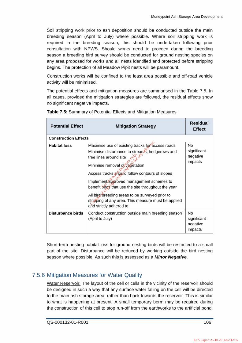
Moneypoint Ash Storage Area Development
QS-000132-01-R001 106
Soil stripping work prior to ash deposition should be conducted outside the main breeding season (April to July) where possible. Where soil stripping work is required in the breeding season, this should be undertaken following prior consultation with NPWS. Should works need to proceed during the breeding season a breeding bird survey should be conducted for ground nesting species on any area proposed for works and all nests identified and protected before stripping begins. The protection of all Meadow Pipit nests will be paramount.
Construction works will be confined to the least area possible and off-road vehicle activity will be minimised.
The potential effects and mitigation measures are summarised in the Table 7.5. In all cases, provided the mitigation strategies are followed, the residual effects show no significant negative impacts.
Table 7.5: Summary of Potential Effects and Mitigation Measures
Potential Effect Mitigation Strategy Residual
Effect
Construction Effects
Habitat loss Maximise use of existing tracks for access roads
Minimise disturbance to streams, hedgerows and tree lines around site
Minimise removal of vegetation
Access tracks should follow contours of slopes
Implement approved management schemes to benefit birds that use the site throughout the year
All bird breeding areas to be surveyed prior to stripping of any area. This measure must be applied and strictly adhered to.
No significant negative impacts
Disturbance birds Conduct construction outside main breeding season (April to July)
No significant negative impacts
Short-term nesting habitat loss for ground nesting birds will be restricted to a small part of the site. Disturbance will be reduced by working outside the bird nesting season where possible. As such this is assessed as a Minor Negative.
7.5.6 Mitigation Measures for Water Quality Water Reservoir: The layout of the cell or cells in the vicinity of the reservoir should be designed in such a way that any surface water falling on the cell will be directed to the main ash storage area, rather than back towards the reservoir. This is similar to what is happening at present. A small temporary berm may be required during the construction of this cell to stop run-off from the earthworks to the artificial pond.
For
insp
ectio
n pur
pose
s only
.
Conse
nt of
copy
right
owne
r req
uired
for a
ny ot
her u
se.
EPA Export 25-10-2016:02:12:35

Moneypoint Ash Storage Area Development
QS-000132-01-R001 107
With the implementation of this mitigation measures there will be no impact, and as such this is reduced to an Insignificant Impact.
Estuary:
“The ash landfill must be capped at the end of its useful life. The capping works should be carried out on a phased basis, and with minimum disturbance to adjoining landowners. Details of the proposed capping system must be submitted to the agency for approval before work commences…. (this issue) needs to be addressed as a priority by ESB Moneypoint”.
Good operation practices will help to reduce the volume of leachate passing through to the estuary.
Good operation practices include:
• Minimising the open/active area at all times • This will reduce the amount of leachate passing through to the treatment
system, as it will be used up in the grassland habitat growing on the surface, and increased evapotranspiration will also take place.
• Capping each layer • Layer each completed area with topsoil and arrange for that area to be
reseeded when final layer is laid. A capping of will topsoil and compost ameliorant in equal proportions will help a sward to establish quickly.
• Ensuring drainage during operations is adequate • This will ensure that rainwater passing through the landfill is gathered in the
leachate treatment system, settled and diluted prior to discharge • Final contouring topography to gather leachate in treatment system • This will ensure that rainwater passing through the landfill is gathered in the
leachate treatment system, settled and diluted prior to discharge
Many of these good operation practices are in place at present outlined in the ESB Energy International Moneypoint Generating Station IPPC licence Review form for the purposes of EC Environmental Objectives (Landfill Directive) Regulations 1999/31/EC document, and all other details laid out in this document should be adhered to. Furthermore, much of the ash has been recycled into the cement industry, and paving industries. This is excellent as it reduces the burden on the landfill.
A detailed assessment of the current collection and treatment methods of the increased leachate to ensure sufficient treatment to meet IPPC limits and water quality standards is required. The use of best practice construction methods onsite to ensure strict adherence to the conditions of the IPPC licence and adherence to the relevant water quality standards will ensure that there is no negative impact from the ash storage extension.
Correspondence with groups such as the Irish Whale and Dolphin group should also take place regarding ongoing population studies and other studies, as dolphins may live up to 50 years and bioaccumulation over this period of time should be taken into account. Ongoing correspondence such as this will ensure that all
For
insp
ectio
n pur
pose
s only
.
Conse
nt of
copy
right
owne
r req
uired
for a
ny ot
her u
se.
EPA Export 25-10-2016:02:12:35

Moneypoint Ash Storage Area Development
QS-000132-01-R001 108
impacts to the estuary continue to minimise the impact from the ash storage area. The additional impact has been assessed as Minor Negative.
Groundwater Quality: “The ash landfill must be capped at the end of its useful life. The capping works should be carried out on a phased basis, and with minimum disturbance to adjoining landowners. Details of the proposed capping system must be submitted to the agency for approval before work commences…. (this issue) needs to be addressed as a priority by ESB Moneypoint”.
The detailed mitigation measures outlined above will help to reduce contamination of groundwater. An effective leachate treatment system will also assist with this. The groundwater system is somewhat contained and groundwater direction is to on the estuary only and saline influence is present in the system. The ongoing health of the estuary, as seen from the various reports produced indicates that the ecosystem in the area is healthy. As such this is assessed at a Minor Negative.
7.5.7 Mitigation Measures for Operational Impacts As the project is the expansion of an existing ASA within the same operational footprint, it is not expected that any significant risks would arise during operation and development of the landfill. The primary impact from operation is temporary habitat loss and disturbance. No specific additional mitigation measures are advised. Mitigation measures are:
• Disturbance impacts during operation al phase will not be increased by continuing to work on a cell by cell basis.
• Working in a cell by cell basis will ensure that habitat loss will be short-term and will not impact on a large part of the site at any one time.
• Wetting of ash will continue to be carried out to ensure air pollution through dust is reduced.
• Active landfilling will occur during daylight hours only.
• Adherence to the specific mitigation measures outlined above. Many of these are a continuation of current best practice operational measures.
Overall the impact through disturbance and habitat loss will be short-term on a small part of the site. As such this is assessed as a Minor Impact.
7.5.8 Mitigation Measures for In-Combination Impacts • Increased disturbance will primarily impact nesting birds. This will be
mitigated against by working outside the bird-nesting season. This is assessed now as No Impact.
• No new cell will be opened until after the turbine is installed, and the landfilling operations are restricted to the current active landfill area. Associated site clearance works for the turbine will be temporary and short-
For
insp
ectio
n pur
pose
s only
.
Conse
nt of
copy
right
owne
r req
uired
for a
ny ot
her u
se.
EPA Export 25-10-2016:02:12:35

Moneypoint Ash Storage Area Development
QS-000132-01-R001 109
lived. Site clearance for the turbine will be a quick process and its effects will be short-term. This is now assessed as a Minor Impact.
• Potential for increased leachate run-off through watering of dusty substrate during construction of turbine in conjunction with landfill. This is assessed under the Water Quality Section.
7.5.9 Mitigation Measures for Cumulative Impacts Strict adherence to the requirements of the Moneypoint IPPC Licence P605-03 will ensure no adverse cumulative impact occurs.
7.5.10 Residual Impacts The residual impact may be defined as the potential impact remaining after mitigation measures have been adopted into a project. Generally, a proposed development adequately considers the ecological issues into its design, so that its impacts on the existing environment are minimised to an acceptable level of slight residual impacts. Occasionally, where significant impacts cannot be avoided or reduced, the consequences of significant residual impacts in light of planning policies and legislation should be considered (IEEM, 2006). Significant residual environmental effects may be offset by appropriate compensatory measures nearby/elsewhere (IEEM, 2006).
Table 7.6 presents those elements of the environment with the potential for severe, major or moderate impacts prior to any mitigation measures. A revised potential impact of the development on these features post-mitigation is provided here also, along with the significance of any potential residual impacts.
Best scientific professional judgment has been used in some cases, to assess the potential impacts post mitigation. The assessment indicates that the potential impact has dropped to insignificant to minor following proposed mitigation measures.
Table 7.6: Summary Table of residual impacts post mitigation measures
Environmental
Element
Potential Impact
Potential Impact
Significance Pre-Mitigation
Potential Impact
Significance Post-
Mitigation
Significance of Residual
Impact
Habitats Grasslands Major Negative Minor Negative Not significant
Water Quality
SAC/Estuary Water Quality
Moderate Negative
Minor Negative Not significant
Molougha Water Quality
Minor Negative Insignificant
Negative Not significant
Groundwater Quality
Moderate Negative
Minor Negative Not significant
For
insp
ectio
n pur
pose
s only
.
Conse
nt of
copy
right
owne
r req
uired
for a
ny ot
her u
se.
EPA Export 25-10-2016:02:12:35
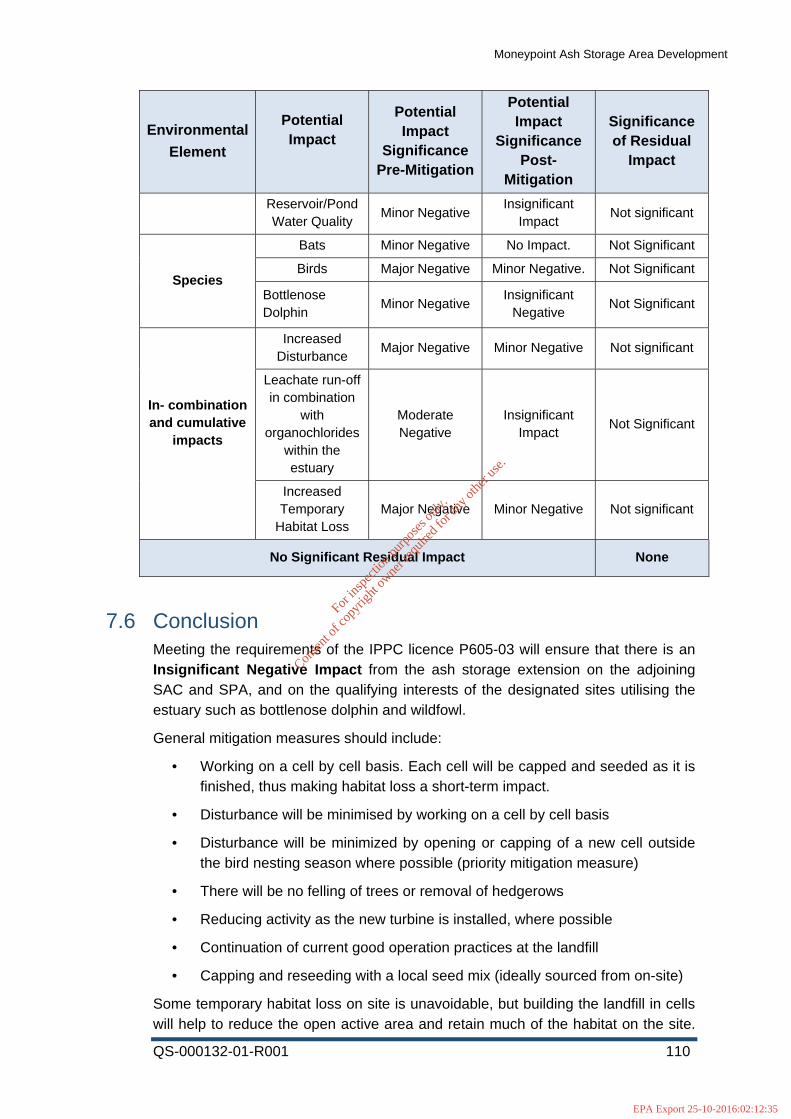
Moneypoint Ash Storage Area Development
QS-000132-01-R001 110
Environmental
Element
Potential Impact
Potential Impact
Significance Pre-Mitigation
Potential Impact
Significance Post-
Mitigation
Significance of Residual
Impact
Reservoir/Pond Water Quality
Minor Negative Insignificant
Impact Not significant
Species
Bats Minor Negative No Impact. Not Significant
Birds Major Negative Minor Negative. Not Significant
Bottlenose Dolphin
Minor Negative Insignificant
Negative Not Significant
In- combination and cumulative
impacts
Increased Disturbance
Major Negative Minor Negative Not significant
Leachate run-off in combination
with organochlorides
within the estuary
Moderate Negative
Insignificant Impact
Not Significant
Increased Temporary
Habitat Loss Major Negative Minor Negative Not significant
No Significant Residual Impact None
7.6 Conclusion Meeting the requirements of the IPPC licence P605-03 will ensure that there is an Insignificant Negative Impact from the ash storage extension on the adjoining SAC and SPA, and on the qualifying interests of the designated sites utilising the estuary such as bottlenose dolphin and wildfowl.
General mitigation measures should include:
• Working on a cell by cell basis. Each cell will be capped and seeded as it is finished, thus making habitat loss a short-term impact.
• Disturbance will be minimised by working on a cell by cell basis
• Disturbance will be minimized by opening or capping of a new cell outside the bird nesting season where possible (priority mitigation measure)
• There will be no felling of trees or removal of hedgerows
• Reducing activity as the new turbine is installed, where possible
• Continuation of current good operation practices at the landfill
• Capping and reseeding with a local seed mix (ideally sourced from on-site)
Some temporary habitat loss on site is unavoidable, but building the landfill in cells will help to reduce the open active area and retain much of the habitat on the site.
For
insp
ectio
n pur
pose
s only
.
Conse
nt of
copy
right
owne
r req
uired
for a
ny ot
her u
se.
EPA Export 25-10-2016:02:12:35

Moneypoint Ash Storage Area Development
QS-000132-01-R001 111
The dry grassland is locally important both botanically and as nectar source and is a good example of this habitat. Restored landfill sites may provide good examples of semi-natural and diverse habitats (Gilbert & Anderson 1998) comparable with SAC designated sites, especially in a predominantly agricultural landscape.
Continuation of the good operational practices will ensure that the grassland will be maintained, and the water quality of the estuary will not be impacted.
The numbers of waterfowl potentially impacted at Moneypoint are very small. The numbers of birds recorded in the surveys during 2010/2011 and 2013/2014 are relatively small in extent given the numbers of birds that the SPA supports as a whole. No birds use the Moneypoint site exclusively and there is no significant impact apparent for any species recorded during the surveys. However it is important to note that the grassland present is a rich and productive habitat for bird species and those species that do nest there must be protected during the deposition process and mitigation has been proposed to allow this.
As previously, it is concluded that the proposed development will not impact adversely on waterfowl numbers either in the immediate area of Moneypoint, or in the bays subject to SPA designation at Clonderalaw, Poulnasherry, Ballylongford and Tarbert. Provided the mitigation measures are adhered to, no significant negative impacts on the qualifying interests of the SPA or any local population of birds is anticipated as a result of the continuation of the ASA development.
REFERENCES
Berrow, S.D., McHugh, B., Glynn, D., McGovern, E., Parsons, K., Baird, R.W. and Hooker, S.K. (2002). Organochlorine concentrations in resident bottlenose dolphins (Tursiops truncatus) in the Shannon estuary, Ireland. Marine Pollution Bulletin 44, 1296-1313.
Berrow, S.D., O'Brien, J., Groth, L., Foley, A., & Voigt, K. (2012). Abundance Estimate of Bottlenose Dolphins (Tursiops truncatus) in the Lower River Shannon candidate Special Area of Conservation, Ireland. Aquatic Mammals 38.2
Bibby C.J., Burgess N.D., Hill D.A. & Mustoe S. (2000) (2nd Edition). Bird Census Techniques. Academic Press, UK.
Birds of the Western Palearctic (interactive). (2006). Birds of the Western Palearctic Interactive. DVD-Rom. BirdGuides Ltd. & Oxford University Press.
Birdwatch Ireland, www.birdwatchireland.ie accessed 13/09/2010.
Boland H., Crowe, O and Walsh, A. (2008). Irish Wetland Bird Survey: Results of waterbird monitoring in Ireland in 2006/2007, Irish Birds 8 341-350.
Bouquegneau J.M. and Joiris C. (1988). The fate of stable pollutants -heavy metals and organochlorines in marine organisms. In: Advances in comparative and environmental physiology. Springer -Verlag, Berlin-Heidelberg 2: 219-247
Cranmer, L., D. McCollin, and J. Ollerton. 2011. Landscape structure influences pollinator movements and directly affects plant reproductive success. Oikos
For
insp
ectio
n pur
pose
s only
.
Conse
nt of
copy
right
owne
r req
uired
for a
ny ot
her u
se.
EPA Export 25-10-2016:02:12:35

Moneypoint Ash Storage Area Development
QS-000132-01-R001 112
121:562–568.
Crowe, O. (2005). Irelands Wetlands and their Waterbirds: Status and Distribution. Birdwatch Ireland, Co.Wicklow.
Coombes, R. H., O. Crowe, A. Lauder, L. Lysaght, C. O’Brien, J. O’Halloran, O. O’Sullivan, T.D. Tierney and H. J. Wilson. (2009). Countryside Bird Survey Report 1998-2007. BirdWatch Ireland, Wicklow.
Cullen, C., Williams, H. (2010). Sparrowhawk Mortality at a Windfarm in Ireland. Irish Birds. Vol 9 Number 1.
Das, K., Debacker, V., Pillet, S., Bouqueneau J.M. (2003). Heavy metals in marine mammals. Toxicology of Marine Mammals. Taylor and Francis Publishers Washington D.C, pp. 135-167.
Englund A, Ingram S, Rogan E (2007). Population status report for bottlenose dolphins using the Lower River Shannon SAC, 2006 – 2007. Final report to the NPWS
Englund, A., Ingram, S., & Rogan, E. (2008). An updated population status report for the bottlenose dolphins using the lower River Shannon cSAC in 2008. (Final report to the National Parks and Wildlife Service, Ireland). 33 pp.
Fossitt, J.A. (2000). A Guide to The Habitats of Ireland. The Heritage Council, Kilkenny.
Gibbons D.W., Reid J.B. & Chapman R.A. (1993). The New Atlas of Breeding Birds in Britain and Ireland: 1988-1991. T. & A.D. Poyser Ltd., UK.
IEEM (2006). Guidelines for Ecological Impact Assessment in the United Kingdom (version 7 July 2006). Institute of Ecology and Environmental Management.
INISa (2013). EcIA for Proposed Enlargement of the Ash Storage Capacity at Moneypoint Power Station, Co. Clare.
INISb (2013). Proposed Five Turbine Wind Farm at Moneypoint Power Station, Co. Clare, Appropriate Assessment.
INISc (2013). Proposed Five Turbine Wind Farm at Moneypoint Power Station, Co. Clare, Ecological Assessment.
Ingram, S. N. (2000). The ecology and conservation of bottlenose dolphins in the Shannon Estuary, Ireland. Doctoral dissertation, University College Cork, Cork, Ireland.
Lynas P., Newton S.F. and Robinson J.A. (2007). The Status of Birds in Ireland: An Analysis of conservation Concern 2008-2013. Irish Birds, 8:149-167.
Mayes, E. (2001). Proposed Wind Farm at Moneypoint, Co. Clare. ESB International, Dublin
McCarthy S, Moriarty J, O’Riordan D, O’Leary G. 2010. Focus on Landfilling in Ireland. EPA. Johnstown Castle. Wexford.
McGarrigle M, Lucey J, Ó’Cinnéide M. 2010. Water Quality in Ireland 2007-2009. Chapter Five: Quality of Estuarine and Coastal Waters EPA. Johnstown Castle.
For
insp
ectio
n pur
pose
s only
.
Conse
nt of
copy
right
owne
r req
uired
for a
ny ot
her u
se.
EPA Export 25-10-2016:02:12:35
Moneypoint Ash Storage Area Development
QS-000132-01-R001 113
Wexford.
McGovern, E., Rowe, A., McHugh, B., Costello, J., Bloxham, M., Duffy, C., & Nixon, E. (2001). Trace metal and chlorinated hydrocarbon concentrations in shellfish from Irish waters, 1997-1999.
Murphy, J. N. (2001). Bird Movements in the Vicinity of Moneypoint Power Station, ESB International, Dublin.
NRA (2009). Guidelines for Assessment of Ecological Impacts of National Road Schemes (Revison 2). NRA, Dublin.
O’Brien, J. M., Berrow, S. D., Ryan, C., McGrath, D., O’Connor, I., Pesante, P., et al. (2009b). A note on long-distance matches of bottlenose dolphins (Tursiops truncatus) around the Irish coast using photo-identification. Journal of Cetacean Research Management, 11(1), 71-76.
Perrin PM & Daly OH. (2010). A provisional inventory of ancient and long-established woodland in Ireland. Irish Wildlife Manuals, No. 46. National Parks and Wildlife Service, Dept. of the Environmental, Heritage and Local Government. Dublin.
Perrin PM, Martin J, Barron S, O’Neill F, McNutt K, Delaney A. (2008). Survey of Native Woodlands.Volume 3d-Sites 1488-2020. National Parks and Wildlife Service, Dept. of the Environmental, Heritage
Pierce-Higgins, J.W., Leigh, S., Langston, R.H.W., Bainbridge, I.P., Bullman, R. (2009). The distribution of breeding birds around upland wind farms. Journal of Applied Ecology. 46, 1323-1331.
Scottish Natural Heritage. (2005) Survey Methods For Use In Assessment Of The Impacts Of Proposed Onshore Wind Farms On Bird Communities
Shannon International River Basin Management Plan (ShIRBM Plan, 2009-2015).
Smith, GF, O’Donoghue, P, O’Hora, K & Delaney, E (2011). Best Practice Guidance for Habitat Surveying and Mapping. The Heritage Council.
Tarrant, S., Ollerton, J., Rahman, M. L., Tarrant, J., & McCollin, D. (2012). Grassland Restoration on Landfill Sites in the East Midlands, United Kingdom: An Evaluation of Floral Resources and Pollinating Insects. Restoration Ecology
Watson, D., & Hack, V. (2000). Wildlife management and habitat creation on landfill sites: a manual of best practice. Ecoscope Applied Ecologists.
For
insp
ectio
n pur
pose
s only
.
Conse
nt of
copy
right
owne
r req
uired
for a
ny ot
her u
se.
EPA Export 25-10-2016:02:12:35

Moneypoint Ash Storage Area Development
QS-000132-01-R001 114
8 Landscape
8.1 Receiving Environment
8.1.1 Site Context The site of the proposed extension to Moneypoint Ash Storage Area Development is located close to the shore on the north side of the River Shannon Estuary approximately 5.5km southeast of Kilrush, County Clare. The ash storage area is located immediately to the north west of Moneypoint Generating Station adjacent to the N67 within a naturally occurring depression in the topography of the site.
Labasheeda lies 12km to the east of the application site, Kilmihil 14km to the northeast and Doonbeg 15km to the northwest. Within County Kerry, the town of Tarbert lies approximately 5km to the southeast at Tarbert Bay on the southern shore of the River Shannon Estuary and Ballylongford 7.5km to the southwest. The town of Glin lies approximately 10km southeast of the application site in County Limerick and the village of Loghill 15km lies to the southeast.
The N67 runs immediately to the south of the application site. The N68 runs approximately 5km to the northwest to the site and a network of regional roads, the R473, R483, R484, R485 and the R486 pass through the northern half of the study area. The Shannon Ferry between Killimer Ferry Terminal and Tarbert Island links the N67 north and south of the River Shannon Estuary. The route continues south of the estuary on Tarbert Island and joins the N69 at Tarbert town.
The N69 passes the site approximately 5km to the southeast at its closest. The R551 runs approximately 5km from the proposed site towards the southwest. The R524 starts at Glin approximately 10km from the ash storage site and continues south. The R552 starts at Ballylongford approximately 7km from the application site and continues south.
8.1.2 Landscape Character The landscape consists of the following four key characteristics - physical, social, experiential and visual. These can be defined in terms of topography, landform, land use, scale, exposure, visual quality.
8.1.2.1 Physical characteristics (Topography, Landform)
The northern half of the study area, including the ash storage site, is located in southern County Clare. The southern half of the study area is located within northern County Kerry and western County Limerick. The lower River Shannon Estuary forms a physical and visual division between the northern and southern part of the study area.
The general land form is generally low to the north and south of the estuary, but becomes distinctively undulating/rolling as one travels further from the water,
For
insp
ectio
n pur
pose
s only
.
Conse
nt of
copy
right
owne
r req
uired
for a
ny ot
her u
se.
EPA Export 25-10-2016:02:12:35

Moneypoint Ash Storage Area Development
QS-000132-01-R001 115
particularly in northern and north-eastern areas. In many areas, low cliffs define the boundary between the land and River Shannon Estuary. Knockanore Mountain in the southwest and the foothills of Sugar Hill to the southeast are the only significant high points within the study area. Loop Head lies to the west outside of the study area. The Lower River Shannon Estuary provides an open expanse of water within the study area and contains Scattery Island, Hog Island, Carrig Island and Tarbert Island.
Numerous small streams and rivers rise in higher ground and feed into the River Shannon, such as the Crompaun River and Cloon River in County Clare, the White River and Glencorbly River in County Limerick and the Ballyline River in County Kerry. The Doonbeg River passes through the northern part of the study area and flows to the Atlantic to the west and the River Galey in the southern part of the study area flows into the Cashen River, west of Listowel.
8.1.2.2 Social (Land use)
Agriculture is the dominant land use within the lower undulating parts of the study area, particularly pasture. Commercial coniferous forestry is restricted to mainly small patches and is sparse in the southern part of the study area but increases in the northern half on the higher ground. The River Shannon Estuary contains a number of nationally important industries such as the power generating stations at Moneypoint and Tarbert as well as large-scale shipping, logistic, manufacturing and associated economic and service activities.
The main settlements within the study area are the town of Kilrush and the smaller towns and villages of Tarbert, Doonbeg, Glin, Ballylongford, Loghill, Labasheeda, Kilmihil, Cooraclare and Creegh. The seaside town of Kilkee lies to the west outside of the study area. Small villages, individual houses and farm buildings are scattered along regional and local roads.
Scattery Island contains the remains of a monastery, several churches and a round tower. Carrigfoyle Castle is located between Carrig Island and the mainland, on the edge of the River Shannon Estuary.
8.1.2.3 Experiential (Scale and exposure)
The study area is characterised by three main forms of topography, the undulating lowlands to the north, east and west and south descending towards the River Shannon Estuary, the flat open River Shannon Estuary in the centre of the study area and the foothills of Sugar Hill and Knockanore Mountain in the southeast and southwest.
The nature of the landscape allows many open views from low hill summits, from the slopes of the foothills and across the estuary. Intermittent and prolonged open views may also be experienced when travelling along roads in the lower lying areas near the River Shannon Estuary. The landscape therefore has an open scale when viewed from hill summits in the lowlands and a wide open scale at the River Shannon Estuary, allowing for long distance panoramic views. Open views are also experienced along the ridges and slopes of the foothills of Sugar Hill and Knockanore Mountain.
For
insp
ectio
n pur
pose
s only
.
Conse
nt of
copy
right
owne
r req
uired
for a
ny ot
her u
se.
EPA Export 25-10-2016:02:12:35

Moneypoint Ash Storage Area Development
QS-000132-01-R001 116
8.1.2.4 Visual
The visual quality of the landscape within the vicinity of the site is largely determined by the River Shannon Estuary with is open visual character. The gently undulating landscape within the wider study area has been determined by human activity with field patterns, hedgerows, clusters of building, farmyards, patches of coniferous forestry, pockets of deciduous woodland and industrial zones along parts of the shores of the river.
Moneypoint and Tarbert Generating Stations, each with two tall chimneys, are significant landmarks within the study area. The stations are approximately 4.5km apart from each other, on either side of the River Shannon Estuary. There are a significant number of overhead transmission lines leading from Tarbert and Moneypoint Generating Station in all directions. Five wind turbines have been permitted at Moneypoint Station. The wide, flat opening of the River Shannon into the Atlantic Ocean is used for shipping and ferry services.
8.1.3 Planning Context (Refer to Designation Map Figure 8.1) Clare County Development Plan 2011-2017,Kerry County Development Plan 2009-2015 and Limerick County Development Plan 2010-2016 contain the statutory plans controlling development within the study area. The Plans have been consulted with regard to visual amenity policies, protected views and landscape designations.
Special Areas of Conservation (SACs), proposed Natural Heritage Areas (pNHAs), Natural Heritage Sites (NHAs), and Special Protection Areas (SPAs) produced by the NPWS for County Clare, Kerry and Limerick were taken into consideration in relation to designations at national level.
8.1.4 Landscape Character (see Figures 8.2 and 8.3)
8.1.4.1 County Clare – Landscape Character Assessment
The Landscape Character of County Clare is described within the Clare County Development Plan 2011-2017, which identified 26 Landscape Character Types and 21 Landscape Character Areas. It also identifies Living Landscapes Types and Seascape Character Areas. Regions covered by the study area are outlined below:
Landscape Character Types
Five Landscape Character Types have been identified within the study area and are described below:
FRH – Farmed Rolling Hills
This landscape character type is located in the centre of the study area and contains the site of the proposed Moneypoint Ash Storage Area.
Key Relevant Drivers
For
insp
ectio
n pur
pose
s only
.
Conse
nt of
copy
right
owne
r req
uired
for a
ny ot
her u
se.
EPA Export 25-10-2016:02:12:35

Moneypoint Ash Storage Area Development
QS-000132-01-R001 117
• Land consists of mosaic of forestry and grassland/pasture
• Very uneven landform
• Presence of bog and commercial coniferous forestry creates impression of an upland area in some places
• Hedgerow and enclosed pattern
• Settlement is concentrated along main roads otherwise scattered throughout the area
• Views from elevated hills to surrounding area and River Shannon Estuary
Forces for change
• Afforestation
• Agricultural intensification or abandonment
• Infrastructure can be highly visible across this landscape type
FLR – Farmed Lowland Ridges
This landscape character type is located in the eastern part of the study area.
Key Relevant Drivers
• Low linear ridges with shallow river valleys and rock outcrops
• Land cover is largely pasture, with pockets of deciduous woodland and scrub, and occasional small patches of commercial coniferous plantations
• Contains a variety of enclosures such as hedgerows, earthbanks and some stone walls
• Settlements consist of small villages with increasing modern buildings, traditional farm buildings and cottages
• Views are generally aligned along valleys
Forces for change
• Agricultural change
• Afforestation
• Degradation of stone walls and earthbanks
• Potential pressure from increased modern development in small villages
CDP – Coastal Plain and Dunes
This landscape character type is located in the north-eastern part of the study area.
Key Relevant Drivers
• Predominantly flat farmland near to coasts, with sand dune systems with a characteristic hummocky shape
• Land cover is largely pasture with limited tree cover in sheltered patches
For
insp
ectio
n pur
pose
s only
.
Conse
nt of
copy
right
owne
r req
uired
for a
ny ot
her u
se.
EPA Export 25-10-2016:02:12:35
Moneypoint Ash Storage Area Development
QS-000132-01-R001 118
• Angular field patterns are enclosed by ditches, banks, hedgerows and fences
• Settlement is limited, scattered and confined to higher ground or concentrated in coastal towns and small villages
• Open and exposed, extensive views are afforded seaward and landward
Forces for change
• Sea level rise
• Tourist and golf course development
• Grazing on dune systems
• Degradation of dune system which form part of natural coastal defence
FEF – Flat Estuarine Farmland and Islands
This landscape character type is located in the eastern part of the study area.
Key Relevant Drivers
• Distinctively flat farmland adjacent to estuaries, which are inundated by the tide
• Land cover is pasture combined with estuarine elements such as mudflats, salt marshes and little tree cover
• Angular field patterns are enclosed by ditches, banks, hedgerows and fences
• Settlement is limited, scattered and confined to higher ground
• Open and exposed, extensive views are afforded seaward and landward
Forces for change
• Sea level rise
• Agricultural change
• Offshore wind farms
• Estuary side development
• Strong vertical elements in flat landscape
• Insensitive housing development
• Tourism development on islands
• Coastal erosion
Landscape Character Areas (LCA)
LCA 18 – Shannon Estuary Farmland
This Character Area is located along the centre of the study area stretching east, northeast and includes the application site.
For
insp
ectio
n pur
pose
s only
.
Conse
nt of
copy
right
owne
r req
uired
for a
ny ot
her u
se.
EPA Export 25-10-2016:02:12:35

Moneypoint Ash Storage Area Development
QS-000132-01-R001 119
Key Relevant Characteristics
• Prominently ridged landscape, with linear hills aligned south-west to north-east.
• Secluded areas interspersed with more open views. Views are afforded across the River Shannon Estuary and across to Limerick from elevated areas and on the estuary shores.
• Coastal fringe is flatter and slopes down towards the sea.
• Diverse habitat and land cover.
• Scattery Island is an important historical and focal feature.
• Complex patterns of pasture, woodland and scrub habitats.
Landscape Condition and Sensitivity
• Moneypoint Generating Station has been identified as a singularly large scale detractor on the River Shannon accompanied by a number of pylons
• Integrated planning is needed for the estuarine areas as developments are highly visible.
LCA 19 – Kilrush Farmland
This Landscape Character Area is located in the north, northeast of the study area.
Key Relevant Characteristics
• Undulating to rolling hills, medium-high elevation. Some non-dominating drumlin-type landforms.
• Complex mix of moorland and farmland.
• Occasional flatter areas within hills, such as Creegh River Valley
• Scattered settlement across the area with Kilmihil, Creegh and Curraclare as the only villages.
LCA 21 – Loop Head
This Landscape Character Area is located to the west of the study area. The key characteristics outlined below take into account the area covered by the study area only.
Key Relevant Characteristics
• Flat peninsular farmland – very distinctive ladder fields, estuaries, salt marsh and mudflats, sand and boulder coves, shelving coastal rocks, vertical cliffs.
• Coast becomes increasingly dramatic towards Loop Head with high cliffs, arches, stacks and rocky inlets. More sheltered bays are typically on the southern side of the peninsula.
• The presence of the sea is always apparent and the character of the land reflects the mood of the weather and the storminess of the seas.
For
insp
ectio
n pur
pose
s only
.
Conse
nt of
copy
right
owne
r req
uired
for a
ny ot
her u
se.
EPA Export 25-10-2016:02:12:35

Moneypoint Ash Storage Area Development
QS-000132-01-R001 120
• The area is remote and feels remote and detached, with peaceful rural unspoilt qualities.
Living Landscape Types
County Clare Development Plan 2011-2017 proposes a series of ‘Living Landscapes’ which are outlined below:
Settled Landscapes
The application site is located within an extensive area described as Settled Landscape.
Development Plan Objective CDP 16.2 defines the objectives for Clare County Council relating to Settled Landscapes.
“Settled Landscape comprises the network of farmland, villages and towns that make up the majority of the County. These landscapes are where the majority of the population live and work. They provide opportunities for enterprise, leisure and personal fulfilment. … Settled Landscapes also contain areas of concentrated development – called ‘Working Landscapes’. …
Working Landscapes
The area to the immediate south of the application site has been classified as a Working Landscape and belongs to the ‘Shannon Estuary Working Landscape’ which has been defined as follows:
“This Landscape contains all shores and waters between Moyne Point and Ballynacragga Point excluding Clonderalaw Bay.”
“The Lower Shannon Estuary contains a nationally significant concentration of economic and natural resources. Extensive areas of sheltered deep water combined with one of the largest concentrations of high voltage transmission and generation capacity in the country as well as adjacency to a large-scale international airport provides the conditions for the development of large-scale shipping, transhipment, logistic, manufacturing and associated economic and service activities.”
Heritage Landscapes
Parts of the coastline to the east and west of the application site are described as Heritage Landscapes. Development Plan Objective CDP 16.5 defines the objectives for Clare County Council relating to Heritage Landscapes.
“Heritage Landscapes are those areas within the County where sensitive environmental resources – scenic, ecological and historic, are located. Heritage Landscapes are envisioned as the most valued parts of the County…”
Seascape Character Areas
The following Seascape Character Areas are partially located within the study area:
For
insp
ectio
n pur
pose
s only
.
Conse
nt of
copy
right
owne
r req
uired
for a
ny ot
her u
se.
EPA Export 25-10-2016:02:12:35

Moneypoint Ash Storage Area Development
QS-000132-01-R001 121
Seascape Character Area 10 – Lower River Shannon
This area is located between Kilcredaun Point and Lynchs Point (east of Moneypoint).
The following describes relevant matters identified in the Seascape Character Assessment:
Condition and Sensitivity
The condition of the seascape is moderate becoming poorer closer to the River Shannon SCA. Power stations and wind farms are dominant features degrading views across the water in County Kerry and Limerick. Changes would be evident due to low lying and exposed nature of the area. Small scale, well sited development may be accommodated. Large-scale development however should be avoided.
Forces for change
• Coastal development in prominent locations which would detract from the seascape value of the area e.g. power station, wind farms, marinas, etc. within view on the Kerry and Limerick coastline
Principles for Seascape Management
• Views to the coastline of Limerick and Kerry should be retained
• Promote agricultural and environmental schemes to avoid dereliction of coastal based landscapes
Seascape Character Area 11 – River Shannon
The River Shannon SCA extends from Limerick to east of Moneypoint. It is bounded by Kerry Head to the South and Kilrush farmlands to the North.
The following describes relevant matters identified in the Seascape Character Assessment:
Condition and Sensitivity
The estuary is in moderate to good condition. However, industrial and commercial activity dominates the view from land to sea. Low lying, flat and open views to sea increase the area's sensitivity to change particularly from shipping and industrial activities.
Forces for change
• Visible impacts of shipping and commercial activity
Principles for Seascape Management
• Linear development along the coastline should be avoided and all other development should be screened appropriately.
8.1.4.2 County Kerry – Landscape Character Assessment
The Landscape Character Assessment of County Kerry (November 2012), which has been prepared for the County Kerry Renewable Energy Strategy 2012, divides the County into Landscape Types and describes these in terms of factors including
For
insp
ectio
n pur
pose
s only
.
Conse
nt of
copy
right
owne
r req
uired
for a
ny ot
her u
se.
EPA Export 25-10-2016:02:12:35

Moneypoint Ash Storage Area Development
QS-000132-01-R001 122
scale, landform, landcover, human influence, perception and quality. The landscape types that fall within the study area for this application include:
1 Ballylongford Creek
This is described as hilly and flat farmland and coast with a gentle slope towards the estuary, enclosed fields with a high level of human influence including houses, roads, and clusters of archaeological monuments in areas.
2 Tarbert Pastures
This is described as hilly and flat farmland and coast which is undulating with areas of oak woodland around Tarbert. The level of human influence is high with houses, roads, Tarbert Power Station, and a number of archaeological monuments.
4 Inner River Plan
This is described as hilly and flat farmland with some transactional marginal land with a scale that varies from large open moorland to smaller patchwork fields. The human influence is high with houses, roads and archaeological monuments.
8.1.4.3 County Limerick – Landscape Character Assessment
Limerick County Development Plan 2010-2016 subdivides the County into different Landscape Character Areas but does not contain landscape sensitivity ratings. The following area is located within the study area:
Area 6: Shannon Integrated Coastal Management Zone – Objective EH O12
The Landscape Character Assessment states that views should be protected along the N69 and suggests that development between the road and the estuary be allowed in exceptional circumstances only.
Key Relevant Characteristics
• The lower foothills of Sugar Hill descending towards the River Shannon Estuary and entering the study area from southeast
• Land use is mainly agricultural
• Enclosed farm types and hedgerows dominant the landscape, which become less regular close to the estuary
8.1.4.4 Designated ecological sites within the study area
The Development Plans for County Clare, Kerry and Limerick indicate a number of designated ecological sites within the study area. However, the online map viewer of the National Parks and Wildlife Service (NPWS) contains the most up to date information on designated ecological sites and was therefore solely used to identify relevant areas within the study area as listed below. While these designations are primarily concerned with ecological issues, their potential amenity value warrants assessment in terms of landscape value.
Proposed Natural Heritage Areas (pNHAs)
• Site Code: 001911 – Scattery Island
• Site Code: 000065 – Poulnasherry Bay
For
insp
ectio
n pur
pose
s only
.
Conse
nt of
copy
right
owne
r req
uired
for a
ny ot
her u
se.
EPA Export 25-10-2016:02:12:35

Moneypoint Ash Storage Area Development
QS-000132-01-R001 123
• Site Code: 001025 – St. Senan’s Lough
• Site Code: 000027 – Clonderalaw Bay
• Site Code: 001332 – Ballylongford Bay
• Site Code: 001386 – Tarbert Bay
Special Protection Areas (SPAs)
• Site Code: 004077 – River Shannon and River Fergus Estuaries
Special Areas of Conservation (SACs)
• Site Code: 002165 – Lower River Shannon
8.1.4.5 Scenic Routes / Views and Prospects
County Clare (indicated by a C on Figure 8.1)
Clare County Development Plan 2011-2017 identifies the need to: “Protect and conserve views and prospects adjoining public roads throughout the County where these views are of high amenity value. In conserving views, it is not proposed that this should give rise to the prohibition of development along these routes but development, where permitted, should not seriously hinder or obstruct these views and should be designed and located to minimise their impact.”
A Scenic Route within the study area has been identified and is mapped on Figure 8.1.
19 - Coast road south east of Cappagh to Carrowdotia South
County Kerry (indicated by a K on Figure 8.1)
Three Views and Prospects as shown in the Kerry County Development Plan 2009-2015 are located within the study area and mapped in Figure 8.1. The description below has been applied for clarity as no names and numbers are indicated in the Development Plan:
K1 - From Carrig along Ballylongford Creek crossing the bridge to Carrig Island, looking east and northeast overlooking the estuary and to Carrigafoyle Castle
K2- Road from Killomeerhoe north to Larha, looking east
K3 - From the townland of Acres along the coast road to the townland of Leansaghane, overlooking the Lower Shannon Estuary to the northeast, north and west
County Limerick (indicated by a L on Figure 8.1)
County Limerick Development Plan 2010-2016 indicates a number of Views and Prospects. One View and Prospect lies within the study area and is mapped on Figure 8.1. The description below has been applied for clarity as no names and numbers are indicated in the Development Plan.
L1 - Shannon Estuary from Foynes to Glin, which is incorporated into the River Shannon Estuary Integrated coastal Management Zone
For
insp
ectio
n pur
pose
s only
.
Conse
nt of
copy
right
owne
r req
uired
for a
ny ot
her u
se.
EPA Export 25-10-2016:02:12:35

Moneypoint Ash Storage Area Development
QS-000132-01-R001 124
8.1.4.6 Walking, Cycling and Touring Routes
Clare and Limerick County Development Plans do not outline specific walking and cycling routes within the study area. Kerry County Development Plan outlines one walking route (The Shannon Way). However, the website www.irishtrails.ie describes a number of walking routes within Counties Clare and Kerry. The Wild Atlantic Way, a new national long distance touring route, is currently being implemented by Fáilte Ireland. All relevant walking and touring routes relevant to the study area have been listed and described below:
County Clare
Killimer Slí This Slí na Sláinte walking route has been developed by the Irish Heart Foundation. The approximately 5km looped route starts at the Colleen Bawn memorial north of the Ferry Terminal and follows local roads as well as the N67. Views across the Shannon Estuary as well as the Counties of Limerick and Kerry can be experienced from elevated areas of the walking route. Kilrush Slí This Slí na Sláinte walking route has been developed by the Irish Heart Foundation. The approximately 4.5km looped walking route starts at the Town Hall, Market Square of Kilrush and follows local roads through Kilrush and along sections of the R473 along the Shannon Estuary. Views include the Kilrush townscape including port facilities, the Shannon Estuary including Inishbig and Scattery Island. Kilrush Multi Access, Riverside Walk and Woodland Loop This looped walks cover Coillte forestry, which is a diverse area with broadleaf, conifer and mixed woodland located within the former Kilrush House demesne. The following three different looped walking routes have been designated within this forestry:
• MultiAccess: 1.2km
• Riverside Walk: 3km
• Woodland Loop: 3km
Wild Atlantic Way The Wild Atlantic Way is a long distance touring route, which is currently being implemented along the west coast of Ireland, stretching along the Atlantic coast from Donegal to West Cork. Sections of the route within the County Clare study area follow the N67 and R473 and include a Ferry transfer from Tarbert Island (County Kerry) to Killimer (County Clare) comprising views across the Shannon Estuary.
County Kerry
Wild Atlantic Way Sections of the route within the County Kerry study area follow the N67 and R551, include a Ferry transfer from Tarbert Island (County Kerry) to Killimer (County Clare) as well as local roads to Carrig Island/Carrig Castle, which comprise views across the Shannon Estuary.
For
insp
ectio
n pur
pose
s only
.
Conse
nt of
copy
right
owne
r req
uired
for a
ny ot
her u
se.
EPA Export 25-10-2016:02:12:35

Moneypoint Ash Storage Area Development
QS-000132-01-R001 125
John F Leslie Walk This 6.5km walking route through the woods on the Leslie Estate comprises views across Tarbert Bay and the Shannon Estuary. The Shannon Way This 21 mile trail goes between Ballybunnion and Tarbert and passes through varied and scenic countryside – from the uplands of Knockanore Mountain (267m) through flat bogs, old estates and woods. County Limerick
Wild Atlantic Way Sections of the route within the County Limerick study area follow the N69 comprising views across the Shannon Estuary.
8.1.4.7 Scenic Drives
The following scenic drive is described at http://www.ireland.com/en-gb/what-is-available/touring-holidays/self-drive-tours/all/1-90399
County Limerick, Kerry and Clare
The Shannon Estuary Drive
This is a scenic 207km drive along the Shannon Estuary. The route begins and ends in Limerick City. Within the study area it travels along the N69, N67, R486 and R473, including the Killimer to Tarbert Island ferry.
8.2 Characteristics of the proposal
8.2.1 The Proposal The proposed development for the Moneypoint Ash Storage Area (ASA) is described in Chapter 2 – Description of the Project. In terms of potential for landscape and visual effects, the size of the development will grow over time as the ash is laid down in layers and capped with soil or membrane within cells on the site. Each stage will consist of new and extended retaining embankments. It is proposed that all partially completed stages will be covered either with a minimal layer of topsoil or a synthetic cover to minimise airborne dust. In general the ASA will be capped with an impermeable construction comprised of for example FGD by product, drainage stone, subsoil and seeded topsoil to give a grassland and natural finish to the surface. The scheduling and phasing of the construction works is unknown at this stage as this will be controlled by outside factors such as energy demand and demand for fly ash in the construction industry.
For
insp
ectio
n pur
pose
s only
.
Conse
nt of
copy
right
owne
r req
uired
for a
ny ot
her u
se.
EPA Export 25-10-2016:02:12:36

Moneypoint Ash Storage Area Development
QS-000132-01-R001 126
8.3 Impacts of the Development The following potential landscape and visual effects arising from the proposed development have been identified. A detailed description of two photomontages is contained in Section 8.3.3 herein.
8.3.1 Potential Landscape Effects The guidelines and definitions of terms used in the following assessment of landscape and visual impacts are listed and described in Appendix 6.
The existing landscape has been heavily transformed by man-made activity. The relatively flat topography, the use of the land for pasture and existing ash storage, and the absence of any semi mature or mature tree vegetation contrasts with the strong vertical elements of the existing Moneypoint Generating Station, the five permitted wind turbines and associated overhead transmission line infrastructure. The proposed extension to the ash storage area will add to the intensification of industrial use of the landscape in this location, and the increase in height of the current ash storage site berms. The coastal location means that the receiving environment is sensitive; however this particular part of the coast has been transformed by existing industrial use, as recognised by the description in the Clare County Development Plan of this area as a “Working Landscape”.
The filling of the natural depression in the topography will be gradual, and while in process, the works will represent a continuation of existing land use. On completion of the mound, and restoration to grassland, the proposal will result in a new topographical element, a low mound in a currently flat landscape. This change in topography will be discernable but not significant when experienced from a lower level along the shoreline, but would be more significant when viewed from above. The overall potential for landscape impact, considering the potential for permanent alteration to the site topography, and also the current industrial characteristic is therefore considered moderate.
Ultimately, on completion of the mound, successful capping and grass planting and the construction of the wind turbines, the perception of the landscape in this location will have moved from one supporting “conventional” energy generation, to one supporting “clean” energy generation.
8.3.2 Potential Visual Effects The areas that would experience visibility of the ash storage area are indicated on Figure 8.1. These include:
• Open views from an approximate 2km stretch of the N67 immediately to the south of the application site,
• Open views from an approximate 1.5km stretch of local road to the north of the site,
For
insp
ectio
n pur
pose
s only
.
Conse
nt of
copy
right
owne
r req
uired
for a
ny ot
her u
se.
EPA Export 25-10-2016:02:12:36

Moneypoint Ash Storage Area Development
QS-000132-01-R001 127
• Intermittent views from approximately 2km of local roads to the north of the site.
The workings at the ash storage site and the ultimate final mound would be visible from these roads, as well as from houses along these roads.
In views from the N67, which forms part of the Wild Atlantic Way, the workings at the site will be visible, and the final mound will slightly alter the extent of the view across the landscape (see Photomontage 1). This view currently includes the two high voltage powerlines emerging from Moneypoint Station and will also include the permitted wind turbines. However, the nature of the surrounding topography means that the new grassed mound will appear as an almost naturally occurring topographical element in views from the N67.
The views from the higher land to the north are more likely to be adversely affected (see Photomontage 2). Some currently open views across the estuary will be partially obscured by the mound and permitted turbines. Currently open views from two houses across the existing Ash Storage Area to the Shannon Estuary will be obstructed.
Other views from this location will retain their openness but include the workings of the storage area as the mound is built, and ultimately the new topographical feature formed by the capped storage area.
While very distant views of the site are possible from the Kerry side of the estuary, as shown in Figure 8.1, it is unlikely that either the workings on the site or the final capped mound would have any discernible visual effect.
For
insp
ectio
n pur
pose
s only
.
Conse
nt of
copy
right
owne
r req
uired
for a
ny ot
her u
se.
EPA Export 25-10-2016:02:12:36

8.3.3 Assessment of Photomontages
For
insp
ectio
n pur
pose
s only
.
Conse
nt of
copy
right
owne
r req
uired
for a
ny ot
her u
se.
EPA Export 25-10-2016:02:12:36

Moneypoint Ash Storage Area Development
QS-000132-01-R001 129
Reason for viewpoint selection
This is an open view from the N67, part of the Wild Atlantic Way and a scenic route as described in the Clare County Development Plan
Description of view
The photomontage shows the final capped ash storage area following establishment of grass seeding. This type of view will be available along this road for approximately 2km, and this photomontage represents the most open view from along the road. The permitted but unbuilt wind farm at Moneypoint is also illustrated.
Visual Effects
The workings at the site will be partially visible (although partially screened by the existing berm), and the final mound will slightly alter the extent of the view across the landscape. This view currently includes the two high voltage powerlines emerging from Moneypoint Station and will also include the permitted wind turbines. The final restored mound will appear as a natural element in the landscape, and when compared to the current exposed ash storage, will have a positive effect on views from this road. However, over the period of the build-up of the mound, there will be moderate adverse effects on views, considering the existing industrial visual characteristics of this location.
Landscape Effects
In the short term, the proposed ash storage area workings will represent an intensification of the current industrial character of this site resulting in moderate adverse landscape effects. In the long term, the construction of the wind turbines and the restoration of the mound will present a cleaner version of the current power generation landscape character.
For
insp
ectio
n pur
pose
s only
.
Conse
nt of
copy
right
owne
r req
uired
for a
ny ot
her u
se.
EPA Export 25-10-2016:02:12:36

For
insp
ectio
n pur
pose
s only
.
Conse
nt of
copy
right
owne
r req
uired
for a
ny ot
her u
se.
EPA Export 25-10-2016:02:12:36

Moneypoint Ash Storage Area Development
QS-000132-01-R001 131
Reason for viewpoint selection
This photomontage represents the maximum impact on identified views from the north of the site. It shows a location where a currently open view over the estuary will be blocked by the proposed mound.
Description of view
This currently open view from a local road to the north of the site will experience significant change to the extent of panoramic view available. The ash storage area will be visible from a number of local roads as indicated on Figure 8.1. This obstruction of the view is localised as higher parts of the landscape will be able to see over the mound to the views beyond.
Visual Effects
The currently open view of the Shannon Estuary is obstructed by the final mound in this particular viewpoint. The construction of the mound will be openly visible from here and from other locations immediately to the north of the site. The resulting visual effect during the build-up of the mound will be negative and moderate-high, and localised. The visual effect on completion of the mound will be high and adverse in this particular location as a currently open view is obscured, other viewpoints in the locality will not be as adversely affected, but where visibility is possible, as shown in Figure 8.1, the effects will be moderate-high.
Landscape Effects
The landscape change in this particular location is high and adverse considering the addition of a new topographical element to the landscape. In the wider context, this new grassed mound would have less landscape effect, as it would be ultimately read as a part of the wider topography. Over the course of the construction of the mound, the landscape effects would be moderate, considering the existing industrial character of the wider landscape.
For
insp
ectio
n pur
pose
s only
.
Conse
nt of
copy
right
owne
r req
uired
for a
ny ot
her u
se.
EPA Export 25-10-2016:02:12:36

Moneypoint Ash Storage Area Development
QS-000132-01-R001 132
8.3.4 Potential Cumulative effects It was considered appropriate to include any nearby development in the visual analysis in order to assess potential cumulative visual impacts.
The following definitions are used to determine cumulative effects on visual impacts.
Definition of types of cumulative effects
In combination
Where two or more features are seen together at the same time from the same place, in the same (arc of) view where their visual effects are combined.
In Succession
Where two or more features are present in views from the same place (viewpoint) but cannot be seen at the same time, together because they are not in the same arc view – the observer has to turn to see new sectors of view whereupon the other features unfold in succession.
In sequence
Where two or more features are not present in views from the same place (viewpoint) and cannot, therefore, ever be seen at the same time, even if the observer moved round the arc of view, the observer has to move to another viewpoint to see the second or more of them, so they will then appear in sequence.
There will be cumulative impact in combination, in succession arising from the extension to the Ash Storage Area, the existing Moneypoint Generating Station and powerlines and the permitted wind farm. In the short term, the workings at the Ash Storage Area will be perceived as an intensification of the industrial character of the area. The short-term significance of these effects are therefore considered moderate adverse. However, in the longer term, the completion and restoration of the Ash Storage Area seen in combination with the wind turbines will contribute to a shift from a landscape character dominated by traditional power generation to one dominated by renewable and cleaner energy generation. The significance of effects will reduce to minor adverse.
8.3.5 Impact on Designated Areas
8.3.5.1 Impact on Landscape Character Areas / Landscape Character Types
The proposal will only have an effect in the Landscape Character Area and Landscape Character Type in which it is located. There will be no effects on other LCAs or LCTs as described above or indicated in Figures 8.2 and 8.3.
For
insp
ectio
n pur
pose
s only
.
Conse
nt of
copy
right
owne
r req
uired
for a
ny ot
her u
se.
EPA Export 25-10-2016:02:12:36
Moneypoint Ash Storage Area Development
QS-000132-01-R001 133
Landscape Character Area 18 – Shannon Estuary Farmland
• The completion of the Ash Storage Areas lifespan and the implementation of landscape restoration proposals will result in a new linear hill formation, which aligns with the general pattern of linear hills in this LCA.
• Some of the views afforded across the River Shannon Estuary and across to Limerick from elevated areas and on the estuary shores will be adversely affected as described above.
• The localised characteristic of a flat coastal fringe sloping down towards the sea will change with the introduction of a new mound in a currently flat area.
• The diverse habitat and land cover will change in this particular location unless planting other than grass can be established on the final capped mound.
• In the short term the detractor of Moneypoint Generating Station and its environs will intensity, however, in the long term the capping of the mound and the construction of wind turbines will result in a more positive aspect of the energy generation character in this location.
Landscape Character Type FRH – Farmed Rolling Hills
• The mosaic of forestry and grassland/pasture will be altered, locally to a more uniform grassed appearance, unless diverse planting can be established on the final capped mound
• The new mound will represent a man-made addition to the current uneven landform
• Some of the views afforded across the River Shannon Estuary and across to Limerick from elevated areas and on the estuary shores will be adversely affected as described above Forces for change
The extension to the ash storage area is proposed within an area described as the ‘Settled Landscape’ (Living Landscapes, County Clare Development Plan 2011-2017), within the Farmed Rolling Hills Landscape Character Type and Shannon Estuary Farmland Landscape Character Area. It is immediately adjacent to the “Working Landscape” as described in the Development Plan.
The proposal in the short term would intensify the industrial characteristic of a part of the landscape described as “settled landscape”, albeit heavily influenced by the adjacent “working landscape”. It, in the short term will effectively extend the “working landscape” northwards. However, in the long term, on successfully capping and restoration of the mound, the character of the “settled landscape” would be restored.
The proposal will be visible from parts of Seascape Character Area 10 – Lower River Shannon. There will be no significant effect in this landscape character area considering the existing industrial characteristic of this part of the coastline as viewed from the water. In the long term, on successful competition of landscape restoration, the impact would be positive.
For
insp
ectio
n pur
pose
s only
.
Conse
nt of
copy
right
owne
r req
uired
for a
ny ot
her u
se.
EPA Export 25-10-2016:02:12:36

Moneypoint Ash Storage Area Development
QS-000132-01-R001 134
8.3.5.2 Impact on ecological sites (NHAs)
While these sites are designated for ecological reasons, they are included in this assessment because of their potential for recreation and amenity value. Views of the proposed site would be possible from the water and a small part of Special Protection Area, River Shannon and River Fergus Estuaries. There would be no effect on any other of these sites.
8.3.5.3 Impact on Scenic Routes / Views and Prospects / Amenity Areas
The application site will be visible from approximately 2km of Co. Clare scenic route no. 19 - Coast road south east of Cappagh to Carrowdotia South. The most open view of the site is represented by Photomontage 1 and described in section 8.3.3 above.
While the location of the site is potentially visible from part of the Views and Prospects and Secondary Amenity Area in the vicinity of Carrig Castle in Co. Kerry, it is unlikely that there would be any significant visibility of the proposed ash storage area at this distance of approximately 6km. See photo below taken from the vicinity of Carrig Castle.
No other identified scenic routes would experience visibility of the proposal (the effects on sections of the Wild Atlantic Way are described below).
8.3.5.4 Impact on Walking, Cycling and Touring Routes
The N67 to the south of the site, as well as the Killimer Tarbert Ferry route forms part of the Wild Atlantic Way. There are discovery points at Scattery Island, the ferry route and Carrig Castle. The proposed workings will be visible from a part of the Wild Atlantic Way described as having “continuous scenic views.” These views at present include views of the existing ash storage area, Moneypoint Power
For
insp
ectio
n pur
pose
s only
.
Conse
nt of
copy
right
owne
r req
uired
for a
ny ot
her u
se.
EPA Export 25-10-2016:02:12:36
Moneypoint Ash Storage Area Development
QS-000132-01-R001 135
Station and the two 400kV powerlines leading north from the station. While the visibility of the ash storage area workings will increase in the short term, the long term landscape effect will be positive, as described above. The construction of wind turbines and the successful capping and planting of the mound will result in a cleaner image of power generation than that currently in existence along this part of the Wild Atlantic Way. It is unlikely that views from discovery points at Scattery Island, the Killimer Tarbert Ferry route or Carrig Castle will be adversely affected by the proposal due to the effects of distance, intervening topography and built structures (Moneypoint Power Station).
8.4 Mitigation The key mitigation measures during the operation of the Ash Storage Area include:
• Control of dust
• Capping and seeding of levels as they are completed
• Retention of boundary screening berms
• Minimising traffic movements
• Phasing to minimise adverse visual effects on identified sensitive viewpoints
8.4.1 Landscape Restoration The final contours of the ash storage mound will be natural in appearance and the capped mound will be planted on completion in order to replicate the nature of vegetation in the surrounding landscape. The restoration plan will reference the descriptions of landscape character as contained in the Co. Clare Landscape Character Assessment.
The details and the successful implementation of these mitigation measures are the key to the integration of the mound into the landscape in the long term.
8.5 Residual Effects
8.5.1 Residual Landscape Effects The residual landscape effect of this proposal will be the introduction of a new, large but naturally appearing grassed mound in a coastal location adjacent to power generating structures. The long term magnitude of landscape change in general is considered low-moderate. The overall landscape effect is considered to be minor adverse. However a number of locations in higher areas to the north will experience changes to their experience of the wider landscape with the obstruction
For
insp
ectio
n pur
pose
s only
.
Conse
nt of
copy
right
owne
r req
uired
for a
ny ot
her u
se.
EPA Export 25-10-2016:02:12:36
Moneypoint Ash Storage Area Development
QS-000132-01-R001 136
of views over the estuary by the new mound, with resulting high adverse landscape effects in localised areas.
8.5.2 Residual Visual Effects The extent of visibility of the site is indicated on Figure 8.1 and shows that views are limited to sections of the N67 and a number of local roads to the north. Visual effects will be highest during the operation phase when exposed ash and construction machinery will be visible. However, on successful implementation of mitigation measures, the introduction of a new large grassed mound into views will result in generally moderate visual effects. The highest visual effect will occur in localised areas to the north of the site where the new mound will result in obstruction of currently open views over the estuary. The general residual visual effects are therefore considered minor adverse for the wider area and moderate adverse for localised areas as identified in this chapter.
For
insp
ectio
n pur
pose
s only
.
Conse
nt of
copy
right
owne
r req
uired
for a
ny ot
her u
se.
EPA Export 25-10-2016:02:12:36

Moneypoint Ash Storage Area Development
QS-000132-01-R001 137
Figure 8-1: Landscape Designations, Photomontage locations visual impact
For
insp
ectio
n pur
pose
s only
.
Conse
nt of
copy
right
owne
r req
uired
for a
ny ot
her u
se.
EPA Export 25-10-2016:02:12:36

Moneypoint Ash Storage Area Development
QS-000132-01-R001 138
Figure 8-2: Landscape Character Areas
For
insp
ectio
n pur
pose
s only
.
Conse
nt of
copy
right
owne
r req
uired
for a
ny ot
her u
se.
EPA Export 25-10-2016:02:12:36
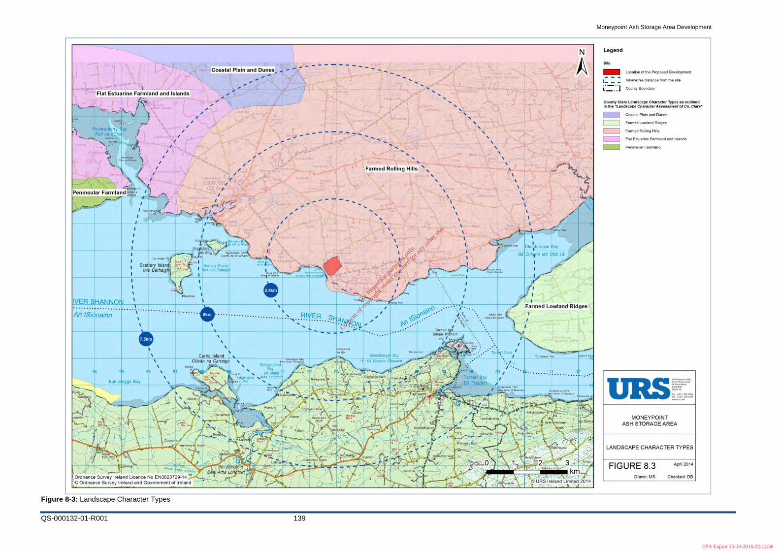
Moneypoint Ash Storage Area Development
QS-000132-01-R001 139
Figure 8-3: Landscape Character Types
For
insp
ectio
n pur
pose
s only
.
Conse
nt of
copy
right
owne
r req
uired
for a
ny ot
her u
se.
EPA Export 25-10-2016:02:12:36

Moneypoint Ash Storage Area Development
QS-000132-01-R001 140
9 Water
9.1 Approach and Methodology The assessment was undertaken with reference to the following.
Shannon International River Basin District River Basin Management Plan 2009 – 2015 (www.wfdireland.ie)
Shannon International River Basin District River Basin District South Clare/Shannon Estuary Water Management Unit Action Plan, (www.wfdireland.ie)
Shannon International River Basin District River Basin Transitional and Coastal Waters Action Programme (www.wfdireland.ie)
Shannon International River Basin District River Basin Groundwater Action Plan
EPA Report -Water Quality in Ireland 2007-2009 , Aquatic Environment
EPA ENVision environmental mapping system
(http://maps.epa.ie/InternetMapViewer/MapViewer.aspx)
Ash Storage Area Assessment, Moneypoint Generating Station, Kilrush, Co. Clare, 27 September 2011, Final, 46402511 URS
The project components have been assessed for potential impact on water quality and mitigation identified.
9.2 Receiving Environment
9.2.1 Surface Water
9.2.1.1 General
The River Shannon is Ireland’s major river. The main channel of the Shannon Estuary extends for approximately 105 km from the limit of the tidal rise at the Ardnacrusha power station to the mouth, which is bounded by Loop Head and Kerry Head. Measurements undertaken at Foynes have shown that sea water makes up some 88% of the water mix within the estuary at that point.
The Ash Storage Area (ASA) is located within the Shannon International River Basin District (SHIRBD) as defined under the European Communities (Water Policy) Regulations, 2003. This is the enabling legislation of the EC Water Framework Directive. The SHIRBD covers the natural drainage basin of the Shannon itself, stretching from its source to the tip of the Dingle peninsula. A full description of the river basin and its characteristics as well as the WFD objectives can be found on www.wfdireland.ie and on www.shirbd.com.
For
insp
ectio
n pur
pose
s only
.
Conse
nt of
copy
right
owne
r req
uired
for a
ny ot
her u
se.
EPA Export 25-10-2016:02:12:36

Moneypoint Ash Storage Area Development
QS-000132-01-R001 141
An objective of SHIRBD Management Plan to maintain water status for High and Good status waters and to restore all waters to at least Good status by 2015. The Shannon Estuary is a cSAC for the protection of a range of significant habitats and species listed for protection.
9.2.1.2 Site Drainage
Prior to development of Moneypoint Power Station ASA, the valley in which the ASA is located was drained by the Molougha River that discharged to the Shannon at Ballymacrinan Bay. Historical mapping shows part of the valley floor upon which the ASA is located to be liable to flooding associated with spring tides.
The development of the existing ASA required the construction of stone embankments to contain the ash. Land drains were constructed across the valley floor draining to the Molougha River that was culverted beneath the ASA. At the northeast end of the ASA a lagoon was constructed to capture and regulate the flow of the Molougha River before passing into the culvert, this lagoon is used to regularise water flows and as a source of water for dust suppression.
A toe drain was constructed around the ASA, this together with the culvert water discharges to a collection chamber. The collection chamber is an open concrete tank with sluice gates to prevent tidal ingress. The combined discharge of the collection chamber is via culvert beneath the public road (N67) to the Shannon Estuary at Ballymacrinan Bay. The discharge level is above the low tide line.
Rainfall falling on the existing ASA and other water used in the area, such as dust suppression water, slowly percolate through the consolidated ash layers to the underlying land drains. The deposited ash is compacted and it can form a cementitous layer on the surface, potentially resulting in very low infiltration rates.
Under the terms of its IPPC Licence, ESB Moneypoint monitored a number of aqueous discharges to the Shannon Estuary and this includes the discharge of the ash disposal area (SW1). Monitoring of the above emission points is carried out in accordance with Section B 2 and Schedule C.2.2 Emissions to Water of Moneypoint’s IPPC licence.
Surface water discharges from the Moneypoint Generation station site discharge to the Lower Shannon Estuary transitional water body (Water Code (IE_SH_060_0300). The status of this water body, is classed as Moderate, See Figure 1
The Molougha Stream is not located in any river water body as described by the EPA and as such no status has been assigned to this stream under the Water Framework Directive.
Surface water discharge metal testing results carried out on SW1 are provided in Table 9.1 in Appendix 7.
The increased storage capacity of the proposed ASA extension will be achieved by increasing the overall existing ash storage area height and will be homogeneous with the existing stored material. As the proposal does not constitute an increase in the footprint there will be no increase in surface water runoff, allowing the existing ASA drainage regime to continue to operate effectively. It is likely that the additional
For
insp
ectio
n pur
pose
s only
.
Conse
nt of
copy
right
owne
r req
uired
for a
ny ot
her u
se.
EPA Export 25-10-2016:02:12:36

Moneypoint Ash Storage Area Development
QS-000132-01-R001 142
material will provide a greater retention of rainwater - due to the longer flow path distance between the ASA surface and the underlying land drains - and reduce the discharge volumes.
It is, however, proposed to provide a settlement pond in conjunction with the proposed extension with the purpose of collecting surface water runoff for re-use in the operation of Moneypoint Power Station. Where practical, surface water generated in the ASA will be collected and routed through this pond. The location of the pond will be transitory and determined in conjunction with the filling of cells as the ASA extension progresses. A caisson pump sump will be the discharge point from the pond.
When the capacity of the extended ASA is reached it is proposed to cap it with an impermeable barrier layer. This will underlay a stone drainage layer, subsoil layer and topsoil layer. The existing surface water drainage regime will be significantly altered due to the provision of a barrier layer and drainage layer and the surface water runoff volumes will ultimately be increased. However, as discharge is to an estuary and outside of the zone of influence on fluvial river levels, there will be no adverse effects arising from the increased discharge volumes. Consequently there is no benefit or requirement to attenuate surface water discharge. Once rainwater filters through the topsoil and subsoil layer, the stone drainage layer will convey surface water to the extremities of the ASA where this water will again be collected in lagoons for re-use within the Moneypoint Power Station. Any overspill from these ponds/ lagoons will be redirected to the existing drainage network and in turn discharged to the Shannon Estuary.
9.2.2 Groundwater The Moneypoint ash storage area is situated in the Kilrush Groundwater body. Groundwater beneath the site is classified as being of Good status
The groundwater regime at the site is discussed in detail in the Soil and Geology Chapter of this EIS, chapter 12. Locally groundwater flow would be to the southwest following the gradients of the valley, but beneath the ASA flow is likely to be modified in shallow groundwater to respond to the land drain system and show some flow towards this infrastructure. As discussed in the soil and geology section groundwater would primarily be associated with bedrock, particularly weathered and fractured zones, and granular horizons in the glacial deposits, although the extent of groundwater in the granular glacial deposit is not considered to be significant.
Site investigation indicates the site is underlain by glacial deposits that typically have a moderate permeability and using the GSI methodology indicate a high to moderate vulnerability of groundwater to surface contamination, see table 12.1. Testing of PFA indicate that this material has a moderate to low permeability. When mixed with FGD by-product, as is proposed for external berms, this mixture would have a low permeability. The permeability of natural soils and deposited ash would indicate that infiltration of rain water is likely to limited.
For
insp
ectio
n pur
pose
s only
.
Conse
nt of
copy
right
owne
r req
uired
for a
ny ot
her u
se.
EPA Export 25-10-2016:02:12:36

Moneypoint Ash Storage Area Development
QS-000132-01-R001 143
No groundwater abstractions are recorded in close proximity to the ASA and no abstractions can be located down gradient of it. It is expected that similar to historic tidal flooding, estuarine water intrusion (known as a saline wedge) is likely to be present beneath the site, at least in the area in proximity to the shoreline.
Under the terms of its IPPC Licence, ESB Moneypoint monitors a number of boreholes around and within the existing ASA. Monitoring of the above emission points is carried out in accordance with Schedule C.4 of Moneypoint’s IPPC licence. This data is presented in 2 to Table 9.7 in Appendix 7.
9.3 Impacts of the Development
9.3.1 General The site is suitable for the development of a landfill with respect to the GSI and EPA groundwater protection zones for the siting of landfills, which is discussed in further detail in Chapter 12, the Soil and Geology chapter of this Environmental Statement.
The accepted methodology for assessment of potential impacts from potential contamination is in terms of the contaminant – pathway – receptor model; if one of the requisite components is missing there is no impact.
Contaminants may potentially arise from the leaching of metals from the deposited ash; contact with water would be required for the generation of leachate. As well as representing mechanism for leachate generation, surface and ground water are the only available pathways for movement of any contamination associated with the leachate at the site. The receptors for the contamination would be humans, controlled waters (surface and ground waters) and ecological receptors
Humans may be exposed to substances leached from ash through contact with contaminated surface or ground water, for metallic contamination exposure would require ingestion. As noted, no water abstractions are associated with the site or likely in the future, therefore no mechanism for exposure of humans to water borne contamination is present at the site and this receptor can be discounted.
The protection and improvement of water quality is a statutory requirement and obligation through the Water Framework Directive, amongst other legislation. Surface water retained within the site boundary is not considered to represent a receptor as it is not influencing wider water quality, however the Shannon Estuary does represent a surface water receptor and as such discharges to it need to be managed as to not disimprove or prevent improvement of its water quality.
Groundwater is a receptor, but at this site the groundwater that may be potentially influenced by the proposed development is constrained to the site footprint by geography. Groundwater cannot flow out of the valley except to the southwest where it could enter the Shannon Estuary. However, the shallow groundwater that is most likely to be influenced by site activities is most likely captured by the land drainage system beneath the site. No water abstractions are present or possible downstream of the site. It is not expected that groundwater from beneath the site could support or
For
insp
ectio
n pur
pose
s only
.
Conse
nt of
copy
right
owne
r req
uired
for a
ny ot
her u
se.
EPA Export 25-10-2016:02:12:36

Moneypoint Ash Storage Area Development
QS-000132-01-R001 144
contribute to any groundwater dependent ecosystems. Given the limited geographical extent of groundwater beneath the site and the impossibility of influencing groundwater quality more widely, it is unlikely that the site could significantly influence the quality classification of the groundwater body. Therefore, groundwater beneath the site is not considered to be a receptor but solely a pathway.
Ecology represents a potential receptor for any site contamination, with the protected Shannon Estuary representing the principal receptor for any ash leachate contaminants via surface or ground water pathways. However, given the relative size and associated flows of the water from the site and the water in the adjacent Shannon Estuary, comparison with standard water quality criteria would represent a conservative proxy for assessment of ecological impact.
As the proposed development represents a continuance of the current site activities, the actual impacts to water quality from past activities can allow a direct assessment of future impacts of the proposed development. In fact, use of past data would represent a conservative assessment, as current and future site operations are more environmentally robust than those in the past. A detailed assessment of ash storage impact to water quality was undertaken in 2011 by URS, and this report is used to support the discussion below and in included in Appendix 5.
9.3.2 Water Quality
9.3.2.1 Ash Leachate Quality
Coal combustion by-products have been subject to much study and research globally to understand their potential impacts and uses. These studies typically show metals including boron, cadmium, molybdenum and selenium are most likely to leach, i.e. be mobilised from solid material in to water, and metals including barium, nickel, lead and zinc are less leachable.
In accordance with the requirement of the IPPC Licence samples of Moneypoint PFA have been collected on an annual basis for analysis to assess the leaching of metals from the solid, the results of this testing is presented in Table 8 in Appendix 7.
The testing shows that the pH of the leachate is typically near neutral, which indicates that the PFA does not generate acidity that would enhance the solubility of most metals. The test results have been compared to EU water quality objectives; this indicates that most analytes are within acceptable concentrations. Only boron and cadmium show frequent exceedence of the groundwater and surface water objectives respectively in keeping with international research. The elevated levels of cadmium when detected exceed the surface water maximum admissible concentration by less than a factor of two and are within both the groundwater objective and drinking water regulation limits. It is noteworthy that the concentration of boron in leachate is comparable to that typically found in seawater.
Occasional elevated levels of aluminium, arsenic and chromium are reported, indicating that they may sometimes leach depending on specific PFA chemistry, but for arsenic and chromium the elevated concentrations reported were comparable to the water quality objectives.
For
insp
ectio
n pur
pose
s only
.
Conse
nt of
copy
right
owne
r req
uired
for a
ny ot
her u
se.
EPA Export 25-10-2016:02:12:36

Moneypoint Ash Storage Area Development
QS-000132-01-R001 145
Water quality objectives are not provided for molybdenum or selenium as these analytes are not typical of concern for waters. However, the data would suggest that these metals are elevated in leachate, particularly molybdenum, compared to levels that would normally be expected for surface water.
The leachate test data indicates that boron, cadmium, chromium, selenium and molybdenum may be generated at a sufficient concentration to have potential environmental impact.
9.3.2.2 Groundwater Quality
The groundwater data from the existing ASA directly demonstrates the impact that ash storage has had on water quality at Moneypoint, through real world contact times and flows. It is considered that the past groundwater quality at Moneypoint would be a conservative representation of any future impacts as the design and operation of the proposed development will lead to improvements compared to when the ASA began operation, such as reduced working face lengths, improved cover, etc.
The overall groundwater monitoring data set shows boron followed by aluminium to most frequently exceed the groundwater quality objectives, in approximately a third and quarter of samples respectively. Less frequent exceedences of the groundwater objectives are reported for arsenic, cadmium and lead. Other water quality criteria , surface water objectives and drinking water regulations, are exceed in some samples by pH, conductivity, chromium, iron, mercury, selenium and zinc, although none as frequently as boron exceeds the groundwater objective.
The groundwater monitoring regime around the existing ASA includes areas that are within and outside of the zone of influence of the existing ASA, this allows comparison to be made between different monitored areas, the monitoring locations are shown on Figure 9-1 and the results of monitoring are presented in Table 9.2 to Table 9.7 of Appendix 7
Given the groundwater flow regime at the site it would be expected that boreholes to the northeast (BH2 and BH6), northwest (BH1, BH31 and BH32) and southeast (BH27, BH27A and BH28) would be up the hydraulic gradient from the ash disposal area and therefore isolated from the influence of ash leaching. The southeast boreholes are located beyond the site and to the south of the N67. Monitoring of these boreholes often show failure of aluminium relative to the groundwater objective, and frequently have pH and iron levels that do not comply with the drinking water regulations. These boreholes also show occasional elevated levels of cadmium, lead, mercury and zinc. Given the location and spread of the boreholes it would be reasonable to consider that this is representative of the natural background concentrations.
Borehole BH26 is located to southeast of the ASA on the southern side of Ballymacrinan Bay, on land reclaimed from the Shannon as part of the construction of the Moneypoint Power Station. This borehole is not within the zone of potential influence from the ASA, but is representative of saline intrusion conditions in near shore boreholes. The monitoring data indicates frequent failures of the groundwater objectives for conductivity, boron and cadmium and less frequently for aluminium,
For
insp
ectio
n pur
pose
s only
.
Conse
nt of
copy
right
owne
r req
uired
for a
ny ot
her u
se.
EPA Export 25-10-2016:02:12:36

Moneypoint Ash Storage Area Development
QS-000132-01-R001 146
arsenic and lead. Iron and selenium are also noted to be elevated relative to the drinking water regulations in two samples. It is anticipated that the chemistry of the borehole reflects saline intrusion (given the conductivities recorded) and as such reflects background chemistry of seawater intrusion beneath land reclaimed with rock fill, although industrial influence cannot be dismissed.
Borehole BH3 and BH33 are located in the northeast of the ASA, but were constructed to allow groundwater ingress from strata including the deposited ash. Monitoring from these northeast ash boreholes indicates frequent failure of groundwater objective with regard to boron and less frequent for aluminium. A few failures for pH and selenium were reported against the drinking water regulation, as were some failures of cadmium, lead and mercury to surface water criteria. It is noteworthy that this location also has molybdenum concentrations several orders of magnitude above that reported in the boreholes outside of the influence of the ASA. This data would suggest that elevated boron and molybdenum are characteristic of waters where quality is influenced by ash leaching.
The boreholes at the down gradient southwest boundary of the ash disposal area would be expected to be subject to the greatest level of influence from ash leachate. The majority of these boreholes show frequent failure of groundwater objective for boron and infrequently for conductivity, aluminium, arsenic, cadmium and lead. Frequent failures of pH and selenium were found in the boreholes with respect to drinking water regulations and less frequent failures of cadmium, chromium, mercury and zinc.
Borehole BH30 shows frequent aluminium failures, but no elevated boron levels, or high molybdenum and/or selenium levels, which suggest that the groundwater at this location is not influenced by ash leaching. Borehole BH30 was the only borehole in this area to show elevated iron levels and had occasional elevated chromium concentrations.
The groundwater data indicates that elevated boron, molybdenum and selenium are characteristic of waters where quality is influenced by ash leaching at this site. It is also possible that occasions of elevated chromium can be attributed to ash leaching. Elevated levels of aluminium and iron appear to be representative of natural background conditions, and the occasional elevated levels of arsenic, lead and mercury cannot be clearly differentiate from background conditions.
9.3.2.3 Surface Water Quality
Monitoring of surface water is undertaken for the ASA as part of the power stations IPPC Licence. The ASA surface water discharge is monitored on a regular basis for pH, conductivity and suspended solids. The test results indicate a near neutral pH, typically around 6.8. Conductivity is highly variable, which is interpreted to reflect varying influence of seawater at the sampling point, although it is likely that values seen are higher than those typical for fresh water run-off. Levels of suspended solids are also variable ranging between 1 and 25 mg/l. The levels of these parameters do not suggest that water from the ASA would have a discernible impact on the quality of receiving saline estuarine waters.
For
insp
ectio
n pur
pose
s only
.
Conse
nt of
copy
right
owne
r req
uired
for a
ny ot
her u
se.
EPA Export 25-10-2016:02:12:36

Moneypoint Ash Storage Area Development
QS-000132-01-R001 147
More detailed metal analysis has been undertaken of the ASA surface water discharge as presented on Table 1 of Appendix 7 This data indicates that cadmium is elevated with respect to the surface water maximum admissible concentration and that chromium is elevated relative to the surface water annual average threshold. Boron and selenium levels are typically elevated relative to the drinking water regulations.
9.3.2.4 Water Quality Impacts
The assessment of leachate, groundwater and culvert surface water indicate that waters from the ASA have elevated levels of boron, cadmium, chromium, molybdenum and selenium associated with leaching of ash. Therefore these are the metals that are most likely to give rise to impact on the receptor and be of concern. The principal receptors for water quality are the water quality and ecological of the Shannon Estuary.
Detailed assessment of ecotoxicology of boron, chromium, molybdenum and selenium are presented, in the URS report in Appendix 5. It is not expected that boron would have a significant impact on water quality or ecological receptors in the Shannon, as seawater typically has a boron concentration of 4,450 ug/l which is generally greater than recorded in site water and leachates.
Molybdenum and selenium are not identified as high risk substances, and the concentrations as recorded although elevated, would not be expected to have a significant impact on estuarine or marine organism, as discussed in URS report.
Cadmium and chromium are recognised as substances that present risk to aquatic organisms and are included in the surface water objectives and regulations. The test data shows where elevated chromium is generally below its maximum admissible concentration in surface water and cadmium less than twice its maximum admissible concentration in surface water. Where such substances are at concentrations that are of concern, the risk assessment should consider if such a discharge would adversely affect the receiving water or organisms there in. It is estimated, as presented in URS report Appendix 5, that surface water discharge from the culvert is less than 0.01 m3/s, which is at least four orders of magnitude less than the receiving water, therefore the concentrations of cadmium and chromium will be reduced to background rapidly and impact would not arise.
As part of this assessment borehole monitoring data from sampling in the ash storage area, undertaken in compliance with the Moneypoint IPPC Licence, was examined. A worst case scenario whereby the maximum concentrations for each parameter arising in groundwater of importance to the ecological receptor bottlenose dolphins was used to predict the contribution to surface water metal concentrations. The maximum concentrations are the maximum recorded from any of the boreholes monitored and therefore represent a very conservative assessment of groundwater metal concentration in the ash storage area. In reality groundwater metal concentrations are found to be much lower. The groundwater to estuary dilution factor (in excess of 148 million) was calculated by URS in the ash storage area assessment report approved by the EPA. This dilution factor was used to determine the resultant metal concentrations in the receiving environment (Shannon Estuary)
For
insp
ectio
n pur
pose
s only
.
Conse
nt of
copy
right
owne
r req
uired
for a
ny ot
her u
se.
EPA Export 25-10-2016:02:12:36

Moneypoint Ash Storage Area Development
QS-000132-01-R001 148
from groundwater discharging from the ash storage area to the estuary.. These are shown in Table 5.
The predicted contribution to metal concentrations in the estuary from the ash storage area are orders of magnitude definitively below the environmental quality standards set out in the European Communities Environmental Objectives (Surface Water) Regulations, 2009, see Table 5. This clearly indicates that no potential significant impact on surface water quality could arise from this source.
For
insp
ectio
n pur
pose
s only
.
Conse
nt of
copy
right
owne
r req
uired
for a
ny ot
her u
se.
EPA Export 25-10-2016:02:12:36

Moneypoint Ash Storage Area Development
QS-000132-01-R001 149
Table 9.1: Predicted metal concentrations in Shannon Estuary from ash storage area groundwater discharge
Parameter Unit Maximum Borehole
concentration
recorded (across all
boreholes)
Dilution Factor ‐
groundwater from ASA
into estuary (URS
Report)
Estimated
concentration
contribution to
estuarine water (ug/l)
European
Communities
Environmental
Objectives
(Surface Water)
regulations, 2009
(SI 272)
AA ‐ EQS ug/l
European
Communities
Environmental
Objectives
(Surface Water)
regulations,
2009 (SI 272)
MAC ‐ EQS ug/l
Note
Aluminium ug/l 6,580.00 142,857,143 0.0000461 not applicable
Arsenic ug/l 130.00 142,857,143 0.0000009 20 not applicable Part B Specific Pollutant
Barium ug/l 1,750.00 142,857,143 0.0000122
Boron ug/l 12,540.00 142,857,143 0.0000878
Cadmium ug/l 12.00 142,857,143 0.0000001 0.2 not applicable Priority Substance
Chromium ug/l 22.35 142,857,143 0.0000002 0.6 not applicable Part B Specific Pollutant
Copper ug/l 6.90 142,857,143 0.0000000 5 not applicable Part B Specific Pollutant
Iron ug/l 159,000.00 142,857,143 0.0011130
Lead ug/l 167.00 142,857,143 0.0000012 7.2 not applicable Priority Substance
Mercury ug/l 0.14 142,857,143 0.0000000 0.05 0.07 Priority Substance
Molybdenum ug/l 5,000.00 142,857,143 0.0000350
Nickel ug/l 17.20 142,857,143 0.0000001 20 not applicable Priority Substance
Zinc ug/l 144.70 142,857,143 0.0000010 40 not applicable Part B Specific Pollutant
For
insp
ectio
n pur
pose
s only
.
Conse
nt of
copy
right
owne
r req
uired
for a
ny ot
her u
se.
EPA Export 25-10-2016:02:12:36

Moneypoint Ash Storage Area Development
QS-000132-01-R001 150
9.3.3 Suspended Solids/Silt Suspended solids have been regularly monitored during the operation of the existing ASA and indicates levels below 25 mg/l. Although storage of ash could potentially generate high concentrations of particulates in run off that could be damaging to receiving waters this has not occurred.
Current practice at the site is to allow precipitation and dust suppression water to percolate into the body of the ash, to eventually reach land drains and the culvert, due to the low permeability of the ash any particulates are removed in transit. The toe drains of the existing site bound mature vegetated embankments, and the little, if any, surface water run-off passing of the storage area passes down these embankments where vegetation traps suspended solids. Additionally all the water the site discharges passes through a collection chamber prior to discharge to the Shannon and this provides further control opportunity for silt should it be required.
9.4 Mitigation The expansion of the ASA will be constructed and operated in accordance with landfill and waste regulations as agreed with the EPA. As the project is the expansion of an existing ASA within the same operational footprint, it is not expected that any significant risks would arise during operation and development of the landfill, nor would additional risk arise with respect to water during closure.
During operation of the project, working faces and uncovered areas of ash would be minimised to reduce the area available for rain water infiltration and the need for dust suppression, although it must be noted that permeability of the ash is moderate to low and rejection of infiltration would be high in any case. Work areas will be constructed with internal drainage that will direct surface water to ponds to allow deposition of suspended solids before discharge to the existing collection tank. The toe drain around the site will be maintained with water directed to the existing collection tank.
The closure plan for the project includes the placement of a drainage layer across the final formation surface so that infiltrating water is captured and directed to the drainage system before infiltrating the ash. The final site contouring will ensure that no areas where water can collect and water run off capture by drainage layer and drains will be directed to the existing collection, or a new pond, prior to discharge to the Shannon.
9.5 Conclusions Groundwater beneath the site is not currently abstracted and is unlikely to be utilised in the future, groundwater beneath the site may be contaminated by ash leaching but any such contamination would be constrained within the site footprint due to site geography. The limited extent of potentially impacted groundwater is unlikely to impact on groundwater body status and therefore classification under the
For
insp
ectio
n pur
pose
s only
.
Conse
nt of
copy
right
owne
r req
uired
for a
ny ot
her u
se.
EPA Export 25-10-2016:02:12:36

Moneypoint Ash Storage Area Development
QS-000132-01-R001 151
Water Framework Directive. The contamination of groundwater beneath the site is not considered a significant impact, but groundwater may act as a contaminant pathway to the Shannon Estuary.
The Molougha river is culverted beneath the existing ASA, and land drains beneath the area discharge to this culvert. In the existing ASA rainwater infiltrates through the ash to the underlying collection system, any surface water run off is collected in a toe drain. Both culvert and toe drains discharge to a collection tank that in turn discharges to the Shannon Estuary.
Boron, cadmium, chromium, molybdenum and selenium contamination of water is found at the existing site associated with the leaching of ash. Waters contaminated with these metals are currently discharged to the Shannon Estuary. Assessment indicates that there is unlikely to be a significant impact on the Shannon Estuary from these metals due to their natures, relative concentrations and assimilative capacity of the Shannon Estuary.
Past operation of the ASA has not given rise to high levels of particulates in discharge from the ASA, and with improvements in operational practice such risk will reduce further.
No specific mitigation are considered to be required for the proposed development to manage risk to waters, but improving operational practice and drainage controls in the closure plan would minimise any residual risks.
For
insp
ectio
n pur
pose
s only
.
Conse
nt of
copy
right
owne
r req
uired
for a
ny ot
her u
se.
EPA Export 25-10-2016:02:12:36

N67
Ballymacrinan
Carrowdotia North
Salmon Weir
Carrigogore
Salmon Weir
CARROWDOTIA SOUTH
Church
Gravel Pit (Disused)
!A
!A
!A!A
!A
!A
!A
!A
!A
!A!A
!A!A
!A
!A !A
!A
!A
!A
!A
!A
!A
!A !A
!A!A
!A
!A
EDischarge Point
TP 5TP 4
TP 3
TP 2
TP 1
BH 7
BH 5
BH 1
BH 3
BH 2
BH 6
BH 26
BH 11
BH 12BH 25
BH 28
BH 27
BH 32
BH 31
BH 30
BH 29
BH 33
BH 4
BH 27A
DRAWN BY VERIFIED BY APPROVED BY REVISION APPROVED DATE
CLIENT REF. NO. OF SHEETS SHEET SIZE SCALE
MAP REFERENCE
Rev Revision Description Date
COPYRIGHT © ESBI ENGINEERING & FACILITY MANAGEMENT Ltd.All rights reserved. No part of this work may be modified or reproduced or copied in any form or by any means - graphics, electronic or mechanical, including photocopying, recording, taping or information-and-retrieval system, or used for any purpose than its designated purpose, without the written permission of ESBI Engineering & Facility Management Ltd.
ESB International,Stephen Court, 18-21 St. Stephen's Green,
Dublin 2, Ireland Tel: +353 (0) 1 703 8000 Fax: +353 (0) 1 703 8088
Email: [email protected] Web: www.esbi.ie
ESB International, is a trading name of ESBI Engineering and Facility Management Ltd.
Registered Office: as above, Registered in Ireland: No. 155249
Client Title
Production UnitProject
Ground Water & Surface WaterMonitoring Location
Civil Building & EnvironmentMoneypoint Ash Storage Area Development
CF
FIGURE 9 .1
PK PK 0
1 A3
18/06/2014
1:6,000
¯
LegendESB Boundary
Moneypoint ASA Extent of Works
Rivers/Streams
!A Trial Pit Locations
!A Borehole Locations
Culvert
ESB Power Generation & Wholesale Markets
Copyright Department of the Environment, Community and Local Government
Ordnance Survey Licence No. EN 0023709-14Copyright Ordnance Survey Ireland
Government of Ireland
For
insp
ectio
n pur
pose
s only
.
Conse
nt of
copy
right
owne
r req
uired
for a
ny ot
her u
se.
EPA Export 25-10-2016:02:12:36

Moneypoint Ash Storage Area Development
QS-000132-01-R001 153
10 Roads & Traffic
10.1 Receiving Environment The receiving environment reflects the presence of Moneypoint Generating Station since its first unit was commissioned in 1985.
Access to the Moneypoint area is via the N67 Killimer - Kilrush and the N68 Kilrush – Ennis National Secondary Routes. Immediate access to the site is from the N67, which is an important route that links Co. Clare and Co. Kerry via the Killimer - Tarbert car ferry service. Beyond the National Secondary Routes the locality has a network of roads that serves a rural community that is reliant mainly on agriculture. The roads are thus used by this community for domestic and agricultural purposes.
The most recent traffic data (for the years 2013 & 2014) from the National Roads Authority (NRA) in terms of Annual Average Daily Traffic (AADT) for the N67 and N68 is shown in Table 10.1. This is an annual average daily traffic volume for a 24-hour period calculated on the basis of NRA permanent traffic counts. It includes traffic in both directions and shows the amount of overall traffic that comprised Heavy Goods Vehicles (HGV).
Table 10.1: NRA Traffic Data
Year
N67 Killimer - Kilrush N68 Kilrush - Ennis
AADT HGV Total
Vehicles HGV
2014 1,112 55 (5%) 3,106 152 (4.9%) 2013 1,423 67 (4.7%) 3,674 161 (4.4%)
The data indicates that traffic on the roads in the vicinity of the site is very much less than their design capacity. Due to the cyclical nature of the Killimer - Tarbert car ferry service, traffic on the N67 close to the power station tends to peak coinciding with ferry times with AM peak flow at 7:45am and PM peak flow at 15:45pm .
10.1.1 Station Related Traffic The principal sources of traffic arising from the presence of the station are the following:
• Staff Transport: It is estimated that about 140 cars are associated with staff transport during weekdays and 40 at weekends
• Ash Transport: Exports of ash from the site are not uniformly distributed throughout the year and they peak in the summer months. Up to 20 truckloads leave the site each day during this time.
For
insp
ectio
n pur
pose
s only
.
Conse
nt of
copy
right
owne
r req
uired
for a
ny ot
her u
se.
EPA Export 25-10-2016:02:12:36

Moneypoint Ash Storage Area Development
QS-000132-01-R001 154
• Consumables: Station operations have a requirement for various consumables whose delivery accounts for approximately 20 truckloads daily.
• Other Activities: Contractors may be engaged from time to time and there is a steady pattern of business visitors. These are estimated to account for 55 vehicles per day of which 15 are deemed to be HGV’s. An increase in the number of casual visitors at weekends is compensated by a reduction in the number of business visitors.
The combined effect of the above during weekdays is shown in Table 11.2 where peaks in all categories of station related traffic have been assumed to coincide.
Table 10.2: Traffic Associated with Generating Station
Source Cars Trucks Vehicle-
Movements
Staff Movement 140 - 280 Ash Transport - 20 40 Consumables - 20 40 Other Activities 40 15 110 TOTAL 180 55 470
The combined effect is approximately 470 vehicle-movement per day during weekdays, with this increasing marginally during periods of major plant overhauls.
10.2 Impacts of the Development
10.2.1 Construction The majority of the vehicles associated with the development will be internal to the site boundary and will not be travelling on public roads, as this will involve the transport of ash from the generating station to the proposed ash storage areas over the internal road network. It is envisaged that the drainage material which will account for approximately 125,000m3 could be sourced from within the site, from the excavation of the existing embankments from on site pre-decommissioning and from the generation of suitable material from pre-decommissioning works, but for the purpose of traffic analysis it is assumed to be sourced externally. The import of drainage material will account for approximately 12,500 trucks and is assumed to be required for the last 7 years of the ash storage area operation. It is envisaged that this is when the final cap will commence for the ash storage area. The capping material which includes topsoil and subsoil will be provided from external sources to the Moneypoint site, therefore traffic will also be generated from this phase of works. This includes for 250,000m3, which will result in approximately 25,000 trucks, again assumed to be required for the last 7 years of the ash storage area operation. Therefore it can be assumed that there will be minimal traffic generated
For
insp
ectio
n pur
pose
s only
.
Conse
nt of
copy
right
owne
r req
uired
for a
ny ot
her u
se.
EPA Export 25-10-2016:02:12:36
Moneypoint Ash Storage Area Development
QS-000132-01-R001 155
from external sources for at least the first 5 years of the operation of this ash storage area.
The potential maximum additional HGV traffic resulting from the proposed development is calculated as being 25 trips per day over a minimum 7 year period.
These HGV movements have been determined on the basis of the upper range of anticipated requirements for capping materials for the ash storage area
The most recent NRA data from a permanent traffic counter located between the station entrance and Kilrush on the N67 indicates an AADT of 1,423 (2013) vehicles for N67. The addition of 25 trips per day (50 vehicle movements) associated with the extension he ash storage area is evidently insignificant with regard to the carrying capacity of the national secondary route. Similar data shows that the impact on the N68 between Kilrush and Ennis (AADT of 3.674) will be even lower.
The above discussion of traffic impacts describes a worst case scenario. It is expected instead, that deliveries of capping material will be made using the inbound ash transport vehicles that currently arrive at the station empty. The materials are similar in nature (particular the drainage material) and the type of transport utilised is common to all three materials. It should also be noted that the above scenario assumes no bi-directional use of the N67 from the station entrance, in that all traffic is assumed to be entering and leaving the site from one direction. It is reasonable to assume that a certain percentage (30%) of the materials required for the capping process will arrive from the eastern side of the site entrance.
Taking this into account, the predicted number of additional daily HGV trips on any one part of the N67 is 18 (36 vehicle movements).
In terms of road capacity, it is noted that according to RT 180 – Geometric Design Guidelines – Environmental Research Unit, the design capacity of a 5 m wide undivided rural road with Level of Service C is a minimum of 550 passenger car units (PCU) per hour in two directions. The N67 is currently operating at only a fraction of its design capacity. With the additional 25 HGVs being equivalent to 55 PCUs per day, the capacity of the N67 will not be compromised by the development, as the additional traffic is clearly insignificant.
The proposed development will not lead to additional long-term employment and there will be no increase in car traffic once construction is completed. Indeed, the slight increase in traffic resulting from the project will occur against a background of a reduction in staff numbers at Moneypoint and hence staff associated traffic as the station may be entering a decommissioning phase.
The equipment to be used on site during the construction phase, is as follows:
• 1 No. Excavator (Internal)
• 1 No. Bulldozer (Internal)
• 1 No. Roller (Internal)
For
insp
ectio
n pur
pose
s only
.
Conse
nt of
copy
right
owne
r req
uired
for a
ny ot
her u
se.
EPA Export 25-10-2016:02:12:36

Moneypoint Ash Storage Area Development
QS-000132-01-R001 156
• 1 No. water bowser for spraying (Internal)
• 4-6 Tipper Trucks for ash transport (Internal)
• 4-6 Tipper Trucks for capping material import (External)
10.2.1.1 Cumulative Impact
Planning approval has been granted for the construction of a Windfarm on the Moneypoint Site. It is envisaged that the construction of the Windfarm will be complete prior to any works commencing on the construction of the ash storage area cap. It is therefore predicted that there will be no cumulative impact on traffic arising from this proposal.
10.3 Mitigation As the supply of drainage and capping material will be co-incident with the completion of each ash storage area cell it is not seen as an activity which will require a constant flow of vehicles to the site. Therefore deliveries of drainage material and capping material will be phased in such a way so as not to coincide with station shift start and finish times, local school opening and closing times and with peak tourist traffic to and from the Killimer car ferry during the construction phase. They will be undertaken during off-peak periods in order to minimise impact on other road users. The use of existing ash transport vehicles for importation of capping material will also be utilised to minimise impact on other road users.
A pre construction and post construction road condition survey will be carried out on the N67 in conjunction with Clare Count Council to monitor and evaluate any damage that may be caused to the structure of the road pavement and to ensure a remediation process is agreed and in place prior to commencement of deliveries of capping materials.
No additional mitigation is required to the above.
10.4 Conclusions The proposed development will not result in significant environmental impacts.
For
insp
ectio
n pur
pose
s only
.
Conse
nt of
copy
right
owne
r req
uired
for a
ny ot
her u
se.
EPA Export 25-10-2016:02:12:36

Moneypoint Ash Storage Area Development
QS-000132-01-R001 157
11 Air Quality & Climate
11.1 Receiving Environment Air emissions emitted from Moneypoint power station are governed under the stations Integrated Pollution Prevention and Control Licence (IPPC). The IPPC Licence for Moneypoint Generating Station was originally granted on 30/10/2002. (P0605-01). It was subsequently reviewed and replaced by Licence P0605-02 (02/04/2004) which incorporated changes due to the Moneypoint Environmental Retrofit Project and further replaced by IPPC Licence P0605-03 which was granted on the 08/03/2013.
As Moneypoint power station is an IPPC licensed facility, emissions are reported via the national pollutant release and transfer register (PRTR), established by the Environmental Protection Agency (EPA).
Air emissions are also governed under the European Union (Industrial Emissions) Regulations 2013, S.I. 138 of 2013. The Industrial Emission Directive (IED) is a recast of seven existing Directives, those concerning integrated pollution prevention and control (2008/1/EC), large combustion plants (2001/80/EC), waste incineration (2000/76/EC, solvent emissions (1999/13/EC) and three directives concerning the titanium dioxide industry which Ireland does not have.
11.1.1 Atmospheric Emissions
11.1.1.1 Greenhouse Gases
Ireland is subject to several conventions and protocols that place limits on and force reductions in these emissions.
The baseline value in CO2 equivalent was established based on 1990 levels at 55.3 Mt and results in total allowable emissions of approximately 314.2 Mt over the commitment period, which equates to an average of 62.8 Mt per annum. Compliance with the Kyoto Protocol limit is achieved by ensuring that Ireland’s total emissions in the period 2008-2012, adjusted for any offsets from activities under Article 3.3 and the surrender of any purchased Kyoto Protocol credits, are below 314.2 Mt at the end of the five-year period.
Estimates of greenhouse gas emissions between the period 1990 to 2011 indicated a peak in 2001 (70,128 million tonnes carbon dioxide equivalent) when emissions reached a maximum following a period of unprecedented economic growth and began to reduce from 2008 on,. In 2012, total emissions of greenhouse gases in Ireland across the six key National Climate Change Strategy sectors (see Table 11.1) were estimated at 58.53 million tonnes carbon dioxide equivalent, which is approximately 5.8% higher than emissions in 1990.. This is 1.4% higher (0.78 Mt CO2eq) than emissions in 2011
For
insp
ectio
n pur
pose
s only
.
Conse
nt of
copy
right
owne
r req
uired
for a
ny ot
her u
se.
EPA Export 25-10-2016:02:12:36

Moneypoint Ash Storage Area Development
QS-000132-01-R001 158
Emissions from Energy (principally electricity generation) increased by 7.1% (0.85 Mt CO2eq) in 2012. This reflects increases in coal and peat used in conventional fossil fuel fired power stations for electricity generation, by 27% and 16% respectively, and a corresponding decrease in natural gas use of 12% in 2012. Electricity generated from wind decreased by 8.4% between 2011 and 2012.
Table 11.1: Greenhouse Gas Emissions in Ireland (in Mt of C02 equivalent)
Year Energy Residential Industry Agriculture Transport Waste Total
1990 11.4 7.5 9.6 20.5 5.1 1.3 55.3
2012 12.8 6.2 8.9 18.6 10.9 1.0 58.5
Note in 2012 Carbon sinks accounted for 3.5 Million tonnes of CO2 equivalent which is deducted from the overall total emission.
The summary findings of the EPA Report Irelands Greenhouse Gas Emissions 2012 indicate the following
• Emissions in the ETS sector increased by 6.9% or 1.08 Mt CO2eq whereas non-ETS emissions decreased by 0.7% or 0.30 Mt CO2eq.
• Emissions from Energy (principally electricity generation) increased by 7.1% (0.85 Mt CO2eq) in 2012. This reflects increases in coal and peat used in conventional fossil fuel fired power stations for electricity generation, by 27% and 16% respectively, and a corresponding decrease in natural gas use of 12% in 2012. Electricity generated from wind decreased by 8.4% between 2011 and 2012.
• Greenhouse gas emissions from the residential sector are 5.9% lower (0.39 Mt CO2eq) in 2012 compared with 2011 levels. This reflects higher than average temperatures in 2012 with consequently lower heat demand from households.
• Industry and Commercial emissions increased by 2.5% (0.22 Mt CO2eq) in 2012. This is due primarily to an increase of almost 18% in CO2 emissions from cement production.
Under the Kyoto Protocol, Ireland's total emissions are limited to an average of 62.8 Mt CO2eq per annum in the period 2008-2012. By 2012, Ireland was 5.68 Mt CO2eq below the Kyoto limit. However, when the impact of the EU Emissions Trading Scheme and forest sinks are taken into account, Ireland exceeded the Kyoto limit by 2.1 Mt CO2eq.
A decision on how this compliance gap will be closed will be made once the inventories have been subject to their final review. There are major concerns on the mechanisms and cost of adhering to the above limit. Countries not fulfilling their obligations will be forced to purchase carbon credits on an open market from compliant countries.
For
insp
ectio
n pur
pose
s only
.
Conse
nt of
copy
right
owne
r req
uired
for a
ny ot
her u
se.
EPA Export 25-10-2016:02:12:36

Moneypoint Ash Storage Area Development
QS-000132-01-R001 159
11.1.1.2 Other Emissions
Long-range atmospheric transport of sulphur dioxide (SO2) and nitrogen oxides (NOx) can contribute to regional problems of acidification and eutrophication of soils and waters and to air pollution over a wide area. SO2 and NOx emissions are transported over long distances and undergo chemical transformations in the atmosphere. The Government has entered into agreements at EU and international level to control national emissions of SO2 and NOx. These agreements specify obligations to reduce total emissions of these gases.
Under Article 4.1 of the National Emissions Ceiling Directive [2001/81/EC], Member States are required to limit their annual national emissions of SO2, NOX, VOC and NH3 to amounts not greater than the emissions ceilings laid down in Annex 1 of the Directive, by the year 2010 at the latest.
Ireland’s position in 2012 in relation with respect to the limits to the above is set out in Error! Reference source not found.3.
Table 11.2: Other Emissions
Pollutant Sulphur Dioxide Nitrogen Oxides VOC Ammonia
Limit 42 kt 65 kt 55 kt 116 kt
Emissions 23.2 kt 71.2 kt 43.4 kt 104.6 kt
SO2 emissions are estimated to have decreased by 87% since 1990 with power generation plant responsible for about 42% of the remaining SO2 emissions despite the fact that emissions in this sector have reduce by almost 91% in the same period. Trends in SO2 emissions are compliant with the 2010 ceiling. This reflects significant switching from the use of oil and solid fuels to natural gas, reduced sulphur content in coal and oil and implemented abatement in the power generation sector.
NOx emissions in Ireland have decreased by 44% between 1990 and 2012 Nonetheless, limits were exceeded in 2012. The EPA report indicates that these reductions were achieved due to improved abatement in Moneypoint power plant, reduced demand for clinker/cement and a reduction in fuel used in road
3 EPA, Ireland Transboundary Gas Emissions in 2011, February 2013
For
insp
ectio
n pur
pose
s only
.
Conse
nt of
copy
right
owne
r req
uired
for a
ny ot
her u
se.
EPA Export 25-10-2016:02:12:36

Moneypoint Ash Storage Area Development
QS-000132-01-R001 160
transportation. However, increasing use of coal at Moneypoint coal fired power station and an increase in cement production ha sled to increased emissions..
The transport sector, which mainly consists of road transport, is the principal source of NOx emissions, contributing approximately 51 per cent of the total in 2012. The industrial and power generation sectors are the other main source of NOx emissions, with contributions of
The agricultural sector accounts for virtually all ammonia emissions which showed a decrease of 2% as compared to 1990 levels..
The main sources of VOC emissions in Ireland are solvent use and transport accounting for 85 per cent of the annual total in 2011. Domestic coal burning in the residential sector is another important but declining source Reductions corresponding to 47 per cent have been achieved from 1990 to 2012 with improved emission control for VOCs in motor vehicles been largely been responsible for the decrease in overall emissions.
Moneypoint Generating Station’s Environmental Retrofit Project included the following main elements:
• Installation of Flue Gas Desulphurisation (FGD) equipment on each boiler to reduce emissions of SO2.
• Installation of Selective Catalytic Reduction (SCR) equipment to reduce NOx emissions.
The approximate annual emissions reductions that have been achieved at Moneypoint with the completion of the station’s Environmental Retrofit Project are shown in Table 11.3.
Table 11.3: Environmental Retrofit Project – Annual Emission Reductions
Sulphur Dioxide (SO2) Oxides of Nitrogen
(NOx) Particulates (t)
~ 20,000 t ~ 20,000 t ~ 300 t
11.1.2 Air Quality Air emissions from the Moneypoint Generating Stations are controlled under the conditions of the station’s IPPC Licence P605-03. In particular Emissions to air are controlled under the requirements of the following sections
Condition 1, Section 1.5 The installation shall be controlled, operated and maintained, and emissions shall take place as et out in the licence. All programmes required to be carried out under the terms of this licence become part of this licence.
For
insp
ectio
n pur
pose
s only
.
Conse
nt of
copy
right
owne
r req
uired
for a
ny ot
her u
se.
EPA Export 25-10-2016:02:12:36

Moneypoint Ash Storage Area Development
QS-000132-01-R001 161
Condition 4.6 Dust and Particulate Matter: Dust and particulate matters from the activity shall not give rise to deposition levels which exceed the limit values.
Condition 5.1: No specified emission from the installation shall exceed the emission limit values set out in Schedule B: Emission Limits subject to Conditions 4 and 5.4 of this licence. There shall be no other emissions of environmental significance.
Condition 5.2 No emissions, including odours and dust, from the activities carried on at the site shall result in an impairment of, or an interference with amenities or the environment beyond the installation boundary or any other legitimate uses of the environment beyond the installation boundary
Condition 6.19: Within six months of the date of grant of this licence, the licensee shall install at least eight dust monitors around the operational landfills. The location of dust monitoring points shall be agreed by the Agency. The location of dust monitors around Landfill Area B shall be agreed prior to operation commencing in that landfill.
Schedule B1 Emissions to Air: The total permitted emissions of oxides of sulphur (as SO2), oxides of Nitrogen (as NO2) and dust for each of the three generating units operating at Moneypoint shall not exceed the tonnages set out in Table 11.4.
Table 11.4: Annual Emission Limits in tonnages
Parameter Unit 1 Unit 2 Unit 3 Total
Oxides of sulphur (SO2)
3,022 2,974 3,128 9,124
Oxides of Nitrogen (NO2)
3,763 3,709 3,895 11,367
Dust 378 372 391 1,141
Dust deposition not to exceed 350 mg/m2/day based on a composite sample over a 30 day period
11.2 Impacts of the Development
11.2.1 Atmospheric Emissions Air quality in the environs of Moneypoint has been the focus of ongoing monitoring and assessment since the late-1970s. This has always indicated that air quality in the area is good and well within quality standards required by legislation. Operating
For
insp
ectio
n pur
pose
s only
.
Conse
nt of
copy
right
owne
r req
uired
for a
ny ot
her u
se.
EPA Export 25-10-2016:02:12:36

Moneypoint Ash Storage Area Development
QS-000132-01-R001 162
in compliance with its IPPC Licence, Moneypoint’s emissions to atmosphere are discharged via two 225m high chimneys whose design was based on achieving adequate dispersion of emissions.
Modelling and monitoring data indicate that the station’s emissions do not have any significant impact on ambient air quality in relation to SO2 and NOx, which complies with national air quality standards by a large margin.
11.2.1.1 Mass emission of Carbon Dioxide Carbon dioxide emission at Moneypoint Generating station is linked to the level of coal combustion and electricity generation which takes place in any given year. In 2013 Moneypoint Generating Station emitted 3.88M tonnes of CO2 to the atmosphere, (source Annual Environmental Report 2013).
11.2.1.2 Mass emissions of SO2, NOx and dust The Moneypoint Generating Station’s Mass Emissions as reported in the AER 2013 are shown in Table 11.5.
Table 11.5: Mass emissions 2013 (tonnes per annum)
Sulphur Oxides (SOx)
Nitrous Oxides (NOx) Dust
Unit 1 1,684 2,007 77
Unit 2 4,282 1,762 134
Unit 3 1,212 1,131 17
Total 7,178 4,900 228
The station’s mass emissions were within the total emission limits as set out in the IPPC licence and also within the national emissions reduction plan (NERP) limits as set out in 2008 NERP national agreement. Ireland has opted to develop a (NERP) under Article 4 (6) of the Large Combustion Plants directive (2001/80/EC) to address emissions from ‘existing plant’ as defined in the directive. The NERP provides flexibility for plant operators to identify the most cost effective abatement options available, across a portfolio of plant, while still achieving the environmental objective of directive 2001/80/EC
11.2.1.1 Dust monitoring results
There are also eight sites situated within the station grounds at Moneypoint to assess the localised impact of dust emissions arising from coal and ash handling operations. Airborne particulate sampling using ISO deposit gauges has been carried out on a monthly basis since 1989. For the most recent annual environmental report period Table 11.6 presents average dust deposition rates based on results derived from dust monitors located in strategic points around the station.
For
insp
ectio
n pur
pose
s only
.
Conse
nt of
copy
right
owne
r req
uired
for a
ny ot
her u
se.
EPA Export 25-10-2016:02:12:36

Moneypoint Ash Storage Area Development
QS-000132-01-R001 163
Table 11.6: Dust Deposition 2013 (mg/m²/day)
Site Undissolved Solids
Based on 12 Month'sAvg mg/m2/day
Ash Farm 1 47.80 12
Ash Farm 2 62.93 12
Ash Farm 3 60.77 12
Gate A 38.23 12
Coal-yard1 64.76 12
Coal-yard 2 66.32 12
Coal-yard 3 72.72 12
Coal-yard 4 75.19 12
There were no non compliances with respect to dust at Moneypoint Generating station as reported in the Annual Emission Report 2013.
11.3 Mitigation The station will continue to operate within its IPPC licence .conditions and particularly its emission limit values.
No further mitigation is required.
11.4 Conclusions The proposed development will not result in significant adverse environmental impacts.
For
insp
ectio
n pur
pose
s only
.
Conse
nt of
copy
right
owne
r req
uired
for a
ny ot
her u
se.
EPA Export 25-10-2016:02:12:36

Moneypoint Ash Storage Area Development
QS-000132-01-R001 164
12 Soils & Geology This assessment was undertaken with reference to the “Guidelines for the Preparation of Soils, Geology and Hydrogeology Chapters of Environmental Impact Statements” (2013), issued by the Institute of Geologists of Ireland.
The data used in compiling this Section has primarily been completed using the data made available to the public by the Department of Communications, Energy and Natural Resources and the Geological Survey of Ireland (GSI), via http://www.gsi.ie/Mapping. The chapter also references available site investigation for the site carried out on behalf of ESB Moneypoint dating from 1993 and 2003.
12.1 Receiving Environment
12.1.1 Soils The existing ash storage area has been constructed by infilling part of a natural valley, that lies on a northeast-southwest lineament with containing embankments. The landfill is located in the seaward, Shannon-side, end of the valley. It is not thought that significant disturbance of natural soils in the valley took place before the placement of ash began in 1985, although a stream was culverted beneath the landfill.
The GSI data indicates that the natural soil at the site comprises marine clays. Made Ground, glacial tills, although this is indicated to be thin or absent in places with rock at or near the surface. Groundwater vulnerability mapping suggests soil thickness ranging between less than 1 to 5 m, as outlined on Table 12.1. Site investigation data, described in more detail in section 12.1.5, indicates that soil is predominately cohesive glacial till of greater than 3m thickness, with less frequent granular horizons and occasional peat deposits. GSI soil mapping for the area is shown on Figure 12-1.
Table 12.1: GSI Groundwater Vulnerability Rating Criteria
Vulnerability Rating
Subsoil Permeability and Thickness Unsaturated
Zone Karst
Features High Permeability
Moderate Permeability
Low Permeability
Extreme 0 - 3 m 0 - 3 m 0 - 3 m 0 - 3 m -
High >3 m 3 - 10 m 3 - 5 m >3 m N/A
Moderate N/A >10 m 5 - 10 m N/A N/A
Low N/A N/A >10 m N/A N/A
For
insp
ectio
n pur
pose
s only
.
Conse
nt of
copy
right
owne
r req
uired
for a
ny ot
her u
se.
EPA Export 25-10-2016:02:12:36

Moneypoint Ash Storage Area Development
QS-000132-01-R001 165
Note: Permeabilities have not been defined. Release point of contaminant is assumed to be 1 - 2 m below ground surface
12.1.2 Bedrock The Geological Survey of Ireland (GSI) Sheet No. 17, Geology of the Shannon Estuary, indicates the site to be underlain by Carboniferous Namurian Central Clare Group, which consists of cyclothermic sandstones, siltstones, mudstones and occasional coal seams.
Site investigations found bedrock beneath the site to comprise a highly fractured sandstone or siltstone and very thinly laminated sandstone.
GSI bedrock mapping is shown on Figure 12-2.
12.1.3 Groundwater The site forms a minor part of the Shannon catchment. The site lies adjacent to the Shannon Estuary at its south-western side and is formed in a valley; therefore groundwater flow would be expected to be to the southwest.
The existing soils of the proposed development are Made Ground comprising coal combustion by-product (pulverised fly ash, PFA), that has a moderate to low permeability and is in turn underlain by predominantly cohesive glacial till that is expected to have a moderate permeability. The presence of granular horizons within the glacial till may allow the development of perched water tables of limited extent. Granular horizons in glacial tills are unlikely to represent significant groundwater resources, but provide pathways for the movement of contaminants to surface waters or deeper bedrock groundwater bodies.
Groundwater flow within the bedrock is likely to be facilitated primarily through joints, fissures, fractures and other discontinuities, particularly in siltstones and mudstones. The fracture flow (or secondary flow) of the bedrock would contrast with the pore flow (or primary flow), which would facilitate flow in granular strata. However, some primary flow may take place within the sandstones of the Central Clare Group, dependant on the degree of cementation of the sandstones.
The sandstones that form part of the Central Clare Group will be of a competent nature, whereas the mudstones and siltstones are likely to be incompetent. Competent rocks accommodate stress by brittle failure and incompetent rocks accommodate stress in a plastic manner. Fracturing of competent rocks may be associated with faulting and folding and the presence of such fracture can lead to increased groundwater flow and well yields.
The GSI groundwater resource mapping, Figure 12-3 indicate that the bedrock groundwater resource is classified as local important productive in local zones beneath (Ll), the GSI groundwater resource matrix is presented as Table 12.2. This is a low groundwater classification and would indicate that sufficient groundwater to support domestic or large abstractions may be available only in specific locations or areas. The absence of available groundwater is supported by
For
insp
ectio
n pur
pose
s only
.
Conse
nt of
copy
right
owne
r req
uired
for a
ny ot
her u
se.
EPA Export 25-10-2016:02:12:36

Moneypoint Ash Storage Area Development
QS-000132-01-R001 166
the low number of wells shown on the GSI database in the generally area, the nearest recorded well more than 1 km from the site. It should be noted that the GSI mapping does show a number of wells at the site, but these are not abstraction wells but some of the monitoring boreholes referred to in section 12.1.5.
Table 12.2: Matrix of Groundwater Protection Zones
Vulnerability Rating
Source Protection Resource Protection (Importance)
Regional Local Poor Aquifers
Site Inner Outer Rk Rf/Rg Lm/Lg Ll Pl Pu
Extreme (E) SS/E SI/E SO/E Rk/E Rf/E Lm/E Ll/E Pl/E Pu/E
High (H) SS/H SI/H SO/H Rk/H Rf/H Lm/H Ll/H Pl/H Pu/H
Moderate (M) SS/M SI/M SO/M Rk/M Rf/M Lm/M Ll/M Pl/M Pu/M
Low (L) SS/L SI/L SO/L Rk/L Rf/L Lm/L Ll/L Pl/L Pu/L
Rk = Major Aquifer, Regionally important limestone karst aquifer
Rg = Major Aquifer, Regionally important fractured bedrock or sand/gravel aquifer
Lm/Lg = Minor Aquifer, Locally important, moderately productive
Ll = Minor Aquifer, Locally important, productive only in local zones
Pl = Poor Aquifer, productive only in local zones
Pu = Poor Aquifer, unproductive
The GSI groundwater vulnerability mapping for the site is shown in Figure 12-4 using the matrix presented in Table 12.1. The site is shown to be predominantly extreme vulnerability, but with areas of Xtreme vulnerability and High vulnerability. However, based on available site data it is likely that bedrock groundwater vulnerability is high to moderate. The groundwater resource protection classification for the project footprint is Ll/X to H, but based on site data would likely be Ll/H-M. This indicative of indicates that bedrock groundwater of limited resource potential may be present that would be highly vulnerable to contamination.
12.1.4 Geoheritage and Resources GSI mapping shows no geoheritage features at or adjacent to the site. No recorded mineral localities are present and the type of bedrock and absence of significant granular deposits would suggest that no significant exploitable geo-resources are present at the site.
For
insp
ectio
n pur
pose
s only
.
Conse
nt of
copy
right
owne
r req
uired
for a
ny ot
her u
se.
EPA Export 25-10-2016:02:12:36

Moneypoint Ash Storage Area Development
QS-000132-01-R001 167
12.1.5 Site Investigations This section presents the findings of the fieldwork and geotechnical testing of soils obtained by in 1993 and 2003 and with respect to the ash storage. Site Investigation locations are shown on Figure 12-5.
Eleven borehole locations (1 to 6 and 29 to 33) were drilled to a maximum depth of 10.1 m. Three trail pits (TP1 to TP3) were excavated in this area to a maximum depth of 3.84 m. The soils in this area were found to consist of three principal types: Made Ground (including ash and topsoil); peat; and glacial deposits.
Made ground was encountered at borehole locations 1 to 6, 31 and 32 and in Trial Pits TP1 to TP3. At Borehole Locations 1, 5, 6, 31 and 32 the Made Ground consisted solely of topsoil, to a maximum thickness of 0.5 m. Made Ground consisting of ash was encountered at Borehole Locations 3 and 4 and in all three trial pits with a maximum proven thickness of 3.9 m at Borehole Location 3. At Borehole Locations 2 and 29, Made Ground of silty gravelly clay was reported at thicknesses of 0.9 and 4.3 m, respectively.
A PSD analysis was undertaken on an ash sample from Borehole Location 3 at 3 m depth; the approximated permeability was 3.24 x 10⁻⁶ m/s, i.e. moderately permeable. The Institute for Industrial Research and Standards had been commissioned by ESB to establish the physical properties of PFA from Moneypoint. The results of the testing indicated that the PFA had a permeability of 1.265 x 10⁻⁷ m/s. Similarly, the former UK Central Electricity Generating Board publication ‘PFA Utilisation’ indicates that PFA permeabilities are in the range 8 x 10⁻⁷ to 5 x 10⁻⁹ m/s. The sources referred to would suggest that the permeability approximated from the PSD analysis is an underestimate and that the actual permeability would be moderate to low, equal or below 10-7 m/s.
A variable head test was successfully completed in the Made Ground of Borehole Location 29, from which a moderate permeability of 3.59 x 10⁻⁵ m/s was calculated.
Peat was encountered in Boreholes 6 and BH29 at 0.9 m and 2.1 m thickness respectively.
Glacial deposits were encountered in all cable percussive boreholes and in Trial Pit TP1 and ranged in proven thickness from 3.1 m at Borehole Location 3 to 7.3 m at Borehole Location 1, with an average thickness of 4.45 m based on the proven thickness of Borehole Locations 1 to 6. The glacial deposits may be split into two types, those where granular materials dominate soil behaviour (i.e. sand and gravel) and those where fine particles dominate soil behaviour (i.e. silt and clay).
Granular Glacial Deposits were encountered in one trial pit (TP1) and four Borehole Locations (1, 2, 3 and 29) and typically consisted of silty or clayey gravel. The granular Glacial Deposits were either found as thin horizons within the Glacial Deposits of 0.4 m thickness or less, or as thicker horizon at the base of the overburden overlying the bedrock, with a maximum reported thickness of 1.64 m at Borehole Location 1.
For
insp
ectio
n pur
pose
s only
.
Conse
nt of
copy
right
owne
r req
uired
for a
ny ot
her u
se.
EPA Export 25-10-2016:02:12:36

Moneypoint Ash Storage Area Development
QS-000132-01-R001 168
PSD analyses were carried out on two soil samples as part of the 1993 investigation. The approximated permeabilities were calculated as 4 m/s and 2.5 x 10⁻⁷ m/s, i.e. high permeability and moderate permeability. The approximations indicate that the permeability of granular deposits may be highly variable and is controlled, at least in the approximation, by the amount of fines present. Subsequently, three granular soil samples had PSD analyses as part of the 2003 investigation, these gave approximated permeabilities of 10-3 m/s in one sample and 10-6 m/s in two samples, i.e. generally moderate permeability.
Cohesive Glacial Deposits typically comprised gravelly clay with cobbles and were found to range in total thickness from 1.35 m at Borehole Location 1 to 4.9 m at Borehole Location 4. Sixteen PSD analyses were undertaken on cohesive Glacial Deposit samples as part of the 1993 investigation and the approximated permeabilities ranged from 1.6 x 10⁻³ to 6.25 x 10⁻⁸ m/s, but were typically in the order of 10-6 to 10-7 m/s, i.e. moderate permeability. Only four cohesive soil samples from this area were submitted for PSD analyses as part of the 2003 investigation, these soils gave approximated permeabilities of 10-5 to 10-7 m/s, i.e. moderate permeability.
Variable head tests were also carried out at Borehole Locations 1 and 2 found the soil to have a permeability of 10-5 m/s. The permeability represents the soil profile as a whole, with the predominant boulder clay permeability being increased due to the presence of granular strata.
Bedrock was only penetrated in Borehole Locations 2 to 5, where rotary coring of bedrock was undertaken, to a maximum penetrated thickness of 3.6 m in Borehole 5. The bedrock was encountered at between 4.6 m below ground level in Borehole Location 2 and 7.2 m below ground level in Borehole Location 3. An extremely fractured layer of sandstone or siltstone was encountered as the upper 0.5 m of bedrock at Borehole Locations 2 and 5. The bedrock typically consisted of very thinly laminated sandstone with very closely to medium spaced discontinuities, described as joints, which were sometimes open and occasionally clay lined or infilled.
Packer tests undertaken in the bedrock at Borehole Locations 4 and 5 indicated permeabilities of 10-7 m/s, i.e. moderate. However, the permeability is for the whole of the response zone of the test and it is possible that permeability due to preferential fracture flow is masked by the lower permeability of the rock groundmass.
Groundwater was encountered during the investigations in Trial Pit TP3 and in Borehole Locations 2, 3, 5, 6, 29 and 30. The groundwater seepages / strikes reported at Borehole Locations 2 to 5 were all with in 1.2 m of the rock head and associated with clay dominant strata. Groundwater was reported in Trial Pit TP2 and Borehole Locations 29 and 30 associated with ash, Made Ground and overburden respectively.
Groundwater levels were obtained from all boreholes and reduced relative to the ground level of each borehole. The plotted levels allow the groundwater level
For
insp
ectio
n pur
pose
s only
.
Conse
nt of
copy
right
owne
r req
uired
for a
ny ot
her u
se.
EPA Export 25-10-2016:02:12:36

Moneypoint Ash Storage Area Development
QS-000132-01-R001 169
contours to be interpreted. The groundwater beneath the ash storage area flows generally to the southwest. However, within this area groundwater flow is more complex with groundwater in the southeast flowing to the northwest and in the northwest flowing to the southeast. The flow contours suggest a trough in the groundwater level. This may relate to the culverted stream beneath the ash storage area, but may also be due to the original topography buried beneath the ash.
The groundwater flow contours would indicate that any water percolating to the groundwater beneath any part of the site would flow towards the Shannon Estuary. Therefore, the groundwater beneath the site would not be expected to contribute to groundwater abstractions outside of the site boundary.
12.1.6 Geotechnical Evaluation As the proposed development involves the construction of a number of external and internal berms, a slope stability analysis was carried out to assess the stability of the structure, (see Appendix 8). The slope stability analysis was carried out to determine the stability of the external berms of the ash storage facility as it reaches its capacity.
The results of each slope stability analysis yielded an overdesign factor greater than the minimum acceptable value of 1.0.
The risk of instability to both the coastal and inland embankments with an outer face gradient of 3H:1V during the construction or operation of the Moneypoint Ash Storage Area redevelopment is minimal. Conservative assumptions were made during the analyses when modelling the slopes.
12.2 Impacts of the Development The proposal is for a mono-landfill of coal combustion by-products, primarily PFA but also FGD by-product. No wastes, other than combustion by-products, will be deposited at the site. The FGD by-product and PFA are classified as non-hazardous and the characteristics of their resulting mixture are well established. It expected that the deposited material will have a moderate permeability, and a low permeability for blended PFA/FGD by-product elements.
The site has and continues to be used for the authorised disposal of PFA. It is not expected that increasing the capacity of the landfill will have any direct impact on soil or geology.
The specific assessment of risk to groundwater from leaching is dealt with in the water chapter of this EIS, chapter 9. However, the GSI and EPA have produced a table based on groundwater protection zones for the siting of landfills, presented below as table 12.3.
For
insp
ectio
n pur
pose
s only
.
Conse
nt of
copy
right
owne
r req
uired
for a
ny ot
her u
se.
EPA Export 25-10-2016:02:12:36

Moneypoint Ash Storage Area Development
QS-000132-01-R001 170
Table 12.3: Matrix of Groundwater Protection Responses For Landfills
Vulnerability Rating
Source Protection
Resource Protection
Regionally Important
Locally Important
Poor Aquifers
Inner Outer Rk Rf/Rg Lm/Lg Ll Pl Pu
Extreme (E) R4 R4 R4 R4 R32 R22 R22 R21
High (H) R4 R4 R4 R4 R31 R21 R21 R1
Moderate (M) R4 R4 R4 R31 R22 R21 R21 R1
Low (L) R4 R31 R31 R31 R1 R1 R1 R1
This indicates that the site falls either in to category R21 or R22, the responses for these landfills are as follows
R21 Acceptable subject to guidance in the EPA Landfill Design Manual or conditions of a waste licence.
Special attention should be given to checking for the presence of high permeability zones. If such zones are present then the landfill should only be allowed if it can be proven that the risk of leachate movement to these zones is insignificant. Special attention must be given to existing wells down-gradient of the site and to the projected future development of the aquifer.
R22 Acceptable subject to guidance outlined in the EPA Landfill Design Manual or conditions of a waste licence.
Special attention should be given to checking for the presence of high permeability zones. If such zones are present then the landfill should only be allowed if it can be proven that the risk of leachate movement to these zones is insignificant. Special attention must be given to existing wells down-gradient of the site and to the projected future development of the aquifer.
Groundwater control measures such as cut-off walls or interceptor drains may be necessary to control high water table or the head of leachate may be required to be maintained at a level lower than the water table depending on site conditions
It should be noted that existing information for the site does not indicate the presence of high permeability zones, down gradient wells or a high water table.
As part of the site development embankments will need to be raised to accommodate the increased volume of coal combustion by-products. The embankments require appropriate design, construction quality assurance and monitoring to ensure that there stability during construction, operation and post –closure. Were the embankments to fail this could release substantial volume of
For
insp
ectio
n pur
pose
s only
.
Conse
nt of
copy
right
owne
r req
uired
for a
ny ot
her u
se.
EPA Export 25-10-2016:02:12:36

Moneypoint Ash Storage Area Development
QS-000132-01-R001 171
coal by-product into the Shannon Estuary that might have significant local impacts on this protected water body.
Site investigation and an assessment of the risk of instability to both the coastal and inland embankments identified that there was minimum risk of instability base don the embankment slope designs proposed. There will therefore be no potential impact arising from the project.
12.3 Mitigation The landfill shall be constructed and operated in accordance with landfill and waste regulations as agreed with the EPA as per the amended environmental permit.
Slopes on the outer face of all embankments should not be steeper than 3H:1V.
Construction should cease temporarily if any minor slips in the gradient are evident. Site works should not resume until the site has been inspected by an experienced geotechnical engineer and they approve that construction may proceed.
12.4 Conclusions The site is located upon and existing coal by-product disposal facility, which is underlain by glacial till and sedimentary bedrock. The bedrock does not contain a significant groundwater resource and this is not indicated to be abstracted in the vicinity of the site. There is no geological heritage or resources identified at or adjacent to the site. The EPA/GSI matrix for groundwater protection responses indicate that the site is acceptable for this development.
The proposed development does not pose plausible risks to soil or geology and will be designed operated and closed in accordance with landfill and waste regulations in agreement with the EPA. The principal risk associated with soil and geology is failure of enclosing embankment, this risk has been assessed and is considered to be minimal for the proposed design and no impact will occur.
For
insp
ectio
n pur
pose
s only
.
Conse
nt of
copy
right
owne
r req
uired
for a
ny ot
her u
se.
EPA Export 25-10-2016:02:12:37
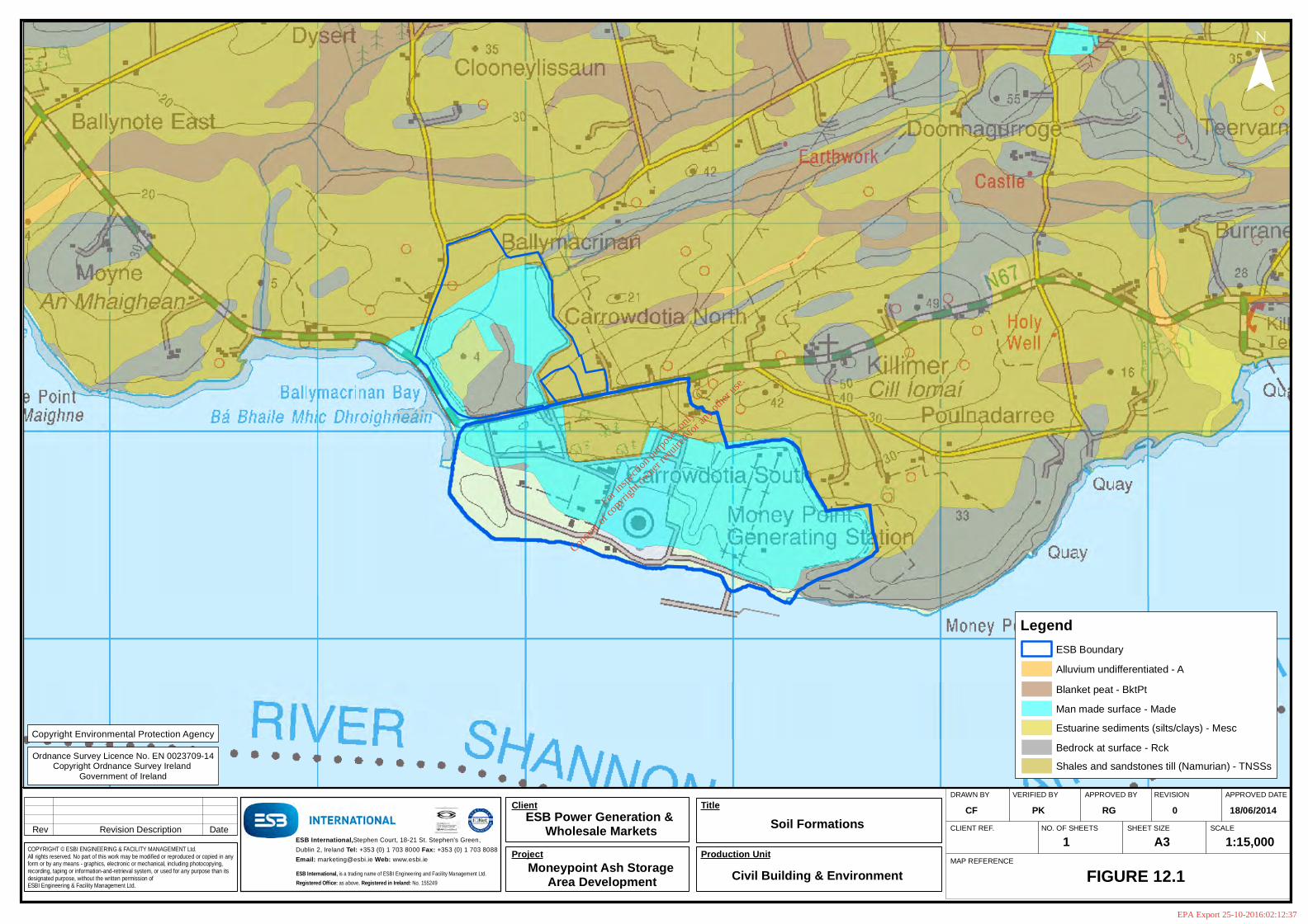
DRAWN BY VERIFIED BY APPROVED BY REVISION APPROVED DATE
CLIENT REF. NO. OF SHEETS SHEET SIZE SCALE
MAP REFERENCE
Rev Revision Description Date
COPYRIGHT © ESBI ENGINEERING & FACILITY MANAGEMENT Ltd.All rights reserved. No part of this work may be modified or reproduced or copied in any form or by any means - graphics, electronic or mechanical, including photocopying, recording, taping or information-and-retrieval system, or used for any purpose than its designated purpose, without the written permission of ESBI Engineering & Facility Management Ltd.
ESB International,Stephen Court, 18-21 St. Stephen's Green,
Dublin 2, Ireland Tel: +353 (0) 1 703 8000 Fax: +353 (0) 1 703 8088
Email: [email protected] Web: www.esbi.ie
ESB International, is a trading name of ESBI Engineering and Facility Management Ltd.
Registered Office: as above, Registered in Ireland: No. 155249
Client Title
Production UnitProject
Soil Formations
Civil Building & EnvironmentMoneypoint Ash Storage Area Development
CF
FIGURE 12.1
PK RG 0
1 A3
18/06/2014
1:15,000
¯
ESB Power Generation & Wholesale Markets
Ordnance Survey Licence No. EN 0023709-14Copyright Ordnance Survey Ireland
Government of Ireland
Copyright Environmental Protection Agency
LegendESB Boundary
Alluvium undifferentiated - A
Blanket peat - BktPt
Bedrock at surface - Rck
Estuarine sediments (silts/clays) - Mesc
Shales and sandstones till (Namurian) - TNSSs
Man made surface - Made
For
insp
ectio
n pur
pose
s only
.
Conse
nt of
copy
right
owne
r req
uired
for a
ny ot
her u
se.
EPA Export 25-10-2016:02:12:37

DRAWN BY VERIFIED BY APPROVED BY REVISION APPROVED DATE
CLIENT REF. NO. OF SHEETS SHEET SIZE SCALE
MAP REFERENCE
Rev Revision Description Date
COPYRIGHT © ESBI ENGINEERING & FACILITY MANAGEMENT Ltd.All rights reserved. No part of this work may be modified or reproduced or copied in any form or by any means - graphics, electronic or mechanical, including photocopying, recording, taping or information-and-retrieval system, or used for any purpose than its designated purpose, without the written permission of ESBI Engineering & Facility Management Ltd.
ESB International,Stephen Court, 18-21 St. Stephen's Green,
Dublin 2, Ireland Tel: +353 (0) 1 703 8000 Fax: +353 (0) 1 703 8088
Email: [email protected] Web: www.esbi.ie
ESB International, is a trading name of ESBI Engineering and Facility Management Ltd.
Registered Office: as above, Registered in Ireland: No. 155249
Client Title
Production UnitProject
Bedrock Formations
Civil Building & EnvironmentMoneypoint Ash Storage Area Development
CF
FIGURE 12.2
PK RG 0
1 A3
18/06/2014
1:15,000
¯
ESB Power Generation & Wholesale Markets
Ordnance Survey Licence No. EN 0023709-14Copyright Ordnance Survey Ireland
Government of Ireland
LegendESB Boundary
Sandstone, siltstone & mudstone - CNCCG
Copyright Geological Survey of Ireland
For
insp
ectio
n pur
pose
s only
.
Conse
nt of
copy
right
owne
r req
uired
for a
ny ot
her u
se.
EPA Export 25-10-2016:02:12:37

DRAWN BY VERIFIED BY APPROVED BY REVISION APPROVED DATE
CLIENT REF. NO. OF SHEETS SHEET SIZE SCALE
MAP REFERENCE
Rev Revision Description Date
COPYRIGHT © ESBI ENGINEERING & FACILITY MANAGEMENT Ltd.All rights reserved. No part of this work may be modified or reproduced or copied in any form or by any means - graphics, electronic or mechanical, including photocopying, recording, taping or information-and-retrieval system, or used for any purpose than its designated purpose, without the written permission of ESBI Engineering & Facility Management Ltd.
ESB International,Stephen Court, 18-21 St. Stephen's Green,
Dublin 2, Ireland Tel: +353 (0) 1 703 8000 Fax: +353 (0) 1 703 8088
Email: [email protected] Web: www.esbi.ie
ESB International, is a trading name of ESBI Engineering and Facility Management Ltd.
Registered Office: as above, Registered in Ireland: No. 155249
Client Title
Production UnitProject
Ground Water Resources
Civil Building & EnvironmentMoneypoint Ash Storage Area Development
CF
FIGURE 12.3
PK RG 0
1 A3
18/06/2014
1:15,000
¯
ESB Power Generation & Wholesale Markets
Ordnance Survey Licence No. EN 0023709-14Copyright Ordnance Survey Ireland
Government of Ireland
Copyright Geological Survey of Ireland
Ll - Bedrock which is Moderately Productive
LegendESB Boundary
Ground Water Resources
For
insp
ectio
n pur
pose
s only
.
Conse
nt of
copy
right
owne
r req
uired
for a
ny ot
her u
se.
EPA Export 25-10-2016:02:12:37

DRAWN BY VERIFIED BY APPROVED BY REVISION APPROVED DATE
CLIENT REF. NO. OF SHEETS SHEET SIZE SCALE
MAP REFERENCE
Rev Revision Description Date
COPYRIGHT © ESBI ENGINEERING & FACILITY MANAGEMENT Ltd.All rights reserved. No part of this work may be modified or reproduced or copied in any form or by any means - graphics, electronic or mechanical, including photocopying, recording, taping or information-and-retrieval system, or used for any purpose than its designated purpose, without the written permission of ESBI Engineering & Facility Management Ltd.
ESB International,Stephen Court, 18-21 St. Stephen's Green,
Dublin 2, Ireland Tel: +353 (0) 1 703 8000 Fax: +353 (0) 1 703 8088
Email: [email protected] Web: www.esbi.ie
ESB International, is a trading name of ESBI Engineering and Facility Management Ltd.
Registered Office: as above, Registered in Ireland: No. 155249
Client Title
Production UnitProject
Ground Water Vulnerability
Civil Building & EnvironmentMoneypoint Ash Storage Area Development
CF
FIGURE 12.4
PK RG 0
1 A3
18/06/2014
1:15,000
¯
ESB Power Generation & Wholesale Markets
Ordnance Survey Licence No. EN 0023709-14Copyright Ordnance Survey Ireland
Government of Ireland
Copyright Geological Survey of Ireland
E - Extreme
H - High
L - Low
M - Moderate
X - Rock or Karst Near Surface
LegendESB Boundary
Ground Water Vulnerability
For
insp
ectio
n pur
pose
s only
.
Conse
nt of
copy
right
owne
r req
uired
for a
ny ot
her u
se.
EPA Export 25-10-2016:02:12:37

N67
Ballymacrinan
Carrowdotia North
Quarry (Disused)
Salmon Weir
Carrigogore
Salmon Weir
CARROWDOTIA SOUTH
Church
Gravel Pit (Disused)
!A
!A
!A!A
!A
!A
!A
!A
!A
!A!A
!A!A
!A
!A !A
!A
!A
!A
!A
!A
!A
!A !A
!A!A
!A
!A
TP 5TP 4
TP 3
TP 2
TP 1
BH 7
BH 5
BH 1
BH 3
BH 2
BH 6
BH 26
BH 11
BH 12BH 25
BH 28
BH 27
BH 32
BH 31
BH 30
BH 29
BH 33
BH 4
BH 27A
DRAWN BY VERIFIED BY APPROVED BY REVISION APPROVED DATE
CLIENT REF. NO. OF SHEETS SHEET SIZE SCALE
MAP REFERENCE
Rev Revision Description Date
COPYRIGHT © ESBI ENGINEERING & FACILITY MANAGEMENT Ltd.All rights reserved. No part of this work may be modified or reproduced or copied in any form or by any means - graphics, electronic or mechanical, including photocopying, recording, taping or information-and-retrieval system, or used for any purpose than its designated purpose, without the written permission of ESBI Engineering & Facility Management Ltd.
ESB International,Stephen Court, 18-21 St. Stephen's Green,
Dublin 2, Ireland Tel: +353 (0) 1 703 8000 Fax: +353 (0) 1 703 8088
Email: [email protected] Web: www.esbi.ie
ESB International, is a trading name of ESBI Engineering and Facility Management Ltd.
Registered Office: as above, Registered in Ireland: No. 155249
Client Title
Production UnitProject
Borehole & Trial Pit Locations
Civil Building & EnvironmentMoneypoint Ash Storage Area Development
CF
FIGURE 12.5
PK RG 0
1 A3
18/06/2014
1:6,000
¯
LegendESB Boundary
Moneypoint ASA Extent of Works
Rivers/Streams
!A Borehole Locations
!A Trial Pit Locations
ESB Power Generation & Wholesale Markets
Copyright Department of the Environment, Community and Local Government
Ordnance Survey Licence No. EN 0023709-14Copyright Ordnance Survey Ireland
Government of Ireland
For
insp
ectio
n pur
pose
s only
.
Conse
nt of
copy
right
owne
r req
uired
for a
ny ot
her u
se.
EPA Export 25-10-2016:02:12:37

Moneypoint Ash Storage Area Development
QS-000132-01-R001 177
13 Material Assets Material assets comprise resources that are valued and intrinsic to specific places and may be of either human or natural origin. Their value may arise for either economic or cultural reasons.
The proposed development will occur on the existing ash storage area footprint within the Moneypoint Generating station site and no additional landtake will be required. The site is an existing IPPC licenced site and its operation, which includes the activities associated with the ash storage area usage are strictly controlled under the conditions of the licence. No changes are proposed to the activities which will take place on site arising from the project as these are an extension of current activities. Hence, potential impacts on material assets are very limited. For example, transportation of ash material from the power station to the ash storage area will occur using the internal road network and no external road usage associated with the ash deposition will occur. Capping materials will require to be imported to the site to finalise the ash storage are in compliance with the requirements of the IPPC Licence. This capping would be a requirement regardless of any proposed increase in capacity of the ash storage area and is addressed in Section 10 on transport.
Cultural heritage including architectural heritage, transport infrastructure, air quality, soils and geology which are considered as material assets are dealt with specifically in separate chapters.
In this chapter the key issues of tourism, important to County Clare, and raw materials such as embankment construction and capping material are addressed.
There will be a visual impact arising from the increased height of the ash storage area and this has the potential to impact on tourism in the area as the site is located along the
13.1 Tourism & Amenity
13.1.1 Approach and methodology Data and statistics on tourism nationally have been obtained from the:
• Central Statistics Office Statistical Yearbook of Ireland 2012,
• Fáilte Ireland, Tourism Facts 2013 Preliminary,
• and from other published sources.
13.1.2 Receiving Environment General
For
insp
ectio
n pur
pose
s only
.
Conse
nt of
copy
right
owne
r req
uired
for a
ny ot
her u
se.
EPA Export 25-10-2016:02:12:37

Moneypoint Ash Storage Area Development
QS-000132-01-R001 178
Tourism is a vital component of the national economy and is now regarded as one of the greatest potential wealth creators and employers at national level. Its importance and the employment it can generate are particularly relevant in areas that lack opportunity for other kinds of development. As presented in Table 13.1 the number of tourists visiting Ireland increased rapidly for much of the past decade. This trend was reversed between 2008 and 2010 with the onset of the global recession. Figures for 2011 indicate numbers increasing with a 7.4%increase between 2011 and 2013.
Table 13.1: Overseas Visits (Thousands) to Ireland
Year 2005 2006 2007 2008 2009 2010 2011 2012 2013
Number 6,977 7,709 8,012 7,839 6,928 6,037 6,505 6,517 6,986
In 20124, the latest year for which complete statistics are available, out-of-state tourist expenditure, including spending by visitors from Northern Ireland, amounted to €3.24 billion. With a further €0.77 billion spent by overseas visitors on fares to Irish carriers, total foreign exchange earnings were €4 billion. Domestic tourism expenditure amounted to approximately €1.4 billion, making tourism in total a €5.4 billion industry and indicating that tourism has continued to be one of the country’s most important indigenous industries in recent years
The Tourism Ireland Situation and Outlook Report5 states that
“Official data from the Central Statistics Office (CSO) indicates that overseas visitors to the Republic of Ireland grew by +7.2% in 2013 when compared to 2012. The GB market performed well and grew by +5.6%. North America (+13.9%) and Australia and Developing markets (+15.1%) had their best years ever and Mainland Europe (+4.9%) also played a major part in growing visitor numbers from overseas. The CSO also estimates that total overseas tourism earnings and overseas holidaymakers grew by +13% and +8% respectively for the first nine months of 2013 when compared to the same period in 2012.”
4 Failte Ireland, Tourism Facts 2013, Preliminary May 2014 5 Tourism Ireland, Situation and Outlook Analysis Report, February 2014
For
insp
ectio
n pur
pose
s only
.
Conse
nt of
copy
right
owne
r req
uired
for a
ny ot
her u
se.
EPA Export 25-10-2016:02:12:37

Moneypoint Ash Storage Area Development
QS-000132-01-R001 179
The CSO’s official count 6 of direct employment in ‘Hotels and Restaurants’, a category which includes hotels, other short-stay accommodation, restaurants, bars, canteens and catering, was 121,686 nationally in 2011 (approximately 5.8% of total employment). Direct employment in ‘Hotels and Restaurants’ in Clare was 2,960 in 2011(approximately 5.7% of total employment in Clare).
Further potential is anticipated and tourism is a priority sector for development by the Government. Maximising the potential of the tourism sector and economic diversification are recognised as key steps in helping to achieve the critical mass of population in rural areas that have been suffering from population decline.
Local Interest
There are no major tourist attractions in the Moneypoint area and it has not been identified in the Clare County Development Plan 2011 – 2017 as being of particular importance for tourism. Moyne Bay caravan park is an established tourist development in the area, some 3 km west of the station.
Moneypoint lies on the N67 Killimer - Kilrush road, which forms part of the Wild Atlantic Way and which is a significant access route for tourists travelling between major tourist destinations in Co. Clare and Co. Kerry. The coast road south east of Cappagh to Carrowdotia South is identified as Scenic Route No. 19 in Clare County Development Plan 2011-2017.
13.1.3 Impacts of the Development Local Interest
Because it is not a significant tourism area in its own right, the ash storage area development will not have any significant adverse impacts on local tourism.
Moneypoint Generating Station is conscious of its position as one of the largest power stations within the ESB system and of the uniqueness of many of its facilities. The station has strong links with local schools and national universities, and site tours are a regular feature when organised in advance.
In views from the N67, the workings at the site will be visible, and the final ash storage area mound will slightly alter the extent of the view across the landscape
6 Profile 3 – At Work, Official CSO Publication, July 2012
For
insp
ectio
n pur
pose
s only
.
Conse
nt of
copy
right
owne
r req
uired
for a
ny ot
her u
se.
EPA Export 25-10-2016:02:12:37

Moneypoint Ash Storage Area Development
QS-000132-01-R001 180
(see Photomontage 1 in Section 8 above). However, the nature of the surrounding topography means that the new grassed mound will appear as an almost naturally occurring topographical element in views from the N67. This view also currently includes the two high voltage powerlines emerging from Moneypoint Station and will also include the permitted wind turbines on the site.
Visitors principally enjoy the attractions of Co Clare further west along the N68 at Kilrush, Kilkee and Milltown Malbay.
Significant development is already a feature here along the N67 due to the presence of Moneypoint Generating Station. Furthermore, the area is one of two designated Working Landscapes in the Clare County Development Plan 2011-2017.
13.1.4 Mitigation There is no mitigation of impacts for tourism.
13.1.5 Conclusions The proposed development will not result in significant adverse impacts on tourism.
13.2 Electricity Supply
13.2.1 Receiving Environment Moneypoint Generating Station is the only coal fired power station in the country and is regarded as a strategic asset in terms of security of energy supply.
Electricity demand is a key indicator of performance and growth in the national economy, with growth in demand for electricity actually surpassing national economic growth. Sustained economic growth requires that a secure supply of electricity is available to meet increasing demand .
The development of Irish society and its economy has, as in the case of many other countries, relied heavily on the exploitation of apparently abundant, affordable and widely available energy supplies and the services they provide. Such services are intrinsic to the operation of a modern economy with its needs for warmth and comfort, power and light, and mobility and communications.
The last two decades have seen significant growth in demand for electricity. Peak demand was 2,460 MW in 1990/91 and reached 5,035 MW in 2006.
The Total Electricity Requirement for Ireland to 2022 is set out in the SONI – EirGrid All Island Capacity Statement 2013 – 2022. The following data is drawn from that document:
For
insp
ectio
n pur
pose
s only
.
Conse
nt of
copy
right
owne
r req
uired
for a
ny ot
her u
se.
EPA Export 25-10-2016:02:12:37

Moneypoint Ash Storage Area Development
QS-000132-01-R001 181
• The demand forecast (that is the total electricity requirement projected for 2020) is stated as being 29,808 Gigawatt hours for the median growth scenario.
Forty percent of this projected demand will be met by renewable energy generation with the balance being provided by conventional power generation. Reliable high efficiency plant operating at base load is therefore required to meet projected future demand in line with Government strategy.
The production of electricity by conventional thermal power plants requires the use of fossil fuels such as coal and gas and Ireland has a very high energy import dependency on gas.
13.2.2 Impact of the Development The proposal will contribute to ensuring that Moneypoint Generating Station has adequate ash storage area capacity to enable it to continue in operation for a further minimum 10 year period. This will provide a strategic alternative to gas in terms of conventional power generation and ensure that electricity supplies are available to support economic activity and growth in a manner fully compatible with Government energy and environmental policies. It will ensure that local and regional economic development is not constrained by shortfalls in the availability of electric power.
13.2.3 Conclusion The proposed development will ensure continued availability of a strategic alternative for energy generation into the future.
13.3 Air Navigation
13.3.1 Existing Environment Current tall structures at the site include the following:
• The station main building is approximately 64.5 m high (top 70 m OD)
• Two ship unloaders on the station’s jetty are approximately 90 m high in the upright position (top 96 m OD)
• The station’s two reinforced concrete chimneys are 225 m high (top 230 m OD)
Planning permission has also been granted on the Moneypoint site for 5 wind turbines, with a maximum height of 152 m above ground level.
For
insp
ectio
n pur
pose
s only
.
Conse
nt of
copy
right
owne
r req
uired
for a
ny ot
her u
se.
EPA Export 25-10-2016:02:12:37

Moneypoint Ash Storage Area Development
QS-000132-01-R001 182
13.3.2 Impact of the Development The proposed maximum elevation of the ash storage area is 28 m AOD, which is significantly lower that existing and planning structures on-site. In regard to aviation, the chimneys are already provided with obstacle lighting to ensure they do not pose a danger to air navigation.
All requirements of the Irish Aviation Authority and the Department of Defence will be implemented in full. The ash storage area will have no implications for air navigation not impact on the safety of air traffic.
13.3.3 Mitigation There is no mitigation of impacts for the proposed development.
13.3.4 Conclusion The proposed development will not result in significant adverse impacts.
For
insp
ectio
n pur
pose
s only
.
Conse
nt of
copy
right
owne
r req
uired
for a
ny ot
her u
se.
EPA Export 25-10-2016:02:12:37

Moneypoint Ash Storage Area Development
QS-000132-01-R001 183
14 Cultural Heritage
14.1 Receiving Environment The current land profile of the site is a man-made one that was created at the time of construction of the power station by site development works, which involved in excess of 3,5000,000 m³ of earth moving leading to remodelling of the site’s topography. The coal yard was formed by excavating rock from the hill at its northern and eastern boundaries and the excavated rock was used to reclaim and level the site towards the estuary, where an additional 24 ha of land were created.
In addition, the ash storage area has been transformed by the deposition of significant volumes of ash there since the station was commissioned and its subsequent restoration to grassland as sections within it have reached their final level.
14.1.1 Archaeology There are no protected structures within the meaning of the Planning and Development Act, 2000 (as amended) within the site. A number of recorded archaeological sites in the townland of Carrowdotia South, as listed in Table 14.1 and shown in Figure 14-1 have been identified. These are classified as Enclosures.
Table 14.1: Surrounding Archaeological Sites
Site Reference CH1 CH2 CH3 CH4 CH5
Site & Monuments
Record (SMR) CL067:041 CL067:042 CL067:043 CL067:050 CL067:051
14.1.2 History The place-name Carrowdotia comes from the Gaelic “Ceathrú Dóite” or “Burnt Quarter”. There are no historical events associated with the site that have the ability to be impacted upon.
14.1.3 Architectural Heritage There are no protected structures within the meaning of the Planning and Development Act, 2000 situated on the station site. The power station buildings at Moneypoint are not considered to be of interest from an architectural heritage perspective. However, there are a number of structures located in the general area, as listed in Table 14.2 and shown in Figure 14-1.
For
insp
ectio
n pur
pose
s only
.
Conse
nt of
copy
right
owne
r req
uired
for a
ny ot
her u
se.
EPA Export 25-10-2016:02:12:37
Moneypoint Ash Storage Area Development
QS-000132-01-R001 184
Table 14.2: Surrounding Architectural Heritage Sites
Site Reference Description
CH6 Two modern agricultural barns, with steel and concrete walls and corrugated roofs.
CH7 Two-storey cottage with chimneys at each gable.
CH8 Modern (1980.s) two-storey dwelling orientated east-west with front facing north; single-storey extension to east.
CH9 Two-storey dwelling orientated with single storey extension to east.
CH10 Single-storey bungalow; three bay with off-centre recessed entrance; garage incorporated into western end.
CH11 Two-storey cottage with rear extension.
CH12: Single-storey gable-ended cottage with attic-room
14.2 Impacts of the Development All of the works associated with the ASA, will take place in the remodelled / filled areas of the power station lands.
The nature of the site is such that the excavation of buried or hidden features in these areas cannot arise during construction. There is no potential for disturbance of sites that are as yet undiscovered. Areas of archaeological interest in the vicinity of the site will be unaffected and undisturbed by the proposed development.
There are no historic events associated within the development areas.
The proposed development has no potential to impact on Architectural heritage sites that are outside of the station lands.
14.3 Mitigation No mitigation of impacts is proposed.
14.4 Conclusions The proposed development will not result in significant environmental impacts.
For
insp
ectio
n pur
pose
s only
.
Conse
nt of
copy
right
owne
r req
uired
for a
ny ot
her u
se.
EPA Export 25-10-2016:02:12:37

N67
Ballymacrinan
Carrowdotia North
Salmon Weir
Salmon Weir
Carrigogore
Salmon Weir
Salmon Weir
CARROWDOTIA SOUTH
POULNADARRE
Post Office
Church
Money Point Quarry
Money Point
Gravel Pit (Disused)
Salthill Quarry (Disused)
!P!P
!P
!P
!P
!P
!P!P
!P!P
!P
!P
CH5
CH4
CH3
CH2CH1
CH6
CH7CH8CH9
CH10CH12
CH11
DRAWN BY VERIFIED BY APPROVED BY REVISION APPROVED DATE
CLIENT REF. NO. OF SHEETS SHEET SIZE SCALE
MAP REFERENCE
Rev Revision Description Date
COPYRIGHT © ESBI ENGINEERING & FACILITY MANAGEMENT Ltd.All rights reserved. No part of this work may be modified or reproduced or copied in any form or by any means - graphics, electronic or mechanical, including photocopying, recording, taping or information-and-retrieval system, or used for any purpose than its designated purpose, without the written permission of ESBI Engineering & Facility Management Ltd.
ESB International,Stephen Court, 18-21 St. Stephen's Green,
Dublin 2, Ireland Tel: +353 (0) 1 703 8000 Fax: +353 (0) 1 703 8088
Email: [email protected] Web: www.esbi.ie
ESB International, is a trading name of ESBI Engineering and Facility Management Ltd.
Registered Office: as above, Registered in Ireland: No. 155249
Client Title
Production UnitProject
Location of Cultural Heritage Sites
Civil Building & EnvironmentMoneypoint Ash Storage Area Development
CF
FIGURE 14.1
MH PK 0
1 A3
18/06/2014
1:8,000
¯
Copyright Department of the Environment, Community and Local Government
Ordnance Survey Licence No. EN 0023709-13Copyright Ordnance Survey Ireland
Government of Ireland
LegendESB Boundary
Moneypoint ASA Extent of Works
!P Architectural Heritage (CH6-CH12)
!P Archaeology (CH1-CH5)
ESB Power Generation & Wholesale Markets
For
insp
ectio
n pur
pose
s only
.
Conse
nt of
copy
right
owne
r req
uired
for a
ny ot
her u
se.
EPA Export 25-10-2016:02:12:37

Moneypoint Ash Storage Area Development
QS-000132-01-R001 186
15 Interactions of Impacts As stated in the EPA Advice Notes on Current Practice in the preparation of Environmental Impact Statements
“all environmental factors are inter-related to some extent. This heading draws attention to significant interaction and interdependencies in the existing environment”
This chapter addresses the main interactions of impacts between different aspects of the environment likely to arise from the proposed Ash Storage Area development In this respect only relevant topics which can be linked to the development are discussed and where not mentioned no potential for impact has been identified.
Mitigation measures in relation to primary impacts are outlined in the relevant Sections of the EIS. Mitigation measures are not repeated herein and only mitigation that is additional to the primary impacts is described.
Cumulative impacts have been addressed in individual chapters in the EIS and are not discussed further here.
15.1 Approach and Methodology This chapter has been prepared with specific reference to the Guidelines on the information to be contained in Environmental Impact Statements (EPA, 2002), and Advice Notes on Current Practice in the preparation of Environmental Impact Statements, (EPA, 2003) (EPA guidelines). Reference is also made to the Guidelines for the Assessment of Indirect and Cumulative Impacts as well as Impact Interactions (Office for Official Publications of the European Communities, 1999) (EU guidelines) and to Guidance: Cumulative Effects of Windfarms (Scottish National Heritage, 2005).
15.1.1 Interaction of impacts An interaction matrix is provided in Table 15.1 where the potential for the topic in the left hand column to have an effect on the environmental media listed in the top row of the matrix is presented. Construction stage interactions are indicated by ‘C’, operational phase by an ‘O’ and for both phases by ‘CO’ .
Where an interaction is considered to be likely it is discussed below.
For
insp
ectio
n pur
pose
s only
.
Conse
nt of
copy
right
owne
r req
uired
for a
ny ot
her u
se.
EPA Export 25-10-2016:02:12:37

Moneypoint Ash Storage Area Development
QS-000132-01-R001 187
Table 15.1: Potential interaction of effects
Human Beings
Noise and
Vibration
Terrestrial Ecology
Water and
Aquatic Ecology
LandscapeAir and Climate
Geology and
Soils
Roads and
Traffic
Material Assets
Cultural heritage
Human Beings
- - - - - - CO - -
Noise and Vibration
CO CO - - - - - - -
Terrestrial Ecology
- - - - - - - - -
Water and Aquatic Ecology
- - - - - - - - -
Landscape CO - CO - - - - CO -
Air and Climate
CO - CO - - CO - - -
Geology and Soils
- - CO CO - - - - CO
Roads and Traffic
CO - CO - C CO - - -
Material Assets
CO - - - - - - - CO
Cultural heritage
For
insp
ectio
n pur
pose
s only
.
Conse
nt of
copy
right
owne
r req
uired
for a
ny ot
her u
se.
EPA Export 25-10-2016:02:12:37

Moneypoint Ash Storage Area Development
QS-000132-01-R001 188
15.1.2 Human Beings / Noise The development of the ash storage area will be ongoing as part of the normal operations of the Moneypoint power generation station. As such construction and operation essentially comprise one activity. Construction and operational noise is controlled by the conditions of the IPPC Licence for the operation, see Chapter 6.
15.1.3 Human Beings / Landscape As stated in Chapter 8 the proposal will result in the introduction of a new, large but naturally appearing grassed mound in a coastal location adjacent to power generating structures. A number of locations in higher areas to the north will experience changes to their experience of the wider landscape with the obstruction of views over the estuary by the new mound. , This is discussed in detail in Chapter 8.
15.1.4 Human Beings / Roads & Traffic Traffic movements associated with the construction and operation of the landfill will be largely confined to the internal; road network of Moneypoint as internally generated materials (ash and flue gas desulphurisation by-product) will be used in the construction of the ash storage area embankments. There will be a requirement to import capping material onto the site on final completion of the ash storage area in accordance with the requirements of the station’s IPPC Licence. This is discussed in Chapter 10. No long term employment will result from the proposed project as it is an extension of existing activities on the site.
15.1.5 Geology and Soils/Water There will be no change in the overall existing footprint of the ash storage area which has been in operation since 1985. The site is located upon and existing coal by-product disposal facility, which is underlain by glacial till and sedimentary bedrock. The bedrock does not contain a significant groundwater resource and this is not indicated to be abstracted in the vicinity of the site. No significant impact on surface or groundwater has been identified as a result of deposition of ash at the existing location and hence no long term impact on water quality is predicted, see Chapter 12.
15.1.6 Geology and Soils/Ecology The existing ash storage area is connected hydraulically to the Lower Shannon Estuary cSAC and therefore provides a pathway by which metals leached from the ash material could gain access to the estuarine environment. This could potentially impact on aquatic species dependent on water quality, (the Bottlenose Dolphin and salmonid species for example). However, no significant impact has been observed
For
insp
ectio
n pur
pose
s only
.
Conse
nt of
copy
right
owne
r req
uired
for a
ny ot
her u
se.
EPA Export 25-10-2016:02:12:37

Moneypoint Ash Storage Area Development
QS-000132-01-R001 189
to date and as the proposed development is an extension of existing operations on the site no additional interaction is expected to occur.
The final capping of the ash storage area will provide a future grassland type habitat into the future once the ash storage area is finally completed.
15.1.7 Landscape / Material Assets The Wild Atlantic Way runs along the N67 Killimer - Kilrush road and is a significant access route for tourists travelling between major tourist destinations in Co. Clare and Co. Kerry. The workings of the site will be visible from the N67, and this could impact on tourist attitudes. However, the route passes Moneypoint, which is a major industrial site that currently includes the two high voltage powerlines emerging from Moneypoint Station and will also include the permitted wind turbines on the site. As such there is not expected to be any additional impact on tourism in the area
The final ash storage area mound will slightly alter the extent of the view across the landscape. However, the nature of the surrounding topography means that the new grassed mound will appear as an almost naturally occurring topographical element in views from the N67.
15.1.8 Air & Climate / Roads & Traffic Air emissions from the site, particularly dust are strictly controlled by the stations IPPC Licence. Transport of ash and construction materials can give rise to elevated dust levels. However, as these occur within the site they are controlled under the IPPC Licence. Traffic associated with the development will also give rise to exhaust emissions during the construction phase. Water bowsers are used on the Moneypoint site to control irregular dust emissions arising from ash transport. The potential impacts are not considered significant in the context of the extent of traffic movements arising.
15.2 Interaction of Impacts Conclusion In terms of interaction of impacts no unacceptable environmental impacts are envisaged as a result of the construction and operation of the proposed Ash Storage Area, provided that the recommended mitigation measures are implemented.
For
insp
ectio
n pur
pose
s only
.
Conse
nt of
copy
right
owne
r req
uired
for a
ny ot
her u
se.
EPA Export 25-10-2016:02:12:37
Moneypoint Ash Storage Area Development
QS-000132-01-R001 190
16 Conclusion The main benefit from this project will be the maintenance of Moneypoint Generating station as a strategic alternative for conventional energy generation required to meet the existing and future electricity demand for Ireland.
The proposed development comprises an extension of an existing activity on the site with no change in the footprint of the ash storage area but with an increase in the overall height. The most significant potential environmental impacts from the project have been examined and no significant adverse impacts on the environment arising from the development have been identified.
For
insp
ectio
n pur
pose
s only
.
Conse
nt of
copy
right
owne
r req
uired
for a
ny ot
her u
se.
EPA Export 25-10-2016:02:12:37