mon-4-ch-2 gillespie - tii
TRANSCRIPT

2. Prehistory and history on the N5 Charlestown Bypassin counties Mayo and RoscommonRichard Gillespie
This paper provides an overview of the archaeological excavations on the N5 CharlestownBypass in counties Mayo and Roscommon carried out by Richard Gillespie and AgnesKerrigan, Mayo County Council, on behalf of the council and the National RoadsAuthority between 2004 and 2006. The Environmental Impact Statement for the schemeidentified five Recorded Monuments and Places (RMP), i.e. known archaeological siteswith statutory protection, and eight additional areas of archaeological potential forexcavation or testing. Test excavations were opened by machine, under archaeologicalsupervision, throughout the footprint of the road scheme, and the groundworks of the maincontractor were subsequently monitored when construction of the road got under way. Inaddition, surveys of vernacular structures and townland boundaries affected by the schemewere also carried out. Thirty-three previously undocumented archaeological sites wereidentified by testing; one site was identified by monitoring of the excavation of badger setsby the scheme’s consultant ecologist; and six further sites were identified while monitoringthe road contractor’s groundworks. These discoveries led to the excavation ofarchaeological material from the Neolithic, Bronze Age and medieval periods.
Neolithic period
The earliest remains identified on this scheme date from the Neolithic period; theseincluded lithic assemblages (i.e. stone tools, mostly of chert and flint) from Cashelduff,Sonnagh and Lowpark, Co. Mayo. A stray find of a chert plano-convex knife fromCloonaghboy ringfort, Co. Mayo, was also recorded (Illus. 1). This finely crafted stone knifeis an artefact typical of the Neolithic. An enclosure site at Cashelduff (NGR 153910,300229; height 114 m OD; ministerial direction no. A020/010; RMP MA063-033)consisted of a natural raised area covered by a ‘cairn’ of small stones with two roughlyconcentric C-shaped rows of large stones. One of these was located close to the base of thecairn and the other at the top, delimiting a central area of charcoal-rich soil covering twocentral pits. A total of 159 struck pieces of chert and flint, including several characteristicallyNeolithic artefacts, were recovered, although not from secure contexts. Similarly, theSonnagh lithic assemblage included unstratified Neolithic artefacts. There were at least twophases of Neolithic activity at Lowpark (NGR 147233, 300643; height 84 m OD;ministerial direction no. A020/012). Both phases consisted of pits dug into the naturalsubsoil, with pottery, lithics, burnt/cremated bone and charcoal included within their fills.
At one site in Lowpark, six pits containing Early Neolithic pottery and lithics wereexcavated close to and within medieval palisaded enclosures (described below). TheNeolithic pottery from these features was identified by Rose Cleary, University CollegeCork, as bone-tempered ware. Some sherds had the characteristic profile of WesternNeolithic round-bottomed shouldered bowls, with both rims and shoulders in theassemblage. This pottery dates from c. 4500–3000 BC. This area also included one Bronze
11

New Routes to the Past
12
Illus
. 1—
Loc
atio
n of
prin
cipal
arch
aeol
ogica
l site
s on
the
N5
Cha
rlesto
wn
Byp
ass
in c
ount
ies
May
o an
d R
osco
mm
on (
base
d on
the
Ord
nanc
e Su
rvey
Ire
land
map
)

Age pit. Subsequent medieval activity is likely to have disturbed more prehistoric features,resulting in the unstratified finds and some truncated pits.
The second prehistoric site in Lowpark was identified during archaeological monitoringof the excavation of badger sets. This site included a series of 14 pits on a relatively flat,natural terrace on the west side of a glacial ridge, 40 m to the west of the Early Neolithicfeatures described above. These pits were oval, circular or subrectangular in plan and werefilled with silty sand and gravel with varying amounts of charcoal. Finds from the pitsincluded numerous sherds of Late Neolithic pottery, an assemblage of flint and chertartefacts, a miniature polished stone axehead and frequent small fragments of burnt bone.Over 1,600 sherds of pottery were recovered from one pit (Illus. 2). Rose Cleary identifiedthis assemblage as including later Neolithic Grooved Ware and large bucket-shaped vessels,with a minimum of 15 vessels present. Pottery from nearby pits included sherds of smallflat-based bowls with twisted cord impressions just below the internal rim, similar topottery from Knowth and Newgrange, Co. Meath, dating from c. 2600–2200 BC. Largeflat-based vessels with applied clay pellets were also found in association with the GroovedWare (Illus. 2, inset). To date, this type of decoration is not known from any other Irish LateNeolithic context. Some vessels have post-firing perforations on the vessel walls. A similarfeature is found on the Newgrange Grooved Ware, but the form of the vessels is notparalleled at Newgrange.
Prehistory and history on the N5 Charlestown Bypass
13
Illus. 2—Pit containing over 1,600 sherds of Late Neolithic pottery, with inset of a pottery sherd decorated withapplied clay pellets (Mayo County Council)
Bronze Age
One large pit from Lowpark (referred to above) included a token deposit of sherds from aBronze Age Food Vessel in association with burnt bone (possibly cremated human bone).This is the only definite evidence of Bronze Age activity from the Lowpark site.
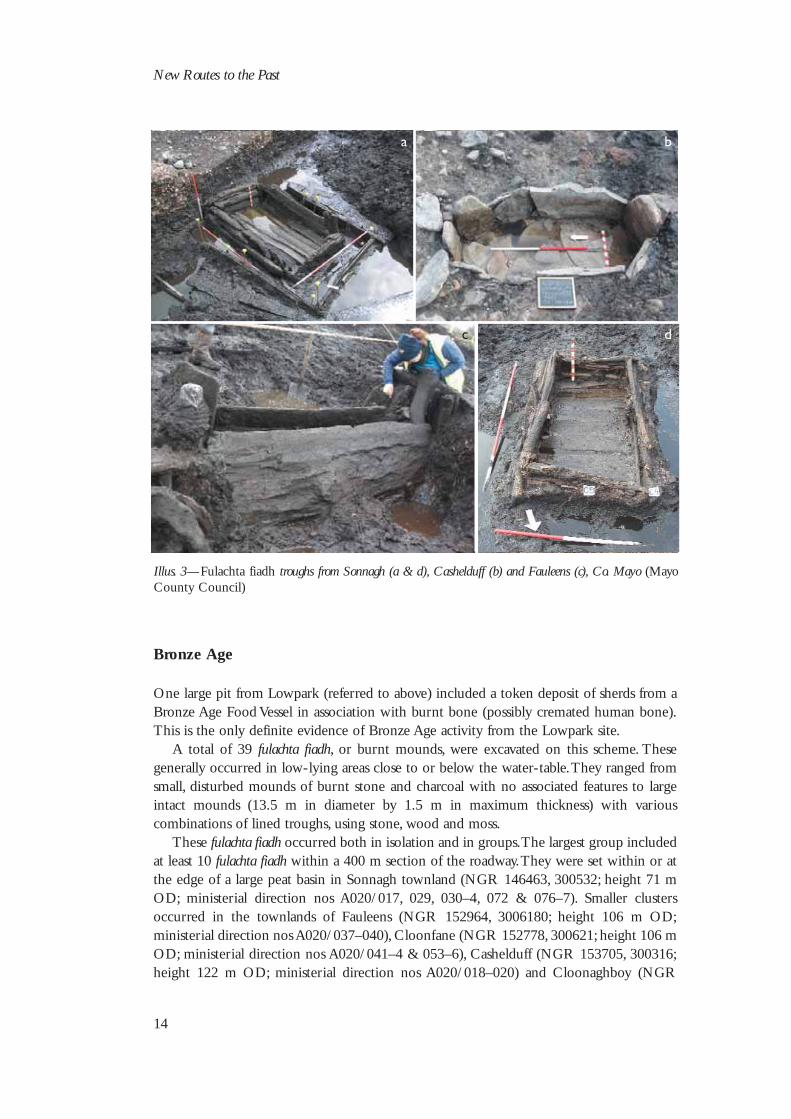
A total of 39 fulachta fiadh, or burnt mounds, were excavated on this scheme. Thesegenerally occurred in low-lying areas close to or below the water-table. They ranged fromsmall, disturbed mounds of burnt stone and charcoal with no associated features to largeintact mounds (13.5 m in diameter by 1.5 m in maximum thickness) with variouscombinations of lined troughs, using stone, wood and moss.
These fulachta fiadh occurred both in isolation and in groups. The largest group includedat least 10 fulachta fiadh within a 400 m section of the roadway. They were set within or atthe edge of a large peat basin in Sonnagh townland (NGR 146463, 300532; height 71 mOD; ministerial direction nos A020/017, 029, 030–4, 072 & 076–7). Smaller clustersoccurred in the townlands of Fauleens (NGR 152964, 3006180; height 106 m OD;ministerial direction nos A020/037–040), Cloonfane (NGR 152778, 300621; height 106 mOD; ministerial direction nos A020/041–4 & 053–6), Cashelduff (NGR 153705, 300316;height 122 m OD; ministerial direction nos A020/018–020) and Cloonaghboy (NGR
New Routes to the Past
14
a
c d
b
Illus. 3—Fulachta fiadh troughs from Sonnagh (a & d), Cashelduff (b) and Fauleens (c), Co. Mayo (MayoCounty Council)
141301, 300284; height 75 m OD; ministerial direction no. A020/071), Co. Mayo, andCurrinah (NGR 156643, 299235; height 112 m OD; ministerial direction nos A020/046& 059–060), Co. Roscommon.
A variety of trough types were uncovered, including 11 rectangular wood-lined troughs,five stone-lined or partly stone-lined troughs, two earth-cut troughs and two oval troughscut into peat (Illus. 3). Most of the rectangular troughs were of brushwood construction,with tightly constructed sides overlapping at the corners and held in place by stakes orcorner posts. The bases were of both plank and brushwood construction, occasionally withlayered bases of timbers and moss. The base of one trough comprised three layers each ofwood, moss and sand. The more intact of these troughs included about 100 timbers andouter moss linings. One large trough was of similar style but was constructed of large splitplanks and roundwoods with overall dimensions of 2.5 m by 1.6 m by 0.5 m deep. It wasconstructed from 31 pieces of timber, with an additional six timbers making up a lower basebelow the floor of the trough.
Another exceptional trough from Fauleens (A020/038) had internal dimensions of 2 mby 0.3 m by 0.4 m deep. It was constructed of three large oak planks making up the sidesand base, and smaller planks making up the ends (Kerrigan 2006). One of the oval troughscontained the collapsed remains of a moss and wicker lining, and the other had a single splittimber at its base held in place by two hazel rods bent across it.
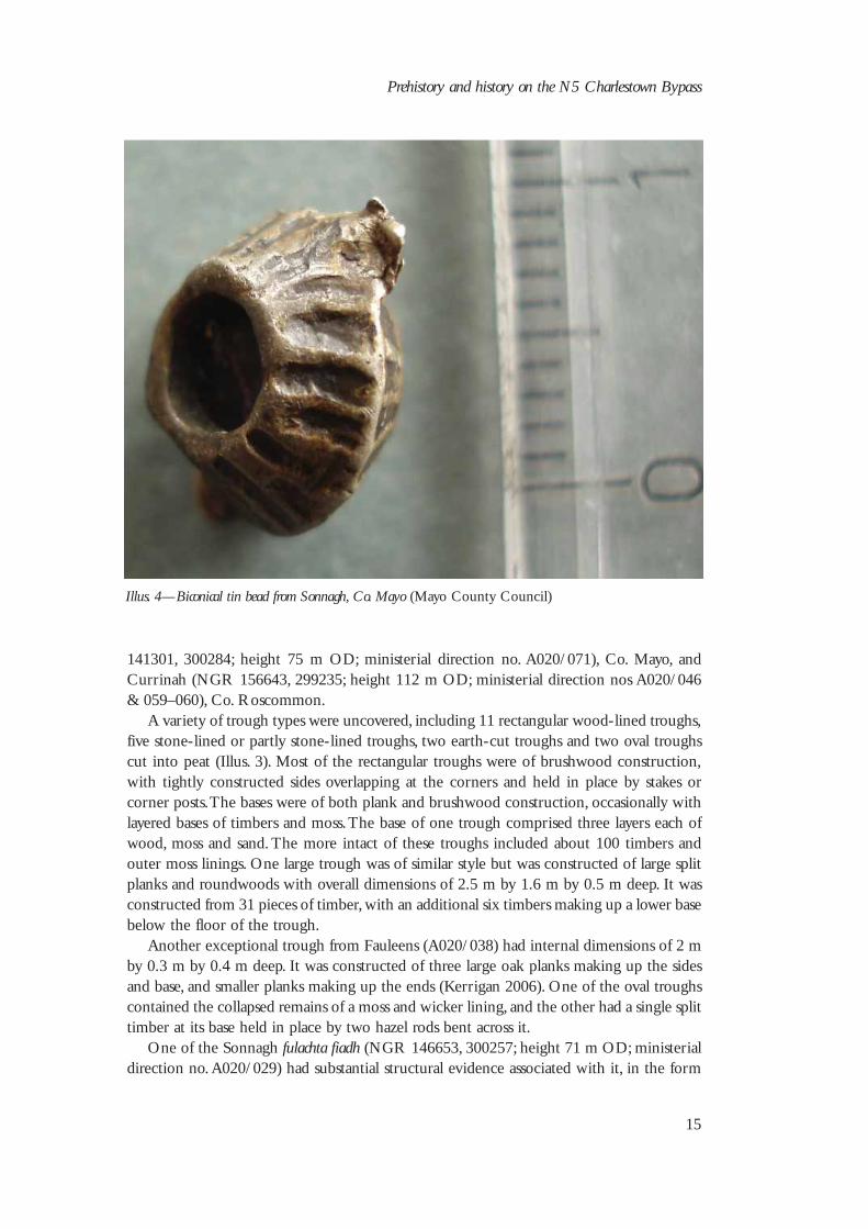
One of the Sonnagh fulachta fiadh (NGR 146653, 300257; height 71 m OD; ministerialdirection no. A020/029) had substantial structural evidence associated with it, in the form
Prehistory and history on the N5 Charlestown Bypass
15
Illus. 4—Biconical tin bead from Sonnagh, Co. Mayo (Mayo County Council)

of a series of circular or oval foundation trenches representing a number of phases ofconstruction. One structure consisted of two roughly concentric foundation trenches withmaximum diameters of 9 m and 4 m respectively. These cut through an earlier oval ditchthat enclosed a space of 8.5 m by 10.5 m. This ditch in turn cut through a small C-shapedfoundation trench with a diameter of 3.5 m, which may have been the foundation for asmall hut.
Some animal bone and lithics were recovered from the 39 fulachta fiadh, as well as a largesiltstone barbed-and-tanged arrowhead from Ballyglass West. The most unusual find was abiconical tin bead with ribbed decoration on its surface (Illus. 4), retrieved from a moss layerin the base of one of the Sonnagh troughs. This rare artefact has parallels with materialrecovered from a Bronze Age site excavated at Flag Fen, Peterborough, England (Pryor2001).
Medieval period
Two medieval sites were excavated on this scheme: a bivallate ringfort (a ringfort comprisedof two enclosing banks) at Cloonaghboy and a newly identified palisaded enclosure atLowpark.
Cloonaghboy ringfortThe Cloonaghboy ringfort was clearly indicated on the first-edition Ordnance Survey six-inch map (1838) but no surface traces survived (NGR 140619, 300541; height 90 m OD;excavation licence no. 04E1341; ministerial direction no. A020/002; RMP no. MA062-058). It occupied a commanding position near the top of a large gravel hill at an altitudeof 90 m OD. Although it had been levelled, two substantial enclosing ditches and part ofa stone-built souterrain survived (Illus. 5). The ditches enclosed an area with a diameter of35 m. The ditches were extant for 90% of the circumference of the ringfort, merged towardsthe east and then faded out.
The souterrain was aligned north–south and consisted of a linear passage cut directlyinto the natural gravel subsoil. It was 12 m long by 1.9 m wide and 1.1 m deep. Nocapstones or roof lintels were present and the southern 2.5 m of the souterrain had beenalmost completely removed. Two post-holes at the northern terminal may have heldwooden door-jambs. The passage was of drystone construction, with up to 10 courses ofmasonry surviving at the deepest part. A quernstone, some animal bone, charcoal, acorroded metal knife and an antler pin were recovered from the fill.
Lowpark palisaded enclosureThe enclosure at Lowpark was located on a low gravel ridge that had clear views on allsides. The enclosing elements consisted of three palisade trenches (Palisades 1–3; Illus. 6 &7). The southern half of Palisade 3 and 30% of Palisade 2 had previously been disturbed bymodern quarrying activity. Palisade 1 enclosed the main area of archaeological activity,which included a drystone-walled souterrain, a large sunken stone-lined chamber, a smallerstone-lined, keyhole-shaped pit and a series of smaller features. There was extensiveevidence for iron-working, and an L-shaped trench may also have held structural elements.Some of these features were cut by the palisades, indicating different phases of medieval
New Routes to the Past
16

Prehistory and history on the N5 Charlestown Bypass
17
Illus. 5—General view of Cloonaghboy bivallate ringfort, Co. Mayo (Mayo County Council)
Illus. 6—General view of Lowpark palisaded enclosures, Co. Mayo (Mayo County Council)

New Routes to the Past
18
(II)
(IV)
Quarry
Prehistoric pits
0 10 m Post-hole
Palisade 3
Palisade 1
Palisade 2
Iron-working (Areas I–IV)
Gold
Keyhole-shaped pit
Souterrain
Sunken chamber
Possible house
(I)
(III)
N
Illus. 7—General excavation plan of the Lowpark palisaded enclosures, Co. Mayo (Mayo CountyCouncil)

activity. A significant assemblage of medieval artefacts was recovered during the course ofthis excavation, including quernstones, honestones, iron knives, copper-alloy ring-pins, abone pin, beads, lignite bracelet fragments, an iron belt buckle and a gold filigree panel.
Successive phases of medieval activity at Lowpark can be broadly distinguished based onstratigraphic relationships, and the results of radiocarbon dating will refine this. The firstphase consisted of three iron-working areas, two of which were cut by palisade trenches.The sunken chamber cut another iron-working area. This implies that iron-working was arelatively early feature of the site. The next phase of activity was associated with Palisade 1,which enclosed the sunken features and several pits and post-holes, and was contemporarywith and adjacent to Palisade 2. Another iron-working area abutted Palisade 1 and mayhave been contemporary. Palisade 3 was evidently from a separate phase. It appeared to cutPalisade 2, but the stratigraphy here was unclear as the fills were identical, making thisdifficult to confirm. Palisade 3 was less well preserved, which may indicate that it was anearlier feature that was robbed out for the construction of Palisades 1 or 2 or the stone-built features.
IRON-WORKING
One of the most important elements of the Lowpark excavation is the iron-workingactivity. There were four main iron-working areas (Illus. 7), three of which had definitestructural evidence, and nine additional pits containing iron-working evidence. Over 1.34tonnes of iron slag were retrieved. Four large stones with concave surfaces, which may have
Prehistory and history on the N5 Charlestown Bypass
19
Illus. 8—Iron-working Area II, with inset of tuyère (Mayo County Council)

been used for crushing ore, were recovered. One of these was located adjacent to a pit iniron-working Area IV. A selection of corroded iron objects, three blow-hole blocks ortuyères (i.e. clay funnels for bellows), vitrified clay hearth linings and hammerscale (i.e. tinymetal debris that is a by-product of hammer-and-anvil work) point towards significantiron-working industry at Lowpark.
Iron-working Area I consisted of a roughly circular arrangement of seven post-holes andtwo stake-holes that enclosed an area 3.5–4 m in diameter and probably held structuraltimbers. Within the structure were two pits containing iron slag, vitrified material,hammerscale and burnt, oxidised subsoil. One of these pits was flanked by three evenlyspaced stake-holes. This structure was immediately adjacent to the foundation trench ofPalisade 1, within the eastern side of the enclosure, and was probably contemporary withit. It was located on the surface of the subsoil.
Iron-working Areas II–IV were dug into the subsoil, with their bases 0.3–0.83 m belowthe surface of the ground. They were all subrectangular in plan, ranging in size from 3.8–6 mby 2.6–4 m. Five post-holes at the edge of Area II probably held structural timbers (Illus. 8).Area IV included two post-holes and a slot-trench along two sides, which would havesupported a wall. In Area III, which had no surviving structural evidence, the position of atuyère near the main pit and its vitrified lining suggest the use of a bellows for smelting orsecondary iron-processing. The adjacent large flat stone is likely to have been used forhammering out iron as part of the process. Area II was cut by the sunken chamber, Area IVwas cut by the Palisade 1 trench and Area III was below the Palisade 3 trench (Illus. 7).
The quantity of slag currently being examined by Angela Wallace, Mayo CountyCouncil, is indicative of industrial activity. The slags include large smithing hearth cakes(0.1–0.4 m in diameter) and may be the result of ore extraction or primary smithing offurnace bloom. This form of iron-working involved hammering impurities out of theheated iron. These impurities filtered down to the hearth base and amalgamated to form arounded ‘cake’ of waste material. Smaller smithing hearth cakes that were rounded or oval(0.05–0.1 m in diameter) are more likely to be from secondary smithing or artefactproduction. The small assemblage of finished iron artefacts recovered from this excavationmay have been produced in these iron-working areas.
The L-shaped foundation trench was located to the south-west of Palisade 1 and isstratigraphically later than Palisades 1 and 2. It consisted of a slot-trench that ran 12 mNNE–SSW and continued for a further 7 m WNW from the SSW end (Illus. 7). This maybe the remains of the foundation trench of a large rectangular structure or enclosure.
THE PALISADE TRENCHES
The enclosing elements of this site included three main palisade trenches. Palisade 3, theoutermost palisade (shaded in blue on the plan), was roughly circular in plan, measuring 44m in diameter. It was relatively poorly preserved. Its profile was irregular and was bestpreserved in the north-east, where it was 0.75 m wide with a stepped profile narrowing toa U-shaped base, with a depth of up to 0.64 m. Its fill consisted of relatively loose sand andgravel with occasional small and medium-sized stones. Breaks in its circumference to theENE, south-west and west may have served as entrances.
The trenches of Palisades 1 and 2 almost abutted each other and were probablycontemporary. Palisade 2 was roughly circular in plan, with an internal diameter of 30 m.Owing to the modern quarrying there were no significant features within the remaining
New Routes to the Past
20

area. The palisade trench was U-shaped, 0.52 m wide and 0.47 m deep. It contained in situand displaced packing-stones that probably held a plank palisade fence. There was a well-defined entrance feature in the eastern side of the palisade, consisting of a 1-m-wide breakin the trench with two post-holes at each side. A short trench parallel to the palisadeoccurred within the enclosure and may have been associated with the entrance. The post-hole arrangement at the entrance would have been suitable for holding a movable hurdlesimilar to that described in early Irish law-texts (Kelly 1998, 378).
Prehistory and history on the N5 Charlestown Bypass
21
Illus. 9—Sunken rectangular chamber at Lowpark within Palisade 1 (Mayo County Council)

Palisade 1 was well preserved and enclosed the most substantial archaeological features.It was subcircular in plan and had an overall diameter of 30 m. This trench had a U-shapedprofile with an average width of 0.55 m and ranged in depth from 0.24 m to 0.72 m. Thefill of the trench was well preserved, with numerous large packing-stones surviving in situ.A series of additional sections of palisade trenches may be related to various phases ofbuilding or repair. Palisade 1 enclosed a souterrain, a large sunken chamber and a stone-lined, keyhole-shaped pit. Of the smaller features, one group of post-holes may be theremains of a circular house.
The features within Palisade 1 suggest human habitation similar to that associated withringforts. In marked contrast, Palisade 2 was almost devoid of features except for thesubstantial entrance, pointing to its use as a livestock enclosure. This is important becausecattle were the main currency in the medieval Irish economy. Palisade 3 was concentric toPalisade 1 and cut or was cut by Palisade 2; their chronological relationship is unclear,however.
THE SOUTERRAIN
The souterrain consisted of a linear passage with a slightly wider chamber at its western endand was lined with drystone walls. The passage was 8 m long, with an average internal widthof 0.8 m and a depth of 1.1–1.4 m below the top of the subsoil. The walls had an averageheight of 1 m and were composed of up to eight courses of drystone walling. The chamberwas 4 m long, 1.05 m in maximum width and 1.4 m in maximum depth, with up to 15courses of dry masonry. Evidence for corbelling of the chamber roof and the presence of alintel arrangement at the western end suggest a combination of lintel and corbelled roofing.This did not extend to the passage. The souterrain had steps at both ends, indicating
New Routes to the Past
22
Illus. 10—Gold filigree panel from Lowpark (Mayo County Council)

possible access points. The side walls had a total of nine post cavities, including four pairs ofopposing post cavities. Timbers within these cavities may have supported the sides duringthe construction of the souterrain. They could also have supported divisions or acted asdoor-jambs. Three pairs of post cavities occurred within the chamber, with one pairmarking the division between the passage and the chamber at their narrowest point. Acopper-alloy pin and a corroded iron knife were recovered from the fill of the passage.
THE SUNKEN RECTANGULAR CHAMBER
This structure was set in a large pit that measured 11.25 m by 5.75 m and had a maximumdepth of 2 m (Illus. 9). It contained a rectangular structure measuring 7.6 m by 3.7 minternally. The walls were of drystone construction, with irregularly coursed masonryinterspersed with two opposing pairs of post cavities in the south-west and north-east walls.This construction technique was similar to that of the souterrain. A break in the wall andrough stone facing continuing outside the structure indicate a possible entrance feature inthe north corner. Artefacts from the fill of this structure included three corroded ironobjects, possibly knives, and a bronze ring-pin. A large quernstone and a possible bullaunstone were incorporated into the fabric of the stone wall.
KEYHOLE-SHAPED PIT
The keyhole-shaped pit measured 3.4 m by 2.4 m and was 0.8 m deep at the narrow endand 1.4 m deep at the wider end. It was lined with randomly coursed boulders, unlike thesunken structure and souterrain. An unusual arrangement of stone slabs occurred at the baseof the pit. Six flat stones formed a box or lined post-hole that measured 0.8 m by 0.4 m by0.3 m deep. This was filled with silt and gravel with occasional flecks of charcoal and waspartly covered by a horizontal slab or lintel. The finds from the pit included a miniaturepolished stone axehead, a fragment of a burnt bone pin and a corroded iron artefact. Thismay have functioned as a food storage pit or corróc (Kelly 1998, 367).
Five post-holes were excavated adjacent to the keyhole-shaped pit. Four of these formedan arc that, if extended to a circle, would have had a diameter of about 8 m. This is roughly27 ft, the diameter of a lord’s house as described in early Irish sources (ibid., 28). The fifthpost-hole was associated with this arc but was not in line with the others. Its fill produceda small gold filigree artefact of twisted wire and foil (Illus. 10). This artefact is the onlyknown parallel for a gold panel that was recovered from the foundation levels of a royalcrannog at Lagore, Co. Meath, dated by Hencken (1950) to the sixth/seventh century AD(N Whitfield, pers. comm.).
Conclusion
These excavations and surveys, particularly of the newly identified archaeological areas,highlight the importance of archaeological testing, excavation and, where necessary,monitoring of infrastructural works on an ongoing basis. The findings give new insightsinto our past from the prehistoric to the historic periods and will be fully published in thenear future. These discoveries have sparked interest on a local and national level fromamateurs and professionals alike. Local schools and enthusiasts followed progress on theexcavations and await further developments and post-excavation results, while
Prehistory and history on the N5 Charlestown Bypass
23

archaeological specialists have focused on their particular areas of interest. Highlights fromthe smaller sites include almost perfectly preserved wood- and stone-lined fulachta fiadhtroughs. The tin bead from Sonnagh is, to date, unique in this country and has only oneparallel, from the British Bronze Age. The Neolithic pottery is also exceptional and includessome very unusual features. The lithic assemblage from the whole scheme will also providean important study. In addition to its rich prehistoric phases, the Lowpark site producedsignificant medieval remains. The large rectangular chamber, souterrain and keyhole-shapedpit were particularly well preserved and have excited debate as to their functions. A bodyof early medieval iron-working on a large industrial scale is only now emerging nationally,largely owing to the current roads programme. The Lowpark iron-working remains providea valuable contribution to this growing body of evidence. The artefacts, particularly the goldfiligree panel, capture our imagination and contribute to a picture of life in rural medievalIreland.
New Routes to the Past
24