modification 6 to 06 0303 tooheys brewery upgrade
TRANSCRIPT

Modification 6 to 06_0303 Tooheys Brewery Upgrade
Works incorporating Depalletiser and Packaging Plant Upgrade, Grain Intake Structure and Fire Pump Facility
29 Nyrang Street, Lidcombe NSW
Environmental Assessment
Prepared for Lion Beer, Spirits & Wine Australia
By Beca Pty Ltd (Beca)
ABN: 45 003 431 089
22 January 2016

© Beca 2016 (unless Beca has expressly agreed otherwise with the Client in writing).
This report has been prepared by Beca on the specific instructions of our Client. It is solely for our Client’s use for the purpose for which it is intended in accordance with the agreed scope of work. Any use or reliance by any person contrary to the above, to which Beca has not given its prior written consent, is at that person's own ri

Modification 6 to 06_0303 Tooheys Brewery Upgrade
Revision History
Revision Nº Prepared By Description Date
A Corbin Stevic Environmental Assessment - DRAFT 19/01/2016
B Corbin Stevic Environmental Assessment - FINAL 22/01/2016
Document Acceptance
Action Name Signed Date
Prepared by Corbin Stevic 22/01/2016
Reviewed by Paul Jemmeson 22/01/2016
Approved by Jason Goodman
22/01/2016
on behalf of Beca Pty Ltd

Modification 6 to 06_0303 Tooheys Brewery Upgrade
Table of Contents
Introduction .......................................................................................................... 1 1
1.1 The Applicant ............................................................................................................... 1
1.2 Development Overview ................................................................................................ 2
1.3 Site Description ............................................................................................................ 2
1.4 Surrounding Land Use ................................................................................................. 3
1.5 Existing Use of the Site ................................................................................................ 4
1.6 Site Constraints ............................................................................................................ 4
Legislative Framework ......................................................................................... 6 2
2.1 Environment and Planning Assessment Act ................................................................ 6
2.2 Auburn Local Environmental Plan and Zoning ............................................................. 6
2.3 Auburn Development Control Plan .............................................................................. 7
Development Proposal ........................................................................................ 8 3
3.1 Development Objective ................................................................................................ 8
3.2 Development Description ............................................................................................. 8
3.3 Timing ........................................................................................................................... 8
3.4 Capital Expenditure ...................................................................................................... 9
Construction Management ................................................................................ 10 4
4.1 Earthworks ................................................................................................................. 10
4.2 Construction Waste Management .............................................................................. 10
4.3 Dust ............................................................................................................................ 10
4.4 Noise .......................................................................................................................... 10
4.5 Traffic ......................................................................................................................... 10
Operation Details ............................................................................................... 11 5
5.1 Site Capacity .............................................................................................................. 11
5.2 Employees .................................................................................................................. 11
5.3 Operating Hours ......................................................................................................... 11
5.4 Traffic Flow ................................................................................................................. 11
Environmental Assessment............................................................................... 12 6
6.1 Access and Traffic ...................................................................................................... 12
6.2 Car Parking ................................................................................................................ 12
6.3 Fire Safety .................................................................................................................. 13
6.4 Stormwater Management and Drainage .................................................................... 13
6.5 Flood Risk .................................................................................................................. 14
6.6 Noise .......................................................................................................................... 15
6.7 Visual Amenity and Privacy ........................................................................................ 16
6.8 Bulk and Scale ........................................................................................................... 16
6.9 Soil and Water ............................................................................................................ 18
6.10 Heritage and Flora and Fauna ................................................................................... 18

Modification 6 to 06_0303 Tooheys Brewery Upgrade
6.11 Waste Management ................................................................................................... 18
6.12 Social and Economic Effects ...................................................................................... 18
Legislative Response ......................................................................................... 19 7
Summary ............................................................................................................. 20 8
Appendices
Appendix A – Title Plan
Appendix B – Plans and Elevations
Appendix C – Traffic Impact Assessment

Modification 6 to 06_0303 Tooheys Brewery Upgrade
Beca | 22 January 2016 | Page 1
Introduction 1
Lion Beer, Spirits & Wine Australia (Lion) is currently the owner and operator of the Tooheys Brewery
located at 29 Nyrang St, Lidcombe (the site). The site title is described as Part Lot 10, DP 1008367.
New development at the site is proposed that aims to improve site efficiency and operational safety.
This proposed development includes internal modifications and new packaging plant for Bottling Hall
1 and new depalletiser plant for Bottling Hall 2, a new grain intake structure and a new fire pump
facility.
In July 2007, the Tooheys Brewery site received single site wide planning approval (06_0303) from
the NSW Department of Planning under Part 3A of the Environmental Planning and Assessment Act,
1979. The approval was granted for the major upgrade of the brewery as well as site wide approval
for on-going operations at the brewery. Lion are now seeking a modification to the existing approval.
In the past, a modification to the existing Project Approval was made under Section 75W of the
Environmental Planning and Assessment Act. Although repealed in 2011, the Department continues
to accept modifications to applications previously approved under Part 3A of the Act.
In support of this modification application, an Environmental Assessment (EA) has been prepared.
The purpose of this EA is to describe the proposed development in detail, and outline the likely
associated environmental impacts and the proposed measures that will mitigate these impacts. This
EA will also include information about the proposed development that will support development plans.
This EA has been developed with consideration to the following policy and legislation:
Environmental Planning and Assessment Act 1979
Environmental Planning and Assessment Regulation 2000
Auburn Local Environmental Plan 2010
Auburn Development Control Plan 2010
1.1 The Applicant
Lion Beer, Spirits & Wine Australia are the largest brewer in the country, incorporating four large and
four small breweries. Lion strives for continual improvement year-on-year to maintain their ability to
deliver on the needs and expectations of customers. The growing country-wide operation generates
significant employment opportunities and supports many other industries, including farming, tourism
and hospitality. For example, Lion source over 100,000 tonnes of barley on an annual basis, engaging
over 1000 farmers. Apart from producing a dynamic product line to satisfy the market, Lion aim to
reinvigorate interest in and appreciation of beer. To do this strong investment in a strategy called
Vibrant Beer Culture encourages people to drink for the right reasons, appreciate a good beer and
contribute to a sociable community.
“The growing country-wide operation generates significant
employment opportunities and supports many other industries”
Modification 6 to 06_0303 Tooheys Brewery Upgrade
Beca | 22 January 2016 | Page 2
1.2 Development Overview
The proposed development will consist of both internal and external works, including:
A Depalletiser Plant Upgrade to the ground floor of Bottling Hall 2
A Packaging Plant Upgrade to the first floor of Bottling Hall 1
A new Fire Pump facility
A new Grain Intake structure, including new silos
Reduction in car parking to accommodate new fire pump facility
1.3 Site Description
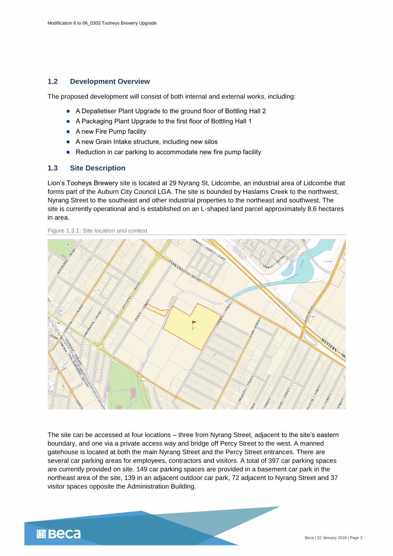
Lion’s Tooheys Brewery site is located at 29 Nyrang St, Lidcombe, an industrial area of Lidcombe that
forms part of the Auburn City Council LGA. The site is bounded by Haslams Creek to the northwest,
Nyrang Street to the southeast and other industrial properties to the northeast and southwest. The
site is currently operational and is established on an L-shaped land parcel approximately 8.6 hectares
in area.
Figure 1.3.1: Site location and context
The site can be accessed at four locations – three from Nyrang Street, adjacent to the site’s eastern
boundary, and one via a private access way and bridge off Percy Street to the west. A manned
gatehouse is located at both the main Nyrang Street and the Percy Street entrances. There are
several car parking areas for employees, contractors and visitors. A total of 397 car parking spaces
are currently provided on site. 149 car parking spaces are provided in a basement car park in the
northeast area of the site, 139 in an adjacent outdoor car park, 72 adjacent to Nyrang Street and 37
visitor spaces opposite the Administration Building.

Modification 6 to 06_0303 Tooheys Brewery Upgrade
Beca | 22 January 2016 | Page 3
The majority of the site is occupied by either buildings or impervious areas, such as sealed car
parking, internal roads and hard stand areas. Packaging and processing facilities and large car
parking areas are located in the north eastern portion of the site. A large warehouse and loading
areas are located in the south eastern corner of the site. The brewhouse, several storage tanks and
silos, site utilities and other associated infrastructure, are located in the south western area of the site.
Isolated areas of vegetation are located across the site, predominantly along the north eastern and
Haslams Creek perimeters of the site with other scattered landscaping within or adjacent to car
parking areas and access ways.
A summary of site particulars is provided in Table 1.3.1.
Table 1.3.1: Site particulars
Applicant Lion Beer, Spirits & Wine Australia
Property Address 29 Nyrang Street, Lidcombe NSW 2141
LGA Auburn City Council
Lot and DP Part Lot 10, DP 1008367
Site Area 8.6ha
Zoning General Industrial - IN1 (Auburn Local Environment Plan 2010)
1.4 Surrounding Land Use
The site lies at the easterly end of the industrial area, with its largest frontage along Nyrang Street.
The site is generally surrounded by industrial, residential, commercial and recreational land uses.
Immediately to the west of the site is Haslams Creek and the continuation of the industrial area. The
majority of premises in this area reflect late 20th century large industrial buildings set back from the
street edge.
Haslams Creek takes the form of a concrete-lined canal where it is adjacent to the brewery site.
Northeast of the industrial area, the creek passes through a wetland area, before discharging to
Homebush Bay.
Redevelopment in the immediate area has been concentrated to the north of the site along
Parramatta Road. Retail, entertainment and recreation facilities have been added to the industrial and
commercial streetscape.
The residential area to the east has a regular grid of streets of blocks containing detached residential
dwellings on large allotments from the post-war period. Also to the east, directly opposite the site, is a
large shopping complex with access off both Nyrang Street and Parramatta Road.
Additional industrial and residential land uses are observed south of the site, as well as a large
recreational facility comprising a basketball centre, oval and velodrome.
Table 1.4.1 summarises the surrounding land uses.

Modification 6 to 06_0303 Tooheys Brewery Upgrade
Beca | 22 January 2016 | Page 4
Table 1.4.1: Land use summary
North Industrial and commercial area with some retail, entertainment and recreation facilities
East Residential area with regular blocks containing detached dwellings on large allotments
South Industrial and residential uses (consistent with type and character of area) and recreational facility
West Haslams Creek and industrial properties
1.5 Existing Use of the Site
The site has been in operation since 1955 and was initially used as a packaging facility. Brewing
commenced at the site in 1978. The brewery has undergone several small scale upgrades during this
time, and a major upgrade in 2007.
The site is currently heavily utilised for the existing brewery activities and exhibits a large building
footprint comprising processing, packaging and administration facilities; access ways, walkways and
car parking; and ancillary uses such as tanks and silos, a waste water treatment plant and electricity
substation.
From 2007, a major upgrade of the site has been implemented. This has involved the extension of the
yeast storage area and yeast propagation plant; construction of a new Beer Processing Building and
relocation and upgrade of the associated beer processing equipment; installation of a new Bright Beer
Tank (BBT) Cellar and tanks, decommissioning of an old bright beer cellar; and upgrade of utility
services including the heating plant, refrigeration plant and compressed air plant.
In 2010, a 2MW co-generation facility was installed to reduce consumption of grid based electricity
and associated operational costs. In 2015, in order to improve the liquid wastewater quality, Lion
installed a wastewater treatment plant on site.
This ongoing enhancement of the site will be continued by the proposed development. Within the
scope of the proposed works, which are focused on improving operational efficiencies and safety, the
proposed upgrades remain highly consistent with the industrial zoning.
1.6 Site Constraints
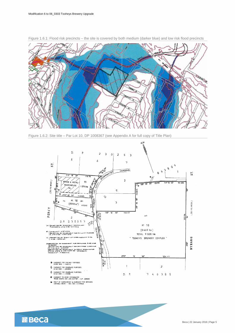
The site is covered by an Auburn Council commissioned flood study Haslams Creek Floodplain Risk
Management Study and Plan undertaken by Bewsher Consulting Pty Ltd in January 2003. The results
of the flood study indicate that some flooding is expected on the site in the 100 year Average
Recurrence Interval (ARI) flood event. As illustrated in Figure 1.6.1, for the 100 year ARI flood event
the western area of the site is classified as a medium flood risk precinct while the remainder is
classified as a low flood risk precinct (shown in a lighter blue). As such, planning controls relevant to
individual flood risk classifications must be appropriately addressed for works occurring in these
precincts.
There is one easement, for sewerage purposes, on the main area of the Tooheys site (see Figure
1.6.2 and Appendix A). Importantly, the proposed development will not build over any easements.
Modification 6 to 06_0303 Tooheys Brewery Upgrade
Beca | 22 January 2016 | Page 5
Figure 1.6.1: Flood risk precincts – the site is covered by both medium (darker blue) and low risk flood precincts
Figure 1.6.2: Site title – Par Lot 10, DP 1008367 (see Appendix A for full copy of Title Plan)

Modification 6 to 06_0303 Tooheys Brewery Upgrade
Beca | 22 January 2016 | Page 6
Legislative Framework 2
2.1 Environment and Planning Assessment Act
The Environment Planning and Assessment Act 1979 (EP&A Act) is administered by the NSW
Department of Planning and at the local government level. The objectives of the EP&A Act relevant to
the proposed development are considered to be:
The promotion and co-ordination of the orderly and economic use and development of land
Ecologically sustainable development
The protection of the environment
The proposed works are considered to satisfy the objectives of the Act in that continued operations at
the Lion facility will result in the efficient long term use of an existing site. The proposed increase in
operational efficiency on the site is not expected to result in any adverse environmental impacts upon
the immediate surrounding environment.
The proposed works are not considered to require any other approvals under Section 91 of the EP&A
Act, 1979.
2.2 Auburn Local Environmental Plan and Zoning
Pursuant to the Auburn Local Environment Plan (LEP) 2010, the site is zoned as IN1 – General
Industrial. The proposed development recognises the objectives of the IN1 zone:
To provide a wide range of industrial and warehouse land uses.
To encourage employment opportunities.
To minimise any adverse effect of industry on other land uses.
To support and protect industrial land for industrial uses.
To encourage economic growth of the locality.
To minimise adverse effects on the natural environment.
Figure 2.2.1: Site zoning

Modification 6 to 06_0303 Tooheys Brewery Upgrade
Beca | 22 January 2016 | Page 7
2.3 Auburn Development Control Plan
This EA will also address the Auburn Development Control Plan (DCP) 2010, particularly those
chapters and sections relevant to the proposed upgrade works. A summary of the relevant planning
controls and objectives of the Auburn DCP Industrial Areas section is provided in Table 3.2.1.
Table 2.3.1: Relevant planning controls and objectives of the Auburn DCP
Planning Control Objectives
2.0 Built Form
To ensure that the form, scale, design and nature of development maintains and enhances the streetscape and visual quality of industrial areas.
To ensure that the scale of any new industrial development is compatible with surrounding industrial buildings.
To ensure the intensity of development recognises the environmental constraints of the site and its locality.
3.0 Streetscape and Urban Character
To ensure that all new development is compatible with the existing and intended future character of the locality in which it is located.
To promote industrial development which is both functional and attractive in the context of its local environment through appropriate design.
To encourage innovative industrial design which adds to and enhances the quality of the existing industrial areas of the Auburn local government area whilst recognising the design attributes of traditional industrial development.
4.0 Landscaping
To improve the visual quality and amenity of industrial development
through effective landscape treatment of individual sites and to achieve a
pleasant working environment.
To ensure a high standard of environmental quality of individual sites
whilst enhancing the general streetscape and amenity of the area.
To ensure that the location and design of driveways, parking and servicing
areas are efficient, safe, convenient and suitably landscaped.
5.0 Access and Car Parking
To ensure that all car parking demands generated by any particular
industrial development are accommodated on the development site.
To ensure that the provision of off-street car parking facilities do not
detract from the visual character, particularly the streetscape of an
industrial area.
To ensure that road access facilities are commensurate with the scale and
extent of the proposed development and compatible with the surrounding
traffic network.
6.0 Stormwater Drainage
To preserve and protect the amenity and property of existing residents,
land owners and the community.
To ensure the safety of residents and the community.
To meet reasonable expectations and statutory requirements.
To protect the physical environment and receiving waters of catchments.
8.0 Operational Restrictions
To ensure that industrial development operates in a manner compatible
with adjoining land uses, particularly residential areas.
To ensure noise, air and water discharges, waste storage and removal,
working hours and storage of dangerous goods and hazardous chemicals
will not have a detrimental effect on environmental amenity.

Modification 6 to 06_0303 Tooheys Brewery Upgrade
Beca | 22 January 2016 | Page 8
Development Proposal 3
3.1 Development Objective
Modification 6 to the Tooheys Brewery Upgrade comprises development that aims to improve site
efficiencies and operational safety. As part of this modification, new plant is intended for Bottling Hall
1 and 2, new facilities are planned for grain intake and fire pump operations and a reduction in car
parking is proposed.
3.2 Development Description
Depalletiser and Packaging Plant Upgrade
The proposed upgrade of depalletiser and packaging plant will occur on the ground floor of Bottling
Hall 2 and the first floor of Bottling Hall 1, respectively. The purpose of this upgrade is to install new
plant and equipment to ensure compliance with industry safety standards and enhance operational
efficiencies.
The Depalletiser plant in Bottling Hall 2 will be either refurbished, rebuilt or replaced to improve
reliability, and most importantly ensure compliance with Lion and Australian standards for guarding
and machine safety. The packaging upgradesin Bottling Hall 1 will replace aged assets with more
reliable, efficient and flexible packaging equipment.
This upgrade will also involve internal, non-structural modifications and a fire safety upgrade to
comply with BCA standards. There will be no new environmental impacts at the site resulting from this
plant upgrade.
Fire Pump Facility
An upgrade of the existing fire pump infrastructure is required to comply with BCA fire safety
standards. A new 102m2 facility is proposed in the eastern area of the site, adjacent to the main entry
and Nyrang Street. As part of this upgrade, a new valve room inside the Nyrang Street Warehouse will
re-purpose the room currently housing existing fire pump equipment.
A reduction of car parking is required to accommodate the fire pump facility. Currently, there are 397
car parks available on site. The proposed reduction of 22 spaces will reduce the parking available
across the site to 375 total spaces, including visitor parking.
Grain Intake Structure
The proposed Grain Intake structure comprises a swivel screw structure and new buffer silo. The new
silo, reaching approximately 12 metres in height, will buffer grain above the ground and allow for the
fast unloading of trucks. The buffer silo will replace the current in-ground buffer and enhance the
quality of product being stored. The height of this structure will not exceed any other silos or
structures already located in this area.
The construction of the grain intake structure will involve the demolition of the existing grain intake
shed adjacent to the proposed new structure. Demolition of the shed will be completed in accordance
with Condition 10 of the original project approval (see Section 4.2).
3.3 Timing
Pending all necessary approvals, development works are due to commence April 2016, with
completion planned for October 2017.

Modification 6 to 06_0303 Tooheys Brewery Upgrade
Beca | 22 January 2016 | Page 9
3.4 Capital Expenditure
Capital expenditure for buildings and structures associated with this modification of the Tooheys
Building Upgrade is estimated at $300,000. This includes $150,000 for the grain intake structure and
$150,000 for the fire pump facility. Plant and equipment is not included as part of this buildings and
structures cost estimate.

Modification 6 to 06_0303 Tooheys Brewery Upgrade
Beca | 22 January 2016 | Page 10
Construction Management 4
4.1 Earthworks
Limited earthworks would be required for the construction of the proposed fire pump facility and grain
intake structure. All surplus excavated materials from earthworks will be removed from the site. If
necessary, an erosion and sedimentation control plan shall be implemented during construction to
minimise impact on the existing stormwater system. If these mitigation measures are required they will
be detailed in a Construction Management Plan.
4.2 Construction Waste Management
The construction contractor shall demonstrate a commitment to avoiding and minimising waste
generation. Waste will be reduced through the adoption of the EPA’s waste management hierarchy
which involves (in order of preference) avoidance, re-use, re-cycle, recovery of energy, treatment,
containment and disposal. Construction waste will not be allowed to accumulate and all areas will be
kept clean and tidy.
Demolition work, both internal and external, will be completed pursuant to Condition 10 of the original
project approval:
10. The Proponent shall ensure that all demolition work is carried out in accordance with
Australian Standard AS 2601-2001: The Demolition of Structures, or its latest version.
4.3 Dust
The management of dust is closely related to the management of earthworks, demolition and
construction waste. Additional dust control measures will also attempt to reduce the amount of dust
originating from construction activities. These include:
On-site wind direction and speed will be observed prior to commencing work, particularly
outdoors, so off-site impacts can be managed during unfavourable conditions
Vehicles transporting loose materials to and from the site will be adequately covered
4.4 Noise
Noise reduction measures will be developed throughout project planning and applied where
practicable. Examples of such measures are as follows:
Lowest noise work practices and equipment will be applied where practical
Trucks associated with the delivery of materials will not be left idling adjacent to residential
areas
Plant will be turned off when not in use
Work on the site will be carried out with a typical construction timetable
4.5 Traffic
It is anticipated that construction traffic will not significantly impact on traffic flow on the surrounding
road network. There are suitable lay-down areas available on site for loading and un-loading of
materials and equipment. Council will be notified of any temporary disruption to traffic on Nyrang
Street and other surrounding roads during construction and appropriate traffic management practices
will be implemented.

Modification 6 to 06_0303 Tooheys Brewery Upgrade
Beca | 22 January 2016 | Page 11
Operation Details 5
5.1 Site Capacity
The site is approved to produce 330 ML of beer each year. The proposed development will not
contribute to any increase in annual operational throughput.
5.2 Employees
There is no increase in employment anticipated as a direct result of the proposed development.
Current employee numbers will remain the same, which comprises 50 administration staff, 100 shift
workers and approximately 150 contractors (critical case - varies throughout the year) spread across
operational shifts.
5.3 Operating Hours
The approved operating hours for the site is 24 hours a day, 7 days a week. In low periods, the
Tooheys Brewery operates 5 days per week, while in peak periods this is extended to up to 7 days
per week. There are 3 shifts across the 24 hours per day operation:
Shift 1 - 6am to 2pm
Shift 2 - 2pm to 10pm
Shift 3 - 10pm to 6am
Office staff and visitors are expected on site between 8am and 6pm.
5.4 Traffic Flow
There are three all-movement priority controlled accesses to the site from Nyrang Street. The central
access is the main site access. This access is used by freight vehicles only. The second, northern
access is used by employees and contractors parking in the main basement car parking area. Visitors
also access the site at this location. The third, southern access is another secondary access and is
used to access the southern area of the site.
The site can also be accessed via a private access way and bridge off Percy Street. A manned
gatehouse is located at this Percy Street entrance, used almost exclusively by large trucks that pick
up and drop off goods at the site.
An internal road network facilitates appropriate flow of traffic throughout the site. Circulation of traffic
within the site will not change post-development.

Modification 6 to 06_0303 Tooheys Brewery Upgrade
Beca | 22 January 2016 | Page 12
Environmental Assessment 6
6.1 Access and Traffic
Vehicles accessing the site include B-Doubles, semitrailers and rigid trucks, as well as staff, visitor
and contractor light vehicles. Heavy vehicles currently access and exit the site via the main gate on
Nyrang Street, or via the southern entrance on Nyrang Street or the secure entrance and private
bridge off Percy Street. A secondary entrance for light vehicles is also available just north of the main
entrance on Nyrang Street.
The Nyrang Street entrances interface with residential dwellings, whereas Percy Street is entirely
within the industrial estate. The main Nyrang Street entrance is considered to have the greatest
impact on the surrounding residential environment.
There is no increase in employee numbers anticipated as a direct result of the proposed
development. Therefore, the number of staff, visitor and contractor vehicles accessing the site will not
change. In addition, no change in throughput is planned or expected. As such, no increase in truck
movements is expected to and from the site post development.
A 102m2 fire pump facility is considered additional industrial floor area. Based on Roads and Traffic
Authority (RTA) Guide to Traffic Generating Developments (October 2002), in conjunction with the
Guide to Traffic Generating Developments Updated Traffic Surveys (August 2013), this development
would produce an additional 5 vehicle (car and truck) movements per day and an additional 1
movement in the morning and evening peak periods. But since this facility will house fire safety
equipment and infrastructure only, no regular vehicle movements are expected as a result of this
development.
A Traffic Impact Assessment (dated 15 January 2016), prepared as part of this Environmental
Assessment and included as Appendix C, concludes that vehicle movements to and from the site will
remain similar to existing and the effective and efficient operation of the existing site access
arrangement and the adjacent road network will be unaltered. As such, there will be no long-term
adverse effect on the existing road network in terms of additional traffic generation.
6.2 Car Parking
The proposed development requires a reduction in car parking across the site. Of the existing 397 car
parking spaces provided on the site, a reduction of 22 spaces to accommodate the fire pump facility in
the eastern car park area (adjacent to Nyrang Street) is proposed. Following the proposed
development, 375 car spaces would be provided on site.
The proposed development is not considered to result in any additional car parking or loading
demands that are not already experienced by the site. A Car Parking Demand Study completed as
part of the site Traffic Impact Assessment demonstrates that car parking demand will be adequately
accommodated post development (see Figure 6.2.1).
The Car Parking Demand Study predicts site car parking usage, at the peak time, to be 73.6 % of the
total post development capacity. This prediction follows a conservative approach and does not
consider any likely car-pooling, mode sharing (eg. public transport) and increased efficiencies in
automation and processing that may reduce the amount of light vehicles required on-site. It also
assumes full overlap of car park demand at shift change times. The study concludes that the
proposed reduction in car parking spaces will not affect the site’s ability to meet future
parking demand of its staff, contractors and visitors.

Modification 6 to 06_0303 Tooheys Brewery Upgrade
Beca | 22 January 2016 | Page 13
Figure 6.2.1: Car parking capacity versus demand
6.3 Fire Safety
A significant fire safety upgrade would be completed as part of the proposed development. Alongside
the planned fire pump facility that will service the entire site, new fire fighting equipment and
infrastructure would also be installed in the first floor of Bottling Hall 1 and the ground floor of Bottling
Hall 2. Details of the proposed fire safety upgrade are outlined below.
Fire Pump Facility
A new fire pump facility adjacent to Nyrang Street
The former fire pump room in the Nyrang Street Warehouse will be re-purposed to house a
new valve set
A new mains pipe will connect new fire pumps to the valve set
Bottling Hall 1
A dry fire protection upgrade for the first floor
A hydrant and hosereel system upgrade for the first floor
Bottling Hall 2
A hydrant and hosereel system upgrade for the ground floor
A dry fire protection upgrade for the ground floor
A sprinkler system will be installed on the ground floor
6.4 Stormwater Management and Drainage
Stormwater run-off from the roof of the new fire pump facility will be connected to the site’s existing
stormwater management system. Existing stormwater infrastructure has capacity to accommodate
this additional connection.
Site drainage will not be modified or impeded. Flood management considerations are further
discussed in the following Section 6.5.

Modification 6 to 06_0303 Tooheys Brewery Upgrade
Beca | 22 January 2016 | Page 14
6.5 Flood Risk
The Tooheys Brewery site is situated within the Haslams Creek Catchment, which ultimately drains
into Homebush Bay. Haslams Creek has been canalised where it is adjacent to the site. Given the
proximity of the Tooheys Brewery site to the adjacent creek, it is likely that the site will be affected by
flooding at some point in the future.
The site is bounded by Haslams Creek to the northwest of the site, which is in close proximity to the
site on both the northwest and northeast sides of the site. The St Hilliers Road Branch channel
connects into Haslams Creek near the west corner of the Tooheys Brewery site. This channel
influences flooding on the site.
The site is covered by an Auburn Council commissioned flood study Haslams Creek Floodplain Risk
Management Study and Plan undertaken by Bewsher Consulting Pty Ltd in January 2003. Pursuant
to Schedule 2, Item 27 of the Tooheys Brewery Upgrade Project Approval Conditions, the proponent
shall ensure that all buildings constructed are above the 1 in 100 year flood level of Haslams Creek.
The construction of buildings must also consider Part 6 – Flood Risk Management of the Auburn DCP
Stormwater Drainage chapter. In particular, design of new structures must address planning
considerations detailed in Table 5 of this section of the DCP (see Table 6.5.1).
Table 6.5.1: Planning considerations of flood risk precincts in the Haslams Creek floodplain (Table 5)
As determined in the Tooheys Brewery Flood Risk Assessment (dated 7 May 2012), in the vicinity of
the site the study predicts a 100 year ARI flood event peak level of 6.9 mAHD, and recommends a
Flood Planning Level (FPL) of 7.4mAHD, which includes a 0.5 m allowance for freeboard.
The grain intake structure is the only element of the proposed development located within the medium
flood risk precinct. Based on Table 6.5.1, the following design considerations are relevant to
structures located in this precinct (note that the structure is not considered a habitable structure):
All structures to have flood compatible building components below or at the 100 year ARI
flood level

Modification 6 to 06_0303 Tooheys Brewery Upgrade
Beca | 22 January 2016 | Page 15
Applicant to demonstrate that any structure can withstand the forces of floodwater, debris
and buoyancy up to and including a 100 year flood
The impact of the development on flooding elsewhere is to be considered
Applicant to demonstrate that area is available to store goods above the 100 year flood plus
0.5m (freeboard)
No external storage of materials below the design floor level which may cause pollution or
be potentially hazardous during any flood
Although detailed design of the proposed grain intake structure and associated silo has not been
finalised, the design team is aware of the risk of flood and the structure will be compliant with all
relevant flood design considerations listed above.
6.6 Noise
The Tooheys Brewery currently operates under noise criteria set out under Condition 15 of the
original Tooheys Brewery Upgrade project approval (06_0303). As part of Modification 4 to this
approval, the Acoustic Criteria for the site was modified and Condition 15 has been updated (see
Figure 6.6.1).
Figure 6.6.1: Updated noise criteria for the Lion Tooheys site (Condition 15 of project approval)
Of the works comprising this proposed development, the planned fire pump facility, located adjacent
to the main entrance and Nyrang Street, is the only aspect of the proposed development to have
potential noise impacts. The fire pump facility will be constructed of rendered concrete blocks. If
required, the facility will receive additional acoustic treatment to ensure that its operating noise will
remain below those noise limits outlined in Condition 15.
To achieve an operating noise that is compliant with specifications of Condition 15, mitigation
measures will be applied to the fire pump facility, which will be of industry standard and drawn from
Chapter 7 of the NSW Industrial Noise Policy (EPA NSW, 2000).

Modification 6 to 06_0303 Tooheys Brewery Upgrade
Beca | 22 January 2016 | Page 16
6.7 Visual Amenity and Privacy
The proposed buildings and works comprise limited external development that will have potential for
visual impact. There will be no impact on the privacy of neighbouring properties.
Depalletiser and packaging plant upgrade will require internal modifications only to Bottling Hall 1 and
2. The proposed fire pump facility is partially visible from off-site locations, while the grain intake
structure is only visible from within in the site.
Much of the site’s eastern boundary is lined with well-established trees. This is the case in the area
where the proposed fire pump facility would be located. These trees will provide significant natural
screening of the proposed structure, which will be dwarfed by existing surrounding buildings and
finished to blend with its surrounds.
The grain intake structure would be located in the western area of the site, close to Haslams Creek
and the private access bridge. Similar infrastructure already exists in this area, which is contained well
within the site. The proposed silo will be constructed of steel plate and finished with two pack
polyurethane to match similar structures already existing in the immediate surrounding area. Other
components of the structure will be constructed of galvanised steel. This will reduce the visual impact
of the new structure, which is expected to be unnoticed by those located off the Tooheys site.
6.8 Bulk and Scale
As part of this modification, two new external structures are proposed. The design of both the grain
intake structure and fire pump facility responds to relevant design objectives outlined in the Auburn
DCP (2.0 Built Form) and listed below:
To ensure that the form, scale, design and nature of development maintains and enhances
the streetscape and visual quality of industrial areas.
To ensure that the scale of any new industrial development is compatible with surrounding
industrial buildings.
To ensure the intensity of development recognises the environmental constraints of the site
and its locality.
Grain Intake Structure
The grain intake structure comprises a swivel screw, silo and bucket elevator. The silo, which will be
the tallest part of the total structure, will reach 12 metres high. Considering the large scale and nature
of well-established structures and buildings already present on the site, the addition of the grain intake
structure is expected to be compatible with surrounding industrial buildings.
Fire Pump Facility
The fire pump room will be a single, flat-roofed rectangular building measuring 15 by 7 metres. This is
considered small in scale compared to other buildings located in this area of the site, and is
comparable in size to the gatehouse located at the adjacent main entrance. To achieve fire safety
compliance and reduce noise impacts, the walls of the facility will be constructed using large concrete
blocks. These will be finished with render and coloured to blend with adjacent buildings, namely the
façade of the packed stock warehouse.

Modification 6 to 06_0303 Tooheys Brewery Upgrade
Beca | 22 January 2016 | Page 17
Figure 6.8.1: Elevation of proposed grain intake structure (for full elevation see Appendix B)
Figure 6.8.2: Elevation of proposed fire pump facility (for full elevation see Appendix B)

Modification 6 to 06_0303 Tooheys Brewery Upgrade
Beca | 22 January 2016 | Page 18
6.9 Soil and Water
Environmental impacts to soil and water are not expected as a result of proposed works at the
Tooheys site. The site will continue to operate with respect to its EPA License and future
manufacturing processes are not expected to introduce contamination issues at the site.
6.10 Heritage and Flora and Fauna
The site does not contain any specific flora and fauna requirements and no heritage items exist on the
site. The site does comprise some established vegetation, particularly along sections of its boundaries
and scattered throughout the site. No vegetation removal or modification of existing landscaped areas
is required as part of the proposed works.
6.11 Waste Management
Waste will be managed during construction and operation in accordance with Condition 38 and 39 of
the original Tooheys Brewery Upgrade project approval.
Demolition of an existing shed adjacent to the grain intake structure Demolition required for the
proposed internal modifications of Bottling Hall 1 and 2 will generate additional waste during
construction. The approach to managing this waste has been outlined in Section 4.2.
6.12 Social and Economic Effects
The proposed development works at the Lion Tooheys site reaffirms its presence in the national
market. The upgrading of plant equipment and site infrastructure represents a significant investment
in the area and will improve the safety and efficiency of existing manufacturing processes. This will
support Lion in continuing to provide positive social and economic effects to the local and wider
community.

Modification 6 to 06_0303 Tooheys Brewery Upgrade
Beca | 22 January 2016 | Page 19
Legislative Response 7
The proposed development will demonstrate an appropriate response to all relevant legislation
outlined in the Auburn Development Control Plan (DCP) 2010 introduced in Section 2.3.
Table 6.5.1: Planning responses of proposed development to relevant chapters and sections of the Auburn DCP
Planning Control Response
2.0 Built Form
Considering the large scale and nature of well-established structures and buildings already present on the site, the addition of new structures is expected to be compatible with surrounding industrial buildings.
The proposed new development has recognised potential flooding constraints of the site and will address these through design of appropriate structures.
3.0 Streetscape and Urban Character
All proposed new development is appropriately designed to remain compatible with existing site buildings and the character of the industrial area within it sits.
4.0 Landscaping
All new buildings will be constructed on existing hard stand areas and,
importantly, no vegetation removal or modification of existing landscaped
areas is required as part of these proposed works. No new landscaping is
planned as part of the proposed external development.
5.0 Access and Car Parking
The Car Parking Demand Study supports that the proposed reduction in
car parking spaces will not affect the site’s ability to meet parking demand
of its staff, contractors and visitors.
The TIA prepared predicts that there will be no adverse effect on the
existing road network in terms of additional traffic generation.
6.0 Stormwater Drainage
(including Flood Risk
Management)
Stormwater run-off from the roof of the new fire pump facility will be
connected to the site’s existing stormwater management system. Existing
stormwater infrastructure has capacity to accommodate this additional
connection. Site drainage will not be modified or impeded.
Flood risk will continue to be managed across the site. The proposed
grain intake structure will be the only structure of the proposed
development located within a medium flood risk precinct. Its design will
comply with planning considerations detailed in Part 6 – Flood Risk
Management of the Auburn DCP Stormwater Drainage chapter, Table 5.
8.0 Operational Restrictions
There will be no change to the way in which the site currently operates.
All potential environmental impacts resulting from the operation of the
proposed development, namely noise, visual impact and stormwater
discharge, will be appropriately mitigated and managed.

Modification 6 to 06_0303 Tooheys Brewery Upgrade
Beca | 22 January 2016 | Page 20
Summary 8
The proposed development incorporates internal depalletiser and packaging plant upgrades, a grain
intake structure and fire pump facility. As part of these works a reduction in car parking will also occur.
This Environmental Assessment has dutifully considered the potential impact of the proposed
development on the surrounding environment and establishes that:
There will be no long-term adverse effect on the existing road network in terms of additional
traffic generation
The proposed reduction in car parking spaces will not affect the site’s ability to meet future
parking demand of its staff, contractors and visitors
The proposed fire pump facility and other associated upgrades will improve fire safety on the
site
Additional stormwater infrastructure associated with the proposed works, namely the new
fire pump facility, will be connected to the existing on-site stormwater management system
The proposed grain intake structure will be compliant with all relevant flood design
considerations specific to medium flood risk precincts
The fire pump facility will implement appropriate mitigation measures to achieve an
operating noise that is compliant with specified noise requirements
Existing vegetation and adjacent buildings will provide appropriate screening that will reduce
the impact on visual amenity of the fire pump facility and grain intake structure
Environmental impacts to soil and water are not expected as a result of the proposed works
The site does not contain any specific flora and fauna requirements and no heritage items
exist on the site
Waste will be managed during construction and operation in accordance with Condition 38
and 39 of the original Tooheys Brewery Upgrade project approval
The proposed development will suitably respond to relevant legislation outlined in the
Auburn Development Control Plan (DCP) 2010
In summary, the proposed development will avoid significant environmental impacts and, where
necessary, will provide suitable mitigation to appropriately attenuate any adverse effects. The
proposed development will support Lion in continuing to provide positive social and economic effects
to the local and wider community.
Based on the limited impact of the proposed development on the environment and community, and
the appropriate respect to relevant legislation, we request that the Department of Planning and
Environment look favourably upon this modification application.

Modification 6 to 06_0303 Tooheys Brewery Upgrade
Appendix A – Title Plan


Modification 6 to 06_0303 Tooheys Brewery Upgrade
Appendix B – Plans and Elevations

N Y R A N G S T R E E T
EXISTING TREE
EXISTING TREE
NEW PUMPHOUSE
APPR
OX. 3
.2m
EXISITNG SECURITY FENCE
GORE
ENST
REET
HAST
INGS
STRE
ET
EXISTING DRIVE WAYEXIT
EXISTING DRIVE WAYENTRY
EXISTING SPRINKLER/
HYDRANT BOOSTER
PROPOSED WORK AREA - C
PROPOSED WORK AREA - B
PROPOSED WORK AREA - A
FRAM
PTON
STRE
ET
SITE BOUNDARY
EXISTING METAL FENCE
AREA WITH PROPOSEDWORK ON SITEEXISTING TREE TOREMAIN
PROPOSED WORK AREA A - DEPALLETISER PLANT UPGRADE:EQUIPMENT UPGRADE WITHIN EXISTING BOTTLING HALL 2, GROUND FLOORLEVEL.INTERNAL WORKS ONLY, NO BUILDING WORKS PROPOSED.
PROPOSED WORK AREA B - PACKAGING PLANT UPGRADEEQUIPMENT UPGRADE WITHIN EXISTING BOTTLING HALL 1, 1ST FLOORLEVELINTERNAL WORKS ONLY, NO BUILDING WORKS PROPOSED
PROPOSED WORK AREA C - FIRE PUMP FACILITY:NEW FIRE PUMP HOUSE AOPPROX. 85 m2 (5m X 17m) 2 HR FIRE RATEDENCLOSURE (WALLS AND ROOF) .REFER TO TRAFFICE REPORT FOR REMOVAL OF EXISTING ON SITEPARKING SPACESBUILDING MATERIALS: RENDERED CONCRETE BLOCK WITH PAINT FINISH.METAL SHEET ROOF AND PARAPET CLADDING, SIMILAR TO EXISTINGBUILDING ON SITE.
PROPOSED WORK AREA D - GRAIN INTAKE STRUCTURE:DEMOLISH EXISTING GRAIN INTAKE AWNING STRUCTURE (SHOWN DOTTED).NEW GRAIN INTAKE SILO AND EQUIPMENT, DETAILS REFER TOENVIRONMENTAL ASSESSMENT
1-
GROUND FLOOR - FRONT ENTRANCE1:250
DO NOT SCALE
Drawing No.
Discipline
Title:
Project:
IF IN DOUBT ASK.
Docu
ment
No.
Rev.
By
* Refer to Revision 1 for Original Signature
Client:
Dwg Check
Drawing Originator:
Scale (A3)
Revision
Dsg Verifier
Scale (A1)
Reduced
Drawn
Original
No.
Design
Date
Approved ForConstruction*
AppdChk Date
Drawing Plotted: 22 Jan 2016 3:08 PM
2574
004-
AA-K
0500
SIT
E.DW
G
NOT FOR CONSTRUCTION
PRELIMINARY
FOR INFORMATION
NOT FOR CONSTRUCTION
2574004-AA-K0500 A
SITE PLANGROUND FLOOR
1 OFF 2
ARCHITECTURAL
TOOHEYS BREWERYUPGRADE
LIDCOMBE NSW
1:250
1:500
M.WARNE 27.10.15TW.WANG 27.10.15- -
- -
A ISSUE FOR DA, MOD 6 TW MW JG 2016/01/15
LEGEND
PROPOSED SCOPE OF WORKS

PROPOSED WORK AREA - D
EXISTING METAL FENCE
AREA WITH PROPOSEDWORK ON SITE
EXISTING TREE TOREMAIN
PROPOSED WORK AREA A - DEPALLETISER PLANT UPGRADE:EQUIPMENT UPGRADE WITHIN EXISTING BOTTLING HALL 2, GROUND FLOORLEVEL.INTERNAL WORKS ONLY, NO BUILDING WORKS PROPOSED.
PROPOSED WORK AREA B - PACKAGING PLANT UPGRADEEQUIPMENT UPGRADE WITHIN EXISTING BOTTLING HALL 1, 1ST FLOORLEVELINTERNAL WORKS ONLY, NO BUILDING WORKS PROPOSED
PROPOSED WORK AREA C - FIRE PUMP FACILITY:NEW FIRE PUMP HOUSE AOPPROX. 85 m2 (5m X 17m) 2 HR FIRE RATEDENCLOSURE (WALLS AND ROOF) .REFER TO TRAFFICE REPORT FOR REMOVAL OF EXISTING ON SITEPARKING SPACESBUILDING MATERIALS: RENDERED CONCRETE BLOCK WITH PAINT FINISH.METAL SHEET ROOF AND PARAPET CLADDING, SIMILAR TO EXISTINGBUILDING ON SITE.
PROPOSED WORK AREA D - GRAIN INTAKE STRUCTURE:DEMOLISH EXISTING GRAIN INTAKE AWNING STRUCTURE (SHOWN DOTTED).NEW GRAIN INTAKE SILO AND EQUIPMENT, DETAILS REFER TOENVIRONMENTAL ASSESSMENT
1-
GROUND FLOOR - FRONT ENTRANCE1:250
DO NOT SCALE
Drawing No.
Discipline
Title:
Project:
IF IN DOUBT ASK.
Docu
men
t No.
Rev.
By
* Refer to Revision 1 for Original Signature
Client:
Dwg Check
Drawing Originator:
Scale (A3)
Revision
Dsg Verifier
Scale (A1)
Reduced
Drawn
Original
No.
Design
Date
Approved ForConstruction*
AppdChk Date
Drawing Plotted: 22 Jan 2016 3:06 PM
2574
004-
AA-K
0500
SIT
E.DW
G
NOT FOR CONSTRUCTIONPRELIMINARY
FOR INFORMATIONNOT FOR CONSTRUCTION
2574004-AA-K0501 A
SITE PLANGROUND FLOOR
2 OFF 2
ARCHITECTURAL
TOOHEYS BREWERYUPGRADE
LIDCOMBE NSW
1:250
1:500
TW.WANG 21.12.15TW.WANG 21.12.15M.WARNE 15.01.16S.CLOES 15.01.16
A ISSUE FOR DA, MOD 6 TWW MW JG 20160115
PROPOSED SCOPE OF WORKS
LEGEND

EXISTING SECURITY GATE HOUSE EXISTING LINK BUILDINGEXISTING DRIVE WAYEXISTING PARKING
EXISTING SECURITY FENCE SHOWN DOTTED
EXISTING LANDSCAPE , WATER METERING AND FIRE HYDRANT SYSTEMNEW PUMP HOUSE
EXISTING LOW HEIGHT BRICK WALL BEHIND FENCE
COLORBOND CLADDING TOPARAPET COLOUR CLASSIC CREAM
RENDERED CONCRETE BLOCKWALL 2HR FIRE RATED. DULUXCOLOUR SPECIFIER CURD P13.F1
EXISTING LOW HEIGHT BRICK WALL FOR WATER METER SYSTEM
1-
NYRANG STREET - FRONT ENTRANCE ELEVATION1:100
DO NOT SCALE
Drawing No.
Discipline
Title:
Project:
IF IN DOUBT ASK.
Docu
ment
No.
Rev.
By
* Refer to Revision 1 for Original Signature
Client:
Dwg Check
Drawing Originator:
Scale (A3)
Revision
Dsg Verifier
Scale (A1)
Reduced
Drawn
Original
No.
Design
Date
Approved ForConstruction*
AppdChk Date
Drawing Plotted: 15 Jan 2016 12:44 PM
2574
004-
AA-K
5000
ELE
VATI
ON.D
WG
NOT FOR CONSTRUCTION
PRELIMINARY
FOR INFORMATION
NOT FOR CONSTRUCTION
2574004-AA-K5100 A
NYRANG STREET ELEVATIONEXISTING BUILDINGS &
NEW PUMP ROOM
ARCHITECTURAL
TOOHEYS BREWERYUPGRADE
LIDCOMBE NSW
1:100
1:200
TW.WANG 21.12.15TW.WANG 21.12.15MW 15.01.16SCC 15.01.16
A ISSUE FOR DA, MOD 6 TWW MW JG 20160115
NOTE:NEW BUILDING WORKS OTHER THAN CODECOMPLIANCE NOT SHOWN


Modification 6 to 06_0303 Tooheys Brewery Upgrade
Appendix C – Traffic Impact Assessment

Traffic Impact Assessment Report
Tooheys Brewery Upgrade Depalletiser and Packaging Plant, Grain Intake and Fire Pump Upgrade
Prepared for Lion
By Beca Pty Ltd (Beca)
22 January 2016
Lion Tooheys’ Nyrang Street Site Development Upgrade (Modification 6) – Traffic Impact Assessment
Beca // 22 January 2016 2574004 // 0.13 // i
Revision History Revision Nº Prepared By Description Date
1 Aidan Cleary Final Report 15/01/2016
2 Aidan Cleary Final Report (Revised Site Arrangement) 22/01/2016
Document Acceptance Action Name Signed Date
Prepared by Aidan Cleary
22/01/2016
Reviewed by Craig Richards
22/01/2016
Approved by Jason Goodman
22/01/2016
on behalf of Beca Ltd
© Beca 2015 (unless Beca has expressly agreed otherwise with the Client in writing).
This report has been prepared by Beca on the specific instructions of our Client. It is solely for our Client’s use for the purpose for which it is intended in accordance with the agreed scope of work. Any use or reliance by any person contrary to the above, to which Beca has not given its prior written consent, is at that person's own risk.

Lion Tooheys’ Nyrang Street Site Development Upgrade (Modification 6) – Traffic Impact Assessment
Beca // 22 January 2016 2574004 // 0.13 // ii
Contents
1 Introduction 1 1.1 Background 1 1.2 Report Structure 1
2 Transport Environment 3 2.1 Surrounding Land Use 3 2.2 Road Network and Site Access 5 2.3 Parking and Loading 6 2.4 Traffic Volumes 7 2.5 Public Transport 7 2.6 Road Safety Record 8
3 Development Proposals 10 3.1 Overview 10 3.2 Access Arrangements 10 3.3 Traffic Generation 10 3.4 Parking Requirements 11
4 Assessment of Effects and Mitigation 14 4.1 Traffic Effects 14 4.2 Road Safety Effects 14 4.3 Parking Effects 14 4.4 Loading Effects 15 4.5 Recommended Mitigation 15
5 Summary and Conclusions 16
Appendices
Appendix A Site Plans
Appendix B Public Transport Plans

Lion Tooheys’ Nyrang Street Site Development Upgrade (Modification 6) – Traffic Impact Assessment
Beca // 22 January 2016 2574004 // 0.13 // 1
1 Introduction
1.1 Background Beca Pty Ltd (Beca) has been commissioned by Lion to prepare a Traffic Impact Assessment (TIA) report for a proposed development at 29 Nyrang Street, Lidcombe. The proposed developments are within the existing manufacturing facility at this location and are part of Lion’s wider and on-going development and investment initiative for the site.
New development at the site is proposed to improve site efficiencies and operational safety. This proposed development includes internal modifications and new plant for Bottling Hall 1 and 2, new facilities for grain intake and fire pump operations and a reduction in car parking.
The site is currently operational and is situated within the Lidcombe suburb in Western Sydney. It is accessed by Nyrang Street and Percy Street. Nyrang Street runs in a generally north-south direction through the area and provides access to the east of the site. Percy Street also runs in a generally north-south direction through the area and provides access to the west of the site.
The location of the site is shown indicatively in Figure 1-1. An overview of the proposed development works is provided in Appendix A.
Figure 1-1: Site Location
1.2 Report Structure This TIA has been prepared to satisfy the requirements of the Development Application (Jan 2016) currently under preparation by Beca on behalf of Lion. A TIA is required to address the external vehicle movements and parking at the site, which can satisfy the requirements of the project stakeholders. The TIA is structured as follows:

Lion Tooheys’ Nyrang Street Site Development Upgrade (Modification 6) – Traffic Impact Assessment
Beca // 22 January 2016 2574004 // 0.13 // 2
n Section 2: Transport Environment – Reviews and describes the surrounding land use and road network including current access
arrangements, and – Summarises existing traffic volumes and crash records for the study area.
n Section 3: Development Proposals
– Provides an overview of the proposed development including new access arrangements, parking and loading configurations, plus predicted traffic generation, distribution and assignment.
n Section 4: Assessment of Effects and Mitigation – Assesses traffic and parking effects, and – Reviews the predicted effects of traffic movements on the existing road network and provides
recommendations for mitigating any predicted adverse effects. This includes assessment of the parking requirements against the Auburn Council Auburn Development Control Plans 2010, Car Parking and Loading.
n Section 5: Summary and Conclusion – Summarises the key findings of the report, including mitigation measures, and identifies conclusions.

Lion Tooheys’ Nyrang Street Site Development Upgrade (Modification 6) – Traffic Impact Assessment
Beca // 22 January 2016 2574004 // 0.13 // 3
2 Transport Environment
2.1 Surrounding Land Use The existing site is located in Lidcombe, NSW. It is bordered to the east by Nyrang Street and the west by Percy Street. Both Percy Street and Nyrang Street are undivided two lane urban carriageways which run in a general north-south direction. The main access to the site is from Nyrang Street. The surrounding area is a mixture of industrial, residential and commercial land use as follows:
n Industrial – – The AirRoad Industrial unit is located immediately north of the site on Nyrang Road. See Figure 2-1,
and – The Acacia Transport unit is located immediately south of the site on Nyrang Road.
n Commercial – The Lidcombe Shopping Centre is located immediately opposite the north east corner of the existing
site and has a main access onto Nyrang Street. See Figure 2-2. n Residential
– Existing residential areas are located to the east of Nyrang Road for the majority of the Tooheys’ site.
Figure 2-1 Existing AirRoad industrial Access – Tooheys’ site is located to the left of the photo.

Lion Tooheys’ Nyrang Street Site Development Upgrade (Modification 6) – Traffic Impact Assessment
Beca // 22 January 2016 2574004 // 0.13 // 4
Figure 2-2 Existing Lidcombe Shopping Centre Access
Figure 2-3 Residential Areas to the right of the photo – Tooheys’ site is located to the left of the photo.
Lion Tooheys’ Nyrang Street Site Development Upgrade (Modification 6) – Traffic Impact Assessment
Beca // 22 January 2016 2574004 // 0.13 // 5
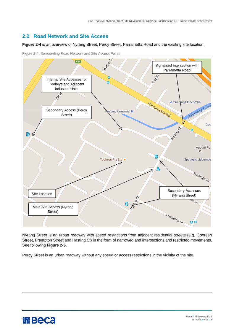
2.2 Road Network and Site Access Figure 2-4 is an overview of Nyrang Street, Percy Street, Parramatta Road and the existing site location.
Figure 2-4: Surrounding Road Network and Site Access Points
Nyrang Street is an urban roadway with speed restrictions from adjacent residential streets (e.g. Gooreen Street, Frampton Street and Hasting St) in the form of narrowed and intersections and restricted movements. See following Figure 2-5.
Percy Street is an urban roadway without any speed or access restrictions in the vicinity of the site.
Internal Site Accesses for Tooheys and Adjacent
Industrial Units
Secondary Access (Percy Street)
Site Location
Main Site Access (Nyrang Street)
Secondary Accesses (Nyrang Street)
Signalised Intersection with Parramatta Road

Lion Tooheys’ Nyrang Street Site Development Upgrade (Modification 6) – Traffic Impact Assessment
Beca // 22 January 2016 2574004 // 0.13 // 6
Figure 2-5: Local Residential Street Access to / from Nyrang Street
There are three all-movement priority controlled accesses to the site from Nyrang Street. One of the accesses (denoted Access A in Figure 2.4) is the main site access. This access is used by freight vehicles only. The second access (denoted Access B in Figure 2.4) is a secondary access and provides access to fright and private vehicles. Visitors access the site at this location. The third access (denoted Access C in Figure 2.4) is a secondary access and is used solely by freight traffic to access the south of the site.
There is one all-movement priority controlled accesses to the site from Percy Street (denoted Access D in Figure 2.4). This is a secondary access and is used by freight vehicles only.
All accesses are security controlled by manned booths, remote operated gates or manually operated gates.
2.3 Parking and Loading
2.3.1 Parking
Following the proposed development, 375 (reduced from 397) car spaces would be provided within the current landholding, as shown on mark-up of Drawing A0101-001-SHT1 Rev 3 within Appendix A.
A breakdown of the spaces and their use and allocations is as follows:
n 50 (reduced from 72) surface level spaces are available to the south east of the site and provide parking for office and plant employees. Access is from Nyrang Street
n 149 basement level spaces are available to the north of the site within Bottling Hall 1 and provide parking for plant employees. Access is provided from Nyrang Street.
n 139 surface level spaces are available to the north of Bottling Hall 1 and provide parking for plant employees. Access is provided from Nyrang Street.
n 17 surface level spaces are available in the north east corner of the site and provide parking for visitors. Access is provided from Nyrang Street.

Lion Tooheys’ Nyrang Street Site Development Upgrade (Modification 6) – Traffic Impact Assessment
Beca // 22 January 2016 2574004 // 0.13 // 7
n The remaining 20 spaces are located to the west of the existing Administration Building and provide parking for plant staff or visitors. Access is provided from Nyrang Street.
The existing parking provisions on Nyrang Street include parallel kerbside parking on both sides of the street with standard restrictions near accesses / driveways and local road intersections. A two hour restriction exists during Public Events associated with Sydney Olympic Park. It is noted within the Tooheys Brewery Wastewater Treatment Plant Environmental Assessment, 2011 that parking occupancy rates for these spaces was less than 50%. A site visit undertaken by Beca in Sept 2015 would suggest that this remains the case in the present time.
2.3.2 Loading
Loading and unloading of materials and finished goods is via the truck only accesses on Nyrang Street and Percy Street. All loading and unloading is undertaken within the site boundaries.
Figure 2-6 Main Site Access (from Nyrang Street)
2.4 Traffic Volumes As noted within Sections 3 and 4 of this report, there is a very minor increase in expected traffic volumes to and from the site as part of the proposed development (i.e. the addition of a pump house). As such Traffic Data has not been sought as part of this Traffic Impact Assessment report.
2.5 Public Transport The site is not directly serviced by Public Transport but bus and train services are located within the vicinity of the site. The available public transport provisions are as follows:
n Train Services – Lidcombe Train Station (1.8km to the south; 22 minute walk)

Lion Tooheys’ Nyrang Street Site Development Upgrade (Modification 6) – Traffic Impact Assessment
Beca // 22 January 2016 2574004 // 0.13 // 8
n Bus Services: – 401 service from Lidcombe Train Station travelling northwards to Homebush Bay (closest stop 1.3km,
15 minute walk on corner of Nicholas Street and Bombay Street), and – M92 service from Lidcombe Train Station travelling northwards to Parramatta Road and beyond
(closest stop 400m, 5 minute walk near 174 John Street).
Table 2-1 Public Transport Routes and Operations
Bus Route Number Route Frequency (AM/PM Peak)
401 Sydney Olympic Park to Lidcombe Station 20 minutes
M92 Sutherland to Paramatta Approx. 3 hours
The existing accesses to the site do not impact the operation of the buses in their current locations.
No information on the quantum of staff usage of the current public transport is available. It is expected to be low, given that shift change times are more often early in the morning (6am) and late in the evening (10pm), when service frequencies reduce or there are no services.
2.6 Road Safety Record Crash records for roads adjacent to the existing site have been obtained from the Transport for NSW Interactive Crash Statistics Website. Available data is limited to the period between 2009 and 2013. Details of the crash record are provided in Figure 2-6, which shows the location and number of crashes for the study period.
Figure 2-6: Crash Locations (from Transport for NSW Crash Statistics Website)
Site Location

Lion Tooheys’ Nyrang Street Site Development Upgrade (Modification 6) – Traffic Impact Assessment
Beca // 22 January 2016 2574004 // 0.13 // 9
A total of six crashes were reported for the period 2009 to 2013 within 200m of the existing site (refer Table 2-2). Four injury accidents were located at the intersection of Nyrang Street and Parramatta Road. The remainder were located on Nyrang Street to the south east of the site.
Table 2-2 Individual Crash Information (from Transport for NSW Crash Statistics Website)
Crash Location Year Number of Crashes
Number of Injuries
Severity
Nyrang St, adjacent Elimatta St
2012 1 1 Serious injury matched to a police
report
Nyrang/Frampton St Intersection
2012 1 1 Minor/Other Injury
Nyrang St/Parramatta Rd Intersection
2012 1 1 Serious injury matched to a police
report
Nyrang St/Parramatta Rd Intersection
2012 1 2 Serious injuries matched to a police
report
Nyrang St/Parramatta Rd Intersection
2011 1 1 Moderate injury matched to a police
report
Nyrang St/Parramatta Rd Intersection
2009 1 1 Moderate injury matched to a police
report
No details as to the cause of the crashes are available as part of the available statistical data. Also, information on the road users involved in the incident (e.g. drivers, pedestrians, cyclists, etc.) is not available.
However, it is known that no fatal crashes were recorded within the study area. It is not known whether any accidents involved road users associated with the existing development although site and anecdotal staff records suggest that there has been none.

Lion Tooheys’ Nyrang Street Site Development Upgrade (Modification 6) – Traffic Impact Assessment
Beca // 22 January 2016 2574004 // 0.13 // 10
3 Development Proposals
3.1 Overview The proposed development consists of amendments and additions to the existing facilities on the site, of which the following directly relates to traffic operation:
n A 102m2 Fire Pump building to be located within a portion of the existing 72 space parking provision adjacent to Nyrang Street. The building will contain apparatus and equipment for use by Fire Services during an emergency or fire event. Regular access will not be required and any access will be limited to maintenance or fire fighting services only;
n The removal of 22 existing car spaces to accommodate the fire pump building.
3.2 Access Arrangements The proposed development does not change the existing site access arrangements from Nyrang Street and Percy Street. Access and circulation within the site is unchanged.
3.3 Traffic Generation
3.3.1 Introduction
In assessing the traffic generation and distribution of the proposed development, this report has reviewed the requirements against:
n The requirements of the relevant Planning and Traffic Guidelines, and n The requirements developed from Lion’s Project Development and Investment Planning. These are assessed within Sections 3.3.2 and 3.3.3.
3.3.2 Predicted Traffic Generation – Planning and Traffic Guidelines
Changes to the traffic generation for the proposed development has been determined using the Roads and Traffic Authority (RTA) Guide to Traffic Generating Developments (October 2002), in conjunction with the Guide to Traffic Generating Developments Updated Traffic Surveys (August 2013), prepared by RMS.
In determining the theoretical changes to the daily and peak hour traffic volumes generated by the proposed development, the following assumptions have been made:
n The Gross Floor Area (GFA) of the proposed additional fire pump room is 102m2 n The development is classified as a Warehouse* as per RTA Guide (October 2002).
* The classification of the proposed building as a ‘Warehouse’ is the closest applicable classification within the Industrial Section of the RTA Guide. This classification assumes a regular access to and from the building during normal operation however, it is considered that any values in the RTA guide will be well in excess of that expected to be generated for the building.
Table 3-1 summarises the theoretical increase in traffic generated by the development under the RTA Guide and the associated RMS update.
Lion Tooheys’ Nyrang Street Site Development Upgrade (Modification 6) – Traffic Impact Assessment
Beca // 22 January 2016 2574004 // 0.13 // 11
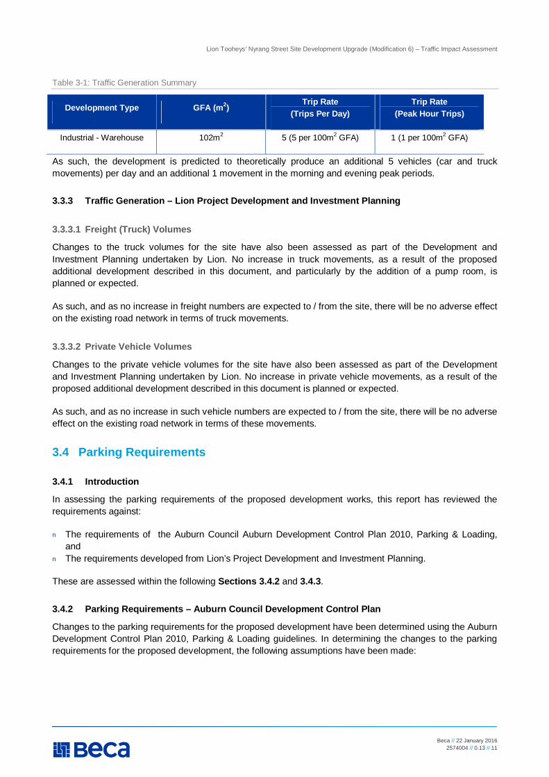
Table 3-1: Traffic Generation Summary
Development Type GFA (m2) Trip Rate (Trips Per Day)
Trip Rate (Peak Hour Trips)
Industrial - Warehouse 102m2 5 (5 per 100m2 GFA) 1 (1 per 100m2 GFA)
As such, the development is predicted to theoretically produce an additional 5 vehicles (car and truck movements) per day and an additional 1 movement in the morning and evening peak periods.
3.3.3 Traffic Generation – Lion Project Development and Investment Planning
3.3.3.1 Freight (Truck) Volumes
Changes to the truck volumes for the site have also been assessed as part of the Development and Investment Planning undertaken by Lion. No increase in truck movements, as a result of the proposed additional development described in this document, and particularly by the addition of a pump room, is planned or expected.
As such, and as no increase in freight numbers are expected to / from the site, there will be no adverse effect on the existing road network in terms of truck movements.
3.3.3.2 Private Vehicle Volumes
Changes to the private vehicle volumes for the site have also been assessed as part of the Development and Investment Planning undertaken by Lion. No increase in private vehicle movements, as a result of the proposed additional development described in this document is planned or expected.
As such, and as no increase in such vehicle numbers are expected to / from the site, there will be no adverse effect on the existing road network in terms of these movements.
3.4 Parking Requirements
3.4.1 Introduction
In assessing the parking requirements of the proposed development works, this report has reviewed the requirements against:
n The requirements of the Auburn Council Auburn Development Control Plan 2010, Parking & Loading, and
n The requirements developed from Lion’s Project Development and Investment Planning.
These are assessed within the following Sections 3.4.2 and 3.4.3.
3.4.2 Parking Requirements – Auburn Council Development Control Plan
Changes to the parking requirements for the proposed development have been determined using the Auburn Development Control Plan 2010, Parking & Loading guidelines. In determining the changes to the parking requirements for the proposed development, the following assumptions have been made:
Lion Tooheys’ Nyrang Street Site Development Upgrade (Modification 6) – Traffic Impact Assessment
Beca // 22 January 2016 2574004 // 0.13 // 12
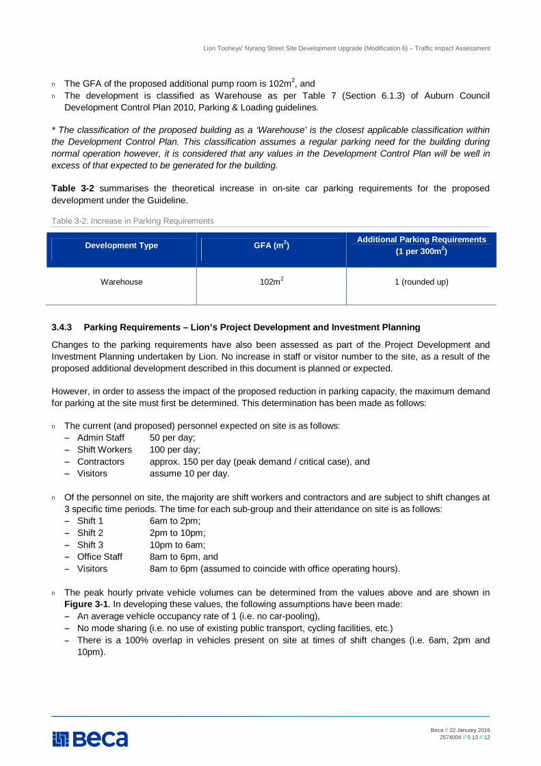
n The GFA of the proposed additional pump room is 102m2, and n The development is classified as Warehouse as per Table 7 (Section 6.1.3) of Auburn Council
Development Control Plan 2010, Parking & Loading guidelines.
* The classification of the proposed building as a ‘Warehouse’ is the closest applicable classification within the Development Control Plan. This classification assumes a regular parking need for the building during normal operation however, it is considered that any values in the Development Control Plan will be well in excess of that expected to be generated for the building.
Table 3-2 summarises the theoretical increase in on-site car parking requirements for the proposed development under the Guideline.
Table 3-2: Increase in Parking Requirements
Development Type GFA (m2) Additional Parking Requirements (1 per 300m2)
Warehouse 102m2 1 (rounded up)
3.4.3 Parking Requirements – Lion’s Project Development and Investment Planning
Changes to the parking requirements have also been assessed as part of the Project Development and Investment Planning undertaken by Lion. No increase in staff or visitor number to the site, as a result of the proposed additional development described in this document is planned or expected.
However, in order to assess the impact of the proposed reduction in parking capacity, the maximum demand for parking at the site must first be determined. This determination has been made as follows:
n The current (and proposed) personnel expected on site is as follows: – Admin Staff 50 per day; – Shift Workers 100 per day; – Contractors approx. 150 per day (peak demand / critical case), and – Visitors assume 10 per day.
n Of the personnel on site, the majority are shift workers and contractors and are subject to shift changes at
3 specific time periods. The time for each sub-group and their attendance on site is as follows: – Shift 1 6am to 2pm; – Shift 2 2pm to 10pm; – Shift 3 10pm to 6am; – Office Staff 8am to 6pm, and – Visitors 8am to 6pm (assumed to coincide with office operating hours).
n The peak hourly private vehicle volumes can be determined from the values above and are shown in Figure 3-1. In developing these values, the following assumptions have been made: – An average vehicle occupancy rate of 1 (i.e. no car-pooling), – No mode sharing (i.e. no use of existing public transport, cycling facilities, etc.) – There is a 100% overlap in vehicles present on site at times of shift changes (i.e. 6am, 2pm and
10pm).

Lion Tooheys’ Nyrang Street Site Development Upgrade (Modification 6) – Traffic Impact Assessment
Beca // 22 January 2016 2574004 // 0.13 // 13
Figure 3-1: Site Parking Demand (based upon Lion’s Project Development and Investment Planning)
Accordingly, the peak car parking demands for the site occur at a time when staff and visitors are on site. At this time, it is likely that a total of 276 personnel, and accordingly, 276 vehicles are on the site and utilising the existing access provisions. This is a conservative view given the assumptions noted in this section. It is likely that there is some portion of car-pooling and mode sharing in place that would reduce the likely car parking demand below the values provided above.
0
50
100
150
200
250
300
6am 8am 10am 12pm 2pm 4pm 6pm 8pm 10pm 12am 2am
Park
ig D
eman
d
Site Parking Demand Over the Average Day
Demand

Lion Tooheys’ Nyrang Street Site Development Upgrade (Modification 6) – Traffic Impact Assessment
Beca // 22 January 2016 2574004 // 0.13 // 14
4 Assessment of Effects and Mitigation
4.1 Traffic Effects As discussed in Section 3, the proposed development is theoretically predicted to result in an increase in traffic from and to the site by an additional 1 vehicle movements in the weekday peak hour periods. However, based on the Project Development and Investment Planning undertaken by Lion, the proposed development is actually not expected to change car and truck usage at the site.
In either case, it is considered that vehicle movements to and from the site will remain similar to existing or previously accepted volumes and the effective and efficient operation of the existing site access arrangement and on the adjacent road network is considered to be unaltered.
4.2 Road Safety Effects Existing crash records from the available years indicate that there are no existing crash issues at the current access and egress points of the site.
A site safety review undertaken at the time of a site visit in September 2015 did not identify any specific safety concerns with vehicles accessing the site. Exiting visibility for vehicles wishing to enter Nyrang Street and Percy Street appeared to be adequate due to the presence of wide verges and gentle horizontal road alignments. On-going maintenance regimes should continue to ensure that adequate visibility is maintained to and from the site accesses.
Anecdotal evidence from Lion confirms that a road safety incident has not been recorded as a direct result of vehicles entering or exiting the site.
Further to the assessment and commentary provided in Section 4.1 above, there is no likely increase in traffic and pedestrian movements at or immediately adjoining the site as a result of this development. As such, it is not considered there will be any adverse effects on the safe operation of the adjacent road network.
4.3 Parking Effects In assessing the site car parking demands against the available parking capacity, the following graph in Figure 4-1 reflects the predicted parking demand for the site against the available car parking capacity. This is based on the Project Investment and Development Planning undertaken by Lion, which is considered to provide an appropriate demand–based assessment of the site needs.

Lion Tooheys’ Nyrang Street Site Development Upgrade (Modification 6) – Traffic Impact Assessment
Beca // 22 January 2016 2574004 // 0.13 // 15
Figure 4-1 Graph of Parking versus Demand
As can be seen from the above, at the peak time, the site car parking usage is expected to be 73.6% of the total post development capacity. This is a conservative view given the assumptions noted in Section 3.4.3. It is likely that there is some portion of car-pooling and mode sharing in place that would reduce the likely car parking demand below the values provided above. Additionally, it is expected that future investment and production improvements will result in increased efficiencies in automation and processing. As such, future staff demand and usage at the site is expected to follow a reducing trend.
On the basis of the above, it is considered that the post development allowance of 375 car parking spaces is sufficient to meet the future demands of the site.
4.4 Loading Effects Section 7-D3 of the Auburn Council Development Control Plans – Parking and Loading provides commentary on the requirements for loading as part of site developments. It considers that “Loading/unloading facilities shall be positioned so as to not interfere with visitor/employee or resident designated parking spaces.”. It is considered that this arrangement current exists on site.
No change to the current loading arrangement is expected as part of this development. As such, it is considered that the proposed loading arrangements are appropriate and do not require additional mitigation measures.
4.5 Recommended Mitigation When compared to the current site operation, it is not expected that the proposed development will result in any additional traffic, car parking or loading demands than are currently generated by the site or that are currently adequately accommodated by the existing access and car parking arrangements.
The reduction in car parking capacity is considered acceptable against the likely maximum site demand as determined above.
On this basis, no mitigation to address any adverse traffic or car parking effects on the safe, effective and efficient operation of the adjacent road network are considered to be required.
050
100150200250300350400450
Park
ig S
pace
s
Site Parking Demand Vs Capacity
Post Development Demand
Capacity (Pre Development)
Capacity (Post Development)
Lion Tooheys’ Nyrang Street Site Development Upgrade (Modification 6) – Traffic Impact Assessment
Beca // 22 January 2016 2574004 // 0.13 // 16
5 Summary and Conclusions
Beca has been commissioned by Lion to prepare a TIA for the proposed development works at Tooheys, Nyrang Street, NSW.
The proposed development essentially comprises a new 102m2 fire pump building to the east of the existing site for fire fighting and emergency purposes. In addition, there are some internal building upgrades associated with Bottling Hall 1 and 2, the existing Valve Room and the Grain Intake. The proposal replaces 22 existing on site car parking spaces.
The proposed development is not considered to result in any additional traffic (staff or truck) movements, car parking or loading demands than are currently generated by the site. As such, the current site access, and loading arrangements are considered to remain appropriate and the proposed car parking supply is considered efficient to accommodate the expected parking demands.
On this basis, it is considered that the proposed development can proceed without any adverse effects on the safe, effective and efficient operation of the adjacent road network.

Lion Tooheys’ Nyrang Street Site Development Upgrade (Modification 6) – Traffic Impact Assessment
Beca // 15 January 2016 2574004 // 0.13 // 17
Appendix A
Site Plans

N Y
R A
N G
S
T R
E E
T
EXIS
TING
TRE
E
EXIS
TING
TRE
E
NEW
PUM
PHO
USE
APPROX. 3.2m
EXIS
ITNG
SEC
URIT
Y FE
NCE
GOREENSTREET
HASTINGSSTREET
EXIS
TING
DRI
VE W
AYEX
ITEX
ISTI
NG D
RIVE
WAY
ENTR
YEX
ISTING
SPR
INKLE
R/
HYDR
ANT B
OOSTER
PROP
OSED
WOR
K A
REA
- C
PROP
OSED
WOR
K A
REA
- B
PROP
OSED
WOR
K A
REA
- A
FRAMPTONSTREET
SITE
BOU
NDAR
Y
EXIS
TING
MET
AL F
ENCE
AREA
WIT
H PR
OPOS
EDW
ORK
ON S
ITE
EXIS
TING
TRE
E TO
REMA
IN
PROP
OSED
WOR
K AR
EA A
- D
EPAL
LETI
SER
PLAN
T UP
GRAD
E:EQ
UIPM
ENT
UPGR
ADE
WIT
HIN
EXIS
TING
BOT
TLIN
G HA
LL 2,
GRO
UND
FLOO
RLE
VEL.
INTE
RNAL
WOR
KS O
NLY,
NO
BUILD
ING
WOR
KS P
ROPO
SED.
PROP
OSED
WOR
K AR
EA B
- PA
CKAG
ING
PLAN
T UP
GRAD
EEQ
UIPM
ENT
UPGR
ADE
WIT
HIN
EXIS
TING
BOT
TLIN
G HA
LL 1,
1ST
FLOO
RLE
VEL
INTE
RNAL
WOR
KS O
NLY,
NO
BUILD
ING
WOR
KS P
ROPO
SED
PROP
OSED
WOR
K AR
EA C
- FI
RE P
UMP
FACI
LITY:
NEW
FIR
E PU
MP H
OUSE
AOP
PROX
. 85 m
2 (5
m X
17m)
2 H
R FI
RE R
ATED
ENCL
OSUR
E (W
ALLS
AND
ROO
F) .
REFE
R TO
TRA
FFIC
E RE
PORT
FOR
REM
OVAL
OF
EXIS
TING
ON
SITE
PARK
ING
SPAC
ESBU
ILDIN
G MA
TERI
ALS:
REN
DERE
D CO
NCRE
TE B
LOCK
WIT
H PA
INT
FINI
SH.
META
L SHE
ET R
OOF
AND
PARA
PET
CLA
DDIN
G, S
IMILA
R TO
EXI
STIN
GBU
ILDIN
G ON
SIT
E.
PROP
OSED
WOR
K AR
EA D
- GR
AIN
INTA
KE S
TRUC
TURE
:DE
MOLIS
H EX
ISTI
NG G
RAIN
INTA
KE A
WNI
NG S
TRUC
TURE
(SHO
WN
DOTT
ED).
NEW
GRA
IN IN
TAKE
SILO
AND
EQU
IPME
NT, D
ETAI
LS R
EFER
TO
ENVI
RONM
ENTA
L ASS
ESSM
ENT
1 -GR
OUND
FLO
OR -
FRON
T EN
TRAN
CE1:2
50DO
NOT
SCA
LE
Draw
ing N
o.
Disc
ipline
Title:
Proje
ct:
IF IN
DOU
BT A
SK.
Document No.
Rev.
By
* Refe
r to R
evisi
on 1
for O
rigina
l Sign
ature
Clien
t:
Dwg C
heck
Draw
ing O
rigina
tor:
Scale
(A3)
Revis
ion
Dsg V
erifie
r
Scale
(A1)
Redu
ced
Draw
n
Origi
nal
No.
Desig
n
Date
Appr
oved
For
Cons
tructi
on*
Appd
Chk
Date
Draw
ing P
lotted
:22
Jan 2
016
3:08
PM
2574004-AA-K0500 SITE.DWG
NO
T F
OR
C
ON
ST
RU
CT
IO
N
PR
EL
IM
IN
AR
Y
FO
R IN
FO
RM
AT
IO
N
NO
T F
OR
C
ON
ST
RU
CT
IO
N
2574
004-
AA-K
0500
A
SITE
PLA
NGR
OUND
FLO
OR
1 OFF
2
ARCH
ITEC
TURA
L
TOOH
EYS
BREW
ERY
UPGR
ADE
LIDCO
MBE
NSW
1:250
1:500
M.W
ARNE
27.10
.15TW
.WAN
G27
.10.15
--
--
AIS
SUE
FOR
DA, M
OD 6
TWMW
JG20
16/01
/15
LEGE
ND
PROP
OSED
SCO
PE O
F W
ORKS

PROP
OSED
WOR
K A
REA
- D
EXIS
TING
MET
AL FE
NCE
AREA
WIT
H PR
OPOS
EDW
ORK
ON S
ITE
EXIS
TING
TRE
E TO
REMA
IN
PROP
OSED
WOR
K AR
EA A
- D
EPAL
LETIS
ER PL
ANT U
PGRA
DE:
EQUI
PMEN
T UP
GRAD
E W
ITHI
N EX
ISTI
NG B
OTTL
ING
HALL
2, G
ROUN
D FL
OOR
LEVE
L.IN
TERN
AL W
ORKS
ONL
Y, N
O BU
ILDIN
G W
ORKS
PROP
OSED
.
PROP
OSED
WOR
K AR
EA B
- PA
CKAG
ING
PLAN
T UPG
RADE
EQUI
PMEN
T UP
GRAD
E W
ITHI
N EX
ISTI
NG B
OTTL
ING
HALL
1, 1S
T FL
OOR
LEVE
LIN
TERN
AL W
ORKS
ONL
Y, N
O BU
ILDIN
G W
ORKS
PROP
OSED
PROP
OSED
WOR
K AR
EA C
- FIR
E PUM
P FAC
ILITY
:NE
W F
IRE
PUMP
HOU
SE A
OPPR
OX. 8
5 m2
(5m
X 17m
) 2 H
R FIR
E RAT
EDEN
CLOS
URE
(WAL
LS A
ND R
OOF)
.RE
FER
TO T
RAFF
ICE
REPO
RT F
OR R
EMOV
AL O
F EX
ISTI
NG O
N SIT
EPA
RKIN
G SP
ACES
BUIL
DING
MAT
ERIA
LS: R
ENDE
RED
CONC
RETE
BLOC
K WITH
PAIN
T FIN
ISH.
META
L SH
EET
ROOF
AND
PAR
APET
CLA
DDIN
G, SI
MILA
R TO
EXIST
ING
BUILD
ING
ON S
ITE.
PROP
OSED
WOR
K AR
EA D
- GR
AIN IN
TAKE
STRU
CTUR
E:DE
MOLIS
H EX
ISTI
NG G
RAIN
INTA
KE A
WNI
NG S
TRUC
TURE
(SHO
WN
DOTT
ED).
NEW
GRA
IN IN
TAKE
SIL
O AN
D EQ
UIPM
ENT,
DETA
ILS R
EFER
TOEN
VIRO
NMEN
TAL
ASSE
SSME
NT
1 -GR
OUND
FLO
OR -
FRON
T EN
TRAN
CE1:
250
DO N
OT S
CALE
Draw
ing N
o.
Disc
ipline
Title
:
Proje
ct:
IF IN
DOU
BT AS
K.
Document No.
Rev.
By
* Refe
r to R
evisi
on 1
for O
rigina
l Sign
ature
Clien
t:
Dwg C
heck
Draw
ing O
rigina
tor:
Scale
(A3)
Revis
ion
Dsg
Verifie
r
Scale
(A1)
Redu
ced
Draw
n
Origi
nal
No.
Desig
n
Date
Appr
oved
For
Cons
tructi
on*
Appd
Chk
Date
Draw
ing P
lotte
d:22
Jan
2016
3:06
PM
2574004-AA-K0500 SITE.DWG
NO
T FO
R C
ON
STR
UC
TIO
NPR
ELIM
INA
RY
FOR
INFO
RM
ATI
ON
NO
T FO
R C
ON
STR
UC
TIO
N
2574
004-
AA-K
0501
A
SITE
PLA
NGR
OUND
FLO
OR
2 OF
F 2
ARCH
ITEC
TURA
L
TOOH
EYS
BREW
ERY
UPGR
ADE
LIDC
OMBE
NSW
1:25
0
1:50
0
TW.W
ANG
21.12
.15TW
.WAN
G21
.12.15
M.W
ARNE
15.01
.16S.
CLOE
S15
.01.16
AIS
SUE
FOR
DA, M
OD 6
TWW
MW
JG20
1601
15
PROP
OSED
SCO
PE O
F W
ORKS
LEGE
ND


Lion Tooheys’ Nyrang Street Site Development Upgrade (Modification 6) – Traffic Impact Assessment
Beca // 15 January 2016 2574004 // 0.13 // 18
Appendix B
Public Transport Plans
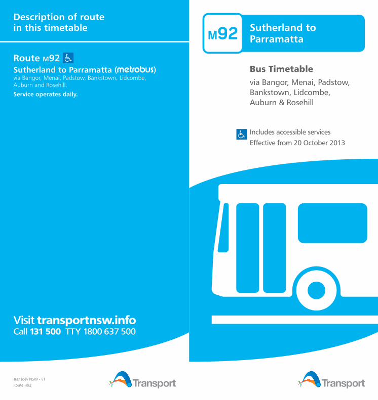
Sutherland toParramatta
Bus Timetablevia Bangor, Menai, Padstow, Bankstown, Lidcombe, Auburn & Rosehill
M92
Transdev NSW - v1
Route M92
Description of route in this timetable
Route M92 Sutherland to Parramatta ( )via Bangor, Menai, Padstow, Bankstown, Lidcombe, Auburn and Rosehill.
Service operates daily.
Includes accessible services
Effective from 20 October 2013

What’s insideYour Bus timetable ........................................................... 1
Your ticketing options ...................................................... 1
Accessible services ............................................................ 1
How to use this timetable ................................................. 1
Other general information ................................................. 1
Bus contacts ..................................................................... 1
Timetables
From Sutherland towards Parramatta
Monday to Friday ............................................................. 2
Saturday .......................................................................... 5
Sunday & Public Holidays ................................................. 7
From Parramatta towards Sutherland
Monday to Friday ............................................................. 9
Saturday ........................................................................ 13
Sunday & Public Holidays ............................................... 15
Explanation of definitions and symbols ........................... 17
Bus route map ................................................................ 18
Your Bus timetableOur bus services take you around the Sydney metropolitan area and further afield, including Newcastle, the Lower Hunter, the Central Coast, the Blue Mountains, Lithgow and the Illawarra. If you have any questions about getting around on buses, just ask. Staff are here for you.
Your ticketing optionsOpal
Opal is the easy, convenient and fast way to pay for travel on public transport. With an Opal card you simply load value onto your card via a range of convenient options then you’re ready to travel.
At the start of your journey, tap your Opal card on an Opal card reader at train stations, on buses, ferry wharves and light rail stops. Tap off at the end of your journey and the correct fare is calculated automatically and deducted from the value on your card.
Opal comes with lots of travel benefits, including:
• Weekly Travel Rewards • 30% off-peak discount on trains • Daily, Weekly and Sunday Travel Caps
Travel Caps exclude the airport station access fee.
Visit opal.com.au or call 13 67 25 (13 OPAL) for more information, to find your nearest Opal retailer, or to order your Opal card.
MyTrain, MyBus, MyFerry and MyMulti tickets and Pensioner Excursion Tickets (PETs)
Travel on one mode only, or multiple modes including light rail.
Tickets can be purchased from Transport Shops, ticket resellers, ticket offices and vending machines at train stations and selected ferry wharves. Single tickets are available from staff on board buses and light rail vehicles.
Some Sydney CBD bus services and transport interchanges are PrePay-only between 07:00 and 19:00. For these services, you need to purchase your tickets in advance.
Tickets purchased from train stations and ferry wharves activate immediately. Tickets purchased from all other outlets activate from date of first use.
Visit transportnsw.info or call Transport Info on 131 500 for further details.
Accessible servicesAll new buses have stepless, low-level floors, with space for wheelchairs, prams or strollers. Wheelchair-accessible buses also run on selected bus services. Look for the symbol in this timetable. Some older buses may not have all the features you need. There will be more accessible services as older buses are replaced.
We try to make sure accessible buses run as intended. If an accessible bus is not available for a scheduled route, we apologise in advance for the inconvenience.

1
Who is providing my bus services?The bus services shown in this timetable are run by Transdev NSW.
Is this timetable current?We try to make sure services depart at the specified times. However, timetables may change and services may be delayed, cancelled or diverted due to circumstances beyond our control.
If you have not travelled with us for a while, you can confirm this timetable is still current by visiting transportnsw.info or calling 131 500.
Over Christmas and the New Year, a reduced timetable may operate. If you’re travelling during this time, plan your trip at transportnsw.info or call 131 500.
Bus etiquetteEating, drinking, smoking or playing loud music on the bus is not allowed. By law, smoking is not allowed at any bus stop, or at train stations, ferry wharves or light rail stops.
Helpful contactsTo plan your trip, get service information and make general enquiries:
Visit transportnsw.info Call 131 500 TTY 1800 637 500
Lost property offices Visit transportnsw.info or call 131 500 TTY 1800 637 500 to contact the operator of your service. If you still have your bus ticket, it will help identify the bus you travelled on.
Emergencies Call Triple Zero (000)
Crime Stoppers To give information that may help stop, solve or prevent criminal activity Call 1800 333 000
Police Assistance Line To report thefts or other non-life threatening matters Call 131 444
Disclaimer: Information in this timetable is based on the latest details at the time of printing, and is subject to change without notice.
How to use this timetable• Go to the route map at the back of this timetable and find the two timing points your bus stop is located between. • Then find these two timing points on the timetable. • Your bus is scheduled to arrive between the times shown for these points.
For example
If your bus stop is located between timing points A and B on the route map, then your bus is scheduled to arrive between the times shown for A and B in the timetable. Please arrive at your bus stop around 5 minutes before your bus is scheduled.
This timetable is expressed in 24-hour time.
12 midnight to 12 midday
12 midday to 12 midnight
00:00 to 11:59 12:00 to 23:5912.00 am = 00:00 12.00 pm = 12:001.00 am = 01:00 1.00 pm = 13:002.00 am = 02:00 2.00 pm = 14:003.00 am = 03:00 3.00 pm = 15:004.00 am = 04:00 4.00 pm = 16:005.00 am = 05:00 5.00 pm = 17:006.00 am = 06:00 6.00 pm = 18:007.00 am = 07:00 7.00 pm = 19:008.00 am = 08:00 8.00 pm = 20:009.00 am = 09:00 9.00 pm = 21:0010.00 am = 10:00 10.00 pm = 22:0011.00 am = 11:00 11.00 pm = 23:00
Download real-time apps transportnsw.info/appsReal-time apps let you track trains, buses, ferries and light rail in real time on the go. So don’t miss your next Transport connection. Download one of the handy apps to track your service on your mobile device.
• Where your train, bus, ferry or light rail service is right now • Estimated arrival times • Service updates • Closest stations, stops, wharves and routes • Accessibility details.

Sutherland to ParramattaMonday to Friday2
Monday to Fridaymapref Route Number M92 M92 M92 M92 M92 M92 M92 M92 M92 M92 M92O Sutherland Interchange ... ... ... ... ... ... ... 06:01 ... 06:21 ...N Bangor Shops Menai Road ... ... ... ... ... ... ... 06:08 ... 06:28 ...M Bradman Road & Old Illawarra Road ... ... ... ... 05:43 ... 06:03 06:13 06:23 06:33 06:43L Old Illawarra Road Roundabout ... ... ... ... 05:47 ... 06:07 06:17 06:27 06:37 06:47K Alma Road & Davies Road ... ... ... ... 05:52 ... 06:12 06:22 06:32 06:42 06:52J Padstow Station Howard Road ... ... ... ... 05:57 ... 06:17 06:27 06:37 06:47 06:57I Eldridge Road & Chapel Road ... ... ... ... 06:04 ... 06:24 06:34 06:44 06:54 07:04H Bankstown Interchange ... ... ... 06:02 06:12 06:22 06:32 06:42 06:52 07:02 07:12G Bankstown Central ... ... ... 06:05 06:15 06:25 06:35 06:45 06:55 07:05 07:15F Rookwood Road & Brunker Road ... ... ... 06:12 06:22 06:32 06:42 06:52 07:02 07:12 07:22E University of Sydney Cumberland East Street ... ... ... 06:19 06:29 06:39 06:49 06:59 07:09 07:19 07:29D Lidcombe Station Church Street 05:40 06:00 06:15 06:25 06:35 06:45 06:55 07:05 07:15 07:25 07:35C John Street & Parramatta Road 05:44 06:04 06:19 06:29 06:39 06:49 06:59 07:09 07:19 07:29 07:39B Rosehill Racecourse James Ruse Drive 05:57 06:17 06:32 06:42 06:52 07:02 07:12 07:22 07:32 07:42 07:52A Parramatta Interchange 06:05 06:25 06:40 06:50 07:00 07:10 07:20 07:30 07:40 07:50 08:03
Monday to Friday (continued...)mapref Route Number M92
Services operate
approximately every
10 minutes until...
M92 M92 M92 M92 M92 M92 M92O Sutherland Interchange 06:40 08:12 08:27 08:37 08:48 09:03 09:18 09:33N Bangor Shops Menai Road 06:47 08:19 08:34 08:44 08:55 09:10 09:25 09:40M Bradman Road & Old Illawarra Road 06:52 08:24 08:39 08:49 09:00 09:15 09:30 09:45L Old Illawarra Road Roundabout 06:56 08:28 08:43 08:53 09:04 09:19 09:34 09:49K Alma Road & Davies Road 07:01 08:33 08:48 08:58 09:09 09:24 09:39 09:54J Padstow Station Howard Road 07:07 08:41 08:56 09:04 09:14 09:29 09:44 09:59I Eldridge Road & Chapel Road 07:14 08:48 09:03 09:11 09:21 09:36 09:51 10:06H Bankstown Interchange 07:22 08:57 09:12 09:20 09:29 09:44 09:59 10:14G Bankstown Central 07:25 09:00 09:15 09:23 09:32 09:47 10:02 10:17F Rookwood Road & Brunker Road 07:32 09:07 09:22 ... 09:39 09:54 10:09 10:24E University of Sydney Cumberland East Street 07:39 09:14 09:29 ... 09:46 10:01 10:16 10:31D Lidcombe Station Church Street 07:45 09:20 09:35 ... 09:52 10:07 10:22 10:37C John Street & Parramatta Road 07:49 09:24 09:39 ... 09:56 10:11 10:26 10:41B Rosehill Racecourse James Ruse Drive 08:02 09:37 09:52 ... 10:09 10:24 10:39 10:54A Parramatta Interchange 08:15 09:45 10:00 ... 10:17 10:32 10:47 11:02

Sutherland to ParramattaMonday to Friday
3
Monday to Friday (continued...)mapref Route Number M92 M92 M92 M92 M92 M92 M92 M92 M92 M92 M92O Sutherland Interchange 09:48 10:03 10:18 10:33 10:48 11:03 11:18 11:33 11:48 12:03 12:18N Bangor Shops Menai Road 09:55 10:10 10:25 10:40 10:55 11:10 11:25 11:40 11:55 12:10 12:25M Bradman Road & Old Illawarra Road 10:00 10:15 10:30 10:45 11:00 11:15 11:30 11:45 12:00 12:15 12:30L Old Illawarra Road Roundabout 10:04 10:19 10:34 10:49 11:04 11:19 11:34 11:49 12:04 12:19 12:34K Alma Road & Davies Road 10:09 10:24 10:39 10:54 11:09 11:24 11:39 11:54 12:09 12:24 12:39J Padstow Station Howard Road 10:14 10:29 10:44 10:59 11:14 11:29 11:44 11:59 12:14 12:29 12:44I Eldridge Road & Chapel Road 10:21 10:36 10:51 11:06 11:21 11:36 11:51 12:06 12:21 12:36 12:51H Bankstown Interchange 10:29 10:44 10:59 11:14 11:29 11:44 11:59 12:14 12:29 12:44 12:59G Bankstown Central 10:32 10:47 11:02 11:17 11:32 11:47 12:02 12:17 12:32 12:47 13:02F Rookwood Road & Brunker Road 10:39 10:54 11:09 11:24 11:39 11:54 12:09 12:24 12:39 12:54 13:09E University of Sydney Cumberland East Street 10:46 11:01 11:16 11:31 11:46 12:01 12:16 12:31 12:46 13:01 13:16D Lidcombe Station Church Street 10:52 11:07 11:22 11:37 11:52 12:07 12:22 12:37 12:52 13:07 13:22C John Street & Parramatta Road 10:56 11:11 11:26 11:41 11:56 12:11 12:26 12:41 12:56 13:11 13:26B Rosehill Racecourse James Ruse Drive 11:09 11:24 11:39 11:54 12:09 12:24 12:39 12:54 13:09 13:24 13:39A Parramatta Interchange 11:17 11:32 11:47 12:02 12:17 12:32 12:47 13:02 13:17 13:32 13:47
Monday to Friday (continued...)mapref Route Number M92 M92 M92 M92 M92 M92 M92 M92 M92 M92 M92O Sutherland Interchange 12:33 12:48 13:03 13:18 13:33 13:48 14:03 14:18 14:33 ... 14:48N Bangor Shops Menai Road 12:40 12:55 13:10 13:25 13:40 13:55 14:10 14:25 14:40 ... 14:55M Bradman Road & Old Illawarra Road 12:45 13:00 13:15 13:30 13:45 14:00 14:15 14:30 14:45 ... 15:00L Old Illawarra Road Roundabout 12:49 13:04 13:19 13:34 13:49 14:04 14:19 14:34 14:49 ... 15:04K Alma Road & Davies Road 12:54 13:09 13:24 13:39 13:54 14:09 14:24 14:39 14:54 ... 15:09J Padstow Station Howard Road 12:59 13:14 13:29 13:44 13:59 14:14 14:29 14:44 14:59 ... 15:15I Eldridge Road & Chapel Road 13:06 13:21 13:36 13:51 14:06 14:21 14:36 14:51 15:06 ... 15:22H Bankstown Interchange 13:14 13:29 13:44 13:59 14:14 14:29 14:44 14:59 15:14 15:22 15:30G Bankstown Central 13:17 13:32 13:47 14:02 14:17 14:32 14:47 15:02 15:17 15:25 15:33F Rookwood Road & Brunker Road 13:24 13:39 13:54 14:09 14:24 14:39 14:54 15:09 15:24 15:32 15:40E University of Sydney Cumberland East Street 13:31 13:46 14:01 14:16 14:31 14:46 15:01 15:16 15:31 15:39 15:47D Lidcombe Station Church Street 13:37 13:52 14:07 14:22 14:37 14:52 15:07 15:22 15:37 15:47 15:55C John Street & Parramatta Road 13:41 13:56 14:11 14:26 14:41 14:56 15:11 15:26 15:41 15:51 15:59B Rosehill Racecourse James Ruse Drive 13:54 14:09 14:24 14:39 14:54 15:09 15:24 15:39 15:54 16:04 16:12A Parramatta Interchange 14:02 14:17 14:32 14:47 15:02 15:17 15:37 15:52 16:07 16:17 16:25

Sutherland to ParramattaMonday to Friday4
Monday to Friday (continued...)mapref Route Number M92 M92
Services operate
approximately every
10 minutes until...
M92 M92 M92 M92 M92 M92 M92O Sutherland Interchange ... 15:05 16:55 17:05 17:15 17:25 17:35 17:45 17:55N Bangor Shops Menai Road ... 15:12 17:02 17:12 17:22 17:32 17:42 17:52 18:02M Bradman Road & Old Illawarra Road ... 15:17 17:07 17:17 17:27 17:37 17:47 17:57 18:07L Old Illawarra Road Roundabout ... 15:21 17:11 17:21 17:31 17:41 17:51 18:01 18:11K Alma Road & Davies Road 15:19 15:26 17:16 17:26 17:36 17:46 17:56 18:06 18:16J Padstow Station Howard Road 15:25 15:33 17:23 17:33 17:43 17:53 18:01 18:11 18:21I Eldridge Road & Chapel Road 15:32 15:40 17:30 17:40 17:50 18:00 18:08 18:18 18:28H Bankstown Interchange 15:40 15:50 17:40 17:50 18:00 18:10 18:16 18:26 18:36G Bankstown Central 15:43 15:53 17:43 17:53 18:03 18:13 18:19 18:29 18:39F Rookwood Road & Brunker Road 15:50 16:00 17:50 18:00 18:10 18:19 18:25 18:35 18:45E University of Sydney Cumberland East Street 15:57 16:07 17:57 18:07 18:17 18:26 18:32 18:42 18:52D Lidcombe Station Church Street 16:05 16:15 18:05 18:15 18:23 18:31 18:37 18:47 18:57C John Street & Parramatta Road 16:09 16:19 18:09 ... 18:27 ... 18:41 18:51 ...B Rosehill Racecourse James Ruse Drive 16:22 16:32 18:22 ... 18:40 ... 18:53 19:03 ...A Parramatta Interchange 16:37 16:50 18:37 ... 18:48 ... 19:00 19:10 ...
Monday to Friday (continued...)mapref Route Number M92 M92 M92 M92 M92 M92 M92 M92 M92 M92 M92 M92O Sutherland Interchange 18:05 18:15 18:27 18:45 19:00 19:15 19:30 19:40 20:10 20:30 21:00 21:30N Bangor Shops Menai Road 18:12 18:22 18:34 18:52 19:07 19:22 19:37 19:47 20:17 20:37 21:07 21:37M Bradman Road & Old Illawarra Road 18:17 18:27 18:39 18:57 19:12 19:27 19:42 19:52 20:22 M20:41 M21:11 M21:40L Old Illawarra Road Roundabout 18:21 18:31 18:43 19:00 19:15 19:30 19:45 19:55 20:25 ... ... ...K Alma Road & Davies Road 18:26 18:36 18:48 19:05 19:20 19:35 19:50 20:00 20:30 ... ... ...J Padstow Station Howard Road 18:31 18:41 18:53 19:09 19:24 19:39 19:54 20:04 20:34 ... ... ...I Eldridge Road & Chapel Road 18:37 18:47 18:59 19:15 19:30 19:45 20:00 20:10 20:40 ... ... ...H Bankstown Interchange 18:45 18:55 19:07 19:23 19:38 19:53 20:08 20:18 20:50 ... ... ...G Bankstown Central 18:48 18:58 19:10 19:26 19:41 19:56 ... 20:21 20:53 ... ... ...F Rookwood Road & Brunker Road 18:54 19:04 19:16 19:32 19:47 20:02 ... 20:27 20:59 ... ... ...E University of Sydney Cumberland East Street 19:01 19:11 19:23 19:39 19:54 20:09 ... 20:34 21:06 ... ... ...D Lidcombe Station Church Street 19:06 19:16 19:28 19:44 19:59 20:14 ... 20:39 21:11 ... ... ...C John Street & Parramatta Road 19:09 ... 19:31 19:47 ... 20:17 ... 20:42 ... ... ... ...B Rosehill Racecourse James Ruse Drive 19:20 ... 19:42 19:58 ... 20:28 ... 20:53 ... ... ... ...A Parramatta Interchange 19:27 ... 19:49 20:05 ... 20:35 ... 21:00 ... ... ... ...

Sutherland to ParramattaSaturday
5
Saturdaymapref Route Number M92 M92 M92 M92 M92 M92 M92 M92 M92 M92 M92O Sutherland Interchange ... ... ... ... ... 07:50 ... 08:30 08:50 09:10 09:30N Bangor Shops Menai Road ... ... ... ... ... 07:57 ... 08:37 08:57 09:17 09:37M Bradman Road & Old Illawarra Road ... 06:42 ... ... 07:42 08:02 08:22 08:42 09:02 09:22 09:42L Old Illawarra Road Roundabout ... 06:46 ... ... 07:46 08:06 08:26 08:46 09:06 09:26 09:46K Alma Road & Davies Road ... 06:51 ... ... 07:51 08:11 08:31 08:51 09:11 09:31 09:51J Padstow Station Howard Road ... 06:56 ... 07:36 07:56 08:16 08:36 08:56 09:16 09:36 09:56I Eldridge Road & Chapel Road ... 07:03 ... 07:43 08:03 08:23 08:43 09:03 09:23 09:43 10:03H Bankstown Interchange 06:50 07:10 07:30 07:50 08:10 08:30 08:50 09:10 09:30 09:50 10:10G Bankstown Central 06:53 07:13 07:33 07:53 08:13 08:33 08:53 09:13 09:33 09:53 10:13F Rookwood Road & Brunker Road 06:59 07:19 07:39 07:59 08:19 08:39 08:59 09:19 09:39 09:59 10:19E University of Sydney Cumberland East Street 07:05 07:25 07:45 08:05 08:25 08:45 09:05 09:25 09:45 10:05 10:25D Lidcombe Station Church Street 07:11 07:31 07:51 08:11 08:31 08:51 09:11 09:31 09:51 10:11 10:31C John Street & Parramatta Road 07:15 07:35 07:55 08:15 08:35 08:55 09:15 09:35 09:55 10:15 10:35B Rosehill Racecourse James Ruse Drive 07:27 07:47 08:07 08:27 08:47 09:07 09:27 09:47 10:07 10:27 10:47A Parramatta Interchange 07:34 07:54 08:14 08:34 08:54 09:14 09:34 09:54 10:14 10:34 10:54
Saturday (continued...)mapref Route Number M92 M92 M92 M92 M92 M92 M92 M92 M92 M92 M92O Sutherland Interchange 09:50 10:10 10:30 10:50 11:10 11:30 11:50 12:10 12:30 12:50 13:10N Bangor Shops Menai Road 09:57 10:17 10:37 10:57 11:17 11:37 11:57 12:17 12:37 12:57 13:17M Bradman Road & Old Illawarra Road 10:02 10:22 10:42 11:02 11:22 11:42 12:02 12:22 12:42 13:02 13:22L Old Illawarra Road Roundabout 10:06 10:26 10:46 11:06 11:26 11:46 12:06 12:26 12:46 13:06 13:26K Alma Road & Davies Road 10:11 10:31 10:51 11:11 11:31 11:51 12:11 12:31 12:51 13:11 13:31J Padstow Station Howard Road 10:16 10:36 10:56 11:16 11:36 11:56 12:16 12:36 12:56 13:16 13:36I Eldridge Road & Chapel Road 10:23 10:43 11:03 11:23 11:43 12:03 12:23 12:43 13:03 13:23 13:43H Bankstown Interchange 10:30 10:50 11:10 11:30 11:50 12:10 12:30 12:50 13:10 13:30 13:50G Bankstown Central 10:33 10:53 11:13 11:33 11:53 12:13 12:33 12:53 13:13 13:33 13:53F Rookwood Road & Brunker Road 10:39 10:59 11:19 11:39 11:59 12:19 12:39 12:59 13:19 13:39 13:59E University of Sydney Cumberland East Street 10:45 11:05 11:25 11:45 12:05 12:25 12:45 13:05 13:25 13:45 14:05D Lidcombe Station Church Street 10:51 11:11 11:31 11:51 12:11 12:31 12:51 13:11 13:31 13:51 14:11C John Street & Parramatta Road 10:55 11:15 11:35 11:55 12:15 12:35 12:55 13:15 13:35 13:55 14:15B Rosehill Racecourse James Ruse Drive 11:07 11:27 11:47 12:07 12:27 12:47 13:07 13:27 13:47 14:07 14:27A Parramatta Interchange 11:14 11:34 11:54 12:14 12:34 12:54 13:14 13:34 13:54 14:14 14:34

Sutherland to ParramattaSaturday6
Saturday (continued...)mapref Route Number M92 M92 M92 M92 M92 M92 M92 M92 M92 M92 M92O Sutherland Interchange 13:30 13:50 14:10 14:30 14:50 15:10 15:30 15:50 16:10 16:30 16:50N Bangor Shops Menai Road 13:37 13:57 14:17 14:37 14:57 15:17 15:37 15:57 16:17 16:37 16:57M Bradman Road & Old Illawarra Road 13:42 14:02 14:22 14:42 15:02 15:22 15:42 16:02 16:22 16:42 17:02L Old Illawarra Road Roundabout 13:46 14:06 14:26 14:46 15:06 15:26 15:46 16:06 16:26 16:46 17:06K Alma Road & Davies Road 13:51 14:11 14:31 14:51 15:11 15:31 15:51 16:11 16:31 16:51 17:11J Padstow Station Howard Road 13:56 14:16 14:36 14:56 15:16 15:36 15:56 16:16 16:36 16:56 17:16I Eldridge Road & Chapel Road 14:03 14:23 14:43 15:03 15:23 15:43 16:03 16:23 16:43 17:03 17:23H Bankstown Interchange 14:10 14:30 14:50 15:10 15:30 15:50 16:10 16:30 16:50 17:10 17:30G Bankstown Central 14:13 14:33 14:53 15:13 15:33 15:53 16:13 16:33 16:53 17:13 17:33F Rookwood Road & Brunker Road 14:19 14:39 14:59 15:19 15:39 15:59 16:19 16:39 16:59 17:19 17:39E University of Sydney Cumberland East Street 14:25 14:45 15:05 15:25 15:45 16:05 16:25 16:45 17:05 17:25 17:45D Lidcombe Station Church Street 14:31 14:51 15:11 15:31 15:51 16:11 16:31 16:51 17:11 17:31 17:51C John Street & Parramatta Road 14:35 14:55 15:15 15:35 15:55 16:15 16:35 16:55 17:15 17:35 17:55B Rosehill Racecourse James Ruse Drive 14:47 15:07 15:27 15:47 16:07 16:27 16:47 17:07 17:27 17:47 18:07A Parramatta Interchange 14:54 15:14 15:34 15:54 16:14 16:34 16:54 17:14 17:34 17:54 18:14
Saturday (continued...)mapref Route Number M92 M92 M92 M92 M92 M92 M92 M92 M92 M92 M92O Sutherland Interchange 17:10 17:30 17:50 18:10 18:30 18:50 19:10 19:30 20:00 20:35 21:00N Bangor Shops Menai Road 17:17 17:37 17:57 18:17 18:37 18:57 19:17 19:37 20:07 20:42 21:07M Bradman Road & Old Illawarra Road 17:22 17:42 18:02 18:22 18:42 19:02 19:22 19:42 M20:11 20:47 M21:11L Old Illawarra Road Roundabout 17:26 17:46 18:06 18:26 18:46 19:06 19:26 19:46 ... 20:51 ...K Alma Road & Davies Road 17:31 17:51 18:11 18:31 18:51 19:11 19:31 19:51 ... 20:56 ...J Padstow Station Howard Road 17:36 17:56 18:16 18:36 18:56 19:16 19:36 19:56 ... 21:01 ...I Eldridge Road & Chapel Road 17:43 18:03 18:23 18:43 19:03 ... 19:43 20:03 ... 21:08 ...H Bankstown Interchange 17:50 18:10 18:30 18:50 19:10 ... 19:50 20:10 ... 21:15 ...G Bankstown Central 17:53 18:13 18:33 18:53 19:13 ... 19:53 20:13 ... ... ...F Rookwood Road & Brunker Road 17:59 18:19 18:39 18:59 19:19 ... 19:59 20:19 ... ... ...E University of Sydney Cumberland East Street 18:05 18:25 18:45 19:05 19:25 ... 20:05 20:25 ... ... ...D Lidcombe Station Church Street 18:11 18:31 18:51 19:11 19:31 ... 20:11 20:31 ... ... ...C John Street & Parramatta Road 18:15 18:35 18:55 19:15 19:35 ... 20:15 20:35 ... ... ...B Rosehill Racecourse James Ruse Drive 18:27 18:47 19:07 19:27 19:47 ... 20:27 20:47 ... ... ...A Parramatta Interchange 18:34 18:54 19:14 19:34 19:53 ... 20:33 20:53 ... ... ...

Sutherland to ParramattaSunday & Public Holidays
7
Sunday & Public Holidaysmapref Route Number M92 M92 M92 M92 M92 M92 M92 M92 M92 M92 M92O Sutherland Interchange ... ... ... 07:50 08:10 08:30 08:50 09:10 09:30 09:50 10:10N Bangor Shops Menai Road ... ... ... 07:57 08:17 08:37 08:57 09:17 09:37 09:57 10:17M Bradman Road & Old Illawarra Road ... 07:21 07:41 08:01 08:21 08:41 09:01 09:21 09:41 10:01 10:21L Old Illawarra Road Roundabout ... 07:24 07:44 08:04 08:24 08:44 09:04 09:24 09:44 10:04 10:24K Alma Road & Davies Road ... 07:28 07:48 08:08 08:28 08:48 09:08 09:28 09:48 10:08 10:28J Padstow Station Howard Road ... 07:33 07:53 08:13 08:33 08:53 09:13 09:33 09:53 10:13 10:33I Eldridge Road & Chapel Road ... 07:40 08:00 08:20 08:40 09:00 09:20 09:40 10:00 10:20 10:40H Bankstown Interchange 07:27 07:47 08:07 08:27 08:47 09:07 09:27 09:47 10:07 10:27 10:47G Bankstown Central 07:30 07:50 08:10 08:30 08:50 09:10 09:30 09:50 10:10 10:30 10:50F Rookwood Road & Brunker Road 07:36 07:56 08:16 08:36 08:56 09:16 09:36 09:56 10:16 10:36 10:56E University of Sydney Cumberland East Street 07:42 08:02 08:22 08:42 09:02 09:22 09:42 10:02 10:22 10:42 11:02D Lidcombe Station Church Street 07:47 08:07 08:27 08:47 09:07 09:27 09:47 10:07 10:27 10:47 11:07C John Street & Parramatta Road 07:50 08:10 08:30 08:50 09:10 09:30 09:50 10:10 10:30 10:50 11:10B Rosehill Racecourse James Ruse Drive 08:02 08:22 08:42 09:02 09:22 09:42 10:02 10:22 10:42 11:02 11:22A Parramatta Interchange 08:09 08:29 08:49 09:09 09:29 09:49 10:09 10:29 10:49 11:09 11:29
Sunday & Public Holidays (continued...)mapref Route Number M92 M92 M92 M92 M92 M92 M92 M92 M92 M92 M92O Sutherland Interchange 10:30 10:50 11:10 11:30 11:50 12:10 12:30 12:50 13:10 13:30 13:50N Bangor Shops Menai Road 10:37 10:57 11:17 11:37 11:57 12:17 12:37 12:57 13:17 13:37 13:57M Bradman Road & Old Illawarra Road 10:41 11:01 11:21 11:41 12:01 12:21 12:41 13:01 13:21 13:41 14:01L Old Illawarra Road Roundabout 10:44 11:04 11:24 11:44 12:04 12:24 12:44 13:04 13:24 13:44 14:04K Alma Road & Davies Road 10:48 11:08 11:28 11:48 12:08 12:28 12:48 13:08 13:28 13:48 14:08J Padstow Station Howard Road 10:53 11:13 11:33 11:53 12:13 12:33 12:53 13:13 13:33 13:53 14:13I Eldridge Road & Chapel Road 11:00 11:20 11:40 12:00 12:20 12:40 13:00 13:20 13:40 14:00 14:20H Bankstown Interchange 11:07 11:27 11:47 12:07 12:27 12:47 13:07 13:27 13:47 14:07 14:27G Bankstown Central 11:10 11:30 11:50 12:10 12:30 12:50 13:10 13:30 13:50 14:10 14:30F Rookwood Road & Brunker Road 11:16 11:36 11:56 12:16 12:36 12:56 13:16 13:36 13:56 14:16 14:36E University of Sydney Cumberland East Street 11:22 11:42 12:02 12:22 12:42 13:02 13:22 13:42 14:02 14:22 14:42D Lidcombe Station Church Street 11:27 11:47 12:07 12:27 12:47 13:07 13:27 13:47 14:07 14:27 14:47C John Street & Parramatta Road 11:30 11:50 12:10 12:30 12:50 13:10 13:30 13:50 14:10 14:30 14:50B Rosehill Racecourse James Ruse Drive 11:42 12:02 12:22 12:42 13:02 13:22 13:42 14:02 14:22 14:42 15:02A Parramatta Interchange 11:49 12:09 12:29 12:49 13:09 13:29 13:49 14:09 14:29 14:49 15:09

Sutherland to ParramattaSunday & Public Holidays8
Sunday & Public Holidays (continued...)mapref Route Number M92 M92 M92 M92 M92 M92 M92 M92 M92 M92 M92O Sutherland Interchange 14:10 14:30 14:50 15:10 15:30 15:50 16:10 16:30 16:50 17:10 17:30N Bangor Shops Menai Road 14:17 14:37 14:57 15:17 15:37 15:57 16:17 16:37 16:57 17:17 17:37M Bradman Road & Old Illawarra Road 14:21 14:41 15:01 15:21 15:41 16:01 16:21 16:41 17:01 17:21 17:41L Old Illawarra Road Roundabout 14:24 14:44 15:04 15:24 15:44 16:04 16:24 16:44 17:04 17:24 17:44K Alma Road & Davies Road 14:28 14:48 15:08 15:28 15:48 16:08 16:28 16:48 17:08 17:28 17:48J Padstow Station Howard Road 14:33 14:53 15:13 15:33 15:53 16:13 16:33 16:53 17:13 17:33 17:53I Eldridge Road & Chapel Road 14:40 15:00 15:20 15:40 16:00 16:20 16:40 17:00 17:20 17:40 18:00H Bankstown Interchange 14:47 15:07 15:27 15:47 16:07 16:27 16:47 17:07 17:27 17:47 18:07G Bankstown Central 14:50 15:10 15:30 15:50 16:10 16:30 16:50 17:10 17:30 17:50 18:10F Rookwood Road & Brunker Road 14:56 15:16 15:36 15:56 16:16 16:36 16:56 17:16 17:36 17:56 18:16E University of Sydney Cumberland East Street 15:02 15:22 15:42 16:02 16:22 16:42 17:02 17:22 17:42 18:02 18:22D Lidcombe Station Church Street 15:07 15:27 15:47 16:07 16:27 16:47 17:07 17:27 17:47 18:07 18:27C John Street & Parramatta Road 15:10 15:30 15:50 16:10 16:30 16:50 17:10 17:30 17:50 18:10 18:30B Rosehill Racecourse James Ruse Drive 15:22 15:42 16:02 16:22 16:42 17:02 17:22 17:42 18:02 18:22 18:42A Parramatta Interchange 15:29 15:49 16:09 16:29 16:49 17:09 17:29 17:49 18:09 18:29 18:49
Sunday & Public Holidays (continued...)mapref Route Number M92 M92 M92 M92 M92 M92 M92 M92O Sutherland Interchange 17:50 18:10 18:30 18:50 19:10 19:30 20:30 21:00N Bangor Shops Menai Road 17:57 18:17 18:37 18:57 19:17 19:37 20:37 21:07M Bradman Road & Old Illawarra Road 18:01 18:21 18:41 19:01 19:21 19:41 M20:41 M21:11L Old Illawarra Road Roundabout 18:04 18:24 18:44 19:04 19:24 19:44 ... ...K Alma Road & Davies Road 18:08 18:28 18:48 19:08 19:28 19:48 ... ...J Padstow Station Howard Road 18:13 18:33 18:53 19:13 19:33 19:53 ... ...I Eldridge Road & Chapel Road 18:20 18:40 19:00 19:20 19:40 20:00 ... ...H Bankstown Interchange 18:27 18:47 19:07 19:27 19:47 20:07 ... ...G Bankstown Central 18:30 18:50 19:10 19:30 19:50 20:10 ... ...F Rookwood Road & Brunker Road 18:36 18:56 19:16 19:36 19:56 20:16 ... ...E University of Sydney Cumberland East Street 18:42 19:02 19:22 19:42 20:02 20:22 ... ...D Lidcombe Station Church Street 18:47 19:07 19:27 19:47 20:07 20:27 ... ...C John Street & Parramatta Road 18:50 19:10 19:30 19:50 20:10 20:30 ... ...B Rosehill Racecourse James Ruse Drive 19:02 19:22 19:42 20:02 20:22 20:42 ... ...A Parramatta Interchange 19:09 19:29 19:49 20:09 20:29 20:49 ... ...

Parramatta to SutherlandMonday to Friday
9
Monday to Fridaymapref Route Number M92 M92 M92 M92 M92 M92 M92 M92 M92 M92 M92A Parramatta Interchange ... ... ... ... ... ... ... 06:12 ... 06:32 ...B Rosehill Racecourse James Ruse Drive ... ... ... ... ... ... ... 06:18 ... 06:38 ...C John Street & Parramatta Road ... ... ... ... ... ... ... 06:29 ... 06:49 ...D Lidcombe Station Church Street ... ... ... ... ... 06:16 ... 06:36 06:46 06:56 07:03E University of Sydney Cumberland East Street ... ... ... ... :… 06:21 ... 06:41 06:51 07:01 07:09F Rookwood Road & Brunker Road ... ... A06:00 ... :… 06:27 ... 06:47 06:57 07:07 07:15G Bankstown Central ... ... 06:06 ... :… 06:34 ... 06:54 07:04 07:14 07:22H Bankstown Interchange ... ... 06:09 06:22 06:27 06:37 06:47 06:57 07:07 07:17 07:27I Eldridge Road & Chapel Road ... ... 06:14 06:27 06:33 06:43 06:53 07:03 07:13 07:23 07:33J Padstow Station Howard Road ... ... 06:21 06:34 06:41 06:51 07:01 07:11 07:21 07:31 07:41K Alma Road & Davies Road ... ... 06:24 06:37 06:44 06:54 07:04 07:14 07:24 07:34 07:44L Old Illawarra Road Roundabout 05:42 05:59 06:29 06:42 06:49 06:59 07:09 07:19 07:29 07:39 07:49M Bradman Road & Old Illawarra Road 05:45 06:02 06:32 06:45 06:52 07:02 07:12 07:22 07:32 07:42 07:52N Bangor Shops Menai Road 05:51 06:08 06:38 06:51 06:58 07:08 07:18 07:28 07:38 07:48 07:58O Sutherland Interchange 05:58 06:15 06:45 06:58 07:07 07:17 07:27 07:37 07:51 08:01 08:11
Monday to Friday (continued...)mapref Route Number M92
Services operate
approximately every
10 minutes until...
M92 M92 M92 M92 M92 M92 M92A Parramatta Interchange 06:48 08:08 08:18 08:28 08:38 08:45 09:00 09:15B Rosehill Racecourse James Ruse Drive 06:54 08:14 08:24 08:34 08:44 08:51 09:06 09:21C John Street & Parramatta Road 07:05 08:25 08:35 08:45 08:55 09:02 09:17 09:32D Lidcombe Station Church Street 07:13 08:33 08:43 08:53 09:03 09:09 09:24 09:39E University of Sydney Cumberland East Street 07:19 08:39 08:49 08:59 09:09 09:15 09:30 09:45F Rookwood Road & Brunker Road 07:25 08:45 08:55 09:05 09:15 09:21 09:36 09:51G Bankstown Central 07:32 08:52 09:02 09:12 09:22 09:28 09:43 09:58H Bankstown Interchange 07:37 08:57 09:07 09:17 09:27 09:32 09:47 10:02I Eldridge Road & Chapel Road 07:43 09:03 ... 09:23 ... 09:38 09:53 10:08J Padstow Station Howard Road 07:51 09:11 ... 09:31 ... 09:46 10:01 10:16K Alma Road & Davies Road 07:54 09:14 ... 09:34 ... 09:49 10:04 10:19L Old Illawarra Road Roundabout 07:59 09:19 ... 09:39 ... 09:54 10:09 10:24M Bradman Road & Old Illawarra Road 08:02 09:22 ... 09:42 ... 09:57 10:12 10:27N Bangor Shops Menai Road 08:08 09:28 ... 09:48 ... 10:03 10:18 10:33O Sutherland Interchange 08:21 09:37 ... 09:57 ... 10:12 10:27 10:42
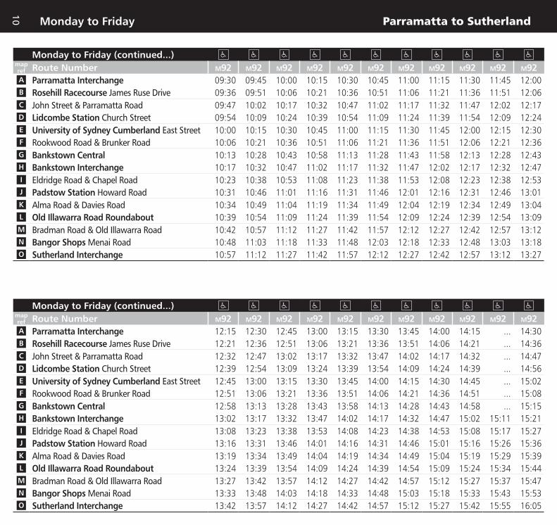
Parramatta to SutherlandMonday to Friday
10
Monday to Friday (continued...)mapref Route Number M92 M92 M92 M92 M92 M92 M92 M92 M92 M92 M92A Parramatta Interchange 09:30 09:45 10:00 10:15 10:30 10:45 11:00 11:15 11:30 11:45 12:00B Rosehill Racecourse James Ruse Drive 09:36 09:51 10:06 10:21 10:36 10:51 11:06 11:21 11:36 11:51 12:06C John Street & Parramatta Road 09:47 10:02 10:17 10:32 10:47 11:02 11:17 11:32 11:47 12:02 12:17D Lidcombe Station Church Street 09:54 10:09 10:24 10:39 10:54 11:09 11:24 11:39 11:54 12:09 12:24E University of Sydney Cumberland East Street 10:00 10:15 10:30 10:45 11:00 11:15 11:30 11:45 12:00 12:15 12:30F Rookwood Road & Brunker Road 10:06 10:21 10:36 10:51 11:06 11:21 11:36 11:51 12:06 12:21 12:36G Bankstown Central 10:13 10:28 10:43 10:58 11:13 11:28 11:43 11:58 12:13 12:28 12:43H Bankstown Interchange 10:17 10:32 10:47 11:02 11:17 11:32 11:47 12:02 12:17 12:32 12:47I Eldridge Road & Chapel Road 10:23 10:38 10:53 11:08 11:23 11:38 11:53 12:08 12:23 12:38 12:53J Padstow Station Howard Road 10:31 10:46 11:01 11:16 11:31 11:46 12:01 12:16 12:31 12:46 13:01K Alma Road & Davies Road 10:34 10:49 11:04 11:19 11:34 11:49 12:04 12:19 12:34 12:49 13:04L Old Illawarra Road Roundabout 10:39 10:54 11:09 11:24 11:39 11:54 12:09 12:24 12:39 12:54 13:09M Bradman Road & Old Illawarra Road 10:42 10:57 11:12 11:27 11:42 11:57 12:12 12:27 12:42 12:57 13:12N Bangor Shops Menai Road 10:48 11:03 11:18 11:33 11:48 12:03 12:18 12:33 12:48 13:03 13:18O Sutherland Interchange 10:57 11:12 11:27 11:42 11:57 12:12 12:27 12:42 12:57 13:12 13:27
Monday to Friday (continued...)mapref Route Number M92 M92 M92 M92 M92 M92 M92 M92 M92 M92 M92A Parramatta Interchange 12:15 12:30 12:45 13:00 13:15 13:30 13:45 14:00 14:15 ... 14:30B Rosehill Racecourse James Ruse Drive 12:21 12:36 12:51 13:06 13:21 13:36 13:51 14:06 14:21 ... 14:36C John Street & Parramatta Road 12:32 12:47 13:02 13:17 13:32 13:47 14:02 14:17 14:32 ... 14:47D Lidcombe Station Church Street 12:39 12:54 13:09 13:24 13:39 13:54 14:09 14:24 14:39 ... 14:56E University of Sydney Cumberland East Street 12:45 13:00 13:15 13:30 13:45 14:00 14:15 14:30 14:45 ... 15:02F Rookwood Road & Brunker Road 12:51 13:06 13:21 13:36 13:51 14:06 14:21 14:36 14:51 ... 15:08G Bankstown Central 12:58 13:13 13:28 13:43 13:58 14:13 14:28 14:43 14:58 ... 15:15H Bankstown Interchange 13:02 13:17 13:32 13:47 14:02 14:17 14:32 14:47 15:02 15:11 15:21I Eldridge Road & Chapel Road 13:08 13:23 13:38 13:53 14:08 14:23 14:38 14:53 15:08 15:17 15:27J Padstow Station Howard Road 13:16 13:31 13:46 14:01 14:16 14:31 14:46 15:01 15:16 15:26 15:36K Alma Road & Davies Road 13:19 13:34 13:49 14:04 14:19 14:34 14:49 15:04 15:19 15:29 15:39L Old Illawarra Road Roundabout 13:24 13:39 13:54 14:09 14:24 14:39 14:54 15:09 15:24 15:34 15:44M Bradman Road & Old Illawarra Road 13:27 13:42 13:57 14:12 14:27 14:42 14:57 15:12 15:27 15:37 15:47N Bangor Shops Menai Road 13:33 13:48 14:03 14:18 14:33 14:48 15:03 15:18 15:33 15:43 15:53O Sutherland Interchange 13:42 13:57 14:12 14:27 14:42 14:57 15:12 15:27 15:42 15:55 16:05

Parramatta to SutherlandMonday to Friday
11
Monday to Friday (continued...)mapref Route Number M92 M92 M92 M92
Services operate
approximately every
10 minutes until...
M92 M92 M92 M92A Parramatta Interchange ... 14:50 ... 15:10 16:30 16:40 16:50 17:00B Rosehill Racecourse James Ruse Drive ... 14:56 ... 15:16 16:36 16:46 16:56 17:06C John Street & Parramatta Road ... 15:07 ... 15:27 16:47 16:57 17:07 17:17D Lidcombe Station Church Street ... 15:16 ... 15:36 16:56 17:06 17:16 17:26E University of Sydney Cumberland East Street ... 15:22 ... 15:42 17:02 17:12 17:22 17:32F Rookwood Road & Brunker Road ... 15:28 A15:38 15:48 17:08 17:18 17:28 17:38G Bankstown Central ... 15:35 15:45 15:55 17:15 17:25 17:35 17:45H Bankstown Interchange ... 15:41 15:51 16:01 17:21 17:31 17:41 17:51I Eldridge Road & Chapel Road ... 15:47 15:57 16:07 17:27 17:37 17:47 17:57J Padstow Station Howard Road 15:46 15:56 16:06 16:16 17:36 17:46 17:56 18:06K Alma Road & Davies Road 15:49 15:59 16:09 16:19 17:39 17:49 17:59 18:09L Old Illawarra Road Roundabout 15:54 16:04 16:14 16:24 17:44 17:54 18:04 18:14M Bradman Road & Old Illawarra Road 15:57 16:07 16:17 16:27 17:49 17:59 18:09 18:19N Bangor Shops Menai Road 16:03 16:13 16:23 16:33 17:55 ... 18:15 ...O Sutherland Interchange 16:15 16:25 16:35 16:45 18:07 ... 18:27 ...
Monday to Friday (continued...)mapref Route Number M92 M92 M92 M92 M92 M92 M92 M92 M92 M92 M92A Parramatta Interchange 17:10 17:20 17:30 17:40 17:50 18:00 18:10 18:20 18:30 18:42 18:55B Rosehill Racecourse James Ruse Drive 17:16 17:26 17:36 17:46 17:56 18:06 18:15 18:25 18:35 18:47 19:00C John Street & Parramatta Road 17:27 17:37 17:47 17:57 18:07 18:17 18:26 18:36 18:46 18:58 19:11D Lidcombe Station Church Street 17:36 17:46 17:56 18:06 18:14 18:24 18:32 18:42 18:52 19:04 19:17E University of Sydney Cumberland East Street 17:42 17:52 18:02 18:12 18:20 18:30 18:37 18:47 18:57 19:09 19:22F Rookwood Road & Brunker Road 17:48 17:58 18:08 18:18 18:26 18:36 18:43 18:53 19:03 19:15 19:28G Bankstown Central 17:55 18:05 18:15 18:25 18:33 18:43 18:50 19:00 19:10 19:22 19:35H Bankstown Interchange 18:01 18:11 18:21 18:31 18:37 18:47 18:54 19:04 19:14 19:26 19:39I Eldridge Road & Chapel Road 18:07 18:17 18:27 18:37 18:43 18:53 18:59 19:09 19:19 ... 19:44J Padstow Station Howard Road 18:16 18:26 18:36 18:46 18:51 19:01 19:07 19:17 19:27 ... 19:52K Alma Road & Davies Road 18:19 18:29 18:39 18:49 18:54 19:04 19:10 19:20 19:30 ... 19:55L Old Illawarra Road Roundabout 18:24 18:34 18:44 18:54 18:59 19:09 19:15 19:25 19:35 ... 20:00M Bradman Road & Old Illawarra Road 18:29 18:39 18:49 18:57 19:02 19:12 19:18 19:28 19:38 ... 20:03N Bangor Shops Menai Road 18:35 18:45 ... 19:03 ... 19:17 ... ... 19:43 ... 20:08O Sutherland Interchange 18:47 18:57 ... 19:12 ... 19:25 ... ... 19:51 ... 20:16

Parramatta to SutherlandMonday to Friday
12
Monday to Friday (continued...)mapref Route Number M92 M92 M92 M92 M92A Parramatta Interchange‡ 19:10 19:25 19:40 20:05 20:40B Rosehill Racecourse James Ruse Drive 19:15 19:30 19:45 20:10 20:45C John Street & Parramatta Road 19:26 19:41 19:56 20:21 20:56D Lidcombe Station Church Street 19:32 19:47 20:02 20:27 21:02E University of Sydney Cumberland East Street 19:37 19:52 20:07 20:32 21:07F Rookwood Road & Brunker Road 19:43 19:58 20:13 20:38 21:13G Bankstown Central 19:50 20:05 20:20 20:45 21:20H Bankstown Interchange 19:54 20:09 20:24 20:49 21:24I Eldridge Road & Chapel Road ... 20:14 ... 20:54 ...J Padstow Station Howard Road ... 20:22 ... 21:02 ...K Alma Road & Davies Road ... 20:25 ... 21:05 ...L Old Illawarra Road Roundabout ... 20:30 ... 21:10 ...M Bradman Road & Old Illawarra Road ... 20:33 ... 21:13 ...N Bangor Shops Menai Road ... 20:38 ... 21:18 ...O Sutherland Interchange ... 20:46 ... 21:26 ...

Parramatta to SutherlandSaturday
13
Saturdaymapref Route Number M92 M92 M92 M92 M92 M92 M92 M92 M92 M92 M92A Parramatta Interchange ... ... ... ... 07:45 08:05 08:25 08:45 09:05 09:25 09:45B Rosehill Racecourse James Ruse Drive ... ... ... ... 07:51 08:11 08:31 08:51 09:11 09:31 09:51C John Street & Parramatta Road ... ... ... ... 08:02 08:22 08:42 09:02 09:22 09:42 10:02D Lidcombe Station Church Street ... 07:08 07:28 ... 08:08 08:28 08:48 09:08 09:28 09:48 10:08E University of Sydney Cumberland East Street ... 07:14 07:34 ... 08:14 08:34 08:54 09:14 09:34 09:54 10:14F Rookwood Road & Brunker Road ... 07:20 07:40 ... 08:20 08:40 09:00 09:20 09:40 10:00 10:20G Bankstown Central ... 07:26 07:46 ... 08:26 08:46 09:06 09:26 09:46 10:06 10:26H Bankstown Interchange 07:00 07:30 07:50 ... 08:30 08:50 09:10 09:30 09:50 10:10 10:30I Eldridge Road & Chapel Road 07:06 07:36 07:56 ... 08:36 08:56 09:16 09:36 09:56 10:16 10:36J Padstow Station Howard Road 07:14 07:44 08:04 08:24 08:44 09:04 09:24 09:44 10:04 10:24 10:44K Alma Road & Davies Road 07:17 07:47 08:07 08:27 08:47 09:07 09:27 09:47 10:07 10:27 10:47L Old Illawarra Road Roundabout 07:22 07:52 08:12 08:32 08:52 09:12 09:32 09:52 10:12 10:32 10:52M Bradman Road & Old Illawarra Road 07:25 07:55 08:15 08:35 08:55 09:15 09:35 09:55 10:15 10:35 10:55N Bangor Shops Menai Road 07:31 08:01 08:21 08:41 09:01 09:21 09:41 10:01 10:21 10:41 11:01O Sutherland Interchange 07:40 08:10 08:30 08:50 09:10 09:30 09:50 10:10 10:30 10:50 11:10
Saturday (continued...)mapref Route Number M92 M92 M92 M92 M92 M92 M92 M92 M92 M92 M92A Parramatta Interchange 10:05 10:25 10:45 11:05 11:25 11:45 12:05 12:25 12:45 13:05 13:25B Rosehill Racecourse James Ruse Drive 10:11 10:31 10:51 11:11 11:31 11:51 12:11 12:31 12:51 13:11 13:31C John Street & Parramatta Road 10:22 10:42 11:02 11:22 11:42 12:02 12:22 12:42 13:02 13:22 13:42D Lidcombe Station Church Street 10:28 10:48 11:08 11:28 11:48 12:08 12:28 12:48 13:08 13:28 13:48E University of Sydney Cumberland East Street 10:34 10:54 11:14 11:34 11:54 12:14 12:34 12:54 13:14 13:34 13:54F Rookwood Road & Brunker Road 10:40 11:00 11:20 11:40 12:00 12:20 12:40 13:00 13:20 13:40 14:00G Bankstown Central 10:46 11:06 11:26 11:46 12:06 12:26 12:46 13:06 13:26 13:46 14:06H Bankstown Interchange 10:50 11:10 11:30 11:50 12:10 12:30 12:50 13:10 13:30 13:50 14:10I Eldridge Road & Chapel Road 10:56 11:16 11:36 11:56 12:16 12:36 12:56 13:16 13:36 13:56 14:16J Padstow Station Howard Road 11:04 11:24 11:44 12:04 12:24 12:44 13:04 13:24 13:44 14:04 14:24K Alma Road & Davies Road 11:07 11:27 11:47 12:07 12:27 12:47 13:07 13:27 13:47 14:07 14:27L Old Illawarra Road Roundabout 11:12 11:32 11:52 12:12 12:32 12:52 13:12 13:32 13:52 14:12 14:32M Bradman Road & Old Illawarra Road 11:15 11:35 11:55 12:15 12:35 12:55 13:15 13:35 13:55 14:15 14:35N Bangor Shops Menai Road 11:21 11:41 12:01 12:21 12:41 13:01 13:21 13:41 14:01 14:21 14:41O Sutherland Interchange 11:30 11:50 12:10 12:30 12:50 13:10 13:30 13:50 14:10 14:30 14:50
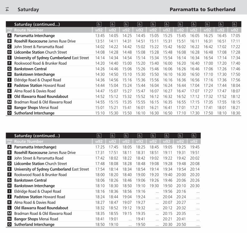
Parramatta to SutherlandSaturday
14
Saturday (continued...)mapref Route Number M92 M92 M92 M92 M92 M92 M92 M92 M92 M92 M92A Parramatta Interchange 13:45 14:05 14:25 14:45 15:05 15:25 15:45 16:05 16:25 16:45 17:05B Rosehill Racecourse James Ruse Drive 13:51 14:11 14:31 14:51 15:11 15:31 15:51 16:11 16:31 16:51 17:11C John Street & Parramatta Road 14:02 14:22 14:42 15:02 15:22 15:42 16:02 16:22 16:42 17:02 17:22D Lidcombe Station Church Street 14:08 14:28 14:48 15:08 15:28 15:48 16:08 16:28 16:48 17:08 17:28E University of Sydney Cumberland East Street 14:14 14:34 14:54 15:14 15:34 15:54 16:14 16:34 16:54 17:14 17:34F Rookwood Road & Brunker Road 14:20 14:40 15:00 15:20 15:40 16:00 16:20 16:40 17:00 17:20 17:40G Bankstown Central 14:26 14:46 15:06 15:26 15:46 16:06 16:26 16:46 17:06 17:26 17:46H Bankstown Interchange 14:30 14:50 15:10 15:30 15:50 16:10 16:30 16:50 17:10 17:30 17:50I Eldridge Road & Chapel Road 14:36 14:56 15:16 15:36 15:56 16:16 16:36 16:56 17:16 17:36 17:56J Padstow Station Howard Road 14:44 15:04 15:24 15:44 16:04 16:24 16:44 17:04 17:24 17:44 18:04K Alma Road & Davies Road 14:47 15:07 15:27 15:47 16:07 16:27 16:47 17:07 17:27 17:47 18:07L Old Illawarra Road Roundabout 14:52 15:12 15:32 15:52 16:12 16:32 16:52 17:12 17:32 17:52 18:12M Bradman Road & Old Illawarra Road 14:55 15:15 15:35 15:55 16:15 16:35 16:55 17:15 17:35 17:55 18:15N Bangor Shops Menai Road 15:01 15:21 15:41 16:01 16:21 16:41 17:01 17:21 17:41 18:01 18:21O Sutherland Interchange 15:10 15:30 15:50 16:10 16:30 16:50 17:10 17:30 17:50 18:10 18:30
Saturday (continued...)mapref Route Number M92 M92 M92 M92 M92 M92 M92 M92A Parramatta Interchange‡ 17:25 17:45 18:05 18:25 18:45 19:05 19:25 19:45B Rosehill Racecourse James Ruse Drive 17:31 17:51 18:11 18:31 18:51 19:11 19:31 19:51C John Street & Parramatta Road 17:42 18:02 18:22 18:42 19:02 19:22 19:42 20:02D Lidcombe Station Church Street 17:48 18:08 18:28 18:48 19:08 19:28 19:48 20:08E University of Sydney Cumberland East Street 17:54 18:14 18:34 18:54 19:14 19:34 19:54 20:14F Rookwood Road & Brunker Road 18:00 18:20 18:40 19:00 19:20 19:40 20:00 20:20G Bankstown Central 18:06 18:26 18:46 19:06 19:26 19:46 20:06 20:26H Bankstown Interchange 18:10 18:30 18:50 19:10 19:30 19:50 20:10 20:30I Eldridge Road & Chapel Road 18:16 18:36 18:56 19:16 ... 19:56 20:16 ...J Padstow Station Howard Road 18:24 18:44 19:04 19:24 ... 20:04 20:24 ...K Alma Road & Davies Road 18:27 18:47 19:07 19:27 ... 20:07 20:27 ...L Old Illawarra Road Roundabout 18:32 18:52 19:12 19:32 ... 20:12 20:32 ...M Bradman Road & Old Illawarra Road 18:35 18:55 19:15 19:35 ... 20:15 20:35 ...N Bangor Shops Menai Road 18:41 19:01 ... 19:41 ... 20:21 20:41 ...O Sutherland Interchange 18:50 19:10 ... 19:50 ... 20:30 20:50 ...

Parramatta to SutherlandSunday & Public Holidays
15
Sunday & Public Holidaysmapref Route Number M92 M92 M92 M92 M92 M92 M92 M92 M92 M92 M92A Parramatta Interchange ... ... ... ... 07:40 08:00 08:20 08:40 09:00 09:20 09:40B Rosehill Racecourse James Ruse Drive ... ... ... ... 07:45 08:05 08:25 08:45 09:05 09:25 09:45C John Street & Parramatta Road ... ... ... ... 07:54 08:14 08:34 08:54 09:14 09:34 09:54D Lidcombe Station Church Street ... 07:00 07:20 ... 08:00 08:20 08:40 09:00 09:20 09:40 10:00E University of Sydney Cumberland East Street ... 07:05 07:25 ... 08:05 08:25 08:45 09:05 09:25 09:45 10:05F Rookwood Road & Brunker Road ... 07:10 07:30 ... 08:10 08:30 08:50 09:10 09:30 09:50 10:10G Bankstown Central ... 07:16 07:36 ... 08:16 08:36 08:56 09:16 09:36 09:56 10:16H Bankstown Interchange ... 07:19 07:39 ... 08:19 08:39 08:59 09:19 09:39 09:59 10:19I Eldridge Road & Chapel Road ... 07:25 07:45 ... 08:25 08:45 09:05 09:25 09:45 10:05 10:25J Padstow Station Howard Road ... 07:33 07:53 08:13 08:33 08:53 09:13 09:33 09:53 10:13 10:33K Alma Road & Davies Road ... 07:36 07:56 08:16 08:36 08:56 09:16 09:36 09:56 10:16 10:36L Old Illawarra Road Roundabout 07:20 07:40 08:00 08:20 08:40 09:00 09:20 09:40 10:00 10:20 10:40M Bradman Road & Old Illawarra Road 07:23 07:43 08:03 08:23 08:43 09:03 09:23 09:43 10:03 10:23 10:43N Bangor Shops Menai Road 07:29 07:49 08:09 08:29 08:49 09:09 09:29 09:49 10:09 10:29 10:49O Sutherland Interchange 07:37 07:57 08:17 08:37 08:57 09:17 09:37 09:57 10:17 10:37 10:57
Sunday & Public Holidays (continued...)mapref Route Number M92 M92 M92 M92 M92 M92 M92 M92 M92 M92 M92A Parramatta Interchange 10:00 10:20 10:40 11:00 11:20 11:40 12:00 12:20 12:40 13:00 13:20B Rosehill Racecourse James Ruse Drive 10:05 10:25 10:45 11:05 11:25 11:45 12:05 12:25 12:45 13:05 13:25C John Street & Parramatta Road 10:14 10:34 10:54 11:14 11:34 11:54 12:14 12:34 12:54 13:14 13:34D Lidcombe Station Church Street 10:20 10:40 11:00 11:20 11:40 12:00 12:20 12:40 13:00 13:20 13:40E University of Sydney Cumberland East Street 10:25 10:45 11:05 11:25 11:45 12:05 12:25 12:45 13:05 13:25 13:45F Rookwood Road & Brunker Road 10:30 10:50 11:10 11:30 11:50 12:10 12:30 12:50 13:10 13:30 13:50G Bankstown Central 10:36 10:56 11:16 11:36 11:56 12:16 12:36 12:56 13:16 13:36 13:56H Bankstown Interchange 10:39 10:59 11:19 11:39 11:59 12:19 12:39 12:59 13:19 13:39 13:59I Eldridge Road & Chapel Road 10:45 11:05 11:25 11:45 12:05 12:25 12:45 13:05 13:25 13:45 14:05J Padstow Station Howard Road 10:53 11:13 11:33 11:53 12:13 12:33 12:53 13:13 13:33 13:53 14:13K Alma Road & Davies Road 10:56 11:16 11:36 11:56 12:16 12:36 12:56 13:16 13:36 13:56 14:16L Old Illawarra Road Roundabout 11:00 11:20 11:40 12:00 12:20 12:40 13:00 13:20 13:40 14:00 14:20M Bradman Road & Old Illawarra Road 11:03 11:23 11:43 12:03 12:23 12:43 13:03 13:23 13:43 14:03 14:23N Bangor Shops Menai Road 11:09 11:29 11:49 12:09 12:29 12:49 13:09 13:29 13:49 14:09 14:29O Sutherland Interchange 11:17 11:37 11:57 12:17 12:37 12:57 13:17 13:37 13:57 14:17 14:37

Parramatta to SutherlandSunday & Public Holidays
16
Sunday & Public Holidays (continued...)mapref Route Number M92 M92 M92 M92 M92 M92 M92 M92 M92 M92 M92A Parramatta Interchange 13:40 14:00 14:20 14:40 15:00 15:20 15:40 16:00 16:20 16:40 17:00B Rosehill Racecourse James Ruse Drive 13:45 14:05 14:25 14:45 15:05 15:25 15:45 16:05 16:25 16:45 17:05C John Street & Parramatta Road 13:54 14:14 14:34 14:54 15:14 15:34 15:54 16:14 16:34 16:54 17:14D Lidcombe Station Church Street 14:00 14:20 14:40 15:00 15:20 15:40 16:00 16:20 16:40 17:00 17:20E University of Sydney Cumberland East Street 14:05 14:25 14:45 15:05 15:25 15:45 16:05 16:25 16:45 17:05 17:25F Rookwood Road & Brunker Road 14:10 14:30 14:50 15:10 15:30 15:50 16:10 16:30 16:50 17:10 17:30G Bankstown Central 14:16 14:36 14:56 15:16 15:36 15:56 16:16 16:36 16:56 17:16 17:36H Bankstown Interchange 14:19 14:39 14:59 15:19 15:39 15:59 16:19 16:39 16:59 17:19 17:39I Eldridge Road & Chapel Road 14:25 14:45 15:05 15:25 15:45 16:05 16:25 16:45 17:05 17:25 17:45J Padstow Station Howard Road 14:33 14:53 15:13 15:33 15:53 16:13 16:33 16:53 17:13 17:33 17:53K Alma Road & Davies Road 14:36 14:56 15:16 15:36 15:56 16:16 16:36 16:56 17:16 17:36 17:56L Old Illawarra Road Roundabout 14:40 15:00 15:20 15:40 16:00 16:20 16:40 17:00 17:20 17:40 18:00M Bradman Road & Old Illawarra Road 14:43 15:03 15:23 15:43 16:03 16:23 16:43 17:03 17:23 17:43 18:03N Bangor Shops Menai Road 14:49 15:09 15:29 15:49 16:09 16:29 16:49 17:09 17:29 17:49 18:09O Sutherland Interchange 14:57 15:17 15:37 15:57 16:17 16:37 16:57 17:17 17:37 17:57 18:17
Sunday & Public Holidays (continued...)mapref Route Number M92 M92 M92 M92 M92 M92 M92 M92A Parramatta Interchange‡ 17:20 17:40 18:00 18:20 18:40 19:00 19:20 19:40B Rosehill Racecourse James Ruse Drive 17:25 17:45 18:05 18:25 18:45 19:05 19:25 19:45C John Street & Parramatta Road 17:34 17:54 18:14 18:34 18:54 19:14 19:34 19:54D Lidcombe Station Church Street 17:40 18:00 18:20 18:40 19:00 19:20 19:40 20:00E University of Sydney Cumberland East Street 17:45 18:05 18:25 18:45 19:05 19:25 19:45 20:05F Rookwood Road & Brunker Road 17:50 18:10 18:30 18:50 19:10 19:30 19:50 20:10G Bankstown Central 17:56 18:16 18:36 18:56 19:16 19:36 19:56 20:16H Bankstown Interchange 17:59 18:19 18:39 18:59 19:19 19:39 19:59 20:19I Eldridge Road & Chapel Road 18:05 18:25 18:45 19:05 19:25 19:45 ... 20:25J Padstow Station Howard Road 18:13 18:33 18:53 19:13 19:33 19:53 ... 20:33K Alma Road & Davies Road 18:16 18:36 18:56 19:16 19:36 19:56 ... 20:36L Old Illawarra Road Roundabout 18:20 18:40 19:00 19:20 19:40 20:00 ... 20:40M Bradman Road & Old Illawarra Road 18:23 18:43 19:03 19:23 19:43 20:03 ... 20:43N Bangor Shops Menai Road 18:29 18:49 19:09 ... 19:49 20:09 ... 20:49O Sutherland Interchange 18:37 18:57 19:17 ... 19:57 20:17 ... 20:57

17
Explanation of definitions and symbolsA Bus commences from Cutcliffe Avenue 4 minutes earlier.
M Bus terminates at Menai Depot at this time.
‡ Up until 19:00 buses depart Parramatta Interchange from Stand A3. After 19:00 buses depart Parramatta Interchange from the ‘Nightsafe’ zone at Stand A2.
Timing PointsA Parramatta InterchangeB Rosehill Racecourse James Ruse DriveC John Street & Parramatta RoadD Lidcombe Station Church StreetE University of Sydney Cumberland East StreetF Rookwood Road & Brunker RoadG Bankstown CentralH Bankstown InterchangeI Eldridge Road & Chapel RoadJ Padstow Station Howard RoadK Alma Road & Davies RoadL Old Illawarra Road RoundaboutM Bradman Road & Old Illawarra RoadN Bangor Shops Menai RoadO Sutherland Interchange
Fare SectionsBus routes are broken into sections, so you only pay for the distance you travel. MyBus tickets are based on these sections.
For information on tickets and fares, visit transportnsw.info or call 131 500.
Section Points for services shown in this timetable are located at:
Route M92 Section Point Number
Location:
00 Parramatta Interchange
01 Hassall Street & Alfred Street
02 James Ruse Drive & George Street
03 Parramatta Road & Rawson Street
04 Parramatta Road & Station Street
05 John Street & Frampton Street
06 Lidcombe Station
07 East Street & Georges Avenue
08 Weeroona Road & Main Avenue
09 Rookwood Road & Muir Road
10 La Salle College
11 Bankstown Interchange
12 Chapel Road & Shenton Avenue
13 Gibson Avenue & Bryant Street
14 Padstow Station
15 Alma Road & Davies Road
16 Alfords Point Bridge
17 Old Illawarra Road Roundabout
18 Old Illawarra Road & Monash Road
19 Carter Road & Menai Road
20 Menai Road & ANZAC Road
21 Akuna Avenue Footbridge
22 Woronora Bridge
23 Sutherland Interchange

Traintowards
Sydney CBD
TraintowardsCampbelltown
Train towardsSydney CBD
Traintowards
Waterfall &South Coast
TraintowardsCronulla
ParramattaStation
RosehillStation
LidcombeStation
PadstowStation
SutherlandStation
Train towardsRichmond, Penrith& Lithgow
Train towardsCarlingford
Traintowards
Sydney CBD
Traintowards
Sydney CBD
TraintowardsLidcombe& Liverpool
M92 Parramatta
M92 Sutherland
M92
M92
A
B
C
D
E
F
I
J
K
L
M
N
O
00
01
02
03 04
05
06
07
08
09
12
13
14
15
16
17
18
1920
21
22
23
WestfieldParramatta
ShoppingCentre
RosehillGardensRacecourse
Auburn HomeMega Mall
LidcombePower Centre
LidcombeTAFE
University of SydneyCumberland Campus
HomemakerCity
MenaiMarketplace
MenaiCentral
BangorShops
Stat
ion
St
Parkes StHassall St
Alfr
ed S
t
Jam
es R
use
Dr
M4 Mwy
Parramatta Rd
St H
illie
rs R
dSi
lver
wat
er R
d
John
St
Church St
Railway St
East
St
Weeroona Rd
Jose
ph S
t
Amy St
Muir Rd
Rook
woo
d Rd
Brunker Rd
Hume Hwy
Macauley Ave
Cha
pel R
d St
h
Canterbury RdGibson Ave
Cah
ors
Rd
Howard Rd
Ryan Rd
Dav
ies
Rd
Alma Rd
Henry
Lawso
n Dr
Alfo
rds
Poin
t Rd
Fowler Rd
Old Illaw
arra
Rd
New
Illa
war
ra R
d
Menai Rd
River
Rd
Lind
en S
t Leonay St
East
Pde
Adelong St
Parramatta
Rosehill
Clyde
Auburn Lidcombe
Bankstown
Padstow
Illawong
Menai Bangor
Sutherland
BankstownInset
Rickard Rd
Jaco
bs S
t
The
App
ian
Way
North Tce
The Mall
South Tce
Feth
erst
one
St
Cha
pel R
d
H
G
10
11Bankstown
Station
BankstownCentralShoppingCentre
BankstownTAFE
Traintowards
Sydney CBD
TraintowardsLidcombe& Liverpool
Rest
wel
l St
Bankstown Inset
Train line/stationTiming point
Section point
Bus route
Bus route number
Legend
Diagrammatic MapNot to Scale
North
M92 04
A
M92Bus route map

CentralLightRailStation
Subway Rd
WollstonecraftRailway Station
WavertonRailway Station
North SydneyRailway Station
Milsons PointRailway Station
Kings CrossRailway Station
MuseumRailway Station
Erskineville Railway Station
MacdonaldtownRailway Station
NewtownRailway Station
StanmoreRailway Station
TempeRailway Station
CarltonRailway Station
AllawahRailway Station
PenshurstRailway Station
MortdaleRailway Station
OatleyRailway Station
Riverwood Railway Station
Padstow Railway StationRevesby Railway Station
Sefton Railway Station
Regents Park Railway Station
Berala Railway Station
LidcombeRailway Station
ClydeRailway Station
ClyburnRailway Station
AuburnRailway Station
GranvilleRailway Station
FlemingtonRailway Station
North Strathfield Railway Station
Concord WestRailway Station
HomebushRailway Station
StrathfieldRailway Station
Croydon Railway Station
LewishamRailway Station Petersham
Railway Station
CanterburyRailway Station Campsie
Railway Station
Narwee Railway Station
PunchbowlRailway Station
YagoonaRailway Station
Birrong Railway Station
MarrickvilleRailway Station
Dulwich HillRailway Station
Hurlstone ParkRailway Station
Lakemba Railway Station
Wiley ParkRailway Station
Ashfield Railway Station
The LakesGolf CourseThe Lakes
Golf Course
BelmoreRailway Station
HurstvilleRailway Station
NeutralBay
LavenderBay
BerrysBay
Balls HeadBay
GoreCove
GoreCreek
Woodford Bay
AlexandraBay
FernBay
Five DockBay
SistersBay
Half MoonBay
WallumattaBay
KingsBay
Canada Bay
Exile Bay
GladesBay
MorrisonsBay
KissingPointBay
YarallaBay
MajorsBay
Hen & ChickenBay
Tarban Creek
CockleBay
JonesBay
BlackwattleBay
WhiteBay
Camerons Cove
JOHNSTONS BAY
DARLIN
G H
ARBOU
R
LANE COVE RIVER
IRON COVE
SnailsBay
KendallBay
PARRAMATTA RIVER
AbbotsfordBay
DrummoyneBay
Cabarita Point Wharf
AbbotsfordWharf
ChiswickWharf
Wolsley StWharf
Huntleys Point Wharf
Birchgrove Wharf
GreenwichWharf
WoolwichWharf
Cockatoo IslandWharf
Thames St Wharf
King St Wharf
Walsh BayMortBay
Circular QuayRailway Station
SydenhamRailway Station
TurrellaRailway Station
International AirportRailway Station
Wolli Creek Railway Station
MascotRailway Station
Green SquareRailway Station
Bardwell ParkRailway Station
Beverly HillsRailway Station
Mon
tagu
e St
Cameron St
Grove St
Row
n tree St
Victoria Rd
Lyons R
d
Bayswater St
Hampden Rd
Blackwall Point R
d
Lyons Rd
Parramatta Rd
Brewer St
Cabarita Rd
Con
cord
Rd
Gipps St
The
Boul
evar
deTh
e Bo
ulev
arde
Liverpool Rd (Hume Hwy)Liverpool Rd (Hume Hwy)Liverpool Rd (Hume Hwy)
Cor
onat
ion
Pde
Punch
bowl R
d
Brighton
Ave
Queensborough RdQueensborough Rd
Roslyn St
King St
Canterbury Rd
Palace St Que
en S
t
Vict
oria
St
Old Can
terbu
ry Rd
New Canterbury Rd
Junction Rd
Marrickville Rd
Livi
ngst
one
Rd
Addison Rd
Ewart St
Ewart St
Illawar
ra R
d
Homer St
William St
William St
Homer St
Stoney Creek Rd
Preddys Rd
Alston StAlston St
Canterbury Rd
Barnsbury
Gr
Darley Rd
Darley Rd
Firth
St
Railw
ay
St
Princ
es H
wy
Bryant St
Bay St
Prince
s Hwy
The
Gra
nd P
de
Frederick St
Marsh St
Qantas Dve
O'R
iord
an S
t
Coward St
Gardeners Rd
Bota
ny R
d
Canal Rd
Sydney Pk Rd
Eusto
n Rd
Alice St
Enmore Rd
Edinburgh RdFitz
roy St
Edgeware Rd
Stanmore Rd
Cry
stal S
t
Pyrmont Bridge Rd
Perc
ival R
d
Ross St
Salisbury Rd
Douglas St
The Crescent
City West Link
Dar
ling
St
Moore St
Booth St
Perry St
Norton St
First AveFairlight St
Barnstaple Rd
Arth
ur S
t
Queen StChurch St
Lyons Rd
Croyd
on R
d
Frederick St
Hom
ebus
h Rd
Sout
h St
Barker RdNewton Rd
Ada AveWoodside Ave
Albyn Rd
Wall
is Av
e
Burwood Rd
Burwood Rd
Wes
t Bot
any
St
Boom
eran
g St
Darling St
Victoria RdVictoria RdVictoria Rd
Redman St
Dalh
ou
sie St
Orpington St
Elizabeth St
Garfield St
Har
ris R
d
Bayv
iew
Rd
Salt St
Arthur St Hen
ley R
dH
amste
ad R
d
Bates St
Dickson St
Francis St
Broughton Rd
Null
awar
ra A
ve
Brent St
Marion St
Wollongong Rd
Station St
Clissold St
King Georges Rd
Morgan St
Brays Rd
Hilly
St
Ingh
am A
ve
Mul
lens
St
Gro
ve S
t
Harris St
Quarry St
Geo
rge
St
Goulburn St
Bathurst StDruitt St Park St
King St
Allen St
Dobroyd Pde
Ward
ell R
d
Dun
troo
n St M
yra Rd
Fore St Permanent Ave
Ward
ell R
d
Campsie St
Claremont St
Claremont St
Orissa St
Park Rd
Iliffe St
Regent StM
imosa St
Parliament Tc
e
Lorraine Ave
Oswell St
Wolli Crk Rd
Necropolis Dr
Pem
berto
n St
Dawn Fraser Ave
Olym
pic Blvd
Hospital Rd
Parramatta RdParramatta Rd
Cooper StCooper St
Georges River Rd
Burw
ood RdBurwood Rd
Majo
rs B
ay
Rd
Fig St
Bexley Rd
Hol
den
St
Prin
ces H
wy
Harrow Rd
Burw
ood
Rd
Read
ing R
d
Mutch Ave
Moa
te A
ve
Roselands Drv
Wonga St
Victoria RdTerry
St
King St Malo
ney
St
Evans AveGardeners Rd
Easte
rn A
ve
Day Ave
Lenthall St
O'Dea Ave
Queen St
Collins St
Huntley St
Lachlan St
Eliza
beth
St
Crescent St
Bapt
ist S
t
Bourke
St
Cro
wn
St
Campbell St
William St
Mac
quar
ie S
t
Joyn
ton
Ave
Buckland St
Mitche
ll St
Mitche
ll St
Coulson St
Hen
derson Rd
Redfern St
Devonshire St
Botany Rd
Raglan StRaglan St Phillip St
Broadway
O'Rior
dan S
t
O'Rior
dan S
t
Australia Ave
Mary StMary St
John
St
Swet
e St
Bom
bay S
t Nicholas St
Mon
s St
Hill
Rd Carter St
Hill
Rd
Wing Pde
Hill Rd
Newing
ton
Bvd
Holker St
M4 Motorway
Underwood Rd
Edwin Flack Ave
West St
Railway Tce
St JamesRailway Station
Herb Elliot Ave
Kent
Rd
Bexley Rd
Charlotte St
Harp St
Northcote St
Milton St
Ramsay St
Great N
orth Rd
Missen den Rd
Airport Drive
Gener
al Holm
es Dr
KingsgroveRailway Station
The
Gra
nd P
de
Hom
ebus
h Ba
y D
rive
Canterbury Rd
Kenyon Rd
Croydon Rd
Haw
thorn
e Ave
Centenary Dr
Rocky Point Rd
South
ern C
ross
Dr
Sout
hern
Cro
ss
Dr
Old Hill Link
Wellbank St
Norman St
Loftus St
Wilsons Rd
Departure Dr
Sheirs Ave
Forest Rd
Balmain
Rd
John St
Rickard StRickard St Domestic AirportRailway Station
Sydney Airport
Town Hall Railway Station
WynyardRailway Station Martin Pl
Railway Station
SydneyCentral Railway Station
Kogarah Railway Station
Bexley NorthRailway Station
BankstownRailway Station
Olympic Park Railway Station
LilyfieldLightRailStation
Summer Hill Railway Station
St PetersRailway Station
Burwood Railway Station
Bankstown Football Centre
Bankstown Football Centre
Velodrome
Sydney Park
Sydney Park
State Sports Ctr.
VelodromeVelodrome
The AustralianGolf Course
The AustralianGolf Course
Canterbury ParkRacecourse
Canterbury ParkRacecourse
BelmoreSportsground
BelmoreSportsground
BelmoreSportsground
AlexandriaBasketball Stad.
AlexandriaBasketball Stad.
Forest Rd Gray St
Roselands Ave
Victoria Barracks
TheEntertainment
Quarter
AustralianTechnology Park
SydneyUni.
QANTASTerminal
DomesticTerminal
InternationalTerminal
HurstvilleHistoricalMuseum
SydneyOpera House
SydneyCove
SydneyHarbour Bridge
The Rocks
GovernmentHouse
HydePark
ParliamentHouse
Art Galleryof NSW
AustralianMuseum
MCA
DarlingHarbour
MaritimeMuseum
Sydney Showground BicentennialPark
Stadium Australia
Uni ofNSW
Princes Hwy
BalmainHospital
St George Hospital
RockdalePlaza
Strathfield Hospital
St VincentsHospital
The SydneyPrivate Hospital
Royal Prince Alfred Hospital
RozelleHospital
ConcordHospital
Dame Eadith Walker Hospital
Thomas Walker Hospital
WesleyPrivate
Hospital
Canterbury Hospital
WandenePrivate
HospitalPrivate
Hospital
CalvaryHospital
HurstvilleCommunity
Co-operativeHospital
TresillianHospital
Metro.Rehab.Private
Hospital
Concord
Wareemba
DobroydPoint
Chiswick
Russell Lea
Rodd Point
Balmain
Rozelle
Lilyfield
Annandale
MillersPoint
MilsonsPoint
Waverton
Wollstonecraft
Woolwich
Hunters Hill
Huntleys Point
TennysonPoint
Sydney
LeichhardtCroydon
Burwood
BurwoodHeights
Enfield
StrathfieldSouth
Belfield
Church St
CroydonPark
CroydonPark
HurlstonePark
Marrickville
MarrickvilleSouth
StanmoreLewisham
Petersham
Newtown
Chippendale
Darlington
Eveleigh
Surry Hills
ErskinevilleErskineville
Alexandria
BeaconsfieldKensington
Banksmeadow
Botany
PortBotany
Mascot
St Peters
Tempe
Arncliffe
Banksia
RockdaleBexley
BardwellPark
Turrella
Undercliffe
Hurstville
SouthHurstville
Blakehurst
BeverleyPark
Kogarah
Allawah
Carlton
HurstvilleGrove
Penshurst
Kingsgrove
ClemtonPark
BeverlyHillsPeakhurst
Narwee
Riverwood
Punchbowl
Mt Lewis
Greenacre
Chullora
Wiley Park
Bankstown
Yagoona
Belmore
Kyeemagh
Summer Hill
Lakemba
Roselands
ConcordWest
Silverwater
Homebush
Rhodes
Lidcombe
Auburn
RookwoodHomebush
West
Homebush Bay
Newington
Bayview Park
Mortlake
CanadaBay
Sydney CricketGround
Ashbury
Rosebery
G
reen
hills
St
Villiers St
Guess Ave
Sydenham
RoselandsShopping Centre
Woo
lcott
St
The Avenue
Queens Rd
Thom
pson
St
Caroline St
Crinan St
Birchgrove
Cockatoo Island
SpectacleIsland
Abbotsford
HomebushBay
RhodesRailway Station
Godfrey St
Pacific Hw
ay
Dunmore St
Walk
er St
Pyrmont Bdge
Banksia St
Princes Hwy
Park Rd
Ramsgate Rd
McEvoy St
RookwoodCemetery
303 X03
X03
To Eastwood, Denistone East, Macquarie, Ryde,
West Ryde & Parramatta515518
510501507
500M52X00
520X18X15
370
308
308
355
352
352
355
400
400
410
410
410
400
400
400
To Woolwich, Macquarie & East Ryde
506X06
505
Marrickville MetroSmidmore St
355
To Bondi Jn 400 410
348
352
352
308
348303
303
308352
BotanyBotany Rd
Seventh Ave
Second Ave
M20
370
355
Redfern Railway Station
401
Lidcombe 401Church Street
408
408
413
412
412
418
Mille
r St
Dulwich HillNew Canterbury &
Marrickville Rds
425426
418425426
418425M30
428
423
425
348
422
436
436
470
418
M41400
525526
526
Parramattavia Rydalmere
525 Olympic ParkFerry Wharf
526 Ryde &Macquarie
458 M41459
Sydney Olympic Pk 401X25Railway Station
Park St
425TempeBus Depot
Leichhardt 370MarketPlace
Marion St
Sydenham M30Station
Wolli Creek 348Station
Mt Olympus Dr
HaberfieldL37 Ramsay St
Leichhardt
303X03478
476477
430
430
400407
407
408418
463
463
525526
Burwood 461Station483
Strathfield480South Side
Terminus
Strathfield 459X25North Side
Terminus
Rockdale 410Station
West Side473492
436
460406
Concord HospitalHospital Rd
460
MortlakeTennyson Rd
439L39
L28
L23
462 464
AbbotsfordGreat North Rd
438L38
CabaritaFerry Wharf
466
ChiswickBlackwall Point Rd
415 504
415466
415
415
444Campsie 412Station 413
415445473
Canterbury 428Station
Broughton St
487
415
415
Kogarah 422430Station
Rockdale 476Station
East Side477
478479
479
479
HurstvilleStation
Forest Rd
490 M41491
Five DockFirst Ave &
Great North Rd491
DrummoyneVictoria &Lyons Rds
490
DrummoyneOval
Bayswater St
M50
470
M10
Lilyfield Rd
Birchgrove 441Grove St
Balmain East 442Ferry Wharf 444
445
Balmain 433Gladstone Park
Glebe Point 431Federal Rd
Rozelle 440Victoria Rd
& Darling St
Pyrmont 389Maritime Museum
Bayview Park502Burwood Rd
Ashfield
466
462464Station
Brown St
492
X04
Continues on SydneyCity inset map (left)
Continues onMiranda inset map
Continues onBankstowninset map
422
Kingsgrove 423Bus Depot
493
413
413
412
412
412
458
303X03
478479
480
483
490
490492504
X04504502
492
438
491
406
406
406
436
461
461
436
438439
L37
438439
439
439
439
480483
480483
445
445
502
502
502
415458
408407
525
487
487
487
525X25526
408 408
407
407
407
407
526
459
459
458
458
458
460
460
460
483
415
466
490492
490492
490492
466
462464
462464
462464
466
466462
462
462
464
413491
444445
444445
428
444445
428
491
491
491
492
490
473M41
473
473
473
412
412
492490
492
490
490
423
423400
423
426428
423
426
352370422
423426428
370370431433
433
X04M50
504502
444445
444
440
444445
433
L37
L37
X04504
502442441
To Spit JunctionM30To Gore HillM20
Todman Ave
M10
M20
Lilyfield
406Keir Ave
Hurlstone Park
Wentworth Ave
Mill Pond Rd
Suth
erlan
d St
308X03
493
400
493
493
493
493
493
RoselandsRoselandsShopping Centre
Buses runningalong dotted line407 466408 415
BurwoodWestfield
Burwood Rd
L28L28
L28
L23
L23
L23
L23
L39
L39
L39
L38
L23 L28
L38 L39
L38 L39
491
Burnett St
Kingsgrove 495Kingsgrove Rd
Bexley North495Bexley Rd
495495M41
RookwoodCemetery
Norton St
L23
M50
M41
418
418
Regent St
Arncliffe Railway Station
BanksiaRailway Station
RockdaleRailway Station
Pyrmont St
Tennyson Rd
Church StChurch St
7am - 7pmweekdays
Anzac Pde
7am - 7pmweekdays
Oxford St
7am - 7pmweekdays
Norton St
7am - 7pmweekdays
7am - 7pmweekdays
Parramatta Rd
7am - 7pmweekdays
Glebe Point Rd
7am - 7pmweekdays
City Rd
7am - 7pmweekdays
Enmore Rd
7am - 7pmweekdays
King St
7am - 7pmweekdays
Victoria Rd
7am - 7pmweekdays
Monterey
Ramsgate Beach
Brighton-Le-SandsTudor St
Beam
ish S
t
Fricourt Ave
Princes St
Bardwell RdBardwell Rd
BexleyNorth
Haberfield
Ashfield ForestLodge
Pyrmont
Strathfield
ConcordWest Cabarita
BreakfastPoint
Gar
net S
tG
arne
t St
To Bondi Jn 355
To Bondi Jn 418
M10To Maroubra Jn
To Bondi Jn 348
To Coogee 370M50
ZetlandVictoria
Park
Moore Park
X03
Cha
lmer
s
St
Cleveland St
NorthSydney
Redmyre Rd
The Crescent
Crane St
ClemtonPark
Redfern
Camperdown
Enmore
Petersham
Lewisham
NorthStrathfield
Dulwich Hill
Canterbury
Campsie
Ramsgate
Drummoyne
Earlwood
Eastlakes
Connemarra St
Albert Rd
Five Dock
Buses running along dotted line413 436 438 439 L38 L39440
461 480 483M10
Kingsgrove Rd
Kingsgrove Rd
Staples St
Shaw St
War
ringa
h Fw
y
Anzac Pde
Mt Vernon St
Bridge Rd
King St
Enmore Rd
355
King St
Erskineville Rd
City Rd
Parramatta Rd
Glebe Point Rd
Pyrmont Bridge Rd
Wigram Rd
M20
M50
M20M30
M30
M30
M30
M50
M10M50
M41
M41
M41
M41
Lim
it of
Are
a Se
rvic
ed b
y Sy
dney
Bus
esContinues on Western Region GuideContinues on Western Region Guide Continues on Northern Region Guide
Con
tinue
s on
Eas
tern
Reg
ion
Gui
deC
ontin
ues
on E
aste
rn R
egio
n G
uide
Continues on Miranda Inset (far left)
For route information in this area,refer to Eastern Region Guide.
For route information in this area, refer to
Western Region Guide.
Virgin AustraliaJetstarREX
Tigerair
As at 4 October 2015Cartography by TransitGraphics
State Transit -Inner West
kilometres
approximate distance
bus route(s)
diversion / extended routebus terminus
indicates route number354
rail line with station
shopping centre
educational institute
hospital
transport mode symbols:
bus
train
ferry
light rail
Legend
kiss’n’ride
airport line
Fare and ticketing information is available in our ticketguide or by visiting www.sydneybuses.info
police station
place of interest
Sutherland Hospital
WooloowareRailway Station
CaringbahRailwayStation
Miranda Railway Station
Rock
y Poi
nt R
d
Malu
a St
Fontainebleau St
Ida St
Tare
n Po
int R
d
Princ
es H
wy
Clar
eville
A
ve
Parraweena Rd
Captain Cook Dr
Dianella St
Tare
n Po
int R
d
Box Rd
Alex
ande
r Ave
Denman Ave
Kingsway
Caw
arra
Rd
Nap
oleo
n St
Sans Souci
Dolls Point
SylvaniaWaters
Sylvania
Miranda
Taren Point
Caringbah
KangarooPoint
Russell Ave
Riverside Dr
Captain Cook Dr
MirandaStation
Kiora Rd
Wellington St
Sans Souci
477
303X03
478
476
478477
Continueson main map
478477
Woo
dlan
ds R
d
Woo
dlan
ds R
d
MirandaBus Service Inset
Canterbury RdBankstownLidcombe Hospital
YagoonaRailway Station
Cha
pel R
d So
uth
Eldridge Rd
Gall
ipol
i St
Claribel St
BankstownRailway Station
Bankstown Football Centre
Bankstown Football Centre
Bankstown
Bankstown 487Centro Interchange
487
487 Continueson main map
BankstownBus Service Inset
Berala Railway Station
Clyburn Railway Station
Kings CrossRailway Station
CockleBay
R
Walsh Bay
Circular QuayRailway Station
Brad
field
Hw
y
Campbell St
Hunt St
Cro
wn
St
William St
Rile
y St
Bour
ke S
t
Redfern St
Eliza
beth
St
Cha
lmer
s St
St VincentsHospital
Central Railway Station
St JamesRailwayStation
Geo
rge
St
Wynyard Railway Station
MilsonsPoint
SurryHills
441
303
308
352
352
ToNorthBondi389
To Bondi Jn 352
To Bronte 440
Continueson main map
Continueson main map
Continueson main map
Martin PlRailway Station
King St
Pyrmont Bdge
Druitt St
York St
Clarence St
Kent St
Pitt
St
Philli
p St
Eliza
beth
St
Bridge StBent St
Geo
rge
St Hunter St
Youn
g St
Pit
t St
Prince Albert R dArt G
allery Rd
Geo
rge
StC
astle
reag
h St
Liverpool St
Goulburn StHay St
Alfred St
MuseumRailwayStation
Park St
Flinders St
Bathurst St
Town Hall Railway Station
Anzac Pde
Oxford St
City - QVBYork St
442
City - Belmore ParkPitt St
433 436 480 483
City - Domain 461Riley St & St Marys Rd 504
X04
City - Town HallL37Kent St - AMPark St - PM
502
441City - Art Gallery
“Boy” Charlton Pool
City - Circular QuayAlfred St
303X03
City - Martin PlaceCastlereagh St
L23 L28
412413
431422470
423
426
438
428439
L38 L39
308CityPitt & Spring Sts
389
440
440
504X04
M10
M10
X03
M50
M30
Buses runningalong dotted line
438422423426428
439
L38 L39L23 L28
440
461470480483
436
502L37
M20M50
M20M50
M20M30
7am - 7pmweekdays
7am - 7pmweekdays
Sydney CityBus Service Inset