modelling impacts of climate change and socio …
TRANSCRIPT
MODELLING IMPACTS OF CLIMATE CHANGE AND SOCIO-ECONOMIC CHANGE ON THE 1
GANGA, BRAHMAPUTRA, MEGHNA, HOOGHLY AND MAHANADI RIVER SYSTEMS IN INDIA AND 2
BANGLADESH. 3
By 4
Paul Whitehead1, Li Jin2, Ian Macadam3, Tamara Janes3, Sananda Sarkar4, Harvey J E Rodda5, Rajiv 5
Sinha6 and Robert J. Nicholls7 6
1 School of Geography and the Environment, University of Oxford, Oxford, UK 7
2 Geology Department, State University of New York College at Cortland, Cortland, NY 13045, USA 8
3 Met Office, Fitzroy Road, Exeter, EX1 3PB, United Kingdom 9
4 School of Civil Engineering, Kalinga Institute of Industrial Technology, Bhubaneswar 751024 (Odisha) 10
India 11
5 Harvey J.E. Rodda, Hydro-GIS Ltd, 10 Coles Lane, Chalgrove, Oxfordshire OX44 7SY, UK. 12
6 Department of Earth Sciences, IIT Kanpur, Kanpur 208016 (UP) India 13
7 Faculty of Engineering and the Environment, University of Southampton, Southampton, UK SO17 1BJ, 14
UK. 15
Email: [email protected]; Fax: +44 1235 850836; Tel: +44 7972 805 094. 16
ABSTRACT 17
The Ganga-Brahmaputra-Meghna (GBM) River System, the associated Hooghly River and the Mahanadi 18
River System represent the largest river basins in the world serving a population of over 780 million. The 19
rivers are of vital concern to India and Bangladesh as they provide fresh water for people, agriculture, 20
industry, conservation and support the Delta System in the Bay of Bengal. Future changes in both 21
climate and socio-economics have been investigated to assess whether these will alter river flows and 22
water quality. Climate datasets downscaled from three different Global Climate Models have been used 23
to drive a daily process based flow and water quality model. The results suggest that due to climate 24
change the flows will increase in the monsoon period and also be enhanced in the dry season. However, 25
once socio-economic changes are also considered, increased population, irrigation, water use and 26
industrial development reduce water availability in drought conditions, threatening water supplies and 27
posing a threat to river and coastal ecosystems. This study, as part of the DECCMA (Deltas, vulnerability 28
and Climate Change: Migration and Adaptation) project, also addresses water quality issues, particularly 29
nutrients (N and P) and their transport along the rivers and discharge into the Delta System. Climate will 30
alter flows, increasing flood flows and changing pollution dilution factors in the rivers, as well as other 31
key processes controlling water quality. Socio-economic change will affect water quality, as water 32
diversion strategies, increased population and industrial development alter the water balance and 33
enhance fluxes of nutrients from agriculture, urban centers and atmospheric deposition. 34
KEY WORDS: Ganga, Mahanadi, Climate Change, RCP 8.5, Socio-economics, Water Quality Modelling 35
36

INTRODUCTION 37
The delta regions of Bangladesh and India are particularly vulnerable to flooding, with large tracts of land 38
at low elevation making the deltas vulnerable to sea-level rise. Moreover, there is the potential for 39
extensive flooding due to enhanced cyclone activity and increased river flows or extended droughts with 40
changes in monsoon rainfall. Deltas have some of the highest population densities in the world with often 41
poor and vulnerable residents (Nicholls et al., 2015, 2016, Hill et al., 2018, this volume). The adaptive 42
strategies available to delta residents (e.g. disaster risk reduction, land use management or polders) 43
may not be adequate to cope with pervasive, systematic, or surprise changes associated with climate 44
change. Hence large movements of deltaic people are often projected under climate change (Nicholls et 45
al., 2018, this volume). In addition, socio-economic change such as population increases are placing 46
increasing pressure on resources making issues of water scarcity and food production crucial 47
components of government planning and the focus of international interest. Climate change combined 48
with socio-economic considerations are key strategic concerns of the Intergovernmental Panel on 49
Climate Change (IPCC) (Fifth Assessment Report IPCC, 2014). The IPCC report highlights the likely 50
impacts of climate change and proposes a strategy for assessing future Shared Socio-economic 51
Pathways (SSPs) and how these might interact with climate change to generate a combined effect on 52
catchments, people and livelihoods. This strategy has already been evaluated in a global rivers study 53
with respect to flows (Arnell et al., 2013), and has been considered in relation to both flow and water 54
quality (Whitehead et al., 2015 a, b, Jin et al., 2015). Other studies such as by Shi et al. (2011) have 55
examined the impacts of climate change on agricultural aspects and how they affect water quality. 56
The DECCMA project is concerned with the impacts of climate change and other environmental drivers 57
across contrasting deltas in Africa and Asia. Processes of migration are analysed using survey, 58
participatory research and economic methods. Potential migration of people is contrasted with other 59
adaptation approaches using a stakeholder-driven and co-produced integrated assessment approach. 60
The project study sites are the Ganga-Brahmaputra-Meghna Delta (Bangladesh and India), the 61
Mahanadi Delta (India) and the Volta Delta (Ghana). The Ganga-Brahmaputra-Meghna (GBM) River 62
System and the River Hooghly constitute one of the largest river basins in the world serving a catchment 63
population of over 780 million, and is of vital concern to India and Bangladesh as it provides fresh water 64
for people, agriculture, industry, conservation and for the Delta System downstream. In the DECCMA 65
programme a set of physical, geographical and chemical models have been used to simulate the 66
catchments, the river systems, the delta estuary system and the coastal ecosystems in order to gain an 67
understanding of the complex interactions and to project future change (Nicholls et al., 2018, this 68
volume). Given the complex flow dynamics, diversified land uses, highly variable rainfall and temperature 69
patterns, modelling the Indian and Bangladesh River Systems is a complex task. However, there have 70
been several modelling studies of these rivers, with a greater focus on the Ganga River System. Many of 71
these have been funded by Government departments or international organisations, such as the World 72
Bank, with summary papers that capture the major findings and large scale macroeconomic aspects 73
(Sadoff et al., 2013). Also, there have been several water quality modelling studies of other Asian River 74
Systems such as nitrogen dynamics in small Himalayan catchments (Collins et al., 1999), pollution in the 75
Ganga and Ramganga River Systems (Whitehead et al., 2015., Jin et al., 2015, Pathak et al., 2018, this 76
volume) and sediment fluxes and morphology of rivers (Sinha et al., 2005, Roy and Sinha, 2014). Most 77
previous climate modelling studies over the region have used data either directly from Global Climate 78
Models (GCMs) or data downscaled from them from a finer resolution Regional Climate Model (RCM) of 79
approximately 50 km. In this study, we have used data downscaled to 25 km from three different GCMs. 80

The main advantage of the finer grid RCM is that it is better able to represent local-scale climate 81
processes than coarser resolution models. The downscaled climate data from the RCM is used to drive 82
catchment models to assess impacts on flows and water quality. Then socio-economic changes are 83
considered and 3 projected future strategies for development are considered. The impact on flow and 84
water quality can be modelled using the INCA models, and a combined assessment of both climate 85
change and socio-economic change evaluated. 86
87
88
Figure 1 Map of the GBM and Hooghly Catchments Draining into the Bay of Bengal 89
90

THE GANGA, BRAHMAPUTRA, MEGHNA (GBM), HOOGHLY AND MAHANADI RIVER 91
SYSTEMS 92
The GBM and associated Hooghly River System extends between the latitude of 22° 10’ N 93
to 31° 30’N and longitude of 78°0’E to 92° 0’ E in the countries of India, Nepal, China, 94
Bhutan, and Bangladesh (Figure 1), with a total catchment area of 1,612,000 km2. The 95
GBMH River System is considered to be one large trans-boundary river basin, even though 96
the rivers of this system have distinct characteristics and flow through very different 97
geographical regions for most of their lengths. The Ganga River originates from the Gangotri 98
glacier in the Himalayas at an elevation of nearly 7010 m and traverses a length of about 99
2550 km (measured along the Bhagirathi and the Hooghly) before it flows southeast into the 100
Bay of Bengal (see Figure 1). Along its way, the Ganga is joined by a number of tributaries 101
to form the large fertile alluvial plain in North India (Figure 2). At Farakka Barrage, a major 102
diversion delivers water from the Ganga into the Hooghly River, which them flows south into 103
the Bay of Bengal on the Indian side. Approximately 50% of flows are diverted except during 104
high flows (> 70,000 m3/s), with the exact diversions varying depending on inflows and 105
season. The Farakka treaty signed between India and Bangladesh in 1996 was a significant 106
agreement between the two countries and provides an agreed mechanism for sharing the 107
available water. After the Farakka Barrage, the remaining flow of the Ganga plus the 108
Brahmaputra and Meghna Rivers join and flow into the Bay of Bengal on the Bangladesh 109
side of the delta, whilst the Hooghly flows into the Bay of Bengal on the Indian side of the 110
Delta. 111
The Brahmaputra River originates on the northern slope of the Himalayas in China (Figure 112
3), where it is called Yalung Zangbo. It flows eastwards for about 1130 km, then turns 113
southwards and enters Arunachal Pradesh (India) at its northern-most point and flows for 114
about 480 km. Then it turns westwards and flows through Arunachal Pradesh, Assam and 115
Meghalaya for another 650 km and then enters Bangladesh, where it is also called Jamuna, 116
before merging with the Ganga and Meghna rivers. The tributaries of the Meghna River 117
originate in the mountains of eastern India and flow southwest to join the Ganga and 118
Brahmaputra rivers before flowing into the Bay of Bengal (Figure 1). 119
The Mahanadi (Figure 4) is a major east-flowing peninsular river in eastern-central India. 120
Extending between the longitudes of 80°28’E to 86°43’ E and latitudes of 19°8’N to 23°32’ N, 121
the Mahanadi River System has a coverage area of 141,589 km2. The Mahanadi, which is 122
851 km in length, starts from the Dhamtari District of Chhattisgarh and drains into a delta on 123
the east coast before flowing into the Bay of Bengal. Although the major part of the basin 124
covers the state of Orissa and Chhattisgarh, a smaller part of the catchment lies in the states 125
of Jharkhand, Maharashtra and Madhya Pradesh. The Mahanadi is a great source of water 126
for irrigation, industry, domestic utilities and for producing hydroelectricity. 127
Bangladesh and Eastern part of West Bengal in India constitute the greatest deltaic plain in 128
the world at the confluence of the Ganga, Brahmaputra and Meghna rivers and their 129
tributaries. About 80 % of Bangladesh is made up of fertile alluvial lowland that becomes 130
part of the Greater Bengal Plain. The country is flat with some hills in the northeast and 131
southeast. About 7 % of the total area of Bangladesh is covered with rivers and inland water 132
bodies and the surrounding areas are routinely flooded during the monsoon. Monsoon 133
precipitation in the Ganga river basin lasts from July to October with only a small amount of 134
rainfall occurring in December and January. The delta region experiences strong cyclonic 135

storms, both before the commencement of the monsoon season, from March to May, and at 136
the end of the monsoon from September to October. Some of these storms result in 137
significant life and the destruction of homes, crops and livestock, most recently in Cyclone 138
Sidr in 2007. 139
In Indian and Bangladesh rivers there tends to be three main sources of pollution which 140
include household and municipal untreated sewage disposal, effluents from commercial 141
activity or industrial sites and agricultural runoff. There is also atmospheric pollution which 142
can be significant with Nitrogen deposition being a large factor in the nitrogen budget, and 143
this needs to be incorporated into the modelling study. 144
145
Figure 2 Map showing the multi-branch Ganga and Hooghly River System (Lower Reaches 146
GA17-21) and sub-catchments 147

148
Figure 3 Map showing the multi-branch Brahmaputra and Meghna River Systems with the 149
sub-catchment areas 150
151
Figure 4 The Mahanadi River Basin with INCA reaches and associated sub-catchment. 152
THE MODELLING METHODOLOGY 153
Modelling complex river systems such as the Ganga, Brahmaputra, Meghna, Hooghly and 154
Mahanadi (GBMHM) requires a semi-distributed model that can account for the spatial 155
variability of land use and topography across the catchment. The Integrated catchment 156
model INCA is one such model that has been applied extensively to heterogeneous 157
catchments and has the advantage that it is dynamic, process-based and integrates 158
hydrology and water quality (Whitehead et al., 1998 a, b, 2015, Wade et al., 2002). The 159
INCA N and INCA P models have been developed over many years as part of UK Research 160
Council (NERC) and EU funded projects and simulate hydrological flow pathways in the 161
surface and groundwater systems and tracks fluxes of solutes/pollutants on a daily time step 162
in both the terrestrial and aquatic portions of catchments. The model allows the user to 163
specify the spatial nature of a river basin or catchment, to alter reach lengths, rate 164
coefficients, land use, velocity-flow relationships and to vary input pollutant deposition loads 165
from point sources, diffuse land sources and diffuse atmospheric sources. INCA originally 166

allowed simulation of a single stem of a river in a semi-distributed manner, with tributaries 167
treated as aggregated inputs. The revised version now simulates nutrient dynamics in 168
dendritic stream networks as in the case of the GBM system with many tributaries. The 169
model is based on a series of interconnected differential equations that are solved using 170
numerical integration method based on the fourth-order Runge-Kutta technique. The 171
advantage of this technique is that it allows all equations to be solved simultaneously. The 172
INCA N and P model is described in detail (Whitehead et al., 1998, Wade et al., 2002, a, b) 173
and a detailed application to the Ganga River is given by Whitehead et al. (2015) and by Jin 174
et al. (2015). 175
INCA N and INCA P SET UP FOR THE GBMHM RIVERS 176
The INCA N and P models have been set up for the Ganga and Hooghly as a multi-reach 177
model with all the tributaries and sub-catchments, as shown in Figure 2. Reach boundaries 178
have been selected based on a number of factors such as a confluence point with a 179
tributary, a sampling or monitoring point or an effluent input or an abstraction point 180
associated with a major irrigation scheme or a large city. Digital terrain maps (DTMs) have 181
been used to establish the sub-catchment boundaries. For the Brahmaputra, the Meghna, a 182
similar multi-reach model set up has been established, as illustrated in Figure 3, which 183
shows all the reach boundaries and sub catchments. The land use data have been derived 184
using a 1 km grid resolution DTM with land cover data generated from the MODIS satellite 185
and direct discharges of effluents are incorporated into the INCA model set up. For the 186
Mahanadi the reach structure is shown in Figure 4. Further details of the Mahanadi setup 187
and flow and water quality simulations are given by Jin et al. (2018, this volume). Input data 188
for the rivers modelled has been obtained as shown in Table 1. 189
Table 1 Data Sources for the River Modelling Study. 190
Data Required Data Source
Digital Terrain Model (DTM) of the Study
Area
SRTM 90 x 90 m resolution raster data.
Landuse and Land cover for Ganga basin National Remote Sensing Centre (NRSC) 56 x 56 Resolution
Grid raster data.
Sewage Treatment Plant Design capacity, nitrate and ammonium concentration of outlet
of STPs from the reports of Central Pollution Control Board.
Crop growth data FAO and Ministry of Agriculture Reports- Kharif crops - April–
September, Rabi Crops- October to March, Double/Triple
Crops & Plantation throughout the year.
Fertilizer input data Fertilizer used for the different crops available from FAO and
Department of Fertilizers, Ministry of Chemicals and
Fertilizers, Govt. of India.
Discharge Observed discharge value (1979-2000) at the Hardinge Bridge in Bangladesh is available from CEGIS in Bangladesh, Observed Data of Mean Annual Discharge (1968-2000) is available at 5 Ganga river stations.
Water quality Data Data available from the Indian Central Pollution Control Board. Annual maximum, minimum and mean NO3-N (2003-2011) at various monitoring stations along Ganga river. Annual maximum, minimum and mean NH3-N (2003-2007) at various monitoring stations along Ganga River. Monthly NO3-N and NH3-N data (2010-2013) for few stations in West Bengal.
Meteorological Daily Soil Moisture Deficit (SMD, mm), Hydrologically Effective
Rainfall (HER, mm), 1.5m Mean Air Temperature (oC) and

Actual Precipitation (mm) data were obtained or derived from
three RCM simulations of the period 1971-2099.
191
CLIMATE DATA 192
To give information about future hydrological conditions, INCA N requires as input a daily 193
time series of catchment-average data describing relevant aspects of the future climate, 194
namely precipitation, HER, temperature and soil moisture deficit (SMD). The model uses 195
these data in smd 196
gical routines that calculate the sub-catchment river flows. The IPCC Fifth Assessment 197
Report used the latest generation of GCMs to provide future projections of precipitation and 198
temperature for all regions of the world, including over the GBMHM catchments (IPCC, 199
2014). However, GCMs typically have coarse spatial resolutions with horizontal grid boxes of 200
a few hundred kilometres in size, and cannot provide the high-resolution climate information 201
that is often required for climate impact and adaptation studies. The use of an RCM, which 202
dynamically downscales the GCM simulations through being driven using boundary 203
conditions from GCMs, can provide higher resolution grids (typically 50km or finer) and is 204
better able to represent features such as local topography and coast lines and their effects 205
on the regional climate. There have been relatively few climate impact studies focused upon 206
the Ganga River linked to the Bangladesh region that have used RCM output. Whitehead et 207
al. (2015) used the 25 km resolution data over south Asia for the period 1971-2099 208
downscaled by the Met Office using the PRECIS RCM system. The RCM is based on the 209
atmospheric component of the HadCM3 GCM (Gordon et al., 2000) with substantial 210
modifications to the model physics (see Jones et al. 2004 for details). The RCM was 211
validated by comparing model output temperature and precipitation during the summer 212
monsoon season with observational datasets, as described by Caesar et al. (2015). 213
For the DECCMA project, PRECIS has again been used to downscale GCM simulations to a 214
resolution of 25km. In this study, three different GCMs have been downscaled to span the 215
uncertainty in GCM-simulated future climate changes for the region, namely CNRM-CM5, 216
GFDL-CM3 and HadGEM2-ES (Janes et al., 2018, this volume). Janes et al. (2018, this 217
volume) have validated the three RCM simulations against precipitation and temperature 218
observations covering northern India and Bangladesh and have found that all three RCMs 219
reproduce the timing of the wet/dry and warm/cool seasons in the region, except for a delay 220
in the wet season in the simulation forced with GFDL-CM3. Differences between the 221
simulation outputs and observations differ in their detail, but all three simulations are slightly 222
too dry during the monsoon season in many areas and slightly too cold throughout the year. 223
In the Himalayas, in common with other RCM simulations performed for this region, all three 224
simulations are wetter and colder than the observed climate, though deficiencies in 225
observational datasets may contribute to these apparent biases. 226
The GCM simulations downscaled are of Representative Concentration Pathway 8.5 (RCP 227
8.5), which has been selected as the main focus of the DECCMA project in order to consider 228
the strongest climate change signal (Kebede et al. 2018, this volume). RCP 8.5 is consistent 229
with greenhouse gas emissions continuing to rise throughout the 21st century and 230
represents a relatively challenging situation for climate change adaptation, but one that does 231
not appear unrealistic given recent changes in the Paris Climate Accord. 232

SOCIOECONOMICS 233
In addition to the climate impacts we need to consider the effects of changing socio-234
economics. Population change, industrial development, agriculture and land use change will 235
all affect flows and water quality in River Systems and these changes will eventually also 236
impact coastal systems. In terms of the socio-economic scenarios, three narratives have 237
been defined in DECCMA based on the IPCC Shared Socio-economic Pathways or SSPs 238
(IPCC, 2014). The three SSP scenarios have been selected based on medium economic 239
growth (SSP2), medium plus with some higher economic growth (SSP5), and medium 240
growth minus with a lower economic growth (~SSP3), all up to the 2050s. Beyond 2050, 241
SSP5 is considered as the most likely scenario consistent with RCP 8.5. In the Indian and 242
Bangladesh catchments there are many factors that affect the socio-economic conditions 243
and potential futures from a flow and a water quantity perspective. These include population 244
change and public water use, effluent discharge, water demand for irrigation and public 245
supply, land use change, atmospheric deposition driven by industrial development or GDP 246
and water transfer plans. Each of these aspects of socio-economic change need to be 247
considered for the GBMHM catchments and a comprehensive description of the socio-248
economic assumptions are given elsewhere (Kebede et al., 2018, this volume). The 249
following sub-sections present brief description and summary details of the catchment-250
specific scenarios and data considered. 251
Population 252
Population forecasts for Indian States vary widely depending on assumptions about fertility 253
rate and economic wellbeing. UNDP population projections for 2041-2060 and 2080-2099 254
and other socio-economic factors indicate a wide range of population growth (Kebede et al., 255
2018) and these are indicated in Table 2, showing a large increase under the low economic 256
growth scenario and a much reduced rate under better economic conditions. Population 257
increase also drives domestic effluent discharge, although the percentage of people moving 258
to urban areas, where there are constructed sewerage systems, is an important factor. In 259
general it is thought that the trends towards urban living will continue, with over 50% of the 260
population living in urban areas in the future. The upgrading of Sewage Treatment Works 261
(STWs) is also an important factor affecting water quality, with tertiary treatment being 262
progressively installed in modern STWs, thereby reducing the phosphorus loads into rivers 263
from these works by 86%. The Ganga Cleanup and Management Plan aims to considerably 264
upgrade the sewerage and treatment processes. Assuming the secondary treatment 265
processes are introduced, average ammonia discharge concentrations should fall from 19 266
mg/l to 5 mg/l. Nitrate is likely to stay much the same unless N tertiary treatment is 267
implemented, which is very expensive. STWs can also be designed to remove phosphorus 268
and a reduction from 5 mg/l to 1 mg/l is highly likely as part of the cleanup process. 269
Water demand for irrigation and public supply 270
The demand for public water supply will increase with population growth, although much of 271
the supply in rural areas is from groundwater. Changes in irrigation water demand reflect 272
changes in agriculture and land use. However, agricultural changes in India are difficult to 273
predict as any changes will depend on factors such as world food prices, which are driven by 274
increasing global population, potential food scarcity and how farmers react to changing crop 275
prices. Other key influential factors include technological developments, such as the 276

introduction of new crop varieties adapted to changing local environmental conditions. The 277
Food and Agriculture Organization of the United Nations (FAO) estimates a 22% rise in 278
Kcal/person/day in food production in India by 2050 (FAO, 2013) with much of this from 279
increased production of dairy and meat, as well as additional crops producing vegetable oils 280
and sugar. Agricultural expansion and intensification will be required to feed a growing 281
population. It is assumed in the medium scenario that new improved crop yields and more 282
efficient farming will occur, and irrigation abstraction from the rivers and groundwater will 283
increase. For the purposes of this study we have assumed that the abstraction from the 284
Ganga River will increase by 22 % on average but will vary slightly between scenarios. 285
Atmospheric Nitrogen Deposition 286
Atmospheric nitrogen pollution has become an increasing problem around the world, as 287
industrial development, power generation and ammonia release from intensive agriculture 288
has expanded. For example, across Europe, a set of Nitrogen Protocols have been 289
established by the UN/ECE Commission of Transboundary Pollution and these protocol 290
have been agreed and implemented by all EU countries. Deposition can be high with 15kg 291
N per hectare per year being deposited in certain parts of Europe such as the UK. The effect 292
of high atmospheric N is to alter the terrestrial ecology of plants and natural vegetation, and 293
provide a baseline source of N to groundwaters and streams, which can then affect aquatic 294
ecology. Research in the Himalayas, in which INCA N was applied to a range of basins, 295
suggests generally low concentrations of atmospheric N, but across India, levels are likely to 296
be much higher, with greater urban and industrial sources of atmospheric N (Whitehead et 297
al., 2015). In the future, increased industrial development and more intensive farming 298
methods will cause atmospheric N concentrations to increase. INCA N can incorporate these 299
effects as deposition loads to the sub-basins, and thus N levels have been altered to reflect 300
the different socio-economic scenarios into the future. It has been assumed that N 301
deposition rates are 8, 10, and 6 kg/ha/year for the three scenarios with medium growth, 302
plus and minus, respectively. 303
Land use change 304
Kathpalia and Kapoor (2010) and the FAO (World Agriculture Report 2013) reviewed 305
projected changes in agriculture in India. Their predicted changes in agriculture translate into 306
crop production and land use change across the basins. In general, they predict modest 307
changes in land use reflecting the fact that land in India is already used intensively for 308
growing a wide range of crops. They predict modest reductions in forest cover but an 309
increased area of double/triple crops to meet enhanced food demands, as indicated in Table 310
2. 311
Table 2 Summaries of three socio-economic scenarios for the catchments, under medium, 312
medium plus and medium minus development for the 2050s and the 2090s. 313
Medium Medium + Medium -
2050s 2090s 2050s 2090s 2050s 2090s
Population change
33% 29% 58% 108% 16% -8.4%

STW flow and design for water quality control (given urban % change)
flow increase by
33%
flow increase by
29%
flow increase by 58% and P at 1 mg/l
flow increase by 108% and P at 1 mg/l
flow increase by 16%
flow decrease by 8.4%
Water demand for irrigation and public supply
abstraction increase by
22%
abstraction increase by
22%
abstraction increase by
25%
abstraction increase by
30%
abstraction increase by 18%
abstraction increase by
18%
Atmospheric deposition of N
8 kg /ha/year
12 kg /ha/year
10 kg /ha/year
15 kg /ha/year
6 kg /ha/year
9 kg /ha/year
Int. Agric. Land
Use Change
5%
increase in agriculture
7% increase in agriculture
7%
Increase in agriculture
10% increase in agriculture
4% increase in agriculture
6% increase in agriculture
314
MODELLING HYDROLOGY AND WATER QUALITY 315
The INCA N and P models have already been set up for the Ganga River as part of a 316
separate study (Whitehead et al., 2015, Jin et al., 2015) and used to model the hydrology, 317
nitrate and ammonia, phosphate in all the tributaries and the main river systems. This study 318
required setting up the INCA N and P model for the Ganga, Brahmaputra, Meghna, Hooghly 319
and Mahanadi using a complex reach structure, as shown in Figures 2, 3 and 4. Details of 320
the Mahanadi application are given by Jin et al. (2018, this volume). The daily precipitation 321
and temperature data from the RCMs have been averaged across the study catchments and 322
these data then used to calculate evapotranspiration rates, hydrologically effective rainfall 323
(HER) and soil moisture deficit (SMD) using the PERSIST model (Futter et al., 2015). The 324
PERSIST model is a daily hydrological model that can be calibrated against observed flows 325
and is driven by daily precipitation and temperature. Key outputs of the model are the daily 326
Hydrologically Effective Rainfall (HER) and the daily SMD and these data sets can then be 327
used to drive the daily INCA model hydrology. This analysis process has been applied to all 328
the GBMHM catchments and the daily HER, SMD and temperature data then used drive 329
INCA N and INCA P. The simulations from the catchment models have then been provided 330
for the downstream coastal modellers in order to assess impacts of climate change on the 331
coastal systems. Details of the model calibration and validation for both flow and water 332
quality are given by Whitehead et al. (2015) and Jin et al. (2015, 2018, this volume). The 333
observed flow and quality data is sparse on the Indian and Bangladesh River systems, 334
although there is a flow gauge on the Brahmaputra at Bahadurabad. Table 3 shows 335
calibration and validation statistics plus N-S statistics (Nash and Sutcliffe, 1970) fits to the 336
observed data for the Ganga River system at 4 locations 337
Table 3 Statistics of Model Fit for Flow on the Ganga at 4 locations 338
Ganga River Locations
R2 N-S Flow calibration
R2 Flow validation
R2
Kachlabridge 0.6 0.49 0.6 0.54
Ankinghat 0.73 0.66 0.56 0.51
Kanpur 0.56 0.45 0.49 0.49
Hardinge bridge 0.73 0.49 0.73 0.7
339
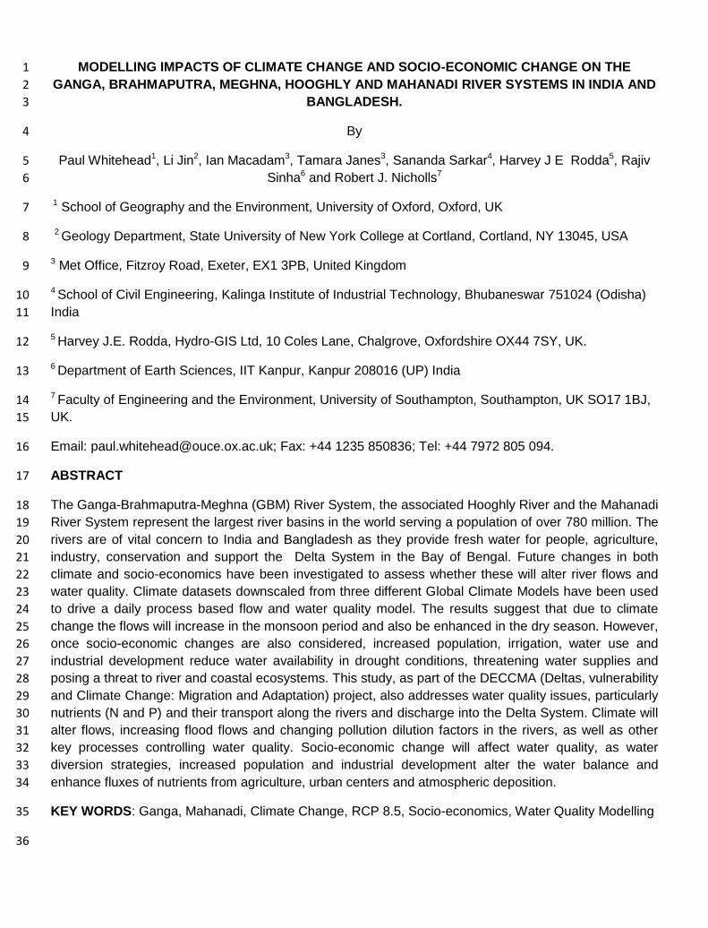
Figures 5 and 6 show typical results for flows and nitrate simulations and fits to the observed 340
data. The N load calculations in Figure 6 are based on simulated and observed Nitrate-N 341
concentrations and flows. In this study, three 20 year time slices have been evaluated using 342
1981-2000 as a baseline period, with 2041-2060 as a future mid-term time slice and the 343
period 2079-2098 as a far future time slice. 344
Model uncertainty analysis and limitations 345
There are always issues concerned with model uncertainty and model limitations in any flow 346
and water quality modelling study. Models are a simplification of reality and allow an 347
approximation to any system to be evaluated (Whitehead et al., 2016). The fact that the 348
system is dynamic and that chemical processes are kinetic in nature and interact with the 349
hydrology makes modelling a very complex process. There have been extensive studies of 350
uncertainty using the INCA models with techniques such as generalized sensitivity analysis 351
(Spear and Hornberger, 1980, Hornberger and Spear, 1980) used extensively to test INCA 352
model uncertainty (Rankinen et al. 2006, Futter et al. 2007, Wade et al. 2002 a, b, c) to 353
evaluate both parametic uncertainty in the INCA Model and uncertainty in the data used to 354
drive the model. For example, Wade et al. (2002a) found that the INCA N model 355
performance was sensitive to the parameters defining nitrogen dynamics such as 356
denitrification processes as well as key hydrological factors such as base flow index. There 357
are limitations in any water quality modelling study because of all the complexities. In this 358
study a key limitation is the lack of frequent water quality data to allow a full calibration and 359
validation of the model and even the flow data is fairly limited. So there will be uncertainty in 360
any results from such a study. 361
362
Figure 5 Simulated (blue line) and Observed (purple line) daily flows at the Flow Gauge on 363
the Brahmaputra River System at Bahadurabad for 1981-2000 together with simulated 364
Nitrate and Ammonium 365
366

367
Figure 6 Simulated and Observed Loads in the Ganga River at Kanpur 368
EFFECTS OF CLIMATE AND SOCIO-ECONOMIC CHANGES ON RIVER FLOW 369
With 5 rivers to compare and 3 Climate Scenarios plus 3 socio-economic scenarios there are 370
many combinations of results to discuss for flow and water quality. Here we discuss a limited 371
set but they capture the likely changes as suggested by the modelling analysis. Figure 7 372
shows the impacts of climate change on flow in the 5 River Systems using the climate data 373
downscaled from HadGEM2-ES. The Brahmaputra simulated monthly mean flows in Figure 374
7 show relatively little change into the future for the 2050s and into the 2090s. However, the 375
pattern of monthly flows is quite different for the Ganga, the Hooghly and the Mahanadi 376
which all show limited changes by the 2050s, but significant increases in monsoon flows in 377
the 2090s, reflecting higher precipitation in the monsoon period (Janes et al., 2018, this 378
volume). 379
Table 3 shows changes in extreme flow for the downscaled GFDL-CM3 GCM. It compares 380
the extremes of behaviour with the statistic Q95 representing the low flow or drought 381
conditions and Q5 representing the high flow or flooding conditions. The simulated flow 382
values are shown in the Table 3 together with the percentage change in Q95 and Q5 by the 383
2050s and the 2090s. The high flow conditions (Q5) show a modest increase in the 2050s in 384
all rivers and a very large change in the 2090s, suggesting that flooding will significantly 385
increase. With regard to low flows, there are differing patterns of behaviour, with the 386
Brahmaputra, Meghna and the Mahanadi showing significant increases by the 2050s and all 387
rivers showing increases by the 2090s. This initially suggests an easing of water security 388
issues, but these results do not take into account the socio-economic changes where 389
increased water use for irrigation and public use will lower baseflow conditions. The socio-390
economic effects are considered below in terms of flow and water quality. 391
An interesting result is the comparison of the 3 downscaled GCMs (CNRM-CM5, GFDL-CM3 392
and HadGEM2-ES). Each of these generates different time series of precipitation, 393
temperature and evaporation (Janes et al., 2018, this volume), and these also vary from 394
catchment to catchment. Figure 8 shows the variation between the regional climate model 395
output in terms of flow in the 5 different rivers. Results for the downscaled CNRM-CM5 and 396
HadGEM2-ES GCMs are remarkably similar in terms of flow changes by the 2050s. 397
However, results for the downscaled GFDL-CM3 GCM show lower flows in the Ganga and 398
Hooghly Rivers. 399
The effects of socio-economic changes on river flows is illustrated in Figure 9, which shows 400
the 2050s total flows for the combined Ganga, Brahmaputra and Meghna in Bangladesh. 401
R² = 0.9656
0
20000
40000
60000
80000
0 50000 100000
Ob
serv
ed
N L
oad
-To
nn
es/
Ye
ar
Simulated N Load-Tonnes/Year

The effects of the socio-economic factors are fairly minimal by the 2050s and are 402
outweighed by the increased flows due to climate change. However, if the effects of major 403
water transfer schemes are considered, such as a 30% diversion of the Brahmaputra flows, 404
then then there is a significant reduction in flows in Bangladesh. This could be quite serious 405
in Bangladesh and especially in the low flow period when the water is used in Bangladesh 406
for irrigation and is a key freshwater driver for fisheries in the rivers and estuary systems. 407
Note in Figure 9 the 3 socioeconomic scenarios are indistinguishable, apart from the 408
Brahmaputra water diversion flow scenario. 409
410
411
Figure 7 Impacts of Future Climate Change on Monthly Mean Flows in the last reaches of 5 412
Rivers for the downscaled HadGEM2-ES climate data. 413
Table 3 Simulated Current Flow Statistics for flood and low flow conditions and percentage 414
changes into the future for the 5 River Systems for climate data downscaled from the GFDL-415
CM3 GCM. 416
1990s Flow
m3/sec
2050s Flow
% change
2090s Flow
% change
Q5 Q95 Q5 Q95 Q5 Q95

Brahmaputra 50561.4 3529.6 6.8 55.6 13.7 55.6
Meghna 3277.4 30.0 35.2 15.1 86.9 98.1
Ganga 31116.3 127.2 5.9 3.5 56.7 37.0
Hooghly 36600.2 148.4 9.6 3.5 29.5 37.0
Mahanadi 6064.2 90.1 17.6 -0.1 97.7 12.34
417
418
Figure 8 Impacts of Climate Change on 2050s Monthly Mean Flows in 5 Rivers for 419
climate data downscaled from the 3 GCMs 420
421

422
Figure 9 Impacts of Socio-Economic Change and also a Water Transfer Scheme in the 423
2050s 424
EFFECTS OF CLIMATE AND SOCIO-ECONOMIC CHANGES ON WATER QUALITY 425
In terms of water quality, the climate and socio-economic changes will impact Nitrate and 426
Phosphorus in different ways. For example, Figure 10 shows the impacts of climate change 427
on Nitrate and Phosphorus in the 2050s and 2090s for the Ganga River using climate data 428
downscaled from the climate model combination GFDL-CM3. The higher monsoon flows in 429
the 2050s and 2090s dilute the sources of N and P in the catchment and hence generate 430
lower N and P in the high flow periods. However in the low flow periods P increases whereas 431
N decreases. This is due to the different process affecting N and P, where N undergoes 432
extensive denitrification under low flows, due to the higher temperatures and the increased 433
residence time of the river water. Whereas P concentrations rise in the low flow periods as 434
there is less dilution of effluent discharges and agricultural runoff. 435
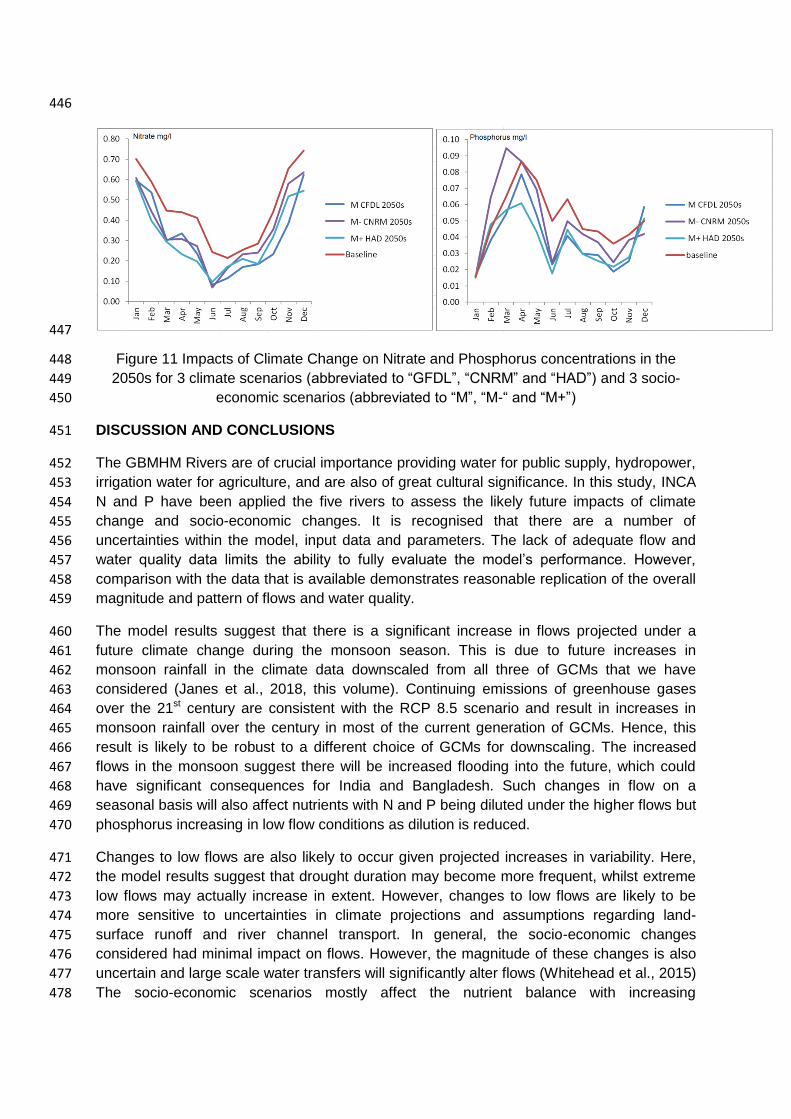
Figure 11 illustrates the impacts on river nutrients of socio-economic changes combined with 436
climate changes. The results suggest that socio-economics will have a fairly limited impact 437
on water quality except in the case of the medium minus economy as it affects P in the dry 438
season. This is because there is the assumption that STWs will not be upgraded and with a 439
decline in low flows plus there is less dilution of pollutants entering the River Systems. The 440
resulting increasing P will enhance eutrophication and lead to enhanced algal blooms, some 441
of which are toxic, such as cyanobacteria (Bussi et al., 2016) 442
443
Figure 10 Impacts of Climate Change on Nitrate and Phosphorus in the 2050s and 2090s for 444
the Ganga using climate data downscaled fromthe GFDL-CM3 GCM 445
446
447
Figure 11 Impacts of Climate Change on Nitrate and Phosphorus concentrations in the 448
2050s for 3 climate scenarios (abbreviated to “GFDL”, “CNRM” and “HAD”) and 3 socio-449
economic scenarios (abbreviated to “M”, “M-“ and “M+”) 450
DISCUSSION AND CONCLUSIONS 451
The GBMHM Rivers are of crucial importance providing water for public supply, hydropower, 452
irrigation water for agriculture, and are also of great cultural significance. In this study, INCA 453
N and P have been applied the five rivers to assess the likely future impacts of climate 454
change and socio-economic changes. It is recognised that there are a number of 455
uncertainties within the model, input data and parameters. The lack of adequate flow and 456
water quality data limits the ability to fully evaluate the model’s performance. However, 457
comparison with the data that is available demonstrates reasonable replication of the overall 458
magnitude and pattern of flows and water quality. 459
The model results suggest that there is a significant increase in flows projected under a 460
future climate change during the monsoon season. This is due to future increases in 461
monsoon rainfall in the climate data downscaled from all three of GCMs that we have 462
considered (Janes et al., 2018, this volume). Continuing emissions of greenhouse gases 463
over the 21st century are consistent with the RCP 8.5 scenario and result in increases in 464
monsoon rainfall over the century in most of the current generation of GCMs. Hence, this 465
result is likely to be robust to a different choice of GCMs for downscaling. The increased 466
flows in the monsoon suggest there will be increased flooding into the future, which could 467
have significant consequences for India and Bangladesh. Such changes in flow on a 468
seasonal basis will also affect nutrients with N and P being diluted under the higher flows but 469
phosphorus increasing in low flow conditions as dilution is reduced. 470
Changes to low flows are also likely to occur given projected increases in variability. Here, 471
the model results suggest that drought duration may become more frequent, whilst extreme 472
low flows may actually increase in extent. However, changes to low flows are likely to be 473
more sensitive to uncertainties in climate projections and assumptions regarding land-474
surface runoff and river channel transport. In general, the socio-economic changes 475
considered had minimal impact on flows. However, the magnitude of these changes is also 476
uncertain and large scale water transfers will significantly alter flows (Whitehead et al., 2015) 477
The socio-economic scenarios mostly affect the nutrient balance with increasing 478
concentration of N and P under the medium minus scenario. However, these socio-479
economic changes are offset by the changes in climate. 480
The development of models for such large and complex river systems provide an important 481
planning tool for assisting in exploring future scenarios, engaging stakeholders in dialogue 482
on water resources management, and identifying gaps in knowledge and data. Considering 483
both flows and water quality for a range of climate and socio-economic scenarios can assist 484
in a more holistic management approach. 485
Acknowledgements 486
The research has been supported by the DECCMA Project on ‘DEltas, vulnerability and 487 Climate Change: Migration and Adaptation’ which is part of Collaborative Adaptation 488 Research Initiative in Africa and Asia (CARIAA), with financial support from the UK 489 Government’s Department for International Development (DfID) and the International 490 Development Research Centre (IDRC), Canada. 491
REFERENCES 492
Arnell N W and Lloyd-Hughes B, 2013, The global-scale impacts of climate change on water 493
resources and flooding under new climate and SSPs, Climatic Change (2014) 122:127–140 , 494
DOI 10.1007/s10584-013-0948-4 495
Caesar, J., Janes, T., and Lindsay, A. 2015 Climate projections over Bangladesh and the 496
upstream Ganges-Brahmaputra-Meghna system, Environ Sci Process Impacts. 2015 497
17(6):1047-56. doi: 10.1039/c4em00650j. 498
Collins, R., Whitehead, P.G. And Butterfield, D. (1999) Nitrogen Leaching from Catchments 499
in the Middle Hills of Nepal; an application of the INCA model, Science of the Total 500
Environment, 228, 259-274. 501
Futter, M.N., Butterfield, D., Cosby, B.J., Dillon, P.J., Wade, A.J., and Whitehead, P.G., 502
2007, Modeling the mechanisms that control in-stream dissolved organic carbon dynamics in 503
upland and forested catchments: Water Resources Research, v. 43, p. W02424, 504
doi:10.1029/2006WR004960. 505
Futter, M. N., Whitehead, P.G., S. Sarkar, H. Rodda and J. Crossman, 2015, Rainfall Runoff 506
Modelling Of The Upper Ganga And Brahmaputra Basins Using Persist, Environ. Sci.: 507
Processes Impacts, 2015,17, 1070-1081 DOI: 10.1039/C4EM00613E 508
Gordon, C., C. Cooper, C. A. Senior, H. Banks, J. M. Gregory, T. C. Johns, J. F. B. Mitchell 509
and R. A. Wood, 2000: The simulation of SST, sea ice extents and ocean heat transports in 510
a version of the Hadley Centre coupled model without flux adjustments. Clim. Dyn.,16:147-511
168 512
Hill, C., Nicholls, R J, Whitehead, P G, Dunn F, Haque, A., Appeaning-Addo, K, and Raju P 513
V, (2018), Delineating Climate Change Impacts on Biophysical Conditions in Populous 514
Deltas , Editorial, A special Issue of Science of the Total Environment, this volume 515
Hornberger, G. M. and Spear, R. C., 1980 Eutrophication in peel inlet: The problem-defining 516
behaviour and a mathematical model for the phosphorus scenario, In Water Research, 517

Volume 14, Issue 1, 1980, Pages 29-42, ISSN 0043-1354, https://doi.org/10.1016/0043-518
1354(80)90039-1. 519
IPCC, 2014: Summary for Policymakers, In: Climate Change 2014, Mitigation of Climate 520
Change. Contribution of Working Group III to the Fifth Assessment Report of the 521
Intergovernmental Panel on Climate Change [Edenhofer, O., R. Pichs-Madruga, Y. Sokona, 522
E. Farahani, S. Kadner, K. Seyboth, A. Adler, I. Baum, S. Brunner, P. Eickemeier, B. 523
Kriemann, J. Savolainen, S. Schlömer, C. von Stechow, T. Zwickel and J.C. Minx (eds.)]. 524
Cambridge University Press, Cambridge, United Kingdom and New York, NY, USA. 525
Janes, T., McGrath, F., Macadam, I., and Jones, R.G., 2018, High-resolution climate 526
projections for South Asia to inform climate impacts and adaptation studies in the Ganges-527
Brahmaputra-Meghna and Mahanadi deltas. Science of the Total Environment, This Volume 528
Jin, L., Whitehead, P G, Sarkar, S., Sinha, R., Futter, M N, Butterfield, D, Caesar J., and 529
Crossman J. , 2015, Assessing The Impacts Of Climate Change And Socio-Economic 530
Changes On Flow And Phosphorus Flux In The Ganga River System, Environ. Sci.: 531
Processes Impacts, 17, 1098-1110 , DOI: 10.1039/C5EM00092K 532
Jin l., Whitehead P G, Rodda H, Macadam I, Sarkar S. 2018 RCP Climate Change Impacts 533
of Flows and Water Quality in the Mahanadi River System, India, Science of the Total 534
Environment, This Volume 535
Jones, R.G., Noguer, M., Hassell, D.C., Hudson, D., Wilson, S.S., Jenkins, G.J. and Mitchell, 536
J.F.B. (2004) Generating high resolution climate change scenarios using PRECIS, Met 537
Office Hadley Centre, Exeter, UK, 40pp April 2004 538
Kathpalia, G.N., and Kapoor, R., 2010, Management of Land and other Resources for 539
Inclusive Growth: India 2050: Alternative Futures, Dehli, p. 32. 540
Kebede, A.S., Nicholls, R.J., Allan, A., Arto, I., Cazcarro, I., Fernandes, J.A., Hill, C.T., 541
Hutton, C.W., Kay, S., Lawn, J., Lazar, A.N., Macadam, I., Palmer, M., Suckall, N., 542
Tompkins, E.L., Vincent, K., and Whitehead, P.G., 2018, Integrated Scenario Framework to 543
Explore Migration and Adaptation in Deltas: The DECCMA Approach: Science of the Total 544
Environment, This Volume. 545
Nash, J. E. and Sutcliffe, J. V. 1970. River flow forecasting through conceptual models part I-546
-A discussion of principles. Journal of Hydrology 10 (3): 282–290. doi:10.1016/0022-547
1694(70)90255-6 548
Nicholls, R.J., C.W. Hutton, A.N. Lázár, A. Allan, W.N. Adger, H. Adams, J. Wolf, M. 549
Rahman, and M. Salehin. 2016. Integrated assessment of social and environmental 550
sustainability dynamics in the Ganga-Brahmaputra-Meghna delta, Bangladesh. Estuarine, 551
Coastal and Shelf Science 183, 370-381. http://dx.doi.org/10.1016/j.ecss.2016.08.017 552
Nicholls, R J, Wolf, J, Whitehead P G, Rahman M , Salehin, M, Hutton C, 2015 A Synthesis 553
of Environmental Change impacts on the ESPA DELTA region (this volume|) 554
Nicholls, R. J., Whitehead, P., Wolf, J., Rahman, M., & Salehin, M. (2015). The Ganga–555
Brahmaputra–Meghna delta system: biophysical models to support analysis of ecosystem 556

services and poverty alleviation. Environmental Science: Processes & Impacts, 17(6), 1016-557
1017. DOI: 10.1039/C5EM90022K 558
Pathak D., Whitehead P G , Futter M N and Sinha R, 2018 Water Quality Assessment And 559
Catchment-Scale Nutrient Flux Modeling In The Ramganga River Basin In North India: An 560
Application Of The INCA Model Science of the Total Environment (this Volume) 561
Rankinen, K., Karvonen, T., Butterfield, D., 2006. An application of the GLUE methodology 562
for estimating the parameters of the INCA N model. Science of the total environment, 365(1): 563
123-139. 564
Roy, N.G. and Sinha, R. (2014). Effective discharge for suspended sediment transport of the 565
Ganges river and its geomorphic implications. Geomorphology, 227, 18-30. 566
Sadoff, C 2013 Ten fundamental questions for water resources development in the Ganga: 567
myths and realities, Water policy 15 (2013): 147-164. 568
Shi, Y., Gao, X., Zhang, D., and Giorgi, F.: Climate change over the Yarlung Zangbo–569
Brahmaputra River Basin in the 21st century as simulated by a high resolution regional 570
climate model, Quaternary international, 244, 159-168, 2011. 571
Sinha, R., Jain, V., Babu, G.P., Ghosh, S., 2005. Geomorphic characterization and diversity 572
of the fluvial systems of the Gangetic Plains. Geomorphology, 70(3): 207-225. 573
Spear RC and Hornberger GM, 1980 Eutrophication in the Peel Inlet II. Identification of 574
critical uncertainties via generalised sensitivity analysis. Water Research 1980;14:43 - 49. 575
Wade, A .J., Durand, P., Beaujouan, V., Wessel, W. W., Raat, K. J., Whitehead, P. G., 576
Butterfield, D., Rankinen, K. And Lepisto, A., 2002a Towards a generic nitrogen model of 577
European ecosystems: INCA, new model structure and equations. Hydrol. Earth Syst. Sci., 578
6, 559-582. 579
Wade, A.J., Whitehead, P.G., Butterfield, D., 2002b. The Integrated Catchments model of 580
Phosphorus dynamics (INCA P), a new approach for multiple source assessment in 581
heterogeneous river systems: model structure and equations. Hydrology and Earth System 582
Sciences, 6(3): 583-606. 583
Wade, A., Whitehead, P., Hornberger, G., Jarvie, H., Flynn, N., 2002c. On modelling the 584
impacts of phosphorus stripping at sewage works on in-stream phosphorus and 585
macrophyte/epiphyte dynamics: a case study for the River Kennet. Science of the total 586
environment, 282: 395-415. 587
Whitehead, P. G. Sarkar, S. and Jin, L. and Futter, M. N. and Caesar, J. and Barbour, E. and 588
Butterfield, D. and Sinha, R. and Nicholls, R. and Hutton, C. and Leckie, H. D., 2015, 589
Dynamic Modelling Of The Ganga River System: Impacts Of Future Climate And Socio-590
Economic Change On Flows And Nitrogen Fluxes In India And Bangladesh, Environ. Sci.: 591
Processes Impacts, 17,6 1082-1097, doi 10.1039/C4EM00616J 592
Whitehead, P.G., E. Barbour, M. N. Futter, S. Sarkar, H. Rodda, J. Caesar, D. Butterfield, L. 593
Jin, R. Sinha, R. Nicholls and M. Salehin , 2015, Impacts Of Climate Change And Socio-594
Economic Scenarios On Flow And Water Quality Of The Ganges, Brahmaputra And Meghna 595

(GBM) River Systems: Low Flow And Flood Statistics, Environ. Sci.: Processes Impacts, 596
2015,17, 1057-1069, DOI: 10.1039/C4EM00619D 597
Whitehead P.G., Wilson E.J., Butterfield D. 1998a A semi-distributed Integrated Nitrogen 598
model for multiple source assessment in Catchments (INCA): Part I - model structure and 599
process equations. Science of the Total Environment, 210/211, 547-558. 600
Whitehead P.G., Wilson E.J., Butterfield D., Seed K. 1998b A semi-distributed Integrated 601
flow and Nitrogen model for multiple source assessment in Catchments (INCA) : Part II - 602
application to large river basins in south Wales and eastern England. Science of the Total 603
Environment, 210/211, 559-583. 604
Whitehead P G, Water Quality Modelling, (2016) Wiley Statistics John Wiley & Sons, Ltd. 605
DOI:10.1002/9781118445112.stat07793.pub2 606
607