modeling goals and objectives / future directions august 23, 2006 break-out group 1
TRANSCRIPT

Modeling Goals and Objectives / Future Directions
August 23, 2006 Break-out Group 1
2
Carbon Cycle and Ecosystems Focus Area
The Legacy Roadmap for Carbon Cycle & Ecosystems
3
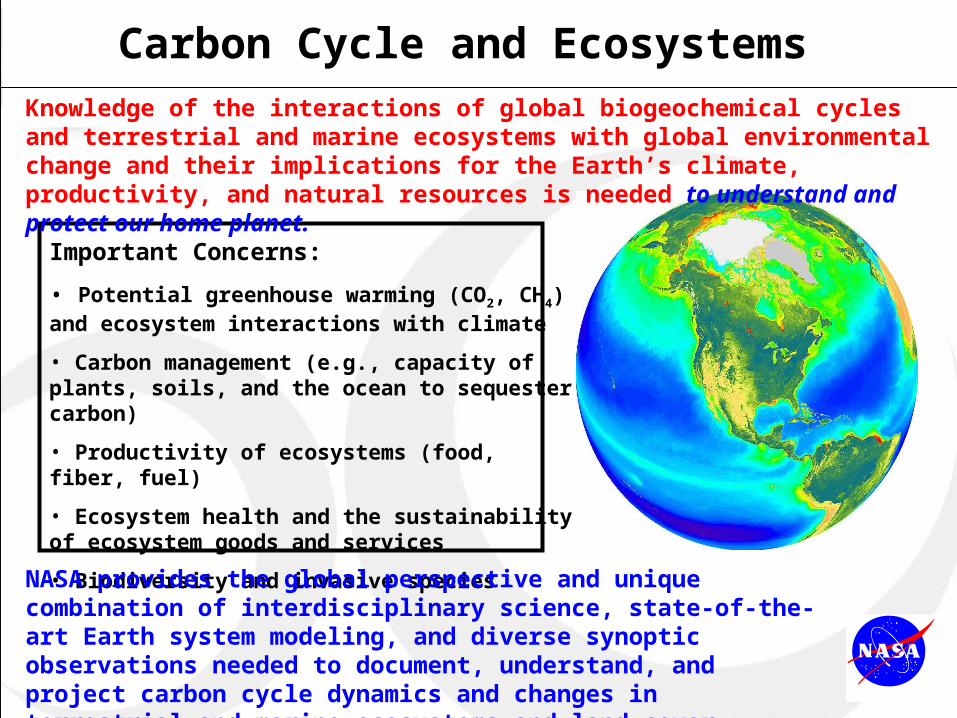
Carbon Cycle and Ecosystems
Important Concerns:
• Potential greenhouse warming (CO2, CH4) and ecosystem interactions with climate
• Carbon management (e.g., capacity of plants, soils, and the ocean to sequester carbon)
• Productivity of ecosystems (food, fiber, fuel)
• Ecosystem health and the sustainability of ecosystem goods and services
• Biodiversity and invasive species
NASA provides the global perspective and unique combination of interdisciplinary science, state-of-the-art Earth system modeling, and diverse synoptic observations needed to document, understand, and project carbon cycle dynamics and changes in terrestrial and marine ecosystems and land cover.
Knowledge of the interactions of global biogeochemical cycles and terrestrial and marine ecosystems with global environmental change and their implications for the Earth’s climate, productivity, and natural resources is needed to understand and protect our home planet.

4
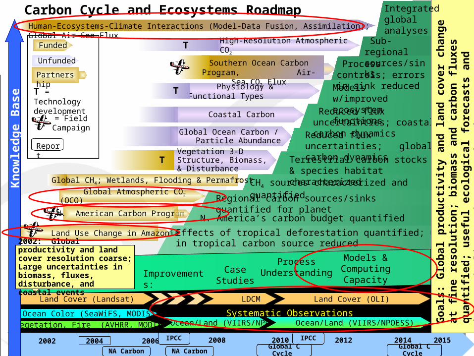
Carbon Cycle and Ecosystems Roadmap
T
2002 2010 2012 2014 20152004
Reduced flux uncertainties; global carbon dynamics
Funded
Unfunded
Global Ocean Carbon / Particle Abundance
N. America’s carbon budget quantified
Global Atmospheric CO2 (OCO)
2006 2008
Reduced flux uncertainties; coastal carbon dynamics
NA Carbon NA Carbon Global C Cycle
T = Technology development
Regional carbon sources/sinks quantified for planet
IPCC IPCC
Effects of tropical deforestation quantified; uncertaintiesin tropical carbon source reduced
= Field Campaign
Physiology & Functional Types
Go
als:
Glo
bal
pro
du
ctiv
ity
and
lan
d c
ove
r ch
ang
e at
fin
e re
solu
tio
n;
bio
mas
s an
d c
arb
on
flu
xes
qu
anti
fied
; u
sefu
l ec
olo
gic
al f
ore
cast
s an
d im
pro
ved
clim
ate
chan
ge
pro
ject
ion
s
Vegetation 3-D Structure, Biomass, & Disturbance T Terrestrial carbon stocks &
species habitat characterized
Models w/improved ecosystem functions
High-Resolution Atmospheric CO2 Sub-regional sources/sinks
Integrated global analyses
CH4 sources characterized and quantified
Report
P
Vegetation (AVHRR, MODIS)
Ocean Color (SeaWiFS, MODIS)
Land Cover (Landsat) LDCM Land Cover (OLI)
Vegetation, Fire (AVHRR, MODIS) Ocean/Land (VIIRS/NPP) Ocean/Land (VIIRS/NPOESS)
Models & Computing Capacity
Case Studies
Process UnderstandingImprovements:
Human-Ecosystems-Climate Interactions (Model-Data Fusion, Assimilation); Global Air-Sea Flux
T
Partnership
N. American Carbon Program
Land Use Change in Amazonia
Global CH4; Wetlands, Flooding & Permafrost
Global C Cycle
Kn
ow
led
ge
Bas
e
2002: Global productivity and land cover resolution coarse; Large uncertainties in biomass, fluxes, disturbance, and coastal events
Systematic Observations
Process controls; errors in sink reduced
Coastal Carbon
Southern Ocean Carbon Program, Air-Sea CO2 Flux
5
Carbon Cycle and Ecosystems Roadmap
T
2002 2010 2012 2014 20152004
Reduced flux uncertainties; global carbon dynamics
Funded
Unfunded
Global Ocean Carbon / Particle Abundance
N. America’s carbon budget quantified
Global Atmospheric CO2 (OCO)
2006 2008
Reduced flux uncertainties; coastal carbon dynamics
NA Carbon NA Carbon Global C Cycle
T = Technology development
Regional carbon sources/sinks quantified for planet
IPCC IPCC
Effects of tropical deforestation quantified; uncertaintiesin tropical carbon source reduced
= Field Campaign
Physiology & Functional Types
Go
als:
Glo
bal
pro
du
ctiv
ity
and
lan
d c
ove
r ch
ang
e at
fin
e re
solu
tio
n;
bio
mas
s an
d c
arb
on
flu
xes
qu
anti
fied
; u
sefu
l ec
olo
gic
al f
ore
cast
s an
d im
pro
ved
clim
ate
chan
ge
pro
ject
ion
s
Vegetation 3-D Structure, Biomass, & Disturbance T Terrestrial carbon stocks &
species habitat characterized
Models w/improved ecosystem functions
High-Resolution Atmospheric CO2 Sub-regional sources/sinks
Integrated global analyses
CH4 sources characterized and quantified
Report
P
Vegetation (AVHRR, MODIS)
Ocean Color (SeaWiFS, MODIS)
Land Cover (Landsat) LDCM Land Cover (OLI)
Vegetation, Fire (AVHRR, MODIS) Ocean/Land (VIIRS/NPP) Ocean/Land (VIIRS/NPOESS)
Models & Computing Capacity
Case Studies
Process UnderstandingImprovements:
Human-Ecosystems-Climate Interactions (Model-Data Fusion, Assimilation); Global Air-Sea Flux
T
Partnership
N. American Carbon Program
Land Use Change in Amazonia
Global CH4; Wetlands, Flooding & Permafrost
Global C Cycle
Kn
ow
led
ge
Bas
e
2002: Global productivity and land cover resolution coarse; Large uncertainties in biomass, fluxes, disturbance, and coastal events
Systematic Observations
Process controls; errors in sink reduced
Coastal Carbon
Southern Ocean Carbon Program, Air-Sea CO2 Flux

6
Quantitative global monitoring & evaluation tools: to assess the efficacy of carbon management (e.g. sequestration in biomass); to assess agricultural, forest, and fisheries productivity; for use in verifying emissions and/or sequestration reporting by nations/sectors.
Global primary productivity and land cover change time series variability and trends quantified at moderate to fine spatial resolution. Carbon sources and sinks identified and quantified.
Models that:- achieve carbon balance- reliably characterize interannual variability and sub-regional processes - quantitatively portray multiple, interacting controlling
processes - are able to correctly simulate past land cover, ecosystem dynamics and biogeochemical cycling
Quantification of carbon and nutrient storage and fluxes, disturbance and recovery processes, and ecosystem health. Quantification of controlling processes and their interactions.
Maps, data products and information on relationships among them as input for decision support systems. Simulation models that enable “If … , then…” scenarios to be explored.
Result / Capability Products / Uses for Decision Support
Predicting Carbon Cycling
Ecological Forecasts: Projections of changes in carbon sources and sinks, land cover, and ecosystem dynamics due to combinations of real-world forcings of global environmental change with sub-regional specificity and good reliability for ~6 mos. to 2 years into the future (e.g., harmful algal blooms, invasive species).
--------------------------------------------
Inputs for Climate Projections: Credible, useful projections of future climate change (including improved ecosystem feedbacks and projections of CO2 and CH4 concentrations) for 50-100 years into the future for a variety of policy-relevant “if …, then …” scenarios.
Anticipated Outcomes and Uses of Results
7
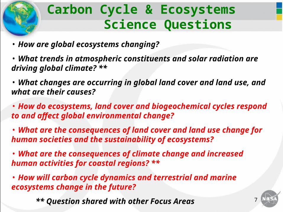
Carbon Cycle & Ecosystems Science Questions
• How are global ecosystems changing?
• What trends in atmospheric constituents and solar radiation are driving global climate? **
• What changes are occurring in global land cover and land use, and what are their causes?
• How do ecosystems, land cover and biogeochemical cycles respond to and affect global environmental change?
• What are the consequences of land cover and land use change for human societies and the sustainability of ecosystems?
• What are the consequences of climate change and increased human activities for coastal regions? **
• How will carbon cycle dynamics and terrestrial and marine ecosystems change in the future?
** Question shared with other Focus Areas

8
Why Carbon Cycle?
Atmospheric concentrations of CO2 & CH4, both greenhouse gases, have increased dramatically in the past 200 years due to fossil fuel burning and land cover/use changeThere is potential to mitigate climate change effects by enhancing biospheric carbon uptake and storage (i.e., carbon sequestration)Better predictions of future atmospheric CO2 & CH4 and ecosystem carbon dynamics are needed to improve climate projections and scenarios used for decision making
transport and carbon gases
weather and
climate
satellite and in-situ
observations
C process models
Coupled Carbon Data Coupled Carbon Data Assimilation SystemAssimilation System
9
Research Challenges: Carbon Cycle
Closing the global carbon budget (& quantifying components)• quantifying North America’s carbon sources and sinks,
understanding their interannual variability, and explaining causes• locating and explaining the Northern Hemisphere terrestrial sink• determining the size, function, and controls on oceanic sinks• clarifying carbon source/sink dynamics and trends in the tropics
Projecting future concentrations of CO2 and CH4 and changes in terrestrial and aquatic carbon cycling dynamics• developing capable carbon cycle, ecosystem, and carbon data
assimilation models • quantifying errors and characterizing uncertainties associated
with model inputs and outputs• collaborating with modelers in other Focus Areas to develop
fully coupled, integrated Earth system models that incorporate projections of future carbon cycle dynamics
10
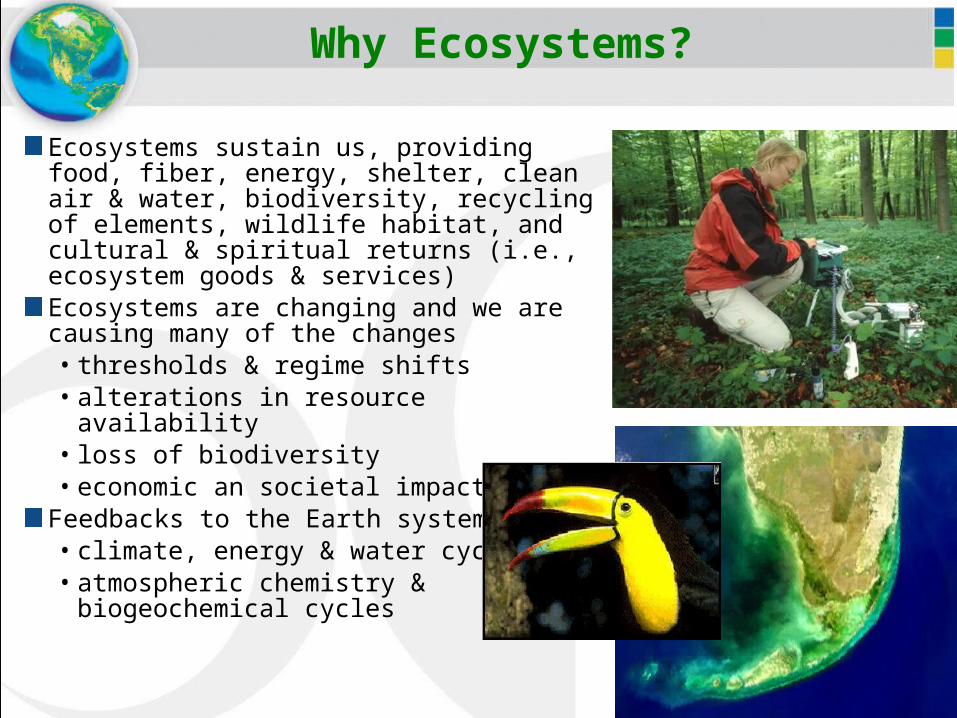
Why Ecosystems?
Ecosystems sustain us, providing food, fiber, energy, shelter, clean air & water, biodiversity, recycling of elements, wildlife habitat, and cultural & spiritual returns (i.e., ecosystem goods & services)Ecosystems are changing and we are causing many of the changes• thresholds & regime shifts• alterations in resource availability• loss of biodiversity• economic an societal impacts
Feedbacks to the Earth system• climate, energy & water cycle• atmospheric chemistry &
biogeochemical cycles
SeaWiFS Views Mysterious Black WaterBlanketing Florida Bay
Sydney
February 4, 2002

11
Research Challenges: Ecosystems
Understanding the effects of global climate change on terrestrial and aquatic ecosystems• evaluating the combined effects of multiple, interacting influences and
stresses on ecosystem structure and function• characterizing and quantifying disturbances• understanding threshold effects and regime shifts• developing the capability to effectively model ecosystem dynamics
and changesCharacterizing and quantifying feedbacks to the climate system (physical and chemical)Learning how to manage ecosystems for multiple end usesDocumenting the range and distribution of organisms of importance (species with vital functions, invasive species, pathogens, etc.) and modeling to predict future distributionsUnderstanding relationships between biodiversity and ecosystem functioning (e.g., productivity, biogeochemical cycling, biological services, resilience & adaptability)

12
Why Land Cover and Land Use Change?
Changes in land cover/use are an independent forcing of global environmental changeThese changes are under strong human influence and can be managed to serve human needsPast land use practices affect present & future ecosystem function (i.e., land use legacies)Land cover/use changes interact with climate variability & change to effect global change They cause direct feedbacks to the climate system They affect ecosystem goods & services and carbon dynamics
13
Research Challenges: Land Cover and Land Use Change
Documenting the spatial and temporal dynamics of land cover and land use changeDeveloping understanding of the combined human and natural causes of land cover and land use changes and how they interact at regional and global scalesCharacterizing and quantifying the role of fragmentation and degradation, the role of multiple drivers of change, the role of institutions, and the interactions among drivers and types of land use changeProjecting land use and land cover ~5-50 years into the future
14
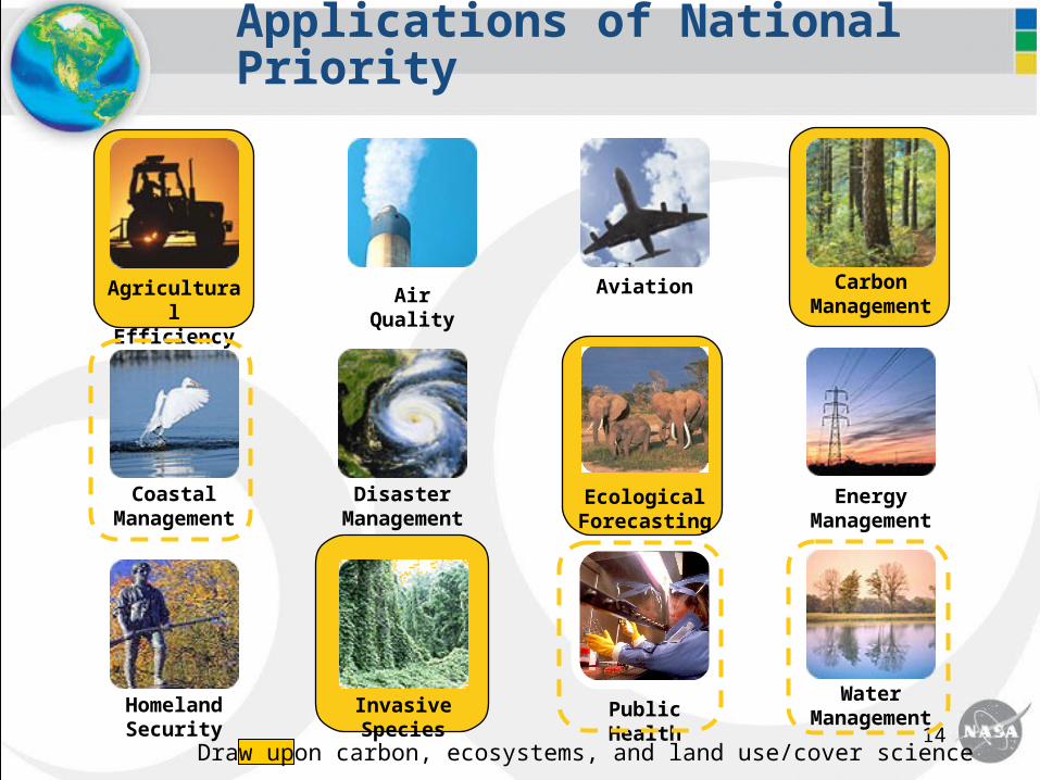
Ecological Forecasting
AgriculturalEfficiency
Air Quality
Invasive Species
Aviation
Energy Management
CarbonManagement
Public HealthWater
ManagementHomeland
Security
Disaster Management
Coastal Management
Applications of National Priority
Draw upon carbon, ecosystems, and land use/cover science

15
Research Challenges: Carbon Cycle & Ecosystems Research Applications
Advancing the remote sensing, spatial analysis, information management, and decision support tools needed to evaluate management and mitigation options for responding to• climate change• management of carbon in the environment• threats to sustainable resource use and the productivity of
agricultural systems and coastal fisheries • changes in or loss of habitat and reductions in biodiversity• non-indigenous species invasions

16
CC&E Missions / Mission Studies
Vegetation 3-D Structure, Biomass, and Disturbance. Vegetation height profiles over the Earth’s land surface are needed to estimate biomass and carbon stocks and to quantify biomass recovery following disturbance. - Candidate technological approaches are lidar profiling, P-band SAR, and interferometric SAR (InSAR). The combination of a profiling lidar and a P-band (or L-band?) SAR represents the most promising approach to meeting the requirements for accuracy and global coverage. - Relevant Decadal Survey White Papers: Biomass Monitoring Mission (BioMM), also Multiplatform Interferometric SAR for Forest Structure, Biomass Monitoring Mission Lidar (BioMM-L), InSAR Applications for Exploration of the Earth, and, possibly, Structure and Inventory of Vegetated Ecosystems (STRIVE)
Physiology and Functional Types. Global observations of plant functional types and physiological function are required. Spectral coverage and sampling, spatial resolution, and temporal sampling must be optimized for terrestrial and aquatic ecosystems and to match their physical-ecological scales of variability. - A polar orbiter for land with an imaging spectrometer and a polar orbiter for the ocean carrying an advanced spectrometer paired with multiple active lidars seem most feasible, but a single mission may be possible.- Relevant Decadal Survey White Papers: Flora Mission for Ecosystem Composition, Disturbance, and Productivity; also PHYTOSAT: A Space Mission to Observe Phytoplankton and Assess its Role in the Oceanic Carbon Cycle
17
CC&E Missions / Mission Studies
Global Ocean Carbon Ecosystems and Coastal Processes. New space-based global observations are needed over an expanded spectral range and with finer resolution to allow for the accurate separation of in-water constituents (e.g., colored dissolved organic material, particle abundance, functional groups) and support the evolution of advanced ocean color algorithms. - A new baseline mission to characterize ocean constituents and make supporting aerosol observations to effectively utilize the new spectral ocean color information. This mission provides global coverage of continental shelves and near-shore environments and key polar regions. - Relevant Decadal Survey White Papers: OCEaNS (Ocean Carbon, Ecosystems, and Near-shore)
Profiles of Atmospheric CO2. Measure high resolution columns and profiles of CO2 and other biogeochemically produced greenhouses gases in order to locate and quantify surface sources and sinks. This mission’s measurements of carbon sources and sinks will be used to develop and explain annual global carbon budgets, evaluate international reporting of greenhouse gas emissions and carbon sequestration, and as inputs to decision support for carbon accounting and management.
- Determine distribution of CO2 abundance with improved sensitivity in the lowermost 5 km of the troposphere with measurement precision of 1-2 ppm CO2 on a grid no coarser than 100km x 100km and an ability to screen for clouds.- Relevant Decadal Survey White Papers:
18
Modeling Break-out Questions
1. Modeling goals & objectives/future directions:Chairs: George Hurtt, Dennis Ojima Room: 1109/1111 What are the most important modeling needs and challenges for NASA to address in the next few years? How could the current program "portfolio" be improved? What should the role of Terrestrial Ecology and related programs be in the advancement toward integrated Earth system models? What results from this area feed into NASA's Ecological Forecasting program? How can this transition be improved/strengthened? How do we know/decide when a modeling capability has matured to the stage it can be used in decision support?