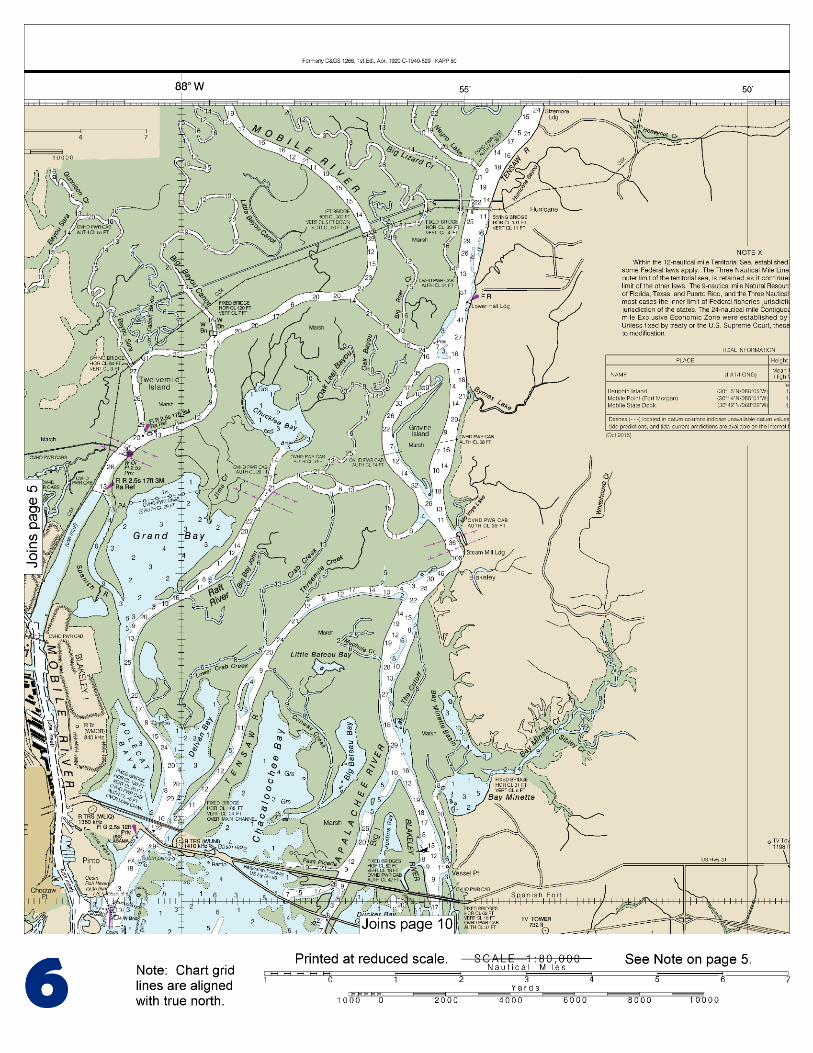
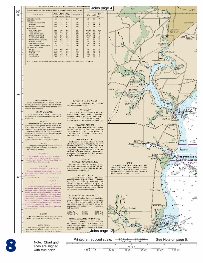
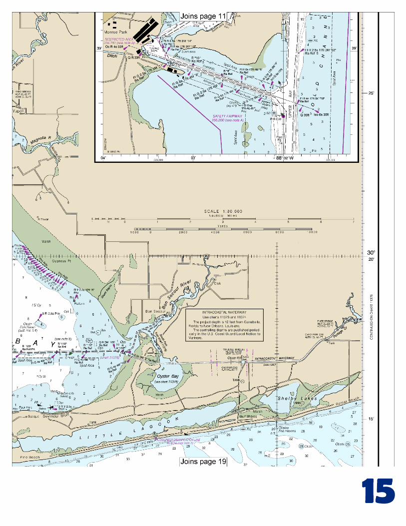
mobile bay mobile bay . noaa chart 11376 . a reduced -scale noaa nautical chart for small boaters...
TRANSCRIPT

BookletChart™ Mobile Bay NOAA Chart 11376
A reduced-scale NOAA nautical chart for small boaters When possible, use the full-size NOAA chart for navigation.

2
Published by the National Oceanic and Atmospheric Administration
National Ocean Service Office of Coast Survey
www.NauticalCharts.NOAA.gov 888-990-NOAA
What are Nautical Charts?
Nautical charts are a fundamental tool of marine navigation. They show water depths, obstructions, buoys, other aids to navigation, and much more. The information is shown in a way that promotes safe and efficient navigation. Chart carriage is mandatory on the commercial ships that carry America’s commerce. They are also used on every Navy and Coast Guard ship, fishing and passenger vessels, and are widely carried by recreational boaters.
What is a BookletChart?
This BookletChart is made to help recreational boaters locate themselves on the water. It has been reduced in scale for convenience, but otherwise contains all the information of the full-scale nautical chart. The bar scales have also been reduced, and are accurate when used to measure distances in this BookletChart. See the Note at the bottom of page 5 for the reduction in scale applied to this chart.
Whenever possible, use the official, full scale NOAA nautical chart for navigation. Nautical chart sales agents are listed on the Internet at http://www.NauticalCharts.NOAA.gov.
This BookletChart does NOT fulfill chart carriage requirements for regulated commercial vessels under Titles 33 and 44 of the Code of Federal Regulations.
Notice to Mariners Correction Status
This BookletChart has been updated for chart corrections published in the U.S. Coast Guard Local Notice to Mariners, the National Geospatial Intelligence Agency Weekly Notice to Mariners, and, where applicable, the Canadian Coast Guard Notice to Mariners. Additional chart corrections have been made by NOAA in advance of their publication in a Notice to Mariners. The last Notices to Mariners applied to this chart are listed in the Note at the bottom of page 7. Coast Pilot excerpts are not being corrected.
For latest Coast Pilot excerpt visit the Office of Coast Survey website at http://www.nauticalcharts.noaa.gov/nsd/searchbychart.php?chart=11376
[Coast Pilot 5, Chapter 9 excerpts] From W, boats drawing up to 6 feet can enter Mobile Bay via Pelican Passage and Pelican Bay, only with local knowledge, owing to the shifting character of the bottom. The channel passes between the shoal SE of Pelican Passage and Dauphin Island, thence E into Pelican Bay. The best water can be found by passing to the S of Dauphin Island Spit before shaping a course N into Mobile Bay. From E, only 3 feet can be taken across
Southeast Shoal around Mobile Point. It is necessary to pass very close to shore; the passage should only be attempted under most favorable
weather conditions and with local knowledge. The channels shift frequently. Mobile Bay Channel extends from the lower anchorage off Fort Morgan through Mobile Bay to Mobile River. Federal project depth is 40 feet to and in a turning basin off Magazine Point. The channel is well marked with lighted ranges, lights, and lighted and unlighted buoys. The Coast Guard advises vessels exercise particular caution where the channel intersects the Intracoastal Waterway, 3 miles above Mobile Point at Lighted Buoys 25 and 26. The Coast Guard has requested vessels make a SECURITE call on VHF-FM channel 13 prior to crossing the Intracoastal Waterway, particularly during periods of restricted visibility. Small boats sometimes anchor N and E of Fort Morgan in Navy Cove. Several piles and other obstructions are in this locality. Dangers.–Shoals extend 4.5 miles S and W of Mobile Bay entrance. Southeast Shoal covered 3 feet, is on the E side of the Bar Channel, and Sand Island Shoal, covered 1 foot, and West Bank, covered 3 feet, are on the W side. Shipping Safety Fairways.–Vessels should approach Mobile Bay through the prescribed Safety Fairways. (See 166.100 through 166.200, chapter 2.) Anchorages.–Vessels should anchor in the Mobile Bay Anchorage, S of and between the safety fairways. Dangers.–Shoals extend about 4.5 miles S and W of Mobile Bay entrance. Southeast Shoal, covered 3 feet, is on the E side of the Bar Channel, and Sand Island Shoal, covered 1 foot, and West Bank, covered 3 feet, are on the W side. The wreck of the Civil War vessel TECUMSEH is N of Mobile Point Light in 30°13'47.5"N., 88°01'37.5"W. The wreck is marked by a buoy with orange and white bands. The vessel is reported to be in an unstable condition, and ammunition and powder aboard the wreck could be detonated if the vessel shifts. Mariners are cautioned not to anchor in the area of the buoy and to reduce speed producing as little wake as possible when transiting Mobile Channel between Buoys 15 and 17. A nearly continuous spoil bank extends along either side of the bay channel from just inside Mobile Bay entrance to the mouth of Mobile River. Through these spoil banks are several charted openings for passage to various points in Mobile Bay. Fish havens, consisting of concrete pipe, lie within a 3.5-mile-square area which extends offshore from 2.7 miles to 6.2 miles E of Mobile Point. Fish havens, consisting of old automobile bodies lashed together, scrap iron, and concrete, have been or may be established on the bottom along the 10-fathom curve off the Alabama coast. While they are not dangerous and are reported to have a minimum depth of 10 fathoms over them, vessels are advised not to anchor in their vicinity. Ferry.–Scheduled daytime ferry crossings are frequent between Fort Gaines and Fort Morgan. The ferries monitor VHF-FM channel 16. Quarantine, customs, immigration, and agricultural quarantine.–(See chapter 3, Vessel Arrival Inspections, and Appendix A for addresses.) Speed limit.–No vessel, except launches, shall exceed 6 m.p.h. in the inner harbor between Mobile Channel Light 76 to and including Chickasaw Creek, and shall take all possible precautions to prevent disturbance of vessels berthed at marginal wharves.
U.S. Coast Guard Rescue Coordination Center 24 hour Regional Contact for Emergencies
RCC New Orleans Commander
8th CG District (504) 589-6225 New Orleans, LA

G
NOAA’s navigation managers serve as ambassadors to the maritime community. They help identify navigational challenges facing professional and recreational mariners, and provide NOAA resources and information for safe navigation. For additional information, please visit nauticalcharts.noaa.gov/service/navmanagers
To make suggestions or ask questions online, go to nauticalcharts.noaa.gov/inquiry. To report a chart discrepancy, please use ocsdata.ncd.noaa.gov/idrs/discrepancy.aspx.
Lateral System As Seen Entering From Seaward on navigable waters except Western Rivers
PORT SIDE
ODD NUMBERED AIDS
GREEN LIGHT ONLY
FLASHING (2)
PREFERRED CHANNEL
NO NUMBERS – MAY BE LETTERED
PREFERRED CHANNEL TO
STARBOARD
TOPMOST BAND GREEN
PREFERRED CHANNEL
NO NUMBERS – MAY BE LETTERED
PREFERRED CHANNEL
TO PORT
TOPMOST BAND RED
STARBOARD SIDE
EVEN NUMBERED AIDS
RED LIGHT ONLY
FLASHING (2)
FLASHING FLASHING
OCCULTING GREEN LIGHT ONLY RED LIGHT ONLY OCCULTING QUICK FLASHING QUICK FLASHING
ISO COMPOSITE GROUP FLASHING (2+1) COMPOSITE GROUP FLASHING (2+1) ISO
"1"
Fl G 6s
G "9"
Fl G 4s
GR "A"
Fl (2+1) G 6s
RG "B"
Fl (2+1) R 6s
"2"
Fl R 6s
8
R "8"
Fl R 4s
LIGHT
G
C "1"
LIGHTED BUOY
G
"5"
GR
"U"
GR
C "S"
RG
N "C"
RG
"G"
LIGHT
6
R
N "6"
LIGHTED BUOY
R
"2
"
CAN DAYBEACON
CAN NUN NUN
DAYBEACON
For more information on aids to navigation, including those on Western Rivers, please consult the latest USCG Light List for your area.
These volumes are available online at http://www.navcen.uscg.gov
Navigation Managers Area of Responsibility
Northeast
Lt. Meghan McGovern
Northwest and
Pacific Islands
Crescent Moegling
Great Lakes Region
Tom Loeper
Chesapeake and
Delaware Bay
Steve Soherr
California
Jeff Ferguson
[email protected] Mid-Atlantic
Lt. Ryan Wartick
Alaska
Lt. Timothy M. Smith
Western Gulf Coast
Alan Bunn
Central Gulf Coast
Tim Osborn
[email protected] South Florida
Puerto Rico
U.S. Virgin Islands
Michael Henderson
Southeast
Kyle Ward
2
2 C U 5
1


VHF Marine Radio channels for use on the waterways:Channel 6 – Inter-ship safety communications.Channel 9 – Communications between boats and ship-to-coast.Channel 13 – Navigation purposes at bridges, locks, and harbors.Channel 16 – Emergency, distress and safety calls to Coast Guard and others, and to initiate calls to other
vessels. Contact the other vessel, agree to another channel, and then switch.Channel 22A – Calls between the Coast Guard and the public. Severe weather warnings, hazards to navigation and safety warnings are broadcast here.Channels 68, 69, 71, 72 and 78A – Recreational boat channels.
Getting and Giving Help — Signal other boaters using visual distress signals (flares, orange flag, lights, arm signals); whistles; horns; and on your VHF radio. You are required by law to help boaters in trouble. Respond to distress signals, but do not endanger yourself.
EMERGENCY INFORMATION
Distress Call Procedures
• Make sure radio is on.• Select Channel 16.• Press/Hold the transmit button.• Clearly say: “MAYDAY, MAYDAY, MAYDAY.”• Also give: Vessel Name and/or Description;Position and/or Location; Nature of Emergency; Number of People on Board.• Release transmit button.• Wait for 10 seconds — If no responseRepeat MAYDAY call.
HAVE ALL PERSONS PUT ON LIFE JACKETS!
This Booklet chart has been designed for duplex printing (printed on front and back of one sheet). If a duplex option is not available on your printer, you may print each sheet and arrange them back-to-back to allow for the proper layout when viewing.
QR
Quick ReferencesNautical chart related products and information - http://www.nauticalcharts.noaa.gov
Interactive chart catalog - http://www.charts.noaa.gov/InteractiveCatalog/nrnc.shtmlReport a chart discrepancy - http://ocsdata.ncd.noaa.gov/idrs/discrepancy.aspx
Chart and chart related inquiries and comments - http://ocsdata.ncd.noaa.gov/idrs/inquiry.aspx?frompage=ContactUs
Chart updates (LNM and NM corrections) - http://www.nauticalcharts.noaa.gov/mcd/updates/LNM_NM.html
Coast Pilot online - http://www.nauticalcharts.noaa.gov/nsd/cpdownload.htm
Tides and Currents - http://tidesandcurrents.noaa.gov
Marine Forecasts - http://www.nws.noaa.gov/om/marine/home.htm
National Data Buoy Center - http://www.ndbc.noaa.gov/
NowCoast web portal for coastal conditions - http://www.nowcoast.noaa.gov/
National Weather Service - http://www.weather.gov/
National Hurrican Center - http://www.nhc.noaa.gov/
Pacific Tsunami Warning Center - http://ptwc.weather.gov/
Contact Us - http://www.nauticalcharts.noaa.gov/staff/contact.htm
NOAA’s Office of Coast Survey The Nation’s Chartmaker
For the latest news from Coast Survey, follow @NOAAcharts
NOAA Weather Radio All Hazards (NWR) is a nationwide network of radio stations broadcasting continuous weather information directly from the nearest National Weather Service office. NWR broadcasts official Weather Service warnings, watches, forecasts and other hazard information 24 hours a day, 7 days a week. http://www.nws.noaa.gov/nwr/