mississippi lock & dam #3 water power … very low head (vlh) turbine generators and...
TRANSCRIPT
Copyright © 2008 Free Flow Power Corporation ‐ All Rights Reserved
BEFORE THE
FEDERAL ENERGY REGULATORY COMMISSION
APPLICATION FOR PRELIMINARY PERMIT
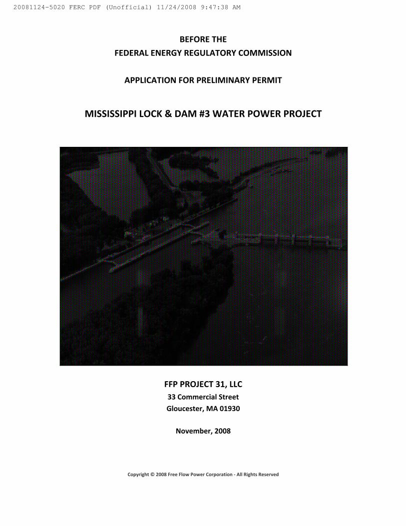
MISSISSIPPI LOCK & DAM #3 WATER POWER PROJECT
FFP PROJECT 31, LLC 33 Commercial Street
Gloucester, MA 01930
November, 2008
20081124-5020 FERC PDF (Unofficial) 11/24/2008 9:47:38 AM

Copyright © 2008 Free Flow Power Corporation ‐ All Rights Reserved
20081124-5020 FERC PDF (Unofficial) 11/24/2008 9:47:38 AM

Copyright © 2008 Free Flow Power Corporation ‐ All Rights Reserved
BEFORE THE UNITED STATES FEDERAL ENERGY REGULATORY COMMISSION
APPLICATION FOR PRELIMINARY PERMIT
I. Statement of Application
FFP Project 31, LLC applies to the Federal Energy Regulatory Commission for a preliminary permit for the proposed Mississippi River Lock and Dam #3 Water Power Project, as described in the attached exhibits. This application is made in order that the applicant may secure and maintain priority of licensing for the project under Part 1 of the Federal Power Act while obtaining the data and performing the acts required to determine the feasibility of the project and to support an application for license.
2. The location of the proposed project is: State: Minnesota and Wisconsin Counties: Goodhue County, MN and Pierce County, WI Nearby Town: Red Wing, MN Body of Water: Mississippi River 3. The exact name, business address, and telephone number of the applicant is:
FFP Project 31, LLC 33 Commercial Street Gloucester, MA 01930 978.283.2822
The exact name, address, and telephone number of persons authorized to act as agent for the applicant in this application are:
Daniel R. Irvin Free Flow Power Corporation 33 Commercial Street Gloucester, MA 01930 978.252.7631 dirvin@free‐flow‐power.com Dan Lissner Free Flow Power Corporation 33 Commercial Street Gloucester, MA 01930 978.252.7111 dlissner@free‐flow‐power.com
20081124-5020 FERC PDF (Unofficial) 11/24/2008 9:47:38 AM

Copyright © 2008 Free Flow Power Corporation ‐ All Rights Reserved
Jon Guidroz Free Flow Power Corporation 33 Commercial Street Gloucester, MA 01930 978.252.7364 jguidroz@free‐flow‐power.com Ramya Swaminathan VP, Project Development 33 Commercial Street Gloucester, MA 01930 978.226.1531 rswaminathan@free‐flow‐power.com Jason Hines Free Flow Power Corporation 1000 Harris Avenue, Ste 21 Bellingham, WA 98225 978.252.7112 jhines@free‐flow‐power.com
4. Preference under Section 7(a) of the Federal Power Act
FFP Project 31, LLC is a domestic limited liability company, and is not claiming preference under the section 7(a) of the Federal Power Act.
5. Term of Permit
The proposed term of the requested permit is 36 months. 6. Existing Dams or Other Project Facilities
The project proposes use of the existing Mississippi Lock and Dam #3 at river mile 796.9. Lock and Dam #3 is owned and operated by the US Army Corps and Engineers. The address for the local office is:
US Army Corps of Engineers 4330 Lock and Dam Road Welch, MN 55089
20081124-5020 FERC PDF (Unofficial) 11/24/2008 9:47:38 AM

Copyright © 2008 Free Flow Power Corporation ‐ All Rights Reserved
Section 4.32(a) Information 1. Identify every person, citizen, association of citizens, domestic corporation, municipality,
or state that has or intends to obtain and will maintain any proprietary right necessary to construct, operate, or maintain the project;
FFP Project 31, LLC is the only entity that has or intends to obtain and will maintain any proprietary rights necessary to construct, operate, or maintain the proposed project.
2. Identify:
(i) Every county in which any part of the project, and any Federal facilities that would be used by the project, would be located:
The project would span the Mississippi River and be located in the following counties:
Goodhue County 426 West Ave Red Wing, MN 55066 Pierce County 414 West Main Street Ellsworth, WI 54011
The following Federal facility would be utilized by the proposed project: US Army Corps of Engineers Mississippi River Lock and Dam #3 4330 Lock and Dam Road Welch, MN 55089
(ii) Every city, town, or similar local political subdivision:
(A) In which any part of the project, and any Federal facilities that would be used by the project, would be located:
City of Red Wing 314 West 4th Street Red Wing, MN 55066
20081124-5020 FERC PDF (Unofficial) 11/24/2008 9:47:38 AM
Copyright © 2008 Free Flow Power Corporation ‐ All Rights Reserved
(B) That has a population of 5,000 or more people and is located within 15 miles of the project dam:
(iii) Every irrigation district, drainage district, or similar special purpose political
subdivision:
The proposed project would use an existing lock and dam that is owned and operated by the US Army Corps of Engineers as stated above. The dam is located at Mississippi river mile 796.9.
(iv) Every other political subdivision in the general area of the project that there is a reason to believe would likely be interested in, or affected by, the application;
The proposed project is located within the following congressional districts;
Goodhue County, MN District #2, John Kline Pierce County, WI District #3, Ron Kind
(v) All Indian Tribes that may be affected by the project;
The following Indian Tribe is located within 100 miles of the proposed project but not within the project boundary;
Ho‐Chunk Nation PO Box 667 Black River Falls, WI 54615
CITY STATE POPULATION ADDRESS ZIP CODE
Hastings MN 21,661 111 East Third St Hastings, MN
55033
Red Wing MN 16,000 314 West 4th St Red Wing, MN
55066
20081124-5020 FERC PDF (Unofficial) 11/24/2008 9:47:38 AM

Copyright © 2008 Free Flow Power Corporation ‐ All Rights Reserved
BEFORE THE UNITED STATES FEDERAL ENERGY REGULATORY COMMISSION
APPLICATION FOR PRELIMINARY PERMIT
EXHIBIT 1 – GENERAL DESCRIPTION 1. General Information
The proposed Mississippi River Lock & Dam #3 Water Power Project will be located on the Mississippi River in Goodhue County, Minnesota approximately 6 miles north of Red Wing, MN. The Project will utilize the existing Lock and Dam that is owned and operated by the US Army Corps of Engineers (USACE), St. Louis District. Lock and Dam #3 is a navigation structure that is part of the USACE Nine Foot Navigation Project and is described in the following table:
The proposed Lock & Dam #3 Water Power Project is envisioned to utilize a combination of modular Very Low Head (VLH) turbine generators and hydrokinetic turbine generators to extract the energy that is currently dissipated at the Lock and Dam drop. The VLH units would be integrated into the movable dam section of the existing structure and the hydrokinetic units would be deployed in the higher velocity sections of river channel adjacent to the existing moveable dam. The placement and mounting of the generating units will take into account the navigational, flood control, and recreational purposes of the Lock and Dam as well as the operational and management parameters which are currently in place and being used by the USACE.
Mississippi Lock and Dam #3
Year Placed in Service 1938 Location Six miles north of Red Wing, MN
Water Body Mississippi River River Mile 796.9 Longitude 92°36'37"W Latitude 44°36'36"N
Length of Movable Dam 365 feet Number of Roller Gates 4
Number of Tainter Gates None Lock Length 600 feet Lock Lift 8 feet
Drainage Area 46,600 sq miles Upper Pool Elevation 675 feet msl Lower Pool Elevation 667 feet msl
20081124-5020 FERC PDF (Unofficial) 11/24/2008 9:47:38 AM
Copyright © 2008 Free Flow Power Corporation ‐ All Rights Reserved
2. Reservoirs
The Mississippi Lock and Dam #3 forms Pool 3 which extends from river miles 796.9 to 815.2, with a total of 18.3 miles. Pool 3 begins at Lock and Dam #3, near Hager City, WI and continues upstream to Lock and Dam #2, near Hastings, MN. Normal pool elevation is 675 feet msl. The dam is operated by USACE in a way that maintains the nine foot navigation channel at all times. Due to this operational regime, Pool 3 has no available storage capacity that can be used for hydro generation purposes. During flooding and high water events, the USACE operates the dam gates to manage pool level which would preclude some generation during these periods.
3. Transmission Lines
The applicant has identified existing transmission infrastructure in the proposed project area. These existing transmission elements will be evaluated during the Permit period through field investigations and discussions with the local utility. It is anticipated that a small substation and a single short transmission line will be associated with the project to provide distribution voltage level (<69 kV) output to the selected utility tie in point. Both submarine and overhead options will be considered during the evaluation process.
4. Turbines and Generators
• The estimated average annual energy production is 56.3 GWh. • The total installed capacity of all turbine generator units is 11.0 MW. • The hydraulic head used for estimating capacity and energy output for the conventional
(VLH) turbines is 7 feet. • It is estimated that 20 VLH units rated at 650 horsepower each and 60 hydrokinetic units
rated at 50 horsepower each will be installed at the project. • All the turbine generators will be newly manufactured for the project.
5. Lands Within The United States
The proposed Lock and Dam #3 Water Power Project will be located on Federal property owned by the United States Army Corps of Engineers. The majority of the project, specifically the conventional VLH generation equipment will be located entirely within the
20081124-5020 FERC PDF (Unofficial) 11/24/2008 9:47:38 AM

Copyright © 2008 Free Flow Power Corporation ‐ All Rights Reserved
bounds of the Lock and Dam property. Two elements of the project will likely be located on non‐Federal land; the transmission interconnection which will be next to the nearby utility infrastructure and the hydrokinetic turbine generators will be located within the river channel adjacent to the Lock and Dam structure.
6. Development, Conservation, and Utilization of Water Resource
The proposed Mississippi Lock and Dam # 3 Water Power Project involves the environmentally responsible, low impact development and utilization of a currently unused source of renewable energy which will provide a clean source of electrical energy to help meet the region’s energy and capacity needs.
20081124-5020 FERC PDF (Unofficial) 11/24/2008 9:47:38 AM

Copyright © 2008 Free Flow Power Corporation ‐ All Rights Reserved
BEFORE THE UNITED STATES FEDERAL ENERGY REGULATORY COMMISSION
APPLICATION FOR PRELIMINARY PERMIT
EXHIBIT 2 – DESCRIPTION OF STUDIES
There are only a few known sources of available engineering and studies at the site of Mississippi Lock and Dam #3 Water Power Project. The first of which is publicly available information gathered by developers seeking proposed hydro development. Also available is a large amount of historical information, photographs, boring data and engineering records that were completed and used during the 1930’s for dam and lock construction. Detailed historic hydrology information is available for the project site. Upon issuance of a Preliminary Permit, more detailed studies will be conducted to determine the ultimate feasibility of the Project and potentially support the preparation of an application for License, as detailed below.
1. General Description of Proposed Studies
The following studies are planned: (i) Description of proposed studies a) Information Review: Publicly available general information will be compiled and
reviewed. This will include engineering and “as built” records from the original construction of the Lock and Dam, local survey data, utility distribution and transmission information, material previously submitted to FERC for earlier development initiatives, as well as any studies or surveys that have been done concerning the Lock and Dam structure, the upstream pool, and the reach of the river near the project.
b) Hydrologic Studies: Publicly available USGS and USACE gaging station record data will
be used to develop detailed daily stream flow forecasts for the Mississippi River at the project site. USACE operational information for the gates and locks will be incorporated to determine actual flows available for generation. Historic USACE data records for upper and lower pool elevations, as well as field data will be gathered and used to develop forecast for actual head data for the proposed turbine locations. A combination of flow and stage data will be used to model flow velocities and patterns at the site.
c) Develop and Review Alternatives in project layout and sizing to maximize the power generated, minimize environmental impact and otherwise select the optimal project to ensure the best possible use of the resource.
20081124-5020 FERC PDF (Unofficial) 11/24/2008 9:47:38 AM

Copyright © 2008 Free Flow Power Corporation ‐ All Rights Reserved
d) Preliminary Engineering and Design The information generated in the preceding studies will be incorporated into an optimized design suitable for a definitive estimate of project cost and feasibility.
e) Energy Generation and Cost Estimates: The flow, velocity, and head data created in
Task (b) coupled with the selected project design alternatives from Tasks (c) and (d) will allow energy generation to be modeled for the project. Daily forecast energy generation will be determined and typical, wet, and dry year generation estimated will be made. Initial budgetary development and construction costs will be developed. A tentative permitting and construction schedule will be defined.
f) Feasibility Analysis: The previous work will be compiled into a final feasibility analysis
along with data gathered on then‐current and forecast wholesale power prices, financing costs, and O&M costs to determine the economic feasibility of the project.
If the result of the feasibility analysis is positive, the following activities are envisioned to take place during the remaining preliminary permit term to support Licensing and development of the project: g) Informal Stakeholder Consultation and Discussions
h) Develop Notice of Intent (NOI)
i) Develop Pre‐Application Document (PAD)
j) Begin Scoping Activities
It is anticipated tasks (a) through (f) will be completed within 12 months of the permit issuance. Tasks (g) through (j), if undertaken, will be performed during the remaining permit term.
(ii) New Road Construction Access for all field surveys will be via existing roads. No new roads are required for the proposed project.
2. New Dam Construction
The project will not require construction of any type of dam as the facility will be located at the existing Mississippi Lock and Dam #3.
3. Waiver
The applicant does not request the Commission to waive the field study requirement.
20081124-5020 FERC PDF (Unofficial) 11/24/2008 9:47:38 AM

Copyright © 2008 Free Flow Power Corporation ‐ All Rights Reserved
4. Statement of Cost and Financing
(i) Estimated Costs: The total cost for completing tasks (a) through (f) as outlined above is estimated to be $100,000. If task (g) through( j) are undertaken the total costs is estimated to not exceed $500,000.
(ii) Expected Sources of Financing: The studies will be financed by the applicant.
20081124-5020 FERC PDF (Unofficial) 11/24/2008 9:47:38 AM
Copyright © 2008 Free Flow Power Corporation ‐ All Rights Reserved
BEFORE THE UNITED STATES FEDERAL ENERGY REGULATORY COMMISSION APPLICATION FOR PRELIMINARY PERMIT
EXHIBIT 3 – MAPS 1. General Location of Proposed Project
Attached are maps showing the vicinity, location, the project layout, and the project boundary for the proposed Mississippi River Lock and Dam #3 Water Power Project.
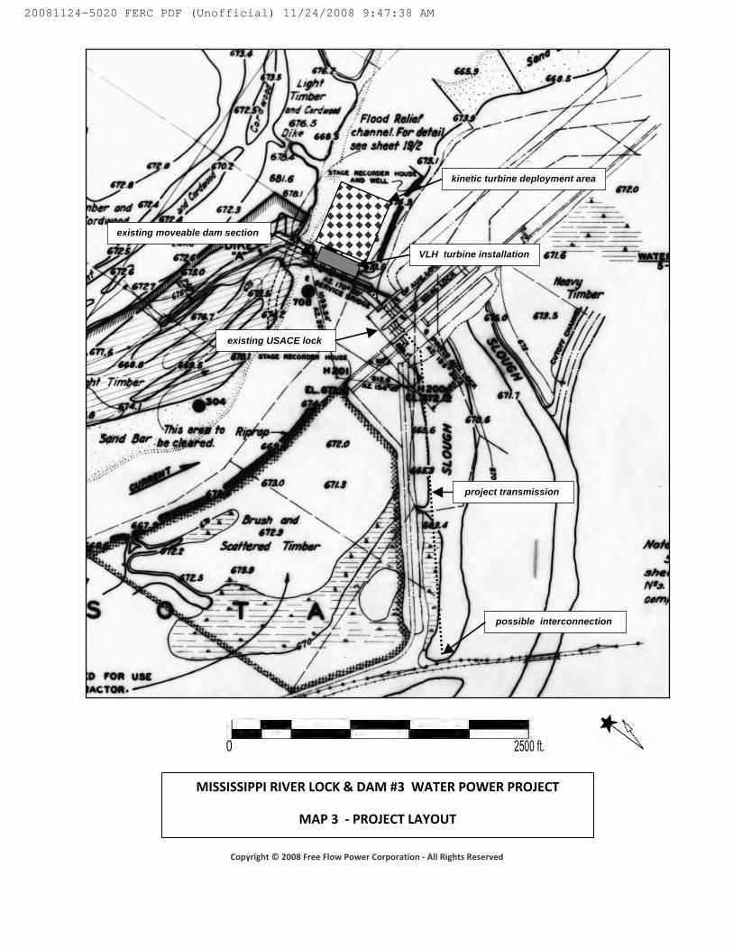
2. Project Features
The probable locations of the primary project features is shown in Map 3 ‐ Project Layout 3. Proposed Boundary
The proposed project boundary is shown on Map 4. 4. National Wild and Scenic Rivers Systems
No areas in the project vicinity are included (or are known to have been designated for study for inclusion) in the National Wild and Scenic Rivers System.
5. Designated Wilderness Areas
No areas within the project boundary have been designated as wilderness area. No areas within the project boundary are known to be recommended for designation as wilderness area or designated as wilderness study area.
20081124-5020 FERC PDF (Unofficial) 11/24/2008 9:47:38 AM
Copyright © 2008 Free Flow Power Corporation ‐ All Rights Reserved
MISSISSIPPI RIVER LOCK & DAM #3 WATER POWER PROJECT
MAP 1 ‐ PROJECT VICINITY
PROJECT
20081124-5020 FERC PDF (Unofficial) 11/24/2008 9:47:38 AM

Copyright © 2008 Free Flow Power Corporation ‐ All Rights Reserved
MISSISSIPPI RIVER LOCK & DAM #3 WATER POWER PROJECT
MAP 2 ‐ PROJECT LOCATION
PROJECT LOCATION
20081124-5020 FERC PDF (Unofficial) 11/24/2008 9:47:38 AM
Copyright © 2008 Free Flow Power Corporation ‐ All Rights Reserved
MISSISSIPPI RIVER LOCK & DAM #3 WATER POWER PROJECT
MAP 3 ‐ PROJECT LAYOUT
kinetic turbine deployment area
existing moveable dam section
possible interconnection
project transmission
VLH turbine installation
existing USACE lock
20081124-5020 FERC PDF (Unofficial) 11/24/2008 9:47:38 AM

Copyright © 2008 Free Flow Power Corporation ‐ All Rights Reserved
MISSISSIPPI RIVER LOCK & DAM #3 WATER POWER PROJECT
MAP 4 ‐ PROJECT BOUNDARY
PROJECT BOUNDARY
20081124-5020 FERC PDF (Unofficial) 11/24/2008 9:47:38 AM

Copyright © 2008 Free Flow Power Corporation ‐ All Rights Reserved
Minnesota and Wisconsin
Mississippi Lock and Dam #3
US Army Corps of Engineers – St. Paul District
Goodhue, MN and Pierce, WI
X
Ramya Swaminathan
978‐226‐0336
Mississippi Lock and Dam #3
Latitude 43°52'01"N Longitude 92°36'37"W
Exhibit 3 – Maps 1 thru 4
November 12, 2008
n/a
20081124-5020 FERC PDF (Unofficial) 11/24/2008 9:47:38 AM

Document Content(s)
notarized Miss L&D #3 Preliminary Permit App 11 19 08.PDF.............1-18
20081124-5020 FERC PDF (Unofficial) 11/24/2008 9:47:38 AM