mission trails - sandiego.gov · lesley henegar, program manager leo de jesus, principal...
TRANSCRIPT

ii

iii
MISSION TRAILS
DESIGN DISTRICT ORDINANCE
AND DESIGN MANUAL
DRAFT October 2010
Printed on recycled paper.
This information, or this document (or portions thereof), will be made available in alternative formats upon request.

iv

ii
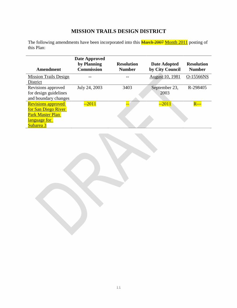
MISSION TRAILS DESIGN DISTRICT
The following amendments have been incorporated into this March 2007 Month 2011 posting of
this Plan:
Amendment
Date Approved
by Planning
Commission
Resolution
Number
Date Adopted
by City Council
Resolution
Number
Mission Trails Design
District
-- -- August 10, 1981 O-15566NS
Revisions approved
for design guidelines
and boundary changes
July 24, 2003 3403 September 23,
2003
R-298405
Revisions approved
for San Diego River
Park Master Plan
language for
Subarea 3
--2011 -- --2011 R---

iii
MAYOR Dick Murphy
CITY COUNCIL Scott Peters
Michael Zucchet
Toni Atkins
Charles Lewis, III
Brian Maienschein
Donna Frye
Jim Madaffer
Ralph Inunza
CITY ATTORNEY Casey Gwinn
CITY MANAGER Michael T. Uberaga
PLANNING COMMISSION Anthony Lettieri
Barry Schultz
Kathleen Garcia
Bruce Brown
Mark Steele
Carolyn Chase
Gil Ontai
CITY PLANNING DEPARTMENT S. Gail Goldberg, Planning Director
Betsy McCullough, Deputy Director
Robert Manis, Program Manager
Lesley Henegar, Program Manager
Leo De Jesus, Principal Engineering Aide
Bryon Frohn, Senior Drafting Aide

iv
THIS PAGE INTENTIONALLY LEFT BLANK.

v
Table of Contents
INTRODUCTION
Subarea 1..........................................................................................................................3
Subarea 2..........................................................................................................................4
Subarea 3..........................................................................................................................4
DESIGN MANUAL
All Subareas......................................................................................................................7
Subarea 1 - Opportunity Areas........................................................................................10
Subarea 2 - Hillside Areas...............................................................................................13
Subarea 3 - Mission Gorge and San Diego River Areas.................................................31

vi
THIS PAGE INTENTIONALLY LEFT BLANK.

7

8

9
INTRODUCTION
The Mission Trails Design District Ordinance and Design Manual covers some 2,000 acres
adjacent to Mission Trails Regional Park within the Navajo, Tierrasanta and East Elliott
communities. The Master Development Plan for Lake Murray, Cowles and Fortuna
Mountains Regional Park (now Mission Trails Park) provided the direction for the
preparation of this ordinance and design manual by calling for design guidelines to control
development in the sensitive areas around the Park.
The Mission Trails Design District is comprised of three subareas:
SUBAREA 1
Opportunity Areas include the commercially and multifamily residentially zoned sections of
the District which could potentially redevelop according to existing zoning and the adopted
community plan.

10
SUBAREA 2
Hillside Areas include steep, undeveloped hillsides presently under the HR (Hillside Review)
Overlay zone, as well as undeveloped non-HR zoned areas contiguous to the Regional Park
and HR areas.
SUBAREA 3
Mission Gorge and San Diego River Areas include portions of Mission Gorge adjacent to the Park
along the San Diego River.
Design guidelines have been prepared for each subarea to assist in evaluating new
development. Because most of the district is or will be developed for residential use, the
design guidelines are primarily intended to assist in the evaluation of new residential
development.
The guidelines developed for Subarea 1, which is primarily a commercial and multifamily
residential zoned area, are designed to ensure that new development should not radically
change the existing character of the surrounding neighborhood. Major concerns are the bulk,
scale and height of new development.
Guidelines for Subarea 2, which is primarily the steep undeveloped hillside areas adjacent to the
Park, are basically concerned with the impacts associated with hillside development and attendant
grading.
The guidelines for Subarea 3 are most concerned with protecting the visual linkages to and from
the park in the Mission Gorge area and implementing the San Diego River Park Master Plan
Design Guidelines.
The design guidelines will be used by the Planning Department in evaluating the impact and
compliance of all new development projects and permit requests within the District.

11

12

13
DESIGN MANUAL
ALL SUBAREAS
The following design principles apply to all subareas within the Mission Trails Design
District:
POLICY: NEW DEVELOPMENT SHOULD RELATE TO THE PARK AND EXISTING
LANDSCAPING IN THE PARK.
A. New developments shall maintain contiguous public access immediately adjacent to the
park edge or boundaries.
1) In a conventional subdivision, rear property lines shall not be permitted contiguous to
the park boundary. Access roads or bike paths could buffer park from private yard.
Wherever possible, pathways should provide linkages to trails within the park.

14
2) In a Planned Residential Development, common recreational/open space areas shall
abut the park boundary. Private property lines shall not be permitted within 20 feet of
the park's edge or boundary.
B. New development immediately abutting the park should provide open space linkages,
bike/pedestrian (and equestrian if in East Elliott) access to the park.

15
C. New landscaping should
complement the park's
existing plant palette in
terms of color and shape
to create a landscaping
transition between the
park and the built
environment as well as
serve as a visual extension
of the park. Every
landscape plan shall
include a design statement
explaining how the
landscape plan relates to
the Regional Park plant
environment.
D. Architectural materials and colors for new development should be designed to blend into
the natural backdrop of the Mission Trails Regional Park to provide a transition from the
park. Architectural materials should be chosen to complement the Regional Park
environment, and natural materials such as flagstone, river rocks, wood and tile should be
considered for a portion of the facade. Architectural colors for exterior facades should be
chosen from the color palette of the natural soil, rocks and plant life from the Regional
Park. Extreme color selections should be avoided. Exterior accent colors should be
chosen from the existing park environment.
E. No structure shall exceed four stories or 50 feet in height, including screening of
mechanical equipment.
F. Citywide Wireless Communication Facilities Policy 600-43. The Citywide
Communications Facilities Policy should be applied to the Mission Trails Design District
with the following additional guidelines and considerations.
1) Screening - All wireless communication facilities should be fully screened from
public view. The screening should be in the form of appropriate facade materials
when the facility will be installed as part of a building, or adequately screened by
landscaping when it will be free standing.
2) Landscaping - Landscaping should be used to screen the wireless communications
facility equipment proposal when necessary to minimize the visual impact of the
equipment. Vertical evergreen trees should be part of the proposal to screen the
equipment.
3) Views to the Park - Any new Wireless Communication Facility should be constructed
to maximize public views to the park, without creating new obstructions in the view
shed.
16
SUBAREA 1 - OPPORTUNITY AREAS
The following design principles apply to Subarea 1 of the Mission Trails Design District:
POLICY: THE SCALE OF NEW BUILDINGS SHOULD BE CONSISTENT WITH THE
EXISTING CHARACTER OF THE REGIONAL PARK.
A. Relate the height of new buildings to the height of existing development.
The relationship between areas of low-profile buildings and areas of taller or more
visually prominent buildings can be made more compatible if the transition in building
height is gradual.
Exceptionally tall buildings immediately adjacent to low buildings usually create
problems such as excessive shadows, undesirable wind tunnels, lack of privacy and view
blockage.
B. Tall buildings should occur closest to centers of activity and community services to
encourage economic, energy and transportation efficiency and express the functional
importance of these centers.
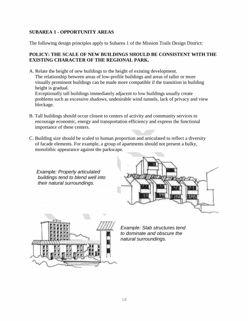
C. Building size should be scaled to human proportion and articulated to reflect a diversity
of facade elements. For example, a group of apartments should not present a bulky,
monolithic appearance against the parkscape.
Example: Properly articulated buildings tend to blend well into their natural surroundings.
Example: Slab structures tend to dominate and obscure the natural surroundings.

17
D. A building that does not share either a similar height or profile with adjoining structures
should mitigate disruptive effects to a neighborhood by incorporating features of adjacent
buildings.
1) Decorative features of adjacent buildings can make a new building appear a part of
the contiguous theme.
2) A false front or parapet can partially disguise a building's height and give a
harmonious profile with adjacent buildings.
E. The appearance of bulk in a structure should be mitigated by means of at least one and
preferably a combination of the following factors so as to produce the impression of an
aggregate of parts rather than a single building mass.
1) Major variations in the planes of wall surfaces, in either height or depth, that
significantly alter the mass.

18
2) Use of angled walls, and asymmetrical patterns of setbacks, use of pronounced
faceting, carving or sculpturing techniques to avoid a square, boxy or flat silhouette.
3) The horizontal dimension of the plane of wall surface should not exceed 50 percent of
the total dimension of the adjacent lot line.
4) Building surfaces should be articulated and textured to reduce their apparent size.
Buildings can be articulated with canopies, balconies, terraces, cornices, small
windows and other architectural details. Buildings can be textured by using different
materials, colors or facades to produce separate elements.
a. Treat upper floors so that they actually, or seem to, set back and recede.
b. Smaller architectural elements: Windows, cornices and other details
should be not much larger than they would be on a single-family house.
F. All parking should be enclosed or underground.

19
SUBAREA 2 - HILLSIDE AREAS
The following design principles apply to Subarea 2 of the Mission Trails Design District:
POLICY: HILLSIDE DEVELOPMENT SHOULD RETAIN THE NATURAL
CHARACTER OF THE LAND.
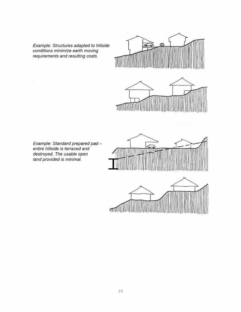
A. LAND PREPARATION/SITE PLANNING
1) Standard prepared pads (cut and fill grading) resulting in a terraced hillside and
extensive removal of natural groundcover shall not be permitted.
20
21
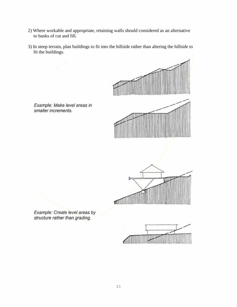
2) Where workable and appropriate, retaining walls should considered as an alternative
to banks of cut and fill.
3) In steep terrain, plan buildings to fit into the hillside rather than altering the hillside to
fit the buildings.
22
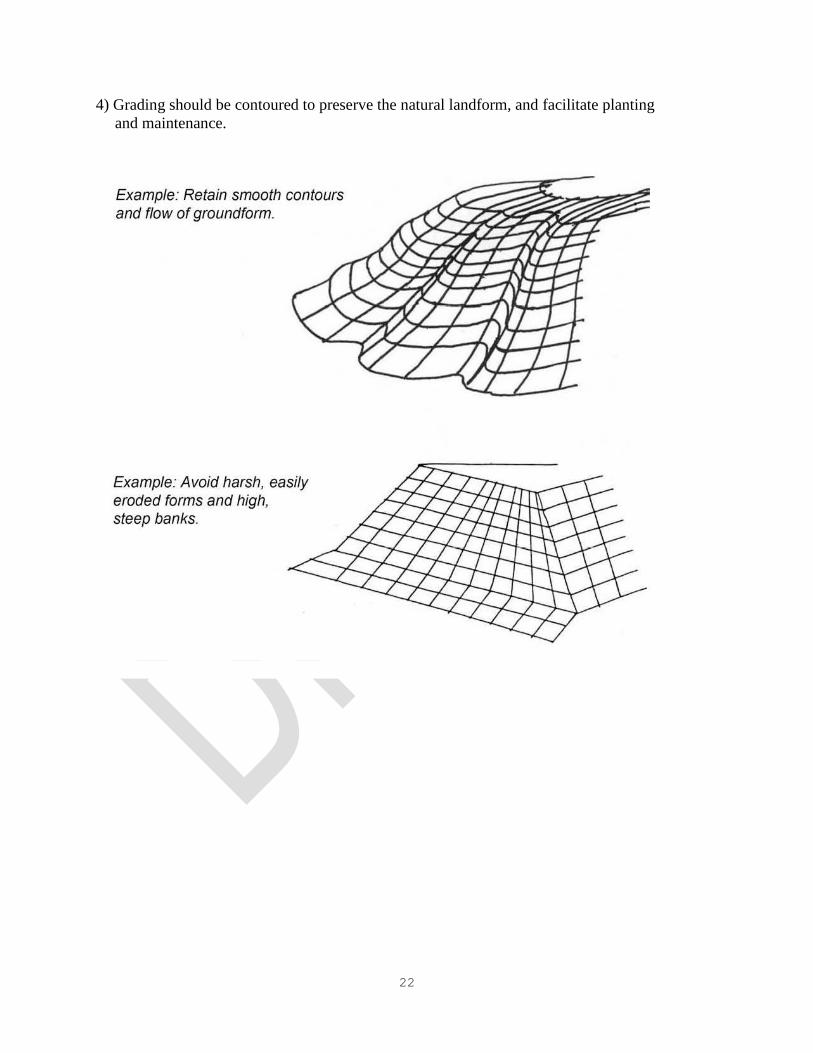
4) Grading should be contoured to preserve the natural landform, and facilitate planting
and maintenance.

23
5) Altered natural land should be replanted with erosion retardant cover.
6) Man-made banks should avoid straight and unnatural slope faces.
Example: Vary slope increments.

24
7) Only clustered development and structures that adjust to steep terrain shall be
permitted.
Clustering usually allows more units on a site than a conventional development on the
same site, but development will be concentrated on the least sensitive land. The
excessive economic and social cost of developing steep, ecologically sensitive, or
scenic land can be avoided.
8) No development should be permitted on the crest of a hill or along a ridge.
Only low-profile development should be allowed on canyon rims or ridges. Such
development should be sensitively designed to fit in with the hillside and not be
visually prominent.
9) Where it is impossible to avoid developing the crest of a hill or ridge, landscaping
should be used to soften the visual impact of development.

25
10) Hillside development shall not be permitted on slopes 50 percent or greater. The
clustering concept should be applied to avoid those slopes.
11) The following cluster development concepts should be considered for hillsides:
a. Development set into the contours of the hillside complementing the land's
natural character.
b. Multiple "step down" development on existing slopes, maximizing views and
opportunities to design rooftops as private outdoor spaces.

26
c. Unconventional structures with foundation adapted to the hillside conditions.

27
12) Lots and structures should be oriented towards views and vistas of Mission Trails
Park. For example, lots should be oriented at right angles to the contour lines in a
staggered fashion instead of at right angles to the streets.
13) Utilize for community or public land use those portions of the hillsides most exposed
to public view, or from which the widest views are possible.

28
14) Site major structures to show only a portion of themselves beyond the hill's brow or
profile when viewed from important roads.
15) Do not obscure the hillside foot at the end of streets perpendicular to Mission
Trails Park, with the exception as outlined in #16 below.
16) Only buildings of significance to the entire community should be allowed at the
ends of streets perpendicular to Mission Trails Park.
17) Where the available building area is limited by topography, and/or in order to provide
better views from proposed structures, flexible siting techniques should be utilized.
More specifically, the sizes and shapes of lots, and setback requirements shall be
permitted to vary from the requirements of the underlying zone. No minimums shall
be required except where "panhandle" lots are included in the development. The
minimum width of corridor should be 20 feet, and the maximum length, 150 feet.
Such corridor shall be part of the panhandle lot.

29
18) Do not exceed equilibrium in the structure-vegetation relationship.

30
19) The paved surface ground in a given development shall not exceed 45 percent of the
total development area, in order to support the natural system of drainage. Paved
surface ground includes structure foundations, driveways, patios, sidewalks, parking
areas and streets.
20) At least three of the following techniques shall be employed to limit the amount of
paved surface and further reduce interference with the natural drainage system:
a) Clustered design as previously described.
b) Grading of foundation area only, or open type foundations as previously
described.
c) Raised wood decks instead of concrete slabs for patios, driveways and parking.
d) Common driveways or cul-de-sacs, and narrow streets for access.
e) Elimination of paved sidewalks. Provision of street sidewalks should be a
response to need rather than to arbitrary policy.
f) Design of garage/parking space either under or over the structure depending on
whether the lot is uphill or downhill from the street.
B. CIRCULATION/PARKING
1) Street design in hillside areas should have the narrowest street width acceptable to the
City Engineer, based on the anticipated average daily traffic in a given development,
parking needs, safety considerations, probable vehicle speeds and limitations imposed
by sight distances, climate, terrain
and maintenance needs.
2) One-way street and split level
roads should be used wherever
possible to avoid excessive earth
moving and to reduce the amount
of paved surface which interferes
with natural drainage and
vegetation.

31
3) Street design in hillside areas
should follow the natural
contours of the land in order
to avoid excessive cut and
fill, discourage speeding,
minimize erosion, create
more varied views, and
emphasize the hillside
topography.
Example: Good circulation "fits" the lay of the land It is less likely to be so visible as to destroy the character of the area. A well fitted circulation system permits more imaginative subdivisions and disturbing natural drainage patterns.
Example: A conventional development, where a number of lots are arbitrarily carved out of the site, demonstrates how a grid of straight lines superimposed on a curving hill may work on paper, but doesn't work on the site.
4) Where it is impossible to follow natural contours due to technical considerations (e.g.
soil/geologic conditions, length and purpose of street, etc.) the street design can be a
straight line on a curving hill.
Streets at right angles to contours can provide a panoramic view of Mission Trails
Park. As the grid plummets up and down the hills the views open out for everyone to
enjoy.

32
5) Streets should be located on ridges or valleys to minimize cut and fill. If a street must
be located between a ridge and a valley, the following methods should be used:

33
6) Streets should follow and/or end in views from the crest of hillsides. Wherever
possible, development facing the park should be set below road grade to preserve
public views of the park from the roadway.
34
7) Aim streets directly at Mission Trails Park to create sightlines for maximum visual
impact.
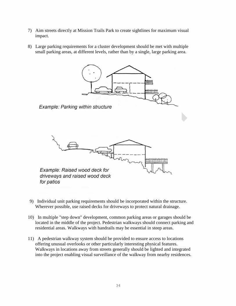
8) Large parking requirements for a cluster development should be met with multiple
small parking areas, at different levels, rather than by a single, large parking area.
9) Individual unit parking requirements should be incorporated within the structure.
Wherever possible, use raised decks for driveways to protect natural drainage.
10) In multiple "step down" development, common parking areas or garages should be
located in the middle of the project. Pedestrian walkways should connect parking and
residential areas. Walkways with handrails may be essential in steep areas.
11) A pedestrian walkway system should be provided to ensure access to locations
offering unusual overlooks or other particularly interesting physical features.
Walkways in locations away from streets generally should be lighted and integrated
into the project enabling visual surveillance of the walkway from nearby residences.

35
C. BUILDING DESIGN CONSIDERATIONS
1) Irregular architectural edges should be used to interlock structures with hillside
contours and vegetation.
2) As seen on the face of the hillside or on the hilltop, buildings should appear higher
than they are wide.

36
3) Development clusters should emphasize vertical lines in the exterior treatment of
structures consistent with the vertical character of the hillside.
4) The treatment of rooftops should be varied since the visual prominence of rooftops on
hillsides emphasizes monotony of materials, forms and colors. Rooftop utilities
should be avoided except for solar type improvements. Such improvements, however,
should be an integral part of roof design.
5) The mixture of residential types, although not necessarily possible or desirable in
every hillside development, does provide a richness of visual experience and should
be encouraged.

37
SUBAREA 3 - MISSION GORGE AND THE SAN DIEGO RIVER PARK AREAS
POLICY: THE SAN DIEGO RIVER AREAS ADJACENT TO MISSION TRAILS REGIONAL
PARK SHOULD PROVIDE VISUAL LINKAGES TO AND FROM THE PARK AND THE
SAN DIEGO RIVER PARK MASTER PLAN SHOULD BE IMPLEMENTED IN THE SAN
DIEGO RIVER AREAS.
A. The following design principles should shall apply to the western and eastern Mission Gorge
and San Diego River Park area and within Subarea 3 of the Mission Trails Design District:
1) When applicable, new developments adjacent to the San Diego River should be
setback 100 feet from the cliff face.
2) In the event property used for natural resource extraction is developed for uses not
directly related to such operations, the following principles should apply:
a. Development within the 100-year frequency flood contours should comply with
the regulations of applicable floodway and floodplain fringe zones, and Council
Policy 600-14 "Development Proposals within Floodplains."
b. Structures should be sited and designed to preserve public views of the San Diego
River from Mission Gorge Road.

38
3) The rear elevations of buildings which face the San Diego River should be as well
detailed and visually interesting as the front elevations.
4) Structures should be designed to step back from the San Diego River's floodway so
that low-story buildings are adjacent to the river with the higher stories tiered away
from the river.
5) No parking area shall be located between the building wall line and the San Diego
River unless a landscaped buffer is provided between the parking area and the
required setback from the river.
1) Boundaries:
Includes the River Corridor Area and the River Influence Area. The River
Corridor Area is the 100 year floodway as mapped by Federal Emergency
Management Agency (FEMA) plus a 35‟ wide path corridor on both sides
of the floodway. The River Influence Area is the first 200‟ feet directly
adjacent to the River Corridor Area on both sides of the river. The design
principles apply to any project fully or partially within these boundaries.

39
Section and Plan View of River Corridor Area and River Influence Area
2) River Corridor Area
(a) Permitted Uses: Within the floodway permitted uses shall be per the Open Space
Base Zones of the Land Development Code (LDC). Floodway development shall be per
the Development Regulations for Special Flood Hazard Areas of the LDC. Within the 35‟
wide Path Corridor and outside the Multi-Habitat Planning Area (MHPA) boundary, uses
shall consist of the River Pathway and passive recreational uses that may include picnic
areas, scenic or interpretive overlooks, fitness stations, seating and educational exhibit

40
areas. Any areas within the Path Corridor that are within the MHPA or a Wetland Buffer
are subject to the Multiple Species Conservation Program (MSCP) Subarea Plan „Land
Use Considerations‟ and the Environmentally Sensitive Lands (ESL) Regulations for
Wetlands within the LDC.
(b) Grading: The River bottom and sides shall be natural or designed with natural
materials and sized to accommodate a 100 year flood as well as provide for ground water
recharge capability. The use of rock gabions and native stone on river side‟s to dissipate
flows shall include design features to provide for or preserve wildlife habitats and wildlife
corridors. The 35‟ wide Path Corridor shall be graded to avoid long, continuous engineered
slopes with hard edges. New slopes shall not exceed 3:1 gradient and shall provide smooth
transitions at the top and bottom of the slope.
(c) River Pathway: A 14‟ wide pedestrian and bicycle meandering River Pathway shall be
located within the Path Corridor. If the Path Corridor is located within the MHPA or a
Wetland Buffer then the River Pathway shall be located outside the MHPA and the
Wetland Buffer areas. The 14‟ wide River Pathway shall include the following features: 1)
A 10‟ wide River Pathway of concrete, porous concrete preferred, in a natural earth brown
or tan color: 2) A 2‟ wide shoulder area of decomposed granite or similar soft material
along each side of the 10‟ wide River Pathway, in colors consistent with the colors of the
River Pathway: 3) A 12‟ vertical clearance above finished grade of the 14‟ wide River
Pathway: and 4) A 10‟ wide minimum landscape area between the floodway and the River
Pathway.
(d) Trails: Can be provided in the River Corridor as a secondary pathway system for
pedestrians. Trails shall be a maximum of 5‟ wide (if located in the MHPA or in a Wetland
Buffer, trails shall be 4‟ wide) and made of soft material such as decomposed granite of a
natural earth color brown or tan color or suitable native soil preferred. There shall be an 8‟
vertical clearance above finished grade of the trail. Trails shall originate from the River
Pathway and loop back to the River Pathway so as not to create „dead end‟ trails.
(e) Picnic Areas and Overlooks: Shall be provided along the River Pathway at locations
at least every ½ mile that provide resting areas, educational and/or cultural locations.
Picnic areas and overlooks may include a combination of: picnic table(s), trash and
recycling receptacles, bicycle racks, shade structures, benches, interpretive signs and
drinking fountains.
(f) Lighting: Shall be provided along the River Pathway as necessary to provide for
security and personal safety. Light poles shall not exceed 12‟ in height. All lighting shall be
shielded and directed away from the river side of the River Pathway and floodway.
(g) Site Furniture: Shall be provided at picnic areas, overlooks and other locations that
compliment the design of the River Pathway. Site furniture shall be designed and
constructed in conformance with the San Diego River Park Master Plan Design Guidelines.
Parcels that do not have picnic tables or overlooks shall provide a minimum of one type of
site furniture for every 200‟ linear feet of the River Pathway.

41
(h) Signs: Shall be designed in conformance with the San Diego River Park Master Plan
Design Guidelines and shall include the River Park Logo. Interpretive signs shall be
provided at educational and cultural overlooks along the River Pathway. Information
Kiosks shall be provided where the river pathway intersects public streets.
(i) Logo: The San Diego River Park Logo, as identified in the San Diego River Park
Master Plan Design Guidelines, shall be incorporated into all site furniture and signs.
(j) Fences: Shall be provided only as required to protect sensitive habitat and shall be
wood peeler log type with a maximum 4‟ in height.
(k) Plant Materials: The River Corridor Area shall be planted with a mixture of native
plants and trees that are consistent with the surrounding native habitat type. Non-native
grasses and lawn areas are allowed only within public parks located on the non-river side of
the River Pathway. Views within the River Corridor Area shall be maintained at the
pedestrian level along the river pathway by using tall canopy trees, rather than short bushy
trees. In addition, plant materials shall be selected and located so that „Visual Openings‟
with views to the river are provided along at least 50% of the river side of the River
Pathway of each parcel. Plant materials within the Visual Opening shall be selected based
on a maximum mature and natural growth habit of 30” in height,
3) River Influence Area
(a) Buildings Height and Setbacks: Buildings adjacent to the River Corridor Area shall
comply with the building height and setbacks requirements listed below unless the base
zone is more restrictive:
Building Height and Setbacks in the San Diego River Park Area
Minimum Building
Setback from River
Corridor(a)
Maximum Building Height within Setback
Area Building Wall Setback
10 feet(b) 35 feet Maximum of 50% may
be located at setback
20 feet 45 feet N/A
30 feet 70 feet N/A
70 feet 1 foot for each foot of building height N/A
115 feet Refer to underlying code N/A
Footnotes
(a) Where river and street setbacks overlap, the requirements of the River Corridor Area
setback shall apply.

42
(b) Architectural features such as eaves, cornices, eyebrows, trellises, bay window
balconies, entry roofs and arbors, and fireplaces may extend a maximum of 4‟ into the 10‟
setback.
Section of Building Height and Setbacks
(b) Setbacks not identified Above: Refer to the underlying Zone.
(c) Off Setting Planes: Refer to the underlying Zone and the other Navajo CPIOZ
requirements of this plan.
(d) Building Massing Adjacent to the River: At 45‟ above finished grade, the narrow
façade of the building shall be oriented parallel to the river and the wider façade shall be
perpendicular to the river.
(e) Building Façade and Entry: Development that abuts the River Corridor Area shall
provide a river facing façade and entry that are of equal design and quality of materials as
the primary building façade and entry.
(f) Building Transparency: All building facades that face the River Corridor Area or that

43
face a street that abuts the River Corridor Area shall comply with the following
transparency requirements as applicable: 1) Residential Zones at least 50% of the total
façade shall be transparent: 2) Commercial and Mixed Use Zones: At least 50% of the total
façade shall be transparent and at least 70% of the ground floor (between finished grade
and the full height of the first floor) shall be transparent: 3) Industrial Zones: At least 25%
of the total façade shall be transparent. Transparency can be: glass windows, display
windows, or windows affording views into retail, customer services, office, gallery, cafes,
lobby space or pedestrian entrances. The amount of transparency, measured as Visible
Light Transmittance (VTL), shall be a minimum of 0.65 VLT.
(g) Building Reflectivity: The amount of building reflectivity, measured as Visible
Light Reflectivity factor (VLR), shall not exceed 0.10 VLR for any materials that are used
on the facades of buildings that face the River.
(h) Exterior Equipment Enclosures, Outdoor Storage, Loading Areas and Refuse
Collection Areas: Shall be located a minimum of 100‟ from the River Corridor Area and
screened with landscape and an opaque wall at least 6‟ high, or one foot taller than the item
to be screened, to a maximum 10‟ in height. Screening material shall be the same design
and quality of materials as the primary landscape materials and building façade.
(i) Off Street Surface Parking: Shall be screened from the River Corridor Area consistent
with either of the following: 1) Screening shall consist of residential or commercial
structures or both: or 2) Off street surface parking to be 100‟ from the River Corridor with
screening consisting of landscaping and a 6‟ high opaque wall of the same design and
quality of materials as the primary landscape and building façade.
(j) Parking Structures: Facades of parking structures that face the River Corridor Area
shall be screened with permitted residential or commercial structures, or both for the full
height and width of the parking structure.
(k) Streets that Abut the River Corridor Area: Shall be the minimum width necessary
to meet the requirements of the Street Design Manual of the LDC. Curb cut widths and
driveways shall be minimized where possible. On-street parking shall be provided in
clusters of parking bays along the river side of the street to allow views of the river.
(l) Building Access to the River Corridor Area: Development on parcels that abut the
River Corridor Area shall provide building access pathways connecting the primary
structure with the River Pathway consistent with the following: One building access
pathway for every 300 linear feet of river frontage, or fraction thereof. The building access
pathway shall be to the primary building entrance or to a secondary entrance designed to
the same quality of materials as the primary entrance.
(m) Public Access Pathway Across Development Site: Development on parcels that abut
the River Corridor Area shall provide public access pathways connecting the public street
and the River Pathway consistent with the following: At least one public pathway shall be
provided for every 1,000 linear feet of river frontage, or fraction thereof. The public access

44
pathway shall be designed to the same quality of materials as the primary on site pathways.
A public access pathway sign at the public street right-of-way and at the intersection of the
River Pathway shall be provided to identify the entry to the public access pathway.
(n) Public Access Pathway from Streets that Abut the River Corridor: A public access
pathway shall connect the public street right-of-way to the River Pathway at every street
intersection, and at a minimum provide connections every 1,000‟ of street frontage along
the River Corridor Area.
(o) Lighting: All lighting within 100‟ of the River Corridor Area shall be shielded and
directed away from the River Corridor Area.
(p) Fences (Walls): Within the 10‟ building setback area only the following fences are
permitted: 1) A solid fence not to exceed 3‟ in height: 2) A 75% open fence not to exceed 6‟
in height; or 3) a combination of a 3‟ high solid fence topped with a 3‟ high 75% open
fence.
(q) Signs: Shall be in conformance with the Sign Regulations of the LDC and in addition
meet the following: 1) Within the first 100‟ of the River Influence Area, signs shall be
located no higher than 15‟ above finished grade: 2) On the river side of the building, all
ground signs between a building and the River Corridor Area shall be monument signs and
not exceed 5‟ in height and shall be located within a landscape area at least of an equivalent
size to the sign face: 3) All signs on the river side of the building shall be either face lighted
or internally lighted.
(r) Public Access Pathway Sign: Shall be mounted on a metal pole at least 4‟ above finish
grade and clearly visible from the street right-of-way. Sign shall be made of metal, such as
aluminum, with a minimum size of 18” wide by 24” tall. Sign face to read “Public Access
Pathway to the San Diego River” and include the San Diego River Park Logo. The sign
letters shall be a minimum of three inches in height.
(s) Plant Materials: Shall transition from native species materials within the River
Corridor Area to non-invasive drought tolerant plant species in the River Influence Area.
B. The City-owned portion of the eastern Mission Gorge area within Subarea 3 of the
Mission Trials Design District should be retained as an open space linkage to the
Regional Park, and for future inclusion in the San Diego River Regional Park System.
C. The privately-owned portion of the eastern Mission Gorge area within Subarea 3 of the
Mission Trails Design District should conform to the following principles.
1) Development within the 100-year frequency flood contours should comply with the
regulations of applicable floodway and floodplain fringe zones, and Council Policy
600-14 "Development Proposals within Floodplains."
2) Structures should be located in park-like surroundings.

45