miramichi shores land development ltd. functional
TRANSCRIPT

COBIDE Engineering Inc 517 10th Street Hanover, ON N4N 1R4 TEL: 519-506-5959 www.cobideeng.com
MIRAMICHI SHORES LAND DEVELOPMENT LTD.
FUNCTIONAL SERVICING REPORT MIRAMICHI SHORES – PHASE 4 SUBDIVISION PART OF LOTS 55 AND 56, LAKE RANGE FORMER TOWNSHIP OF SAUGEEN TOWN OF SAUGEEN SHORES
FEBRUARY 2021


Functional Servicing Report Miramichi Shores – Phase 4 Town of Saugeen Shores
TABLE OF CONTENTS
1. INTRODUCTION ................................................... 1
Location ................................................................................. 1 Development Proposal ......................................................... 1 Other reports ......................................................................... 1
2. EXISTING CONDITIONS ...................................... 4
Land use................................................................................. 4 Onsite ...................................................................................... 4 Surrounding ............................................................................. 4
Topography............................................................................ 6 Geology .................................................................................. 6 Soils ........................................................................................ 6 Natural Environment ............................................................. 6 Surface water ......................................................................... 7 Groundwater/Hydrogeology................................................. 7 archaeology ........................................................................... 7
3. WATER DISTRIBUTION SYSTEM ....................... 7
Design Criteria ....................................................................... 7 Water Consumption .............................................................. 8 Fire Flow................................................................................. 8 Design Flow Rates ................................................................ 8 Watermain Configuration ..................................................... 9
4. SANITARY SERVICING ........................................ 9
5. STORM SEWER SYSTEM .................................. 11
6. GRADING, EROSION & SEDIMENT CONTROL12
Construction Stage ............................................................. 12 Lot Development ................................................................. 12
ii
Cobide Engineering Inc. No. 00104
Functional Servicing Report Miramichi Shores – Phase 4 Town of Saugeen Shores
7. ROADS ................................................................ 13
8. UTILITIES ............................................................ 14
Streetlights........................................................................... 14 Electricity ............................................................................. 14 Telephone/ Cable TV/ Internet............................................ 14
LIST OF TABLES Table 1 - Proposed Water Demands ......................................................... 8 Table 2 - Infiltration Factor Parameters ..................................................... 10
LIST OF FIGURES Figure 1 - Site Location Map ..................................................................... 3
APPENDICES A – DP1 – Proposed Draft Plan
B – Dwg. 00104-WAT1 – Water Servicing Plan Dwg. 00104-STM1 – Storm Servicing Plan
C - Hydrant Flow Test Results – Carter Drive (OCWA)

1 Functional Servicing Report Miramichi Shores – Phase 4 Subdivision Town of Saugeen Shores
Cobide Engineering Inc. No. 00104
1. INTRODUCTION Cobide Engineering Inc. was retained by Miramichi Shores Land Development Limited to prepare a Functional Servicing Report to support of a Draft Plan Approval Application for the proposed Miramichi Shores – Phase 4 subdivision.
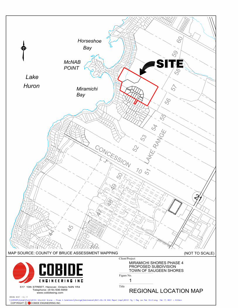
LOCATION The proposed subdivision development is located between Port Elgin and Southampton in the Miramichi Shores Subdivision on part Lots 55 and 56, Lake Range in the former Township of Saugeen, Town of Saugeen Shores, County of Bruce (described herein as the “site”). A Site Location Map is included as Figure 1.
The proposed subdivision will have access through Block 15 of Plan 3M-209 onto Carter Drive.
DEVELOPMENT PROPOSAL The overall property area is 16.252 hectares (40 acres) in size. 3.815 hectares (9.4 acres) is planned to be developed into 14 single family residential lots including the cul-de-sac and associated walkways.
The following provides a summary of the proposed development plan for the subdivision: Blocks/Lots Description Size
Lots 1 – 14 Single Family Residential 3.089 ha
Block 15 Walkway/Service Corridor 362 m²
Block 16 Walkway 305 m²
Block 17 and 18 Lands Retained by the Owner 12.44 ha (See Note 1)
Notes:
1. Block 17 is to be retained in the ownership of the developer. There is a requirement for a conservation easement to be placed over Block 17.
There will also be a municipal street servicing the development which is 0.659 ha. The name of the proposed street will be Mystic Court.
The Draft Plan showing the lot and block configuration has been included in Appendix A and noted as DP1.
The proposed development is located within the “Shoreline Residential” of the current Official Plan of the Town of Saugeen Shores. The area of the proposed single-family residential lots is zoned “Residential”.
OTHER REPORTS In support of the proposed Plan of Subdivision, the following reports have/will be prepared:
• Planning Justification Report, Miramichi Shores – Phase 4, Ron Davidson Planning Consultant, February, 2021
• Preliminary Stormwater Management Report – Mary Rose Subdivision, Pryde Schropp McComb Inc., January 2008;
• Natural Heritage Environmental Impact Study, AWS (Aquatic Wildlife Services), January 2006;

2 Functional Servicing Report Miramichi Shores – Phase 4 Subdivision Town of Saugeen Shores
Cobide Engineering Inc. No. 00104
• Miramichi Shores – Phase 4, Environmental Impact Study Update, WSP Canada Inc., February 2021
• Miramichi Shores Phase Hydrogeological Report - Permit to Take Water, GAMAN Consultants Inc., January 2021;
• Miramichi Shores Phase 4 Hydrogeological Report – Perforated Storm Sewer Evaluation, GAMAN Consultants Inc., January 2021;
• Geotechnical Investigation, Miramichi Shores – Phase 4 Subdivision, Saugeen Shores, Ontario, CMT Engineering Inc., December 2020;
Huron
Lake
2
1
5
6
5
5
5
4
5
3
5
2
5
1
5
0
4
9
4
8
4
7
6
0
5
9
5
8
5
7
C
O
N
1
1
R
A
N
G
E
L
A
K
E
4
4
4
5
C
O
N
C
E
S
S
I
O
N
1
0
Miramichi
Bay
McNAB
POINT
Horseshoe
Bay
MIRAMICHI SHORES PHASE 4
1
REGIONAL LOCATION MAP
Client/Project
Figure No.
Title
TOWN OF SAUGEEN SHORESPROPOSED SUBDIVISION
517 10th STREET, Hanover, Ontario N4N 1R4
Telephone: (519) 506-5959
www.cobideeng.com
COPYRIGHT C COBIDE ENGINEERING INC.
SITE
MAP SOURCE: COUNTY OF BRUCE ASSESSMENT MAPPING (NOT TO SCALE)
4 Functional Servicing Report Miramichi Shores – Phase 4 Subdivision Town of Saugeen Shores
Cobide Engineering Inc. No. 00104
2. EXISTING CONDITIONS LAND USE
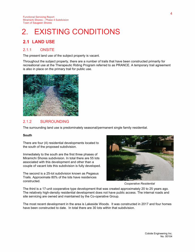
ONSITE The present land use of the subject property is vacant.
Throughout the subject property, there are a number of trails that have been constructed primarily for recreational use at the Therapeutic Riding Program referred to as PRANCE. A temporary trail agreement is also in place on the primary trail for public use.
SURROUNDING The surrounding land use is predominately seasonal/permanent single family residential.
South
There are four (4) residential developments located to the south of the proposed subdivision.
Immediately to the south are the first three phases of Miramichi Shores subdivision. In total there are 55 lots associated with this development and other than a couple of vacant lots this subdivision is fully developed.
The second is a 25-lot subdivision known as Pegasus Trails. Approximate 80% of the lots have residences constructed.
The third is a 17-unit cooperative type development that was created approximately 20 to 25 years ago. The relatively high-density residential development does not have public access. The internal roads and site servicing are owned and maintained by the Co-operative Group.
The most recent development in the area is Lakeside Woods. It was constructed in 2017 and four homes have been constructed to date. In total there are 30 lots within that subdivision.
Cooperative Residential

5 Functional Servicing Report Miramichi Shores – Phase 4 Subdivision Town of Saugeen Shores
Cobide Engineering Inc. No. 00104
West
Along the western boundary of the proposed development is a single tier of single family residential dwellings with frontage onto Miramichi Bay Road.
North
The lands are vacant.
East
Located on the tablelands, east of the proposed development, is farmland. On Lots 52 and 53 Miramichi Farms is used for a combination of cash crop farming and horse-riding facility. The horse-riding facility is the home of PRANCE, which is a therapeutic riding program for handicapped children servicing Bruce and Grey Counties.
6 Functional Servicing Report Miramichi Shores – Phase 4 Subdivision Town of Saugeen Shores
Cobide Engineering Inc. No. 00104
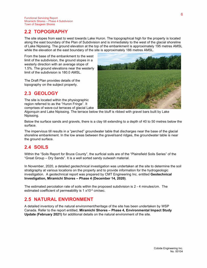
TOPOGRAPHY The site slopes from east to west towards Lake Huron. The topographical high for the property is located along the east boundary of the Plan of Subdivision and is immediately to the west of the glacial shoreline of Lake Nipissing. The ground elevation at the top of the embankment is approximately 195 metres AMSL while the elevation at the east boundary of the site is approximately 186 metres AMSL.
From the base of the embankment to the west limit of the subdivision, the ground slopes in a westerly direction with an average slope of 1.5%. The ground elevations near the westerly limit of the subdivision is 180.0 AMSL.
The Draft Plan provides details of the topography on the subject property.
GEOLOGY The site is located within the physiographic region referred to as the “Huron Fringe”. It comprises of wave-cut terraces of glacial Lake Algonquin and Lake Nipissing. The terrace below the bluff is ribbed with gravel bars built by Lake Nipissing.
Below the surface sands and gravels, there is a clay till extending to a depth of 40 to 50 metres below the surface.
The impervious till results in a “perched” groundwater table that discharges near the base of the glacial shoreline embankment. In the low areas between the gravel/sand ridges, the groundwater table is near the ground surface.
SOILS Within the “Soils Report for Bruce County”, the surficial soils are of the “Plainsfield Soils Series” of the “Great Group – Dry Sands”. It is a well sorted sandy outwash material.
In November, 2020, a detailed geotechnical investigation was undertaken at the site to determine the soil stratigraphy at various locations on the property and to provide information for the hydrogeologic investigation. A geotechnical report was prepared by CMT Engineering Inc. entitled Geotechnical Investigation, Miramichi Shores – Phase 4 (December 14, 2020).
The estimated percolation rate of soils within the proposed subdivision is 2 - 4 minutes/cm. The estimated coefficient of permeability is 1 x10⁻² cm/sec.
NATURAL ENVIRONMENT A detailed inventory of the natural environment/heritage of the site has been undertaken by WSP Canada. Refer to the report entitled, Miramichi Shores – Phase 4, Environmental Impact Study Update (February 2021) for additional details on the natural environment of the site.

7 Functional Servicing Report Miramichi Shores – Phase 4 Subdivision Town of Saugeen Shores
Cobide Engineering Inc. No. 00104
SURFACE WATER The predominant surface water feature in the vicinity of the subject property is Lake Huron.
There is one primary stream that flows through the subject property with eventual discharge into Lake Huron. The location of the drainage course is shown on the draft plan and is located to the north of the proposed 14 lot subdivision.
The source of surface water for the stream are seeps from the embankment to the east of the property.
Refer to the report prepared by Cobide Engineering entitled, Stormwater Management Addendum Report, Miramichi Shores – Phase 4 (February 2021) for additional information regarding surface water.
GROUNDWATER/HYDROGEOLOGY A detailed hydrogeologic investigation was undertaken in the fall of 2020 by GAMAN Consultants Inc.
Two reports have been prepared:
• Hydrogeological Report Perforated Storm Sewer Evaluation (January, 2021)
o prepared to assist WSP in their environmental impact study.
• Hydrogeologic Report – Permit to Take Water (January, 2021)
o prepared to support an application for permit to take water permit to take water required for the temporary dewatering during construction.
ARCHAEOLOGY A Stage 1 and 2 Archaeological Assessment of the property was completed in 2006 by AMICK consultants. The Ministry of Culture have approved the archaeological investigation.
3. WATER DISTRIBUTION SYSTEM The water distribution system will be sized based on the existing conditions at the connection to the municipal system and the subdivisions demands which are determined by the Ministry of the Environment, Conservation and Parks (MECP) Design Guidelines for Drinking-Water Systems (2008).
DESIGN CRITERIA The water distribution system will be design in accordance MECP guidelines which state the system “should be designed to satisfy the greater of the following demands:
• Maximum day demand plus fire flow; or,
• Peak hour demand
The maximum day demand and peak hour demand are based on the projected water consumption from the development and the fire flow is based on the type of the development.
The system will require modelling during the detailed design stage to ensure the water pressure throughout the system is within the requirements of the MECP.

8 Functional Servicing Report Miramichi Shores – Phase 4 Subdivision Town of Saugeen Shores
Cobide Engineering Inc. No. 00104
Based on MECP guidelines, the minimum pressure at ground level at all points in the distribution system under maximum day demand plus fire flow conditions are to be 140 kPa (20 psi). The normal operation pressure should be between 350 kPa (50 psi) to 480 kPa (70 psi). There shall be no point in the distribution system that has a normal operating pressure of less than 275 kPa (40 psi). The maximum pressure in the pipe cannot exceed 700 kPa (100 psi).
WATER CONSUMPTION The system will be designed based on a domestic water demand of 450 L/cap/day. The peaking factors will be derived from Table 3-1 of the MECP Design Guidelines. Based on the projected population of 49 people the peaking factor for the maximum day demand will be 2.75 and the peaking factor for the peak hour demand will be 4.13.
Table 1 below summarizes the projected maximum day and peak hour demands for the proposed development.
Table 1 - Proposed Water Demands
Demand Population (3.5 ppl/lot)
Consumption (L/cap/day)
Peaking Factor
Peak Rate (L/day)
Peak Rate (L/s)
Maximum Day 49 450 2.75 60,637 0.70
Peak Hour 49 450 4.13 91,066 1.06
FIRE FLOW The AWWA Manual of Water Supply Practices M31 – Distribution System Requirements for Fire Protection and the Fire Underwriters Survey document, Water Supply for Public Fire Protection will determine the required fire flows.
The fire flows are dependent upon many factors including the type of construction materials, building height and density of the development.
The fire flow requirements for a typical single detached residential home within the subdivision are expected to 4,000 L/min (66.7 L/s) which would need to be sustained for 1.5 hours.
DESIGN FLOW RATES The watermain within the subdivision will be required to maintain the aforementioned pressure while supplying 67.4 L/s (MDD + Fire Flow). The pipes will be designed with a pipe roughness C-value of 130 which is typically used to represent moderately aged PVC pipe. This will ensure adequate pressure for the development in the future.
Based on hydrant flow testing completed near the entrance to the subdivision on Carter Drive by the Ontario Clean Water Agency (OWRA), the existing water infrastructure can supply at least 4,270 L/s (1,129 gpm) of water at 140 kPa (20 psi). Therefore, there is sufficient flow and pressure to meet the maximum day demand plus fire flow requirements of the subdivision development from Carter Drive while maintaining a minimum pressure of 140 kPa (20 psi). A copy of the hydrant flow tests is included as Appendix C.

9 Functional Servicing Report Miramichi Shores – Phase 4 Subdivision Town of Saugeen Shores
Cobide Engineering Inc. No. 00104
WATERMAIN CONFIGURATION A new 150 mm diameter PVC watermain will be connected to the municipal water system at the intersection of the new subdivision road and Carter Drive. When Carter Drive was constructed, a 200 mm diameter tee and 200 mm watermain extension was installed to the property line.
Fire hydrants will be placed along the new subdivision street at a spacing no greater than 150 m.
A 19 mm single water connection will be provided to each residential lot. Water services will be PEX pipe complete with curb stops placed at the property line of each lot.
A drawing showing the proposed watermain distribution system has been included in Appendix B as Dwg. 00104-WAT1.
4. SANITARY SERVICING The proposed development will be serviced with individual on-site sewage systems similar to the first three phases of the Miramichi Shores development.
Though it could be argued that the Ministry’s D-5-4 Individual On-Site Sewage Systems: Water Quality Impact Risk Assessment is not applicable to the Miramichi Shores – Phase 4 Subdivision development because of the lack of use of groundwater resources in the area, these calculations have been completed anyway to illustrate that the groundwater resources of the area will not be adversely impacted by the proposed residential development being serviced by an on-site sewage system.
Contaminant Source: (On-site Sewage Systems)
Sewage effluent
Background Water Quality: <0.2 mg/l (nitrate-nitrogen)
Effluent Volume 1,000 l/day x 14 lots = 14,000 l/day
Available Infiltration Water (q infiltrate)
q infiltrate = A x WS x If
Where A = Gross area within the flow path of the contaminant plume in square metres. (Includes area to the east that will remain undeveloped)
= 72,300 m2 (7.23 ha)
WS = Average daily precipitation surplus, in metres per day.
WS = P – ET
Where WS = Average annual precipitation surplus, (m/yr)
P = mean annual precipitation (m/yr) derived from the Environment Canada precipitation normals for the closest climatic station to the site (Paisley 1981 – 2010) (1.23616 m/yr)
ET = mean annual actual evapotranspiration (m/yr) derived from the Environment Canada evapotranspiration normals (22 inches/yr or 0.5588 m/yr)

10 Functional Servicing Report Miramichi Shores – Phase 4 Subdivision Town of Saugeen Shores
Cobide Engineering Inc. No. 00104
WS = P – ET = 1.23616 – 0.5588 = 0.67736 m/yr = 1.856 x 10⁻³ m/day
lf = Infiltration factor
The MECP has compiled a set of factors to quantify the percentage of the water surplus that infiltrates into the subsurface. These factors are defined as infiltration factor, lf, and are shown in the following table:
Table 2 - Infiltration Factor Parameters
Physical Description of Site Value of lf
Topography:
• Flat land, average slope <0.6 m per km
• Rolling land, average slope of 2.8 m to 3.8 m per km
• Hilly land, average slope of 28 m to 47 m per km
0.30
0.20
0.10
Soil:
• Tight impervious clay
• Medium combination of clay and loam
• Open sandy loam
0.10
0.20
0.40
Cover:
• Cultivated lands
• Woodland
0.10
0.20
lf = Topography Factor + Soil Factor + Cover Factor
= 0.2 + 0.4 + 0.2 = 0.8
Therefore: q infiltrate = 72,300 m2 x 1.856 x 10-3 m/day x 0.8
= 107.4 m3/day
The nitrate concentration at the downgradient boundary of the proposed development can be calculated as follows:
Nitrate Concentration (as N) = qinfiltrate x cbackground +qeffluent x ceffluent
qinfiltrate + qeffluent
Where: qinfiltrate = 107.4 m3/day (107,400 l/day)
cbackground = 0.2 mg/l
11 Functional Servicing Report Miramichi Shores – Phase 4 Subdivision Town of Saugeen Shores
Cobide Engineering Inc. No. 00104
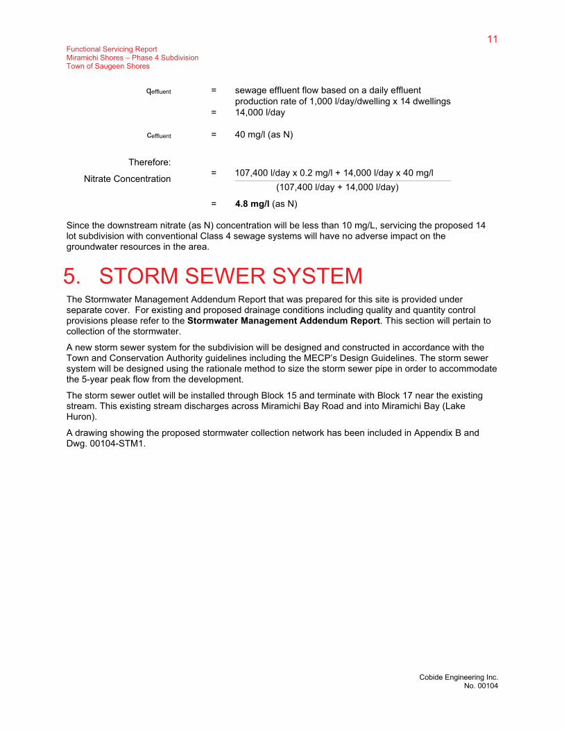
qeffluent = sewage effluent flow based on a daily effluent production rate of 1,000 l/day/dwelling x 14 dwellings
= 14,000 l/day
ceffluent = 40 mg/l (as N)
Therefore:
Nitrate Concentration = 107,400 l/day x 0.2 mg/l + 14,000 l/day x 40 mg/l
(107,400 l/day + 14,000 l/day)
= 4.8 mg/l (as N)
Since the downstream nitrate (as N) concentration will be less than 10 mg/L, servicing the proposed 14 lot subdivision with conventional Class 4 sewage systems will have no adverse impact on the groundwater resources in the area.
5. STORM SEWER SYSTEM The Stormwater Management Addendum Report that was prepared for this site is provided under separate cover. For existing and proposed drainage conditions including quality and quantity control provisions please refer to the Stormwater Management Addendum Report. This section will pertain to collection of the stormwater.
A new storm sewer system for the subdivision will be designed and constructed in accordance with the Town and Conservation Authority guidelines including the MECP’s Design Guidelines. The storm sewer system will be designed using the rationale method to size the storm sewer pipe in order to accommodate the 5-year peak flow from the development.
The storm sewer outlet will be installed through Block 15 and terminate with Block 17 near the existing stream. This existing stream discharges across Miramichi Bay Road and into Miramichi Bay (Lake Huron).
A drawing showing the proposed stormwater collection network has been included in Appendix B and Dwg. 00104-STM1.

12 Functional Servicing Report Miramichi Shores – Phase 4 Subdivision Town of Saugeen Shores
Cobide Engineering Inc. No. 00104
6. GRADING, EROSION & SEDIMENT CONTROL
Erosion and sediment controls shall meet the requirements of the most recent version of the MECP Stormwater Management Planning and Design Manual at the time of construction.
CONSTRUCTION STAGE Prior to the start of construction, appropriate sediment control facilities are to be in place. Following are details regarding erosion and sediment control that are to be implemented:
• Placement of heavy duty siltation fencing is required along the along the property boundary within the drainage corridor on the west side of the site to intercept sediment that could potentially be transported by sheet flow across the site. Light Duty Siltation fence will also be installed at any development grading limits where runoff may discharge from the site.
• It is proposed that the pond be constructed first to act as a sedimentation basin. A temporary outlet would be installed and surrounded in clear stone.
• Placement of temporary straw check dams within swales and any other locations where a concentrated flow of runoff may occur. All proposed drainage swales are to be seeded during construction;
• Installation of filter cloth under all new and existing catchbasin grates until paving of the subdivision streets is completed;
• Mud mats will be placed at construction accesses to keep public roadways free from debris during the construction period.
• Re-vegetate all disturbed areas after underground and surface works have been constructed.
Prior to removal of sediment control facilities, ensure that sediment that may have accumulated has been removed.
Once the area has been stabilized, the silt fencing can be removed.
LOT DEVELOPMENT During individual construction of homes within the subdivision, silt barriers are to be constructed, as appropriate, to prevent the eroding of materials into the roadside drainage system. The sedimentation control can be in the form of siltation fences placed in the direction of flow from the construction site and shallow excavated sediment traps (moats) should be constructed around any stockpiled materials.
The responsibility for the individual lot sediment control is the landowner/builder constructing the dwelling.
The proposed development grading design will generally following the existing grade. The proposed grading design will match all existing grades at the property lines and will not alter or affect the drainage patterns of the neighbouring properties. The proposed site grading will drain the stormwater through side yard swales and a storm sewer system. The majority of the slopes found on site are proposed to be less than 5%

13 Functional Servicing Report Miramichi Shores – Phase 4 Subdivision Town of Saugeen Shores
Cobide Engineering Inc. No. 00104
7. ROADS The proposed cul-de-sac will be designed to meet the municipal standard for an urban street. The following parameters are proposed:
• 20m road allowance;
• 4.25m asphalt lanes with 2% cross fall
• 600.100 OPSD mountable curb and gutter
• pavement design (as per recommendations of the geotechnical investigation)
o 40 mm HL3 asphaltic concrete (surface)
o 50 mm HL4 asphaltic concrete (base)
o 150 mm Granular A base
o 300 mm Granular B base
As part of the site servicing, a 1.5m wide concrete sidewalk will be constructed from the end of the cul-de-sac to Carter Drive. The concrete sidewalk will interconnect to the woodland trails within Block 17.

14 Functional Servicing Report Miramichi Shores – Phase 4 Subdivision Town of Saugeen Shores
Cobide Engineering Inc. No. 00104
8. UTILITIES STREETLIGHTS
The configuration of the streetlights will be designed in accordance with municipal standards. Concrete poles shall be used with LED cobra head style streetlights.
ELECTRICITY Hydro One will be responsible for completing the design of the electrical distribution system. Each lot will be individually serviced. Underground distribution lines will be utilized for this development.
TELEPHONE/ CABLE TV/ INTERNET Eastlink and Bruce Telecom will be given the opportunity to provide telephone, cable TV and internet services to the development. They will complete their own design, based upon Hydro One’s proposed design configuration along with trench locations dictated by the Town of Saugeen Shores standard cross section.
Sincerely,
Cobide Engineering Inc.
Stephen J. Cobean, P. Eng.
H:\Pryde\00104 Miramichi Shores - Phase 4 Subdivision\Reports\FSR\2021-02-25 Miramichi Shores - Phase 4 - Functional Servicing Report FINAL.docx

Appendix A
DRAFT PLAN OF SUBDIVISION – DP1

B
A
Y
R
O
A
D
N
1
4
°
3
3
'3
5
"
E
7
9
.5
5
3
m
N28°33'30"E
18
2.9
25
m
1
7
.
1
2
0
m
N
1
9
°
3
6
'
4
5
"
W
N62°21'00"W
61.134m
N
1
4
°
3
7
'1
5
"
E
N60°52'30"W
491.006m
N28°45'25"E
31
1.2
08
m
N60°52'10"W
161.700m
4
1
.3
4
3
m
3
0
m
3
0
m
1
23
4
5
6
7
8
9 10
11
52.9m
61.0m
31.3
m
31.0m
30.0m
67
.0
m
6
3
.
1
m
66
.6
m
30.0m
32.9m
2
2
.
5
m
2
1
.
5
m
30.0m
67
.0
m
32.0m
4
3
.
0
m
60
.0
m
6
0
.3
m
12
13
14
30
.0
m
67
.0
m
4
8
.
2
m
66
.7
m
2
4
.3
m
30
.0
m
67
.0
m
67
.0
m
30.0m
23.9
m
6
0
.6
m
61.0m
30
.0
m
2.8m
2
8
.2
m
5
0
.
9
m
2
1
.8
m
2
5
.
7
m
7
8
.
4
m
30.0m
30.0m 22.4m
1
0
.8
m
4
7
.
7
m
23.8m
6
.0
m
6
1
.6
m
41.2m
58.5m 30.0m30.0m
32.0m
74.1m
6
.0
m
6.4m
6
.2
m
32.8
m
5
6
.1
m
106.2m
7
8
.3
m
B
LO
C
K
15
BLOCK 17
R=5.0m
R
=
2
2
.
0
m
MYSTIC COURT
ZONED 'PD'
ZONED 'PD'
ZONED 'PD'
ZONED 'PD'
ZONED 'PD'
ZONED 'PD'
ZONED 'EH'
ZONED 'EH'
ZONED 'EH'
ZONED 'R1'
ZONED 'R1'
BLOCK 17
BLOCK 17
BLOCK 16
BLOCK 18
ZONED 'EH'
ZONED 'EH'
49.0m
5
.
4
m
5
6
.
3
m
5
4
.
3
m
6
.
6
m
3
0
m
N62°21'00"W
61.647m
215.23m
275.78m8
6
.
0
m
100.7m
N31°18'10"E
20.014
N60°52'10"W
66.744m
N31°18'10"E
66.744m
265.740m
N60°52'10"W
MY
ST
IC
C
OU
RT
10
6.8
04
m
110.0m
5
3
.
3
m
85.0m
L
A
K
E
H
U
R
O
N
C
O
N
C
E
S
S
I
O
N
1
0
S
O
U
T
H
S
T
D
R
C
A
R
T
E
R
C
O
L
L
A
R
D
W
A
Y
M
I
R
A
M
I
C
H
I
B
A
Y
R
D
H
I
G
H
W
A
Y
2
1
3
21
POINT
McNAB
Bay
Miramichi
BayHorseshoe
L
A
K
E
H
U
R
O
N
EDGE OF EXISTING PAVEMENT
Legend
PROPOSED LOT LINE
EXISTING PROPERTY/STREET LINE
PROPOSED SUBDIVISION BOUNDARY
EXISTING CONTOUR
NOTE:
1. NUMBERING OF LOTS ON FINAL PLAN MAY VARY FROM THAT SHOWN ON THE DRAFT PLAN.
2. LOCATION OF TRAILS DERIVED FROM INFORMATION PROVIDED BY THE TOWN OF SAUGEEN
SHORES AND IS APPROXIMATE ONLY.
EXISTING HYDRO POLE
EXISTING HYDRO GUY WIRE
EXISTING TELEPHONE PEDESTAL
EXISTING TREE LINE
EXISTING FIREHYDRANT
EXISTING ZONING LIMITS
EXISTING TRAIL
EXISTING STREAM
DEVELOPABLE LAND BOUNDARY AS SHOWN ON
SP2 (AQUATIC AND WILDLIFE SERVICES PLAN
DATED DECEMBER 23, 2005.)
KEY PLAN
NTS
REVISION / ISSUE
Design Engineer
DATE
DESCRIPTION
SJC
SJC
JAF
OCT 2020
00104-DP1
No. BY APPD
FIRST SUBMISSION
DEC 21/200 SJC SJC
1:1000
Drawn:
Date:
Checked:
Approved:
Design:
Scale:
Client:
THIS DRAFT PLAN FOR APPROVAL.
AUTHORIZE COBIDE ENGINEERING INC. TO SUBMIT
DATE
I, THE REGISTERED OWNER OF THESE LANDS, HEREBY
OWNER'S CERTIFICATE
I CERTIFY THAT:
ARE CORRECTLY SHOWN.
DATE
SURVEYOR'S CERTIFICATE
AND THEIR RELATIONSHIP TO THE ADJACENT LANDS
THE BOUNDARIES OF THE LANDS TO BE SUBDIVIDED
i. SILTY SAND
h. MUNICIPAL WATER SUPPLY
g. AS SHOWN
l. AS SHOWN
j. AS SHOWN
a. AS SHOWN
b. AS SHOWN
e. AS SHOWN
f. AS SHOWN
c. AS SHOWN
d. SINGLE FAMILY RESIDENTIAL
UNDER SECTION 51 OF THE PLANNING ACT
ADDITIONAL INFORMATION REQUIRED
k. WATER, STORM SEWERS, HYDRO,
TELEPHONE, CABLE TV, FIRE,
AMBULANCE AND POLICE
PROTECTION.
DRAFT PLAN OF SUBDIVISION
RELEVANT SITE INFORMATION
OWNER:
c/o BRAD R. PRYDE
P.O. BOX 1725
PORT ELGIN, ON
PROPOSED SUBDIVISION
10 COLLARD WAY,
517 10th STREET, Hanover, Ontario N4N
1R4Telephone: (519) 506-5959
www.cobideeng.com
COPYRIGHT C COBIDE ENGINEERING INC.
ONTARIO & CANADA LAND SURVEYORS
DINSMORE & ENGLAND LTD.
J. BRENT ENGLAND O.L.S.
N0H 2C0
TOWN OF SAUGEEN SHORES
AND PART OF LOTS 55 AND 56
COUNTY OF BRUCE
(GEOGRAPHIC TOWNSHIP OF SAUGEEN)
LAKE RANGE
BLOCK 15
REGISTERED PLAN No. 3M-209
0.067 ha.(BLOCKS 15 AND 16)
0.659 ha.
MUNICIPAL STREETS
3.089 ha.DETACHED RESIDENTIAL LOTS (14)
16.252 ha.TOTAL PROPOSED SUBDIVISION
(BLOCKS 17 AND 18) 12.437 ha.
WALKWAYS
TO BE RETAINED BY OWNER
(MYSTIC COURT)
25344
12
13
14
5
6
7
8
9
10
11
1867
1830
1728
3928
2372
1775
2010
1986
2010
2693
RESIDENTIAL LOT INFORMATION
FRONTAGE (m.)
LOT
2
3
1
2010
2010
2139
AREA (sq.m.)
30.0
30.0
30.1
30.1
30.0
30.0
30.0
31.7
35.2
30.1
31.8
30.0
30.0
32.0
(AS DEFINED IN ZONING BYLAW No.
201-2000)
TOWN OF SAUGEEN SHORES
AND PART OF LOTS 55 AND 56
(GEOGRAPHIC TOWNSHIP OF SAUGEEN)
LAKE RANGE
BLOCK 15
REGISTERED PLAN No. 3M-209
SITE
MIRAMICHI SHORES PHASE 4
MIRAMICHI SHORES LAND DEVELOPMENT LTD.
MIRAMICHI SHORES LAND DEVELOPMENT LTD.
JANUARY 4, 2021.

Appendix B
DRAWINGS
WAT1 – Water Servicing Plan STM1 – Storm Servicing Plan

S
O
U
T
H
S
T
D
R
C
A
R
T
E
R
C
O
L
L
A
R
D
W
A
Y
M
I
R
A
M
I
C
H
I
B
A
Y
R
D
H
I
G
H
W
A
Y
2
1
POINT
McNAB
Bay
Miramichi
BayHorseshoe
LO
T 14
LO
T 13
LOT 11
LOT 12
LOT 5
LOT 4
LOT 6
LOT 56 LAKE RANGE
N
o
. 3
3
7
REGISTERED PLAN 3M-154
LOT 55 LAKE RANGE
LOT 10
LOT 9
LO
T 8
LO
T 9
LO
T 10
BLO
CK
15
LO
T 11
LO
T 12
LO
T 13
LO
T 14
1
23
4
5
6
7
89 10
11
12
13
14
B
L
O
C
K
1
5
MYSTIC COURT
BLOCK 17
BLOCK 16
REGISTERED PLAN No. 3M-209
CARTER DRIVE
MY
ST
IC
C
OU
RT
PROPOSED 150mmØ PVC WTM
SCALE 1:2500 (11 x 17)
100 METRES
300 FEET50 0 5025 100 200
20 10 0
SCALE 1:1500 (11 x 17)
5025
KEY PLAN
NTS
SITE
REVISION / ISSUE
DRAWING No.
DATE
DESCRIPTION
TLB
SJC
JAF
FEB 2021
00104-WAT1
PRELIMINARY SUBMISSIONFEB 22/21
No.
1
BY APPD
TLBSJC
1:1500
COPYRIGHT C COBIDE ENGINEERING INC.
517 10th St, Hanover, ON N4N 1R4
Telephone: (519) 506-5959
www.cobideeng.com
TOWN OF SAUGEEN SHORES
PROPOSED SUBDIVISION
MIRAMICHI SHORES PHASE 4
Legend
PROPOSED LOT LINE
EXISTING PROPERTY/STREET LINE
PROPOSED SUBDIVISION BOUNDARY
EXISTING CONTOUR
EXISTING STREAM
MIRAMICHI SHORES LAND DEVELOPMENT LTD.
WATER SERVICING PLAN
PROPOSED WATERMAIN

S
O
U
T
H
S
T
D
R
C
A
R
T
E
R
C
O
L
L
A
R
D
W
A
Y
M
I
R
A
M
I
C
H
I
B
A
Y
R
D
H
I
G
H
W
A
Y
2
1
POINT
McNAB
Bay
Miramichi
BayHorseshoe
LO
T 14
LO
T 13
LOT 11
LOT 12
LOT 5
LOT 4
LOT 6
LOT 56 LAKE RANGE
N
o
. 3
3
7
REGISTERED PLAN 3M-154
LOT 55 LAKE RANGE
LOT 10
LOT 9
LO
T 8
LO
T 9
LO
T 10
BLO
CK
15
LO
T 11
LO
T 12
LO
T 13
LO
T 14
1
23
4
5
6
7
89 10
11
12
13
14
B
L
O
C
K
1
5
MYSTIC COURT
BLOCK 17
BLOCK 16
REGISTERED PLAN No. 3M-209
CARTER DRIVE
MY
ST
IC
C
OU
RT
PROPOSED STORM SEWER
OGS
SCALE 1:2500 (11 x 17)
100 METRES
300 FEET50 0 5025 100 200
20 10 0
SCALE 1:1500 (11 x 17)
5025
KEY PLAN
NTS
SITE
REVISION / ISSUE
DRAWING No.
DATE
DESCRIPTION
TLB
SJC
JAF
FEB 2021
00104-STM1
PRELIMINARY SUBMISSIONFEB 22/21
No.
1
BY APPD
TLBSJC
1:1500
COPYRIGHT C COBIDE ENGINEERING INC.
517 10th St, Hanover, ON N4N 1R4
Telephone: (519) 506-5959
www.cobideeng.com
TOWN OF SAUGEEN SHORES
PROPOSED SUBDIVISION
MIRAMICHI SHORES PHASE 4
Legend
PROPOSED LOT LINE
EXISTING PROPERTY/STREET LINE
PROPOSED SUBDIVISION BOUNDARY
EXISTING CONTOUR
EXISTING STREAM
MIRAMICHI SHORES LAND DEVELOPMENT LTD.
STORM SERVICING PLAN
PROPOSED STORM SEWER
PROPOSED DITCH
PROPOSED STORM MANHOLE
PROPOSED TWIN INLET
CATCH BASIN MANHOLE
PROPOSED CATCH BASIN MANHOLE
PROPOSED CATCH BASIN
PROPOSED OIL/ GRIT SEPARATOR
OGS

Appendix C
HYDRANT FLOW TESTING RESULTS – CARTER DRIVE (OCWA)

HYDRANT DESCRIPTION
GENERAL INSPECTION
OK FR RR CF OK FR RR CF OK FR RR
Auxiliary Valve Location:
FLUSHING *If hydrants are being flow tested, inspections and flushing are completed prior to testing
FLOW TESTING *Flow testing results may be from previous year(s). Note date & time
Comments:
Yes
N/A
N/A
N/A
Water Removed (if non-draining)
Dechlorinated
12 psi537 gal 537 gal
Pitot
Calculated Flow @ 0 psi
Calculated Results
Calculated Flow @ 20 psi 1129 gpm
1382 gpm
5 psi
Coefficient
Pollard Diffuser
Cl2 Residual
Flow Device Used Total FlowTime Flushed
1.0 minutes
Flow
CF
Residual
Auxiliary / Secondary Valve
Size
Flow Hydrant
Yes - Easily Operated
Clear Flow ObtainedHydrant Operated
Yes
Flow Time Flushed
Test Hydrant
Located / Accessible
Operated/Exercised
1 minutes 537 gal
Time: 12:50 PMDate: 6-Dec-17
GREEN CLASS A
Paint Cond
36 psi
Number of Turns
Open Direction
Lubricate & Clean Nozzle Threads
Lubricate & Clean Cap Threads
Time: 12:50 PM
Chains
Inspection By:
The Ontario Clean Water Agency
SAUGEEN SHORES
Hydrant ID:
Oshane Edwards
Address:
Side of Street: W
32 CARTER
SUGGESTED NFPA RATING
6-Dec-17Date:
General
Accessibility
HYDRANT INSPECTION & FLOW REPORT
Upper Section
Location:
Prepared By:
Prepared For:
Bonnet Port Height
Operating Nut
O-Ring(s)
Gaskets / Bolts
N/A
Total Flow
N/A
N/A
N/A
N/A
Traffic Flange
Hydrant
Open
Above Grade Leak
Subsurface Leak N/A
Subsurface Leak
Hydrant
Closed
Above Grade Leak
Caps / Nozzles
Mid Section
Maintenance
FR - Future Repair Required
Hydrostatic Leak Testing
ID
347 gal
Position / Height
Jesse Kankula Inspection By:
2950
CF - Component Failure RR - Repair RequiredOK - Good Condition
0 gal
Pressure Drop 43.75%
Comments:
Comments:
537 gal
1.0 minutes
Pollard Diffuser
2950
0 gal
347 gal
2953
1.0 minutesPollard Diffuser
2953 Pollard Diffuser
1.0 minutes
N/A Lubricate Operating Nut
Drain Ports
Static
64 psi
ID
1129 gpm @ 20 psi (138 kPa)
Canada Valve
Century
Longitude:
LeftOpen Dir:
Latitude:
Year:
Model:
Make:
200 400
500 600
700 800
900 1000
1100
1200 1250
1300 1350
1400 1450
1500 1550
1600 1650
1700 1750
1800 1850
1900 1950
2000 2050
2100 2150
2200
0
10
20
30
40
50
60
70
80
90
100
110
120
130
140 FIRE FLOW TEST RESULTS
PR
ESSU
RE
FLOW (gpm)

HYDRANT DESCRIPTION
GENERAL INSPECTION
OK FR RR CF OK FR RR CF OK FR RR
Auxiliary Valve Location:
FLUSHING *If hydrants are being flow tested, inspections and flushing are completed prior to testing
FLOW TESTING *Flow testing results may be from previous year(s). Note date & time
Comments:
Yes
N/A
N/A
N/A
Water Removed (if non-draining)
Dechlorinated
15 psi601 gal 601 gal
Pitot
Calculated Flow @ 0 psi
Calculated Results
Calculated Flow @ 20 psi 1290 gpm
1567 gpm
5 psi
Coefficient
Pollard Diffuser
Cl2 Residual
Flow Device Used Total FlowTime Flushed
1.0 minutes
Flow
CF
Residual
Auxiliary / Secondary Valve
Size
Flow Hydrant
Yes - Easily Operated
Clear Flow ObtainedHydrant Operated
Yes
Flow Time Flushed
Test Hydrant
Located / Accessible
Operated/Exercised
1 minutes 601 gal
Time: 12:40 PMDate: 6-Dec-17
GREEN CLASS A
Paint Cond
40 psi
Number of Turns
Open Direction
Lubricate & Clean Nozzle Threads
Lubricate & Clean Cap Threads
Time: 12:40 PM
Chains
Inspection By:
The Ontario Clean Water Agency
SAUGEEN SHORES
Hydrant ID:
Oshane Edwards
Address:
Side of Street: W
22 CARTER
SUGGESTED NFPA RATING
6-Dec-17Date:
General
Accessibility
HYDRANT INSPECTION & FLOW REPORT
Upper Section
Location:
Prepared By:
Prepared For:
Bonnet Port Height
Operating Nut
O-Ring(s)
Gaskets / Bolts
N/A
Total Flow
N/A
N/A
N/A
N/A
Traffic Flange
Hydrant
Open
Above Grade Leak
Subsurface Leak N/A
Subsurface Leak
Hydrant
Closed
Above Grade Leak
Caps / Nozzles
Mid Section
Maintenance
FR - Future Repair Required
Hydrostatic Leak Testing
ID
347 gal
Position / Height
Jesse Kankula Inspection By:
2951
CF - Component Failure RR - Repair RequiredOK - Good Condition
0 gal
Pressure Drop 39.39%
Comments:
Comments:
601 gal
1.0 minutes
Pollard Diffuser
2951
0 gal
347 gal
2950
1.0 minutesPollard Diffuser
2950 Pollard Diffuser
1.0 minutes
N/A Lubricate Operating Nut
Drain Ports
Static
66 psi
ID
1290 gpm @ 20 psi (138 kPa)
Canada Valve
Century
Longitude:
LeftOpen Dir:
Latitude:
Year:
Model:
Make:
200 400
500 600
700 800
900 1000
1100
1200 1250
1300 1350
1400 1450
1500 1550
1600 1650
1700 1750
1800 1850
1900 1950
2000 2050
2100 2150
2200
0
10
20
30
40
50
60
70
80
90
100
110
120
130
140 FIRE FLOW TEST RESULTS
PR
ESSU
RE
FLOW (gpm)