minninup sand mining proposal -...
TRANSCRIPT

MINNINUP SAND MINING PROPOSAL
WESTRALIAN SANDS LIMITED
Report and Recommendations
of the
Environmental Protection Authority
Environmental Protection Authority Perth, Western Australia Bulletin 335 June 1988

ISSN 1030-0120 ISBN 0 7309 1860 2
/~
CONTENTS
I. SUMMARY AND RECOMMENDATIONS
1. INTRODUCTION
2. PROJECT DESCRIPTION
3. EXISTING ENVIRONMENT
4. PUBLIC AND GOVERNMENT SUBMISSIONS
5. ENVIRONMENTAL ISSUES
- REHABILITATION AND FINAL STABILITY OF DUNE AND BEACH SYSTEMS -REHABILITATION -FINAL STABILITY AND COASTAL PROCESSES - GROUNDWATER -RADIATION - EFFECTS ON NEARBY RESIDENTS, PARTICULARLY WITH - REGARD TO DUST AND NOISE -LEGAL VALIDITY OF COMMITMENTS - POST MINING LAND USE - GENERAL ISSUES
6. CONCLUSION
APPENDICES
1. Review of Submissions.
2. Proponent's Response to Public Submissions on the Minninup Sand Mimng Proposal ERMP.
3. Summary of Commitments.
4. Critical Review of Coastal Engineering Aspects of the Proposal
FIGURES
1 .Mine Site Location Plan
2.Diagramatic Representation of Mining Procedures
TABLES
1. Summary of submissions
2. Submissions received
Page
1
1
5
6
7
13
3
4
6
6

i. SUMMARY ANO RECOMMENDATIONS
Westralian Sands Limited has submitted a proposal to mine heavy mineral sands, together with Cable Sands (WA) Ply Ltd, from the beach and primary dune at Minninup Beach, Western Australia. The proposed m1ne site is on the Geographe Bay coastline approximately 1 0 kilometres south of Bunbury.
Immediately to the east of the proposed mining area Cable Sands (WA) Ply Ltd has been mining the secondary dune system since August 1986. The proposed mininQ operations on the beach and foredune would be carried out by Cable Sands as an extension to their ex1st1ng operations.
The Cable Sands operations are carried out using a suction cutter dredge which mines and pumps the ore to a wet concentrator plant that floats directly behind the dredge in the dredge pond. The heavy mineral sands concentrates are dewatered and stockpiled onsite for transport to Cable Sands' dry processing plant in North Bunbury. Clean sand tailings are stacked in the wake of the mining operations to reconstruct dune profiles. The reconstructed dunes are covered in topsoil stripped from areas ahead of the mining operations. Stabilisation and revegetation programmes are undertaken over the mined out areas as mining progresses.
The proposed primary dune and beach mining would be carried out using scrapers to mine these areas. The mined ore would be dumped in the path of the existing dredge and processed in the same manner as existing mining operations.
Clean sand tailings would be picked up by the scrapers and returned to fill mined out areas of the beach and primary dunes. Stabilisation and rehabilitation programmes would be similar to those currently used on existing mined out areas. Stabilisation of the unvegetated foredune and beach is proposed through reconstructing these areas to a predetermined alignment. Surplus sand would be placed on the foredune to provide make up sand for the beach while natural coastal processes reshape the immediate coastal zone towards achieving equilibrium. Extensive modelling has been carried out by the Company's consultants to predict the coastal influences on reconstructed areas.
During previous assessment of the existing mining operations at Minninup the Environmental Protection Authority recommended that any proposal to mine the primary dune and beach area would require the submission of an Environmental Rev1ew and Management Programme. 1t was also determined that the Cable Sands mining operations should not progress beyond the leeward toe of the primary dune.
An Environmental Review and Management Programme has been submitted for assessment under Part IV of the Environmental Protection Act, 1986 and has undergone a public review period of ten weeks.
In its assessment of the proposal the Authority determined that rehabilitation and stabilisation of the dune and beach systems were the primary issues.
Rehabilitation practices proposed to be applied on the primary dune area subject to this proposal are similar to those currently being used by Cable Sands along with more extensive interim stabilisation procedures as required. These practices include return oftopsoil and vegetation debris that has been stripped from areas to be mined to allow regeneration of a range of existing plant species. Regeneration is supplemented with direct planting of other plant species to re-establish dune vegetation. Interim stabilisatlon of mined areas is carried out using brush matting or placement of unbroken hay bails, which have proved to be effective in the existing operation.
The Authority believes that this approach to rehabilitation would be desirable.
Detailed studies of coastal processes and engineering aspects were presented in the ERMP and prediction made regarding the impact of mining operations. Based on these studies a beach and foredune reconstruction programme was devised to achieve an acceptable degree of final stability on the mined out beach and foredune areas that do not carry vegetation. To verify these predictions the Authority commissioned an independent consultant to review relevant aspects of the proposal.
1t was concluded that, in general, the Company's coastal engineering consultant's conclusions are valid yet, in some specific instances, difficult to verity. However, the reviewer believed that these conclusions are realistically conservative and will not lead to any long term degradation of the Geographe Bay shoreline.
This report addresses the various environmental issues raised during the assessment of the proposal and a number of recommendations have been made to ensure that adequate environmental management programmes are adopted for the project.
The Authority considers that there are still uncertainties regarding the stabilisation and rehabilitation of beach and dune systems that could only be addressed through trial mining and rehabilitation and subsequent monitoring. Monitoring programmes should, therefore be designed to demonstrate that coastal stability could be achieved following mining and successful rehabilitation of the beach and primary dune system.
The proposed beach and primary dune mining would be the first case of heavy mineral sand mining of its type to be undertaken 1n Western Australia for many years. As it is not possible to compare earlier operations to the present pro()osal, the Environmental Protection Authority is not prepared to say that, in generality, mineral sand mining on the shoreline is, in itself, environmentally acceptable. However, this ()articular proposal would be considered acceptable as an appropriate test case for the mineral sands industry to determine if mining in this environment can be undertaken in an environmentally acceptable manner.
The Environmental Protection Authority believes that an appropriate site to be chosen for such a trial would be one where the hinterland is least sensitive. In this case the entire hinterland Is subject to current mining operations and would therefore be appropriate.
lt is therefore considered that no further proposals involving beach and primary dune mining should be approved until it is demonstrated througli extensive monitoring of this trial that such operatfons can be undertaken in an environmentally acceptable manner by the environmental impacts being managed.
RECOMMENDATION 1
The Environmental Protection Authority concludes that the proposal described in the Environmental Review and Management Programme would be considered acceptable as a trial for the heavy mineral sand mining Industry operating In the near shore zone. The conclusion Is subject to the Environmental Protection Authority's recommendations as contained in this Assessment Report and the commitments made by the proponent In the ERMP tor environmental management Including:
• commencement of rehabilitation as soon as mining Is completed In a particular section;
. maintain dust and noise levels below current standards set tor the mining industry;
. undertake monitoring of rehabilitation jointly with Cable Sands (WA) Pty Ltd and modify the programme as necessary to ensure success; and
. monitor dune stability and beach erosion and take remedial action If necessary.
RECOMMENDATION 2
The Environmental Protection Authority recommends the proponent should ensure that stabllisation and rehabilitation of mined areas Is progressively carried out in the manner described In the Environmental Review and Management Programme to achieve the objectives described the ERMP Including:
. three years stability of land form;
. perennial plant species surviving at least two summer seasons;
. vegetation density providing long-term stability of restored land form; and
. re-established vegetation containing particular species at appropriate densities.
RECOMMENDATION 3
The Environmental Protection Authority recommends that regular monitoring of rehabilitated areas be carried out by Westrallan Sands Ltd. and results are reported to the Environmental Protection Authority as well as the Department of Mines, until such a time that it Is determined by those agencies that rehabilitation and stablllsation of the dunes has been successful. Initially, these reports should be submitted annually.
RECOMMENDATION 4
The Environmental Protection Authority recommends that dune stability and beach erosion should be monitored by the proponent to the satisfaction of the Departments of Mines, Marine and Harbours and the Environmental Protection Authority with results of the monitoring being reported to those agencies until such a time as they are satisfied that coastal movements (as a result of mining operations) have reached equilibrium. Initially, these reports should be submitted annually.
RECOMMENDATION 5
The Environmental Protection Authority recommends that If monitoring required In Recommendation 41ndlcates that dune and beach erosion is occurring at an unacceptable rate the proponent
ii

be required to undertake remedial action to the satisfaction of the Departments of Mines, Marine and Harbours and the Environmental Protection Authority.
RECOMMENDATION 6
The Environmental Protection Authority recommends that the proponent should carry out gamma radiation surveys over mined areas on a quarterly basis to the satisfactloh of the Department of Mines and the Environmental Protection Authority with results being provided to those agencies on an annual basis.
RECOMMENDATION 7
The Environmental Protection Authority recommends that the proponent be required to monitor dust and gamma radiation levels associated with the mining operations and transport of heavy mineral concentrates fort he project, to the satisfaction oft he Environmental Protection Authority and the Department of Mines, and shall immediately notify those agencies if any Impacts are lden· tilled. The proponent should take Immediate measures to ameliorate any undesirable impacts to the satisfaction of the Environmental Protection Authority and the Department of Mines. Reports of routine monitoring results should be submitted annually.
iii
1. INTRODUCTION
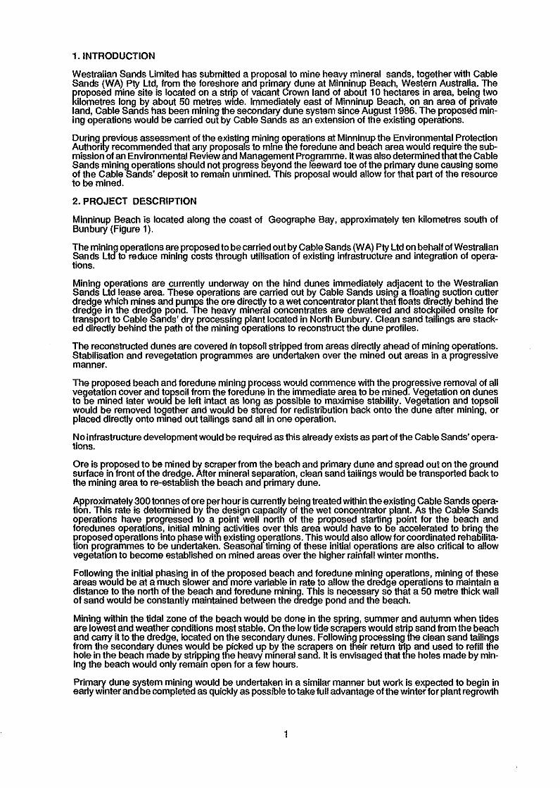
Westralian Sands Limited has submitted a proposal to mine heavy mineral sands, together with Cable Sands (WA) Pty Ltd, from the foreshore and primary dune at Minninup Beach, Western Australia. The proposed mine site is located on a strip of vacant Crown land of about 1 0 hectares in area, being two kilometres long by about 50 metres wide. Immediately east of Minninup Beach, on an area of private land, Cable Sands has been mining the secondary dune system since August 1986. The proposed min· ing operations would be carried out by Cable Sands as an extension of the existing operations.
During previous assessment of the existing mining operations at Minninup the Environmental Protection Authority recommended that any proposals to mine the foredune and beach area would require the sub· mission of an Environmental Review and Management Programme. lt was also determined that the Cable Sands mining operations should not progress beyond the leeward toe of the primary dune causing some of the Cable Sands' deposit to remam unmined. This proposal would allow for that part of the resource to be mined.
2. PROJECT DESCRIPTION
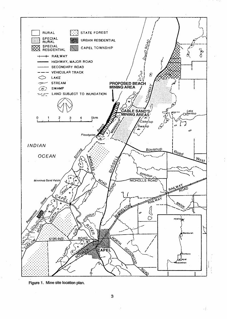
Minninup Beach is located along the coast of Geographe Bay, approximately ten kilometres south of Bun bury (Figure 1 ).
The mining operations are proposed to be carried out by Cable Sands (WA) Pty Ltd on behalf of Westralian Sands Ltd to reduce mining costs through utilisation of existing infrastructure and integration of opera· lions.
Mining operations are currently underway on the hind dunes immediately adjacent to the Westralian Sands Ltd lease area. These operations are carried out by Cable Sands using a floating suction cutter dredge which mines and pumps the ore directly to a wet concentrator plant that floats directly behind the dredge in the dredge pond. The heavy mineral concentrates are dewatered and stockpiled onsite for transport to Cable Sands' dry processing plant located in North Bunbury. Clean sand tailings are stack· ed directly behind the path of the mining operations to reconstruct the dune profiles.
The reconstructed dunes are covered in topsoil stripped from areas directly ahead of mining operations. Stabilisation and revegetation programmes are undertaken over the mined out areas in a progressive manner.
The proposed beach and foredune mining process would commence with the progressive removal of all vegetation cover and topsoil from the foredune in the immediate area to be mined. Vegetation on dunes to be mined later would be left intact as long as possible to maximise stability. Vegetation and topsoil would be removed toQether and would be stored for redistribution back onto the dune after mining, or placed directly onto m1ned out tailings sand all in one operation.
No infrastructure development would be required as this already exists as part of the Cable Sands' opera· tions.
Ore is proposed to be mined by scraper from the beach and primary dune and spread out on the ground surface in front of the dredge. After mineral separation, clean sand taiHngs would be transported back to the mining area to re-establish the beach and primary dune.
Approximately 300 tonnes of ore per hour is currently being treated within the existing Cable Sands operation. This rate is determined by the design capacity of the wet concentrator plant. As the Cable Sands operations have progressed to a point well north of the proposed starting point for the beach and foredunes operations, initial mining activities over this area would have to be accelerated to bring the proposed operations into phase with existing operations. This would also allow for coordinated rehabilitation programmes to be undertaken. Seasonal timing of these initial operations are also critical to allow vegetation to become established on mined areas over the higher rainfall winter months.
Following the initial phasing in of the proposed beach and foredune mining operations, mining of these areas would be at a much slower and more variable in rate to allow the dredge operations to maintain a distance to the north of the beach and foredune mining. This is necessary so that a 50 metre thick wall of sand would be constantly maintained between the dredge pond and the beach.
Mining within the tidal zone of the beach would be done in the spring, summer and autumn when tides are lowest and weather conditions most stable. On the low tide scrapers would strip sand from the beach and carry it to the dredge, located on the secondary dunes. Following J>rocessing the clean sand tailings from the secondary dunes would be picked up by the scrapers on their return trip and used to refill the hole in the beach made by stripping tlie heavy mineral sand. lt is envisaged that the holes made by min· ing the beach would only remain open for a few hours.
Primary dune system mining would be undertaken in a similar manner but work is expected to begin in early wmter and be completed as quickly as possible to take full advantage of the winter for plant regrowth
1
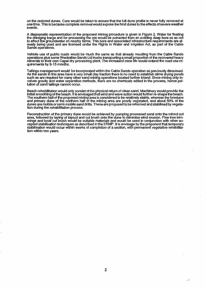
on the restored dunes. Care would be taken to ensure that the full dune profile is never fully removed at one time. This is because complete removal would expose the hind dunes to the effects of severe weather events.
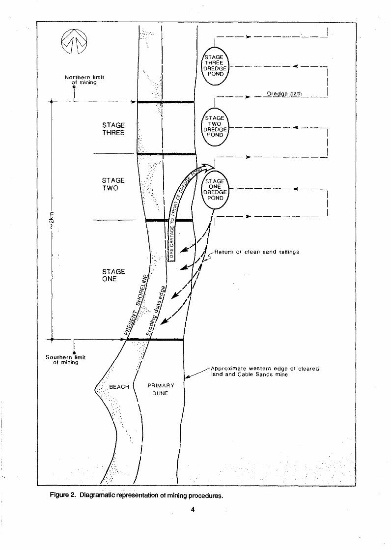
A diagramatic representation of the proposed mining procedure is given in Figure 2. Water for floating the dredging barge and for processing the ore would be extracted from an existing deep bore so as not to affect the groundwater on nearby farms. This bore and associated infrastructure requirements are already being used and are licensed under the Rights in Water and Irrigation Act, as part of the Cable Sands operations.
Vehicle use of public roads would be much the same as that already resulting from the Cable Sands Oj)erations plus some Westralian Sands Ltd trucks transporting a small proportion of the recovered heavy minerals to their own Caj)el dry processing plant. The increased mine life would extend the road use requirements by 9-15 months.
Tailings management would be incorporated within the Cable Sands operation as previously discussed. As the sands in this area have a very small clay fraction there is no need to establish slime drying ponds such as are required for many other sand mining operations located further inland. Since mining only involves gravity .and water separation methods, there are no chemicals added in the process, hence pollution of sand tailings cannot occur.
Beach rehabilitation would only consist of the physical return of clean sand. Machinery would provide the initial smoothing of the beach. lt is envisaged that wind and wave action would further re-shape the beach. The southern half of the proposed mining area is considered to be relatively stable, whereas the foredune and primary dune of the northern half of the mining area are j)Oorly vegetated, and about 50% of the dunes are mobile or semi-mobile sand drifts. These are proposed to be reformed and stabilised by vegeta• tion during the rehabilitation process.
Reconstruction of the primary dune would be achieved by pumping processed sand onto the mined out area, followed by laying of topsoil and cut brush onto the dune to minimise wind erosion. Pine tree trimmings and local cut brush would be suitable materials and would be used in conjunction with other accej)ted stabilisation techniques as described in the ERMP. lt is envisage by the proponent that temporary stabilisation would occur wlthin weeks of completion of a section, with permanent vegetative rehabHitation within two years.
2
I )
D RURAL D . STATE FOREST
E2l SPECIAL RURAL 11 URBAN RESIDENTIAL o/
-<:1 0/
Q:l ~ SPECIAL ~ RESIDENTIAL CAPEL TOWNSHIP
-1--t- RAiLWAY
0
INDIAN
HIGHWAY, MAJOR ROAD
SECONDARY ROAD
VEHICULAR TRACK
LAKE
STREAM
SWAMP
LAND SUBJECT TO INUNDATION
2 3 4 5km
OCEAN
... ·I ..... ·I
. -:::::::::::::I
.·.·.·.·.·.·.·.)
:<<<:>l •••••• 0 •• . . . . . . . . . Figure 1. Mine site location plan.
J I I
"' .PI (\/ ,~1,
PROPOSED BEACH MINING AREA
l
3
. I --- .... ---------
--------4---
Northern limit ..
~--rlf_m_i_ni_n_g----~-~~----~------~ 'l
I
1
I ____ .,.. _ _Qred~path __ j
E ><
"' I
l Southern limit
of mining
STAGE THREE
STAGE TWO
STAGE ONE
',·,
( \
\ I
J
2 w 0
" ~
\!
PRIMARY DUNE
j
------- .. ---1
I I ___ .,.. ________ _
______ ...,.. __ _ I I I , ___ .,.. _______ _
).I ;I
/ I . /&Return of clean sand tailings
;f
Approximate western edge of cleared land and Cable Sands mine
Figure 2. Diagramatic representation of mining procedures.
4
3. EXISTING ENVIRONMENT
The Minnlnup area experiences a mediterranean type climate characterised by cool, wet winters and hot, dry summers. Average annual rainfall is in the vicinity of 850 millimetres with 85% of that occurring in the six months from May to October. An average of only 130 millimetres falls over the rest of the year with rain falling only a few days during this time.
Temperatures average about 16.2°C ranging fJOm a mean minimum daily temperature of 8.2°C in July to a mean maximum daily temperature of 27.6 C in February.
Evaporation rates in the area range from 283 mm in January to 71 mm in July.
Winds in the area are seasonally variable with predominantly south easterly winds on summer and autumn mornings and characteristic west to south- westerly winds during summer afternoons as a result of seabreezes. Winter and sprinQ winds are highly variable. From 3% to 5% of winds In summer and winter are calm ( <5 km/hr) and With only a sman proportion of the winds throughout the year ( <2%) are greater than 30 km/hr.
Storm activity is also an important climatic factor. There are two distinct seasonal weather patterns which may cause storm events in the south-west. From December to April tropical cyclones form off the northwest coast and sometimes move sufficiently far south to affect the south-west. Widespread influences from these intense low pressure areas can produce sustained winds and associated heavy rainfall. From May to October, low pressure cells originating in the Southern Ocean move across the coast. Storms from these cells are variable in intensity and last anywhere from 1 0 hours to 55 hours.
The Minninup deposits occur within the Safety Bay Sand unit described by Wilde and Walker (1982) as consisting of unlilhified calcareous sand with abundant mollusc and foriminifer fragments. The deposit occurs on a sloping planar beach, growing outward into the sea, with a seaward slope of less than 5 degrees between tlie low water mark and a small berm.
Two sedimentary units have been identified within this area. Heavy mineral content of the upper lying unit averages about 17%, while the lower unit contains approximately 40% heavy mineral.
The entire beach and nearshore sequence rests on an erosion surtace of estuarine sands and clays which is present both behind and beneath the foreshore barrier. These sediments are up to one metre thick and overlie the Tamala limestone. The high concentration of heavy minerals in the beach cause moderately high levels of background radiation. Most of these radiation levels are attributed to be monazite in the heavy mineral. hi the case of Minninup Beach sand, up to 0. 7% of the heavy mineral concentrate is monazite. Levels of 0.42 G/hr (micro Gray per hour) at the standard one metre above ground level are common at Minninup Beach. This is natural radiation and is not caused by human activity. These levels are in excess of the derived dose limfts for members of the public as defined by the Commonwealth Code of Practice for the Mining and Milling of Radioactive Ores 1987 le 1mSv per year or 0.11 micro sieverts per hour.
The condition of the vegetation of the primary dune varies greatly. lt is generally in a much better condition in the southern section where a fence has protected the dune from horse riding, vehicles, grazing and especially people movement. The northern section is severely eroded and the vegetation is very disturbed. In addition, the entire seaward slope of the primary dune is actively eroding, resulting in a steep and unstable slope. The foredune and part of the primary dune itself, was comP.Ietely destroyed in April 1978 by Cyclone Alby but the primary dune has been partially rebuilt and stabilised by vegetation. This restoration of the foredune is more complete in the southern than in the northern section and the new toe is also more vegetated in the southern section.
The height of vegetation is greatly influenced by exposure to strong winter winds. The foredune and seaward slope of the primary dune are generally covered by herbaceous ground cover, sedge and grasses. The crest of the primary dune is usually well covered by shrubs of less than one metre in height. On sheltered leeward slopes and in the valleys, tall shrub lands occur except in wetter depressions which generally support sedgelands.
The flora of the primary dune and beach zone is typical of vegetation on Quindalup dune systems which extends along much of the south-western coastline of Western Australia.
No gazetted rare plant species have been observed on the primary dune or adjacent secondary dune area. All of the species are widely distributed and are included in areas which have been set aside for the conservation of flora and fauna and for public recreation. Of the 123 species of plants recorded by Martinick and Associates (1987) in their study, 39 (32%) were weeds or exotic species.
Some faunal surveys have been carried out in the area and results were discussed in the ERMP. Although these surveys concentrated primarily on birds, the proponent believes that there are no rare or geographically restricted fauna species that occur in the immediate area that would be affected by the proposed mimng operations.
5

Exotic fauna recorded in the dunes by Martinick and Associates were rabbits, cats, fox, mouse and black rat.
4 PUBLIC AND GOVERNMENT SUBMISSIONS
Thirteen public submissions and eight responses from State Government agencies were received during the public review period. A summary of the respondents and issues raised are provided in Tables 1 and 2.
Table 1. Summary of submissions.
ISSUE NO OF SUBMISSIONS
Rehabilitation Final stability of Dune and Beach System
as well as during Rehabilitation Monitoring and Post Mining Commitments Groundwater Post Mining Land Use Radiation Flora and Fauna Effects on Nearby Residents Particularly
with Respect to Dust and Noise Coastal Processes Impacts on Adjacent Wetlands Cost Benefit Analysis Documentation Based on Internal Consultants
Reports Legal Validity of Commitments Plant Pathogens Expansion of Proposals Reduction in Height of Dunes Eire Control Aboriginal Sites Commitments
Table 2. Submissions received.
LIST OF RESPONDENTS
Department of Resources Development Department of Mines Western Australian Department of Agriculture Health Department of Western Australia Western Australian Museum State Planning Commission Department of Conservation and Land Management Main Roads Department SC Baker ECManea M R & P F Beatson D & R Byrne J Holmes PJ & PJ Power DWhite M Leslie J & P Kirkman / L & D Jamieson Joint submission P, D & K Kurylo } J & E Bailey } Shire of Cape! Australian Conservation Foundation Conservation Council of Western Australia Western Australian Naturalists' Club (!ne)
11
9 5 7. 5 5 4
2 5 3 5.
4 1 1 1 1 2 1 2
The predominant concerns raised in the submissions were mainly with regard to rehabilitation and stabilisation of mined areas, impacts on groundwater, radiation and ongoing commitments and responsibilities of the proponent in ensuring that environmental management objectives are achieved. A wide range of other issues were also raised in submissions as detailed in the review of submissions included in Appendix 1 of this report. The Company has subsequently addressed the issues raised by the public
6

and government agencies in their submissions and by the Environmental Protection Authority. Westralian Sands Limited's response is in Appendix 2 of this Report.
5 ENVIRONMENTAL ISSUES
In considering the Company's initial proposal the Environmental Protection Authority determined that the potential for environmental impact was such that the proposal would require assessment under Part IV of the Environmental Protection Act, 1986, and that the level of assessment would be Environmental Review and Management Programme (ERMP).
An ERMP was submitted for the proposal and has undergone a ten week public review period, which finished on 25 March, 1988.
REHABILITATION AND FINAL STABILITY OF DUNE AND BEACH SYSTEMS
A major issue considered by the Environmental Protection Authority in its assessment of the proposal was rehabilitation and stablllsation of the mined beach and foredune areas.
REHABILITATION
Mining ofthe Minninup Beach mineral deposit would remove all vegetation from the foredune and primary dune. The dune vegetation is the primary stabilising factor of the dune systems. lt is therefore considered essential that this vegetation be re-established as quickly as possible in order to restabilise the dunes and that interim stabilisation techniques are applied to allow the vegetation to become established.
The ERMP discusses a number of procedures and restabilisation alternatives to achieve this objective. lt is considered by the proponent that revegetation of the dune system is the most viable option for ensuring ongoing stability.
lt is proposed In the ERMP that dune reconstruction at Minninup would consist of the following steps:
1. The construction of the foredune, primary dune and secondary dune to the desired size, shape and location, using processed clean sand from mine residue.
2. Topsoil would be returned together with all plant material. This would be removed from ahead of the mine path and immediately returned to the rear of the mine path onto restored landforms.
Vegetation and topsoil would be removed from the mine path in a single operation. The mixture of vegetation and about 15-20 cm of topsoil will be pushed into the valley between the primary and secondary dune. lt would then be respread over the reconstructed primary dune immediate!)' after this has attained its desired slope. Thus, when the topsoil is returned, the pre-existing vegetation IS replaced at the same time as a layer of bushes, branches and debris. These form a wind protection over the soil sur1ace.
3. Additional brush would be provided on a needs basis and this would probably be cut on-site although some pine cuttings may be used.
4. lt was envisaged that considerable regeneration of plants would occur from seed contained in the topsoil. This would be supplemented by handseeding using special hand tools with which the seed will be placed carefully in selected sites. Some hand ~lan!ing of seedlings and cuttings would be undertaken, probably at a density of about 3 (>!ants per 1 Om . Runners of native dune grasses would be collected ahead of the mine path and hand planted on restored landforms. Only dune species from the region will be established.
5. Efforts would be made to remove weeds, but as these are already present on the entire dune landfonn, their total eradication cannot be guaranteed. However, as native vegetation becomes established weed populations may decline with time.
6. Physical stability, where required, would also be provided by the placement of unbroken straw bales at rates calculated to substantially decrease windspeeds at sur1ace, and also be spraying with bitumen straw, if necessary.
7. Where a surplus oftopsoll is available from the secondary dunes, it will be used on the primary dunes.
8. Efforts will be made to mine stage 1 of the foredune at the beginning of the 1988 winter season so that vegetation establishment can commence as early as possible thereafter to take advantage of the favourable growth conditions during the winter.
9. Fertilisers will be used to assist in the rapid growth of all plants.
As well as these techniQues, a wide range of backup methods of stabilisation are available. These were discussed In Appendix C of the ERMP.
7
In the ERMP the proponent has made several commitments to rehabilitation, including a commitment to monitor dune stability and beach erosion and undertake remedial action if necessary.
Although Westralian Sand Limited, as the tenement holder, has ultimate resJlonsibility for rehabilitation, work will be done by Cable Sands under an agreement between them and Westralian Sands Limited. The two companies would be continuing to operate in the area for many years and are committed to maintaining responsibility for dune stability for as long as reasonably necessary. 11 is envisaged by the proponent that complete stabilisation would have been reached within three years of cessation of operations. A commitment has been made that successful rehabilitation would be determined by the Department of Mines, using the criteria outlined In Section 9.4 of the ERMP as follows:
"1. There should be at least three years of stability of land form, stability being attributable to its loca· tion, shape and the establishment of stable and self-perpetuating vegetation.
2. Perennial plant species must have survived at least two summer seasons.
3. The vegetation must have a density of plants which will provide long term stability to the restored landforms. The minimum density required per 10 m2 is based on baseline date collected prior to mining from excellent examples of stable stands of vegetation on the dune system (Mart/nick & Associates Pty Ltd, 1987):
(a) Foredune: 10 evenly distributed plants • each developing into clumps, of any combination of the species listed in Table 1 O(A). This includes monostands.
(a) Primary dune: Any 10 plants from Table 10(b) and at/east any 2 plants from Table 10(c), or up to 12 from Table tO( c) and none from Table 10(b).
Other species will occur naturally and will be in addition to the minimum numbers given above.
Table 10. Species used to aid definition of end point of rehabilitation.
A. FOREDUNE SPECIES
Arctocheca populifolia Cakile maritima Spinifex hirsutus Spinifex longifolius Tetragon/a decumbens
B. PRIMARY DUNE GRASSES, SEDGES AND GROUND COVERS
Acanthocarpus preissii Caki/e maritima Hardenbergia comptoniana Lepidosperma ustulatum Poa drummondiana Scaevola orassitolia Tetragon/a decumbens Trachyandra divarisata
C. PRIMARY DUNE SHRUBS
Acacia coohlearis Acacia cyclops Acacia saligna Olearia axillaris Rhagodia baccata Spyridium globulosum •
Monitoring would be done by regular observation, by the undertaking of detailed research and botanical monitoring and by photographic recording of the rehabilitated sites from a series of standard points at six monthly intervals. A species list of plants from selected sites would be made on an annual basis to record rates of species recruitment.
The primary dune and foredune would also need to be extensively monitored to ensure that they are withstanding normal dynamic cycles of sand deposition and erosion.
8

The Environmental Protection Authority considers that, as this would be the first heavy mineral sand mining operation to be carried out on a beach and primary dune area in Western Australia for many years, it is not possible to compare earlier OJ>erations of this type to the present proposal. lt is therefore, difficult to determine whether or not sand mininp on the shoreline would be, in itself, an environmentally acceptable activity. However, the Authority believes that this particular proposal would be acceptable as an appropriate test case for the mineral sands industry to determine it mining in this environment can l>e undertaken in an environmentally acceptable manner.
An appropriate site to be chosen for such a trial would be one where the hinterland is least sensitive. In this case the entire hinterland is subject to current mining operations and would therefore be appropriate.
11 is also considered that no further proposals for beach and primary dune mining should be approved until it is demonstrated through extensive monitoring of this project that such operations can be undertaken in an acceptable manner and the dune system adequately stabilised.
The Authority believes that the approach to rehabilitation and monitoring as proposed in the ERMP would be adequate for undertaking such a trial.
RECOMMENDATION 2
The Environmental Protection Authority recommends the proponent should ensure that stabillsation and rehabilitation of mines areas is progressively carried out In the manner described In the Environmental Review And Management Programme to achieve the objectives described the ERMP Including: .
• Three years stability of land form;
. Perennial plant species surviving at least two summer seasons;
. Vegetation density providing long-term stability of restored land form;and
. Re-established vegetation containing particular species at appropriate densities.
RECOMMENDATION 3
The Environmental Protection Authority recommends that regular monitoring of rehabilitated areas be carried out by Westralian Sands Ltd. and results are reported to the Environmental Protection Autl)ority as well as the Department of Mines, until such a time that it is determined by those agencies that rehabilitation and stablllsatlon of the dunes has been successful. Initially, these reports should be submitted annually.
FINAL STABILITY AND COASTAL PROCESSES
Issues relating to the final physical stability and the coastal processes that influence that stability were discussed in detail in the ERMP.
The Authori!}' considered that due to the technical nature of these issues and their importance with respect to final stability an independent consultant's review of relevant aspects of the proposal would be required. This review was undertaken by Dr D P Lewis otthe Coastal and Hydraulic Engineering Laboratory, Centre for Water Research at the University of Western Australia. The Critical Review report comprises Appendix 4 of this Report.
lt was determined in the ERMP that the removal of the heavy mineral sands from the beach and their replacement with lighter beach sand would mean that the potential for longshore transport on the existing beach alignment would increase by a factor of 1 .2 to 1 .5. To compensate for this increased capacity to move the lighter sediment, the southern end of the beach would realign itself by rotating east-ward approximately 1° until a degree of stability is again established.
To reduce the likelihood of damage to the reconstructed primary dune it is proposed to relocate this dune on the preferred alignment.
The foredune would be re-established on the same alignment as present, but increased in height by 1 m to provide additional sand during the re-equilibration phase. Some realignment of the foredune through eros1on and acretion would occur naturally and may be significant in the first year after reconstruction, as the beach tends towards establishing a new equilibrium.
In reviewing these issues relating to the planned management and predicted final stability the consultant's report prepared for the Authority concludes the Environmental Review and Management Programme prepared by Westralian Sands Limited has addressed the coastal engineering aspects of the proposed project In a quite thorough and detailed manner. The reviewer agreed wkh the conclusion
9

of the ERMP that, "The mining of mineral sand from the beach of Minninup should not result in any long term effects on the coastline of Geographe Bay", provided the environmental management initiatives outlined in Chapter 9 of the ERMP are implemented.
lt was also concluded that the general methodology and assumptions adoyted by the coastal engineering consultants are quite valid. The reviewer contended that a number o more specific issues where either inadequately addressed or may have warranted further investigation. These include:
- the origin of, and modern sedimentation controls on, the heavy mineral beach deposit;
- quantification of the volume of material to be removed from the dune system and details of consequent modifications to the reconstructed rear dune region;
- verification of the predicted nearshore wave climate, particularly along the Minninup shoreline, in relation to the observed and predicted longshore sediment transport rates, the assumed stable beach profile at Minninup, and the effect of locally generated seas as opposed to longer period prevailing swell, on the transport rate; and
- the prediction of increased longshore transport as a result of the removal of the heavy mineral component from the beach deposit at Minmnup. The estimate of this increased transport, and the subsequent rotation of the beach by 0.5° to 1.0°, cannot be verified without further detailed investigation.
1t was further concluded that, in general, the coastal engineering consultants conclusions are valid yet, In some specific instances, difficult to verily. However, the reviewer believed these conclusions are realistically conservative and the proposal would not lead to any long term degradation of the Geographe Bay shoreline.
The Environmental Protection Authority has considered these issues in light of the consultant's report and recognises the proponent's commitments in the ERMP that:
- " dune stability and beach erosion would be monitored and remedial action taken if necessary; and
- results of monitoring would be presented to the Department of Mines on a regular basis pending complete finalisation in about three years."
As discussed in the previous section on rehabilitation, the Authority considers that there are still uncertainties regarding the stabillsation and rehabilitation of beach and dune systems that could only be addressed through trial mining and rehabilitation and subsequent monitoring. Monitoring programmes should, therefore be desiQned to demonstrate that coastal stability could be achieved following mining and successful rehabilitatiOn of the beach and dune system.
RECOMMENDATION 4
The Environmental Protection Authority recommends that dune stability and beach erosion should be monitored by the proponent to the satisfaction of the Departments of Mines, Marine and Harbours and the Environmental Protection Authority with results of the monitoring being reported to those agencies until such a time as they are satisfied that coastal movements (as a result of mining operations) have reached equlllbrlum.lnitlally, these reports should be submitted annually.
RECOMMENDATION 5
The Environmental Protection Authority recommends that If monitoring required In Recommendation 41ndlcates that dune and beach erosion Is occurring at an unacceptable rate the proponent be required to undertake remedial action to the satisfaction of the Departments of Mines, Marine and Harbours and the Environmental Protection Authority.
A number of more specific issues were raised In public and government agency submissions with regard to coastal processes and final stability. These issues have been addressed by the proponent and responses are contained in Appendix 2 of this Report.
10

GROUNDWATER
Issues relating to the proposal's impacts on groundwater in the area through disturbance of the dune profile and abstraction of water was considered by the Authority in Its assessment of the proposal. A number of submissions expressed some concerns that extraction of water for mining and processing would affect other bores in the area.
lt is important to note that this proposal to extend mining operations at Minninup will not cause the annual requirement for water to be increased above the currently licensed rate of 1 200 000 kilolitres per year. The f>Otable and process water supply would be provided by two existing deep bores, located on land owned by Cable Sands. The bores draw from Yarragadee Formation at a depth of below 200 metres to reduce any affects on the superficial aquifer.
lt is therefore accepted that the proposal should not have any significant impacts on either local ground water bores or water levels in wetlands in the vicinity of the operations.
Some concern was also expressed in submissions regarding the likelihood of salt water intrusion as a result of mining the dunes.
The ERMP discusses this issue in detail and concludes that there would be no long term impacts on hydrology of the area as a consequence of dune removal as the dunes would be immediately reconstructed at their present location and in similar configuration and height. During mining there would be temporary disruption of surface hydrology but as mining is shallow, only small areas would be mined out any given time and as reconstruction would rapidly follow, the impact is expected to be minimal. Salt water would not enter the hind dunes as the dredge is floated on fresh water at a higher level then the high water mark and water would seep through the sea rather then the reverse.
The Authority believes that salt water intrusion would not occur as a result of the proposed mining operations.
RADIATION
As the proposed mining areas have been identified as having high natural background levels of radiation levels this issue was considered with respect to both the occupational health and safety aspects of the proposal and public health Implications.
In June 1984 a report was submitted to the Minister for Health of Western Australia on Protection from Ionizing Radiation Associated with the Mineral Sands Industry. In this report reference was made to naturally occurring areas of high radiation. Although Minninup Beach was not specifically identified In this Report as one of those areas, radiation surveys carried out in the area indicate that background levels are high enough to cause concern.
Levels reported in the ERMP for the beach and dune area are up to 1.05 micro sieverts per hour. This level is well in excess of the member of the public derived dose limit of 0.11 micro sieverts per hour as defined by Code of Practice for Mining and Milling of Radioactive Ores 1987. lt is also higher than the subsidiary dose limit of 5 milli sieverts per year or 0.57 micro sieverts per hour that is permissible for some years, provided that the average annual effective dose over a lifetime does not exceed 1 mill I sievert per year.
The ERMP proposes that levels of radiation would be reduced on the beach and dune are as a result of mininQ of heaVy mineral sands. After removal of the radioactive minerals radiation levels are expected to be m the vicinity of normal background levels for the area. This is expected to be about 0.1 micro slevert per hour, as stated in the ERMP In Section 6.6.
A number of submissions expressed some concern that levels could eventually return to the pre-mlnlng situation as more heavy mineral is transported from the seabed and deposited on the beach.
In Its response to submissions the Company stated that all the mineral sand would be removed from the dune during the initial mining operation. As a result, there should not be a need to remine the dunes. Studies by the Company have Indicated that, there is some heavy mineral sand lying immediately offshore from the beach, although the total volume of heavy mineral sand Involved is small, particularly when compared to the mineral sand content of the beach at present. While it is agreed that some heavy minerals may be returned to the beach after mining, the subsequent rise In radioactivity is expected to be minor. The level of radioactivity depends on the mineral composition, the concentration of minerals, the thickness of the deposits and the depth to which it is buried under clean quartz sand.
11
RECOMMENDATION 6
The Environmental Protection Authority recommends that the proponent should carry out gamma radiation surveys over mined areas on a quarterly basis to the satisfaction of the Department of Mines and the Environmental Protection Authority with results being provided to those agencies on an annual basis.
Occupational health and safety issues with regard to the radiological aspects of the proposal were also raised in a number of submissions.
In the response to submission the Company considered this issue was not within the scope of the ERMP. lt was, however, acknowledged that all operations would comply with the Commonwealth Code of Practice for the Mining and Milling of Radioactive Ores 1987 which 1s based on the International Committee of Radiation Protection (ICRP) standards.
EFFECTS ON NEARBY RESIDENTS, PARTICULARLY WITH REGARD TO DUST AND NOISE
Dust and noise related impacts, particularly from transport of heavy mineral concentrates, were raised as issues of concern in some of the submissions.
The Company has addressed these issues in their response to submissions and the Environmental Protection Authority notes that noise and dust levels from the overall operations must be within standards set by pollution control regulations under the Environmental Protection Act, 1986.
Nevertheless, it is important that dust in particular is not allowed to develop as a nuisance and public health hazard. In peak summer conditions the potential of dust to be generated from the mine site or material to be spilfed in transit may be increased.
The Authority, therefore, expects and insists that there be no undesirable impacts from dust or gamma radiation associated with the mining operations or transport of the heavy mmeral concentrate and accordingly makes the following recommendation.
RECOMMENDATION 7
The Environmental Protection Authority recommends that the proponent be required to monitor dust and gamma radiation levels associated with the mining operations and transport of heavy mineral concentrates for the project, to the satisfaction of the Environmental Protection Authority and the Department of Mines, and shall immediately notify those agencies if any impacts are iden• tilled. The proponent should take immediate measures to ameliorate any undesirable impacts to the satisfaction of the Environmental Protection Authority and the Department.of Mines. Reports of routine monitoring results should be submitted annually.
LEGAL VALIDITY OF COMMITMENTS
Some submissions expressed concern over the legal validity of conditions where the Proponent is not the Company that would be carrying out the proposed mining operations.
The registered holder and beneficial owner of the mining lease is Western Mineral Sands Pty Ltd which in turn is fully owned subsidiary of Westralian Sands Limited. The proponent for this proposal is Westralian Sands Ltd who have a legal obligation under the Environmental Protection Act, 1986 to comply with all conditions set by the Minrster for Environment. ·
A joint venture aQreement has been signed between Western Mineral Sands Pty Ltd and Cable Sands (WA) Pty Ltd settmg out working arrangements for the mining and rehabilitation of the proposed mining area.
The Agreement requires that Cable Sands observe and comply with conditions of the Mining Lease, the Mining Act, the approved environmental management programme (including all obligations imposed thereunder with respect to rehabilitation of the Mining Area) and all other requirements of any relevant competent authority. These responsibilities are intended to be binding upon Cable Sands until such a time as an "end point" for rehabilitation as defined in an approved management programme is achieved. Ongoing management of the Mining Lease would be the responsibility of Westralian Mineral Sands Pty Ltd.
The formal Agreement is subject to the approval of the Minister for Mines as well as conditions and procedures required to be Implemented pursuantto the provisions ofthe Environmental Protection Act, 1986.
The Environmental Protection Authority is aware of this Agreement and is satisfied that the conditions imposed under the Environmental Protection Act, 1986 would be binding on both the proponent and the mine operator.
12
POST MINING LAND USE
A number of submissions expressed concern with respect to a lack of any commitments by the Company in establishing facilities for recreational access to the beach.
In the Company's response to submissions it was considered thatthere is only an obligation to rehabilitate the dunes to a stable state. This would not include provision of recreational facilities.
Access to the area is through land currently held under freehold title by Cable Sands Ltd. The Authority notes that the conditions attached to the Local Council's Extractive Industries Licence for the existing Cable Sands' mining operation include provision of a road and car park area. Establishment of a beacfl access ramp on rehabilitated vacant Crown land could be negotiated provided that this is acceptable to the State Government.
The Environmental Protection Authority believes that this issue needs to be further discussed between the proponent, Cable Sands and the Capel Shire.
GENERAL ISSUES
A number of other general and more specific issues were raised in public submissions on the ERMP.
These issues were generally with regard to:
. cost benefit analysis;
. documentation being based on internal consultants reports not generally available;
. plant pathogens ( eg dieback);
. expansion of mining proposals;
. fire control;
. specific commitments; and
. flora and fauna documentation.
These issues have been addressed in the proponent's response to public submissions which comprises Appendix 3 of this report The Authority has noted those responses and believes they provide adequate explanations.
6. CONCLUSION
The proposed beach and primary dune mining would be the first case of heavy mineral sand mining of its type to be undertaken 1n Western Australia for many years. As it is not possible to compare earlier operations to the present proposal, the Environmental Protection Authority is not prepared to say that, in generality, mineral sand mining on the shoreline is, in itself, environmentally acceptable. However, this J>articular proposal would be considered acceptable as an appropriate test case for the mineral sands inClustry to determine if mining in this this environment can be undertaken in an environmentally acceptable manner.
The Environmental Protection Authority believes that an appropriate site to be chosen for such a trial would be one where the hinterland is least sensitive. In this case the entire hinterland is subject to current mining operations and would therefore be appropriate.
lt is therefore considered that no further proposals involving beach and primary dune minin!J should be approved until it is demonstrated througfl extensive monitoring of this tnal that such operatiOns can be undertaken in an environmentally acceptable manner by the environmental impacts being managed.
Upon assessment of the Westralian Sands Limited proposal the Environmental Protection Authority has concluded that the proposed Minninup Sand Mining Proposal would be considered acceptable as a trial, subject to operations being carried out in accordance with the commitments of the Environmental Review and Management Programme and subsequent correspondence (Appendix 3) and the Environmental Protection Authority's Recommendations in this Report.
RECOMMENDATION 1
The Environmental Protection Authority concludes that the proposal described In the Environmental Review and Management Programme would be considered acceptable as a trial for the heavy mineral sand mining Industry operating In the near shore zone. The conclusion Is subject to the Environmental Protection Authority's recommendations as contained in this Assessment
13

Report and the commitments made by the proponent in the ERMP for environmental management Including:
. commencement of rehabilitation as soon as mining Is completed In a particular section;
. maintain dust and noise levels below current standards set for the mining Industry;
. undertake monitoring of rehabilitation jointly with Cable Sands (W A) Pty Ltd and modify the programme as necessary to ensure success; and
. monitor dune stability and beach erosion and take remedial action If necessary.
14
: l

APPENDIX 1
REVIEW OF SUBMISSIONS

Appendix 1
REVIEW OF SUBMISSIONS
1. REHABILITATION (11 submissions)
A number of submissions discussed the proposed rehabilitation programme in relation to a wide range of concerns. Further information is required and should address the following points:
questionable whether rehabilitation objectives can be achieved on freshly mined areas where natural vegetation communities and soil profiles have evolved over centuries;
proposal does not specifically state that reconstructed dunes will be fenced during rehabilitation to prevent random access by the public which could lead to destabilisation;
current rehabilitated areas at Minninup are infested with weeds that are not natural to the area and most of the trees that have been planted have died;
heavy infestation of "double gees" in existing mine rehabilitation areas;
ongoing responsibilities of the Company for rehabilitated areas are not clearly defined;
reconstruction of dunes should follow natural pattern of high pointy hills and deep valleys rather than continuous dune or flat rounded hills as in the case of North Bunbury;
winter stress from storms may make rehabilitation difficult;
rehabilitation the Department
monitoring of Mines;
results should be reported to EPA as well as
no precise commitments to rehabilitation;
topsoil storage may result in deterioration over time particularly with regard to micorrhizal fungi;
proponent lacks experience in coastal dune system rehabilitation -demonstrated ability to rehabilitate;
research initiatives with regard to micorrhizal fungi and plant root system associations;
123 species are listed in Appendix D of the ERMP verses 18 listed on page 64 to be re-introduced;
further discussion of formal community associations in rehabilitated areas;
confidence expressed in Company's ability to rehabilitate the mined areas; and
excellent rehabilitation results being achieved in adjacent operations.
2.
3.
4.
Appendix 1 REVIEW OF SUBMISSIONS (cont'd)
FINAL STABILITY OF DUNE AND BEACH SYSTEMS AS WELL AS DURING REI~ILITATION (9 submissions)
Unstabili ty during mining
of scraper track operations;
and haul roads through rehabilitated areas
sand blowing from significant impacts
unstabilised newly rehabilitated areas may on adjacent wetland area such as "Muddy Lake";
destabilisation of dune system through mining;
have
to assess the extent of coastal recession nearshore/beach/frontal dune profiles should be recorded prior to mining and at regular intervals during mining operations and for several years following mining and dune rehabilitation; and
proposal has potential to stabilise the currently unstable dune system and re-create an enjoyable and safe beach area.
MONITORING AND POST-MINING COMMITMENTS (5 submissions)
Monitoring of post-mining coastal processes and rehabilitated areas, as well as strict enforcement of the Company's management commitments, will be essential;
regular monitoring of surface and ground water levels adjacent to the mine site would be required;
monitoring ground water for salt water intrusion; and
regular reporting authorities.
of monitoring
GROUNDWATER (7 submissions)
results to relevant Government
Possible contamination of ground water through run-off from areas of high radioactivity;
salt water intrusion through severe during mining operations while there is
storm waves being driven inland a low dune profile;
some commitment residents should supplies;
needs to be made extraction of
to supplement water supplies of nearby water for mining effect domestic water
impacts on groundwater levels needs to be monitored;
possible occurrence of caverns or preferred water paths rather than predictable sand aquifer;
believed to be a decrease in surface and ground water levels in the area as a result of current mining operations;
possible salt water encroachment as a result of interruption of the salt/fresh ground water interface; and

5.
Appendix 1 REVIEW OF SUBMISSIONS (cont'd)
estimated to be about 100 water bores in the area as compared to the one only mentioned in the ERMP.
POST MINING LAND USE (5 submissions)
End land use and proposals for recreational access to the beach needs to be addressed in rehabilitation plans;
needs for Company to make specific commitments to provide infrastructure following mining such as road(s), car walkway(s) etc;
basic access park(s) and
ERMP is not specific in addressing end land use proposals; and
would be desirable to convert vacant 'Recreation and Foreshore Management' mining and rehabilitation.
crown vested
land to a reserve for in the Shire following
6. RADIATION
6.1 OCCUPATIONAL HEALTH AND SAFETY (5 Submissions)
Predicted radiation dose levels need reassessment;
occupational scrapers and
health issues and measures such as sealing of cabins on trucks need to be further discussed; and
a worker education programme in radiation safety needs to be developed and implemented.
6.2 BACKGROUND RADIATION AND PUBLIC HEALTH ASPECTS
7.
ERMP states that there will be an initial lowering of radiation levels on the beach and dunes through removal of heavy mineral sands. It is believed that these levels could eventually return to the pre-mining situation as more heavy mineral is transported from the seabed and deposited on the beach;
beach would need to be surveyed for gamma radiation levels on an ongoing basis to check possible radiation build-up;
danger from background radiation to residents located over other heavy mineral deposits in the area; and
post mining radiation levels need to be predicted.
FLORA AND FAUNA (4 submissions)
Documentation of flora and birds is thorough although comments on reptiles and mammals are based on inference;
the conclusions attributed to Kitcher ~., (1982) on page 35 of the ERMP are somewhat misleading. Kitchener et al., concluded that M splendens was of 11 VUlnerable" conservation status in the wheatbelt being recorded on only three of 24 reserves surveyed and d frontalis was given an 11 Uncertain conservation status 11 because of relatively few records;

8.
9.
no survey apparently the species
Appendix 1 REVIEW OF SUBMISSIONS (cont'd)
work on mammals, reptiles, insects or invertebrate fauna was undertaken further information would be required as a list of was not provided; and
commitments to undertake monitoring of flora and fauna communities in nearby wetland areas.
EFFECTS ON NEARBY RESIDENTS PARTICULARLY WITH REGARD TO DUST AND NOISE (2 submissions)
Dust nuisance that may result from transport of materials along Rich Pool;
noise from transport along proposed route; and
current operations have had no adverse effects on the lifestyle of nearby residents with regard to dust and noise.
TRANSPORT AND ACCESS ROADS (3 submissions)
Needs to be commitment to restrict mine haulage and transport to proposed routes;
mine transport using unauthorised transport routes may be a problem;
current spillages of heavy mineral sand concentrations along the Bussel Highway are likely to be increased as a result of further mining operations; and
dust and noise impacts associated with mine transport.
10. COASTAL PROCESSES (5 submissions)
Section on coastal engineering is well documented and gives confidence to the conclusions and recommendations drawn;
removal of heavy mineral fraction from the breach and dune system is likely to lead to destabilisation; and
conclusions evaluated by
relating to predicted coastal processes other than Company's consultants.
need to be further
11. IMPACTS ON ADJACENT WETLANDS (3 submissions)
12.
Lowering of water table through monitored with respect to impacts on
mine water extraction wetlands; and
sand blowing from unstabilised dunes may effect wetlands.
GENERAL ISSUES RAISED IN SUBMISSIONS
needs to be
12.1 COST BENEFIT ANALYSIS (5 submissions)
Cost/benefit analysis did not account for in any detail, environmental disbenefits associated with the proposal; and
Appendix 1 REVIEW OF SUBMISSIONS (cont'd)
difficult to express lost conservation values in dollar term to compare with financial benefits of proposed operations.
12.2 DOCUMENTATION BASED ON INTERNAL CONSULTANTS REPORTS (4 submissions)
Difficult referenced procedures
to adequately publications
are restricted
assess some aspects purporting to justify in distribution;
of the certain
proposal where processes and
conclusions based on unpublished consultant's reports are difficult to verify; and
extensive referral to unpublished consultant's reports for internal Company use.
12.3 LEGAL VALIDITY OF COMMITMENTS (1 submission)
Legal validity of commitments was questioned in the proposed situation where mining and rehabilitation will be carried out by another Company.
12.4 PLANT PATHOGENS (l submission)
Measures to prevent the introduction and dissemination of any disease agent, or representatives of any exotic biota into the area through soil moving equipment, transport vehicles or other means need to be discussed.
12.5 EXPANSION OF PROPOSALS (1 submission)
Is there a possibility that mining may continue further north from the proposed mine site as further economic deposits are identified.
12.6 REDUCTION IN HEIGHT OF DUNES (1 submission)
Overall reduction in the height of the sand dunes may cause adverse wind and salt related impacts on farming and special rural areas immediately inland.
12.7 FIRE CONTROL (2 submissions)
Further discussion of proposed fire control measures required.
12.8 ABORIGINAL SITES (1 submission)
The Department of Aboriginal Sites would appreciate some further information on which studies are referred to and who carried out the on~ site investigation to enable it to assess the ERMP's conclusion that there is no significant cultural heritage in the vicinity of the proposal.
12.9 COMMITMENTS (2 submissions)
Local government requirements should be added to list of commitments; and
commitment re: commencement of mining should be amended to reflect approval be Minister for Environment, not EPA, as per Environmental Protection Act, 1986.

APPENDIX 2
PROPONENT'S RESPONSE TO PUBLIC SUBMISSIONS ON THE MINNINUP SAND MINING PROPOSAL ERMP
~! I

! \ i

1.1
Appendix 2
PROPONENT'S RESPONSE TO PUBLIC SUBMISSIONS ON THE
MINNINUP SAND MINING PROPOSAL ERMP
S. = Submission, as summarised by the Environmental Protection Authority <EJ>A)
R. = Response by Westralian Sands Limited (WSL)
1.0 REHABILITATION
S. Questionable whether rehabilitation objectives can be achieved on freshly mined
areas when natural vegetation communities and soil profiles have evolved over
centuries.
R.
1. Experience in primary-dune sand-mining areas in Eastern Australia has clearly
shown that rehabilitation can not only be achieved but that it may be of very
high quality. For example, Stradbroke Island, discussed on pages 61-62 of the
ERMP.
2. It is arguable whether the soils, etc., have developed over centuries as indicated
in the submission. It is suggested on page 32 of the ERMP that the soils may be
only tens of years old, and this is supported by Riedel & Byrnes's studies '-
<ERMP, Appendix B).
3. There is almost no soil profile, and the vegetation is very simple. Species
distribution is determined almost entirely by soil moisture and wind. This
differs from more complex vegetation types where soil profiles, nutrient
1.2
distribution and many other factors come into effect. Indications are that
coastal dune systems are amongst the simplest to rehabilitate. This is supported
by observations such as Mandalay Beach at Walpole, where dunes moving at sm
per year have been stabilised after only 2 years of rehabilitation (Department of
CALM files).
~ Proposal does not specifically state that reconstructed dunes will be fenced
during rehabilitation to prevent random access by the public which could lead to
destabilisation.
Appendix 2 (cont'd)
- 2 -
R. Page 52 Section 7.9 states the rehabilitated areas will be protected from stock.
As mining will be moving progressively forward, rehabilitation will be well under way
in some areas mined early in the programme well before public access resumes.
Page 55 Section 8.5 refers to pedestrian control following the completion of mining
and Section 8.7 refers to beach closure during mining. Page 58 point 4 mentions
that vegetative cover will be protected by physically excluding people, stock and
vehicles, and preventing fire.
1.3
S. Current rehabilitation is infested with weeds and most of the trees have died.
R. Weeds are generally species which are prolific seeders, often with wide dispersal
mechanisms, and are commonly pioneers on disturbed soils. It is therefore highly
likely that introduced weedy species will be amongst early recruitment onto ground
disturbed by mining. Appendix D of the ERMP lists the plants found on the dunes at
the present time and includes 48 species of exotic plants. This indicates that weeds
are common in the dune systems before mining and suggests that mining has not been
the cause of their presence, and that the likelihood of their becoming early colonizers
is very high. Some species e.g. Hypochaeris radicata are well known for their almost
universal distribution, even in long-undisturbed bushland. The question therefore
hinges around the word "infested". This term implies extreme abundance and that the
species is out of control. Field observations suggest that abundance is not greater
than that normally occurring on newly disturbed land and that no species is out of
control in the sense that it requires special management, other than allowing normal
successional changes to take place. Page 60 Item 4 of the ERMP refers to the weed
issue.
In reference to tree deaths, this is a result of natural thinning and death when tree
establishment rates are far in excess of required densities. Loss of seedlings in
regeneration areas can be as high as 95%. with further losses in following years. As
the remaining trees become older, losses decrease with time. Before it is reasonable
to evaluate tree losses, about three years of establishment is necessary to permit
natural losses to occur, and to provide a reliable guide to programme success. If, at
that time losses are deemed to be too great, supplementary planting or seeding will
take place.
Appendix 2 (cont'd)
- 3 -
In the case of the present project, which occupies the beach and primary dune, tree
losses are irrelevant, because trees do not grow on the dune, and will not be
included in the rehabilitation programme.
1.4
S. Heavy infestations of "Double-gees" in mine rehabi.litation areas.
R. Double -gees are one of the plant species typical of the pioneers discussed in 1.3
above. As these are a pest species in the Bunbury region, if they become prolific in
the dune area they will be treated with herbicide.
1.5
S. Ongoing responsibilities of the Company for rehabilitation areas are not clearly
defined.
R. Page 65 Section 9.5 of the ERMP clearly
and a definable endpoint for measuring success
1.6
states both a long-term
of rehabilitation.
commi ttment
~ Reconstruction of the dunes should follow the natural pattern .. [of
geomorphologyl.
R. This is discussed briefly on Page 57 section 9.1 and at length in Appendix C of
the ERMP. Pages Ct-C3 of Appendix C indicate that dune location, height, width
and profiles will be similar to those existing at present, with the exception of
modifications necessary to improve dune stability.
1.7
S. Winter stress from storms may make rehabilitation difficult.
R. Presumably this refers to storms cutting back the foredune. The foredune will
not be revegetated, but will be reconstructed in a manner which will permit some
erosion to occur (refer ERMP, Appendix B). Winter rainfall will both encourage
plant growth and reduce wind erosion on areas which are to be rehabilitated.
Appendix 2 (cont'd)
- 4 -
1.8
S. Rehabilitation results should be reported to the EPA as well as the Department
of Mines.
R. The Department of Mines will refer the results to the EPA.
1.9
~ No precise commitments to rehabilitation.
R. Both WSL and Cable Sands (CS) feel that commitments set out in Section 11 and
supporting sections of the ERMP are both sufficiently detailed and clear to make the
rehabilitation committment precise.
1.10
S. Topsoil storage may lead to deterioration of mycorrhizal fungi.
R. Agreed, that is why it is stated in Section 9.2 (Page 59 Point 1) that topsoil
will be removed from in front of the mine path and then returned immediately to
behind the mine.
possible time.
In this way stockpiling will be minimal and for the shortest
1.11
~ Proponent lacks experience in coastal dune rehabilitation and has not
demonstrated their ability to rehabilitate.
R. This question raises both a philosophical and practical argument. Firstly, is it
reasonable to say that something cannot be done simply because it has not been done
before?. History shows that this is an argument without foundation.
Secondly, the proponent <WSL) and the mine operator (CS) cannot be considered
separately, as the project is a joint venture. Between the joint venture, there is
considerable experience in successful rehabilitation, as mentioned in Section 1.6 (Page
S) of the ERMP.
Further, there is enormous collective expertise available to the proponent from
within the mining industry.
!.I

Appendix 2 (cont'd)
- 5 -
For example, there is considerable information available on:
o dune stabilisation following mining elsewhere in Australia (Page 61 Section 9.3),
o dune stabilisation projects in much more difficult Western Australian locations
than at Minninup (Appendix C), and
o coastal dune mining and stabilisation in the Bun bury-Bus se !ton area (Koombana
Bay - Page 62).
1.12
~ What are the research initiatives with regard to mycorrhizal fungi and plant
root system associations?.
R. There are no particular initiatives proposed with regards these studies at
Mininnup. This is because:
o Neither WSL or CS have the laboratories or specialised staff needed to
undertake such a study,
o There is an abundance of information already available on the subject,
o There are many case studies and a great deal of information available on dune
flora establishment in which particular attention has not been given to
mycorrhizal associations. Nonetheless, these programmes have proved successful.
1.13
~ 123 species ·are listed in appendix D of the ERMP yet only 18 are listed on
Page 64 to be reintroduced.
R. (a) Many of the species listed in Appendix D are undesirable for
reintroduction. For example, 48 of them are weeds.
(b) The list on Page 64 is not just the list of species to be introduced. It is
clearly indicated both in the title to the table, and in Section 9.4, that it
is a list of "indicator" species which can be used to define a satisfactory
end point for rehabilitation.

Appendix 2 (cont'd)
- 6 -
(c) Rehabilitation will actually comprise:
0 replacement of topsoil. This replaces the entire soil stored seed
population, ie. all the species which had seeds in the soil prior to
mining.
o the planting of seed where natural regeneration is inadequate.
This method ensures that as great a suite of species as possible is replaced,
minimises the need to introduce genetic stock from any other area, and in trials
elsewhere in Australia has been shown to highly successful. This is partly because
dune species tend to be ready colonisers, an environmental attribute important to
rapidly changing habitats.
1.14
S. Further discussion required on formal community associations in rehabilitated
areas.
R. A treatise or literature review of this subject is beyond the scope of the ERMP.
WSL also believe it to be beyond the scope of this review of public comment. If the
EPA specifically requests such a review WSL is prepared to discuss the matter further.
1.15
S. Confidence was expressed in WSL's ability to rehabilitate the mined areas.
R. WSL is fully confident that rehabilitation will be successful.
1.16
S. There appears to be excellent results from rehabilitation on adjacent areas.
R. Studies by Wolf Martinick & Associates on CS's Minninup property bear out this
opinion.
I ,
Appendix 2 (cont'd)
- 7 -
2.0 FINAL STABILITY OF DUNE AND BEACH SYSTEMS
AS WELL AS DURING REHABILITATION
2.1
S. Instability of scraper track and haul roads through rehabilitated areas during
mining operations.
R. There will be no tracks in the rehabilitated areas because as mining moves
forward <Appendix A), the area behind is rehabilitated.
2.2
~ Sand blowing from unstable newly rehabilitated areas may have significant
impact on adjacent wetlands.
R. Several factors must be put in perspective:
o There is no evidence of sand blowing into the adjacent wetland to a significant
extent during current mining at Minninup. This is despite several severe blowouts
in the vicinity.
o The wetlands in the vicinity of the project have been severely degraded over
many years by stock grazing on the margins and nutrient input from stock and
fertilisers. In comparison, the unlikely impact of minor sand drift would be
insignificant.
o Vegetation debris is an integral part of the topsoil replacement programme.
This will reduce wind speed over the soil surface and help prevent sand blow.
o As detailed in Appendix C, WSL have gone to some pains to discuss several
options available to them if there are indications of destabilisation. One or
more of these will be implemented immediately if sand blow is seen to be a
problem.
Appendix 2 (cont'd)
- 8 -
2.3
S. Concern regarding destabilisation of the dune through mining.
The dune will be stripped in sections, not all at once. It will then be
rehabilitated immediately mining has passed. The profile design (ERMP Appendix D)
following mining ensures better stability in the long term than is the case at
present.
2.4
~ The extent of coastal recession should be recorded before, during and after
mining.
R Beach profiles have already been taken, as well as up-to-date aerial photographs.
Details of profiles are available but were not included in the ERMP for reasons of
brevity. Coastal changes after mining will continue to be monitored by WSL.
WSL have accepted the responsibility that in the event of unacceptable changes
occurring they will take corrective action (Section 9.5 and Committment 11.18).
2.5
~ The proposal has the potential to stabilise the currently unstable dune system
and re-create a safe beach area.
R. Agreed
3.0 MONITORING AND POST- MINING COMMITMENTS
3.1
~ Monitoring of post-mining coastal processes and rehabilitated areas as well as
strict enforcement of the Company's commitments will be essential.
R Agreed. Refer WSL comments in points 1.5, 1.9 and 2.4 above.

Appendix 2 (cont'd)
- 9 -
3.2
~ Regular monitoring of surface and groundwater levels adjacent to the mine site
will be required.
R. There is no point in doing so in relation to this project, because:
o The adjacent areas have been mined by CS, and it would be impossible to relate
any water table disruption to either one or other operation,
o The mining of the beach, foredune and primary dune is unlikely to cause any
changes in the water table as the sand to be mined all lies above that level.
The only changes to occur as a result of the operation itself will be some very
localised increases in the table as a result of seepage from the dredge pond.
However, this has been occurring since CS operations started, and will not be a
new effect from the Minninup proposal.
3.3
~ Groundwater should be monitored for salt intrusion.
R. CS monitors the groundwater already. Page 49 of the ERMP addresses this issue
and indicates that salt water intrusion is unlikely.
3.4
S. There should be regular reporting of monitoring results to Government
authorities.
R. This is done as a matter of course.
4.0 GROUNDWATER
4.1
~ There may be contamination of groundwater through runoff from areas of high
radioactivity.
R. After mining of the hind-dunes by CS and of the foredune and primary dune by
CS and WSL, the mineral sands will be removed, thereby removing the source of
radioactivity.

Appendix 2 (cont'd)
- 10 -
4.2
_§,_ There may be salt water intrusion through severe storm waves being driven
inland while there is a low dune profile.
R. Salt water intrusion by storm waves cannot occur because of the substantial
physical barrier which will be maintained between the mining area and the sea at all
times. The need to maintain a dune barrier between the dredging operation and the
sea is spelt out in Section 7.3 and in greater detail in Appendix A of the ERMP.
4.3
S. Committment is required to supplement domestic water supplies should the
operation affect them.
R. There can be no effects on domestic water supplies from the operation, for the
following reasons:
o The area to be mined lies within SOm or so of the beach. This is at least one
kilometre from the nearest domestic supply.
o CS mining operations which lie in the hind dunes have had no effect on water
quality in the adjacent wetlands, as demonstrated by the data in Table 9 of the
ERMP.
o Domestic bores in the Minninup area do not draw on the Yarragadee Formation
from which CS is drawing water for the dredge pond. Reasons for this are
explained in detail on Page 49 of the ERMP.
4.4
S. Impacts on groundwater levels need to be monitored.
R. Refer Points 3.2 and 3.3 above.
4.5
This submission is unclear. A reply will be prepared after clarification.
Appendix 2 (cont~d)
- 11 -
4.6
~ There is believed to be a decrease in surface and groundwater levels in the area
as a result of current operations.
R. No evidence for such changes have been found by CS or WSL. A number of
factors must be considered in assessing this question.
(a) The only monitoring occurring in the vicinity of the mine is on CS land.
Where is the data from which this comment is derived?
(b) Observations at the Minninup drain do not support the comment. There
appears to be no change to water volume.
(c) Despite (b), there is a general
south- west of the State as a
lowering of water levels throughout the
consequence of climatic changes. Tree
deaths throughout the south- west support this view.
It would seem this comment is based on a casual observation rather than hard data.
It is also in conflict with the information that water is being drawn from the
Yarragadee Formation to float the dredge, not from superficial formations.
4-7
~ Possible salt water encroachment as a result of interruption of the salt/fresh
groundwater interface.
R. Refer points 3.2 and 3.3 above and Page 49 of the ERMP.
4.8
~ There are estimated to be about 100 bores in the area as compared to the one
only mentioned in the ERMP.
R. Section 4.7 of the ERMP refers to the shallow water table which is "heavily
drawn upon by local farmers". This issue is not taken further because the existing
and proposed mining can have no impact on the superficial water table. The single
bore referred to in the ERMP is the CS bore which enters the Yarragadee Formation,
well below the superficial aquifer.
!I
Appendix 2 (cont'd)
- 12 -
5.0 POST-MINING LAND USE.
5.1
S. End land -use and proposals for recreational access to the beach need to be
addressed in rehabilitation plans.
R. WSL has an obligation only to rehabilitate the dunes to a stable state. They
have no obligation to provide recreational facilities. It must also be clearly borne in
mind that the land being mined by CS is freehold, and owned by that Company. They
have no obligation to provide any public facility.
The dune areas are presently unsuitable for recreation, but following stabilisation
(after rehabilitation) will be able to be used with controlled access. However, they
will remain Vacant Crown Land.
5.2
S. Need for Company to make specific commitments to provide recreational
facilities.
R. This is dealt with in reply point 5.1 above.
5.3
S. ERMP is not specific in addressing end land-use proposals.
R. Within the constraint mentioned in 5.2 above, Sections 7.9 and 8.5 of the ERMP
mention future availability of the area for recreation, and Section 8.2 refers to the
rest being restored to native vegetation. The latter, being freehold, may eventually
be sold.
54
S. Desirable to convert Vacant Crown Land to a reserve after mining.
R. It is the responsibility of WSL to restore the land to a stable and satisfactory
condition after mining has finished. Changes to vesting, etc, are neither the
prerogative nor within the abilities of the company.

Appendix 2 (cont'd)
- 13 -
6.0 RADIATION
6.1 OCCUPATIONAL HEALTH AND SAFETY
6.1.1
S. Predicted radiation dose levels need reassessment.
R. Presumably this refers to the acceptability or otherwise of the current
International Atomic Energy Agency Standards of Radiation Protection, not to the
accuracy of the measurements taken on site. If so, reassessment of these standards
is not within the abilities of the mining companies.
6.1.2
~ Occupation health issues need to be further discussed.
R. Occupational health is not part of an environmental assessment as required in
an ERMP. However, as stated in Section 6.6 of the ERMP, all operations will comply
with the 1982 Western Australian Department of Mines Code of Practice.
6.1.3
~ Worker education programme required.
R. This is not within the scope of an ERMP. Refer point 6.1.2 above.
6.2 BACKGROUND RADIATION AND PUBLIC HEALTH ASPECTS
6.2.1
S. The ERMP states that there will be an initial lowering of radiation levels on the
beach and dunes through removal of heavy mineral sands. It is believed that these
levels could eventually return to the pre-mining situation as more heavy mineral is
transported from the seabed and deposited on the beach.
R. All the mineral sand will be removed from the dune during the initial mmmg
operation. There will therefore be no need to ever remine the dune. Studies by
WSL have confirmed that, while there is some heavy mineral sand lying immediately
offshore from the beach, the total volume of heavy mineral sand involved is small.
This is particularly so when compared to the mineral sand content of the beach at
present. While it is agreed that some heavy minerals may return to the beach after

Appendix 2 ( cont' d)
- 14 -
mining, the subsequent rise in radioactivity is expected to be minor. The level of
radioactivity depends on the mineral composition, the concentration of the minerals,
the thickness of the deposit, and the depth to which it is buried under the clean
quartz sand. Any sand which derives from submarine sources and re -accumulates on
the beach can easily be removed by a scraper at low tide. This will mean that long
term beach maintenance will become feasible whereas it is not at present.
6.2.2
S. Beach would need to be surveyed for gamma radiation levels on an ongoing basis
to check possible radiation build-up.
R. Possibly, and this would be the responsibility of the controlling authority who
maintains the beach.
6.2.3
S. Danger from background radiation to residents located over other heavy mineral
deposits in the area.
R. Possibly, but this is not the responsibility of either CS or WSL.
6.2.4
S. Post-mining radiation levels need to be predicted.
R. Mter removal of the radioactive minerals, radiation levels are expected to be in
the vicinity of normal background levels for the area. This is expected to be about
0.1 microGray per hour (uG/hr), as stated in the ERMP in Section 6.6. However,
there are complexities in determining "background" levels because of considerable local
variations. Levels of up to 0.6 microSieverts per hour (uSv/hr) (about 0.6 uG/hr)
seem to be acceptable although readings of up to 1.0 uG/hr have been considered
satisfactory.*
• Swindon, T.N. (1985). Remedial action in areas of enhanced natural background radiation levels. Radiation Protection in Australia. 3 (3) :112-117).

Appendix 2 (cont'd)
- 15 -
7.0 FLORA AND FAUNA
7.1
S. Documentation of flora and birds is thorough although comments on reptiles and
mammals are based on inference.
R. Population densities and species diversity of reptiles and mammals in primary
dunes are known to be very low. it is also known that there are no reptile or
mammal species in the Bunbury-Busselton region which are restricted to primary dune
systems. Detailed surveys were therefore not warranted. By contrast, flora of
importance were known to be likely to occur, and the Emu- wren had been recorded in
the area. Greatest effort therefore went into examining these groups.
In addition, pages 37 and 38 of the ERMP indicate that habitat evaluations were
done and gave the reasons for the lack of mammal surveys.
7.2
S. The conclusions attributed to Kitchener et al. Cl982) on page 35 of the ERMP are
somewhat misleading. Kitchener et al. concluded that M. spendens was of
"vulnerable" conservation status in the Wheatbelt, being recorded on only three of 24
reserves surveyed and ~ frontalis was given an "uncertain conservation status"
because of relatively few records.
R. The conservation status of these species as stated by Kitchener et al. (1982)
referred only to the status of those species in the Wheatbelt. The Minninup ERMP
did not quote Kitchener et al. (ibid.) to demonstrate that the species were either
common or secure. The point of issue was that both species "occupy a wide variety
of habitat types" (ERMP, page 35, paragraph 5). Malurus splendens, for example,
occupies woodlands, mallee, shrubland, heath, lithic complexes and breakaways.
Clearly, these species are not habitat specific. Consequently, removal of the primary
dune vegetation will not destroy the only habitat available to them.
7-3
S. No survey work
apparently undertaken.
on mammals, reptiles, insects or invertebrate fauna was
Further information would be required as a list of the
species was not provided.
Appendix 2 (con t 'd)
- 16 -
R. Refer to point 7.1 above. In addition, one must consider the costs and benefits
of such a survey. To be comprehensive, three to four surveys per year (in each
season) for a number of years would be necessary to provide a complete list. This
would be extremely expensive.
Having obtained such a list, what would be done with it? Important and indicator
species have already been identified. Further, so little is known about the
invertebrate fauna (of anywhere in Western Australia) that a species list could do
nothing for management. In short, the costs of such a study would be huge and the
benefits minimal.
7.4
S. Commitments to undertake monitoring of flora and fauna communities in nearby
wetland areas [are required).
R. There are no wetland areas directly associated with mining of the foredune and
primary dune. If the submission refers to the drains and swamps located to the east
of the CS mining area, the land surrounding the drain has been under mining for
mineral sand since August 1986. Monitoring of the wetlands commencing now would
be unable to differentiate between the impacts of the Minninup proposal versus the
CS operation, should any impacts be identified.
Further,
o if any impact was likely to occur, it would already have done so, and
o past (historic) impacts of grazing and agricultural fertilisers will have had far
greater impact than will mining of a som wide sand dune located at least 300m
away from the drain.

Appendix 2 (cont'd)
- 17 -
8.0 EFFECTS ON NEARBY RESIDENTS, PARTICULARLY WITH REGARD TO DUST AND NOISE
8.1
S. Dust nuisance that may result from transport of materials along Rich Road.
R. The only possible sources of dust will be from the truckloads of heavy mineral
sand concentrate and from the roads. The heavy mineral sand concentrate is very
coarse and dense and is therefore unlikely to blow out of the trucks. No
unconcentrated ore is transported out of the mine area. The trucks are never
overfilled, all have tarpaulins during transport, there are "hungry- boards" fitted to
tray edges, and the sand is wet. Wind blown sand is therefore virtually nil. The
roads are all bitumenised and do not create dust. It should also be noted that the
roads have been used for carting concentrate since CS commenced operations in
August 1986. There have been no complaints of dust generation during this time (also
see point 8.3 below).
8.2
S. Noise from transport along proposed route.
R. As stated in point 8.1, the same roads have been use since August 1986. The
proponent is unaware of any complaints during that time, as indicated in point 8.3
below.
8.3
S. Current operations have had no adverse effects on the lifestyle of nearby
residents with regard to dust and noise.
R. No response necessary.
9.0 TRANSPORT AND ACCESS ROADS
9.1
S. Needs to be commitment to restrict mine haulage and transport to proposed
routes.
R. Firstly, there are no economic or other advantages in changing the routes, as
the best possible ones are already in use. A commitment to use these routes was
implied in point 11.6 of the Summary of Commitments in the ERMP.

Appendix 2 (cont'd)
- 18 -
9.2
S. Mine transport using unauthorised transport routes may be a problem.
R. This will not occur, as indicated in point 9.1 above. All existing routes have
been authorised.
9.3
S. Current spillages of heavy mineral sand concentrates along the Bussel Highway
are likely to be increased as a result of further mining operations.
R. Cartage of mineral sands to Bun bury will be extended by about 9- 15 months as a
result of incorporating sand from the WSL lease into the CS operation. However,
neither WSL or CS are aware of any significant spillages. There may be small
amounts of mineral sand fall from tyres and truck tray reinforcements but this is
generally minimal. The heavy mineral concentrate is of considerable economic value
and the companies guard very carefully against spillages or leakages.
9.4
S. Dust and noise impacts associated with mine transport.
R. The Minninup proposal is a few tens of metres west of the existing CS operation,
and will be on the seaward rather than the landward side of the secondary dunes.
Noise is therefore expected to be even less than that generated by CS. There have
been no complaints of dust or noise since operations commenced in August 1986.
The coarse sands do not create dust.
10.0 COASTAL PROCESSES
10.1
S. Section on coastal engineering is well documented and gives confidence to the
conclusions and recommendations drawn.
R. WSL commissioned Riedel & Byrne to undertake the coastal engineering aspects
because they were generally accepted as being the most competent coastal dynamics
engineers familiar with the region.

Appendix 2 (cont'd)
- 19 -
10.2
S. Removal of heavy mineral sand fraction from the beach and dune system is likely
to lead to destabilisation.
R. Data presented by Riedel & Byrne suggest otherwise <ERMP, Appendix B).
10.3
S. Conclusions relating to predicted coastal processes need to be further evaluated by
other than Company's consultants.
R. They have been referred by the Environmental Protection Authority to an
independent assessor.
11.0 IMPACTS ON ADJACENT WETLANDS
11.1
S. Lowering of water table through mine water extraction needs to be monitored
with respect to impacts on wetlands.
R. Dealt with in points 3.3, 4.2 to 4.4 and 4.6 to 4.8 above.
11.2
S. Sand blowing from unstabilised dunes may affect wetlands.
R. Dealt with in point 2.1 above.
12.0 GENERAL ISSUES RAISED IN SUBMISSIONS
12.1 COST BENEFIT ANALYSIS
12.1.1
S. Cost/benefit analysis did not account for, in any detail, environmental disbenefits
associated with the proposal.
R. WSL believes the ERMP rationally presented both the costs and benefits of the
proposal. WSL believes it demonstrated, in addition to significant economic benefits
to both the State and the Nation, substantial environmental benefits in terms of dune
stability, wildlife habitat and recreational values, while disbenefits will be minor in
comparison.
I I
Appendix 2 (cont'd)
- 20 -
12.1.2
S. Difficult to express lost conservation values in dollar terms to compare with
financial benefits of proposed operations.
R. It is agreed that it is difficult to apply dollar values to conservation, but WSL
believes the indefinable but nonetheless obvious conservation advantages in the long-
terrri can be compared to short-term disadvantages.
example, is difficult to quantify, but still real.
Increased dune stability, for
12.2 DOCUMENTATION BASED ON INTERNAL CONSULTANTS REPORTS
12.2.1
S. Difficult to adequtely assess some aspects of the proposal where referenced
publications purporting to justify certain processes and procedures are restricted in
distribution.
R. Accepted, but unavoidable, although WSL was, and still is, prepared to make
available to the EPA a copy of any publication referred to in the ERMP, and which
is not readily obtained elsewhere.
12.2.2
S. Conclusions based on unpublished consultant's reports are difficult to verify.
and
S. Extensive referral to unpublished consultant's reports for internal Company use.
R. "Verify" in the first submission presumably refers to availability, as have the
related comments. All papers quoted in the ERMP are readily available to the EPA
upon request.
12.3 LEGAL VALIDITY OF COMMITMENTS
12.3.1
S. Legal validity of commitments was questioned in the proposed situation where
mining and rehabilitation will be carried out by another Company.
R. WSL and CS have worked closely together in this proposal. All commitments in
Section 11.0 of the ERMP have been examined by CS prior to publication.
Appendix 2 (cont'd)
- 21 -
12.4 PLANf PATHOGENS
S. Measures to prevent the introduction and dissemination of any disease agent, or
representatives of any exotic biota into the area through soil moving equipment,
transport vehicles, or other means, need to be discussed.
R. With regard to dieback disease, it is not seen as a problem <ERMP, Section 5.10).
Mining equipment has been on-site for almost two years, and will not transport
dieback into the area from other sources. Haulage trucks operate entirely on bitumen
roads, except within the minesite, and so will not transport the disease.
The same comments apply to weed introductions (presumably what is meant by "exotic
biota") in that there is virtually no opportunity for introduction, although weed
populations are already well established within the area held by CS and in the
proposed WSL mining area.
12.5 EXPANSION OF PROPOSALS
12.5.1
S. Is there a possiblity that mining may continue further north from the proposed
mine site as further economic deposits are identified?
R. This is always possible, but deposits are not economic at present and are of such
low concentration that they are not likely to become so in the foreseeable future.
12.6 REDUCTION IN HEIGHT OF DUNES
12.6.1
S. Overall reduction in the height of the sand dunes may cause adverse wind and
salt related impacts on farming and special rural areas immediately inland.
R. There will be no reduction in the height of the primary dune, as indicated in
point 1.6 above and Section 9.1 and Appendix C of the ERMP.

12.7 FIRE CONIROL
12.7.1
\ ~ Appendix 2 (cont'd)
- 22 -
S. Further discussion of proposed fire control measures are required.
R. As indicated in Section 5.8, fire has not had an influence historically. Dune
vegetation is not conducive to fires, being sparse and salt-laden. Vegetation
containing high levels of salt in its sap, or deposited on the foliage from sea-spray
has very poor combustability because the salt absorbs moisture, making the foliage
damp.
Fire sources were primarily agriculture and recreation before mining commenced on
CS land. During CS operations on the Minninup dune, both these influences will not
be present. After full re-establishment of vegetation, fire risks will probably be
similar to the present, except that there will be an ongoing management presence by
the mining companies.
12.8 ABORIGINAL SITES
12.8.1
S. The Department of Aboriginal Sites would appreciate some further information on
which studies are referred to and who carried out the on-site investigation to enable
it to assess the ERMP's conclusion that there is no significant cultural heritage in the
vicinity of the proposal.
R. The Registrar of Aboriginal Sites provided the information that there were no
registered sites in the vicinity. On-site inspections were done by Barry Muir of
Dames & Moore. Mr Muir has extensive experience in recognition of materials and
sites of Aboriginal origin through Western Australia. Sand blowouts were inspected
as these are points in which artefacts, bones, shells, etc., tend to accumulate. None
was found. Enquiries with the Registrar of Aboriginal Sites, Mr Gary Quartermaine
(archaeologist) and Mr Rory O'Connor (ethnographer) indicated that, to the best of
their knowledge, there were no interests in the area by living Aborigines.
WSL and CS undertake to abide fully by the Aboriginal Heritage Act 0972),
notwithstanding these findings.
Appendix 2 (cont'd)
- 23 -
It must be remembered that the project will impact on an area only som wide by
3.Skm long, and will have no influence outside this area. Thus, sites located outside
the immediate mine area, if there are any, would not be affected.
12.9 COMMITMENTS
S. Local government requirements should be added to the list of commitments.
R. This is not within the scope of an ERMP, however, WSL and CS will abide by any
requirements of the Local Government Authority, provided these are agreed to by all
parties and fall into the realm of acceptability to the Mines Department.
12.9.2
S. Commencement of mining should be amended to reflect approval by the Minister
for Environment, not EPA, as per Environmental Protection Act, 1986.
R. Agreed. Commitment 11.3 of the ERMP is amended accordingly.


APPENDIX 3
SUMMARY OF COMMITMENTS

i

Appendix 3 SUMMARY OF COMMITMENTS
1. Westralian Sands Limited (WSL) in conjunction with Cable Sands (WA) Pty Ltd (CS) will undertake heavy mineral sand mining of the beach, foredune and primary dune at Minninup.
2. The area to be mined is enclosed within M70/87 (previously DCllH). Some land within CS private holdings to the east of M70/87 will also be mined as part of the operation.
3. Mining will commence immediately approval is received from the Minister for Environment and relevant decision making authorities .. This will maximise returns, since much of the success of the project depends on commencing operations as soon as possible.
4. WSL and CS agree to comply with the relevant statutory requirements of both Western Australian State and Commonwealth Authorities.
5. Site preparation prior to mining will occur in accordance with the descriptions presented in Sections 3.2 and 3.3 of this Environmental Review and Management Programme (ERMP).
6. The mining operation, transport and ore processing will comply with the general descriptions presented in Sections 3.4 to 3.6 and Appendix A of this ERMP.
7. Clean sand will be used to rebuild the fore, primary and secondary dunes.
8. Reconstruction of the coastline will follow the guidelines presented in Appendix B of the document.
9. Rehabilitation will commence as soon as m1n1ng is completed at a particular location. Rehabilitation will comply with the guidelines presented in Sections 3.8 and 9.2 of this ERMP. Techniques of stabilisation mentioned in Appendix C will be applied as and where necessary.
10. Although WSL, as the tenement holder, has ultimate responsibility for rehabilitation, work will be done by CS under an agreement between them and WSL. WSL and CS will be operating in the area for many years and will maintain responsibility for dune stability for as long as is reasonably necessary. It is expected that complete stabilisation will have been reached within three years of cessation of operations. Successful rehabilitation will be determined by the Mines Department, using the suggested endpoint standard outlined in Section 9.4 of this ERMP.
11. Water supplies, electricity demands, access roads and sewerage and rubbish disposal will be carried out as described in Section 3. 10 of the ERMP and will not be varied to any great extent, without prior consultation with the EPA.
12. All workers in the mineral sand mining operation will be kept within radiation standards set for the mineral sand mining industry.
13. Every effort will be made to protect regrowth vegetation on the rehabilitated areas from fire and weed encroachment.

Appendix 3 SUMMARY OF COMMITMENTS (cont'd)
14. Part of the rehabilitation process will be to create varied habitat types.
15. In the event that material of Aboriginal origin is uncovered during operations all work will cease and the Aboriginal Sites Department of the Western Australian Museum will be called upon to advise.
16. Dust and noise levels will be kept below current standards set for the mining industry.
17. Monitoring of the rehabilitation will be undertaken jointly by WSL and CS and the programme modified as necessary to ensure greatest success.
18. Dune stability and beach erosion will also be monitored and remedial action taken if necessary.
19. Results of monitoring will be presented to the Mines Department on a regular basis pending complete finalisation in about three years.
20. Decommissioning will be in conjunction with the CS operation. The area will be left clean and tidy, adequately rehabilitated and with some provisions for recreation.
APPENDIX 4
ENVIRONMENTAL REVIEW AND MANAGEMENT PROGRAMME FOR MINNINUP SAND MINING PROPOSAL


ENVIRONMENTAL REVIEW AND MANAGEMENT PROGRAMME
FOR
MINNINUP SAND MINING PROPOSAL
Submitted by
oiESTRALIAN SANDS LIMITED
JANUARY 1988
CRITICAL REVIEW
by
D.P. LEWIS
COASTAL AND HYDRAULIC ENGINEERING LABORATORY
CENTRE FOR WATER RESEARCH
UNIVERSITY OF WESTERN AUSTRALIA
NEDLANDS 6009 W A
MAY 1988
Appendix 4

- 1 -Appendix 4 (cont'd)
INTRODUCTION
This review, commissioned in April 1988, was requested to critically evaluate the coastal engineering aspects of the Environmental Review and
Management Programme submitted by Westralian Sands Limited for the Minninup Sand Mining Proposal.
The Environmental Protection Authority requested that the review include:
an examination of the mining plan, oceanography, coastal processes, coastal stability, and coastal engineering aspects of the ERMP, as related to the description of the existing environment, the prediction
of environmental impacts of the proposal, and the environmental management measures should the proposal proceed
an assessment of the adequacy of the methodology, assumptions and data
used by the consultants
a commentary on the validity of the consultants conclusions and whether these conclusions have been correctly used in the main report
of the ERMP.

Appendix 4 (cont'd) - 2 -
CRITICAL EVALUATION OF THE MAIN VOLUME OF THE ERMP
The following review considers only those issues or comments that the
reviewer regards as contentious, wrong, inadequately addressed or requiring
further investigation. The absence of any comment on a particular issue
relating to the coastal engineering aspects of the ERMP indicates that the
reviewer is in broad agreement with the ERMP's discussion of that issue.
page 23, Section 5.1, paragraphs 2 and 3
The conclusion that mining on the beach should be concentrated during the
months of September through March is quite valid and correct, however its
justification on the basis of data presented in paragraphs 2 and 3 is not
clear. Equipment downtime should be minimised during these months due to
the lessened probability of severe wave, tide and surge events.
page 24, Section 5.2.1, 'Regional Geology'
This description of the geology of the Minninup deposit does not define the
origin of, or the sedimentation controls on, the heavy mineral deposit.
Paragraph 3 suggests that river outflows were the source of the heavy
minerals and that the swell wave regime and onshore winds are the modern
controls on the materials movement. A greater understanding of the origin
of the deposit and the concentration mechanisms would have assisted the
coastal dynamics analysis (see comments, Appendix B, pages 3-10).
page 24, Section 5.2.1, paragraph 5
The statement that the 'Minninup deposit occurs on a sloping planar
prograding beach' is not supported in latter sections of the document where
the beach is concluded to be in stable equilibrium (see comment: Appendix
B, page 23, paragraph 1).
page 29, Section 5.5, 'Coastal Processes'
See comments, Appendix B.

Appendix 4 (cont'd)
- 3 -
page 47, 'Topographic and Geomorphological Changes', paragraph 1
The loss of material resulting from the removal of the heavy mineral
component of the deposit has not been quantified. Using the data presented
on page 4 of the ERMP, approximately 25 000 m3 of material will be
extracted from the beach and dune deposits. The consequent reduction in
topographic height behind the primary dune has not been defined.
page 47, paragraph 2
See comments, Appendix B, page 38.
page 47, paragraph 3
The proposed beach and dune reconstruction plan is acceptable but may not
be entirely necessary. Should the prediction that increased longshore
transport will temporarily result from the removal of the heavy minerals be
incorrect, then the mining should have very little affect on the beach
alignment.
Appendix B,
worthwhile
The proposed plan may therefore be conservative (see comments,
pages 33-35). The raising of the fore-dune by 1 metre is a
precaution against severe erosion early in the dune
reconstruction.
page 48, '7.2 Impact on Coastal Dynamics'
In general, the predictions of increased longshore sediment transport and
the subsequent beach realignment are difficult to verify.
proposed reconstruction plan is realistically conservative.
page 61, '9.3 Relationships to Current Practice Elsewhere'
However, the
The comparison of heavy mi nera 1- ri eh beach mine-sites in New South Wales
and Queensland is not relevant without justification of the statement that,
' ••. many of these sites have characteristics similar to Minninup'. The
re vi ewer, however, does agree that there is evidence of successful beach
mining and rehabilitation elsewhere in Australia that supports the Minninup
mining plan.

Appendix 4 (cont'd) - 4 -
EVALUATION OF APPENDIX B: COASTAL ENGINEERING ASPECTS
pages 3-10, '2 Regional Setting'
The report describes in some detail the
geomorphology along the Minninup shoreline.
description of the source of the heavy mineral
which the deposits may have been concentrated
at Mi nni nup. The report states (page 10),
phys i ea l environment and
There is, however, little
deposits or the processes by
along the 2 km coastal strip
'The concentration of heavy
minerals (ilmenite) within the sequence began about 8000 years B.P, and has
persisted throughout barrier evolution'. The reviewer believes a more
detailed investigation of the evolutionary processes of the deposit may
have revealed much about the modern coastal dynamics at Minninup. This is
supported by Baxter ( 1977) who noted that the discovery of a whaler wreck
within a heavy mineral deposit in Koombana Bay near Bunbury appeared to
date that localised concentration at less than 200 years old.
page 17, 'Results', paragraph 3
Figure 3.3 does not appear to be correct. Firstly, the north grid
orientation is approximately 20°-30° east of true north. This indicates
that the schematic rays tend to the northwest rather than slightly south of
west. Secondly, the focusing of the lower ray in Figure 3.3 towards the
Minninup lease area is difficult to justify. The reviewer believes that
the focusing phenomenum requires verification. Thirdly, the predicted
focusing of wave energy along the lease area does not back-up previous
statements that the beach is either prograding (page 24, main volume) or
stable (page 23, Appendix B), nor would it appear to promote hydraulic
concentration of the heavy minerals at Minninup.
page 23, paragraph 1
The Minninup shoreline is determined to be stable in the short term (aerial
photographs from 1958-1987). Over the longer term, the shoreline has been
assumed to be prograding (page 24, main volume).

Appendix 4 (cont'd) - 5 -
page 23, paragraph 3
The estimate of 30 000-50 000 m3 yr-1 longshore sediment transport at Minninup can only be considered approximate. The lower limit of 30 000 m3 yr-1 would appear to be small.
page 25, paragraph 2
Typographic error: 'to the power of 2.5 and the wave direction'.
page 27, paragraph 3
Figures 4.3 and 4.4 indicate a steadily increasing northerly longshore transport along Geographe Bay from Busselton (30 000 m3 yr-1) to Capel (40 000 m3 yr-1) to Minninup (40 000-50 000 m3 yr-1) and to Bunbury
(lOO 000 m3 yr-1). This corresponds to the expected increase in swell wave
energy moving north along the coast. Localised variations in these rates
could account for the observed accretion between Busselton and Minninup.
The predicted strong effect of locally generated seas on the longshore transport should be verified.
page 31, paragaph 3
There is little evidence to support the statement that,' one would expect the net sediment transport at the northern end of the site to be
greater than the southern end and there to be subsequent erosion'.
pages 33-35, 'Heavy minerals'
The report states that where there is a high concentration of mineral sands in the deposit the CERC model will overpredict the amount of longshore transport. The report refers to a method suggested by Bi j ker ( 1971) to quantify the increased transport. The reviewer has no evidence to dispute
the predictions made in the ERMP but contends that to confirm the predictions further investigations would be necessary. For example, on the basis of mass alone, the properties tabulated on page 34 for the quartz and mineral sands indicate that the average heavy mineral grains are in fact lighter than the quartz grains. It is also worth noting that heavy
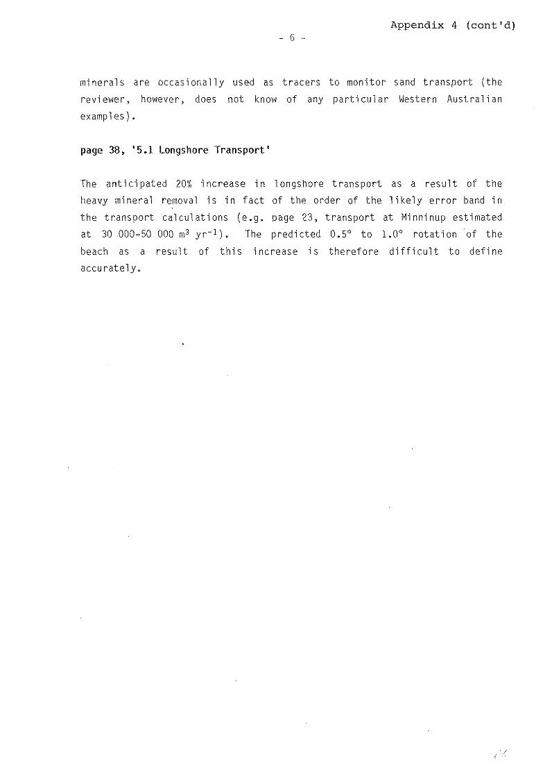
Appendix 4 (cont'd) - 6 -
minerals are occasionally used as tracers to monitor sand transport (the
re vi ewer, however, does not know of any particular Western Australian
examples).
page 38, '5.1 Longshore Transport'
The anticipated 20% increase in longshore transport as a result of the
heavy mineral removal is in fact of the order of the likely error band in
the transport calculations (e.g. page 23, transport at Minninup estimated
at 30 000-50 000 m3 yr-1). The predicted 0.5° to 1.0° rotation of the
beach as a result of this increase is therefore difficult to define
accurately.
- 7 -Appendix 4 (cont'd)
SUMMARY
The En vi ronmenta l Review and Management Programme prepared by West r'a l i an
Sands Limited has addressed the coastal engineering aspects of the proposed
project in a quite thorough and detailed manner. The reviewer agrees with
the conclusion of the ERMP that, 'The mining of mineral sand from the beach
at Minninup should not result in any long-term effects on the coastline of
Geographe Bay' (page 47, main volume), provided the envir·onmental
management initiatives outlined in Chapter 9 are implemented.
The general methodology and assumptions adopted by the coastal engineering
consultants are quite valid. However, the reviewer contends that a number
of issues were either inadequately addressed or may have warranted further
investigation. These include:
the origin of, and modern sedimentation controls on, the heavy mineral
beach deposit
quantification of the volume of material to be removed from the dune
system and details of consequent modi fi cations to the reconstructed
rear dune region
verification of the predicted nearshore wave climate, particularly
along the Minninup shoreline, in relation to the observed and
predicted longshore sediment transport rates, the assumed stable beach
profile at Mi nni nup, and the effect of 1 ocally generated seas as
opposed to longer period prevailing swell, on the transport rate.
the prediction of increased longshore transport as a result of the
removal of the heavy mineral component from the beach deposit at
Minninup. The estimate of this increased transport, and the
subsequent rotation of the beach by 0.5° to 1.0°, cannot be verified
without further detailed investigation.
In general, the coasta-l engineering consultants conclusions are valid yet,
in some specific instances, difficult to verify. However, the reviewer
believes these conclusions are realistically conservative and will not lead
to any long-term degradation of the Geographe Bay shoreline.

Appendix 4 (cont'd) - 8 -
REFERENCES
Baxter, J.L. (1977) Heavy Mineral Sand Deposits of \•estern Australia.
West. Aust. Geol. Surv. Min. Res. Bulletin No.10.
Bijker, E.W. (1971) Longshore Transport Computations. Proc. I\ SCE J.
Waterways, Harbors and Coastal Engineering, WW4.
Westralian Sand Limited (1988) Minninup Sand Mining Proposal, ERMP,
prepared by Dames and Moo re Pty Ltd.

J;'7:l ~
STATE FOREST RURAL
SPECIAL RURAL SPECIAL RESIDENTIAL
• gJ URBAN RESIDENTIAL o' «:I CAPEL TOWNSHIP
0/ o:, -t--1- RAILWAY
- HIGHWAY, MAJOR ROAD
SECONDARY ROAD
VEHICULAR TRACK
LAKE
~ STREAM
SWAMP
LAND SUBJECT TO INUNDATION
0 2 3 4 5km
INDIAN
OCEAN
. . . . . . ...... . . . " .. ' ....... ' ...... . . . . . . . .
. . . . . . . . . . . . . . . . . . . . . . . . . . . . . . . . . . . . . . . . . . . . . . . . . . . . . . . ' ......... . . . . . . . . .
J/ I
J)! (\/ ~~lJ
PROPOSED BEACH MINING AREA
l
l r )

D RURAL STATE FOREST
i77:l SPECIAL [2;21 RURAL
f,'7:l ~ ~ llll!!!ll URBAN RESIDENTIAL Q/
'<:~ 0/
Q:;l ~SPECIAL ll:QQl! RESIDENTIAL ~ CAPEL TOWNSHIP
+--+- RAILWAY
0
INDIAN
HIGHWAY, MAJOR ROAD
SECONDARY ROAD
VEHICULAR TRACK
LAKE
STREAM
SWAMP
LAND SUBJECT TO INUNDATION
2 3 4 Skm
OCEAN
....... . . . . . . . . . . . . . . . . . . . . . . . . . . . . . . . . . . . . . . . . . . . . . . . . . . . . . . . . . . . . . . . . . . . . . . . . . . . . . . . . . . . . . . . . . .
J I I
.,I J.J!
(\j (~!,
PROPOSED BEACH MINING AREA
1