ministry of agriculture & forestry - world bank · ministry of agriculture & forestry ......
TRANSCRIPT

E4220v2
Republic of South Sudan Ministry of Agriculture & Forestry
EMERGENCY FOOD CRISIS RESPONSE
PROJECT
ENVIRONMENTAL AND SOCIAL
ASSESSMENT REPORT
Pub
lic D
iscl
osur
e A
utho
rized
Pub
lic D
iscl
osur
e A
utho
rized
Pub
lic D
iscl
osur
e A
utho
rized
Pub
lic D
iscl
osur
e A
utho
rized
Pub
lic D
iscl
osur
e A
utho
rized
Pub
lic D
iscl
osur
e A
utho
rized
Pub
lic D
iscl
osur
e A
utho
rized
Pub
lic D
iscl
osur
e A
utho
rized
ii
May 2013
Contents
LIST OF ACRONYMS AND ABBREVIATIONS III
EXECUTIVE SUMMARY 1
ACKNOWLEDGEMENTS 4
1. BACKGROUND INFORMATION ON THE PROJECT AND THE STUDY 5
2. AN OVERVIEW OF THE AGRICULTURE SECTOR IN SOUTH SUDAN 14
3. REVIEW OF THE RELEVANT POLICIES, LAWS AND REGULATIONS 19
4. DESCRIPTION OF THE PROJECT ACTIVITIES AND IMPLEMENTATION APPROACH 26
6. PUBLIC CONSULTATIONS AND DISCLOSURE 48
7. PEST MANAGEMENT 52
8. ENVIRONMENTAL AND SOCIAL ISSUES, IMPACTS AND MITIGATION 55
9. ENVIRONMENT AND SOCIAL MANAGEMENT AND MONITORING PLAN 60
10. SUMMARY OF THE STUDY 66
11. REFERENCES 69

iii
LIST OF ACRONYMS AND ABBREVIATIONS
AAHI Action Africa Help International
CES Central Equatoria State
CPA Comprehensive Peace Agreement
EA Environmental Assessment
EFCRP Emergency Food Crisis and Response Project
ESA Environmental and Social Assessment
ESAF Environment and Social Assessment Framework
ESIA Environmental and Social Impact Assessment
ESMF Environment and Social Management Framework
ESMP Environment and Social Management Plan
FAO Food and Agriculture Organization
GDP Gross Domestic Product
GFRP Global Food Crisis Response Program
GNI Gross National Income
GoSS Government of Southern Sudan
IPM Integrated Pest Management
IPMF Integrated Pest Management Framework
IPMP Integrated Peoples Management Plan
IPPF Indigenous People Planning Framework
MAF Ministry of Agriculture and Forestry
MDTF Multi-Donor Trust Fund
MDTF-S The Multi-Donor Trust Funds for Southern Sudan
NGOs Non-Governmental Organizations
NPA Norwegian People’s Aid
OP Operation Policy
PDO Project Development Objective
PIU Project Implementation Unit
PMP Pest Management Plan
PTC Project Technical Committee
RSS Republic of South Sudan
SS South Sudan
TOR Terms of Reference
UN United Nations
UNDP United Nations Development Program
WFP World Food Program

1
EXECUTIVE SUMMARY
The Ministry of Agriculture is implementing the Emergency Food Crisis and Response
Project (EFCRP). The project is currently being implemented in six counties. These
include Morobo (Central Equatoria State), Yambio (Western Equatoria State), Tonj North
(Warrap State), Leer (Unity State), Panyikang (Upper Nile State) and Raga (Western
Bahr el Ghazal State). The implementation of the project is done through international
NGOs and these include Norwegian Peoples Aid (NPA) in Leer and Panyikang counties;
ACTED in Raga county; World Vision in Tonj North county and; AAH-I in Morobo and
Yambio counties. The project supports three broad activities, namely, agricultural
productivity (i.e. provision of improved inputs for field crops, vegetable production, large
scale cultivation and technology transfer), support to community safety nets (i.e. storage
facilities, granaries, markets and road rehabilitation) and project management. The
project activities are bound to have environmental and social impacts in varying
magnitude and extent in the areas of operation.
Thus, this Environmental and Social Assessment (ESA) has been carried out to evaluate
the environment and social impacts arising from the project activities and recommend
mitigation measures to the adverse negative impacts. The ESA also contains an
Environmental and Social Management Plan (ESMP) to ensure that project activities
implementation is done in an environmentally sustainable manner.
The EFCRP falls under prescribed list of projects (Category B) under the World Bank's
Operational Policy - Environmental Assessment (OP 4.01); Natural Habitats (OP 4.04);
Pest Management (OP 4.09), Indigenous Peoples (OP 4.10,); Forests (OP 4.36) and
Involuntary Resettlement (OP 4.12).
The aim of the assessment is to highlight potential environmental and social impacts of
the EFCRP activities, and to establish an environmental and social management plan for
mitigating the negative impacts.
Key specific objectives for the assessment were:
a) To describe, in general, the baseline conditions of the project areas
b) To review environmental policies and procedures of the Government of South Sudan
and relevant World Bank Operational Policies, triggered by the project activities, for
consideration in the planning and implementation of the project activities.
c) To determine the environmental and social impacts of the project activities.
d) To develop an environmental and social management plan with recommended
mitigation measures and strategies for addressing negative impacts in the course of
project implementation and operation.

2
In order to achieve the above objectives, the following methods and investigative tools
were used:
a) Project sites visits and investigations were carried out between January and April
2012. The field surveys enabled the team to identify the environmental setting of the
project sites and to ascertain some of the existing physical conditions. In addition, the
site visits allowed the team to discuss with local communities and beneficiary farmer
groups as well as Agricultural extension workers and field staff of the implementing
NGOs on their views and understanding of the project goals and activities, as well the
potential environmental and social impacts of the project activities.
b) A series of stakeholder consultations were conducted throughout the study period and
the drafting process of the report. Some of the consultations were round table
discussions and focus group discussions with key stakeholders including senior
officials in the Ministry of Agriculture and Forestry. Stakeholder consultations and
the rural appraisal process provided a unique opportunity to interact and share
experiences with the extension workers, the farmer groups and the local communities
who were directly involved and affected in the implementation of the project
activities.
c) Questionnaires seeking socio-economic information of local communities in the
project areas were administered in selected implementing counties. The aim was to
obtain opinions on the key potential environmental and social impacts and to get
additional views on appropriate mitigation measures for the negative impacts
including details on the socio-economic setting of the local communities in the
project areas.
d) Some information presented in this report was obtained from available published and
unpublished documents. Examples of this information include data on rainfall, flora
and fauna, population statistics, socio-economic data, altitude and hydrology regimes
of the area; agricultural sector overview and the maps used in the report.
The study has identified and analyzed several negative and positive impacts of the project
activities. The positive impacts include; improved food security and poverty reduction for
the local community, creation of jobs through the community safety nets program to
enable communities buy food and; income generating activities in the trade for
agricultural inputs and produce and; enhanced economic activities for the project impact
areas. Other positive impacts also include improved agricultural practices and utilization
of farm inputs albeit at varying magnitude and extent.
The negative impacts include loss of natural vegetation and habitats, loss of biodiversity,
pollution of the soil and water sources through agricultural chemicals and pesticides

3
although on a very small scale currently. Other negative impacts include deforestation,
and loss of globally threatened species including Khaya senegalensis, Milicia excelsa and
Vitallaria paradoxa partially due to farming activities. However, it should be noted that
some of the negative impacts cannot entirely be attributed to project activities because
they would have occurred, whether the project activities took place or not. These include
cutting trees for firewood, timber and charcoal burning some of which are globally
threatened plant species.
The study has identified and recommended a number of mitigation measures with which
to address the negative impacts and enhance the positive effects of the project. Some of
the recommended strategies include the following:
a) Enhancing agricultural productivity through improved agricultural practices and
technologies and discouraging opening up of new areas as a way of improving
productivity. This will contribute to natural resources conservation, sensitive natural
habitats protection and encourage sustainable use.
b) Controlled and careful use of pesticides and agrochemicals on the household gardens
to prevent abuse while achieving the intended result.
c) Use of code of best practice for the project activities to ensure environmental
protection while encouraging sustainable utilisation of natural resources especially
arable land
d) Training of the farmers and extension workers in the project areas of operation to
improve efficiency in the areas of environmental management in relation to
agricultural activities.

4
ACKNOWLEDGEMENTS
We would like to thank the Ministry of Agriculture and Forestry (MAF) for the assistance
offered during this assessment. Special thanks go to the Project Focal Person and other
members of the Project Implementation Unit (PIU) for their support and assistance during
the study.
We also recognize the invaluable contribution of implementing agencies, county and
State authorities their assistance in facilitating community consultations and field visits.
Views and opinions obtained from all the consulted persons both the MAF Juba and the
States are all highly appreciated.
Technical input from the Project Implementation Unit and the World Bank (WB) were
also very useful in the study and much appreciated. Special thanks to Mr. Luka Kiwanuka
for his invaluable support in organizing meetings and travel to all the project sites visited.

5
1. BACKGROUND INFORMATION ON THE PROJECT AND THE STUDY
1.0 Introduction
This document is an Environmental and Social Assessment (ESA) report for the
Emergency Food Crisis and Response Project (EFCRP) under the Ministry of Agriculture
and Forestry, Government of the Republic of South Sudan (RSS). The project is being
implemented in six counties. These include Morobo (Central Equatoria State), Yambio
(Western Equatoria State), Tonj North (Warrap State), Leer (Unity State), Panyikang
(Upper Nile State) and Raga (Western Bahr el Ghazal State). The implementation of the
project is done through international NGOs and these include Norwegian Peoples Aid
(NPA) in Leer and Panyikang counties; ACTED in Raga county; World Vision in Tonj
North county and; AAH-I in Morobo and Yambio counties. The locations of the different
States with these counties are found in Figure 1.1. The EFRCP is a US$7.2 million
project funded by the Global Food Price Response Trust Fund (GFPR) of the World
Bank. The project supports three broad activities, namely, agricultural productivity,
support to safety nets and project management.
Figure 1.1: Map showing EFCRP States in South Sudan

6
1.2 Nature of the Project
The EFCRP is integrated in nature and has three main components which are:
(i) Support to increased agricultural production
(ii) Strengthening community safety nets and,
(iii) Support to project implementation
This report mainly focuses on the support to increased agricultural production
component. This component aims at reducing vulnerability to food price escalation
through increased production and improved post-harvest handling of key staples
including maize. The component also provides inputs and tools to farmers working as
cooperatives and/or groups so that they can expand their area farmed. The component
provides grants for construction of low-cost food stores and granaries at the household
and community levels.
1.3 Objective of the project
The Project objective is to support adoption of improved technologies for food
production by eligible beneficiaries, increase storage capacity for staples, and provide
cash or food to eligible people participating in public works programs in six counties in
South Sudan. EFCRP support includes: (i) provision of inputs and technology packages;
(ii) bringing presently idle land back into production; (iii) training on reduction of post-
harvest losses; (iv) construction of food storage capacity at the household and community
levels; and (iv) provision of cash or food for work to eligible individuals.
1.4 Project Implementing Agency
The proponent of the EFCRP is the Government of Republic of South Sudan (RSS), and
the project-implementing agency is the Ministry of Agriculture and Forestry (MAF).
Contact details of the Ministry are as follows:
Official Address: The Under Secretary,
Ministry of Agriculture and Forestry, Government of Republic of South Sudan,
Physical Address: Ministries Complex, Juba
Contact Person: Dr. George Leju - The Project Focal Person/Director General for
Research, Training and Extension Services, Ministry of Agriculture and Forestry.
1.5 Project Rationale
Six years after the signing the Comprehensive Peace Agreement (CPA) and now coming
close to one year after attaining independence, South Sudan is still poor (poverty
estimated at 60.6%) and vulnerable to shocks. Food insecurity is pervasive in most of the
States having deficits in cereals.

7
The food deficit in South Sudan is at present structural; primarily stemming from a
conjunction of: (i) low agricultural productivity; (ii) poor state of infrastructure; (iii) the
lost productivity ensuing from incessant conflict; (iv) inadequate provision of agricultural
services; (v) weak institutions and lack of policies and regulations; (vi) inadequately
skilled human resources; (vii) irrational use of natural resources; and (viii) absence of an
appropriate land tenure system and limited implementation of the land law.
Much of the food deficit is covered by food aid contributed by donors or purchased by
the Government. Despite the high level of food aid, sufficient commercial trade exists to
make domestic prices sensitive to movements on regional markets. Most commercially
imported food is sourced in Uganda. Prices are very high due to transport costs, and spike
higher when regional shortages appear. Most of Southern Sudan is still food insecure
with the areas along the border with the North hardest hit.
A combination of a persistent and chronic gap between production and consumption
needs, high global and regional food prices, low purchasing power, and uncertainty in
trade flows due to the tension between Sudan and South Sudan since attainment of
independence by South Sudan has prolonged the conditions that required the original
intervention under the Global Food Crisis Response Program. As a consequence a
number of war returnees remain at risk long after cessation of hostilities and new waves
of internal migrants returning from the North after independence require assistance.
Those with assets in the form of livestock or equipment are forced to sell to meet
immediate needs, thus putting future income streams at risk. Latent conflicts over access
to land and water are more likely to flare into open fighting and this is already happening
in Unity, Jonglei and Upper Nile States. The increased numbers of needy exert significant
fiscal pressure on government’s resources.
In light of the background outlined above, three issues emerge for justification of the
EFCRP:
1. The persistent negative impacts of high food prices and exacerbation due to events
surrounding the referendum and independence. In accordance with OP/BP 13.20
resources are sought to scale-up investments under the ongoing project, with a dual focus
on increased food security and improved storage of staples.
2. The Government’s fiscal position now is in a more precarious situation now after the
shutting down of the oil wells which contribute over 97% of the country’s revenue. This
has narrowed fiscal space and deflated the modest financial cushion leading to the start of
implementation of austerity measures by the Government. The additional fiscal demands
of the establishment of a new state provide a rationale for continued emergency
8
assistance for food security, even though the amounts of the present additional financing
are very modest.
3. The proposed additional financing responds to the Government’s request and will be
used to: (i) scale-up the provision of input and technology packages to farmers; (ii) help
farmers bring idle land into production; (iii) train farmers on mitigation of post-harvest
losses; (iv) construct markets and food storage facilities (both on-farm and off-farm); and
(v) provide cash or food to vulnerable people through their participation in construction
of public works. The additional resources will mostly target four (i.e. Morobo, Yambio,
Leer and Panyikang) of the initial six counties, to strengthen progress made by the
implementing NGOs. Proposed additional counties include Pochalla, Maban and Tali –
Terekeka with a focus on safety nets.
1.6 Purpose of the Environmental and Social Impact Assessment
1.6.1 Justification for Preparation of the Environmental and Social Assessment Report
The need to undertake an environmental and social assessment for the project emanates
from the following observations, among others:
The Transitional Constitution of the Republic of South Sudan of 2011 incorporates
numerous provisions that have a bearing on the environment. Article 41 (1) provides that
the people of South Sudan shall have a right to a clean and health environment (2) every
person shall have the obligation to protect the environment for the benefit of present and
future generations (3) Every person shall have the right to have the environment
protected for the benefit of present and future generations, through reasonable legislative
action and other measures that:
a) prevent pollution and ecological degradation;
b) promote conservation; and
c) secure ecologically sustainable development and use of natural resources while
promoting rational economic and social development so as to protect the bio-
diversity of Southern Sudan.
Furthermore, Article 166 (6) expects local governments involve communities in decision
making in the promotion of a safe and healthy environment.
The basis is that the project constitutes several components of activities, which could
have generated considerable changes and significant effects to the environment including
land, water and biological diversity. Thus, the ESA is designed to evaluate the
environment and social situation arising from the project activities and recommend

9
mitigation measures to the adverse negative impacts. The ESA will also contain an EMP
to ensure that project activities implementation is done in an environmentally sustainable
manner.
The EFCRP falls under prescribed list of projects (category B) under the World Bank's
Operational Policy (OP4.01 -Environmental Assessment); under the World Bank’s
Operational Policy (OP 4.04, Natural Habitats); under the World Bank's Operational
Policy (OP4.09, Pest Management), under the World Bank’s Operational Policy (OP
4.10, Indigenous Peoples); the World Bank Operational Policy (OP 4.36, Forests); and
under the World Bank's Operational Policy (OP4.12 Involuntary Resettlement). Project
environmental and social impact assessments are required in such circumstances, to put
in place policy and operational frameworks to ensure mitigation of potential
environmental and social impacts during the planning stage, thereby avoiding long-term
negative environmental and social impacts.
1.6.2 Aim and Objectives of the Environmental and Social Assessment
The aim of the assessment is to highlight potential environmental and social impacts of
the EFCRP activities, and to establish an environmental management plan for mitigating
the negative impacts.
Key specific objectives for the assessment are:
(i) To describe, in general, the baseline conditions of the project areas
(ii) To outline the objectives of the project activities.
(iii)To review environmental policies and procedures of the Government of South
Sudan and relevant World Bank Operational Policies, triggered by the project
activities, for consideration in the planning and implementation of the project
activities.
(iv) To determine the environmental and social impacts of the project activities.
(v) To develop an environmental management plan with recommended mitigation
measures and strategies for addressing negative impacts in the course of project
implementation and operation.
1.6.3 Target Group for the Environmental Impact Assessment Report
This environmental and social impact assessment report has been prepared for use by
different stakeholders to be involved in the implementation of the project. The report
contains useful information on policies and procedures to be adhered to, implementation
modalities, analysis of potential environmental and social impacts and suggested
mitigation measures at various stages of the project activities. Such information will be
useful in planning, implementation, and management of the project. In this regard, the
report will be useful to the following stakeholders:

10
Funding agencies and donors for the EFCRP
MAF and the PIU of the project
Implementing NGOs
The communities in the different counties involved in the project
1.7 Approaches to the preparation of the Environmental and Social Assessment Report
The focus of the assignment is to identify environmental and social impacts of the
EFCRP activities and to develop a management plan for addressing potential negative
impacts. In order to achieve these targets, the basic tenet of the strategy involved
consultations with the various stakeholders as outlined in the sections below. The
rationale of these extensive consultations was to take on board, views from a cross
section of people, at least from local level (Boma & Payam), County, State level, and
Central government level.
The strategies for executing this assignment followed the steps outlined below:
a) Assessing the biophysical setting in the project sites.
b) Review of typical implementation approach and processes for the EFCRP
activities.
c) Identification and analysis of potential environmental and social impacts the
implementation processes will likely trigger and generate within and around the
project sites
d) Identification of appropriate mitigation measures for the impacts and preparation
of a management plan for addressing environmental and social impacts during
implementation and operations of the project.
1.8 Information gathering for the Environmental and Social Impact Assessment
The information for this study has been collected through a number of research methods
which include field surveys and investigations, stakeholder consultations, review of
related literature from published and unpublished documents and professional judgment.
1.8.1 Field surveys of the Schemes
Site visits and investigations and field surveys to the project sites between January and
April 2012. The field surveys enabled the team to identify the environmental setting of
the project sites and to identify some of the existing physical conditions. In addition, the
site visits allowed the team to discuss with local communities and beneficiary farmer
groups as well as Agricultural Extension Workers and field staff of the implementing

11
NGOs on their views and understanding of the project goals and activities, as well the
potential impacts of the project activities.
1.8.2 Stakeholder consultations
A series of stakeholder consultations were conducted throughout the study period and the
drafting process of the report. Some of the consultations were round table discussions and
focus group discussions with key stakeholders such as senior officials in the Ministry of
Agriculture and Forestry. A list of all people who were consulted has been provided in
Appendix 1. Stakeholder consultations and the rural appraisal process provided a unique
opportunity to interact and share experiences with the extension workers, the farmer
groups and the local communities who will be directly involved and affected in the
implementation of the project activities.
1.8.3 Questionnaire
Questionnaires seeking socio-economic information of local communities in the project
areas were administered in every implementing county (Appendix 3). These were
administered during the site surveys to the selected counties. The aim was to obtain
opinion on the key potential environmental and social impacts and to get additional views
on appropriate mitigation measures for the negative impacts including details on the
socio-economic setting of the local communities in the project areas.
1.8.4 Literature Review
Some information presented in this report was obtained from available published and
unpublished documents. Examples of this information include data on rainfall, flora and
fauna, population statistics, socio-economic data, altitude and hydrology regimes of the
area; rainfall figures and the maps used in the report. All the documents used are duly
acknowledged in Section 12 of this report.
1.9 Constraints and limitations to the study
The information presented in this report is consistent with the data and information
gathered through the various sources and approaches outlined above. However, just as in
any studies, the exercise experienced a number of constraints and as a result, there could
be some gaps of information in the report as the consultant could not exhaust the
collection of all primary data.
One constraint was that some institutions and people (who are ideally key stakeholders to
the project) understood the purpose of the environmental and social assessment
differently due to lack of awareness of the overall objective of the project. In view of this
the team devoted some considerable time in awareness discussions, including question
and answer sessions, prior to settling down to real issues of consultation.

12
Secondly, the consultants experienced significant difficulties in receiving the responses to
the questionnaires distributed to stakeholders partly because of the relatively short time
for the exercise. Thirdly, the consultants could not interview and discuss with all
stakeholders such as extension workers, Boma, Payam and State officials, let alone
visiting some project sites due to time limitations. As such, while the findings and issues
advanced in this report reflect the general views and opinions of some selected people,
they may not cover the specific issues from some unique situations or some individuals
affected by the project.
Lastly, but not least, some of the information in the report was processed from secondary
sources and such data include information for maps, land resources, water resources,
biological resources, socioeconomic data on poverty situation in South Sudan and data on
the role of agriculture to the economy of South Sudan. It is therefore necessary to
understand such information within these limitations.
1.10 Format of the Report
This report is organized in seven chapters. Chapter One provides background
information to the EFCRP including justification for the proposed project in South
Sudan, aims and objectives of the project, the major components of the project, project
areas, and estimated costs. In addition, the chapter outlines the scope of the
environmental and social impact assessment, and the approach and methodology in the
preparation of the report.
Chapter Two gives an overview of the Agriculture Sector in South Sudan whereas
Chapter Three provides an overview of the relevant policies and laws in place for
support and regulation of the EFCRP including the relevant World Bank environmental
and social safeguards. Chapter Four gives a description of the project activities and
implementation approach being used by the implementing agencies.
Chapter Five outlines the baseline environmental and social conditions in the project
sites whereas Chapter Six outlines the key findings during the consultative process.
Chapter Seven presents an overview of the pest management strategies and approaches
being used in South Sudan whereas Chapter Eight presents the process used in
identification and assessment of the environmental and social impacts of the EFCRP.
Chapter Nine outlines the environmental and social monitoring and management plan
for the impacts, for integration in the EFCRP activities. The plan includes responsible
authorities for collaboration in the implementation of the mitigation measures. The
chapter includes recommendations of alterative options in the implementation of some
13
project activities in order to address some impacts. It also includes the plan for
monitoring the implementation of the environmental management activities.
Chapter Ten outlines the summary of the ESA study for the EFCRP.
Chapter Eleven provides the conclusions and main recommendations for consideration
in the implementation of the project activities.

14
2. AN OVERVIEW OF THE AGRICULTURE SECTOR IN SOUTH SUDAN
2.1 Background
Southern Sudan covers an area of about 640,000 square kilometres and includes stretches
of tropical and equatorial forests, wetlands (including the Sudd swamps), savannah and
mountains. The high agriculture potential Greenbelt is in the southern states of Western
Equatoria, Central Equatoria, and Eastern Equatoria. South Sudan is entirely within the
Nile River basin and shares borders with five countries (Ethiopia, Kenya, Uganda,
Central African Republic, and Democratic Republic of the Congo). South Sudan is
culturally, geographically and religiously diverse and well endowed with natural
resources, including water, wildlife, forest, oil and minerals. However, since the
independence of Sudan in 1956, South Sudan has been a battleground for two civil wars
(1955-1972, 1983-2005) that resulted in egregious suffering, loss of life and
opportunities, widespread poverty, greatly diminished capacity and food insecurity.
The level of poverty is extremely high and South Sudan consistently ranks among the
lowest countries in the world in terms of most standard development indicators.
Economic livelihoods are largely dependent upon subsistence farming and pastoralism.
Public services are weak, leaving people in rural areas isolated in terms of access to basic
services.
The overall situation in South Sudan is characterized by a fragile peace, an almost
complete lack of infrastructure and basic services, a depressed economy, and nascent
governance and rule of law structures with significant and urgent capacity-building
needs. Translating the Comprehensive Peace Agreement (CPA) into actions and
programs that will facilitate sustainable post-conflict recovery, governance and delivery
of services is and will be an immense challenge to the Republic of South Sudan and its
development partners. Conditions are improving as RSS and donors move ahead to
implement a range of programs to address these challenges.
A USAID Assessment of its Economic Growth portfolio in September 2007 noted the
major constraints in South Sudan to be:
Uncertainty about peace or a resumption of war
Limited government capacity, weak business environment and rampant corruption
Minimal infrastructure (e.g., roads, water, electricity, ICT)
Weak markets and non-existent market information systems
Informal regional and internal trade linkages
Unclear land tenure and demarcation

15
Weak or non-existent capacity to provide services to develop agriculture and off-
farm opportunities (e.g., extension services, agricultural research)
High level of food insecurity
Many returnees with few or no assets
Agriculture in South Sudan constitutes about one-third of Gross Domestic Product (down
from 42% in 2000). Currently approximately 98% of government revenues come from
oil, over half of which is paid for government salaries, leaving few resources for
development activities, particularly at the state, county, payam and boma levels. Profit
margins for farmers are particularly squeezed by the appreciation of the Sudanese pound,
in addition to the adverse effects of supply-side bottlenecks. Given that the agricultural
sector employs 67% of the population, mainly in the form of small-scale subsistence
farmers, the declining competitiveness of the sector is a major concern for prospects for
sustainable growth.
A quick review of markets in major urban centres indicates that most agricultural
commodities come from Uganda and, to a lesser extent, Kenya and the Democratic
Republic of Congo (DRC). This has created a situation where trade flows are one way –
into South Sudan. The high prices (and high demand) in South Sudan for agricultural
commodities have resulted in price increases in Kampala. In order for South Sudan to be
competitive in the region, significant improvements have to be made in increasing
productivity, reducing post-harvest losses and reducing transaction costs, particularly
transport.
2.2 Agricultural systems in South Sudan
Cultivated area in South Sudan has historically ranged between a minimum of one
percent and a maximum of two percent of the total area (i.e. 650,000 – 1,300,000 ha).
According to FAO-WFP (Crop and Food Supply Assessment Mission for Southern
Sudan-CFSAM 2009), about 1 million ha were put under cultivation in 2008, and
increase from 2007 levels likely due to increasing numbers of returnees. Harvest of the
“traditional” (non-irrigated) sector for 2008 was estimated to be 1.25 million tons of
cereal crops. Sorghum is the main cereal, followed by millet and maize, with an average
yield of 1.01 tons/ha (but ranging from 0.75 tons/ha in Bahr el Ghazal to 1.5 tons/ha in
Yambio). These figures are for the traditional (non-irrigated) sector. Average yields for
Africa range from 1.04 to 1.14 tons/ha.
The 2009 CFSAM report provided a theoretical surplus of 47,000 tons, but quickly noted
that “the surplus is in reality a theoretical construct as the current road infrastructure and
marketing network preclude meaningful movement of grains from the myriad of small
hand-cultivated, household farms in surplus areas in the south to most of the deficits

16
areas located mainly in the north.” There is some grain that is held at the homestead,
mostly the less perishable crops.
Agricultural potential in South Sudan is high with about 90% of its total area considered
suitable for agriculture, 50% of which is prime agricultural land. Soil and climate
conditions allow for a wide variety of food and cash crops. South Sudan’s agricultural
production is principally based on small, hand-cultivated household units belonging to
larger family aggregations. Regarding cereals, in most small-holder systems farmers
grow a wide range of sorghum landraces, with minor crops of maize, bulrush millet,
finger millet and upland rice according to location. Other crops grown include
groundnuts, which make a significant contribution to the household food security
replacing sorghum as the main staple in poorer sorghum-growing years when the rains
begin later than usual; and providing a regular staple and cash crop in the higher localities
with sandier soils. Cowpeas, beans, sesame, pumpkins and tobacco add to the
biodiversity of the northern farming areas of South Sudan.
Crop production cultivation is almost exclusively by manual means with rudimentary
basic tools and the area of land cultivated, which is also related to average allocated land
ranging from 1 to 4 feddans (0.4 to 1.7 hectares), is determined by family labour
availability (principally women); and by the minimum acreage required for assurance of
basic household food supply. Cropping areas are typically cultivated under a shifting
regime for two to three years or until yields prove to be in considerable decline, at which
stage the land is fallowed and a new arable area is cleared, the vegetation burnt and
cultivation commenced. In some cases, the move to new land involves the movement also
of the family home; in others, a permanent home location is maintained and only the
cropping plots rotated.
The standard practice is for crops to be grown in mixed and/or sequential plantings. The
main cereal crops, sorghum and millet, are usually grown with sesame; and root crops,
principally cassava, is often inter-planted with groundnuts, maize and pumpkins or other
vegetables. The inter-crops may be planted to coincide with weeding of the main crops,
or following on from an early harvest. Mixed cropping has advantages of complementary
growth between crops, spreading or mitigation of risks, including those of weather and
pests and diseases, labour saving and better ground cover, hence soil conservation.
However, it can also entail considerable competition and less than optimal plant spacing,
which can reduce yields and overall productivity.
2.3 Agricultural Contribution to Household Food Requirements
In the south and central areas, although groundnuts and the other crops are also grown in
quantity, cassava is the most important contributor to the household food economy
providing at least half of the carbohydrate ration. Minor crops of sweet potatoes, yams,

17
coffee, mangoes, and Paw paw are also grown for home and some localized commercial
use. In average figures, Southern Sudan has produced about 90% of its cereal needs
(CFSAM, 2007), which range from 60 to 120 kg per capita per annum, varying according
to the availability and access to animal products, cassava, groundnuts and wild foods.
According to respondents in the WFP-FAO-MAF (2006) assessment, households
obtained most of their food from: own production (53%); markets (32); barter (5%); gifts
(4%); and borrowing (3%). Food aid as a source of food contributes less than 1%. Labour
exchange and hunting/fishing/collecting wild foods contribute 1% each. As the economy
improves and more employment opportunities are created, labour exchange will be
replaced by wage labour and trading in barter will be replaced by money transactions.
2.4 Rural Incomes
Sources of household income in South Sudan are not highly diversified as most income is
from farm related activities. However, within the farm sector itself, the income sources
are diverse. High diversity of income sources implies reduced exposure to risk. (WFP-
FAO-MAF 2006). In terms of household expenditures, households spent approximately
22% of their incomes on staple and non-staple food purchases. High dependency on
staple food purchase carries high risk of market shocks especially for the poor
households. Social events, shelter and household assets take 15% each of the
expenditures. Roughly 13% was spent on clothing. The remaining 20% was spent on
social services like health (11%) and education (9%).
2.5 Challenges Facing Agricultural Development
According to an IFAD agricultural project design document, the major constraints to
development of the agricultural sector are:
reliance on outdated and low performing planting material and seed based on
local cultivars or landraces of the principal crops, most of which have degenerated
and for which there has been no opportunity in recent years for improvement;
the rudimentary tools and methods of agricultural work and the virtual absence of
improved production techniques; both hampering increase of cultivated area and
crop intensification;
the prevalence of pests and diseases and the scarcity of the inputs and technical
information to manage them;
climatic adversity (droughts and floods, or sometimes lack of the natural flooding
of a river plain);
weakness or almost total absence of agricultural support services and
communications infrastructure to facilitate their provision;
lack of capacity and training of public service providers, and of fishers, livestock
keepers and farmers;

18
an increasing competing demand for resources (land for farming and grazing and,
water for domestic purposes, irrigation and cattle);
the lack of marketing system and adequate markets, so that commercialization of
farm produce is negligible and the whole rural economy is neither market-
oriented, nor even monetized; and lack of marketing facilities and poor
infrastructure in the livestock (health services, holding grounds, slaughter slabs,
hygiene facilities) and fisheries (including landing points) sector; transport
facilities; appropriate processing technologies (crop and fisheries);
The results of conflict and insecurity in the disruption or destruction of people’s
way of life and means of livelihood.

19
3. REVIEW OF THE RELEVANT POLICIES, LAWS AND REGULATIONS
3.1 South Sudan’s Environmental Regulations
Since attainment of Independence in July 2011, the Government of the Republic of South
Sudan has adopted a new Republican Constitution, and a number of new policies and
legislation, others still being drafted, with the ultimate aim of enhancing sustainable
socio-economic development in the country. The policies and laws provide procedures to
be followed in the planning and implementation of government activities in order to
utilize resources and execute government programs to maximum benefit.
The following sections highlight some selected policies and laws, which are applicable in
the planning and implementation of public sector projects, more especially those projects
in the agricultural and forestry sector.
3.2 National Policies
3.2.1 Environment Policy of South Sudan, 2010 (Draft)
The policy provides a wide range of guidance in response to emerging environmental
management challenges to enable decision makers and resource users make development
choices that are economically efficient, socially equitable and environmentally friendly to
ensure realization of sustainable development.
The goal of the South Sudan National Environment Policy is to ensure protection and
conservation of the environment and sustainable management of renewable natural
resources in order to meet the needs of its present population and future generations.
The objectives of the RSS environmental policy seek to:
Improve livelihoods of South Sudanese through sustainable management of the
environment and utilization of natural resources;
Build capacity of the government at all levels of governance and other
stakeholders for better management of the environment;
Integrate environmental considerations into the development policies, plans, and
programs at the community, government and private sector levels;
Promote effective, widespread, and public participation in the conservation and
management of the environment.
This policy is important to the EFCRP activities because it provides general guidelines
and principles to be followed in environmental management during the operations of the
project. Some of the specific areas of its relevance include waste management, protection
20
of aquatic and other sensitive habitats against both encroachment and pollution and
encouraging sustainable harvesting regimes.
3.3 National legislation and regulations
3.3.1 The Transitional Constitution of 2011
The Transitional Constitution of the Republic of South Sudan of 2011 incorporates
numerous provisions that have a bearing on the environment. Article 41 (1) provides that
the people of South Sudan shall have a right to a clean and health environment (2) every
person shall have the obligation to protect the environment for the benefit of present and
future generations (3) Every person shall have the right to have the environment
protected for the benefit of present and future generations, through reasonable legislative
action and other measures that:
a) prevent pollution and ecological degradation;
b) promote conservation; and
c) secure ecologically sustainable development and use of natural resources while
promoting rational economic and social development so as to protect the bio-
diversity of South Sudan.
Furthermore, Article 166 (6) expects local governments involve communities in decision
making in the promotion of a safe and healthy environment.
3.3.2 The Environment Protection Bill, 2010 Cap 7 (Draft)
Section 32 of the Draft Environment Protection Bill, 2010 Cap 7 intends to introduce the
requirement for Environmental Audits. An Environmental Audit, according to this Bill, is
defined as the systematic, documented, periodic and objective evaluation of how well
Environmental organisation, management and equipment are performing in conserving
the Environment and its resources. The guiding principles for an Environmental Audit
include:
(1) The Owner of the Premises or the operator of a Project shall be
responsible for carrying out an Environmental Audit of all activities that
are likely to have a significant effect on the Environment, in consultation
with the Lead Agency.
(2) An Environmental Inspector may enter any land or Premises for the
purpose of determining how far the activities carried out on that land or
Premises conform to the statements made in the Environmental Impact
Assessment in respect of that land or Premises.
(3) The Owner of the Premises or the operator of a Project for which an
Environmental Impact statement has been made shall keep records and
make quarterly and annual reports to the Ministry describing how far the
21
project conforms in operation with the statements made in the
Environmental Impact statement.
(4) The Owner of Premises or the operator of a Project shall take all
reasonable measures to mitigate any undesirable effects not contemplated
in the Environmental Impact Statement and shall prepare and submit an
Environmental audit report on those measures to the Ministry quarterly
and annually or as the Authority may, in writing, may require.
3.3.3 Land Act, 2009
One of the key objectives of the Land Act is to promote a land management system to
protect and preserve the environment and ecology for the sustainable development of
South Sudan. It also provides for fair and prompt compensation to any person whose
right of occupancy, ownership or recognized long standing occupancy of customary use
of land is revoked or otherwise interfered with by the Government.
The Land Act reinforces government recognition of customary land tenure: ‘Customary
land rights including those held in common shall have equal force and effect in law with
freehold or leasehold rights.’ Community land can be allocated to investors as long as
investment activity ‘reflects an important interest for the community’ and ‘contributes
economically and socially to the development of the local community’. It also requires
that state authorities approve land acquisitions above 250 feddans (105 hectares) and
create a regulated ceiling on land allocations. The Land Act requires government to
consult local communities and consider their views in decisions about community land.
The Land Act also gives pastoralists special protection: ‘No person shall without
permission … carry out any activity on the communal grazing land which may prevent or
restrict the residents of the traditional communities concerned from exercising their
grazing rights’. Project proponents must also conduct environmental and social impact
assessments (ESIAs) before undertaking any activity that might affect people or the
environment.
3.4 An Overview of the World Bank Environmental requirements
The EFCRP triggered three of the World Bank's safeguard policies, namely, OP 4.01
Environmental Assessment, OP 4.09 Pest Management, under the World Bank’s
Operational Policy (OP 4.10, Indigenous Peoples); the World Bank Operational Policy
(OP 4.36, Forests); and under the World Bank's Operational Policy (OP4.12 Involuntary
Resettlement).
The World Bank's Environmental Assessment (EA) policy states quote "The EA, takes
into account the natural environment (air, water, and land); human health and safety;
social aspects (involuntary resettlement, indigenous peoples, and cultural property); and
transboundary and global environmental aspects. EA considers natural and social

22
aspects in an integrated way. It also takes into account the variations in project and
country conditions; the findings of country environmental studies; national
environmental action plans; the country's overall policy framework, national legislation,
and institutional capabilities related to the environment and social aspects; and
obligations of the country, pertaining to project activities, under relevant international
environmental treaties and agreements. "
Section 7 of the WB's Environmental Policy states "Depending on the project, a range of
instruments can be used to satisfy the Bank's EA requirement. Environmental impact
assessment (EIA), regional or sectoral EA, environmental audit, hazard or risk
assessment, and environmental management plan (EMP). EA applies one or more of
these instruments or elements of them, as appropriate. "
In terms of environmental screening, quote "a proposed project is classified as Category
A if it is likely to have significant adverse environmental impacts that are sensitive,
diverse, or unprecedented."
In view of the above, it is considered that the proposed EFCRP satisfies the definition of
a Category B project which is defined as quote "A proposed project is classified as
Category B if its potential adverse environmental impacts on human populations or
environmentally important areas-including wetlands, forests, grasslands, and other
natural habitats-are less adverse than those of Category A projects. These impacts are
site-specific; few if any of them are irreversible; and in most cases mitigatory measures
can be designed more readily than for Category A projects. The scope of EA for a
Category B project may vary from project to project, but it is narrower than that of
Category A EA. Like Category A EA, it examines the project's potential negative and
positive environmental impacts and recommends any measures needed to prevent,
minimize, mitigate, or compensate for adverse impacts and improve environmental
performance. "
The World Bank also requires a variable selection of follow up studies and reports
depending upon the perceived environmental issues, their scale and impacts. Such studies
can include an Environmental Impact Assessment, an Environmental Audit, a Hazard
Risk Assessment or an Environmental Management Plan. In this case the Bank has
required the preparation of an Environmental and Social Management Plan which is part
of this report and an Environmental and Social Management Framework (ESMF). The
latter is addressed in a separate report and will cover other agricultural projects and
activities in MAF.
The EMP must include:

23
(i) Mitigation;
(ii) Monitoring, and;
(iii)Institutional Measures
Particular attention is to be paid to:
(i) Globally threatened species, sensitive habitats and protected areas especially in
Yambio county and Morobo counties
(ii) Provision of an Integrated Pest Management Framework (IPMF)
The Environmental and social requirements of the World Bank are addressed in this
Environmental Assessment, and the Environmental Management Plan and the
Environmental and Social Management Framework. The following sections review these
applicable operational policies.
3.4.1 Environmental Assessment (Operational Policy, OP 4.01)
The objective of OP 4.01 is to ensure that Bank-financed projects are environmentally
sound and sustainable, and that decision-making is improved through appropriate
analysis of actions and of their likely environmental impacts. This policy is triggered if a
project is likely to have potentially adverse environmental risks and impacts in its area of
influence. Thus, the farming practices and construction of stores in various project sites
could have environmental impacts of varying magnitude and extent.
3.4.2 Pest Management (Operational Policy, OP 4.09)
The objective of OP 4.09 is to promote the use of biological or environmental control
methods and reduce reliance on synthetic chemicals and pesticides. In World Bank-
financed operations, pest populations are normally controlled through Integrated Pest
Management (IPM) approaches. In Bank-financed public health projects, the Bank
supports controlling pests primarily through environmental methods. The policy further
ensures that health and environmental hazards associated with pesticides are minimized.
3.4.3 Involuntary Resettlement (Operational Policy, OP 4.12)
The objective of OP 4.12 is to avoid or minimize involuntary resettlement, where feasible
by exploring all viable alternative project sites and designs. Furthermore, it assists
displaced persons in improving their former living standards. It encourages community
participation in planning and implementing resettlement and seeks to provide assistance
to the affected people, regardless of the legality of title of land. This policy is triggered
not only if physical relocation occurs, but also by any loss of land resulting in relocation
or loss of shelter; loss of assets or access to assets; loss of income sources or means of
livelihood, whether or not the affected people must move to another location. The World
Bank's safeguard policies are provided in Appendix IV.
24
3.4.4 Indigenous Peoples (Operational Policy, OP 4.10)
The World Bank policy on indigenous peoples, OP/BP 4.10, Indigenous Peoples,
underscores the need to identify indigenous peoples, consult with them, ensure that they
participate in, and benefit from Bank-funded operations in a culturally appropriate way -
and that adverse impacts on them are avoided, or where not feasible, minimized or
mitigated.
Indigenous Peoples as a term defines groups that are particularly vulnerable to
exploitation and oppression by nation states, and as a result a special set of political rights
in accordance with international law have been set forth by international organizations
such as the United Nations, the International Labour Organization and the World Bank.
Indigenous Peoples may be referred to in different countries by such terms as "indigenous
ethnic minorities," "hill tribes," "minority nationalities," "scheduled tribes," or "tribal
groups."
3.4.5 Forests (Operational Policy 4.36)
The Bank's current forests policy (Operational Policy/Bank Procedure 4.36) aims to
reduce deforestation, enhance the environmental contribution of forested areas, promote
afforestation, reduce poverty, and encourage economic development.
Combating deforestation and promoting sustainable forest conservation and management
have been high on the international agenda for two decades. However, little has been
achieved so far and the world's forests and forest dependent people continue to
experience unacceptably high rates of forest loss and degradation. The Bank is therefore
has finalised a revised approach to forestry issues, in recognition of the fact that forests
play an increasingly important role in poverty alleviation, economic development, and for
providing local as well as global environmental services.
The latest Forest Strategy suggests three equally important and interdependent pillars to
guide future Bank involvement with forests:
(i) Harnessing the potential of forests to reduce poverty,
(ii) Integrating forests in sustainable economic development, and
(iii) Protecting vital local and global environmental services and forest values.
EFCRP is supporting activities in areas that have tropical rainforests and are of high
conservation value especially in Yambio and woodlands in Morobo and Raga Counties.
3.4.6 Natural habitats (Operational Policy 4.04)
This policy seeks to ensure that World Bank-supported infrastructure and other
development projects take into account the conservation of biodiversity, as well as the
25
numerous environmental services and products which natural habitats provide to human
society. The policy strictly limits the circumstances under which any Bank-supported
project can damage natural habitats (land and water areas where most of the native plant
and animal species are still present).
Specifically, the policy prohibits Bank support for projects which would lead to the
significant loss or degradation of any Critical Natural Habitats, whose definition includes
those natural habitats which are either:
legally protected,
officially proposed for protection, or
unprotected but of known high conservation value.
In other (non-critical) natural habitats, World Bank supported projects can cause
significant loss or degradation only when there are no feasible alternatives to achieve the
project's substantial overall net benefits; and acceptable mitigation measures, such as
compensatory protected areas, are included within the project. Some areas in Yambio
County, particularly in Bangasu Payam contain forests with high conservation value due
to the presence of globally threatened species (IUCN, 2012) including Khaya
senegalensis (Mahogany) and Milicia excelsa. In Morobo county, Vitellaria paradoxa
(lulu) is common and tends to grow gregariously. However, the tree species is being cut
for charcoal burning, firewood and clearing land for agricultural activities.
3.5 Other International Policies and Conventions
South Sudan is in the process of ratifying a number of internationally acceptable policies,
conventions, treaties and protocols in order to augment the national policies and laws.
These include the conventions and protocols listed below:
The convention on biological diversity.
The Ramsar convention on wetlands of significant importance.
The convention on conservation of migratory species of wild animals.
The convention on protection of world and natural heritage.
Convention on desertification and drought.
African convention on conservation of nature and natural resources.

26
4. DESCRIPTION OF THE PROJECT ACTIVITIES AND IMPLEMENTATION APPROACH
4.1 Background
The Emergency Food Crisis Response Project is an emergency response, formulated in
the context of the RSS’ overall strategy for livelihood security that underpins increase in
access to food and nutrition to the population. The EFCRP covers six Counties, namely
Morobo, Yambio, Tonj North, Leer, Panyikang and Raga. Others areas have been
proposed for inclusion and these include Pochalla, Maban and Tali – Terekeka. It is a
US$7.2 million project funded by the Global Food Price Response Trust Fund (GFPR) of
the World Bank. It is already working with some 186,000 farmers and scheduled to close
on December 31, 2012. The project supports three broad activities, namely, agricultural
productivity, support to safety nets and project management. Currently, the
implementation of the project has been outsourced to four international NGOs including
NPA in Leer and Panyikanga, ACTED in Raga, AAH-I in Morobo and Yambio and
World Vision in Tonj North.
4.2 EFCRP Description and Objective
The EFCRP Development Objective is to support adoption of improved technologies for
food production by eligible beneficiaries, increase storage capacity for staples, and
provide cash or food to eligible people participating in public works programs in six
counties in South Sudan. EFCRP support includes: (i) provision of inputs and technology
packages; (ii) bringing presently idle land back into production; (iii) training on reduction
of post harvest loss; (iv) construction of food storage capacity at the household and
community levels; and (iv) provision of cash or food for work to eligible individuals,
under three main components:
a) Support to Agricultural Productivity: This component aims at reducing
vulnerability to food price escalation through increased production and improved post
harvest handling of key staples. The component also provides inputs and tools to farmers
working as cooperatives and/or groups so that they can expand their area farmed. The
component provides grants for construction of low-cost food banks and granaries at the
household and community levels.
b) Strengthening Community Safety Nets: The objective of this component is to
increase the ability of targeted food insecure households to buy food by providing cash-
for-work or obtain it directly through food for work. The public works undertaken
enhance agricultural productivity or reduce post-harvest losses.
c) Support to Project Implementation Arrangements: This component finances the
administrative costs of implementing NGOs, project operational costs and the
strengthening of public institutions for coordination at the different levels. Support under
this component also defrays costs associated with monitoring and evaluation.

27
4.3 Project Administration and Management Strategy
The project is designed to work within the institutional arrangements of the MAF with a
Project Implementation Unit (PIU) to facilitate implementation. An Internal Coordination
Committee (ICC), which comprises of the technical staff in the ministry is chaired by the
Undersecretaries and is responsible for the implementation of the project. All
implementing agencies are members of the ICC. Similar structures exist with the same
functions at the State and the County levels. The project uses a systems approach,
guided by Implementation and Operational Manuals that define the different roles and
responsibilities of the different actors.
4.3.1 Project Management Unit
The project Implementation unit (PIU) is responsible for strategic planning and
facilitating implementation of the project. Among others, the project implementation unit
is responsible for day to day project administration, supervision of the project activities,
procurement of goods and services for implementation of the activities, coordination of
multi-sectoral training and coordination of internal and external evaluations and audits.
The project management unit has highly motivated staff in order to establish an effective
and responsive project management structure. Key staff will be the following:
One Project Focal Person
One Chief Technical Advisor, and One Program Assistant
One Financial Specialist, and One Assistant Financial Controller
One Procurement Specialist and two Assistant Procurement Officers
One Environmental and Social Management Specialist
One Project Support Officer
One Office Assistant and Three Drivers
Three Messengers and Three Security guards
The staff of the project implementation unit is on short-term performance related contract
work conditions in order to enhance high level of work productivity throughout the
project period.

28
5. ENVIRONMENTAL BASELINE CONDITIONS
This chapter describes the biophysical, socio–economic and cultural conditions in South
Sudan with more specific information, where available, in the States and Counties where
the EFCRP is operating. Data and Information presented here is primary data (i.e. from
field observations and interviews). Other information has also been sourced from various
documents, which were used as reference during the Environmental and Social Impact
Assessment (ESA) Study.
5.1 South Sudan: General overview
South Sudan, officially called the Republic of South Sudan, is the world's newest
country. It is a landlocked country located to the south of the country of Sudan. South
Sudan became an independent nation on July 9, 2011 after a January 2011 referendum
regarding its secession from Sudan passed with around 99% of voters in favour of the
split. South Sudan mainly voted to secede from Sudan because of cultural and religious
differences and a decades-long civil war. It has an estimated population of 8.2 m people
and an area of 619,745 sq. km.
Since South Sudan is located near the Equator in the tropics, much of its landscape
consists of tropical rainforest and its protected national parks are home to a plethora of
migrating wildlife. South Sudan also has extensive swamp and grassland regions. The
White Nile, a main tributary of the Nile River, also passes through the country. The
highest point in South Sudan is Kinyeti at 10,456 feet (3,187 m) and it is located on its far
southern border with Uganda.
The climate of South Sudan varies but it is mainly tropical. Juba, the capital and largest
city in South Sudan, has average yearly high temperature of 94.1˚F (34.5˚C) and an
average yearly low temperature of 70.9˚F (21.6˚C). The most rainfall in South Sudan is
between the months of April and October and the average yearly total for rainfall is 37.54
inches (953.7 mm).
5.2 EFCRP operations areas
The Project activities and operations were restricted to six states in South Sudan, namely,
Western Bahr el Ghazal, Central and Western Equatoria, Warrap, Unity and Upper Nile.
These are mainly located in the South and East of Southern Sudan except Warrap and
Unity State which occupies a northern central position. Below is a brief overview about
each State in which the EFCRP operated and Figure 2.1 shows the locations of the project
States in South Sudan.

29
Source: http://www.goss-brussels.com/goss.php/map.goss, accessed 06/06/2011
Figure 5.1: Locations of the various States in South Sudan
Administratively, Southern Sudan is sub-divided in to 10 States; namely, Central
Equatoria, Eastern Equatoria, Jonglei, Unity, Upper Nile, Western Equatoria, Lakes, N.
Bahr El Ghazal, Warrap, and Western Bahr El Ghazal States. Below is a brief overview
of the states in which the project is operating.
5.2.1 Unity State
Unity State is one of the ten states of South Sudan. Unity state is in the Greater Upper
Nile region. It has an area of 35,956 square kilometres (13,883 sq mi). Unity is inhabited
predominantly by two ethnic groups, the Nuer (majority) and the Dinka (minority).
The capital of Unity state is Bentiu. Prior to an administrative reorganization in 1994,
Unity was part of a much larger province of Upper Nile, and the state is still sometimes
called Western Upper Nile. The counties of Unity are: Mayom, Rubkona, Panrieng, Leer,
Guit, Koch, Abiemnom, Mayendit, and Payinjiar. In Unity State, the EFCRP is being
implemented in Leer county. The larger towns are Bentiu, Mayom, Leer and Adok.
Agriculture is the state's primary economic activity. The people are nomadic agro-
pastoralists who engage in both agriculture and rearing of livestock, especially cattle.
Farming is conducted during the rainy season although some cultivation also occurs
30
during the drier season. Vegetables are not widely cultivated as most farmers are rural
rather than urban, and therefore lack access to markets for their produce. Some NGOs are
introducing farmers to the practice of cultivation for supplying markets.
The EFCRP is being implemented in Leer county. Leer is in Dok Nuer territory. It is
located in Block 5A, an important oil-producing area in the north of South Sudan. Leer is
a 1.5 hour flight or a two day bus drive from Juba, the capital of South Sudan. The roads
are not usable in the rainy season, when the only means of travel is by boat on the River
Nile. Leer County has been described as "a sprawling, flat, marshland littered with oil
fields".
The low-lying country around Leer is subject to flooding in the later part of the rainy
season, so crops must be planted early. Alternative sources of food if the floods arrive too
soon include hunting, fishing and collection of edible wild plants.
5.2.2 Central Equatoria State
Central Equatoria is one of the ten states of South Sudan. With an area of 22,956 km², it
is the smallest South Sudanese State. It was formerly named Bahr al Jabal after a
tributary of the White Nile that flows through the state. It was renamed Central Equatoria
in 2005 under the government of Southern Sudan. The state capital of Juba is also the
national capital of South Sudan. Counties that comprise the Central Equatoria State
include Juba County, Lainya County, Morobo, Terekeka County, Yei County and Kajo
Keji County.
Important towns of Central Equatoria are Juba, Kajo Keji, Liria, Mangalla, Rokon, Tali,
Terekeka, Yei, Gemaiza, Tombek, Tindilo, Muni and Rejong. The major border crossing
to the Democratic Republic of the Congo is at Dimo.
Major tribes include Bari people, Pojulu , Kakwa, Kaliko, Kuku, Lugbara, Nyangwara,
Makaraka and Lulubo. Minor tribes include the Nyepo in Northern Kajo-Keji County and
Lokoya along Nimule Road.
The EFCRP is being implemented in Morobo county. In Morobo County, the average
number of males and females per household was the same (i.e. 3.8 per household) with an
average of 7.8 persons per household. About 80% to 90% of the households were food
insecure in 2007 and 2008. The lower figure of 67.3% in 2009 is attributed to enforcing
(by the County administration) of the policy of increased crop production at the
household level and no dependency on food relief. The County Food Security Committee
(FSC), chaired by the County Executive Commissioner, lays emphasis on enforcing this
policy. The major factors that influence food accessibility in Morobo include lack of
funds to buy food, poor road network and poor market facilities. In Morobo County, the

31
commonly grown crops are maize, cassava, sorghum and groundnuts. Rice and other
crops are the least grown. The average acreage of crops grown ranges from 0.8 to 1.0
acre per household and the most common form of plant preparation for cultivation is by
use of hand tools including hoes and machetes. Tractor and ox-ploughing are rarely
practiced. Some of the key factors that affect crop production include high incidences of
pests and irregular rainfall patterns. Other factors include poor market facilities and low
soil fertility.
The vegetation in Morobo is mainly woodland dominated by Daniellia oliveri,
Isoberlinia doka, Burkea africana, Terminalia avicinnioides and Lannea kerstingii.
Figure 5.2: Typical woodland vegetation in Morobo county recovering from a fire
Vitallaria paradoxa (Lulu) is one of the important globally threatened species (IUCN,
2012) that occurs in the county. It is being cut for charcoal burning and firewood. It is
important for its Shea nut oil that is highly medicinal.

32
Figure 5.3: Vitallaria paradoxa (Lulu) tree that is quite common in Morobo county
5.2.3 Western Equatoria State
Western Equatoria is one of the ten states of South Sudan. It has an area of 79,319 km².
Its main town is Yambio. The state is divided into counties, each headed by a County
Commissioner. There are a total of ten counties in Western Equatoria and these include
Yambio, Nzara, Ibba, Ezo, Maridi East, Tambora, Mundri West, Mvolo, Najero and
Mundri County. The economy of Western Equatoria is largely agricultural, with high
quality timber being one of its most important products. Western Equatoria is home of
the Azande people, the third largest nationality in South Sudan. The EFCRP is being
implemented in Yambio county, particularly Yambio, Bangasu and Ri Lang Payams.

33
In Yambio County the average number of males per household is just slightly higher than
average number of females (4.0 for males and 3.9 for females) and the average number of
people per household is 7.9. The invasion of Yambio by the Lord’s Resistance Army
(LRA) from Uganda in two highly productive payams of Gangura and part of Bangasu
contributed significantly to the food insecurity. This resulted in farmers moving away and
staying in Internally Displaced Persons’ (IDPs) camps, making them dependent on food
relief. The commonly grown crops in Yambio County are groundnuts and maize, while
cassava is moderately grown. The average acreage of crops grown ranges from 0.8 to 1.4
acres per household. People are also involved in the project safety nets program
specifically improving roads by themselves.
A
B
C
D
Figure 5.4: A: Women fixing a road under the safety nets program, B: a granary in one of
the homes visited C: Milicia excelsa, (on IUCN redlist) tree preserved in a home garden
D: typical natural vegetation in Yambio

34
The main vegetation includes young tropical rainforest with relics of moist woodland
savanna. Dominant species include Celtis zenkeri, Chrysophyllum albidum,
Mildbraediodendron excelsum and Holoptelea grandis, Eleis guinense, Phoenix
reclinata, Anogeissus, Khaya sp. (Mahogany) and Milicia excelsa. The latter two species
are on the IUCN redlist and are important as sources of high quality timber. Other
common species are Terminalia glaucescens, Albizia zygia, Combretum binderianum,
Bridelia scleroneuroides, and Dombeya quinqueseta.
5.2.4 Upper Nile State
Upper Nile is one of the ten states of South Sudan. The White Nile flows through the
state, giving it its name. The state also shares a similar name with the region of Greater
Upper Nile, of which it is part along with the states of Unity and Jonglei. It has an area of
77,773 km². Malakal is the capital of the state. The town of Kodok, the location of the
Fashoda incident that ended the "Scramble for Africa", is located here.
Upper Nile is subdivided into 12 counties. These include Baliet, Fashoda, Longechuk,
Maban, Malakal, Manyo, Maiwut, Melut, Nasir, Panyikang, Renk and Ulang County.
The ERCRP is being implemented in Panyikang county.
5.2.5 Warrap State
Warrap, sometimes spelled Warab, is one of the ten states of South Sudan. The state is
located in the Bahr el Ghazal region. It is bordered by the disputed region of Abyei to the
north, by Unity State in Greater Upper Nile Region to the east, by Lakes State to the
south, by Western Equatoria State in Equatoria Region to the south west. The states of
Western Bahr el Ghazal and Northern Bahr el Ghazal lie to the west.
Warrap State has an area of 31,027 km². Kuajok is the main town of Warrap state. The
counties that constitute Warrap State include Gogrial East County, Gogrial West, Tonj
South County, Tonj North County, Tonj East County and Twic county. The project is
being implemented in Tonj North county by World Vision.
The state is home to the Twic, Jur Chol, Bongo and Rek subtribes of Nilotic ethnicity.
The Twic and Rek are Dinka tribes. Other towns in the state are Gogrial, Kuajok, Tonj,
Thiet, Turalei, Akuon, and Panliet.
The main religions in Warrap State are Catholicism, Evangelical Christianity,
Protestantism and other forms of Christianity. A sizable proportion of the population
practices animism.

35
5.2.6 Western Bahr el Ghazal State
Western Bahr el Ghazal is one of the ten states of South Sudan. It has an area of 93,900
km2
(36,255 sq mi) and is the least populous state in South Sudan. It is part of the Bahr el
Ghazal region. Its main town is Wau. The state shares international borders with Sudan to
the north and the Central African Republic to the west.
Local ethnic groups include the Balanda Boor, Balanda Bviri (Balanda Viri, Balanda
Bagari), the Jur Luo, Ndogo, Kresh, Bai, Baggara Arabs, and many others. Despite the
common element "Balanda" in their names, the first two ethnicities are not related.
This state, and Raga County in particular, is the part of South Sudan that was most
affected by the slave trade conducted by nearby Muslim sultanates from the 18th century
on and by Mameluk Egypt in the second half of the 19th
century, and Raga County is the
only part of South Sudan with a significant number of Muslims and Arabs. Traditionally,
the northern part of Raga County falls within the "Baggara belt", the 1400 kilometre wide
section of the central Sahel in which cattle herding Arabic speaking tribes conduct
seasonal nomadic migrations. When the slave trade soared in the 1860's and 1870's, the
region's population was decimated, plunging by 75 percent to about 400,000.
Depopulation was due to several factors all related to wars that were provoked by the
upsurge in slaving promoted by Egypt, factors including: actual capture of inhabitants,
emigration of refugees, and epidemics. The population according to the 2008 census is
lower still. This may be partly due to the second Sudanese civil war, 1983-1999, which
devastated most of South Sudan, exacting a toll of two million dead civilians and
hundreds of thousands of refugees.
Western Bahr el Ghazal like other ten states of South Sudan is subdivided into counties.
These include Jur River County, Raga County, and Wau County. The ERCRP is being
implemented in Raga county.
Wau is the capital city of the state. Raga is located in the western part of the state.
Acongeong is located northeast of Wau. Deim Zubeir is located in the central part of the
state.
5.3 Climate
5.3.1 Rainfall, Humidity and Temperature
Although South Sudan lies within the tropics, the climate ranges from arid in the north to
tropical wet-and-dry in the far southwest. Temperatures do not vary greatly with the
season at any location; the most significant climatic variables are rainfall and the length
of the dry season. Variations in the length of the dry season depend on which of two air
flows predominates, dry northeasterly winds from the Arabian Peninsula or moist
southwesterly winds from the Congo River basin.
36
From January to March, the country is under the influence of the dry northeasterlies. By
early April, the moist southwesterlies have reached southern Sudan, bringing heavy rains
and thunderstorms. In September the dry northeasterlies begin to strengthen and to push
south and by the end of December they cover the entire country. Yambio, close to the
border with Zaire, has a nine-month rainy season (April-December) and receives an
average of 1,142 millimeters of rain each year.
Temperatures are highest at the end of the dry season when cloudless skies and dry air
allow them to soar. The far south, however, with only a short dry season, has uniformly
high temperatures throughout the year.
5.4 Geology
According to Buursink (1971), the following represents an elementary synthesis of the
geology of these areas grouped per geologic period:
Precambrian
The largest proportion of the so called Basement Complex in Sudan and South Sudan in
general and Ethiopia consists of folded metamorphic rocks which are intruded by foliated
and non-foliated metamorphic rocks. The rocks of the Sabaloka series mainly consist of
rhyolites and trachytes, and frequently occur in close association with, younger or
contemporaneous sodic granites or syenites, which may form ring structures, as at
Sabaloka on the Nile (Delany, 1955). The time stratigraphic position of the Basement
Complex is not fully established as yet. Delany (1960) considers the Basement Complex
of Sudan as Precambrian.
Paleozoic
There are no known Paleozoic rocks overlying the basement in South Sudan. Throughout
the Paleozoic and early Mesozoic the rocks of the Basement Complex were exposed to
sub-aerial denudation, the resulting topography was accidented, present-day mountain
forms partially reflect this 'Tassilian' relief (Delany, 1960).
Mesozoic
The 'Continental Intercalaire' in South Sudan is represented by continental Lower
Cretaceous deposits with its characteristic flora and fauna (Furon and Lombard, 1964). At
present the tendency exists to correlate the Continental Intercalaire with the 'Nubian
Sandstones'. The Nubian formation consists of yellow and brown-bedded sandstones with
intercalations of mudstones, varying in thickness from 50 to 600 meters. Both the
Continental Intercalaire and the subhorizontal Nubian Sandstones lie with marked
unconformity on the Basement rocks (Delany, 1960).

37
5.5 Soils
The country's soils can be divided geographically into two categories. These are the clay
soils of the central region, and the laterite soils of the south. Less extensive and widely
separated, but of major economic importance, is a third group consisting of alluvial soils
found along the lower reaches of the White Nile and Blue Nile rivers.
Agriculturally, the most important soils are the clays in central South. Known as cracking
soils because of the practice of allowing them to dry out and crack during the dry months
to restore their permeability, they are used for irrigated cultivation. East of the Blue Nile,
large areas are used for mechanized rainfed crops. West of the White Nile, these soils are
used by traditional cultivators to grow sorghum, sesame, peanuts, and cotton. The
southern part of the clay soil zone lies in the broad floodplain of the upper reaches of the
White Nile and its tributaries, covering most of Aali an Nil and upper Bahr al Ghazal
states. Subject to heavy rainfall during the rainy season, the floodplain proper is
inundated for four to six months--a large swampy area, As Sudd, is permanently flooded-
-and adjacent areas are flooded for one or two months. In general this area is poorly
suited to crop production, but the grasses it supports during dry periods are used for
grazing.
The laterite soils of the south cover most of western Al Istiwai and Bahr al Ghazal states.
They underlie the extensive moist woodlands found in these states. Crop production is
scattered, and the soils, where cultivated, lose fertility relatively quickly; even the richer
soils are usually returned to bush fallow within five years.
5.6 Hydrology
South Sudan is drained by the Nile and its main tributary, the White Nile (Al Bahr al
Abyad). The longest river in the world, the Nile flows for 6,737 kilometres from its
farthest headwaters in central Africa to the Mediterranean. The importance of the Nile
has been recognized since biblical times; for centuries the river has been a lifeline for
Sudan.
The White Nile flows north from central Africa, draining Lake Victoria and the highland
regions of Uganda, Rwanda, and Burundi. At Bor, the great swamp of the Nile, As Sudd
begins. The river has no well-defined channel here; the water flows slowly through a
labyrinth of small spillways and lakes choked with papyrus and reeds.
The White Nile has several substantial tributaries that drain southern Sudan. In the
southwest, the Bahr al Ghazal drains a basin larger in area than France. Although the
drainage area is extensive, evaporation takes most of the water from the slow moving
38
streams in this region, and the discharge of the Bahr al Ghazal into the White Nile is
minimal. In southeast Sudan, the Sobat River drains an area of western Ethiopia and the
hills near the Sudan-Uganda border. The Sobat's discharge is considerable; at its
confluence with the White Nile just south of Malakal, the Sobat accounts for half the
White Nile's water.
5.7 Biological Resources
5.7.1 Ecological zones
According to Harrison and Jackson (1958) classification, South Sudan is classified as
savannah woodland (high and low rainfall), flood region, montane zone, and semi-desert.
Savannah woodland is sub-divided into low rainfall savannah and high rainfall savannah.
Low rainfall savannah occurs mainly in the north and is only represented in the south by
a small area in the northern parts of Upper Nile State. High rainfall savannah covers most
of Southern Sudan with the exception of the floodplain around the Nile and the montane
region of Didinga and Imatong Mountains. High rainfall savannah woodland is further
divided into two sub-zones, savannah woodland and savannah woodland recently derived
from rainforest.
5.7.2 Biodiversity
Data for Southern Sudan is limited. Due to the conflict, little natural resources data has
been collected in the last 25 years. Besides limited data on the larger, more charismatic
animals, data is also deficient on plant diversity, avifauna, reptiles, amphibians, and
fisheries. For example, Itto (2000) states that there is inadequate information on Southern
Sudan’s fisheries resources to make rational policy decisions and to set regulations on
resource exploitation.
Much of Southern Sudan’s wildlife is found outside of protected areas. According to
Salter (2006), a number of Southern Sudan’s wildlife populations (notably White-eared
kob and Tiang, but including several other species) undertake seasonal migrations outside
protected areas. Even if adequately protected in national parks and game reserves (which
is currently not the case), these species are vulnerable to hunting pressure and habitat loss
when travelling outside protected areas (Figure 2.2).
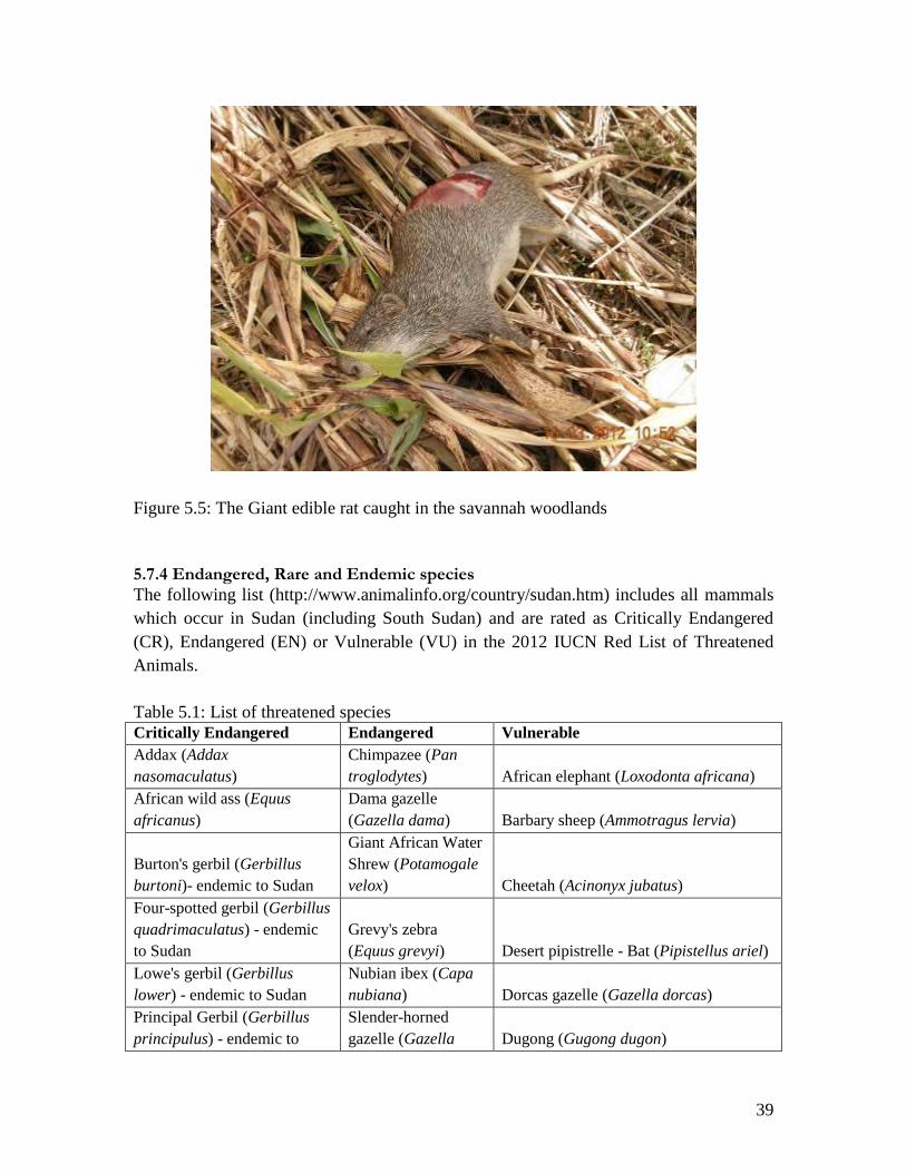
39
Figure 5.5: The Giant edible rat caught in the savannah woodlands
5.7.4 Endangered, Rare and Endemic species
The following list (http://www.animalinfo.org/country/sudan.htm) includes all mammals
which occur in Sudan (including South Sudan) and are rated as Critically Endangered
(CR), Endangered (EN) or Vulnerable (VU) in the 2012 IUCN Red List of Threatened
Animals.
Table 5.1: List of threatened species
Critically Endangered Endangered Vulnerable
Addax (Addax
nasomaculatus)
Chimpazee (Pan
troglodytes) African elephant (Loxodonta africana)
African wild ass (Equus
africanus)
Dama gazelle
(Gazella dama) Barbary sheep (Ammotragus lervia)
Burton's gerbil (Gerbillus
burtoni)- endemic to Sudan
Giant African Water
Shrew (Potamogale
velox) Cheetah (Acinonyx jubatus)
Four-spotted gerbil (Gerbillus
quadrimaculatus) - endemic
to Sudan
Grevy's zebra
(Equus grevyi) Desert pipistrelle - Bat (Pipistellus ariel)
Lowe's gerbil (Gerbillus
lower) - endemic to Sudan
Nubian ibex (Capa
nubiana) Dorcas gazelle (Gazella dorcas)
Principal Gerbil (Gerbillus
principulus) - endemic to
Slender-horned
gazelle (Gazella Dugong (Gugong dugon)
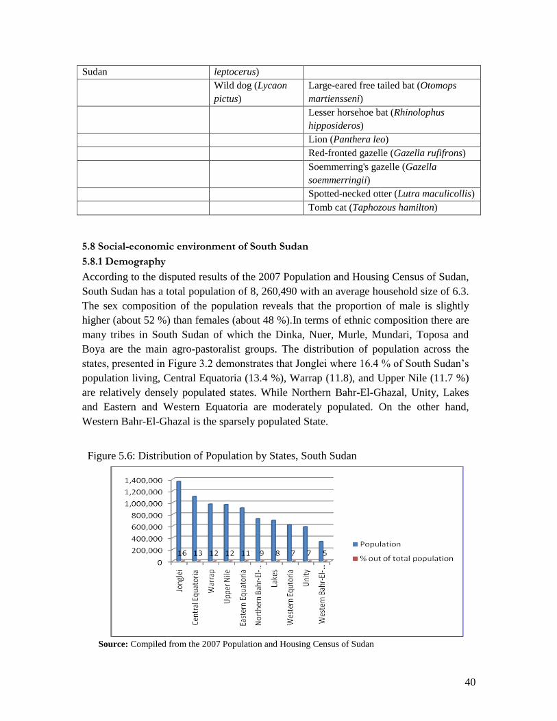
40
Sudan leptocerus)
Wild dog (Lycaon
pictus)
Large-eared free tailed bat (Otomops
martiensseni)
Lesser horsehoe bat (Rhinolophus
hipposideros)
Lion (Panthera leo)
Red-fronted gazelle (Gazella rufifrons)
Soemmerring's gazelle (Gazella
soemmerringii)
Spotted-necked otter (Lutra maculicollis)
Tomb cat (Taphozous hamilton)
5.8 Social-economic environment of South Sudan
5.8.1 Demography
According to the disputed results of the 2007 Population and Housing Census of Sudan,
South Sudan has a total population of 8, 260,490 with an average household size of 6.3.
The sex composition of the population reveals that the proportion of male is slightly
higher (about 52 %) than females (about 48 %).In terms of ethnic composition there are
many tribes in South Sudan of which the Dinka, Nuer, Murle, Mundari, Toposa and
Boya are the main agro-pastoralist groups. The distribution of population across the
states, presented in Figure 3.2 demonstrates that Jonglei where 16.4 % of South Sudan’s
population living, Central Equatoria (13.4 %), Warrap (11.8), and Upper Nile (11.7 %)
are relatively densely populated states. While Northern Bahr-El-Ghazal, Unity, Lakes
and Eastern and Western Equatoria are moderately populated. On the other hand,
Western Bahr-El-Ghazal is the sparsely populated State.
Figure 5.6: Distribution of Population by States, South Sudan
Source: Compiled from the 2007 Population and Housing Census of Sudan
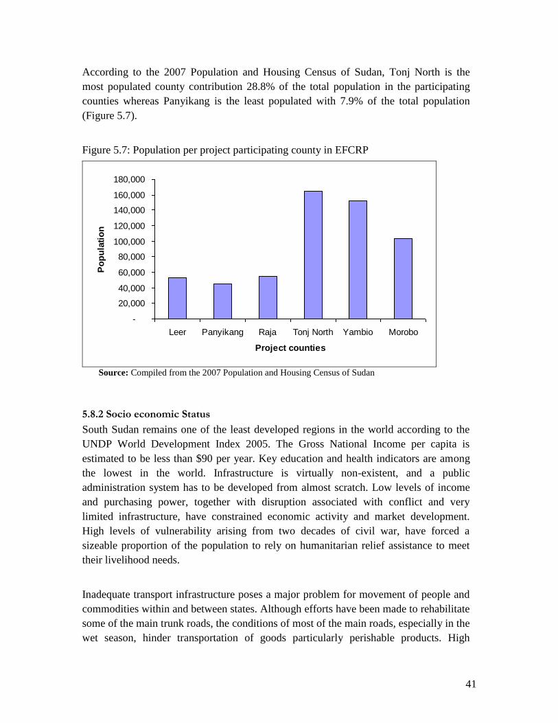
41
According to the 2007 Population and Housing Census of Sudan, Tonj North is the
most populated county contribution 28.8% of the total population in the participating
counties whereas Panyikang is the least populated with 7.9% of the total population
(Figure 5.7).
Figure 5.7: Population per project participating county in EFCRP
-
20,000
40,000
60,000
80,000
100,000
120,000
140,000
160,000
180,000
Leer Panyikang Raja Tonj North Yambio Morobo
Project counties
Po
pu
lati
on
Source: Compiled from the 2007 Population and Housing Census of Sudan
5.8.2 Socio economic Status
South Sudan remains one of the least developed regions in the world according to the
UNDP World Development Index 2005. The Gross National Income per capita is
estimated to be less than $90 per year. Key education and health indicators are among
the lowest in the world. Infrastructure is virtually non-existent, and a public
administration system has to be developed from almost scratch. Low levels of income
and purchasing power, together with disruption associated with conflict and very
limited infrastructure, have constrained economic activity and market development.
High levels of vulnerability arising from two decades of civil war, have forced a
sizeable proportion of the population to rely on humanitarian relief assistance to meet
their livelihood needs.
Inadequate transport infrastructure poses a major problem for movement of people and
commodities within and between states. Although efforts have been made to rehabilitate
some of the main trunk roads, the conditions of most of the main roads, especially in the
wet season, hinder transportation of goods particularly perishable products. High
42
transportation cost is a disincentive to farmers in potential surplus production areas
from expanding production. However, the situation of various socio-economic
infrastructure and the livelihoods conditions of the people of South Sudan have
substantially changed since the signing of the Comprehensive Peace Agreement (CPA)
in January 2005.
5.8.3 Health and Nutrition
Health and education are quite rudimentary and almost entirely dependent on
humanitarian support. High rates of acute malnutrition above the emergency level
continue to occur in South Sudan despite the improvement in food security. Current
nutrition programs have focused mostly on Supplementary and Therapeutic Feeding
programmes to treat moderate and severe cases of acute malnutrition, as well as address
needs of malnourished pregnant and lactating mothers. It is evident that a
comprehensive preventative approach; focusing on all predisposing factors, need to be
used in addressing malnutrition instead of only relying on the curative approach. This
requires the collaboration of RSS, state governments and all NGOs and UN agencies.
5.8.4 Agriculture: Crop Production
The country's economy, like the case in other developing countries, is heavily
dependent on Agriculture. The Agriculture sector provides the main source of
livelihood to the people and there is a tremendous potential to expand to a commercial
scale since about 90% of its total area is considered suitable for agriculture, 50% of
which is prime agricultural land. Agriculture in South Sudan is predominantly rainfed
with annual rainfall levels increasing from the north to south and from east to west
ranging from less than 500 mm/year in the semi-arid lands of Northern Bahr el Ghazal
and Western Equatoria to around 1,800 mm/year in the Green Belt zone (areas around
Yei, Maridi and Yambio,Tambura to Kajo-Keji).
Soil and climatic conditions allow for a wide variety of food and cash crops. The nature
of crop production varies according to different agro-ecological zones of the country.
The Green Belt Zone is the main high potential region for crop production, with the
highest levels of rainfall. Main crops include maize, sorghum, finger millet, cassava,
sweet potato, and groundnuts. Rice production was, before the war, introduced and
greatly expanded in the Awel rice scheme. During the war the rice scheme collapsed but
rice was adopted by farmers outside the scheme. Soybean and cowpea are common but
relatively new crops, introduced to a large extent by emergency seed support
interventions. Some white seeded sesame is cultivated, coffee is grown commercially
and there are a few tobacco plantations. Fruit trees include banana, plantain, pineapple
and citrus. Vegetables include onion, okra, amaranthus, cabbage, carrot and cucumber.
43
Minor crops such as sweet potatoes, yams, coffee, mangoes, papayas are also grown for
home and some localized commercial use. Teak is a common non-native plantation tree
species grown for timber. Nonetheless, agricultural production methods remain largely
poor, limiting households to cultivate an average of 0.5-3.5 feddans, with each feddan
producing only 0.9 ton of cereal per year (FAO/WFP, 2008). In general agricultural
production is mainly affected by poor seed supply, timing and methods of weeding, use
of inputs, pest and disease and security challenges at local level.
5.8.5 Forestry
South Sudan also ranks among the best timber wood exporting countries to the
international market. Some of the states with best Teak and natural trees for timbers are
Western Equatoria and Central Equatorial states. In Central Equatoria some of the
existing Teak plantations are at Kegulu, the other oldest planted forest reserves are
Kawale, Lijo, Loka West and Nuni. While Western Equatoria has its resources, Mvuba
trees at Zamoi. However, much of the forest cover and biodiversity has been lost due to
50 years war (FAO/WFP, 2008). Table 5.2 shows the acreage under central forests
reserves and Protected Areas in South Sudan.
Numerous reports have also documented that the status of forests especially in and
around towns in South Sudan is decreasing. Deforestation is increasing due to the
continuous clearing of land for crops and cutting of wood for energy. Natural forests
and woodlands in most areas have been stripped bare of trees leaving landscapes strewn
with patchily distributed trees of little value. Most of the products used in most urban
areas are collected from nearby teak plantations. Communities in these areas collect
their wood products from natural forests.
Moreover, the consumption patterns of households in most of the South Sudan shows
that on average a household consumes approximately 0.3 to 0.6m³ of firewood and
approximately 50 kg of charcoal per week. As there are few alternatives for fuel or
construction, households are dependent on forest resources. However, the status of
forests and woodlands for instance around and in proximity to Bahr el Ghazal and
Upper Nile are less degraded. Khaya (Mahogany), Milicia, and Phoenix reclinata trees
are abundant and extend from Rumbek County to Yirol County.

44
Table 5.2: Acreage under central forests reserves and Protected Areas in South Sudan
45
5.8.6 Food Security and Livelihoods
The livelihood system in South Sudan is predominately subsistence small-holder
agriculture among which about 12-15% of the population depends on fishing for their
livelihoods (FAO/WFP, 2008). Employment opportunities both in the public and private
sector are few, but are increasing with the current political stability and economic
growth. Petty trading provides a source of income for many household in the rural
towns and around market centres. The total land area is over 100 million hectares
(FAO/WFP, 2008), of which about half is arable, rainfall is plentiful in most parts of the
country and soils are relatively fertile. Sorghum is the most important crop. Livestock
production provides an important livelihood base for large groups of people but is
hampered by disease and environmental degradation. The road network is poor and
many areas of the country are not accessible by road, particularly in the wet season
which provides a major obstacle for marketing and commercialization of agricultural
production. Poverty escalates during the dry season and in most parts of the country
periods of 3-6 months per year of food deficit is common. During these periods most
families move around for income generation, i.e. selling of charcoal, doing casual
labour etc.
5.8.7 Critical habitats
Due to the species richness and presence of species of global conservation concern, the
young tropical rainforests in Yambio county, particularly Bangusa Payam may be
classified as critical habitats for biodiversity conservation. Key large mammals of the
forests and some woodland savannah areas include Waterbuck (Kobus defasa),
Bushbuck, oribi, duiker, Uganda kob (Kobus kob), warthog (Phacocoerus ethiopicus),
hartebeest (Alcelaphus sp.), giant eland (Tragelaphus derbianus), buffalo (Syncerus
caffer), and various species of primates including the Black and White colobus monkey.
A rich diversity of avifauna, reptiles, amphibians, and invertebrates also occurs here.
However, the high levels of illegal hunting have decimated most of the wild life
populations in these areas.
5.8.8 Chemical use by farmers
There is no evidence of use of inorganic fertilizers by farmers in the project areas. This is
because the yields are still good and also practice shifting cultivation. However, some
NGOs have introduced fertilizers (particularly Urea) in Yambio county for trial purposes
even when there is no documented need for them (Figure 5.8). The fertilizer has been
distributed to about 600 farmers, which is an overly big number for trial purposes.

46
Figure 5.8: Fertilizer that has been introduced in Bangusa Payam, Yambio county for trial
purposes.
Although we did not find any evidence of use of pesticides in the project areas by
farmers, the State MAF confirmed the use of pesticides to control pests including the
Zonocerus sp. the elegant grasshopper that attacks cassava. The Department of Plant
Protection staff are the only permitted people to keep and apply the pesticides when there
are disease outbreaks. This is intended to control abuse of pesticides if otherwise left in
the hands of farmers.

47
Figure 5.8: Leaves of a cassava plant eaten away by the Zonocerus sp. (Elegant
grasshopper)

48
6. PUBLIC CONSULTATIONS AND DISCLOSURE
6.1 Introduction
Consultative meetings were held with relevant stakeholders and regulatory institutions, as
well as the local communities in the respective counties between January to April 2012 to
facilitate public participation in environmental and social aspects of EFCRP activities and
operations within the context of the GoSS environmental laws, regulations and policies
and WB safeguard policies. The consultation process has ensured stakeholder awareness
of the operations and activities of the EFCRP and enabled their input into this EA.
At national level, key stakeholders consulted included the World Bank, Ministry of
Environment and Ministry of Agriculture and Forestry. At State level, consultations were
held with County, Payam, Boma and State officials in the States where the project is
operating. NGOs implementing the project were also consulted. Choice of Stakeholders
consulted was based on their direct roles, technical expertise and responsibility in
ensuring that the EFCRP operations in their areas of jurisdiction comply with
development plans of the State, and meet the regulatory instruments and procedures of
the country at large. Appendix 1 shows some of the stakeholders consulted.
6.2 Salient issues raised and remarks made during the consultations
1. There is limited cross-sectoral coordination of activities between the forestry and
agriculture departments in the counties to minimize environmental damage while
carrying out agricultural activities. This is exacerbated by the failure of
implementing NGOs to emphasise agroforestry and forestry related activities as
they work with farmer groups to improve agricultural productivity.
2. Ideally there should be tree nurseries in every Payam to supply tree seedlings for
interested farmers but due to lack of finances, the forestry departments at county
level are unable to carry out their activities including establishment of tree
nurseries. Furthermore, most NGOs tend to emphasize agricultural activities,
neglecting the forestry/environmental aspects of their activities.
3. The Agriculture Departments at county level lack facilitation to monitor the
activities of the farmer groups and be able to advise them on environmentally
acceptable farming practices. This was evident in Morobo county where there is
one motor cycle only donated by FAO specifically for FAO activities.
4. There is hardly any use of pesticides nor inorganic fertilizers in most of the
counties under the EFCRP. Farmers tend to use locally prepared infusions of red
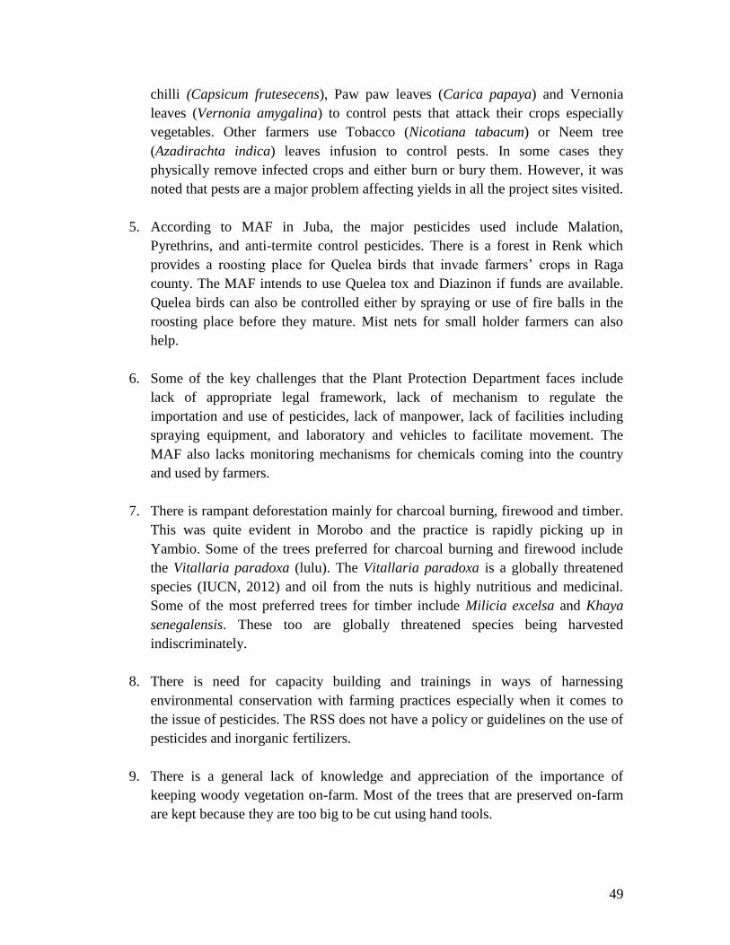
49
chilli (Capsicum frutesecens), Paw paw leaves (Carica papaya) and Vernonia
leaves (Vernonia amygalina) to control pests that attack their crops especially
vegetables. Other farmers use Tobacco (Nicotiana tabacum) or Neem tree
(Azadirachta indica) leaves infusion to control pests. In some cases they
physically remove infected crops and either burn or bury them. However, it was
noted that pests are a major problem affecting yields in all the project sites visited.
5. According to MAF in Juba, the major pesticides used include Malation,
Pyrethrins, and anti-termite control pesticides. There is a forest in Renk which
provides a roosting place for Quelea birds that invade farmers’ crops in Raga
county. The MAF intends to use Quelea tox and Diazinon if funds are available.
Quelea birds can also be controlled either by spraying or use of fire balls in the
roosting place before they mature. Mist nets for small holder farmers can also
help.
6. Some of the key challenges that the Plant Protection Department faces include
lack of appropriate legal framework, lack of mechanism to regulate the
importation and use of pesticides, lack of manpower, lack of facilities including
spraying equipment, and laboratory and vehicles to facilitate movement. The
MAF also lacks monitoring mechanisms for chemicals coming into the country
and used by farmers.
7. There is rampant deforestation mainly for charcoal burning, firewood and timber.
This was quite evident in Morobo and the practice is rapidly picking up in
Yambio. Some of the trees preferred for charcoal burning and firewood include
the Vitallaria paradoxa (lulu). The Vitallaria paradoxa is a globally threatened
species (IUCN, 2012) and oil from the nuts is highly nutritious and medicinal.
Some of the most preferred trees for timber include Milicia excelsa and Khaya
senegalensis. These too are globally threatened species being harvested
indiscriminately.
8. There is need for capacity building and trainings in ways of harnessing
environmental conservation with farming practices especially when it comes to
the issue of pesticides. The RSS does not have a policy or guidelines on the use of
pesticides and inorganic fertilizers.
9. There is a general lack of knowledge and appreciation of the importance of
keeping woody vegetation on-farm. Most of the trees that are preserved on-farm
are kept because they are too big to be cut using hand tools.

50
10. The man farming practice is shifting cultivation and farmers cultivate a piece of
land for 3-5 years before shifting to another place. This is done because of the
decreasing soil fertility over the years and also because of the fact that land is
plenty due to very low populations. Burning is a common practice as a starting
activity in the clearing of land for cultivation.
11. Local people, especially the very poor households are encouraged to participate in
activities such as road rehabilitation and are paid money so as to be able to buy
food. This is working well in Yambio where food prices have remained relatively
high because fewer men are involved in cultivation. Most men are now turning to
charcoal burning as a source of income rather than cultivation which takes a while
to realise any gains and is also risky in terms of weather adversity and poor or
lack of seed supply.
12. There is no record of cultivation in central or state forest reserves by farmer
groups in the project counties. This is because the boundaries of the forest
reserves are known by the local communities and there is plenty of land elsewhere
outside the designated protected areas. This was evident in Bangusa Payam,
Yambio where Yatta forest reserve is not encroached upon despite the existences
of refugees and an army barracks who are both involved in cultivation.
13. According to consultations with the farmer groups, county authorities and
implementing NGOs, there has been no displacement of communities or activities
of farmers to enable implementation of project activities. There is also no record
of minority ethnic groups or distinct cultural entities that could have been
neglected or ignored during project implementation.
14. County officials typically expressed priority for expanding land under cultivation
as the first step towards increasing production, and did not place emphasis on
increasing productivity to achieve the same objective.
51
A
B
Figure 6.1: Consultative process with farmers in (A) Morobo and (B) Yambio counties
under AAH-I

52
7. PEST MANAGEMENT
This section gives a general overview of the pest situation in the project operation areas
and the existing pest management approaches and practices. A more detailed Integrated
Pest Management Framework for the MAF and projects in the agricultural sector will be
presented in a separate document.
7.1 Existing Pest Management Approaches and Practices
7.1.1 Common pests in the project operational areas
The crops that are commonly grown in the project sites include rice, maize, root crops
(mainly cassava), ground nuts, millet, and sorghum. Vegetables grown include cabbage,
tomatoes, onions and other different kinds of vegetables. These crops attract a variety of
pests that need to be managed in order to avoid damage, leading to low crop yields.
Common pests in Morobo and Yambio counties that attack these crops include army
worms, green grasshoppers (Zonocerus sp.), stem borers and maize ear worms. Rodents
pests including ground squirrels (Xerus erythropus) and cane rat (Thryonomys
swinderianus) are more common in Morobo and tend to feed on root tubers especially
cassava but with minimal damage. In Raga county, the Red-billed Quelea (Quelea
quelea) birds are the most problematic pests while growing rice and other cereals.
7.1.2 Existing Pest Management Approaches and Limitations in the project sites
Management of pests in the counties is done by the Department of Plant Protection staff
in the States. This is intended to ensure appropriate application of pesticides and also
prevent abuse. Farm and crop management techniques are also used to control pests but
there are limitations and problems that the farmers face in using these methods. Below
are the existing and potential pest management efforts and their limitations.
7.1.2.1 Growing a Healthy Crop by Starting with Healthy Seed
A crop that germinates from seed that is healthy is likely to be less vulnerable to pest
damage. Also, a crop grown from seed that has been bred from resistant strains is less
likely to be damaged during plant growth and crop storage. Some farmers don’t have
access to good seed at the time of planting and as a result they use seed from the previous
harvest. Farmer groups are given ‘healthy’ seed to plant but this is not always the case
and this leads to crop failure.
7.1.2.2 Good farming practices to ensure vigorous crops
A plant growing in good garden conditions is generally less vulnerable to pest damage
than a plant growing under stressed conditions. Good farming practices include timely
and recommended land/soil preparation and planting. Limitations and constraints for the
farmers include lack of appropriate skills/knowledge, erratic and unpredictable rainy

53
seasons, lack and/or limited farm inputs and resources to adequately and timely prepare
their gardens.
7.1.2.3 Making the Crop Unattractive or Unavailable to Pests
This strategy includes adjusting planting times to ensure that crop development does not
coincide with pest appearance. The success of using this strategy requires good
knowledge of the seasons and the ability to forecast the right time for planting. The
farmers need the appropriate training and information through the extension workers to
ensure that they plant at the right times.
7.1.2.4 Crop Diversity or Rotation, Early Planting
Crop rotations or multiple cropping removes the chance for the re-appearance of
persistent pests. This strategy depends on the availability of seed to the farmers who,
sometimes, are in short supply of adequate and good quality seed. It was noted during the
surveys that crop diversification and rotation was practiced to some extent. Some of the
crops were difficult to sell due to lack of markets or very low prices. The farmers
mentioned lack of markets as one of the reasons why they preferred to stick to the crops
that had ready markets. This justifies the need to find mechanisms for linking the farmers
to market outlets. Feeder road repairs as part of the community safety nets programs of
the EFCRP is a good initiative especially in the highly productive areas Bangusa and
Yambio Payams in Yambio county.
7.1.2.5 Biological/ecological control
This is achieved by conserving and enhancing natural biological/ecological controls
already in the field and in selected situations, through natural enemies of pests. The use
of botanical pesticides such as Chilli (Capsicum frutescens), Vernonia amygalina, Neem
(Azadirachta indica) and Tobacco (Nicotiana tabacum) is practiced in Morobo county.
These are used to control pests mainly on vegetables such as tomatoes and cabbage. The
farmers need to be trained in available and appropriate biological controls that can be
used to prevent and control pests.
7.1.2.6 Physical Control
Physical controls include hand picking of pests, uprooting infested crop, using fire to
remove pests on crop residues and frequent weeding. These methods are commonly used
by the farmers. However, there is need to enhance their application to ensure that they are
used in a systematic and coordinated manner.
7.1.2.7 Use of pesticides
Pesticides may be used with care to ensure their toxicity to non-target organisms is as low
as possible. The effectiveness of pesticides should be as selective as possible. Certain

54
pesticides of natural origin are compatible with integrated pest management (IPM),
causing minimum disturbance to natural biological and ecological pest control
mechanisms.
It was noted that farmers use pesticides although under the guidance of staff from the
Plant Protection Departments. The farmers therefore need to be guided and trained to
understand the limitations and environmental consequences of using pesticides. They
should be knowledgeable of pesticides that are compatible with IPM and that do not
degrade the natural biological and ecological pest control systems. The farmers need to
be equipped with information on pesticide application quantities and methods; prevention
of chemical poisoning/accidents and effects of high pesticides residues in crops.
7.1.3 Extent to which the Existing Pest Management Approaches are Consistent with IPM
Pest management approaches and practices that are consistent with IPM include the
physical, biological and chemical pest control techniques presented in Section 7.1.2
above. There is a draft Pesticides policy with MAF that is yet to be presented to the
Council of Ministers for consideration. It’s expected to lead to the establishment of a
Pesticides Council, which will be consistent with the requirements of IPM. The draft
policy supports efforts to use recommended chemicals and to ban/control illegal
importation of pesticides that are not approved by the Pesticides Board. Some of the
pesticides management approaches and practices that are not consistent with IPM include
overuse of and over-dependence on chemical control methods; and limited use of
physical and biological methods due to lack of technical knowledge and supervision. The
use of unlisted or unapproved pesticides and stockpiling of obsolete pesticides, as
reported by some States MAFs are not consistent with IPM. These inconsistent
approaches and practices emanate from the following:
(i) Lack of training and limited knowledge of IPM practices and benefits by the
farmers
(ii) Inadequate technical supervision of the farmers by the extension workers due to
shortage of trained personnel to support IPM
(iii) Poor information availability and information management on pesticides and their
uses
(iv) Lack of systems and controls to enforce IPM approaches and practices in the
various States and county level. This leads to isolated and independent use of
pest control methods as is happening in some counties.

55
8. ENVIRONMENTAL AND SOCIAL ISSUES, IMPACTS AND MITIGATION
8.1 Environmental Issues and Impacts
Direct impacts of agricultural practices on the environment arise from farming activities,
which contribute, to soil erosion, loss of nutrients and loss of natural vegetation. Shifting
cultivation is also an important cause of land degradation. Leaching from use of
pesticides and fertilizers is an important source of contamination of water bodies (both
surface and ground water).
One of the aims of the EFCRP is enhancement of agricultural productivity with a focus
on increase in yields, production of better quality farm products, and higher income to
farmers. Some of the key activities involved include cultivation of high yielding varieties,
improved agronomic practices, harvesting and storage of agricultural produce (harvesting
activities and development/operation of storage facilities), Transportation and processing
of agricultural produce (operation of transportation facilities, setting and operation of
agricultural processing units), and marketing including establishing market facilities and
linkages.
Environmental impacts of agricultural activities and the respective mitigation measures
have been outlined in the Table 8.1 below. These specific activities include cultivation of
high yielding varieties, diversification of crops, harvesting and storage of agricultural
produce, transportation and marketing.
Use of high yielding varieties on the same piece of land can result into increased use of
pesticides and fertilisers. They can also result into potential reduction in gene pool due to
the replacement of local or wild varieties of crops. However, farmers are still practising
shifting cultivation and the prevalence of pests is also fairly high.
Agricultural produce is generally transported by road. Long travel times and lack of
refrigeration facilities result in huge losses of perishable food items (like tomatoes) which
have a low shelf life. Enhancement in transportation by improving the road infrastructure
and construction of stores where produce can be collected and picked for sale can be very
useful in this respect.

56
Table 8.1: Environmental Impacts and Mitigation measures for Agricultural activities
Sector Activities Issues Impacts Mitigation measures
Agricultural productivity Cultivation of high
yielding varieties
Increased use of
pesticides/fertilizers
(i) Potential soil and water
contamination
(ii) Associated health and safety
hazards
(iii) Possible increase in pesticide
residues in food chains
(iv) Pesticide/fertilizer containers
disposal
(i) Prior assessment of pests existing in the
project area and development of pest
management strategies accordingly
(ii) Promote integrated pest management
techniques and practices – use of biological
pesticides and new generation pesticides and
herbicides
(iii) Ensure use of Personal Protective
Equipment (PPE) while handling, using and
storage of fertilisers and pesticides
(iv) Ensure appropriate disposal of hazardous
waste like pesticides with containers
(v) Assess and revive traditional practices
where suitable to control pests e.g. the use of
infusions of red chilli, Tobacco and Neem
leaves
Biodiversity (i) Loss/gradual extinction of
indigenous varieties of crops and
framing practices-erosion of gene
pool of the country
(ii) Bio piracy and illegal
introduction of high yielding
varieties without going through
national safeguards
(iii) Loss of globally threatened
species including Khaya spp.,
Milicia excelsa and Vitallaria
paradoxa
(i) Avoid undertaking project activities close
to areas considered to be biodiversity
hotspots or protected areas to minimise
potential risks to biodiversity
(ii) Ensure that indigenous varieties are not
completely replaced in the project areas
(iii) Ensure that national and local safeguards
fir biodiversity protection are stringently
followed so that illegal transactions and use
of uncertified seeds are avoided
(iv) Consultations with local communities to
understand local biodiversity issues
(v) Ensure that globally threatened species
are preserved in gardens and other habitats
where they occur
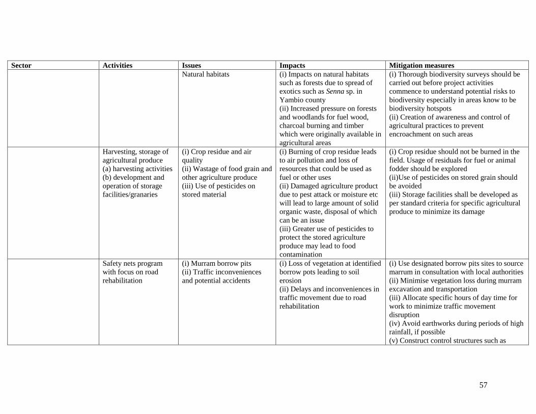
57
Sector Activities Issues Impacts Mitigation measures
Natural habitats (i) Impacts on natural habitats
such as forests due to spread of
exotics such as Senna sp. in
Yambio county
(ii) Increased pressure on forests
and woodlands for fuel wood,
charcoal burning and timber
which were originally available in
agricultural areas
(i) Thorough biodiversity surveys should be
carried out before project activities
commence to understand potential risks to
biodiversity especially in areas know to be
biodiversity hotspots
(ii) Creation of awareness and control of
agricultural practices to prevent
encroachment on such areas
Harvesting, storage of
agricultural produce
(a) harvesting activities
(b) development and
operation of storage
facilities/granaries
(i) Crop residue and air
quality
(ii) Wastage of food grain and
other agriculture produce
(iii) Use of pesticides on
stored material
(i) Burning of crop residue leads
to air pollution and loss of
resources that could be used as
fuel or other uses
(ii) Damaged agriculture product
due to pest attack or moisture etc
will lead to large amount of solid
organic waste, disposal of which
can be an issue
(iii) Greater use of pesticides to
protect the stored agriculture
produce may lead to food
contamination
(i) Crop residue should not be burned in the
field. Usage of residuals for fuel or animal
fodder should be explored
(ii)Use of pesticides on stored grain should
be avoided
(iii) Storage facilities shall be developed as
per standard criteria for specific agricultural
produce to minimize its damage
Safety nets program
with focus on road
rehabilitation
(i) Murram borrow pits
(ii) Traffic inconveniences
and potential accidents
(i) Loss of vegetation at identified
borrow pots leading to soil
erosion
(ii) Delays and inconveniences in
traffic movement due to road
rehabilitation
(i) Use designated borrow pits sites to source
marrum in consultation with local authorities
(ii) Minimise vegetation loss during murram
excavation and transportation
(iii) Allocate specific hours of day time for
work to minimize traffic movement
disruption
(iv) Avoid earthworks during periods of high
rainfall, if possible
(v) Construct control structures such as

58
Sector Activities Issues Impacts Mitigation measures
sumps and settlement ponds around
drainage points to trap sediment

59
8.2: Social Impacts
8.2.1 Positive social impacts
8.2.1.1 Increase in incomes for farmers
Farmers are able to earn some income from the sale of their produce on the market. On
average, income earned even exceeds SSP 400 (USD 100) per month for some farmers in
Yambio. A fairly well off farmer in Yambio informed us that he is able to hire workers to
work in his farm fields for about SSP 400 per month. He is able to cater for all his family
needs and take children to school.
8.2.1.2 Social cohesion
With stable incomes, households are able to have stable families. This enhances social
cohesion, proper planning and taking care of the children without so much hassle as
would be the case without income.
8.2.1.3 Improvement in food security
As the yield improves with provision of good seed, farmers are able to improve their food
security especially when they get bumper harvests from their gardens. Yambio county is
one of the most productive areas among the project sites.
8.2.1.4 Employment (safety nets)
Through the safety nets program being implemented by the project, people are able to
earn income through the rehabilitation of feeder roads especially those from highly
productive areas. This helps farmers transport their farm produce easily to markets.

60
9. ENVIRONMENT AND SOCIAL MANAGEMENT AND MONITORING PLAN
9.1 Purpose Environmental and Social Management Plan
This Environment and Social Management Plan (ESMP) describes the environments in
which the project is operating and the range of activities that will be conducted during the
implementation of the project and which have the potential to give rise to environmental
issues or adverse environmental impacts. The purpose of this ESMP (Table 9.1) is to
document environmental impacts, mitigation measures and monitoring procedures that
will allow the project to:
a) Reduce potential impacts arising by incorporating environmental impact appraisal
procedures and impact mitigation strategies in the project activities' implementation
programs;
b) Where the risk of potential impacts cannot be avoided, implement effective mitigation
measures that will minimise and reduce to an acceptable level any residual impacts
that might arise;
c) Conduct an environmental monitoring program for all potential impacts that will
provide adequate data to evaluate the effectiveness of the negative impact avoidance
strategies and mitigation measures and will clearly and promptly indicate any loss of
efficacy or failure of these and allow corrective action(s) to be taken;
d) Identify any protection or preservation activities or sites that may be required to
protect sensitive environments such as critical natural habitats and forest areas, or
cultural, historical, archaeological or sacred sites. Develop an impact avoidance
strategy and measures to be taken that will ensure that these sites are not affected by
any project related operations or activities.
The ESMP sets out the main activities that are to be implemented through the ESA
process. However, it is to be appreciated that the implementation of the plan of action
may be slightly modified to suit changes or emergencies that may occur on sites during
project implementation. The plan therefore should be considered as the main framework
that must be followed to ensure that the negative impacts are kept minimal or under
control. In this regard, a certain amount of flexibility should be allowed to maximize its
implementation to the best advantage.
In this section, the recommended measures and/or practices for avoiding, managing and
mitigating the negative impacts of the project activities are presented and these are
representative of the project implementation sites under the different NGOs.
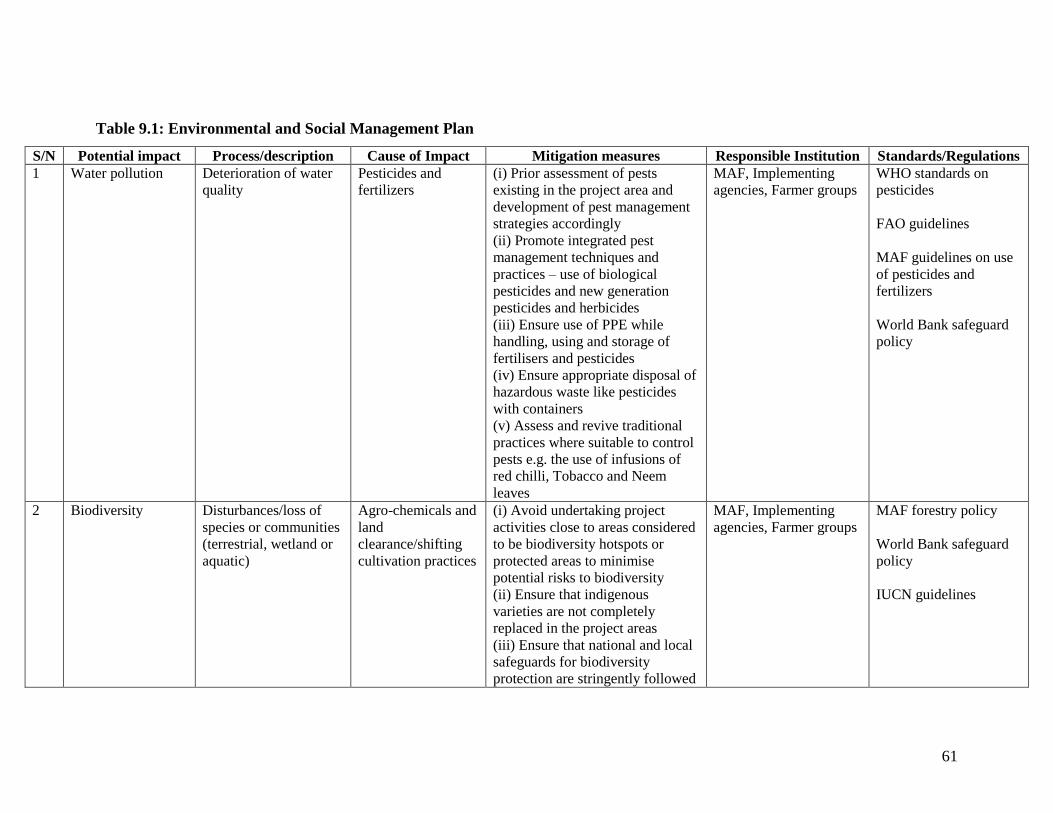
61
Table 9.1: Environmental and Social Management Plan
S/N Potential impact Process/description Cause of Impact Mitigation measures Responsible Institution Standards/Regulations
1 Water pollution Deterioration of water
quality
Pesticides and
fertilizers
(i) Prior assessment of pests
existing in the project area and
development of pest management
strategies accordingly
(ii) Promote integrated pest
management techniques and
practices – use of biological
pesticides and new generation
pesticides and herbicides
(iii) Ensure use of PPE while
handling, using and storage of
fertilisers and pesticides
(iv) Ensure appropriate disposal of
hazardous waste like pesticides
with containers
(v) Assess and revive traditional
practices where suitable to control
pests e.g. the use of infusions of
red chilli, Tobacco and Neem
leaves
MAF, Implementing
agencies, Farmer groups
WHO standards on
pesticides
FAO guidelines
MAF guidelines on use
of pesticides and
fertilizers
World Bank safeguard
policy
2 Biodiversity Disturbances/loss of
species or communities
(terrestrial, wetland or
aquatic)
Agro-chemicals and
land
clearance/shifting
cultivation practices
(i) Avoid undertaking project
activities close to areas considered
to be biodiversity hotspots or
protected areas to minimise
potential risks to biodiversity
(ii) Ensure that indigenous
varieties are not completely
replaced in the project areas
(iii) Ensure that national and local
safeguards for biodiversity
protection are stringently followed
MAF, Implementing
agencies, Farmer groups
MAF forestry policy
World Bank safeguard
policy
IUCN guidelines
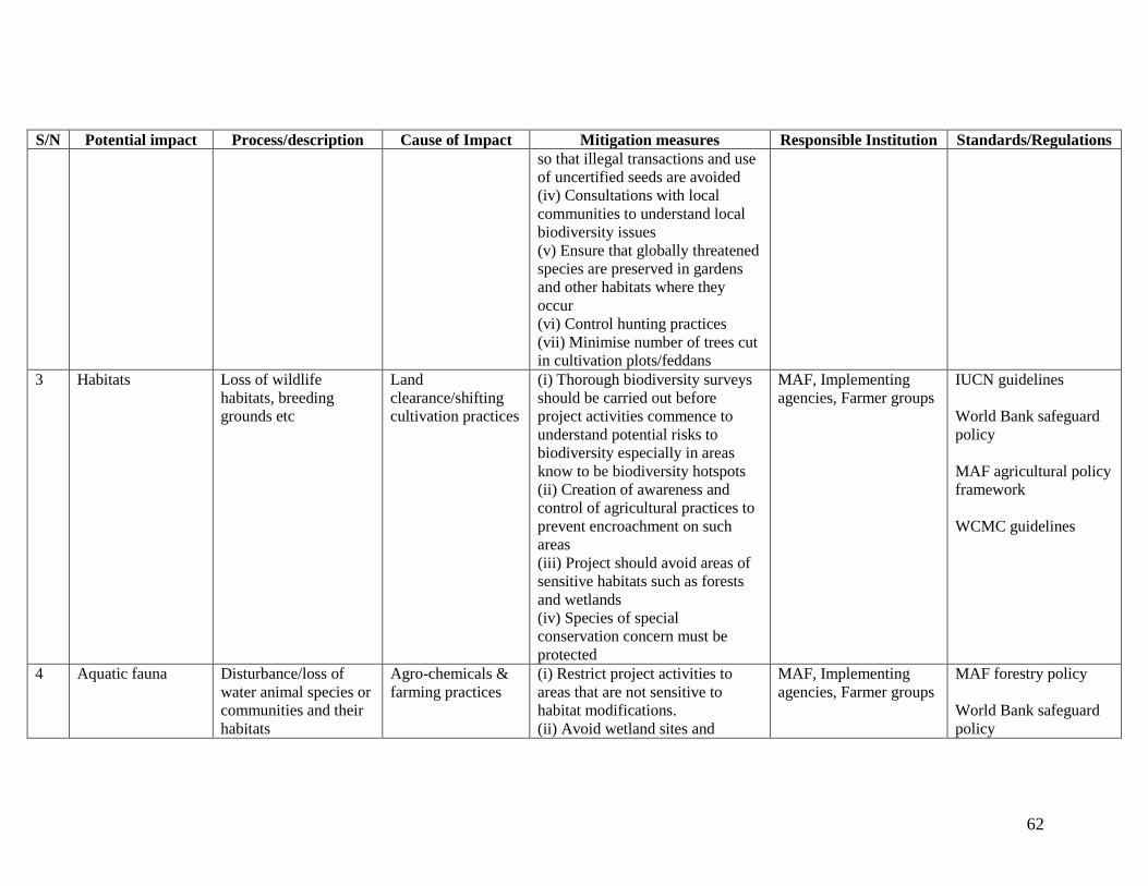
62
S/N Potential impact Process/description Cause of Impact Mitigation measures Responsible Institution Standards/Regulations
so that illegal transactions and use
of uncertified seeds are avoided
(iv) Consultations with local
communities to understand local
biodiversity issues
(v) Ensure that globally threatened
species are preserved in gardens
and other habitats where they
occur
(vi) Control hunting practices
(vii) Minimise number of trees cut
in cultivation plots/feddans
3 Habitats Loss of wildlife
habitats, breeding
grounds etc
Land
clearance/shifting
cultivation practices
(i) Thorough biodiversity surveys
should be carried out before
project activities commence to
understand potential risks to
biodiversity especially in areas
know to be biodiversity hotspots
(ii) Creation of awareness and
control of agricultural practices to
prevent encroachment on such
areas
(iii) Project should avoid areas of
sensitive habitats such as forests
and wetlands
(iv) Species of special
conservation concern must be
protected
MAF, Implementing
agencies, Farmer groups
IUCN guidelines
World Bank safeguard
policy
MAF agricultural policy
framework
WCMC guidelines
4 Aquatic fauna Disturbance/loss of
water animal species or
communities and their
habitats
Agro-chemicals &
farming practices
(i) Restrict project activities to
areas that are not sensitive to
habitat modifications.
(ii) Avoid wetland sites and
MAF, Implementing
agencies, Farmer groups
MAF forestry policy
World Bank safeguard
policy
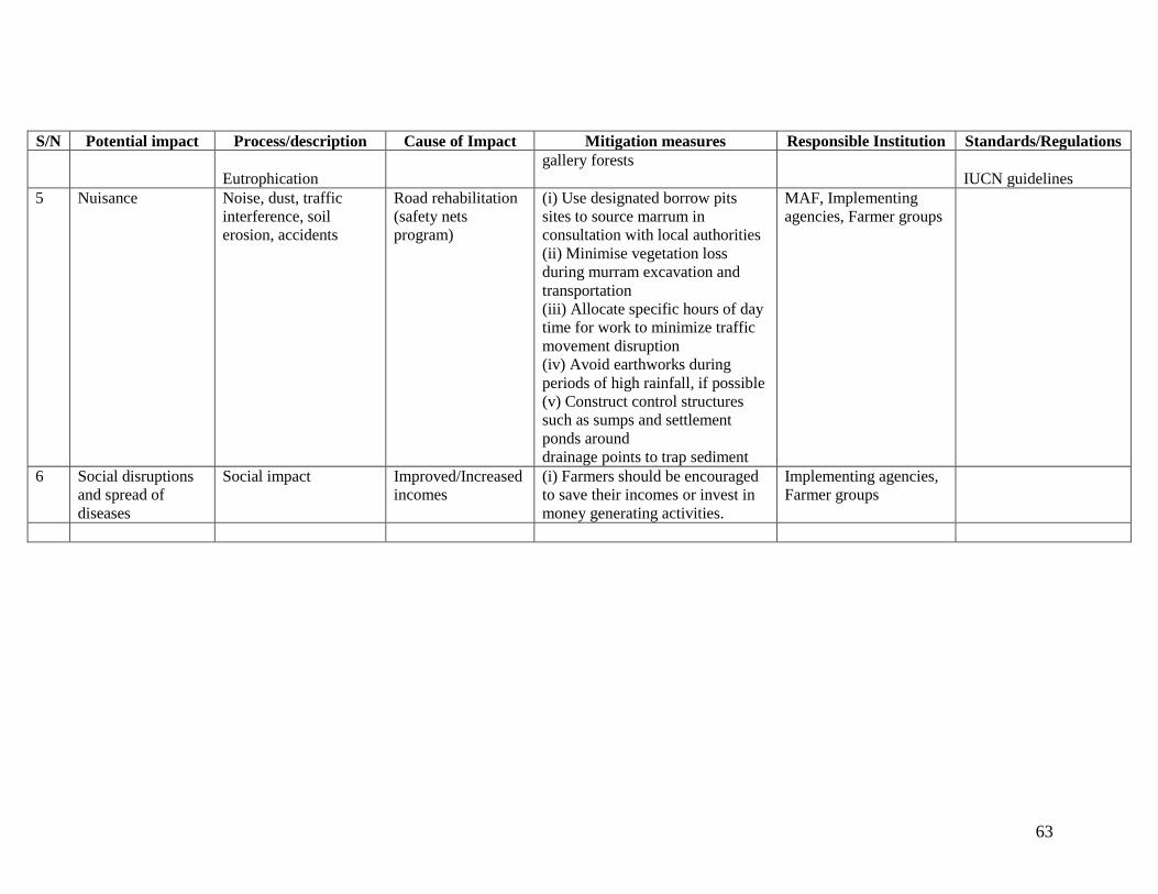
63
S/N Potential impact Process/description Cause of Impact Mitigation measures Responsible Institution Standards/Regulations
Eutrophication
gallery forests
IUCN guidelines
5 Nuisance Noise, dust, traffic
interference, soil
erosion, accidents
Road rehabilitation
(safety nets
program)
(i) Use designated borrow pits
sites to source marrum in
consultation with local authorities
(ii) Minimise vegetation loss
during murram excavation and
transportation
(iii) Allocate specific hours of day
time for work to minimize traffic
movement disruption
(iv) Avoid earthworks during
periods of high rainfall, if possible
(v) Construct control structures
such as sumps and settlement
ponds around
drainage points to trap sediment
MAF, Implementing
agencies, Farmer groups
6 Social disruptions
and spread of
diseases
Social impact Improved/Increased
incomes
(i) Farmers should be encouraged
to save their incomes or invest in
money generating activities.
Implementing agencies,
Farmer groups

64
9.2 Environmental and Social Monitoring Plan
The Environmental and Social Monitoring Plan is designed to ensure that the
management plan is implemented through participation and input of all the relevant
stakeholders. The basic principles of environmental monitoring are to ensure that the
mitigation measures are followed up and implemented through the planned activities and
regular checks and monitoring.
Monitoring efforts, during the operation period have to ensure that the operating and
performance standards of agricultural productivity enhancement activities are followed
and achieved. Monitoring activities should include regular inspections to ensure that the
activities follow the required environmental and social safeguards.
Monitoring activities, the responsible persons or institutions to ensure compliance are
presented in Table 9.2.

65
Table 9.2: Environmental Monitoring Plan
S/N Environmental
issue
Monitoring required Time/Frequency M & E Indicator Applicable
standard/regulation
Responsibility
1 Ensure that
environmental
considerations and
recommendations
have been
incorporated into
the design report
Check and/or
participate in
preparation of project
design specifications
During draft and
detailed design
preparation
EIA report recommendations and
EMP
World Bank safeguard
policies
MAF, Implementing
agencies
2 Surface and ground
water
contamination y
fertilizers and
pesticides
Surface and ground
water sampling and
testing
Once a month Concentration of pesticides,
nitrogen, phosphates and
potassium
As per specified
chemical regulations on
administration
MAF, Implementing
agencies
3 Proliferation of
pests
Crop inspections Quarterly Pests IPM MAF, Implementing
agencies
4 Land clearance for
agricultural
activities
Garden inspections Once a month Number of trees left standing in
gardens
World Bank safeguard
policies
MAF agricultural policy
framework
MAF, Implementing
agencies
5 Biodiversity loss Biodiversity surveys Once in six months Species diversity indices per taxon
surveyed
MAF, Implementing
agencies
6 Habitat loss Sensitivity of
ecosystems, habitats
cleared
Once in six months Ecosystem/Habitat variability MAF, Implementing
agencies
66
10. SUMMARY OF THE STUDY
10.1 Aim of the ESA study
The aim of the study was to assess the potential environmental impacts (both positive and
negative), of the EFRCP activities in the operational areas of the project. These include
Morobo county (Central Equatoria), Yambio (Western Equatoria State), Raga county
(Western Bahr el Ghazal), Tonj North (Warrap), Leer (Unity State) and Panyikang
(Upper Nile).
The Environmental and Social Assessment (ESA) study was to establish an
environmental management plan for mitigating potential negative impacts from the
project activities and to highlight measures for enhancing the positive impacts. Key
specific objectives for the study were:
a) To describe in general, the major components of the project
b) To outline the objectives of the EFCRP activities.
c) To review environmental policies and procedures of the Republic of South Sudan
(RSS) and the relevant World Bank Operational Policies to be triggered by the
proposed activities for consideration in the implementation of the project
activities.
d) To forecast the main potential environmental and social impacts of the project
activities.
e) To develop an environmental and social management plan with recommended
mitigation measures and strategies for addressing negative impacts in the course
of project implementation and operation.
10.2 Positive and Negative Impacts identified
The study has identified and analyzed several negative and positive impacts of the project
activities. The positive impacts include; improved food security and poverty reduction for
the local community, creation of jobs through the community safety nets program to
enable communities buy food and; income generating activities in the trade for
agricultural inputs and produce and enhanced economic activities for the project impact
areas. Other positive impacts also include improved agricultural practices and utilization
of farm inputs and natural resources.
The negative impacts include loss of natural vegetation, loss of biodiversity, pollution of
the soil and water sources through agricultural chemicals and pesticides albeit on a very
small scale currently. Other negative impacts include deforestation, and loss of globally
threatened species including Khaya senegalensis, Milicia excelsa and Vitallaria paradoxa
partially due to farming activities. However, it should be noted that some of the negative
impacts cannot entirely be attributed to project activities because they would have

67
occurred, whether the project activities took place or not. These include cutting trees for
firewood and charcoal burning.
The study has identified and recommended a number of mitigation measures with which
to address the negative impacts and enhance the positive effects of the project. Some of
the recommended strategies include the following:
Enhancing agricultural productivity through improved agricultural practices and
technologies and discouraging opening up of new areas as a way of improving
productivity. This will contribute to natural resources conservation and encourage
sustainable use.
Controlled and careful use of pesticides and agrochemicals on the household
gardens to prevent abuse while achieving the intended result.
Use of code of best practice for the project activities to ensure environmental
protection while encouraging sustainable utilisation of natural resources
especially arable land
Training of the farmers and extension workers in the relevant areas of operation to
improve efficiency in the areas of environmental management in relation to
agricultural activities.
10.3 Conclusions and Recommendations
The study has analyzed and concluded that the project activities generate considerable
socio-economic benefits to the farmers and the communities in the project areas. The
study has also established a number of ecological consequences that the project activities
are likely to induce albeit on a small scale. However, it is possible to mitigate these
negative impacts as long as the recommendations given in the environmental
management and monitoring plans are implemented.
The project will bring more positive benefits to the communities provided the negative
impacts are mitigated as recommended in the environmental management plan. This is in
line with the efforts of the government to improve food security and to enhance the social
and economic status of the rural population.
However, it must be appreciated that the farmers will need the support, training and
encouragement of the government and relevant stakeholders in order to attain meaningful
self-dependence in agricultural production.
Based on the findings of the study, it is concluded that the EFCRP has produced
considerable social benefits that include food security, improved and sustainable
management of natural resources such as land, improved agricultural management
practices and additional income generating activities. These should be enhanced in the
68
next phase of funding. The negative impacts include loss of trees (vegetation) and
disturbance of animal life, and deforestation. These negative impacts will cause
environmental and social problems if the project is implemented without adequate
conservation measures. It is therefore, necessary that the environmental management
action plan be integrated within the activities of the project and monitoring carried out to
ensure compliance.
To this end, it is recommended:
(a) That the Ministry of Agriculture and Forestry and all stakeholders to the proposed
development project should adopt the recommendations advanced in this report
(b) That the Ministry will have to mobilize the required inputs, technical expertise
and the appropriate consultants to implementation of the mitigation measures
outlined in this report alongside implementing agencies.
(c) That the project activities will require careful implementation and as such, the
implementing NGOs should ensure the integration of necessary mitigation
measures at the appropriate time during the project implementation.
(d) That the Ministry ensures that farmers are taught proper farming practices
including the application of agricultural chemicals and pesticides to ensure that
the environmental concerns are addressed.
(e) Environment and natural resources management are the underpinning of
sustainable agricultural development and will need to be incorporated into the
planning and implementation process. Of concern is the current tendency to
expand the area of land under cultivation rather than intensify production on
smaller areas. While some extension will be necessary, this should be done on the
basis of land use planning to ensure the best use of natural resources and avoid
over exploitation.
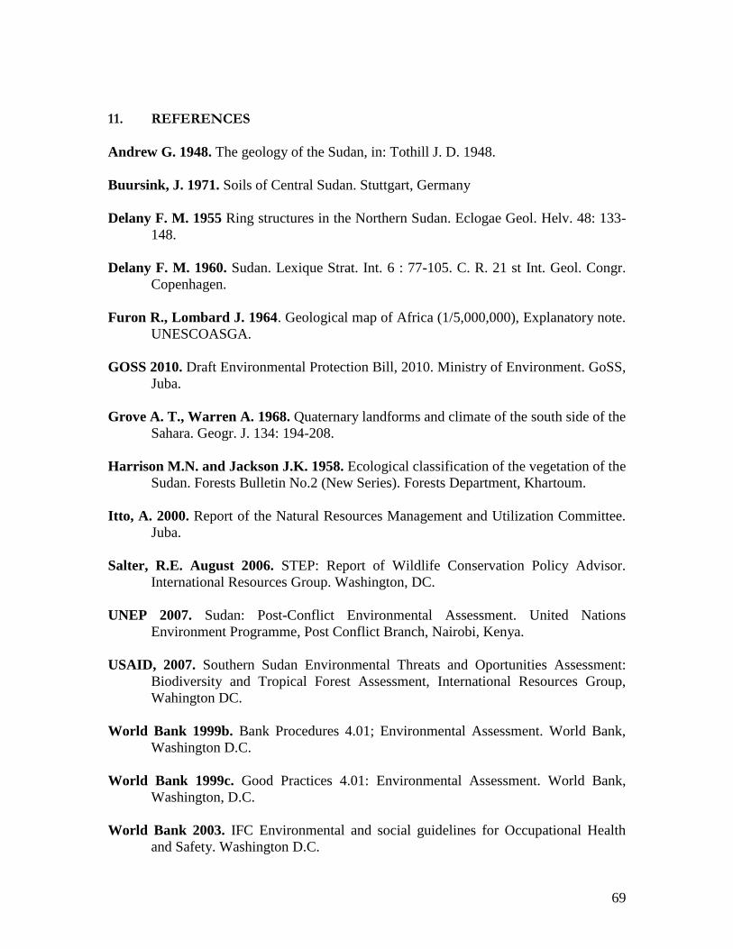
69
11. REFERENCES
Andrew G. 1948. The geology of the Sudan, in: Tothill J. D. 1948.
Buursink, J. 1971. Soils of Central Sudan. Stuttgart, Germany
Delany F. M. 1955 Ring structures in the Northern Sudan. Eclogae Geol. Helv. 48: 133-
148.
Delany F. M. 1960. Sudan. Lexique Strat. Int. 6 : 77-105. C. R. 21 st Int. Geol. Congr.
Copenhagen.
Furon R., Lombard J. 1964. Geological map of Africa (1/5,000,000), Explanatory note.
UNESCOASGA.
GOSS 2010. Draft Environmental Protection Bill, 2010. Ministry of Environment. GoSS,
Juba.
Grove A. T., Warren A. 1968. Quaternary landforms and climate of the south side of the
Sahara. Geogr. J. 134: 194-208.
Harrison M.N. and Jackson J.K. 1958. Ecological classification of the vegetation of the
Sudan. Forests Bulletin No.2 (New Series). Forests Department, Khartoum.
Itto, A. 2000. Report of the Natural Resources Management and Utilization Committee.
Juba.
Salter, R.E. August 2006. STEP: Report of Wildlife Conservation Policy Advisor.
International Resources Group. Washington, DC.
UNEP 2007. Sudan: Post-Conflict Environmental Assessment. United Nations
Environment Programme, Post Conflict Branch, Nairobi, Kenya.
USAID, 2007. Southern Sudan Environmental Threats and Oportunities Assessment:
Biodiversity and Tropical Forest Assessment, International Resources Group,
Wahington DC.
World Bank 1999b. Bank Procedures 4.01; Environmental Assessment. World Bank,
Washington D.C.
World Bank 1999c. Good Practices 4.01: Environmental Assessment. World Bank,
Washington, D.C.
World Bank 2003. IFC Environmental and social guidelines for Occupational Health
and Safety. Washington D.C.

70
APPENDICES

71
Appendix 1: Consultations: Summary of key issues and list of stakeholders
Consultations were held with a range of stakeholders as part of the report preparation
process between January and April 2012. The key issues raised by different stakeholder
groups are summarized below.
S.No. Stakeholder
Group
Key issues raised
1. Ministry of
Agriculture,
Directorate of
Forestry
Loss of trees, some of high value, due to poor coordination
of activities between the forestry and agriculture
departments
Risk of Quela Bird infestation on farmers field
No appropriate chemicals (Quela Tox, Diazinon) are
available due to shortage of finance for protecting Quela
Bird
Limited cross-sectoral coordination between the Forestry
and Agriculture departments in the counties
Lack tree nurseries at community level due to lack of
finances
Less consideration of forest conservation and environmental
protection by implementing NGOs
Need for capacity building and trainings in ways of
harnessing environmental conservation with farming
practices
2. Ministry of
Agriculture,
Directorate of
Plant Protection
RSS does not have a policy or guidelines on the use of
pesticides and inorganic fertilizers.
Lack of appropriate legal framework, lack of mechanism to
regulate the importation and use of pesticides, lack of
manpower, lack of facilities including spraying equipment,
and laboratory and vehicles to facilitate movement.
Lack of monitoring mechanisms for chemicals coming into
the country and used by farmers.
Major pesticides being used in some parts of the country are
Malathion, Pyrethrins, and anti-termite control pesticides.
Use of communities indigenous knowledge and botanical
plants as a pesticide
Lack of adequate pesticides, this aggravate crop loss due to
pest attack
3. Forestry
Department in
Morobo County
Need for greater emphasis on agroforestry and forestry
related activities when NGOs and Agriculture Department
work with farmer groups to improve agricultural
productivity.
Having tree nurseries in every Payam would help to supply
tree seedlings for interested farmers but currently there is no
money to set-up nurseries.
Rampant deforestation mainly for charcoal burning,
firewood and timber.
Limited cross-sectoral coordination of activities between
the forestry and agriculture departments
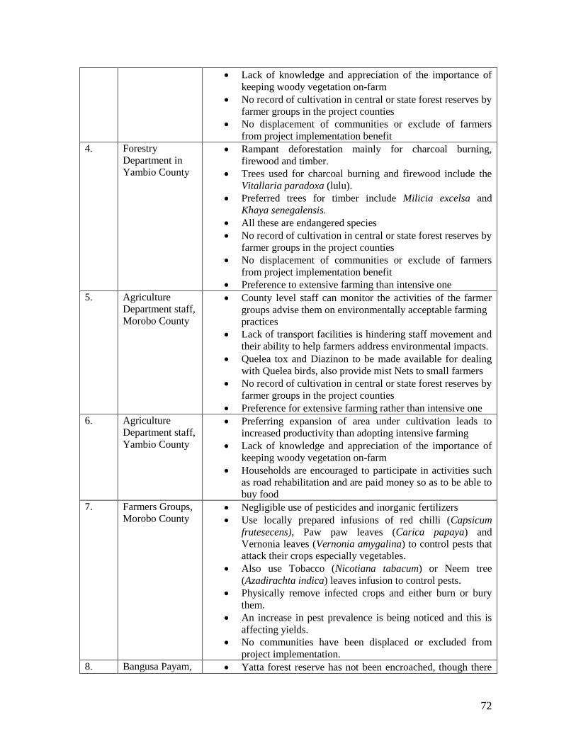
72
Lack of knowledge and appreciation of the importance of
keeping woody vegetation on-farm
No record of cultivation in central or state forest reserves by
farmer groups in the project counties
No displacement of communities or exclude of farmers
from project implementation benefit
4. Forestry
Department in
Yambio County
Rampant deforestation mainly for charcoal burning,
firewood and timber.
Trees used for charcoal burning and firewood include the
Vitallaria paradoxa (lulu).
Preferred trees for timber include Milicia excelsa and
Khaya senegalensis.
All these are endangered species
No record of cultivation in central or state forest reserves by
farmer groups in the project counties
No displacement of communities or exclude of farmers
from project implementation benefit
Preference to extensive farming than intensive one
5. Agriculture
Department staff,
Morobo County
County level staff can monitor the activities of the farmer
groups advise them on environmentally acceptable farming
practices
Lack of transport facilities is hindering staff movement and
their ability to help farmers address environmental impacts.
Quelea tox and Diazinon to be made available for dealing
with Quelea birds, also provide mist Nets to small farmers
No record of cultivation in central or state forest reserves by
farmer groups in the project counties
Preference for extensive farming rather than intensive one
6. Agriculture
Department staff,
Yambio County
Preferring expansion of area under cultivation leads to
increased productivity than adopting intensive farming
Lack of knowledge and appreciation of the importance of
keeping woody vegetation on-farm
Households are encouraged to participate in activities such
as road rehabilitation and are paid money so as to be able to
buy food
7. Farmers Groups,
Morobo County Negligible use of pesticides and inorganic fertilizers
Use locally prepared infusions of red chilli (Capsicum
frutesecens), Paw paw leaves (Carica papaya) and
Vernonia leaves (Vernonia amygalina) to control pests that
attack their crops especially vegetables.
Also use Tobacco (Nicotiana tabacum) or Neem tree
(Azadirachta indica) leaves infusion to control pests.
Physically remove infected crops and either burn or bury
them.
An increase in pest prevalence is being noticed and this is
affecting yields.
No communities have been displaced or excluded from
project implementation.
8. Bangusa Payam, Yatta forest reserve has not been encroached, though there

73
Details of stakeholders consulted are presented below.
Name/Contact Designation
Baiga Ayume Anda
Kaya Boma Chief, Kimba Payam, Morobo County,
Central Equatoria State
(a) Cheka Henry Stephen
(b) George Ruese Yairo
Ag. Assistant Commissioner of Forestry,
Morobo County
Forestry Overseer,
Morobo County
Christine Rojjo Samson
Assistant Commissioner for Agriculture
Morobo County
Lukasara & Loro Farmers
groups supported by AAH-I
Rose Ayozu Darious
Richard Sebit Ephraim
Kendila Boma
Gulumbi Payam
Morobo County
Payam Extension Officer for Gulumbi Payam
AAH-I Agriculturalist
Logu-Dapa Farmers Group
Supported by NPA
Kenyi Village, Kenyi Boma, Kenyi Payam
Lainya County
Mr. Timothy Thwol Onak Director General, Forestry, MAF
Alexander Ali Natana
Abdelrahman Tamim Sartak
Ag. Director for Plant Protection, MAF/RSS
Pesticide Chemist
MAF/RSS
Miiro Mivule
Project Director
AAH-I
Yambio are refugees and an army barracks in the area.
preferring extensive farming than intensive farming
9. Farmers Groups,
Lainya County Shifting cultivation practiced.
A piece of land cultivated for 3-5 years before shifting to
another place, when soil fertility declines.
Burning is a common practice as a starting activity in the
clearing of land for cultivation.
Poor benefiting from payments from road rehabilitation,
able to buy food
No encroachment into Reserve Forest areas
10. Raga County Risk of Quela Bird on farmers field
No appropriate chemical (Quela Tox, Diazinon) are
available due to shortage of finance
Lack of knowledge and appreciation of the importance of
keeping woody vegetation on-farm
Very poor households are encouraged to participate in
activities such as road rehabilitation and are paid money so
as to be able to buy food

74
Name/Contact Designation
Faustino Mukhundu
Payam Yambio
Boma Ngido
Yambio County
Western Equatoria State,
Chairman of farmers’ group
Joseph Eriminio Abiambu
Yambio
Senior Conservator of forests,
Yambio County
Anthony Tungo Peter
Yambio County
Rimenze Boma
Bangusu Payam
Western Equatoria State
Agricultural Payam Extension worker for Bangusu Payam,
Yambio County
Western Equatoria State
Rev. Elinama Phillimon
ECS Deanary Makpandu
Rimenze Boma
Bangasu Payam
Yambio County
Director General/State MAF,
Western Equatoria State
Western Equatoria State, Yambio
PIU staff MAF Juba
Bedilu Amare
World Bank
Environmental Specialist
World Bank

75
Appendix 2: Integrated Safeguards Data Sheet for EFCRP

76

77

78

79
Appendix 3: Questionnaire used during the socio-economic studies
MAF/EFCRP SURVEY QUESTIONNAIRE
SOCIO-ECONOMIC SURVEY FOR SELECTED HOUSEHOLDS
Name of interviewer: _______________
Date of interview: _________________ Village: _________________
Boma: _______________ Payam: _______________
County: _______________ State: _______________
Personal Information
What is the nature of occupancy?
Land Owner _________
Tenant ________
Licensee ________
Co-owner ________
Other ___________ (please specify)
(Tick appropriate response)
Household Head________________________________________________
(Surname, First Name)
Sex: _____________________
Date/Year of Birth: ___________ Age: ________ (exact/appropriate)
Where were you born? _________________ When did you come here? _________________

80
Are your parents alive? Yes/No If alive, which of them is?
________________________
Where do/did your parents live?
______________________________________________________
Marital status (tick appropriate response):
Single
Married
(No. of spouses): __
Divorced
Widowed
Tribe: ___________________________________________________
Village: __________________________________________________
Main occupation of head of household: _____________________________
Where do you work? _____________________________________________
Other working persons in household:
Any other working person in household?:
Yes
No
Main occupation: ________________________________________________
Where do you work? ______________________________________________
Religion:
Catholic
Protestant
Muslim
Other______________________(please specify)
Household Members
How many household members do you have?
(i) Below 18 years? ______________________Males: Females:

81
(ii) Between 18-64 years? __________________Males: Females:
(iii) Above 64__________________Males: Females:
Household housing structures
Permanent House: ______________________ No.: ______________________
Semi-permanent House: ______________________ No.: ______________________
Temporary House (Tukul): ______________________ No.: ______________________
Livelihood in Affected Households
What is your monthly income? (SSP)
(i) 0- 100
(ii) 100 – 200
(iii) 200 – 300
(iv) 300 – 400
(v) Above 400
What is your main occupation?
(i) Farmer
(ii) Trader/Business
(iii) Teacher
(iv) Other (state)
If you are a farmer, what are the main crops grown?
(i) Crop________________ Feddans: ________________
(ii) Crop ________________ Feddans: ________________
(iii) Crop ________________ Feddans: ________________
(iv) Crop ________________ Feddans: ________________
Do you use any pesticides? YES NO
Do you use any artificial fertilizers? YES NO
What farming practice do you use?
1- Shifting cultivation
2- Fallowing

82
3- Crop protection
Which practice do you use for land preparation (ploughing, simple slashing, burning)
Health & Vulnerability
Are there disabled or chronically ill people in the household?
YES NO
If YES: Type of disability/illness:_______________________
Type of care required: ________________________
Number of births and deaths in the household over the last 12 months:
Births: ________________________
Deaths: _______________________ Cause: _________________
Has a child under age of 5 died in the household in last 3 years?
YES NO
If YES, Cause: _________________
What are the 3 commonest diseases that affect the family?
____________________________________
____________________________________
____________________________________
How much do you spend on treating the above commonest diseases? :________________
What is the nearest health facility known to the family?:________________
Is it actually used by the family? YES NO
If NO, why not?__________________________________
Do you practice family planning? YES NO
Have you heard of HIV/AIDS? YES NO
Do you know how HIV is contracted? YES NO
(verify knowledge if correct response given)
Do you know how HIV is avoided? YES NO
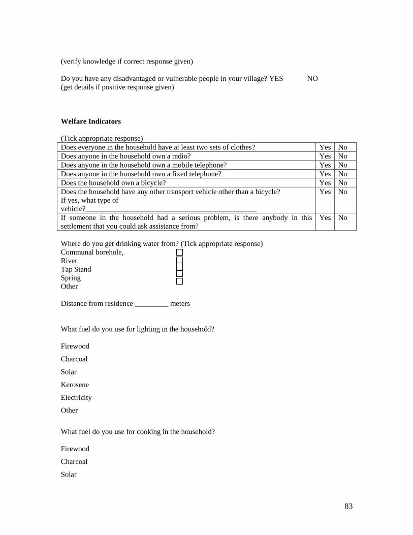
83
(verify knowledge if correct response given)
Do you have any disadvantaged or vulnerable people in your village? YES NO
(get details if positive response given)
Welfare Indicators
(Tick appropriate response)
Does everyone in the household have at least two sets of clothes? Yes No
Does anyone in the household own a radio? Yes No
Does anyone in the household own a mobile telephone? Yes No
Does anyone in the household own a fixed telephone? Yes No
Does the household own a bicycle? Yes No
Does the household have any other transport vehicle other than a bicycle?
If yes, what type of
vehicle?______________________________________________
Yes No
If someone in the household had a serious problem, is there anybody in this
settlement that you could ask assistance from?
Yes No
Where do you get drinking water from? (Tick appropriate response)
Communal borehole,
River
Tap Stand
Spring
Other
Distance from residence _________ meters
What fuel do you use for lighting in the household?
Firewood
Charcoal
Solar
Kerosene
Electricity
Other
What fuel do you use for cooking in the household?
Firewood
Charcoal
Solar

84
Kerosene
Other
Expenditure Patterns
Rank the following items according to which you spend most money on per month (1= Most
spent on; 7= least spent on)
Item Rank
School fees
Healthcare/medical expenses
Food
Clothing
Transport
Dependants
Rent
EFCRP Project Information
1. Do you know about EFCRP
2. Are you the beneficiary of this project?
3. Do you have any relatives benefited from this project?
4. What possible impact /advantage anticipate or observe from this project
5. What is perception/attitude on the implementation of this project
Ethnobotanical uses
Uses of plants in forests/woodlands in order of priority
S/N Local name of plant Scientific name Uses Parts used
1
2
3
4
5
6
7
85
8
9
10
Authentication:
"I ………………………………………………………………………………………………
confirm that on this date I responded to questions asked
by………………………………………………regarding project. I can confirm that I am the head
of household and own or have a right to the land/property/crops discussed in the questionnaire".
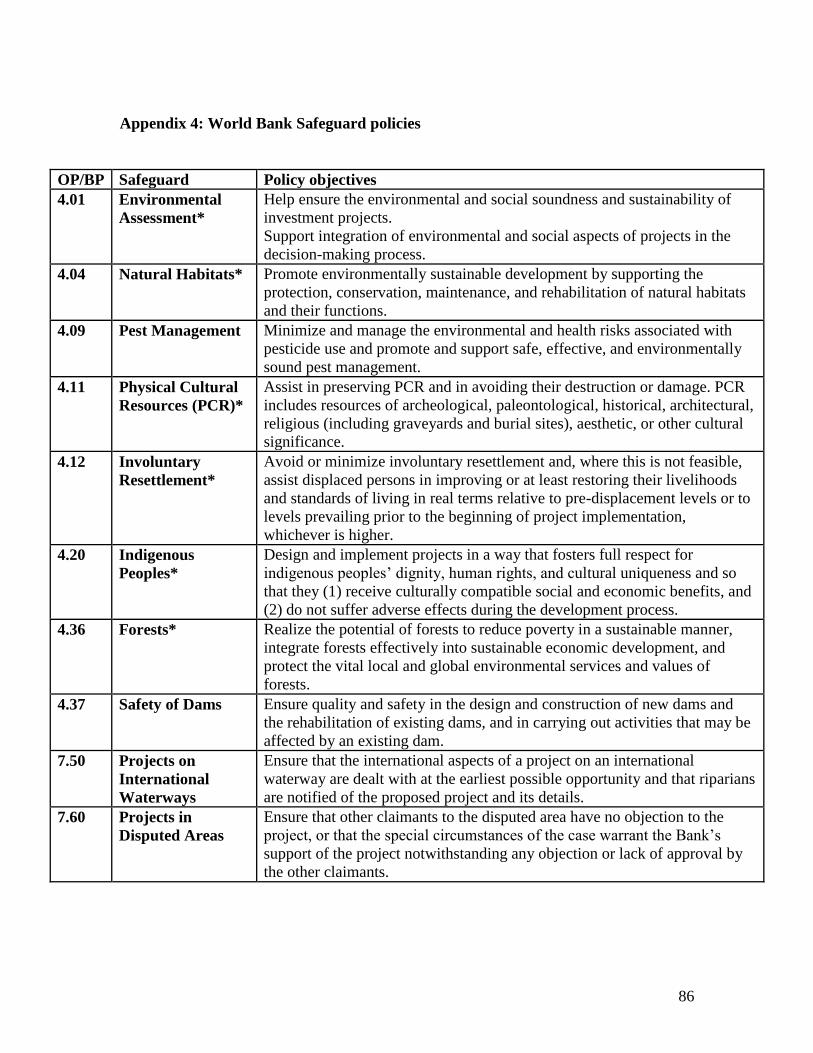
86
Appendix 4: World Bank Safeguard policies
OP/BP Safeguard Policy objectives
4.01 Environmental
Assessment*
Help ensure the environmental and social soundness and sustainability of
investment projects.
Support integration of environmental and social aspects of projects in the
decision-making process.
4.04 Natural Habitats* Promote environmentally sustainable development by supporting the
protection, conservation, maintenance, and rehabilitation of natural habitats
and their functions.
4.09 Pest Management Minimize and manage the environmental and health risks associated with
pesticide use and promote and support safe, effective, and environmentally
sound pest management.
4.11 Physical Cultural
Resources (PCR)*
Assist in preserving PCR and in avoiding their destruction or damage. PCR
includes resources of archeological, paleontological, historical, architectural,
religious (including graveyards and burial sites), aesthetic, or other cultural
significance.
4.12 Involuntary
Resettlement*
Avoid or minimize involuntary resettlement and, where this is not feasible,
assist displaced persons in improving or at least restoring their livelihoods
and standards of living in real terms relative to pre-displacement levels or to
levels prevailing prior to the beginning of project implementation,
whichever is higher.
4.20 Indigenous
Peoples*
Design and implement projects in a way that fosters full respect for
indigenous peoples’ dignity, human rights, and cultural uniqueness and so
that they (1) receive culturally compatible social and economic benefits, and
(2) do not suffer adverse effects during the development process.
4.36 Forests* Realize the potential of forests to reduce poverty in a sustainable manner,
integrate forests effectively into sustainable economic development, and
protect the vital local and global environmental services and values of
forests.
4.37 Safety of Dams Ensure quality and safety in the design and construction of new dams and
the rehabilitation of existing dams, and in carrying out activities that may be
affected by an existing dam.
7.50 Projects on
International
Waterways
Ensure that the international aspects of a project on an international
waterway are dealt with at the earliest possible opportunity and that riparians
are notified of the proposed project and its details.
7.60 Projects in
Disputed Areas
Ensure that other claimants to the disputed area have no objection to the
project, or that the special circumstances of the case warrant the Bank’s
support of the project notwithstanding any objection or lack of approval by
the other claimants.