minerals technical report for west vic - … · web viewfine grain size of the minerals prevented...
TRANSCRIPT

MINERAL ASSESSMENTMINERAL ASSESSMENTREPORTREPORT
December 1999

Published by the joint Commonwealth and Victorian Regional Forest Agreement (RFA) Steering Committee
© Commonwealth of Australia 1999
ISBN 0 642 56601 1
The views expressed in this report are those of the authors and not necessarily those of the Commonwealth of Australia or Victoria. The Commonwealth and Victoria do not accept responsibility for any advice or information in relation to this material.
Copies are available from:
Department of Natural Resources and Environment8 Nicholson StreetEAST MELBOURNE VIC 3002 Ph: (03) 9637 8080
Copies will also be available through the Environmental Resources Information Network on its World Wide Web Server. Contact: http://www.rfa.gov.au
For further information about this report contact the Commonwealth Forests Taskforce, Ph: (02) 6271 5181.
This work is copyright. It may be produced in whole or in part for study or training purposes subject to the inclusion of acknowledgment of the source and no commercial usage or sale. Reproduction for purposes other than those listed above requires written permission of the Commonwealth and Victorian RFA Steering Committee.
Requests should be addressed to:
Commonwealth and Victorian RFA Steering CommitteeC/- Commonwealth Forests TaskforceDepartment of the Prime Minister and Cabinet3–5 National CircuitBARTON ACT 2600Ph: (02) 6271 5181

Acknowledgments
The collection of information and report preparation on the mineral resources and the mineral potential of the West region were undertaken cooperatively between officers of the Australian Geological Survey Organisation and the Geological Survey of Victoria. An economic assessment of mineral resources was prepared by the Australian Bureau of Agricultural and Resource Economics.
Australian Geological Survey Organisation
Yanis Miezitis, Subhash Jaireth, Aden McKay, Keith Porritt, Don Perkin, Lloyd David, Neal Evans, Ken Lawrie, Andrew Lucas, Tim Johns, Danuta Dlugosz.
Geological Survey of Victoria, Department of Natural Resources and Environment
Tom Dickson, Roger Buckley, Ian McHaffie, Alan Willcocks, Peter O’Shea, Kemal Inan
Australian Bureau of Agricultural and Resource Economics
Chris Allen
West Victoria—mineral assessment report iii
Contents
Acknowledgments...............................................................................iii
Introduction.........................................................................................1
PART 1 KNOWN AND POTENTIAL RESOURCES OF METALLIFEROUS AND EXTRACTIVE MINERALS...................3
Geological setting.................................................................................5
Adelaide Fold Belt...........................................................................5Lachlan Fold Belt............................................................................8Murray Basin.................................................................................10Otway Basin..................................................................................10
History of mining and known mineral and extractive resources......13
Metals...........................................................................................13Non metals....................................................................................21
Potential mineral and extractive resources.......................................33
Mineral potential assessment methodology....................................33Mineral and extractive potential in the West region........................34Summary of potential for metalliferous and industrial minerals, and construction materials in the West region.......................................44
PART 2 CURRENT EXPLORATION, MINING AND EXTRACTION ACTIVITIES AND POTENTIAL ECONOMIC VALUE........................................................................63
Current exploration, mining and extraction activities and potential economic value...................................................................................65
Exploration........................................................................................67
Exploration prior to 1965...............................................................67Exploration from 1965 to the present.............................................67
Mining and quarrying.......................................................................71
Case study—slate belt gold and the Nagambie Mine......................71
Outlook for mineral production........................................................73
Gold..............................................................................................73Base metals...................................................................................73Brown coal....................................................................................74Titanium minerals..........................................................................75
West Victoria—mineral assessment report v

Legislation and land access................................................................77
Legislation and regulation relevant to exploration, mining and extractives.....................................................................................77Nature of exploration and mining...................................................78
References..........................................................................................81
APPENDIXES......................................................................................................91
Appendix A Methodology for assessment of potential (undiscovered) mineral resources.............................93
Appendix B Mineral resource assessment and mineral deposit models........................................................................97
Appendix C Mineral resources metadata sheets.............................a
Tables
Table 1a Glenelg Zone—summary of geological and mineralising events.............6Table 1b Stawell, Bendigo–Ballarat and Melbourne Zones, Otway and Murray
Basins—summary of geological and mineralising events during the Palaeozoic.............................................................................................7
Table 2 Main mineral occurrences, old mines and deposits...............................14Table 3 Recorded past gold production from goldfields....................................15Table 4 Resources in gold deposits...................................................................17Table 5 Recorded past production from major deep leads..................................18Table 6 Other mineral resources.......................................................................19Table 7 Resources in mineral sands deposits.....................................................21Table 8 Brown coal resources...........................................................................22Table 9 Active construction materials quarries..................................................25Table 10 Dimension stone..................................................................................28Table 11 Recorded production of other mineral resources...................................29Table 12 Precious and semi-precious stones sites................................................30Table 13 Summary of potential mineral resources as at June 1999......................35Table 14 Mineral exploration expenditure on exploration licences, West region,
1991–92 to 1997–98 (1997–98 dollars)................................................69Table 15 Expenditure on mining licences in the West region, 1991–92 to 1997–98
(1997–98 dollars).................................................................................70Table 16 Gross revenue and direct employment, Nagambie Gold Mine...............72Table 17 Land use categories as a proportion of total land area, West region.......78
Figures
vi West Victoria—mineral assessment report

Figure 1 Relationship between levels of resource potential and levels of certainty33Figure 2 Land tenure, quarries and exploration licenses.............................attachedFigure 3 Mineral potential tracts for heavy mineral sands...................................47Figure 4 Mineral potential tracts for slate-belt gold deposits...............................48Figure 5 Mineral potential tracts for disseminated gold deposits.........................49Figure 6 Mineral potential tracts for alluvial gold, including deep-lead gold.......50Figure 7 Mineral potential tracts for epithermal deposits for gold and silver.......51Figure 8 Mineral potential tracts for porphyry copper-gold deposits...................52Figure 9 Mineral potential tracts for volcanic associated massive sulphide base
metal deposits......................................................................................53Figure 10 Mineral potential tracts for tin vein deposits (including greisen tin
deposits)..............................................................................................54Figure 11 Mineral potential tracts for tungsten-molybdenum deposits..................55Figure 12 Mineral potential tracts for coal............................................................56Figure 13 Mineral potential tracts for dimension stone deposits............................57Figure 14 Mineral potential tracts for limestone deposits......................................58Figure 15 Mineral potential tracts for silica sand deposits.....................................59Figure 16 Mineral potential tracts for kaolin deposits...........................................60Figure 17 Mineral potential tracts for construction materials................................61Figure 18 Exploration licences granted per year within the West Victoria RFA
region, 1965–1998...............................................................................69Figure 19 Production from slate belt gold deposits in Victoria, 1857–1974..........71Figure 20 Base metals and gold prices (1998 US dollars).....................................74Figure 21 Energy consumption for electricity generation and production of brown
coal in Victoria, 1980–81 to 1997–98...................................................75
Maps
Map 1a Surface geologyMap 1b Legend for geologyMap 2 Mineral occurrencesMap 3 Composite mineral potentialMap 4 Cumulative mineral potential
West Victoria—mineral assessment report vii

Introduction
The aim of the regional assessment of minerals potential is to draw together new and existing information to aid the consideration of economic effects of forest use options to be considered in the development of the West Victoria Regional Forest Agreement (RFA). In particular this assessment contributes to the evaluation of:
the nature of mineral resources in forested land;
current and potential uses of forested land;
economic value of mineral products;
structure and regional significance of the mining industry; and
resource, infrastructure and policy requirements for the establishment of minerals industries.
The National Forest Policy Statement recognises the need to consider access for mineral exploration and extraction activities in deciding on landuse for public native forests. Access for mining and exploration varies with land tenure. Due to the incomplete nature of information on minerals resources and the fact that exploration is a dynamic information-gathering process, continued access to land is a significant issue for the mining industry and for future mineral development.
This report outlines: identified mineral deposits; the potential for a number of deposit types; indicators of the region’s potential mineral value; and factors affecting this value. Mineral deposits outside but close to the boundary of the region (within 15 kilometres) are noted if they are considered to have significance for mineral potential within the region. In this report the study area is referred to as ‘the West region’ or as ‘the region’.
Brown coal, gold and various construction materials are currently mined and extracted in the West region. It is estimated that the gross value of the mineral production in the region in 1998 from these operations was approximately $200 million (ABARE estimate).
The region is a major source for construction materials and about half of Victoria’s total production in 1997–98, worth approximately $294 million, was extracted in the West region under the Extractive Industries Development Act 1995. Important industrial minerals and construction materials quarries in the region supply Melbourne, Ballarat, Bendigo, Portland, Warrnambool and other regional centres.
Brown coal is mined for power generation from the Anglesea coalfield near Geelong at a rate of just over 1 million tonnes per year.
There are large sub-economic mineral sands deposits in the northwest of the region. Recent exploration in the Murray Basin, however, has delineated three potentially economic strandline type deposits. Results from current exploration suggest that the Murray Basin could be a very significant heavy mineral sands province.
The Stawell gold mine is the largest gold producer of the region and Victoria. Three of the other 83 gold tenements in the region produced more than one kilogram of gold in 1997–98. An open-pit gold mining operation is proposed at Big Hill, near Stawell. The region was a major gold producer last century, and many old deposits have recently attracted exploration
West Victoria—mineral assessment report 1
interest. Resources have been identified at a number of prospects within the region or immediately adjacent to it.
The region is highly to moderately prospective for a number of mineral deposit types and is therefore, likely to contain a number of undiscovered deposits.
Where access for exploration is possible, both undeveloped and as yet undiscovered deposits may be mined in the future, subject to normal approval processes, and yield economic benefits.
The mineral resources assessment is based on data supplied by Minerals and Petroleum Victoria (MPV) and the latest geological reports. MPV reports used for the assessment include those on the 1:250 000 scale map sheet areas of Hamilton, Ballarat, Colac, Portland, and Queenscliff, the Geology of Victoria (edited by Douglas & Ferguson 1988), and reports on specific geological areas within the region such as the Melbourne Zone (O’Shea et al. 1992). These reports, including the explanatory notes for the 1:100 000 scale maps, describe the geology, mineralisation and exploration of the West region. Information on the industrial minerals in the West region is derived in part from a report by McHaffie and Buckley (1995), seminar publications and from other sources.
Most of the West region has been subjected to a detailed high resolution airborne geophysical surveys and parts of the region have been mapped in detail (1:100 000 scale).
2 West Victoria—mineral assessment report

Part 1
Known and potential resources of metalliferous and extractive minerals

Geological setting
The following description of the geological setting of the West region is mainly a summary of work by MPV as published in VIMP 4 (Bush et al. 1995), and VIMP 52 (Maher et al. 1997), and explanatory notes accompanying 1:100 000 map sheets covering this region.
The regional geological setting is shown on Maps 1a and 1b, and the main geological and mineralising events are summarised in Tables 1a and 1b. Late Neoproterozoic and Palaeozoic basement rocks in the West region are grouped into four structural zones:
Adelaide Fold Belt- Glenelg Zone
Lachlan Fold Belt- Stawell Zone- Bendigo-Ballarat Zone- Melbourne Zone
Two major sedimentary basins overlie parts of the region (Maps 1a and 1b):
Otway Basin
Murray Basin
Adelaide Fold Belt
Neoproterozoic to middle Cambrian—the Hummocks Serpentinite and the Glenelg River BedsThe oldest rocks in the West region are the Neoproterozoic to early Cambrian rocks of the Glenelg Zone. This sequence commenced with a period of basaltic volcanism represented by the Hummocks Serpentinite. This was followed by deposition of marine sediments and episodes of mafic intrusion now represented by the Glenelg River Beds. The occurrence of sedimentation contemporaneous with basaltic volcanism suggests that the Glenelg River Beds were deposited in a tectonic rift environment (Gibson & Nihill 1992). These sediments were derived from erosion of Proterozoic cratonic rocks, possibly the Gawler Craton in South Australia. The eastern portion of the Glenelg Zone consists of metamorphosed volcanics that crop out immediately west of the Moyston Fault. These include andesites, rhyolites, and other calc-silicate rocks. These rocks extend to the north below flat-lying sediments of the Murray Basin. (Moore et al. 1998).
Cambrian granitoid intrusion A major episode of granitoid intrusion occurred during the Cambrian period. Sediments of the Glenelg River Beds were metamorphosed by these intrusions resulting in the formation of low grade metamorphic rocks (Glenelg River Metamorphics).
West Victoria—mineral assessment report 5

Table 1a Glenelg Zone—summary of geological and mineralising events
6 West Victoria—mineral assessment report
Geo
logi
cal T
ime
Scal
eA
ge
(Ma)
Sedi
men
tatio
n an
d as
soci
ated
vol
cani
csM
agm
atis
mM
ajor
geo
logi
cal
even
tsM
ain
min
eral
isat
ion
even
ts
251
298
354
D
evon
ian
410
Si
luria
n
434
490
C
ambr
ian
545
LAT
E N
EO
PRO
TER
OZO
IC(M
a) M
illio
n ye
ars a
go
Tabl
e 1a
: G
lene
lg Z
one
- Sum
mar
y of
geo
logi
cal a
nd m
iner
alis
ing
even
tsPALAEOZOIC
Gle
nelg
Riv
er B
eds.
Mar
ine
seds
, maf
ic
intr
usio
ns. T
ect.
rift
Ord
ovic
ian
Car
boni
fero
us
Perm
ian
ADELAIDEFOLDBELT-GLENELGZONE
Del
amer
ian
defo
rmat
ion
Reg
iona
l met
amor
phis
m
Post
tect
onic
gra
nito
ids
Gra
mpi
ans
Gro
up T
erre
stria
l &
shal
low
mar
ine
seds
in g
rabe
n st
ruct
ure
Roc
klan
ds rh
yolit
e
Gra
nito
id in
trusi
on I-
type
C
onta
ct m
etam
orph
ism
Reg
iona
l def
orm
atio
n
Mac
edon
Vol
c. C
ompl
ex
Volc
anic
mas
sive
sul
phid
esG
old
asso
c. w
ith V
MS
(M
t Sta
vely
Vol
cs.)
Slat
e be
lt go
ld
Epi
ther
mal
gol
d
Tin
vein
s, W
-Mo
vein
sM
exic
an s
tyle
tin
vein
s
Gra
nito
ids,
gabb
ro
Por
phyr
y co
pper
Wan
do R
iver
gra
nito
id
Hum
moc
ks s
erpe
ntin
iteB
asic
/ultr
amaf
ic v
olca
nism
Gre
enst
ones
Gle
nelg
Riv
er m
etam
orph
ics

Table 1b Stawell, Bendigo–Ballarat and Melbourne Zones, Otway and Murray Basins—summary of geological and mineralising events during the Palaeozoic
West Victoria—mineral assessment report 7

Late Cambrian-Early Ordovician Delamerian DeformationDuring the late Cambrian, sediments and volcanics were deformed by the Delamerian Orogeny of the Adelaide Fold Belt. These metamorphic rocks were cratonised onto the margin of the Gawler Craton. Deformation was accompanied by the intrusion of Cambro-Ordovician granites, and high-grade metamorphism. Following deformation, these rocks were intruded by post-tectonic granites (Wando River Granitoids) during the Ordovician.
Late Silurian to Early Devonian Grampians GroupDeformation during the Late Silurian resulted in the formation of a series of grabens at sea level. These grabens overlie parts of both the Adelaide Fold Belt (Glenelg Zone) and Lachlan Fold Belt (Stawell Zone). The Grampians Group, a thick sequence of terrestrial and shallow marine sediments was deposited into these grabens. Several thousand metres of Grampians Group sandstones, minor siltstones and gravels were deposited rapidly in a short geological period. Shallow marine to aeolian conditions prevailed as the rate of subsidence of the graben was matched by the rate of sediment build-up (Bush et al. 1995). The graben system extended to the northwest and is overlain by sediments of the Murray Basin.
Early Devonian granite intrusion, and eruption of associated felsic volcanicsI-type granites intruded into the Glenelg Zone, the Stawell Zone, and parts of the Bendigo-Ballarat Zone at approximately 395 million years ago. The intrusion of these granites was preceded by the eruption of associated felsic volcanics, the largest being the Rocklands Rhyolite.
Lachlan Fold Belt
Late Cambrian to Early Ordovician submarine volcanism followed by rapid marine sediment depositionThe Lachlan Fold Belt in Victoria commenced during the Cambro-Ordovician times approximately 500 million years ago. The oldest rocks are widespread Cambrian submarine volcanics (greenstones) which are adjacent to major thrust faults. These thrust faults (Moyston, Avoca and Mt Wellington faults) mark the boundaries of the major tectonic belts of the Lachlan Fold Belt in Victoria. East of the Moyston Fault, Cambrian tholeiitic basalts are exposed along the largest faults. In the Melbourne zone, Cambrian sediments and volcanics (greenstones) formed from the accumulation of tholeiitic basalt, ultramafic lavas, interbedded volcaniclastic sediments, and chert. They accumulated in an oceanic island arc geological setting and represent Cambrian oceanic crust. These crop out as elongate, fault-bounded lenses and blocks immediately to the east of the Mount Wellington Fault zone and range in age from 545–490 million years.
These greenstones are overlain by extensive deposits of marine sediments, which are represented in western Victoria by the sandstone, mudstone, black shale and chert successions of the late Cambrian Saint Arnaud Group, the Ordovician Castlemaine Supergroup, and Ordovician sediments of the Melbourne zone. These deposits form part of an extensive accumulation of turbidites that extends across most of Victoria. They were deposited by turbidity currents in a deep marine environment (Bush et al. 1995b).
The Saint Arnaud Group and the Castlemaine Supergroup were deposited in a submarine fan system with the sediments derived from continental slopes to the west.
8 West Victoria—mineral assessment report
Mineralisation—The Cambrian greenstone sequences host several small base metal deposits, the best known being the Mount Ararat copper-silver-gold deposit. The Stavely rocks are similar in age and tectonic setting to the Mount Read Volcanics which host base metal sulphide deposits in Tasmania. The most prospective areas of these volcanics are covered by a thin veneer of Murray Basin or Otway Basin sediments.
Minor orthomagmatic chromite deposits occur within altered peridotites.
Late Ordovician to Early Silurian Benambran Deformation (the Stawell and Bendigo-Ballarat Zones)The Benambran Defomation occurred in the Early Silurian and caused folding and regional metamorphism (greenschist facies) of the Saint Arnaud Group and the Castlemaine Supergroup sediments. Major thrust faults, including the Moyston, Mount Ararat, Stawell-Ararat, and Avoca faults, formed during this deformation. The entire region was uplifted to above sea-level at the completion of the Benambran Defomation.
Mineralisation—Fold structures and faults related to the Benambran Deformation contain some of the most important historic gold-fields in Australia namely the turbidite-hosted deposits in the Stawell and Bendigo areas. The gold mineralisation is controlled by faults and folds, with faults acting as the main plumbing systems. Fold-controlled structures include bedding parallel veins, generated by flexural slip during folding, and saddle reefs localised in fold hinges.
Late Silurian to Early Devonian Grampians GroupDeformation during the Late Silurian resulted in the formation of a series of grabens at sea level at the boundary of the Adelaide and Lachlan Fold Belts. The Grampians Group, a thick sequence of terrestrial and shallow marine sediments was deposited into these grabens. (Refer to previous description of the geology of the Grampians Group).
Silurian and Middle Devonian of the Melbourne Zone Sandstone, siltstone and shale of Silurian to Middle Devonian age crop out over part of the Melbourne Zone. The Norton Gully Sandstone is part of this sequence.
Early Devonian granite intrusion, and eruption of associated felsic volcanicsI-type granites intruded into the Grampians, the Stawell Zone, and parts of the Bendigo-Ballarat Zone at approximately 395 million years ago. The intrusion of these granites was preceded by the eruption of associated felsic volcanics. Sediments of the Grampians Group, Saint Arnaud Group and the Castlemaine Supergroup adjacent to the granitic intrusions were metamorphosed to hornfels.
Mineralisation—Gold mineralisation related to these granitic intrusions formed along the margins of the granites and within the adjacent sediments. This type of mineralisation is likely to occur within the basement rocks below sediments of the Murray Basin.
Middle Devonian Tabberabberan DeformationThe Tabberabberan deformation occurred in the Early to Middle Devonian (approximately 390 million years ago). This deformation resulted in folding of the Grampians Group sediments and refolding of Cambro-Ordovician sediments that had previously been deformed
West Victoria—mineral assessment report 9

and intruded by granites. The hornfelsic rocks adjacent to the granites were metamorphosed to schistose rocks.
Mineralisation—Deformation caused movement along many of the older thrust faults such as the Stawell-Ararat and Avoca thrusts and gold-silver mineralisation was precipitated along theses zones as breccias and reefs.
Permian glaciationIn the Permian, glaciation associated with the movement of an extensive ice cap occurred over the entire region. There were periods of mafic dyke and volcanic pipe intrusion from Devonian to Cretaceous times.
Murray BasinBy mid Cretaceous, erosion had produced a landscape of low relief over the entire region. Deposition of a thick sequence of marine and terrestrial sediments, including brown coal and heavy mineral sands within the Murray Basin commenced in the Cretaceous and continued to the present. Within the West region, the Murray basin sediments are less than 200–300 metres thick.
The Tertiary succession is an extensive thin cover of shallow marine sediments. There are three major depositional sequences (Brown & Stephensen 1991):
Palaeocene to lower Oligocene non-marine and carbonaceous sediments,
Oligocene-Miocene marine platform carbonate sediments,
Upper Miocene-Pliocene siliciclastic marine sediments.
Mineralisation—Significant mineral sand deposits have been located in the southern margins of the Murray Basin within the West region. These deposits occur within the Parilla Sands and to a lesser extent within the underlying Bookpurnong Beds (Bush et al. 1995a). The Parilla Sands were deposited in a littoral to near-shore, shallow water environment on the southern margin of the Murray Basin during the late Miocene to early Pliocene times.
The Palaeocene White Hills Gravel, a coarse fluvial conglomerate unit, overlies the Palaeozoic basement rocks along the southern margins of the Basin in the region. This conglomerate is a rich source of alluvial gold
Otway BasinThe Otway Basin comprises a sequence of Cretaceous-Tertiary sediments. The formation of the basin involved two main tectonic phases—an Early Cretaceous rift phase marked by rapid subsidence, and a Late Cretaceous-Tertiary post rift phase characterised by slower subsidence (Tickell et al. 1992).
The Early Cretaceous Otway Group, a thick sequence of fluviatile sediments derived from the erosion of andesitic to dacitic volcanics, was deposited during the rift phase. The Late Cretaceous and Tertiary sediments consist of continental, deltaic, and shallow marine sediments.
In the Pliocene, much of the area was uplifted above sea-level, and alluvial outwash plains covered a large area.
10 West Victoria—mineral assessment report

The Otway Basin is of interest for oil and gas exploration. Several small gas fields have been discovered.
Quaternary volcanismDuring the late Tertiary to early Quaternary there were extensive outpourings of basalt (Newer Volcanics) over much of the southern portions of the West region. These basalts were erupted onto a relatively flat and poorly drained land surface.
West Victoria—mineral assessment report 11

History of mining and known mineral and extractive resources
Map 2 shows 7 852 mineral occurrences, old mines and deposits in the West region, with the main ones labelled and also shown in Table 2. Many of the 5 805 gold occurrences occur within 51 goldfields. The Stawell gold mine is the largest gold producer of the region and Victoria. Three of the other 83 gold tenements in the region produced more than one kilogram of gold in 1997–98. An open-pit gold mining operation is proposed at Big Hill, near Stawell.
Construction materials worth approximately $294 million were extracted in 1997–98 in Victoria under the Extractive Industries Development Act 1995. About a half of this can probably be attributed to the West region (personal communication Iain McHaffie, Department of Natural Resources & Environment, 1999).
Important industrial minerals and construction materials quarries in the region supply Melbourne, Ballarat-Bendigo, Portland-Warrnambool and other regional centres. Brown coal is mined for power generation from the Anglesea coalfield near Geelong at a rate of just over 1 million tonnes per year.
There are large sub-economic mineral sands deposits (fine-grained WIM150 type) in the north-west of the region. Strandline type heavy mineral deposits have been recently discovered at Cottesloe, Acapulco and Bondi, and their economic significance is currently under investigation.
Metals
GoldVictoria’s total gold production until 1988 was approximately 2 450 tonnes of gold (Ramsay & Willman 1988), of which 60 per cent was alluvial and 40 per cent from a primary (hard rock) source (Ramsay 1995). In excess of 560 tonnes of gold were produced in the West region. Historical gold production, especially from alluvial mining, is probably significantly understated as no systematic records were kept in the early years of mining. Recorded historical production for some of the goldfields in the region is shown in Table 3 and current gold resources are shown in Table 4. The most significant current resources of gold, as recorded in 1996, amounted to about 35 tonnes of gold at Stawell, 31 tonnes at Ballarat East Project, and 22 tonnes at Ballarat East Gold Mine.
Small scale alluvial gold mining is taking place at the Avoca Gold Project, near the town of Amphitheatre. Operations are now at the Wildebeest deposit after resources in the Amphitheatre (just outside the region), Mountain Hut and Belfast deposits were depleted in the last two to three years. Other small resources are yet to be mined and exploration is taking place to the south-west at Breccia Hill (possibly the hard rock source of the alluvial gold) where low grade, gold drill intersections have been made in granite related hornfels breccias (Sedimentary Holdings NL Annual Reports 1997, 1998). The Amphitheatre goldfield was discovered in 1853 and was worked for alluvial and primary gold. The Amphitheatre or Avoca Lead closely follows the course of the Avoca River and was mined over a length of
West Victoria—mineral assessment report 13

about 24 kilometres, until the depth of the lead and heavy water flow made mining uneconomical (Canavan 1988, cited in Bush et al. 1995a).
14 West Victoria—mineral assessment report
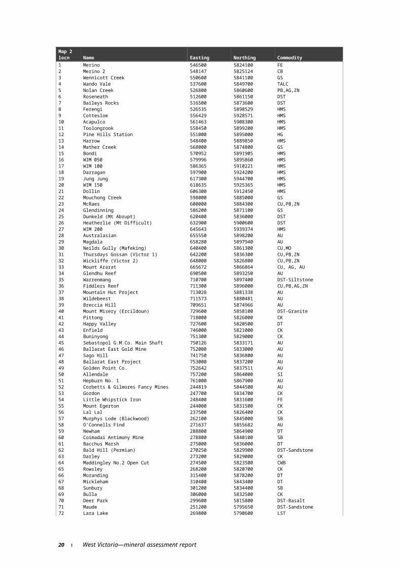
Table 2 Main mineral occurrences, old mines and deposits
West Victoria—mineral assessment report 15
Map 2 locn Name Easting Northing Commodity1 Merino 546500 5824100 FE2 Merino 2 548147 5825124 CB3 Wennicott Creek 550600 5841100 GS4 Wando Vale 537600 5849700 TALC5 Nolan Creek 526800 5860600 PB,AG,ZN6 Roseneath 512600 5861150 DST7 Baileys Rocks 516500 5873600 DST8 Ferengi 526535 5898529 HMS9 Cottesloe 556429 5928571 HMS10 Acapulco 561463 5908300 HMS11 Toolongrook 558450 5899200 HMS12 Pine Hills Station 551000 5895000 HG13 Harrow 548400 5889850 HMS14 Mather Creek 568000 5874800 GS15 Bondi 570952 5891905 HMS16 WIM 050 579996 5895860 HMS17 WIM 100 586365 5910221 HMS18 Darragan 597900 5924200 HMS19 Jung Jung 617300 5944700 HMS20 WIM 150 618635 5925365 HMS21 Dollin 606300 5912450 HMS22 Mouchong Creek 598000 5885000 GS23 McRaes 600000 5884300 CU,PB,ZN24 Glendinning 586200 5871100 GS25 Dunkeld (Mt Abrupt) 620400 5836000 DST26 Heatherlie (Mt Difficult) 632900 5900600 DST27 WIM 200 645643 5939374 HMS28 Australasian 655550 5898200 AU29 Magdala 658280 5897940 AU30 Neilds Gully (Mafeking) 640400 5861300 CU,MO31 Thursdays Gossan (Victor 1) 642200 5836300 CU,PB,ZN32 Wickliffe (Victor 2) 648000 5826800 CU,PB,ZN33 Mount Ararat 665672 5866864 CU, AG, AU34 Glendhu Reef 690500 5893250 AU35 Warrenmang 710700 5897400 DST-Siltstone36 Fiddlers Reef 711300 5896000 CU,PB,AG,ZN37 Mountain Hut Project 713028 5881338 AU38 Wildebeest 711573 5880481 AU39 Breccia Hill 709651 5874966 AU40 Mount Misery (Ercildoun) 729600 5858100 DST-Granite41 Pittong 718000 5826000 CK42 Happy Valley 727600 5820500 DT43 Enfield 746000 5821000 CK44 Buninyong 751300 5829000 CK45 Sebastopol G.M.Co. Main Shaft 750126 5833171 AU46 Ballarat East Gold Mine 752000 5833000 AU47 Sago Hill 741750 5836800 AU48 Ballarat East Project 753000 5837200 AU49 Golden Point Co. 752642 5837511 AU50 Allendale 757200 5864000 SI51 Hepburn No. 1 761000 5867900 AU52 Corbetts & Gilmores Fancy Mines 244819 5844500 AU53 Gordon 247700 5834700 CK54 Little Whipstick Iron 248400 5831600 FE55 Mount Egerton 244000 5831500 CK56 Lal Lal 237500 5826400 CK57 Murphys Lode (Blackwood) 262100 5845000 SB58 O’Connells Find 271637 5855682 AU59 Newham 288800 5864900 DT60 Coimadai Antimony Mine 278800 5840100 SB61 Bacchus Marsh 275000 5836000 DT62 Bald Hill (Permian) 270250 5829900 DST-Sandstone63 Darley 273200 5829000 CK64 Maddingley No.2 Open Cut 274500 5823500 CWB65 Rowsley 268200 5820700 CK66 Moranding 315400 5878200 DT67 Mickleham 310400 5843400 DT68 Sunbury 301200 5834400 SB69 Bulla 306000 5832500 CK70 Deer Park 299600 5815800 DST-Basalt71 Maude 251200 5795650 DST-Sandstone72 Lara Lake 269800 5790600 LST73 Batesford 262600 5778300 LST74 Barrabool (Ceres) 257300 5773300 DST-Sandstone75 Barrabool Hills 261600 5772100 DST-Sandstone76 Waurn Ponds 261050 5767200 DST-Limestone77 Point Henry 274000 5774000 SA78 Point Lonsdale 291700 5761900 LST79 Angahook 778000 5746000 CWB80 Anglesea 251958 5747078 CWB81 Lookout Hill 244000 5741800 DST-Sandstone82 Benwerrin 757200 5739400 CWB83 Wensleydale 759900 5752100 CWB
16 West Victoria—mineral assessment report

Map 2 locn Name Easting Northing Commodity84 Deans Marsh-Bambra 752500 5747500 CWB85 Swan Marsh 707400 5747000 PEAT86 Kawarren 726100 5738100 LST87 Gellibrand 719800 5730600 BENT88 Charleys Creek 720500 5727500 BENT89 Curdie 670650 5743700 LST90 North Paaratte 1 670280 5731028 GAS91 North Paaratte 2 671831 5731088 GAS92 Iona 1 675699 5728440 GAS93 Grumby 1 670125 5727362 GAS94 Wallaby Creek 1 665974 5729053 GAS95 Strathallan 640650 5744200 LST96 Cudgee 641350 5754800 LST97 Warrnambool 625600 5750900 LST98 Port Fairy 604750 5754200 DST-Basalt99 Tyrendarra 567800 5767600 LS100 Portland 541400 5756000 LST101 Heywood 549850 5778400 LST102 Greenwald 528200 5794800 BENT
Outside West region103 WIM 250 657605 5958028 HMS104 Avon Plains 672600 5954400 GYP105 Avon Plains (South) 672100 5950800 GYP106 Henrys Hill 718000 5901600 W107 Pearl-Croydon Reefs 737450 5888970 AU108 Lillicur 728700 5885200 DT109 Amphitheatre 715805 5885709 AU110 Belfast 713817 5880888 AU111 London 713859 5879096 AU112 Glengower 751900 5877300 DT113 Bosuns 765000 5877300 AU114 Sandon 235250 5881440 AU115 Coliban 272985 5870666 AU116 Malmsbury 270900 5881900 DST-Basalt117 Redesdale 281400 5899500 DT118 Heathcote 296042 5910429 MS119 Taits Mine 304000 5914500 SB120 Nagambie 348339 5925952 AU121 Mangalore Reef 340400 5908250 AU122 Cunninghams Antimony Lode (Tyakk) 332400 5881500 AU123 Apollo Mine 330940 5867610 AU124 Campbellfield 319226 5827697 CK
Table 3 Recorded past gold production from goldfieldsMap 2 Goldfield
GoldfieldOre
(tonnes)
Grade(g/t)
Gold(kg) Period Source
G1 Mather Creek – – – – Bush et al. (1995b)G2 Mouchong Creek – – – – MINAREA database, DNRE,
Victoria G3 Glenisla – – – – MINAREA database, DNRE,
VictoriaG4 Gap creek – – – – MINAREA database, DNRE,
VictoriaG5 Stony creek – – – – MINAREA database, DNRE,
VictoriaG6 Mafeking
Alluvial – – 775 1900–1912 Bush et al. (1995a)Primary – – 28 1900–1912 Bush et al. (1995a)
G7 StawellAlluvial – – 18 600 1853–
presentBush et al. (1995a)
Primary 556 000 – 71 300 1853–present
Bush et al. (1995a)
G8 Londonderry – – – – MINAREA database, DNRE, Victoria
G9 MoystonPrimary 104 300 – 2 356 1867–1910 Bush et al. (1995a)
G10, G11 AraratAlluvial – – 18 674 1854–1958 Bush et al. (1995a)Primary – – 242 1854–1958 Bush et al. (1995a)
G12 Landsborough – – – – Bush et al. (1995a)G13 Landsborough West – – – – MINAREA database, DNRE,
VictoriaG14 Glendhu – – – – Bush and others (1995a)G15 Barkly-Navarre1 – – – – King (1978)
West Victoria—mineral assessment report 17

Map 2 Goldfield
GoldfieldOre
(tonnes)
Grade(g/t)
Gold(kg) Period Source
G15 Percydale – – – – MINAREA database, DNRE, Victoria
G15 Redbank-Moonambel – – – – King (1978)G16 Avoca–Homebush1
Alluvial – – 3 193 1854 – ? Bush et al. (1995a)G17 Amphitheatre1 – – – – MINAREA database, DNRE,
VictoriaG18 Beaufort (in the Amphitheatre goldfield)
Alluvial – – 7 812 1854–1918 Bush et al. (1995a)Primary 3 000 – 25 1854–1918 Bush et al. (1995a)
G19 Clunes1
Alluvial – – 2 170 1851–1894 Bush et al. (1995a)Primary – – 37 200 1851–1894 Bush et al. (1995a)
G20 CreswickAlluvial – – 46 500 1853 – ? Bush et al. (1995a)
G21 Ballarat East Alluvial – – 155 000 1851– ? Snowden Corporate Services
(1998)Primary – – 46 924 1851–1917 Finlay and Douglas (1992)
G21 Buninyong – – – – MINAREA database, DNRE, Victoria
G21 Little Bendigo/NerrinaPrimary – – 3 511 1850s–?
1899Finlay and Douglas (1992)
G22 Ballarat West Alluvial – – 62 000 1860s–1917 Snowden Corporate Services
(1998)Primary – – 25 825 1854–1918 Finlay and Douglas (1992)
G23, G24 ScarsdalePrimary – – 5 335 1888–1916 Finlay and Douglas (1992)
G23, G24 Haddon Goldfield/Scarsdale/ Smythesdale
MINAREA database, DNRE, Victoria
G25, G26 Linton Goldfield-Happy Valley/Snake Valley
– – – – MINAREA database, DNRE, Victoria
G27 BerringaPrimary – 8 11 195 1850s–1917 Finlay and Douglas (1992)
G28 GlenfinePrimary – – 1 359 1898–1908 Finlay and Douglas (1992)
G28 Pitfield Plains – – – – MINAREA database, DNRE, Victoria
G29 Rokewood Junction-Illabarook
– – – – MINAREA database, DNRE, Victoria
G30 Rokewood-Corindhap – – – – MINAREA database, DNRE, Victoria
G31 Enfield – – – – MINAREA database, DNRE, Victoria
G32 Daylesford1 – – – – Ramsay and William (1988)G33 Blackwood-Trentham – – – – Ramsay and William (1988)G34 Koorweinguboora – – – – MINAREA database, DNRE,
VictoriaG35 Blakeville – – – – MINAREA database, DNRE,
VictoriaG36 Bullengarook – – – – MINAREA database, DNRE,
VictoriaG37 Mangalore1 – – – – MINAREA database, DNRE,
VictoriaG38 Mount Piper – – – – O’Shea et al. (1992)G39 Kilmore – – – – O’Shea et al. (1992)G40 Sunday Creek1 – – – – O’Shea et al. (1992)G41 Donnybrook – – – – O’Shea et al. (1992)G42 Sunbury – – – – O’Shea et al. (1992)G43 Gordon
Alluvial and primary – – 4 600 – Bradford (1903), cited in Roberts (1984)
G44 Mount EgertonAlluvial and primary – – 22 400 – Bradford (1903), cited in
Roberts (1984)G45 Mount Doran MINAREA database, DNRE,
VictoriaG46 Ballark – – – – MINAREA database, DNRE,
VictoriaG47 Dolly’s Creek – – – – Roberts (1984)G48 Elaine – – – – MINAREA database, DNRE,
VictoriaG49 Morrisons – – – – MINAREA database, DNRE,
VictoriaG50 Steiglitz – – – – MINAREA database, DNRE,
VictoriaG51 Wangerrip – – – – MINAREA database, DNRE,
Victoria
18 West Victoria—mineral assessment report

Map 2 Goldfield
GoldfieldOre
(tonnes)
Grade(g/t)
Gold(kg) Period Source
G52 Rostron Diggings2 – – – – MINAREA database, DNRE, Victoria
G53 Rathscar2
Primary 1 670 16 – Maher (1996)G54, G56 Amherst-Talbot/Bung
Bong/ Dunolly-Inkerman/Havelock/ Majorca-Craigie/ Maryborough/Moliagul2
– – – – MINAREA database, DNRE, Victoria
G54, G56 Dunolly–Goldsborough3
Primary – – 3 100 1853 – ? Bush et al. (1995a)G54, G56 Maryborough3
Alluvial – – 3 100 1854 – ? Bush et al. (1995a)Primary – – 8 990 1854 – ? Bush et al. (1995a)
G55 Madam Hopkins Lead2 – – – – MINAREA database, DNRE, Victoria
G57 Campbelltown2 – – – – MINAREA database, DNRE, Victoria
G58 Guildford2 – – – – MINAREA database, DNRE, Victoria
G59 Castlemaine-Chewton/ Fryerstown/ Malmsbury/ Drummond/Goldsborough/ Taradale3
– – – – Ramsay and William (1988)
G60 Metcalfe2 – – – – MINAREA database, DNRE, Victoria
G61 Heathcote (gold and chromium) 2
– – – – Ramsay and William (1988)
G62 Costerfield2 – – – – MINAREA database, DNRE, Victoria
G63 Graytown2 – – – – MINAREA database, DNRE, Victoria
G64 Mitchellstown2 – – – – O’Shea et al. (1992)G65 Nagambie2 – – – – MINAREA database, DNRE,
VictoriaG66 Reedy Creek4 – – – – O’Shea et al. (1992)G67 Strath Creek2 – – – – O’Shea et al. (1992)G68 Whittlesea4 – – – – O’Shea et al. (1992)G69 Yarrambat2 – – – – MINAREA database, DNRE,
VictoriaG70 Chilwell2 – – – – MINAREA database, DNRE,
Victoria1 Partly within West region.2 Just outside West region.3 Just north of West region.4 Just east of West region.
West Victoria—mineral assessment report 19

Table 4 Resources in gold depositsMap 2 Goldfield locn/min. occur. locn.
GoldfieldMine/prospect
Material(tonnes)
Grade (g/t)
Gold (kg) As at Source
G7 Stawell9 Stawell
Proven and probable reserves 3 775 000 4.9 18 497 31/12/96 Mining Project Investors (1997)
Measured, indicated, inferred resources
2 416 000 6.6 15 945 31/12/96 Mining Project Investors (1997)
Surface stocks 260 000 2.3 598 31/12/96 Mining Project Investors (1997)
G17 Amphitheatre (partly within West region)89, 18, 91, 17
Avoca Gold Project (incl. Amphitheatre, Breccia Hill, Mountain Hut, Wildebeest)
562 000 bank cubic
metres
0.43 241.7 30/6/98 Sedimentary Holdings NL Annual Report 1998
G21, G20 Ballarat East and West/Berry Lead System/Buninyong/Creswick/Little Bendigo
48 Ballarat East ProjectInferred resource 3 300 000 9.5 31 350 30/7/98 Snowden Corporate
Services (1998)46 Ballarat East Gold Mine
Proven/probable reserves 306 000 1.03 315.2 31/12/96 William Resources (1996)
Resource 4 346 000 5.05 21 947 31/12/96 William Resources (1996)
G54, G56 Maryborough (just outside West region)107 Pearl–Croydon Reefs
Indicated resource 656 000 2.67 1 751.5 30/7/98 Snowden Corporate Services (1998)
Inferred resource 378 000 2.31 873.2 30/7/98 Snowden Corporate Services (1998)
G57 Campbelltown (just outside West region) 113 Bosuns
Inferred 800 000 1.48 1 184 30/7/98 Snowden Corporate Services (1998)
The Stawell goldfield has a recorded production of almost 90 tonnes of alluvial and primary gold. Alluvial gold was discovered in the Stawell area in 1850 and a large number of shallow alluvial and deep lead deposits were worked. The Deep Lead was the richest in the area, yielding almost 3.1 kilograms of gold per cubic metre. Primary (hard rock) reef gold was found in 1856 on Big Hill (Bush et al. 1995a) and underground reef mining continued until 1923. Exploration and drilling of the area in the latter half of the 1970s led to the tunnelling of an exploration decline to test underground potential in 1980 of the Magdala lode. Further exploration around the nearby old Wonga open cut (mined in the 1860s) identified low grade gold ore near surface. Open cut mining at Wonga started in late 1983 and gold bullion was produced in mid-1984. After Wonga open cut mining finished in 1986 an underground mine was developed using a decline tunnel from the bottom of the pit and a second open pit (Davis) was mined from mid 1987 to early 1989.
Since 1980 underground gold production has come from the Wonga and Magdala mines. Production for the year to end December 1998 was 2.5 tonnes (MINMET 1999). Reprocessing of old tailings from around Stawell city was also completed in early 1989 (Stawell Gold Pty Ltd 1995). An open pit gold mine operation is proposed at Big Hill, near Stawell, but resource figures are not available (Buckley 1999).
In the Ballarat area, mining of rich shallow alluvial deposits at Clunes, Buninyong and Golden Point started in 1851 but it was not until 1852–53 that mining of spectacularly rich, shallow and then deep leads buried beneath alluvium and/or basalt commenced. The most productive deep leads were the Sebastapol leads (63 tonnes gold) in the Ballarat West goldfield mined from 1855 to 1872, and the Berry, Australasian and Hepburn leads (58 tonnes gold), between Creswick and Ullina, mined from the early 1870s to 1910 (Canavan 1983, cited in King 1985). Gold bearing gravel (or wash) in the deep leads was commonly up to one metre thick and 100 m wide with gold values of 10–20 grams/cubic metre (Whiting &
20 West Victoria—mineral assessment report
Bowen 1976, cited in King 1985). North of Creswick as the leads got deeper enormous quantities of water were pumped out to access the wash. The Charlotte Plains Company pumped 28 million litres of water per day for six years prior to mining then 22 million litres per day during mining (Hunter 1909, cited in King 1985). The Haddon-Linton-Smythesdale (29 tonnes gold), Snake Valley-Carngham (3.2 tonnes gold), Beaufort, Little Bendigo, and Maryborough goldfields were also significant deep lead gold producers (see Table 5) in the Ballarat region (King 1985, Finlay & Douglas 1992).
Table 5 Recorded past production from major deep leadsGoldfieldMine/prospect
Gold(kg)
Ballarat 62 200Berry 52 900Beaufort-Raglan 8 000Glenfine-Pitfield 5 600Cathcart, Ararat 5 100Homebush, Avoca 3 200Source: Whiting & Bowen 1988.
Gold bearing quartz veins were discovered beneath the deep leads, and in rock outcrop, and hard rock gold mining continued at Ballarat until 1917 (King 1985). Other significant hard rock gold past producers in the Ballarat region include the Berringa, Maryborough and Moyston goldfields (King 1985).
An estimated 155 tonnes of gold was recovered from surface alluvial workings in the Ballarat East goldfield from 1851 onwards and subsequent hard rock mining continued until 1917 with 37.2 tonnes produced from 14 significant mines. A medium to large inferred underground gold resource (Table 4) has recently been delineated below the historical underground workings at the Ballarat East Project, located on the edge of Ballarat city. Surface drilling, refurbishment of an old shaft with associated drives (tunnels), and tunnelling of a new decline (with exploration drives to provide underground drilling access) will enable better definition of the resource (Snowden Corporate Services 1998).
Open cut mining of a low grade resource at the Ballarat East gold mine, just south of the above Ballarat East Project, commenced in late 1996 but ceased in late 1997. A medium sized gold resource remains (Table 4) and the mine is currently being reevaluated with a view to reopening it (William Resources Inc 1996 Annual Report, Williams Resources Inc 1997 Quarterly Reports, Goldminco NL Annual Report 1998).
In the Ballarat West goldfield, immediately west of Ballarat, about 23.8 tonnes of gold was produced from quartz reefs and 62 tonnes from alluvial deep lead deposits from the 1860s to 1917. The deepest mine reached about 950 m below surface. Anomalous gold assay results were obtained during recent exploration from the Winters Line of Lode, the Albion No.9 mine and the Northern Star mine (Snowden Corporate Services 1998).
Alluvial gold was discovered in the Berringa goldfield, 35 km south-west of Ballarat, in 1864. Underground mining of quartz reefs occurred between 1865 and 1917 for total production of 293 000 ounces (9.1 tonnes) of gold. Underground mining from Birthday Tunnel, Kangaroo, Williams Fancy, Birthday and South Birthday took place from 1898 to 1917. Mining restarted at Kangaroo Reef in the 1930s and about 13 470 ounces (0.417 tonnes) of gold were recovered until 1952. In 1974, the Berringa mine was reopened by sinking a new shaft and a 29.5 tonne bulk ore sample yielding 9.25 ounces of gold was taken in 1979 (Snowden Corporate Services 1998).
The Ararat goldfield was discovered in 1854 at the rich Pinky Point location near Ararat. Alluvial gold accounted for over 98 per cent of the total recorded production in the field and
West Victoria—mineral assessment report 21

was mainly from deep lead deposits. Initial production was from alluvium along the present day drainage but after the discovery of the rich Canton lead in 1856 attention focused on the deep lead deposit mining (Bush et al. 1995a).
Base metalsSignificant copper mineralisation occurs at the Mt Ararat copper deposit, near Ararat. Exploration in the early 1970s identified a gossan and a small pyrite-chalcopyrite-sphalerite lode associated with previously known copper mineralisation. A small resource (Table 6) was delineated and is open at depth (Cochrane 1982 cited in Bush et al. 1995a).
Table 6 Other mineral resourcesMap 2 mineral occur. locn
Mine/quarry/deposit/ prospect
Material(tonnes) Grade
Containedcommodity Source
Base metals24 Mt Ararat
Inferred 1 000 000 2.7% Cu10g/t Ag0.6g/t Au
27 kt Cu10 000 kg Ag
0.6 kg Au
Cochrane (1982), cited in Bush et al. 1995a
Bentonite58 Greenwald
MeasuredIndicated
2 500 0003 300 000
--
--
McKenzie (1976), cited in Bush et al. (1995b)
73 GellibrandMeasuredIndicated
28-170 00057-340 000
* --
Bowen (1970), cited in McHaffie and Buckley (1995)
88 Charley’s Creek 57-341 000 - - Edwards et al. (1996)Diatomite
38 Happy Valley 10 000 - - King (1985)92 Lillicur 40 000 - - King (1985)
Quartz gravel47 Sago Hill 3 000 000 - - King (1985)
Kaolin53 Gordon - - 7 800 tonnes Roberts (1984)
Iron ore43 Lal Lal 750 000 48% iron 367 500
tonnes ironRoberts (1984)
Clay52 Darley 34 000 m3 - - Learmonth (1955), cited
in Roberts (1984)*Varies based on various economic criteria
Copper mineralisation is also associated with gold at the Glendhu Reef and Fiddlers Creek deposits. Old mine workings at the Nolan Creek (or Roseneath) silver-lead deposit, north of Casterton were reported to have produced gold, silver, lead and copper (Ferguson 1894, cited in Bush et al. 1995b).
Platinum group metalsMinor platinum group metal mineralisation is associated with gold mineralisation at the Glendhu Reef, west of Avoca (Weston 1992, cited in Bush et al. 1995a) and recorded at 36 other gold occurrences (VICMINE 1996).
TungstenA small deposit of wolframite occurs at Henry’s Hill, just north of the region, where coarse bladed wolframite occurs in quartz veins (McKenzie & Nott 1981, cited in Bush et al. 1995a).
22 West Victoria—mineral assessment report

MolybdenumThere is a small occurrence of molybdenum at Neild’s Gully, west of Ararat (King 1985).
TinAlluvial tin concentrations occur at several localities in the west of the region but the only reported historical workings were on Mather Creek in the early 1900s (Bush et al. 1995b).
BismuthBismuth mineralisation has been located at the Surprise Mine (just outside the region), Redbank (up to 0.24 per cent) and in gold mineralisation at the Glendhu Reef (Weston 1992, cited in Bush et al. 1995a). Just outside the region, traces of bismuth also occur in the Moonambel reefs (King 1978).
Iron oreThin lateritic ironstone deposits, of possible Tertiary age, occur at Lal Lal, Little Whipstick Forest and north of Ballark. Resources of 750 000 tonnes at about 48 per cent iron at Lal Lal (Krause 1880, cited in Roberts 1984) and iron was mined here in the late 1800s.
NickelLow-grade nickel in serpentinite occurs at The Hummocks, north of Casterton (Bush et al. 1995b).
AntimonyA small number of antimony occurrences are located in the Blackwood Goldfield and the Coimadai area with only the Coimadai Antimony mine having recorded substantial workings (Roberts 1984).
SilverSilver mineralisation closely associated with gold is found at Glendhu Reef (up to 1 800 grams/tonne), Fiddler’s Reef (up to 100 grams/tonne) and the Surprise Mine (up to 570 grams/tonne) (Jenkins 1901, cited in Bush et al. 1995a). Silver is associated with copper and gold mineralisation at Mt Ararat and native silver occurs as small specks and filaments at the Glendhu reef. At Fiddler’s Reef, silver possibly occurs in solid solution in galena or as fine disseminations of discrete silver sulphides (Cayley & McDonald, cited in Bush et al. 1995a).
MercuryStirling (1898), cited in Bush et al. 1995b, reported the occurrence of fine globules of mercury, highly permeated throughout a bright red clay on Pine Hills station, about 20 km east of Edenhope.
West Victoria—mineral assessment report 23

Non metals
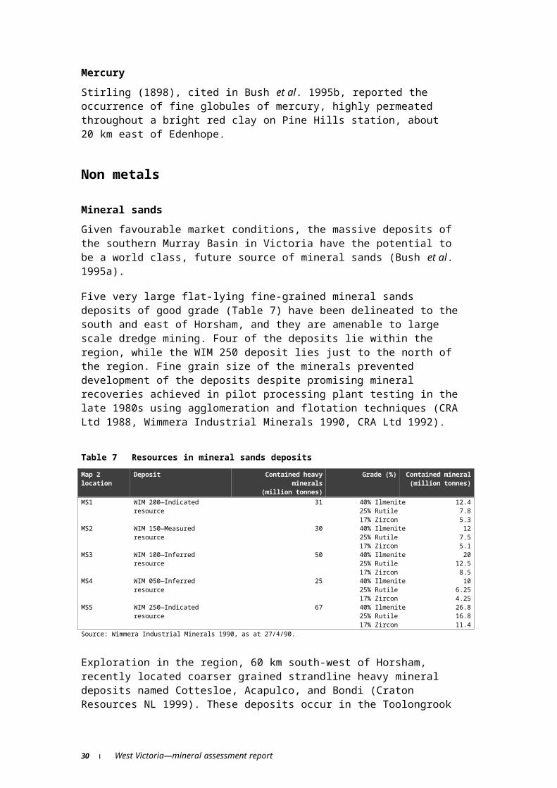
Mineral sandsGiven favourable market conditions, the massive deposits of the southern Murray Basin in Victoria have the potential to be a world class, future source of mineral sands (Bush et al. 1995a).
Five very large flat-lying fine-grained mineral sands deposits of good grade (Table 7) have been delineated to the south and east of Horsham, and they are amenable to large scale dredge mining. Four of the deposits lie within the region, while the WIM 250 deposit lies just to the north of the region. Fine grain size of the minerals prevented development of the deposits despite promising mineral recoveries achieved in pilot processing plant testing in the late 1980s using agglomeration and flotation techniques (CRA Ltd 1988, Wimmera Industrial Minerals 1990, CRA Ltd 1992).
Table 7 Resources in mineral sands depositsMap 2 location
Deposit Contained heavy minerals
(million tonnes)
Grade (%) Contained mineral (million
tonnes)MS1 WIM 200—Indicated
resource31 40% Ilmenite
25% Rutile17% Zircon
12.47.85.3
MS2 WIM 150—Measured resource
30 40% Ilmenite25% Rutile17% Zircon
127.55.1
MS3 WIM 100—Inferred resource 50 40% Ilmenite25% Rutile17% Zircon
2012.58.5
MS4 WIM 050—Inferred resource 25 40% Ilmenite25% Rutile17% Zircon
106.254.25
MS5 WIM 250—Indicated resource
67 40% Ilmenite25% Rutile17% Zircon
26.816.811.4
Source: Wimmera Industrial Minerals 1990, as at 27/4/90.
Exploration in the region, 60 km south-west of Horsham, recently located coarser grained strandline heavy mineral deposits named Cottesloe, Acapulco, and Bondi (Craton Resources NL 1999). These deposits occur in the Toolongrook strand system. Cross section widths of mineralised sands range from a few hundred to over a thousand metres with significant thicknesses of 10 to 20 m. Ilmenite is the dominant ore mineral with significant amounts of rutile and zircon.
Brown coalBrown coal occurs in the Otway and Murray Basins within the region. All production and economic resources are in the Tertiary age sedimentary sequences of the Otway Basin, but there are also significant resources of poorer quality coal in the Tertiary age sediments of the Murray Basin (Table 8).
24 West Victoria—mineral assessment report

Table 8 Brown coal resourcesMap 2Coalfield number/min. occur. locn. Mine/deposit
Browncoal(Mt) Source
C1 Bacchus Marsh-Altona Coalfield 15 110 Gloe and Holdgate (1991)- Bacchus Marsh 60 Kinhill (1982)53 Maddingley underground 4 500 Kinhill (1982)- Altona 4 600 Kinhill (1982)C2 Anglesea Coalfield includes: 450 Gloe et al.(1988)79 Angahook (measured resource) 182 Kinhill (1982)- Jan Juc (measured resource) 203 Kinhill (1982)77 incl: Anglesea Open Cut (straddles
Angahook/Jan Juc common boundary)
Reserves about 50 Australian Mines Handbook 1996–97
In situ resource (at 01/97) 118 Register of Australian Mining 1998–99
- Yan Yan Gurt (indicated resource) 5 Kinhill (1982)82 Benwerrin Coalfield 0.075 Gloe et al. (1988)84 Deans Marsh–Bambra Coalfield A few million tonnes Gloe et al. (1988)- Lal Lal Coalfield 2 Gloe et al. (1988)- Murray Basin 30 000 Preston (1987), cited in Gloe et al.
(1988)83 Wensleydale Coalfield A few million tonnes Gloe et al. (1988)
The Anglesea coalfield, south of Geelong, is the highest grade large deposit of brown coal in Victoria. After the Tertiary age brown coal seams were drilled in 1958, a small open cut mine commenced in 1960 and current production is about 1.1 million tonnes of coal per year. There are up to eight seams of more than three metres thickness, with the thickest (25–40 m) upper A1 seam providing the bulk of the coal mined. Economic coal also occurs in three to six seams lower in the sequence. The coal is used to generate power for the nearby Point Henry aluminium smelter (Gloe et al. 1988).
In the Altona-Bacchus Marsh coalfield, west of Melbourne, brown coal seams 1–40 m thick have been drilled in many boreholes between Newport and Bacchus Marsh. Sediments overlie the coal at the western end, but the rest is covered by basalt, which is locally up to 100 m thick (Gloe & Holdgate 1991). It is likely that an area of 50 000 hectares between Altona and Bacchus Marsh is coal bearing. From 1910 to 1919 the Altona coal seam was worked at an average thickness of 22 m (43 m maximum thickness) and recorded production was 33 780 tonnes. At Bacchus Marsh, coal was discovered in 1884 during construction of a railway viaduct and subsequent drilling intersected thick coal seams in the area. Underground mining started in 1929 at Parwan on a seam over 30 m thick and coal was mined on several levels but flooding later curtailed production. Subsequent mining occurred at the Lucifer, Star, Boxlea and Maddingley No 1 & 2 open cuts. These mines exploited coal seams over 30 m thick, except the 25 metre seam at Maddingley No 1 (Gloe et al. 1988).
Brown coal in the Lal Lal coalfield, south-east of Ballarat, was discovered in a shaft in 1857 and by 1891 a seam of over 45 m thick was being worked at 21 m depth. Further intermittent mining occurred between 1914 and the 1950s but ash content and composition were very variable. Total recorded production was about 57 500 tonnes of brown coal (Gloe et al. 1988).
In the Wensleydale coalfield, south of Winchelsea, open cut mining produced 17 000 tonnes of brown coal from 1923 to 1932 from a seam up to 45 m thick. Latest production was 2 945 200 tonnes of brown coal to 1959 (Gloe et al. 1988).
In the Otway ranges south of Deans Marsh, the Benwerrin coalfield contains a thin (2–3 metre) brown coal seam from which 7 000 tonnes of coal were produced from 1899 to 1903 and 4 620 tonnes from 1943 to 1948. This coal has the lowest moisture content and highest calorific value of any Victorian brown coal (Gloe et al. 1988). Production in the Deans
West Victoria—mineral assessment report 25

Marsh-Bambra coalfield, just north-east of Deans Marsh, from a nine metre brown coal seam amounted to 5 875 tonnes from 1901 to 1905 and 5 360 tonnes from 1950 to 1952 (Gloe et al. 1988).
Murray Basin brown coal is of Tertiary age and extensive seams reach thicknesses of 40 m in the Kerang-Cohuna and Torrumbarry-Warracknabeal areas but is of inferior quality with ash contents generally above 10 per cent (Gloe et al. 1988).
The Tertiary Dilwyn Formation in the far west of the region contains thin (60 per cent were less than one metre thick) uneconomic seams of Tertiary brown coal found in bores (Bush et al. 1995b).
Black coalBlack coal deposits are found within early Cretaceous non-marine sediments belonging to the basal sequences of the Eumeralla Formation in the far west of the region. Thin seams of black coal (less than one metre thick) are found outcropping at Merino and Dwyers Creek, (Bush et al. 1995b).
PeatA large peat deposit of 650 ha area and 10 m depth has been identified at Swan Marsh for use in soil conditioning, horticulture and fertiliser (McHaffie & Buckley 1995).
Oil shaleShales containing small amounts of oil have been found in the Dilwyn Formation, in the far west of the region. Analysis of 10 samples of dark brown and black muds and clays recorded yields of up to 14 litres/tonne with an average 5.7 litres/tonne (Meyer 1982b in Bush et al. 1995b).
Oil and gasThe first petroleum exploration well was drilled near Port Campbell in 1959 and some 25 wells followed. Commercial quantities of gas were discovered in the North Paaratte 1 well in 1979 and a small gas field supplies Warrnambool with natural gas (Tickell et al. 1992). In 1994, oil and gas was found in the Mylor 1 well, three kilometres north-west of Port Campbell, and also in three other wells in the area (Edwards et al. 1996). The Minerva gas field was discovered 12 km offshore of Port Campbell and is planned to come into production in the near future.
LimestoneTertiary age limestone suitable for cement making is extracted from two large quarries at Batesford and Waurn Ponds, near Geelong. The Batesford limestone has been used for cement making since 1890. It has also been used for lime production and building stone. Resources at Batesford and Waurn Ponds are probably sufficient for a quarry lives of over 50 years at each location (McHaffie & Buckley 1995).
The Tertiary age Port Campbell Limestone is quarried at Heywood, Moyne, Allansford, Timboon and Curdie Vale for road making and also for agricultural lime at Timboon. Quaternary age dune limestone is extracted for road making at Princetown (Tickell et al. 1992). Potential Tetriary age limestone resources also exist at Tyrendarra, Bald Hill,
26 West Victoria—mineral assessment report

Princetown-Warrnambool area, Kawarren-Gellibrand area, Aire, Aireys Inlet-Torquay area, in the Whalers Bluff Formation and the Comadai area (McHaffie & Buckley 1995).
Quaternary dune sands are quarried near Portland, Tyrendarra and Warrnambool for agricultural lime and road making (McHaffie & Buckley 1995). Quaternary age limestone was worked for agricultural lime in small pits near Lara (Spencer-Jones 1970, cited in Abele 1977), as were dune sands on the Nepean Peninsula (Keble 1950, cited in Abele 1977).
SilicaSilica sand of particular economic significance occurs in three main areas in the region:
the Tertiary units in the Otway Basin comprising the Wiridjil Gravel, Moomowroong Sand and the Dilwyn Formation, in an area northeast of Princetown;
the Tertiary Werribee Formation in the Bacchus Marsh area; and
the Malanganee Sand in the southwestern part of the region.
Pebble and cobble mine dumps from deep lead gold mining are significant future sources of lump silica. Dumps from the Berry Lead, near Allendale, are being worked and other suitable deposits may be identified, especially in the Avoca-Clunes-Maryborough-Creswick area (McHaffie & Buckley 1995). Quartz pebbles from deep lead mine tailings dumps in the Ballarat area are crushed and used to make aggregate for facing buildings, or further milled to a powder for use in ceramics, paints and abrasives (King 1985).
Construction materialsConstruction materials and industrial minerals have become increasingly important within the Melbourne Supply Area (MSA) for many uses including housing, buildings, roads, railways, ports, and bridges. Construction materials worth approximately $294 million were extracted in 1997–98 in Victoria under the Extractive Industries Development Act 1995 and nearly half of this can be attributed to the West region (Department of Natural Resources & Environment 1999).
A small part of the region in the east overlies about one third of the MSA and contains major resources and quarries of these commodities. Within the MSA and around Ballarat, ‘Extractive Industry Interest Areas’ have been identified (Figure 2) for construction materials by taking into account commodity resources, cultural, environmental and competing land use factors. These areas have been identified as possible sites for future extraction of construction materials. However, resources are not limited to these areas (Olshina & Jiricek 1996, 1997).
There are 334 active or intermittently active construction materials Work Authority Licence tenements in the region and some are grouped to form an area big enough to support a larger quarry. One hundred and thirteen tenements are for sand/gravel, 74 for basalt, 33 for silica, 29 for limestone, 28 for clay/clay shale and the rest are for volcanic tuff, sedimentary rocks, quartzite, soil, granite, hornfels, trachyte, slate and rhyodacite. A detailed list of these tenements is shown in Table 9. Work Authority tenements do not cover all of the many small pits and quarries throughout the region that local government authorities use to extract large volumes of stone, sand and gravel for road construction. About eight million tonnes of hard rock, and about 2.5 million tonnes of sand and gravel were extracted in 1994–95 for construction purposes in the North-West Region of the MSA, which overlaps the eastern end of the West RFA region (Olshina & Jiricek 1996).
West Victoria—mineral assessment report 27

AggregateBasalt of the early to mid-Tertiary Older Volcanics is mined from major quarries at Kilmore East and Bulla. Outcrop of these Volcanics occurs in deep valleys north-west of Melbourne, hill cappings (e.g. at Myrniong, Kilmore East and Broadford) and as sheets scattered elsewhere in the region (Olshina & Jiricek 1996). Newer Volcanics basalt quarries exist at Werribee, Deer Park, Melton, Point Wilson and near Ballarat. Scoria is mined at Mount Fraser, Mount Anakie, She Oak Hill and Rockbank (Olshina & Jiricek 1996). There are 29 scoria pits and 14 tuff pits operating between Portland and Colac (McHaffie & Buckley 1995). Scoria and tuff are used for local minor road construction in the central southern part of the region.
Cainozoic age basalt is quarried for road and other construction at Dunnstown, Miners Rest and Talbot. Scoria is mined at Mount Elephant as is hornfels and dyke rock at a large quarry near Stawell. Basalt is also the most widely used building stone for buildings and bridges in the Ballarat area. Heatherlie is one of the principal sources of cream coloured Grampians Group sandstone, which has been used to face many buildings in Melbourne. Local granite has been used for gutter stones and general building in Stawell, while good quality slate occurs at Percyvale. Road construction rock is taken from a large quarry south of Stawell (King 1985).
Just south-west of Bacchus Marsh good quality aggregate has been obtained from dense, hard basalt over 20 m thick. The Newer Volcanics and Pentland Hills Volcanics in the Bacchus Marsh area have provided low quality weathered basalt aggregate in the past. A scoria pit at Mount Darriwil contains friable red scoria with clayey ash suitable for road making and drilling has indicated resources of 1.3 million tonnes of scoria are adjacent to the north (Roberts 1984).
TABLE 9 ACTIVE CONSTRUCTION MATERIALS QUARRIES
28 West Victoria—mineral assessment report

Map 2 Locn
Name Commodity
1 Sand/Gravel2 Sand/Gravel3 Sand/Gravel4 Quartzite5 Sedimentary6 Hornfels7 Stawell Clay/
Clayshale8 Sand/Gravel9 Sand/Gravel10 Sand/Gravel11 Sand/Gravel12 Sand/Gravel13 Clay/
Clayshale14 Sand/Gravel15 Sand/Gravel16 Sand/Gravel17 Basalt18 Granite19 Sand/Gravel20 Sand/Gravel21 Sand/Gravel22 Trachyte23 Sand/Gravel24 Hamilton Rhyodacite25 Sedimentary26 Clay/
Clayshale27 Scoria28 Basalt29 Scoria30 Sand/Gravel31 Sand/Gravel32 Sand/Gravel33 Sand/Gravel34 Limestone35 Sand/Gravel36 Sand/Gravel37 Limestone38 Sand/Gravel39 Sand/Gravel40 Sand/Gravel41 Sand/Gravel42 Limestone43 Sand/Gravel44 Basalt45 Scoria46 Clay/
Clayshale47 Sand/Gravel48 Clay/
Clayshale48 Soil49 Portland Limestone50 Soil51 Sand/Gravel52 Portland Limestone53 Basalt54 Basalt55 Limestone56 Limestone57 Basalt58 Basalt59 Limestone
Map 2 Locn
Name Commodity
60 Volcanic Tuff61 Unknown62 Sand/Gravel63 Sand/Gravel64 Limestone65 Scoria66 Mt Bute Sand/Gravel67 Mt Elephant Scoria68 Scoria69 Scoria70 Volcanic Tuff70 Scoria71 Basalt72 Basalt73 Basalt74 Limestone74 Sand/Gravel75 Limestone76 Unknown77 Basalt78 Volcanic Tuff79 Scoria80 Scoria80 Volcanic Tuff81 Volcanic Tuff81 Scoria82 Volcanic Tuff83 Scoria84 Scoria85 Sand/Gravel86 Limestone87 Sand/Gravel88 Sedimentary89 Sand/Gravel90 Sedimentary91 Sedimentary92 Percydale
(slate)Sedimentary
93 Quartzite94 Granite95 Mt Misery Sand/Gravel96 Basalt97 Miners Rest Basalt98 Ballarat Clay/
Clayshale99 Sago Hill Sand/Gravel100 Sand/Gravel101 Basalt102 Bunninyong Clay/
Clayshale102 Bunninyong Sand/Gravel103 Enfield Clay/
Clayshale104 Sand/Gravel105 Basalt106 Sand/Gravel107 Quartzite108 Sand/Gravel109 Kilmore East Basalt110 Sedimentary111 Sand/Gravel112 Romsey Sedimentary113 Sand/Gravel114 Soil115 Bacchus Marsh Scoria
116 Darley Sand/Gravel117 Scoria118 Bulla Basalt119 Greenvale Granite120 Melton Basalt121 Rowsley Clay/
Clayshale122 Rowsley Clay/
Clayshale123 Melton Basalt 124 Sedimentary125 Deer Park Basalt126 Soil127 Werribee Basalt128 Clay/
Clayshale129 Basalt130 Quartzite130 Sand/Gravel131 Scoria132 Sand/Gravel133 Unknown134 Werribee Basalt135 Werribee Basalt136 Basalt137 Limestone138 Sand/Gravel139 Basalt140 Limestone141 Basalt142 Sedimentary143 Limestone144 Basalt145 Sand/Gravel146 Sand/Gravel146 Clay/
Clayshale147 Sand/Gravel148 Limestone149 Anglesea Sand/Gravel
Outside West region150 Pimpinio Sedimentary151 Oooen Sedimentary152 Sand/Gravel153 Sand/Gravel154 Talbot Basalt155 Slate156 Sand/Gravel157 Scoria158 Basalt160 Scoria161 Basalt162 Sedimentary163 Unknown164 Clay/
Clayshale165 Wollert Basalt166 Soil167 Hornfels168 Epping Basalt169 Clay/
Clayshale170 Clay/
Clayshale171 Sand/Gravel172 Basalt173 Sand/Gravel
West Victoria—mineral assessment report 29
Hornfels (rock hardened by heat and pressure), often found around the margins of igneous rock bodies, is quarried at Greenvale and Stawell. Granitic rocks are also extracted at Greenvale (McHaffie & Buckley 1995). Cambrian cherts and siliceous shales are used locally for road making in Romsey Shire (Olshina & Jiricek 1996).
Acid volcanics of the Rocklands Rhyolite outcrop in the central west of the region as flow banded lavas and ignimbrites and these are exploited by only one major rhyodacite rock quarry located northwest of Hamilton (McHaffie & Buckley 1995).
Near Portland there are some large operating limestone quarries and limestone deposits are quite widespread further to the north. Other sites of limestone are used intermittently for road-making and agricultural purposes.
A granite and hornfels quarry is located at Oaklands Junction, near Bulla and hornfels is quarried at Quarry Hill, just east of the region (Olshina & Jiricek 1996).
Sand and gravelThe bulk of the sand extracted in the eastern end of the region comes from the Tertiary age Werribee Formation north of Bacchus Marsh and Quaternary age deposits at the You Yangs. Major extraction of Tertiary sand and gravel, suitable for concrete and aggregate, up to 30 m thick takes place from a number of pits around Darley (Olshina & Jiricek 1996). Resources were estimated at 20 million to 30 million cubic metres with further potential resources to the west of Darley (Roberts 1984). Significant resources of granitic coarse sand and fine gravel occur south and east of the Pykes Creek Reservoir, while potential major sand and gravel resources are located between the Lal Lal Reservoir and the western end of the Parwan Valley (Roberts 1984). Sand and gravel for road construction have been quarried extensively in the Gherang area, near Anglesea (Tan 1971, cited in Abele 1977) and there is potential for major sand resources overlying brown coal at Anglesea (McHaffie & Buckley 1995).
Tertiary age quartz gravels, deep lead mine tailings, granitic sands, weathered Paleozoic age sediments and lateritic gravel are all used for road making. The Tertiary gravels are widespread in the Ballarat area, such as at Sago Hill quartz gravel quarry near Ballarat, Smythesdale, Chalk Hill Gravel Reserve, Leigh Grand Junction pit, Black Hill, Watsons Hill, Sandy Creek and Great Western. They provide the potential for long-term regional gravel resources. Granitic sand/gravel is quarried intermittently at Mount Misery, Mount Beckworth, Mount Bolton, Mount Emu, Nanima Hill, Mount Bute, on the Stawell granitoid pluton, and in the Langi Ghiran-Mount Cole area (Olshina & Jiricek 1996).
A number of Extractive Industry Work Authorities allowing the removal of rock, sand and gravel are current in the far west of the region (Figure 2, Table 9). Late Cainozoic flows of basalt and, to a lesser extent, scoria are widespread throughout the far west of the region. Ironstone or ‘buckshot’ gravel suitable for unsealed road sheeting is also widespread and is well developed in the extensive laterite horizon capping much of the Dundas and Merino Tablelands. The gravel is typically from 12 to 36 mm in size and is mixed with some clay or loam to form a solid surface on compaction. Gravel of this type is often extracted from shallow pit ‘scrapes’. The Merino iron deposit is a good example of this type of deposit and supplied much of the local gravel requirements in the early part of the century. The Quaternary Mallanganee Formation is widespread throughout much of the far west of the region and contains very large deposits of wind blown siliceous sand suitable for filling and concrete (Bush et al. 1995b). Sand extracted from this Formation west of Portland is exported to Hawaii for cement making (McHaffie & Buckley 1995).
30 West Victoria—mineral assessment report
ClayLarge Tertiary age secondary (or sedimentary) clay deposits are located in the Parwan Valley/Darley and Lal Lal areas. A pit west of Darley has refractory clay suitable for firebricks in two seams and resources of 34 000 m3 of clay were delineated (Learmonth 1955, cited in Roberts 1984). At Lal Lal a white to ligneous clay 15–21 m thick is suitable for firebricks and ceramics (Baragwanath 1948, Keble & Watson 1952, cited in Roberts 1984). A sequence of white to grey clay and sand about 30 m thick occurs south of Ballark (Roberts 1984).
Extensive clay deposits occur in the Ballarat, Bunninyong and Enfield areas and host a number of quarries (McHaffie & Buckley 1995). Residual clays from weathering of Paleozoic age sediments used to make bricks, pavers, tiles and earthenware pipes are extracted at Enfield, at a large quarry at Humbug Hill (near Creswick) and next to the brick works in Ballarat. In Stawell white clay is taken for brick making from a number of pits, and red clay from tailings dumps around the town (King 1985).
Important brick making operations are located at Campbellfield in the northern suburbs of Melbourne, just east of the region, where white firing clays are extracted. Red firing clays are readily available locally, but the resources of local white clays are diminishing. Increasingly, white clays are being sourced from deposits within the region at Enfield and Rowsley (Olshina & Jiricek 1996). At Rowsley, clay for low grade refractory bricks is extracted from pits in a clay layer 20 m thick while red and buff clay is extracted at Enfield for face bricks, roofing tiles and pottery. Red and buff plastic kaolinitic clays are also extracted at Napoleons (McHaffie & Buckley 1995).
Potential sources of high purity, low plasticity kaolin occur in thick, extensive kaolinised zones in granite in the Morchup-Pittong, Yendon-Lal Lal areas and near Ararat (Eversley Pluton). Deeply weathered intermediate composition dykes in the Egerton and Lal Lal area also offer potential. Secondary kaolinitic ball clay potential (McHaffie & Buckley 1995) exists in old lake/basin fills (e.g. Rowsley and Lal Lal Basins) and old river channels (e.g.. Campbellfield).
Dimension stoneBasalt has been the most widely used Victorian building stone since the 1930s and over the past 20 years it has come mainly from Port Fairy and Deer Park (Table 10). Small amounts of basalt have been used in buildings but its primary used is in paving. Victorian basalt production was 10 785 tonnes in 1995–96 (King & Weston 1997).
West Victoria—mineral assessment report 31

Table 10 Dimension stoneMap 2 locn(Fig 2 locn) Name Commodity Occurrence type Source- Bacchus Marsh Slate Quarry King and Weston (1997), p12719 Baileys Rocks Granite - VICMINE database51 Bald Hill Sandstone Minor VICMINE database- Ballarat, near Basalt Quarry VICMINE database- Ballarat, near Basalt Quarry VICMINE database- Barrabool Hills Sandstone Quarries VICMINE database81 Barrabool Hills Sandstone Quarries King and Weston (1997), p12773 Batesford Limestone Disused quarry King and Weston (1997), p126(88) Beech Forest Sandstone Quarry King and Weston (1997), p125- Bulla (Broadmeadows) Granite Minor VICMINE database82 Ceres Sandstone Minor VICMINE database- Coimadai Siltstone Minor VICMINE database55, (125) Deer Park Basalt Major quarry King and Weston (1997), p47, 125(18) Dergholm Granite Quarry King and Weston (1997), p125- Ercildoun, near Granite - VICMINE database- Ercildoun, near Granite - VICMINE database- Ercildoun, near Granite - VICMINE database26 Heatherlie (Grampians) Sandstone Major VICMINE database76 Lookout Hill Sandstone Minor VICMINE database56 Maude Sandstone Minor VICMINE database34, (25) Mount Abrupt (Dunkeld) Sandstone Quarry VICMINE database- Mount Beckworth Granite Occurrence King and Weston (1997), p126- Mount Bepcha Sandstone Quarry King and Weston (1997), p1257 Mount Difficult
(Heatherlie)Sandstone - VICMINE database
- Mount Emu Granite Occurrence King and Weston (1997), p12627 Mount Misery Granite Disused quarries King and Weston (1997), p126- Poolaijelo Granite Test pits King and Weston (1997), p126- Percydale Slate Quarry King and Weston (1997), p12762 Port Fairy Basalt Major quarry VICMINE database20 Roseneath Granite - VICMINE database- Selkirk Pit Slate - VICMINE database- Stawell Sandstone Quarries King and Weston (1997), p127- Trawool Granite Disused quarry King and Weston (1997), p12651 Upper Quarry (Bald Hill) Sandstone - VICMINE database- Wando Vale Granite Disused quarry King and Weston (1997), p12610, (92) Warrenmang Siltstone Quarry King and Weston (1997), p12580 Waurn Ponds Limestone Disused quarry King and Weston (1997), p126
Outside West region- Granite Hill Dyke Granite - VICMINE database- Leishman Hill Basalt Quarry VICMINE database96 Malmsbury Basalt Minor VICMINE database- Morang Granite - VICMINE database- Talbot Basalt Quarry VICMINE database
Small quantities of grey granite from small quarries at Bulla were used for building in Melbourne. Red granite from Dergholm has been used intermittently for Melbourne buildings, while pink and red granite also occur nearby at Baileys Rocks and Poolaijelo respectively. Pink granite at Mount Misery has not been quarried but its potential is rated highly, with testing planned by the industry (King & Weston 1997).
Barrabool Sandstone, Stawell Sandstone (Grampians Group) and Permian age sandstone from Bacchus Marsh-Lauriston are the most widely used sandstones in Victoria. The Stawell Sandstone is homogenous and extremely durable, but most of the other sandstones outside the Grampians have significant deterioration problems. Pink to brown sandstone Stawell Sandstone is quarried at Dunkeld and Mount Bepcha (King & Weston 1997). Sandstone in the Bacchus Marsh area has been extracted for local use as dimension stone from a number of small quarries and for several Melbourne buildings from the Bald Hill Upper Quarry, but it deteriorates badly. More durable sandstone is found in the Greendale and Little Whipstick Forest areas. Barrabool Hills sandstone has been used extensively in Geelong, Bendigo and Melbourne buildings but its weathering properties are extremely variable (Spencer-Jones 1970, in Abele 1977).
Batesford Limestone was used for dimension stone around 1930 after the Waurn Ponds Limestone dimension stone quarry was exhausted. Quarrying for cement has rendered both quarries inaccessible, but potential still exists for durable dimension stone quality limestone at Batesford (King & Weston 1997). Dunn (1912), cited in Bush et al. 1995, recorded the presence of a 3.7 metre wide belt of marble along Nolan Creek, in the far west of the region, but the suitability of the stone for dimension purposes is not known.
32 West Victoria—mineral assessment report

Slate is quarried at Percydale, in the north of the region, where production for paving is small. Disused slate quarries are located north-west of Coimadai and the slate was used for ornamental facing and paving (King & Weston 1997).
KaolinDeeply weathered, kaolinised, decomposed granite occurs in the Pittong and Gong Gong-Lal Lal areas. Medium sized kaolin extraction (see Table 11 for production rates) occurs at Lal Lal and Pittong for paper manufacture, ceramics and other uses (King 1985). The average thickness of the resource at Pittong is 36 m and the clay is extracted from a pit 15–20 m deep covering a 15 ha area (McHaffie & Buckley 1995).
Table 11 Recorded production of other mineral resourcesMap 2Locn Mine/quarry/prospect
Material (tonnes) Period Source
Kaolin43 Lal Lal 31 200 annually King (1985)37 Pittong 60 000 annually McHaffie and Buckley
(1995)Magnesite
118 Heathcote 4 020 1911–1953 McHaffie and Buckley (1995)
At Lal Lal, the deposit averages 20 m thick under up to five metres of ferruginous clay overburden and the kaolin clay pit covers about 1.5 ha with a defined resource area of 16 ha. The kaolin is exceptionally white and has a low plasticity. In addition, primary kaolin (98 per cent pure) is mined underground from a weathered feldspathic dyke one to two metres thick at Lal Lal for use in high quality porcelain and filler applications. Similar dykes in the area at Mount Egerton and Gordon have been mined underground in the past for high quality kaolin at 20–100 m depth. Resources at Gordon are estimated at 3 000 m3 (Roberts 1984).
High grade siliceous china and stoneware clays derived from weathered, kaolinised dykes occur at Stawell, Clunes, Snake Valley and south-east of Ballarat (King 1985).
Secondary (or transported) kaolinitc clays at Rowsley have been mined for 60 years and currently produce semi-ball clay for ceramics and firebricks. Large resources are available relative to current production, which is taken from a substantial pit (12 ha area and 20 m depth) and another smaller pit (McHaffie and Buckley 1995).
DolomiteThe Coimadai Dolomite has been worked for agricultural lime since the early part of the century until 1980s. Alkemades, Hjorths and Burnips are the main quarries of several located east of Coimadai (Roberts 1984).
Precious and semi-precious stonesThe Daylesford area is the most significant sapphire and zircon source in Victoria but there has been no commercial production (Birch & Henry 1997). Other locations are shown in Table 12.
West Victoria—mineral assessment report 33

Table 12 Precious and semi-precious stones sitesMap 2 locn. Name Commodity Source14 Mather Creek Diamond Stirling 1898, cited in Bush et al. 1995b22 Mouchong
CreekOpaline quartz King 1979, cited in Bush et al. 1995b
3 Wennicott Creek
Sapphire Rickards 1991, cited in Bush et al. 1995b
24 Glendinning Topaz, garnet, quartz crystals, ruby, amethyst
Stirling 1898, King 1979, cited in Bush et al. 1995b
The deep leads and modern drainages of the Ararat region have concentrated gems derived from the erosion of basalts and granites. Gems include bright blue to near black sapphires, emeralds and orange to reddish brown zircons derived from basalts and red garnets, colourless to pale blue topaz, and coloured varieties of quartz derived from granites (McHaffie & Buckley 1995, cited in Bush et al. 1995a). Garnet, topaz, amethyst, emerald, peridote, ruby, sapphire and zircon can be found in dumps from deep lead mining in the Ballarat and Creswick area (King 1985).
Topaz, rubies, garnets, quartz crystals and amethyst have been found in decomposed and lateritised conglomerates overlying Rocklands Rhyolite to the west of Glendinning homestead (Bush et al. 1995b).
Some small yellow diamonds, along with sapphires and rubies, were recovered from gold-bearing gravels of the Mathers Creek goldfield, in the far west of the region, in the late 1890s (Birch & Henry 1997).
Other locations of gemstones include Mouchong Creek (opaline quartz) and Wennicott Creek (King 1979, Rickards 1991 cited in Bush et al. 1995b).
TalcSeveral occurrences of talc in serpentinite have been reported in the Wando Vale area, north of Casterton (Bush et al. 1995b).
BentoniteBentonite production at the Greenwald deposit, south of Coleraine, has been intermittent and generally less than 1 000 tonnes per annum, with a total of 7 064 tonnes produced between 1979 and 1989. There has been no production in recent years. Drilling has outlined measured and indicated resources (Table 6) of bentonite at 10 per cent moisture content, and extensions of the resource are likely in adjacent areas (McKenzie 1976, cited in Bush et al. 1995b). The bentonite is of variable quality with the higher quality, grey/green bentonite convertible to the higher value, sodium-type bentonite (McHaffie & Buckley 1995, cited in Bush et al. 1995b).
At Gellibrand, measured and indicated resources ranges have been delineated (Table 6), but analysis shows high calcium and magnesium content. Sodium beneficiation would be required, so the deposits are currently uneconomic (Bowen & Darragh 1970, cited in McHaffie & Buckley 1995).
Low swelling, calcium rich bentonite occurs at Charley’s Creek where resources are between 57 000 and 341 000 tonnes, depending on quality specifications (Edwards et al. 1996).
Bentonite has been recorded in the Lower Cretaceous Otway (Merino) Group, south-west of Coleraine, in bentonitic shales beneath lateritic capping.
34 West Victoria—mineral assessment report

SaltMinor amounts of salt have been produced intermittently from seawater evaporation ponds at Lara and Point Henry, near Geelong (McHaffie & Buckley 1995).
Small and intermittent salt production has been recorded from a number of small natural salt lake deposits in the far west of the region. In winter these lakes are partially filled by rising groundwater, rich in sodium chloride and other salts, which are then precipitated in summer as the water evaporates. Salt is harvested both in its naturally occurring form directly from the lake bed, and from specially prepared crystallising areas in which salt from the lake, dissolved by winter rains, is recrystallised during spring and summer (Bush et al. 1995b).
DiatomiteDiatomite deposits have been worked at Moranding and Newham, each producing over 1 000 tonnes of diatomite. Smaller production has occurred at Mickleham and Allestrie. A small diatomite resource (Table 6) occurs at Happy Valley, near Linton and some production from it occurred from 1943–73.
Diatomaceous earth of fair quality was reported from the Lal Lal swamp to the north of the Lal Lal railway station (Baragwanath 1948, cited in Roberts 1984). Unworked deposits occur at Bacchus Marsh, Bunker’s Hill, Lancefield and Daylesford (Atkinson 1988).
Resources in deposits up to four metres thick (intercalated with basalts) at Lillicur, just north of the region, are the largest known high grade deposits in Victoria and have been intermittently worked since 1866 (King 1985). Over 30 000 tonnes of diatomite has been produced from Lillicur (Atkinson 1988). Surface-indicated resources are about 40 000 tonnes but several times this figure is possibly covered by basalt (McHaffie & Buckley 1995).
MagnesiteSecondary magnesite nodules up to 18 kilograms were reported from the river alluvium of Spring Creek, near Bacchus Marsh. Magnesite joint fillings are also found in the Pentland Hills Volcanics and Newer Volcanics in the Bacchus Marsh area (Roberts 1984).
West Victoria—mineral assessment report 35

Potential mineral and extractive resources
Mineral potential assessment methodologyA qualitative assessment of the potential resources of an area is an estimate of the likelihood of occurrence of mineral deposits which may be of sufficient size and grade to constitute a mineral resource. The term ‘mineral resource’ is restricted to material, the extraction of which is judged to be potentially viable in the next 25 years. Only the deposit types judged to be most likely to constitute significant resources in the region have been assessed in detail.
The mineral potential of the West region has been assessed by determining the types of mineral deposits likely to be found within the geological framework known or believed to exist there. The general methodology used was developed by the United States Geological Survey (USGS), and has been used successfully for mineral resource assessments of forest areas in North America and elsewhere. This approach identifies geological units (tracts) which could contain particular styles of mineralisation. A summary of the qualitative assessment methodology is described in publications by Marsh et al. (1984), Taylor and Steven (1983), and by Dewitt et al. (1986).
Min
eral
pot
entia
l dec
reas
ing
H/D
Highpotential
H/C
Highpotential
H/B
Highpotential
U/A
Unknownpotential
MD
Moderatepotential
M/C
Moderatepotential
M/B
Moderatepotential
L/D
Lowpotential
L/C
Lowpotential
L/B
LowpotentialN/D
Nopotential
D C B A(High) (Low)
Level of certainty
Figure 1 Relationship between levels of resource potential and levels of certainty
West Victoria—mineral assessment report 37

An assessment of a region’s potential mineral resources combines knowledge of its geology, geophysics, geochemistry, mineral deposits and occurrences with current theories of mineral deposit genesis and results of mineral exploration. The assessment uses available geoscientific data to determine the history of geologic processes and environments. Geologic environments judged to have characteristics known to be associated with specific types of mineral deposits are then identified. In particular, the assessment draws on regional and local characteristics of mineral deposit models to establish whether or not specific types of mineral deposits are likely to occur.
The mineral potential of an area—that is the likelihood of it having a particular type of mineral deposit—is ranked as ‘high’, ‘moderate’, ‘low’ or (where there is insufficient data) ‘unknown’, based on professional judgments of geoscientists involved in the assessment. To reflect the differing amounts of information available, the assessments of mineral potential are ranked from A-D according to levels of certainty, ‘A’ denoting the lowest level of certainty and ‘D’ the highest (Figure 2). The method is described in more detail in Appendix A.
Assessments similar to the procedure used in this report are commonly used by companies to select areas for exploration. It is important to note, however, that the assessment of potential resources is subject to the amount and the quality of data available to the assessors. As geological knowledge of an area is never complete, it is not possible to have a ‘final’ assessment of potential mineral resources at any given time. Mineral resource potential needs to be monitored and periodically reassessed to take account of new data, and advances in geological understanding including new mineral discoveries. Advances in mineral exploration and mining technologies and market changes may also change the mineral resource potential of an area.
Due to incomplete geological knowledge, the discovery rate in Australia is roughly of the order of one mine for one thousand exploration programs. Areas may be explored repeatedly before a mineral deposit is found. Increased geological knowledge and other factors can result in discoveries of world class deposits in both highly prospective areas (e.g. Kanowna Belle in Yilgarn, WA; Century in the Mount Isa Inlier, Qld) or areas not previously known to be of very high potential (e.g. Olympic Dam on Stuart Shelf, SA). Continued access to land for regulated exploration, is a transient process rather than a long-term land use, and is an important issue for both the minerals industry and for future mineral development.
Geological areas (or ‘tracts’) in the West region, judged to contain geological environments permissive of the formation of specific types of mineral deposits have been delineated and their mineral potential ranked (Figures 3 to 17).
Mineral and extractive potential in the West regionDescriptive mineral deposit models used for qualitative broadscale assessment of the West region are described in Appendix B. The favourable geological tracts for these types of mineralisation are indicated on Figures 3 to 17. The potential mineral resources are summarised in Table 13 and are described below as follows.
Heavy mineral sands
Strandline and WIM150 type heavy mineral deposits (Figure 3)Tract HMS1/H/C and Tract HMS2/M-H/C—This tract includes the southern rim of the Murray Basin that lies within the region. This part of the basin is occupied by the Loxton-Parilla sands that were deposited in strandlines as evident from aerial photographs, digital
38 West Victoria—mineral assessment report

terrain models and airborne radiometric images. Heavy mineral concentrations have been intersected in numerous exploration holes throughout the Loxton-Parilla sands. Known heavy mineral deposits in the region comprise the recently discovered strandline deposits of Cottesloe, Acapulco and Bondi as well as the large subeconomic and fine grained and flat lying deposits of WIM50, WIM100, WIM150, WIM200 and WIM250. The presence of the flat-lying fine-grained deposits is considered to be indicative of possible strandline type heavy mineral deposits that may be present in shallower strandline sands. The fine-grained flat lying WIM150 type of deposits have been located in the shallower part of the Murray Basin. These deposits are probably also present in the deeper parts of the basin but such deposits would be more costly to mine.
Table 13 Summary of potential mineral resources as at June 1999Deposit type Mineral potential Certaint
y levelArea of
tract (sq km)
% of region
covered by tract1
% of tract in exempt
Crown land2
Heavy mineral sands strandline High C 8 208.8 14.2 4.1Heavy mineral sands flat-lying, fine-grained (WIM type)
Moderate-high C 8 208.8 14.2 4.1
Slate belt gold High B-C 8 701.1 15.1 9.1Moderate-high B-C 4 622.7 8.0 1.3Moderate B-C 7 420.3 12.9 0.0Low-moderate B 9 792.2 17.0 12.4Low B 2 168.9 3.8 0.0Unknown A 4 342.2 7.5 0.2
Disseminated gold Moderate-high C 1 694.1 2.9 0.0Moderate B-C 12 099.1 21.0 9.9Low-moderate B 19 580.8 33.9 56.2Low B 2 364.8 4.1 0.0Unknown A 4 471.0 7.7 0.2
Alluvial gold High C-D 1 856.0 3.2 0.4Moderate-high B-C 14 995.1 26.0 5.0Low C 6 581.6 11.4 26.9Unknown A 17 803.8 30.8 26.3
Epithermal gold–silver Moderate B 2 107.4 3.7 0.9Low-moderate C 166.0 0.3 0.0Unknown A 1 130.6 2.0 2.5
Porphyry copper-gold Moderate-high B-C 182.8 0.3 1.0Moderate B 547.9 0.9 9.5Low-moderate B 613.0 1.1 1.2Unknown A 6 681.6 11.6 4.1
Volcanic associated massive sulphide base metals
High B-C 3 069.1 5.3 5.0Moderate-high B-C 210.8 0.4 0.7
Volcanic associated massive sulphide gold
High B-C 3 069.1 5.3 5.0Moderate-high B-C 210.8 0.4 0.7Unknown A 571.3 1.0 0.0
Tin veins Low B 4 786.7 8.3 0.9Unknown A 1 130.6 2.0 2.5
Tungsten–molybdenum veins Moderate C 6 728.1 11.7 9.6Unknown A 15.1 0.0 0.0
Brown coal High D 14.9 0.0 0.0Moderate C 1 012.7 1.8 1.4Low-moderate B 1 952.9 3.4 0.8
Black coal Moderate B 3 756.3 6.5 8.8Brown and black coal Unknown A 22 327.3 38.7 15.8Dimension stone High B 1 249.3 2.2 33.8
Moderate B 2 989.3 5.2 11.0Low B 438.8 0.8 0.5Unknown A 1 951.6 3.4 7.5
Limestone High B 52.4 0.1 0.0Moderate B-C 1 052.9 1.8 3.4Low C 735.5 1.3 0.2
Silica sand High C 155.2 0.3 1.2Moderate-high C 2 180.8 3.8 3.8Low C 86.3 0.1 0.0
Kaolin High C 512.1 0.9 0.0Low-moderate C 1 630.4 2.8 6.3
Construction materials High D 1 471.4 2.5 0.01 Total area of region is 57 722.25 sq km.2 Reserves (exempt Crown land—3110.9 sq km) in this column comprise National and State Parks Wilderness and Reference Areas.
West Victoria—mineral assessment report 39

The Murray Basin within the region has all of the assessment criteria for strandline heavy mineral deposits and the potential for strandline deposits is assessed as high with a certainty level of C. The potential for the WIM150 type of deposits is moderate-high with a certainty level of C.
Gold
Gold-Slate belt gold deposits (Figure 4)Tract Au 1a/H/B-C—The tract contains areas of the Stawell and Bendigo-Balmarat zones within north north-east to north-south trending (Bendigo-Ballarat zone) and north north-west trending (Stawell zone) mineralised corridors defined by prominent fault zones that are known to have played a role in controlling gold mineralisation. A few lineaments visible on the Digital Terrain Model appear to coincide with the structural corridors that are known to control mineralisation, and these combined with a few lineaments visible on aeromagnetic datasets, were used to extend the corridors outside areas of known mineralisation. The tract does not include granitoids because they are interpreted to be post mineralisation. The mineral potential of the tract is assessed to be high with a certainty level of C. A lower level of certainty (B) is assigned to areas extending under Murray-basin sediments.
Tract Au1b/M-H/B-C—The tract includes those parts of Stawell and Bendigo-Ballarat zones which fall outside the structural corridors (tract Au1a/H/B-C). The tract contains favourable host rocks similar to those in the tract Au1a/H/B-C but differs in lower vein density and less faulting. The tract is known to host several primary and alluvial gold occurrences.
The tract also includes Ordovician, Silurian and Devonian turbidites and volcanics (greenstones) in the Melbourne zone. However, the host turbidite lithologies in this zone are not as fine grained as in the Ballarat and Stawell regions, and contain a higher proportion of coarser clastic sediments (sandstones). This would favour the formation of extension (ladder) veins. However, the absence of major fault zones, lower level of brittle/ductile deformation and relatively fewer known occurrences of slatebelt and alluvial gold in the zone indicate that mineral potential (moderate to high of this zone within the RFA area is lower (moderate to high instead of high) than in Stawell and Bendigo-Ballarat zones. A lower level of certainty (B instead of C) is assigned to areas covered by sediments of the Murray Basin.
Tract Au1c/M/C—The tract includes Devonian granitoids of the Melbourne zone. Dating of mineralisation and plutonism in the Melbourne zone shows that these granitoids are broadly coeval with slate belt gold mineralisation. The potential for slate belt gold in the granitoids is assessed to be moderate with a certainty level of C.
The tract also includes extensions of tracts Au1a/H/B-C and Au1b/M-H/B-C that extend under basalts of the Newer Volcanics (Qvn). The basalts cover (maximum thickness less than 60 m) Cambrian, Ordovician, Silurian and Devonian turbidites and volcanics (greenstones) that are favourable hosts of slate belt mineralisation. Aeromagnetics also shows that some major fault zones that define structural corridors controlling spatial distribution of gold deposits in the Stawell and Bendigo-Ballarat zones also extend in this part of the tract. The tract also hosts a number of known occurrences of gold. As this part of the tract is covered by basalts and the presence of favourable rocks and structures is mostly interpreted from geophysical data, mineral potential of this part of the tract is assessed to be moderate with a certainty level of C.
Tract Au1d/L-M/C—The tract includes Cambrian (meta)sedimenatry rocks, volcanics and granitoids in the Glenelg zone. In the Glenelg zone these rocks underwent deformation and metamorpism related to the Late Cambrian to Early Ordovician Delamerian Orogeny, which is older than Benambran and Tabberabberan orogenies with which is associated the slate belt
40 West Victoria—mineral assessment report

mineralisation in the Lachlan Fold Belt part of the region. There are few known gold deposits in the tract area, however, the high metamorphic grade and more pervasive ductile deformation suggest that potential is not as high in the Lachlan Fold Belt part of the region. Hence, the tract is considered to have low to moderate potential with a certainty level of C.
Tract Au1e/L/B—This tract is defined by the extension of the tract Au1d/L-M/C under Tertiary basalts where the latter occur on thin Tertiary marine sediments less than 500 m in thickness. Basalt thickness is poorly defined and their magnetic character and underlying limestone and marl sediments makes it difficult to identify bedrock geology or structures. The potential of this tract is low, with a certainty level of B.
Tract Au1f/Un/A—This tract is defined by the extension of tracts Au1c/M/C, Au1d/L-M/C and Au1e/L/B in areas where the cover of Tertiary and Quaternary Basalts and Tertiary marine sediments is greater than 500 m. The thickness of the cover is poorly defined the extent of Palaeozoic bedrocks and structures under the cover is not very easy to define. Hence, mineral potential of this tract for slate belt gold deposits is unknown.
Disseminated gold deposits (Figure 5)Tract Au2a/M-H/C—The tract hosts turbidite lithologies in the Melbourne zone that are coarser grained than in the Ballarat-Bendigo and Stawell zones and contain a higher proportion of coarser clastic sediments (sandstones). Descriptions of structures and cleavage relationships indicate a higher level, more brittle structural environment in this tract. Deposits are likely to be controlled by more brittle geometries that include extension veins (ladder). The metamorphic grade indicates that these lithologies are preserved at a higher crustal level. There is a higher potential for brittle-fracture and fault-related dilational geometries, and therefore, the potential for disseminated gold deposits is moderate to high with a certainty level of C. Favourable sites may also include hornfels aureole zones of plutons and dykes, although the latter are not mapped or recognised on geophysical datasets used in this study.
Tract Au2b/M/B-C—The tract includes Stawell and Bendigo-Ballarat zones that have high potential for slate belt gold deposits. It contains prominent structural corridors and several slate belt and alluvial gold occurrences. However, the turbidite host rocks are relatively more fine grained and would have experienced less brittle structural deformation needed for the formation of disseminated deposits. Additionally the granitoids in the Stawell and Bendigo-Ballarat zones are younger than the main gold mineralising events and therefore, could not have acted as host for disseminated gold deposits. Hence the potential for disseminated gold in this part of the Stawell and the Bendigo-Ballarat zones is assessed to be moderate with a certainty level of C. Certainty level for areas outside structural corridors and in areas covered by the Murray Basin sediments is B.
The tract also includes granitoids in the Melbourne zone that have moderate potential for slate belt gold deposits. In Melbourne zone granitoids are interpreted to be of broadly the same age as mineralisation. Although granitoids are known to be a less favourable host for vein-style slate belt mineralisation, their physical and mechanical properties suggest that they would be better hosts for disseminated and stringer type of mineralisation. Hence mineral potential of granitoids in the Melbourne zone is assessed to be moderate with a certainty level of C.
Tract Au2c/L-M/B—The tract includes Cambrian and Ordovician turbidites and greenstones, their metamorphosed equivalents, and granitoids in the Glenelg zone. These rocks have low to moderate potential for slate belt gold deposits. The tract includes rocks of the Grampian Group of Silurian age. The Grampian group rocks are coarse grained and have been targeted by exploration companies for disseminated style gold deposits (Tom Dickson, personal communication, Department of Natural Resources and Environment). Mineral potential of the tract is assessed to be low to moderate with a certainty level of B.
West Victoria—mineral assessment report 41

This tract also includes extension of tracts Au2a/M-H/C and Au2b/M/B-C under basalts of the Newer Volcanics (Qvn). The basalts cover (maximum thickness less than 60 m) Cambrian, Ordovician, Silurian and Devonian turbidites and volcanics (greenstones) that are favourable hosts of slate belt mineralisation. Aeromagnetics also shows that some major fault zones that define structural corridors controlling spatial distribution of gold deposits in the Stawell and Bendigo-Ballarat zones also extend in this part of the tract. The tract also hosts a number of known occurrences of gold. As this part of the tract is covered by basalts and the presence of favourable rocks and structures is mostly interpreted from geophysical data, mineral potential of this part of the tract is assessed to be low to moderate with a certainty level of B.
Tract Au2d/L /B—This tract is an extension of the tract Au2d/L-M/B (Glenelg Zone) under Tertiary basalts where the latter occur on thin Tertiary marine sediments less than 500 m in thickness. Basalt thickness is poorly defined and their magnetic character and underlying limestone and marl sediments makes it difficult to identify bedrock geology or structures. The potential of this tract is low, with a certainty level of B.
Tract Au2e/Un /A—This tract is an extension of tracts Au2c/L-M/C, Au2d/L/B in areas where the cover of Tertiary and Quaternary Basalts and Tertiary marine sediments is greater than 500 m. The thickness of the cover is poorly defined the extent of Palaeozoic bedrocks and structures under the cover is difficult to define. Hence, mineral potential of this tract for slate belt gold deposits is unknown.
Alluvial gold deposits (Figure 6)Tract Au3a/H/C-D—This tract includes Quaternary and Tertiary fluvial sediments and Tertiary and Quaternary volcanics in the known alluvial goldfields of the Glenelg (very small areas not far from the Moyston Fault), Stawell, Bendigo-Ballarat and Melbourne zones. It also includes deep lead channels beneath Tertiary volcanics (with a buffer of one kilometre), and the distribution of present day drainage (with a buffer of 200 m), to account for unmapped Quaternary fluvial sediments.
The tract also includes a small part of coarse-grained sandstones of the Grampian Group where the Pohlner Conglomerate is known to contain concentrations of alluvial gold. As the tract is defined by the presence of known gold field its potential is assessed to be high, with a certainty level of D. For areas where the presence of fluvial Quaternary sediments is not mapped but inferred from the existence of present day drainage, certainty level of assessment is C.
Tract Au3b/M-H/B-C—This tract includes Quaternary and Tertiary fluvial sediments and Tertiary and Quaternary volcanics outside the known goldfields of the Ballarat, Stawell and Melbourne zones. The tract is extended in the south to a line, north of which the thickness of the Cainozoic cover is interpreted to be less than 500 m. In areas where basalts have been mapped in detail north of this line, the recorded thicknesses are generally less than 60 m. The tract also includes fluvial quaternary sediments of the Murray Basin.
Parts of the tract lying within Stawell, Ballarat-Bendigo, and Melbourne zones host several occurrences of primary and alluvial gold and have high and moderate to high potential for slate belt and disseminated gold deposits. The southern extensions of the tract under the cover of Tertiary Basalts have few known occurrences but potential source rocks of gold are interpreted to be present under the cover. Some channels or deep leads have been traced beneath basaltic cover. This part has moderate potential for slate belt and disseminated gold deposit. Hence mineral potential of alluvial and deep lead gold deposits in the tract is assessed to be moderate to high with a certainty level of C. Lower levels of certainty (B) apply for areas south of the Late Cretaceous boundary of Otway Basin.
42 West Victoria—mineral assessment report

Tract Au3c/L/C—The tract comprises parts of the Glenelg zone which is to the west of the Moyston Fault. It has low to moderate potential for slate belt and disseminated gold and relatively few sources of gold to form alluvial concentrations. The area to the west of Moyston fault is also known to have limited post-Cretaceous uplift. The tract also includes areas south of the Late Cretaceous boundary of Otway Basin and extends to the line, south of which the basement is overlain by Tertiary Basalt and by Cretaceous sediments of thickness greater than 500 m.
The tract has a low potential for alluvial and deep lead gold with a certainty level of C.
Tract Au3d/Un/A—This tract is an extension of the in the area where source rocks for forming alluvial and deep lead gold are covered by a thick Mesozoic and Cainozoic cover (more than 500 m). Hence, mineral potential of the tract is unknown.
Epithermal gold deposits (Figure 7)Tract Au4a/M/B—The tract includes The Early Devonian Rocklands Volcanics in the Glenelg region. Although regional stream sediment survey did not find anything of interest, recent investigations have detected quartz-sericite-kaolin-haematite alteration with raised tin values (Cayley & Taylor 1997). The Rocklands Volcanics host two gold occurrences (Glendinning and Frenchman’s Creek). The Rocklands Volcanics host a few gold occurrences and locally show alterations typical of epithermal systems.
The tract is assessed to have Moderate potential with a certainty level of B.
Tract Au4b/L-M/C—The tract includes Late Devonian volcanics of the Mount Macedon Complex in the Ballarat zone. Rhyodacite in the Mount Macedon Complex show alterations typical of epithermal hydrothermal system. No gold occurrences are reported in the complex although similar rocks elsewhere in Victoria are known to host gold occurrences.
The tract is assessed to have low to moderate potential with a certainty level of C.
Tract Au4c/Un /A—This tract is an extension of the tract Au4a/M/B in the area where the Mesozoic and Cainozoic cover over Rocklands Volcanics is expected to be more than 500 m. Hence, mineral potential of the tract is unknown.
Base metals
Copper-gold porphyry deposits (Figure 8)Tract CuAu/M-H/B—This tract includes the I-type, magnetic and oxidised tonalite of the Cambrian Wando River Granitoid. The calc-silicate contact aureoles of this intrusive are known to contain anomalous values of Cu, Mo, Bi, Ag, W. It also includes Devonian Mafeking Granite, a mafic, I-type, magnetic, oxidised granodiorite, that shows hydrothermal alterations and hosts gold and copper/molybdenum occurrences (Neilds Gully). Mineral potential of the tract is assessed to be moderate to high with a certainty level of B.
CuAu/M/B—The tract includes I-type Devonian, magnetic and oxidised granitoids of Green Hill, Long Reach Adamellite, Mackenzie River Granodiorite and Victoria Valley Granite. Mackenzie River granodiorite shows propylitic alteration (chlorite, calcite, epidote replacing hornblende) and shows anomalous values of base metals and molybdenum. Victoria Valley Granite also hosts quartz veins with traces of molybdenite. The tract is assessed to have a moderate potential with a certainty level of B.
CuAu/L-M/B—The tract includes Cambrian, Ordovician, and Devonian granitoids (Ararat Granite, Buangar Granite, Burrumbeet Granodiorite, Elmhorst Granite, Glenlogie
West Victoria—mineral assessment report 43

Granodiorite, Hickman Creek Granite, Hopkins River) that are I-type and magnetic. Hydrothermal alterations have not been reported and they do not host any known mineral occurrences of copper, gold and molybdenum. Mineral potential of the tract is hence assessed to be low to moderate with a certainty level of B.
CuAu/Un/A—This tract includes all the other Cambrian and Devonian magnetic granitoids for which mineral potential for porphyry copper type of deposits is unknown from the available information.
Volcanogenic massive sulphide deposits (VMS) (Figure 9)Tract BM/H/B-C—This tract consists of areas of Cambrian greenstones of the Mount Stavely Volcanic Complex and similar greenstones in the Dimboola and Miga subzones of the Glenelg Zone. These greenstone belts host several known base metal occurrences.
The Stavely andesites are geochemically similar to the Cambrian Mount Read Volcanics of western Tasmania, which host major volcanic massive sulphide base metal deposits (Crawford 1988). Exploration at Thurday Gossan (Victor1) and Wickliffe (Victor2) has shown the presence of mineralisation and alteration similar to those related with volcanogenic hydrothermal systems.
Hence mineral potential of Cambrian greenstone belt for volcanogenic massive sulphide deposit is assessed to be high with a certainty level of C (Lower level of certainty (B) applies for areas where the presence of greenstones is inferred primarily from aeromagnetic data).
Tract BM/M-H/B-C—The tract includes greenstone belts in the Heathcote zone and the Ozenkadnook subzone of the Glenelg Zone. The belts are similar, in composition and geotectonic setting, to those in the tract BM/H/C, although no significant occurrences of volcanic massive sulphides have been reported from them. Most greenstones in the Glenelg zone are covered by younger rocks and their presence and extent of distribution has been inferred from aeromagnetic data. Hence the mineral potential of the tract is assessed to be moderate to high with a certainty level of C (Certainty level of B for greenstones in the Murray Basin area where their presence is inferred only from aeromagnetic data).
Tract BM/Un /A—The tract includes extensions of greenstones in the tracts BM/H/C and BM/M-H/B under the cover (more than 500 m) of Mesozoic and Cainozoic rocks. Their presence has been inferred from aeromagnetic data. The potential of the tract is unknown.
Gold associated with volcanogenic massive sulphide mineralisationVolcanic hosted massive sulphide deposits are often associated with significant gold mineralisation. Many well known massive sulphide deposits in Tasmania such as Que River and Hellyer belong to this category.
Tract Au5a/H /B-C—This tract coincides with the tract BM/H/B-C for volcanic associated massive sulphide deposits. It contains several occurrences of base metals with gold values.
Mineral potential of gold associated with volcanogenic massive sulphides in this tract is thus assessed to be high with a certainty level of C (Lower level of certainty (B) applies for areas where the presence of greenstones is inferred primarily from aeromagnetic data).
Tract Au5b/M-H/B-C—The tract coincides with the tract BM/M-H/B-C which includes greenstones in the Glenelg zone. This tract has moderate to high potential for volcanic hosted massive sulphide deposits. The tract hosts only a few known occurrences of base metals. Hence the potential of the tract is assessed to be moderate to high with a certainty level of C
44 West Victoria—mineral assessment report

(Certainty level of B for greenstones in the Murray Basin area where their presence is inferred only from aeromagnetic data).
Tract Au5c/Un/A—The tract includes extensions of greenstones in the tracts BM/H/C and BM/M-H/B under the cover (more than 500 m) of Mesozoic and Cainozoic rocks. Their presence has been inferred from aeromagnetic data. The potential of the tract is unknown.
Tin vein deposits including tin greisens (Figure 10)Tract Sn1/L/B—Tract is based on the distribution of granitoids which are felsic, fractionated, non-magnetic, S-type or I-type, that may have associated tin occurrences. It includes the Dog Rock Granite, Trawalla Granite and Rocklands Rhyolite. The Rockland Rhyolite is included in the tract because these volcanics are similar to the rhyolite flows which host the Mexican tin deposits (‘Rhyolite-hosted tin deposits’ model 25h, Cox & Singer 1986). This tract includes a five kilometre buffer around these granitoids.
This tract is assessed as having low potential with certainty level B.
Tract Sn/Un /A—The tract is formed by the extension of the Rocklands Rhyolite under the cover (more than 500 m) of Mesozoic and Cainozoic rocks. Their presence has been inferred from aeromagnetic data. The potential of the tract is unknown.
Tungsten-Molybdenum vein deposits (Figure 11)Tract WMo1/M/C—Tract is based on the distribution of granitoids which are fractionated, moderately magnetic (moderately oxidised), S-type or I-type, that may have associated W-Mo vein deposits. This tract includes the Warrawidgee Granite; Ben Nevis Granite; Wando River Granite; Stawell Granodiorite and the Mafeking Tonalite. It also includes unnamed Upper Silurian-Lower Devonian I-type granitoids. The tract includes a five kilometre buffer zone around the above granitoids.
This tract is assessed as having moderate potential with certainty level C.
Tract WMo/Un/A—The tract is formed by the extension of the tract WMo/M/C under the cover (more than 500 m) of Mesozoic and Cainozoic rocks. Their presence has been inferred from aeromagnetic data. The potential of the tract is unknown.
Coal
Brown and black coal deposits (Figure 12)Tract Coal/H/D—The tract has been delineated by the extent of the economic brown coal at Anglesea. The Eastern View Formation hosts the Anglesea coalfield. The economic resources within this formation are assessed as high potential with a high certainty (D).
Tract Coal/M/B-C—This tract has been delineated by the Bacchus Marsh–Altona Basin sub-economic brown coalfield; the Eastern View Formation not already covered by the Anglesea brown coalfield; by the Lal Lal Basin, a coal bearing western continuation of the Ballan Graben, and the Werribee Formation not already covered by the Bacchus Marsh–Altona Basin brown coalfield.
The tract is assessed to have a moderate potential with a certainty level of C.
This tract also includes the Eumeralla Formation throughout the Otway Basin for black coal. The Eumeralla Formation hosts black coal but to date intersections of seams (in the west) have been too thin to be of economic interest. However, more detailed drilling, particularly over the ‘basement highs’ identified by the Glenelg Geophysical Survey (Slater 1995), may
West Victoria—mineral assessment report 45

identify thicker seams at shallower depths. The Eumeralla Formation is known both in the west and in the south of the region and has been assessed as moderate potential for black coal with a certainty of B.
Tract Coal/L-M/B—The tract has been delineated for brown coal by the Demons Bluff Formation and the Dilwyn Formation; by the Ballan Graben remaining outside the previous coal tracts and an area of brown coal drill hole intersections in the west of the region.
The tract is assessed having as low to moderate potential for brown coal with a certainty of B.
Tract Coal3/Un/A—The remainder of the Otway Basin is assessed of having an ‘Unknown’ potential for black and brown coal deposits. Due to extensive cover of the Otway Basin by either basalt flows or recent sediments and only limited drilling there is little geological information available to indicate the presence or absence of coal deposits, despite there being a possibility of favourable environments. The potential of this area is unknown.
Dimension stone deposits (Figure 13)Tract Dimst/H/B—This tract is defined by the Stawell Sandstone in the Grampians Group in the northeastern part of the region and includes dimension stone quarries at Mount Bepcha and Dunkeld.
The tract also includes the Beckworth, Ercildoun granites east of the Grampians that have been quarried at Mount Beckworth, Mount Misery and Mount Ercildoun. In the far west of the region, small granitic intrusives have been included in the tract, which have been quarried at Dergholm, Baileys rocks and Poolaijeilo.
The tract is assessed to have a high potential for dimension stone supplies with a certainty level of B.
Tract Dimst/M/B—This tract is defined by the rocks of the Eumeralla Formation, which is widespread throughout the region and occurs in the west and includes the Wandovale quarry, the formation is also extensive northeast of Cape Otway and in the east of the region around Barrabool Hills. The tract also includes the Bridgewater Formation in the coastal area of the region in the west and includes the Jan Juc Formation in the east.
The tract is assessed to have a moderate potential as source for dimension stone with certainty level of B.
Tract Dimst/L/B—This tract is delineated by the Port Campbell Limestone in the region north of Port Campbell. The tract also includes the Bulla Adamellite which includes the Bulla quarry. This tract has a low potential for the occurrence of suitable rock types for dimension stone with a certainty level of B.
Tract Dimst/Un/A—A range of other rock types may have potential for dimension stone but there is insufficient information to determine their potential. These rocks comprise different granitic intrusives throughout the region. The potential of these rocks for dimension stone is unknown.
Limestone deposits (Figure 14)Tract Lst/H/B—This tract is defined by the Tertiary limestones in the Jan Juc Formation in the Waurn Ponds area in the eastern part of the region. The formation also crops out to the south on the coast near the Torquay and the Jan Juc townships. The tract includes the Batesford Limestone about 12 km north of Waurn Ponds. The tract also includes the limestone being mined at Maude.
46 West Victoria—mineral assessment report
Other geological units in this tract include two areas with the Clifton Formation north of Cape Otway and about 40 km inland at Kawarren.
The tract includes outcrops of limestone and is considered to have a high potential for limestone deposits with a certainty level of B.
Tract Lst/M/B-C—This tract is defined by the Quaternary Port Campbell Limestone near Port Campbell. In the far south west of the region the tract is defined by the Bridgewater Formation and the Whalers Bluff Formation.
The tract is considered to have a moderate potential for limestone deposits with a certainty level of B to C.
Tract Lst/L/C—This tract is defined by the Gellibrand Marl northeast of Port Campbell and by the Maude Formation north of Waurn Ponds. The Gellibrand Marl is quite extensive but the source of limestone is limited to beds of shelly calcarenite. The limestone in the Maude Formation is confined to a relatively thin bed.
The tract is considered to have a low potential for limestone due to relatively thin source beds. The level of certainty is C.
Silica sand deposits (Figure 15)Tract Silsnd/H/C—This tract defines parts of the Tertiary Wiridjil Gravel, Moomowroong Sands and the Dilwyn Formation northeast of Princetown. The tract is considered to have a high potential for silica sand with a certainty level of C.
Tract Silsnd/M-H/C—This tract includes the Malanganese Sands in the southwestern part of the region. The tract is considered to have a moderate to high potential for silica sand deposits with a certainty level of C.
Tract Silsnd/L/C—This tract includes the Werribee Formation in the Bacchus Marsh area of the region. The tract is assessed to have a low potential for silica sand deposits with a certainty level of C.
Kaolin deposits (Figure 16)Tract Kao/H/C—This tract is delineated by the extent of potential primary kaolin areas developed over granites and feldspathic dykes including the known kaolin occurrences and workings at Pittong, Lal Lal and Gordon in the central part of the region. The tract also includes the secondary kaolin areas around Rowsley to the east of Lal Lal.
The tract is assessed to have a high potential for kaolin with a certainty level of C.
Tract Kao/L-M/B—This tract is defined by the extent of Cambrian and Devonian granites in the region where kaolin may have formed due to weathering processes. The tract was assessed to have a potential of low to moderate for kaolin deposits with a certainty level of B.
Construction materials (Figure 17)Tract Conmat/H/C: Higher value construction materials—This tract consists of construction materials Extractive Industry Interest Areas identified within the Melbourne Supply Area and around Ballarat by taking into account commodity resources, cultural, environmental and competing land use factors. However, resources are not limited to these areas (Olshina & Jiricek 1996, 1997). The tract is assessed to have a high potential for construction materials deposits with a certainty level of C.
West Victoria—mineral assessment report 47

The potential for economic deposits of higher value construction materials in the West region exists where suitable rock types, gravels, sands and clays occur within viable transport distances of population centres. The viable transport radius around a centre increases with population size because of the economies of scale of supplying a larger market and better road networks around larger centres. Deposits near good transport routes, such as the highways and other major roads, may also have viable access to markets in more distant population centres. Major population centres around which there would be a higher demand for construction materials include Melbourne, Geelong, Ballarat, Warrnambool, Portland, Colac, Stawell, Ararat and Hamilton.
Lower value construction materials—A specific tract has not been delineated because most of the rock types in the West region have potential for lower value construction materials in their fresh or weathered state; and soil, sand and gravel are widespread across the region. Suitable materials are mainly used for secondary road building and extraction of material usually occurs in close proximity to these roads. The materials include: (1) rippable sandstone, shale, schist, weathered granite and other rock, (2) sand and gravel, (3) soil and clay.
Summary of potential for metalliferous and industrial minerals, and construction materials in the West regionMineral potential tracts were identified for nine types of metalliferous mineral deposits, and five types of industrial mineral deposits, and for coal. ‘Interest’ areas for construction materials were considered as representing tracts with high potential for construction materials.
The tracts of mineral potential for various types of mineral deposits (Figures 3 to 17) have been combined and summarised in two different ways in Maps 3 and 4. Extraction sites for low value construction materials are often dictated by other land uses and by costs of transport. Mineral potential for construction materials is included only as specific designated ‘interest’ areas in combined mineral potential Maps 3 and 4. These interest areas were identified in previous reports by Olshina and Jiricek (1996) in the vicinity of Melbourne and by Olshina and Jiricek (1997) around Ballarat.
Map 3 is a composite of mineral potential tracts over the West region and shows the highest level of mineral potential assessed (in June 1999) for any particular area in the region. Where tracts for different types of deposits overlap, this area is assigned the highest potential level of all the overlapping tracts. In this approach, the tract having the highest mineral potential in any particular area obscures tracts of lower mineral potential.
In terms of mineral potential, the region can be subdivided from north to south into three broad areas.
In the northern part of the region the areas of high potential are dominated by high potential for heavy mineral sands in the Murray Basin in the north west (Figure 3). In the central north, the areas of high potential are for slatebelt gold, alluvial gold and smaller areas of high potential for volcanic associated base metals and gold, dimension stone, silica sands and kaolin (Figures 4, 6, 9 and 13). Smaller areas of high potential in the eastern part of the region are tracts of high potential for construction materials (designated ‘interest’ areas) (Figure 17).
48 West Victoria—mineral assessment report

The area of moderate to high potential in the central and north east portions of the region represents the potential for alluvial gold in the central part of the region and for alluvial gold, slatebelt gold and disseminated gold in the north east (Figures 4, 5 and 6).
In the southern part of the region there is an extensive area of unknown potential. This represents the area where Palaeozoic basement is overlain by more than 500 m of sediments of the Otway Basin. Tertiary and Quaternary volcanics overlie parts of the basin sediments. This area has an unknown potential for coal. There is also an unknown potential in the underlying basement rocks for slatebelt gold, disseminated gold, copper/gold porphyry, and for volcanic associated base metals and gold.
In the coastal zone of the region there are areas of high, moderate to high and high potential for coal, silica sand, limestone and dimension stone (Figures 12, 13, 14 and 15).
Map 3 is a composite of mineral potential tracts for different types of mineral deposits that do not have equal economic values. For example, a tract with moderate to high potential for slate belt gold may be considered to have a higher economic value than a tract with moderate to high potential for dimension stone.
The mineral potential tracts (Figures 3 to 17) are superimposed on Map 4 to highlight areas with overlapping tracts. This presentation takes account of the diversity of mineral resource potential as well as the level of potential. This was done by allocating standard scores according to a subjective ranking of levels of mineral potential as follows: high potential (18), moderate/high (12), moderate (6), low/moderate (2), low (1), unknown potential (no score). In those areas where tracts overlap, the scores are added and this cumulative score is assigned to overlapping areas. For example where there is an overlap of high potential for slate belt gold (score 18), moderate to high potential for disseminated gold (score 12), moderate potential for limestone (score 6) and low potential for dimension stone (score 1), then this area will have a cumulative potential score of 37.
It should be understood that the areas with overlapping tracts highlighted by Map 4 emphasise the diversity of deposit types and their mineral potential, but these areas are not necessarily more prospective than a single tract of high potential, for example, slate-belt gold. As with Map 3, the relative economic potential of different deposit types has not been accounted for. The relative economic significance of the tracts for different types of mineral deposits, as perceived by mining companies, would be influenced by their perceptions of prospectivity, future market conditions, land access and other factors.
The area with the highest cumulative scores (50–109) in the region, lies along the north west trending belt of the Mount Stavely Volcanics in the central north portion of the region. This part of the region has high, and moderate to high potential for strandline and for flat-lying (WIM150) type of heavy mineral deposits. In addition there is moderate to high, and high potential in the underlying Palaeozoic basement for slatebelt gold, disseminated gold and volcanic associated base metals and gold in the Stavely Volcanics which have some similarities with the highly mineralised Mount Read Volcanics in Tasmania.
Other areas of elevated cumulative scores are in an arcuate belt in the south-western part of the region which has high, and moderate to high potential for strandline and WIM150 types of heavy mineral sand deposits and for silica sand. In the eastern part of the region, areas with higher cumulative scores are due to the combined high and moderate to high potential for construction materials in the interest areas together with various types of gold deposits and for some types of industrial mineral deposits.
West Victoria—mineral assessment report 49

Figure 3 Mineral potential tracts for heavy mineral sands
50 West Victoria—mineral assessment report

Figure 4 Mineral potential tracts for slate-belt gold deposits
West Victoria—mineral assessment report 51

Figure 5 Mineral potential tracts for disseminated gold deposits
52 West Victoria—mineral assessment report

Figure 6 Mineral potential tracts for alluvial gold, including deep-lead gold
West Victoria—mineral assessment report 53

Figure 7 Mineral potential tracts for epithermal deposits for gold and silver
54 West Victoria—mineral assessment report

Figure 8 Mineral potential tracts for porphyry copper-gold deposits
West Victoria—mineral assessment report 55

Figure 9 Mineral potential tracts for volcanic associated massive sulphide base metal deposits
56 West Victoria—mineral assessment report

Figure 10 Mineral potential tracts for tin vein deposits (including greisen tin deposits)
West Victoria—mineral assessment report 57
Figure 11 Mineral potential tracts for tungsten-molybdenum deposits
58 West Victoria—mineral assessment report

Figure 12 Mineral potential tracts for coal
West Victoria—mineral assessment report 59

Figure 13 Mineral potential tracts for dimension stone deposits
60 West Victoria—mineral assessment report

Figure 14 Mineral potential tracts for limestone deposits
West Victoria—mineral assessment report 61

Figure 15 Mineral potential tracts for silica sand deposits
62 West Victoria—mineral assessment report
Figure 16 Mineral potential tracts for kaolin deposits
West Victoria—mineral assessment report 63

Figure 17 Mineral potential tracts for construction materials
64 West Victoria—mineral assessment report

Part 2
Current exploration, mining and extraction activities and potential
economic value
Current exploration, mining and extraction activities and potential economic value
The potential economic value of the region’s mineral resources is affected by a number of factors including: mineral prospectivity; exploration costs; geological knowledge base and intensity of data over the region, timing and significance of discoveries; future metal prices and mining costs; and rules and regulations governing exploration and mining.
The mineral potential assessment provides an indication of areas of land, which are more likely to be most prospective for particular minerals. However, an assessment of the potential value of mineral resources in these areas is not possible without an estimate of the number and type of deposits likely to occur in a particular region. Therefore, it has not been possible to compare the ‘mineral’ value of particular areas of land that have been assessed as prospective for minerals with other land (whether prospective or not). These limitations, when combined with the dynamic information-gathering nature of exploration, have significant implications for land access arrangements for exploration and mining in these areas.
Current and historical exploration expenditures provide some indication of the potential value of the undiscovered mineral resources of the West region. This is because a decision to invest in exploration is based largely on a company’s perception of the mineral potential of an area, i.e. exploration expenditure will tend to be higher in areas of higher perceived mineral potential. However, given the uncertainty, different risk attitudes of companies and the difficulty of exploration, expenditures only provide an approximation of true prospectivity. Sometimes deposits are found in previously unprospective areas when new ideas or technology are applied where little previous exploration has occurred.
West Victoria—mineral assessment report 67

Exploration
Currently there are significant extractive operations for industrial minerals and construction materials as well as a few gold mines in the West region. Exploration expenditure totalled about $7.7 million in 1997–98. The major commodity target was gold and, to a lesser extent, heavy mineral sands, with minor interest also in coal and base metals and other minerals.
Exploration prior to 1965Alluvial gold was discovered at Clunes north of Ballarat and on Campbells Creek south of Castlemaine in mid 1851 and was followed almost immediately by a rush of diggers numbering up to 30 000 seeking their fortune The alluvial diggings and the subsequently discovered hard rock gold mines encompassed the now famous major gold mining centres of Bendigo, Castlemaine, Ballarat, and Maldon, Creswick, Clunes, and Stawell, each of these centres ultimately producing more than 30 tonnes of gold.
The area also embraces the so-called Golden Triangle, made up of the area between Avoca, Castlemaine and Wedderburn and this general area covering about 10 000 square kilometres is known to be one of the richest and most important gold provinces of its type in the world.
After 1851, shallow alluvial mining boomed and reached a peak in about 1856, while quartz reef and hard rock mining grew rapidly from 1854 to 1864 and then stabilised during the 1860s. However, it was not until the early 1870s that the amount of gold produced from hard rock mines exceeded that from alluvial mining.
Mining of alluvial gold was extended when gold was found in deep leads and old river channels covered by relatively young basalt flows. In the 1890s and early 1900s, the introduction of low-cost alluvial dredges or floating large-scale processing plants on pontoons along many creeks and alluvial flats around Maryborough, Avoca, Clunes, and Castlemaine allowed much lower grade gold-bearing gravels to be worked. Dredge activity continued intermittently until 1957.
Exploration from 1965 to the presentAn Exploration Licence (EL) system was introduced by the Department of Mines and Industrial Development in the mid 1960s which allowed exploration of larger areas than would normally have been covered by a mining lease, search permit or a prospecting area licence. This greatly facilitated company-scale exploration for minerals and launched a new era of exploration and discovery.
Exploration in some portions of the area has been hampered by rough topography and thick vegetation, resulting in difficult access, and at least some exploration programs in the region may have been largely ineffective and significant mineral deposits may remain undetected. Hence, a number of quite prospective areas may remain to a large degree untested. Since 1965, over 600 ELs have been granted over the West region (Figure 18).
The exploration targets sought since 1965 have varied in accordance with relative metal prices, perceived prospectivity, relative recovery costs of metals and new exploration paradigms or mineral deposit models. Until 1967, the gold price was fixed at a relatively low
West Victoria—mineral assessment report 69

level compared with its post 1980 price, although base metal prices were relatively strong in the 1960s and 1970s. Gold prices did not begin to move rapidly upward until after 1972.
Commodities sought in the region include gold, silver, copper, lead, zinc, platinoids, tin, tungsten, molybdenum, heavy mineral sands, uranium, coal, diamond, phosphate and clay.
During the period 1965 to 1968, 22 ELs were granted, mostly for gold and phosphate. The first ELs taken out in the area were for alluvial and reef gold by WMC Resources Ltd around Ballarat and by Planet Resources Group NL around Castlemaine, Bendigo and the north Grampians in 1965, in all totalling nine ELs for gold and another for phosphate (Planet around Colac). The following year saw a further eight ELs taken out in vicinity of the south Grampians and elsewhere for phosphate in the Otway Basin by IMC Resources, Esso, and Continent Resources Pty Ltd respectively, and one EL for gold. In 1967, exploration activity began to wane with only three licences taken up (two for gold and one for phosphate) and the following year none.
The mining boom of the late 1960s coupled with strong copper and base metal prices in 1970, led to a peak of 11 ELs being granted in 1970. The main commodities being sought included gold, base metals, tungsten and phosphate.
There was a lull in exploration activity in the in the early to mid 1970s, with ELs granted averaging about five or six per year, mainly for alluvial or reef gold but to a lesser extent for base metals. In 1976, AO Australia was granted two ELs for heavy mineral sands in the Glenelg River area.
Exploration activity picked up again in 1978 with a renewed interest in energy minerals and gold as a result of rising prices in oil and gold. Most of the ELs for coal were situated over Otway Basin sediments in the southern half of the region, although CRA Ltd took out a number of ELs for coal over Murray Basin sediments in the north-west of the region. The main commodities being sought included diamonds and uranium but exploration for gold became increasingly dominant after 1978.
The number of ELs granted for gold increased sharply from an average of about four per year to nine in 1979 in response to a sharp increase in gold prices. There were a further nine ELs in 1979 and as the price of gold peaked in 1980, so the number of ELs for gold in the area went from nine in 1980 and 13 in 1981 to 18 in 1982 falling to four in 1983.
The total number of ELs peaked at 31 in 1981. In 1980, six ELs were granted to CRA Ltd for heavy mineral sands (and coal) in the Murray Basin around Horsham and in the Wimmera area. Several more heavy mineral sands ELs were granted in the following two years and then in 1983 CRA Ltd applied for a further nine.
The years 1984 to 1987 inclusive saw a general falling off of exploration interest with an average of around 14 licences granted per year, mainly for gold.
From early 1988 onward, a more sustained interest in gold exploration targets generally was evident. Unlike previous periods, almost all the gold targets sought were for hard-rock gold with only a small proportion of the ELs directed at alluvial gold potential. The 11 year period from 1988 to 1998, with its high interest in gold, was accompanied by renewed interest in base metals associated with interpreted and outcropping Cambrian mafic volcanics and intrusives. These occurred mainly in the Stavely, Ararat and Glenelg areas. From 1988 to 1995, an average of three ELs per year were granted for base metals (26 in all). In the light of the WIM150 discovery earlier in the decade (1984) and other technical exploration successes for heavy mineral sands in the following periods, strong interest also persisted for heavy
70 West Victoria—mineral assessment report
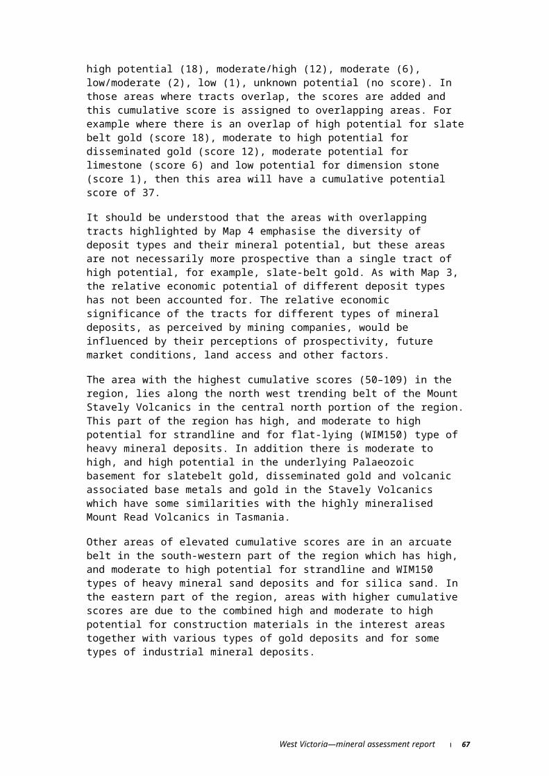
mineral sands on the southern edge of the Murray Basin during the last 11 years to the end of 1998, with 33 ELs granted, an average of three per year, within the region.
Figure 18 Exploration licences granted per year within the West Victoria RFA region, 1965–1998
At the time of this assessment, there were 106 active ELs in West region, distributed among a variety of companies. In 1997–98, total exploration expenditure in West region was about $13.7 million (Minerals and Petroleum Victoria 1997), being $7.7 million on ELs and $6 million on exploration under Mining Licences (Tables 14 and 15).
Table 14 Mineral exploration expenditure on exploration licences, West region, 1991–92 to 1997–98 (1997–98 dollars)
Year
West region exploration expenditure
($)
Victorian exploration expenditure MRD Act
($)
West region exploration expenditure as a percentage of
Victorian exploration expenditure
1991–92 871 868 12 630 933 6.91992–93 821 087 18 207 611 4.51993–94 1 093 606 22 382 803 4.81994–95 1 973 748 46 151 801 4.31995–96 7 449 928 36 311 376 20.51996–97 6 084 640 37 857 964 16.11997–98 7 686 896 36 900 000 20.8Totals 25 981 773 210 442 489 12.6Note: Figures include private mineral exploration expenditure on exploration and mining licences, as derived from Mineral and Petroleum Victoria records. Expenditure expressed in current dollars in each financial year has been converted to constant 1997–98 dollars using changes in the consumer price index.
West Victoria—mineral assessment report 71

Table 15 Expenditure on mining licences in the West region, 1991–92 to 1997–98 (1997–98 dollars)
Year
Mining licence exploration
expenditure ($)
Mining licence other expenditure
($)
Total expenditure mining licences
($)
Number ofmining licences1
1991–92 40 819 37 302 732 37 343 551 71992–93 5 689 978 23 656 142 29 346 120 131993–94 1 753 682 38 649 482 40 403 164 211994–95 16 704 199 32 762 493 49 466 691 371995–96 3 193 399 21 997 322 25 190 720 511996–97 4 227 382 27 907 762 32 135 145 591997–98 6 056 988 26 792 370 32 849 358 61Totals 37 666 447 209 068 303 246 734 7501Number of licence reported.Note: Figures derived from Mineral and Petroleum records. Expenditure expressed in current dollars in each financial year has been converted to constant 1997–98 dollars using changes in the consumer price index.
72 West Victoria—mineral assessment report

Mining and quarrying
There are 334 active or intermittently active construction materials Work Authority tenements in the region and some are grouped to form an area big enough to support a larger quarry. Work Authority Licence tenements do not cover the large number of small pits and quarries throughout the region that local government authorities use to extract large volumes of stone, sand and gravel for road construction. One hundred and thirteen tenements are for sand/gravel, 74 for basalt, 33 for scoria, 29 for limestone, 28 for clay/clay shale and the rest are for volcanic tuff, sedimentary rocks, quartzite, soil, granite, hornfels, trachyte, slate and rhyodacite.
Case study—slate belt gold and the Nagambie MineWhile the resource assessment found that the region is prospective for slate belt gold deposits, no assessment was made of the potential number or size of undiscovered slate belt gold deposits that may lie within the West region. However, the size of identified slate belt gold deposits in Victoria (which contain virtually all the gold mined in Victoria to date) provide an indication of the potential size of undiscovered slate belt gold deposits that may lie within the region.
Of the 163 Victorian slate belt gold deposits surveyed by Bowen (1974), 85 per cent had a total production of between 1 000 and 6 228 kilograms (Figure 19). The Nagambie mine, which lies outside the study area and recently closed after production of 4 185 kilograms (Register of Australian Mining), provides an example of a gold deposit within this range. Moreover, the Nagambie mine was found close to a small rural town and the history of the Nagambie operation provides a useful insight into the effect that such a mine (if found in the West region) could have on local towns and regional economies.
Figure 19 Production from slate belt gold deposits in Victoria, 1857–1974
The Nagambie gold deposit was discovered in 1985 by Frank Green of East Union Prospecting (Hughes 1990). Perseverance Corporation acquired the title over the area in 1987 and began a program of drilling to delineate a resource of 7 million tonnes at a 1.2 grams per tonne gold grade using a 0.4 grams per tonne cut off grade (Hughes 1990). Ore was mined
West Victoria—mineral assessment report 73
0
20
40
60
0-15
00
1501
-35
00
3501
-55
00
5501
-75
00
7501
-95
00
9501
-11
500
1150
1 -
1350
0
1350
1 -
1550
0
1550
1 -
1750
0
1550
1 -
1950
0
> 19
500
contained gold (kg)
num
ber
of d
epos
its

from July 1989 until June 1993. However, spraying of the heap leach to extract minor amounts of gold continued until March 1997. The mine generated gross revenues of around $74 million over the eight year mine life. Direct employment and gross revenue flows from the mine over its operating life are shown in Table 16.
Table 16 Gross revenue and direct employment, Nagambie Gold MineYear Gross revenue
($)Direct employment
(no.)1989 2 663 377 901990 25 129 676 1781991 18 095 995 1051992 12 370 433 1251993 11 155 253 341994 3 387 699 321995 1 251 428 211996 351 320 14Note: Real 1995–96 dollars.Source: J. Kelly, Perseverance Corporation Ltd, personal communication, February 1997.
Adding to the net economic benefits associated with the rents from production (not calculated in this report), the Nagambie mine also generated considerable indirect benefits which have been detailed by Sinclair (1991).
It was estimated that the mine resulted in the stimulation of an additional 73 jobs in Victoria and 7.5 jobs within the Nagambie region through indirect employment multiplier effects.
Perseverance spent $465 000 on local infrastructure, which included upgrading the electricity relay station and road improvements. These enabled a $1.5 million mushroom farming business to be established in the area that created eight new jobs in the region. These benefits are in addition to the multiplier effects described above.
The mine introduced a variety of workers into the region, increasing the diversity and level of skill in the Nagambie region’s occupational structure (31 of the mines’ employees were new residents to the area). In addition, the population growth in the region was around 4.5 per cent over the period 1989–91—reversing the previous trend of population decline in the area.
Mines like Nagambie may be temporary (three to ten years life in many cases) but it is apparent that these projects—in addition to bringing economic benefits to the local and wider economies during their operating life—also provide infrastructure and demographic benefits to smaller communities, which can have lasting effects.
74 West Victoria—mineral assessment report

Outlook for mineral production
Developments in markets for mineral and energy resources will affect development opportunities for the minerals industry in the West region. The outlook for gold, base metals, brown coal, and heavy mineral sands is reviewed in this section. Detailed market outlook assessments for gold, base metals, brown coal, and titanium minerals are given in Allen and Evans (1999), Haine and Berry (1999), Bush et al. (1999), and Anderson (1999).
GoldHistorical and projected real gold prices are shown in Figure 20. It can be seen that real gold prices have experienced a clear declining trend since 1980. This trend in price reflected important changes in the structure of the world gold market, which are expected to continue into the coming decade. Over this period, annual gold consumption (measured by net additions to stock holdings) declined, whilst annual non-investment gold consumption (mainly jewellery) increased. The growth in world consumption of non-investment gold has stemmed mainly from rising incomes in a number of developing regions (notably India and Asia). Although non-investment gold consumption has increased faster than world mine production (tending to increase prices), real prices have fallen due to sales of investment gold bars and coins (by governments and private investors).
The change in patterns of gold holding and consumption behaviour that underlie the easing real price is expected to continue into the medium term. However, it is envisaged that real price falls will be mitigated by three important market influences. First, the official sector faces strong incentives (collectively) to control the rate at which their extensive holdings of monetary gold are sold (and replaced with higher yielding alternative reserve assets). These incentives stem from the requirements of central banks to maintain international financial stability, and the prospect of faster disposal rates rapidly eroding the prices received and therefore, returns from such sales. In addition, recent currency crises may provide encouragement for official purchases in some countries.
Second, demand for non-investment gold use (primarily jewellery) is expected to continue growing strongly, in response to lower gold prices and higher incomes in developing economies which have strong cultural affinities for gold jewellery consumption, notwithstanding the shortterm economic disruption in Asia. Third, downward pressures on price will be moderated to the extent that lower prices bring about slower growth of world gold mine output, although it is clear that the gold mining industry is continuing to lower its costs.
Overall, the forecast for strong world demand for gold is expected to be met by expanding mine supply and from official and investment sources. While periodic market imbalances are likely, particularly some shorter term price volatility, the easing trend in real prices seen over the past two decades is expected to be maintained at least over the medium term.
Base metalsAsia (including Japan and China) accounted for 33 per cent of world base metals consumption in 1998, down from 36 per cent in 1997. The fall reflects the current economic downturn in parts of Asia. The share of developing Asian countries is expected to fall further in the short term. Over the medium to longer term, Asia’s share of world base metals
West Victoria—mineral assessment report 75

consumption is projected to increase, reflecting a resumption of relatively fast economic growth in these countries.
The developed market economies, which accounted for around 51 per cent of world base metals consumption in 1998, are assumed to continue to expand. Thus, demand for base metals in these countries is expected to continue to grow. Overall, world base metals consumption is projected to increase at around 2.0–2.5 per cent per year over the medium term before easing gradually over the longer term. This reflects expected trends in world economic growth and industrial production.
World mine supply of the three base metals is expected to rise in 1999 and refinery production of the three base metals is expected to keep pace with increases in mine production. A number of large, committed and planned development projects are expected to be the major contributors to the projected rise in base metals supply over the next few years. Substantial increases are projected up to the end of the year 2000 as low cost mines, primarily copper mines in Chile and zinc and lead mines in Australia, commence production. However, these rises are expected to be partially offset by the closure of some older, high cost, producers which are likely to become uneconomic with projected lower prices, particularly for copper.
Over the longer term, continuing technological developments can be expected to place downward pressure on costs. Thus, together with projected demand growth, the long-term downward trend in real prices experienced for each of the base metals is expected to continue. Price projections to 2004 are shown in Figure 20.
Figure 20 Base metals and gold prices (1998 US dollars)
Brown coalBrown coal is used almost exclusively for electricity generation by power generators in Victoria. The strong growth in energy consumption in the Victorian electricity generation sector over the last three or four years, apparent in Figure 21, is linked to the effects of recent
76 West Victoria—mineral assessment report
Gold
0400800
12001600
1980
1982
1984
1986
1988
1990
1992
1994
1996
1998
2000
2002
2004
US$/oz
Lead
0400800
120016002000
1980
1982
1984
1986
1988
1990
1992
1994
1996
1998
2000
2002
2004
US$/t
Copper
010002000300040005000
1980
1982
1984
1986
1988
1990
1992
1994
1996
1998
2000
2002
2004
US$/t
Zinc
0
1000
2000
3000
1980
1982
1984
1986
1988
1990
1992
1994
1996
1998
2000
2002
2004
US$/t
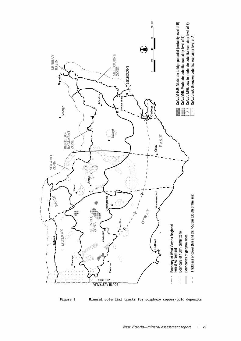
microeconomic reforms, including the construction of a national electricity market (Bush et al. 1999).
The share of brown coal as an energy source (excluding hydroelectricity) increased from 42.3 per cent to 47.9 per cent within the interconnected electricity market of New South Wales, Victoria and South Australia over the five years to 1997–98, making it the main fuel source for thermal generation in that market. In addition to underlying growth in electricity demand, greater use of brown coal largely reflects that brown coal generators are very low-cost producers of electricity.
Over the longer term, however, brown coal production and consumption may decline for two main reasons. First, improvements in the competitiveness of alternative fuels (particularly natural gas), as the national electricity market matures are expected to increase the usage of other fuels. Second, power generation from brown coal is likely to become more efficient in itself (and require less coal per unit of power output), as old plant is gradually replaced over time.
Source: Bush et al. (1999)
Figure 21 Energy consumption for electricity generation and production of brown coal in Victoria, 1980–81 to 1997–98
Titanium mineralsModest declines in prices for most titanium minerals are expected over the next two years. However, prices for most titanium minerals are projected to firm moderately over the period beyond to 2004.
Titanium dioxide pigmentPrices for titanium dioxide pigment are projected to weaken in the short term as consumption growth in Europe and the US eases. Supply constraints and renewed consumption growth in the longer term will support stronger prices to 2004.
West Victoria—mineral assessment report 77
20000
40000
60000
80000
1980
-81
1984
-85
1988
-89
1992
-93
1996
-97
kt 200
400
600
PJ
Brown coal production (LHS)
Energy consumption (RHS)
Titanium feedstocksTight supplies of sulfate and chloride grade ilmenite are forecast to lead to an increase in the average export unit ilmenite price over the short term. Average rutile prices are expected decline slightly in the shorter term as a result of weaker demand for natural rutile in titanium metal production. However, stronger demand for titanium metal in Asia beyond 2001 is expected to lead to a slight firming in rutile prices over the remainder of the outlook period. Real prices for synthetic rutile and leucoxene are projected to decline from current levels over the next few years, but then to show some recovery from 2002–03 in line with a firming pigment market.
ZirconIncreasing world supplies of zircon and reduced demand mean that the price received by Australian zircon producers is forecast to decline over the first few years of the outlook period. However, over the medium term, constrained world supplies are expected to reverse the declining price trend.
78 West Victoria—mineral assessment report

Legislation and land access
Access to land is an important issue for exploration and mining. The implications of the RFA for exploration and mining in the West region are not yet known.
It is important to note that no area can ever be classified as unproductive and no assessment of potential mineral resources can ever be considered ‘final’. New information, new concepts and better understanding of geological processes continually change the perceived prospectivity of a region and the availability, usefulness and implication of these can change over time. There are also dynamic aspects to market information that will affect perceptions of a region’s prospectivity, for example mineral prices and extraction costs may change substantially over time.
The nature of access for mineral exploration and mining has a large bearing on the level, and type of exploration and mining that occurs in a region. Transparent and well-defined access arrangements reduce uncertainty and facilitate exploration and mining activities. Access provisions of relevant legislation are outlined below.
More detailed discussions of resource access issues relating to exploration, mining and environment can be found in Industry Commission (1991), Cox et al. (1994) and Murray et al. (1995).
Legislation and regulation relevant to exploration, mining and extractivesIn Australia ownership of mineral resources and control of mineral exploration and development largely lies in the hands of the state and territory governments. The Commonwealth Government has control over mining and exploration activities outside three nautical miles offshore and over radioactive substances in the Northern Territory. It also exercises its constitutional powers to exert control over the way States and Territories access and use their mineral resources.
The principal legislation covering mining and exploration licences in Victoria is the Mineral Resources Development Act 1990 (MRDA) which was amended in 1993 and 1994. This Act is the responsibility of the Minister for Agriculture and Resources and is administered by the Victorian Department of Natural Resources and Environment. It sets out the rules for granting licences and attaining approval to start operations.
All exploration and mining activities are subject to a range of environmental requirements before, during and after the life of the project, including:
lodging a rehabilitation bond, before starting an exploration or mining program, to serve as a security should the company be unable to satisfy its rehabilitation liability;
exploration and mining is subject to standard conditions, and where appropriate supplementary site-specific conditions;
regular reporting of exploration activities;
mining and exploration only starting after a work plan has been approved and other approvals obtained; and
West Victoria—mineral assessment report 79
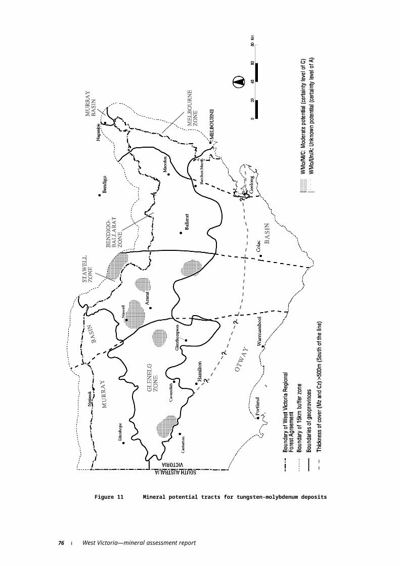
monitoring of environmental management activities by government officers.
Under the MRDA there are four main land types:
private land,
exempt Crown land (for example, National Parks, State Parks and Wilderness Areas),
restricted Crown land (for example, flora and fauna reserves and historic reserves), and
unrestricted Crown land (for example State forests).
No exploration or mining activities can be carried out on exempt Crown land, unless the licence was in place before the land became exempt. The approval of the Minister for Conservation and Environment is required before exploration or mining can be carried out on restricted Crown land. On unrestricted Crown land the Minister for Conservation and Environment’s consent is not required. However, the Minister must be consulted. Work can start on private land once the consent of the owner and occupier is obtained or compensation arrangements are made.
The principal legislation covering extractive industries in Victoria is the Extractive Industry Development Act 1996 (EIDA), which provides for granting work authorities for extractive operations. The four main land types under the EIDA are the same as those in the MRDA. Land owner consent is required before extractive activities can be undertaken on freehold land, and land manager consent for operations on Crown land.
Mining and exploration is currently excluded from five per cent of the land in West region (Table 17). The consent of the Minister for Conservation and Environment is required for exploration and mining to be carried out on restricted Crown land which is a further three per cent of the region.
Table 17 Land use categories as a proportion of total land area, West regionLand use category Area
(ha)Proportion of West region
(%)Exempt Crown land 311 117 5Restricted Crown land 183 863 3Unrestricted Crown land 487 240 9Freehold land 4 751 280 83Total 5 733 500 100Source: Data supplied by NRE, Victoria 1999.
Nature of exploration and miningMineral exploration is the assessment of the earth’s crust to determine if mineral deposits which can be commercially mined are present. Mining is the commercial extraction of mineral deposits from the earth’s crust. Whilst there is often a close relationship between exploration and mining, they are effectively two quite separate activities.
In order to examine the implications of alternative land access arrangements for exploration and mining, it is important to understand both the nature of exploration and its likely costs and benefits.
The potential benefits for a private firm from an exploration program derive from the economic returns that will accrue from the discovery of an economic deposit. Given that exploration is a high-risk activity (i.e., there is a small probability of any one venture being
80 West Victoria—mineral assessment report

successful), companies will approach exploration in a sequential and systematic fashion. This enables the decision to abandon or keep exploring in the area to be made in an efficient manner.
The cost and duration of exploration programs vary from company to company and across commodities. Clark (1996) suggested that the development of a typical major deposit (worldwide) involves a five to 20 year lead time. This estimate results from a typical three to ten years exploration program before the mine development phase.
Exploration is primarily an information gathering process so it is necessarily dynamic, and most regions can never be regarded as ‘completely explored’. Many recent Australian discoveries have occurred in known mineral provinces that have been the subject of exploration efforts for over 100 years. There are a number of reasons for continuing exploration in such areas. Technology and scientific understanding of geological processes continue to develop with time. These advances not only encourage exploration in areas where prospectivity was previously considered low, but also lower the costs and increase the efficiency of exploration (for example in highly prospective areas such as Kanowna Belle in Yilgarn, WA, and Century in the Mount Isa Inlier, Qld or in areas not previously known to be of very high potential e.g. Olympic Dam on Stuart Shelf, SA). Further, changing economic conditions (for example, changes in metal prices or the costs of extraction) affect the expected returns from exploration and can significantly affect the level and type of exploration.
The exploration process starts with assessments of very large regions and is then systematically narrowed down as the exploration target becomes better defined. The direct costs facing explorers increase as the target area becomes smaller and exploration methods become more intense. The environmental impact associated with exploration also increases as the area being explored becomes smaller and the exploration methods used become more invasive (for example, drilling), unless special steps are taken to reduce such impacts.
Exploration methods used in the West region include:
regional reconnaissance using remote sensing techniques such as satellite imagery, aerial photography and regional mapping. This exploration phase has little, if any, impact on the land. Activities may cover hundreds of square kilometres in order to identify areas of exploration interest. Geological mapping involves the search for and examination of rock outcrops and exposures in a licence area.
sampling in the field which usually involves taking small rock chip, soil or stream sediment samples. Samples are typically obtained by shovel, hand auger or hammer. More intensive sampling and localised mapping may also be carried out using trenches or small pits. All of the above may occur on a surveyed grid.
geophysics uses a range of techniques to look for anomalous physical properties indicating structures or mineralisation not visible at the surface. The geophysical properties being assessed include magnetism, electrical conductivity, resistivity or capacitance; gravity; natural radioactivity or seismic properties. Surveys can be airborne for regional surveys, or ground based. The impact of ground-based survey is generally very low, but will vary depending upon the extent of grid and track development required.
The above methods are broadscale in scope and provide information that builds up a picture of where mineralisation is most likely to occur. The most economical way to assess in detail the possible presence of an ore body is by drilling, which may be supplemented by bulk sampling:
West Victoria—mineral assessment report 81

drilling is usually carried out by truck mounted equipment to yield samples for mineralogical, chemical or metallurgical analysis. Drill holes are usually around 10 cm in diameter. Follow-up drilling may be required should earlier drilling show positive results. The impact of drilling on the environment depends on the openness of the vegetation and the topography. Usually drilling rigs can be manoeuvred around trees or the drill hole relocated to avoid disturbance of trees. A small level pad, typically around six metres square, may need to be constructed to accommodate the drilling rig.
bulk sampling gives another level of confidence in the drilling results particularly when gold is not evenly dispersed throughout the ore and coarsely grained.The ‘nugget-effect’ can give rise to misleading reserve assessments and large samples are needed to overcome it. Bulk samples are usually excavated from a site, typically less than five metres deep and 10 metres square.
Rehabilitation of areas disturbed by exploration is required in Victoria.
Compared with exploration, mining generally covers relatively small areas, involves greater disturbance to the land surface in the immediate area of the mine, and may leave changed landforms when mining is finished. Mining is generally seen as posing greater difficulties in terms of compatibility with other land uses.
Many potential environmental effects of mining activities can be eliminated or mitigated, though at a cost to the mining company. Relatively limited areas of land are disturbed by the operation of a mine. However, off-site impacts such as water pollution may represent a potential threat to the environment and must be carefully managed. This can be controlled by using techniques such as impoundment and evaporation of tailings, sedimentation, filtration and pH neutralisation. Rehabilitation of mine sites is mandatory in Victoria. Modern site rehabilitation, at the completion of operations, can restore many of the features of the landscape that existed before mining began, substantially, replacing and assisting the re-establishment of vegetation and reducing the potential for pollution from the former mine site.
All mining projects in Victoria require approval under local government planning controls or by preparation of an Environmental Effects Statement. Both processes provide for public input and independent scrutiny of projects. Detailed assessments of impacts on natural values are a routine aspect of mining approvals. Such assessments may include impacts on flora and fauna, water supply, catchment management and public safety.
82 West Victoria—mineral assessment report

References
The papers cited by Cox and Singer, 1986 are not included in the following list of references and can be located in Cox and Singer (1986).
Abele C. 1977. Explanatory notes on the Queenscliff 1:250,000 geological map. Geological Survey of Victoria Report No.1977/5.
Alcaston Mining NL in Greenchip Management Pty Ltd 1994. Re-creating history: the new gold rush—the Victorian Gold Book 1994
Allen, C. and Evans, M. 1999. ‘Gold’, in Outlook 99, Proceedings of the National Agricultural and Resources Outlook Conference, Canberra, 17–18 March, ABARE, Canberra.
Allen, R.L. and Barr, D.J. 1990. Benambra Copper-Zinc Deposits, in Hughes, F. E., ed. Geology of the Mineral Deposits of Australia and Papua New Guinea, Australasian Institute of Mining and Metallurgy: Melbourne, pp. 1311–1318.
Anderson, J. 1999. Titanium minerals: Outlook to 2003–04, Australian Commodities, vol.6, no 1, pp. 181–185
Atkinson P.L. 1988. Diatomite. In Douglas, J.G. and Ferguson, J.A. eds. Geology of Victoria, Geological Society of Australia: Melbourne, p.566.
Australian Mines Handbook 1996–97
Barton, C.M., Bolger, P.F., Holdgate, G.R., Thompson, B.R. and Webster, R.L. 1992. The Brown Coal Geology of the Gippsland Basin. Gippsland Basin Symposium. The Australasian Institute of Mining and Metallurgy: Melbourne.
Berger, B.R. and Bethke, P.M. (eds.) 1985. Geochemistry of epithermal systems: Reveiws in Economic Geology, v. 2.
Birch, W.D. and Henry, D.A. 1997. Gem minerals of Victoria. The Mineralogical Society of Victoria Special Publication No.4.
Blake, D.H. 1972. Regional and economic geology of the Herberton-Mount Garnet area, Herberton tinfield, north Queensland. Australian Bureau of Mineral Resources, Geology and Geophysics. Bulletin 124.
Bobis, R.E., Jaireth, S. and Morrison, G.W. 1996. The anatomy of Carboniferous epithermal ore shoot at Pajingo, Queensland: Setting, zoning, alterations, and fluid inclusions: Economic Geology, v. 90, pp. 1776–7198.
Bowen, B. 1974. An analysis of gold production data for Victorian Reef and Deep Lead Mines, Unpublished report 1974-12, Geological Survey of Victoria, Melbourne.
Brakel, A.T. 1989. Sydney Basin: Permian coal measures stratigraphy and sedimentation in Permian Coals of Eastern Australia. Bureau Of Mineral Resources Bulletin 231, pp. 9–41.
West Victoria—mineral assessment report 83
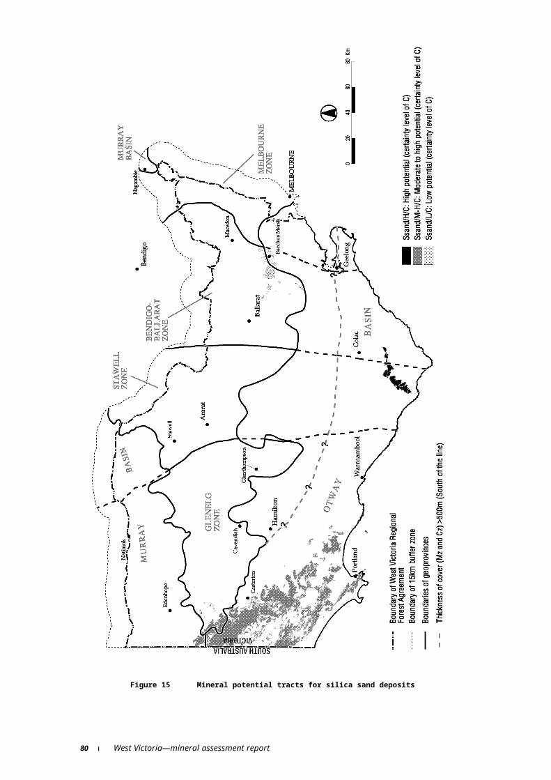
Brown, C.M. and Stephensen, A.E. 1991. Geology of the Murray Basin southeastern Australia. Bureau of Mineral Resources, Geology & Geophysics. Bulletin 235.
Buckley, R. 1999. Exploration in Victoria. Australasian Institute of Mining and Metallurgy Bulletin No.1, February 1999.
Bush, M.D., Cayley, R.A., Rooney, S., Slater, K. and Whitehead, M.L. 1995a. The geology and prospectivity of the southern margins of the Murray Basin. Geological Survey of Victoria. VIMP Report 4.
Bush, M.D., Cayley R.A. and Rooney, S. 1995b. The geology and prospectivity of the Glenelg Region, North West VIMP Area Victorian Initiative for Minerals and Petroleum Report 13. Department of Agriculture, Energy and Minerals.
Bush, S., Dickson, A., Beil, S., Harman, J. and Anderson, J. 1999. Australian Energy: market developments and projections to 2014–15, ABARE Research Report, 99.4 Canberra.
Carr, D.D. and Rooney, L.F. 1983. Limestone and dolomite, in ed., Lefond, S. J., Industrial Minerals and Rocks (5th Edition), American Institute of Mining, Metallurgical and Petroleum Engineers Inc, pp. 833–868.
Cayley R.A. and McDonald P.A. 1995. Beaufort 1:100,000 map geological report. Geological Survey of Victoria Report 104.
Chappell, B.W., English, P.M., King, P.L., White, A.J.R. and Wyborn, D. 1991: Granites and Related rocks of the Lachlan Fold Belt (1: 1 250 000 scale map), Bureau of Mineral Resources, Geology & Geophysics, Australia.
Clark, A.L. 1996. ‘Structural changes in global mineral supply—Australia’s changing role’, in Outlook 96, Proceedings of the National Agricultural and Resources Outlook Conference, Canberra, 6–8 February, vol. 3, Minerals and Energy, pp. 24–31, ABARE, Canberra.
Clark, G.H. 1990. Panguna Copper-Gold Deposit, in Hughes, F.E. ed. Geology of the Mineral Deposits of Australia and Papua New Guinea, Australasian Institute of Mining and Metallurgy: Melbourne, pp. 1807–1816.
Cooper, W. and Sawers J.D. 1990. Cape Flattery and Shelburne Bay silica sand deposits, in Hughes, F.E. ed. Geology of the Mineral Deposits of Australia and Papua New Guinea, The Australasian Institute of Mining and Metallurgy: Melbourne, pp 1665–1667.
Cox, A., Beil, S. and Waring, T. 1994. Exploration, mining and resources access policy, an economic perspective on environmental and native title issues. Paper presented at the 6th Minerals and Energy Forum, Beijing, 16 March.
Cox, D.P. and Singer, D.A. 1986. Mineral deposit models. United States Geological Survey Bulletin 1693.
Cox, S.F., Wall, V.J., Ethridge, M.A. and Potter, T.F. 1991. Deformational and metamorphic processes in the formation of mesothermal vein-hosted gold deposits—examples from the Lachlan Fold Belt, Victoria, Australia, Ore Geology Reviews, 6, 391–423.
CRA Ltd 1988. Press release 8 December, 1988.
84 West Victoria—mineral assessment report

CRA Ltd 1992. Press release 18 June, 1992.
Craton Resources NL 1999. Quarterly report for the period ending 31 March 1999. Report to the Australian Stock Exchange Limited.
Crawford A.J. 1988. Cambrian. In Douglas J.G. and Ferguson J.A. (Eds), Geology of Victoria, 2nd Edition, pp. 36–62. Victorian Division, Geological Society of Australia, Melbourne.
d’Auvergne, P.B. 1990. Ballarat East gold deposit, in Hughes, F. E. ed. Geology of the Mineral Deposits of Australia and Papua New Guinea, Australasian Institute of Mining and Metallurgy: Melbourne, pp. 1277–1278.
Dewitt, E., Redden, J.A., Wilson, A.B. and Buscher, D. 1986. Mineral resource potential and geology of the Black Hills National Forest, South Dakota and Wyoming. United States Geological Survey Bulletin 1580.
Dickson, T.W. 1999. A history of exploration for heavy minerals in the Victorian section of the Murray Basin. In Murray Basin Mineral Sands Conference. April 21–23, 1999. Mildura, Victoria, Australia. Australian Institute of Geoscientists Bulletin 26, pp34–41.
Douglas, J.G. and Ferguson, J.A. eds. 1988. Geology of Victoria, Geological Society of Australia: Melbourne.
Edwards, A.B. 1948b. Coal types in the Maddingley brown coal seam, Bacchus Marsh. Proc. Aus. I.M.M., 150–151, 113–115.
Edwards J., Leonard J.G., Pettifer G.R. and McDonald P.A. 1996. Colac 1:250,000 map geological report. Geological Survey of Victoria Report No.98.
Forde, A. and Bell, T.H. 1994. Late structural control of mesothermal vein-hosted gold deposits in Ventral Victoria, Australia: mineralisation mechanisms and exploration potential. Ore Geology Reviews, 9, 33–59.
Finlay I.S. and Douglas P.M. 1992. Ballarat 1:100,000 mines and deep leads map geological report. Geological Survey of Victoria Report 94.
Forde, A. and Bell, T.H. 1994. Structural control of mesothermal vein hosted deposits in Central Victoria Australia: Ore Geology Reviews, v. 9, pp. 33–59.
Frater, K.M. 1983. Geology of the Golden Grove prospect, Western Australia: a volcanogenic massive sulfide-magnetite deposit, Economic Geology, 78: pp875–919.
Gibson, G.M. and Nihill, D.N. 1992. Glenelg River Complex: Western margin of the Lachlan Fold Belt or extension of the Delamarian Orogen into Western Victoria. Tectonophysics 214.
Gillies, A.L. 1990. Nagambie gold deposit, in Hughes, F. E., ed. Geology of the Mineral Deposits of Australia and Papua New Guinea, Australasian Institute of Mining and Metallurgy: Melbourne, pp. 1299–1301.
Gloe, C.S. and Holdgate, G.R. 1991. Geology and Resources, in ed. Durie, R. A., The Science of Victorian Brown Coals: structure, properties and consequences of utilisation, Coal Corporation of Victoria (Butterwoth Heinemann), pp. 1–43.
West Victoria—mineral assessment report 85

Gloe, C.S. 1984. The geology, discovery and assessment of the brown coal deposits of Victoria, in ed. Woodcock, J.T., Victoria’s Brown Coal Monograph II—a huge fortune in chancery, The Australasian Institute of Mining and Metallurgy:Melbourne, pp. 79–109.
Gloe, C.S., Barton, C.M., Holdgate, G.R., Bolger, P.F., King, R.L. and George, A.M. 1988. Brown coal In Douglas, J.G. and Ferguson, J.A. Eds, Geology of Victoria., Geological Society of Australia Inc, Victorian Division, p 498–510.
Goldminco NL 1998. Annual Report.
Goldfarb, R.J., Phillips, G.N. and Nokleberg, W.J. 1998. Tectonic setting of synorogenic gold deposits of the Pacific Rim. Ore Geology Reviews, 13, 185–218.
Groves, D.I., Goldfarb, R.J., Gebre-Mariam, M., Hageman, S.G. and Robert, F. 1998. Orogenic gold deposits: A proposed classification in the context of their crustal distribution and relationship to other gold deposit types. Ore Geology Reviews, 13, 7–27.
Gregory, P.W., Hartley, J.S. and Wills, K.J.A. 1990. Thalanga Zinc-Lead-Copper-Silver Deposits, in Hughes, F. E., ed. Geology of the Mineral Deposits of Australia and Papua New Guinea, Australasian Institute of Mining and Metallurgy: Melbourne, pp. 1527–1537.
Haine, I. and Berry, P. 1999. ‘Base metals’, in Outlook 99, Proceedings of the National Agricultural and Resources Outlook Conference, Canberra, 17–18 March, ABARE, Canberra.
Harben, P.W. and Bates, R.L. 1990. Carbonate rocks, in Industrial Minerals: Geology and world deposits. Industrial Minerals Division. Metal Bulletin plc. London, pp 41–48.
Harris, D. and Rieber, M. 1993. Evaluation of the United States Geological Survey’s Three-Step Assessment Methodology. Unpublished Report submitted to the United States Geological Survey, University of Arizona, Tucson.
Heithersay, P.S., O’Neill, W.J., van der Helder, P., Moore, C.R. and Harbon, P.G. 1990. Goonumbla Porphyry Copper District: Endevour 26 North, Endevour 22 and Endevour 27. Copper-Gold Deposits, in Hughes, F.E., ed. Geology of the Mineral Deposits of Australia and Papua New Guinea, Australasian Institute of Mining and Metallurgy: Melbourne, pp. 1385–1398.
Henley, R.W. 1991. Epithermal gold deposits in volcanic terranes, in Foster, R.P. ed. Gold metallogeny and exploration, Blackie: Glasgow and London, pp. 133–164.
Hills, P.B. 1990. Mount Lyell Copper-Gold-Silver Deposits, in Hughes, F.E., ed. Geology of the Mineral Deposits of Australia and Papua New Guinea, Australasian Institute of Mining and Metallurgy: Melbourne, pp. 1257–1266.
Hodgson, C.J. 1989. The structure of shear-related vein-type gold deposits: a review. Ore Geology Reviews, 4, 231–273.
Hora, D. 1992. Primary Kaolin in Lefebure, D.V. and Ray, G.E. ed. 1995. Deposit Profiles and Resource Data for Selected British Columbia Mineral Deposits. British Columbia Geological Survey Branch unpublished report.
86 West Victoria—mineral assessment report

Hora, D. 1992. Limestone in ed. Lefebure, D.V. and Ray, G.E. 1995. Deposit Profiles and Resource Data for Selected British Columbia Mineral Deposits. British Columbia Geological Survey Branch unpublished report.
Hughes, F.E. ed. 1990. Geology of the Mineral Deposits of Australia and Papua New Guinea, vols 1 and 2, Australasian Institute of Mining and Metallurgy, Melbourne.
Industry Commission 1991. Mining and Minerals processing in Australia, vol 3. Issues in Detail, Report no. 7, AGPS Canberra
Keppie, J.D., Boyle, R.W. and Haynes, S.J. eds. 1986. Turbidite-Hosted Gold Deposits. Geol. Assoc. Can., Spec. Pap. 32, 186pp.
King R.L. 1985. Explanatory notes on the Ballarat 1:250,000 geological map. Victorian Geological Survey Report No.75.
King R.L. 1978. Explanatory notes on the St Arnaud 1:250,000 geological map. Victorian Geological Survey Report No.1977/6.
King, R. and Weston, K.S. 1997. Dimension stone in Victoria, Victorian Geological Survey Report No.112.
Kinhill Pty Ltd 1982. Victorian Brown Coal Resource Development Study
Kuroda, H. 1983. Geologic characteristics and formation environments of the Furutobe and Matsuki kuroko deposits, Akita Prefecture, northeast Japan: Economic Geology Monograph 5, pp. 149–166.
Large, R.L. 1992. Australian Volcanic-Hosted Massive Sulphide Deposits: Features, Styles and Genetic Models, Econ. Geol., vol. 87, pp. 471–510.
Leandri, P. 1998. The geological characteristics of RGC’s mineral sands deposits in northwest Victoria. In VICMIN98: The second GPIC Conference on developments in Victorian geology and mineralisation, Australian Institute of Geoscientists Bulletin 24, pp115–120.
Lees, T., Khin Zaw, Large, R.R. and Huston, D.L. 1990. Rosebery and Hercules Copper-Lead-Zinc Deposits, in Hughes, F. E., ed. Geology of the Mineral Deposits of Australia and Papua New Guinea, Australasian Institute of Mining and Metallurgy: Melbourne, pp. 1241–1247.
Lefond, S.J. 1985. Industrial Minerals and Rocks (5th Edition), American Institute of Mining, Metallurgical and Petroleum Engineers Inc.
Maher, S. 1996. Mineral resources of the Dunolly 1:100 000 map area. Victorian Initiative for Minerals and Petroleum Report 29. Department of Natural Resources and Environment.
Maher, S., Moore, D.H., Crawford, A.J., Twyfold R. and Fanning, C.M. 1997. Test Drilling on the Southern Margin of the Murray Basin. Victorian Initiative for Minerals and Petroleum Report 52. Department of Natural Resources & Environment.
Marsh, S.P., Kropschot, S.J. and Dickinson, R.G. 1984. Wilderness mineral potential. Professional Paper United States Geological Survey 1300.
West Victoria—mineral assessment report 87

Mason, T. 1999. Exploration to mining—RZM at Wemen. In Murray Basin Mineral Sands Conference. April 21–23, 1999. Mildura, Victoria, Australia. Australian Institute of Geoscientists Bulletin 26, pp70–77.
Masters, B.K. 1990. Heavy mineral deposits in the Yoganup Formation. In Geology of the Mineral Deposits of Australia and Papua New Guinea (Ed. F.E. Hughes), pp 1595–1597 (The Australasian Institute of the Mining and Metallurgy: Melbourne).
McConachy, G.W. and Swensson, C.G. 1990. Fosterville goldfield, in Hughes, F.E., Ed. Geology of the Mineral Deposits of Australia and Papua New Guinea, Australasian Institute of Mining and Metallurgy: Melbourne, pp. 1297–1298.
McGoldrick, P. 1998. High grade beach placers of North West Victoria. In Competitive Victoria Conference. Melbourne 18–19 March, 1998, pp55–58.
McHaffie, I.W. and Buckley, R.W. 1995. Industrial minerals and rocks of Victoria. Geological Survey Report 102. Energy and Minerals Victoria.
McCuaig, T.C. and Kerrich, R. 1994. P-T-t-deformation-fluid characteristics of lode gold deposits: Evidence from alteration systematics. In Lentz (ed.) Alteration and Alteration Processes Associated with Ore-Forming Systems. Geol. Assoc. Can., Short Course Notes, 11, 339–379.
MINMET 1999. MINMET Mining Information System database. Minmet Australia Pty Ltd, Perth, WA.
Montoya, D.E., Noble, D.C., Eyzaguirre, V.R. and Desrosiers, D.F. 1995. Sandstone-hosted gold deposits: a new exploration target is recognised in Peru, Engineering and Mining Journal, 6, pp. 34–41.
Moore, D.H. 1996. Geophysical signatures of gold deposits in western Victoria, in eds., Hughes, M. J., Ho, S. E. and Hughes, C. E., Recent developments in Victorian geology and mineralisation, Australian Institute of Geoscientists, Bulletin No. 20, p. 19–23.
Moore, D.H., VandenBerg, A.H.M., Willman, C.E. and Magart, A.P.M. 1998. Palaeozoic geology and resources of Victoria. AGSO Journal of Australian Geology and Geophysics. 17(3), 107–122.
Murray, R., Cox, A. and Allen, C. 1995 Mining and the environment: issues in resource access. paper presented to the Northern Australian Regional Outlook Conference Darwin, 12 October.
Nesbit, B.E., Murowchick, J.B. and Muehlenbachs, K. 1986. Dual origin of lode-gold deposits in the Canadian Cordillera. Geology, 14, 506–509.
O’Brien, P.E. 1989. Bowen Basin beneath the Surat Basin in in Permian Coals of Eastern Australia. Bureau Of Mineral Resources Bulletin 231, pp. 93–105.
Ohmoto, H. and Skinner, B.J. eds. 1983. The Kuroko and related volcanogenic massive sulfide deposits: Economic Geology, Monograph 5.
Olshina A. and Jiricek F. 1996. Melbourne supply area extractive industry interest areas. Victorian Geological Survey Report 1996/1.
88 West Victoria—mineral assessment report

Olshina A. and Jiricek F. 1997. Extractive Industry Interest Areas, Ballarat Supply Area. Geological Survey of Victoria Technical Record 1997/3.
O’Shea, P.J., Whitehead, M., Buckley, R. and Lanzer, L.A. 1992. Primary Gold Mineralisation Potential in the Melbourne Zone of the Lachlan Fold Belt, Central Victoria. Energy and Minerals Victoria, Unpublished report 1992/31.
Phillips, G. N. and Powell, R. 1993. Link between gold provinces, Economic Geology, 88, 1084–1098.
Phillips, G.N. and Hughes, M.J. 1996. The geology and gold deposits of the Victorian gold province. Ore Geology Reviews, 11, 255–302.
Ramsay, W.R.H., Bierlein, F.P., Arne, D.C. and VandenBerg, A.H.M. 1998. Turbidite hosted gold deposits of Central Victoria, Australia: their regional setting, mineralising styles, and some genetic constraints. Ore Geology Reviews, 13, 131–151.
Ramsay, W.R.H. and Willman, C.E. 1988. Gold. In Douglas, J.G. and Ferguson, J.A. eds. Geology of Victoria. Geological Society of Australia, Victorian Division, Melbourne, pp. 454–481.
Ramsay, W.R.H. and VandenBerg, A.H.M. 1986. Metallogeny and tectonic development of the Tasman Fold Belt System in Victoria: Ore Geology Reviews v. 1, pp. 213–257.
Ramsay, W.R.H. 1995. Gold Prospectivity in Victoria—structural controls and mineralising environments. In Gold in Central Victoria—125th Anniversary Symposium, University of Ballarat. Geology Department, University of Ballarat, p31–35.
Register of Australian Mining 1991–92 to 1997–98. Resource Information Unit, Subiaco, Western Australia.
Register of Australian Mining 1998–99. Resource Information Unit, Subiaco, Western Australia.
Roberts P.S. 1984. Explanatory notes on Bacchus Marsh and Ballan 1:50,000 geological maps. Geological Survey of Victoria Report No.76.
Roy, P.S. and Whitehouse, J. 1999. Origin of the Loxton-Parilla Sands in the Murray Basin. In Murray Basin Mineral Sands Conference. April 21–23, 1999. Mildura, Victoria, Australia. Australian Institute of Geoscientists Bulletin 26, pp90–97.
Rush, P. M. and Seegers, H.J. 1990. Ok Tedi Copper-Gold Deposits, in Hughes, F. E. ed. Geology of the Mineral Deposits of Australia and Papua New Guinea, Australasian Institute of Mining and Metallurgy: Melbourne, pp. 1759–1761.
Sedimentary Holdings NL 1998. Annual report.
Sedimentary Holdings NL 1997. Annual report.
Sharpe, E.N. and MacGeehan, P.J. 1990. Bendigo goldfield, in Hughes, F.E. ed. Geology of the Mineral Deposits of Australia and Papua New Guinea, Australasian Institute of Mining and Metallurgy: Melbourne, pp. 1287–1296.
West Victoria—mineral assessment report 89

Shepherd, M.S. 1990. Eneabba Heavy mineral sand placers, in Hughes, F.E. ed. Geology of the Mineral Deposits of Australia and Papua New Guinea, The Australasian Institute of the Mining and Metallurgy: Melbourne, pp 1591–1594.
Sillitoe, R.H. 1989. Gold Deposits in western Pacific gold deposits, in Keays, R.R., Ramsay, W.R.H. and Groves, D.I. eds. The Geology of Gold Deposits: The Perspectives in 1988, Economic Geology Monograph 6, 274–191.
Sinclair, E. 1991. The Nagambie Gold Mine: A Case Study of Regional Effects, Department of Manufacturing and Industry Development, Melbourne.
Slater, K.R. 1995. An appraisal of new airborne geophysical data over the Glenelg Region, North West VIMP area. Victorian Initiative for Minerals and Petroleum Report 14.
Snowden Corporate Services 1998. Independent valuation of the mineral assets of Ballarat Goldfields NL and Highlake Resources NL. In Recommended Merger Between Ballarat Goldfields NL and Highlake Resources NL Scheme of Arrangement document submitted to the Australian Stock Exchange.
Solomon, M. and Groves, D.I. 1994. The geology and origins of Australia’s mineral deposits, Oxford Monographs on Geology and Geophysics, Oxford University Press, Oxford, pp. 951.
Stanley, D.R. 1986. Brown Coal Resources of Victoria, An Overview: Geological Survey Of Victoria, Unpublished Report 1986/25.
Stawell Gold Pty Ltd 1995. Company Profile, In MINMET Database, Minmet Australia Pty Ltd, Perth, Western Australia.
Stitt, P. 1999. Thoughts on the paragenesis of the Wim deposits. In Murray Basin Mineral Sands Conference. April 21–23, 1999. Mildura, Victoria, Australia. Australian Institute of Geoscientists Bulletin 26, pp93–98.
Taylor, R.B. and Steven, T.A. 1983. Definition of mineral resource potential: Economic Geology, v. 78, pp. 1268–1270.
Taylor, R.G. 1979. Geology of Tin Deposits. Elsevier, New York, pp. 543.
Thornett, J.R. 1981. The Sally Malay deposit: Gabbroid associated nickel copper sulfide mineralisation in the Halls Creek mobile zone, Western Australia: Economic Geology, v. 76, p. 1565–1580.
Tickell, S.J., Edwards, J. and Abele, C. 1992. Port Campbell Embayment. 1;100 000 map Geological Report. Geological survey Report 95. Department of Energy & Minerals, Victoria.
VICMINE Database 1996. Victorian Department of Natural Resources and Environment.
Wallis, D.S. and Oakes, G.M. 1990. Heavy mineral sands in eastern Australia, in Hughes, F.E. ed. Geology of the Mineral Deposits of Australia and Papua New Guinea, The Australasian Institute of the Mining and Metallurgy: Melbourne, pp 1599–1608.
White, N.C. and Hedenquist, J.W. 1990. Epithermal environments and styles of mineralisation: variations and their causes, and guidelines for exploration: Journal Geochemical Exploration, v. 36, pp. 445–474.
90 West Victoria—mineral assessment report

White A.J.R., Chappell, B.W., Price, R.C., Gray, C.M., Nicholls, I.A., and Day, A. 1988. Petrology of Igneous Rocks, in Douglas, J.G. and Ferguson, J.A. eds, Geology of Victoria. Geological Society of Australia, Victoria Division. Melbourne, pp. 427–451.
Whiting R.G. and Bowen K.G. 1988. Deep leads. In Douglas, J.G. and Ferguson, J.A. eds. Geology of Victoria, Geological Society of Australia: Melbourne, p.481.
William Resources Inc 1996. Annual Report.
William Resources Inc 1997. Quarterly Reports.
Williams, V.A. 1990. WIM 150 detrital heavy mineral deposit, in Hughes, F.E. ed. Geology of the Mineral Deposits of Australia and Papua New Guinea, The Australasian Institute of the Mining and Metallurgy: Melbourne, pp 1609–1614.
Wilson, C.J.L., Mapani, B.S.E. and Geological Staff of Stawell Goldmines 1996. Structural evidence for vein formation and nature of mineralised fluids: Examples from Stawell, Victoria, in Recent Developments in Victorian Geology and Mineralisation, Australian Institute of Geoscientists Bulletin 20:55–61.
Wimmera Industrial Minerals Pty Ltd 1990. Press Release 27 April, 1990.
West Victoria—mineral assessment report 91

Appendixes

Appendix A Methodology for assessment of potential (undiscovered) mineral resources
The mineral potential of the study areas has been assessed by determining the types of mineral deposits likely to be found under the geological conditions known or believed to exist there. The general methodology used, described below, was developed by the United States Geological Survey (USGS), and has been used successfully for mineral resource assessments of forest areas in North America and elsewhere. The qualitative methodology for the assessment of potential mineral resources is described by Marsh et al. (1984), Taylor and Steven (1983) and Dewitt et al. (1986).
The qualitative method is essentially the first step of the ‘Three Step Method’ used for quantitative assessments of potential mineral resources that was thoroughly evaluated and subsequently supported by a panel of experts in 1993 (Harris & Rieber 1993). There has been no quantitative assessment in the West region.
An assessment of the potential mineral resources of a region combines knowledge of the region’s geology, geophysics, geochemistry, mineral deposits and occurrences with current theories of mineral deposit genesis and results of mineral exploration. The assessment process requires a study of available geoscientific data—for a region to small area, as required—to determine the history of geological processes and environments. Geological environments judged to have characteristics known to be associated with specific types of mineral deposits are then identified. In particular, the assessment draws on regional and local characteristics of mineral deposit models to establish whether or not specific types of mineral deposits are likely to occur.
The mineral deposit models used in this assessment are generally those published by Cox and Singer (1986). These mineral deposit models are the systematic arrangements of information describing the essential attributes (properties) of groups or classes of mineral deposits. The models used are empirical (descriptive), the various attributes being recognised as essential even though their relationships are unknown. Each model encapsulates the common features of a group of deposits, as these are known from deposits around the world, and is constructed (as far as possible) to be independent of site specific attributes not common to the group. The value of these models lies in the ability to apply what is known about a group of significant mineral deposits to the known geological environment of the area being assessed.
The assessment takes into account all of the features of the deposit models and whether these features can be recognised in the geoscientific data available for the area being assessed. Local and regional scale features provide evidence as to whether the geological environment is conducive to, or permissive of, the formation of a given deposit type.
There are probably at least 70 styles of mineral deposits of economic or potential economic significance in Australia. These have distinct features and have formed in different ways. It is not be feasible to apply models for all of these deposit classes systematically in each study area. Only the deposit types judged to be most likely to constitute economically significant resources in each area have been assessed in any detail. Where necessary, variations on USGS deposit models (Cox & Singer 1986) can be made to better fit regional circumstances.
West Victoria—mineral assessment report 95

Qualitatively assessed potential resourcesA qualitative assessment of the potential resources of an area is an estimate of the likelihood of occurrence of mineral deposits which may be of sufficient size and grade to constitute a mineral resource. The qualitative assessment methodology is described by Marsh et al. (1984), Taylor and Steven (1983) and Dewitt et al. (1986).
The mineral potential of an area is assessed for specific types of mineral deposits. For each type of deposit considered in a given area, the mineral potential is ranked in qualitative terms as ‘high’, ‘moderate’, ‘low’, ‘no’ or ‘unknown’, based upon professional judgements of geoscientists involved in the assessment. A qualitative mineral potential assessment is not a measure of the resources themselves. It cannot be classified according to the two dimensional (‘McKelvey’) diagram used for identified resources. For this reason the qualitatively assessed potential resources are shown in a separate box (figure 3). The rankings are defined as follows:
H—An area is considered to have a high mineral resource potential if the geological, geophysical or geochemical evidence indicate a high likelihood that mineral concentration has taken place and that there is a strong possibility of specific type(s) of mineral deposit(s) being present. The area has characteristics which give strong evidence for the presence of specific types of mineral deposits. The assignment of high resource potential does not require that the specific mineral deposits types have already been identified in the area being assessed.
M—An area is considered to have a moderate mineral resource potential if the available evidence indicates that there is a reasonable possibility of specific type(s) of mineral deposit(s) being present. There may or may not be evidence of mineral occurrences or deposits. The characteristics for the presence of specific types of mineral deposits are less clear.
L—An area is considered to have a low mineral resource potential if there is a low possibility of specific types of mineral deposit(s) being present. Geological, geophysical and geochemical characteristics in such areas indicate that mineral concentrations are unlikely, and evidence for specific mineral deposit models is lacking. The assignment of low potential requires positive knowledge and cannot be used as a valid description for areas where adequate data are lacking.
N—The term ‘no’ mineral resource potential can be used for specified types of mineral deposits in areas where there is a detailed understanding of the geological environment and geoscientific evidence indicates that such deposits are not present.
U—If there are insufficient data to classify the areas as having high, moderate, low or no potential, then the mineral resource potential is unknown.
To reflect the differing amount of information available, the assessment of mineral potential is also categorised according to levels of certainty, denoted by letters A to D (figure 3).
A—The available data are not adequate to determine the level of mineral resource potential. This level is used with an assignment of unknown mineral resource potential.
B—The available data are adequate to suggest the geological environment and the level of mineral resource potential, but either the evidence is insufficient to establish precisely the likelihood of resource occurrence or the occurrence and/or genetic models are not well enough known for predictive resource assessment.
C—The available data give a good indication of the geological environment and the level of mineral resource potential.
96 West Victoria—mineral assessment report
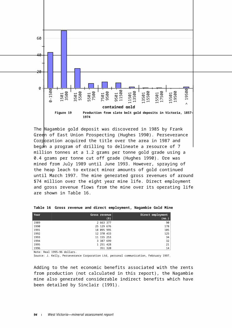
D—The available data clearly define the geological environment and the level of mineral resource potential.
West Victoria—mineral assessment report 97

Appendix B Mineral resource assessment and mineral deposit models
Descriptive model MS1: descriptive model of Shoreline Placer Ti(Model 39c of Cox & Singer, 1986)
Model descriptionDescription of the model after Eric R. Force.
DescriptionIlmenite, rutile, zircon, leucoxene, magnetite, monazite and other heavy minerals (garnet, xenotime, cassiterite and gold) concentrated by beach processes.
Geological environmentRock types: Well-sorted medium to fine grained sand in dune, beach and inlet deposits commonly overlying shallow marine deposits.
Age range: Commonly Late Tertiary (Miocene) to Quaternary (Holocene) but could be any age range.
Depositional environment: Stable coastal region with efficient sorting and winnowing, receiving sediment from deeply weathered igneous and metamorphic terranes of sillimanite or higher grade.
Tectonic setting: Margin of craton, intracratonic basins. Crustal stability during deposition and preservation of deposits.
Deposit descriptionStructure: Elongate ‘shoestring’ deposits parallel to coastal dunes and beaches.
Ore controls: Ultimately a high-grade metamorphic source but may include sediments and metasediments as source rocks in which heavy minerals were trapped during an earlier depositional cycle and subsequently eroded; stable coastline with efficient sorting and winnowing. Heavy mineral concentrations are formed by wave and wind action and include beach placer, beach ridge, and sand dune deposits.
Weathering: Leaching of iron from ilmenite and destruction of labile heavy minerals results in residual enrichment of deposits.
Geochemical and geophysical signatures: High Ti, Zr, Th, U, rare earth elements; anomalously high concentrations of heavy minerals; gamma radiometric anomalies due to thorium in monazite; sophisticated magnetic surveys, particularly at prospect scale; induced polarisation anomalies due to ilmenite.
West Victoria—mineral assessment report 99

ExamplesMain strandline deposits located to date in the Murray Basin include the Wemen, Kulwin, Woornack and Birthday Gift occur in the Miocene/Pliocene strandlines. Numerous other smaller strand line heavy mineral sand deposits and occurrences are also known in the Basin (Dickson 1999, Leandri 1998, McGoldrick 1998, Mason 1999).
Heavy mineral concentrations of ilmenite and rutile along ancient shorelines inland from the present coastline in south west of Western Australia at Yoganup (Masters 1990) and Eneabba (Shepherd 1990).
Numerous heavy mineral concentrations of rutile and ilmenite along the current and ancient inland shorelines in northern New South Wales and southern Queensland (Wallis & Oakes 1990).
Known deposits and mineral prospects in the West regionThe history of recent discoveries of strandline heavy mineral deposits in the Murray Basin have been described by Dickson (1999). Exploration results to date suggest that the Murray Basin may turn out to be a major heavy mineral sands province. Flat-lying fine grained heavy mineral deposits of the WIM type occur in the region, and the known major strandline deposits such as the Wemen, Kulwin and Rownack-Woornack are north of the region. The Wemen deposit, north of the region, is being developed for mining.
Exploration in the region, 60 kilometres southwest of Horsham, recently located strandline heavy mineral deposits named Cottesloe, Acapulco, and Bondi (Craton Resources NL 1999). These deposits occur in the Toolongrook strand system. Cross section widths of mineralised sands range from a few hundred to over a thousand metres with significant thicknesses of 10 to 20 m. Ilmenite is the dominant ore mineral with significant amounts of rutile and zircon.
The Murray Basin is currently undergoing the fourth phase of exploration for heavy mineral sands in the last 30 years and new deposits are being discovered and delineated. The strand line deposits can occur at 20 to 30 m below the surface and are very difficult to locate. The first indication of promising heavy mineral concentrations in the Wemen deposit was made accidentally in a groundwater drilling survey in 1987–88. This discovery was noted by Aberfoyle geologist in 1995 during the fourth phase of exploration and led to more discoveries of significant strandline type deposits in the Murray Basin.
Assessment criteria1. Presence of the Late Miocene to Pliocene Loxton-Parilla sand.
2. Presence of Miocene/Pliocene strandlines as visible from aerial photographs, airborne radiometric images and digital terrain model images.
3. Known occurrences of heavy mineral sands including ilmenite, rutile and zircon.
4. The presence of strandline heavy mineral deposits and other heavy mineral occurrences, including the distribution of heavy mineral concentrations located by numerous exploration holes.
5. The presence of large flat-lying fine grained heavy mineral deposits which may indicate the presence of associated strandline heavy mineral deposits.
100 West Victoria—mineral assessment report

Assessment
Tract HMS1/H/CThis tract includes the southern rim of the Murray Basin that lies within the region. This part of the basin is occupied by the Loxton-Parilla sands that were deposited in strandlines as evident from aerial photographs, digital terrain models and airborne radiometric images. Heavy mineral concentrations have been intersected in numerous exploration holes throughout the Loxton-Parilla sands. Known heavy mineral deposits in the region comprise the recently discovered strandline deposits of Cottesloe, Acapulco and Bondi as well as the large subeconomic and fine grained and flat-lying deposits of WIM50, WIM100, WIM150, WIM200 and WIM250. The presence of the flat-lying fine grained deposits is considered to be indicative of possible strandline type heavy mineral deposits that may be present in shallower strandline sands.
The Murray Basin within the region has all of the assessment criteria for strandline heavy mineral deposits and the potential for strandline deposits is assessed as high with a certainty level of C.
Economic significanceBased on data on 61 deposits worldwide, shoreline placer deposits have a median ore tonnage of 11 million tonnes (Cox & Singer, 1986). Both beach and dune sand deposits are included in this sample. About 90 per cent of these deposits contain at least 11 million tonnes of ore and 10 per cent contain at least 690 million tonnes. The median grades for these deposits are 1.3 per cent TiO2 for ilmenite and 0.15 per cent TiO2 for rutile.
The economic viability of shoreline deposits is determined by the constituent mineralogy, grades and size of the deposit.
Descriptive model MS1: descriptive model of Shoreline Placer TI (fine-grained flat-lying WIM150 subtype)(Model 39c of Cox and Singer, 1986)
Model descriptionDescription of the model derived from descriptions by Williams (1990), Stitt (1999), Mason (1999) and Roy and Whitehouse (1999).
DescriptionIlmenite, rutile, zircon, leucoxene, magnetite, monazite and other heavy minerals (garnet, xenotime, cassiterite and gold) concentrated by beach processes.
Geological environmentRock types: Fine-grained silt in offshore deposits.
Age range: Commonly Late Tertiary (Miocene) to Quaternary (Holocene) but could be any age range.
Depositional environment: Very fine grained heavy mineral concentrations form as large, tabular deposits thought to be deposited on the lower shoreface/inner shelf under low energy conditions. Sediment derived from deeply weathered igneous and metamorphic terranes of
West Victoria—mineral assessment report 101

sillimanite or higher grade. The origin of these deposits in the West region is not well understood.
Tectonic setting: Margin of craton or intracratonic basin. Crustal stability during deposition and preservation of deposits.
Deposit descriptionStructure: Large flat-lying fine grained deposits formed below the base of wave action.
Ore controls: Ultimately an igneous or high-grade metamorphic source but may include sediments and metasediments as source rocks in which heavy minerals were trapped during an earlier depositional cycle and subsequently eroded; stable coastline with efficient sorting and winnowing. Heavy mineral concentrations are formed below the base of wave action and form in deeper water offshore from beach ridge deposits.
Weathering: Leaching of iron from ilmenite and destruction of labile heavy minerals results in residual enrichment of deposits.
Geochemical and geophysical signatures: High Ti, Zr, Th, U, rare earth elements; anomalously high concentrations of heavy minerals; gamma radiometric anomalies due to monazite content; induced polarisation anomalies due to ilmenite. Known deposits of this type however, are deeply buried so that geochemical and geophysical signatures are masked.
ExamplesFine grained (less than 80 micron) WIM-style deposits occur in the region along the south-east margin of the Murray Basin (Williams 1990, Stitt 1999).
Known deposits and mineral prospects in the West regionThe history of recent discoveries of heavy mineral deposits in the Murray Basin have been described by Dickson (1999). Results from the latest exploration phase suggest that Murray Basin may be a major heavy mineral sands province. Flat-lying fine grained heavy mineral deposits of the WIM type occur in the region west and north east of Horsham. From west to east the deposits comprise the WIM50, WIM100, WIM150, WIM200 and the WIM250 deposits. Strandline heavy mineral concentrations are also present in the region and recent discoveries of strandline deposits in the region include Cottesloe, Acapulco and Bondi. Exploration results suggest that the offshore flat-lying and fine grained grade inshore into strandline deposits. According to Mason (1999), most of the known strandline deposits in the Murray Basin have an associated fine grained offshore deposit. In other words, the presence of strandline deposits indicates the possible presence of associated offshore deposit and vice versa.
The WIM150 deposit was subjected an extensive pilot stage study. The study failed to achieve an economic separation of the fine grained heavy minerals and these very large fine grained deposits are currently subeconomic.
Assessment criteria1. Presence of the Late Miocene to Pliocene Loxton-Parilla sand.2. Known occurrences of heavy mineral sands including ilmenite, rutile and zircon.3. Presence of strandline heavy mineral sand deposits.
102 West Victoria—mineral assessment report

Assessment
Tract HMS2/M-H/CThis tract includes the southern rim of the Murray Basin that lies within the region. This part of the basin is occupied by the Loxton-Parilla sands that were deposited in strandlines as evident from aerial photographs, digital terrain models and airborne radiometric images.
Heavy mineral concentrations have been intersected in numerous exploration holes throughout the Loxton-Parilla sands. Known heavy mineral deposits in the region include the large subeconomic, fine grained and flat lying deposits of WIM50, WIM100, WIM150, WIM200 and WIM250. Strandline deposits have also been recently discovered in the region at Cottesloe, Acapulco and Bondi. The presence of strandline heavy mineral deposits is considered to be indicative of possible offshore type heavy mineral deposits near these strandline deposits. Most of the known offshore deposits occur in the shallower part of the basin near its southern rim west and north east of Horsham. Although offshore deposits are probably also present in the deeper parts of the basin away from the basin perimeter, they would be more costly to mine.
On the available evidence, the Loxton-Parilla Sands in the region have a moderate to high potential for offshore heavy mineral deposits with a certainty level of C.
Economic significanceThe offshore heavy mineral deposits are currently subeconomic to mine because of the fine-grain size of the ore minerals. Such problems may be overcome at some stage in the future.
Au1: Slate-belt gold deposits(Model 36A of Cox and Singer, 1986)
Model descriptionDescription of the model after Byron R. Berger, up-dated using Groves et al. 1998 and Goldfarb et al. (1998)
Approximate synonyms: Mesothermal gold deposits; ‘Mother Lode’ veins; turbidite-hosted gold veins; metamorphic gold; low sulphide gold-quartz veins; gold only, lode gold veins; orogenic gold deposits.
Description: Gold in quartz veins and silicified lode structures, mainly in regionally metamorphosed rocks.
General references: Lindgren (1933), Nesbitt et al. (1986), Keppie et al. (1986), Cox et al. (1991), Phillips and Powell (1993), Hodgson (1989), Forde and Bell (1994), McCuaig and Kerrich (1994), Phillips and Hughes (1996), Ramsay et al. (1998), Groves et al. (1998), Goldfarb et al. (1998).
Geological environmentRock types: Oceanic metasediments: regionally metamorphosed volcanic rocks, greywacke, chert, shale, and quartzite, especially turbidite-deposited sequences. Late granitic batholiths.
Age range: Precambrian to Tertiary. In Victoria, mineralisation is diachronous within the LFB terrain i.e. east of Moyston fault, Au mainly pre-late Silurian (Late Ordovician) to Late Devonian (Reference Arne et al. 1998).
West Victoria—mineral assessment report 103

Depositional environment: Continental margin mobile belts, accreted margins. Veins age pre to post-metamorphic and locally cut granitic rocks.
Tectonic setting(s): Brittle-ductile shear zones and more brittle fault systems produced by regional compression.
Associated deposit types: Placer Au-PGE, Homestake gold. Fosterville-Nagambie style gold (stockworks), disseminated gold.
Deposit descriptionMineralogy: Characterised by gold only or gold dominant. Other sulphides are a minor component in most deposits. Quartz >> sericite + carbonates ± native gold ± arsenopyrite ± pyrite ± galena ± sphalerite ± chalcopyrite ± pyrrhotite ± sericite ± rutile. Locally, tellurides ± scheelite ± bismuth ± tetrahedrite ± stibnite ± molybdenite ± fluorite. Carbonates of Ca, Mg, and Fe abundant, leading to carbonate spotting in alteration zones. Gold fineness > 900.
Texture/structure: Brittle-ductile shear-hosted veins, and more open spaced infill texture terminology. Terms after Hodgson, (1989) include: shear fracture; central shear vein, (first or second order etc.), laminated, ribbon; oblique shear vein: (first or second order), S-type oblique and extension; Z-type oblique and extension (centipede); conjugate array; Extension fracture: en echelon gash vein arrays, planar or sigmoidal, ladder vein arrays, massive extension veins, Extension + shear fracture: leather jacket, centipede, fold-related zones: saddle reef, leg reef, neck, spur; brittle structures: stockwork vein arrays, sheeted, discrete fault-related vein, fault-parallel or oblique; Breccia vein: extension central shear veins, breccias, however, open-space filling textures commonly destroyed by vein deformation.
Alteration: Quartz + siderite and (or) ankerite ± albite in veins with possible halo of carbonate alteration. Chromian mica ± dolomite ± talc ± siderite in areas of ultramafic rocks. Sericite ± disseminated arsenopyrite ± rutile in granitic rocks. Wallrock sulphide alteration is more pronounced in the Stawell zone than elsewhere.
Ore controls: Veins occur along regional high-angle brittle-ductile shear zones and faults. Best deposits overall in areas with greenstone or in turbidites with carbonaceous lithologies. Disseminated ore bodies where veins cut granitic rocks. Carbonaceous shales and iron-rich host rocks (e.g. volcanics) may be important. Competency contrasts appear to control vein style; shale/sandstone contacts and intrusive contacts, including both aureole and intrusive bodies themselves, may be important.
Weathering: Abundant quartz chips in soil. Red limonitic soil zones. Gold may be recovered from soil by panning.
Geochemical signature: The slate belt gold deposits in this area are often associated with Ag, Pb, Zn and Cu. Sb occurs in some deposits, Bi in those with a spatial association to intrusions (e.g. Maldon, Stawell), while Stawell zone deposits are generally higher in silver content (e.g. St Arnaud and Glen Wills). The deposits have outer alteration halos that are potassium and carbonate rich (Bierlein et al. 1998; Li et al. 1998).
Geophysical signature: These deposits are poorly defined generally, due to the lack of magnetic minerals associated with mineralisation and structural offsets within weakly magnetic lithologies. Airborne magnetics may define important structures where there are interbedded volcanics (greenstones) and turbidites (e.g. in Stawell zone). High resolution magnetics may be important in the Stawell zone due to the occurrence of associated pyrrhotite alteration.
104 West Victoria—mineral assessment report

Recent geophysical studies at Stawell, and St Arnaud have revealed that these deposits are hosted within weakly but distinctly magnetic units than the surrounding rock, and all lie about two kilometres or less from the edge of a nonmagnetic granite, possibly felsic I-type intrusions (Moore 1996). Mineralised veins are often hosted by them are found within their thermal halo.
The deposits may have a gamma ray radiometric signature on account of elevated potassium in alteration halos, although these occur only in zones less than 10 m in width (Bierlein et al. 1998).
Examples Bendigo Goldfield, AUVT (Sharpe & MacGeehan 1990) Ballarat East Gold Deposits, AUVT (d’Auvergne 1990) Mother Lode, USCA (Knopf 1929) Goldfields of Nova Scotia (Ryan & Smith 1998) Pacific Rim deposits (Goldfarb et al. 1998)
Known deposits and mineral occurrences in the West regionThe area hosts a large number of gold prospects and deposits that form part of the Victorian gold provinces. The two western most provinces contain few known gold deposits (Glenelg and Grampians). Most known deposits, from which over 1 per cent of the world’s gold has been produced come from the Western Lachlan Fold Belt in Victoria. The zones are (from west to east): Stawell, Ballarat, and Melbourne. The main types of deposit recognised are:
shear and/or fault-controlled quartz vein deposits that crosscut pre-existing anticlines at shallow angles. Veins and ore zones form plunging ore shoots, and lenticular and discordant to bedding and occur in fissure planes (e.g. Ballarat);
bedded reefs which are generally laminated and parallel to bedding planes, with laminations separated by thin films of metasediments;
reefs associated with dykes. They either truncate the dyke or occur sub-parallel to one wall of the dyke (e.g. at Stawell);
spurry reefs are tension gashes, irregular quartz fissures and stockworks; and
intrusive-hosted or contact aureole-hosted quartz vein deposits (e.g. Stawell, Maldon).
Mineralisation appears to be diachronous, with generally older deposits in the west, but with more than one phase of gold mineralisation in places like Stawell (Arne et al. 1998). Gold mineralisation in the Stawell zone and Bendigo-Ballarat zone accompanied regional metamorphism and thrusting between 455 and 420 Ma. (Foster et al. 1999). In the Melbourne zone locally in the Bendigo-Ballarat zone mineralisation is associated with magmatic events and deformation between 380 and 360 Ma (Foster et al., 1999). There is also a difference in the grade of metamorphism of host rocks, and style of deposit, from west to east, suggesting the deposits in the west were formed at deeper crustal levels than those in the east (Ramsay et al. 1988). In the Stawell Zone the metamorphic grade is generally greenschist facies with brittle-ductile shear zone control; the Ballarat Zone is prehnite-pumpellyite facies in the west and zeolite facies in east, with more brittle fault structures and dilational sites controlling mineralisation (higher grades in carbonaceous host lithologies); epithermal styles are observed in the Melbourne Zone.
West Victoria—mineral assessment report 105

Geological studies in the area and other goldfields in Victoria fail to recognise any single geological factor controlling mineralisation. The factors and the age of mineralisation seem to vary from area to area with a combination of two or more factors (structural, lithological, magmatic, geochemical) becoming important in several areas. In addition to the well-documented structural control (faults, fissure, dilational jogs, and fold hinges) it is possible that some form of lithological control was important in some areas. For instance, nugget gold often occurs at quartz vein intersections with ‘Indicator Beds’ (carbonaceous shale), and fluid inclusion data support a role for reduction involving wall rock-fluid interaction (Cox et al. 1991).
Similarly in the Ballarat East goldfield it is suggested that mineralisation is often localised by the presence of ‘indicator beds’ (O’Shea et al. 1994). The presence of dyke swarms is only locally important in localising ore in known deposits within western Victoria.
Assessment criteria1. Distribution of (outcropping and concealed) Cambrian, Ordovician, Silurian and Devonian
turbidites and volcanics (greenstones), with note taken on shale/sandstone ratios (or their metamorphic equivalents).
2. Grade of metamorphism (generally lower or equal to the greenschist facies) and structural style that relates to crustal emplacement/preservation level.
3. Presence of major north northeast to north-south and north northwest trending structural corridors around major faults (both hangingwall and footwall may be prospective).
4. Presence of Silurian and Devonian granitoids (particularly I-type- not necessarily oxidised).
5. Presence of primary and/or alluvial gold deposits and prospects.
Assessment
Tract Au 1a/H/B-C The tract contains areas of the Stawell and Bendigo-Ballarat zones within north northeast -to north-south trending (Bendigo-Ballarat zone) and north northwest trending (Stawell zone) mineralised corridors defined by prominent fault zones that are known to have played a role in controlling gold mineralisation.
With some exceptions (e.g. region-bounding faults such as the Avoca Fault), individual faults or fault zones are not visible on the regional geophysical datasets used in this study. A few lineaments visible on the Digital Terrain Model appear to coincide with the structural corridors that are known to control mineralisation, and these combined with a few lineaments visible on aeromagnetic datasets, were used to extend the corridors outside areas of known mineralisation. The northern and southern extensions of most of these structural (and mineralisation) corridors is less certain, and difficult to map. There are a number of large-scale east northeast trending lineaments on the DTM that subparallel faults that dextrally offset mineralisation in the Ballarat deposits (Taylor 1998). However, no data or interpretation of any offsets on these structures could be found in this study, and further work is recommended. The tract does not include granitoids because they are interpreted to be post mineralisation.
The corridors contain:
known deposits (e.g. Ballarat East, Ballarat West).
106 West Victoria—mineral assessment report

Ordovician, Silurian, Siluro-Devonian and Devonian turbidites and their metamorphic equivalents.
brittle-ductile faults.
Hence, mineral potential of the tract is assessed to be high with a certainty level of C. A lower level of certainty is assigned to areas extending under Murray-basin sediments.
Tract Au1b/M-H/B-CThe tract includes those parts of Stawell and Bendigo-Ballarat zones which fall outside the structural corridors (tract Au1a/H/B-C). The tract contains favourable host rocks similar to those in the tract Au1a/H/B-C but differs in lower vein density and less faulting. The tract is known to host several primary and alluvial gold occurrences.
The tract also includes Ordovician, Silurian and Devonian turbidites and volcanics (greenstones) in the Melbourne zone. Although several faults have been mapped in the zone, it is not possible to define a structural corridor that could have controlled mineralisation. Melbourne zone hosts several occurrences of slatebelt and alluvial gold. However, the host turbidite lithologies in this zone are not as fine grained as in the Ballarat and Stawell regions, and contain a higher proportion of coarser clastic sediments (sandstones). This would favour the formation of extension (ladder) veins. However, the absence of major fault zones, lower level of brittle/ductile deformation and relatively fewer known occurrences of slatebelt and alluvial gold in the zone indicate that mineral potential (moderate to high) of this zone within the RFA area is lower (moderate to high instead of high) than in Stawell and Bendigo-Ballarat zones. A lower level of certainty (B instead of C) is assigned to areas covered by sediments of the Murray Basin.
Tract Au1c/M/C The tract includes Devonian granitoids of the Melbourne zone. Dating of mineralisation and plutonism in the Melbourne zone shows that these granitoids are broadly coeval with slate belt gold mineralisation. However, they are not known to be poor hosts of mineralisation which is often localised in the peripheral hornfelsic zones in the country rock. Hence their potential is assessed to be moderate with a certainty level of C.
The tract also includes extensions of tracts Au1a/H/B-C and Au1b/M-H/B-C that extend under basalts of the Newer Volcanics (Qvn). The basalts cover (maximum thickness less than 60 m) Cambrian, Ordovician, Silurian and Devonian turbidites and volcanics (greenstones) that are favorable hosts of slate belt mineralisation. Aeromagnetics also shows that some major fault zones that define structural corridors controlling spatial distribution of gold deposits in the Stawell and Bendigo-Ballarat zones also extend in this part of the tract. The tract also hosts a number of known occurrences of gold. As this part of the tract is covered by basalts and the presence of favorable rocks and structures is mostly interpreted from geophysical data, mineral potential of this part of the tract is assessed to be moderate with a certainty level of C.
Tract Au1d/L-M/CThe tract includes Cambrian (meta)sedimentary rocks, volcanics and granitoids in the Glenelg zone. In the Glenelg zone these rocks underwent deformation and metamorphism related to the Late Cambrian to Early Ordovician Delamerian Orogeny, which is older than Benambran and Tabberabberan orogenies with which is associated the slate belt mineralisation in the Lachlan Fold Belt part of the Region. There are few known gold deposits in the tract area, however, the high metamorphic grade and more pervasive ductile deformation suggest that potential is not as high in the Lachlan Fold Belt part of the Region. Hence, the tract is considered to have low to moderate potential with a certainty level of C.
West Victoria—mineral assessment report 107

Tract Au1e/L/BThis tract is defined by the extension of the tract Au1d/L-M/C under Tertiary basalts where the latter occur on thin Tertiary marine sediments less than 500 m in thickness. Basalt thickness is poorly defined and their magnetic character and underlying limestone and marl sediments makes it difficult to identify bedrock geology or structures. The potential of this tract is low, with a certainty level of B.
Tract Au1f/Un/AThis tract is defined by the extension of tracts Au1c/M/C, Au1d/L-M/C and Au1e/L/B in areas where the cover of Tertiary and Quaternary Basalts and Tertiary marine sediments is greater than 500 m. Due to the thickness of the cover, the extent of Palaeozoic bedrock and structures under the cover is not very easy to define. Hence, mineral potential of this tract for slate belt gold deposits is unknown.
Economic significanceSlate belt gold deposits are amongst the largest gold deposit styles and are important source of gold (and silver) on a global scale. According to the grade/tonnage models for the low-sulphide gold-quartz veins (Cox & Singer 1986) 90 per cent of these deposits contain at least 1 000 tonnes of ore; 50 per cent contain at least 30 000 tonnes and 10 per cent contain at least 0.91 million tonnes. In 90 per cent of these deposits ores contain at least 6 grams/tonne gold; 50 per cent contain at least 15 grams/tonne gold and 10 per cent contain 43 grams/tonne gold.
Au2: disseminated gold deposits
Model descriptionApproximate synonyms: Low-grade disseminated gold deposits. Stockwork gold deposits.
Description: Disseminated gold in altered rocks in proximity to known slate-belt gold veins.
General references: Montoya et al. (1995).
Geological environmentRock types: Oceanic metasediments: regionally metamorphosed volcanic rocks, greywacke, chert, shale, and quartzite, especially turbidite-deposited sequences. Alpine gabbro and serpentine. Late granitic batholiths and swarms of dykes.
Age range: Precambrian to Tertiary. In Victoria most deposits are of Palaeozoic age.
Depositional environment: Continental margin mobile belts, accreted margins. Veins age pre to post-metamorphic and locally cut granitic rocks.
Tectonic setting(s): At margins of brittle-ductile fault zones; associated with fault and joint systems produced by regional compression.
Associated deposit types: Slate-belt gold veins, Placer Au-PGE, Homestake gold.
Deposit descriptionMineralogy: Mineral composition similar to that in typical state belt gold deposits. Mineralisation represented by sulphides (pyrite, arsenopyrite, pyrrhotite, chalcopyrite, sphalerite, and stibnite) and gold in altered rocks containing carbonates, quartz, sericite and
108 West Victoria—mineral assessment report
chlorite. In some deposits sulphides form spheroids or framboids with anomalously high concentration of zinc, copper, nickel, gold, antimony, lead, arsenic and lead.
Texture/structure: Stockwork and zones of dissemination marginal to brittle ductile shears, and more pervasively in porous sandstones at higher structural levels.
Alteration: Assemblages containing carbonates (calcite, siderite, sideroplesite, and ankerite), phengitic sericite, ripidolitic chlorite, and sulphides (pyrite, chalcopyrite, auriferous arsenopyrite and sphalerite) occurring within about 100–150 m of major textures. Silicification is either mild or absent.
Ore controls: Veins occur along regional high-angle brittle-ductile shear zones and faults. Best deposits overall in areas with greenstone or in turbidites with carbonaceous lithologies. Disseminated ore bodies where veins cut granitic rocks. Carbonaceous shales and iron-rich host rocks (e.g. volcanics) may be important. Competency contrasts, appear to control vein style; shale/sandstone contacts and intrusive contacts, including both aureole and intrusive bodies themselves, may be important.
Weathering: Limonitic zones over primary sulphide mineralisation. However, gold concentration is lower than in primary mineralisation.
Geochemical signature: Au, As, Ag, Pb, Zn, Cu may be useful.
Geophysical signature: Weakly magnetic if pyrrhotite is dominant disseminated sulphide.
Examples Nagambie (Gillies 1990) Fosterville (McConachy & Swensson 1990) Peru (Montoya et al. 1995)
Known deposits and mineral occurrences in the West regionAlthough haloes of disseminated mineralisation in Victoria are known to be associated with major slate belt vein deposits, they have acquired economic importance only recently because of the possibility of their mining by small-scale, heap-leaching techniques. Within the West region there are no major deposits of this type.
A number of important known occurrences of this type occur outside the assessment area, but analogies may exist within West region. The most significant of these are the Morning Star gold mine in the Gippsland RFA region, the Nagambie mine in the region’s buffer zone, and Fosterville in the Bendigo-Ballarat Gold Zone.
Mineralisation in the Woods Point-Jamieson goldfield is associated with Middle Devonian dyke swarm intruding into Lower Devonian sediments deformed and metamorphosed to lower greenschist facies during Tabberabberan orogeny. The dykes are primarily of dioritic and lamprophyric composition and are altered and sheared close to the zones of mineralisation. Recent exploration has revealed disseminated mineralisation in the vicinity of ladder veins where the dyke is bleached because of alteration.
In the Nagambie gold deposit, mineralisation is hosted by a thick sequence of Silurian-Devonian turbidites protruding through flat lying Quaternary sediments of the Shepparton Formation. Economically significant mineralisation occurs along the crest of an anticline. Mineralisation is in the form of quartz veins, stringers and stockworks (Gillies 1990). The Nagambie mine, located within 15 kilometre buffer zone of the West region, is an example of a low grade disseminated deposit, with sulphides disseminated in wallrocks adjacent to brittle-
West Victoria—mineral assessment report 109

ductile shear zones with minor quartz veins developed. Mineralisation in this deposit was upgraded due to supergene processes. Although these deposits have been studied in some detail no clear single geological factor appears to control this type of mineralisation. Important geological factors include structure (shear and fault zones in particular jogs where shear obliquely cross previously formed folds), lithology (relatively porous sandstone and/or interbedded black shale, and magmatic intrusives (presence of K-feldspar-quartz porphyritic dykes).
Assessment criteria1. Tracts with mineral potential for slate belt gold mineralisation.
2. Distribution of the Cambrian, Ordovician, Silurian and Devonian turbidites and volcanics (greenstones), with note taken on shale/sandstone ratios (or their metamorphic equivalents).
3. Presence of major north northeast to north-south and north northwest trending fault corridors near major fault structures (both hangingwall and footwall may be prospective).
4. Presence of Cambrian, Ordovician, Silurian and Devonian granitoids (particularly I-type- not necessarily oxidised).
5. Presence of primary and/or alluvial gold deposits and prospects.
6. Presence of dykes.
Assessment
Tract Au2a/M-H/CThe tract hosts turbidite lithologies in the Melbourne zone that are coarser grained than in the Ballarat-Bendigo and Stawell zones and contain a higher proportion of coarser clastic sediments (sandstones). Descriptions of structures and cleavage relationships indicate a higher level, more brittle structural environment in this tract. Deposits are likely to be controlled by more brittle geometries that include extension veins (ladder). The metamorphic grade indicates that these lithologies are preserved at a higher crustal level. There is a higher potential for brittle-fracture and fault-related dilational geometries, and therefore, the potential for disseminated gold deposits is moderate to high with a certainty level of C. Favourable sites may also include hornfels aureole zones of plutons and dykes, although the latter are not mapped or recognised on geophysical datasets used in this study.
Tract Au2b/M/B-CThe tract includes Stawell and Bendigo-Ballarat zones that have high potential for slate belt gold deposits. It contains prominent structural corridors and several slate belt and alluvial gold occurrences. However, the turbidite host rocks are relatively more fine grained and would have experienced less brittle structural deformation needed for the formation of disseminated deposits. Additionally the granitoids in the Stawell and Bendigo-Ballarat zones are younger than the main gold mineralising events and therefore, could not have acted as host for disseminated gold deposits. Hence the potential for disseminated gold in this part of the Stawell and the Bendigo-Ballarat zones is assessed to be moderate with a certainty level of C. Certainty level for areas outside structural corridors and in areas covered by the Murray Basin sediments is B.
The tract also includes granitoids in the Melbourne zone that have moderate potential for slate belt gold deposits. In Melbourne zone granitoids are interpreted to be of broadly the same age as mineralisation. Although granitoids are known to be a less favourable host for vein-style
110 West Victoria—mineral assessment report

slate belt mineralisation, their physical and mechanical properties suggest that they would be better hosts for disseminated and stringer type of mineralisation. Hence mineral potential of granitoids in the Melbourne zone is assessed to be moderate with a certainty level of C.
Tract Au2c/L-M/BThe tract includes Cambrian and Ordovician turbidites and greenstones, their metamorphosed equivalents, and granitoids in the Glenelg zone. These rocks have low to moderate potential for slate belt gold deposits. The tract includes rocks of the Grampian Group of Silurian age. The Grampian group rocks are coarse grained and have been targeted by exploration companies for disseminated style gold deposits (Tom Dickson, personal communication). Mineral potential of the tract is assessed to be low to moderate with a certainty level of B.
This tract also includes extension of tracts Au2a/M-H/C and Au2b/M/B-C under basalts of the Newer Volcanics (Qvn). The basalts cover (maximum thickness less than 60 m) Cambrian, Ordovician, Silurian and Devonian turbidites and volcanics (greenstones) that are favourable hosts of slate belt mineralisation. Aeromagnetics also shows that some major fault zones that define structural corridors controlling spatial distribution of gold deposits in the Stawell and Bendigo-Ballarat zones also extend in this part of the tract. The tract hosts a number of known occurrences of gold. As this part of the tract is covered by basalts and the presence of favourable rocks and structures is mostly interpreted from geophysical data, mineral potential of this part of the tract is assessed to be low to moderate with a certainty level of B.
Tract Au2d/L /BThis tract is an extension of the tract Au2d/L-M/B (Glenelg Zone) under Tertiary basalts where the latter occur on thin Tertiary marine sediments less than 500 m in thickness. Basalt thickness is poorly defined and their magnetic character and underlying limestone and marl sediments makes it difficult to identify bedrock geology or structures. The potential of this tract is low, with a certainty level of B.
Tract Au2e/Un /AThis tract is an extension of tracts Au2c/L-M/C, Au2d/L/B in areas where the cover of Tertiary and Quaternary Basalts and Tertiary marine sediments is greater than 500 m. Due to the thickness of the cover, the extent of Palaeozoic bedrock and structures under the cover is not easy to define. Hence, mineral potential of this tract for slate belt gold deposits is unknown.
Economic significanceSignificant economic disseminated Au deposits occur at Fosterville, Nagambie and Ballieston. However, there is some controversy over whether some of these deposits are classified as higher level equivalents of slate belt deposits or as epithermal deposits.
Au3: placer gold(Model 39a of Cox and Singer, 1986)
Model descriptionModified after Warren E. Yeend (1989)
Approximate synonyms: lead, shallow lead, deep lead, auriferous deep lead, lead system, alluvial deposit, alluvial placer, eluvial gold, alluvial terrace, colluvial gold detrital gold, wash, washdirt, drift, reef wash (terrace deposits), gutter wash (channel fill).
West Victoria—mineral assessment report 111

Description: Elemental gold as grains and (rarely) nuggets in gravel, sand, silt, and clay, and their consolidated equivalents, in alluvial, beach, aeolian, and (rarely) glacial deposits.
General references: Boyle (1979), Wells (1973), Lindgren (1911), Yeend (1989), Adams and Henley (1979), Canavan (1988), Phillips and Hughes (1996), Nielsen (1998), Hughes et al. (1998, 1999).
Geological environmentRock types: Alluvial gravel, conglomerate, and breccia, usually with white quartz clasts. Sand and sandstone of secondary importance.
Textures: Coarse clastic, as breccias and/or conglomerates
Age range: Cainozoic. Older deposits are known but their preservation is uncommon.
Depositional environment: Occur in steep gradient sections of river channels in headwaters at shallow levels, and where gradients flatten and river velocities lessen, as at the inside of meanders, below rapids and falls, beneath boulders, in terrace deposits and in vegetation mats. Winnowing action of surf caused Au concentrations in raised, present, and submerged beaches.
Tectonic setting(s): Tertiary conglomerates along major fault zones, shield areas where erosion has proceeded for a long time producing multicycle sediments; high-level terrace gravels.
Associated deposit types: Black sands (magnetite, ilmenite, areaomite); Platinum group elements, yellow sands (zircon, monazite). Au placers commonly derive from various Au vein-type deposits but also other gold deposits, e.g. Porphyry copper-gold, gold skarn, massive sulphide deposits and replacement deposits. Re-working of older gold-bearing gravels and regolith (e.g. Norval Regolith) in Ararat-Stawell area and westwards.
Deposit descriptionMineralogy: Au, commonly with attached quartz or limonite, rarely attached to sulphides and other gangue minerals. Associated with quartz and heavy minerals, which may include: rutile, ilmenite, areaomite, magnetite, limonite, pyrite, zircon, monazite, tourmaline, cassiterite, platinum-iron alloys and osmium-iridium alloys.
Texture/structure: Usually flattened with rounded edges, also flaky or flour gold (extremely fine grained); rarely angular and irregular (‘crystalline’), very rarely equidimensional nuggets. Decrease in gold coarseness away from source. Crystalline gold is common where supergene gold or gold remobilisation within alluvium has occurred. Fine gold, with lower silver contents occurs in ferricrete cements at higher stratigraphic levels in palaeoplacers due to fluid remobilisation.
Ore controls: Economic Au grades occur mainly at base of gravel deposits in various gold ‘traps’ such as natural riffles in floor of river or stream; structures trending transverse to direction of water flow, such as fractured bedrock, and may include changes in lithology competence (interbedded lithologies, dykes etc) that cause formation of waterfalls and waterholes. Au may also be localised within steep gradient (dendritic) tributaries near headwaters, at tributary intersections with main channels, or in the main channels for distances of over 100 km downstream (Phillips & Hughes 1996). Within channels, Au concentrations occur mainly within narrow width ‘wash’ horizons (less than two metres thick) in semi-continuous layers and/or lenses. Au occurs within these layers in gravel deposits above clay layers that constrain the downward migration of Au particles. In some channels gold, thought
112 West Victoria—mineral assessment report

to have been remoblised during later weathering processes, was recovered from duricrust cements at higher stratigraphic levels.
Geochemical signature: Anomalous high amounts of Ag, As, Hg, Sb, Cu, Fe, S, and heavy minerals magnetite, areaomite, ilmenite, hematite, pyrite, zircon, garnet, rutile. Au nuggets have decreasing Ag content with distance from source. Maghemite pisoliths may also be important.
Geophysical signature: High resolution aeromagnetic and airborne EM techniques define buried channels (Lawrie et al. 1999). Other methods which have been used to define buried channels/deep leads, but which have had limited success, include seismic methods (both reflection and refraction), and ground resistivity, magnetics and microgravity (Sedmik 1963, O’Connor & Smith 1964). Ground penetrating radar may, in some circumstances, be used to identify shallow channels.
Examples Sierra Nevada, USCA (Lindgren 1911, Yeend 1974) Victoria, AUVT (Knight 1975)
Known deposits and mineral occurrences in the West regionThere are numerous localities in the region where alluvial gold was mined. Many of the historical goldfields are dominantly placer, with limited historical hard-rock mining (e.g. St. Arnaud). In addition to the typical placer deposits, the West region is favourable for the presence of deep and shallow lead placer gold. Deep and shallow leads are quite common elsewhere in Victoria. Deep leads are buried gold placers which formed at various times during the Cainozoic and were later buried under alluvium or basalt or both. In Victoria some leads are preserved under Eocene? Older Volcanics, some are under Pliocene-Pleistocene basalt. Most of the deep lead concentrations were formed along valleys draining inland from the main divide and were later modified during Cainozoic uplift and consequent stream rejuvenation.
Three groups of deposits are recognised by age in Central Victoria: Recent (very shallow leads); Late Tertiary (shallow and deep leads); Early Tertiary (perched leads; e.g. Kooreh, St Arnaud). The groups differ in age, vertical position and in the characteristics of the alluvium and gold content (Nielsen 1998).
Differences in the age of placer and palaeoplacer deposits in the West region are poorly constrained, however, three broad subdivisions are recognised (Hughes et al. 1998, 1999). These are perched outliers of Palaeocene (possibly as old as Mesozoic) deposits that occur as poorly preserved inliers, and the more economically important shallow and deeper (lead) placer and palaeoplacer deposits of the Eocene to Pliocene that occur in well preserved drainage channels. Although modern drainage may be superimposed on some of these placer and palaeoplacer deposits, gold-rich zones formed at the earlier period. Tertiary basalt flows cover much of the southern portion of these provinces, and obscure any potential hard rock sources, and any placer and palaeoplacer gold deposits themselves.
By far the most important placer and palaeoplacer deposits occur in the Ballarat Zone. The productivity of these deposits reflects the grades and tonnages in the bedrock sources, however, additional favourable factors include: the fact that gold occurred as free grains, often coarse-grained within quartz veins; the area underwent at least two periods of significant uplift and denudation of bedrock which, at the time of incision appears to have had no significant near surface barren zones that might have been associated with deep weathering; high energy rivers and formation of deep and narrow drainage valley systems with steep gradients and
West Victoria—mineral assessment report 113

valleys courses which traversed mineralised veins at low angels, or had tributary channels that accessed mineralised veins with short distances between source and main channels.
The gold sources for placer and palaeoplacer deposits in the Melbourne zone are likely to have been epithermal and sediment-hosted sulphidic gold deposits. Historical records for this area are poor at recording gold fineness data, however, in the northwards extension of this zone it is recorded that lower prices were paid for alluvial gold from sulphide rich lodes due to a higher silver content, and partly because the gold was difficult to recover from within the sulphide grains. The alluvial deposits in this area are likely to have less economic potential than in the adjacent Ballarat Zone. However, the possibility of other as yet unrecognised epithermal styles of gold deposit in this area might provide higher grade sources.
Only minor placer and palaeoplacer gold has been produced from the Grampians and less from the Glenelg Province. Mid-Cretaceous uplift east of the Moyston Fault (Western boundary of Western Lachlan Fold Belt) created relief which drainage incised later in the Tertiary. There is less relief west of this fault, and the area is consequently less prospective, despite the presence of some auriferous quartz veins.
Assessment criteria1. Presence of gold-bearing source rocks.
2. Location relative to Cretaceous to Tertiary uplift history. Mid-Cretaceous uplift east of the Moyston Fault created relief which drainage incised later in the Tertiary—less relief west of this fault- less prospective, despite presence of auriferous quartz veins.
3. Distribution of Tertiary and Quaternary alluvial, eluvial, fluvio-glacial and lacustrine sediments. No further subdivision was possible in this study with the datasets available. A more detailed analysis may in the future discriminate between: the Loddon River Group: economically most significant; (north and south flowing channels); geographically ‘equivalent’ formations include the ‘sub-basaltic gravels’, the Denicull Formation and the Calivil Formation. These may not be time-equivalent, however, are grouped together as they occur in equivalent locations in the landscape, and range in age from Eocene to Pliocene; the White Hills Group: less significant due to their poorer preservation due to their perched nature in tie eroding landscape. Formations include the White Hills Gravel and Great Western Formation in (Hughes et al. 1998, 1999), Palaeocene to Mesozoic? Rejuvenation of uplift between these two depositional events- Loddon River Group: narrow steep-sided valleys, White Hills Group: broad shallow valleys.
4. Distribution of known alluvial gold deposits (buffered to mapped distribution of Tertiary and Quaternary sediments and volcanics).
5. Distribution of deep leads (one kilometre buffer around known deep lead channels).
6. Distribution of ‘Newer Volcanics’ (Qvn, Qvh, Qvs, Qvs1, Qvs2, Qvt), and ‘Older Volcanics’ (Tvo).
7. Distribution of present day rivers (buffered by 200 m).
Assessment
Tract Au3a/H/C-DThis tract includes Quaternary and Tertiary fluvial sediments and Tertiary and Quaternary volcanics in the known alluvial goldfields of the Glenelg (very small areas not far from the Moyston Fault), Stawell, Bendigo-Ballarat and Melbourne zones. It also includes (a) deep lead channels beneath Tertiary volcanics (with a buffer of one kilometre), and (b) the distribution
114 West Victoria—mineral assessment report
of present day drainage (with a buffer of 200 m), to account for unmapped Quaternary fluvial sediments.
The tract also includes a small part of coarse-grained sandstones of the Grampian Group where the Pohlner Conglomerate is known to contain concentrations of alluvial gold. As the tract is defined by the presence of known gold field its potential is assessed to be high, with a certainty level of D. For areas where the presence of fluvial quaternary sediments is not mapped but inferred from the existence of present day drainage, certainty level of assessment is C.
Tract Au3b/M-H/B-C This tract includes Quaternary and Tertiary fluvial sediments and Tertiary and Quaternary volcanics outside the known goldfields of the Ballarat, Stawell and Melbourne zones. The tract is extended in the south to a line, north of which the thickness of Tertiary Basalt cover is interpreted to be less than 500 m. In areas where the basalts have been mapped in detail, the recorded thicknesses are generally less than 60 m. The tract also includes fluvial quaternary sediments of the Murray Basin.
Parts of the tract lying within Stawell, Ballarat-Bendigo, and Melbourne zones host several occurrences of primary and alluvial gold and have high and moderate to high potential for slate belt and disseminated gold deposits. The southern extensions of the tract under the cover of Tertiary Basalts have few known occurrences but potential source rocks of gold are interpreted to be present under the cover. Some channels or deep leads have been traced beneath basaltic cover. This part has moderate potential for slate belt and disseminated gold deposit. Hence mineral potential of alluvial and deep lead gold deposits in the tract is assessed to be moderate to high with a certainty level of C. Lower levels of certainty (B) apply for areas south of the Late Cretaceous boundary of Otway Basin.
Tract Au3c/L/CThe tract comprises parts of the Glenelg zone which is to the west of the Moyston Fault. It has low to moderate potential for slate belt and disseminated gold and relatively few sources of gold to form alluvial concentrations. The area to the west of Moyston fault is also known to have limited post-Cretaceous uplift. The tract also includes areas south of the Late Cretaceous boundary of Otway Basin and extends to the line, south of which the basement is overlain by Tertiary Basalt and by Cretaceous sediments of thickness greater than 500 m.
The tract has a low potential for alluvial and deep lead gold with a certainty level of C.
Tract Au3d/Un/AThis tract is an extension of the in the area where source rocks for forming alluvial and deep lead gold are covered by a thick Mesozoic and Cainozoic cover (greater than 500 m). Hence, mineral potential of the tract is unknown.
Economic significanceGold has been mined from important placer and palaeoplacer deposits in the Stawell, Ballarat and Melbourne metallogenic provinces of the Western Lachlan Fold Belt. More than 1 per cent of the world’s gold has been mined from placer and palaeoplacer deposits in Victoria, and more than one half of that total would have been produced in the West region. Placer and palaeoplacer deposits have been mined adjacent to most of the historically important known bedrock gold deposits, with more gold recovered from the former (Phillips & Hughes 1996).
Sedmik 1963: B.M.R. Record No. 1964/147; O’Connor & Smith 1964: B.M.R. Record No. 1964/84
West Victoria—mineral assessment report 115

Au4: epithermal gold-silver deposits(Model 25B of Cox and singer, 1986)
Model descriptionDescription of the model after Dan L. Mosier, Takeo Sato, Norman J Page, Donald A. Singer, and Byron R. Berger
Approximate synonym: Epithermal gold (quartz-adularia) alkali-chloride-type, polymetallic veins.
Description: Galena, sphalerite, chalcopyrite, sulfosalts, + tellurides + gold in quartz-carbonate veins hosted by felsic to intermediate volcanics. Older miogeosynclinal evaporites or rocks with trapped seawater are associated with these deposits.
General references: Buchanan (1980), Berger and Bethke (1985), White and Hedenquist (1990), Henley (1991).
Geological environmentRock types: Host rocks are andesite, dacite, quartz latite, rhyodacite, rhyolite, and associated sedimentary rocks. Mineralisation related to calc-alkaline or bimodal volcanism.
Textures: Porphyritic.
Age range: Mainly Tertiary (most are 29-4 Ma.).
Depositional environment: Bimodal and calc-alkaline volcanism. Deposits related to sources of saline fluids in prevolcanic basement such as evaporites or rocks with entrapped seawater.
Tectonic setting(s): Through-going fractures systems; major normal faults, fractures related to doming, ring fracture zones, joints associated with calderas. Underlying or nearby older rocks of continental shelf with evaporite basins, or island arcs that are rapidly uplifted.
Associated deposit types: Placer gold, epithermal quartz alunite Au, polymetallic replacement, Porphyry Cu-Au
Deposit descriptionMineralogy: Galena + sphalerite + chalcopyrite + copper sulfosalts + silver sulfosalts ± gold ± tellurides ± bornite ± arsenopyrite. Gangue minerals are quartz + chlorite ± calcite + pyrite + rhodoareaosite + barite ± fluorite ± siderite ± ankerite ± sericite ± adularia ± kaolinite. Specular haematite and alunite may be present.
Texture/structure: Banded veins, open space filling, lamellar quartz, stockworks, colloform textures.
Alteration: Top to bottom: quartz ± kaolinite + montmorillonite ± zeolites ± barite ± calcite; quartz + illite; quartz + adularia ± illite; quartz + chlorite; presence of adularia is variable.
Ore controls: Through-going or anastomosing fracture systems. High-grade shoots where vein changes strike or dip and at intersections of veins. Hanging-wall fractures are particularly favourable.
Weathering: Bleached country rock, goethite, jarosite, alunite—supergene processes often important factor in increasing grade of deposit.
116 West Victoria—mineral assessment report

Geochemical signature: Higher in system Au + As + Sb + Hg; Au + Ag + Pb + Zn + Cu; Ag + Pb + Zn, Cu + Pb + Zn. Base metals generally higher grade in deposits with silver. W + Bi may be present.
Examples Pajingo, AUQL (Bobis et al. 1996) Creede, USCO (Steven & Eaton 1975, Barton et al. 1977) Pachuca, Mexico (Geyne et al., 1963) Toyoha, Japan (Yajima & Ohta 1979)
Known deposits and mineral occurrences in the West regionThere are no known occurrences of epithermal gold-silver deposits in the region. The Rocklands Volcanics in the Glenelg region is know to host a number of gold occurrences some of which are associated with quartz-sericite-kaolinite-haematite alteration (Cayley & Taylor 1997).
Assessment criteria1. Distribution of intrusive/extrusive complexes represents a predominantly subaerial
complex of volcanic and volcaniclastics of silicic to mafic composition.
2. Presence of favourable structures such as caldera with ring fractures and zones of brecciation.
3. Presence of alterations such as: silicification, propylitic, chloritic, sericitic and argillic.
4. Presence of mineral prospects having features similar to epithermal precious-metal deposits.
Assessment
Tract Au4a/M/BThe tract includes the Early Devonian Rocklands Volcanics in the Glenelg region. The volcanics form a sub-horizontal sequence (maximum thickness of 250 m) dominated by six large-volume densely welded ignimbrites of alkali rhyolitic composition. The sequence also includes smaller volumes of rhyolitic and quartz latite lava, non-welded ignimbrite, and associated tuff thin intervals of fluvial sedimentary rock and rhyolitic and mafic dykes (Cayley and Taylor, 1997). Most volcanics are highly magnetic and are thought to be related to the Victoria Valley batholith to the east (Cayley & Taylor 1997). The two youngest units are non-magnetic and related to non-magnetic subsurface granite (Cayley & Taylor 1997). Although regional stream sediment survey did not find anything of interest, recent investigations have detected quartz-sericite-kaolin-haematite alteration with raised tin values (Cayley & Taylor 1997). The Rocklands Volcanics host two gold occurrences (Glendinning and Frenchman’s Creek). The Rocklands Volcanics host a few gold occurrences and locally show alterations typical of epithermal systems.
The tract is assessed to have Moderate potential with a certainty level of B.
Tract Au4b/L-M/CThe tract includes Late Devonian volcanics of the Mount Macedon Complex in the Ballarat zone. The volcanics are hypersthene-bearing rhyodacites that are interpreted to be equivalent to the last volcanic phase in the Acheron and Dandenong Complexes (Marsden 1998). The rhyodacites are intruded in the southeast by a granodiorite that caused extensive propylitic
West Victoria—mineral assessment report 117

alteration. The tract includes rhyodacite, granodiorite and sedimentary rocks of the Kerrie Conglomerate and Devonian rhyolite dykes belonging to the Mount Macedon Complex. No gold occurrences are reported in the complex although similar rocks elsewhere in Victoria are known to host gold occurrences.
Rhyodacite in the Mount Macedon Complex show alterations typical of epithermal hydrothermal system.
The tract is assessed to have low to moderate potential with a certainty level of C.
Tract Au4c/Un /AThis tract is an extension of the tract Au4a/M/B in the area where the Mesozoic and Cainozoic cover over Rocklands Volcanics is expected to be greater than 500 m. Hence, mineral potential of the tract is unknown.
Economic significanceEpithermal gold-silver deposits are important sources for gold and silver. Grade/tonnage model for deposits of this type (Cox & Singer 1986) indicates that 90 per cent of deposits contain more than 0.065 million tonnes of ore, 50 per cent more than 0.77 million tonnes and 10 per cent contain more that 9.1 million tonnes. In 90 per cent of these deposits ores have at least 2.0 grams per tonnes gold and 10 grams per tonne silver. The ores in 50 per cent of these deposits have at least 7.5 grams per tonne gold and 110 grams per tone silver. In 10 per cent of these deposits the ores have at least 27 grams per tone gold and 1 300 grams per tonne silver.
CuAu1: Porphyry copper-gold deposits(Model 20C of Cox and Singer, 1986)
Model descriptionDescription of the model after Dennis P. Cox
Approximate synonym: Felsic to intermediate volcanic type.
Description: Stockwork veinlets of chalcopyrite, bornite, and magnetite in porphyritic intrusions and coeval volcanic rocks. Ratio of Au (ppm) to Mo (per cent) is greater than 30.
General references: Sillitoe (1979, 1989)
Geological environmentRock types: Tonalite to monzogranite; dacite, andesite flows and tuffs coeval with intrusive rocks. Also syenite, monzonite, and coeval high-K, low-Ti volcanic rocks (shoshonites).
Textures: Intrusive rocks are porphyritic with fine- to medium-grained aplitic groundmass.
Age range: Palaeozoic to Quaternary.
118 West Victoria—mineral assessment report

Depositional environment: In porphyry intruding coeval volcanic rocks. Both involved and in large-scale breccia. Porphyry bodies may be dykes. Evidence for volcanic centre; one to two kilometres depth of emplacement.
Tectonic setting(s): Island-arc volcanic setting, especially waning stage of volcanic cycle. Also continental margin rift-related volcanism.
Associated deposit types: Porphyry Cu-Mo; Gold-porphyry; epithermal Ag-Au, gold placers.
Deposit descriptionMineralogy: Chalcopyrite ± bornite; traces of native gold, electrum, sylvanite, and hessite. Quartz + K-feldspar + biotite + magnetite + chlorite + actinolite + anhydrite. Pyrite + sericite + clay minerals + calcite may occur in late-stage veinlets.
Texture/structure: Veinlets and disseminations.
Alteration: Quartz ± magnetite ± biotite (chlorite) ± K-feldspar ± actinolite, ± anhydrite in interior of system. Outer propylitic zone. Late quartz + pyrite + white mica ± clay may overprint early feldspar-stable alteration.
Ore controls: Veinlets and fractures of quartz, sulphides, K-feldspar magnetite, biotite, or chlorite are closely spaced. Ore zone has a bell shape centred on the volcanic-intrusive centre. Highest grade ore is commonly at the level at which the stock divides into branches.
Weathering: Surface iron staining may be weak or absent if pyrite content is low in protore. Copper silicates and carbonates. Residual soils contain anomalous amounts of rutile.
Geochemical signature: Central Cu, Au, Ag; peripheral Mo. Peripheral Pb, Zn, Mn anomalies may be present if late sericite pyrite alteration is strong. Au (ppm):Mo (per cent) > 30 in ore zone. Au enriched in residual soil over ore body. System may have magnetic high over intrusion surrounded by magnetic low over pyrite halo.
Examples Goonumbla, AUNW (Heithersay et al. 1990) Panguna, PPNG (Clark 1990) Ok Tedi, PPNG (Rush & Seegers 1990) Dizon, PLPN Dos Pobres, USAZ (Langton & Williams, 1982) Copper Mountain, CNBC (Fahrni et al. 1976)
Known deposits and mineral occurrences in the West regionThere are only two known localities where copper, molybdenum and gold mineralisation has been reported. At Neilds Gully (Mafeking), gold mineralisation is hosted in Devonian mafic,
metaluminous to weakly peraluminous, I-type, oxidised granodiorite (Mafeking Granite) (Cayley & Taylor 1997). The granodiorite shows patchy alteration to sericite, epidote, chlorite and leucoxene and contains traces of magnetite and molybdenite. Quartz veins with traces of molybdenum are also reported in similar Devonian Victoria Valley and Mackenzie River granites.
In the Glenelg zone, skarn type calc silicates in the contact aureole of the Wando River tonalite are reported to contain elevated levels of tungsten, silver, copper, molybdenum and
West Victoria—mineral assessment report 119

bismuth (Bush et al. 1995). The Wando River Tonalite is a syn-kinematic, I-type, oxidised intrusive.
Assessment criteria1. Distribution of relatively oxidised Cambrian, Ordovician, Silurian and Devonian
granitoids.
2. Presence of porphyry-related wall-rock alteration.
3. Strongly or moderately magnetic granitoids visible on the aeromagnetic map.
4. Presence of geochemical anomalies.
5. Presence of mineral prospects having features similar to porphyry copper deposits
Assessment
Tract CuAu/M-H/BThe tract includes Cambrian Wando River Granitoid (Egi) which is an I-type, magnetic and oxidised tonalite the calc-silicate contact aureoles of which are known to contain anomalous values of Cu, Mo, Bi, Ag, W. The tract also includes Devonian Mafeking Granite (Dgi) which is a mafic, I-type, magnetic, oxidised granodiorite that shows hydrothermal alterations and hosts gold and copper/molybdenum occurrences (Neilds Gully).
Mineral potential of the tract is assessed to be moderate to high with a certainty level of B.
CuAu/M/BThe tract includes the following Devonian (Dgi) I-type, magnetic and oxidised granitoids: Green Hill, Long Reach Adamellite, Mackenzie River Granodiorite and Victoria Valley Granite. Mackenzie River granodiorite shows propylitic alteration (chlorite, calcite, epidote replacing hornblende) and shows anomalous values of base metals and molybdenum. Victoria Valley Granite also hosts quartz veins with traces of molybdenite.
Mineral potential of the tract is assessed to be moderate with a certainty level of B.
CuAu/L-M/BThe tract includes Cambrian, Ordovician, and Devonian granitoids (Ararat Granite, Buangar Granite, Burrumbeet Granodiorite, Elmhorst Granite, Glenlogie Granodiorite, Hickman Creek Granite, Hopkins River) that are I-type and magnetic. Unlike other granitoids, hydrothermal alterations have not been reported and they do not host any known mineral occurrence of copper, gold and molybdenum. Mineral potential of the tract is hence assessed to be low to moderate with a certainty level of B.
CuAu/Un/AThis tract includes Cambrian and Devonian magnetic granitoids for which there is no reliable information on their composition. Only sketchy description of these granitoids is available which is not enough to assess their potential. Some of these granitoids are also covered by more than 500 m of Mesozoic and Cainozoic rocks. The potential of the tract is unknown.
Economic significanceGenerally these deposits are important sources of copper and gold. The grade/tonnage model (Cox & Singer 1986) for porphyry copper gold deposits indicate that 90 per cent of these
120 West Victoria—mineral assessment report

deposit contain at least 25 million tonnes of ore, 50 per cent contain at least 100 million tonnes of ore and 10 per cent contain at least 400 million tonnes. In 90 per cent of these deposits, the ore contains at least 0.35 weight per cent copper and 0.2 parts per million gold, in 50 per cent of the deposits, ore contains at least 0.5 weight per cent copper and 0.38 ppm gold and in 10 per cent of the deposits the ore contains at least 0.72 weight per cent copper and 0.72 ppm gold. One of the largest deposits of this type is the Goonumbla group of deposits in NSW which contains 30 million tonnes of ore with 0.91 weight per cent copper and 0.63 ppm gold (Heithersay et al. 1990)
BM1: volcanic hosted massive sulphide deposits(Model 28a of Cox and Singer, 1986)
Model descriptionDescription of the model modified after Donald A. Singer, in Cox and Singer (1986).
Approximate synonym: Noranda type, volcanogenic massive sulfide, felsic to intermediate volcanic type.
Description: Copper, lead, zinc, silver, gold bearing massive sulfide deposits in marine volcanic rocks of mafic, intermediate to felsic composition.
General references: Ishihara (1974), Franklin et al. (1981), Hutchinson et al. (1982), Ohmoto and Skinner (1983), Large (1992), Allen and Barr (1990).
Geological environmentRock types: Marine rhyolite, dacite, and subordinate basalt and associated sediments, principally organic-rich mudstone or shale. Pyritic, siliceous shale. Some basalt.
Textures: Flows, tuffs, pyroclastics, breccias, bedded sediment, and in some cases felsic domes.
Age range: Archaean to Cainozoic.
Depositional environment: Hot springs related to marine volcanism, probably with anoxic marine conditions. Lead-rich deposits associated with abundant fine-grained volcanogenic sediments.
Tectonic setting(s): Island arc. Local extensional tectonic activity, faults, or fractures. Archaean greenstone belt.
Associated deposit types: Epithermal quartz-adularia veins in Japan are regionally associated but younger than Kuroko deposits. Volcanogenic Mn, Algoma Fe, and VMS-associated gold.
Deposit descriptionMineralogy: Upper stratiform massive zone (black ore)- pyrite + sphalerite + chalcopyrite ± pyrrhotite ± galena ± barite ± tetrahedrite—tennantite ± bornite; lower stratiform massive zone (yellow ore)—pyrite + chalcopyrite ± sphalerite ± pyrrhotite ± magnetite; stringer (stockwork) zone—pyrite + chalcopyrite (gold and silver). Gahnite in metamorphosed deposits. Gypsum/anhydrite present in some deposits.
West Victoria—mineral assessment report 121

Texture/structure: Massive (more than 60 per cent sulphides); in some cases, an underlying zone of ore stockwork, stringers or disseminated sulphides or sulfide-matrix breccia. Also slumped and redeposited ore with graded bedding.
Alteration: Adjacent to and blanketing massive sulfide in some deposits—zeolites, montmorillonite (and possibly chlorite); stringer (stockwork) zone—silica, chlorite, and sericite; below stringer—chlorite and albite. Cordierite and anthophyllite in footwall of metamorphosed deposits, graphitic schist in hanging wall.
Ore controls: Toward the more felsic top of volcanic or volcanic-sedimentary sequence. Near centre of felsic volcanism. May be locally brecciated or have felsic dome nearby. Pyritic siliceous rock (exhalite) may mark horizon at which deposits occur. Proximity to deposits may be indicated by sulfide clasts in volcanic breccias. Some deposits may be gravity-transported and deposited in paleo depressions in the seafloor. In Japan, best deposits have mudstone in hanging wall.
Weathering: Yellow, red, and brown gossans. Gahnite in stream sediments near some deposits.
Geochemical signatures: Gossan may be high in Pb and typically Au is present. Adjacent to deposit-enriched in Mg and Zn, depleted in Na. Within deposits—Cu, Zn, Pb, Ba, As, Ag, Au, Se, Sn, Bi, Fe.
Examples Benambra, Australia (Allen and Barr 1990) Golden Grove, Australia (Frater 1983) Mount Lyell, Australia (Hills 1990) Rosebery, Australia (Lees et al. 1990) Thalanga, Australia (Gregory et al. 1990) Brittania, Canada (Payne et al. 1980) Buchans, Canada (Swanson et al. 1981) Kidd Creek, Canada (Walker et al. 1975) Furutobe, Japan (Hideo Kuroda 1983)
Known deposits and mineral occurrences in the West regionThe Stawell zone, in the central part of the region, contains a good example of this deposit type. This is the Mount Ararat copper deposit, seven kilometres south-west of Ararat, but the mineralisation is currently sub-economic. The deposit occurs in the most easterly portion of the Stavely Greenstone Belt, which stretches 80 km from Mt Stavely in the south to Mt Drummond in the North. The Mount Ararat copper deposit was drilled to a depth of approximately 200 m in about 1976 and resources of about one million tonnes of 2.7 per cent copper, 0.6 grams/tonne gold and 10 grams/tonne silver were outlined (Cochrane, 1982 cited in Bush et al. 1995a). The mineralisation is in quartz-actinolite schists, associated with graphitic pyritic schist sometimes associated with magnetite. A further minor occurrence of this style of mineralisation has been intersected in a similar sequence of rocks under recent basalt at Tatyoon, 30 km to the south (Ramsay, in Douglas & Ferguson 1988).
The Stavely Greenstone Belt is a Cambrian succession of calc-alkaline affinity made up of epiclastic and volcaniclastic andesitic to dacitic volcanics, a probable harzburgitic serpentinite emplaced as a fault slice up to 600 m wide and the complex intruded by several tonalite-trondhjemite stocks and dykes. Other associated sediments include sandstones, and black shales. A volcanogenic massive sulphide (VMS) prospect dubbed VICTOR 2 was located by North Ltd around 1994 and occurs on the eastern margin of the southern part of the Mount Stavely Volcanic Complex (Crawford et al. 1996). The northerly Mount Dryden sub-belt west
122 West Victoria—mineral assessment report

of Stawell, is compositionally dissimilar from the Mount Stavely Complex, and consists of a sequence of greenstones containing a distinctive coarse agglomerate unit made up of angular black fragments of silicic andesite and dacite, overlain by porphyritic andesites becoming more mafic up sequence. Overlying these is a sequence of upward-fining volcaniclastics and sandstones culminating in siliceous shales and greywacke. The only possibly stratiform VMS style mineralisation known to be associated with the northern portion of the Stavely Greenstone belt was by reported by King (1985) who records that shallow auger holes drilled near the top of Mount Dryden revealed a slight increase in copper with depth. Minor disseminated copper sulphides were reported from mafic lavas in this area. Stratabound manganese mineralisation is also known to be associated with the greenstones at the surface near Ararat.
Other Cambrian volcanic and volcaniclastic rocks in the region known to host possible copper and other base metal VMS-related occurrences include the Cambrian volcanics of the Glenelg zone in the far west, and the southern portion of the Heathcote zone in the north-eastern part of the region.
In the upper Glenelg River area, probable Cambrian Hummocks serpentinite occurs north-west of Wando Vale and east of the Glenelg River Beds which are probably also Cambrian and consist of slate, greywacke, siltstone, dolomitic limestone and some mafic intercalations. The nearby Glenelg River Metamorphic complex near Harrow and Balmoral, have been metamorphosed to high grade schist and gneiss and also contain amphibolites which preserve doleritic and gabbroic textures and may be altered lavas. Base metal mineralisation known in this zone includes silver lead zinc at Nolan Creek. Exploration by WMC and Asarco in the mid to late 1970s indicates that the weak vein mineralisation at this locality is unlikely to be VMS associated. Similarly, the granodiorite contact-related base metal mineralisation at Robertsons Creek is not VMS-related. Although very poor exposure of bedrock is characteristic of this area, there appears to be no direct evidence of VMS related mineralisation in the Glenelg zone. Nevertheless, such mineralisation cannot be ruled out given the interpreted lithological and tectonic setting which favours the occurrence of this deposit type.
In the southern portion of the Heathcote Zone, which occurs in the north-east of the region, no VMS style mineralisation is known to be associated with this greenstone. At Mt Camel to the north of the area boundary, minor disseminated copper mineralisation is known to be associated with the greenstones.
Assessment criteria1. Distribution of submarine volcanic, volcaniclastic rocks (Cambrian,) and their
metamorphosed equivalents.
2. Distribution of layered to semi massive pyritic or magnetite-bearing sediments.
3. Distribution of known base metal occurrences.
Assessment
Tract BM/H/B-CThis tract consists of areas of Cambrian greenstones of the Mount Stavely Volcanic Complex and similar greenstones in the Dimboola and Miga subzones of the Glenelg Zone. These greenstone belts host several known base metal occurrences.
Most Australian volcanic massive sulphide base metals deposits are hosted by volcanic/sedimentary rock packages of calc-alkaline geochemical character. Cambrian
West Victoria—mineral assessment report 123
andesites, andesitic agglomerates and tuffaceous sediments of this geochemical type occur near Stawell, and extend south towards Stavely. The Stavely andesites are geochemically similar to the Cambrian Mount Read Volcanics of western Tasmania, which host major volcanic massive sulphide base metal deposits (Crawford 1988). Exploration at Thursday Gossan (Victor1) and Wickliffe (Victor2) has shown the presence of mineralisation and alteration similar to those related with volcanogenic hydrothermal systems.
Hence mineral potential of Cambrian greenstone belt for volcanogenic massive sulphide deposit is assessed to be high with a certainty level of C (Lower level of certainty apply for areas where the presence of greenstones is inferred primarily from aeromagnetic data).
Tract BM/M-H/B-CThe tract includes greenstone belts in the Heathcote zone and the Ozenkadnook subzone of the Glenelg Zone. The belts are similar, in composition and geotectonic setting, to those in the tract BM/H/C, although no significant occurrences of volcanic massive sulphides have been reported from them (Hummocks Serpentinite contains copper and zinc mineralisation with chromite). Most greenstones in the Glenelg zone are covered by younger rocks and their presence and extent of distribution has been inferred from aeromagnetic data. Hence mineral potential of the tract is assessed to be moderate to high with a certainty level of C (Certainty level of B for greenstones in the Murray Basin area where their presence is inferred only from aeromagnetic data).
Tract BM/Un /AThe tract includes extensions of greenstones in the tracts BM/H/C and BM/M-H/B under the cover (more than 500 m) of Mesozoic and Cainozoic rocks. Their presence has been inferred from aeromagnetic data. The potential of the tract is unknown.
Economic significanceVolcanic-hosted massive sulphide deposits are significant sources for copper, lead and zinc. Global grade/tonnage models for this type of deposit indicate that 90 per cent of these deposits have more than 0.12 million tonnes of mineralisation, 50 per cent have more that 1.5 million tonnes and 10 per cent have more than 18 million tonnes. Similarly, 90 per cent of these deposits have more than 0.45 per cent copper, 50 per cent have more than 1.3 per cent copper and 2.0 per cent zinc and 10 per cent have more than 3.5 per cent copper, 8.7 per cent zinc and 1.9 per cent lead.
Fifty per cent of this deposit type grade more than 0.16 grams/tonne gold and 13 grams/tonne silver, while 10 per cent have more than 2.3 grams/tonne gold and 100 grams/tonne silver.
Potential of associated deposit types: Gold associated with volcanogenic massive sulphide mineralisation
Often volcanic hosted massive sulphide deposits are associated with significant gold mineralisation. Many well known massive sulphide deposits in Tasmania such as Que River and Hellyer belong to this category.
Assessment
Tract Au5a/H /B-CThis tract coincides with the tract BM/H/B-C for volcanic associated massive sulphide deposits. It contains several occurrences of base metals with gold values.
The Stawell Gold Mine has shear-hosted gold mineralisation associated with Cambrian tholeiitic volcanics and volcanogenic sediments and the intrusive Stawell granite (Wilson et
124 West Victoria—mineral assessment report

al. 1996). Although origin of the gold mineralisation is controversial, it is possible that mesothermal slate belt type of mineralisation resulted from the remobilisation of gold associated with volcanogenic massive sulphides.
In the McRaes zinc-copper occurrences hosted by the Black Range greenstone belt, gold mineralisation is reported in association with volcanogenic massive sulphides. Gold mineralisation is also found in Thursday Gossans (Victor1).
Mineral potential of gold associated with volcanogenic massive sulphides in this tract is thus assessed to be high with a certainty level of C (Lower level of certainty (B) applies for areas where the presence of greenstones is inferred primarily from aeromagnetic data).
Tract Au5b/M-H/B-CThe tract coincides with the tract BM/M-H/B-C which includes greenstones in the Glenelg zone. This tract has moderate to high potential for volcanic hosted massive sulphide deposits. The tract hosts only a few known occurrences of base metals. Hence the potential of the tract is assessed to be moderate to high with a certainty level of C (Certainty level of B for greenstones in the Murray Basin area where their presence is inferred only from aeromagnetic data).
Tract Au5c/Un/AThe tract includes extensions of greenstones in the tracts BM/H/C and BM/M-H/B under the cover (more than 500 m) of Mesozoic and Cainozoic rocks. Their presence has been inferred from aeromagnetic data. The potential of the tract is unknown.
Sn1: Tin veins and Greisens(Model 15B and 15C of Cox and singer, 1986)
Model descriptionDescription of the model after B. L. Reed
Approximate synonym: Cornish type lodes.
Description: Simple to complex quartz-cassiterite ± wolframite and base-metal sulfide fissure fillings or replacement lodes in or near felsic plutonic rocks.
General reference: Solomon and Groves (1994), Hosking (1974), Taylor (1979).
Geological environmentRock types: Close spatial relation to multiphase granitoids; specialised biotite and (or) muscovite leucogranite common; pelitic sediments generally present.
Textures: Common plutonic textures.
Age range: Paleozoic and Mesozoic most common; may be any age.
Depositional environment: Mesozonal to hypabyssal plutons; extrusive rocks generally absent; dykes and dyke swarms common.
Tectonic setting(s): Foldbelts and accreted margins with late orogenic to postorogenic granitoids which may, in part, be anatectic; regional fractures common.
West Victoria—mineral assessment report 125

Associated deposit types: Sn greisen, Sn skarn, and replacement Sn deposits.
Deposit descriptionMineralogy: Extremely varied; cassiterite ± wolframite, arsenopyrite, molybdenite, hematite, scheelite, beryl, galena, chalcopyrite, sphalerite, stannite, bismuthinite; although variations and overlaps are ubiquitous, many deposits show an inner zone of cassiterite ± wolframite fringed with Pb, Zn, Cu, and Ag sulfide minerals.
Texture/structure: Variable; brecciated bands, filled fissures, replacement, open cavities.
Alteration: Sericitisation (greisen development) ± tourmalisation common adjacent to veins and granite contacts; silicification, chloritisation, hematisation. An idealised zonal relation might consist of quartz-tourmaline-topaz, quartz-tourmaline-sericite, quartz-sericite-chlorite, quartz-chlorite, chlorite.
Ore controls: Economic concentrations of tin tend to occur within or above the apices of granitic cusps and ridges; localised controls include variations in vein structure, lithologic and structural changes, vein intersections, dykes, and cross-faults.
Weathering: Cassiterite in stream gravels, placer tin deposits.
Geochemical signature: Sn, As, W, B are good pathfinder elements; elements characteristic of specialised granites (F, Rb, Be, Nb, Cs, U, Mo, REE).
Examples Cornwall, Great Britain (Hosking 1969) Herberton, Australia (Blake 1972)
Known deposits and prospects in the West regionNo primary deposits have been reported in the region. One alluvial tin/gold/gemstone occurrence is associated with the Ordivician Harrow Intrusive (S-type) at Mathers Creek.
Assessment criteria1. Distribution of fractionated, reduced, S or I type, late orogenic to postorogenic granitoid
intrusions (either outcropping or at shallow depth).
2. Presence of tin-bearing aplite-pegmatite dyke swarms.
3. Subsurface distribution of granitoids (as indicated by magnetic data)—veins are within the five kilometre granite buffer.
4. Presence of known tin occurrences.
Assessment
Tract Sn/L/BTract is based on the distribution of felsic, fractionated, non-magnetic, S-type or I-type granitoids (Dog Rock Granite, Trawalla Granite) and the Rocklands Rhyolite. The Rocklands Rhyolite is included in the tract because these volcanics are similar to the rhyolite flows which host the Mexican tin deposits. As there are no known occurrence of vein or greisen tin and no alterations associated with tin mineralisation reported from these granitoids the potential of the tract is assessed to be low with a certainty level of B.
126 West Victoria—mineral assessment report

Tract Sn/Un /AThe tract is formed by the extension of the Rocklands Rhyolite under the cover (more than 500 m) of Mesozoic and Cainozoic rocks. Their presence has been inferred from aeromagnetic data. The potential of the tract is unknown.
Economic significanceAccording to grade/tonnage models for tin vein deposits, 90 per cent of deposits contain at least 0.012 million tonnes of ore, 50 per cent at least 0.24 million tonnes and 10 per cent at least 4.5 million tonnes. In these types of deposits, 90 per cent contain at least 0.7 per cent Sn, 50 per cent at least 1.3 per cent Sn and 10 per cent at least 2.3 per cent Sn (Cox & Singer 1986).
WMo: tungsten-molybdenum veins(Model 15A, Cox and singer, 1986)
Model descriptionDescription of the model after D.P. Cox and W.C. Bagby
Approximate synonym: Quartz-wolframite veins (Kelly & Rye 1979).
Description: Wolframite, molybdenite, and minor base-metal sulphides in quartz veins.
General reference: Sinclair (1995), Solomon and Groves (1994), Strong (1988).
Geological environmentRock types: Monzogranite to granite stocks intruding sandstone, shale, and metamorphic equivalents.
Textures: Phanerocrystalline igneous rocks, minor pegmatitic bodies, and porphyroaphanitic dykes.
Age range: Paleozoic to late Tertiary.
Depositional environment: Tensional fractures in epizonal granitic plutons and their wallrocks.
Tectonic setting(s): Belts of granitic plutons derived from remelting of continental crust. Country rocks are metamorphosed to greenschist facies.
Associated deposit types: Sn-W veins, pegmatites.
Deposit descriptionMineralogy: Wolframite, molybdenite, bismuthinite, pyrite, pyrrhotite, arsenopyrite, bornite, chalcopyrite, scheelite, cassiterite, beryl, fluorite; also at Pasto Bueno, tetrahedrite-tennantite, sphalerite, galena, and minor enargite.
Texture/structure: Massive quartz veins with minor vughs, parallel walls, local breccia.
Alteration: Deepest zones, pervasive albitisation; higher pervasive to vein-selvage pink K-feldspar replacement with minor disseminated REE minerals; upper zones, vein selvages of
West Victoria—mineral assessment report 127

dark-grey muscovite or zinnwaldite (greisen). Chloritisation. Widespread tourmaline alteration at Isla de Pinos.
Ore controls: Swarms of parallel veins cutting granitic rocks or sedimentary rocks near igneous contacts.
Weathering: Wolframite persists in soils and stream sediments. Stolzite and tungstite may be weathering products.
Geochemical signature: W, Mo, Sn, Bi, As, Cu, Pb, Zn, Be, F.
Examples Pasto Bueno, Peru (Landis & Rye 1974) Xihuashan, China (Hsu 1943, Giuliani 1985, and personal visit) Isla de Pinos, Cuba (Page & McAllister 1944) Hamme District, United States (Foose et al. 1980) Round Mountain, United States (Shawe et al. 1984)
Known deposits and prospects in the West regionMolybdenite occurs as fine coatings on joint planes in the Mafeking Granodiorite (Tonalite) (Ramsay & VandenBerg 1986) and there is a small occurrence of molybdenum at Neilds Gully (Bush et al. 1995a).
Molybdenum geochemical anomalies have been explored in the west of the region and they appear to be associated with patchy, weak mineralisation widely distributed in the Rocklands Volcanics. Mt Mackersey are Mt Mackersey (South) are known molybdenum occurrences. Anomalous molybdenum geochemistry has also been reported near Wando and in Mather Creek (Bush et al. 1995b).
A small deposit of wolframite (tungsten oxide) occurs at Henry’s Hill, just north of the region, where coarse, bladed wolframite bearing quartz veins cut tourmalinised hornfels of the Cambrian age marine St Arnaud Beds. Mineralisation is thought to be related to pluton cooling (Ramsay & VandenBerg 1986, Bush et al. 1995a). A poorly exposed granite outcrops just to the north (Cayley & McDonald 1995).
Contact metamorphosed marine sediments of the St Arnaud Group north-east of Pittong host tungsten-gold-molybdenum bearing quartz reefs (King 1985) approximately four kilometres from the contact of the Devonian Mt Bute Granite (I-type)/Tiac Granodiorite (I-type)/Warrawidgee Granite (I-type) multi-pluton complex.
Other occurrences are: Simpson J & Co (tungsten)—in Cambrian sediments/volcanics close to Devonian Stawell Granodiorite (I-type); McKenzie Creek (molybdenum)—in Silurian Grampians Group marine sediments; Phoenix, Creswick Consols (tungsten), Nuggety Reef (tungsten)—north of the region in Ordovician marine sediments of the Castlemaine Group.
Assessment criteria1. Distribution of fractionated, syn to late orogenic, I-type and/or S-type granitoids.
2. Presence of granitoids with moderate to intense magnetic response on high-resolution aeromagnetics (i.e. granitoids which are moderately oxidised). Granitoids associated with W-Mo veins and pipes are more oxidised than those associated with tin deposits.
3. Distribution of tungsten, molybdenum and bismuth prospects.
128 West Victoria—mineral assessment report

4. W-Mo veins and pipes are located at the outer surface of the granite and in haloes around the granite. Locations within a few hundred metres of the contact have the highest potential,
Assessment
Tract WMo/M/CTract is based on the distribution of granitoids which are fractionated, moderately magnetic (moderately oxidised), S-type or I-type, that may have associated W-Mo vein deposits. This tract includes the Warrawidgee Granite; Ben Nevis Granite; Wando River Granite; Stawell Granodiorite and the Mafeking Tonalite. It also includes unnamed Upper Silurian-Lower Devonian I-type granitoids (Dlg342 and Dlg353). The tract includes a five kilometre buffer zone around the above granitoids.
This tract is assessed as moderate potential with certainty level C.
Note: The Phoenix and Creswick Consols are shown as tungsten occurrences on the mineral occurrence coverage. These occurrences are not related to any known granitoid body. Since no information could be found on these occurrences, they were not included in the tract map for tungsten-molybdenum veins.
Tract WMo/Un/AThe tract is formed by the extension of the tract WMo/M/C under the cover (more than 500 m) of Mesozoic and Cainozoic rocks. Their presence has been inferred from aeromagnetic data. The potential of the tract is unknown.
Economic significanceAccording to grade/tonnage models for tungsten deposits, 90 per cent deposits contain at least 0.045 million tonnes of ore, 50 per cent at least 0.56 million tonnes and 10 per cent at least 7 million tonnes. In these type s of deposits, 90 per cent contain at least 0.6 weight per cent WO3, 50 per cent at least 0.9 weight per cent WO3 and 10 per cent at least 1.4 weight per cent WO3 (Cox & Singer 1986).
Coal deposits
Model descriptionDescription of oal-bearing sedimentary sequences
Description: Coal measures
General references: Harrington (1989), Traves et al. (1975), Doyle et al. (1986)
Geological environmentRock types: Coal measures interbedded with various terrestrial and marine sedimentary sequences.
Age range: Carboniferous to Tertiary
Depositional environment: Peat swamps behind coastal barrier systems or within structural depressions further inland; swamps and peat bogs associated with and marginal to alluvial fans and deltaic plains; fluvial flood plains; lacustrine; lagoonal. Depositional environment must be
West Victoria—mineral assessment report 129
free from frequent incursions of clastic sediments or oxygenated waters, thus environments are generally low energy, anoxic and occur in fresh—brackish waters.
Tectonic setting: Small rifts and valleys, marginal and intracontinental sedimentary basins. Coal deposition is generally closely related to marine transgression and/or regression. Deposits are dominantly terrestrial, with marine influence common.
Associated deposit types: Possibly oil shale?
Deposit descriptionMineralogy/composition: Coal composition varies depending on depositional environment and extent of coalification.
Brown coal—moisture content 50–70%, dry weight: 60–75% carbon
Bituminous coal—moisture content 5–10%, dry weight: 80–90% carbon
Anthracite—moisture content 2–5%, dry weight: 90–95% carbon (after Doyle et al. 1986)
Dominant components of coals are macerals and ash. Macerals are the organically derived components of coal. The major components of coal ash are silicate and sulfide minerals.
Texture/structure: Generally laterally continuous seams. Can have various textures relating to sedimentary processes such as fluvial channels or marine incursion. Differing environments of deposition and subsequent decay and decomposition of plant material can also result in differing lithotypes and banding within seams. Jointing in deformed coals?
Ore controls: Limits of sedimentary basins; deformation subsequent to coalification; faults in basement; local structure and differential compaction of coal seams may influence location of depocentres.
Examples Gippsland Basin, AUVT (Barton et al. 1992) Sydney Basin, AUNSW (Brakel 1989) Bowen Basin, AUQLD (O’Brien 1989)
Known deposits and mineral prospects in the West regionCoal occurs in the Otway Basin within the region. The Otway Basin comprises a number of separate depressions such as the Port Campbell and Torquay Embayments and the Port Phillip (and Lal Lal) sub-basins within the eastern part of the Otway Basin. Brown coal deposits of various size and Tertiary age occur in each of these depressions. Black coal of late Cretaceous age occurs in the west and south of the region.
Anglesea: In the Torquay Embayment, to the east of the Otway Ranges, is the Anglesea coalfield which contains a number of coal seams divided into an upper and a lower group. The main upper group seam is 24–36 m in thickness and is unconformably overlain by 12–30 m of overburden. The lower group consists of a number of thinner splits which vary in thickness and continuity but with an aggregate thickness of more than 30 m (George 1975). Demonstrated resources have been estimated to be 390 million tonnes (Mt) with 160 million tonnes regarded as economically winnable arid 70 million tonnes readily recoverable. An open cut mine produces approximately 1 million tonnes of coal annually, all of which is used in an adjacent 175 megawatt power station. The coal has a high sulphur content (3.9 per cent dry basis), but a lower average moisture content (44 per cent) and a higher net wet specific energy
130 West Victoria—mineral assessment report

(13.2 megajoule/kilogram) than that of any other coal currently being mined in Victoria. The Eastern View coal measures at Anglesea rest uncomformably on Jurassic sediments. The coal measures are best developed north west of the town of Anglesea, and are deposited in a synclinal structure which plunges to the south and then probably to the south-east and out to sea beneath the town of Anglesea.
Altona-Bacchus Marsh: The Port Phillip Sub-Basin extends from Bacchus Marsh to Melbourne and southwards to Geelong and contains an extensive development of brown coal, mostly covered by thick (over 100 m in places) flows of basalt. There is one main coal seam which near Bacchus Marsh is known as the Maddingley seam (Edwards 1948b) and locally exceeds 40 m in thickness. The Werribee Formation host the Maddingley Coal Seam.
The seam continues eastwards towards Altona where it is up to 25 m thick and known as the Altona seam. Near Bacchus Marsh, where the overburden in a relatively small area is free of basalt, Australian Paper Manufacturers Pty Ltd operates the Maddingley No 2 open cut mine. Former attempts to mine the seam from shafts through the basalt cover at Newport, Williamstown, Altona and Parwan were largely unsuccessful. Total indicated resources of the Altona-Maddingly Seam exceed 15 000 Mt (Gloe 1984). The quality of the coal generally resembles that of Morwell open cut coal in the Gippsland Basin except that the latter has a lower ash yield, a higher specific energy, and also a lower sulphur content.
Ballan Graben: The first brown coal discovered, analysed and exploited in Victoria was a 12 m thick seam found in the small, faulted Lal Lal Basin at the western end of the Ballan Graben. Due to the limited reserves, variable quality and complicated geological structure, the mining of this seam ceased in the 1950s.
Barwon Downs Graben: Several small, discrete brown coal deposits located towards the eastern end of the Port Campbell Embayment include the Wensleydale, Deans Marsh arid Benwerrin deposits. These brown coal deposits occur in seams up to 40 m, 9 m and 2.5 m thickness respectively. The coal at Benwerrin, although of limited extent, is of significance in that it is the highest rank brown coal in Victoria. These are in the Eastern View formation. The associated Demon Bluff Formation has carbonaceous and shallow lagoonal components.
Henty: Within the West region known coal intersections within the western part of the Otway Basin are uneconomic. From 39 drill holes, recorded coal intersections are generally less than 1 m thick and often deeply buried. Black coal, intersected in 25 of these drill holes in the Casterton region, is in the late Cretaceous non-marine sediments belonging to the basal sequences of the Eumeralla Formation. The ‘Merino High’ (the northern section of the Otway Basin) has been regarded as the most prospective region in the area for black coal deposits, and modern exploration has concentrated on this area. Twelve drill holes intersected brown coal to the west in the Tertiary Dilwyn Formation.
Murray Basin: Of 2519 well spread drill holes within the West region from a database of Murray Basin drilling, averaging 25 m deep, for which 20 per cent have lithology information, only two note the presence of intersected coal. These two holes are actually well to the south of the Murray Basin in the Henty region. Within the Murray Basin but well to the north of the West region, are significant coal resources at Kerang-Cohuna—these have a high ash content and an overburden to coal ratio beyond the Latrobe Valley criteria for economic reserves of less than 2:1. Durie’s conclusion on the Murray Basin is that the potential for better overburden ratios than the Kerang-Cohuna deposit is probably unlikely.
Assessment criteria1. Presence of the coal bearing formations.
2. Proximity of known coal deposits.
West Victoria—mineral assessment report 131

3. Extent of low overburden ratio, thickness of coal seams and shallow burial.
4. Evidence for coal from drill or boreholes or evidence from other surveys.
5. Absence of overlying basalt.
Assessment
Tract Coal/H/DThe tract has been delineated by a coalfield polygon, supplied by NRE, for the extent of the economic brown coal at Anglesea. The Eastern View Formation hosts the Anglesea coalfield. The economic resources within this formation are assessed as high potential with a high certainty (D).
Tract Coal/M/B-CThe tract has been delineated by:
Bacchus Marsh–Altona Basin sub-economic brown coalfield polygon supplied by NRE,
Eastern View Formation not already covered by the Anglesea coalfield,
Lal Lal Basin a coal bearing western continuation of the Ballan Graben, and
Werribee Formation not already covered by the Bacchus Marsh–Altona Basin coalfield.
A large broadly delineated area of brown coal in the Bacchus Marsh–Altona Basin containing 1 500 million tonnes of currently sub-economic brown coal, occurring mostly beneath basalt, is ascribed moderate potential for brown coal with a lower level of certainty (level C). The Eastern View Formation outside the economic resources at Anglesea, is assessed as moderate potential for brown coal with a certainty level of C. The coal bearing Lal Lal sub-basin and Werribee Formation are similarly assessed as having moderate potential for brown coal with a certainty level of C.
This tract also includes the Eumeralla Formation for brown coal throughout the Otway Basin. The Eumeralla Formation hosts black coal but to date intersections of seams (in the west) have been too thin to be of economic interest. However, more detailed drilling, particularly over the ‘basement highs’ identified by the Glenelg Geophysical Survey (Slater 1995), may identify thicker seams at shallower depths. The Eumeralla Formation is known both in the west and in the south of the region and has been assessed as moderate potential for black coal with a certainty of B.
Tract Coal/L-M/BThe tract has been delineated for brown coal by:
the Demons Bluff Formation and the Dilwyn Formation;
the remaining Ballan Graben; and
an area of brown coal drill hole intersections in the west of the region.
The remainder of the Ballan Graben and those units that may overlie the Eastern View Formation or are characterised in part by shallow non-marine and carbonaceous content (Demons Bluff and Dilwyn Formations) are assessed as having low to moderate potential for coal with a certainty of B. Also an area of thin brown coal intersections from drilling in the far west of the region is assessed having as low to moderate potential for brown coal with a certainty of B.
132 West Victoria—mineral assessment report

Tract Coal/U/AThe remainder of the Otway Basin is assessed of having an ‘Unknown’ potential for brown and black coal deposits. Due to extensive cover of the Otway Basin by either basalt flows or recent sediments and only limited drilling there is little geological information available to indicate the presence or absence of coal deposits, despite there being a possibility of favourable environments.
Economic significanceThe Anglesea field, owned and operated by Alcoa of Australia Ltd, is the highest-grade large brown coal deposit in Victoria. Total reserves are in the order of 390 million tonnes and 160 million tonnes of this are currently economic. Mining at the plant is at the rate of 1 million tonnes/year and this supplies a 175 megawatt power station delivering 41 per cent of power requirements for Alcoa’s Point Henry aluminium smelter.
Australian Paper Manufacturers Pty Ltd operates the Maddingley No.2 open cut three kilometres south-east of Bacchus Marsh.
DIMST: Dimension Stone
Model descriptionDescription of the model after Hora (1992)
Approximate synonyms: Freestone, building stone.
Description: Geological materials suitable for dimension stone uses.
General references: Hora (1992)
Geological environmentRock types: Intrusive and extrusive of mafic, felsic and ultramafic, and alkaline composition. Limestones, sandstone, shales, and phyllites.
Age range: Precambrian to Tertiary.
Depositional environment and tectonic setting: Synorogenic and postorogenic plutonic intrusions. Post orogenic volcanics. Sedimentary marine and continental rocks. Metasedimentary and meta-igneous rocks that have undergone contact and/or regional metamorphism.
Deposit descriptionMineralogy: Typical of granites, basalts, limestone, marbles, sandstone, shales, phyllite etc.
Texture/structure: Massive, bedded, porphyritic, hornfelsic, spotted.
Alteration: Effect of weathering: Structural deterioration, decrease in strength and durability. In limestones and marbles weathering results in variety of karst features. Marbles with silicate components (tremolite, phlogopite, garnet) might significantly deteriorate in durability and strength. Effects of metamorphism: granites could change into gneiss, which may also be quarried as dimension stone. Limestone and marble undergo recrystallisation resulting in more massive beds, sometimes with enhanced colours and texture features and more suitable for polish.
West Victoria—mineral assessment report 133

Ore controls: Frequency of joints. Common types of granite can afford some 20 per cent waste, only rare and attractive varieties waste up to 80 per cent of quarried rock. For marbles and limestones and sandstones, thick bedding (greater than one metre), absence of fractures and joints, absence of inhomogeneities like chert, and other type of silica staining components like sulphides, absence of intrusive sills and dikes, absence of solution cavities in carbonate rocks.
Weathering: Leads to structural deterioration and decrease in strength and durability.
Geochemical signatures: Nil
Geophysical signatures: Resistivity has been used to identify low fracture densities in granites and karst features in limestones and marbles.
Known deposits and mineral occurrences in the West regionThe region hosts important basalt quarries and a number of other significant localities with various dimensions stone types.
Name Map 2 locn no. Commodity Occurrence typeBacchus Marsh - Slate QuarryBaileys Rocks 19 Granite -Bald Hill 51 Sandstone MinorBallarat* - Basalt QuarryBallarat* - Basalt QuarryBarrabool Hills 81 Sandstone QuarriesBatesford - Limestone Disused quarryBeech Forest 88 Sandstone QuarryCeres 82 Sandstone QuarryDeer Park 55, 125 Basalt Major quarryDergholm 18 Granite QuarryErcildoun* - Granite QuarryHeatherlie (Grampians) - Sandstone MajorLookout Hill 76 Sandstone MinorMaude 56 Sandstone MinorMount Abrupt (Dunkeld) 34, 25 Sandstone QuarryMount Bepcha - Sandstone QuarryMount Difficult (Heatherlie) 7 Sandstone -Mount Misery 27 Granite Disused quarriesPercydale - Slate QuarryPort Fairy 62 Basalt Major quarryRoseneath 20 Granite -Stawell - Sandstone QuarriesTrawool - Granite Disused quarryWando Vale - Granite Disused quarryWarrenmang 10, 92 Siltstone QuarryWaurn Ponds 80 Limestone Disused quarry
Just outside West region Leishman Hill - Basalt QuarryMalmsbury 96 Basalt MinorTalbot* - Basalt Quarry* Nearest town
Basalt of the Tertiary to Quaternary age Newer Volcanics has been the most widely used Victorian building stone since the 1930s and over the past 20 years it has come mainly from Port Fairy and Deer Park. Basalt types are mainly tholeiites to the north of Melbourne, icelandite from Williamstown to Ballarat and hawaiite in the Laverton Werribee area (King & Weston 1997).
Small quantities of grey xenolithic granite from small quarries at Bulla were used for building in Melbourne. Medium to coarse grained red granite from Dergholm has been used intermittently for Melbourne buildings, while pink coarse grained granite and red granite also occur nearby at Baileys Rocks and Poolaijelo respectively. Medium grained pale pink granite at Mount Misery has not been quarried but its potential is rated highly, with testing planned by the industry (King & Weston 1997).
134 West Victoria—mineral assessment report

Cretaceous age Barrabool Sandstone, Silurian-Devonian age Stawell Sandstone (Grampians Group) and Permian age sandstone from Bacchus Marsh-Lauriston were, and are, the most widely used sandstones in Victoria. The Stawell Sandstone is homogenous and extremely durable but most of the other sandstones outside the Grampians have significant deterioration problems. Pink to brown, fine to medium grained sandstone of the Red Man Bluff Formation (part of Stawell Sandstone) is quarried at Dunkeld and Mount Bepcha (King & Weston 1997). Lower Cretaceous sandstone in the Barrabool Hills has been used extensively in Geelong, Bendigo and Melbourne buildings but its weathering properties are extremely variable (Spencer-Jones 1970, cited in Abele 1977).
Batesford Limestone was used for dimension stone around 1930 after the Waurn Ponds Limestone dimension stone quarry was exhausted. Potential exists for durable dimension stone at Batesford from harder carbonate cemented foraminifera limestone (King & Weston 1997). Dunn (1912, cited in Bush et al. 1995b) recorded the presence of a 3.7 m wide belt of marble along Nolan Creek, in the far west of the region, but the suitability of the stone for dimension purposes is not known.
Grey to dark grey slate is quarried at Percydale, in the north of the region, and disused slate quarries are located north-west of Coimadai (King & Weston 1997).
Assessment criteria1. Distribution of suitable granitoids, and alkaline igneous rocks.
2. Distribution of sedimentary and metasedimentary rocks such as marble, limestone, sandstone, shale, slate and phyllite.
3. Distribution of basaltic volcanic rocks.
4. Presence of known quarries and occurrences.
Assessment
Tract: Dimst/H/BThis tract is defined by the Stawell Sandstone in the Grampians Group in the northeastern part of the region and includes dimension stone quarries at Mount Bepcha and Dunkeld.
The tract also includes the Beckworth, Ercildoun granites east of the Grampians that have been quarried at Mount Beckworth, Mount Misery and Mount Ercildoun. In the west of the region, small granitic intrusives have been included in the tract, which have been quarried at Dergholm, Baileys rocks and Poolaijeilo.
The tract is assessed to have a high potential for dimension stone supplies with a certainty level of B.
Tract: Dimst/M/BThis tract is defined by the rocks of the Eumeralla Formation, which is widespread throughout the region and occurs in the west and includes the Wandovale quarry, the formation is also extensive northeast of Cape Otway and in the east of the region around Barrabool Hills. The tract also includes the Bridgewater Formation in the coastal area of the region in the west and includes the Jan Juc Formation in the east.
The tract is assessed to have a moderate potential as source for dimension stone with certainty level of B.
West Victoria—mineral assessment report 135

Tract: Dimst/L/BThis tract is delineated by the Port Campbell Limestone in the region north of Port Campbell. The tract also includes the Bulla Adamellite which includes the Bulla quarry. This tract has a low potential for the occurrence of suitable rock types for dimension stone with a certainty level of B.
Tract: Dimst/U/AA range of other rock types may have potential for dimension stone but there is insufficient information to determine their potential. These rocks comprise different granitic intrusives throughout the region. The potential of these rocks for dimension stone is unknown.
Lst: limestone
Model descriptionDescription of the model after D. Hora (1992).
Approximate synonyms: Limerock, cement rock, calcium carbonate.
Description: Limestone deposits of economic importance were partly or wholly biologically derived from seawater and accumulated in a relatively shallow marine environment. Environment of deposition determines the size, shape and purity of the carbonate rock. Limestone deposits are frequently of large areal extent and may be of considerable thickness (several hundred metres).
General references: Carr and Rooney (1983), Harben and Bates (1990)
Geological environmentRock types: Limestone
Age range: Late Proterozoic to Holocene.
Depositional environment: Belts of shallow sea water sediments.
Tectonic setting(s): Continental shelf and subsiding marginal marine basins.
Associated deposit types: Deposits of dolomitic limestones and dolomites.
Deposit descriptionMineralogy: Limestone is a sedimentary rock consisting of 50 per cent or more of calcite (CaCO3), and dolomite (CaMg (CO3)2). There is a complete gradation from impure limestone to high calcium limestone (greater than95 per cent CaCO3). In dolomites, the mineral dolomite is the major carbonate, which usually forms by replacement of calcite. Common impurities in carbonate rocks include clay, quartz sand, chert, and organic matter.
Texture/structure: Massive, bedded.
Alteration: Groundwater dissolution results in karst cavities frequently filled with clay.
Ore controls: Highly sought white limestones for mineral fillers are usually a product of the contact or regional metamorphic process. Maximum limitations of overburden: Extremely
136 West Victoria—mineral assessment report

varied depending on the end use. Limestones are known to be mined underground even for uses like cement production.
Weathering: solutions weathering results in a variety of karst landforms in most climatic areas, but intensifies with warmer climate.
Geochemical signature:
Geophysical signature: Resistivity has been used to identify karst features in covered terrain.
Examples Silurian Marulan and Wombeyan Limestones of NSW;
Tertiary Eucla Basin limestones, e.g.. Nullarbor Limestone of WA and SA; Tertiary Batesford Limestone and Gambier Limestone of Victoria and SA.
Known limestone deposits in the West RegionAreas of potential for limestone deposits occur in the Geelong area, in south-west Victoria between Port Campbell and Warnambool, and in the far south-west of Victoria, near the South Australian border. In more detail the source rocks for limestone deposits are as follows:
In the Geelong area the source rocks comprise the Jan Juc Formation of Tertiary age where limestone suitable for cement making is extracted from two large quarries at Batesford and Waurn Ponds. The Batesford Limestone has been used for cement making and for lime production and building stone (McHaffie & Buckley 1995).
In the Port Campbell–Warrnambool area the Tertiary age Port Campbell Limestone is quarried at Heywood, Moyne, Allansford, Timboon and Curdie Vale for road making and also for agricultural lime at Timboon. Potential Tertiary age limestone resources also exist at Kawarren-Gellibrand area. Other localities with Tertiary limestone are Tyrendarra, Bald Hill, Aire, and the Aireys Inlet-Torquay area in the Whalers Bluff Formation and the Coimadai area (McHaffie & Buckley 1995). Quaternary age dune limestone in the Princetown-Warrnambool area is extracted for road making at Princetown (Tickell 1992).
Quaternary dune sands are quarried near Portland, Tyrendarra and Warrnambool for agricultural lime and road making (McHaffie & Buckley 1995). Quaternary age limestone was worked for agricultural lime in small pits near Lara (Spencer-Jones 1970, cited in Abele 1977), as were dune sands on the Nepean Peninsula (Keble 1950, cited in Abele 1977). Quaternary limestone also crops out extensively as the Bridgewater Formation and the Whalers Bluff Formation in south-west Victoria near the South Australian border.
Assessment criteria1. Presence of Tertiary marine sedimentary rocks.
2. Presence of Tertiary limestone.
3. Presence of Quaternary limestone.
4. Presence of known occurrences of limestone and marble.
West Victoria—mineral assessment report 137

Assessment
Tract Lst/H/BThis tract is defined by the Tertiary limestones in the Jan Juc Formation in the Waurn Ponds area in the eastern part of the region. The formation also crops out to the south on the coast near the Torquay and the Jan Juc townships. The tract includes the Batesford Limestone about 12 km north of Waurn Ponds. The tract also includes the limestone being mined at Maude.
Other geological units in this tract include two areas with the Clifton Formation north of Cape Otway and about 40 km inland at Kawarren.
The tract includes outcrops of limestone and is considered to have a high potential for limestone deposits with a certainty level of B.
Tract Lst/M/B-CThis tract is defined by the Quaternary Port Campbell Limestone near Port Campbell. In the far south west of the region the tract is defined by the Bridgewater Formation and the Whalers Bluff Formation.
The tract is considered to have a moderate potential for limestone deposits with a certainty level of B to C.
Tract Lst/L/CThis tract is defined by the Gellibrand Marl northeast of Port Campbell and by the Maude Formation north of Waurn Ponds. The Gellibrand Marl is quite extensive but the source of limestone is limited to beds of shelly calarenite. The limestone in the Maude Formation is confined to a relatively thin bed.
The tract is considered to have a low potential for limestone due to relatively thin source beds. The level of certainty is C.
Economic significanceLimestone/dolomitic limestone, like many other industrial minerals, have a low value per unit of volume but it is essential that they are accessible in large quantities close to urban areas for use in construction. Thus competing land uses are a constant pressure on the availability of these resources. Other uses are in agriculture, roads and fillers for paper and plastic. Production in Victoria has fluctuated between 2.5 million and 3 million tonnes since 1969–70 but dropped below 2 million tonnes in the early 1990s.
Limestone/dolomitic limestone deposits usually need to be either outcropping or near surface to be economic to extract. Distance from markets is also an important factor in the viability of a limestone/dolomitic limestone deposit as transport makes up a substantial proportion of product costs.
Model Silsnd: silica sand
Model descriptionApproximate synonyms: Fluvial and dune silica sand deposits.
Description: Unconsolidated fluvial, beach and aeolian dune sand; commonly of Tertiary and Quaternary age.
138 West Victoria—mineral assessment report

General references: McHaffie and Buckley (1995), Cooper and Sawers (1990).
Geological environmentRock types: Poor to well sorted fine to coarse grained beach, dune and fluvial quartz sand deposits.
Age range: Commonly Tertiary to Recent but can be of any age. Original source rocks may be of any age.
Depositional environment: Stable mature coastal region for well-sorted deposition of fluvial sand deposits and/or winnowing and sorting of dune and beach sand deposits. However, poorly sorted quartzose sediments deposited in high energy environments are also used for manufacture of silica sand but such sediments require additional sorting and processing.
Tectonic setting(s): Crustal stability during deposition and preservation of deposits.
Associated deposit types: Heavy mineral dune and beach sand deposits, placer type deposits.
Deposit descriptionMineralogy: Silica quartz sand of high purity, preferably absence of iron staining, low heavy mineral and clay content.
Texture/structure: May be confined to fluvial deposits, dune or beach sands.
Ore controls: Usually stable mature coastal environment for effective sorting of fluvial material and/or efficient sorting and winnowing of beach and dune sands. However, poorly sorted quartzose sediments deposited in high energy environments are also used for manufacture of silica sand.
Weathering: Deep leaching may remove heavy mineral fraction and iron staining.
Geochemical signature: None
Geophysical signature: Relatively high resistivity, low radiometric response.
Known deposits and mineral prospects in the West regionA major silica sand dredging operation is situated about seven kilometres west of the south-western boundary of the region. The sources for the silica sand at the site are Quaternary dune sand and the underlying fluvial sand deposits of the Haunted Hills Formation. Both of these types of sand deposits are widespread in the southern part of the region, and the latter is of particular economic significance.
Silica sand occurs in three main areas in the region:
The Tertiary units in the Otway Basin comprising the Wiridjil Gravel, Moomowroong Sands and the Dilwyn Formation occur in an area north-east of Princetown.
The Tertiary Werribee Formation in the Bacchus Marsh area provides a source of silica fine grained silica sand that is suitable for glass making and ceramics. Fine grained, near pure silica sand and silt interbeds in a 12 m thick layer in the Werribee Formation are being worked at a major deposit west of Anthony’s Cutting north and south of the Western Freeway (Olshina & Jiricek 1996) for moulding sand (McHaffie and Buckley 1995). Silica content south of the Western Freeway has been shown to be over 99 per cent.
West Victoria—mineral assessment report 139

The Malanganese Sand in the south-western part of the region is also a possible source of silica sand.
Pebble and cobble mine dumps resulting from deep lead gold mining are significant future sources of lump silica.
Assessment criteria1. Parts of the Tertiary units of the Wiridjil Gravel, Moomowroong Sands and the Dilwyn
Formation in the Otway Basin.
2. The extent of the Tertiary Werribee Formation in the Bacchus Marsh area.
3. The extent of the Manlanganese Sand in the south-western part of the region.
4. Known sand occurrences and silica sand deposits.
Assessment
Tract: Silsnd/H/CThis tract defines parts of the Tertiary Wiridjil Gravel, Moomowroong Sands and the Dilwyn Formation north-east of Princetown. The tract is considered to have a high potential for silica sand with a certainty level of C.
Tract: Silsnd/M-H/CThis tract includes the Malanganese Sands in the south-western part of the region. The tract is considered to have a moderate to high potential for silica sand deposits with a certainty level of C.
Tract: Silsnd/L/CThis tract includes the Werribee Formation in the Bacchus Marsh area of the region. The tract is assessed to have a low potential for silica sand deposits with a certainty level of C.
Economic significanceAustralia accounts for about 2 per cent of the world’s annual production of silica. Victoria produces about 240 000 tonnes per annum. Most of the silica sand production in Victoria is used for glassmaking. The rest is used for fibreglass manufacture, abrasives, foundry sands, ceramics, silex balls, paint additives and ornamental stone. Industries using silica are well established in Victoria (McHaffie and Buckley 1995). The largest producer of silica sands in Australia is from dune sands at Cape Flattery, located on Cape York Peninsula, Queensland. The production from Cape Flattery is exported Japan (70 per cent), Korea, Taiwan, and the Philippines. In general however, silica extraction is dictated by cost of transport and distance from markets.
KAO: kaolin
Model descriptionDescription of the model after Hora D (1992).
Synonyms: Primary kaolin, secondary kaolin.
140 West Victoria—mineral assessment report

General references: Harben and Bates (1990); Hora (1992); Lefond (1985)
Geological environmentRock types: Kaolinised feldspathic rocks, like granites to diorites with their volcanic equivalents. Secondary alluvial kaolinitic clays.
Age range: The age range for kaolinisation is Upper Cretaceous to Eocene, but the parent rock ages may be much older
Tectonic setting: Down-faulted sedimentary basins but may also include uplifted plateaus etc
Depositional environment: Interior basins and flat alluvial plains with basement composed of feldspathic rocks. Alteration of feldspathic rocks by hydrothermal and/or residual weathering. Also feldspathic volcanic rocks may be the host for kaolin deposits, particularly where faults may provide the channels for circulating ground waters. Secondary alluvial clays eroded from primary deposits laid down in Tertiary and Quaternary river channels and lakes.
Associated deposit types: Fire clay, bentonite, coal, ceramic and cement ‘shales’.
Deposit descriptionMineralogy: Kaolin, quartz, feldspar, with minor biotite and hornblende.
Alteration mineralogy: n/a.
Ore controls: Unconformity and fractured basement rocks.
Examples Weipa, Australia, Queensland Pittong, Australia, Victoria Lang Bay, Sumas Mountain, British Columbia, Canada
Known deposits in West regionPrimary (or residual) kaolin forms by in-place weathering of feldspar-rich rocks such as granite, gneiss, arkose or some sediments. Deep weathering under hot, humid conditions (McHaffie 1992, cited in McHaffie & Buckley 1995) in Victoria during the late Cretaceous and early Tertiary periods generated extensive, thick kaolinitic surficial zones.
Deeply weathered, kaolinised, decomposed Devonian granite occurs in the Pittong and Gong Gong-Lal Lal areas. Medium sized kaolin extraction occurs at Lal Lal and Pittong for paper manufacture, ceramics and other uses (King 1985; McHaffie and Buckley 1995).
At Lal Lal, the deposit occurs under about five metres of ferruginous clay overburden. The kaolin is exceptionally white and has a low plasticity. In addition, primary kaolin (98 per cent pure) is mined underground from a weathered feldspathic dyke 1–2 m thick at Lal Lal for use in high quality porcelain and filler applications. Similar dykes in the area at Mount Egerton and Gordon have been mined underground in the past for high quality kaolin at 20 to 100 m depth.
High grade siliceous china and stoneware clays derived from weathered, kaolinised dykes occur at Stawell, Clunes, Snake Valley and south-east of Ballarat (King 1985).
West Victoria—mineral assessment report 141
The primary kaolinitic zones were largely eroded away later in the Tertiary and Quaternary and provided the source material for secondary (or alluvial) kaolinitic clay deposits.
Secondary (or transported) kaolinitc clays at Rowsley have been mined for 60 years and currently produce semi-ball clay for ceramics and firebricks. Large resources are available relative to current production, which is taken from a substantial pit (12 ha area and 20 depth) and another smaller pit (McHaffie and Buckley 1995).
Assessment criteria1. Presence of Tertiary deep weathering (primary deposits) profiles.
2. Presence of feldspar rich rocks.
3. Tertiary and Quaternary unconsolidated sediments (secondary deposits).
4. Presence of known occurrences.
Assessment
Tract Kao/H/CThis tract is delineated by the extent of potential primary kaolin areas developed over granites and feldspathic dykes including the known kaolin occurrences and workings at Pittong, Lal Lal and Gordon in the central part of the region. The tract also includes the secondary kaolin areas around Rowsley to the east of Lal Lal.
The tract is assessed to have a high potential for kaolin with a certainty level of C.
Tract Kao/L-M/BThis tract is defined by the extent of Cambrian and Devonian granites in the region where kaolin may have formed due to weathering processes. The tract was assessed to have a potential of low to moderate for kaolin deposits with a certainty level of B.
Economic significanceKaolin, like many other industrial minerals, has a low value per unit of volume and it is essential that it is accessible in large quantities close to urban areas for industrial applications and construction. Thus competing land uses are a constant pressure on the availability of these resources.
Victorian production of kaolin has averaged 145 000 tonnes/year (McHaffie & Buckley 1995).
CONMAT: construction materials
Model descriptionAfter New South Wales Geological Survey.
Approximate synonyms: The term extractive resources is used as a synonym for construction materials. Various terms are used for construction aggregates depending on size and specific use. Such terms include hard rock aggregate, coarse aggregate, crushed and broken stone, rip rap, decorative aggregate, prepared road base, fine aggregate, construction sand, sand and gravel, river stone and shingle.
142 West Victoria—mineral assessment report

Descriptive terms for clays used in construction include clay/clay shale, structural clay, brick clay, low cost clay, stoneware clay, pipe clay, terra cotta clay.
Known deposits in the West regionBasalt lavas of the early to mid-Tertiary Older Volcanics outcrop as scattered sheets and remnant hill cappings or in deep valleys (north-west of Melbourne). They are hard, dense, glassy and non-vesicular titanaugite and olivine basalts with pronounced columnar jointing. Thick sequences of inter-lavaflow tuffs and volcanic sediments occur in many areas. Quarries are located at Kilmore East and Bulla (Olshina and Jiricek 1996). Deep weathering of these volcanics occurred during the Early Pliocene period commonly producing a sharp transition between fairly fresh rock and overlying clay. This feature allows easier separation of sound rock and overburden (McHaffie & Buckley 1995).
The Newer Volcanics basalt lavas are extensive in the region and form undulating plains featuring volcanic scoria cones, with surrounding elevated tuff rings. The basalts (commonly labradorite basalt) are porous, often vesicular and display columnar jointing. Mount Cotterill and Mount Atkinson are thought to have been the major sources of lava outpourings in the Werribee Plains, while the Rocky Range, in the north-east corner of the region, produced lava streams that flowed as far south as Bulla. In the east of the region between two and 39 basalt lava flows, generally up to 30 m thick, have been identified and some thicker accumulations of (up to 140 m thick) occur in valley fills. Smectite alteration related to old water tables is often present in the upper parts of volcanics and can cause fresh rock to break down rapidly. The younger flows often form stony rises and contain fresher less altered basalt. Important quarries are located at Werribee, Deer Park, Melton and Port Wilson (Olshina & Jiricek 1996).
Hornfels (thermally altered rocks) occur in aureoles around a number of granitoid intrusive rock bodies in the region, such as at Stawell, Greenvale, Bulla and Cobaw. They can range from very hard siliceous varieties to more altered material, which weathers easily. Such variation may be considerable where sediments of different types are interbedded and steeply dipping.
Acid volcanics of the Rocklands Rhyolite outcrop in the central west of the region as flow banded lavas and ignimbrites and these are only exploited by one major rhyodacite rock quarry located north-west of Hamilton (McHaffie & Buckley 1995).
Paleozoic and Mesozoic age sedimentary rocks are widespread local sources of road making material. The quartz rich Paleozoic rocks make more durable road pavements, while the more feldspathic, chlorite cemented Mesozoic sediments are prone to break down during weathering. Cainozoic age porous limestones are also used extensively for minor road construction in the south-west of the region (McHaffie & Buckley 1995).
Tertiary age fluvial sediments provide much of the construction sands and gravels, which are used mainly in urban centres of the region. The sediments were deposited under variable water velocities to produce a wide range of grain sizes useful for a range of construction purposes. Important sources are in the Ballarat area and the Tertiary Werribee Formation north of Bacchus Marsh. Extensive Tertiary age shallow marine sands occur along the southern margin of the Murray Basin in the north-west of the region (Bush et al. 1995a).
Quaternary coastal or inland dune sands (near Portland), and alluvial deposits (at the You Yangs) are also significant producers. Wind action sorting and winnowing of the dune sands has produced fine to medium materials relatively free of clay and in some cases, depending on the source, highly siliceous or calcareous (McHaffie & Buckley 1995).
Deep weathering in late Cretaceous, early Tertiary and mid Tertiary times under hot, humid conditions formed significant residual clay deposits on Palaeozoic rocks. Residual deposits
West Victoria—mineral assessment report 143

developed on sediments around Ballarat are important for brick making, as they are at Campbellfield and Craigieburn just north of Melbourne. Other residual clays for structural use are derived from weathering of granites. Erosion and redeposition of the residual Cretaceous/Tertiary clays formed alluvial clay deposits in lakes and streams later in the Tertiary and Quaternary ages, such as at Rowsley and Lal Lal (McHaffie & Buckley 1995).
Assessment criteria1. Presence of construction materials Extractive Industry Interest Areas.
2. Proximity to construction material markets/end use points and viable transport routes.
3. Presence of basalt volcanics, limestone, clay/clayshale, volcanic tuff, sedimentary rocks, soil, granite, hornfels and acid to intermediate volcanics.
4. Presence of Tertiary and Quaternary soil and sediments.
5. Presence of soft or weathered rock.
Assessment
Tract Conmat/H/C: Higher value construction materialsThis tract consists of construction materials Extractive Industry Interest Areas identified within the Melbourne Supply Area and around Ballarat by taking into account commodity resources, cultural, environmental and competing land use factors. However, resources are not limited to these areas (Olshina & Jiricek 1996, 1997). The tract is assessed to have a high potential for construction materials deposits with a certainty level of C.
The potential for economic deposits of higher value construction materials in the West region exists where suitable rock types, gravels, sands and clays occur within viable transport distances of population centres. The viable transport radius around a centre increases with population size because of the economies of scale of supplying a larger market and better road networks around larger centres. Deposits near good transport routes, such as the highways and other major roads, may also have viable access to markets in more distant population centres. Major population centres around which there would be a higher demand for construction materials include Melbourne, Geelong, Ballarat, Warrnambool, Portland, Colac, Stawell, Ararat and Hamilton.
Lower value construction materialsA specific tract has not been delineated because most of the rock types in the West region have potential for lower value construction materials in their fresh or weathered state; and soil, sand and gravel are widespread across the region. Suitable materials are mainly used for secondary road building and extraction of material usually occurs in close proximity to these roads. The materials include: (1) rippable sandstone, shale, schist, weathered granite and other rock, (2) sand and gravel, (3) soil and clay.
Economic significanceConstruction materials, like many other industrial minerals, have a low value per unit of volume and transport costs contribute significantly to their delivered cost. Thus it is essential that they are accessible in large quantities close to urban areas for use in construction, paving, water reticulation and many other uses which are the an integral part of modern living.
Fundamental infrastructure, such as road and railway networks, depend on widespread availability of crushed rock, sand, clay and other materials for their construction and
144 West Victoria—mineral assessment report
maintenance. Similarly, major and minor aircraft runways and ports are all built with a significant input of construction materials.
Construction sand is commonly used in concrete, mortar, plaster and asphalt mixes. Special uses include glass and fibre glass manufacture, metal casting moulds, sand blasting and filtering media. Clay and clay shale are used in large quantities to make bricks, pipes and roofing tiles.
Construction materials worth approximately $294 million were extracted in 1997–98 in Victoria under the Extractive Industries Act 1996 and approaching half of this can probably be attributed to the Western Victoria region (Department of Natural Resources & Environment, 1999).
Construction sand is commonly used in concrete, mortar, plaster and asphalt mixes. Special uses include glass and fibre glass manufacture, metal casting moulds, sand blasting and filtering media. Clay and clay shale are used in large quantities to make bricks, pipes and roofing tiles.
West Victoria—mineral assessment report 145

Appendix C Mineral resources metadata sheets
VIC: Geological maps databaseOrganisation Department of Natural Resources and Environment
Minerals and Petroleum Victoria
Abstract The geological maps database is a digital version of the 1:250 000 scale geological maps of Victoria.
Contents Citation informationDataset descriptionSpatial domainContact informationDataset currency and statusDataset storage and formatDataset qualityMetadata contact information
Citation information
Data set title: Victorian 1:250 000 Geological maps databaseData set short title: Vic GEOLJurisdiction: VictoriaCustodian: Department of Natural Resources and Environment, Minerals and Petroleum VictoriaPublication date: Dec 1995Acknowledgements:References:
Dataset description
Abstract: The Geological Maps Database is a digital version of the 1:250 000 scale geological maps of Victoria that were compiled during the 1970s and 1980s. Some areas have been updated from more recent 1:100 000 scale mapping.Search words: Geosciences, GeologyLocation description: West Victoria, Victoria
Spatial domain North bounding coordinate: -36.48East bounding coordinate: 140.96South bounding coordinate: -38.86West bounding coordinate: 145.31Bounding polygon:Attribute list: See attached listing
West Victoria—mineral assessment report a

Contact information
Contact organisation: Department of Natural Resources and Environment, Minerals and Petroleum VictoriaContact position: Manager, Geological MappingContact person: Peter O’SheaContact address: PO Box 500, East Melbourne, Vic 3002City: MelbourneState: VictoriaContact phone: 03 9412 5093Contact fax: 03 9412 5155Contact email: [email protected]
Dataset currency and status
Beginning date: 1970Ending date: 1995Progress: in progressMaintenance and update frequency: Irregular
Dataset storage and format
Stored data format: Digital - polygon, Hardcopy - MapsOutput data format: Digital - polygon, Hardcopy - MapsNative data format: available in Genemap, MapInfo or ArcInfo formatsAccess constraints:
Dataset quality Lineage summary: Derived from 1: 250 000 scale geological mapsScale: 1:250 000Resolution: 250Cell size:Positional accuracy: + 250 mAttribute accuracy: Data is accurate at time of map compilation to the best knowledge of the people compiling the map, given the state of geological knowledge.Logical consistency: Data identified from field mapping and aerial photography interpretation at 1: 250 000 scale.Completeness: As aboveAdditional information:Attribute list: see attached listing
Metadata contact information
Metadata date: 3 August 1999Metadata contact person: Roger BuckleyMetadata contact organisation: Department of Natural Resources and Environment, Minerals and Petroleum VictoriaMetadata contact email: [email protected]
Attribute list Unit: The abbreviated formal rock unit id. code (e.g.. Emv)Unit no.: Used only for granitoid plutons. The number quoted is that defined by White et al., Petrology of Igneous Rocks. In J.G. Douglas & J. A. Ferguson, (eds) Geology of Victoria. Geological Society of Australia, Victoria Division. Melbourne, pp. 427-451.Name: The formal name of the rock unit/formation/member. Description & Description 1: A brief description of the unit.
b West Victoria—mineral assessment report

VIC: Airborne geophysics databaseOrganisation Department of Natural Resources and Environment Minerals and
Petroleum Victoria
Abstract Airborne geophysics data, including magnetics, radiometrics and digital terrain model (DTM) over West Victoria is mostly recent low altitude, close line spacing data flown by the Geological Survey of Victoria and the Australian Geological Survey Organisation. Several datasets were used, including the Woodend – Castlemaine (GSV), Glenelg (GSV), Ballarat (AGSO), Otway Basin (AGSO), and Murray Basin (CRAE) sets.
Contents Citation informationDataset descriptionSpatial domainContact informationDataset currency and statusDataset storage and formatDataset qualityMetadata contact information
Citation information
Data set title: West Victoria region aeromagnetic dataData set short title:Jurisdiction: VictoriaCustodian: Department of Natural Resources and Environment, Minerals and Petroleum VictoriaPublication date: Woodend – Castlemaine 1997, Glenelg 1995, Ballarat 1992, Otway Basin 1990, Melbourne – Queenscliff 1983, Murray Basin 1980Acknowledgements: References:
Dataset description
Abstract: Magnetic data over West Victoria is a mosaic of several airborne surveys, mostly recent low altitude, close line spacing data flown by the Geological Survey of Victoria and the Australian Geological Survey Organisation. Several datasets were used, Woodend – Castlemaine (GSV), Glenelg (GSV), Ballarat (AGSO), Otway Basin (AGSO), and Murray Basin (CRAE) sets.Search words: Minerals, GeophysicsLocation description: West Victoria, Victoria
Spatial domain North bounding coordinate: -36.48East bounding coordinate: 140.96South bounding coordinate: -38.86West bounding coordinate: 145.31Bounding polygon:Attribute list:
West Victoria—mineral assessment report c

Contact information
Contact organisation: Department of Natural Resources and Environment; Minerals and Petroleum VictoriaContact position: Manager Geophysics, Geological Survey of VictoriaContact person: Alan WillocksContact address: PO Box 500, East Melbourne, Vic 3002City: MelbourneState: VictoriaContact phone: (03) 9412 5131Contact fax: (03) 9412 5155Contact email: [email protected]
Dataset currency and status
Beginning date: Woodend – Castlemaine 1997, Glenelg 1995, Ballarat 1992, Otway Basin 1990, Melbourne – Queenscliff 1983, Murray Basin 1980Ending date: As aboveProgress: All complete.Maintenance and update frequency: irregular
Dataset storage and format
Stored data format: Digital - Database; Hardcopy - Maps, ReportsOutput data format: Digital: MapInfo, ERMapper, TIFF, DS ASCII; Hardcopy: Plotted maps, Report, TransparencyNative data format: noneAccess constraints:
Dataset quality Lineage summary:Woodend - Castlemaine - Line spacing 200m, height 80mBallarat - Line spacing 200, 400m, height 100mGlenelg - Line spacing 200m, height 80mMurray Basin – Line spacing 250m, height 80mMelbourne - Queenscliff – Line spacing 1500m, height 150mOtway Basin - Line spacing 1500m, height 100mScale: 1:250 000
Metadata contact information
Metadata date: 3 August 1999Metadata contact person: Alan Willocks, Manager GeophysicsMetadata contact organisation: Department of Natural Resources and Environment, Minerals and Petroleum,Victoria.Metadata contact email: [email protected]
d West Victoria—mineral assessment report
VIC: Mining tenementsOrganisation Department of Natural Resources and Environment Minerals and
Petroleum Victoria
Abstract The mining tenements database provides information and location of both current and expired exploration licences and mining licences in Victoria.
Contents Citation informationDataset descriptionSpatial domainContact informationDataset currency and statusDataset storage and formatDataset qualityMetadata contact information
Citation information
Data set title: Victorian Mining and Exploration TenementsData set short title: VICELJurisdiction: VictoriaCustodian: Department of Natural Resources and Environment, Minerals and Petroleum VictoriaPublication date:1 September 1998Acknowledgements:References:
Dataset description
Abstract: The VICEL data set is derived from the corporate GEDIS system, and as such represents a snapshot in time of continually changing data. The database provides an outline of current and expired Exploration Licences and Mining Licences together with information on dates held and licences.Search words: Minerals Mining and Exploration LeasesLocation description: West Victoria, Victoria
Spatial domain North bounding coordinate: -36.48East bounding coordinate: 140.96South bounding coordinate: -38.86West bounding coordinate: 145.31Bounding polygon:Attribute list: see later
Contact information
Contact organisation: Department of Natural Resources and the EnvironmentContact position: Manager Technical ApplicationsContact person: Andrew WilsonContact address: PO Box 500, East Melbourne, Vic 3002City: MelbourneState: VictoriaContact phone: 03 9412 5058Contact fax: 03 9412 5151Contact email: [email protected]
West Victoria—mineral assessment report e

Dataset currency and status
Beginning date: September 1998Ending date:Progress: CompleteMaintenance and update frequency: Daily (source dataset) Not planned (this dataset)
Dataset storage and format
Stored data format: Digital - Polygon, Digital-DatabaseOutput data format: Digital - Polygon, Digital - database, hard copy - maps; hard copy - reportsNative data format: Distributed Via CD or disk or on-line for subscribersAccess constraints:
Dataset quality Lineage summary: Sourced from accurate topographic mapsScale: 1:25000Resolution: 25 mCell size:Positional accuracy: + 25 metresAttribute accuracy: All information is accurate as far as MPV can determine.Logical consistency:Completeness: Complete for State of VictoriaAdditional information:
Metadata contact information
Metadata date: 3 August 1999Metadata contact person: Roger BuckleyMetadata contact organisation:Minerals and Petroleum Victoria, Department Natural Resources and EnvironmentMetadata contact email: [email protected]
Attribute list elcurr.
These files include the location and details of current Exploration titles (as at 21st November 1997).
Number The Exploration Licence title number. Type The title type (El. for Exploration Licence, MP for
an area excluded from title applications during the Moratorium period).
No. renewed The number of times the title has been renewed. Applicant The name of the title applicant.Priority The title priority date. Granted Date the title was granted. Expiry Date the title is due for renewal/expiry.Moratorium Date the moratorium period expires.Area The area of the title in square kilometres.Municipality The municipal shire in which the title lies.Status The status of the title (CURRE for current, RENEW
for under renewal, APPLI for under application).DNRE Region The Department of Natural Resources and
Environment region in which the title lies.
f West Victoria—mineral assessment report

elhist
Title The Exploration Licence title numberApplicant The name of the title applicant. Granted Date the title was granted. Expiry Date the title is due for renewal/expiry.Renewed The number of times the title has been renewed.Area sq. km The area of the title in square kilometres.Municipality The municipal shire in which the title lies. Commodity target The commodity target. Expenditure The amount of exploration expenditure reported
to the Department. Exploration expenditure figures in square brackets ([]) indicate expenditure was jointly reported with several Exploration Licences not listed.
CONFID: Appears where the details of the report are still confidential. Mapping, Ground geophysics, Air geophysics, Lit survey, Drilling Indicates if mapping, ground geophysical surveys, air-borne geophysical surveys, geochemical sampling surveys, literature surveys or drilling was recorded in the exploration activities.
Target (cont-cont2) Brief description of the commodities and style of mineralisation sought.
mlcurr
This file contains data giving an image of the currently held Mining titles (as of 20th October, 1995). Details of the titles can be viewed by opening the mlcurr.tab file (if not already opened), choosing the Info tool button in the Main Button Pad and clicking within the title you wish to inquire. The information displayed is:
Number The Mining title number. Type The title type (DL for Development Lease, ESP for
Extractive Search Permit, LIC for Extractive Industry Licence, LSE for Extractive Industry Lease, MAL for Mining Area Licence, MIN for Mining Licence, ML for Mining Lease, MRC for Miners Right Claim, and TRL for Tailings Removal Licence.
No. Renewed The number of times the title has been renewed.Applicant The name of the title applicant.Priority The title priority date. Granted Date the title was granted. Expiry Date the title is due for renewal/expiry.Area The area of the title in hectares.Municipality The municipal shire in which the title lies.Status The status of the title (CURRE for current, RENEW
for under renewal, APPLI for under application).DNRE Region The Department of Natural Resources and
Environment region in which the title lies.
West Victoria—mineral assessment report g
Vic Mine DatabaseOrganisation Department of Natural Resources and Environment, Minerals and
Petroleum Victoria
Abstract The VicMine database contains information on mines, prospects and mineral occurrences in Victoria.
Contents Citation informationDataset descriptionSpatial domainContact informationDataset currency and statusDataset storage and formatDataset qualityMetadata contact information
Citation information
Data set title: VicMine DatabaseData set short title: VicMineJurisdiction: VictoriaCustodian: DNRE, MPVPublication date: September 1998Acknowledgments:References: Weston, K.S., 1992, Minerals Of Victoria 1:1 000 000 map report, Geological Survey Report 92.
Dataset description
Abstract: The VicMine database provides information on location, geology, production and resources of mines, prospects and mineral occurrences in Victoria.Search words: Minerals, Mineral DepositsLocation description: West Victoria, Victoria
Spatial domain North bounding coordinate: -36.48East bounding coordinate: 140.96South bounding coordinate: -38.86West bounding coordinate: 145.31Bounding polygon:Attribute list: See list below
Contact information
Contact organisation: Department of Natural Resources and Environment, Minerals and Petroleum VictoriaContact position: Manager, Mineral ResourcesContact person: Roger BuckleyContact address: PO Box 500, East Melbourne, Vic 3002City: MelbourneState: VictoriaContact phone: 03 9412 5025Contact fax: 03 9412 5155Contact email: [email protected]
h West Victoria—mineral assessment report

Dataset currency and status
Beginning date: 1990Ending date: 1999Progress: In progressMaintenance and update frequency: Irregular
Dataset storage and format
Stored data format: Digital - IngresOutput data format: Digital - ASCII, Digital - Access, Digital-MapInfo; Hardcopy - reportNative data format: Digital - PointAccess constraints:
Dataset quality Lineage summary: Data derived from literature with minor field checks.Scale: 1:25 000 to 1:1000 000Resolution: 25 to 1000 metresCell size:Positional accuracy: Varies according to source, + 1 km to + 25 m.Attribute accuracy: As derived from literature review and geological appraisal from minor field checks.Logical consistency: Data compiled to best of ability given available resources. Completeness: Dependent on available data in literature.Additional information:
Metadata contact information
Metadata date: 3 August 1999Metadata contact person: Roger BuckleyMetadata contact organisation: Department of Natural Resources and Environment, Minerals and Petroleum Victoria Metadata contact email: [email protected]
West Victoria—mineral assessment report i

Attribute list NO—Every minerals occurrence has a unique identifying number for each mine/prospect/mineral location. COMMODITY—Gives the commodities produced, in abbreviated form.COMMODITY DESCRIPTION—Describes in words the commodity code of the previous fieldCOMMODITY GROUP—Gives the field type of the commodity, e.g. Tin field, brown coal field, etc.FIRST COMMODITY—Main commodity produced at that site.FIRST COMMODITY DESCRIPTION—Explanation in words of the commodity code of the previous field.FIRST COMMODITY TYPE—MET, FUEL or INDFIRST COMMODITY TYPE DESCRIPTION—Explanation in words of the commodity type code of the previous field.RESOURCE CLASS—MAJ, MIN or OCCRESOURCE CLASS DESCRIPTION—Explanation in words of the resource class code of the previous field.MAPSHEET NO—Standard 1:100 000 map sheet number.ZONE—AMG zone 54 or 55LOCATIONAL ACCURACY—1, 2 or 3LOCATIONAL ACCURACY DESCRIPTION—Explanation in words of the location accuracy code of the previous field.GEDIS REFERENCE NO—Minerals & Petroleum Victoria corporate reference database number.GOLD PRIMARY PRODUCTION KG—Hard rock (primary) gold production from the site, as cited in references, primarily Bowen & Whiting 1976. 0 indicates unknown production.GOLD ALLUVIAL PRODUCTION KG—Alluvial gold production from the site, as cited in references, primarily Bowen & Whiting 1976. Would generally be significantly understated from actual due to lack of official records. 0 indicates unknown productionGOLD TOTAL PRODUCTION KG—Sum of primary and alluvial gold production from the site. 0 indicates unknown productionCOMMENTS—Any further relevant information.
AUSTRALIA: MINeral Resources And Locations Information System (MINERALIS)Abstract Compilation of data for MINERALIS database began in 1989 and now
contains location data for 70 000 mineral occurrences and resource information for some 2500 deposits in Australia. Location data includes co-ordinates, name of occurrence, and commodity(ies) of economic interest. Resource information includes size, grade and classification. All data points are referenced. The information in the database covers all of Australia.
j West Victoria—mineral assessment report

Contents Citation informationDataset descriptionSpatial domainDataset curency and statusDataset storage and formatDataset qualityContact information
Citation information
Data set title: MINeral Resources And Locations Information System (MINERALIS)Data set short title: MINERALISJurisdiction: AustraliaCustodian: Australian Geological Survey Organization (AGSO)Publication date: updates periodically released, usually 2-3 times per year.Acknowledgments: Mineral Resources and AdviceReferences:
Dataset description
Abstract: Compilation of data for MINERALIS database began in 1989 and now contains location data for 70 000 mineral occurrences and resource information for some 2500 deposits in Australia. Location data includes co-ordinates, name of occurrence, and commodity(ies) of economic interest. Resource information includes size, grade and classification. All data points are referenced. The information in the database covers all of Australia.Search words: MINERALS, PRODUCTION, RESERVES, PROSPECT, OCCURRENCE, Mineral Deposits, Mine Sites, Occurrences, Metals, CommoditiesLocation description: Australia Attribute list: Mineral occurrence/deposit location name; location co-ordinates; mineral commodity(ies) present, size (tonnage), grade, classification (AusIMM and AGSO), reference. See technical manual for full attribute listing and entity relationship diagram.
Spatial domain North bounding coordinate: -9.0East bounding coordinate: 112.0South bounding coordinate: -44.0West bounding coordinate: 155.0Bounding polygon:
Dataset currency and status
Beginning date: 1989Ending date: ContinuingProgress: In ProgressMaintenance and update frequency: 2-3 times per year
Dataset storage and format
Stored data format: Digital - PointOutput data format: Hardcopy - Printed Map; Hardcopy – Other (ASCII, Microsoft Access, ESRI – ARCINFO & ESRI - ArcView and MapInfo)Native data format: Oracle - RDBMS (Relational Database)Access constraints: No Access Constraints
West Victoria—mineral assessment report k

Dataset quality Lineage summary: Each data point has a reference to it’s source. Most occurrences are digitized from maps of 1:100 000 scale or larger scale prepared by AGSO/BMR and Territory and State Geological Surveys or drawn from other databases. Other sources include geoscientific and technical literature, field studies and industry/company sources. AGSO’s MINeralis and Energy Resources And Locations Information System is a second-generation database developed from the MINLOC and MINRES databases that AGSO released in October 1990 and February 1996 respectively. Development of MINERALIS began in late 1997 using new Internet technologies and Oracle version 8. Database specialists and users reviewed MINRES and MINLOC and eliminated non-core attributes and added attributes to store mineral discovery and production data. before designing and coding the system. MINLOC and some MINRES data were then transferred to MINERALIS for user acceptance testing prior to release for internal use in November 1998. Mineral occurrence and resource data for the current year are now being entered and the first public releases of MINLOC and MINRES data through MINERALIS are planned in 1999. Scale: Variable. Scale was captured and stored with source details.Resolution:Cell size:Positional accuracy: Multiple options depending on source. Unknown, <1m, 1-10m, 11-50m, 51-100m, 101-250m, 250-500m, and greater than 500m. These figures are stored with each record in a field labelled ‘location accuracy’. Attribute accuracy: Each data point is tagged with precision. See technical manual for detailed information on accuracy and precision management.Logical consistency: Cross-checking of data-sets, Overlays of maps, User feedbackCompleteness: 100% of Australia is covered on first pass basis.Additional information:
Contact information
Metadata date: 1 January 1999Contact organisation: Mineral Resources and Advice, Australian Geological Survey Organisation, Department of Industry, Science and Resources.Contact person: Greg EwersContact position: Data AdministratorElectronic mail address: [email protected] address: Australian Geological Survey Organization (AGSO) PO Box 378City: CanberraState: ACTCountry : AustraliaPostcode: 2601Telephone: 02 6249 9580Facsimile: 02 6249 9917
l West Victoria—mineral assessment report

VIC: Mineral Potential Tracts (17)Organisation Mineral Resources and Advice, Australian Geological Survey
Organisation
Abstract Mineral Potential Tracts are assessed for their mineral potential based on 1:250,000 geological, geophysical and mineral occurrence datasets of the CRA region.
Contents Citation informationDataset descriptionSpatial domainContact informationDataset currency and statusDataset storage and formatDataset qualityMetadata contact information
Citation information
Data set title: Mineral Potential Tract MapsData set short title: Mineral Potential Tract MapsJurisdiction: VictoriaCustodian: Mineral Resources and Advice, Australian Geological Survey OrganisationPublication date: August, 1999Acknowledgements:References:
Dataset description
Abstract: Mineral Potential Tracts are based on the Horsham, Hamilton, Portland, St. Aranud, Ballarat, Colac, Bendigo, Melbourne, and Queenscliff 1:250,000 geological maps. The tracts were created in ArcInfo/ArcView by the Minerals Promotion Resources and Advice, Australian Geological Survey Organisation. Delineation of tracts and the assessment of mineral potential is based on a methodology adapted from that used by the United States Geological Survey. For description of methodology see the report. Database of Metallic Mineral Occurrences and information on the granite chemistry are used to delineate tracts. Description of deposit models, assessment criteria and brief description of tracts are included in the main report. Sixteen datasets (15 maps) represent the potential of sixteen deposit types. These maps are fundamental in assessing mineral potential of the West CRA.Search words: Mineral potentialLocation description: West, Victoria
Spatial domain North bounding coordinate: -36.48East bounding coordinate: 145.31South bounding coordinate: -38.86West bounding coordinate: 140.96Bounding polygon:Attribute list: See attached listing
West Victoria—mineral assessment report m

Contact information
Contact organisation: Minerals Promotion Resources and Advice, Australian Geological Survey OrganisationContact position: Senior Research ScientistContact person: Subhash JairethContact address: GPO Box 378 Canberra ACT 2601 AUSTRALIACity: CanberraState: ACT Contact phone: 02-6249 9419Contact fax: 02- 6249 9917Contact email: [email protected]
Dataset currency and status
Beginning date: 1998Ending date: 1999Progress: CompleteMaintenance and update frequency: Irregular
Dataset storage and format
Stored data format: Digital – ArcInfo; Digital – ArcView3aOutput data format: Digital – ArcInfo; Digital – shapefiles in ArcView3a; Hardcopy - reportNative data format: ArcInfo/ArcView Access constraints:
Dataset quality Lineage summary: Derived from 1:250 000 scale geological maps, geophysical, geochemical, mineral occurrence and other datasets of the CRA region.Scale: 1:250 000Resolution: Cell size: 250mx250mPositional accuracy: See metadata sheet for GeologyAttribute accuracy: 250mx250mLogical consistency:. See metadata sheet for GeologyCompleteness: Complete as per assessments in May 1998Additional information:
Metadata contact information
Metadata date: 2 August 1999Metadata contact person: Subhash JairethMetadata contact organisation: Australian Geological Survey OrganisationMetadata contact email: [email protected]
Attribute list ‘Tract name_pot – expressed in numerical symbols (low =1, low to moderate=2, moderate=6, moderate to high=12, high=18, unknown=0). Certainty – levels of increasing certainty from A to D (for details see technical report)
n West Victoria—mineral assessment report

Vic MINPOT (Composite Mineral Potential and Cumulative Mineral PotentialOrganisation Australian Geological Survey Organisation (AGSO)
Abstract Composite mineral potential shows the highest level of mineral potential of an area
Contents Citation informationDataset descriptionSpatial domainContact informationDataset currency and statusDataset storage and formatDataset qualityMetadata contact information
Citation information
Data set title: Composite mineral potentialData set short title: Composite mineral potentialJurisdiction: VictoriaCustodian: Australian Geological Survey OrganisationPublication date: August 1999Acknowledgments:References:
Dataset description
Abstract: Composite Mineral Potential Map/Dataset is a collation of mineral potential tracts of nineteen deposit types. The map was created by using Spatial Analyst Extension of ArcView3a. It represents the highest level of mineral potential assessed (in June 1999) for an area in the CRA region (attribute column COMP).Cumulative Mineral Potential Map/Dataset takes account of the diversity of mineral resource potential. Standard scores based on subjective ranking of levels of mineral potential for overlapping tracts are added to derive a cumulative score. Areas with high cumulative scores indicate potential for more than one deposit type (attribute column CUMU).Search words: Composite mineral potential; Cumulative mineral potentialLocation description: West, Victoria
Spatial domain North bounding coordinate: -36.48East bounding coordinate: 145.31South bounding coordinate: -38.86West bounding coordinate: 140.96Bounding polygon:Attribute list: See list below
West Victoria—mineral assessment report o

Contact information
Contact organisation: Australian Geological Survey OrganisationContact position: Senior Research ScientistContact person: Subhash JairethContact address: GPO Box 378 Canberra ACT 2601 AUSTRALIACity: CanberraState: ACT Contact phone: 02-6249 9419Contact fax: 02- 6249 9917Contact email: [email protected]
Dataset currency and status
Beginning date: 1998Ending date: 1999Progress: CompleteMaintenance and update frequency: Irregular
Dataset storage and format
Stored data format: Digital – ArcInfo; Digital – ArcView3aOutput data format: Digital – ArcInfo; Digital – shapefiles in ArcView3a; Hardcopy - reportNative data format: Digital - ArcInfoAccess constraints:
Dataset quality Lineage summary: The map is derived from individual tract maps for nineteen deposit types, which were delineated using 1:250,000 geological, geophysical and mineral occurrence datasets of the CRA region. Scale: 1:250,000Resolution:Cell size: 250mx250mPositional accuracy: See metadata sheet for Geology.Attribute accuracy: 250mx250mLogical consistency: See metadata sheet for Geology.Completeness: Complete as per assessments in June 1999Additional information:
Metadata contact information
Metadata date: 2 August 1999Metadata contact person: Subhash JairethMetadata contact organisation: Australian Geological Survey OrganisationMetadata contact email: [email protected]
p West Victoria—mineral assessment report

Attribute list Important attributes are:Au-alluv (alluvial gold); Au_diss (disseminated gold); Au_epi (epithermal gold-silver); Au_sbelt (slatebelt gold); Au_vms (gold associated with volcanic massive sulphides); coal; conmat (construction material); CuAu_por (copper gold porphyry); dstone (dimension stone); hms-strand (heavy mineral sand –strandline); hms_wim (heavy mineral sand wim); kaolin; limestone; sn_vein (tin veins); ssand (silica sand); vms (volcanic massive sulphide); wmo_vein (tungsten molybdenum vein) - numerical symbols (low =1, low to moderate=2, moderate=6, moderate to high=12, high=18, unknown=0) represent levels of potential for individual deposit types. Numerical symbols (low =1, low to moderate=2, moderate=6, moderate to high=12, high=18, unknown=0) in the column COMP represent levels of potential on a Composite Mineral Potential Map; numerical values in the column CUMU represent cumulative scores in the Cumulative Mineral Potential Map.
West Victoria—mineral assessment report q