mineral resources of alaska 1945-46 - usgs
TRANSCRIPT

Mineral Resources of Alaska 1945-46
GEOLOGICAL SURVEY BULLETIN 963
This bulletin was printed as separate chapters, A E, inclusive
UNITED STATES GOVERNMENT PRINTING OFFICE, WASHINGTON : 1951
£ 7-5
3
UNITED STATES DEPARTMENT OF THE INTERIOR
Oscar L. Chapman, Secretary
GEOLOGICAL SURVEY
W. E. Wrather, Director
CONTENTS
[The letters in parentheses preceding the titles are those used to designate the papersfor advance publication] '
Page (A) Some mineral investigations in southeastern Alaska, by W. S. Twen-.
hofel, J. C. Reed, and G. 0. Gates____-_____.____________ ' 1 (B) Copper deposits of the Prince William Sound district, Alaska, by F. H.
Moffitand R. E. Fellows__-____---_-__-_______--______.______- 47 (C) Garnet deposits near Wrangell, southeastern ^Alaska, by C. T. Bress-
ler______________^___________.________-____ ___.___________. 81 (D) Photo interpretation of terrain along southern part of Alaskan High
way, by H. M. Raup and C. S. Denny.________________________ 95'(E) Coal investigations in south-central Alaska, 1944-46, by F. F. Barnes,
Clyde Wahrhaftig, C. A. Hickcox, Jacob Freedman, and D. M. Hopkins, with a section on the clay deposits on Healy Creek by E. H. Cobb_____-----_-_-__--__--_------_-__--_--_--____-_-_- 137
ILLUSTRATIONS
Page PLATE 1. Geologic map of the main level of the Flagstaff mine, Prince of
Wales Island, southeastern Alaska ___________________ In pocket2. Underground workings of the William Henry Bay mine, Lynn
Canal, southeastern Alaska__________________________ In pocket3. Map of Prince William Sound_________________________ In pocket4. Map of northeastern Prince William Sound__-_---_____ In pocket5. Map of southwestern Prince William Sound..____________ In pocket6. Map of northwestern Prince William Sound-____________ In pocket7. Generalized geologic map of part of the Wrangell district,
southeastern Alaska__________._____________________ In pocket 8. Geologic map of the Wrangell garnet mine and vicinity. __ In pocket 9. Map of principal physiographic regions and forest sections in
northern British Columbia and adjacent areas _________ In pocket10. Forest on flood plain and terraces adjoining Liard River. _ In pocket11. White spruce, aspen, and lodgepole pine on terraces and uplands
bordering Liard River._____________________________ In pocket12. Forests and alpine tundra in mountains near Summit Lake. In pocket13. Forests on uplands, with heavy clay soils, east of Rocky
Mountains_-____-______________-_______^__________ In pocket14. Generalized map of terrain and vegetation in Beatton River
valley____-----_-__-_--_------------_--------_____ In pocket15. Vegetation of valleys in plateaus east of Rocky Mountains.. In pocket16. Map of vegetation types in part of the Beatton Valley. __ In pocket17. A, Coal-bearing formation at Suntrana, on Healy Creek; B,
Type section of coal-bearing formation on Lignite Creek___ 146
S88890 51 6 HI

IV MINERAL RESOURCES OF ALASKA, 1945-46
Page18. Geologic map and sections of part of valley of Healy Creek.. In pocket19. Stratigraphic coal sections in coal-bearing formation, Healy
Creek____________________________________________ In pocket20. Geologic map and sections, valley of Lignite Creek_______ in pocket21. Stratigraphic coal sections in coal-bearing formation, valley of
Lignite Creek______________________________________ In pocket22. Correlation of type Stratigraphic sections on Healy and Lignite
Creeks____________________________________________ In pocket23. Stricture-contour map of part of valley of Healy Creek. _ In pocket24. Preliminary geologic map of western part of Nenana coal
field -_-.-.____-----..______._..______._.__.._._ In pocket25. Stratigraphic coal sections in coal-bearing formation, western
part of Nenana coal field__________________________ In pocket26. Detailed map of coal deposits near Broad Pass station.... In pocket27. Geologic map of Eska-Jonesville area of Wishbone Hill coal
district.__________________________________________ In pocket28. Logs of diamond-drill holes on Eska reserve, Wishbone Hill
coal district-______________________________________ In pocket29. Geologic sections through diamond-drill holes on Eska reserve,
Wishbone Hill coal district-_.__-_-______-_______-_.. In pocket30. A, Homer Coal Corp. mine 1}_ miles west of Homer; B, Coal-
bearing Kenai formation in beach bluffs west of Homer. ... 202
FIGURE 1. Index map of southeastern Alaska, showing location of de posits described in this report._________________________ 8
2. Sketch map of underground workings at the Dama (CopperCliff) prospect, Niblack Anchorage_____________________ 9
3. Sketch map of Shelton vein, Twelvemile Arm. _____________ 94. Sketch map of main workings, Big Harbor mine, Trocadero
Bay-____-_______-___________________-_______________ 165. Sketch map of east workings, Big Harbor mine, Trocadero
Bay..-..____.____._____._________-_-_- 166. Sketch map of the Lime Point barite deposit, Hetta Inlet.. _ _ 187. Sketch map of vein at Nutkwa Lagoon____________________ 218. Map showing location of magnetite deposit at Stag Bay___. 249. Index map of part of Chichagof Island showing location of
gypsum mine and prospect at lyoukeen Cove.___________ 2510. Sketch map of vicinity of prospect of Canal Gypsum Co.,
lyoukeen Cove________________-_-----_------------- 2711. Sketch map showing locations of prospects between Reid and
Lamplugh Glaciers, Glacier Bay ________-_-_---------- 2O12. Sketch map of workings at A. L. Parker prospect, Glacier
Bay . - - 3213. Sketch map showing location of Bear Creek asbestos deposit,
Admiralty Island.____________---__-_----------------- 3514. Sketch map of Bear Creek asbestos deposit, Admiralty Island. 36
i* 15. Sketch map of workings at copper prospect near head ofDuncan Canal._____________-_-_-------------------'-- 3^
16. Sketch map of adit 1 at lead prospect on Coronation Island-- 39
17. Sketch map of adit 2 at lead prospect on Coronation Island.... 3918. Map of north end of Kuiu Island showing location of witherite
deposits.. ___._.___L._^_._______ _-___---_-_--_---_ _ 40

COAL INVESTIGATIONS IN ALASKA, 1944-46 V
PageFIGURE 19. Sketch of barite and witherite stringers on northeast shore of
Cornwallis Peninsula, about 2}_ miles southeast of Cornwallis Point.-.______---.____ _ ___---_._- 41
20. Sketch map of Alaska showing location of Prince WilliamSound. .- _.___.__ _-._. -.-- . .*. 48
21. Tunnel map of the Wrangell Garnet mine _________________ 9022. Mean monthly temperature along the Alaska Highway______ 10023. Elevation and mean winter temperature .between Dawson
Creek and White Horse.________________________._ 10124. Sketches of leaves, flowers, and fruit of forest trees and of
dwarf birch and scrub-type willow._____________________ 10425. White spruce and balsam poplar on Liard River flood plain. _ 10826. Lodgepole-pole pine forest on terrace near eastern end of
Watson Lake.-----____--------_-------__-----_----_- 11027. Aspen forest on steep south-facing bluff on north side of Beat-
ton River valley...,__________________________________ 11128. White spruce, aspen, and lodgepole pine on upland between
Liard River and Watson Lake__________________________ 11229. White spruce, alpine fir, lodgepole pine, and black spruce in
foothill forest on Morley River-McNaughton River divide. _ 11430. Black spruce-lodgepole pine-white spruce forest, in Beatton
VaUey. ..., . . ..^ ._ 11531. Valley of Beatton River_______..______________________ 11632. Dwarf-birch and willow scrub after fire on plain along Beatton
River .__ -_ _ __ _ __ __ 11633. Index map of south-central Alaska showing location of areas
described in this report______________________________ 13934. Sketch map showing general relations of Healy Creek and
Lignite Creek areas___________________________________ 14235. Diagrammatic cross sections of syncline on Savage River.___ 18336. Broad Pass Lignite area_________________________________ 18837. Sections of coal beds in Eska-Jonesville area _______________ 19538. Sketch map of Homer area showing coal outcrops examined in
__________ ________________________________ 205

Some MineralInvestigations inSoutheastern AlaskaBy W. S. TWENHOFEL, J. C. REED, and G. 0. GATES
GEOLOGICAL SURVEY BULLETIN 963-A
Miscellaneous mineral deposits examined in the period from 1939 to 1944
UNITED STATES GOVERNMENT PRINTING OFFICE, WASHINGTON : 1949

UNITED STATES DEPARTMENT OF THE INTERIOR
J. A. Krug, Secretary
GEOLOGICAL SURVEY
W. E. Wrather, Director
For sale by the Superintendent of Documents, U. S; Government Printing Office Washington 25, D. C. - Price 40 cents (paper cover)
CONTENTS
Page____________________________________________________ 1______________________---_--_-________-___-________. 2
Mineral activities of the Federal Government in southeastern Alaska. ___ 2Investigations in 1940 and 1941-------------------------------- 2Investigations in 1942____________.._________ ._ ___________ 3Investigations in 1943 _ _-_-__--__-__-___-_-__-__--_______-____ 5Investigations in 1944 ___._______.____________________^_ ___ 6
Description of deposits_-___________-__---_-, ._.___.-____________'____ 7Introductory statement_____-_______-_- _^___________. ___________ 7
' '. Deposits on. Prince. of Wales Island. ______________________________ 7Dama (Copper Cliff) prospect_- r -_-_----___.-,--___._-_______ , 7Shelton prospect. _________________________________________ 8Flagstaff mine __ ___. 10
History and development-.,---- ______________________ 10
Copper prospect near Lake Bay... .______________ ___________ 13Big Harbor copper deposits, Trocadero Bay _______________ 15Barite at Lime Point, Hetta Inlet _ _________________________ 17Copper-lead prospect near head of Nutkwa Lagoon ____________ 19
Deposits on Chichagof Island_____----_ ______________________ 20Scheelite in the vicinity of Lisianski Inlet _ _ _________________ 20
Abstract of geology-__________---___-_-_-______________ 20Apex and El Nido mines.- _--__-___-_______-_-_._____ 20
Magnetite at Stag Bay__ __________ _____________________ 23Gypsum prospect at lyoukeen Cove ______________________ 24
_______.._-_-----_----------_--__-..-__--_ 24__________---__--_------_--_---_--___-__ 24
Copper deposit at William Henry Bay I_ _______________________ 28Introduction. _. __ _________.____________-_-________..______ 28Ore bodies-___-__-_____---._---_-------- ..............'... 29
Prospects between Reid and Lamplugh Glaciers, Glacier Bay. ___.:.-- 30 Introduction. _____________ _ : __i_______.__ _______ ________!__ 30
History, production, and development _________^_________ 31Claims of J. P. Ibach___ _ _ ____ ____ __ __ _ ----;-- ' 31Claims of A. L. and A. F. Parker __ _ __ __ __._ ____ 32
Veins.-. __ _ __ ... __ _ ,____^ ..... ..... ._.--«._ 33Galena prospect. _ _____________ ̂ ._ _-_-___--____-________ 33Rainbow prospect __________-_-_-_- __ ^ ______ ___________ 33TunneL_---_--__-------_---_ ____ r-r---- _ ----- 33A. L. Parker prospect__-__--___-___-_____-_____________ 34A. F. Parker prospect______---_--____-.-__---___ _ _____ 34
Asbestos on Bear Creek, Admiralty Island ..................... 34Copper prospect near head of Duncan Canal_____-________________ 37Lead prospects on Coronation Island __ _________________________ 38Witherite deposits near the north end of Kuiu Island. _ __________ 40
Introduction. ____-______________-__^___-___._____________,_ 40Witherite deposits on the northeast shore of the Cornwallis
Peninsula __ ___________________________________________ 41Structure.-- _-__._ _____________________ .________^___ 41
.' '.- m
IV CONTENTS
Description of deposits ContinuedWitherite deposits near the north end of Kuri Island Continued
Witherite deposits on the northeast shore of the CornwallisPeninsula Continued Page
Veins _-_^__--______^__________________.______________ 41Barite veins and stringers__________________________ 41Witherite stringers_________________________________ 42Barite and witherite stringers_______________________ 42
Witherite deposits on one of the Keku Islets__________________ 43Witherite at northwest corner of island.__________________ 43Witherite at northeast comer of island.____1______.______ 43
Mineralogy_________________________________________ 44Origin of the deposits.^____________________________________ 44Possibility of commercial witherite deposits_-___---___________ 44
Index. __________________________ ____________________ 45
ILLUSTRATIONS
PLATE 1. Geologic map of the main level of the Flagstaff mine, Princeof Wales Island, southeastern Alaska..._____________ In pocket
2. Underground workings of the William Henry Bay mine, LynnCanal, southeastern Alaska.._______________________ In pocket
FIGURE 1. Index map of southeastern Alaska, showing location of de posits described in this report._________________________ 8
2. Sketch map of underground workings at the Dama (CopperCliff) prospect, Niblack Anchorage.____________________ 9
3. Sketch map of Shelton vein, Twelvemile Arm._____________ 94. Sketch map of main workings, Big Harbor mine, Trocadero
Bay._-_----------------------_---_-----____________ 165. Sketch map of east workings, Big Harbor mine, Trocadero
Bay.___-_-----------------------------------------_ 166. Sketch, map of the Lime Point barite deposit, Hetta Inlet. _ 18
7. Sketch map of vein at Nutkwa Lagoon__________________ 218. Map showing location of magnetite deposit at Stag Bay_____ 24
9. Index map of a part of Chichagof Island showing location ofgypsum mine and prospect at lyoukeen Cove.___________ 25
10. Sketch map of vicinity of prospect of Camel Gypsum Co.,lyoukeen Cove-_-_----------------------------_------ 27
11. Sketch map showing locations of prospects between ReicLandLamplugK Glaciers, Glacier Bay ________________________ 3O
12. Sketch map of workings at A. L. Parker prospect, GlacierBay..__--------------------------------------_----- 32
13. Sketch map showing location of Bear Creek asbestos deposit,
Admiralty Island........_.._ .... -_ _..._ 3514. Sketch map of Bear Creek asbestos deposit, Admiralty Island- 3615. Sketch map of workings at copper prospect near head of
Duncan Canal.______________________________________ 3816. Sketch map of adit 1 at lead prospect on Coronation Island. _ 39
17. Sketch map of adit 2 at lead prospect on Coronation Island-- 3Q
18. Map of north end of Kuiu Island showing location of witheritedeposits.___-_-_--_----___-_-__-__-----------_------- 40
19. Sketch of barite and witherite stringers on northeast shore of Cornwallis Peninsula, about 2}_ miles southeast of Cornwallis Point._________ . - 41

MINERAL RESOURCES OF ALASKA 1945-46
SOME MINERAL INVESTIGATIONS IN SOUTHEASTERN ALASKA
By W. S. TWENHOFEL, J. C. REED, and G. 0. GATES
ABSTRACT
About a dozen mines, principally gold mines, were operating in southeastern Alaska in 1940, but by 1944 the Riverside tungsten mine in the Hyder district was the only active mine in the region except for a little mining and prospecting by a few groups of a few men each. During the same interval the exploration for and appraisal of mineral deposits in southeastern Alaska by the Geological Sur vey and the Bureau of Mines was greatly increased, and many of the examina tions were of deposits of the strategic and critical minerals.
In 1940 and 1941 the Geological Survey made a detailed investigation of the nickel-copper deposits on Yakobi Island, and in 1941 the chromite deposits at Bed Bluff Bay on Baranof Island and the nickel-copper deposits on the west Coast of Chichagof Island were studied. Late in 1941 the Bureau of Mines started a sam pling and drilling project on the Yakobi Island deposits and completed it in 1942 and later in 1942 also tested the deposits on Chichagof Island. In the summer of 1942 the Geological Survey examined tungsten deposits in the Hyder district, and the deposits were drilled and sampled by the Bureau of Mines in 1942 and 1943. The Geological Survey in 1942 studied molybdenite deposits in Glacier Bay and started a systematic investigation of the iron-copper deposits of Prince of Wales Island. The molybdenite deposits and some of the iron-copper deposits were later drilled and sampled by the Bureau of Mines. Some of the zinc deposits of southeastern Alaska and an antimony deposit on the Cleveland Peninsula were investigated by the Geological Survey in 1942, and a start was made on a study of the copper-palladium deposit at the Salt Chuck mine.
In 1943 the Geological Survey continued its studies of the ir#n-copper deposits of Prince of Wales Island and .completed the project at the Salt Chuck mine. The zinc investigations were expanded in 1943. In addition some ultrabasic rocks were explored for nickel, chromium, and refractory grade olivine, and two molybdenite deposits were examined. In 1944 the Survey continued its investi gations of the iron-copper and zinc deposits.
The results of much of the Geological Survey work outlined above have ap peared in bulletins or in mimeographed reports. However, some of the studies, especially brief examinations made largely for planning purposes, have not hitherto been prepared for public distribution. In this report are recorded for the first time the results of many of these investigations. The report includes information gathered in 1939 through 1944 and contains descriptions of six cop per deposits or groups of deposits; three gold deposits; and One deposit of each

2 MINERAL RESOURCES OF ALASKA, 1945-46
of the 'following: Copper-lead, lead, barite, tungsten, iron, gypsum, asbestos, and witherite.
INTRODUCTION
For a considerable number of years the Geological Survey, because of limited funds and personnel, has not been able to continue its former practice of publishing a yearly resume of mineral investiga tions in southeastern Alaska. However, for the years from 1904 through 1942 the Geological Survey issued an annual summary of the statistics of production of Alaskan mines,1 and most of the important mining activities in southeastern Alaska have been briefly recorded in those summaries. This report records in more detail some of the mineral Investigations in southeastern Alaska for the period from 1939 to 1944, inclusive.
In the interval 1940-44 two major changes took place in the mineral industry of. southeastern Alaska. All mining virtually ceased, and the activities of the Federal Government in the exploration for and of mineral deposits were greatly expanded. Both changes were brought about directly as a consequence of the war.
At the beginning of the period nearly a dozen mines, most of them gold mines, were in operation. During 1940 and 1941 the mining com panies were beginning to be affected by the manpower shortage and the difficulties of obtaining supplies and equipment. The lure of higher wages paid on many of the large construction projects in Alaska and nearby Canada took many of the miners and laborers from the mines throughout Alaska. Gold mining was drastically curtailed late in 1942 by an order of the War Production Board which declared that gold mining was not an essential industry. Priorities were refused all mines except those that were specifically exempt because they pro duced strategic materials; as a consequence, by 1943 only two or three mines were operating in southeastern Alaska. In 1944 the AlaskaJuneau Gold Mining Co. closed its mine at Juneau, and by tKe end of
1944 the Riverside tungsten mine in the Hyder district was reported to be the only active mine in southeastern Alaska. However, some min ing and prospering was carried on in 1944 by groups of a few men.
ACTIVITIES OF THE FEDERAL. GOVERNMENT IN SOUTHEASTERN ALASKA
By 1940 nickel was considered one of the so-called strategic metals,and the Geological Survey made a detailed investigation of the large nickel-copper deposits on Yakobi Island.12
1 See U. S. Geol. Survey bulletins entitled, Mineral industry of Alaska. 1 Reed, J. C., and Dorr, J. V. N., 2d, Nickel deposits of Bohemia Basin and vicinity, Yakobi
Island, Alaska: U. S. Geol. Survey Bull. 931-F, pp. 105-138,1942.
SOME MINERAL' INVESTIGATIONS IN . SOUTHEASTERN .ALASKA 3
In 1941 a Geological Survey party, consisting of P. W. Guild and J. R. Balsley, investigated in detail the chromite deposits at Red Bluff Bay and vicinity, Baranof Island,3 and another field party, under W. T. Pecora, mapped the nickel-copper deposits on the west coast of Chichagof Island.4 During the same summer a Geological Survey party consisting of J. C. Reed and G. O. Gates briefly examined a number of deposits of strategic minerals in southeastern Alaska to appraise the deposits as sources of vitally needed materials and to determine the desirability of further geologic work on them.
INVESTIGATIONS IN 1942
Late in 1941 the Bureau of Mines started a project of sampling and diamond-drilling the nickel deposits on Yakobi Island. The project was shut down in the winter of 1941-42 because of weather conditions but was completed in the following summer.5
In 1942 the field activities of the Geological Survey were enlarged as a consequence of the expanded demand for minerals caused by the entry of the United States into the war. In the Hyder district F. M. Byers, Jr., and Clyde Wahrhaftig examined in detail the Riverside mine and the Mountain View prospect, both of which contain signifi cant amounts of scheelite. Many other mineral deposits in the Hyder district also were examined for tungsten ore.6 In the winter of 1942- 43 the Bureau of Mines diamond-drilled and sampled the Riverside mine.
The Geological Survey continued its investigations of the nickel- copper deposits on Yakobi Island in connection with the Bureau of Mines program of diamond-drilling. G. O. Gates, of the Geological Survey, was first assigned to this project, and later G. C. Kennedy continued the work and mapped and examined the rest of Yakobi Island. 7 After completion of the work on Yakobi Island the Bureau of Mines sampled and diamond-drilled some of the nickel-copper deposits on the west coast of Chichagof Island.8 G. C. Kennedy also further studied the deposits on Chichagof Island at that time.9
Guild, P. W., and Balsley, J. R., Jr., Chromite deposits of Red Bluff Bay and vicinity, Baranof Island, Alaska: U. S. Geol. Survey Bull. 936-G, pp. 171-187,1942.
4 Pecora, W. T. Nickel-copper deposits on the west coast of Chichagof Island, Alaska: U. S. Geol. Survey Bull. 936-1, pp. 221-243, 1942.
8 Bureau of Mines, Yakobi Island, Sitka mining district, Alaska: War Minerals Rept. 174, 1944.
Byers, F. M., Jr., Tungsten deposits of the Hyder district, southeastern Alaska: U. S. Geol. Survey preliminary report (mimeographed), 1945.
7 Kennedy, G. C., and Walton, M. S., Jr., Nickel investigations in southeastern Alaska: O. S. Geol. Survey Bull. 947-C, pp. 41-56, 1946.
8 Bureau of Mines, Mirror Harbor, Chichagof Island, Alaska: War Minerals Rept. 333, 1944.
»Kennedy, G. C., and Walton, M. S., Jr., op. cit. (Bull. 947-C).
4 MINERAL RESOURCES OF ALASKA, 1945-46
In 1942 a Geological Survey field party consisting of W. S. Twen- hofel and D. M. Hopkins examined the large low-grade molybdenum deposit near the head of Muir Inlet, in Glacier Bay.10 The Bureau of Mines later in the summer extensively sampled the deposit and dia mond-drilled two holes.11
In 1942 the Geological Survey started a long-range program of investigation of most of the iron deposits of southeastern Alaska, For a number of years there has been considerable interest in the possibility of greater industrialization of the Pacific Northwest. As any such development takes place it is thought that some of the iron ore that may be needed can be obtained from southeastern Alaska. In the past many statements of the iron-ore possibilities of south eastern Alaska have been made, but prior to the recent investigations, little was known about the actual tonnage and grade of iron ore available. The largest known iron deposits in southeastern Alaska are in the vicinity of the old Mount Andrew and Mamie mines on the Kasaan Peninsula, Prince of Wales Island. This area was studied in 1942 by E. N. Goddard, L. A. Warner, and M. S. Walton, Jr.1* After completion of studies of the Mount Andrew-Mamie area the same field party examined the Iron King No. 1 copper prospect 13 and the Poor Man iron deposit,14 both of which also are on the Kasaan Peninsula.
The zinc deposits of Groundhog Basin, Wrangell district, were studied by H. K. Gault, of the Geological Survey.15 This work wasthe start of a program to investigate the geology and zinc resources of the several known zinc deposits on the west flank of the Coast Ranges of southeastern Alaska. Late in 1942 Ventures Ltd. of Can ada conducted explorations at the Groundhog Basin deposits. The company suspended operations after it had drilled two holes and had taken underground and surface samples. According to reports, thecompany ceased operations because of monetary difficulties attendant
upon a Canadian company's activities in the United States.
'"Twenhofel, W. S., Robinson, G, D,, and Gault, H, R,, Molybdenite investigations insoutheastern Alaska : TJ. S. Geol. Survey Bull. 947 B, pp. 9 18, 1946.
11 Bureau of Mines, Molybdenum deposits, Muir Inlet, Alaska : War Minerals Rept. 40, 1943. Muir Inlet or Nunatak molybdenum deposits, Glacier Bay, southeastern Alaska: War Minerals Rept. 300, 1943.
"Goddard, E. N., Warner, L. A., and Walton, M. S., Jr., Copper-bearing iron deposits of the Mount, Andrew-Mamie area, Kasaan Peninsula, Prince of Wales Island, southeasternAlaska, U. S. Geol. Survey preliminary report (mimeographed), 1944.
13 Warner, L. A., and Walton,, M. S., Jr., The Iron King No. 1 copper prospect, Kasaan Peninsula, Prince of Wales Island, southeastern Alaska, U. S. Geol. Survey preliminary report (mimeographed), 1944.
14 Warner, L. A., and Walton, M. S., Jr., The Poor Man iron deposit, Kasaan Peninsula, Prince of Wales Island, southeastern Alaska, U. S. Geol. Survey preliminary report (mimeographed), 1944.
16 Fellows, R. E., and others. Lead-zinc deposits of southeastern Alaska : U. S. Geol. Survey (in preparation).

SOME MINERAL INVESTIGATIONS IN SOUTHEASTERN ALASKA 5
G. D. Robinson of the Geological Survey mapped the small anti mony deposits at Caamano Point, on the Cleveland Peninsula, in the summer of 1942. 16
Late in 1942 the Geological Survey assigned H. R. Gault and Clyde Wahrhaftig to study the unique copper-palladium deposit at the Salt Chuck mine at the head of Kasaan Bay.17 This work continued into the early part of 1943.
Also late in 1942 the Bureau of Mines started a project of diamond- drilling of the Poor Man..iron deposit 18 and the Iron King No. 1 copper deposit.
INVESTIGATIONS IN 1943
In 1943 the Geological Survey continued its investigations of the iron and copper deposits on Kasaan Peninsula. The geologists as signed to this work included L. A. Warner, C. T. Bressler, R. G. Ray, S. P. Brown, and C. P. Wagner. The deposits examined included the Haida, Copper Center, Brown and Metzdorf, It, Alarm, and Venus, and the Rush and Brown mine, the Salt Chuck mine, and the Rich Hill mine.19 At the same time the Bureau of Mines diamond-drilled and sampled the Poor Man iron deposit, the Salt Chuck mine, and part of the Rush and Brown mine.
The zinc investigations of the Geological Survey in the Coast Ranges of southeastern Alaska were continued on an expanded .scale in 1943. H. R. Gault, G. M. Flint, Jr., and D. L. Rossman continued in the Glacier Basin the work that was begun the previous season in the Groundhog Basin.20 The zinc-lead deposits at the Lake claims in the Wrangell district also were examined.21 G. D. Robinson and R. A. Harris examined the zinc deposits at Moth Bay on Revillagigedo Island'22 and the molybdenum deposits at Shakan and on Baker Island.23 On Baker Island the Kennecott Copper Corp. was engaged in an exploratory program of diamond-drilling.
G. C. Kennedy and M. S. Walton, Jr., studied several areas of ultra- basic rocks as possible sources of nickel, chromium, platinum, and
19 Robinson, G. D., The Caamano Point antimony deposit, Cleveland Peninsula, south eastern Alaska: U. S. Geol. Survey preliminary report (mimeographed), 1943.
"Gault, H. R., The Salt Chuck copper-palladium mine, Prince of Wales Island, south eastern Alaska: U. S. Geol. Survey preliminary report (mimeographed), 1945.
18 Bureau of Mines, Poor Man iron deposit, Kasaan Peninsula, Prince of Wales Island, southeastern Alaska : War Minerals Rept. 227, 1944.
19 Warner, L. A., Goddard, E. N., and others, Iron and copper deposits of Kasaan Peninsula, Prince of Wales Island, southeastern Alaska, U. S. Geol. Survey (in preparation).
20 Fellows, R. E., and others, Lead-zinc deposits of southeastern Alaska: U. S. Geol. Survey (in preparation).
* Idem,"Idem.^Twenhofel, W. S., Robinson, G. D., and Gault, H. R., Molybdenum investigations in
southeastern Alaska: U. S. Geol. Survey Bull. 947-B, pp. 19-36, 1946,
834834 48 2
6 MINERAL RESOURCES OF ALASKA, ..19.45-4.6
refractory-grade olivine. Among the areas studied were the Blashke Islands; Kane Peak, on Kupreanof Island.; Mount Burnett, on the Cleveland Peninsula; central Baranof Island; and Lituya Bay.24 Kennedy and Walton also made a magnetometer survey of the Muskeg nickel-copper body on Yakobi Island.25
J. C. Reed and W. S. Twenhofel, in order to appraise the need for future geologic work, made preliminary examinations of a number of. mineral deposits in southeastern Alaska in 1943.
INVESTIGATIONS IN 1944
During 1944 the activities of the Federal Government in the explora tion of mineral deposits in southeastern Alaska continued on about the same scale as in the previous year. The Geological Survey con tinued its investigations of the iron deposits on Prince of Wales Island. L. A. Warner and Karl Stefansson mapped the geology and made magnetic maps of the Tolstoi Mountain area on Kasaan Penin sula.26 Prior to the Survey's examination the Bureau of Mines trenched and sampled some of the deposits at'Tolstoi Mountain.
,C. T. Bressler, in connection with a Bureau of Mines program of trenching and diamond-drilling, further studied the iron deposits of the Mount Andrew-Mamie area on Kasaan Peninsula. At Jumbo Basin on the west coast of Prince of Wales Island, G. C. Kennedy investigated the iron deposits and studied the old Jumbo copper mine. At the same time the Bureau of Mines sampled the surface exposures of the magnetite deposits. ".
The Geological Survey also continued in 1944 its investigations of the zinc deposits of the Coast Ranges of southeastern Alaska. H. R. .Gault and R. E. Fellows studied the geology of the east side of Hoik- ham Bay and the zinc-copper deposits at Tracy Arm.27
W. S. Twenhofel and G. M. Flint, Jr., briefly examined a number of mineral deposits, some of which are described later in this report.
The Bureau of Mines in 1944 drove an exploratory drift and sam pled the Mountain View tungsten deposit in the Hyder district. Late in 1944 the Bureau started an exploratory project on the nickel depositat Punter Bay.
24 Kennedy, G. C., and Walton, M. S., Jr., Geology and associated mineral deposits of some ultrabasic rock bodies in southeastern Alaska: U. S. Geol. Survey Bull. 947-D, pp. 65-84,1946.
25 Kennedy, G. C., and Walton, M. S., Jr., Nickel investigations in southeastern Alaska: D. S. Geol. Survey Bull. 947-C, pp. 41-56, 1946.
26 Warner, L. A., Goddard, E. N., and others, Iron and copper deposits of KasaanPeninsula, Prince of Wales Island, southeastern Alaska: U. S. Geol. Survey (in prepara
tion).27 Fellows, R. E., and others, op. cit.
SOME MINERAL INVESTIGATIONS IN SOUTHEASTERN ALASKA 7
DESCRIPTION OF DEPOSITS
INTBODUCTOBY STATEMENT .
Most of the Geological Survey's recent investigations in south eastern Alaska have been detailed and comprehensive studies of small areas or of single deposits, and the results of many of these studies are described in other Survey reports, as noted in the preceding parts of this report. In the course of the detailed work it was desirable to examine briefly many other deposits in order to plan future work. Some of these deposits warranted further study and were selected for detailed investigation in later years. A number of the deposits that did not appear to warrant further work at the time are described later in this report. Most of these descriptions are based on 1- or 2-day examinations and are necessarily brief. This report also in cludes descriptions of some deposits that were studied earlier but on which no reports have previously been published.
DEPOSITS ON PBINCE OF WALES ISLAND
DAM A (COPPER CLIFF) PROSPECT
The Dama prospect, also known as the Copper Cliff, is about 750 feet above sea level on the southwest side of Niblack Anchorage, about 25 miles southwest of Ketchikan. (See fig. 1.) It is midway between the entrance and the head of Niblack Anchorage.and directly opposite the large island nearest the head of the bay. , About 560. feet of under ground workings have been excavated at the prospect. (See fig. 2.) Most of the development work was done in the years 1903-5,28 and the property has since been idle. Several trenches arid open cuts, about 200 feet above the underground workings, expose parts of the mineral ized zones.
The deposit consists of several broad zones, in places as much as 125 feet thick, of pyritized schist. Parts of the mineralized zones are completely replaced by pyrite; other parts are not completely replaced. The broadest zone seen was in the underground workings. It is esti mated that this zone consists of at least 50 percent of pyrite; the other minerals are quartz, mica, and some feldspar. The pyritized schist zone exposed in the workings and the schist on both sides of'the zone strike N. 45° W. and dip approximately 70° S. W.
The mineralized zones were prospected for their copper content, but a crude sample, collected by taking chips at 5-foot intervals across the 125-foot zone, was analyzed by W. G. Schlecht, of the Chemical Lab oratory of the Geological Survey, and found to contain only 0.11 per-
«Wright, F. B. and C. W., The Ketchikan and Wrangell .mining districts, Alaska: U. S. Gedl. Survey Bull. 347, p. 131,1908.
8 MINERAL RESOURCES OF ALASKA, 1945-46
cent of copper. The ore bodies at the old Niblack copper mine at the head of Niblack Anchorage were similar to the pyritized zones at the Dama prospect except that they were smaller and contained consider ably more copper.
SHEI/TON PROSPECT
The Shelton prospect is on the east side of Twelvemile Arm about 6 miles from its head. (See fig. 1.) An old and obscure blazed trail
FIGDEB 1. Index may of southeastern Alaska, showing location of deposits described inthis report.

SOME MINERAL.INVESTIGATIONS IN SOUTHEASTERN ALASKA 9
Strike and dip of foliation so o so Feet
FIGURE 2. Sketch map of underground workings at the Dama (Copper Cliff) prospect,Nlblack Anchorage.
Quartz and calcite, ^ Pn'ncipally quartz
N &$&' 6 f°ot sample,Cu. 0.25%i i
Elev. !04Ofeet
EXPLANATION
Vein
Poult,showing di.p
soFeet
FIGURE 8. Sketch map of Shelton vein, Twelvemile Arm.
;10 ; ./.MINERAL RESOURCES OF ALASKA, 1945-46 ;.
leads from a small bight to the prospect, about 1,000 feet above sea level.. -The prospect consists of a vein that crops out in the bed of a small stream. It has been prospected by a short drift and a 55-foot winze. (See fig. 3.) .The development work was done prior to 1905,29 and the property 'has since been idle. '.
The gangue minerals are quartz and calcite; calcite is abundant near the footwall but is rare near the hanging wall. The only ore minerals in the vein are pyrite and chalcopyrite. The sulfide minerals are prin cipally associated with quartz in and near wall-rock inclusions in the vein. Sulfide minerals are not abundant and probably do not average more than 1 or 2 percent of the vein material. A 6-foot sample taken across the vein near the head of the winze was analyzed by W. G. Schlecht, of the Chemical. Laboratory of the ideological Survey, and found to contain 0.25 percent of copper..
- -- -._..... FLAGSTAFF MINE
The Flagstaff gold mine is on the northeast slope of Granite Moun tain, 4 miles southwest of Karta Bay, a small indentation at the head of Kasaan Bay. Karta Bay is about 42 miles by water northwest of Ketchikan (fig. 1).
From tidewater on Karta Bay, a truck road leads 1^ miles to Little Salmon Lake (also known as Karta Lake). Transportation across the lake was formerly furnished by a log raft powered by an auto mobile engine, but the raft is now in disrepair. A rough truck roadleads from the ferry landing 3 miles up the valley of Granite Creek to the camp.and mill of the Flagstaff mine. The buildings are at an. altitude of 510 feet, but the main portal of the mine is at an altitude of about 1,400 feet on the steep and heavily timbered mountainside above the mill.
HISTORY AND DEVELOPMENT
The following history of the Flagstaff mine has been assembled from publications of the Geological Survey and from oral reports
from various sources.The claims which the property now comprises include some that
were staked prior to 1905 as the Treasure group. Development up to
that year consisted of two tunnels, one 50 feet long and the other400 feet long, corresponding, respectively, to the present lowestadit and the main adit.30 In 1912 the claims were restaked as the
Last Chance group,' and by 1915 another 50-foot adit had been driven at an elevation of 2,400 feet.31 This adit was not seen during the
» Wright, F. E. and C. W., op. cit. (Bull. 347),.p. 128,30 Wright, F. E. and C. W. Lode mining in southeastern Alaska: U. S. Geol. Survey
Bull. 284, pp. 41-42, 1906.31 Chapin, Theodore, Mining developments in southeastern Alaska : U. S. Geol. Survey
Bull. 642-B, p. 80, 1916.

SOME MINERAL.INVESTIGATIONS IN SOUTHEASTERN'ALASKA
investigations for this, report. No further record has been found of the development of the claims until 1935, when Tom Stevens and associates reported a'small amount of production. The main adit was driven 80 feet farther during that year. In August 1937 the Flagstaff Mining Co. was formed with W..M. Goodwin as president. Syste matic development ..was undertaken shortly thereafter. The mine closed in 1941 and 'has Jrot been operated since. It is said that the mine was forced to close because a large part of the gold was not recov ered by the milling methods used.
The Flagstaff mine was examined briefly by J. C. Reed and J. V. 'N. Dorr 2d, of the .Geological Survey, early in May 1940. The main level was mapped by Dorr, and a reconnaissance of the surface geology was made by Reed, accompanied by W. M. Goodwin. .
At the time of the investigation, development of the property con sisted of a main level 1,120 feet long, a 55-foot winze, and five small stopes. Buildings and equipment on the property included a 20-ton mill, an 1,800-foot aerial tram with half-ton counterbalanced buckets, a compressor, an assay office,"a staff house, mess hall, two bunk- houses, and other smaller structures. The owners have had a watch man at the property since the mine closed,,and most of the equipment and buildings are still: in fair condition. . .
GEOLOGY
The country rock in the area is part of a large stock, probably of Cretaceous age, which is closely related to the Coast Range batho- lith of the mainland. In the immediate vicinity of the mine the rock is diorite and gabbro, which,' according to the Wrights,?2 contain much, secondary epidote and hornblende.
The Flagstaff vein is traceable on the surface for more than a mile and through a vertical range of at least 1,300 feet. It strikes about N. 55° W. and dips 60° to 86° NE. In the mine the vein follows the footwall of a dike, the thickness of which is nowhere measurable but which, judging entirely from inadequate surface indications, is ,probably not more than 8 feet.
Three hundred feet 'above the main level a small cross fault inter sects the vein. No offset in either structure was-observed. The cross fault contains 6 inches of quartz for a distance of 6 or 8 feet from the vein. Good ore crops out in the main vein about 35 feet below the intersection. -
. A second cross fault, which also contains quartz and which strikes N. 18° E. and dips 26° W., intersects the Flagstaff vein about 450 feet above the main level. The intersection is covered by talus so that the relation of the two veins is obscured.
«3 Wrlght, P. E. and C. W., op. cit. '(Bull. 284), p. 42.
12 MINERAL RESOURCES OF ALASKA, 1945-46
Six hundred feet above the main level the vein is 4 feet wide and very well mineralized.
A third cross fault, marked by a quartz vein 2 feet wide, intersects the Flagstaff vein at an altitude of about 2,500 feet. Northwest of this intersection the Flagstaff vein is said,by the operators to be lean and discontinuous. An old adit, approximately 160 feet long, in the well- mineralized quartz of the cross vein lies about 100 feet above and sev eral hundred feet north of the intersection. An old arrastre nearby indicates that this may be the adit that was driven in 1915.
The Flagstaff vein as exposed in the main adit of the mine ranges in width from less than an inch to a little more than 36 inches and averages about 18 inches. Variation in width along the strike is commonly abrupt. (See pi. 1.) The vein forms the footwall of a diabase dike of unknown thickness. A zone of gouge between the vein and the dike indicate faulting, and horizontal and nearly horizontal slickensides in the quartz show that at least the latest movement was later than the quartz. The footwall of the vein is marked by a second dike ranging from 1 inch to more than 30 inches in width; the average width is between 3 and 6 inches. The widths of the vein and of the footwall dike appear to range independently. The dike does not everywhere follow the vein but at some places splits off into the country rock in an irregu lar manner, thereby causing the vein to lie against a footwall of the diorite that composes the country rock. (See pi. 1.)
Microscopic examination of a relatively unaltered specimen of the hanging-wall dike, taken about 3 feet from the vein, proved it to bediabase. Other specimens show that this dike is greatly altered close to the vein; the principal constituents are chlorite, calcite, and a brown clay mineral that is apparently secondary after original augite. A few remnants of plagioclase are present. The complete absence of silicification is interesting.
The footwall dike has been altered so completely that none of the original minerals is identifiable although a relict diabasic texture is preserved. Originally this dike also was probably diabase, although finer grained than the hanging-wall dike. There is no silicification.
Neither dike has been crushed, but the footwall dike is very Sparsely veined by chlorite, calcite, and quartz.
The vein is composed of white locally vuggy quartz with locally abundant sulfide minerals, which in many places are banded parallel to the vein walls. Thin sections reveal both medium-grained and fine grained quartz, possibly of two generations, which show no strain and only slight crushing. The ore minerals include galena, chalcopyrite, .pyrite, sphalerite, covellite, and a little sooty chalcocite. Native copper was reported by H. G. Wilcox.33 The covellite and chalcocite may be
83 Personal communication. . .

SOME MINERAL INVESTIGATIONS IN SOUTHEASTERN ALASKA 13
secondary. Hydrous oxides of iron were noted but are not particularly common and seem no more abundant at the outcrop than several hun dred feet underground. The operators believe that the poor mill recov ery of gold is due to the oxidized nature of the ore, but this explanation does not seem entirely adequate.
It is not known with which minerals the gold and silver are asso ciated. The record of production in 1939 shows that, by the milling methods then in use, less than 1 percent of the gold was recovered by amalgamation and that the silver-gold ratio of the ore by weight is about 7 to 1. According to the same record, 10.5 pounds of copper and 1.6 pounds of lead were produced for each ounce of gold. The value of the ore is reported by the operators to average about $12 per ton, but recovery as indicated by production returns is appreciably less.
The distribution of the sulfide minerals within the vein follows no regular pattern other than the rude banding parallel to the walls. Between a point about 500 feet from the portal and the cross fault about 210 feet from the face, values are higher than the average of the mine as a whole and some stoping has been done. The vein is leaner beyond the cross fault and, close to the face, is composed largely of cal- cite. The operators of the mine report that a raise has shown that the ore is limited upward by this cross fault, which displaces the vein 18 inches. The bottom of a 50-foot winze near the fault is in ore.
It has been reported that this fault is the same as the one found at the surface 300 feet above the adit, but this is not possible unless the dip changes markedly between the exposures in the adit and at the surface. The surface geology indicates a system of fractures with low westerly dips that is younger than the fracture in which the Flagstaff vein is emplaced, and younger, in part at least, than the vein itself.
The operators state that within the mine commercial ore seems to be limited northward by the cross fault. Specimens collected from the Flagstaff vein several hundred feet above and north of the projected trace of the fault contain abundant sulfide minerals and seem to be identical with the ore-bearing parts of the vein exposed in the mine below the fault. The leanness of the vein on the main level for about 200 feet beyond the cross fault is probably due in part to local thinness and may be related to locally higher calcite content.
COPPER PROSPECT NEAR LAKE BAY
Lake Bay is a small protected inlet off Kashevarof Passage on the northeast side of Prince of Wales Island (fig. 1). It is 5 miles south west of the Blashke Islands, about 35 miles southwest of Wrangell, and 70 miles northwest of Ketchikan. The prospect, formerly known
834834 49 3

14 MINERAL RESOURCES OF ALASKA, 1945-46 '
as the McCullough prospect,34 is at an altitude of about 100 feet and is about a mile by trail and surface tram from salt water. The prospect may be reached by going in a small skiff from Lake Bay into Barnes Lake through a very narrow salt chuck that is navigable only at slack water. The trail to the prospect starts from the west side of another salt chuck that connects Barnes Lake with a large unnamed lake to the south. This salt chuck is only about a foot deep at low water and rises to about 4 feet deep at high water. Because of the tortuous channel through which the tidal waters must go to get to the second salt chuck, high water is an hour or more later than high tide at Kashevarof Passage.
The deposits are said to have been located about 40 years ago, and some development work has been done on them from time to time. The property appears to have been idle for at least 20 years and per haps longer. All the buildings are now in ruins, although the power house, which houses the hoist, Pelton wheel, and sawmill, is still standing.
The deposit is a quartz-breccia vein containing pyrite and chalco- pyrite. Chalcopyrite is the most abundant sulfide mineral in the vein. The vein is approximately vertical and strikes about N. 45° W. It has been explored by a shaft 61 feet deep and by several open cuts northwest of the shaft. It is not-known whether the shaft, which is now full of water, is in the vein the entire distance. Most of the open cuts have slumped. The dump from the shaft apparently has buried several of the vein outcrops. The vein crops out for about 350 feet along the southwest bank of a small creek. To the northwest and southeast the vein strikes toward the bed of the creek, and no ex posures were found beyond the creek. It would be difficult to trace the vein along its strike beyond its present outcrops because of the thick cover of muskeg and stream gravels. Because the exposures areso poor it was not possible to measure the thickness of the vein ac curately 5 however, at places where the vein is best exposed it is at least 10 feet wide.
The country rock is banded graywacke and argillite, Included
Within the vein are angular fragments of graywacke and argillite ranging from microscopic particles to blocks 6 inches across. Theyare most numerous near the margins of the vein, and at places consti tute as much as 50 percent of the material, The breccia fragmentsapparently have controlled the deposition of the sulfide minerals to some extent, as most of the sulfide minerals are either in or near the margins of the fragments.
, M Chapin, Theodore, Mining developments in southeastern Alaska : U. S. Geol. StlTvey Bull. 642-B, pp. 88-89, 1916.
SOME MINERAL INVESTIGATIONS IN SOUTHEASTERN ALASKA 15'
Eoehm 35 took two samples from the vein. Chemical analyses indi cated that one contained 0.7 percent and the other 3.3 percent of copper. The places at which the samples, were taken were not known. The Geological Survey, party took one 10.5-foot sample across the vein about 250 feet northwest of the powerhouse. This material is thought to be representative, although, because of the scarcity of out crops, this inference is somewhat conjectural. An analysis by S. H. Cress of the Chemical Laboratory'of the Geological Survey gave 0.9 percent of copper.
BIG HARBOR COPPER DEPOSITS, TROCADERO BAY
' _ '' ",....'>The Big Harbor copper deposits are on the north side of Trocadero
Bay on the west coast of Prince of Wales Island (fig. 1). The trail to the deposits leads from the mouth of a creek that enters a small bight about 3i/£ miles from^the head of Trocadero Bay. The most westerly of the main workings are 'on' the west bank of a' small creek, 300 yards north of an old cabin about three-eighths of a mile from salt water. A log trail leads from the cabin for about three-eighths of a mile to the eastern workings.
Chapin 36 reported that the deposits were staked in 1907 and were later acquired by the Northland Development Co. In 1916 the prop erty was acquired by the Southeastern Alaska Copper Corp.37 Accord ing to records of the Geological Survey a total of 136 tons of crude ore was shipped in the years 1913 and 1916, the only years in which ship ments were made. The Geological Survey has no record of the prog ress of the work on the deposits since 1917, but, judging from the con dition of the mine and the buildings when examined in 1944, .the property has been idle at least 25-years. The wharf and aerial tram leading from the main workings to the beach are in ruins:'
In the west or main workings (see fig. 4) the rocks strike N. 65° E. and dip 50° to 60° NW.' The ore bodies, which parallel the enclosing rotck^, consist of lenses of pyrite and chalcopyrite on the f ootwall side of a gradational contact between greenstone schist and quartz-mica schist. The gradational zone has been altered, silicified, and mineral ized with sufide minerals. At several places faults have* displaced the greenstone schist and quartz-mica schist for short distances. The quartz-mica schist contains'a little disseminated pyrite, but nowhere was it seen to be intensively mineralized. Chapin 38 described the quartz-mica schist band as a stringer lode and recommended that it be
88 Roehm, J. C., Territorial Dept. Mines (unpublished report), 1942. 80 Chapin, Theodore, op. cit. (Bull 642-B), pp. 91-93.. ' 87 Chapin, Theodore, Mining developments in the Ketchikan and Wrangell mining districts :
U. S. Geol. Survey Bull. 662-B, pp. 69-70, 1917. w Chapin, Theodore, op. cit. (Bull. 642-B).
16 MINERAL RESOURCES OF ALASKA, 1945-46
Sloped up is ft.
rticol bond ol solid sulfide minerals
Strike ond dip of fohotion
0 Winze
8 Raise
FIGURE 4. Sketch map of main workings, Big Harbor mine, Trocadero Bay.
Shaft,tfmbered,full \.^£ of water to ad it level/5£ 25 feet to surface -
NA
/Fault, verticalwith a little
-< chalcopyrite
y Quartz-mica, schist,ttiin
bedded,with a little pyrite
Elev. 205 feet
50 0 50 FeetI I I I I I_____________J
Strike of vertical foliation
FIGURE 5. Sketch map of east workings, Big Harbor mine, Trocadero Bay.
SOME MIJSTERAL INVESTIGATIONS IN SOUTHEASTERN ALASKA 17
prospected for gold. However, it appears doubtful that this type of material would carry significant quantities of gold.
The mine is flooded below the main level. It is not known what was encountered at greater depth nor the extent of the development work below the main level. However, it is obvious from the distribution of the small amount of ore remaining in the mine and from the size of the stopes that the ore bodies were small and discontinuous. Accord ing to records of the Geological Survey the ore that was shipped con tained between 6 and 7 percent of copper. No values for gold or silver are recorded. No significant amount of ore remains in the mine above water level.
The development work on the eastern deposit (fig. 5) consists of a vertical shaft that connects with a 75-foot adit 25 feet below the surface. A band of practically solid pyrite and chalcopyrite was exposed in the last 8 feet of the adit. The sulfide band strikes east ward and is vertical. An 8-foot chip sample that was taken across the band by the Geological Survey and that was analyzed by S. H. Cress, of the Chemical Laboratory of the Geological Survey, contained 1.90 percent of copper. The rest of the adit is in thinly bedded quartz- mica schist that contains a small amount of disseminated pyrite.
The openings below the adit level are now flooded, and the follow ing data are taken from Chapin's description.39 In 1916 the bottom of the shaft was 120 feet below the surface and was in ore for its entire length. A 24-foot crosscut 48 feet below the surface exposed 17 feet of pyrite-chalcopyrite ore and 3 feet of barren rock. On the 120-foot level 11 feet of ore and 7 feet of slightly mineralized rock are ex posed, and a drill hole in the face intersected another body of ore. In 1916 it was reported that the shaft was to be extended to 500 feet, but it is not known whether this work was done.
A 30-foot adit entirely in quartz-mica schist lies 600 feet west of the east workings at an altitude of 120 feet.
The eastern deposit is so poorly exposed that it is impossible to appraise its significance. The one sample collected indicates a mod erate content of copper across an 8-foot width. Furthermore, the similarity of the east workings to the ore bodies at the west workings suggests that ore bodies of minable grade may be present. On the other hand, the property was abandoned after a moderate amount of development work was done. It is not known whether the property was abandoned because of lack of a minable ore body or for some other reason.
BARITE AT LIME POINT, HETTA INIJBT
A deposit of barite (BaSO4 ) on the southwest coast of Prince of "Wales Island, about 45 miles southwest of Ketchikan (fig. 1), was
89 Chapin, Theodore, op. cit (Bull. 662-B).
18 MINERAL RESOURCES OF ALASKA, 1945-46
briefly described by Chapin,40 who examined it in 1915. The deposit is on the south tip of a small projection of land that extends westward from a point near Lime Point on the south end of the peninsula between Hetta and Nutkwa Inlets. A 33-foot adit has been driven parallel to the strike of the body. Chapin reports that the former
Barite
eo/ Strike and dipof beds
APPROXIMATE
BO Feet
FIGURE 6, Sketch map of the Lime Foint barite deposit, Hetta inlet,
operators shipped some of the barite to San Francisco, where it was tested with satisfactory results.
The country rock near the deposit is a denSe blllG-gray massivecrystalline limestone that strikes N. 9° W. and dips about 80° W.(See fig. 6.) The barite is fine-grained, snowy white, and dense. It is readily distinguished by its white color from the blue-gray lime stone. On the weathered surface the limestone is pitted, whereas the
« Chapin, Theodore, op. cit. (Bull. 642-B), p. 104.

SOME MINERAL INVESTIGATIONS IN SOUTHEASTERN ALASKA 19
surface of the barite is generally smooth and even. The barite-lime- stone contact dips steeply to the west.
From its irregular shape and the fact that the bedding in the barite and limestone is continuous across their contact it is inferred that the barite body was formed by the selective replacement of part of the original limestone, Wherever barite was seen in the outcrop the re placement was remarkably complete, and there are few places where the rock is not either pure limestone or pure barite. As a consequence the boundaries shown on figure 6 are sharp and distinct. There are several fairly large unreplaced remnants of limestone near the north end' of the deposit.
A "character" sample of the barite was taken by the Geological Sur vey party by collecting chips from representative places over the surface of the deposit. S. H. Cress, of the Chemical Laboratory of the Geological Survey, reports that the sample contained 53.72 per cent of barium; this is equivalent to approximately 91 percent of barium sulfate. Inspection of thin sections of the rock indicates that the only impurity is calcite and that the rock consists largely of fine-grained equigraiiular barite.
The barite body is exposed above high tide over a horizontal length of about 100 feet and ranges in width from 11 feet to 40 feet. The average width is about 21 feet. Near the face of the adit the body is exposed about 40 feet below the surface outcrop. If the barite body exposed on the surface extends downward without appreciable change to low-tide level, the deposit is estimated to be about 5,000 short tons of barite.
The rocks near the deposit were examined for other barite bodies, but none was found except for a few very small pods along the beach north of the deposit. The deposit is ideally situated for producing a small tonnage of high-grade barite. The barite could be blasted down and loaded directly on to a barge.
COPPER-LEAD PROSPECT NEAR HEAD OF NUTKWA LAGOON
Nutkwa Lagoon is a large salt-water lagoon nearly 4 miles long and about half a mile wide on the west coast of Prince of Wales Island. (See fig. 1.) It is joined to the head of Nutkwa Inlet by a "skookum chuck," through which water passes with great velocity except for a few minutes of slack water about iy2 hours before and after high tide. Only boats with drafts of a few feet can pass through the skookum chuck, and these only at slack water.
The deposit is on the northwest shore of the lagoon about three- quarters of a mile from its head. At the beach is a small cabin now in disrepair. A trail leads from the cabin for one-eighth of a mile to an adit at an altitude of 110 feet. A tool shed is near the adit portal.
20 MINERAL RESOURCES OF ALASKA, 1945-46
The deposit has been briefly described by Chapin 41 and was form erly known as the Marion and Ella claims. The deposit was restaked in 1944 by J. S. Pitcher and A. L. Anderson.
The adit has been driven along a quartz vein that strikes N. 30° W. and dips from about 85° SW. to nearly vertical. (See fig. 7.) The vein has a maximum width of 5 feet near the face of the adit, but in general it is only 1 or 2 feet wide. It pinches and swells abruptly, and for considerable distances the position of the vein-is indicated only by a fault. (See fig. 7.) The vein contains abundant bands of graywacke schist that forms the country rock, and at places schist composes almost 50 percent of the vein material. At other places the vein is not clearly defined and consists of several stringers of quartz separated by bands of schist. The vein is parallel to the foli ation of the schist. At most places the vein walls are indistinct, but at some places they are well-defined and separated from the vein by 2 or 3 inches of fault gouge. The fractured nature of the vein indicates that some postmineral movement has occurred.
In addition to quartz the vein contains pyrite, chalcopyrite, galena, and calcite. Locally calcite makes up as much as 15 percent of the vein material. The sulfide minerals in general compose only a small percentage of the vein material and it is apparent from the exposure seen that the vein does not carry significant amounts of copper and lead. No data are available on the gold and silver content of the vein.
ABSTEACT OF GEOLOGY
A considerable number of mineralized quartz veins are known near the northwest tip of Chichagof Island near Lisianski Inlet, a long, nar row indentation of the island. The principal country rocks are in trusive, have a wide mineralogic range, and collectively form part of a batholith believed to have been intruded in early Cretaceous time,Some of the veins have been prospected, and a few have yielded a small production of precious metals.
APEX AND EL NIDO MINES
The Apex and El Nido mines 42 are on the southwest side of Lisi anski Inlet (fig. 1) nearly opposite the small settlement of Pelican.
The property is said to be controlled by Jenny K, Cann5 of Seattle, In« Chapin, Theodore, Mining developments in southeastern Alaska: U. S, Geol, Surrey
Bull. 642-B, pp. 90-91, 1916.<2 Buddington, A. F., Mineral investigations in southeastern Alaska: U. S. Geol. Survey
Bull. 773-B, p. 117 (fig. 5), 1923.

SOME MINERAL INVESTIGATIONS IN SOUTHEASTERN ALASKA 21
85
50I__I
Underhand stope 4 feet deep
EXPLANATION
Vein
Fault, showing dip
50 Feet PORTALEl. no feet
FIGURE 7. Sketch map of vein at Nutkwa Lagoon.
1941, when the property was examined for scheelite by the Geological Survey, some work, apparently largely examination of the property, was being done under the direction of George L..Holmes, ljut. neither mine was being operated. Production from the mines, mostly from
834834 4£

22 MINERAL RESOURCES OF ALASKA, 19 4 5-4 6
the Apex, is said to aggregate several hundred thousands of dollars worth of precious metals, mostly gold.
Scheelite in El Nido mine has been known since 1923.43 Budding- ton, in describing El Nido vein, said "the scheelite is pale yellow and occurs as disseminated grains and in narrow bands parallel to the vein walls."
The principal country rock of the vicinity is hornblende diorite. The Apex vein strikes about N. 60° E. and dips about 45° NW. The vein ranges from about 5 inches to more than 48 inches in width. In places it splits into a stockwork of branching veinlets that trend in many directions.
In 1941 scheelite was found at several places in the Apex vein, but the amount is very small and the mineral is finely disseminated. Ma terial occupying the chutes from stopes and from levels above the No. 2 level was also examined and some of it found to contain a little scheelite. Of considerable interest was the discovery of coarsely crystalline scheelite in a fragment of silicified, light-colored dike rock in one of the chutes. The dike is typical of many pyrite- and arseno- pyrite-bearing dikes of the neighborhood. Vein quartz, brightly fluorescent in blue under ultraviolet light, was seen in the Apex mine.
El Nido vein strikes between S. 60° E. and N. 85° E., and in general it dips about 60° SE. It ranges in width from 4 to 60 inches and probably averages about 10 inches. According to Buddington,44 it fills a fracture in an aplite dike which is intrusive into the dioritic country rock.
Both adit levels of El Nido mine were examined for scheelite with an ultraviolet lamp. On the lower level, between the place where the vein is first encountered by a crosscut from the surface and a raise to the upper level, the vein contains scheelite in disseminated grains and in small streaks against the hanging wall. Near the raise the scheelite is somewhat more abundant than farther northeast, but farther back in the adit, where the vein is thin and discontinuous jscheelite is very sparsely distributed. Scheelite is abundant in the last6 feet of the adit and in the face, where the vein is 4 to 6 inches wide.
From the place where the crosscut on the upper level encountersthe vein, to the top of the raise from the lower level, scheelite is presentbut in very small amounts. From the raise on into the face scheelite is distributed in the vein in somewhat greater abundance. At one place,in a Veinlet that diverges at a flat angle into the hanging wall from the
main vein, a streak of nearly solid scheelite about 2 inches wide and3 feet long was seen. At this place material, presumably largely Scheelite, has been gouged out of both the floor and the back of the
« Buddington, A. F., op. cit. (Bull. 773-B), p. 120.«Idem, p. 119.
SOME MINERAL INVESTIGATIONS IN SOUTHEASTERN ALASKA 23
adit, and the walls indicate that the veinlet, before the material was removed, was 6 inches or more in width.
Estimates based on the examination of El Nido vein with the ultra violet lamp indicate that the vein on the lower adit level between the crosscut and the raise may carry about 0.2 percent of W03 and that the relatively high grade part of the vein near the face may contain about 3 percent of WO8 . The scheelite content of the vein in the upper level, except locally, is probably less than 0.2 percent of W03 . These estimates may be widely in error.
A vein in a small abandoned mine in a basin draining into Goulding Harbor, about 7 miles southeast of the Apex and El Nido mines, was examined with the ultraviolet lamp. Although the local geology is similar, no scheelite was identified.
At no place, except possibly near the face of the lower adit of El Nido mine, does scheelite appear to be abundant enough and in large enough deposits to constitute minable bodies of tungsten ore. Pos sibly the lower adit should be advanced to determine for what distance and in what widths the relatively high grade scheelite continues.
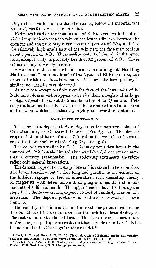
MAGNETITE AT STAG BAY
The magnetite deposit at Stag Bay is on the northwest slope of Cub Mountain, on Chichagof Island. (See fig. 1.) The deposit crops out at an altitude of about 710 feet on the west side of a small creek that flows northward into Stag Bay (see fig. 8).
The deposit was visited by G. C. Kennedy for a few hours in the summer of 1942, but the limited time available did not premit more than a cursory examination. The following statements therefore reflect only general impressions.
The deposit crops out on a steep slope and is exposed in two trenches. The lower trench, about 70 feet long and parallel to the contour of the hillside, exposes 55 feet of mineralized rock consisting chiefly of magnetite with lesser amounts of gangue minerals and minor amounts of sulfide minerals. The upper trench, about 150 feet up the slope from the lower trench, exposes 35 feet of similarly mineralized materials. The deposit probably is continuous between the two trenches.
The country rock is sheared and altered fine-grained gabbro or diorite. Most of the dark minerals in the rock have been destroyed. The rock contains abundant chlorite. This type of rock is part of the pretectonic group of igneOus rocks that has been described on Yakobi Island 45 and in the Chichagof mining district.46
«Reed, J. C., and Dorr, J. V. N., 2d, Nickel deposits of Bohemia Basin and vicinity, Takobl Island, Alaska : U. S. Geol. Survey Bull. 931-F, pp. 112-113, 1942.
«* Reed, J. C., and Coats, R. R., Geology and ore deposits of the Chichagof mining district, Alaska : U. S. Geol. Surrey Bull. 929, pp. 35-40,1941.

24 MINERAL RESOURCES OF ALASKA, 1945-46
The mineralized rock consists largely of magnetite, epidote, and quartz. It is estimated that magnetite constitutes about 60 percent of the rock and that quartz and epidote each makes up about 20 percent of the rock. Pyrite is locally abundant, and chalcopyrite is present but nowhere exceeds 2 percent of the rock.
Further development work on the prospect should be preceded by a magnetic survey of the area. Such a survey would indicate the presence or absence of a body of magnetite of significant size.
I36°20'
I36°20'
5 Miles
FIGURE 8. Map Showing location of magnetite deposit at Stag Bay.
GYPSTTM PROSPECT AT lYOTTIDEEJSr COVE
INTRODUCTION
The only known gypsum deposits in southeastern Alaska are on the east side of Chichagof Island near lyoukeen Cove (see figs. 1
and 9). Mining was started on one deposit in 1906 and continued with occasional interruptions until December 1923, when the mine was abandoned. In all, the property has probably produced about half a million tons of gypsum. . . . .

SOME MINERAL INVESTIGATIONS IN SOUTHEASTERN ALASKA 25
The deposits have been described or briefly mentioned in many Geological Survey publications, the most recent and complete descrip tion being by Stewart.47
A few years after the productive mine shut down eight claims known as the Gypsum-Camel group were staked in the name of
o
UM^JCAMELGYPSUM CO. PROSPECT 1
N0) s
I _L SMiles
FIGURE 9. Index map of a part of Chichagof Island showing location of gypsum mine andprospect at lyoukeen Cove.
Larson and Anderson.48 These claims are along the shore of lyoukeen Cove about iy2 miles east of the old mine. (See fig. 9.) The prospect on these newer claims was visited briefly by J. C. Heed and R. R. Coats on September 23, 1939. Up to that date no gypsum had been shipped, but a few tons, recovered while driving prospect openings, were stacked on the beach.
47 Stewart, B. D., The occurrence of gypsum at lyoukeen Cove, Chichagof Island, Alaska: U. S. Geol. Survey Bull. 824-E, pp. 173-177, 1932.
«Idem, p. 174.
26 MINERAL RESOURCES OF ALASKA, 1945-46
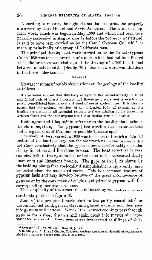
According to reports, the eight claims that comprise the property are owned by Dave Housel and Arvid Anderson. The latest develop ment work, which was begun in May 1939 and which had been tem porarily suspended in August shortly before the property was visited, is said to have been carried on by the Camel Gypsum Co., which is made up principally of a group of California men.
The principal development work carried on by the Camel Gypsum Co. in 1939 was the construction of a dock, which had not been floored when the prospect was visited, and the driving of a 100-foot tunnel between tunnels 2 and 3. (See fig. 10.) Some new work was also done in the three older tunnels.
GEOLOGY
Stewart 49 summarizes his observations on the geology of the locality as follows:
It also seems evident that this body of gypsum lies unconformably on tilted and folded beds of cherty limestone and limestone breccia and is overlain by partly consolidated beach gravel and sand of recent geologic age. It is also ap parent that the geologic relations of the indicated body of gypsum at this locality are similar in all essential respects to those existing at the deposit on Gypsum Creek and that the gypsum itself is of similar type and quality.
Buddington and Chapin,50 in referring to the locality that includes the old mine, state, "The [gypsum] bed overlies Carboniferous beds and is regarded as of Permian or possible Triassic age."
The study of the prospect in 1939 was too short to furnish a detailed picture of the local geology, but the observations on the property did not show conclusively that the gypsum lies unconformably on older cherty limestone and limestone breccia. The local structure is very complex both in the gypsum bed or beds and in the associated cherty limestones and limestone breccia. The gypsum itself, as shown by the bedding planes that are locally distinguishable, is apparently more contorted than the associated rocks. This is a common feature of gypSUm beds and may develop because of the great incompetence of gypsum or by the conversion of original anhydrite to gypsum with the corresponding increase in volume.
The Complexity Of the Structure is indicated by the scattered struc
tural data plotted in figure 10.Most of the prospect tunnels start in the partly consolidated or
unconsolidated sand, gravel, clay, and glacial moraine and then pass into gypsum or limestone. Some of the prospect openings pass through gypsum for a short distance and again break into masses of uncon solidated. material. These masses are interpreted as fillings of sink-
» Stewart, B. D., op. cit. (Bull. 824-E), p. 176.80 Buddington, A. F., and Chapin, Theodore, Geology and mineral depostis of southeastern
Alaska: U. S. GeoL Survey Bull. 800, p. 332, 1929.

SOME MINERAL INVESTIGATIONS IN SOUTHEASTERN ALASKA 27
22
30Limestone breccia
N A
EXPLANATION
Country rock is massive limestone
Strike and dip of beds
Limestone breccia
100 0111111
500 Feet
Total length of workings according to:(a) B. P. Stewart as of 1929(b) Operators as of 1939
Tunnel I Tunnel 2
Tunnel 3 Tunnel 4 (not drilled) 100 feet
FIGURE 10. Sketch map of vicinity of prospect of Camel Gypsum Co., lyoukeen Core.

28 MINERAL RESOURCES OF ALASKA, 1945-46
holes in the gypsum. One or two small caverns that were not filled with unconsolidated material were seen.
Stewart 51 has pointed out that the gypsum "underlies bench land adjacent to the shore of lyoukeen Cove" and that the recent partly consolidated material dips gently toAyard the beach.
The gypsum, which is present as massive material and locally as small masses in a sandy claylike material, is reported to be of high quality. Much of it is white and translucent, some is slightly red, and some is gray and banded. The impression was gained that a large amount of the material may be present, and it seems likely that care ful and detailed geologic work, including the sinking of drill holes from the benchland, might prove at relatively small expense the presence, location, and geologic relations of a large tonnage. Whether or not such material, even in large quantities, can be produced at a profit is an economic problem in which many factors are involved, and these should be carefully considered in any plan to develop the prospect commercially. The fact that the nearby old gypsum mine was able to operate for a long time demonstrates that the mining of gypsum in southeastern Alaska can be successful.
COPPER DEPOSIT AT WILLIAM HENRY BAY
INTRODUCTION
A deposit that was developed originally as a copper deposit is at William Henry Bay, a small inlet on the west side of Lynn Canal about 40 miles northwest of Juneau. (See fig. 1.) The deposit is on the west side of the valley of Beardslee Kiver, which enters at the head of William Henry Bay. It is about a mile south of the head of the bay and about 160 feet above sea level. An old surface tram, now over grown with brush, extends from the beach to the deposit.
In 1916 the property was taken over by the Alaska Endicott Mining & Milling Co. By 1918 S2 the company had driven most of the mainlevel, and, according to reports, had produced 200 tons of ore con taining 48.38 ounces of gold valued at $1,000 and 20 ounces of silver valued at $20.
The wharf ana all the mine buildings, with the exception Of the mill
and the assay office, are now in ruins. The mill house is still in ex cellent condition and a 15-stamp mill, Wilfley table, flotation cells,and two Pelton wheels still remain and seem to be in good condition.
The underground workings were mapped by W. S. Twenhofel and
G. M. Flint, Jr., in the summer of 1044.
« Stewart, B. D., op. cit. (Bull. 824-E), pp. 174-175."Mertie, J. B., Jr., Lode mining in the Juneau and Ketchikan districts: U. S. Geol.
Survey Bull. 714-B, pp. 109-112, 1921.
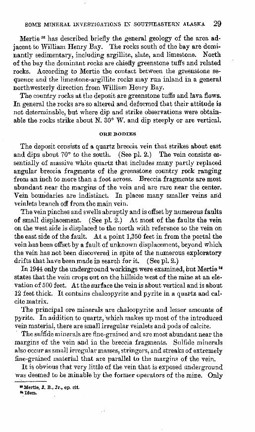
SOME MINERAL INVESTIGATIONS IN SOUTHEASTERN ALASKA 29
Mertie®3 has described briefly the general geology of the area ad jacent to William Henry Bay. The rocks south of the bay are domi- nantly sedimentary, including argillite, slate, and limestone. North of the bay the dominant rocks are chiefly greenstone tuffs and related rocks. According to Mertie the contact between the greenstone se quence and the limestone-argillite rocks may run inland in a general northwesterly direction from "William Henry Bay.
The country rocks at the deposit are greenstone tuffs and lava flows. In general the rocks are so altered and deformed that their attitude is not determinable, but where dip and strike observations were obtain able the rocks strike about N. 30° W. and dip steeply or are vertical.
ORE BODIES
The deposit consists of a quartz breccia vein that strikes about east and dips about 70° to the south. (See pi. 2.) The vein consists es sentially of massive white quartz that includes many partly replaced angular breccia fragments of the greenstone country rock ranging from an inch to more than a foot across. Breccia fragments are most abundant near the margins of the vein and are rare near the center. Vein boundaries are indistinct. In places many smaller veins arid veinlets branch off from the main vein.
The vein pinches and swells abruptly and is offset by numerous faults of small displacement. (See pi. 2.) At most of the faults the vein on the west side is displaced to the north with reference to the vein on the east side of the fault. At a point 1,350 feet in from the portal the vein has been offset by a fault of unknown displacement, beyond which the vein has not been discovered in spite of the numerous exploratory drifts that have been made in search for it. (See pi. 2.)
In 1944 only the underground workings were examined, but Mertie M states that the vein crops out on the hillside west of the mine at an ele vation of 500 feet. At the surface the vein is about vertical and is about 12 feet thick. It contains chalcopyrite and pyrite in a quartz and cal- cite matrix.
The principal ore minerals are chalcopyrite and lesser amounts of pyrite. In addition to quartz, which makes up most of the introduced vein material, there are small irregular veinlets and pods of calcite.
The sulfide minerals are fine-grained and are most abundant near the margins of the vein and in the breccia fragments. Sulfide minerals also occur as small irregular masses, stringers, and streaks of extremely fine-grained material that are parallel to the margins of the vein.
It is obvious that very little of the vein that is exposed underground was deemed to be minable by the former operators of the mine. Only
"Mertie, J. B., Jr., op. cit. «Idem.
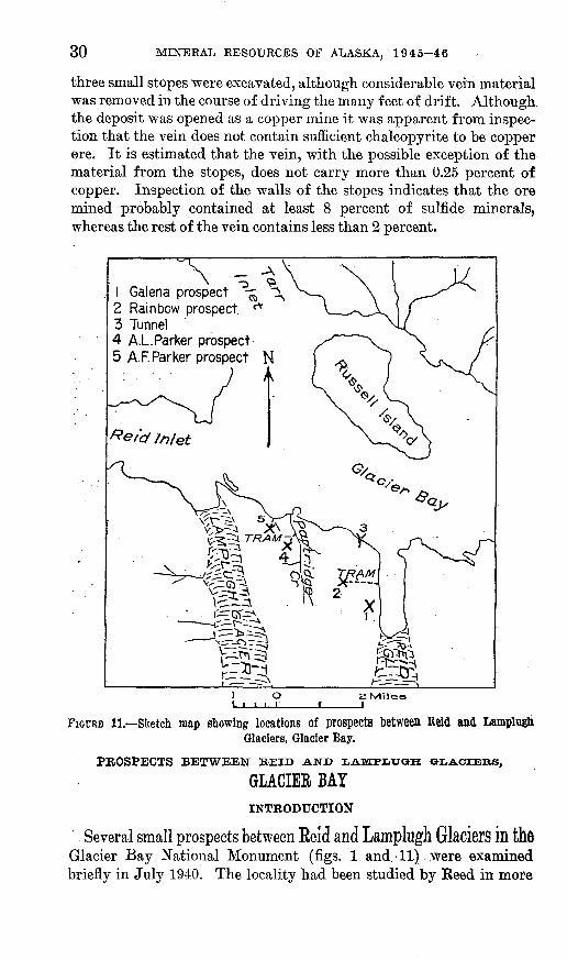
30 MINERAL RESOURCES OF ALASKA, 1945-46
three small stopes were excavated, although considerable vein material was removed in the course of driving the many feet of drift. Although the deposit was opened as a copper mine it was apparent from inspec tion that the vein does not contain sufficient chalcopyrite to be copper ore. It is estimated that the vein, with the possible exception of the material from the stopes, does not carry more than 0.25 percent of copper. Inspection of the walls of the stopes indicates that the ore mined probably contained at least 8 percent of sulfide minerals, whereas the rest of the vein contains less than 2 percent.
1 Galena prospect2 Rainbow prospect3 Tunnel4 A.L.Parker prospect5 A.F. Parker prospect N
2 Miles
FIGURE 11. Sketch map showing locations of prospects between ReW and LamplughGlaciers, Glacier Bay.
PROSPECTS BETWEEN REID AND LAMFJ-XrGKH OKDACIEIIS,
GLACIER BAYINTRODUCTION
Several small prospects between Eeid and Lamplugh Glaciers in the Glacier Bay National Monument (figs. 1 and. 11) .were examined briefly in July 1940. The locality had been studied by Eeed in more

SOME MINERAL INVESTIGATIONS IN SOUTHEASTERN ALASKA 31
detail in -1936 as part of a- systematic investigation of most of the known prospects of Glacier Bay.55 :
The following outline of the general geology and of the veins in the vicinity of Reid and Lamplugh Glaciers is quoted from Reed's report:
The principal country rock of the area * * * appears to be granite. The granite contains different-sized masses of engulfed older sediments which are siliceous and-possibly, originally were sandstones. Marble an'd slate crop out along.the east side of Reid Glacier and on the divide, between Reid and Lamplugh Glaciers * * *. The granite and older rocks are cut by dark-colored dikes in cluding many of lamprophyre and perhaps some of other rocks. * * *
The bed rocks of the * .* ' * vicinity are cut by quartz veins that range in thickness from a small fraction of an inch to as much as 18 inches. Several of the veins were traced horizontally for about 400 feet and for about the same distance vertically. One, with some interpolation, is mapped for a horizontal distance of about 1,600 feet an'd over a vertical range of more than 800 feet. * * *
The granite of the country rock is commonly intensely altered for several feet on each side of a vein. In several places fractures were observed along which alteration has taken place but which contained no vein. Locally several thin veinlets occupy single fracture zones. The altered zones are-apparent in the field because of their conspicuous bright color due to hydrated oxides of iron. * * * Many of the altered zones are 20 feet thick, and few are less than 10 feet.
The quartz of the veins is commonly banded, with comb quartz and vugs near the centers. The walls are free and are locally marked by a little gouge. Ore minerals observed include pyrite, marcasite, sphalerite, galena, and chalcopyrite. Of these, pyrite and sphalerite are the most abundant. ->
HISTORY, PRODUCTION, AND DEVELOPMENT
CLAIMS OF J. P. IBACH
The first two mining claims in the vicinity of ,Reid Glacier were staked in 1924 by J. P. Ibach for himself and his associates. In 1936 he staked a large number of claims and collected in all about 5 tons of ore from several prospects. The ore was taken to Lemesurier Island in Icy Strait near the mouth of Glacier Bay, where it was milled in a 2-ton Gibson mill.
In 1936 no ore was mined, but a considerable amount of prospecting is said to have been done. The Rainbow prospect (No. 2 on fig. 11) yielded almost 7 tons of ore in 1938, Ibach and Tom Smith are said to have produced 30 tons of ore from the Galena prospect (No. 1 on fig. 11) in 1939."
.An aerial tram to the Rainbow prospect was constructed-early in the summer of 1940. The prospect is at an altitude of about 1,900 feet, and the slope distance to tidewater is about 3,500 feet. In 1940, up to July 1,11 tons are said to have been produced from the Rainbow
83 Reed', J. C., Some mineral deposits of Glacier Bay and vicinity, Alaska: -Econ. Geology, vol.'33, No.-1, pp. 52-80, January-February'1938.

32 MINERAL RESOURCES OF ALASKA, 1945-46
prospect. It is reported that Ibach continued small-scale mining in the years 1941 and 1944.
CLAIMS OF A. L. AND A. F. PARKER
A. L. Parker holds two claims (No. 4 on fig. 11), the Lincoln and Le Roy in the vicinity of Partridge Creek, a small stream about half way between Reid and Lamplugh Glaciers. The claims were staked in 1938. A road leads from the beach up Partridge Creek about 2,400
LOWER ADIT } Elev.900 feet
Elev.96Qfeet
N
Vein stoped to surface fromupper adit.
FIGURE 12. Sketch map of workings at A. L. Parker prospect, Glacier Bay.
feet to a house that is near the foot of an aerial tram from the prospectThe tram is about 2,300 feet long.
In 1939, according to A. L. Parker, 3,300 pounds of ore wereshipped to the Tacoma smelter. The property was optioned by Le Roy
Mining Co. in 1940, and that company started operations early in 1941. A compressor, mill, and other mining equipment were in stalled. The company started mining on the upper level (fig. 12) and stoped the ore to the surface, about 70 feet above the upper level at the

SOME MINERAL INVESTIGATIONS IN SOUTHEASTERN ALASKA 33
face. In 1942, when the property was visited by Reed and Twenhofel, there was still ore in the face of the upper level. A lower level, about 60 feet below the upper level, had been driven about 140 feet in 1942 without encountering ore. According to the operators, about 250 tons of ore was mined in 1941, from which was recovered a little more than $45,000. In 1942 it is reported that the company exceeded its 1941 production. No data are available on the operation of the mine since 1942.
A. F. Parker's prospect (No. 5 on fig. 11) is farther west than the prospect of A. L. Parker and is nearer Keid Inlet. The .property was staked in 1938. The prospect is at an altitude of 850 feet and is con nected with tidewater by an aerial tram. The tram is powered with a 2-horsepower gasoline motor. According to reports, A. F. Parker had produced 7 or 8 tons of ore from his prospect up to July 1940. Forty-two sacks of ore were seen at the loading platform at the head of the tram and 15 more part way down where the grade of the tram changes abruptly.
VEINS
GALENA PROSPECT
Trenches near and along a small stream at the Galena prospect have exposed for about 60 feet a vein that ranges from 4 to 18 inches in width. A specimen of the banded and vuggy quartz shows abundant pyrite, sphalerite, and galena. In 1936, when the vein was not as well exposed as it was in 1940, Reed cut a sample across the full width at a place where it is 12 inches wide. An assay of the sample showed 0.16 ounce of gold and 0.30 ounce of silver per ton and 0.79 percent of zinc. According to the owner, the average value of the vein material is about $60 per ton.
RAINBOW PEOSPECT
The vein at the Rainbow prospect crops out on a precipitous slope. It strikes about N. 7° W. and dips 70° W. Along the vein fracture is considerable gouge and crushed quartz. The vein material, including the gouge, has been scraped out of the fracture for a length of about 100 feet and to a maximum depth of about 10 feet. * The material is said to average about $100 per ton, and some is said to be worth $360 per ton. A sample cut by Reed in 1936 across a width of 18 inches contained 0.97 ounce of gold and 0.50 ounce of silver per ton and 1.08 percent of zinc. When the prospect was visited in July 1940 a considerable amount of sacked ore was being held at the prospect pend ing the repair of the tram, which was temporarily out of commission.
TUNNEL
A 30-foot tunnel has been driven southward from just above high- tide level of Reid Inlet (No. 3 on fig. 11) along a fracture that dips
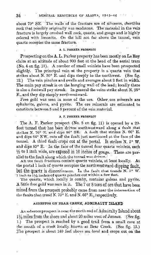
34 MINERAL RESOURCES OF ALASKA, 1945-46
about 70° SE! The walls of the fracture are of siliceous, chertlike rock that possibly originally was sandstone. The material in the vein fracture is largely crushed wall rock, quartz, and gouge and is highly colored with limonite. On tlie hill not far above the tunnel, vein quartz occupies the same fracture. <
A. L. PARKER PROSPECT
Prospecting on the A. L. Parker property has been mostly on Le Koy claim at an altitude of about 900 feet at the head of the aerial tram (No. 4 on fig. 11).. A number.of small veinlets have been prospected slightly. The principal vein at the .property is a quartz vein that strikes about N. 30° E. and dips steeply to the-northwest. (See fig. 12.) The vein pinches and swells and averages about 2 feet in width. The main pay streak is on the hanging wall of the lead; locally there is also a footwall pay streak. In general the veins strike about N. 25° E., and they dip steeply northwestward.
Free gold was seen in some of the ore. Other, ore minerals are sphalerite, galena, and pyrite. The ore minerals are estimated to constitute between 5 and 8 percent of the vein material.
A. F. PARKER PROSPECT
The A. F. Parker prospect (No. 5 on fig. 11) is opened by a 20- foot tunnel that has been 'driven 1 southwestward along a fault that strikes N. 70° "E. anddips 86° SE. A fault that strikes N. 66° E. and dips 64° NW. cuts off the fault just mentioned at the face of the tunnel. A third fault'crops out at the portal. It strikes N. 5° W. and" dips 85° E. In the face'of the tunnel four quartz veinlets, each % to 1 inch wide, are exposed in 10 inches of gouge. Tliese are par allel to the fault along which the tunnel was driven.
-A.il the fault fractures contain quartz veinlets, at least locally. At the portal 1 inch of quartz occupies the northwestward-dipping faillt, bllt the QUartZ iS discontinuous. In the fault that trends N. 5° W.
'.1 inch to 1^6 inches of quartz pinches out within a few feet.The quartz, which locally is comby, contains galena and pyrite.
A little free gold was seen in it, The 7 or 8 tons of ore that have been mined from the prospect probably came from near the intersection of the faults that trend N. 70° E. and N. 66° E., respectively.
ASBESTOS ON BEAR CREEK, ADMIRALTY ISLAND
An asbestos prospect is near the north end of Admiralty Island about l!/2 miles from the shore and about 20 miles west of Juneau. (See fig. 1.) The prospect is reached by a good trail from a small cove at the-mou.th of a- creek locally, known-as Bear Creek. (See fig. 13.) ,The prospect is about 140 feet above sea level and crops out on the

SOME MINERAL INVESTIGATIONS IN SOUTHEASTERN ALASKA 35
east side of a steep cutbank of a tributary to Bear Creek. At the mouth of Bear Creek are several cabins that were built by the owners .of the deposit, A rail tram was started from the cove to the deposit, but it was completed only for a short distance.
The deposit was first located by the late Augustus cle Roux, of Juneau;
The prospect was examined by B. D. Stewart,56 of the Territorial Department of Mines, in 19.28 and by W. S. Twenhof el and G. M. Flint,
(Mile
FIGURE 13. Sketch map showing location of Bear Creek asbestos deposit, Admiralty Island.
Jr., of the Geological Survey, in 1944. The deposit was not as well exposed in 1944 as in 1928.
The asbestos crops out as a band in amphibole schist that is exposed in a steep cutbank of a small stream. Apparently at one time a small amount of trenching %as done, but subsequently the bank has slumped and the asbestos is poorly exposed. However, with a small amount of effort the bank could be trenched to expose the asbestos band for a strike length of at least 60 feet. In 1944 the asbestos was exposed for a length of i4 feet, and in places where both walls of the band were seen it was 1% feet wide. (See fig. 14.) The asbestos band is parallel "to the foliation of the enclosing schist, which strikes about N. 45° W. and is vertical.
The asbestos occurs as leaves and sheaves of parallel fibers, as much as 18 inches long, that are parallel to the strike of the band. The mate-
58 Stewart, B. D., Occurrence of tremolite asbestos on Admiralty Island, southeastern Alaska, Territorial Dept. Mines (unpublished report).
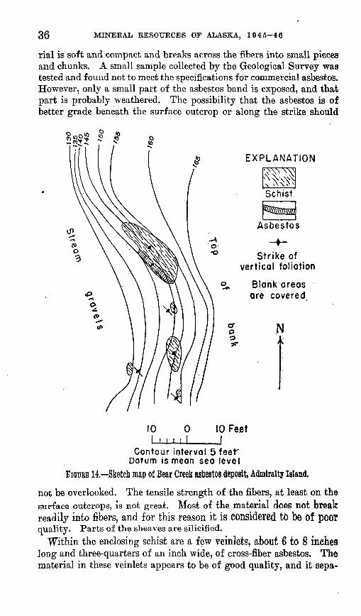
36 MINERAL RESOURCES OP ALASKA, 1945-46
rial is soft and compact and breaks across the fibers into small pieces and chunks. A small sample collected by the Geological Survey was tested and found not to meet the specifications for commercial asbestos. However, only a small part of the asbestos band is exposed, and that part is probably weathered. The possibility that the asbestos is of better grade beneath the surface outcrop or along the strike should
Asbestos
Strike of vertical foliation
Blank areas are covered
N
10 10 Feet I
Contour interval 5 feet" Datum is mean sea level
FIGURE 14. Sketch map of Bear Creek asbestos deposit, Admiralty Island,
not be overlooked. The tensile strength of the fibers, at least on the surface outcrops, is not great. Most of the material does not break readily into fibers, and for this reason it is considered to be of poor quality. Parts of the sheaves are silicified.
Within the enclosing schist are a few veinlets, about 6 to 8 inches long and three-quarters of an inch wide, of cross-fiber asbestos. The material in these veinlets appears to be of good quality, and it sepa-
SOME MINERAL INVESTIGATIONS IN SOUTHEASTERN ALASKA 37
rates readily into thin fibers that are limited in length by the width of the veinlet. The amount of cross-fiber asbestos present is believed to be small.
The asbestos has been reported erroneously to be of the chrysotile variety,57 but the material collected in 1944, both the cross-fiber and the parallel-fiber material, has been identified as of the tremolite variety. Possibly the specimen that had previously been identified as chrysotile was not from the Admiralty Island deposit.
If further development of the property is undertaken, it is recom mended that additional information on the quality of the material be obtained. This would involve excavating the asbestos band along its strike and beneath the weathered outcrop. Asbestos is generally mined by the company that processes it. Some asbestos that may be usable by one company may not be usable by another manufacturer who has been using a slightly different type of material. Thus it is apparent that once the quality of the asbestos on Admiralty Island has been determined it will be necessary to ascertain whether any manu facturer desires that type of material.
A copper prospect is on the east side of Kupreanof Mountain about 4 miles north of the head of Towers Bay, which is in Duncan Canal about 15 miles northwest of Petersburg. (See fig. 1.) It was dis covered about 19,00 and was owned early in its history by the Portage Mountain Mining Co., which also held the claims on Portage Moun tain about 6 miles east.58 Prior to 1918 the Northern Copper Co. took over the property and started the construction of a plank truck road from Towers Bay to the deposit. 59 Only 4% miles of the road had been completed when work was stopped. The property has been idle since, and little if any ore has been shipped. The plank road is in ruins.
Buddington 60 has described the deposit and its mineralogy, and the salient features mentioned are summarized below: The ore minerals are chiefly pyrrhotite and chalcopyrite, which occur as veinlets and blebs replacing pyroxene granulite. Minor amounts of sphalerite and magnetite are present also. The hanging wall of the pyroxene granu lite is highly altered fine-grained diorite, and the footwall is inter- bedded slate and chert. The pyroxene granulite consists of euhedral pyroxene crystals, with interstitial quartz and a little garnet.
« Smith, P. S., Mineral resources of Alaska, 1929: U. S. Geol. Survey, Bull. 824, p. 80, 1932.
88 Wright, F. E. and C. W., The Ketchikan and Wrangell mining districts, Alaska: U. S. Geol. Survey Bull. 347, pp. 141-142, 1908.
w Buddington, A. F., Mineral deposits of the Wrangell district, southeastern Alaska: U. S. Geol, Survey Bull. 739-B, pp. 70-72, 1923.
»Idem.

38 MINERAL RESOURCES OF ALASKA, 1945-46
Development work on the property consists of a 40-foot shaft with a drift at the bottom, a 375-foot adit, a 120-foot trench, and several open cuts that have largely slumped. (See fig. 15.) The shaft -was not entered by the- Survey party-that visited the property in 1944, but sulfide minerals were seen on the dump. The trench exposes irregular masses and bands of mineralized pyroxene granulite. Although the pyroxene granulite is poorly exposed, the exposures in the trench indi cate that it strikes about N. 55° E. and dips 10° to 20° SE. The 375-foot adit is about 150 feet lower than the other workings. It
Pit 4 feet deep <^>- ,. ^ Opencut Q £1.1300 feet Cabin £ &./27Ofeet
\ '>AN
N
FIGURE 16. Sketch map of adit 1 at lead prospect on Coronation Island,
encountered no Sulfide minerals and was driven in. horizontally bedded
black slate.Because exposures are so poor it is difficult to estimate the amount of
the Slllfide minerals. However, it is estimated that chalcopyrite may make up 1 percent of the mineralized material and pyrrhotite 5 to 10 percent.
LEAD PROSPECTS ON CORONATION ISLAND
Coronation Island lies at the entrance of Sumner Strait about 6 miles
south of the south tip of Kuiu Island and about 80 miles southwest ofWrangell. (See fig. 1.) According to the WriglltSj01 galena WaS (US'
Covered in 1900 by sailors who were stormbound in Egg Harbor, on
the north end of the island. In 1902 the Coronation Island Mining Co.acquired the property and for several years carried on operations.
* Wright, F. E. and C. W., The Ketchikan and Wrangell mining districts, Alaska: U. S. Geol. Survey Bull. 347, pp. 190-191, 1908.

SOME MINERAL.INVESTIGATIONS IN SOUTHEASTERN ALASKA 39
It is reported that more than 100 tons of ore have been mined and shipped. ' . , : -..;
Most of Coronation Island is underlain by white massive limestone and marble.' Bedding is largely, obscured by folding .and metamorph- ism. Near the center of the island is a large mass of intrusive diorite. ,, The deposits are above timber line at elevations of 800 to 1,100 feet on Pin Peak on the west side of Egg Harbor. A good trail leads from
85Fault'-*
10 0
d up 15 feet
El ev. 10 feet
Breccia zone
50 Feet
FIGURE 16. Sketch map of adit 1 at lead prospect on Coronation Island.
tidewater on the west side of Egg Harbor, from a point a few feet north of the most southerly cave at high-tide level, to adit 1 at an altitude of 1,020 feet. (See fig. 16.) About a quarter of a mile north of adit 1 is adit 2 at an altitude of 900 feet. (See fig. IT.) An old tramline leads from adit 2 to the beach a few hundred feet north of the point where the trail starts up the mountain. The Wrights 62 mention a third adit, but this was not found.when the area was ; examined in 1944. The old tramline follows a steep, narrow gully up;
' FIGURE 17. Sketch of adit 2 at lead prospect on Coronation Island.
the mountainside, and near the top of the tramline above adit 2 old planks and timbers are buried in an avalanche of slide rock. The portal of the third adit probably is now buried beneath this debris.
The ore bodies in the two adits examined have been completely mined out; in fact, neither galena nor any other sulfide mineral was seen. However, it is apparent that the ore bodies were lenticular
"Wright, F. E. and C. W., op. cit. (Bull. 347). :

40 MINERAL RESOURCES OF ALASKA, 1945-46
masses in fault zones. Numerous faults were seen on the surface. Within the faults are zones as much as 4 feet wide containing brec- ciated limestone fragments cemented by gouge and clay. The galena ore was deposited in some of the wider parts of the faults. Some parts of the faults are iron-stained on the surface, and the larger of these have been prospected by small pits. At most, the ore bodies could not have been more than about 10 or 20 feet in greatest dimension.
It is probable that other ore bodies are present in the fault zones, but their value probably would not be commensurate with the effort needed to find them.
Witheriteoccurrences
0 4Miles
18. Map of north end of Kuiu Island showing location of witherite deposits.
INTRODUCTION
Short, widely separated stringers of witherite (BaCO8) associated
with stringers of barite (BaS04) occur in volcanic rocks along the northeast shore of the Cornwallis Peninsula on Kuiu Island and in limestone on one of the Keku Islets. (See figs. 1 and 18.) The de posits on the Cornwallis Peninsula were discovered by George Corn- stock about 1931. Specimens from these deposits were identified as

SOME MINERAL INVESTIGATIONS IN SOUTHEASTERN ALASKA 41
witherite by B. D. Stewart. Later, E. S. Hungerf ord found witherite on one of the Keku Islets. There has been no development work at either locality.
A few thin stringers of witherite have also been reported on the northeast shore of the Cornwallis Peninsula south of the small island where witherite was found and also about a mile farther southeast; on the southwest shore of Saginaw Bay; and at the head of the first bight west of the mouth of Saginaw Bay. All the localities mentioned in this paragraph, except the one farthest southeast on the northeast shore of the peninsula, which was covered with snow, were examined by G. O. Gates in the winter of 1942, and no witherite was found. Four days were spent in these examinations.
WITHERITE DEPOSITS ON THE NORTHEAST SHORE OF THE CORNWALLIS PENINSULA
Short, discontinuous, and widely separated stringers of witherite and stringers and veins of barite are exposed along the northeast shore of the Cornwallis Peninsula, between points 2^ and 3% miles south east of the Point Cornwallis Light. (See fig. 18.) Between these' two points a sequence of acidic tuffs, breccias, and lava flows has been beveled by wave action to form a bench 50 to 200 feet wide. This bench is backed by steep slopes and bluffs largely covered with vegeta tion. The stringers of witherite and barite are exposed on the bench between high- and low-tide levels. To the northwest and southeast of the volcanic rocks the shore consists of bold cliffs of limestone in which stringers also are present, but these consist entirely of calcite.
STRUCTURE
The volcanic rocks dip gently and are much broken by irregular nearly vertical fractures that can be grouped roughly into two sets. One set consists of fractures, spaced 30 to 100 feet apart, that can be traced all the way across the bench. These strike N. 30° to 70° W. Obscure slickensides and reversals of dips of the volcanic rocks indi cate that there has been some movement along these fractures but not enough to form breccia and gouge. Adjacent to these fractures or faults the rocks are more broken. The fractures of the other set, which are spaced a few inches to a few feet apart, strike north to N. 20° W. and are a few inches to a few feet long.
VEINS
Some of the fractures of both sets have been filled with either barite or witherite. The two minerals are associated in the same stringer in only a few fractures.
Barite veins and stringers. Most of the mineralized fractures are filled entirely with barite. These have been described by Bud-
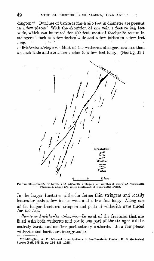
42 MINERAL RESOURCES OF ALASKA,'1 945-46^
dihgtbh.63 Bunches of barite as much as 5 feet in diameter are present in a few.places. With the exception of one vein 1 foot to 2^ feet wide, which can be traced for 200 feet, most of the'barite occurs in stringers 1 inch to a few inches wide and :a few inches to a few feet long. ; ' > ' -
: 'Witherite. stringers. -Most of the1 witherite stringers are less than an inch wide and are a few inches to a few feet long. (See fig. 19.)
10 Feet
FIGURE 19. Sketch of barite and witherite stringers on northeast shore of Cornwallis Peninsula, about 2% miles southeast of Cornwallis Point.
In the larger fractures witherite forms thin stringers and locally lenticular pods a few inches wide and a few feet long. Along oneof the longer fractures stringers and pods of witherite were traced for 150 feet.
Bariie and 'wltKente siringers. In most of the iractures tkat arftfilled with both witherite and barite one part of the stringer will be entirely barite and another part entirely witherite. In a few places witherite and barite are intergranular.
* Buddington, A. F., Mineral investigations in southeastern Alaska: U. S. Geological Survey Bull. 773-B, pp. 136-138, 1925.

SOME MINERAL INVESTIGATIONS IN SOUTHEASTERN ALASKA 43
Stringers of witherite are exposed at the northwest and northeast corners of the easternmost of the two long islands nearest the north east shore of the Cornwallis Peninsula and about 6.5 nautical miles southeast of Point Cornwallis Light. (See fig. -18.)
At this locality witherite stringers are associated with stringers of barite and calcite. All these stringers cut fine-grained gray limestone, which in some places has been recrystallized to pods of coarse-grained calcite several feet in diameter. The stringers are mostly less than 2 inches wide and a few inches to a few feet long. Stringers of barite predominate and are found along the entire shore of the island. Witherite is localized at the northwest and northeast corners of the island.
WITHERITE AT NORTHWEST CORNER OF ISLAND
The largest stringer of witherite found on the island is at the northwest corner. The stringer pinches out at each end and follows a curving fracture from the low-water line for 46 feet across a rocky shore. From north to south the strike changes from N. 25° E. to N. 4° E. and the dip ranges from 75° to 85° E. In a 12-foot interval near the center of the outcrop the stringer is a vuggy pod 4 to 7 inches wide; the other parts are 14 inch to 2 inches wide. Except for a border of coarse-grained calcite along each wall of the central pod, the stringer consists entirely of witherite. A few smaller stringers of witherite crop out on either side of this stringer.
Barite stringers are present here as elsewhere along the shore of the island.
WITHERITE AT NORTHEAST CORNER OF ISLAND
At the east end of the island a number of nearly vertical basalt dikes, 10 feet to several tens of feet wide, cut the limestone in a northwesterly direction.
The barite stringers at this place have been described by Budding- ton.64 Only one of these differs from those described elsewhere in this report. In addition to barite, one stringer contains considerable anhedral pyrite, a few streaks of galena, and some late witherite. Most of the stringers of barite are in limestone, but a few cut basalt dikes.
The witherite is contained largely within a zone in the limestone. This zone is about 80 feet wide and is cut by closely spaced, anastamos- ing seams and veins of fine-grained quartz. Some barite and calcite also are present in this zone. Numerous vugs lined with drusy quartz are common throughout the zone. A few of the vugs are filled with witherite, and the zone also contains a few stringers of witherite, the
« Buddington, A. F., op. cit. (Bull.'773-B), p. 136.

44 MINERAL RESOURCES OF ALASKA, 1945-46
largest of which is 17 feet long and extends to 7 feet below low tide- The stringer strikes N. 50° E. and dips 65° NW. It is 14 inch to 1 inch wide except at the center, where it swells to form a pod 2 feet, long and 5 inches wide. It is bordered by bands of coarse calcite i inch wide.
MINERALOGY
The barite is white or pink, and platy except in some of the larger veins, where it is fine-grained.
The witherite is bluish white. Surfaces that are exposed to wave action are milky white and very conspicuous. Freshly broken surfaces- show a characteristic radiating columnar structure, which in some- places is combined with concentric banding perpendicular to the- columns.
ORIGIN OF THE DEPOSITS
Buddington 6B states:The origin of the veins is not evident. Basalt dikes, however, are found in.
their vicinity, and there is a possibility that the mineralization followed the- intrusion of these dikes and was effected by solutions that originated in the- same underlying magma as the dikes and deposited their dissolved mineral matter in the fissured volcanic rock, conglomerate, and limestone. The structure of the veins and the association of chalcedony with the barite at one locality suggest that they are of the low-temperature, low-pressure, near-surface type.
The association of the witherite and the barite stringers indicates- that the two minerals had a common source. Most of the witherite was probably a little later than the barite, though intergranular witherite and barite in a few stringers indicate some overlapping.
POSSIBILITY OF COMMERCIAL WITHERITE DEPOSITS
None of the known witherite deposits is of commercial value.AJLth.ou.gh. the wide distribution, of the -witherite stringers shows that
witherite almost certainly occurs at other places in the vicinity, the indications are that these also are small. The witherite fills fractureswith little or no replacement of country rock. Furthermore, the country rock is broken by many small fractures instead of by a fewlarge faults. Hence the solutions that deposited the witherite prob-
ably were dispersed in many small channels rather than concentratedin a f ew larger ones.
« Buddington, A. F., op. dt. (Bull. 773-B), p. 137.

INDEX
PageAdmiralty Island, asbestos deposit on..--.-.. 34-37 Apex mine.... . 20-23Asbestos deposit..._ -.- 34-37
Barite deposits......................... 17-19,41-42Bear Creek, asbestos deposit of.......-..-..-. 34-37Big Harbor mine..---..----.-.-.------------- 15-17
copper deposits of.... ... ... . 15,17Buddington, A. F., quoted....._....... 44Buddington, A. F., and Chapin, Theodore,
quoted... 26
Chichagof Island, gypsum deposits..... 24-28magnetite deposits ..-.........--.---.. 23-24scheelite deposits....--------------------- 20-23
Copper Cliff deposit. See Dama prospect. Copper deposit, Duncan Canal..-...- 37-38
in Flagstaff goldmine............-------- 12-13Kashevarof Passage...-____ 13-15 Kupreanof Island.....-.--....---.-------- 37-r38Lake Bay..-.-..-..... ... 13-15Niblack Anchorage..__.____ 7-8 Prince of Wales Island 7-15,19-20Trocadero Bay...__...__.. 15-17Twelvemile Arm..___...___.. .. 8-10William Henry Bay.. .. 28-30
Copper-lead deposit......_._.. 19-20Cornwallis Peninsula, witherite deposits on.. 40-42 Coronation Island, lead deposits on. .. 38-40
Dama prospect. ------......__ 7-8,9Duncan Canal, copper deposit near... .. 37-38
ElNidomine... 20-23
Federal Government, investigations by.... _ 2-6Flagstaff mine, development....._ ... 10-11
geology.._____________ 11-13, pi. 1location...._____..___.. .. 10
Galena prospect; the.-...__.............. 30,31,33Galena prospects- __ _._.__ 38-40 Glacier Bay, prospects near__________ 30-34 Gold.. . 10-13,33-34Gypsum... .... ._ .._- _ 24-28
Hetta Inlet, barite deposits near-Page
. 17-19
O
Ibach, J. P., claims of........................ 31-32lyoukeen Cove, gypsum deposits near..._.. 24-28
Kasaan Bay, mineral deposits near......_.. 10-13Kashevarof Passage, copper deposits near..... 13-15Keku Islets, witherite deposits on........__ 43-44Kuiu Island, witherite deposits of......__.. 40-44Kupreanof Island, copper deposit on____. 37-38
Lake Bay, copper deposits near__..._.... 13-15Lead prospects...-..----..........._....... 38-40Lime Point, barite deposits near.__.___ 17-19 Lisianski Inlet, scheelite deposits near._.... 20-23
McCullough prospect. See Lake Bay, copperdeposits near.
Magnetite, Chichagof Island deposits......_ 23-24Marion and Ella claims...._________ 20
Niblack Anchorage, deposits near..... _. _ 7-8 Nutkwa Lagoon, copper-lead deposit near._ 19-20
Parker, A. F., claims of...__________ 33,34 prospect.__________________ 30,34
Parker, A. L., claims of..______.__ 32-33,34 prospect..._._...______.____ 30,34
Partridge Creek, prospects near....___ 30,32-33Prince of Wales Island, barite deposits____ 17-19
copper deposits.______________ 7-20 copper-lead deposit.______.____ 19^20
Kainbow prospect.____________ 30,31-32,33 Eeed, J. C., quoted._____________ 31 Reid Glacier, prospects near_________ 30-34
Scheelite, Chichagof Island deposits.._._ 20-23 Shelton prospect..___.__________ 8-10 Stag Bay, magnetite near..___________ 23-24 Stewart, B. D., quoted...................._ 26,28
Trocadero Bay, copper deposits near.....__ 15-17 Twelvemile -Arm, mineral deposits near...... 8-10
William.Henry Bay, copper deposit near.__ 28-30 Witherite deposits............................ 40-44
45