military circle / military highway urban development area public meeting
DESCRIPTION
Boards from community meeting February 29, 2016TRANSCRIPT

WELCOME!
Military Circle / Military Highway Urban Development AreaPUBLIC MEETING February 29, 2016 City of Norfolk
To the Military Circle / Military Highway Urban Development Area PUBLIC MEETING
This project will develop a Vision for the Military Circle/Military Highway area in Norfolk. The Military Circle shopping center and some surrounding commercial development need more economic reinvestment and revitalization that will enhance the area, contribute to the City economy and enhance the quality of life and business climate in the area.
What is it?
The City and Hampton Roads Transit have been studying an extension of the Tide Light Rail line to the Naval Station and one potential corridor for that extension runs along Military Highway, with potential station areas in the vicinity of the Military Circle and JANAF shopping centers. At the same time, the City has obtained a grant from the State Office of Intermodal Planning and Investment to provide technical assistance to re-envision this site as an Urban Development Area – an area designated for higher density development that incorporates the principles of Traditional Neighborhood Development. After collecting feedback from the public and Advisory Committee, a team of professional planners and designers has been working with City leaders, residents and business owners to develop the vision for this area at no additional cost to the City.
Why this project? Why now?
Transit Oriented Development (TOD) is an approach to designing and developing areas such as this site that is based on compact mixed use development (mixing housing, shopping and offices), walkable, safe streets, open spaces and plazas and convenient travel choices such as walking, biking and transit. It has proven to successfully outcompete conventional non-TOD development in many cities throughout the nation, and frequently results in increases in property values for residents, higher office and retail rents and an overall vibrant, vital and valued community center. In addition, TOD responds to many predicted trends in demographic and consumer preferences for more walkable urban centers as being the future magnets for the 21st century workforce and the key to making Norfolk more competitive in attracting future jobs and investment.
What are the benefits?
The City has been engaging with residents, business owners and developers with a stake in the Military Highway/Military Circle area.
Study materials and comment forms are available at www.norfolk.gov/militarycirclestudy
Contact the City planning department for more information: Paula Shea, AICP – Norfolk Department of City Planning - City of Norfolk, VA – (757) 664-4772, [email protected]
How can I get more information?

WHERE WE’VE BEEN
Military Circle / Military Highway Urban Development AreaPUBLIC MEETING February 29, 2016 City of Norfolk
Process, Goals & Public Involvement
JULY OCTOBER DECEMBER FEBRUARY APRIL JULY
ADVISORY COMMITTEE
PUBLIC
STAKEHOLDERS/ CIVIC LEAGUES
STAFF
September 28th Public Meeting -111 attendees, 87 of which were Norfolk residents
Additional input from stakeholders, civic league representatives and property owners in the area
Where we are in the process Input collected from:
Goals Established
DON’T SIT ON A SHELF BE TRANSPARENT BE INCLUSIVEBE SUSTAINABLE
REVITALIZE SURROUNDING
AREA
INCREASE SAFETY & SECURITY
ATTRACT ECONOMIC
DEVELOPMENT
BUILD FOR RESILIENCE
CONNECT & UNIFY THE AREA
Project Goals:
Process Goals:
Ideas for BrandingBranding is an ongoing process that will extend beyond the life of this planning process. Through several iterations, three themes have been popular among residents and stakeholders: 1) Regional Destination (CROSSING), 2) Localized (NORFOLK), and 3) Legacy (MERMAID)
September 28th Public Meeting

WHERE WE’VE BEEN
Military Circle / Military Highway Urban Development AreaPUBLIC MEETING February 29, 2016 City of Norfolk
Regional Assessment & Potential
Crossroads of the RegionMilitary Circle has been the historical crossroads of the region, from the construction of Military Highway and Virginia Beach Boulevard, to the installment of interstate highways. It could also be the crossroads of the future if light rail crosses through the area.
A
B
Source: NSN Transit Extension study – February 2015
Potential Light Rail AlignmentsThe 2015 Naval Base Study provided two options for bringing light rail to the base. An eastern alignment may include:
Split off at or near Curlew Dr Station to follow Military Hwy
Split off at or near Newtown Rd Station to follow Kempsville Rd
INTERSTATES
BOULEVARDS
LIGHT RAIL (Potential)
WHERE WE’VE BEEN
Military Circle / Military Highway Urban Development AreaPUBLIC MEETING February 29, 2016 City of Norfolk
Alternatives for Light Rail and Land Use
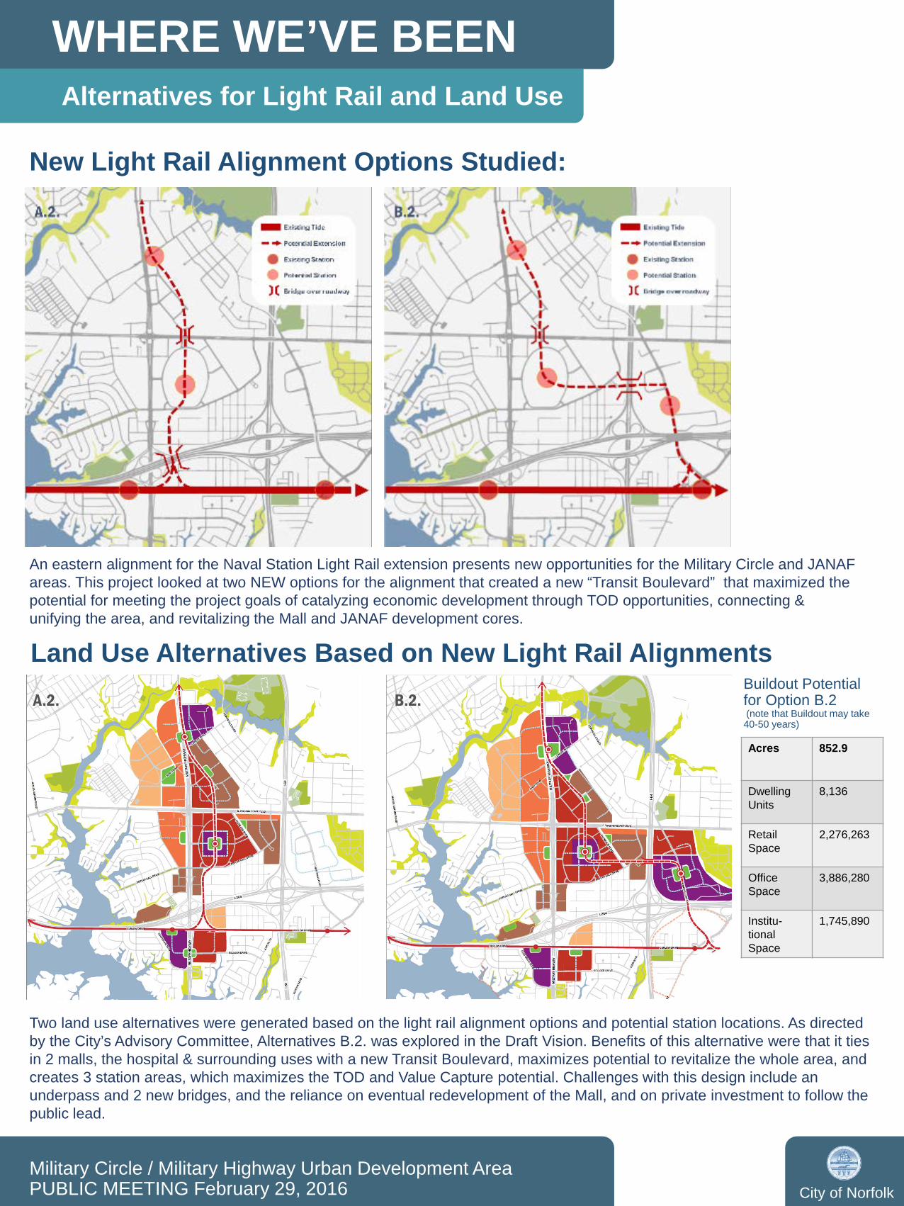
New Light Rail Alignment Options Studied:
An eastern alignment for the Naval Station Light Rail extension presents new opportunities for the Military Circle and JANAF areas. This project looked at two NEW options for the alignment that created a new “Transit Boulevard” that maximized the potential for meeting the project goals of catalyzing economic development through TOD opportunities, connecting & unifying the area, and revitalizing the Mall and JANAF development cores.
Land Use Alternatives Based on New Light Rail Alignments
Two land use alternatives were generated based on the light rail alignment options and potential station locations. As directed by the City’s Advisory Committee, Alternatives B.2. was explored in the Draft Vision. Benefits of this alternative were that it ties in 2 malls, the hospital & surrounding uses with a new Transit Boulevard, maximizes potential to revitalize the whole area, and creates 3 station areas, which maximizes the TOD and Value Capture potential. Challenges with this design include an underpass and 2 new bridges, and the reliance on eventual redevelopment of the Mall, and on private investment to follow the public lead.
A.2. B.2.
Acres 852.9
DwellingUnits
8,136
Retail Space
2,276,263
Office Space
3,886,280
Institu-tionalSpace
1,745,890
Buildout Potential for Option B.2(note that Buildout may take 40-50 years)
PROJECT CONTEXT
Military Circle / Military Highway Urban Development AreaPUBLIC MEETING February 29, 2016 City of Norfolk
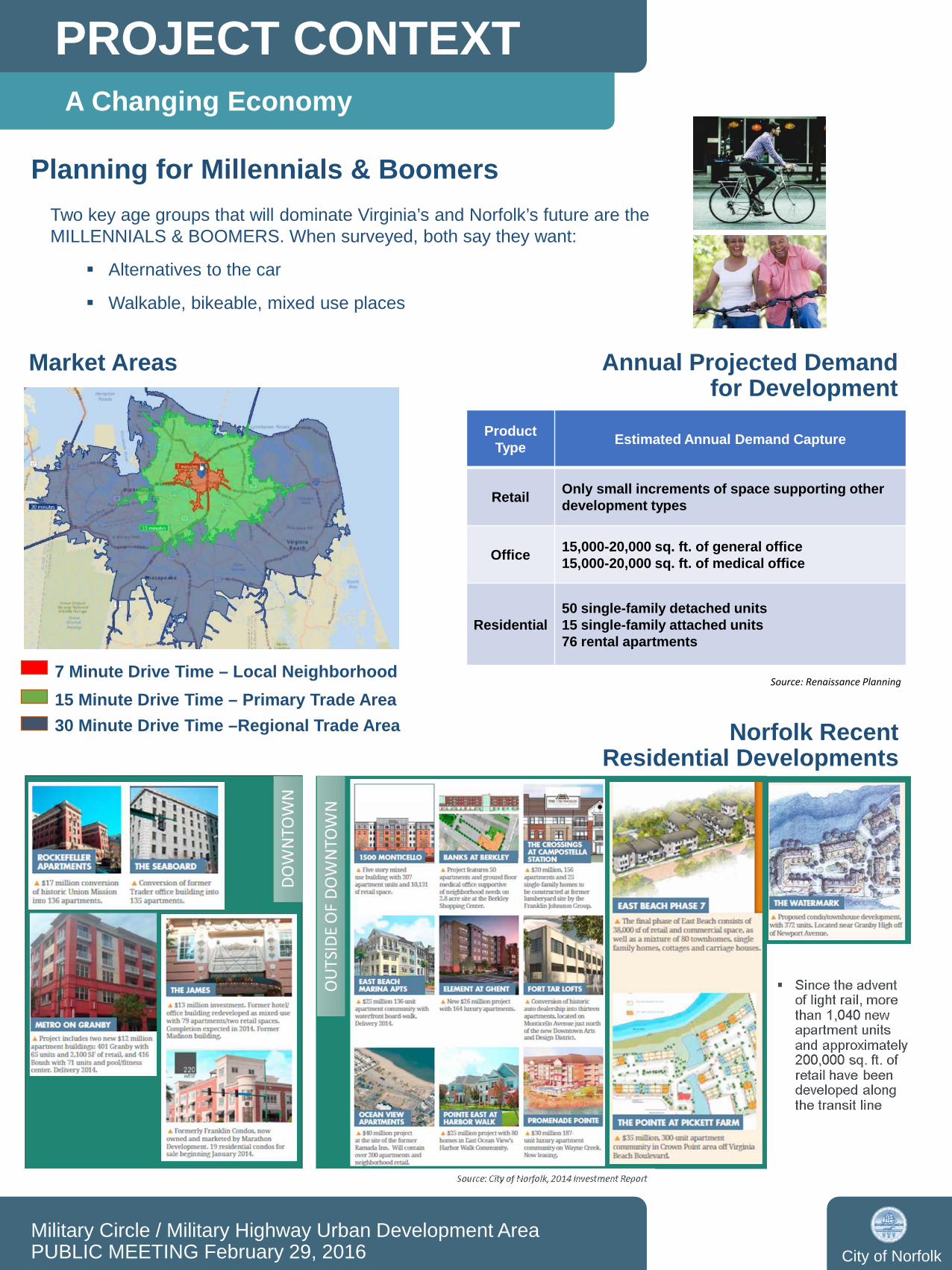
A Changing Economy
Market Areas
7 Minute Drive Time – Local Neighborhood15 Minute Drive Time – Primary Trade Area30 Minute Drive Time –Regional Trade Area
Annual Projected Demand for Development
ProductType Estimated Annual Demand Capture
Retail Only small increments of space supporting other development types
Office 15,000-20,000 sq. ft. of general office 15,000-20,000 sq. ft. of medical office
Residential50 single-family detached units15 single-family attached units76 rental apartments
Source: Renaissance Planning
Norfolk Recent Residential Developments
Planning for Millennials & BoomersTwo key age groups that will dominate Virginia’s and Norfolk’s future are the MILLENNIALS & BOOMERS. When surveyed, both say they want:
Alternatives to the car
Walkable, bikeable, mixed use places

PROJECT CONTEXT
Military Circle / Military Highway Urban Development AreaPUBLIC MEETING February 29, 2016 City of Norfolk
Changes in Transportation
Current & Potential Transportation Networks
New Rail Alignments Create Transit Oriented Development (TOD) Potential
at Military Circle / Military Highway
Source: Florida Department of Transportation Systems Planning Office www.dot.state.fl.us/planning/systems/sm/los/default.shtm
• At 6 lanes, both Military Highway and Virginia Beach Blvd are potentially over capacity.• Portions of these roads go up to 8, 10, or even 12 lanes• However, driveways and intersection dynamics reduce the potential capacity
*NOTE – does not account for constraints on roadway capacity resulting from intersection capacity & operations
Excess Capacity & New Transit Create Potential for ‘Road Diet’
PROJECT CONTEXT
Military Circle / Military Highway Urban Development AreaPUBLIC MEETING February 29, 2016 City of Norfolk
Quality of Life Factors
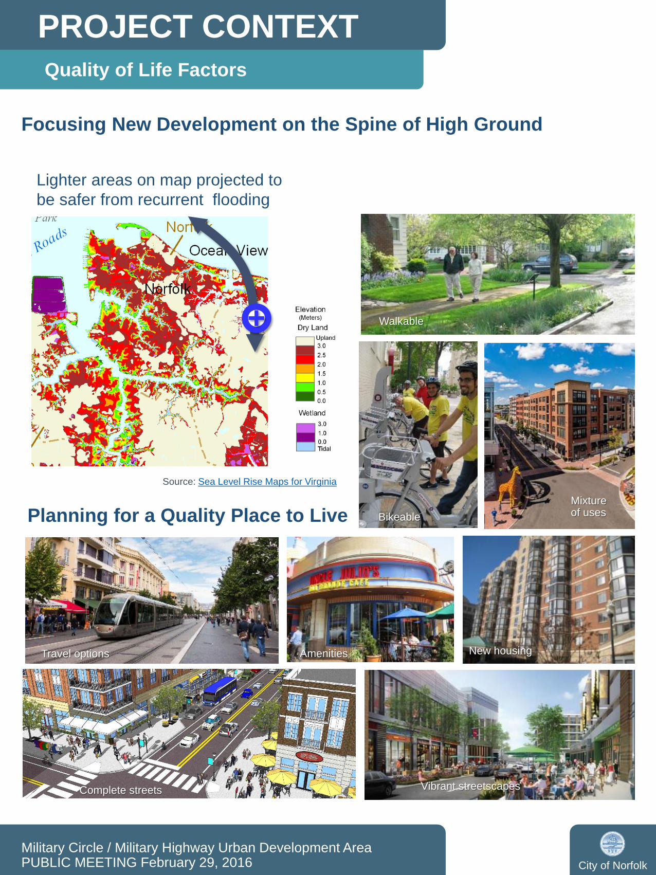
Focusing New Development on the Spine of High Ground
Source: Sea Level Rise Maps for Virginia
Planning for a Quality Place to Live
Vibrant streetscapes
Amenities New housing
Mixture of uses
Complete streets
Travel options
Bikeable
Walkable
Lighter areas on map projected to be safer from recurrent flooding
DRAFT VISION
Military Circle / Military Highway Urban Development AreaPUBLIC MEETING February 29, 2016 City of Norfolk
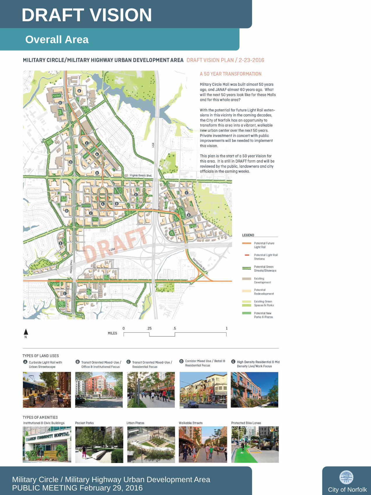
Overall Area

DRAFT VISION
Military Circle / Military Highway Urban Development AreaPUBLIC MEETING February 29, 2016 City of Norfolk
Kempsville Road Area
Draft Vision Plan for the Kempsville Road Area

DRAFT VISION
Military Circle / Military Highway Urban Development AreaPUBLIC MEETING February 29, 2016 City of Norfolk
Military Circle Area
Draft Vision Plan for the Military Circle Area

DRAFT VISION
Military Circle / Military Highway Urban Development AreaPUBLIC MEETING February 29, 2016 City of Norfolk
Curlew Drive Area
Draft Vision Plan for the Curlew Drive Area

DRAFT VISION
Military Circle / Military Highway Urban Development AreaPUBLIC MEETING February 29, 2016 City of Norfolk
JANAF Area
Draft Vision Plan for the JANAF Area