middle america
DESCRIPTION
MIDDLE AMERICA. DEFINING THE REALM. Topics : Building a wall between two realms Ciudad Juarez: Murder capital of the Americas The natural vulnerability of Haitian Hispaniola and other Caribbean islands Is small beautiful? The predicament of tiny island-nations - PowerPoint PPT PresentationTRANSCRIPT
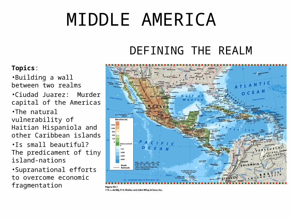
MIDDLE AMERICA
Topics:
•Building a wall between two realms
•Ciudad Juarez: Murder capital of the Americas
•The natural vulnerability of Haitian Hispaniola and other Caribbean islands
•Is small beautiful? The predicament of tiny island-nations
•Supranational efforts to overcome economic fragmentation
DEFINING THE REALM
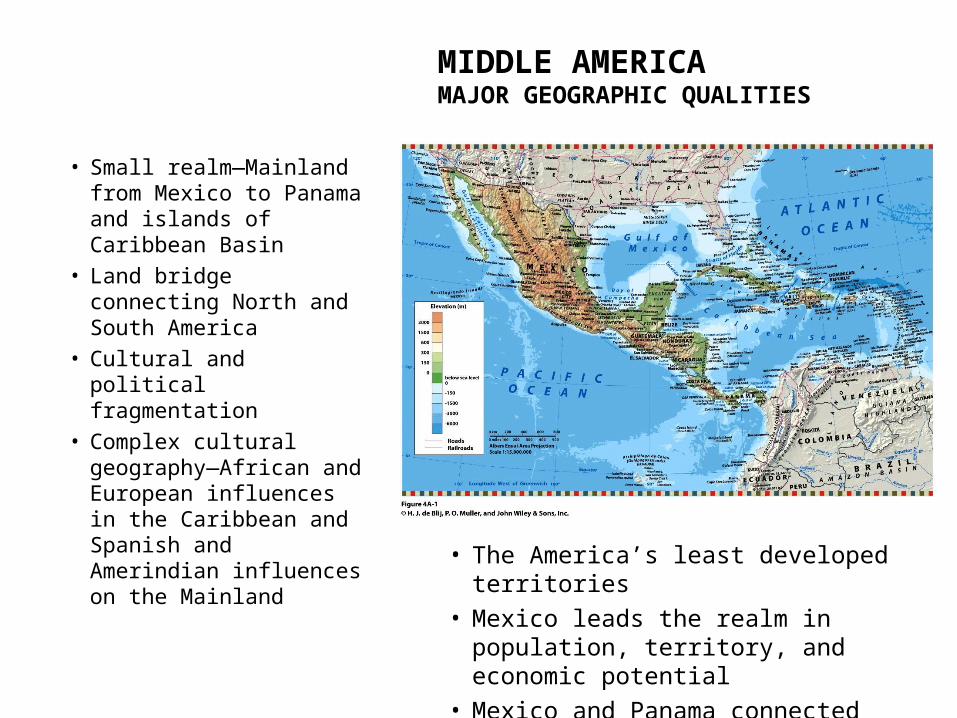
MIDDLE AMERICAMAJOR GEOGRAPHIC QUALITIES
• Small realm—Mainland from Mexico to Panama and islands of Caribbean Basin
• Land bridge connecting North and South America
• Cultural and political fragmentation
• Complex cultural geography—African and European influences in the Caribbean and Spanish and Amerindian influences on the Mainland • The America’s least developed territories
• Mexico leads the realm in population, territory, and economic potential
• Mexico and Panama connected beyond the realm with the United States

MIDDLE AMERICAGEOGRAPHICAL FEATURES
The Realm’s Northern Land Boundary
•Longest border in the world—3,169 km (1,969 mi) between North and Middle America
•NAFTA (North American Free Trade Agreement)
‒ Canada, United States, and Mexico (1994)
• Maquiladoras—foreign-owned assembly factories‒ Assemble imported, duty-
free raw materials into finished products
‒ Near U.S.A./Mexico border‒ 4,000 factories with 1.2
million workers‒ Mexico provides about 13%
of all U.S. imports after Canada (24%)
A Troubled Border Zone
• Illegal immigrants‒ About 1 million migrants per year
• Smuggling‒ Drugs, people, etc.
• Ciudad Juarez/El Paso
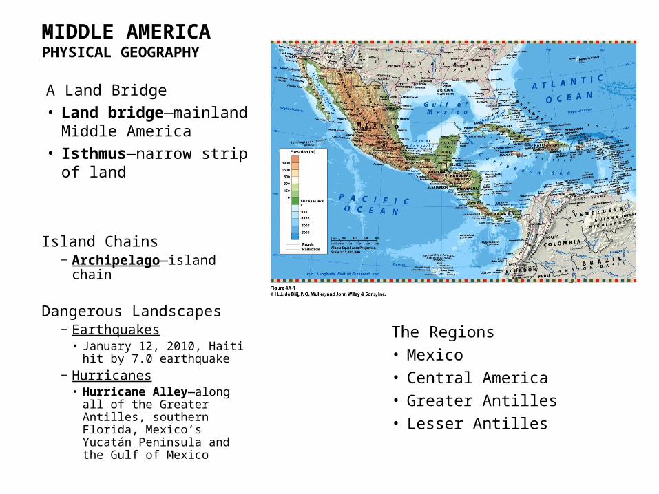
MIDDLE AMERICAPHYSICAL GEOGRAPHY
A Land Bridge
• Land bridge—mainland Middle America
• Isthmus—narrow strip of land
The Regions
• Mexico
• Central America
• Greater Antilles
• Lesser Antilles
Island Chains‒ Archipelago—island chain
Dangerous Landscapes‒ Earthquakes• January 12, 2010, Haiti hit by
7.0 earthquake
‒ Hurricanes• Hurricane Alley—along all
of the Greater Antilles, southern Florida, Mexico’s Yucatán Peninsula and the Gulf of Mexico

MIDDLE AMERICAPHYSICAL GEOGRAPHY
Altitudinal zones—distinct local climates, soils, vegetation, crops, domestic animals and modes of life.
• Tierra caliente—sea level to 750 m (2,500 ft)‒ “Hot land”‒ Coastal plains and low-lying
basins‒ Tropical agriculture
• Tierra templada—up to about 1,800 m (6,000 ft)‒ Temperate land—cooler‒ Commercial crops—coffee,
corn, wheat
• Tierra fría—1,800 to 3,600 m (6,000 to 12,000 ft)‒ Cold country of Andes‒ Potatoes and barley
• Tierra helada—3,600 to 4,500 m (12,000 to 15,000 ft)‒ Above tree line‒ Cold and barren‒ Sheep grazing and hardy livestock
• Tierra nevada—highest zone‒ Permanent snow and ice

MIDDLE AMERICAPHYSICAL GEOGRAPHY
Tropical Deforestation• Only 10% of tropical
rainforest remains
• Leading causes‒ Clearing rural lands for cattle
pasture‒ Rapid logging of tropical
woodlands‒ Population explosion• Peasants must extract
subsistence from inferior lands• Cutting trees for firewood and
crop-raising space
• Major effects‒ Erosion of top soil‒ Loss of ecological resources‒ Increased mining/extraction‒ Biodiversity threatened• Coral reefs and fish• Tropical rainforest mammals• Foods, Medicines, Tools

MIDDLE AMERICACULTURAL GEOGRAPHY
Mesoamerican Legacy
Culture hearth
• Source area from which new ideas radiated and whose population could expand and make significant material and intellectual progress.
• Agricultural specialization, urbanization, transportation networks, writing, science, art.
Mesoamerica—southeast of Mexico City to central Nicaragua
•Low-lying tropical plains of northern Guatemala, Belize, and Yucatán Peninsula
•Guatemala highlands
•Plateau of central Mexico

MIDDLE AMERICACULTURAL GEOGRAPHY
Mesoamerican Legacy
The Lowland Maya
• Only major culture hearth that arose in the lowland tropics
• Great cities with stone pyramids and massive temples
• Zenith from 3rd to 10th centuries AD
• Powerful religious hierarchy
The Highland Aztecs• Intermontane highland zone of Mexico
‒ Teotihuacan• North of Mexico City• First true urban center in the Western
Hemisphere
• Valley of Mexico‒ Tenochtitlan• Functioning city and ceremonial center
• Developed irrigation systems• Constructed walls to terrace slopes• Domesticated corn (maize), sweet
potato, cacao bean, tobacco
*Population = 200 million people•Mexico is largest in size and population (114 million).

MIDDLE AMERICACULTURAL GEOGRAPHY
Spanish Conquest Introduced
• Cattle and sheep
• Wheat
• Spanish town‒ Plaza or market square‒ Gridiron street pattern
Collision of Cultures
• Amerindian
• Spanish
• Other European‒ British, Dutch, French
• African
• United States—later
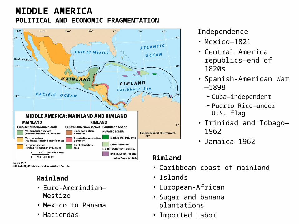
MIDDLE AMERICAPOLITICAL AND ECONOMIC FRAGMENTATION
Independence
• Mexico—1821
• Central America republics—end of 1820s
• Spanish-American War—1898 ‒ Cuba—independent‒ Puerto Rico—under U.S.
flag
• Trinidad and Tobago—1962
• Jamaica—1962
Mainland
• Euro-Amerindian—Mestizo
• Mexico to Panama
• Haciendas
Rimland
• Caribbean coast of mainland
• Islands
• European-African
• Sugar and banana plantations
• Imported Labor

MIDDLE AMERICAPOLITICAL AND ECONOMIC FRAGMENTATION
Connectivity: direct links between locations.
•Connections and correlation to economic development.
‒ Higher GDP• Mexico’s connection with the
United States.• Panama’s connection to world
economy.
•Economies best with countries bordering Middle America.
The Push for Regional Integration•Economic Benefits
‒ CAFTA—Central American Free Trade Agreement (2005) with USA.
‒ CARICOM—Caribbean Community (1989)• 15 members, common passport (2009).
MIDDLE AMERICAPOLITICAL AND ECONOMIC FRAGMENTATION
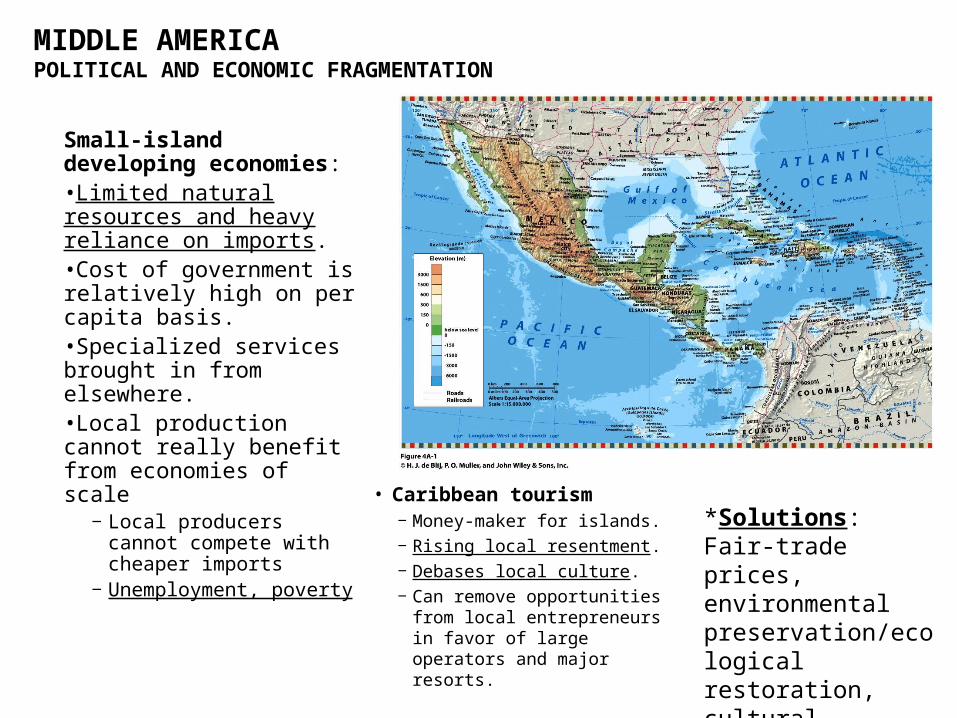
Small-island developing economies:•Limited natural resources and heavy reliance on imports.•Cost of government is relatively high on per capita basis.•Specialized services brought in from elsewhere.•Local production cannot really benefit from economies of scale
‒ Local producers cannot compete with cheaper imports
‒ Unemployment, poverty
• Caribbean tourism‒ Money-maker for islands.‒ Rising local resentment.‒ Debases local culture.‒ Can remove opportunities
from local entrepreneurs in favor of large operators and major resorts.
*Solutions: Fair-trade prices, environmental preservation/ecological restoration, cultural heritage education, and local ecotourism.

MIDDLE AMERICA
Topics:
•Mexico’s drug wars
•Indigenous peoples demand recognition and rights
•Panama Canal expansion fuels boom in Panama City
•Aftermath of Haiti’s 2010 killer earthquake
•The debate over Puerto Rico’s status
REGIONS OF THE REALM
MIDDLE AMERICA
Mexico
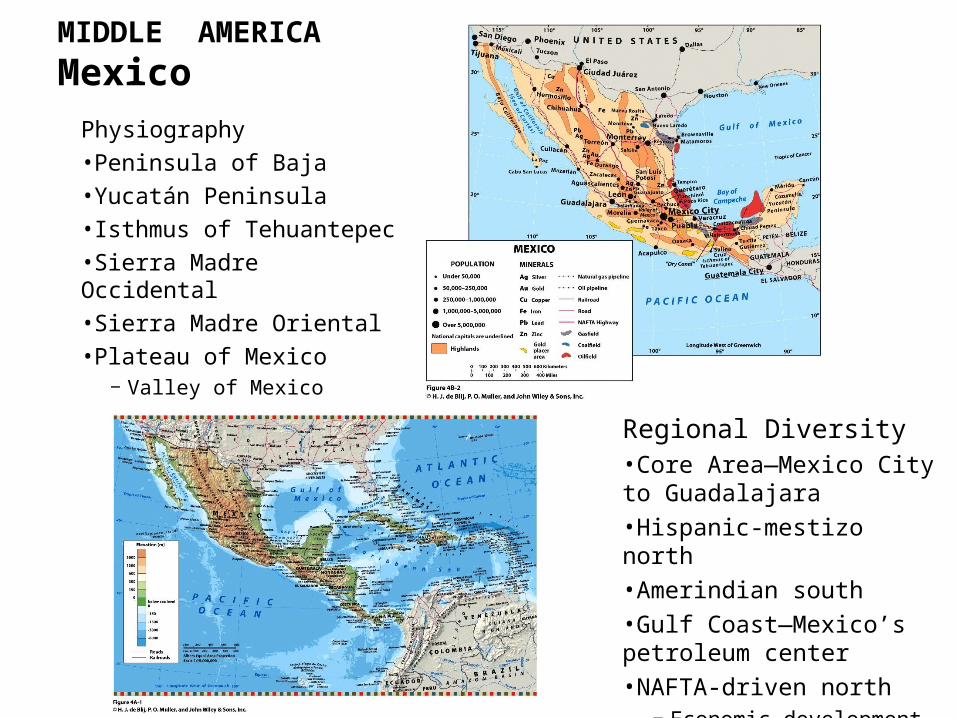
Physiography
•Peninsula of Baja
•Yucatán Peninsula
•Isthmus of Tehuantepec
•Sierra Madre Occidental
•Sierra Madre Oriental
•Plateau of Mexico‒ Valley of Mexico
Regional Diversity•Core Area—Mexico City to Guadalajara
•Hispanic-mestizo north
•Amerindian south
•Gulf Coast—Mexico’s petroleum center
•NAFTA-driven north‒ Economic development

Mexico
Population Patterns•Growth slowing, drop in fertility
•Distribution‒ Concentrated in core area‒ Veracruz State to Jalisco State• Federal District of Mexico City
‒ Least-populated in North
•High rate of urbanization‒ 77% live in towns and cities
•Low rate of urbanization‒ Amerindian highlands
Mexico City
•Almost 30 million
•26% of national population
•Largest urban concentration on Earth

Mexico
Mix of culturesFusion of heritages
•Acculturation—one-way incorporation of European culture.
•Transculturation—two-way exchange of cultural traits.
•Strong Amerindian influence‒ Linguistic‒ Dress, foods, artistic, and
architectural styles and folkways
Agriculture: Fragmented Modernization•Ejidos—government-held farmlands parceled to village communities and individuals (1917)
‒ Amerindian legacy‒ Half of lands “social landholdings”‒ Reforms did not increase production‒ Low yields and rural poverty
•Northern agriculture‒ Major irrigation projects, mechanized cotton production
Mexico
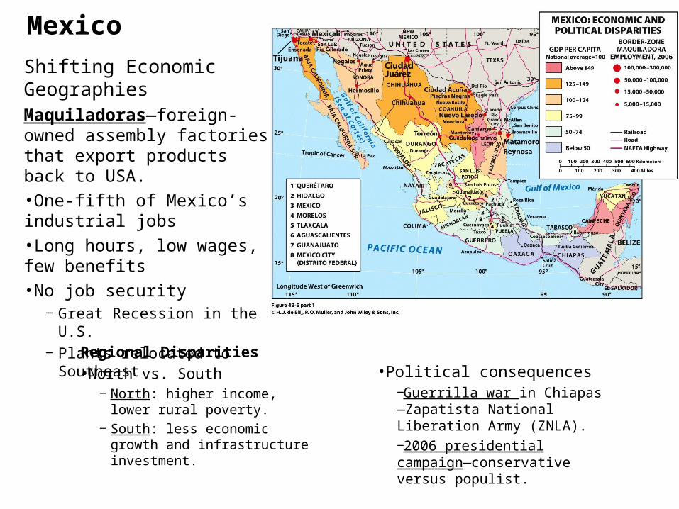
Shifting Economic GeographiesMaquiladoras—foreign-owned assembly factories that export products back to USA.
•One-fifth of Mexico’s industrial jobs
•Long hours, low wages, few benefits
•No job security‒ Great Recession in the U.S.‒ Plants relocated to Southeast
Regional Disparities
•North vs. South‒ North: higher income, lower
rural poverty.‒ South: less economic growth
and infrastructure investment.
•Political consequences‒Guerrilla war in Chiapas—Zapatista National Liberation Army (ZNLA).‒2006 presidential campaign—conservative versus populist.
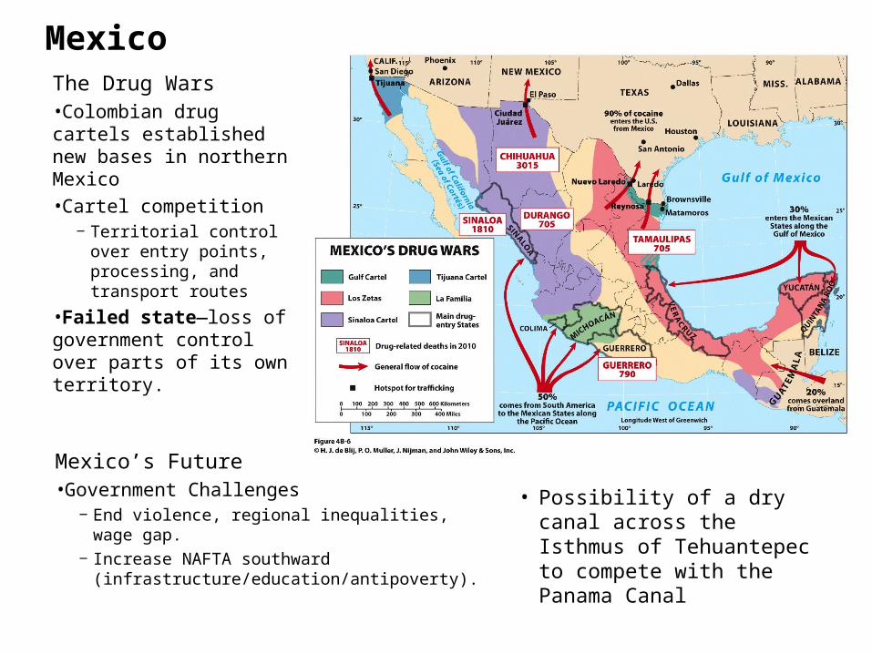
MexicoThe Drug Wars•Colombian drug cartels established new bases in northern Mexico
•Cartel competition‒ Territorial control over
entry points, processing, and transport routes
•Failed state—loss of government control over parts of its own territory.
Mexico’s Future•Government Challenges
‒ End violence, regional inequalities, wage gap.‒ Increase NAFTA southward
(infrastructure/education/antipoverty).
• Possibility of a dry canal across the Isthmus of Tehuantepec to compete with the Panama Canal
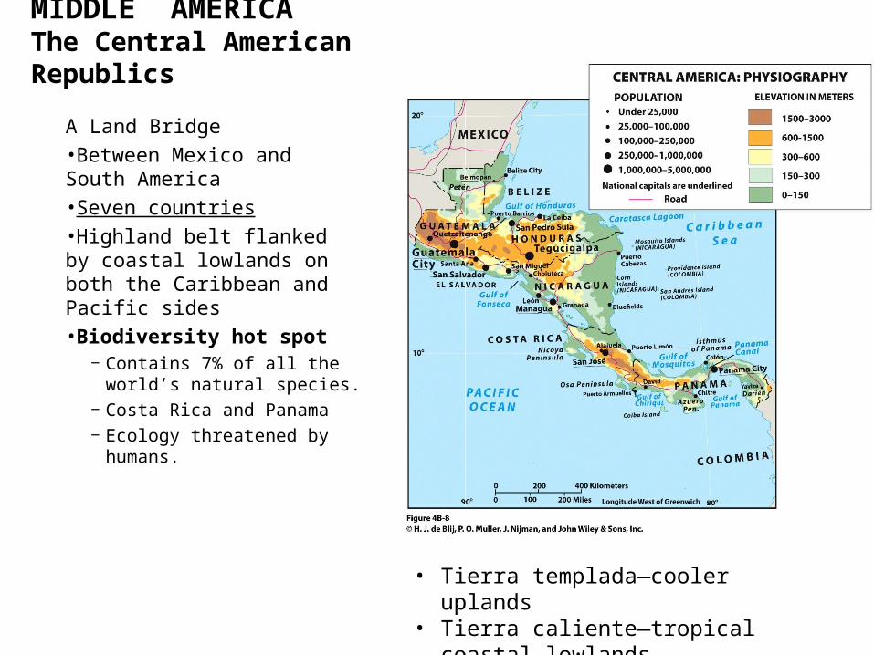
MIDDLE AMERICAThe Central American Republics
A Land Bridge
•Between Mexico and South America
•Seven countries
•Highland belt flanked by coastal lowlands on both the Caribbean and Pacific sides
•Biodiversity hot spot‒ Contains 7% of all the world’s
natural species.‒ Costa Rica and Panama‒ Ecology threatened by humans.
• Tierra templada—cooler uplands• Tierra caliente—tropical coastal lowlands

Guatemala• Heart of Maya Empire
• Mestizo—59%
• Amerindian—41%
• Ladinos—better-off mestizos
• Mineral wealth‒ Nickel and oil
• Agriculture‒ Coffee
• British Honduras—Dependency of the United Kingdom until 1981
• Similar to Caribbean islands
• Population of African descent
• Becoming increasingly Hispanicized
• Economic sphere‒ Sugar, bananas, seafood-
processing, clothing industries, tourism.
‒ Offshore banking—financial haven for foreign companies.
Belize
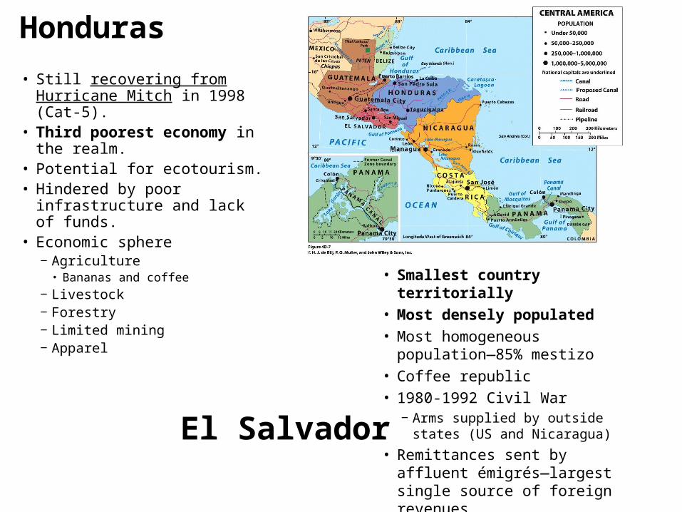
Honduras
• Still recovering from Hurricane Mitch in 1998 (Cat-5).
• Third poorest economy in the realm.
• Potential for ecotourism.• Hindered by poor infrastructure
and lack of funds.• Economic sphere
‒ Agriculture• Bananas and coffee
‒ Livestock‒ Forestry‒ Limited mining‒ Apparel
• Smallest country territorially
• Most densely populated
• Most homogeneous population—85% mestizo
• Coffee republic
• 1980-1992 Civil War‒ Arms supplied by outside states
(US and Nicaragua)
• Remittances sent by affluent émigrés—largest single source of foreign revenues.
El Salvador
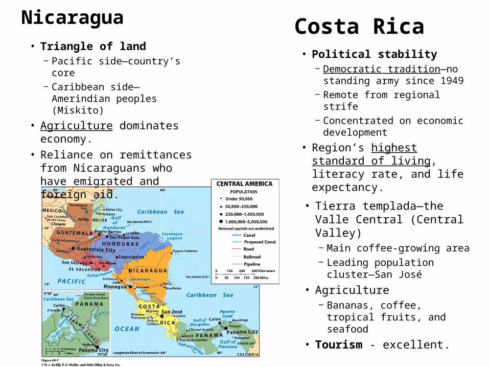
Nicaragua
• Triangle of land‒ Pacific side—country’s core‒ Caribbean side—Amerindian
peoples (Miskito)
• Agriculture dominates economy.
• Reliance on remittances from Nicaraguans who have emigrated and foreign aid.
• Political stability‒ Democratic tradition—no
standing army since 1949‒ Remote from regional strife‒ Concentrated on economic
development
• Region’s highest standard of living, literacy rate, and life expectancy.
Costa Rica
• Tierra templada—the Valle Central (Central Valley)‒ Main coffee-growing area‒ Leading population cluster—
San José
• Agriculture‒ Bananas, coffee, tropical fruits,
and seafood
• Tourism - excellent.
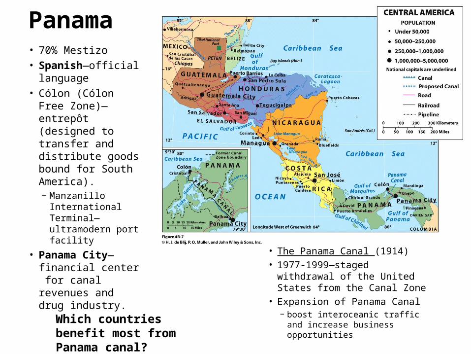
Panama• 70% Mestizo
• Spanish—official language
• Cólon (Cólon Free Zone)—entrepôt (designed to transfer and distribute goods bound for South America).‒ Manzanillo
International Terminal—ultramodern port facility
• Panama City—financial center for canal revenues and drug industry.
• The Panama Canal (1914)
• 1977-1999—staged withdrawal of the United States from the Canal Zone
• Expansion of Panama Canal‒ boost interoceanic traffic and
increase business opportunities
Which countries benefit most from Panama canal?

MIDDLE AMERICATHE CARIBBEAN BASIN
Fragmentation and Insularity•Island arc in Atlantic Ocean from Cuba to Trinidad.
‒ Greater Antilles• Four larger islands in the
west (Cuba, Hispaniola, Jamaica, Puerto Rico)
‒ Lesser Antilles• Eastern segment of smaller
islands reaching to the South American coast
Ethnicity and Class•Social stratification
‒ Closely linked with ethnicity, as result of colonial times.
‒ Rankings• Europeans• Hispanics• Mixed European-African
(mulatto)• Afro-Caribbean
•Minorities hold power and exert influence (historic advantage).•South and East Asian presence
‒ After end of slavery, groups arrived as indentured laborers.

CUBA• Largest island-state—
territorially and in population.• Independence in 1898—
Spanish-American War.• 1959-overthrew American-
backed dictator.‒ Fidel Castro—communist
dictatorship‒ 2006—Turned over to Raúl
Castro
• Economic opportunities‒ Raw materials—nickel and
timber‒ Agriculture—sugar,
tobacco, rice, tropical fruits• Venezuelan oil
JAMAICA
• Former British dependency‒ Member of British Commonwealth
• English - official language
• Entirely Afro-Caribbean population
• Raw materials--Bauxite
• Agricultural—Sugar, bananas, tobacco
• Must import all of its oil and much of its food
• Tourism—largest source of income

HAITI• Poorest state in the Western
Hemisphere.• Environmental disasters
‒ Center of “Hurricane Alley”• 2008—four tropical cyclones in
one season
‒ Atop dangerous fault zone• 2010—killer earthquake
• Few natural resources, major deforestation.
• History of political instability, repression, and deprivation.
• Heavy reliance on aid and remittances.
• Wider range of natural environments.
• Stronger resource base—nickel, gold, silver.
• Agriculture—sugar, tobacco, coffee, cocoa.
• Tourism
DOMINICAN REPUBLIC

PUERTO RICO• 1898 Spanish-American War
‒ U.S. Commonwealth ‒ 1948 permitted to elect governor.‒ Puerto Ricans are U.S. citizens.
• Receives annual subsidies from the USA.
• Long dependent on single-crop economy (sugar).
• Massive emigration.
• Trinidad & Tobago (Port of Spain) – exports shipped to wealthy nations.• Ex. Natural Gas, Ammonia, Methanol

THE LESSER ANTILLES
• The Bahamas—former British colony.
• Trinidad and Tobago‒ Oil/Natural gas producer.‒ Influx of energy, chemical, and
steel companies.‒ Largest supplier of liquefied
natural gas for United States.
• Small-island developing economies‒ Some islands chose to maintain a
political relationship with former colonial ruler.
‒ Curaçao, Aruba and St. Maarten• “Countries” within the Kingdom of
the Netherlands
• Leeward Islands and Windward Islands
• Environmental risks‒ Earthquakes, volcanoes,
and hurricanes.
• Socioeconomic problems‒ Limited resources,
overpopulation, difficult agricultural industry, and market limitations.

Homework
1. Read Textbook Chapter 4a/b 2. Homework: • Choose one “@from the Field Notes”
subsection topic in Ch.4 textbook; research and summarize (1 page).
OR• Choose a realm/region within or adjacent
to Middle America to review in detail (1 page). Use Chapter 4b for ideas and information, research and summarize.