microdis working paper series - hwg paper by uoi 1.pdf · 1. introduction 2. methodology 3 ......
TRANSCRIPT

MICRODIS Working Paper Series
2009-Nov-18
SPATIAL ANALYSIS OF ENVIRONMENTAL
FACTORS FOR LEPTOSPIROSIS OUTBREAK
FOLLOWING THE FEBRUARY 2007 FLOODS
IN JAKARTA, INDONESIA
Authors:
Mondastri K Sudaryo Eko S Pambudi
Olivier le Polain de Waroux Meidy F Prameswari Renti Mahkota Vallerie R Louis
Debarati Guha-Sapir
C R E D
Centre for Research on
the Epidemiology of
Disasters (CRED)
School of Public
Health, Catholic
University of Louvain
Brussels, Belgium
http://www.cred.be
MICRODIS Working Paper Series
2009-Nov -18
SPATIAL ANALYSIS OF ENVIRONMENTAL FACTORS
FOR LEPTOSPIROSIS OUTBREAK
FOLLOWING THE FEBRUARY 2007 FLOODS
IN JAKARTA, INDONESIA
Authors:
Mondastri K Sudaryo Eko S Pambudi
Olivier le Polain de Waroux Meidy F Prameswari Renti Mahkota Vallerie R Louis
Debarati Guha-Sapir

2
Table of Contents
Sections
Page
1. Introduction
2. Methodology
3. Result
3.1. Leptospirosis outbreak and its relation to flood.
3.2. Leptospirosis distribution based on altitude, flooded areas and river flows
3.3. Leptospirosis distribution based on waste disposal sites and slum areas
4. Discussion
4.1. Impact of flood to the occurrence of Leptospirosis outbreak
4.2. Possible influences of altitude, flooded areas and river flows on
leptospirosis distribution
4.3. Possible influences of waste disposal and slum areas on leptospirosis
distribution
4.4. Limitation
5. Conclusion and Recommendations
5.1. Conclusion.
5.2. Recommendation
References
8
9
10
10
11
13
15
15
16
18
19
20
20
20
21
3
List of Figures and Tables
Figures
Page
Figure 1.a. Epidemic curve of the leptospirosis cases due to the flood in
February 2007
11
Figure 2. Leptospirosis cases distribution based on land altitude level 12
Figure 3. Leptospirosis cases distribution based on flooded areas 12
Figure 4. Leptospirosis cases distribution based on drain, canal & river location 13
Figure 5. Leptospirosis cases distribution based on waste disposal sites 14
Figure 6. Leptospirosis cases distribution based on radius distance from
disposal sites.
14
Figure 7. Leptospirosis cases distribution based on slum areas 15
Figure 8. Epidemic Curve of the Leptospirosis Cases, January 2006 – February
2, 2007
16
Tables
Page
Table 1. Distribution of leptospirosis cases among Jakarta resident (n=196)
before, during and after flood by municipality, November 2006 –
May 2007.
10
Table 2. Distribution of leptospirosis cases among Jakarta resident (n=196) by
age and gender
11

4
Acknowledgements
Funding for this report was made available by the European Commission under the 6th
Framework Programme – Contract n° GOCE-CT-2007- 036877.
We would like to thank all colleagues from the following participating institutions,
i.e. Persahabatan Hospital, Sumber Waras Hospital, Tarakan Hospital, Budhi Asih
Hospital, Cengkareng Hospital, Jakarta Provincial Health Office, Indonesian Ministry
of Health. Special thanks for Dr. Ronalli Rasmin, Sp.JP, Dr. Helario Hasibuan, SPM,
Dr. M. Fadhil Rasad, Sp.THT,M.Kes, Drg. Ahmad Husni Basuni, MARS, Mrs.
Lasma D. Sitorus, SKM, and Dr. Syafaruddin, for their helpful supports of our study.
We also would like to appreciate Mr. Adi Wibowo and his colleagues from GIS lab,
Faculty of Mathematic and Science, University of Indonesia for their valuable
thoughts, advices and supports in spatial analysis.
Contact:
Centre for Research on the Epidemiology of Disasters (CRED)
Department of Public Health
Université catholique de Louvain
30.94 Clos Chapelle-aux-Champs
1200 Brussels
Telephone: 32-2-764.33.27
E-mail: [email protected]
www.cred.be
Information given in this MICRODIS Working Paper Series reflects the authors’ views only. The
Community is not liable for any use that may be made of the information contained therein.
5
About MICRODIS
MICRODIS is an Integrated Project funded under the EU Sixth Framework Programme –
Thematic Priority 6.3 Global Change and Ecosystems (Contract number GOCE-CT-2007-
036877).
Why create MICRODIS?
Disaster losses are increasing with great consequence to the survival, dignity and livelihoods
of individuals and communities, particularly of the poor in developed and less developed
countries. Disaster risk arises when hazards interact with physical, social, economic and
environmental vulnerabilities. In the past two decades, more than 200 million people have
been affected, on average, every year by these extreme events.
Environmentally unsound practices, global environmental changes, population growth,
urbanisation, social injustice, poverty, conflicts, and short-term economic visions are
producing these vulnerable societies. This takes on particular urgency in the face of long-
term risks brought about by climate change, and goes beyond environmental degradation or
the mismanagement of natural resources.
There is now international acknowledgment that efforts to reduce disaster risks must be
systematically integrated into policies, plans and programmes for sustainable development
and poverty reduction. The MICRODIS project locates itself within this above framework.
What are the Objectives and Goals of MICRODIS? MICRODIS is a project with the overall goal to strengthen preparedness, mitigation and
prevention strategies in order to reduce the health, social and economic impacts of extreme
events on communities.
Broad Objectives
� To strengthen the scientific and empirical foundation on the relationship between extreme events and their health, social and economic impacts.
� To develop and integrate concepts, method, tools and databases towards a common global approach.
� To improve human resources and coping capacity in Asia and Europe though training and knowledge sharing.
For example, the MICRODIS project will, among others, specifically aim at:
- developing an integrated impact methodology,
- establishing an evidence-base of primary field research through surveys,
- increasing the coverage accuracy and resolution of global disaster data.

6
Where will MICRODIS operate? The two regions which form the focus of the MICRODIS project are:
1. European Union, associated countries and new accession states: Belgium, France, Finland, Germany, the Netherlands, Norway, the United Kingdom.
2. South and Southeast Asia regions: India, Indonesia, the Philippines and Vietnam.
These regions have been selected based on their high frequency of extreme events and the
impact on affected communities.
What Extreme Events will MICRODIS focus on? There are twelve broad and twenty-three sub-groups of distinct extreme events, ranging from
chronic slow onset phenomena to acute rapid onset ones. The health and socio-economic
impact implications differ vastly between these twenty three types and addressing all of these
would compromise the quality and applicability of the project results, risking over-
generalisation.
In both Asia and the European Union, three types of extreme events, namely foods,
earthquakes, and windstorms, account for nearly seventy-five percent of the occurrence of
all extreme events. The MICRODIS project will concentrate on these three phenomena.
Partners European Union and Associated Countries
Belgium Université catholique de Louvain
Finland Finnish Institute of Occupational Health
France University of Paris – Sorbonne (FERURBAT)
Germany EVAPLAN – University of Heidelberg
Netherlands HealthNet International
Norway SWECO GRONER
U.K. University of Greenwich
U.K. University of Northumbria
U.S.A. United Nations Office for the Coordination of Humanitarian Affairs
South and Southeast Asian Partners
India Jadavpur University
India Voluntary Health Association of India
India University of Delhi
Indonesia University of Indonesia
Philippines Citizens’ Disaster Response Center
Philippines Xavier University
Vietnam Hanoi School of Public Health

7
ABSTRACT
INTRODUCTION: Within the period of February 1 - 26, 2007, a major flood had
occurred in Jakarta Province, inundating 60% of this capital city. In such condition,
leptospirosis, as a disaster related disease, may cause outbreak.
METHOD: A combination of case series and ecological study was carried out to
analyze 195 leptospirosis case reported from five major general hospitals in Jakarta.
Spatial analysis using Arcview@ version 3.3 was done to observe the leptospirosis
distribution and clustering pattern.
RESULTS: Our study showed that the high level of leptospirosis cases emerged
within the period of massive and prolonged Jakarta flood in February 2009 was
clearly a common source outbreak. Most cases were more concentrated in flooded
areas, especially in northern part, where based on geographical, infrastructure and
hydrological conditions was considered to be more flood prone. Interestingly, the case
distribution showed clustering pattern around some parts of main city drains, canals
and rivers. Our map also showed that almost all cases came from regions having slum
pocket areas. In addition to that, the cases were mostly distributed in areas where
there were waste accumulation sites.
CONCLUSION: Environmental factors, like water levels of flood, rivers,
drains/canals, slum environment, waste disposal sites, especially in surrounding main
city rivers and drains/canals, are suspected to induce the spread of the leptospirosis in
Jakarta. Our findings underline the need to increase people awareness concerning the
possibility of leptospirosis outbreaks after flood, to improve modifiable environment
which may induce the occurrence of the outbreak and to establish biological causal
relationship between determinants related to flood and the risk to get infection
through further analytical study.
8
1. Introduction
The February 2007 floods were one of the most important floods in Jakarta,
the capital city of Indonesia. This greatest flood (since the last 3 centuries) inundated
60% of the city, with water levels ranging from 10 centimeters up to 7 meters. About
70 000 houses in Jakarta were flooded (WHO, Bulletin # 6, 2007). Although floods
seem to be a periodic disaster following a five-year cycle in Jakarta, disaster
management, preparedness and response are still weak and water-borne diseases such
as leptospirosis have significantly increased and become a public health problem in
the last years.
Leptospirosis, a zoonotic bacterial disease caused by spirochetes, Leptospira
interrogans, has a worldwide distribution (Terpstra, W.J., 2006), but is more
common in tropical and rural setting (Ko. AI. 1999). Recently, however, leptospirosis
has become an emerging problem in urban settings as well (Ko. AI. 1999).
Leptospirosis is endemic in many parts of the world, but can become epidemic in
certain conditions such as heavy rainfall or flooding. Leptospirosis has recently
received growing attention in hydrological disasters.(Terpstra, W.J., 2006)
Leptospirosis can be transmitted by direct contact with urine, blood or tissues
of infected animals, mainly feral and peri-domestic rodents, shrews, cattle, pigs and
dogs (Jena, AB., 2004, Mohan Rao, AMK, 2006, WHO, 2006). Indirect
contamination occurs when people get in contact with water, damp soil, mud or
vegetation that are contaminated with infected animal urine (Ko, AI, et al., 1999;
Sarkar,U. et al., 2002; Watson, JT, et al., 2007, WHO, 2006). The usual port of entry
is through skin abrasion or through the conjunctiva, but hyper motility in leptospira
can also allow them to penetrate into intact skin during prolonged immersion in
infected waters (Levett P.N., Leptospirosis. Clin Microbiol Rev, 2001, Bharti et al,
Lancet Infect Dis, 2003).
Flooding facilitates the proliferation of rodents and brings rodents into closer
contact to humans shared high ground (Watson, JT, et al., 2007). Flooding also
promotes the spread of contaminated waters (La Rocque, RC, et al., 2005; Sanders,
E.J., et al.,1999).
Leptospirosis includes a wide variety of symptoms, from a flu-like illness to a
severe illness with multiple organ failure (CDC, 2006; Haymann, DL, 2004), hence,
without laboratory confirmation it could be easily mistaken for other diseases. Severe

9
forms of the disease are associated with case-fatality rates of 5-40% (Ko. AI. 1999). A
report from one Indonesian general hospital stated that the fatality rate was between
15-40% (Pohan HT, 2000)
This study aims at observing possible relationship of environmental risk
factors with the leptospirosis outbreak occurred immediately after February flood
2007, using mainly spatial analysis.
2. Methodology
The DKI Jakarta province is divided administratively into five municipalities
and one Regency, namely South (Selatan) Jakarta, East (Timur) Jakarta, Central
(Pusat) Jakarta, West (Barat) Jakarta, the North (Utara) Jakarta and the Thousand
Islands (Pulau Seribu) Regency. This capital city is also divided into several lower
administrative levels, i.e. 44 sub-districts (Kecamatan), 267 sub-sub-districts
(Kelurahan) and thousands of neighbourhood blocks (RW), with a total population of
approximately 9 million people (Jakarta in Figures 2007, Statistic DKI Jakarta
Provincial Office). In our study, however, there was not any case reported from the
Thousand Islands Regency, which consist of several scattered small islands located
far separated from the “mainland” of Jakarta province, i.e. in the north bay of Jakarta.
Since leptospirosis is a notifiable disease in Indonesia, we first collected data
from the Provincial District Health Office between November 1st 2006 and May 31
st
2007, including the one-month period of heavy floods. Based on that figure, we
decided to collect more specific demographic (age and sex) and geographic (address)
information on the patients in five major hospitals in Jakarta, which together reported
87% of all reported leptospirosis cases over that period. The five hospitals involved in
this study were RSU Persahabatan, RSU Sumber Waras, RSUD Tarakan, RSUD Budi
Asih, RSUD Cengkareng,
We obtained information for 208 confirmed cases (based on positive finding
of IgM for leptospirosis using Ig-M rapid immunochromatography dipstick assay) but
ended up with 196 cases for the analysis, since 12 cases lived outside the Jakarta area.
In addition, we obtained geographical and environmental data (locations of flooded
areas, slum areas, waste concentrated area, and Jakarta’s rivers, the land altitude and
the depth of the flood) from government agencies, such as Coordination Body for
National Survey and Mapping, Coordination Body for National Disaster

10
Management, Provincial Government Office, etc. We used the software Arcview@,
version 3.3 for our spatial analysis.
3. Result
3.1. Leptospirosis Outbreak and Its Relation to Flood.
The leptospirosis cases reported from the 5 general hospitals came from all 5
municipalities in Jakarta Province (Table.1). About 56% of the cases came from West
Jakarta. As seen in Table.2., most of reported cases (68%) were young adults aged
from 18 years to 49 years, and male cases were predominant (77%)
In this study, as seen in Table1., we compared cases of leptospirosis over the 7
months period. The floods started to occur in Jakarta in February 1 and was declared
as over on February 26, 2007 (UN-OCHA, 2007). Using the range of incubation
period, which is between 2 to 30 days (Haymann, DL., 2004; CDC, 2006; WHO,
2003), we can estimate the period during which patients were likely to develop the
disease presumably through flood exposure by adding the shortest incubation period
to the first day of floods, and adding the longest incubation period to the last day of
floods. Thus, the period is from February 3 to March 28, 2007. All leptospirosis cases
reported before the 3rd of February were labeled as cases infected “before the floods”,
while those reported after the 28th of March, were labeled as cases infected “after the
floods”. This very sharp increase of the leptospirosis cases since February 3, as
reflected in the epidemic curve (Fig.1a.), has strongly indicated a leptospirosis
outbreak during the flood.
Table.1.. Distribution of leptospirosis cases among Jakarta resident (n=196) before, during
and after flood by municipality, November 2006 – May 2007.
No Municipality
of Origin
Number of
cases infected
“before flood”
(%)
Number of
cases infected
“during flood”
(%)
Number of
cases infected
“after flood”
(%)
Total number
of cases from
Jakarta
(%) 1
2
3
4
5
West Jakarta
Central Jakarta
South Jakarta
East Jakarta
North Jakarta
1 (0.9)
1 (3.2)
0 (0.0)
0 (0.0)
0 (0.0)
103 (93.6)
27 (87.1)
9 (100.0)
37 (97.4)
7 (87.5)
6 (5.5)
3 (9.7)
0 (0.0)
1 (2.6)
1 (12.5)
110 (100.0)
31 (100.0)
9 (100.0)
38 (100.0)
8 (100.0)
Total 2 (1.0) 183 (93.4) 11 (5.6) 196 (100.0)
Note: “before flood”: < Feb. 3, 2007; “during flood”: Feb. 3 – March. 28, 2007; “after flood”: >
March. 28, 2007

11
Table.2.Distribution of leptospirosis cases among Jakarta resident (n=196) by age and gender
Gender Total
Male Female n % n % n %
<18 years 10 6.6% 2 4.4% 12 6.1%
18-29 years 34 22.5% 11 24.4% 45 23.0%
30-39 years 32 21.2% 7 15.6% 39 19.9%
40-49 years 36 23.8% 13 28.9% 49 25.0%
50-59 years 28 18.5% 5 11.1% 33 16.8%
Age group
>=60 years 11 7.3% 7 15.6% 18 9.2%
Total 151 100.0% 45 100.0% 196 100.0%
Fig.1.a. Epidemic curve of the leptospirosis cases due to the flood in February 2007
3.2. Leptospirosis Distribution Based on Altitude, Flooded Areas and River Flows
Although in general, the leptospirosis cases reported from the five general
hospitals in five municipalities in Jakarta Province, we can see that the cases were
more concentrated in flooded areas.
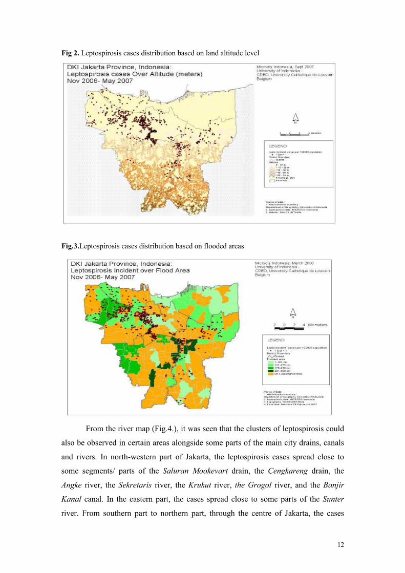
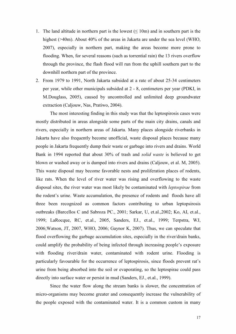
Most of the leptospirosis cases were originated from the northern areas of
Jakarta (Fig.2) and most of them were clustered in northwest part of the province. In
Fig.3, we can see that most of flooded areas also located in northern part of the
Jakarta province, which have lower altitude level (≤ 10 m) as compared to Southern
areas of Jakarta (> 40 m).
12
Fig 2. Leptospirosis cases distribution based on land altitude level
Fig.3.Leptospirosis cases distribution based on flooded areas
From the river map (Fig.4.), it was seen that the clusters of leptospirosis could
also be observed in certain areas alongside some parts of the main city drains, canals
and rivers. In north-western part of Jakarta, the leptospirosis cases spread close to
some segments/ parts of the Saluran Mookevart drain, the Cengkareng drain, the
Angke river, the Sekretaris river, the Krukut river, the Grogol river, and the Banjir
Kanal canal. In the eastern part, the cases spread close to some parts of the Sunter
river. From southern part to northern part, through the centre of Jakarta, the cases

13
spread next to of some parts of the biggest river of the city, i.e. Ciliwung river. In
general, most of leptospirosis cases clustered around some parts of Grogol river,
Banjir Kanal canal and Ciliwung river.
Fig.4.Leptospirosis cases distribution based on drain, canal & river location
3.3. Leptospirosis Distribution Based on Waste Disposal Sites and Slum Areas
We observe from our study that the leptospirosis case distribution pattern was
not fully overlapped with the pattern of areas having different amount of waste
disposal sites (Fig.5.). What we meant with disposal site was any container or limited
space specifically provided for temporary waste collection from the households,
available in each sub-district level. The case distribution did not show clear tendency
to cluster in areas with higher number of disposal sites

14
Fig.5. Leptospirosis cases distribution based on waste disposal sites
When we drew buffer layer areas in radius distance of “within 500 m”, “500-
1000 m” or “> 1000 m” from the waste disposal sites, seems that most of the cases
were distributed in areas within 500 m from the point of disposal (Fig.6.)
Fig.6. Leptospirosis cases distribution based on radius distance from disposal sites.
When we tried to see the case distribution based on slum areas, the cluster of
leptospirosis cases did not seem to be superimposed with slum areas. The case
distribution did not show tendency to be more concentrated in slum areas (Fig.7.). In
this study we used definition of slum areas as defined by the Central Statistics

15
Agency, Province of Jakarta. This agency defined slum areas as neighborhood block
where the score for slum indicators of physical and environmental conditions was
below acceptable standard, i.e. < 36 (out of 40). The slum indicators comprised 10
conditions, i.e. population density, construction design, housing construction
condition, housing ventilation, construction density, road/street condition, water
drainage, clean water utility, human excrete disposal and waste management (BPS,
2004).
Fig.7. Leptospirosis cases distribution based on slum areas
4. Discussion
4.1. Impact of Flood to the Occurrence of Leptospirosis Outbreak
On the 23rd of January 2007, very heavy rains (150 mm per day) down poured
continuously the southern part of Jakarta and the adjacent cities; Bogor and Depok
(WHO, bulletin #2, # 5, #6, 2007). One week later, on the 1st of February 2007, major
floods hit Jakarta severely, due the overflow of two main rivers; Ciliwung river and
Pesanggrahan river (WHO, bulletin #2, #5, #6, 2007). Just after 1st of February, the
reported leptospirosis cases increased sharply. The epidemic curve reaches its highest
peak abruptly (23 cases) on 19th of February and falls again in a log-linear fashion,

16
suggesting a point source outbreak (Dwayer & Groves, 2005), meaning that the
population was probably exposed from one common source, i,e, the massive floods, at
one point in time. This kind of epidemic curve was also observed by Vanasco et al
(2000) in the city of Santa Fe (Argentina) in 1998 after severe floods.
Comparing our epidemic curve of leptospirosis cases reported from 5 general
hospitals around the February flood period with the trend of the whole leptospirosis
cases in Jakarta reported by Jakarta Provincial Health Office (PHO) in previous
period years, it is really clear that the February outbreak has reached very high level
of cases that had never been experienced during the previous 2 years. Since Jan 2,
2005 until February 2, 2007, the infection had never reached the rate of 5 cases per
month (Figure.1.b.).
Fig.8. Epidemic curve of the leptospirosis cases, January 2006 – February 2, 2007
4.2. Possible Influences of Altitude, Flooded Areas and River Flows on Leptospirosis Distribution
As mentioned previously, the cases were found more in the northern areas of
Jakarta, while most of flooded areas located in northern part of the province.
Assuming that flooding is a strong determinant of leptospirosis outbreak, we may
speculate that major widespread of flooded areas in northern part of Jakarta may
indirectly be related to the case predomination in the northern areas of Jakarta
Floods are more likely to occur in the northern part of Jakarta, partly due to
the fact that:
17
1. The land altitude in northern part is the lowest (≤ 10m) and in southern part is the
highest (>40m). About 40% of the areas in Jakarta are under the sea level (WHO,
2007), especially in northern part, making the areas become more prone to
flooding. When, for several reasons (such as torrential rain) the 13 rivers overflow
through the province, the flash flood will run from the uphill southern part to the
downhill northern part of the province.
2. From 1979 to 1991, North Jakarta subsided at a rate of about 25-34 centimeters
per year, while other municipals subsided at 2 - 8, centimeters per year (PDKI, in
M.Douglass, 2005), caused by uncontrolled and unlimited deep groundwater
extraction (Caljouw, Nas, Pratiwo, 2004).
The most interesting finding in this study was that the leptospirosis cases were
mostly distributed in areas alongside some parts of the main city drains, canals and
rivers, especially in northern areas of Jakarta. Many places alongside riverbanks in
Jakarta have also frequently become unofficial, waste disposal places because many
people in Jakarta frequently dump their waste or garbage into rivers and drains. World
Bank in 1994 reported that about 30% of trash and solid waste is believed to get
blown or washed away or is dumped into rivers and drains (Caljouw, et al. M, 2005).
This waste disposal may become favorable nests and proliferation places of rodents,
like rats. When the level of river water was rising and overflowing to the waste
disposal sites, the river water was most likely be contaminated with leptospirae from
the rodent’s urine. Waste accumulation, the presence of rodents and floods have all
three been recognized as common factors contributing to urban leptopsirosis
outbreaks (Barcellos C and Sabroza PC., 2001; Sarkar, U, et.al.,2002; Ko, AI, et.al.,
1999; LaRocque, RC, et.al., 2005, Sanders, EJ., et.al., 1999; Terpstra, WJ,
2006;Watson, JT, 2007, WHO, 2006; Gaynor K, 2007). Thus, we can speculate that
flood overflowing the garbage accumulation sites, especially in the river/drain banks,
could amplify the probability of being infected through increasing people’s exposure
with flooding river/drain water, contaminated with rodent urine. Flooding is
particularly favourable for the occurrence of leptospirosis, since floods prevent rat’s
urine from being absorbed into the soil or evaporating, so the leptospirae could pass
directly into surface water or persist in mud (Sanders, EJ., et.al., 1999).
Since the water flow along the stream banks is slower, the concentration of
micro-organisms may become greater and consequently increase the vulnerability of
the people exposed with the contaminated water. It is a common custom in many

18
regions in Indonesia that people living nearby the rivers use the river for washing,
bathing and defecating as reported by Fresh, J.W., et.al.(1971) and Ristiyanto, et.al.
(2006). Therefore, the risk to get infected by leptospirae, through skin exposure,
increases, especially when the river water level rises during the rainy seasons and
flood. Johnson, MAS, et al. (2004) in his study in tropical urban slum areas in Iquitos,
Peru, found that river bathing and living close to the river are among potential risk
factors of leptospiral seropositivity. Sarkar, U, et.al. (2002) estimated that people
being exposed with flood water or mud will have significant risk about 3 times higher
to get infected. Even, within the period of two or three days after rains, when the
flooding water remains stagnant, the leptospires can still multiply in the flooded areas
(Swapna RN, et.al., 2006). Under favourable conditions, i.e. neutral PH or slightly
alkaline water and temperature of ≥ 220 C, the leptospires can survive in the
environment an extended period of time (Terpstra, WJ, 2006, Katz, AR., 1991, Syam,
AF, e al., 1997).
4.3. Possible Influences of Waste Disposal and Slum Areas on Leptospirosis Distribution
Given the occurrence of leptospirosis spread alongside the drains and rivers, as
previously discussed, and the fact that most people living near city rivers and drains
disposed their sewages in the edge of city rivers or drains (or even throwing in to
them) we may speculate that the flood coming from the rivers or drains and passed
through the waste disposal might had delivered water contaminated by rodent urine to
not only people living in the river banks but also in surrounding farther residential
places, leading to the increase probability of leptospirosis outbreaks. This possibility,
which in our study was somewhat indicated by the distribution pattern of most cases
within radius of 500 m around the waste disposal point, had also supported by
Barcellos C and Sabroza PC (2001) stating that leptospirosis cases is not only found
in the core of waste disposal point, but may also spread quite farther from the waste
collection sites. Interestingly, he reported that the highest incidence rate of
leptospirosis was actually found in areas located at a distance of 250 m to 500 m from
the waste accumulation sites. This might be explained by the possibility that people
living really close to the waste accumulation sites (<250meters) develop a certain
19
level of immunity against leptospirosis, while those who live a bit further (>250m) are
more vulnerable in a situation of floods.
Our finding that the case distribution did not show tendency to be more
concentrated in slum areas, was not consistent with notions in some literatures.
Findings from other studies (Barcellos C and Sabroza PC, 2001; Ristiyanto, et.al.,
2006; Ko, AI, et.al., 1999; and Sarkar, U, et.al., 2002), stated generally that slum
areas with poor sanitation may produce high number of cases and may potentially
become endemic areas of leptospirosis, especially during periods of flooding and
heavy rainfall. This inconsistency needs further elaboration.
4.4. Limitation
We used in our study reported cases from hospitals. If the proportion of
misdiagnosis or under-reported cases in the general population is high, the spatial
distribution of our hospital-based cases may not perfectly represent the real
distribution of cases in the general population. However, we assume that this kind of
bias is expected to be constant through out the period.
The limitation of the analysis correlating the environmental factors with the
leptospirosis distribution is mainly due to the absence of statistical procedures to test
the hypothesa. In this study, analysis was done in more descriptive manners based on
visual inspection of the distribution and pattern from the map.
Another potential problem was that we do not have information concerning
the possible estimates of under-reported leptospirosis cases. However, many studies
had reported the similarity of clinical profiles of leptosiprosis cases with other
infectious diseases, leading to misdiagnosis of leptosiprosis. Withiekanun, et al.
(2007) stated that several common infectious diseases, including leptospirosis in
Thailand, are hard to differentiate. Among 208 leptospirosis cases reported by the five
general hospitals in our study that coming from areas both Jakarta and outside Jakarta,
leptospirosis was only suspected in 31.4% of the cases at admission (Le Polain, et al,
2008). A Indonesian national referral general hospital, i.e. Cipto Mangunkusumo
general hospitals reported once that about 41% of hospital leptospirosis cases was
initially diagnosed as other diseases such as hepatitis and typhoid fever (Syam, et al.,
1997)
20
5. Conclusion and Recommendation
5.1. Conclusion From the findings of our study, we may conclude that:
1. the greatest Jakarta flood occurred from 1-26 February and submerging 60% of
this capital city was most likely to have induced the point source leptospirosis
outbreak in Jakarta province.
2. certain environmental predisposition factors, like flows of rivers, drains/canals
and possibly waste disposal sites, could be suspected to induce the spread of the
leptospirosis, especially in surrounding main city rivers and drains/canals, in
Jakarta
5.2. Recommendation
Based on the findings, we underline the need:
1. To increase people awareness concerning the possibility of leptospirosis
outbreaks after flood
2. To improve modifiable environmental factors which may induce the occurrence
of the outbreak
3. Further analytical epidemiologic researches are also needed to establish the
biological and causal relationship between important determinants closely
related to flood exposures and the individual risk of individual to get
leptospirosis infection
21
References
Barcellos C and Sabroza PC., O. et.al. The place behind the case: leptospirosis risks
and associated environmental conditions in a flood-related outbreak in Janeiro.
Cad Saude Publica. Rio de Jeneiro. 2001.17 (supplement): p.59-67
BPS (Badan Pusat Statistik) Propinsi DKI Jakarta. Evaluasi Rukun Warga (RW)
Kumuh DKI Jakarta. BPS Propinsi DKI Jakarta, 2004
Caljouw, M. et al. Flooding in Jakarta, towards a Blue City with Improved Water
Management. Bijdragen tot de Taal-, Land- en Volkenkunde (BKI), 2005. 161-4:
p. 454-484
Caljouw, M., et al. Flooding in Jakarta. Paper presented on The First International
Urban Conference, on August 23-25 2004 in Majapahit Hotel-Surabaya
CDC. Information for Clinical and Laboratory Support for Diagnosis, Management
and Treatment of Leptospirosis in the Aftermath of a Disaster. What is the risk of
leptospirosis outbreaks after a disaster, 2006 [cited from: http://www.
bt.cdc.gov/disasters/disease/pdf/leptoclin.pdf]
Dwayer, DM & Groves, C. Outbreak Epidemiology. In: Nelson KE, et al. Infectious
Disease Epidemiology: Theory and Practice. Sudbury, USA:Jones and Bartlet
Publishers; 2005;134-7.
Fresh, J.W., et.al.A Leptospirosis Study in South Sumatra and Bngka Island,
Indonesia. Southeast Asian J. Trop. Med. Pub. Hlth, 1971. 2(1): p. 22-4
Gaynor, K., et.al. Leptospirosis on Oahu: an outbreak associated with flooding of a
university campus. Am J Trop Med Hyg, 2007. 76(5): p. 882
Haymann, DL (ed). Control of Communicable Diseases Manual. American Public
Health Assocation, 2004, Washington DC.
Jakarta in Figures 2007, Statistic DKI Jakarta Provincial Office
Kosasih, E.N., Tafsiran Hasil Pemeriksaan Laboratorium Klinik (Result
Interpretation of Clinical Laboratory). Karisma Publishing Group. , ed. K.P.
Group. 2007, Jakarta.
Jena, AB., et.al. An Outbreak of Leptospirosis in Orissa, India: the Importance of
Surveillance. Tropical Medicine and International Health, 2004. 9(9):p.1016-21
Johnson, MAS., et al. Environmental Exposure and Leptospirosis, Peru, Emerging
Infectious Diseases, 2004. 10(6): p.
Ko, A.I. et al., Urban Epidemic of Severe Leptospirosis in Brazil. The Lancet, 1999.
354: p. 820-825

22
Katz, AR., et al. Leptospirosis on Kauai: Investigation of a Common Source
Waterborne Outbreak. American Journal of Public Health, 1999. 81(10): p. 1310-
12.
Le Polain de Waroux O, et al. Clinical characteristics of leptospirosis in a 7-
months retrospective hospital-based study in Jakarta, Indonesia. Paper
submitted for publication, 2007.
LaRocque, RC, et.al. Leptosirosis during dengue Outbreak,Bangladesh. Emergening
Infectious Disease. 2005. 11(5): p. 766-9
Mohan Rao, AMK. Preventive Measures for Leptospirosis: Rodent Control. IJMM
(Supplement), 2006. 24(4):p.325-8
Pohan HT. Gambaran Klinis dan Laboratoris Leptospirosis di RSUPN Dr.Cipto
Mangunkusumo dan RS Persahabatan, Jakarta. Maj. Kedokt Indon, 2000. 50(2):
h.86-90
Ristiyanto, et.al. Sot Survey Reservoir Leptospirosis di Desa Bakung, Kecamatan
Jogonalan, Kabupaten Klaten, Jawa Tengah. Bul. Penel Kesehatan (Bulletin of
Health Studies), 2006. 34(3): h.105-110.
Sanders, E.J., et al., Increase of leptospirosis in dengue-negative patients after a
hurricane in Puerto Rico in 1996 [correction of 1966]. Am J Trop Med Hyg,
1999. 61(3): p. 399-404.
Sarkar, Urmimala, et al. Population-Based Case-Control Investigation of Risk Factors
for Leptospirosis during an Urban Epidemic. Am.J.Trop.Med.Hyg, 2002. 66(5):
p. 605-610
Syam, AF., et al. Patogenesis dan Diagnosis Leptospirosis. Maj. Kedokt Indon, 1997.
47(12): h.636-9
Swapna RN, et.al., Seroprevalence of Leptospirosis in High Risk Groups in Calicut,
North Kerala, India, IJMM (Supplements) , 2006. 24(4): p. 349-52.
Terpstra, W.J. Historical perspective in Leptospirosis, Indian journal of medical
microbiology. IJMM (Supplements), 2006. 24(4): p.316-9
Theilen-Willige, B. Flooding Risk of Java, Indonesia. Forum DKKV/CEDIM:
Disaster Reduction in Climate Change 15./16.10.2007, Karlsruhe University
UN-OCHA (United Nations Office for the Coordination of Humanitarian Affairs).
Indonesia: Floods in JABODETABEK (Jakarta-Bogor-Depok-Tangerang-Bekasi).
OCHA Situation Report No. 12, 2007. [cited from http://ocha-gwapps1.unog.ch]
Watson, J.T., M. Gayer, and M.A. Connolly, Epidemics after natural disasters.
Emerg Infect Dis, 2007. 13(1): p. 1-5.
23
WFP (World Food Program). Jakarta Food Early Warning. Flood Early Warning
Bulletin # 2, 2004
WHO. Flood in Jakarta Province, Republic of Indonesia. Emergency Situation
Report # 5. 2007
WHO. Floods and Communicable Diseases Fact Sheet, Risk Assessment and
Preventive Measures. Communicable Diseases Working Group on Emergencies,
HQ, 2006. [cited from: http://www.who.int /hac/ techguidance/ems/ Flooding and
Communicable Diseases Fact sheet.pdf].
WHO. Human leptospirosis: guidance for diagnosis, surveillance and control.
Geneva, International Leptospirosis Society, 2003 (cited from http://
whqlibdoc.who.int /hq/2003/WHO_CDS_CSR_EPH_2002.23.pdf)
Wuthiekanun,V., et al. Clinical Diagnosis and Geographic Disribution of
Leptospirosis, Thailand. Emerging Infectious Disease, 2007. 13(1):p.124-6
.

24
This study has been funded by the
European Commission on the 6th Framework Programme
World Health Organization (WHO) Collaborating
Centre for Research on the Epidemiology of Disasters (CRED)
Catholic University of Louvain School of Public Health
30.94 Clos Chapelle-aux-Champs
1200 Brussels, Belgium
Tel: +32 (0)2 7643327
Fax: +32 (0)2 7643441
Email: [email protected]
http://www.cred.be