michigan geological and biological survey · pdf filemichigan geological and biological survey...
TRANSCRIPT

MICHIGAN GEOLOGICAL AND BIOLOGICAL SURVEY
Publication 5. Geological Series 3.
THE LATE GLACIAL AND POST GLACIAL UPLIFT OF THE MICHIGAN BASIN
EARTHQUAKES IN MICHIGAN
BY WM. HERBERT HOBBS
PUBLISHED AS A PART OF THE ANNUAL REPORT OF THE BOARD OF GEOLOGICAL AND BIOLOGICAL SURVEY FOR
1910
LANSING, MICHIGAN WYNKOOP HALLENBECK CRAWFORD CO., STATE PRINTERS
1911
BOARD OF GEOLOGICAL AND BIOLOGICAL SURVEY, 1911.
EX OFFICIO:
THE GOVERNOR OF THE STATE, HON. CHASE S. OSBORN, President.
THE SUPERINTENDENT OF PUBLIC INSTRUCTION, HON. L. L. WRIGHT, Secretary.
THE PRESIDENT OF THE STATE BOARD OF EDUCATION, HON. D. M. FERRY, JUNIOR.
DIRECTOR, R. C. ALLEN.
SCIENTIFIC ADVISORS.
Geologists.—Dr. L. L. Hubbard, Houghton; Prof. W. H. Hobbs, Ann Arbor; Prof. W. H. Sherzer, Ypsilanti
Botanists.—Prof. E. A. Bessey, East Lansing; Prof. F. C. Newcomb, Ann Arbor.
Zoologists.—Prof. W. B. Barrows, East Lansing; Prof. J. Reighard, Ann Arbor; Dr. Bryant Walker, Detroit.
CONTENTS. Introduction. .......................................................................3
Late uplift and tilting of northern countries .....................3 Characteristic marks of wave action on shores .............3 The abandoned shore lines about the Laurentian Lakes..............................................................................7 Mackinac Island a record of abandoned shores ............8 Early studies which proved the uplift and tilting of the lake region......................................................................9 The succession of ancient lakes in the St. Lawrence basin explained by the initial blocking and later successive unblockings of different natural outlets for the water by the continental glacier .............................13 Gilbert's prophecy of a future reversal of the St. Lawrence drainage to its earlier Chicago outlet...........15 Modification of this prediction to account for hinge lines north of the Chicago outlet ..................................15 The warping of the ancient beaches ............................16 The relatively recent general introduction of precise levelling methods .........................................................16 Additional hinge lines ...................................................16
The author's study of ancient beaches about the northern end of Green Bay. .............................................17
Conditions of the work..................................................17 Bay de Noc Peninsula..................................................17 West shore of Little Bay de Noc...................................19 The Garden Peninsula .................................................20 Clamshell Harbor .........................................................21 Burnt Bluff.....................................................................23 Summer Island .............................................................23 St. Martins Island .........................................................23
Conclusions based upon the observed data. ..................23 The bent water planes..................................................23 The manner of the uplift ...............................................24 Comparison of the Laurentian Basin with Scandinavia24 A block movement of uptilt ...........................................24
Publication 5, Geological Series 3 -- Part 1 – Page 1 of 26

Publication 5, Geological Series 3 -- Part 1 – Page 2 of 26
LIST OF ILLUSTRATIONS.
Figures. Figure 1. The Alexander archipelago on the Alaskan coast, a
depressed coast line.........................................................3
Figure 2. Part of the coast of Florida, the relatively even coast line of an elevated shore. .................................................4
Figure 3. The coast of Maine with its estuaries indicating depression, which estuaries are extended inland by beds of marine clay bordering the streams and proving a subsequent uplift (after Stone). ........................................4
Figure 4. Farwell's Point, a notched cliff on Lake Mendota, Wisconsin .........................................................................4
Figure 5. A sea arch and small coves on the shore of one of the Apostle Islands, Lake Superior (after a photograph by the Detroit Photographic Co.) ...........................................5
Figure 6. A stack on the shore of Lake Superior (after a photograph by the Detroit Photographic Co.). ..................5
Figure 7. A cliff cut by waves in loose materials and maintaining the angle of repose for such materials. The beach at Scituate, Mass. (after Shaler). ...........................5
Figure 8. Profile of a cut and built terrace on a steep rocky shore ................................................................................5
Figure 9. Profile of cut and built terrace on a steep shore formed of loose material. ..................................................6
Figure 10. Plan of a steep rocky headland which has been attacked by the waves so as to produce coves and stacks as well as a, beach to leeward. ........................................6
Figure 11. Crescent form characteristic of a beach. Lake Mendota, Wisconsin. ........................................................6
Figure 12. A storm beach of chipped stone about five feet high built up beneath Burnt Bluff on the northeast shore of Green Bay. .......................................................................6
Figure 13. Characteristic form of beach pebble.......................6
Fig. 14. Spit at AuTrain Island, Lake Superior (after Gilbert). ..7
Figure 15. Section of a barrier with characteristic steep landward and gentle seaward slope. ................................7
Figure 16. Barriers in series with partially filled lagoons behind...............................................................................7
Figure 17. University Bay on Lake Mendota at Madison, Wisconsin. A filled lagoon behind a barrier, with bar formed in front (Map by Wisconsin Geological Survey). ...7
Figure 18. Series of barriers and partially filled lagoons at Duluth, Minn.. ...................................................................8
Figure 19. View of Mackinac Island from the direction of St. Ignace...............................................................................8
Figure 20. The sugar loaf, a stack in an earlier lake, as seen from the observatory on Mackinac Island (after a photograph by Taylor). .....................................................8
Figure 21. View from the observatory looking across the short target range toward the Fort on Mackinac Island. ............9
Figure 22. Beach ridge on the battle field of Mackinac Island now a part of the golf links (after a photograph by Taylor). .............................................................................9
Figure 23. A notched stack near the railroad at St. Ignace on the straits of Mackinac (after photograph by Taylor). .......9
Figure 24. A view of Boyer bluff, Door County, Wisconsin (after Goldthwait)..............................................................9
Figure 25. View at Ephraim, Door County, Wisconsin (after Goldthwait). ....................................................................10
Figure 26. An abandoned cliff and terrace in drift materials at Sawyer, Wisconsin (after Goldthwait). ...........................10
Figure 27. Sketch map of Lake Superior showing the localities where indications of canting of the basin are to be observed. .......................................................................12
Figure 28. Portion of the inner Sandusky Bay affording a comparison of the shore line of 1820 with that of today (after E. L. Moseley). ......................................................12
Figure 29. Map of the Great Lakes district to illustrate the uplift and tilting of the basin ....................................................13
Figure 30. First stage of the ancient lakes in the Laurentian basin, (after Taylor and Leverett). ..................................14
Figure 31. Second stage of the lakes in the Laurentian basin (after Taylor and Leverett)..............................................14
Figure 32. Lakes Algonquin and Iroquois, with outlet to the Atlantic by way of the Mohawk valley (after Taylor and Leverett). ........................................................................14
Figure 33. The Nipissing Great Lakes with outlets through the Ottawa river to the Atlantic (after Taylor and Leverett). ..15
Figure 34. Diagram showing the manner of opening out ("feathering") of beaches as they are followed northward (after Goldthwait)............................................................16
Figure 35. Sample section of beach ridges and terraces above Lake Michigan in Door County, Wisconsin (after Goldthwait). ....................................................................16
Figure 36. Diagrams to illustrate the uplift of the Laurentian basin. .............................................................................17
Figure 37. Outline representation of Goldthwait's section of the deformed ancient strands found in the Door County peninsula, Wisconsin and extended northward upon the basis of earlier data........................................................17
Figure 38. Map of the greater part of Green Bay...................18
Figure 39. Map of the north shore of Green Bay showing the positions of profiles. .......................................................18
Figure 40. Series of profiles on west shore of Bay de Noc Peninsula. ......................................................................18
Figure 41. Profile of the high terrace composed of fluvio-glacial materials west of Little Bay de Noc. ....................20
Figure 42. Profiles made on the west shore of Little Bay de Noc.................................................................................20
Figure 43. Series of profiles indicating elevations of beaches on the Garden peninsula and neighboring islands. ........21
Figure 44. Sketch map of the rocky island of the Nipissing Great Lakes on the headland which now encloses Clam Shell Harbor. ..................................................................22

Figure 45. One of the lower Algonquin beach ridges formed of chipped limestone and located near the deserted school house north of Clam Shell Harbor. .................................22
Figure 46. Strong beach ridge of the Nipissing stage............22
Figure 47. Hinge line of recent uplift crossing Denmark. .....24
Figure 48. Series of diagrams to illustrate the supposed successive block uptilt of the Michigan basin .................26
Plates. Plate I. (a.) North shore of Lake Superior at Otter Cove
showing steep descent of rivers at their mouths and new beach ridge forming on edge of newly exposed lake bottom (after Lawson).....................................................12
(b.) View on northwest shore of Lake Superior showing cliff with bask submerged (after Lawson)..............................12
Plate II. Correlation of deformed water-planes about the north end of Green Bay, Michigan. ..........................................25
LETTER OF TRANSMITTAL. To the Honorable the Board of Geological and Biological
Survey of the State of Michigan:
Governor Chase S. Osborn, President. Hon. D. M. Ferry, Jr., Vice President. Hon. L. L. Wright, Secretary.
Gentlemen:—I present herewith as a part of the report for 1910 of the Board of Geological and Biological Survey, Publication No. 5, by Prof. Wm. Herbert Hobbs.
Very respectfully, R. C. ALLEN, Director.
Fig. 1. The Alexander archipelago on the Alaskan coast, a depressed coast line.
THE LATE GLACIAL AND POST-GLACIAL UPTILT OF THE MICHIGAN BASIN.
BY WILLIAM HERBERT HOBBS.
INTRODUCTION. Late uplift and tilting of northern countries. The late oscillations in level of the land in northern latitudes are of great interest and have been the subject of much study. Where the land borders the sea, the records of such movements are to be found in marks which are well understood. Wherever the land has sunk with reference to the sea, the mouths of rivers have been flooded, or "drowned" as the saying is, by invasion of the sea. Thus estuaries and a generally ragged coast line are developed (Fig. 1).
An uplift of the coast, on the other hand, brings the relatively even floor of the sea—a surface unetched in the intricate pattern characteristic of above-sea erosion—to the light of day, so that a relatively even shore line is the result (Fig. 2). If already existent land masses have been further elevated, the levels of the former strands appear as elevated terraces. It is largely because a movement in the one direction has so generally been followed by one in the reverse sense, that these records are so often obscure, and the times of the respective positive and negative shore migrations made difficult of determination. Thus the coasts of Scandinavia and Maine have in common the ragged outlines which can only be interpreted as the result of a relative sinking of the coast; but in both instances the marks of wave action are to be found at points far above where even the highest waves can reach today, and in this there is evidence of a subsequent rise of the coast. The rivers of Maine though still drowned, are yet for long distances from their mouths bordered by beds of marine clays, which show conclusively that they were formerly invaded by the sea to a much greater distance than they are today, and that they have since moved toward regaining their former level (Fig. 3).
In interior regions where large lakes exist, similar changes of level may be registered, though here we are without the zero of our scale of levels—the surface of the sea. Before we can make efficient use of these records of former shores, we must learn their language—we must become familiar with the characteristic marks of wave action.
Characteristic marks of wave action on shores. The waves which are raised by the wind blowing over the surface of a body of water, have a size usually measured in terms of their vertical height from trough to crest (amplitude), or their length from crest to crest or trough to trough (wave length). The particles of water are by the wind set in an orbital motion within a vertical plane, which motion is communicated downward with diminishing amplitude and dies out at a depth about equal to the length of the wave, a level technically
Publication 5, Geological Series 3 -- Part 1 – Page 3 of 26

referred to as wave base. The orbital motion of the water particle is measured by the wave amplitude, and it is the communication of this movement to neighboring particles along the surface which makes the wave move forward, notwithstanding the fact that the water particle does not transgress the orbital limits corresponding to the wave amplitude.
Fig. 2. Part of the coast of Florida, the relatively even coast line of an elevated shore.
Fig. 3. The coast of Maine with its estuaries indicating depression, which estuaries are extended inland by beds of marine clay bordering the streams and proving a subsequent uplift (after Stone).
Wherever in its forward movement the wave approaches the shore and the sea bottom thus comes to be above
wave base, friction against the bottom retards the motion of the wave in its lower portions. Inertia of motion carries the relatively unimpeded upper portions of the wave forward above the lower. There results a piling up of the water which increases the wave height, and also a turning movement, or couple, which causes the modified wave to fall forward or break (breakers, surf, combers).
Fig. 4. Farwell's Point, a notched cliff on Lake Mendota, Wisconsin. After a time the overhanging portion will fall by gravity to produce blocks like those in the foreground (after Fenneman).
With the breaking of the wave, its energy is quickly dissipated. If the shore is very steep and bordered by relatively steep underwater slopes, the water of the breaking wave is hurled against the shore with a certain impact resembling the blow of a hammer. Each bit of rock sediment which is carried, acts like a chisel to wear away the shore. Such direct action of the wave can evidently reach to the height only to which the water is dashed, and obviously, also, erosion of the shore cannot descend below the level of ware base. Steep rocky shores are cut away by the waves so as to leave a cliff notched at the bottom (notched cliff), which after the process has sufficiently undermined it is further retired by the falling under gravity of its outer and higher portions (Fig. 4).
The fallen rock fragments before sea cliffs, if too large to be handled by the waves, may form a natural break-water which dissipates the wave energy and protects the shore. This happens less frequently than might be supposed, for the work of cliff carving is mainly done at the time of exceptionally heavy storms, such as come but once in a number of years. At such times great blocks of rock are moved about by the waves and the coarse particles of sand the cutting tools—are carried in quantity in the water off shore. Furthermore, since rocks are generally intersected by vertical fissure planes called joints, the undermining of the shore produces relatively small blocks and leaves a nearly vertical face. These same fissures often direct the erosive process so that coves and caves or sea arches (Fig. 5) are developed along them particularly on sharp headlands. Carried farther this process results in the separation of portions of the headland as rocky islands with precipitous slopes known technically as stacks (see Fig. 6).
Publication 5, Geological Series 3 -- Part 1 – Page 4 of 26

Fig. 5. A sea arch and small coves on the shore of one of the Apostle Islands, Lake Superior (after a photograph by the Detroit Photographic Company.)
On a shore formed of loose materials, as the bank becomes undermined by the waves, material slides down to its natural angle of repose, which slope it maintains as the front is progressively retired. Bowlders too large for the waves to handle are left stranded near where they were exhumed and so come to be strewn over the shelf in front of the cliff (see Fig. 7).
Fig. 6. A stack on the shore of Lake Superior (after a photograph by the Detroit Photographic Company).
But the shore waves not only cut away, they build up with the materials worn from the cliff. Such material is carried out by the receding current which slides by gravity down the sloping bottom as the undertow, only to be suddenly arrested and in part picked up by the next succeeding breaker. This rock debris thus makes interrupted journeys forward and back and along shore. Inasmuch as the water is in motion down to the level of wave base, much of the finer material eventually makes
its way out to that depth and there builds out a sloping platform which on its outer edge descends to greater depth on slopes as steep as the material will lie. Thus the cutting and transportation by waves yields the cut and built terrace on a steep shore. If the shore is of rock, the profile is that of Fig. 8, otherwise that of Fig. 9. Over large areas in the St. Lawrence basin there are heavy drift deposits, in which this latter form is characteristic. Careful below-water surveys of our inland lakes reveal a marginal sloping shelf whose outer edge (in built terrace) is at a depth corresponding to the length of the storm wave upon this particular lake, (see Fig. 17 in the neighbor-hood of Picnic Point).
Fig. 7. A cliff cut by waves in loose materials and maintaining the angle of repose for such materials. Bowlders appear in front near where exhumed by the waves. The beach at Scituate, Mass. (after Shaler).
Fig. 8. Profile of a cut and built terrace on a steep rocky shore. The cliff is vertical and notched at the base.
We have said that the rock debris worn from the shore, journeys laterally along shore as well as up and down the terrace slope. Lake shores are generally irregular in outline and the water of the wave after breaking moves against gravity up the inclined plane of the terrace with constantly decreasing velocity and generally in a direction more or less diagonal to the shore. The
Publication 5, Geological Series 3 -- Part 1 – Page 5 of 26

journey of the rock particle will, therefore, be in a curve slantingly up the terrace and more directly down it until it is arrested and picked up by the next succeeding breaker for a repetition of the same zigzag course. The interrupted movement of the particle is thus in a series of zigzags, but the effect is the same as though the current moved steadily parallel to the shore in the direction determined by that component of the wave's motion which is parallel to the shore (see Fig. 10). These zigzagging water movements constitute the shore currents which are the chief factor in the formation of beaches and other shore deposits. Though, the beach material which is carried in the shore currents may take on retrogressive movements during storms from a contrary quarter, the main beach deposits will nevertheless always be found in the lee (as regards prevailing storms) of the principal headland the destruction of which has furnished the materials. Whenever in the study of now abandoned shore lines doubt exists that a given rock cliff was in reality shaped by waves, the solution is best reached through a search for the corresponding beach and other deposits. Wave erosion and deposition are thus to be studied together.
Fig. 9. Profile of cut and built terrace on a steep shore formed of loose material. Note inclination of cliff and the stranded bowlders in front.
Fig. 10. Plan of a steep rocky headland which has been attacked by the waves so as to produce coves and stacks as well as a, beach to leeward. Still further to leeward and at the first reentrant of the shore a spit and its extension in a bar are to be seen.
Sediment being first dropped in the lee of the cliff, the shore currents are continually but gradually forced a little farther off shore as they travel away from the headland, and so the beach which results from the deposition of
the quarried materials assumes the form of a beautifully sweeping arc or crescent (Fig. 11). Where storm waves have a long reach, or blow for a long distance across the water surface, they build, up so-called storm beaches which rise as distinct ridges above the general level of the shore. These storm beaches are largely shaped by a single great storm, and so may have a definite date of formation1 (see Fig. 12). The material of a storm beach is usually coarse, the so-called "chipped stone" or shingle. The individual pebbles of the shingle have a wholly characteristic form—they are flat lenticular, or watch-shaped (see Fig. 13).
Fig. 11. Crescent form characteristic of a beach. Lake Mendota, Wisconsin.
Fig. 12. A storm beach of chipped stone about five feet high built up beneath Burnt Bluff on the northeast shore of Green Bay.
Fig. 13. Characteristic form of beach pebble.
1E. L. Moseley, Formation of Sandusky Bay and Cedar Point, Proc. Ohio State Acad. Sci., vol. 4, pt. 5, pp. 180-183.
Publication 5, Geological Series 3 -- Part 1 – Page 6 of 26

Wherever the shore makes a sudden landward turn to form a bay, the shore currents by virtue of their inertia of motion are unable to follow the shore, and the load which they carry is transported in a direction corresponding to a continuation of the shore to this point (see Fig. 10). A bar is thus formed which continues to grow at its outer end as does a railway embankment in process of construction across a valley. The effect of this obstruction to navigation, is to separate the bay from the main body of water of which it was a part. When the bar has grown to such a height that its crest is above wave base, waves are broken over it as upon a shore and thus compelled to deposit their sediment. In this manner the deposit from shore currents, the bar, is built upward to and above the surface of quiet water to become a barrier. This transforming process begins at the shore, the cape at the entrance to the bay, since there the beach material is supplied in largest quantity. The transition from bar to barrier becomes visible as a sharp point of land or spit (see Figs. 10 and 14), which moves progressively outward from the shore. Its extension beneath the water surface as a bar, may often be followed during high winds in the curving line of broken water.
Fig. 14. Spit at Au Train Island, Lake Superior (after Gilbert).
The outer or seaward side of a barrier is shaped by undertow and shore current and so takes the flat slope which is characteristic of wave terraces. The inner or landward slope, on the other hand, is built up from the sand and pebbles which are carried up the terrace during great storms and dropped on the landward side, where they assume the angle of repose characteristic of such materials. Barriers have, therefore, steep landward and gentle seaward slopes (see Fig. 15).
Fig. 15. Section of a barrier with characteristic steep landward and gentle seaward slope.
The formation of a barrier thus; raises the bottom of the main water body within its neighborhood so that the same depth which formerly existed beneath the barrier is now to be found some distance farther seaward. With favoring winds and shore irregularities a new spit and bar will now develop some distance out from that already formed and be transformed into a barrier (see Fig. 16). The lagoon which the first barrier has made from the former bay now contains water which is relatively stagant and to some extent protected from wave disturbance. Processes are thus set in operation which tend to extinguish it. For the sediments which are brought in by tributary streams it is now an efficient settling basin, and vegetable growth is now favored in its quiet water. In course of time it is transformed into a peat bog. Thus we find where once was a bay, the old shore of the lake easily recognizable, a flat peat bog before it, limited in front by a barrier, and outside this in open water a bar perhaps connected with spits upon either shore, and with lake vegetation already beginning behind it (see Fig. 17). A quite remarkable instance of barriers in series with partially filled lagoons behind them, is furnished by the harbor of Duluth at the head of Lake Superior (see Fig. 18).
Fig. 16. Barriers in series with partially filled lagoons behind.
Fig. 17. University Bay on Lake Mendota at Madison, Wisconsin. A filled lagoon behind a barrier, with bar formed in front (Map by Wisconsin Geological Survey).
The abandoned shore lines about the Laurentian Lakes. Having now become familiar with the characteristic marks of wave action—the notched rock cliff, the sloping cliff in loose materials, the cut and built terrace, the sea arch and the stack, as well as the beach, bar, and barrier—we are in a position to study the evidence of changes of level within the Laurentian basin.
Publication 5, Geological Series 3 -- Part 1 – Page 7 of 26

Fig. 18. Series of barriers and partially filled lagoons at Duluth, Minnesota.
As in but few other places upon the globe, the opportunities are here favorable for such studies. Today the lakes of the St. Lawrence system are the largest fresh water lakes in the world, but in the yesterday of geology they were still greater, and the now abandoned shore lines of these ancestors of the present lakes, are so easily recognized by the trained eye that they may be mapped almost as accurately as the outlines of the existing lakes.
Now it is obvious that when formed all shore lines must have been approximately horizontal, hence any considerable variation from horizontality which they show today indicates that a tilting movement of the ground must have occurred since water occupied them. Thus there is provided for us a levelling instrument the precision of which when applied over sufficiently extended areas is infinitely superior to that of the finest of surveyor's levels.
Mackinac Island a record of abandoned shores. Let us now for a moment examine the marks along the abandoned strands of the glacial lakes in the St. Lawrence basin, in order to become familiar with their appearance, and so recognize them when it becomes our opportunity to see them. Nowhere is there a better locality in which to begin our examination than the Straits of Mackinac connecting Lakes Michigan and Huron.
As one approaches Mackinac Island in a steamer from St. Ignace, the profile of the island upon the horizon is worthy of remark (see Fig. 19). From a central crest broken by minor irregularities and bounded on either side by a cliff, the island profile slopes gently away in either direction to a still lower cliff, below which is another terrace. When we have reached the island and climbed to the central crest, we there find the characteristic surface carved by running water, while at lower levels are the forms carved or moulded by wave
action. This central "island" superimposed, as it were, upon the larger part of the island, is the only portion which rose above the earlier of the ancestral lakes in this district, and in looking out from the observatory upon the summit, it is easy to reconstruct a picture of the country when water stood at the base of the highest cliff. To the northward in a sea of foliage one sees the sugar loaf rise as it formerly did above the waters (see Fig. 20). It is a great stack off the shore of the ancient island. Turning now to the south and directing our gaze toward the Fort, we encounter a veritable succession of beach ridges ranged like a series of waves in the clear space of the "short target range" (see Fig. 21). These ridges, composed of shingle and finer materials each mark a stage in the successive uplifts which have brought the island to its present height.
Fig. 19. View of Mackinac Island from the direction of St. Ignace. The irregular central portion was never submerged in the glacial lakes. Two terraces corresponding each to a former lake level are strikingly revealed, (after a photograph by Taylor).
Fig. 20. The sugar loaf, a stack in an earlier lake, as seen from the observatory on Mackinac Island (after a photograph by Taylor).
If now we descend from our outlook and visit the battlefield, we find a great beach ridge behind which the British stationed themselves in their defense of the island (see Fig. 22). Nearby in the woods is pulpit rock, a prominent stack of a former lake. This has the characteristic form of such a feature and has been undercut by the waves. Across the straits at St. Ignace is an even finer example well notched at the base where the waves made their direct attack upon the rock (see Fig. 23). Other less prominent beaches intervene between this level and the present shore of Lake Michigan.
Publication 5, Geological Series 3 -- Part 1 – Page 8 of 26

Fig. 21. View from the observatory looking across the short target range toward the Fort on Mackinac Island. The beach ridges appear in succession in the cleared space (after a photograph by H. J. Rossiter).
Fig. 22. Beach ridge on the battle-field of Mackinac Island now a part of the golf links (after a photograph by Taylor).
Fig. 23. A notched stack near the railroad at St. Ignace on the straits of Mackinac (after a photograph by Taylor).
Cliffs and terraces similar to those upon Mackinac Island are to be seen on every prominent headland about the northern lakes, where they appear in the distant view as low steps in the horizon line (see Fig. 24). As one sails nearer the shore he may occasionally see at a level well above the reach of the waves a cave in the rock cliff which remains as a long since partially undercut sea-arch of an extinct lake (see Fig. 25).
Fig. 24. Characteristic step-like terraces cut in the headlands about the upper lakes, each cliff being above a former strand of an ancient lake and measuring by its altitude the subsequent uplift of the land. A view of Boyer bluff, Door County, Wisconsin, (after Goldthwait).
Mackinac Island has served to illustrate particularly such elevated cliffs as have been cut on steep rocky shores by the waves of extinct lakes. The sloping cliffs developed by the same process within loose materials, are to be found about the upper lakes wherever heavy drift deposits have taken the place of the steep rock shore. Such a cliff is shown in Fig. 26.
Early studies which proved the uplift and tilting of the lake region. It is worthy of note that the earliest recognition of the late uplift of the lake region was by a land surveyor of Wisconsin, Mr. G. K. Stuntz, who made observations about Lake Superior in the years 1852 and 1853 and published a brief paper in 1870.2 Stuntz had noticed that on the north shore of Lake Superior there were evidences that the land had recently risen, while on the south side there were signs of recent overflow. Thus in the St. Mary's River, the outlet of Lake Superior, he found a mill race entirely dry, while in the neighborhood a small stream ran into the lake with a swift current. On the southern shore of the lake and particularly toward the west, a flooding of the river mouths was generally observable. This was specially noticeable in the St. Louis river which enters Lake Superior at Duluth. Says Stuntz:
"In several parts submerged stumps several feet below- the present water level, are found. The numerous inlets surrounding the main bay, when we consider the nature of the soil, and the formation (a tough, red clay), in all of which the water is deep, could not have been excavated in the natural course of events with the water at its present level. The testimony of the Indians also goes to strengthen the same conclusion. At the time of running the State line above mentioned, the Indians, ever jealous of their rights, called me to a council to inquire why I ran the line through Indian land. In the explanation, I gave, using the language of the law, as a starting point, the
Publication 5, Geological Series 3 -- Part 1 – Page 9 of 26

lowest rapid in the St. Louis River. The chief immediately replied that formerly there was; a rapid nearly opposite the Indian village. Start, said he, from that place, and you will be near the treaty line. After he had been further questioned, I learned that it was only a few years since the river was quite rapid at the Indian village. At the time the said line was run the first rapid was about one mile by the stream above the village. From these facts I conclude that a change is taking place gradually in the level of this great valley."3
Publication 5, Geological Series 3 -- Part 1 – Page 10 of 26
Fig. 25. Abandoned sea-arch cut by waves of a former lake and now at an elevation of more than 30 feet. View at Ephraim, Door County, Wisconsin, (after Goldthwait).
Fig. 26. An abandoned cliff and terrace in drift materials at Sawyer, Wisconsin, which is now at an elevation of 40 feet above the lake (after Goldthwait).
Gilbert in 1898 drew attention to this subject in an article now classic, in which he contributed the results of the personal investigation of records of water guages at various points on the Canadian and American shores of all the lakes except Superior.4
The results when carefully analyzed and corrected indicated:
"The whole lake region is being lifted on one side or depressed on the other, so that its plane is bodily canted toward the south-southwest, and that the rate of change
is such that the two ends of a line 100 miles long and lying in a south-southwest direction are relatively displaced four-tenths of a foot in 100 years.5
2G. K. Stuntz, on some recent geological changes in Northeastern Wisconsin, Proc. Am. Assoc. Adv. Sci., vol. 18, 1870, pp. 206-7. 3Stuntz, ibid, page 602. 4G. K. Gilbert, Recent earth movements in the Great Lakes region, 18th Ann Rept. I. S. Geol. Surv., 1898, pt. 2, pp. 595-647. 5Gilbert, l. c., p. 639. See correction by Lane to .37 ft. (Geol. Surv. Mich., vol. 7, 1900, pp. 36-39.)
"The waters of each lake are gradually rising on the southern and western shores or falling on the northern and eastern shores, or both. * * * All about Lake Huron the water is falling, most rapidly at the north and northeast, where the distance from the Port Huron isobase * * * is greatest. * * * In Lake Superior the isobase of the outlet * * cuts the shore at the international boundary; the water is advancing on the American shore and sinking on the Canadian."
As already stated Gilbert was unable to secure guage records from Lake Superior, and his estimates are baaed upon the assumption that the lake area has tilted like a trap door—been canted as a plane so as to take on essentially the same tilt throughout. Subsequent work has shown that in the pre-historic period, at least, this has not been the case, and hence the values which he gives are probably subject to a large error.
Quite recently Spencer has claimed6 that Gilbert's method of manipulating the guage records is open to criticism, and on the basis of his own examination of the figures he has asserted that no tilting of the lake region has occurred since the guaging stations were established. No opinion is here expressed as to the correct interpretation of the guage records, since no personal study has been made of them, but it is believed that the geological evidences are of a kind to be less easily disposed of. These indications will, therefore, be given with some fullness.
A canting of the lake region from north-northeast to south-southwest should tend to lay bare a rim of land of continually increasing width about the northern and eastern lake margins, at the same time that a Hooding or submergence of the southern and western shores is taking place. This advance of the water upon the southern and western shores would, however, be dependent not alone upon the rate of tilting, but upon the distance of the shore from the axis or isobase passing through the outlet, the distance being measured perpendicular to the isobase. Lake Huron, having its outlet so far south, that the entire lake lies north of the outlet isobase, no flooding of southwestern shores should occur. The shores of Saginaw Bay are so Hat that very small changes of level should be marked by large migrations of the shore line, yet the original meander posts are still to be found in essential correspondence with the present shore line.7 Of none of the other lakes is this true. The condition on these will be discussed in turn, beginning with Lake Superior.

Publication 5, Geological Series 3 -- Part 1 – Page 11 of 26
6Joseph William Winthrop Spencer, M. A. Ph. D., F. G. C., The falls of Niagara, etc., Ottawa, 1907, chapter XXXI. 7A. C. Lane, Summary of the surface geology of Michigan, Rept. Geol. Survey Mich. for 1907, 1908, p. 136.
As long ago as 1801 the north shore of Lake Superior was studied by Lawson with particular reference to the now abandoned shore lines.8 These studies furnish a confirmation of the earlier observations by Stuntz. The spilling of the water from this northern shore over upon the southern, has left the rivers on the northeastern shore to descend in cataracts and flow across a newly exposed sandy strand and enter the lake through a barrier ridge of recent construction (see plate 1 A). Lawson's description of the Montreal River (Fig. 27), located near where the recent uplift must have been greatest, is worth quoting:
"The Montreal River in its lower stretch is a torrent rushing through a very narrow high-walled canyon whose form is due to structural planes in the granite of the country. This torrent has brought down to the lake a large amount of very coarse material which has been dumped at the mouth of the canyon and spread out in the form of a delta. The surface material of the delta consists chiefly of large boulders and angular blocks whose average diameter is perhaps three feet at the mouth of the canyon, with masses of less size down to cobble stones farther lakeward. The finer gravel has been carried to the outer edge of the delta and there thrown up into a magnificent beach through which the stream maintains a narrow passage to the lake. This fine bar has its counterpart for an older phase of the stream at an elevation of 211.3 feet less than half a mile up the canyon and above the edge of its more precipitous part."9
In contrast with the southern and western coast of the lake, the outline of the northern and eastern shore is relatively regular. The apparent exception of the Minnesota coast, the stretch from Duluth to Grand Portage, is explained by a fault which in that section cuts through the resistant Keweenawan rocks. Here the submerged base of the cliff is well below the present water surface (see plate 1 B).
At Isle Royale toward the middle of the lake measured in the direction of uplift but nearer to the northern shore, there are indications that emergence while still in progress is relatively slow.10
8A. C. Lawson, Sketch of the coastal topography of the north side of Lake Superior with special reference to the abandoned strands of Lake Warren (in later nomenclature, Lakes Nipissing and Algonquin. Ed.), 20th Ann. Rept. Geol. and Nat. Hist. Surv. Minn., 1893, pp. 181-289. 9Lawson. I. c., pp. 278-280. 10A. C. Lane, Geological report on Isle Royale, Michigan. Geol. Surv. Vol. 6. 1898, pp. 186-187.
Upon the south shore of Lake Superior in Michigan, the estuarine character of the rivers has already been mentioned, especially in the stretch from Ontonagon westward. Some of the most striking manifestations of the advance of the lake upon the shores are to be found in the Porcupine mountain district. Says Dr. Wright:11
"The lake shore is evidently sinking in the Porcupine Mountain district. The greater part of the coast line is rocky and bounded frequently by reefs of sandstone and conglomerate dipping toward the lake. Along the shore of Secs. 16 and 17 of T. 51 N., R. 43 W., old cedar trees 12-14 inches in diameter are so near the water's edge that their bark for the first two feet has been worn off by the beating waves. They have not reached their present position by individual slipping from the higher protected plane, for the ground immediately behind them is covered by a dense, low marshy cedar thicket. If there had been any slipping the entire outlying belts must be in a similar state of movement, as evidences of the sinking of the shore are noticeable along the whole coast line of the map. On the shore S. W. of Lone Rock in Sec. 24, T. 51 N., R. 44 W., dead trees, still upright and firmly rooted in the coarse shingle which lines the coast at this point, stand 6 to 8 feet from the shore and under 6 to 8 inches of water. On the shore of Sec. 17, T. 51 N., R. 43 W., an old fisherman's cabin extends almost to the water's edge. It is apparently on its original site, which, however, must be lower now than at the time of its erection for. no fisherman would build a shack within reach of high waves. The old Carp Lake road along the lake shore in Sec. 15, T. 51 N., R. 42 W., had to be abandoned and another built farther inland because of the encroaching lake. Old corduroy stakes slipping toward the lake still mark the course of the former road. A thin belt of swamp and cedar thicket frequently extends along the lake shore for considerable distances. Mr. Redner of Bessemer, who has often camped at the old Lafayette landing in Sec. 24, T. 51 N., R. 44 W., states that 10 or 12 years ago the shore of that point was sandy and like the usual Lake Superior beach. At present, all of the finer sand has been washed away and only the coarse shingle remains. Further evidence of the encroachment of the lake on the land is the discrepancy between the lengths of the section lines and shore sections as determined by the original government surveyors and the present survey.”
Professor J. A. Merrill, Principal of the State Normal School at Superior, Wisconsin, in a personal communication to the author, states that navigators who now use the St. Louis River for light gasoline boats, find stumps under the water, and that the old settlers report that many of these have already been removed on account of their danger to boats. 11F. E. Wright, Report on the progress made by the Porcupine Mountain party during the summer of 1903, Rept. Geol. Surv. Mich. for 1903, 1905, p. 37.
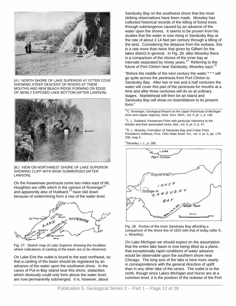
(A.) NORTH SHORE OF LAKE SUPERIOR AT OTTER COVE SHOWING STEEP DESCENT OF RIVERS AT THEIR MOUTHS AND NEW BEACH RIDGE FORMING ON EDGE OF NEWLY EXPOSED LAKE BOTTOM (AFTER LAWSON).
Publication 5, Geological Series 3 -- Part 1 – Page 12 of 26
(B.) VIEW ON NORTHWEST SHORE OF LAKE SUPERIOR SHOWING CLIFF WITH BASK SUBMERGED (AFTER LAWSON).
On the Keweenaw peninsula some two miles east of Mt. Houghton are cliffs which in the opinion of Rominger12 and apparently also of Hubbard,13 have slid down because of undermining from a rise of the water level.
Fig. 27. Sketch map of Lake Superior showing the localities where indications of canting of the basin are to be observed.
On Lake Erie the outlet is found to the east northeast, so that a canting of the basin should be registered by an advance of the water upon the southwest shore. In the caves of Put-in-Bay Island near this shore, stalactites which obviously could only form above the water level, are now permanently submerged. It is, however, about
Sandusky Bay on the southwest shore that the most striking observations have been made. Moseley has collected historical records of the killing of forest trees through submergence caused by an advance of the water upon the shores. It seems to be proven from his studies that the water is now rising in Sandusky Bay at the rate of about 2.14 feet per century through a tilting of the land. Considering the distance from the isobase, this is a rate more than twice that given by Gilbert for the lakes district in general. In Fig. 28, after Moseley there is a comparison of the shores of the inner bay at intervals separated by ninety years.14 Referring to the future of Port Clinton near Sandusky, Moseley says:15
“Before the middle of the next century the water * * * will go quite across the peninsula from Port Clinton to Sandusky Bay. After two or two and a half centuries the water will cover this part of the peninsula for mouths at a time and after three centuries will do so at ordinary stages. Marblehead will then be an island and Sandusky Bay will show no resemblance to its present form.” 12C. Rominger, Geological Report on the Upper Peninsula of Michigan (Iron and copper regions), Geol. Surv. Mich., vol. 5, pt. 1, p. 136. 13L. L. Subbard, Keweenaw Point with particular reference to the felsites and their associated rocks, ibid., vol. 6, pt. 2, p. 47. 14E. L. Moseley, Formation of Sandusky Bay and Cedar Point, President's Address, Proc. Ohio State Acad. Sci., vol. 4. pt. 5, pp. 179-238, map II. 15Moseley, l. c., p. 288.
Fig. 28. Portion of the inner Sandusky Bay affording a comparison of the shore line of 1820 with that of today (after E. L. Moseley).
On Lake Michigan we should expect on the assumption that the entire lake basin is now being tilted as a plane, that exceptionally rapid conditions of water advance would be observable upon the southern shore near Chicago. The long axis of the lake is here more nearly in correspondence with the general direction of uplift than in any other lake of the series. The outlet is to the north, though since Lakes Michigan and Huron are at a common level, it is the position of the isobase of the Port

Huron outlet which will determine the rate of submergence of the Chicago shore. It is a little difficult to draw with accuracy the isobases of present day tilting, but if these take the direction of post-Pleistocene but prehistoric isobases, as seems not improbable, Lake Michigan would be expected to register a larger landward migration of its southern shore than any lake of the group. This is, of course, upon the assumption of Gilbert that the lake basin is now being tilted as a plane. That no submergence of the southern shore of Lake Michigan has been observed, is thus of great significance, and is best explained by assuming that there are to day as in earlier times definite hinge lines of uplift, and that these now lie well to the north of the Chicago shore. The earliest of the post-glacial hinge lines is quite near the Port Huron outlet, and if the present hinge line be either in the same neighborhood, or to the northward, the conditions on the Chicago shore are adequately explained (see Fig. 29). We shall again revert to this matter after the observations about the north end of Green Bay have been discussed.
Fig. 29. Map of the Great Lakes district to illustrate the uplift and tilting of the basin. a. isobase of the Chicago outlet; b. hinge line of Lake Whittlesey beaches (after Leverettt); b’. hinge line of Lake Warren beaches (according to Taylor); c. isobase of Port Huron outlet to Lakes Michigan and Huron (after Gilbert); d. hinge line of Lake Algonquin beaches (after Goldthwait); c, f, g, h, later hinge lines of Lake Algonquin beaches (Hobbs); i. distance along which present day tilting tending to raise the level of the Chicago shore should be measured on the assumption of tilting as a plane; j. distance along which such tilting should be measured on the assumption that the hinge line of present day tilting corresponds to that of the Lake Whittlesey beach; k. isobase of Lake Erie outlet (after Gilbert); l. isobase of Lake Superior outlet with reference to Lake Algonquin beaches (after Leverett); m. the same for Nipissing beaches [approx.] (after Leverett).
The succession of ancient lakes in the St. Lawrence basin explained by the initial blocking and later successive unblockings of different natural outlets for the water by the continental glacier. The beaches of the ancestors of the present Laurentian lakes were familiar to the Indians, who made use of them as trails. A prominent shore line of this character was as early as 1840 traced by Bela Hubbard for a distance of sixty miles where the broad plain of southeastern Michigan (the old lake bottom) approached the ridge of bounding moraines upon the north and west.16 Later, very extended observations especially by Leverett,17 and Taylor,18 have provided us with maps from which the sequence of the lakes and the more important episodes of their history have become well known to geologists. At first erroneously supposed to be arms of the sea and later as land-enclosed fresh water lakes,19 an impounding of the water as the result of damming by the great continental glacier of late Pleistocene time came to be the explanation. The idea of ice dams was suggested by Newberry in a foot-note to Mr. Gilbert's paper on the Maumee Valley in 1873, and is apparently the first conception of the continental ice sheet as the cause for the high water stage in the Maumee Basin. Within a few years after the publication of this report on the Maumee Valley, Gilbert adopted the ice-dam hypothesis in place of that of land-locked lakes. About 1890 Frank Leverett determined the relations of the beaches of Lake Erie to certain moraines in northern Ohio and published the results in 1892.20
Thus the great continental glacier of late Pleistocene time impounded the water along its front as soon as it had retired behind the divide surrounding the St. Lawrence basin. These ancient lakes had thus ever a dam of ice upon their northeastern margin, and have come to be known as ice-dammed lakes. Inasmuch as there were certainly four successive invasions of and retreats from American territory by the continental glaciers of the socalled "ice age," complex series of ice-dammed lakes must inevitably have been formed during each advance as well as during each retreat—making some eight complete series in all. The effacement of the records of the first seven series by later over-riding of the glaciers, makes, it necessary to confine our attention to the latest recession only of the continental glacier. 163rd. Ann. Rept. Geol. Surv. Mich., 1840, p. 104. 17Frank Leverett, The Illinois glacial lobe, Mon. 38 U. S. Geol. Surv. 1899, p. 817, pl. 24. Glacial formations and drainage features of the Erie and Ohio basins, ibid., Mon. 41, 1902, p. 802, pl. 26. 18Am. Jour. Sci., (Fig. 3), vol. 43, 1892, pp. 210-218; Bull. Geol. Soc. Am., vol. 5, 1894. pp. 620-626 ; Am, Geol., vol. 13, 1894, pp. 365-383; ibid., vol. 14, 1894, pp. 273-289; ibid., vol. 15, 1892, pp. 24-33, 100-120, 162-179, 304-314; vol. 17, 1896, pp. 253-257; vol. 20, 1897, pp. 65-66, 111-128; vol. 24, 1899, pp. 6-38. 19C. K. Gilbert, Geology of Ohio, vol. 1, 1873, p. 552. 20Frank Leverett, On the correlation of moraines with raised be-aches of Lake Erie, Am. Journal. Sci. 3d series, vol. 43, 1892, pp. 281-301.
Publication 5, Geological Series 3 -- Part 1 – Page 13 of 26

The earlier lakes of this series would naturally be able to develop only in the immediate neighborhood of the divide surrounding the basin, since at this time the ice still covered all remaining portions. In Michigan, as elsewhere, these initial lakes; were strikingly crescent shaped and formed where the exposed land was lowest between the ice and the divide. In the valley of the Maumee, west of the present Lake Erie, there were several lakes in succession whose shapes and areas were determined by the altitudes of successive outlets (see Fig. 30). In Fig. 31 are shown the second stages of the early lakes, in the Maumee basin notably changed owing to the opening of a new outlet. The later episodes of the lake history were each initiated through successive uncovering by the glacier of some lower lying outlet for the impounded waters along the ice front. The main outlet was in all the earlier stages by various routes to the Mississippi. In the Erie basin the Lakes Maumee, Arkona, Whittlesey, and Warren, followed one another in succession. A full modern exposition of the facts concerning these lakes is to be found in a recent report of the Michigan Geological Survey,21 and in a summary by Leverett.22
Publication 5, Geological Series 3 -- Part 1 – Page 14 of 26
Fig. 30. First stage of the ancient lakes in the Laurentian basin, (after Taylor and Leverett).
When the area of the lakes had been increased through the withdrawal of the ice from what is now American territory the main outlet was found by the Mohawk valley into the Atlantic. The lakes of this stage are referred to as Lake Algonquin, in the enlarged basin of the upper lakes, and Lake Iroquois, in the enlarged basin of Lake Ontario (see Fig. 32). Still later, when the ice had retired until its front was to the north of the Ottawa river and Lake Nipissing, the water of the upper lakes found its outlet at North Bay east of Georgian Bay through the so-called "Nipissing outlet" into the Ottawa river and thence to an arm of the sea which then occupied the lower St.
Lawrence valley. The lakes of this stage are known as the Nipissing Great Lakes (see Fig. 33).
Fig. 31. Second stage of the lakes in the Laurentian basin, (after Taylor and Leverett).
Fig. 32. Lakes Algonquin and Iroquois, with outlet to the Atlantic by way of the Mohawk valley (after Taylor and Leverett).
21A. C. Lane, Summary of the surface geology of Michigan, Rept. Geol. Surv. Mich. for 1907, 1908, pp. 122-135. 22Frank Leverett, Outline of the History of the Great Lakes, 12th Rept. Mich. Acad. Sci., 1910, pp. 19-42.
As in no other state there is in Michigan an unparalleled opportunity to study the late changes of level of the land which have occurred since the earliest lake of this latest series came into existence. On both sides of the lower peninsula are found beaches to mark the former strands, while the northern peninsula and the high islands within the lakes extend the records to the northward. These may be still further extended along the same direction into Canada about the northern shore of Lake Superior. They may be supplemented also by studies on the east shore of Lake Huron and Georgian Bay, as well as to the westward on the west shore of Lake Michigan and both shores of Green Bay. Thus the results obtained on a

single section may be compared with those on neighboring sections to the east and west.23
Publication 5, Geological Series 3 -- Part 1 – Page 15 of 26
23See works by Leverett, Taylor. Goldthwait and Lane, as above cited, and the Ann Arbor Folio published by the U. S. Geological Survey.
Fig. 33. The Nipissing Great Lakes with outlets through the Ottawa river to the Atlantic, (after Taylor and Leverett).
The present day attitude of the now abandoned strands with respect to the levels of the existing lakes, is determined, first, by the former levels of the respective outlets; and, second, by later elevations, depressions, or tiltings of the land. Absolute uplift or depression of the region it would be difficult to measure accurately, because no zero from which to read is available. On the other hand, a tilting of the land can be determined with much precision, since the large areas involved render the errors of vertical measurement exceedingly small by comparison.
Gilbert's prophecy of a future reversal of the St. Lawrence drainage to its earlier Chicago outlet. If the lake basin be considered to move as a plane, the northern end of which is in process of uplift, certain results must follow. The water of the upper lakes now discharges through an outlet at Port Huron at the southern extremity of Lake Huron. The natural rock sill of the divide between the Chicago and the Des Plaines river—between the St. Lawrence and the Mississippi basins—is now but eight feet above the common mean level of Lakes Michigan and Huron. A relative uplift of the Port Huron channel in excess of eight feet would, therefore, be more than sufficient to start an occasional small overflow into the Mississippi drainage by way of the Chicago outlet. Upon the assumption of Gilbert that the rate of tilting of the lakes is uniform and equivalent to four-tenths of a foot differential uplift between the ends of each south southwest line 100 miles in length during every century, the first intermittent high water discharge over the natural sill in the Chicago outlet should occur in from 500 to 600 years; for the mean lake stage in 1000 years; and for continuous discharge in 1500 years. Water would thus be withdrawn from the Niagara outlet, and the process continuing, in 2500 years Niagara Falls
would be dry at low lake stages, and in 8500 years the falls would become extinct.
Modification of this prediction to account for hinge lines north of the Chicago outlet. One who had studied only the abandoned beaches about Lake Erie, would doubtless have reached the conclusion that little, if any, canting of the land had occurred since the time when, waves, beat upon these now dry shores. Here the differences of level represented by any beach examined for long distances are surprisingly small. On the other hand, the observant traveler by steamer on the upper lakes, cannot but remark as he goes northward on either Lake Michigan or Lake Huron that the ancient. shore lines which he may follow with his eye above the present shores are constantly rising higher above the lake level. Somewhere, then, between these two districts there must have been an axis about which the northern area has been tilted like a trap door upon its hinge. This fulcrum line has been traced by Leverett for the beaches of Lake Whittlesey about the Erie basin, and takes its course across the middle of Lake St. Clair and thence across Ontario and Lake Erie to Ashtabula, in Ohio (see Fig. 29b). It would not, however, be correct to say that the pre-Whittlesey beaches are horizontal to the south of this line. In the entire distance south to Fort Wayne, Indiana, the most southwesterly point reached by the waters of the earlier post-glacial lakes, the tilt is represented by some twenty feet of uplift of the northern edge above the southern; but this uplift was completed before the Whittlesey stage. At the Whittlesey hinge line its beach assumes rather abruptly an angle of tilt.
The beaches of Lake Warren the next later of the lake stages in the same basin, begin their inclination to the north of a line some fifteen miles northeast of the Whittlesey hinge line (see Fig. 29 b'). The Algonquin beaches of the more northerly lake basins begin their tilt at a line running in a broad curve from the south end of Green Bay in Wisconsin past Manistee, Michigan, and across the southern ends of Saginaw Bay and Lake Huron (see Fig. 29 d).24 It would thus appear that subsequent to the change of level of the waters by which each of the lake stages was terminated, there must have been a relatively sudden northward tilt of the land, which was terminated before the next lake stage had been concluded.
As must be clear, Gilbert's predictions have been based upon the assumption that the tilting of the lake basin has been as a plane revolving about some axis lying to the south southwest of the present lakes. Now it has been brought out that the southernmost hinge line in the eastern Michigan district lies to the northward of Detroit and crosses the middle of Lake St. Clair (see Fig. 29 b). Hence to the southward of this line tilting has been proportionately so small as to be almost negligible by comparison. The line perpendicular to an isobase upon which the differential uplift tending to reverse the drainage should be measured is, therefore, not the distance i. (Fig. 29), as has been assumed by Gilbert, but j. a distance less than one-fourth as great if this

hinge line has continued to act to the present day. But it was noticed in the last section that a quick response in uplift of the land followed close upon the retiring ice front, and that the hinge lines of beaches formed by later lakes lie to the northeastward of the earlier ones. The hinge line of the Lake Warren beaches lies north of Lake St. Clair and but a few miles distant from the Port Huron outlet, while the earliest hinge line of the later Algonquin beaches lies well to the northward of Port Huron. This fact and the no less significant absence of submergence effects near Chicago, makes it probable that (independent of artificial channels) there are no processes now in operation which tend to reverse the St. Lawrence drainage and so bring about the predicted future discharge through the former Chicago outlet. Moreover, as we shall see, the rate of uplift has increased at greatly accelerated rate toward the northeastern margin of the Lakes region and has also been most recent there.
Publication 5, Geological Series 3 -- Part 1 – Page 16 of 26
24J. W. Goldthwait, Isobases of the Algonquin and Iroquois beaches and their significance, Bull. Geol. Soc. Am., vol. 21, 1910, pp. 227-248, pl. 5.
The warping of the ancient beaches. Spencer in 189125 found that north of Lake Huron and about Georgian Bay the northerly uplift of the beaches increased toward the north northeast and was greatest for the upper or earlier beaches. These observations proved that the water planes of the former lake surfaces had not simply been canted to the southward and westward, but had been warped as well. It was further shown by the same author that some beaches divided or forked as they were followed northward.
Fig. 34. Diagram showing the manner of opening out ("feathering") of beaches as they are followed northward (after Goldthwait).
In the classic monograph upon Lake Agassiz, the ancient glacial lake which occupied the broad valley of the Bed River of the North, while the retreating continental glacier still lay across its natural northern outlet, Upham has convincingly shown essentially the same features of tilting. The highest or Herman beach followed northward becomes tilted to the southward at an increasing angle and divides repeatedly until no less than seven beaches have replaced the one near the southern margin,26 (see Fig. 34).
The relatively recent general introduction of precise levelling methods. Door County in Wisconsin, which comprises the peninsula between Green Bay and Lake Michigan, offers somewhat unusual opportunities for study of the late uplift and tilting of the land. Gilbert's and Leverett's investigations had early shown that the axis of canting is nearly at right angles to the main extension of this peninsula, and for much of its length the bedrock is here exposed so that earlier strand features; are of a kind to have been easily preserved. Appreciating the importance of determining accurately the elevations of these beaches which had. before been measured by crude and inaccurate methods only and at widely separated points, Goldthwait has in this district run lines of precise levels at frequent intervals, thus deriving facts of great significance in the glacial and post-glacial history of the Laurentian basin.27
Without these precise methods it had been impossible, in far northern districts at least, to .successively correlate the scattered observations and so follow out any given shore line with full confidence. Goldthwait's surveys have, therefore, opened up a new horizon of observation, and are throwing much light upon the Laurentian lake history as well as upon the general problems of the oscillations in level of the land. A sample section of beaches levelled by precise methods in Door County is reproduced after Goldthwait in Fig. 35.
Goldthwait's complete correlations of ancient water planes throughout the peninsula reveal at what rates the gradients of the now abandoned strands are accelerated toward the north. In general, therefore, and regarded broadly, the post-glacial uplift of the Lake Michigan basin is represented by B of Fig. 36 instead of by A, as had been at first supposed.
Fig. 35. Sample section of beach ridges and terraces above Lake Michigan in Door County, Wisconsin. The figures in the section represent elevations in feet above lake level (after Goldthwait).
Additional hinge lines. On studying carefully Goldthwait’s general section of the several water planes in the Door County Peninsula, the writer was at once impressed by the fact that the slope of these planes did not increase gradually to the northward, but was characterized by sharp breaks separating sections which had each an increased average gradient over those that had gone before—there were additional hinge lines to the one at the south end of the section (see Fig. 37). It was at first thought that these sharp breaks in the section might be explained by accidental aver aging of the data while constructing the sections, but further examination and correspondence with the author made this hypothesis extremely improbable. The positions of
25J. W. Spencer, Deformation of the Algonquin beach, and birth of Lake Huron, Am. Journ. Sci., (Fig. 3) vol. 41, 1891, pp. 14-16. 26Warren Upham, The Glacial Lake Agassiz, Mon. 25, U. S. Geol. Surv., 1896, pp. 483-484.

the additional and later hinge lines of the section fall closely into correspondence with Dykesville, Dreutzers Quarry, Ephraim, and Rock Island, each separated by a distance of about 21 miles.
Publication 5, Geological Series 3 -- Part 1 – Page 17 of 26
27J. W. Goldthwait, Abandoned shore-lines of eastern Wisconsin, Bull. 13, Wis. Geol. and Nat. Hist. Surv., 1907, p. 134, pl. 37 and fig. 37. It should not be forgotten that Lawson as long ago as 1891 made use of the surveyor's level in very valuable reconnaissance studies of beaches north of Lake Superior, and that some of Spencer's earlier studies were also made with a precise instrument.
Fig. 36. Diagrams to illustrate the uplift of the Laurentian basin. A. Earlier view; B, Later view first brought out by Spencer for the east shores of Georgian Bay and by Upham for Glacial Lake Agassiz, and proven by precise methods by Goldthwait in Door County, Wisconsin, (after Goldthwait).
Fig. 37. Outline representation of Goldthwait's section28 of the deformed ancient strands found in the Door County peninsula Wisconsin and extended northward upon the basis of earlier data. Hinge lines appear at Dykesville, Dreutzers Quarry on Sturgeon Bay, Ephraim, and Rock Island.
The later study by the same author of the beaches on the east shore of Lake Michigan, has yielded likewise a series of sections which no less clearly bring out an additional sharp break in the slope of the beaches.29 This break occurs near the isobase of Beaver Island, as is clear from examination of the series of sections, and this leaves an interval separating it from the most northerly of the hinge lines in Door County which is approximately equivalent to the others.
THE AUTHOR'S STUDY OF ANCIENT BEACHES ABOUT THE
NORTHERN END OF GREEN BAY. Conditions of the work. With a view to further examination of the problem of tilting, and in order to secure data for extending Goldthwait's profiles to the north shore of Green Bay, the writer spent the summer of 1907 under instructions of Dr. A. C. Lane, the then State Geologist of Michigan, in re-examining some of the localities studied by Goldthwait and in carrying out precise levels about the north end of Green Bay. In this work he was ably assisted by Mr. W. F. Hunt, instructor in mineralogy in the University of Michigan. Some time was spent in Door County, Wisconsin, in gaining familiarity with the abandoned strands on that peninsula before searching for the same or additional shore lines in the less accessible and more generally dune and forest covered districts to the northward. It was further thought that it might be possible to discover evidences of post-glacial faulting in the vicinity of the hinge lines, in case glaciated rock surfaces were there exposed.
In brief, it may be stated that the lines of level which were run in Door County in all respects confirmed the surveys by Goldthwait, and in one instance post-glacial faults were found. These appeared upon the finely polished and striated surface of the Niagara limestone, where it had been stripped above the Green Quarry near Sawyer on Sturgeon Bay. The displacements had taken place on joints which were directed about N 15 degrees W and N 83 degrees E. The individual displacements were generally only one-eighth to one-half an inch, though occasionally a value as high as one and one-half inches was measured. These slips were far enough back from the quarry edge to exclude apparently the hypothesis of settling since the excavation of the rock in the quarry. The locality is near one of the hinge lines indicated in Goldthwait's section, but this correspondence may be purely fortuitous, and further search may reveal such structures at other places as well, though glaciated surfaces were not found at the other particular localities.
The main purpose of the summer's work was, however, to secure additional data by precise methods within the areas farther to the northward, where reconnaisance work had already been carried out by Taylor30 and Russell.31 The results of this study are discussed in the following section.
Bay de Noc Peninsula. The Bay de Noc Peninsula is a broad V of land with the point to the southward separating the Little from the Big Bay de Noc on the northern shore of Green Bay (see Fig. 38). Its eastern shore is low and sandy, while the western is fringed with a series of low step-like terraces, from which the land extends eastward in a plain to a central back-bone covered with hard woods and extending for at least ten miles to the northward beyond the "Soo" Railroad (see Fig. 39). The plain to the west of this ridge is covered with jack-pine—one of the jack-pine plains characteristic
28J. W. Goldthwait, Geol. and Nat. Hist. Surv. Wis., Bull. 18, pl. 37. 29J. W. Goldthwait, a reconstruction of water planes of the extinct glacial lakes in the Lake Michigan basin. Jour. Geol., vol. 16. 1908, pp. 459-476, plate of sections. (See especially p. 470.)

of large sections in this district. Just north of the station of Ensign is a considerable area occupied by sand dunes alternating with bogs.
Publication 5, Geological Series 3 -- Part 1 – Page 18 of 26
30F. B. Taylor, A reconnaissance of the abandoned shore lines of Green Bay, Am. Geol. vol. 13, 1894, pp. 316-327. 31I. C. Russell, A geological reconnaissance along the north shores of Lakes Huron and Michigan, Rept. Geol. Surv. Mich. for 190C 1905. pp. 39-105, pls. 13-16.
Fig. 38. Map of the greater part of Green Bay.
Fig. 39. Map of the north shore of Green Bay showing the positions of profiles. The numbers refer to beach profiles prepared with the use of the Wye level.
The rock underlying the peninsula is the Cincinnati shale, which is exposed where recently undercut on the southwest shore from some miles south of Farmer's Dock to Peninsula Point. The Trenton limestone with "shelly" weathered surface is found along the north shore of the Little Bay de Noc, especially in the bed of the Rapid River. It also extends out into the bay as a reef which to the south of Garth is covered by less than five feet of water and continues as an obstruction to navigation as far as Gladstone.
Beaches on the west shore of the peninsula have been examined near Gravel and Farmer's Docks near the southwest comer of the peninsula; midway between this point and Maywood Park; at Maywood Park; Campbell's Landing; Garth; and at the mouth of White Fish River.
The southernmost profile of the series was made about one-eighth of a mile south of the Gravel Dock. Here a very perfect terrace appears at an elevation of 7 feet; and beach ridges at 19 and 29 feet, respectively, the last mentioned being much the stronger (Fig. 40, profile 1). At Farmer's Dock beach ridges occur at 4 and 5 feet elevation and strong terraces at 7 feet and 25 feet. A still higher beach occurs near the cross roads at an elevation of 87 feet (Fig. 40, profile 2).
Fig. 40. Series of profiles on west shore of Bay de Noc Peninsula: 1, near Gravel Dock; 2, Farmer’s Dock; 3, opposite Escanaba river; 4, Maywood Park; 5, Campbell’s Landing; 6, Garth; 7, White Fish river (compare Fig. 39 for location).
At a point about 4 miles north of Farmer's Dock, and nearly opposite the mouth of the Escanaba river, beaches were located at 14-16 feet, 20 feet, and 25 feet (Fig. 40, profile 3).
In the profile made at Maywood Park, there is a beach at 39 feet, and a long terrace extends lakeward terminating in a bank near the present shore (Fig. 40, profile 4). At Campbell's Landing what is probably a beach terrace occurs at elevation of 27 feet, and a more clearly defined one at 51 feet. At Garth near the head of the bay, beach

Publication 5, Geological Series 3 -- Part 1 – Page 19 of 26
terraces were found at 6 feet, 11 feet, and 26 feet of elevation, and a swept terrace begins at 64 feet, the end of the section (Fig. 40, profile 6). From here the jack-pine plain extends far to the northward with but little variation from a plain surface. Near the mouth of the White Fish River a profile was made and a beach terrace encountered at an elevation of 36 feet, while a swept terrace is reached at 72 feet (Fig. 40, profile 7). The wagon road ascends the steep cliff below the terrace and shows good sections in water-laid sand and gravel with some of its layers approaching paper thinness. From the brink of the terrace one may follow the White Fish road in a north-northeasterly direction for between eight and nine miles on a gently ascending plain covered with jack-pines, until it meets the hardwood ridge, and goes over it in a cliff, the elevation of which was not determined.
West shore of Little Bay de Noc. The western shore of the Little Bay de Noc between the Escanaba river and the head of the bay is formed of a high bluff composed of stratified sand and gravel of glacial derivation, which bluff has been cut back by the Nipissing and later lakes. This bluff is seen as a striking feature from vessels entering the harbor of Escanaba. Its strongly marked horizontal stratification is best shown in the section between the Escanaba river and Gladstone, where the lines are clearly visible from the middle of the bay. Attention has already been drawn to these cliffs by Russell,32 who has explained the deposits as kame terraces. He calls attention to the fact that the Trenton limestone of the Rapid and White Fish valleys is glaciated and covered with reddish till by from 5 to 15 feet, upon which layer rests the thick deposit of sand and gravel.
The conditions found near the shores of Little Bay de Noc, he shows continue at least a number of miles farther north where the Rapid and White Fish rivers flow in nearly parallel courses without an intervening ridge. Be believed this to show that the valley was probably pre-glacial. The upper surface of the western sand plain he stated to be about 160 feet above the bay at Gladstone, and believed it to slope at a small angle northward. This estimate of altitude is probably based on aneroid readings, since the highest point near Gladstone is, by our precise levels, lees than 140 feet above the bay.
The question of the slope of the surface of this plain, is clearly one of very considerable interest in connection with its origin, and has, therefore, been given considerable attention. The approach of its surface to a plane along the brink of the high escarpment is so striking that a line of levels was run from near Gladstone to the top of the terrace and thence north-northeastward to Masonville, south-southwestward for some three miles, and northwestward across the plain to a rising slope beyond the third railroad in the series (see Fig. 39). Cross sections were made to the bay at Furnace Island and at a point some three miles south of
Gladstone. The long north-northeast section parallel to the shore is reproduced in Fig. 41. 32I. C. Russell, l. c., pp. 82-83.
From this profile it appears that the surface of the plain is gently undulating with maximum local variations of only a few feet and that for a distance of about three miles south of Furnace Island the plain slopes southward at the rate of about 3 feet per mile ranging from 139 feet of elevation on the south to 147 feet on the north. Goldthwait's earlier studies on the southern peninsula of Michigan and in the vicinity of Mackinac Island, had already indicated that this elevation and this slope are both alike characteristic of the highest Algonquin beach line near this isobase. Our own measurements both to the east and west confirm the earlier determination, as will be shown below, and we may, therefore, conclude that these deposits are not merely a kame terrace as supposed by Russell. In addition, the deposits are of the nature of a delta formed in an early stage of Lake Algonquin when the margin of the ice was close at hand in an east-northeast west-southwest direction near Brampton (Fig. 39), and extended a tongue down into the Little Bay de Noc. The levels derived from surveys in connection with the Peninsular Division of the C. & N. W. Railway between Bay Siding and Brampton show how nearly the surface of the deposits approaches a horizontal plane except for the uplift of the northern margin due to earth tilting since the time of the first Algonquin Lake.
But we have made two additional profiles with, a view to fixing more definitely the slopes upon the upper surface of this delta. One of the profiles was begun at the shore, one mile south of Gladstone and carried west-northwestward up to the top of the bluff, thence in the same direction to the east-west road running west through west Gladstone, and thence along this road westward until it intersects the north-south road about one mile west of the Escanaba river. The top of the bluff overlooking the bay was reached at an elevation of 135 feet, and thence to the tracks of the Peninsular Division of the Northwestern Railway, the stations in our profile ' had elevations of 134.4, 133.4, 133.7, and 134.3 feet (see Fig. 41 A); which figures indicate the somewhat remarkable evenness of the plain up to this point. From this railroad crossing the land begins to slope gently down into the later valley of the Escanaba river and continues to descend until the river is reached. The floor of the bridge spanning the river is at an elevation of 90 feet above the bay. From here the slopes ascend and the next railroad in the section was crossed at an elevation of 92 feet. After rising out of the river bed, a section of plain is again encountered at an average elevation of 130 feet, which meets the rising ground as a probable beach near the cross roads where the elevation is 151 feet.
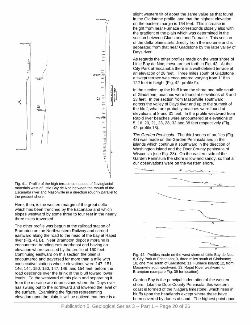
Fig. 41. Profile of the high terrace composed of fluvioglacial materials west of Little Bay de Noc between the mouth of the Escanaba river and Masonville in a direction roughly parallel to the present shore.
Here, then, is the western margin of the great delta which has been trenched by the Escanaba and which slopes westward by some three to four feet in the nearly three miles traversed.
The other profile was begun at the railroad station of Brampton on the Northwestern Railway and carried eastward along the road to the head of the bay at Rapid river (Fig. 41 B). Near Brampton depot a moraine is encountered trending east-northeast and having an elevation where crossed by the profile of 160 feet. Continuing eastward on this section the plain is encountered and traversed for more than a mile with consecutive stations whose elevations were 147, 151, 146, 144, 150, 150, 147, 146, and 154 feet, before the road descends over the brink of the bluff toward lower levels. To the westward of this plain and separating it from the moraine are depressions where the Days river has swung out to the northward and lowered the level of the surface. Examining the figures representing elevation upon the plain, it will be noticed that there is a
slight western tilt of about the same value as that found in the Gladstone profile, and that the highest elevation on the eastern margin is 154 feet. This increase in height from near Furnace corresponds closely also with the gradient of the plain which was determined in the section between Gladstone and Furnace. This section of the delta plain starts directly from the moraine and is separated from that near Gladstone by the later valley of Days river.
As regards the other profiles made on the west shore of Little Bay de Noc, these are set forth in Fig. 42. At the City Park at Escanaba there is a well-defined terrace at an elevation of 28 feet. Three miles south of Gladstone a swept terrace was encountered varying from 118 to 122 feet in height (Fig. 42, profile 9).
In the section up the bluff from the shore one mile south of Gladstone, beaches were found at elevations of 8 and 33 feet. In the section from Masonville southward across the valley of Days river and up to the summit of the bluff, what are probably beaches were found at elevations at 8 and 31 feet. In the profile westward from Rapid river beaches were encountered at elevations of 5, 16, 20, 21, 23, 28, 32 and 38 feet respectively (Fig. 42, profile 13).
The Garden Peninsula. The third series of profiles (Fig. 43) was made on the Garden Peninsula and in the islands which continue it southward in the direction of Washington Island and the Door County peninsula of Wisconsin (see Fig. 38). On the eastern side of the Garden Peninsula the shore is low and sandy, so that all our observations were on the western shore.
Fig. 42. Profiles made on the west shore of Little Bay de Noc. 8, City Park at Escanaba; 9, three miles south of Gladstone; 10, one mile south of Gladstone; 11, Furnace Island; 12, from Masonville southwestward; 13, Rapid River westward to Brampton (compare Fig. 39 for location).
Garden Bay is the principal indentation of the western shore. Like the Door County Peninsula, this western coast is formed of the Niagara limestone, which rises in bluffs upon the headlands except where these have been covered by dunes of sand. The highest point upon
Publication 5, Geological Series 3 -- Part 1 – Page 20 of 26

the peninsula is Burnt Bluff, forming the extreme south-western point and rising to a crest more than 200 feet above the lake. The principal settlement upon the peninsula is now ranged upon the northeast side of Garden Bay with postoffices at Vans Harbor and Garden. Vans Harbor (short for Van Winkle's Harbor) is the slight indentation upon the north side of the bay near its mouth, where are located the docks, and the saw mill. The larger portion of the settlement is, however, at Garden postoffice near the head of the bay. Communication is made with Escanaba by a daily boat of the Escanaba and Gladstone Transportation Company during the open season, and with the railway station of Cooks Mill to the northward by daily stage.
Fig. 43. Series of profiles indicating elevations of beaches on the Garden Peninsula and neighboring islands.
The shores of Garden Bay are too low for the preservation of any beaches much higher than the Nipissing, and this is encountered at many points in the vicinity. It is seen to advantage as a shingle ridge near Vans Harbor on the road to Garden. Somewhat nearer to Garden (about midway) the section shown in Fig. 43, profile 22, was made. A strong ridge is here 32 feet above the lake, and has a back slope between 2 and 3 feet high. Less distinct lower beaches are found at elevations of 5 and 17 feet respectively.
On the rocky slope northwest of the saw mill at Vans Harbor, a terrace of the higher beach is found extended by an embankment which a little farther on returns to the former shore so as to enclose an extinct lagoon. On the south side of Garden Bay the same beach is again encountered near the road leading to Fayette. The same beach is also met with in the cedar swamp about a half mile north of Valentine's creek, or some five miles north of Garden.
Much of the country north of Garden is covered with sand dunes. Jack's Bluff is the highest point of the shore, and like the country about it is sheathed in sand.
Clamshell Harbor. More than thirty years ago this little harbor was surrounded by a prosperous settlement and smelters belonging to the Jackson Iron Company. The magnificent hardwood forests were, however, cut down and burned to charcoal in brick kilns for feeding the smelters, the kilns in a dilapidated condition being still to be seen scattered over the district. The smelters and warehouses in a similarly dilapidated condition are located on the immediate shore of the small but excellent harbor, where vessels of moderate draught may tie up anywhere about the inner basin. To the east of the harbor the Niagara limestone rises in a beautiful bluff which is cut back by the present lake, and at the basin of the harbor is the quarry which was utilized to obtain flux for supplying the furnaces.
The headland immediately west of the harbor was an island in the Nipissing great lakes, and was separated from the mainland by a narrow strait where now is found the Shelton House. This island (see Fig. 44) and the Nipissing terrace for a distance of half a mile south of the docks is covered with rotting houses and barracks for the most part long since deserted by their occupants. Yet the location of Fayette is one of almost ideal beauty, and with the removal of the worthless structures which now mar the landscape, it would be difficult to rival it in attractiveness for a retired summer residential settlement.
The vicinity of the harbor is a most favorable locality upon the peninsula for studying the lower lying abandoned shore lines of the ancient lakes. The Nipissing and certain of the lower Algonquin shores are well developed immediately about the harbor, and on the road to Garden near the South River fine beach ridges of the higher Algonquin beaches are cut through by the highway.
As already stated, the headland enclosing Clamshell Harbor represents an island which rose above the Nipissing lake. This island was exposed to the strong West and southwest winds and has in consequence strongly developed beach formations. The sketch map of Fig. 44, which is drawn to scale, displays these to advantage. The margin of the rocky hill furnishes; the outline's of the former island, and this is surrounded on the west and south by a well developed bench below a sharply cut rock cliff. This terrace has been in turn undercut by later lakes, but is still wide enough to accommodate a road. Northwest of the island it broadens so that a row of houses are erected upon it between the road and a beach ridge which extends from the island in a northeasterly direction. This beach ridge is soon joined by one which goes out from the southeast corner of the island and which derived its materials from shore currents which followed the main shore and made through the strait separating the island from the mainland. Near where these two ridges are joined they have been cut through by the road, and somewhat
Publication 5, Geological Series 3 -- Part 1 – Page 21 of 26

further they are extended in a spit that rapidly loses its height as it is followed northeastward. Along the protected east side of the island its slope is more gradual. The top of the ridge which goes out from this side to join the spit is 35 feet above the lake, but this has probably been somewhat raised by grading about a house. The western ridge was found to be about two feet lower, and the terrace on the west, like the depression between the ridges, still two feet lower. The actual height of the ancient water plane at this point is probably not far from 32 feet.
Fig. 44. Sketch map of the rocky island of the Nipissing great lakes on the headland which now encloses Clamshell Harbor.
Fig. 45. One of the lower Algonquin beach ridges formed of chipped limestone and located near the deserted school-house north of Clamshell Harbor.
Across the harbor from the Nipissing Island, just described, the Nipissing terrace has been cut away by the present lake to leave a nearly vertical bluff in the Niagara limestone, in which are partly effaced sea arches extending from just above the Nipissing level downward some 10 or 12 feet. At the inner basin of the harbor, the terrace is found on the east side at an elevation of 33 feet. Below this terrace another is indicated at an elevation of 18 feet. Higher up upon the bluff certain lower water planes of the Algonquin series are found at elevations of 59 and 83 feet with a strong beach ridge at 109 feet (Fig. 43, profile 19). This latter ridge is found at the top of the steep rise about 125 yards west of the deserted school building. The ridge itself is 6 to 7 feet in height and composed of washed but somewhat weathered limestone fragments (see Fig. 45).
On the road from Clamshell Harbor to Garden, about three miles northeast of the harbor and the same distance south of the west end of Garden Bay, is a high hill on which are strongly developed beach ridges cut through by the highway. The highest of these is at an altitude of 145 feet and is located on the very crest of the hill, which is the highest land in the vicinity. It, therefore, represents a shoal in the early Algonquin lake and is probably below the highest water plane of that series. Assuming its water plane to be at 145 feet, and that of the highest Algonquin beach on Burnt Bluff at 137 feet, if they represented the same plane the rate of northerly rise would be about a foot and a half per mile, since the distance separating the two localities measured along the line of increasing uplift is very nearly five miles. The rate found by Goldthwait upon the southern peninsula of Michigan along approximately the same isobase is in excess of 2 feet per mile, which is approximately the rate of northerly rise of the delta plane west of Gladstone. On the west of this summit strong beach ridges were developed at lower levels, namely, at 143, 140, (on the east side 141), 135, 136, 127 and 124 feet. Nearly half way between this summit and the shore of Garden Bay, a strongly developed beach ridge was found at an elevation of 100 feet (Fig. 43, profile 20).
Fig. 46. Strong beach ridge of the Nipissing stage largely sheathed in wind-blown sand, but exposing the shingle near the middle of the picture.
Publication 5, Geological Series 3 -- Part 1 – Page 22 of 26

Publication 5, Geological Series 3 -- Part 1 – Page 23 of 26
The Nipissing terrace so well developed at Clamshell Harbor is followed southward toward Fayette Bay and is utilized by the highway, as it is also for a series of now rotting barracks a short distance south of the harbor. Near the church, a spit or embankment extends the terrace into the broad bight which is Fayette Bay. Serried banks of low sand dunes now appear, separating the highway from the shore of the bay. For much of the distance around the bay, there is a heavy Nipissing ridge composed of shingle for the most part sheathed in sand dune, though in places this is exposed (see Fig. 40). This beach has a back slope some 6 or 7 feet in height and doubtless lay in front of a lagoon which extended inland to the higher ground. The elevation of the top of this ridge at a point about one-half mile south of the church is 32 feet.
Burnt Bluff. Upon this headland the waves raised by westerly and southwesterly winds must have beat with especial force by reason of their long reach, and the bluff is so strongly notched that it compels the attention of any one passing in a steamer or stopping in Fayette. The highest of the Algonquin stages is represented by the strongest of these notches which was determined to have an altitude of 137 feet. Great beach ridges of chipped stone are now forming at the shore and rise above it to a height of from 4 to 5 feet (see Fig. 12). The road under construction (in 1907) by Mr. Remo from the valley south of the signal tower down to the present beach, cuts through higher storm beaches of just this character, one of which was roughly measured by aneroid to have an elevation above the lake of 120 feet. These beaches were, however, not included in the leveled section which had already been carried up the steeper face of the bluff. In this section strongly developed terraces were found at elevations of 85, 128 and 137 feet. Though the bluff extends to considerably over 200 feet above the lake, it was searched in vain for indications of former submergence at higher levels, and the beach at 137 feet is hence unquestionably the highest of the Algonquin series in this neighborhood.
On the east-west road following the township line at a point three-fourths of a mile west of the schoolhouse (being removed) at the cross roads and one mile south of Fayette postoffice, a strong beach ridge of chipped stone is cut through by the highway, and this was found to have an elevation of 142 feet. Inasmuch as this beach is clearly the highest Algonquin and is on practically the same isobase as the Burnt Bluff terrace, it furnishes some measure of the possible projection of such ridges above the former water plane. The greater part of this difference of five feet is doubtless to be thus explained. A beach ridge quite distinct though less strong than the last is cut through by the road a quarter of a mile farther east and one-half mile west of the crossroads. Its elevation is 116 feet.
Summer Island. Big Summer Island, which lies to the south of the Garden Peninsula, rises to a height according to our levels of 70 feet above the lake. At the deserted blacksmith shop on the northeast shore near
the landing place is a beach having an elevation of 17 feet. Beach terraces occur also at 26 feet and at 58 feet (see Fig. 43, profile 15).
St. Martins Island. A profile was made upon this island from the lighthouse on the northeast shore up the old wagon road. A series of no less than fourteen beach ridges are ranged upon this route at distances of from 10 to 75 feet from their nearest neighbors and varying in height from 9 to 15 feet. Higher beach ridges are found at elevations of 24 feet and 46 feet, and a series of five ridges separated from their neighbors by a few paces only range in height from 62 to 67 feet above the lake.
CONCLUSIONS BASED UPON THE OBSERVED DATA.
The bent water planes. The data derived from the field studies which were detailed in the last section must be brought into correlation if we are to arrive at general conclusions. This is best accomplished by following Goldthwait in drawing longitudinal profiles, as has here been done in Plate II. To properly represent the now bent water planes, it is best to indicate a narrow zone some five feet in thickness about the average position of the plane, for we find our largest storm beaches on exposed shores of the lake reach approximately to that height. With beach ridges having a back slope the actual water plane may, therefore, be assumed to be in some cases a number of feet below the top. Terraces, on the other hand, will generally meet the cliffs at levels but little above the water plane. To bring the three parallel sections of the district into correspondence, the direction of the isobase is of much importance. This could be best obtained from the highest Algonquin beach, which obviously has the steepest gradient. Unfortunately, we must here depend upon a single value in the eastern section, and correlate this with the delta plane of the western section, since no beach proper is there disclosed. Goldthwait's studies led him to believe that the isobases near the Straits of Mackinac run about 15° north of west, but only 5° to the north of west to the southward of Traverse Bay. These isobases he further believed to curve southward as they crossed Lake Michigan, the curvature being, however, indicated as less in the northern part of the district. Utilizing the author's determination of the highest Algonquin beach on Burnt Bluff as 141 feet (the beach ridge northeast of the bluff), he carries the isobase of 720 A. T. (138 above lake) from the south shore of Beaver Island to Burnt Bluff in a direction 11° north of west.
When the north Green Bay sections of later shore lines are studied, it is found that this direction must be replaced by one inclining much more to the northwestward. The isobase of Burnt Bluff for these later beaches would pass not far from Gladstone on the west side of the Little Bay de Noc, which agrees well with that determined by Leverett on Lake Superior.33 With this isobase the sections have been correlated and the results appear in Plate II. All the beaches of

Goldthwait's sections to the eastward34—the Algonquin, Battlefield and Fort Brady series, and the lower Nipissing and Algoma beaches—are represented. Below the Algoma a later series Is very strikingly brought out.
Publication 5, Geological Series 3 -- Part 1 – Page 24 of 26
3312th Rept. Mich. Acad. Sci., 1910, p. 36, fig. 8. 34.Journ. Geol., vol. 16, 1908, plate opp. p. 468.
The manner of the uplift. As regards the problem of the manner of uplift of continental masses, this series of sections; of the bent water planes, like the earlier ones of Goldthwait, is most illuminative. While certain beaches are more strongly developed than others, usually indicating that the land stood at certain levels for longer periods than at others, there are in most cases lesser intermediate beaches, especially in the case of the newer shore lines. From this we may conclude that between successive lake stages represented by beaches the rate of uplift and tilting was relatively rapid, the longer periods of practically continuous uplift, or, more likely, quick succession of interrupted short uplifts, falling between the several series. This subject has already been treated in another place.35 Such interrupted uplifts have their sensible manifestations in earthquakes. The times corresponding to the longer intervals in the series of beaches, in so far as these were not brought about by changes of outlet, were characterized by greater earthquake frequency and Intensity, or both combined. The time corresponding to the building up of a heavy beach ridge or cut-terrace was, on the other hand, noteworthy for relatively low seismicity.
The latest of all the more marked water planes passes over into the latest lake level through a veritable series of storm beaches which differ in no material aspect from the one thrown up in the latest great storm. Thus it becomes of considerable interest to give careful study in the future to the earthquakes of Michigan, particularly as regards their distribution in the lower peninsula. A preliminary study bringing together the meagre records of the past, which may perhaps serve as a starting point for studies of this nature, follows directly upon this paper. 35Wm. Herbert Hobbs, The evolution and the outlook of seismic geology, Proc. Am. Philos. Soc., vol. 48, 1909, pp. 40-44.
Comparison of the Laurentian Basin with Scandinavia. The elevation of shore lines is a problem with the discussion of which the modern era of geology began. Sir Charles Lyell with his usual clearness of reasoning and expression, interpreted the elevated strand lines of Norway to indicate a post-Pleistocene elevation of the Scandinavian Peninsula. More recently Suess in his monumental work upon "The face of the earth," starting from a quite unrivaled familiarity with geological literature, has with much ingenuity endeavored to show that so far as elevated shore lines are either there or elsewhere to be observed; they are prehistoric, and that they are largely to be accounted for by variations in level of the surface of the sea.36 For Scandinavia these arguments have been fairly answered by Baron de Geer,37 who has summarized his conclusions in English.
Fig. 47. Hinge line of recent uplift crossing Denmark. The uptilted area lies to the northeast. The dark areas are the districts of most frequent earthquakes (after Ussing).
It must be evident that in dealing with the measure of uplift, the lack of an immovable datum plane excludes the possibility of absolute values. A tilting of the land is, on the other hand, much less equivocal in its interpretation, and where the angle of accomplished uptilt amounts to a number of feet per mile, and is continued over wide stretches of country, it is less easy to bring in arguments for the extensive deformation of actual water surfaces.38 De Geer has fully discussed such tilting of the land in Scandinavia, and under the name "zero isobase" has taken account of the hinge line or axis of uptilt. For Scandinavia these hinge lines are found on the borders of the province. Under the name "marginal line of recent uplift," Ussing39 has referred to the hinge line of this character which crosses Denmark from northwest to southeast (see Fig. 47). De Geer has implied that the Scandinavian hinge lines may migrate from their earlier positions, and that some of the submerged peat hogs and buried river channels are perhaps to be thus explained.40
36Edward Suess, The face of the earth, vol. 2. 37Gerard de Geer, Proc. Boston. Soc. Nat. Hist., vol. 25, 1892, pp. 455-461. 38Six inches per mile is according to Woodward the highest gradient which within one degree of the ice front can be attributed to ice attraction. (Bull. 48, U. S. Geol. Surv., 1889, p. 66.) 39N. V. Ussing, Dänemark, Handb. d. Regional. Geol., vol. 1, abt. 2, 1910, p. 3, figs. 1-2. 40De Geer, l. c., p. 461.
A block movement of uptilt. As already pointed out earlier in this paper, the binge lines of tilting; within the Michigan basin have migrated northeastward following upon the retirement of the continental glacier, so that the present hinge line farthest to the south lies to the northward of the Port Huron isobase. Were this not the case an advance of the water upon the Chicago shore of

Lake Michigan should occur in the same manner as is now true of the southwest shores of Lake Superior and Lake Erie. In the northern part of the district the hinge lines appear also to have changed direction, veering more to the northwest in later stages. The breaks in the Algonquin and later water planes being spaced with an approximation to uniformity, seem to the writer to be best accounted for by a quick uptilt in succession of more and more northerly blocks of the earth's shell as the ice receded from the region. In the southern lake basins we have less full data, the beaches are more nearly horizontal, and the ice having there been in close proximity when the beaches were being formed, the water surface would be raised along the ice front like a flat meniscus. This latter effect could not, however, have been very important in the more northerly lakes where the ice front was more distant, and for this reason also the breaks in the section are there more sharply defined.
Publication 5, Geological Series 3 -- Part 1 – Page 25 of 26
The nature of this block uptilt may be illustrated by the series of diagrams in Fig. 48. Such a process calls for relatively sudden uptilts accompanied by earthquake manifestations at the completion of successive stages of the lake history, as well as for a much closer approach to equilibrium in the post-glacial period, this latter being expressed in diagram F of Fig. 48.
Such an intermittent uptilting process observed in the basin of Lake Agassiz, occasioned much perplexity in the mind of Mr. Upham when discussing the late deformation of the basin of Lake Agassiz and River Warren.41 Speaking of the River Warren, Mr. Upham says:
"Through a comparatively long time, represented by the Herman beach, this large outflowing river, bearing the waters supplied by the progressive glacial melting upon a vast area, had only deepened its channel slightly; but at the close of this stage the division between it and the next following Norcross stage, though doubtless only a short interval of time, was marked by a considerable increase of depth of the channel. Why was the river able to erode so much faster then than during the time of formation of the Herman beach, or of the Norcross beach afterward, which likewise represents a nearly stationary period in the progress of erosion of the Lake Traverse Valley? * * *
"There was, however, no apparent reason why the region of Lake Traverse or the Minnesota. Valley should be thus intermittently elevated, so far as we can directly compare the change with the process of the glacial retreat; and to what extent this; movement affected the northern portions, of the lake area can only be ascertained by very exact comparison of the altitudes of the lowest Herman and the highest Norcross beaches.
"Rhythmic stages of elevation of the country across which the River Warren flowed, intervening with pauses in the action of the "uplifting forces, are shown in succession by the Norcross beach to which the erosion from, the level of the lake at the later part of its formation of the Herman beach was about 20 feet; by the two
Tintah beaches, to the first of which there was further erosion of about 15 feet, and a similar amount more to the second; by the Campbell beach, to which again the river still further cut down its channel 15 or 20 feet, and by the McCauleyville beach, formed by the lake when its channel of outlet was the bed of Lake Traverse, once more 15 to 20 feet below its preceding level. Each of these beaches records a comparatively long pause in an uplift of the land adjoining the mouth and outlet of Lake Agassiz, which was periodically renewed during brief stages of somewhat rapid increase of elevation at no less than five times-while Lake Agassiz outflowed southward. The regularity, or rhythm in the sequence of these beaches, and their division by nearly vertical intervals were doubtless produced by rhythmic uplifts, alternating with longer stages of nearly complete rest." 41Warren Upham, The glacial Lake Agassiz, Mon. 25 U. S. Geol. Surv., pp. 224-225.
CORRELATION OF DEFORMED WATER-PLANES ABOUT THE NORTH END OF GREEN BAY.
A rhythmic uplift, then, has been characteristic of both the Michigan and the Minnesota basins, and special importance must, therefore, be ascribed to both the times and the distributions of earthquakes within the entire region.
From the migration of the hinge lines in the southern, parts of the basin of the Laurentian lakes, it would appear that essential equilibrium is secured to the southward while uplift is still going on in the northern portions of the province. This explains why the southern end of Lake Michigan is not being flooded like similar portions of Lakes Superior and Erie, and why no future reversal of drainage to the Mississippi basin is to be expected. The same conditions appear to be characteristic of the Lake Agassiz basin. Upham says:42
"It seems to be clearly shown by the Campbell and Niverville beaches that there was essential rest from the uplifting movement, with a permanence of height nearly as now, upon the southern part of the basin of Lake Agassiz while its northern part was rising, and afterward upon the whole of this basin while the country surrounding Hudson Bay has been elevated. A wave of permanent uplift has advanced from near the southern border of the glaciated area to its central portion, where the ice-sheet was thickest and where it lingered in remnants probably long after its principal mass was melted. * * *

Publication 5, Geological Series 3 -- Part 1 – Page 26 of 26
Fig. 48. Series of diagrams to illustrate the supposed successive block uptilts of the Michigan basin following close upon the retirement of the continental glacier, as well as the slower subsequent uptilt of the region. The heavy broken lines in diagrams A to E represent in succession the positions and attitudes of shore lines during the retirement of the glacier from, the Michigan basin. In F is represented by the higher line the present attitude of the highest shore line as a result of quick early and slow later recovery of equilibrium in the province. The lower line may represent the present position of a horizontal plane at the end of the glacial period.
"Nearly the entire amount of the changes in the levels of the beaches of Lake Agassiz was evidently contemporaneous with the existence of this lake, taking place gradually, but apparently progressing comparatively fast between the stages marked by the formation of definite beaches, which doubtless belonged to times when these changes advanced very slowly or were interrupted by intervals of repose. * * *
"During the subsequent post-glacial period, to the present time, only very slight changes have taken place in the relative elevations of the part of this area where the heights of the beaches of Lake Agassiz have been determined in Minnesota, North Dakota, and Manitoba, and these small changes of level, shown by the Niverville beaches, have been merely a continuation of the movements which accompanied the recession of the ice-sheet and are recorded by the successive shore lines of this lake."
It seems natural to account for the early quick recovery from depression due to ice load as of an elastic nature. This movement of the earth's shell due to its resilience, is then followed by slow uplift, due probably to entirely different causes. This appears also to have been the
opinion of Upham in reference to the deformed basin of Lake Agassiz.43
In papers read some years ago before the American Mathematical Society and the National Academy of Sciences, it was shown by Dr. R. S. Woodward, that if the Laplacian law of compressibility holds true for the earth's mass, a removal of superficial load, as for example, a continental glacier, would result in uplift amounting to two meters or about six and a half feet for each atmosphere of load. Thus for every one hundred feet of thickness of ice removed an uplift of about twenty-two feet should result. Though this important paper by Professor Woodward has not been published, the writer is permitted to make reference to the principal conclusion. It seems probable that the response to the removal of superficial load from the elastic earth would be relatively rapid and it thus helps us in explaining the observed rhythmical alternation of rapid and slow elevations as the ice sheet retired in succession from neighboring blocks of the earth's shell.
University of Michigan, March 11, 1911. 42Warren Upham, l. c., pp. 481-480. 43Warren Upham, l. c., p. 488.