michigan academy of science, arts and papers of the
TRANSCRIPT

MICHIGAN ACADEMY OF SCIENCE, ARTS AND LETTERS
VOLUME XXXII (1946)
CONTAINING PAPERS SUBMITTED AT THE ANNUAL MEETING IN 1946
Selections from Papers of the MASAL--Vol. 32 – Page 1 of 68
VOLUME XXXII IS AVAILABLE IN FOUR PARTS:
PART I: BOTANY AND FORESTRY
PART II: ZOOLOGY
PART III: GEOGRAPHY AND GEOLOGY
PART IV: GENERAL SECTION ANTHROPOLOGY, ECONOMICS, FOLKLORE, HISTORY
LANGUAGE AND LITERATURE, PSYCHOLOGY SANITARY AND MEDICAL SCIENCE, SOCIOLOGY
he annual volumes of Papers of the Michigan Academy of Science, Arts and Letters are issued
under the joint direction of the Council of the Academy and of the University of Michigan Press. The editor for the Academy is Henry van der Schalie; for the University, Eugene S. McCartney.
Before the inauguration of the present series in 1922 the Academy published twenty-two volumes under the title Annual Report of the Michigan Academy of Science. Copies are still available for distribution and will be sent on exchange as long as the editions last. Applications for copies should be made to the University of Michigan Press.
The Annual Reports which are now being published contain the proceedings of the Academy. Applications for copies should be addressed to the Librarian of the University of Michigan.
Volumes XXIV-XXXII are also issued in parts, in paper covers. The contents and the prices of these parts and the prices of all volumes in the series are listed at the end of this volume. Orders for volumes and requests for detailed book lists of other University of Michigan publications should be sent to the University of Michigan Press.
PAPERS OF THE MICHIGAN ACADEMY OF SCIENCE ARTS AND LETTERS
EDITORS
EUGENE S. MCCARTNEY HENRY VAN DER SCHALIE
VOLUME XXXII (1946)
“Pusilla res mundus est nisi in illo quod quaerat omnis mundus habeat.”
—SENECA, Naturales Quaestiones ANN ARBOR: THE UNIVERSITY OF MICHIGAN PRESS
LONDON: HUMPHREY MILFORD, OXFORD UNIVERSITY PRESS 1948
All rights reserved COPYRIGHT, 1948,
BY THE UNIVERSITY OF MICHIGAN
Set up and printed, July, 1948
PRINTED IN THE UNITED STATES OF AMERICA BY THE PLIMPTON PRESS · NORWOOD · MASS.
OFFICERS FOR 1946 PRESIDENT, Alfred L. Nelson, Wayne University, Detroit VICE-PRESIDENT, Harry D. Ruhl, Department of Conservation, Lansing, Michigan SECRETARY, Frederick K. Sparrow, Jr., University of Michigan TREASURER, Volney H. Jones, University of Michigan EDITOR, Henry van der Schalie, University of Michigan LIBRARIAN, Warner G. Rice, University of Michigan
SECTION CHAIRMEN
ANTHROPOLOGY, Paul Honigsheim, Michigan State College, East Lansing BOTANY, Marjorie T. Bingham, Cranbrook Institute of Science, Bloomfield Hills ECONOMICS, William Palmer, University of Michigan FINE ARTS, Avard Fairbanks, University of Michigan FOLKLORE, E. C. Beck, Central Michigan College, Mt. Pleasant FORESTRY, Paul S. Newcomb, United States Forest Service, Muskegon GEOGRAPHY, Stanley D. Dodge, University of Michigan GEOLOGY AND MINERALOGY, William F. Brown, Mt. Pleasant HISTORY AND POLITICAL SCIENCE, D. C. Shilling, Western Michigan College, Kalamazoo LANDSCAPE ARCHITECTURE, John I. Rogers, Department of Conservation, Lansing LANGUAGE AND LITERATURE, H. V. S. Ogden, University of Michigan MATHEMATICS, John W. Bradshaw, University of Michigan PHILOSOPHY, William Frankena, University of Michigan PSYCHOLOGY, S. A. Courtis, University of Michigan SANITARY AND MEDICAL SCIENCES, M. H. Seevers, University of Michigan SOCIOLOGY, C. R. Hoffer, Michigan State College ZOOLOGY, Robert R. Dreisbach, Dow Chemical Co., Midland
T
Selections from Papers of the MASAL--Vol. 32 – Page 2 of 68
GOLDEN JUBILEE MEETING On April 12 and 13, 1946, the Michigan Academy held its fiftieth annual meeting. An account of the anniversary program appears in the Forty-eighth Annual Report (1946). A brief history of the Academy may be found in Volume 19 (1934) of the Papers.
The Academy met for the first time in December, 1894, in the Pioneer Room of the State capitol at Lansing. Under normal circumstances, therefore, the fiftieth meeting would have taken place in 1943, but no session was held in 1896, 1914, or 1945, although a volume containing papers prepared for the 1945 meeting was published.
CONTENTS BOTANY
A POSTGLACIAL PLANT SUCCESSION AT ANN ARBOR, MICHIGAN, DATING FROM THE HIGHEST LAKE MAUMEE LEVEL. Ethel B. Hansen.................................................... 3 A POSTGLACIAL FOSSIL FLORULA NEAR FORESTER, MICHIGAN. Gladys F. West.............................................. 18
GEOGRAPHY
AN IMPROVED (POLAR) LOBATE GLOBOID GRID FOR A POLAR MAP OF THE WORLD AND ITS SIGNIFICANCE IN AIR NAVIGATION. Floyd A. Stilgenbauer ................................ 40
GEOLOGY
NEW INTERPRETATION OF THE DEPOSITS OF THE PLEISTOCENE CONTINENTAL GLACIERS. William Herbert Hobbs .............................................................................. 47 CONTINUITY OF STRATA IN THE NEWARK SERIES. Dean B. McLaughlin ...................................................................... 50
ANTHROPOLOGY
THE BEVEL IN STONE AND STEEL TOOLS. Amos R. Green 53 THE KILLARNEY SEQUENCE AND ITS OLD WORLD CONNECTIONS. Emerson F. Greenman........................... 56 AN ANALYSIS OF TWO ADENA SITES IN OHIO. Barbara A. Hermann.......................................................................... 61
ILLUSTRATIONS
PLATES BOTANY
HANSEN:
Pls. I-V. Deposits of tufa and peat in Maumee terrace bench exposed during widening of the Plymouth Road near Ann Arbor, Michigan ..............................................................14
Pls. VI-IX. Wood (transverse sections), seeds, and achenes from the Maumee deposit...............................................15
WEST:
Pl. I. Exposures of fossil plant remains in the banks of Big Creek, near Forester, Michigan......................................32
Pls. II-XVI. Fossil leaves, seeds, achenes, and other parts of plants ............................................................................32
ANTHROPOLOGY
GREEN: Pl. I. Beveled stone and steel tools having similar cutting methods..............................................................55
GREENMAN:
Pl. I. Airplane view of an archaeological site near Killarney, Ontario ..................................................................58
Pls. II-VI. Scrapers, choppers, other implements, and potsherds from the site...................................................59
FIGURES IN THE TEXT BOTANY
HANSEN:
Fig. 1. Map of Ann Arbor, showing location of the Maumee deposit near the railroad and of the deltas of the highest and the middle Maumee glacial lakes ..............................4
Fig. 2. Map showing relation of ice borders to Lake Maumee in Michigan and in Essex County, Ontario ...........................5
Fig. 3. Diagram showing strata of tufa and peat in Maumee terrace at Ann Arbor, Michigan.........................................6
Fig. 4. Coniferous wood from variegated peat layer, Maumee deposit............................................................................10
Figs. 5-6. Pollen diagrams of Maumee terrace, indicating the development of vegetation at the site of Ann Arbor after the retreat of the Wisconsin glacier ................................10
Fig. 7. Normally shed antler of Virginia white-tailed deer, Odocoileus virginianus, from a deposit ..........................12
WEST: Fig. 1. Map of Sanilac County, Michigan, showing location of Big Creek, near Forester, where deposits of fossil plants were found..................................................19
GEOGRAPHY
STILGENBAUER:
Fig. 1. Vertical east-west hemisphere face of the earth ........41
Fig. 2. The 10-degree parallels of the earth projected to the equatorial plane from an infinite distance.......................42
Fig. 3. The 10-degree parallels and meridians projected to the equatorial plane..............................................................42
Fig. 4. Basic construction for the (polar) lobate globoid grid. 42
Fig. 5. Position of selected standard meridians; size, position, and number of hiatuses..................................................42
Fig. 6. The original (polar) lobate globoid grid, with the around-the-world route of United States Army fliers plotted to scale...............................................................................43
Fig. 7. An intermediate five-point grid of like construction resulting in two objectional breaks which would enter the Eurasian land mass........................................................43

Fig. 8. The improved (polar) lobate globoid grid, which is likewise a secant cone construction, with the standard parallel moved up to 70 degrees north ...........................43
Fig. 9. The airline pole chart of Detroit, with great-circle routes plotted to many centers throughout the world.................44
Fig. 10. The equator, poles, and all meridians swing out onto the Detroit airline pole plane to show position of airline centers from one another ...............................................44
Fig. 11. Diagram showing how the airline pole plane of Detroit is constructed perpendicular to the zenith and tangent to the earth. ........................................................................45
Fig. 12. Superimposed airline poles of each landing point on world route......................................................................45
Fig. 13. Around-the-world airline traverse route ....................45
Fig. 14. Great-circle routes plotted on the improved (polar) lobate globoid map to many parts of the world. ..............46
GEOLOGY
MCLAUGHLIN:
Fig. 1. Map of gray shale strata in the lower Brunswick formation in eastern Pennsylvania and western New Jersey.............................................................................50
Fig. 2. Map of interbedded red and gray argillites near Point Pleasant, Pennsylvania. .................................................51
Fig. 3. Correlation of sections of the ''Graters” shales ...........52
Fig. 4. Correlation of sections of gray shale member K of the Brunswick formation at several localities ........................52
ANTHROPOLOGY
GREEN:
Fig. 1. Sketch of a stone Mousterian side scraper.................54
Fig. 2. Sketches of common types of shaper and planer bits that show the use of the bevel to reinforce the cutting edge ...............................................................................54
Fig. 3. Sketches of shapes of turning tools that show the use of the bevel to reinforce the cutting edge........................55
A POSTGLACIAL PLANT SUCCESSION AT ANN ARBOR,
MICHIGAN, DATING FROM THE HIGHEST LAKE MAUMEE LEVEL*
ETHEL B. HANSEN
INTRODUCTION URING the oscillating retreat of the last continental ice sheet new land areas were constantly being laid
bare to the invasion of plants. To determine the identity of these pioneers and the plant successions that developed in the denuded areas is of importance, for it serves not only to unite the present vegetation with that of the past, but also to facilitate the interpretation of relict communities and postglacial climates.
An early postglacial deposit located in the roadside bank along Plymouth Road about one-quarter mile northeast of Calvary Evangelical Church (formerly known as Broadway Chapel), Ann Arbor, Michigan (Fig. 1), offered an opportunity for such an investigation. Although many of the fossils were poorly preserved and fragmentary, they provided the basis for a reconstruction of the biota in the Ann Arbor area as well as for a study of the development of the vegetation after the fall in level of the highest glacial Lake Maumee.
ACKNOWLEDGMENTS For kindly criticism I am indebted to Professor H. H. Bartlett, who found the deposit and directed me in the conduct of the investigation. I wish to thank those who made the following identifications: the fossil Mollusca, by Mr. Calvin Goodrich; the deer antler, by Dr. Lee R. Dice; the snail eggs and the surface Mollusca, by Dr. A. F. Archer; the moss, by Dr. W. C. Steere; the algae, by Dr. G. W. Prescott. To Dr. Gladys F. West I am grateful for assistance in making the collections. But above everyone else I am under obligation to the late Dr. Frank Leverett, who interpreted the glacial geology of the region and wrote a detailed memorandum, illustrated by a map, on the position of the ice border.
GEOLOGICAL HISTORY During the waning stage of the last or Wisconsin ice sheet the ice margin was formed into prominent lobes occupying the basins of the Great Lakes. This lobation was favored by the fact that the ice was thinner on the highlands and disappeared from them faster than in the basins of the Great Lakes between them.
Three large lobes of the Wisconsin ice sheet, the Huron-Erie, the Saginaw, and the Michigan, encroached upon the Southern Peninsula of Michigan. As the ice sheet halted in the northward retreat of its border, moraines were formed. These were arranged in loops adjacent to and lying concentrically with the borders of the lobes. The Huron-Erie and the Saginaw were the only lobes
D
Selections from Papers of the MASAL--Vol. 32 – Page 3 of 68

which touched the Ann Arbor quadrangle. As the Saginaw lobe of the glacier withdrew from the northwestern part of this quadrangle, it exposed part of the interlobate moraine formed between the Saginaw and the Huron-Erie lobes. On the Huron-Erie ice border were formed in succession the Fort Wayne moraine and the outer ridge of the Defiance moraine. Drainage was then down the Huron River and along the ice front to the Raisin River and southward into a pre-Defiance bay of glacial Lake Maumee at Tecumseh, Michigan. An outwash apron, on which the University of Michigan campus now stands, and the gravel deposits east of the Huron River in the north part of Ann Arbor were laid down at this time. As the Huron-Erie lobe shrank to the inner ridge of the Defiance moraine, the Huron and Raisin rivers continued to discharge into glacial Lake Maumee (Russell and Leverett, 1915).
After this period the ice border shrank eastward far enough to permit the extension of Lake Maumee to Ypsilanti and along a narrow bay or estuary up the Huron River Valley to Ann Arbor (Fig. 1). The backwaters of the highest stage of glacial Lake Maumee filled the Huron River Valley in the Ann Arbor area as far as the 800-foot contour line and thus formed an estuary extending over what is now the lowland along the Ann Arbor railroad in the northern part of the city. While it was flowing into the end of the estuary, the Huron River built a delta of the highest glacial Lake Maumee (A in Fig. 1).
FIG. 1. Map of Ann Arbor, showing location of the Maumee
deposit near the railroad and of the deltas of the highest and the middle Maumee glacial lakes
Eventually, as the ice melted further, Lake Maumee found a lower outlet than that through Fort Wayne, which led across the “Thumb” of Michigan (Leverett and Taylor, 1915). The level of the estuary was lowered sufficiently to allow the lime-laden waters of the springs to seep down the gravel bank of the old Huron River into the bordering lower land at the site of the deposit and form a
layer of tufa about two feet thick upon the Lake Maumee clay surface, at an elevation of 788 feet. There followed a succession of alternating layers of peat and tufa which built up the terrace bench, from 788 feet to 797½ feet, in which the fossil remains were preserved (Pls. I-II).
Dr. Leverett was greatly interested in the deposit described in this paper and personally prepared the map which is reproduced as Figure 2. A memorandum by him which accompanied the map is here repeated almost verbatim. The position of the ice border during the time the tufa deposit was being developed has been worked out not only in the southeastern part of Michigan, but also in the adjoining part of Ontario. The Birmingham moraine marks the position on the west side of the Huron ice lobe from Imlay City southward past Romeo, Rochester, and Birmingham. Between Birmingham and Detroit there is an interlobate moraine formed as the joint product of the Huron and the Erie ice lobes. This is called the Detroit Interlobate, and it has been traced by W. H. Sherzer across the Ontario Peninsula from Windsor, Ontario, to the north bluff of Lake Erie near Leamington in a southeastward course; the Huron lobe stood on its northeastern side while the Erie lobe stood on the southwestern side. The Huron lobe covered about thirty miles of the north bluff of Lake Erie east of Leamington, Ontario, as determined by Leverett, and forced the Lake Erie lobe to stay within the limits of the Erie bluff. A moraine forming the east border of the Huron lobe starts at the Lake Erie shore at Cedar Springs in Kent County and runs northward past Ridgetown and Highgate, and is traceable in that course through Middlesex County past Mt. Brydges. This correlates closely with the Birmingham moraine of southeastern Michigan. It is a matter of note that the Huron lobe formed a definite easily mappable moraine all around its border. In this respect it is decidedly in contrast with the Erie lobe. The Erie lobe is represented in Wayne and Monroe counties in Michigan by bouldery strips in a featureless plain. These are not continuous, but are found in patches and short strips, as indicated by Sherzer in his maps of Wayne and Monroe counties. The outer boulder belt is called the Rawsonville moraine, since it is developed in the vicinity of that hamlet. The inner belt is called the Scofield, moraine, from a small village situated on it in northern Monroe County (Fig. 2).
DETAILED DESCRIPTION OF THE DEPOSIT The site of the tufa and peat deposit is shown in Plates I and II. It was exposed during the excavating for widening what is known as the Plymouth Road. The fresh exposure showed a series of highly irregular layers and lenses of peat interlarded with much more calcareous tufa than peat, the whole resting upon an impervious layer of Maumee Lake clay which formed a definite spring level. At the top of the sloping road cut is a railroad, and beyond the railroad the gently sloped surface of the terrace extends for one hundred and fifty feet from the edge of the road. Since higher levels on the same slope showed only gravel, it is obvious that the
Selections from Papers of the MASAL--Vol. 32 – Page 4 of 68
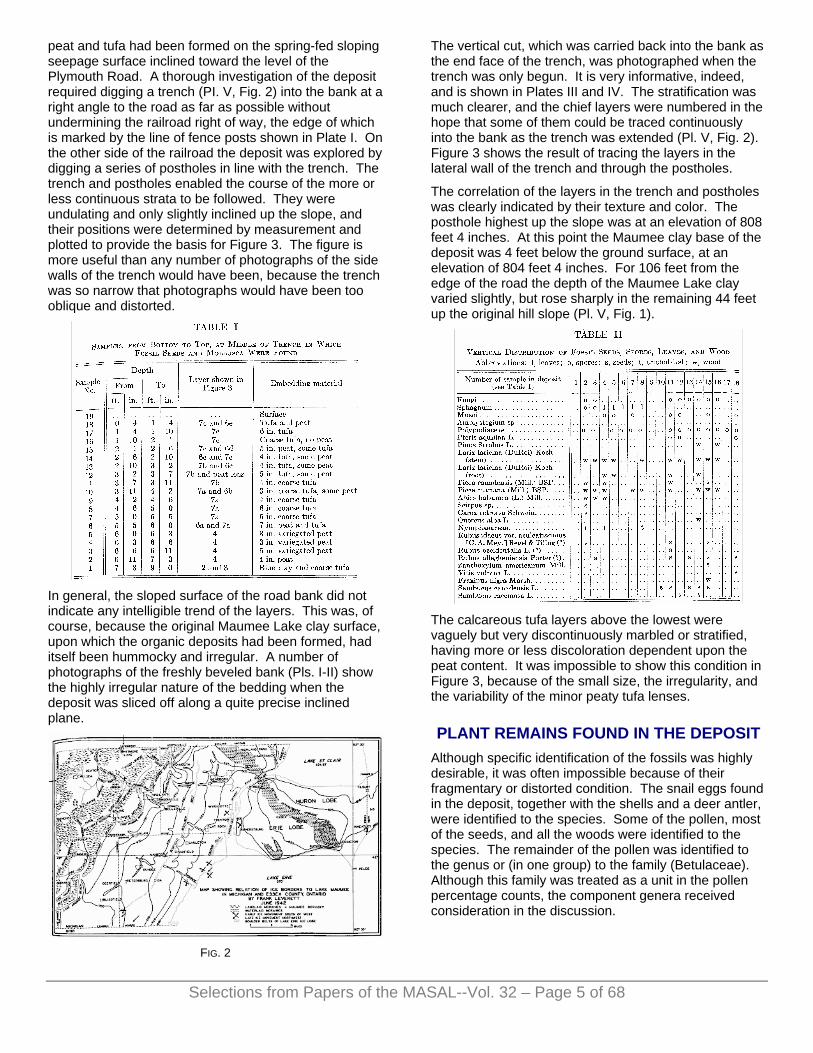
peat and tufa had been formed on the spring-fed sloping seepage surface inclined toward the level of the Plymouth Road. A thorough investigation of the deposit required digging a trench (PI. V, Fig. 2) into the bank at a right angle to the road as far as possible without undermining the railroad right of way, the edge of which is marked by the line of fence posts shown in Plate I. On the other side of the railroad the deposit was explored by digging a series of postholes in line with the trench. The trench and postholes enabled the course of the more or less continuous strata to be followed. They were undulating and only slightly inclined up the slope, and their positions were determined by measurement and plotted to provide the basis for Figure 3. The figure is more useful than any number of photographs of the side walls of the trench would have been, because the trench was so narrow that photographs would have been too oblique and distorted.
In general, the sloped surface of the road bank did not indicate any intelligible trend of the layers. This was, of course, because the original Maumee Lake clay surface, upon which the organic deposits had been formed, had itself been hummocky and irregular. A number of photographs of the freshly beveled bank (Pls. I-II) show the highly irregular nature of the bedding when the deposit was sliced off along a quite precise inclined plane.
FIG. 2
The vertical cut, which was carried back into the bank as the end face of the trench, was photographed when the trench was only begun. It is very informative, indeed, and is shown in Plates III and IV. The stratification was much clearer, and the chief layers were numbered in the hope that some of them could be traced continuously into the bank as the trench was extended (Pl. V, Fig. 2). Figure 3 shows the result of tracing the layers in the lateral wall of the trench and through the postholes.
The correlation of the layers in the trench and postholes was clearly indicated by their texture and color. The posthole highest up the slope was at an elevation of 808 feet 4 inches. At this point the Maumee clay base of the deposit was 4 feet below the ground surface, at an elevation of 804 feet 4 inches. For 106 feet from the edge of the road the depth of the Maumee Lake clay varied slightly, but rose sharply in the remaining 44 feet up the original hill slope (Pl. V, Fig. 1).
The calcareous tufa layers above the lowest were vaguely but very discontinuously marbled or stratified, having more or less discoloration dependent upon the peat content. It was impossible to show this condition in Figure 3, because of the small size, the irregularity, and the variability of the minor peaty tufa lenses.
PLANT REMAINS FOUND IN THE DEPOSIT Although specific identification of the fossils was highly desirable, it was often impossible because of their fragmentary or distorted condition. The snail eggs found in the deposit, together with the shells and a deer antler, were identified to the species. Some of the pollen, most of the seeds, and all the woods were identified to the species. The remainder of the pollen was identified to the genus or (in one group) to the family (Betulaceae). Although this family was treated as a unit in the pollen percentage counts, the component genera received consideration in the discussion.
Selections from Papers of the MASAL--Vol. 32 – Page 5 of 68

FIG. 3. Diagram showing strata of tufa and peat in Maumee terrace at Ann Arbor, Michigan, as disclosed in trench and
postholes A, B, C, D, and E
The amount and kind of fossil evidence often differed for each plant; for example, the water lily was represented by internal trichomes (trichoblasts); Sphagnum, by spores and leaves; the bracken fern, Pteris aquilina, by sporangia; the bramble, Rubus, by pollen and seeds; the willow, Salix, by pollen; the tamarack, Larix laricina, by pollen and wood, and the white pine, Pinus Strobus, by wood (Tables I-II). The ecological significance of the fossils was of paramount importance in this investigation (Cain, 1944).
CLASSIFICATION OF THE PLANT FOSSILS THALLOPHYTA
FUNGI
Spores.
BRYOPHYTA
SPHAGNACEAE
Sphagnum sp.
Spores and leaf fragments. Common in bogs.
AMBLYSTEGIACEAE
Amblystegium sp.
Portion of leaf of this moss.
PTERIDOPHYTA
POLYPODIACEAE
Pteris aquilina L. (Bracken fern)
Spores and sporangia. This fern is common in thickets and on hillsides; invades burnt-over forests of Michigan.
SPERMATOPHYTA
PINACEAE
Pinus Strobus L. (White pine) (Plate VI, Fig. 1)
Safely, 1867; Penhallow, 1896, 1899; Hollick, 1906; West, 1948.
Pollen and wood. Formerly dominant as far south as Van Buren County, Michigan; a few relict trees are found at Howell, Michigan, about twenty-five miles north of Ann Arbor.
Pinus Banksiana Lamb. (Northern scrub pine)
Pollen. The characteristic tree of the sand plains in the northern part of the Southern Peninsula; absent from Washtenaw County.
Larix laricina (DuRoi) Koch (Tamarack) (Plate VI, Fig. 2)
Safely, 1867; Dawson and Penhallow, 1890; Keyes, 1893; MacBride, 1896; Penhallow, 1896, 1899, 1904; Calvin, 1898; Coleman, 1899; Tarr, 1904; Baker, 1920; Cooper and Foot, 1932; Brown, 1938; West, 1948.
Pollen and wood. This tree is abundant in swampy areas and bogs in Michigan.
Picea sp. (Spruce)
Pollen.
Picea canadensis (Mill.) BSP. (White spruce) Safely, 1867; Baker, 1920; Cooper and Foot, 1932; Wilson,
1932; Hansen, 1935; Brown, 1938.
Seed and wood. A dominant tree of the Picea-Abies association in the northern part of the Northern Peninsula; infrequent in bogs. Extends along the Lake Huron shore from Bay City to Mackinaw City, Michigan.
Picea mariana (Mill.) BSP. (Black spruce) (Plate VII, Fig. 1)
Safely, 1867; Green, 1870; Bain, 1895; Coleman, 1899; Baker, 1920; Cooper and Foot, 1932; Wilson, 1932.
Pollen and wood. Abundant in tamarack and cedar bogs, and may be found as a rare relict in the vicinity of Ann Arbor.
Abies balsamea (L.) Mill. (Balsam fir) (Plate VII, Fig. 2)
Coleman, 1895; Baker, 1920.
Pollen and wood. Balsam fir is one of the dominants of the climax forest in Isle Royale. Port Austin in Huron County is its southern limit in Michigan.
Tsuga canadensis (L.) Carr. (Hemlock) West, 1948.
Pollen. One of the dominants of beech-maple forests in the northern part of the Southern Peninsula of Michigan. Extends as far south as Port Huron on the eastern side.
Thuja occidentalis L. (Arbor vitae) Dawson and Penhallow, 1890; Baker, 1920; Brown, 1938;
West, 1948.
Pollen. Dominant tree in cedar bogs of Michigan. Extends as far south as St. Clair County (Gates and
Selections from Papers of the MASAL--Vol. 32 – Page 6 of 68

Selections from Papers of the MASAL--Vol. 32 – Page 7 of 68
Ehlers, 1924), and to the Waterloo area of Washtenaw and Jackson counties, where it is a rare relict.
TYPHACEAE
Typha sp. (Cattail) West, 1948.
Pollen. Common in edges of bogs and ditches.
NAJADACEAE
Potamogeton sp. (Pondweed)
Pollen. Three species frequently found in ponds and quiet streams.
CYPERACEAE
Eleocharis sp. (Spike rush) West, 1948.
Pollen. Four species common in shallow water.
Scirpus sp. (Bulrush) (Plate VIII, Fig. 1)
Brown, 1938.
Pollen and achene. Four species abundant and sometimes dominant in aquatic associations.
Carex sp. Dawson and Penhallow, 1890; Penhallow, 1900; Berry, 1924,
1933; Brown, 1938; West, 1948.
Pollen. Fifty species found in different habitats in Washtenaw County.
Carex retrorsa Schwein. (Sedge) (Plate VIII, Fig. 2)
West, 1948.
Achene. One of the commonest sedges in Michigan.
GRAMINEAE
Pollen.
SALICACEAE
Salix sp. (Willow) Brown, 1938; West, 1948.
More than one species seems to be present. Seven species common in county.
Populus sp. (Poplar)
Pollen. Three species frequently found in this area.
JUGLANDACEAE
Juglans sp. (Walnut) Brown, 1938.
Pollen.
Carya sp. (Hickory) Brown, 1938; West, 1948.
Pollen. Four species common in the oak-hickory forest of southern Michigan.
BETULACEAE
Corylus sp. (Hazelnut)
Betula sp. (Birch)
Alnus sp. (Alder)
Pollen.
FAGACEAE
Fagus sp. (Beech) Hollick, 1906; Berry, 1907, 1914, 1926, 1933; Emerson, 1917;
Baker, 1920; West, 1948.
Pollen. Fagus grandifolia is a dominant in the beech-maple forest of the northern two thirds of Michigan; common on rich soil.
Quercus sp. (Oak) West, 1948.
Pollen. At least six species very common.
Quercus alba L. (White oak) (Plate IX, Fig. 2)
Penhallow, 1904; Berry, 1907, 1912; Emerson, 1917.
Pollen and wood. Common in oak-hickory forests of Washtenaw County.
URTICACEAE
Ulmus sp. (Elm) Penhallow, 1896, 1899, 1907; Brown, 1938.
Pollen. Two species found along rivers.
NYMPHAEACEAE
Trichoblasts.
ROSACEAE
Rubus idaeus var. aculeatissimus [C. A. Mey.] Regel & Tiling (?) (Wild red raspberry)
(Plate VIII, Fig. 3)
Berry, 1907, 1914, 1924, 1926, 1933; Brown, 1938; West, 1948.
Seeds. Occurs in the northern part of the Southern Peninsula in burnt-over beech-maple land and in other associations; common in dry soil
Rubus occidentalis L. (?) (Black raspberry) (Plate VIII, Fig. 5)
Seeds. Frequent in woods and along fence rows in the vicinity of Ann Arbor.

Rubus allegheniensis Porter (?) (Blackberry) (Plate VIII, Fig. 4)
West, 1948.
Seed. Dominant in bramble association, especially on sandy soil in the northern part of the Southern Peninsula; infrequent in present flora of Washtenaw County.
Prunus sp. Brown, 1938.
Pollen. Two species common in county.
RUTACEAE
Zanthoxylum americanum Mill. (Prickly ash) (Plate VIII, Fig. 9)
West, 1948.
Seed. Found in rocky woods and along river banks in Washtenaw County.
ACERACEAE
Acer sp. (Maple) Dawson and Penhallow, 1890, Emerson, 1917; West, 1948.
Pollen. More than one species seems to be present. Seven species are found in present flora.
VITACEAE
Vitis vulpina L. (River-bank grape) (Plate VIII, Fig. 8)
Brown, 1938; West, 1948.
Charred seed. This grape grows along stream banks or near water; infrequent in Washtenaw County.
TILIACEAE
Tilia sp. (Basswood) Penhallow, 1899, 1907; West, 1948.
Pollen. Common in rich woods.
ONAGRACEAE
Epilobium sp. (Fireweed)
Pollen. Probably E. angustifolium, which invades clearings and newly burned ground; frequent.
OLEACEAE
Fraxinus sp. (Ash) Penhallow, 1899, 1900; Brown, 1938.
Pollen.
Fraxinus nigra Marsh. (Black ash) (Plate IX, Fig. 1)
Penhallow, 1899; West, 1935, 1948.
Wood, probably pollen. Infrequent in this locality; common in swamps and river bottoms in northern Michigan.
CAPRIFOLIACEAE
Sambucus canadensis L. (Common elder) (Plate VIII, Fig. 7)
Berry, 1924, 1933; Brown, 1938; West, 1948.
Seeds. Common in rich soil, open places.
Sambucus racemosa L. (Red-berried elder) (Plate VIII, Fig. 6)
West, 1948.
Seeds. Infrequent in this locality.
COMPOSITAE
Ambrosia sp. (Ragweed)
Pollen.
Erechtites sp. (Fireweed)
Pollen. May represent E. hieracifolia, which comes in after burns. Frequent in woods.
MOLLUSCA OF THE DEPOSIT The tufa and likewise the peat contain a vast number of mollusks which were identified by Mr. Calvin Goodrich, emeritus curator of Mollusca in the Museum of Zoology, University of Michigan.
The mollusks were picked out of the embedding matrix of nineteen samples (Table I) taken from the middle of the trench shown in Figure 3. They afford an interesting record of vertical distribution (Table III).
Selections from Papers of the MASAL--Vol. 32 – Page 8 of 68

Ninety per cent of the Mollusca of the deposit proved to be terrestrial, and this is true even of the lowest layer. All the species are living, and none shows any significant deviation from the living representatives.
The few fresh-water species (pulmonates, with the exception of the ctenobranchiate Pomatiopsis lapidaria) are such as might occur in very shallow water, as at the edge of the deposit in its initial stages or in pools among the hummocks of the irregular surface later on.
The great numbers of specimens of Carychium indicate a continuously wet situation, as does Strobilops to a lesser degree. A common habitat for Vertigo in the Ann Arbor region today is the steep banks of ravines, where seepage permits a thick growth of mosses.
The following land species are typical in peat bogs: Carychium exiguum (Say) Carychium exile (Lea) Helicodiscus parallelus (Say) Polygyra monodon (Rackett) Strobilops labyrinthica (Say)
Succinea avara (Say) Succinea retusa (Lea) Vertigo spp. Vitrea hammonis (Strom) Vitrea indentata (Say)
The Mollusca collected at the very surface make a long list, and all but the following are also found buried in the deposit: Anguispira solitaria (Say) Polygyra albolabris (Say)
Polygyra fraterna (Say) Polygyra inflecta (Say)
Strobilops affinis (Pilsbry)
These species may have existed a hundred years ago, when the forest was cleared. Only one of those on top of the deposit was found alive, namely, Anguispira alternata (Say). The surface (i.e. Recent) shells were identified by Dr. Allen Archer and are recorded in Column 19 of Table III.
In addition to the species listed from the trench, the postholes and other places yielded records of the following species, which were not definitely placed in the vertical sequence: Euconulus fulvus (Müller) Lymnaea sp., probably L.
palustris (Müller) Polygyra hirsuta (Say)
Retinella electrina (Gould) Valvata tricarinata (Say) Vitrea indentata (Say) Zonitoides ligerus (Say)
Zonitoides milium (Morse)
INTERPRETATION OF THE DEPOSIT Silt sinking from glacial waters to the bottom of the estuary formed an impervious layer of clay. By the opening of a lower outlet farther to the northeast, across the “Thumb” of Michigan, the level of glacial Lake Maumee was lowered and likewise the level of the estuary.
The rainfall of the adjoining upland collected in this part of the gravel catchment basin of the Huron River and flowed from the spring level of this bank and over the impervious Lake Maumee clay as the level of the estuary was lowered.
The plants growing in these spring waters all the way down the slope afforded a suitable substratum for lime-depositing organisms, which covered them with a layer of lime. As the vegetation decayed, cavities were left which gave to the tufa its characteristic porous texture. It was probably in this manner that the calcareous layers of the terrace were formed (Pls. II-III). Even at the present time tufa is still being formed at the site of the deposit. A small rill of spring water, which flows along the roadside bank, is choked throughout most of its course by dense mats of Chara (probably C. vulgaris). The large number of land shells (90 per cent) found in the deposit gave additional evidence that most of it was formed in seepage water of little depth.
Considerable time probably elapsed before about two feet of basal tufa was formed on the glacial lake clay (Fig. 3, Stratum 3). As the climate became drier, the ground water level was lowered, and many of the springs ceased to flow and produce tufa. Conditions thus became favorable for the growth of bog plants which, during an unknown interval of time, built up a layer of peat on the tufa. It is possible that each layer of tufa was formed during periods of increased moisture, which would augment the volume of water flowing from the lime-charged springs, while, on the other hand, each continuous layer of peat may represent a period of decreased moisture, with conditions favorable for the growth of a bog flora (Clements, 1916).
An examination of the lowest tufa (Fig. 3) gave no evidence of the first pioneers on the land surface recently exposed by the melting glacier, but a thin gray lens of peat included within the tufa contained the pollen of alder, birch, willow, hemlock, spruce, and pine. The significance of this group of pioneer trees may be clarified by the reports of scientists who have studied the development of vegetation in Alaska. Raymond Taylor (1932) states that at Glacier Bay, Alaska, “Pure stands of spruce . . . seem to be sub-climax and are characterized . . . by a sterile sandy soil covered by a mull composed of the debris of alder, willow, and poplar.” It is altogether possible that these deciduous trees may have played a similar role in preparing the soil for the spruce seedlings in this early postglacial forest. By the use of permanent quadrats Cooper (1939) has studied vegetational development at Glacier Bay, Alaska. He found that the pioneer community consisted
Selections from Papers of the MASAL--Vol. 32 – Page 9 of 68

of mosses, Epilobium, Equisetum, Dryas, and prostrate willows. The next stage was the willow-alder thicket, and the final and climax stage had as dominants the Sitka spruce, Picea sitchensis, and two hemlocks, Tsuga heterophylla and T. Mertensiana. Baxter and Wadsworth (1939), in a study of transects on bars of the lower Yukon River at Koyukuk, Alaska, found that the order of succession was willow, poplar, alder, birch, and spruce. It is likely that willows were the first trees to advance into this region and that they were followed by alder, birch, spruce, hemlock, and pine (Table IV).
The layer of peat that lies just above the basal tufa (Fig. 3, lower part of layer 4) contained pollen, spores, seeds, wood (Fig. 4), and shells. From the identified fossils it may be inferred that a bog, with its characteristic zones of plant life, occupied the margin of the estuary. There were water lilies floating in the water. Sedges, including Carex retrorsa, together with a spikerush, Eleocharis, cattails, Typha, and a bulrush, Scirpus, grew in shallower water behind the lilies. Sphagnum formed tufts among the sedges. Tamarack, Larix laricina, and the black spruce, Picea mariana, were dominant trees of the bog, which also supported the balsam fir, Abies balsamea, the white spruce, Picea canadensis, and arbor vitae, Thuja occidentalis. On well-leached gravel
or sandy ridges grew the northern scrub pine, Pinus Banksiana. There were clumps of hemlock, Tsuga canadensis, on lower ground, and along the watercourses were willows and alders. Birds may have dropped near the bog the seeds of the red raspberry, Rubus idaeus var. aculeatissimus (?), and the blackberry, R. allegheniensis (?) growing on the border of the approaching oak-hickory forest (Figs. 5-6, 95 in.).
FIG. 4. Coniferous wood from variegated peat layer (Fig. 3,
Stratum 4), Maumee deposit. The rule is one foot long
Thus in the peat layer upon the basal tufa was preserved evidence not only of the presence of a bog with its characteristic zones of plant life, but also of the northern coniferous forest with its pioneers, and a vanguard of shrubs heralding the approach of the deciduous forest.
FIG. 5. Pollen diagram of Maumee terrace, indicating the development of vegetation at the site of Ann Arbor, Michigan, after the retreat of the Wisconsin glacier
Selections from Papers of the MASAL--Vol. 32 – Page 10 of 68

FIG. 6. Pollen diagram of Maumee terrace, indicating the development of vegetation at the site of Ann Arbor, Michigan, after the retreat of the Wisconsin glacier
The ice front, which had receded to a line east of Ypsilanti, was over twelve miles distant when the northern conifers entered and later reached their maximum development at Ann Arbor. It is probable, therefore, that zones of both tundra and scrub separated the northern coniferous forest from the margin of the ice sheet.
The proximity of the Wisconsin glacier during the period of shrinkage and waste would not require one to believe that southern Michigan had a boreal climate when the northern conifers occupied the region; on the contrary, it is likely that the climate was no more rigorous than that of northern Michigan today.
After the maximum development was attained by the coniferous forest (Fig. 5, 95 in.) the pines alone began a gradual increase until they became by far the most abundant trees in the area. There was a similar decrease in the deciduous trees which had entered the region. The increase in pines is believed to have taken place during a long dry period of peat formation. Although charred plant material was not found in this
layer of peat, fires may have occurred in the surrounding region. They probably destroyed the seedlings of the invading oaks and other hardwoods, and may have provided conditions favorable for dominance of the fire-tolerant pines. Studies on the effect of fire on longleaf and slash pines in South Carolina and Louisiana by Frank Heyward (1939) show that thousands of acres of longleaf pine owe their dominance to tolerance of fire which destroyed seedlings of the invading hardwoods. A few pollen grains of grasses, Gramineae, were present here and also in the top stratum of the deposit.
After the pines had reached a maximum (Fig. 5, 79 in.) there occurred a gradual change in the facies of the formation. The deciduous trees, competing successfully with the conifers, increased at their expense. Finally, the oaks became dominant (Fig. 5, 55 in.), with pines ranking next in abundance. Hickory, although increasing in percentage, still lagged behind the dominant oak. Besides a few elms along the river there were maples and beeches growing in well-drained rich soil in the forest.
Forest fires are known to have occurred in the Pleistocene, and there is evidence of them in this area in the form of charcoal fragments and a charred seed found in the deposit. Coleman (1895) wrote: “It appears that forest fires raged in Ontario then as now, for fragments of charcoal or chips charred on one edge are not infrequently found mixed with quite uncarbonized woody material.”
While the oaks were dominant, a fire swept the country, as is indicated by charcoal found 55 inches below the surface. Whether the fire was local or general in extent cannot be ascertained. However, charcoal fragments were present from a depth of 55 inches all the way to the top of the deposit, which indicates not one but probably several fires. The low pollen count, from 55 to 27 inches (Figs. 5-6), and also the total absence of Sphagnum leaves and in their place black structureless microscopic remains seem to indicate that the fire was general in extent. It damaged not only the bog, but also much of the vegetation of the surrounding region; only a few trees were left to reseed the soil.
After the fire a burn subsere consisting of the usual stages of annual and perennial herbs, shrubs, and trees was inaugurated in the area now freed of competition by the subclimax species (Clements, 1920). Fungi were abundant in the bog after the fire. This inference is based not only on the large percentage of spores present but also on observations made after a severe fire which occurred in 1931 in Mud Lake bog about twelve miles from Ann Arbor. Quantities of fungi, some of them undescribed species, appeared in this bog soon after the burn. The numerous fungi, including rusts, which continued to occur in the spore counts during this period (Fig. 5, 55-27 in.), may indicate the presence of rusts on the fireweeds, willows, and poplars, which are sometimes heavily infected with them.
Selections from Papers of the MASAL--Vol. 32 – Page 11 of 68

The fire indicator, bracken fern, Pteris aquilina, probably formed extensive societies over the burn-scarred region. Among the plants which quickly invaded after the burn and became widespread because of their easily disseminated seeds were the fireweeds, Epilobium and Erechtites. Sometime later Rubus idaeus var. aculeatis-simus (?) and R. allegheniensis (?) became abundant. The former is now dominant in burnt-over beech-maple land in the northern part of the Southern Peninsula of Michigan.
The presence of alder, hazel, and birch in large numbers may account for the marked increase in the pollen of Betulaceae after the fire. It may be surmised that the fire indicators, paper birch, Betula alba var. papyrifera, and the American aspen, Populus tremuloides, came in after the burn, although no fossil evidence of these species was found.
Meanwhile, in this region now characterized by fire indicators the pollen counts suggest that the oaks and the conifers at first decreased and then remained stationary while the elm, beech, ash, maple, and birches increased in varying amounts. It is likely that during this period there were many ground fires that prolonged favorable conditions not only for the fire indicators, but also for the continuance of an oak-hickory subclimax (Weaver and Clements, 1929). The lessening amount of hickory and beech that is indicated by pollen throughout the period may have resulted from ground fires. Moreover, general observations both in Michigan and elsewhere have shown that these trees suffer severely from light ground fires that readily scar the base of the trees and leave them open to attack by fungi.
Finally, after a steady gain, maple, oak, and elm probably became dominants in their respective habitats (Figs. 5-6, 27 in.). The walnut, Juglans, was a recent invader in the woods. The oaks and hickories occupied dry hills and lighter soils. In still drier upland situations the white pine, Pinus Strobus, doubtless formed pure stands, and the scrub pine occupied well-leached sandy hills. Arbor vitae and hemlock were also present, and in the shrub layer grew the common elder, Sambucus canadensis, the red-berried elder, S. racemosa, and the black raspberry, Rubus occidentalis. The Virginia white-tailed deer, Odocoileus virginianus (Fig. 7), roamed through the woods.
There is some evidence that shortly after the maples and oaks became abundant in the forest (Fig. 5, 23 in.) another fire occurred, which, although not so severe as an earlier one, was more severe than the ground fires that swept through the locality at frequent intervals. Beech, together with members of the Betulaceae, appear to have been badly injured. This family decreased very suddenly but after the fire regained dominance. In the herbaceous layer were fireweeds and the ragweed Ambrosia.
It is likely that, instead of the normal succession of herbs, shrubs, and trees developing in this burn subsere as in the former one, there was formed an intricate
pattern of dominants. Because of the root-sprouting habit of certain shrubs, as well as of birch and aspen, and because of the release of seeds from the cones of scrub pine and white pine, these were all able to begin development the first year about the time the herbs began to appear. Thus the dominants of the herbs, shrubs, and trees probably appeared at almost the same time, but each dropped out in turn as competition with the next higher member became too great (Clements, 1920).
FIG. 7. Normally shed antler of Virginia white-tailed deer,
Odocoileus virginianus, from Stratum 6d (see Fig. 3)
The final record of fossil vegetation from the Maumee terrace may be used to establish the plant communities in their natural habitats. In the drier uplands the forests were largely dominated by the oak-hickory association (including Quercus alba) with the undershrub Corylus, while on the heavy clay soils were representatives of the beech-maple climax forest. On the flood plains of the Huron River there occurred such trees as Ulmus, Tilia, Fraxinus nigra, Juglans, Zanthoxylum americanum, and Prunus. Along the river shores were growing thickets of willow, poplar, and alder, among which twined Vitis vulpina. There were brambles of blackberries and red raspberries, and in open places dense stands of the common elder. In the herbaceous layer were composites, grasses, ferns, and mosses. The mosses were represented only by spores and a portion of a tiny leaf of Amblystegium sp. The reduced number of pollen grains and woods of coniferous origin seems to indicate that, except for hemlock and a few other relicts, the conifers had followed the zones of scrub and tundra as they migrated northward in the wake of the retreating ice.
The movement of climax zones northward is indicated by relict boreal species which still persist in this region “several hundred miles behind the zone to which they belong” (Clements, 1916). White pines may be found twenty-five miles north at Howell, Michigan. In the tamarack bogs of Washtenaw County Larix laricina is
Selections from Papers of the MASAL--Vol. 32 – Page 12 of 68

Selections from Papers of the MASAL--Vol. 32 – Page 13 of 68
dominant in the bog-tree stage, with Picea mariana sometimes present. There are also a few cedar bogs in Washtenaw and Jackson counties in which Thuja occidentalis is a rare tree. These relicts now grow in bogs where they find protection and compensation against the new climate (Clements, 1934).
SUMMARY AND CONCLUSIONS The alternating strata of tufa and peat in the Maumee terrace at Ann Arbor have recorded the successive waves of plant life as they moved northward in the wake of the Wisconsin glacier. They have preserved evidence of a gradual development of the vegetation from the early invaders, which were able to withstand extreme physical conditions, to the final mixed deciduous forest, which required favorable conditions.
Along with the progressive development of the vegetation there was doubtless a corresponding development of the soil, from the sterile till or gravel left by the glacier to the well-drained fertile soil capable of supporting a mixed deciduous forest (Shantz and Zon, 1924). Moreover, along with the development of the vegetation and soil there was a gradual amelioration of the climate which had its resultant effect upon plants and their habitats.
Alternating moist and dry periods were probably indirectly responsible for the production of the layers of tufa and peat respectively. The thick layer of peat (Fig. 3, Stratum 6a) may have been formed during a major dry cycle.
Although the development of the vegetation was inhibited by fires after which burn subseres were inaugurated, the course of the succession was resumed each time and finally resulted in a mixed deciduous forest.
1. The tufa-peat deposit at Ann Arbor, Michigan, was formed after the lowering of the level of the highest stage of glacial Lake Maumee.
2. According to the estimate of Dr. Frank Leverett, the oldest part of the deposit was formed about 30,000 years ago.
3. Fifty-five animals, mostly mollusks, and forty-four plants were identified from the deposit.
4. The same species of animals and plants which lived during the closing part of the Wisconsin glacier are present in some part of the state today.
5. The abundance of terrestrial shells and the layers of tufa indicate that much of the deposit was formed in seepage water.
6. The peat and tufa layers may be indirectly related to the amount of precipitation.
7. Willow, alder, birch, and spruce were probably the first trees in the region and may have entered in the order given. They were followed by the northern conifers.
8. The thickest peat layer may indicate a major dry cycle, during which fire-tolerant pines maintained dominance over the deciduous trees.
9. After deciduous trees gained dominance burn subseres were inaugurated by fires.
10. The final record gives a mixed deciduous forest with relicts of the northern coniferous forest.
11. Because of the shrinkage and final disappearance of the ice sheet, the climate appears to have changed from one as cold as that of northern Michigan to one similar to that of central Michigan today.
UNIVERSITY OF MICHIGAN
* Papers from the Department of Botany of the University of Michigan, No. 515.
LITERATURE CITED BAIN, H. F. 1895. Geology of Washington County. Ann. Rep.
Iowa Geol. Surv., 5: 115-173.
BAKER, F. C. 1920. The Life of the Pleistocene or Glacial Period as Recorded in the Deposits Laid Down by the Great Ice Sheets. Univ. Ill. Bull, 17 (41): 1-476.
BAXTER, D. V., AND WADSWORTH, F. H. 1939. Forest and Fungus Succession in the Lower Yukon Valley. Univ. Mich. School of For. and Conserv. Bull. 9: 1-52.
BERRY, E. W. 1907. Contributions to the Pleistocene Flora of North Carolina. Journ. Geol., 15 : 337-349.
—— 1912. Pleistocene Plants from the Blue Ridge in Virginia. Am. Journ. Sci., 184: 218-223.
—— 1914. Additions to the Pleistocene Flora of the Southern States. Torreya, 14: 159-162.
—— 1924. Organic Remains Other than Diatoms from the Excavation, pp. 12-24, in The Fossil Swamp Deposit at the Walker Hotel Site, Connecticut Avenue and De Sales Street, Washington, D.C. Journ. Wash. Acad. Sci., 14: 1-41.
—— 1926. Pleistocene Plants from North Carolina. U. S. Geol. Surv., Prof. Paper 140-C: 97-119.
—— 1933. New Occurrences of Pleistocene Plants in the District of Columbia. Journ. Wash. Acad. Sci., 23: 1-25.
BROWN, C. A. 1938. The Flora of Pleistocene Deposits in the Western Florida Parishes, West Feliciana Parish, and East Baton Rouge Parish, Louisiana. La. Dept. Conserv., Geol. Surv., Bull. 12: 59-96.
CAIN, S. A. 1944. Foundations of Plant Geography, 556 pp. Harper and Bros., New York.
CALVIN, S. 1898. Geology of Buchanan County. Ann. Rep. Iowa Geol. Surv., 8: 203-253.
CLEMENTS, F. E. 1916. Plant Succession. Carnegie Inst. Wash., Publ. 242: 1-512.
—— 1920. Plant Indicators. Ibid., 290: 1-388.
—— 1934. The Relict Method in Dynamic Ecology. Journ. Ecol., 22: 39-68.

COLEMAN, A. P. 1895. Glacial and Interglacial Deposits near Toronto. Journ. Geol., 3: 622-645.
—— 1899. The Iroquois Beach. Trans. Can. Inst., 6: 29-44.
COOPER, W. S. 1939. A Fourth Expedition to Glacier Bay, Alaska. Ecology, 20(2): 130-155.
—— AND FOOT, H. 1932. Reconstruction of a Late-Pleistocene Biotic Community in Minneapolis, Minn. Ibid., 13 : 63-72.
DAWSON, W., AND PENHALLOW, D. P. 1890. On the Pleistocene Flora of Canada. Bull. Geol. Soc. Am., 1: 311-334.
EMERSON, B. K. 1917. Geology of Massachusetts and Rhode Island. U. S. Geol. Surv., Bull. 597:1-289.
GATES, F. C, AND EHLERS, J. H. 1924. An Annotated List of the Higher Plants of the Region of Douglas Lake, Michigan. Pap. Mich. Acad. Sci., Arts, and Letters, 4 (1925): 183-284.
GOODRICH, C. 1932. The Mollusca of Michigan. Univ. Mich. Mus., Handbook No. 5, 120 pp.
GREEN, H. A. 1870. Geology and Paleontology. Ill. Geol. Surv., 4: 1-508.
HANSEN, E. B. 1935. A Pre-Kansan Record of Picea canadensis from Missouri. Rhodora, 37: 17-20.
HEYWARD, F. 1939. The Relation of Fire to Stand Composition of Longleaf Pine Forests. Ecology, 20: 287-304.
HOLLICK, A. 1906. Systematic Palaeontology of the Pleistocene Deposits of Maryland: Pteridophyta and Spermatophyta. New York Bot. Gard., Contrib. 85 : 217-237, 273-281.
KEYES, C. R. 1893. Geology of Lee County. Iowa Geol. Surv., 3: 307-407.
LEVERETT, F., AND TAYLOR, F. B. 1915. The Pleistocene of Indiana and Michigan and the History of the Great Lakes. U. S. Geol. Surv., Mon. 53: 1-529.
MACBRIDE, T. H. 1896. A Pre-Kansan Peat Bed. Proc. Iowa Acad. Sci., 4: 63-66.
PENHALLOW, D. P. 1896. Contributions to the Pleistocene Flora of Canada. Proc. and Trans. Roy. Soc. Can., Ser. 2, 2(iv): 59-77.
—— 1899. Pleistocene Flora of the Don Valley. Rep. Brit. Assn. Adv. Sci., 68: 525-529.
—— 1900. The Pleistocene Flora of the Don Valley. Ibid., 70: 334-339.
—— 1904. Notes on Tertiary Plants from Canada and the United States. Trans. Roy. Soc. Can., Ser. 2, 10 (iv): 57-76.
—— 1907. Contributions to the Pleistocene Flora of Canada. Am. Nat., 41: 448-450.
RUSSELL, I. C, AND LEVERETT, F. 1915. Geologic Atlas of the United States, Ann Arbor Folio, Michigan. U. S. Geol. Surv., 18 pp.
SAFELY, R. 1867. Discovery of Additional Remains at Cohoes, N. Y. Am. Journ. Sci., Ser. 2, 43: 115-116.
SHANTZ, H. L., AND ZON, R. 1924. Atlas of American Agriculture. Part 1, Sect. E, Natural Vegetation. U. S. Dept. Agric, 29 pp.
TARR, R. S. 1904. Artesian Well Sections at Ithaca, New York. Journ. Geol., 12: 69-82.
TAYLOR, R. 1932. The Successional Trend and Its Relation to Second-Growth Forests in Southeastern Alaska. Ecology, 13 : 381-391.
WEAVER, J. E., AND CLEMENTS, F. E. 1929. Plant Ecology, 520 pp. McGraw-Hill Book Co., Inc., New York.
WEST, G. F. 1935. A Post-Wisconsin Record of Fraxinus nigra. Rhodora, 37: 20-22.
—— 1948. A Postglacial Fossil Florula near Forester, Michigan. Pap. Mich. Acad. Sci., Arts and Letters, 32 (1946): 151-186.
WILSON, L. R. 1932. The Two Creeks Forest Bed, Manitowoc County, Wisconsin. Trans. Wis. Acad. Sci., 27: 31-46.
HANSEN PLATE I
EXPLANATION OF PLATE I
Tufa and peat in Maumee terrace bench exposed along the Plymouth Road, in freshly graded highway U.S.-12 (photograph by Professor H. H. Bartlett 1925)
HANSEN PLATE II
EXPLANATION OF PLATE II
Three views of the beveled roadside, showing the deposit of tufa interbedded with peat. The cut is roughly parallel to the irregular margin of the Maumee terrace. No regular bedding could be made out until a trench was cut at a right angle to the roadside (photographs by Professor H. H. Bartlett, 1925)
Selections from Papers of the MASAL--Vol. 32 – Page 14 of 68

HANSEN PLATE III
EXPLANATION OF PLATE III
Vertical end wall of the beginning of the trench, showing the following strata:
FIG. 1. Maumee blue plastic clay upon sandy boulder clay
FIG. 2. Yellow tufa
FIG. 3. Variegated peat (peat and tufa); wood at A, B, and C
FIGS. 4-10. Tufa and peat in alternating layers
FIG. 11. Topsoil
HANSEN PLATE IV
EXPLANATION OF PLATE IV
Enlargement of Stratum 3 of Plate III, showing fine stratification. Wood located at A, B, and C
HANSEN PLATE V
EXPLANATION OF PLATE V
FIG. 1. Dr. Frank Leverett, the most distinguished American glacial geologist determining the altitude of the Maumee deposit
FIG. 2. Trench extending into Maumee terrace from Plymouth Road. Dr. Leverett examining fossils
Selections from Papers of the MASAL--Vol. 32 – Page 15 of 68
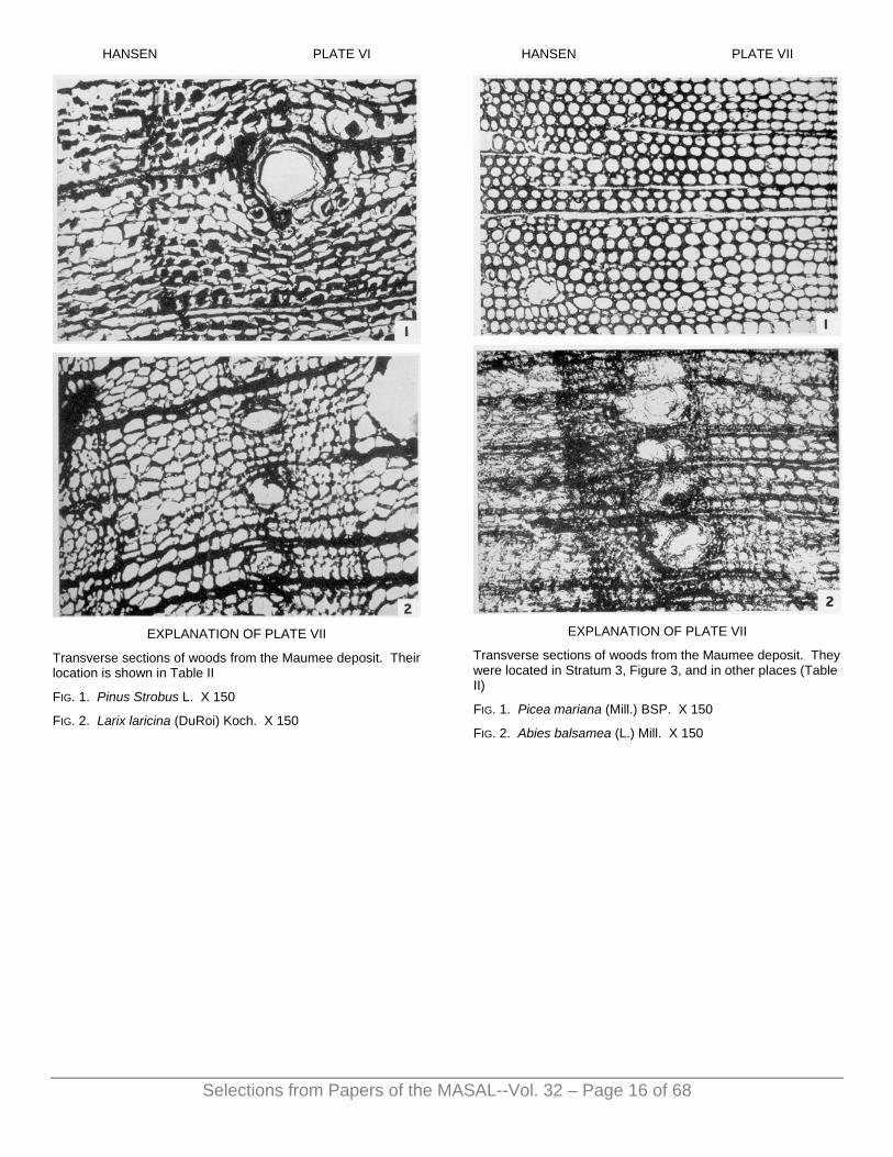
HANSEN PLATE VI
EXPLANATION OF PLATE VII
Transverse sections of woods from the Maumee deposit. Their location is shown in Table II
FIG. 1. Pinus Strobus L. X 150
FIG. 2. Larix laricina (DuRoi) Koch. X 150
HANSEN PLATE VII
EXPLANATION OF PLATE VII
Transverse sections of woods from the Maumee deposit. They were located in Stratum 3, Figure 3, and in other places (Table II)
FIG. 1. Picea mariana (Mill.) BSP. X 150
FIG. 2. Abies balsamea (L.) Mill. X 150
Selections from Papers of the MASAL--Vol. 32 – Page 16 of 68

HANSEN PLATE VIII
EXPLANATION OF PLATE VIII
Seeds and achenes from Maumee deposit. Their location is shown in Table II.
FIG. 1. Scirpus sp. Achene. X 6
FIG. 2. Carex retrorsa Schwein. Achene. X 4
FIG. 3. Rubus idaeus var. aculeatissimus [C. A. Mey.] Regel & Tiling (?). Seed X 6
FIG. 4. Rubus allegheniensis Porter (?). Seed. X 6
FIG. 5. Rubus occidentalis L. (?) Seed. X 6
FIG. 6. Sambucus racemosa L. Seed. X 4
FIG. 7. Sambucus canadensis L. Seed. X 4
FIG. 8. Vitis vulpina L. Seed. X 4
FIG. 9. Zanthoxylum americanum Mill. Seed. X 6
HANSEN PLATE IX
EXPLANATION OF PLATE IX
Transverse sections of woods from the Maumee deposit. Their location is shown in Table II.
FIG. 1. Fraxinus nigra Marsh. X 150
FIG. 2. Quercus alba L. X 80
Selections from Papers of the MASAL--Vol. 32 – Page 17 of 68

A POSTGLACIAL FOSSIL FLORULA NEAR FORESTER, MICHIGAN*
GLADYS F. WEST
HE history of the postglacial predecessors of the present Great Lakes has been preserved by their old
beaches and outlets as they passed through their successive stages of growth and development during the time of the recession of the Wisconsin ice sheet from northeastern United States and southeastern Canada. Since this history is intimately associated with the cutting of certain gorges in the Niagara River, the chronology of which has been carefully estimated, it is possible to approximate the ages of most of these lakes and likewise that of any organic remains preserved in their deposits.
Careful study and identification of the plant and animal remains from deposits which can be definitely correlated with any of the postglacial lake stages should eventually make possible a fairly complete picture of the development of vegetation and climate in the Great Lakes region since the retreat of the last ice sheet. So far the deposits of glacial Lake Chicago have received the most attention. Baker (1920) brought together the results obtained by earlier workers and by himself during many years' work and established a florula of 15 species and a fauna of 109 species from the deposits of the various stages of this lake. Recently the Two Creeks forest beds described by Goldthwait (1907) have been studied botanically in two different exposures by Wilson (1932, 1936). He considered these forest beds to have been formed during the Glen-wood Stage of glacial Lake Chicago, and he described from both deposits forests composed almost entirely of spruce.
Remains of plants which lived during and after the time of glacial Lake Maumee, a correlative of glacial Lake Chicago, are being described by Hansen (1948), who outlines a gradual development of vegetation from the time of the first appearance of the northern coniferous trees in the region to the time of a mixed deciduous forest.
References to organisms that existed during the time of glacial Lake Algonquin are few and scattered. Hunter (1902) mentioned fossil unios, bones, and pieces of wood from a well boring in a deposit of glacial Lake Algonquin in Simcoe County, Ontario. Tarr (1904) referred to a deposit of logs and pieces of wood near Ithaca New York, associated with glacial Lake Iroquois, a correlative of glacial Lake Algonquin. Penhallow (1905) identified part of the wood as Pinus rigida and Larix americana. West (1935) reported wood of Fraxinus nigra from a swamp deposit in glacial Lake Tonawanda in New York, a correlative of both Lake Iroquois and Lake Algonquin. Wilson's study (1944) of the sediments in Douglas Lake, Cheboygan County, Michigan, should give valuable chronological information on deposits formed during Algonquin and Nipissing time in that immediate locality.
In the Lake Superior region Wilson (1931, 1935) described plant remains from peat submerged fifty-four feet below the surface of the lake near Sand Island, off the north shore of Wisconsin. This deposit was formed during the time of the Nipissing Great Lakes, while the northern outlet at North Bay, Ontario, was in operation. The tree and shrub species represented were Taxus canadensis, Pinus Strobus, P. Banksiana, P. resinosa, Larix laricina, Picea mariana, Salix sp., Alnus sp., Quercus sp., Acer spicatum, Betida papyrifera, B. pumila, and Chamaedaphne calyculata. Taylor (1931, pp. 265-267) has pointed out the importance of this deposit from the standpoint of lake history, since it “appears to supply the first reliable evidence bearing on the depth of submergence of the original Nipissing beach,” which was caused by uplift of the land in the north.
Cooper and Foot (1932) described a deposit at Minneapolis, Minnesota, which was formed previous to the inauguration of glacial Lake Agassiz, and reported a florula of thirteen genera, which they described as a bog forest in the lowlands and a “climax forest of white spruce, balsam fir, white pine and birch” in the upland.
The present investigation1 was undertaken in an effort to obtain as much information as possible on the vegetation and climatic conditions which existed during the last or highest stage of glacial Lake Algonquin.
The accumulation of more information of this type should also Drove helpful in the interpretation of fossil remains from interglacial periods of the Pleistocene.
LOCATION AND DESCRIPTION OF THE FORESTER DEPOSIT
The Forester deposit is located in the southwest quarter of the southeast quarter of Section 28, Forester Township, Sanilac County, T. 13 N., R. 16 E., on the eastern side of the “Thumb” of Michigan, bordering on Lake Huron (Fig. 1). All the plant remains described in this paper were obtained from two exposures, one in the south bank of Big Creek about 365 yards inland from the lake shore, and the other in the north bank of the creek, ranging from 350 to 365 yards inland (Pl. I, Figs. 1-2).
The deposit rests on a mixture of blue-gray plastic clay, sand, and gravel extending down to the water level of the creek. The section in the north bank of Big Creek (Pl. I, Fig. 2) may be described as follows:
At the time the collections were made some of the fossil leaves in Stratum 1 were weathered out of their matrix and were hanging in ragged masses from the side of the bank (Pl. II, Fig. 1). From their midst the end of a partially crushed sycamore trunk protruded (Pl. I, Fig. 2).
T
Selections from Papers of the MASAL--Vol. 32 – Page 18 of 68

FIG. 1
(Based upon a map by C. H. Gordon, Geological Report on Sanilac County, Michigan, Geol. Surv. Mich., Vol. VII, Part 3)
GEOLOGICAL HISTORY AND DEVELOPMENT OF THE DEPOSIT
The history and development of the Forester deposit is so intimately associated with the history of certain of the Great Lakes that to give the history of one is to give the history of the other. It begins about thirty thousand years ago, when the Wisconsin ice sheet began to retreat from northeastern United States. The early period of the recession of the ice front was characterized by a slow retreat to the southern watershed of the Great Lakes basins, where it assumed a lobate outline corresponding roughly with the lake basins. The melt waters were gathered into small lakes along the margins of the ice lobes, and were dammed up between the ice barrier and the higher land of the watershed. These small lakes, formed at different times and fed by the melting ice, developed into vast bodies of water of much greater magnitude than our present Great Lakes system (Leverett and Taylor, 1915, pp. 318-321).
The actual development of the Forester deposit began at the time when the margin of the continental ice sheet had retreated sufficiently for the glacial waters in the basins of Lake Superior, Lake Michigan, Lake Huron, and Georgian Bay to be free to unite into one vast body of water at one level, known as the Second or Kirkfield stage of Lake Algonquin (Leverett and Taylor, 1915, pp. 410-411). This lake drained through an outlet near Kirkfield, Ontario, eastward through the Trent Valley into glacial Lake Iroquois, which lay in the Lake Ontario basin
(Leverett and Taylor, 1915, p. 412; Leverett, 1917, p. 137). By this time the channel of Big Creek at Forester was already in existence and flowing into Lake Algonquin (the late Dr. Leverett, personal communication). Perhaps more than half of postglacial time had already elapsed.
After the ice had almost entirely disappeared from the northern part of the lake basins a differential uplift of the land surface began in the Trent Valley, which resulted in a gradual rise of the Kirkfield outlet (Leverett and Taylor, 1915, pp. 329, 410). While the region around the northern outlet was being gradually tilted upward, the level of the land around the southern part of the lake remained stationary. The water was thus gradually shifted to the south and began to back up on higher land and submerged the Kirkfield beaches. With the gradual rise of water level in the south it became correspondingly lower in the north, until eventually the Kirkfield beaches were abandoned. South of a line running “from Kirkfield west-northwest, passing about 20 miles south of Sault Ste. Marie,” the waters rose to a higher level on the land, and the beaches of the Kirkfield stage were submerged and destroyed (Leverett and Taylor, 1915, p. 413). North of this line they were abandoned, and new beaches formed at a lower level. The two southern outlets at Chicago and Port Huron gradually came to receive more and more of the overflow. But for a long time all three outlets were in use during a transitional three-outlet stage. Eventually the northern outlet was totally abandoned, and the two southern outlets discharged the entire overflow. However, the Port Huron outlet which was on a clay foundation, was rapidly cut down to a lower level than the Chicago outlet, which lay over a rock sill. The entire discharge then passed through Port Huron (Leverett and Taylor, 1915, pp. 410, 414; Leverett, 1917, p. 138), southward into Lake Erie and eventually into the Niagara River. This represents the last or highest stage of Lake Algonquin.
As a result of the uplift in the north, in the vicinity of Forester the waters rose to 607 feet above sea level, as is shown by the beach of the highest stage of Lake Algonquin. Accordingly, the waters had also backed up into the mouth and valley of Big Creek to a point 607 feet above sea level and formed an estuary.
The deposit at Forester is represented in two sections exposed by the present channel of Big Creek as it cut through the old silted-up estuary. The bottom of the exposure, composed of gravel, sand, and blue-gray plastic clay, probably represents the bed of the old creek channel, which was gradually submerged by the rising Algonquin waters.
The leaves in Stratum 1 (PI. I, Fig. 2) appear to have been deposited during the early part of the uplift, while the estuary was being formed and the water was still shallow. They were probably blown into the creek and carried downstream, finally coming to rest at the mouth of the channel, where it emptied in the shallow water of the estuary. The presence of certain fossil remains (which will be described later) in Strata 2 and 3 above
Selections from Papers of the MASAL--Vol. 32 – Page 19 of 68

Selections from Papers of the MASAL--Vol. 32 – Page 20 of 68
the leaf layer indicates a rise of several feet in water level of the estuary caused by the continued uplift in the north.
A further retreat of the ice in southern Canada uncovered a lower outlet at North Bay, Ontario, in the Mattawa Valley, which eventually came to receive all the overflow and resulted in the inauguration of the Nipissing Great Lakes (Leverett and Taylor, 1915, p. 330; Leverett, 1917, p. 138). The Nipissing Great Lakes endured until a differential uplift in the Mattawa Valley raised the level of the North Bay outlet sufficiently for the discharge to be again shifted to the southern outlet at Port Huron, which resulted in the post-Nipissing or modern stage of the upper three Great Lakes.
At the close of Lake Algonquin the ice front probably stood ten to twenty-five miles north of Lake Superior, and north of the line of the Canadian Pacific Railway, which passes through Franz and Sudbury, Ontario, southeastward to Mattawa, Ontario, and thence eastward through southern Quebec (Antevs, 1931, pp. 13, 15), a distance of approximately 270 miles from Forester. At the inauguration of the second or Kirkfield stage the ice front, which stood near Kirkfield, Ontario, was approximately 210 miles distant from Forester. From that time until the close of the last or highest stage the ice front had receded approximately 60 miles. It can be reasonably estimated, therefore, that at the time of the formation of the estuary in Big Creek during the last stage of Lake Algonquin the ice front stood approximately 240 to 250 miles away from a forest growing in the valley of Big Creek, abundant remains of which have been buried and preserved in the silts of the estuary.
AGE OF THE DEPOSIT The age of such a deposit is always a matter of considerable interest. As shown by measurements of the rate and the amount of recession of the Horseshoe Falls, the age of the Upper Great Gorge in the Niagara River may be about 4,000 years (Kindle and Taylor, 1914, p. 170; Taylor, 1929, p. 262; Dr. Leverett, personal communication). Since the Upper Great Gorge was formed after the drainage of the Nipissing Great Lakes was diverted from the Mattawa-Ottawa, valleys back to the southern outlet at Port Huron, so that the discharge of the upper three Great Lakes and Lake Erie passed into the Niagara River (Kindle and Taylor, 1914, p. 154, fig. 14), the amount of time required to cut the Upper Great Gorge also represents the length of time during which the upper three Great Lakes discharged through the southern outlet. The northern outlet of the Nipissing Great Lakes has been estimated to have been in operation for from 2,000 to 2,500 years (Taylor, 1929, p. 260). The amount of erosion accomplished by the last or highest stage of glacial Lake Algonquin while it discharged to the south is so slight that it would probably not have taken over 4,000 years; and the length of time might be estimated to have been even less, except for the fact that for a while the southern discharge was di
vided between two outlets, viz., Chicago and Port Huron (Dr. Leverett, personal communication). The deposit, the formation of which began in the early part of the last or highest stage of Lake Algonquin, may then be about 10,500 years old and is, therefore, of considerable antiquity.
CLASSIFICATION AND DESCRIPTION OF PLANT REMAINS
THALLOPHYTA
CHARACEAE
Chara sp. Cooper and Foot, 1932, pp. 69, 70; Baker, 1920, pp. 26, 94,
101.
Nutlike oögonia incrusted with calcium carbonate were present in large numbers in Strata 2 and 3. Their absence from Stratum 1 (the leaf bed) has been interpreted to mean that the deposition at that level was in very shallow water, and probably took place during the time when the water level of Lake Algonquin was slowly rising in the south and had begun to creep back into the channel of Big Creek.
BRYOPHYTA MacBride, 1896, pp. 63-66; Cheney, 1930, pp. 66-68; 1931,
pp. 93, 94; Williams, 1930, p. 33; Cooper and Foot, 1932, pp. 63-72; Wilson, 1932, pp. 31-46; 1936, p. 320; Berry, 1933, 7; Voss, p. 1933, p. 813; Steere, 1941, pp. 83-89; Hansen, 1948, p. 53.
Remains of the vegetative structure of the following thirteen species of mosses, which were found in the leaf bed, were identified by Dr. W. C. Steere: Aulacomniaceae
Aulacomnium heterostichum (Hedw.) Bry. Eur. Leucodontaceae
Leucodon sciuroides (L.) Schwaegr. (PI. Ill Fig. 1) Thuidiaceae
Anomodon attenuatus (Schreb.) Hüben. (PI. Ill, Fig. 2) Anomodon rostratus (Hedw.) Schreb. Thuidium delicatulum (L.) Mitt. (Pl. II Figs. 2-3)
Amblystegiaceae Amblystegium varium (Hedw.) Lindb. Campylium radicale (P. B.) Grout Drepanocladus aduncus (Hedw.) Warnst. Leptodiciyum riparium (Hedw.) Warnst.
Brachytheciaceae Bryhnia novae-angliae (Sull. and Lesq.) Grout Eurhynchium strigosum (Hedw.) J. and S. (Pl. III, Figs. 3-4)
Plagiotheciaceae Plagiothecium denticulatum (L.) Bry. Eur.
Hvpnaceae Hypnum imponens Hedw.
Of this group, Anomodon attenuatus (Schreb.) Hüben. was represented the most abundantly, and Leucodon sciuroides (L.) Schwaegr. ranked second in frequency of occurrence.
All these species are common in northeastern United States, and all are found in the present flora of Michigan.
Selections from Papers of the MASAL--Vol. 32 – Page 21 of 68
For the most part they represent species which can be found growing in a beech-maple forest on moist shaded banks of streams, on stones, and on tree trunks, with the exception of Drepanocladus aduncus (Hedw.) Warnst., which is aquatic, and Leptodictyum riparium (Hedw.) Warnst., which is subaquatic.
PTERIDOPHYTA
POLYPODIACEAE
Onoclea sensibilis L. (Sensitive fern) (Pl. IV, Fig. 1)
A small portion of a fertile frond, the pinnules of which still retain on their lower surfaces a few characteristic sporangia with spores, represents the only remains of this species. The sensitive fern is found abundantly in wet places throughout Michigan. The genus has not hitherto been reported in the Pleistocene of this country.
SPERMATOPHYTA
PINACEAE
Pinus Strobus L. (White pine) (Pl. IV, Fig. 7)
Safely, 1867, p. 116; Penhallow, 1896, p. 67; 1898, p. 526; Cooper and Foot, 1932, pp. 66, 69; Wilson, 1935, pp. 533-535; Hansen, 1948, p. 54.
The lower half of a single mature cone from Stratum 2 represents the only remains of this species.
White pine is found in Michigan throughout the Upper Peninsula and as far south in the Lower Peninsula as Allegan, Eaton and St. Clair counties, approximately fifty miles farther south than its occurrence as a fossil near Forester.
Pinus sp.
Pollen representing at least two species of pine was noted.
Larix laricina (DuRoi) Koch. (Tamarack) Safely, 1867, p. 116; Keyes, 1893, p. 357; Dawson and
Penhallow, 1890 p. 326; Penhallow, 1896, pp. 60, 61, 67, 69; 1898, pp. 526, 527; 1905, pp. 69-70; MacBride, 1896, pp. 65, 66; Calvin, 1898, p. 240; Coleman, 1899, pp. 35, 36; Tarr, 1904, pp. 78, 79; Baker, 1920, pp. 42, 71; Cooper and Foot 1932, p. 69; Voss, 1933, p. 814; Wilson, 1935, pp. 533-535; Hansen, 1948, p. 54.
A single fragmentary twig bearing one short lateral branchlet was found in the lower part of Stratum 2. The specimen has been arbitrarily assigned to Larix laricina, the only species native to northeastern United States, since there was no distinctive character present which would definitely mark it as this particular species and since the facies of the fossil florula resembles so closely that of the present in many parts of the Lower Peninsula of Michigan.
Tamarack is common in swampy areas throughout Michigan.
Picea sp. (Spruce)
Spruce is represented by pollen only. Although it has not been possible definitely to identify the species to which it belongs, it seems probable that it may represent Picea mariana (Mill.) BSP., from a swampy area near by.
Tsuga canadensis (L.) Carr. (Hemlock) (PI. IV, Figs. 2-4)
Hemlock was one of the most commonly represented species. Small twigs, needles, cones, and seeds were abundant in Strata 1 and 2. Tsuga pollen, undoubtedly referable to this species, was also found.
Hemlock occurs throughout Michigan today except in the southeastern part of the Lower Peninsula, where it extends as far south as Port Huron (Quick, 1923) along the eastern side.
Thuja occidentalis L. (Arbor vitae) (Pl. IV, Figs. 5-6) on and Penhallow, 1890, pp. 324, 325;
Wegeman, 1909, pp. 26, 27; Baker, 1920; pp.42, 71, 101.
This species is sparingly represented in Strata 1 and 2 by small twigs with leaves, two mature open cones, and a few seeds.
Arbor vitae is common in low situations throughout the northern two thirds of Michigan; it extends as far south as Montcalm and Sanilac counties. According to Dodge (1912, p. 37), it is plentiful near the Lake Huron shore as far south as St. Clair County.
TYPHACEAE
Typha sp. (Cattail flag) Penhallow, 1896, p. 64.
The genus Typha is represented by pollen only, and the species was not determined.
SPARGANIACEAE
Sparganium sp. (Bur reed) (Pl. IV, Fig. 8)
Berry, 1914, p. 160; 1924, p. 16.
Achenes representing at least two different species were found abundantly in Stratum 2.
NAJADACEAE
Potamogeton sp. (Pondweed) (Pl. IV, Figs. 9, 11)
Dawson and Penhallow, 1890, pp. 327, 331; Knowlton, 1896, p. 371; Penhallow, 1896, pp. 65, 66; 1898, p. 528; Coleman, 1915, p. 247; Baker, 1920, pp. 27, 39, 91; Hollick, 1931, pp. 37-39, pl. 2; Cooper and Foot, 1932, p. 69.
This genus is represented by a great many well-preserved achenes, representing at least three different species, found in Strata 2 and 3. Their presence in these two strata, along with remains of Chara and Myriophyllum, would seem to indicate a water depth of

Selections from Papers of the MASAL--Vol. 32 – Page 22 of 68
four or five feet or even more during the time of deposition. Their absence from Stratum 1 (the leaf bed) has, therefore, been interpreted to mean shallower water at that level.
ALISMACEAE
Sagittaria latifolia Willd. (Arrowhead) (Pl. V, Fig. 1)
Achenes of Sagittaria latifolia were very common in Strata 2 and 3. In the present flora it is abundant throughout Michigan in wet places. This is the first reported occurrence of the genus in the Pleistocene of this country.
Alisma Plantago-aquatica L. (Water plantain)
This species is represented by a small number of achenes in Stratum 2. At the present time it is common and abundant in shallow water and ditches throughout Michigan. The presence of water plantain has not previously been reported in the Pleistocene of this country.
CYPERACEAE
Dulichium arundinaceum (L.) Britton (Pl. V, Fig. 2)
Berry, 1924, p. 18, pl. I, figs. 17-18.
Two achenes represent the only remains of Dulichium arundinaceum. It is found abundantly in the present flora of Michigan in wet swampy places on the borders of streams, ponds, and small lakes.
Eleocharis olivacea Torr. (?) (Spike rush)
Small black achenes 1.25 mm. long, 0.75 mm. wide, obovate, with fragmentary tubercle, and bristles absent, resembling very closely Eleocharis olivacea, were present in considerable numbers in Strata 2 and 3.
This species has been found in both the Upper and the Lower peninsulas of Michigan, but it appears to be rather rare in the state.
No previous discovery of the gross remains of the genus Eleocharis has been recorded in the Pleistocene of this country.
Carex lupulina Muhl. (Sedge) (Pl. V, Fig. 3)
Well-preserved achenes were found in Strata 2 and 3, which corresponded so closely with those of Carex lupulina that the determination has been made without hesitation. In the present flora it is of common occurrence in swamps and wet places throughout Michigan.
Although Carex has been reported from both early and late Pleistocene deposits in this country, there is no previous record of this species.
Carex retrorsa Schwein. (Pl. V, Fig. 4)
Hansen, 1948, p. 56.
Triangular-fusiform achenes resembling so closely the achenes of Carex retrorsa that it seems unquestionable that they belong to this species. It is one of the commonest sedges in Michigan.
Carex Schweinitzii Dewey (?) (Pl. V, Fig. 5)
Achenes obovoid; equally 3-angled; 1.75 mm. long- styles fragmentary; perigynium incomplete, 3.5 mm. long; 1.5 mm. wide; few-nerved and very delicate. These achenes resemble more closely the achenes of Carex Schweinitzii than those of any other American species in the genus.
The species is not abundant in Michigan, and has been reported from only three counties in the Lower Peninsula, viz., Crawford (Beal, 1904, p. 57), Cheboygan (Gates and Ehlers, 1924, p. 212), and Ottawa (herbarium specimen in the University of Michigan Herbarium).
No previous occurrence of the species has been reported from the Pleistocene of this country.
SALICACEAE
Salix sp. (Willow)
The presence of Salix is represented by pollen alone. More than one species appears to be present. In all probability they grew in close proximity to the place of deposition.
There are a number of references to the occurrence of Salix during postglacial time, as well as earlier in the Pleistocene.
JUGLANDACEAE
Carya sp. (Hickory)
The only remains of this genus thus far found are deposits of pollen. The nature of the fossil florula is such as would indicate that hickory grew in a dry upland area some distance away from the place of deposition.
Several different species of hickory have been reported from the Pleistocene of this country.
BETULACEAE
Pollen representing certain members of the Betulaceae was found to be relatively abundant.
Carpinus caroliniana Walt. (Blue beech) (Pl. VI, Figs. 6-9)
Berry, 1907a, p. 692; 1907b, pp. 340-341; 1910, p. 395; 1926, p. 108.
Remains of the blue beech were common in Strata 1 and 2 in the form of practically skeletonized leaves, bractlets, and a great many flattened nuts.

Selections from Papers of the MASAL--Vol. 32 – Page 23 of 68
In Michigan blue beech occurs locally along streams and in wet places and is found most frequently in the southern part of the state.
Betula sp. (Birch) Penhallow, 1896, p. 66.
A few seeds resembling very closely both Betula lutea Michx. f. and Betula lenta L. were found in Strata 1 and 2. There seems to be a sufficient amount of variation in the seeds of these two modern species to make an exact specific identification questionable. The composition of the fossil florula is such as to indicate the possible presence of both. Both species, although occurring throughout the state, are most common in the northern part.
Betula alba L. var. papyrifera (Marsh.) Spach. Safely, 1867, p. 116; Emerson, 1898a, p. 740; 1898b, p. 7;
1917, p. 148; Cooper and Foot, 1932, p. 69; Wilson, 1935, pp. 533-535.
This species is represented by a single seed, small cylinders of bark, and a few pieces of wood. The seed is unquestionably that of Betula alba L. var. papyrifera, since the shape, size, and cell structure of the wings correspond identically with those features in this particular species and variety.
Although the wood structure was found to resemble very closely that of the paper birch, the identification is given with some hesitation, since certain of the diagnostic characters have been obscured as a result of decomposition and crushing.
Paper birch in Michigan occurs from Lansing northward, although Dodge (1912, p. 31) found it quite common a little farther south along the Lake Huron shore in St. Clair County.
FAGACEAE
Fagus grandifolia Ehrhardt (Beech) (Pl. VII, Figs. 1-8; Pl. VIII, Figs. 1-4)
Orton 1873, pp. 427-428; Knowlton, 1896, p. 371; Mercer, 1899, pp. 279, 281; Emerson, 1898a, p. 740; 1898b, p. 7; 1917, p. 148; Hollick, 1906, p. 226; Berry, 1906, pp. 88-89; 1907a, pp. 692-693, pl. 2, fig. 7; 1907b, p. 341; 1909, p. 435; 1910, pp. 393-394; 1914, p. 162; 1915, pp. 206-207; 1926, p. 108, pl. 48, figs. 3-13; 1927, p. 25; 1933, p. 11; Baker, 1920, p. 312.
Beech was the most common member of the fossil florula, and was represented by a large number of well-preserved leaves, bud scales, flattened burs and nuts, a small twig bearing a terminal bud, a single specimen of wood, and pollen. Leaves of this species were more abundant than those of any other species and, along with leaves of Acer saccharum, formed 85 per cent or more of the leaf bed. The pollen can be referred to this species with little doubt.
The wood structure was well preserved and corresponds identically with that of the modern beech (Brown and Panshin, 1940, pp. 446-448; Record, 1934, pp. 131,
132). Since published descriptions of Pleistocene wood are few, it has been thought advisable to describe the structure of some of the wood from this deposit.
Transverse section.—Annual rings 1.0 to 1.25 mm. wide. Diffuse-porous. Vessels angular to round or oval. Fibers still retain their shape, but in many specimens the secondary wall has disorganized, so that only the thin primary wall remains.
Radial section.—Vessel segments rather long; without spirals; end walls oblique, with perforations scalariform to simple; tyloses abundant. Rays heterogeneous.
Tangential section.—Tyloses present a thin platelike appearance. Rays short-uniseriate to large compound structures.
Beech occurs throughout Michigan, but is more abundant in the Lower Peninsula, and is a prominent member of the climax forest in the locality where the fossil material was collected.
Quercus sp. (Oak)
The only remains of this genus thus far found in the deposit consist of pollen. The complete absence of any other remains of oak indicates that it probably was not a component part of the vegetation along the creek, but grew in a higher, drier upland area some distance away from the place of deposition.
There are many references to the occurrence of Quercus during postglacial time as well as throughout the Pleistocene.
URTICACEAE
Ulmus americana L. (American elm) (Pl. IX, Figs. 1-4)
Penhallow, 1896, p. 68; 1898, p. 528; 1907, pp. 449, 450; Berry, 1915, p. 207.
This species is represented by a large number of leaves and fifteen identified specimens of wood from Strata 1 and 2. Although no complete specimens of leaves were obtained, it was possible to distinguish them from Ulmus fulva Michx. by means of the venation.
Excluding the effects of disintegration, the wood structure corresponds exactly with that of the modern species (Record, 1934, pp. 120-121, pl. 3, fig. 2; Brown and Panshin, 1940, pp. 462-464).
Transverse section. — Annual rings variable in width, 0.25 to 1.5 mm., and usually visible to the unaided eye. Ring porous. Vessels of spring wood large, oval, elliptical to slitlike, and, with few exceptions, arranged in a single tangential row. Summer wood vessels irregularly angular; arranged for the most part in wavy tangential bands. Tyloses present in both early and late vessels. Wood parenchyma vasicentric, scarcely distinguishable in poorly preserved specimens; in better-preserved specimens distinguishable by brownish contents; shape usually distorted. Fibers arranged in bands alternating with the bands of summer vessels.
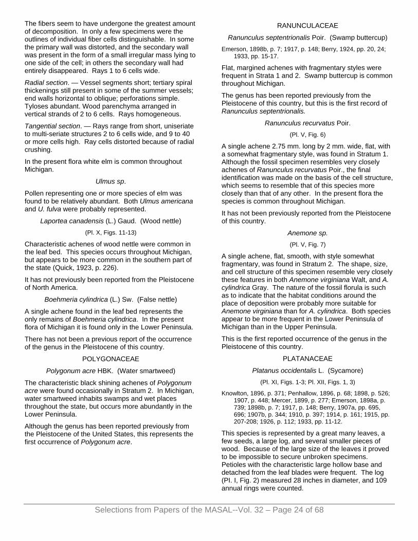
Selections from Papers of the MASAL--Vol. 32 – Page 24 of 68
The fibers seem to have undergone the greatest amount of decomposition. In only a few specimens were the outlines of individual fiber cells distinguishable. In some the primary wall was distorted, and the secondary wall was present in the form of a small irregular mass lying to one side of the cell; in others the secondary wall had entirely disappeared. Rays 1 to 6 cells wide.
Radial section. — Vessel segments short; tertiary spiral thickenings still present in some of the summer vessels; end walls horizontal to oblique; perforations simple. Tyloses abundant. Wood parenchyma arranged in vertical strands of 2 to 6 cells. Rays homogeneous.
Tangential section. — Rays range from short, uniseriate to multi-seriate structures 2 to 6 cells wide, and 9 to 40 or more cells high. Ray cells distorted because of radial crushing.
In the present flora white elm is common throughout Michigan.
Ulmus sp.
Pollen representing one or more species of elm was found to be relatively abundant. Both Ulmus americana and U. fulva were probably represented.
Laportea canadensis (L.) Gaud. (Wood nettle) (Pl. X, Figs. 11-13)
Characteristic achenes of wood nettle were common in the leaf bed. This species occurs throughout Michigan, but appears to be more common in the southern part of the state (Quick, 1923, p. 226).
It has not previously been reported from the Pleistocene of North America.
Boehmeria cylindrica (L.) Sw. (False nettle)
A single achene found in the leaf bed represents the only remains of Boehmeria cylindrica. In the present flora of Michigan it is found only in the Lower Peninsula.
There has not been a previous report of the occurrence of the genus in the Pleistocene of this country.
POLYGONACEAE
Polygonum acre HBK. (Water smartweed)
The characteristic black shining achenes of Polygonum acre were found occasionally in Stratum 2. In Michigan, water smartweed inhabits swamps and wet places throughout the state, but occurs more abundantly in the Lower Peninsula.
Although the genus has been reported previously from the Pleistocene of the United States, this represents the first occurrence of Polygonum acre.
RANUNCULACEAE
Ranunculus septentrionalis Poir. (Swamp buttercup) Emerson, 1898b, p. 7; 1917, p. 148; Berry, 1924, pp. 20, 24;
1933, pp. 15-17.
Flat, margined achenes with fragmentary styles were frequent in Strata 1 and 2. Swamp buttercup is common throughout Michigan.
The genus has been reported previously from the Pleistocene of this country, but this is the first record of Ranunculus septentrionalis.
Ranunculus recurvatus Poir. (Pl. V, Fig. 6)
A single achene 2.75 mm. long by 2 mm. wide, flat, with a somewhat fragmentary style, was found in Stratum 1. Although the fossil specimen resembles very closely achenes of Ranunculus recurvatus Poir., the final identification was made on the basis of the cell structure, which seems to resemble that of this species more closely than that of any other. In the present flora the species is common throughout Michigan.
It has not been previously reported from the Pleistocene of this country.
Anemone sp. (Pl. V, Fig. 7)
A single achene, flat, smooth, with style somewhat fragmentary, was found in Stratum 2. The shape, size, and cell structure of this specimen resemble very closely these features in both Anemone virginiana Walt, and A. cylindrica Gray. The nature of the fossil florula is such as to indicate that the habitat conditions around the place of deposition were probably more suitable for Anemone virginiana than for A. cylindrica. Both species appear to be more frequent in the Lower Peninsula of Michigan than in the Upper Peninsula.
This is the first reported occurrence of the genus in the Pleistocene of this country.
PLATANACEAE
Platanus occidentalis L. (Sycamore) (Pl. XI, Figs. 1-3; Pl. XII, Figs. 1, 3)
Knowlton, 1896, p. 371; Penhallow, 1896, p. 68; 1898, p. 526; 1907, p. 448; Mercer, 1899, p. 277; Emerson, 1898a, p. 739; 1898b, p. 7; 1917, p. 148; Berry, 1907a, pp. 695, 696; 1907b, p. 344; 1910, p. 397; 1914, p. 161; 1915, pp. 207-208; 1926, p. 112; 1933, pp. 11-12.
This species is represented by a great many leaves, a few seeds, a large log, and several smaller pieces of wood. Because of the large size of the leaves it proved to be impossible to secure unbroken specimens. Petioles with the characteristic large hollow base and detached from the leaf blades were frequent. The log (PI. I, Fig. 2) measured 28 inches in diameter, and 109 annual rings were counted.

Selections from Papers of the MASAL--Vol. 32 – Page 25 of 68
Although the original appearance of the wood was changed considerably because of crushing and decomposition, most of the diagnostic characters were present (Record, 1934, pp. 130-131; Brown and Panshin, 1940, pp. 482-483).
Transverse section. — Annual rings 2 to 4 mm. wide. Diffuse-porous. Vessels narrowly elliptical to slitlike, a shape caused by radial crushing of the log. Wood parenchyma diffuse; shape of individual cells distorted. Ray cells have abundant reddish-brown contents.
Radial section.—Vessel segments short; without spirals; end walls usually oblique; perforations simple or scalariform; horizontal full-bordered pits; tyloses abundant. Rays homogeneous.
Tangential section. — Vessels radially crushed. Rays broad; 8 to 14 cells wide and 6 to 7 times as high. Ray cells distorted because of radial crushing. Wood parenchyma and wood fibers practically indistinguishable; pitting obscure.
Along the eastern side of Michigan the northern limit of sycamore is the Saginaw Bay region (Dodge, 1911, p. 96; 1921a, p. 195). In the central part of the state it is reported as far north as Roscommon County (Illick, 1927, p. 61).
BOSACEAE
Crataegus sp. (Hawthorn) (Pl. XII, Fig. 2)
A single incomplete specimen of a leaf, 2.25 inches long by 1.25 inches wide; serrate-dentate, and appears to have been entire and cuneate at the base, and acute or rounded at the apex. There is some similarity to leaves of Crataegus Crus-galli L.
The genus has been reported a number of times from the Pleistocene of this country.
Rubus idaeus L. (?) (Pl. X, Fig. 3)
Seeds irregularly bean-shaped; 2 to 2.5 mm. long; 1 mm wide; somewhat flattened; coarsely and irregularly reticulate-ridged; raphe conspicuous; seeds sometimes hollow and somewhat shriveled. The seeds resemble very closely those of Rubus idaeus L., although they are somewhat smaller than those of either the species or the variety aculeatissimus [C. A. Mey.] Regel & Tiling which is common in Michigan. It is quite possible, however, that Rubus idaeus L. or some form of it is represented. Both R. idaeus and the variety aculeatissimus are common throughout Michigan.
Although this genus has been reported previously from the Pleistocene of this country, no specific identifications have been made.
Rubus allegheniensis Porter (?) (Pl. X, Fig. 4)
Hansen, 1948, p. 58.
This identification was made on the basis of two seeds. Seeds broadly ovoid, 1.75 to 2 mm. long; 1.25 to 1.5 mm. wide; somewhat compressed; coarsely and irregularly reticulate-ridged, with a conspicuous margin extending around them from hilum to end of the raphe; raphe conspicuous. These specimens unquestionably belong in the blackberry group and resemble Rubus allegheniensis Porter in every respect except size, since they are slightly smaller. This species also is common throughout Michigan.
Agrimonia sp. (Agrimony) (Pl. X, Figs. 8-9)
Three fruits, found in Stratum 2, were 3.75 mm. long by 3.25 mm. wide; flattened; bristles absent from the marginal rim; conspicuous longitudinal ridges present which are characteristic of the fruits of Agrimonia. Sufficient diagnostic characters were not present to make possible a specific identification.
The genus has not hitherto been reported from the Pleistocene of North America.
RUTACEAE
Zanthoxylum americanum Mill. (Prickly ash) (Pl. X, Figs. 7, 10)
Hansen, 1948, p. 58.
A few seeds and a great many characteristic thorns were found in Strata 1 and 2. Prickly ash occurs in the Lower Peninsula of Michigan and is characteristic of the shrub zone in the beech-maple climax association.
ACERACEAE
Acer saccharum Marsh. (Sugar maple) (Pl. XIII, Figs. 1-3; Pl. XIV)
Dawson and Penhallow, 1890, pp. 329-330; Emerson, 1898a, p. 739; 1898b, p. 7; 1917, p. 148.
The sugar maple, one of the commonest members of the fossil florula, was represented by leaves, seeds, and wood. The leaves of this species were the second most abundant and, along with those of beech, made up 85 per cent or more of the leaf bed (Stratum 1).
The seeds were flattened, with the wings either fragmentary or entirely absent. The wood was poorly preserved, and all the necessary diagnostic characters (Record, 1934, pp. 128-129; Brown and Panshin, 1940, pp. 494-496) were recognized only after sectioning several pieces.
Transverse section. — Annual rings 1.0 to 1.4 mm. wide. Diffuse-porous. Vessels oval, narrowly elliptical to slitlike; single, or in radial rows of 2 to 6; vessel walls partially to entirely disintegrated. Brown gummy

Selections from Papers of the MASAL--Vol. 32 – Page 26 of 68
substance frequent in vessels, or in the spaces left after decomposition of the vessels. Fibers mostly collapsed.
Radial section. — Vessel segments short; spirals distinguishable in some vessels; end walls oblique; perforations simple. Gummy deposits in the form of horizontal plates or round masses present in the vessels, as in modern wood, but more abundant. In the disintegrated vessels the gummy deposits often formed casts showing the impression of the spirals. Rays homogeneous.
Tangential section. — Rays varying from short-uniseriate to large structures 7 or 8 cells wide and 80 or more cells high. Pitting on fibers obscure.
In the present flora sugar maple is found throughout Michigan.
Acer saccharum var. Rugelii Rehd. (?) (Pl. XV, Figs. 1-2)
A large leaf differing from those of Acer saccharum Marsh, in that it is 3-lobed and 3-veined, with an entire to slightly undulated margin, has been found to resemble very closely Acer saccharum var. Rugelii Rehd., as described by Sargent (1926). The long slender lateral lobe of the fossil specimen agrees better with the description of variety Rugelii than with that of variety nigrum which on the whole, has much broader and shorter lobes.
Another leaf (PI. XV, Fig. 2), also representing some form of these species, although fragmentary, was found to resemble closely the base of a small leaf of variety Rugelii. However, in view of the fact that a great deal of natural variation is found in the leaves of A. saccharum, all that can be said with certainty is that these leaves represent variations of the species named above.
Variety Rugelii, according to Sargent (1926), may extend as far north as the Southern Peninsula of Michigan and southern Ontario. Although it does not appear in any published reports on the flora of Michigan, herbarium specimens of it that were collected at Port Huron and Isle Royale are in the herbarium at the University of Michigan.
Acer sp.
Pollen representing members of this genus was relatively abundant.
VITACEAE
Vitis vulpina L. (River-bank grape) (Pl. X, Fig. 5)
Hansen, 1948, p. 58.
A single seed from Stratum 1 has been referred to this species. There are many reports of the occurrence of grape in both inter-glacial and postglacial periods, but only a few specific identifications have been certainly made.
TILIACEAE
Tilia americana L. (Basswood) (Pl. VI, Figs. 1-5)
Penhallow, 1898, p. 528; 1907, p. 449.
Basswood is represented in the leaf bed by a number of leaf fragments and a great many bracts and fruits. The leaf specimens were referred to Tilia americana L. on the basis of the coarse, deep serration of the margin, the long incurved points of the teeth, and the long slender, abruptly acute apex. The bracts resembled those of this species more closely in general shape and size than those of any other species of the genus native to this country.
Tilia americana is found throughout Michigan.
HALORAGIDACEAE
Myriophyllum sp. (Water milfoil) (Pl. IV, Fig. 10)
A number of small pectinate-pinnatifid floral leaves, 3 to 5.5 mm. long, referable to some species of Myriophyllum, were found in Stratum 3. There was no indication of their presence in the two lower strata.
The genus has not previously been reported from the Pleistocene.
CORNACEAE
Cornus stolonifera Michx. (Red-osier dogwood) (Pl. V, Figs. 8-9)
A small number of seeds characteristic of this species were found in the leaf bed; also a few small, undeveloped fruits of some species of dogwood. The red-osier dogwood is common throughout Michigan.
The genus has been reported a number of times in the Pleistocene of this country, but this is the first record of Cornus stolonifera Michx.
Nyssa sylvatica Marsh. (Black gum) (Pl. VII, Fig. 9)
Berry, 1933, p. 22.
A single rather fragmentary leaf, simple, obovate, 1.875 inches long, 0.875 inch wide, entire, tip acute; base appears to be cuneate. In shape, size, and details of minute venation it corresponds s closely with small leaves of this species that, although it is fragmentary, the determination was made without hesitation.
In Michigan black gum is frequent in the southern half of the Lower Peninsula and extends as far north as Manistee on the Lake Michigan side (Otis, 1925; Illick, 1927). On the Lake Huron side of the state it extends as far north as Omer, in Arenac County (Dodge, 1921b, p. 17). The northern limit of Nyssa sylvatica in Michigan today is only about sixty miles north of the place where it grew about ten thousand years ago.

Selections from Papers of the MASAL--Vol. 32 – Page 27 of 68
OLEACEAE
Fraxinus sp. (Ash) (Pl. XVI, Figs. 1-2, 4)
Penhallow, 1898, pp. 525-529; 1900, pp. 334-339.
Fragmentary leaflets referable to this genus were abundant in the leaf bed. On the basis of shape, size, and, more especially, character of the margin and venation, these specimens resemble more closely leaflets of Fraxinus americana L. and F. pennsylvanica Marsh, than those of any other species. No diagnostic character was found which could be used to determine definitely which one of the two species was represented. The nature of the fossil florula indicates a beech-maple climax forest, and since F. americana is considered an abundant dominant in the beech-maple climax forest of the Lower Peninsula, with F. pennsylvanica present in the lowland areas (Quick, 1923, pp. 223-232), it is altogether possible that both species may be represented by these fossil specimens.
The Fraxinus pollen found may represent more than one species.
Fraxinus americana is common throughout Michigan, whereas F. pennsylvanica is found chiefly in the southern part of the Lower Peninsula.
Fraxinus nigra Marsh. (Black ash) (Pl. XVI, Fig. 3)
Penhallow, 1898, pp. 527, 528; West, 1935, pp. 20-22, pl. 324, figs. 1-4; Hansen, 1948, p. 59.
A single specimen of wood from the south bank of the creek represents the only remains of black ash. Although poorly preserved, its structure corresponds with that of the wood of the modern species (Record, 1934, p. 124, pl. 5, fig. 2; Brown and Panshin, 1940, pp. 518-519).
Transverse section. — Annual rings 0.5 to 0.75 mm. wide. Ring porous. Spring vessels irregularly oval, narrowly elliptical to slitlike; arranged singly or in radial groups of two. Shriveled tyloses sometimes visible. Summer wood vessels relatively large, isolated, or in radial rows of two or three, and surrounded by wood parenchyma, which has usually not undergone as much decomposition as the fibers. The masses of parenchyma surrounding the summer wood vessels do not ever appear to be connected. Rays difficult to distinguish and study.
Radial section. — Vessel segments short; without spirals; end walls transverse to oblique; perforations exclusively simple. Rays homogeneous. A golden brown gummy substance was sometimes present in the vessels and is undoubtedly a decomposition product.
Tangential section. — Rays distorted as a result of crushing; 1 to 3 cells wide, with the majority of them biseriate; 3 to 16 cells high. Difficult to distinguish individual fibers because of decomposition and collapse of the walls.
In the present flora black ash is found throughout Michigan; it becomes more important in the northern part of the state.
CAPRIFOLIACEAE
Sambucus canadensis L. (Common elder) (Pl. X, Fig. 1)
Berry, 1924, p. 20; 1933, pp. 22, 23; Hansen, 1948, p. 59.
Nutlets of the common elder were found to be very abundant in Strata 1, 2, and 3.
This species is common throughout Michigan and abundant in the locality where the fossil collection was made.
Sambucus racemosa L. (Red-berried elder) (Pl. X, Fig. 2)
Hansen, 1948, p. 59.
Seeds of this species were distinguished from those of Sambucus canadensis because the surface is less rough and is composed of tiny wavy ridges, which are for the most part horizontal and parallel.
Sambucus racemosa is found throughout Michigan, but most abundantly in the northern part.
COMPOSITAE
Bidens frondosa L. (Beggar-ticks) (Pl. X, Fig. 6)
Berry, 1933, p. 23.
A number of achenes characteristic of this species were found in the leaf bed. Achenes 8 mm. long by 3 mm. wide; obovate-cuneate; flat; 1-nerved on either face; 2-awned; awns retrorsely barbed; only fragmentary remains of hairs present on the margins of achenes.
Bidens frondosa L. is of common occurrence throughout Michigan.
Bidens laevis (L.) BSP.
Four achenes belonging to this species were found in the leaf bed. Achenes 6 to 7 mm. long; wedge-shaped; many-nerved; 4-awned; awns retrorsely barbed; retrorsely hispid on the margins of the achenes.
In Michigan this species has been reported only in the southern part of the Lower Peninsula, where it has been found in St. Clair County (specimen in the University of Michigan Herbarium), Tuscola County (Dodge, 1921a, p. 220), Huron County (Dodge, 1911, p. 118), and the Grand Rapids region.
Bidens cernua L. (?)
Achene 5 mm. long; wedge-obovate; many-nerved; fragmentary remains of four awns. This specimen resembles Bidens laevis (L.) BSP. very closely except that it appears to have been dilated at the tip and to have been 4-angled, as in B. cernua. The fragmentary awns appear to have been retrorsely barbed. Since the

Selections from Papers of the MASAL--Vol. 32 – Page 28 of 68
single specimen is incomplete, the specific identity remains questionable. B. cernua L. is of frequent occurrence throughout the state.
A RECONSTRUCTION OF THE FOSSIL FLORULA
At the beginning of the last or highest stage of glacial Lake Algonquin a climax forest of beech and maple flourished in the valley of Big Creek a short distance inland from the lake. Abundant evidence of this was afforded by the thick leaf bed in Stratum 1, which was deposited during the early part of the uplift in the north. Eighty-five per cent of the deciduous leaves were found to be beech, Fagus grandifolia Ehrh., and the sugar maple, Acer saccharum Marsh. Beech was represented by the greatest variety of remains, comprising leaves, seeds, fruits, bud scales, twigs, and wood, which would seem to indicate its dominance in the number of individuals. Sugar maple, represented abundantly by leaves and wood, appeared to be codominant with the beech. In all probability these two trees formed a dense, shady forest in the valley of Big Creek.
Hemlock, Tsuga canadensis (L.) Carr., ranked third in abundance of fossil remains. Many needles, cones, and seeds were present throughout the leaf bed and Strata 2 and 3. The abundance of hemlock remains and the fact that it is a shade-tolerant tree suggest that it was an important constituent of the forest at that time. At the present time hemlock occurs in the Lower Peninsula of Michigan in the northern consocies of the beech-maple climax association but extends south on both sides of the peninsula. On the eastern side along Lake Huron it occurs south of Forester about as far as Port Huron (Quick, 1923, p. 225).
Other important components of the forest were the American elm, Ulmus americana L., ash, either Fraxinus americana L. or F. pennsylvanica Marsh., or possibly both, sycamore, Platanus occidentalis L., and basswood, Tilia americana L., arranged in the order of the abundance of their fossil remains. Black birch, Betula lenta L., or yellow birch, Betula lutea Michx. f., or perhaps both, may have been present in greater numbers than the scant fossil remains suggest.
Other less important members of the forest were black ash, Fraxinus nigra Marsh., black gum, Nyssa sylvatica Marsh., hawthorn, Crataegus sp., and a form of Acer saccharum Marsh., the leaves of which resemble those of variety Rugelii.
The shrubs associated with this forest were the common elder, Sambucus canadensis L., blue beech, Carpinus caroliniana Walt., prickly ash, Zanthoxylum americanum Mill., red-osier dogwood, Cornus stolonifera Michx., red raspberry, Rubus idaeus L., a blackberry closely resembling Rubus allegheniensis Porter, and the red-berried elder, Sambucus racemosa L. Sambucus canadensis L. is the most abundant shrub at the present time in the beech-maple climax association in this particular area (Quick, 1923, p. 228). Among the fossil
shrubs this species also ranked first in quantity of remains, and Carpinus caroliniana Walt, ranked second.
In the herbaceous layer hooked crowfoot, Ranunculus recurvalus Poir., is the only representative of the vernal vegetation. The summer aspect of the flora showed anemone, either Anemone cylindrica Gray or A. virginiana L., swamp buttercup, Ranunculus septentrionalis Poir., and agrimony, Agrimonia sp., near the margin of the woods, and false nettle, Boehmeria cylindrica (L.) Sw., and wood nettle, Laportea canadensis (L.) Gaud., in the deep shade of the forest. The late summer and autumnal aspect of the herbaceous layer is indicated by the remains of water smartweed, Polygonum acre HBK., and the bur marigolds, Bidens cernua L., B. frondosa L. and B. laevis (L.) BSP.
Paper birch, Betula alba L. var. papyrifera (Marsh.) Spach. although not a member of the climax forest, was present in small numbers and probably grew somewhere near by in a drier situation along the sandy lake shore, as it does today.
In Strata 2 and 3, just above the leaf bed remains of Chara sp. Potamogeton sp., Myriophyllum sp., and shells provide evidence of a rising water level in the mouth of Big Creek as a result of continued uplift of the land in the north. These two upper layers contained abundant remains of aquatic plants which grew in the mud and shallow water at the edge of the creek and estuary. They included water plantain, Alisma Plantago-aquatica L., spike rush, Eleocharis olivacea Torr., arrowhead, Sagittaria latifolia Willd., one of the bur reeds, Sparganium sp., Dulichium arundinaceum (L.) Britton, and the sedges, Carex lupulina Muhl., C. retrorsa Schwein., and another which resembled in detail C. Schweinitzii Dewey, and a cattail, Typha sp. Remains of Larix laricina (DuRoi) Koch and Thuja occidentalis L. indicate swamp conditions around the estuary.
Among the species represented by macroscopic remains recovered from this old estuary only one, Pinus Strobus L., was characteristic of drier upland conditions. The small amount of pollen obtained from the silts of Strata 1, 2, and 3 indicate, in addition to the mesophytic forest along the creek, a drier upland habitat in which were Quercus sp., Carya sp., and two different species of Pinus.
It can be inferred that the area inhabited by plants the remains of which were preserved in the silts of the old estuary was rather limited, and was probably confined to a narrow strip of land along the lake which is characterized by fertile lake clay. Back of this, in the upland, is an area characterized by a poorer type of soil formed by ground moraines and till plains, with boggy areas in the low places (Leverett and Taylor, 1915, pl. 7). The climax type of forest may have been scarce or absent in this region, which may have been covered with a forest predominating in oak and hickory, with white pine present as a relict of the earlier pine-hemlock forest.

Selections from Papers of the MASAL--Vol. 32 – Page 29 of 68
CLIMATIC SIGNIFICANCE OF THE FOSSIL FLORULA
According to Antevs' estimated temperature changes during postglacial time, the temperature during the life of Lake Algonquin was lower than that prevailing today in Michigan (Antevs, 1931, pp. 2-15). No evidence has been obtained from the presence of a fossil florula composed of more than fifty genera which would indicate definitely that the climate in the vicinity of Forester during late Algonquin time was at all different from that prevailing there today. The species in the fossil forest are, for the most part, those characteristic of the beech-maple forest growing in that particular region today (Quick, 1923, p. 228). Certain species of secondary importance which are characteristic and abundant in the climax forest in the northern part of the Lower Peninsula, as, for example, Taxus canadensis, Acer pennsylvanicum, Acer spicatum, Gaylussacia baccata, Lonicera canadensis, and Sambucus racemosa, were absent in the fossil material, with the exception of Sambucus racemosa. This species, although prominent in the north, is found sparingly in the southern part of the state. The much greater abundance of fossil seeds of S. canadensis appears to indicate that it was more prominent than S. racemosa in the Forester region during later Algonquin time, as it is now in the modern flora.
The large amount of hemlock, also more prominent in the climax forest farther north, might be interpreted as indicating a lower temperature. But, on the other hand, hemlock is to be found reproducing itself today in a beech-maple grove within a mile of the Forester deposit. Since the deposit undoubtedly contains remains from an area of rather limited dimensions, the reasons are equally strong for not interpreting the abundant remains of this species as an indication of a lower temperature than that which occurs there today.
The abundance of Platanus and the presence of Nyssa indicate relatively warm climate similar to that of the present. The northern limit of the range of these two species in the Lower Peninsula today is only fifty to seventy-five miles north of Forester. The occurrence of these two species during Algonquin time so near to the northern limits of their present ranges strongly indicates climatic conditions similar to those now prevailing in that vicinity.
The close proximity of the ice front, 240 to 250 miles distant, apparently had little if any effect on the climate, at least so far as the type of vegetation was concerned. All the species in the fossil florula which have a characteristically wide northern distribution may be found growing some distance south of Forester today. Upham (1895) recognized that the nearness of the margin of a continental ice sheet to a certain region would not materially affect the temperature, and he believed it to be entirely possible for a warm temperate flora and fauna to keep pace with the glacial recession.
Of the 416 species of vascular plants found growing on the narrow rim of land surrounding the continental ice cap in Greenland, Fernald (1925, pp. 245-246) says: “. . . 275 (67% of the Greenland flora) occur south of the St. Lawrence or the Straits of Belle Isle, 243 of them (58½% of the Greenland flora) being known at or near sea-level; and 100 species (24% of the Greenland flora) occur in Massachusetts, Rhode Island or Connecticut. Furthermore, 75 species which occur in Greenland (18% of its flora) are plants of temperate eastern America which reach their northeastern limits in America (outside of Greenland) at or near the Straits of Belle Isle.”
At Mendenhall Glacier, near Juneau, Alaska, Taylor (1932, p. 387) noted that the first pioneers appeared on glacial sand 2,170 feet away from the face of the glacier, and that Picea sitchensis and Tsuga heterophylla were present with them. At a distance of 6,070 feet from the margin of the ice he found a subclimax forest composed exclusively of spruce seventy-five years old.
Cooper (1942) pointed out that the fossil coniferous forest near Minneapolis, Minnesota, described by Cooper and Foot (1932), was well established when the continental ice front was only 150 miles or less distant. And close proximity to a receding ice sheet is not prohibitive to shrub and tree growth in similar situations in Alaska, where in some places alder thicket and spruce forests grow on ablation moraines that rest upon stagnant ice (1923). But he suggested caution in drawing parallels between the conditions in Alaska today with those surrounding a continental ice sheet on the interior of a continent.
In Michigan there may have been local conditions which hastened the development of a beech-maple climax forest. In the Lower Peninsula the range of many southern plants extends farther north along both the Lake Michigan and the Lake Huron shores than in the center of the state, and likewise the range of many northern plants extends farther south along the two shorelines than throughout the interior of the state. It is known that the Great Lakes tend to equalize the temperature of the land surfaces near by (Schneider, 1917, p. 1). In an ecological study of Michigan vegetation Quick (1923, p. 234) made the following statement: “The more moderate climate of the lake shores allows the northern plants to remain here uninjured by the heat of the summer, and at the same time allows a northward advance of southern species in the same regions because of the lessened severity of the winter.” It is altogether possible that the same conditions prevailed during Algonquin time and that a beech-maple climax forest invaded Michigan along the eastern side of the state more rapidly than in the central part. The strip of lake clay along the eastern side of the “Thumb” (Leverett and Taylor, 1915, pl. 7) doubtless caused a more rapid development of the vegetation to the climax forest condition. The high water-holding capacity of the clay would make it possible for humus to develop rapidly and thus prepare the soil for occupancy by a mesophytic forest. The region to the north arid

Selections from Papers of the MASAL--Vol. 32 – Page 30 of 68
south of Forester bordering on the lake was no doubt also characterized by the same type of forest, since the soil is generally the same.
The fossil forest indicates that optimum growing conditions had been attained during late Algonquin time in the valley of Big Creek, near Forester, Michigan, with respect to (1) moisture, (2) soil, and (3) atmospheric factors. On the basis of the evidence at hand the climate in Sanilac County at that time may be regarded as having been similar to that prevailing there today. Whether or not this forest of late Algonquin time remained unaltered by climatic fluctuations during the intervening time up to the present has not been proved. However, no significant change in type of forest vegetation was indicated by the fossil remains in the strata of the old estuary which existed during the time of the last or highest stage of Lake Algonquin, a period of approximately four thousand years. It is significant that there is in the Forester area at the present time a climax forest similar in its component species to the fossil forest which flourished there over ten thousand years ago.
SUMMARY 1. A postglacial deposit in Sanilac County, near Forester Michigan, is described.
2. The deposit was formed during the last or highest stage of glacial Lake Algonquin.
3. The deposit is of considerable antiquity and is about 10,500 years old.
4. The fossil material identified represents thirty-three families, fifty-three genera, and forty-nine species.
5. The fossil florula represents a beech-maple climax forest made up of the same plants which characterize the climax forest in the southern half of the Lower Peninsula of Michigan, rather than the climax forest of the northern part of the Lower Peninsula and in the Upper Peninsula.
6. The presence of a beech-maple climax forest during late Algonquin time indicates that optimum growing conditions had been attained in that locality with regard to (1) soil, (2) rainfall, and (3) temperature.
7. The climate is considered to have been similar to that prevailing today in Sanilac County, Michigan.
UNITED STATES DEPARTMENT OF AGRICULTURE RALEIGH, NORTH CAROLINA
* Papers from the Department of Botany of the University of Michigan, No. 514. 1 For helpful suggestions and criticisms during the course of this study I am greatly indebted to Professor H. H. Bartlett. I am also under obligation to the late Dr. Frank Leverett for personally visiting the deposit and for much information concerning the geological history and development of it. My appreciation is expressed to Dr. W. C. Steere for the identification of the thirteen species of fossil mosses. Thanks are due to Mr. L. A. Harris for photographs and information concerning the location of the deposit; to Dr. E. A. Bessey for some of the seeds used for identification of the fossil specimens; and to the Michigan State Seed Laboratory for the privilege of using specimens in their seed herbarium. Grateful acknowledgment is made to Dr. Ethel B. Hansen for much assistance in the collection of the fossil material during the summers of 1931 and 1932.
LITERATURE CITED ANTEVS, ERNST. 1931. Late-glacial Correlations and Ice
Recession in Manitoba. Mem. Can. Geol. Surv., 168: 1-76.
BAKER, FRANK C. 1920. The Life of the Pleistocene or Glacial Period. Bull. Ill. Univ., 17 (41): xiv + 476.
BEAL, W. J. 1904. Michigan Flora. Rep. Mich. Acad. Sci., 5: 3-147.
BERRY, EDWARD W. 1906. Pleistocene Plants from Virginia. Torreya, 6: 88-90.
—— 1907a. Pleistocene Plants from Alabama. Am. Nat., 41: 689-697.
—— 1907b. Contributions to the Pleistocene Flora of North Carolina. Journ. Geol, 15 : 337-349.
—— 1909. Pleistocene Swamp Deposits in Virginia. Am. Nat, 43: 432-436.
—— 1910. Additions to the Pleistocene Flora of Alabama. Am. Journ. Sci, 29(4): 387-398.
—— 1914. Additions to the Pleistocene Flora of the Southern States. Torreya, 14: 159-162.
—— 1915. Pleistocene Plants from Indian Head, Maryland. Torreya, 15: 205-208.
—— 1924. Organic Remains Other Than Diatoms from the Excavation, pp. 12-24 in The Fossil Swamp Deposit at the Walker Hotel Site, Connecticut Avenue and De Sales Street, Washington, D.C. Journ. Wash. Acad Sci., 14: 1-41.
—— 1926. Pleistocene Plants from North Carolina. U. S. Geol. Surv, Prof. Paper 140-C: 97-119, 8 pls.
—— 1927. New Plant Records from the Pleistocene. Torreya, 27: 21-27.
—— 1933. New Occurrences of Pleistocene Plants in the District of Columbia. Journ. Wash. Acad. Sci, 23 (1): 1-25.
BROWN, H. P, AND PANSHIN, A. J. 1940. Identification of the Commercial Timbers of the United States. McGraw-Hill Book Company, Inc., New York, xxi + 554.
CALVIN, SAMUEL. 1898. Geology of Buchanan County. Ann. Rep. Iowa Geol. Surv, 8: 203-253.
CHENEY, L. S. 1930. Wisconsin Fossil Mosses. Bryologist, 33: 66-68.

Selections from Papers of the MASAL--Vol. 32 – Page 31 of 68
—— 1931. More Fossil Mosses from Wisconsin. Ibid., 34: 93-94.
COLEMAN, A. P. 1899. The Iroquois Beach. Trans. Can. Inst, 6: 29-44.
—— 1915. Length and Character of the Earliest Interglacial Period. Bull. Geol. Soc. Am, 26: 243-254.
COOPER, W. S. 1923. The Recent Ecological History of Glacier Bay, Alaska. II. The Present Vegetation Cycle. Ecology, 4: 223-246.
—— 1942. Contributions of Botanical Science to the Knowledge of Postglacial Climates. Journ. Geol, 50: 981-994.
—— AND FOOT, HELEN. 1932. Reconstruction of a Late-Pleistocene Biotic Community in Minneapolis, Minn. Ecology, 13: 63-72.
DAWSON, JOHN WILLIAM, AND PENHALLOW, D. P. 1890. On the Pleistocene Flora of Canada. Bull. Geol. Soc. Am., 1: 311-334.
DODGE, C. K. 1911. Catalog of Plants, in Biological Survey of the Sand Dune Region on the South Shore of Saginaw Bay, Michigan. Mich. Geol. and Biol. Surv. Publ. 4, Biol. Ser. 2, 65-120.
—— 1912. Flora of the County, in History of St. Clair County, Michigan, 1: 30-41. The Lewis Publishing Co, New York.
DODGE, C. K. 1921a. Observations on the Flowering Plants, Ferns and Fern Allies Growing without Cultivation in Tuscola County, Michigan. Mich. Geol. and Biol. Surv., Publ. 31, Biol. Ser. 6, pp. 165-222.
—— 1921b. Observations on the Flowering Plants, Ferns, and Fern Allies on and near the Shore of Lake Huron from Linwood Park near Bay City, Bay County, to Mackinaw City, Cheboygan County, Including the Vicinity of St. Ignace, Mackinac and Bois Blanc Islands, Mackinac County, Michigan. Ibid., pp. 15-74.
Emerson, B. K. 1898a. Geology of Old Hampshire County, Mass. U. S. Geol. Surv., Mon. 29: 1-790, 35 pls.
—— 1898b. U. S. Geol. Surv. Geol. Atlas, Holyoke Folio 50: 1-8.
—— 1917. Geology of Massachusetts and Rhode Island. U. S. Geol Surv., Bull. 597: 1-289.
FERNALD, M. L. 1925. Persistence of Plants in Unglaciated Areas of Boreal America. Mem. Am. Acad. Arts, 15 (3): 239-342.
GATES, F. C, AND EHLERS, J. H. 1925. An Annotated List of the Higher Plants of the Region of Douglas Lake, Michigan. Pap. Mich. Acad. Sci., Arts, and Letters, 4 (1924): 183-284.
GOLDTHWAIT, J. W. 1907. The Abandoned Shore Lines of Eastern Wisconsin Bull. Wis. Geol. Nat. Hist. Surv., 17: 1-134.
GORDON, C. H. 1900. Geological Report on Sanilac County, Michigan. Mich. Geol. Surv., Vol. 7, Part 3, pp. 1-30, pl. V and map.
HANSEN, ETHEL B. 1948. Early Postglacial Plants of Michigan, 32 (1947): 47-76.
HOLLICK, CHARLES ARTHUR. 1906. The Pliocene and Pleistocene Deposits of Maryland. Maryland Geol. Surv. Pliocene and Pleistocene, pp. 1-291, 75 pls.
—— 1931. Plant Remains from a Pleistocene Lake Deposit in the Upper Connecticut River Valley. Brittonia, 1: 35-55, 11 pls.
HUNTER, A. F. 1902. The Algonquin Shoreline in Simcoe County, Ontario. Summary Rep. Can. Geol. Surv., pp. 281-304.
ILLICK, JOSEPH S. 1927. Common Trees of Michigan. The American Tree Association, Washington, D.C., 108 pp.
KEYES, C. R. 1893. Geology of Lee County. Iowa Geol. Surv., 3: 307-407.
KINDLE, E. M., AND TAYLOR, F. B. 1914. Description of the Niagara Quadrangle. U. S. Geol. Surv. Geol. Atlas, Niagara Folio 190 :1-184, 25 pls.
KNOWLTON, F. H. 1896. Report of a Collection of Fossil Plants from Morgantown, West Virginia. Am. Geol., 18: 370-372.
LEVERETT, FRANK. 1917. Surface Geology and Agricultural Conditions of Michigan. Mich. Geol. and Biol. Surv., Publ. 25, Geol. Ser. 21, pp. 49-223, 15 pls.
—— AND TAYLOR, F. B. 1915. The Pleistocene of Indiana and Michigan and the History of the Great Lakes. U. S. Geol. Surv., Mon. 53, 529 pp.
MACBRIDE, T. H. 1896. A Pre-Kansas Peat Bed. Proc. Iowa Acad. Sci., 4: 63-66.
MERCER, HENRY C. 1899. The Bone Cave at Port Kennedy, Pennsylvania, and Its Partial Excavation in 1894, 1895, and 1896. Journ. Phila., Acad. Nat. Sci., (2) 11: 269-286.
ORTON, EDWARD. 1873. Geology of Hamilton County. Rep. Ohio Geol. Surv., Vol. 1, Part 1, Geology, pp. 419-434.
OTIS, CHARLES H. 1925. Michigan Trees, 247 pp. Ann Arbor, Michigan.
PENHALLOW, D. P. 1896. Contributions to the Pleistocene Flora of Canada. Proc. and Trans. Roy. Soc. Can., Ser. II, 2 (Section IV): 59-77.
—— 1898. Pleistocene Flora of the Don Valley. Rep. Brit. Assn. Adv. Sci., 68: 525-530.
—— 1900. (Same title.) Ibid., 70 : 334-339.
—— 1905. Notes on Tertiary Plants from Canada and the United States. Proc. and Trans. Roy. Soc. Can., Ser. II, 10 (Section IV): 57-76.
—— 1907. Contributions to the Pleistocene Flora of Canada. Am. Nat., 41 : 443-452.
QUICK, B. E. 1924. A Comparative Study of the Distribution of the Climax Association in Southern Michigan. Pap. Mich. Acad. Sci., Arts, and Letters, 3 (1923): 211-243.
RECORD, SAMUEL J. 1934. Identification of the Timbers of Temperate North America, ix + 196, 6 pls. John Wiley and Sons, Inc., New York.
SAFELY, ROBERT. 1867. Discovery of Additional Remains at Cohoes, N. Y. Am. Journ. Sci., (2)43: 115-116.
SARGENT, CHARLES S. 1926. Manual of the Trees of North America (Exclusive of Mexico), xxvi + 910. Houghton Mifflin Co., New York.
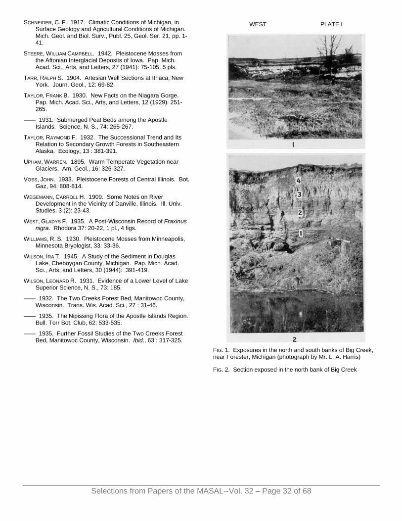
SCHNEIDER, C. F. 1917. Climatic Conditions of Michigan, in Surface Geology and Agricultural Conditions of Michigan. Mich. Geol. and Biol. Surv., Publ. 25, Geol. Ser. 21, pp. 1-41.
STEERE, WILLIAM CAMPBELL. 1942. Pleistocene Mosses from the Aftonian Interglacial Deposits of Iowa. Pap. Mich. Acad. Sci., Arts, and Letters, 27 (1941): 75-105, 5 pls.
TARR, RALPH S. 1904. Artesian Well Sections at Ithaca, New York. Journ. Geol., 12: 69-82.
TAYLOR, FRANK B. 1930. New Facts on the Niagara Gorge. Pap. Mich. Acad. Sci., Arts, and Letters, 12 (1929): 251-265.
—— 1931. Submerged Peat Beds among the Apostle Islands. Science, N. S., 74: 265-267.
TAYLOR, RAYMOND F. 1932. The Successional Trend and Its Relation to Secondary Growth Forests in Southeastern Alaska. Ecology, 13 : 381-391.
UPHAM, WARREN. 1895. Warm Temperate Vegetation near Glaciers. Am. Geol., 16: 326-327.
VOSS, JOHN. 1933. Pleistocene Forests of Central Illinois. Bot. Gaz, 94: 808-814.
WEGEMANN, CARROLL H. 1909. Some Notes on River Development in the Vicinity of Danville, Illinois. Ill. Univ. Studies, 3 (2): 23-43.
WEST, GLADYS F. 1935. A Post-Wisconsin Record of Fraxinus nigra. Rhodora 37: 20-22, 1 pl., 4 figs.
WILLIAMS, R. S. 1930. Pleistocene Mosses from Minneapolis, Minnesota Bryologist, 33: 33-36.
WILSON, IRA T. 1945. A Study of the Sediment in Douglas Lake, Cheboygan County, Michigan. Pap. Mich. Acad. Sci., Arts, and Letters, 30 (1944): 391-419.
WILSON, LEONARD R. 1931. Evidence of a Lower Level of Lake Superior Science, N. S., 73: 185.
—— 1932. The Two Creeks Forest Bed, Manitowoc County, Wisconsin. Trans. Wis. Acad. Sci., 27 : 31-46.
—— 1935. The Nipissing Flora of the Apostle Islands Region. Bull. Torr Bot. Club, 62: 533-535.
—— 1935. Further Fossil Studies of the Two Creeks Forest Bed, Manitowoc County, Wisconsin. Ibid., 63 : 317-325.
WEST PLATE I
FIG. 1. Exposures in the north and south banks of Big Creek, near Forester, Michigan (photograph by Mr. L. A. Harris)
FIG. 2. Section exposed in the north bank of Big Creek
Selections from Papers of the MASAL--Vol. 32 – Page 32 of 68

WEST PLATE II
FIG. 1. Fossil leaves weathered out from Stratum 1
FIG. 2. Thuidium delicatulum (Hedw.) Mitt. Habitat of plant. X 20
FIG. 3. Thuidium delicatulum (Hedw.) Mitt. Part of a single leaf. X 70
WEST PLATE III
EXPLANATION OF PLATE III
FIG. 1. Leucodon sciuroides (L.) Schwaegr. A single leaf. X 75
FIG. 2. Anomodon attenuatus (Hedw.) Hüben. A single leaf. X 75
FIG. 3. Eurhynchium strigosum (Hedw.) J. and S. Habit of plant. X 30
FIG. 4. Eurhynchium strigosum (Hedw.) J. and S. A single leaf. X 75
Selections from Papers of the MASAL--Vol. 32 – Page 33 of 68

WEST PLATE IV
EXPLANATION OF PLATE IV
FIG. 1. Onoclea sensibilis L. Part of fertile frond. X 1
FIG. 2. Tsuga canadensis (L.) Carr. A small twig and individual needles. X 1
FIG. 3. Tsuga canadensis (L.) Carr. Seeds. X 1
FIG. 4. Tsuga canadensis (L.) Carr. Open cones. X 1
FIG. 5. Thuja occidentalis L. Small twigs. X 1
FIG. 6. Thuja occidentalis L. Open cones. X 1
FIG. 7. Pinus Strobus L. Lower half of an open cone. X 1
FIG. 8. Sparganium sp. Achenes. X 4
FIGS. 9, 11. Potamogeton sp. Achenes representing three species. X 4
Fig. 10. Myriophyllum sp. Floral leaves. X 1
WEST PLATE V
EXPLANATION OF PLATE V
FIG. 1. Sagittaria latifolia Willd. Achenes. X 4
FIG. 2. Dulichium arundinaceum (L.) Britton. Achene. X 4
FIG. 3. Carex lupulina Muhl. Achene. X 4
FIG. 4. Carex retrorsa Schwein. Achenes. X 4
FIG. 5. Carex Schweinitzii Dew.? Achenes, one enclosed within perigynium. X 8
FIG. 6. Ranunculus septentrionalis Poir. Achene. X 4
FIG. 7. Anemone sp. Achene. X 4
FIGS. 8, 9. Cornus stolonifera Michx. Seeds. X 4
Selections from Papers of the MASAL--Vol. 32 – Page 34 of 68