mgi celebration series - geo- · pdf filemgi celebration series . bas van de sande - gis...
TRANSCRIPT

MGI Celebration Series Bas van de Sande - GIS Consultant
at Royal HaskoningDHV
09 April 2014

09 April 2014
This presentation
1. Studies
2. Working at Royal HaskoningDHV
3. Role of my studies
2

09 April 2014
Studies Bachelor Landscape, Planning and Design (2003 – 2006)
Master Landscape Architecture (2006 – 2008)
Master MGI (2008 – 2010)
3

09 April 2014
Studies - Sketches
4

09 April 2014 5
Studies - Sketches

09 April 2014 6
Studies - Sketches

09 April 2014 7
Studies - Sketches

09 April 2014
Studies - Maps
8

09 April 2014
Studies - Maps
9

09 April 2014
Studies - Spatial Quality
10

09 April 2014
Studies - Spatial Quantity
11

09 April 2014
Studies - Thesis Landscape Architecture incl. internship at Lenné3D Berlin
12

09 April 2014
Studies - Thesis Landscape Architecture incl. internship at Lenné3D Berlin
13

09 April 2014
Studies - Thesis Landscape Architecture incl. internship at Lenné3D Berlin
14

09 April 2014
Studies - Thesis Landscape Architecture incl. internship at Lenné3D Berlin
15

09 April 2014
Thesis Geo Information Science – Sensitivity of coastal flood risk assessments to DEMs
16

09 April 2014
Thesis Geo Information Science – Sensitivity of coastal flood risk assessments to DEMs
17
Impact of 3 m storm surge by using SRTM DEM

09 April 2014
Thesis Geo Information Science – Sensitivity of coastal flood risk assessments to DEMs
18
Impact of 3 m storm surge by using LiDAR DEM
09 April 2014
Now; business as usual
GIS Consultant/ Project Engineer
Liaison of our GIS team in Delhi Office
19

09 April 2014
Royal HaskoningDHV – International engineering and project management consultancy
In 2012 former “Royal Haskoning” and “DHV” merged into “Royal HaskoningDHV”
Markets; Aviation, Buildings, Energy, Industry, Infrastructure, Maritime, Mining, Rural Areas, Urban Areas, Water
Lots, lots, lots of spatial components involved in almost all our projects… So GIS has an important role !
20

09 April 2014
Royal HaskoningDHV – Organizational structure
Business Lines represent more or less the markets which we serve
Advisory Groups within a Business Line
Currently working for the Advisory Group “Geo Information Management”, which is part of Business Line “Infrastructure”
21

09 April 2014
Royal HaskoningDHV - Tasks Bridging gaps between various disciplines by means of GIS
> connecting disciplines Project coordination/ Data management of projects Project Engineering Spatial Analyses Training & Liaison (training of GIS team in India)
22

09 April 2014
Data Management
23

09 April 2014
Data Management
24
https://apps.geosolutions.nl/sandbox/milieuviewer/

09 April 2014
Engineering; combination CAD and GIS

09 April 2014
Engineering; Difference CAD vs GIS
26
AutoCAD GIS
09 April 2014
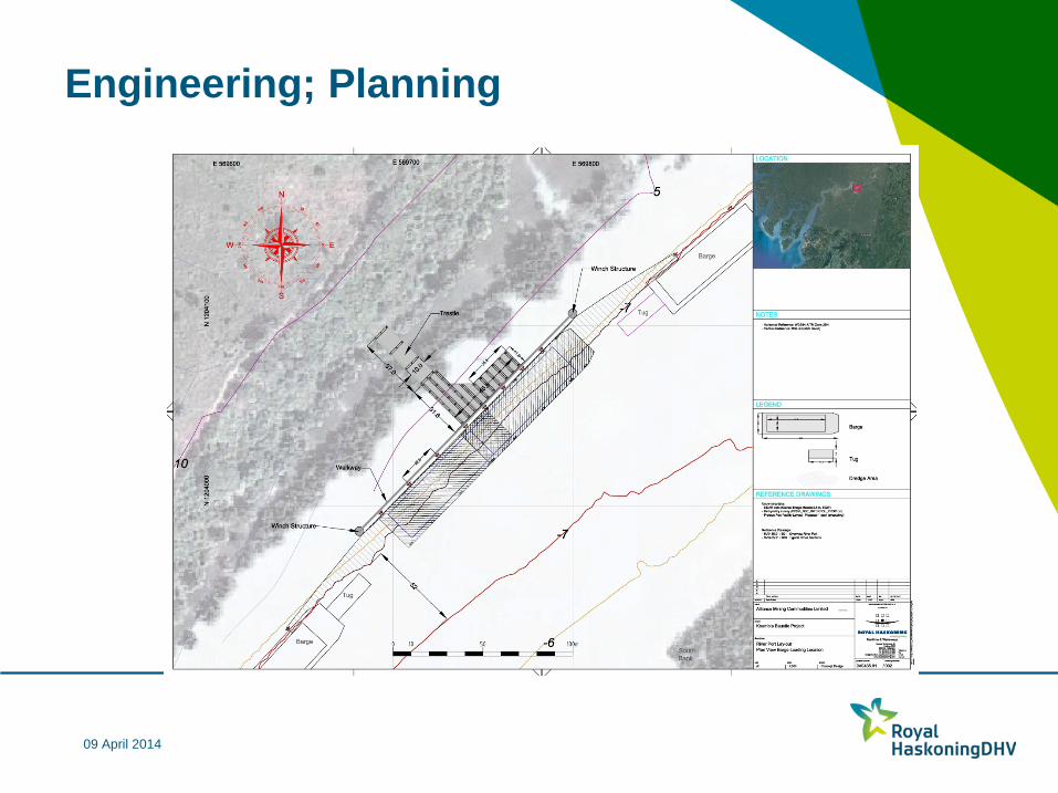
Engineering; Planning
09 April 2014
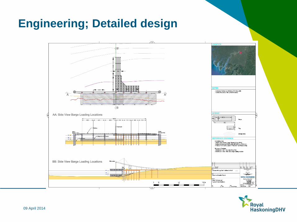
Engineering; Detailed design
09 April 2014
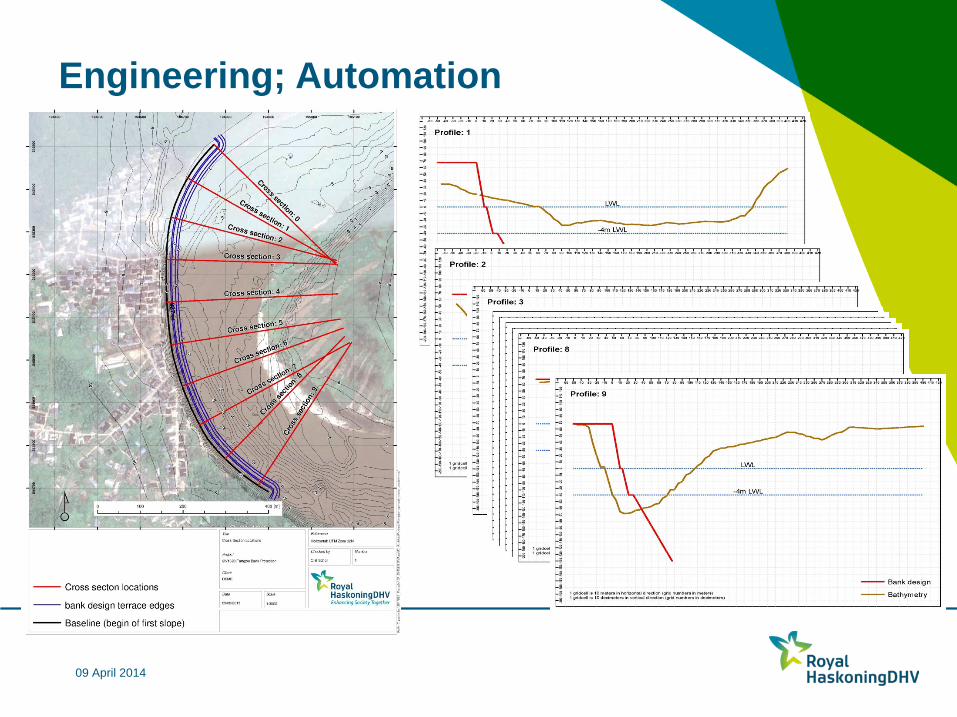
Engineering; Automation
09 April 2014
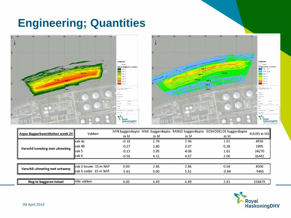
Engineering; Quantities

09 April 2014
Spatial Analysis; Land Reclamation Tool
Providing insight in the suitability of possible land reclamations in the nearshore areas of Indonesia based on a set of parameters:
1. Bathymetry 2. Tsunami’s 3. Land prices 4. Wave conditions 5. Sand supplies 6. Tidal information The conditions of the parameters were classified to suitability scores
E.g. Waveheights NOAA: http://www.arcgis.com/home/webmap/viewer.html?webmap=8ea030a208df49e9bd3f3e5d05de7819 E.g. Tidal Information Indonesia: http://www.arcgis.com/home/webmap/viewer.html?webmap=d358eb65f2ed4cda9b29b58363f575c2

09 April 2014
Spatial Analysis; Land Reclamation Tool
Bathymetry > Tsunami’s > Land prices > Wave conditions > Sand supplies > Tidal information >
E.g. Waveheights NOAA: http://www.arcgis.com/home/webmap/viewer.html?webmap=8ea030a208df49e9bd3f3e5d05de7819 E.g. Tidal Information Indonesia: http://www.arcgis.com/home/webmap/viewer.html?webmap=d358eb65f2ed4cda9b29b58363f575c2

09 April 2014
Spatial Analysis; Land Reclamation Tool Ambon

09 April 2014
Spatial Analysis; Land Reclamation Tool Jakarta

09 April 2014
Spatial Analysis; Land Reclamation Tool Makkasar

09 April 2014
Spatial Analysis; Land Reclamation Tool Padang

09 April 2014
Port Master Planning; Land Reclamation Tool Surabaya

09 April 2014
GIS as Data & Information Platform in Civil and Environmental Engineering Projects Pulau Tekong Polder Development;
http://rhk.maps.arcgis.com/apps/OnePane/basicviewer/index.html?appid=eaa0ce4788a54847a6538e7660e55a7e
Al Kharj City Development; http://rhk.maps.arcgis.com/apps/OnePane/basicviewer/index.html?appid=2bd6c8d6c82043d482f0e3033ba714aa
38

09 April 2014
Resume I’m using GIS as a tool; I’m not a true GIS developer
Mainly working on allocation of, preliminary/conceptual design of larger
human induced spatial developments
For civil and environmental engineering GIS is the optimal means to serve as a data and information platform, but moreover a means to create understanding amongst various disciplines and to make a story of your project
Still applying what I’ve learned at Geo Information Science (and Landscape Architecture) to my current work
39

09 April 2014
Google Earth Screenshot 2011
40
Impact of 3 m storm surge by using LiDAR DEM

09 April 2014
Google Earth Screenshot 2014
41