mexico - waste isolation pilot plant · new mexico; thus the sinking of n 1,200-foot shaft at...
TRANSCRIPT

._.. .. •' - ., .
. ·::_ .:·~~=-::· ~--~,. . ~ . ~:.""";"::.~. '~~~.--. -. ...----... : .. ·:- -
..... -:.--.. -- ,-.
· ....
................ ·ATOMIC EN.ERGY COMMISSION PLOWSHARE PROGRAM .
•.r~' .,1;(-_lc"';_. ~~~~~-. :,.~~
-.-~:..- -~ ~~-~-'-:.-~~-
....
CARLSBAD. NEW MEXICO . DECEMBER 10-; 1961
o. RaWson' / c~ Boardman. I N .. Jaffe-Chazan
LAWRENCE RADIATION LABORATORY.
ISSU!I)t APRU. 20, 1965
'!-... ,--.~-7~- .... -- .. , .. · ..

Cavity produced by t he Gnome explosion and subsequent colla pse. 1·ote figure right-center of rubble for scale. Cavity is 70 feet high and mor than 150 feet across. Photograph by Lawrence Radiation Laboratory.

I~
r'"'~
1"""1 ! •
!""'!~ ' I
•
,..,., I I
I
Geologic Studies
Project Qnome
Eddy County, New Mexico By LEONARD M. GARB; J ~. -
. GEOLOGICAL SURVEY PROFESSIONAL PAPER 589
... Prepared on behalf of the
U.S. Atomic Energy Commission
UNITED STATES GOVERNMENT PRINTING OFFICE, WASHINGTON : 1968

' :
.J
L-~-~~---·~----------------------
UNITED STATES DEPARTMENT OF THE INTERIOR
STEW ART_ L. UDALL, Secretary
GEOLOGICAL SURVEY
William T. Pecora, Director
Librnry or Congress cntalog-card No. GS 68-186
For sale by the Superintendent of Documents, U.S. Government Printing Office Washington, D.C. 20402

CONTENTS
~ Page •
~stract-------------------------------------------
Pap
1 1 1 2 2 3 3 3 3 3 4 5 5 7 8 8 8 8 9
Gnome area-Continued ~troduction. _----- __ - ____________________________ _ Properties of the rocks-Continued
Purpose of Project Gnome ______ ~ ___ " ___ : _______ _ Minor elements in Salado Formation in the Historical summary of the project _______________ _ Participation by the U.S. Geological Survey ______ _
Gnome drift ____________________________ _
Muieralogy and petrography of the Salado For-13
Purpose of this report" _________________________ _ mation near the device ::hamber ___________ _ Acknowledgments ____ --_------ _________________ _ Halite---------------------------------
~ Methods of study ______________________________ _
~eology.------------------------------------------Polyhalite ___ - _ --------------- __ -------Anhydrite ____________________________ _
14 14 15 15 15 16 17 17 17 17 17 18 19 19 21 23 24 32
Regional setting ___ ---- _____________________ ---_ Clastic material--- __ -- ________________ _ Gnome area. _____ - ___ - - _- _______________ - ________ - Effects of the nuclear explosion ______________________ _ ~ Stratigraphy at the site _________________________ _ Effect on the shaft _____________________________ _
~ Salado Formation. ______ ----- ___ ---_-- __ ---_ 'Effe'ct at the main station _______________________ _ The reentry drift. _____________________________ _ Rustler Formation _________________________ _
Dewey Lake Redbeds----------------------- Venting----------------------------------------~
1
Gat una Formation. ________________________ _ The cavity _____ ------ _________________________ : Explosion-induced structure. ____________________ _
illi Alluvial bolson deposits _____________________ _ Structure in confined salt. __________________ _
- St~cture.------------------------------------- Structure in unconfined salt _________________ _ ,., Geolo~)t of the preshot Gnome drift ______________ _ 1.1 Propertie_!l of the rocks _________________________ _ 11
11 13
New minerals formed. _____ ~---- ___ .... ____________ _ Elements introduced ___________________________ _
Physical properties. _____ --- ________________ _ Detailed description of rocks in the Gnome shaft ______ _ Changes in physical properties. ___________ - __ _ References _______________________ -·- ______ -.• _______ _ _,
w ILLUSTRATIONS
~ I
wJ Page
i'LATE 1. :;\Iap and geologic sections of preshot underground workings, Project Gnome, Eddy County, New :\Iexico ___ In pocket
~ 2. :Yiap and geologic sections of postshot underground workings, Project Gnome, Eddy County, New :Ylexico ___ In pocket
I \dWGURE 1.
2. Location map of Project Gnome site, Eddy County, N. :..Iex_____________________________________________ 2
:Ylap showing extent of the Delaware basin in New Mexico and adjacent structural and geographic features____ 4 3.
fMIIII 4 .
.J 5.
:\Iap showing location of shaft, ground zero, and U.S. Geological Survey test holes at Project Gnome site_____ 4 Geologic sectiol1-between Carlsbad Caverns N atitmal 'Park>'tmd Projeet Gnome site_________________________ 5 Geologic cross section between shaft and cavity, Project Gnome site______________________________________ 6
6. Photograph of units 12, 13, and 14 exposed in preshot drift______________________________________________ 10 7.
~ 8. I
Sketches of twinned polyhalite crystal forms·--------------------------------------------------------·- 15 Photograph of steam-eroded potholes in unit 10 where shot vented into preshot drift________________________ 1R
Iiiii 9. Map of underground workings and cavity_____________________________________________________________ 18
10. Geologic cross section of drilling alcove, showing thrust faults.------------------------------------------- 19 11.
filii! 12.
~ 13.
Photographs showing thrust faults, lithification, and brecciation resulting from the Gnome explosion__________ 20 Geologic cross section through buttonhook reentry drift_________________________________________________ 21 Photomicrograph of preshot salt______________________________________________________________________ 21
14. Photomicrographs of intrusive breccia resulting from Gnome explosion____________________________________ 22
~ 15.
' I • Photograph of hand specimen showing vein of intrusive breccia------------------------------------------- 23
v
"'Il
~ 1111111
!
~
fi'IOIII -

I~J
iJd
fnlili' 1. i w
~ I
l""l I i •
VI
TABLE I. 2. 3. 4. 5. 6. 7.
8. 9.
10.
CONTENTS
TABLES
Generalized stratigraphic section of rocks exposed in the Gnome shaft _____________________________________ _ Detailed stratigraphic section of Salado Formation along drift from device chamber to shaft_ ________________ _ Physical properties of rock samples from Gnome shaft_ _________________________________________________ _ Physical properties of rock samples from Gnome shaft, as determined by static method _____________________ _ Measured velocities and calculated elastic moduli for rock salt near the position of the Gnome explosion ______ _ Physical properties of samples of halite from unit 10, Salado Formation. __________________________________ _ Description and stratigraphic position of samples of Salado Formation analyzed by semiquantitative spectro-
graphic methods---------------------------------------------------------------------------------Summary of semiquantitative spectrographic analyses of evaporite rocks (Salado Formation) from Gnome drift. Approximate size and heavy-mineral composition of clastic material in units 11-13 of the Salado Formation in
Gnome drift------------------------------------~-----------------------------------------------Semiquantitative spectrographic analysis of insoluble residue of vein material resulting from the Gnome explosion_
Pare
5 9
11 12 12 13
13 14
16 23

GEOLOGIC STUDIES, PROJECT GNOME, EDDY COUNTY, NEW MEXICO
By LEoNARD M. GARD, JR.
ABSTRACT
For Project Gnome, part of the Plowshare Program to develop peaceful uses for nuclear energy, a nuclear device was detonated December 10, 1961, underground in rock salt of the Permian Salado Formation SOU'the!l.St of Carlsbad, N. Mex.
The Gi!ological Survey's investigations on behalf of the U.S. Atomic Energy Commission provided basic geologic and geophysical information needed to dt>:fl.ne preshot and postshot geologic and hydrologic conditions at and near the site. Thts report describes the geology Of the site, some physical and chemical properties of the rocks, and the known effects of the nuclear detonation on the rocks at the site.
, -~ Geologic strata at the Gnome site consist of e'"aporite and
clastic rocks of the Salado and Rustler Formations and Dewey Lake Redbeds, all of Late Permian age, the unconformably ;'1- -overlying Gatuna Formation of Pleistocene(?) age, and a
I.J t!over of alluvial and eolian sands. All rocks, except where distorted by solution collapse, are nearly tlat lying.
1""1 The evaporite deposits are easily dissolved and either are 1 missing at the surface or only partially crop out in southeastern
._. New Mexico; thus the sinking of n 1,200-foot shaft at Project Gnome provided an excellent opportunity to study these for·
~ m:a.tJions in detail. The strata were measured, ·sampled, and photographed while the shaft was being sunk.
illllli The upper one-third of the Salado is exposed in the shaft and consists of 490 feet of bedded halite containing a few inter-
~ stratified beds of clayey halite, anhydrite, polyhalite, and clay. The halite is overlain by a leached member comprised of 58
1.1 feet of clay, silt, gypsum, and anhydrite, much of which is a robbly sornt1cm breceia.
The Rustler Formation disconformably overlies the Salado Formation. The five members of the Rustler are: lower member, 128 feet of silt and clay containing a few beds of gypsum; Culebra Dolomite Member, 28 feet of vesicular dolomite; Tamarisk Member, 113 feet mainly of beds of anhydrite partly hydrated to gypsum and a few thin beds of clay; Magenta Member, 21 feet of red-purple silty gypsiferous dolomite; and Fortyniner Member, 67 feet of anhydrite and gypsum.
The Dewey Lake Redbeds overlies the Rustler Formation with apparent conformity. These rocks are thinly laminated palereddish-brown siltstone displaying light-greenish-gray "reduction spots."
The Gatuna Formation of Pleistocene(?) age unconformably overlies the Dewey Lake Redbeds and consists of 49 feet of friable, poorly consolidated tlne-grnined sandstone and thin beds of clay, silt, and conglomerate. The Gatuna is in turn unconformably overlain by 43 feet of Recent alluvial bolson deposits. which are partly eolian and partly colluvial sand.
~.lapping disclosed that deposition of the evaporite deposits was cyclical and resulted from repeated incursions of freeh sea water. Each cycle customarily begins with a bed of poly-
-halite, grades upward into pure halite, and ends with a claybearing halite at the base of the n~rt higher polyhalite.
Comparison of preshot and I)O"tshot velocities in the salt near the shotpoint indicated that rock fracturing caused by the explosion was detectable trom changes in elastic moduli, but compaction was not. No change in density of the rock could be detected.
The explosion formed a cavity nbout 70 feet high and mor~ -than 150 feet acl'o81l. Postshot mining exploration revealed geologically interesting phenomena that resulted from the explosion. Intrusive breccia veins associated with complex tbru3t faulting were formed adjacent to the cavtt;r. The breccia 1a composed of blocks of granulated and plaatically deform4!d salt in a matrix at black melted salt. The black color of the matrix is. due to the presence of laurionite, galena, and carbon. These materials, not present in tlle preshot rocks, were created by the shot. Lead from near the device combined with water and chlorine from salt to form laurionite and with sulfur from poly· halite to form galena. The carbon probably was deriT"ed from organic material present in the device chamber at shot time.
Lateral displacement of an instrument in a drill hole 100 feet from the shotpoint was about 16 feet. Strata 200 feet above the shotpoint were permanently displaced upward 5 feet. and a bed 55 feet below the shotpoint was displa~ downward more than 10 feet.
INTRODUCfiON
PURPOSE OF PROJECT GNOME
Project Gnome was a multiple-objective experiment conducted·'by the 1!:'8. Atomic Energy Commission as part of the Plowshare Program to develop peaceful uses for nuclear explosives. Gnome was the first nuclear detonation within the continental limits of the united States outside of the Nevada Test Site since the Trinity shot in 1945.
The Project Gnome experiment consisted of the detonation of a nuclear device of about 3 kilotons equivalent TNT yield at a depth of about 1,200 feet below the surface in a thick salt deposit. The Gnome site is in the Nash Draw quadrangle in the approximate center of sec. 34, T. 23 S., R. 30 E., in Eddy County, and about 25 miles southeast of Carlsbad, N. l\fex. (fig. 1).
The objectives of the experiment were fivefold (U.S. Atomic Energy Comm., 1961) :
1. To explore the feasibility of converting the energy from a nuclear explosion into heat for the production of electric power.
1

"""' ' ' ~
"'"" I -
1'11111 i i • ~ .. ~ ~
~ .. ~ I I • ~ i ; .. .~ .. r:
I • 1""1
2 GEOLOGIC STUDIES, PROJECI' GNOME, NEW MEXICO
34.
33" ~--
1 Artesia
I
0 a:: t:.l E-0
0
I ----r
25 I
SANTA FE 0
NEW MEXICO
50 MILES
103"
N
•
_ FIGURE..l.-LOcation of Project Gnome site, Eddy County, ~- Mex.
2. To investigate the practicality of recovering useful - radioisotopes for scientific and industrial applica
tions. 3. To expand the· data on characteristics of under
ground nuclear detonations to_ a new_ medium (salt), which differs markedly from-th.etes£ media. of the Nevada Test Site in which previous underground shots had been fired.
4. To make neutron cross-section measurements to contribute generally to ~cientific knowledge and to the reactor-development progra.~.
5. To provide scientific and technical information on design principles useful in developing nuclea.rexplosive devices specifica.lly for peaceful purposes.
HISTORICAL SUMl'ttARY OF THE PROJECT
The Gnome shot 'vas detonated on December 10, 1961. It was the culmination of planning and site selection that started in 1958 when a study was begun by the U.S. Geological Survey to locate a site that would satisfy both technical and public-safety req_l;lirements.
The required site was to have a. deposit of relatively pure salt not more than 800 feet underground, to be within the continental United States, prefera.bly on land controlled by the U.S. Government, and to be in an area having a. low population density.
The Gnome site was selected after all possible sites in the United States had been thoroughly evaluated. Subsequently, a preliminary investigation of this area. was undertaken by the Geological Survey. The surface and subsurface geology of the area. wa.s studied (Baltz, 1959; Moore, 1958a., b; Cooper, 1960, 1961, 1962; Jones, 1960; Vine, 1960, 1963); the regional ground-water conditions were appraised (Hale a.n.d Clebsch, 1959) ; the chemical and physical properties of salt were investigated (Morey, 1958; Harry Hughes, written commun., 1959; E. C. Robertson, A. R. Robie, and K. G. Books, written ~mmun., 1958) ; the seismic properties · w ~ W'Bl'W1meastll'ed'and Mmpared"Wftli. ttiose"of"· other rock types (Byerley and others, 1960; ·Roller a.nd others, 1959) ; a.nd a large-scale topographic ma.p of the Gnome site was constructed.
This report describes the geology, hydrology, and physical, chemica.l, and optical properties of rocks at the site.
Shaft sinking began in July 1960 and wa.s completed to a depth of 1,200 feet in May 1961. The Gnome shaft penetrates rocks of Permian and younger age. The shaft, circular in plan, has a finished diameter of 10 feet and is lined with reinforced concrete from the surface to a depth -of 722 feet. The 1,000-foot drift was mined during the summer of 1961.
PARTICIPATION BY THE U.S. GEOLOGICAL SURVEY
The U.S. Geological Survey made scientific studies and investigations related to Project Gnome ~ behalf of the Atomic Energy Commission. The Surv~y- acted as agency advisor and provided teclmical support, largely with respect to public-safety aspects. The broad objectives of the Geological Survey's progra.m were ( 1) to provide the basic geologic and geophysical information needed to define the preshot and postshot geologic and physical properties of the salt and other rocks affected by the explosion, and (2) to provide geologic and hydrologic information on the preshot and postshot hydrologic conditions at the Gnome site and surrounding region.
This report does not attempt to describe all the geologic effects produced by the Gnome explosion. Other· agencies have studied close-in surface effects (Hoy and Foose, 1962) and the environment created by the exI,>losion. (Ra.w~ 19.6.1-;.,B.awsea aaQ..others, 1965.~-.

GEOLOGY 3
1'1111
-- FIEMSE .Z EWSdlEiPQB1' ·• .~ . ,., .... Mtks~.ia ... pneiaJtt•*Wa Altlu~~the.,pre-
~ This report describes the geology of the site, some physical and chemical properties of the rocks, and the
~ effects, as far as. they are known, of the nuclear detonaiJ tion on the rocks at the site. It is based on studies that
were carried out between July 1960 and June 1962.
ACKNOWLEDGMENTS
~ For their friendly cooperation and many kindnesses, the Geological Survey pei_"Sonnel on the Gnome Project
~ thank the personnel, too numerous tO mention individullf ally, of the Atomic Energy Commission; Holmes and
N arver, Inc.; Lawrence Radiation Laboratory; Reyn~ olds Electrical and Engineering Co. ; and Cementation ~ Co. of America, Inc.
~ METHODS .O'F STUDY
~ The rocks in the shaft were measured, described (detailed measured section, p. 24), and srumpled on a noninterference basis by L. M. Gard and W. A. ,....,
~ Mourant during construction of the shaft. This was done '&S final mucking a.fter each round was completed and before drilling for the next round began. Depend
~ ing on the efficiency of the blasting, a· round advanced 1,1 the shaft 3-6 feet.
During this construction a section of the north wa.ll ~ was washed down and photographed in color. Unusual 1111 geologic features noted else,vhere in the shaft wnll were
also photographed and described. A complete photo-111111 graphic log in color is available for inspection at the 1a11 Field Records and Photo Library, U.S. Geological
Survey in Denver. The geology of the preshot drift (pl. 1) was mapped
~ by L. M. Gard and C. G. Bowles, using steel tape, at a scale of lr inch to 10 feet; vertical and horizontal contr,ol was established by Holmes and N arver, Inc. In the uil
!i derground mapping, projections of both left and right • ribs (walls) were used. (Left and right are identified
as one faces the shotpoint.) The rib projections are ro~ tated outward to the horizontal plane along the line that ~ joins their bases to the sill (floor). The back (roof) was
not mapped, because it displayed very few mappa;ble 1111111 geologic features. i.J The geology of the postshot workings (pl. 2) W'&S
ma.pped by L. :u. Gard and W. L. Emerick, assisted by r~ W. H. Laraway, M. L. Schroeder, and John Moreland,
1 Jr. The method was the same as that used in preshot • mapping except that near the cavity, to expedite the work because of time limitations, the ribs were mapped
: continuously. Thus, the nine walls of the drilling alcove and parts of the approaching drift a.re represented by a single straight projection, nnd the corners are indi
~
shot drift was intact after the shot, it was not remapped because of high levels of radiation.
Prior to mapping both the preshot, a.nd the postshot workings, the ribs were washed with water. The cleaned wet rock displayed additional stratigraphic details.
Elastic properties of the salt were determined underground, both before and after the shot, by D. D. Dickey and D. R. Cunningham. Preshot calculations were made by R. D. Carroll 'and D. D. Dickey, an~ postsh9t calculations were made by D. D. Dickey.
From his know ledge of the minor-element content in evaporite rocks of southeastern New Mexico, C. G. Bowles suggested and later supervised the determination of the minor elements in the salt beds of the preshot drift. B. M. Madsen made the petrographic descriptions of the preshot samples, Julius Schlocker studied the insoluble clastic material from these samples, e.nd Theodore Botinelly determined the oomposit!on of the intrusive breccia formed by the explosion.
GEOLOGY
REGIONAL SETTING
The Gnome site- is on the Mescalero pediment on the east side of the Pecos Valley, a section of the Great Plains physiographic province (Fenneman, 1931, fig. 1). The Pecos River flows through the southwestern part of this section and divides it physiographically into the Mescalero pediment to the east and the alluvial plain north of Malaga and the Gypsum Hills south of Malaga to the west.
The Gnome site is in the northeastern part of the Delaware basin (Adams, 1944; King, 1948; Xewell and others, 1953). This deep structural basin, which is about 1,35 miles.loog·,and 7 .. ~ miles wide,.lies in southeastern New Mexico and west Texas and is generally considered to be the area surrounded hy the Capitan Limestone (a reef limestone of Late and Early Permian age). The Capitan reef is horseshoe shaped, opening south ward, and extends in the subsurface from Carlsbad eastward nearly to Hobbs, N. Mex., a.nd thence southeastward into Texas (fig. 2). West a.nd southwest of Carlsbad the Capitan Limestone is exposed and forms El Capitan Peak and part of the Guadalupe Mountains. Large caverns--m:>tably Carlsbad Caverns-were formed in the reef limestone through the solvent action of circulating ground water.
The Delaware basin was submerged in Permian time (230-280 million years ago, according to Kulp (1961)) and was filled with thousands of feet of sediment. Toward the end of Permian deposition in the basin, the

!"'"! I
~:
4 GEOLOGIC STUDIES, PROJECT GNOME, NEW MEXICO
0 25 50 MILES
FIGURE 2.-Extent of the Delaware basin in New Mexico and adjacent structural and geographic features. Modified from King ( 194:8) and Stipp and Haigler ( 1956).
reef.growdu.round. .th.a basin. was.- halted by increasing . ·salinity of the sea water, and the evaporite rocks of the Castile, Salado, and Rustler Formations were deposited.
The Salado Formation, a•lmost wholly salt, was deposited in a sea that extended from the Dela,nre basin across the Capitan reef zone many miles onto the shelf to the north. The southern end of this sea apparently had a restricted opening, and the consequent reduced circulation and outflow allowed evaporation to concentrate the sea water therein until salt was precipitated on the floor of the basin in southeastern New Mexico. The concentrated brine undoubtedly was replenishe-d periodically by normal sea water; otherwise, the process would soon have ceased. as the basin dried up. The salt beds of the Salado Formation grade southward into calcium sulfate and then into calcium carbonate facies, suggesting that the source o~ n~rmal sea water lay in that direction and that the water became more concentrated as it moved northward.
After deposition of the evaporite rocks ceased, deposition of fine-grained terrestrial clastic sediment (Dewey Lake Redbeds) marked the close of the Permian. Terrestrial deposition continued during parts of Triassic time (181-230 million ye!Crs agoj, although subseque~t erosion has removed Triassic beds from the Gnome area. Additional thin sediments accumulated in Quaternary time.
The evaporite rocks in the Delaware basin contain extensive deposits of potash minerals, which are mined at many localities . .M:any wells produce oil from the reef limestone in southeastern X ew l\Iexico and west Texas. Oil and gas are produced also from some of the deeper formations in the Delaware basin.
GNOME AREA
The Gnome area referred to in this report is the square mile of sec. 34, T. 23 S., R. 30 E. (fig. 3). The land surface at the area is covered with as much as 4:3 feet of alluvial and windblown sand anrl. caliche . .More than 18,000 feet of sedimentary material ranging in age from Ordovician to recent underlies the Gnome site. Beneath the surface lie, in descending order, the Gatuna Formation of Pleistocene ( ~) age, the Dewey Lake Redbeds, and the Rustler and Salado Formations of Late Permian age. Beneath the Salado !J.re thousands of feet of Paleozoic rocks which are not discussed in this report. All these formations are concealed by alluvium in the Gnome area, but all except the Salado crop out nearby (Vine, 1963).
Solution by ground water of salt at the top of the Salado Formation and of anhydrite within the Rustler Formation has removed thick sections of these rocks. A subsequent_ ~er~the.land.sutface.and d.ift'erential collapse of the Rustler have formed many sihk:holes and created a karst topography over much of this part of southeastern New Mexico. Nash Draw, about 6 miles to the northwest, is one of the largest depressions. Within Nash Draw are several smaller depressions, the largest of which is Laguna Grande de la Sal (Salt Lake).
The rocks dip gently to the east and southeast, and progressively younger formations are exposed in that
T 23 5
II II II -o ~~~ II • 11:1 ll~ ~~~
r ::a
33
24 II~ 4 5. II:
• It G
I Iii 11E t(i II~ llg; IIC
~=o Test hole 2
0
R 30 E
II II II if II 11 Ground
: Test 11 zero Test Test hole So~ .::thole 4 11 Do---hole 6
,"oo I 8 11
~ ~ ~
~ :::-:=.~/,.;
"' ~
I" Test hoe 11 oTest 1" 34~ 0 Shaft hole 7
tL,,,,~.:;-~"-\Test hole 1
N
3
1 MILE
FIGURF. 3.-Location of shaft, ground zero, and C.S. Geological Survey test boles at Project Gnome site.

1'""1 '
STRATIGRAPHY AT THE GNOME SITE 5 [.1
w ~ iE ' I
• -!~ .. '"' - 4000'
I I
• 3000'
~ I I ., 2000'
i""'' 1000' I ~
1111111
SEA LEVEL
f"'"' I I •
Sell Canyon Formation o1 Delaware Mountain Group
0 5 MILES L..............
.. ~ ~ , II 0:
VERTICAL EXAGGERATION X 26.4
E
§
• E ~ ... 0 , II ii en
c 2 • E ~
i II
"
,.. 0: < z 0: ... .... < ~ a
z < 31. 0: ... ...
~ ,J Frauu 4.-Geologic section betWeen Carlsbad Caverns National • Park and Project Gnome site. Modified from Cooper (1960).
direction (fig. 4). A!though the Salado Formation underlies an extensiye area in southeastern New Mexico, dO
outcrops of !t a.re known._ In many places the salt of the Salado Formation has
WI been wholiy or partially removed by solution. West of the Pecos River, very little salt remains; to the northwest over the buried Capitan reef, no salt is present; and !'*"I
south of the Gnome site, the Saldo salt is thin or absent over an area of nearly 100 square miles (Cooper, 1962). As much as 800 feet of salt has been removed. Within Xash Draw, solution has remored, and is presently removing, salt from the upper part of the Salado Formation.
~ ~ The Rustler Formation crops out in numerous places
west and northwest of the Gnome area and south of :VlaLa.ga, a srruill town about 10 miles west.af the area. The
ij Dewey Lake Redbeds is exposed at several localities ., north and west of the Gnome area, especially along the
margin of Nash Draw, and also crops out in a. narrow ~· discontinuous north-south belt a. few miles east of the ~ Pecos River. Triassic rocks are represented by the Santa
Rosa. Sandstone north of Nash Draw and southeast of , the area; the Santa. Rosa is not present, however, at the
Gnome site. Unconsolidated Tertiary rocks crop out east of the area.
1-l Quaternary rocks include the Gatuna Formation of :.J Pleistocene(?) age, and alludum, windblown sand,
caliche, and playa lake deposits of Recent age. Alluvium occurs chiefly near the Pecos Rh·er north of :Malaga. A recent report by Vine (1963) includes a geologic map of the Nash Draw quadrangle and stratigraphic sections of exposed rocks. The following generalized strati-
282-767 o-68--2
-
TABLE !.-Generalized stratigraphic section of rocka ezposed in the Gnome shaft
Age Unit
Recent ••.••....• Alluvial bolson deposits.
Pleistocene(?)... Gatuna Formation.
Late Permian... Dewey Lake Redbeds.
Rustler Formation; Forty-Dlller
Member. Mqenta •
Member. Tamarisk
Member. Culebra DoJo.
mite Member. Lower member.
Salado Formation: Leached
melll.ber. Unleached
pUt. •
(Bottom ot shaft.)
Lithology
Unconsolidatt!d sand.
Friable s:;.ndstone and conglorner. ate.
Thin-bed·:O.···; siltstone-.
Chiefly gypsum and anhydrite.
Silty dolomite ••••
Chiefly anhydrite and gypsum.
Dolomite .........
Chiefly clay and silt, with some msumand
ydrite .
Chiefly elaystcne and siltstone.
Chlel!y impure halite rock, with some anhydrite, polyhali!~ • .:.::;: sut...one. .
~th Thick-ow nea
sarface (It) ((t)
0 -43 43.0
43 - 91.9 48.9
91.9-:IIH 202.1
21M -.161.3 67.3
361.3-382.2 20.9
382. :H96.S 113.3
,96.H23.S 28.0
523. s-661. 2 127.7
651. 2-7011. 3 58.1
7011.3-1,202 '92. 7
graphic section (table 1) d~ribes the rocks exposei~ the Gnome shaft (fig. 5). ·. · ~
Structural defor~at~on of th~ ro:ks is limited ma:i _ 1
to a gentle monocline m the Permmn rocks and to co lapse structures in the e.va.porite sedieas -ef. the·· · · mian rocks. No deeply buried faults are kno,m. Locally, there are structural features related to the hydration of anhydrite to gypsum. This hydration considerably increased the volume of the affected rocks and caused them to be deformed, and in many places domed~ where they are exposed at the surface (Vine, 1960).
STRATIGRAPHY AT THE SITE
The following stratigraphic descriptions are suppiemented by the detailed measured section at the end oft he report (p. 2-!).
SALADO FORMATIOS
.At the Gnome site the Salado Formation is about 1,550 feet thick. :\'Iore than i5 percent of the thickness of the Salado is salt, except where solution has thinned the formation. The remainder of the formation consists of potassium minerals and minor amounts of sandstone, siltstone, shale, anhydrite, and gypsum.
The bulk of the Salado is not known to coutain ground water, although the leached member at the top of the formation is a brine aquifer locally. Xo free water has been reported to occur within the formation in the potash mines nor in the many drill holes throughout the

·""''
"""' ,.... .. !""'~
I
~
·-i-(""1.
\l!ilof
r-I -,.,
""" 1""'\
.l.J ~ .. ~
!
~
!""\
'-' ~
... ~
; • ,..,
I
• ""' i ~ ~
~
~ I -
.""''I
~.
f'\lllll -
6 GEOLOGIC STUDIES, PROJECT GXOME, NEW .MEXICO
Dump Ground zero I
Depth, 1n feet
I ~~~i~~~~f.~i~io,1~i~~~t~;;,.:,·~;f~ili,1~i~: ---------· -----1 __ --=---=-----_ -- Dewey Lake Redbeds - _-_ ----~L
0
--1 200
Forty-niner Member
Magenta Member c ~ 1- 400 "' Tamarisk Member E .. ~-< ..
_L_ I .. Culebra Dolomite Member ~ ::l a:
Lower member 600
-
800
Salt
~~======~========~=======~/V=a=c~a=T=r=is=te~S=a=n=d~st~o=n=e=M==e=m=b=e=r=o=f=A=d=a=m=s=·=(l=9=44==)====~==~~==~~~======~~ 1000
I
1200
///// ///// /
Union anhydrite of local usage ~-L/ //// L'~
Salt
L_----~~------------------------------------------------~~----------------------~1400
0 100 200 300 400 FEET
FIGURE 5.-Geologic cross section between shaft and cavity, Project Gnome site.

.MI ' i
~ STRATIGRAPHY AT THE GNOME SITE 7
~~--L' • .-....~~ :".,1108FZ!nPIII C_.., ~ ......,~. 'r'DC'~~ ~ 'tt tu,~..L ... .J , . .U.L.L1~.L.Ll.L~QIU.LQuse IIIII recrysta.llizntion of the salt restricts migrating fluids The Rustler Formation of lAte Permian age uncon-
and prevents the formation of open spaces. formably overlies the Salado Formation and is com-The shaft penetrated more than 490 feet of bedded posed mainly of evaporite deposits of anhydrite (com:J halite that contains minor interstrati.fied beds· of clayey monly altered to gypsum) and dolomite and contains
- halite, anhydrite, poly halite, and clay. The halite beds some siltstone and clay in the lower part. The thickness range in color from transparent colorless through white of the Rustler at the sh.a.ft is 357.2 feet, although in
1"'1 to reddish orange. The intensity of the orange color nearby areas the thick-ness ranges from 90 to more than ~ depends upon the amount of disseminated iron and poly- 500 feet.
halite impurities present. The clayey halite beds range in The Rustler is divided into five members, all present - <:t>lor from reddish bro,'fn to greenish gray. The reddish-. ill ·the Gnome shaft. The upper four members crop out
I
lilliiil brown polyhalite beds, locally used as marker beds, · near Nash Draw to the north and near the Pecob River average about 1 foot thick. They commonly have a thin to the west.
_ bed of greenish-gray clay at the base. From 1,024.3 to The lower, unnamed member of the Rustler Formaww 1,029 feet the shaft cut the Vaca Triste Sandstcne Mem- tion lies disconformably on the leached top of the Salado
hero£ Adams (1944), a pale-reddish-brown clayey silt- Formation. It is 127.7 feet thick and consists principally """' stone that forms a well-known marker unit. of poorly consolidated silt and clay and contains a few
The total thickness of the Salado Formation at the interstratified beds of gypsum. 1.\ Gnome site has not been determined accurately, but The Culebra Dolomite Member overlies the lower
da.ta from nearby oil tests indicate that as much as 1,550 member and consists of 28 feet of yellowish-gray genfeet of the formation may be present (fig. 4). erally microcrystalline dolomite. It conta~ some mas
The uppermost 58 feet of the Salado Formation con- sive zones, as well as as brecciated zones, that are sists of reddish-brown to gray clay and silt with a few recemented with pale-yellowish-brown_ dolomite. A
~ interstratified gypsum and. anhydrite beds. These strata characteristic feature of the Culebta is the presence of iii~~ represent, at least in part, an insoluble residue left after numerous- small nearly spherical cavities that range
the removal of halite by ground water. This leached from 1 to 20 mm in diameter. Some cavities are partly member or zone is estimated to be roughly one-third to filled with secondary gypsum· and calcite, but most are 0 one-tenth the thickness of the original halite rock that open. They do not appear to be interconnected. These was present. The thickest unit of this leached zone is a cavities are thought to ha"·e originated either by solu
·~ solution breccia 36 feet thick. It is a heterogeneous rub- tion of a highly soluble mineral aggregate or by the bly mixture composed of siltstone, gypsum, and polyha- inclusion of gas or liquid when the sediment was soft
lllill lite blocks as much as 3 feet long set in a matrix of plas- (Vine, 1963, p. 14).
tic grayish-red clay. In the shaft the leached zone did The Culebra Member is an artesian aquifer at the not contain water, although a small amount of water was shaft, where it has a head of about 75 feet. The water detected in this zone in an obsenation well drilled about appears to be contained in fractures and is confined
!'""'!
three-fourths mile west of grou!W. .zero {Gard. md · .. :a,bo,•e, ay tl~ anhydrite;·&ftd gy?SUID -of the Tamarisk others, 1962, p. 121). Vine ( 1963, p. 8) reported that Member and below by clay of the lower member.
I •
-'
locally the leached zone is a prolific aquifer. The Culebra is an excellent subsurface marker, be-The top of the Salado Formation is considered by ~ause i~s li~hology is_ unique in southea~ern New lfex
many geologists to be at the top of the uppermost halite Ico. It IS widespread m the Delaware basm and has been bed and the leached member is assigned to the Rustler identified in many hundreds of drill holes. It is the F ' f Th' · t · based rtl th f t principal aquifer at the Gnome site and yields water to
orma IOn. IS assi~en. _Is pa Y on . e ac wells in the western half of the project area. The depth tha.t the Rustler Formatwn IS reported to con tam some to h f' th Cui b f · tl N h
t e top o . e e ra ranges rom zero m . 1e as salt beds to the southeast, an~ ~artl! on the fact that the Draw-Pecos River area to at least 1,200 feet in the
leached member cannot ~e d~stmgms_hed fr~m the lower eastern part of the State. The configuration of the top member of the Rustler 111 either drill cuttmgs or geo- o£ the Culebra is similar to that of the top of the salt physical logs. However, because the leached member was in the Salado Formation. Apparently, as salt in the recognized as !\ distinct unit in the Gnome shaft and : Salado was removed by solution, the overlying beds setbecause it has a disconfm'lll.able upper contact and con- I tled and assumed, in general, the shape of the surface tains se,·eral collapse breccia beds that are distinctly : of the remaining salt. different from the lower member of the Rustler, it has : The o,·erlying Tamarisk :\!ember is 113.3 feet thick· been assigned in this report to the Salado Forrmttion. i and is composed mainly of beds of anhydrite partly

-
8 GEOLOGIC STUDIES, PROJECI' GNOME, NEW MEXICO
hydrated to gypsum, but it contains some thin beds of clay.
The overlying Magenta Member is a red-purple (magenta) silty gypsiferous dolomite 20.9 feet thick. Although an aquifer in some places, it contains no water at the shaft.
The Forty-niner Member, like the Tamarisk Member, is composed mainly of anhydrite and gypsum. It is 67.3 feet thick in the shaft, but is missing in U.S. Geological Survey hydrologic test holes 4 and 5 about one-half mile west of the shaft (fig. 3). Whether removal of the Forty-niner Member was by erosion prior to deposition of the Dewey Lake Redbeds or by leaching subsequent to deposition is not known, although leaching is considered to be more likely.
The structure of the Rustler Formation is mildly undulating where these beds are 200-300 feet below the ground surface. Locally, however, solution and col-
GA..TUNA. FORMA..TION
The Gatuna Formation of Pleistocene(~) age unconformably overlies the Dev.-ey Lake Redbeds and is pale-red to moderate-brown friable fine-grained sandstone, 48.9 feet thick in the c;haft, that contains a few thin beds of clay and silt and many thin beds of conglomerate. The sand- and silt-sized material is mainly made up of quartz grains, and the pebbles are quartzite, limestone, and chert. The grains are weakly to moderately cemented with calcium carbonate. The presence, in several beds, of reworked fragments from the underlying Dewey Lake suggests that the Gatuna was deposited on a surface of considerable relief.
Elsewhere in the Nash Draw quadrangle (Vine, 1963}, the Santa Rosa Sandstone of Triassic age lies between the Dewey Lake Redbeds and the Gatuna Formation, but it is missing at the Gnome site.
la.:piiii!J ~a1Jedee'ille- i1 I fi811t .. ~ it.. i&~ :' ··-';,;, .ALLIU'"<llL..Bmao.N- DJI'BQSITS --•4 ·~
buried. Generally the carbonate members-the ~le- Alluvial bolson deposits of Recent age unconformabra and the Magenta-are the least affected by solutiOn bly overlie the Gatuna Formation and are chiefly made and are ~resent throughout most of the area. At the up of unconsolidated moderate-brown fine-to medi~Gnome s1te they are separated by more than 100 feet grained quartz sand. The upper 9 feet of these deposits
of the Tamarisk Member. In the Nash Draw area, ~- is dune sand, but the lower 34 feet is partly eolian a.nd lution and collapse have locally removed the entire partly colluvial. The sand has been derived from the
Tamarisk, and the Magenta rests directly upon the Gatuna Formation and perhaps in part from the Ogal
Culebra. lala Formation of Plioc~e .age, .which may once have
DEWEY LAKE REDBEDS
The Dewey Lake Redbeds of Late Permian age overlies the Rustler Formation with apparent conformlty_. The contact is marked by the abrupt color change from the white of the gypsum of the Forty-niner Member of
the Rustler Formation to the red of the Dewey Lake. The Dewey Lake is mainly made up of pale-reddish-
covered the area (Vine, 1963, p. 36}. The top 3 feet of the lower 34 feet is weakly cemented by caliche, a nearsurface accumulation of calcareous material, that was preo.ipitated by subsurface eYaporation of moisture in
-this semiarid region.
STRUCTU.RE
~. brown siltstone that displays a polka-dot appearance, The rocks penetrated by the shaft are nearly fiat ly
inO' althouO'h locally in the shaft the Rustler Formation '='' 1:> ilaJ owing to the presence of light-greenish-gray red~ction
· spots (round spots about 0.5 em across where ferric iron has been reduced to ferrous iron). The formation is 202.1 feet thick in the shaft and is composed mainly of subangular to subrounded clear quartz grains and chert and feldspar grains in a clay matrix. :Muscovite, biotite, rock fragments, and opaque minerals make up less than 10" percent of the mineral grains. Bedding consists of thin ( 0.5-1.5 mm) laminae a'nd, less commonly, very small scale cross-laminations·. Red clay forms 15-25
percent of the rock and is the principal cement, although calcite and gypsum are common. The Dewey Lake represents the beginning of detrital sedimentation follo,ving the long period of chiefly evaporite deposition in the Delaware basin and adjacent shelf areas in southeastern New Mexico.
dips steeply. The regional structure is a small homo-clinal dip to the east (Vine, 1960, pA 37~ :In the shaft the Dewey Lake rocks strike N. 45° E. and dip about ~o NW. Bedding in the Salado Formation obsen·ed m the drift strikes N. 89° E. and dips 0°20' N. The attitude of the bedding in the Sahdo Formation is locally variable. Information from a drill hole 500 feet south of ground zero suggests that the same beds may be as much as 10 feet higher in the drill holeth&n in the drift. Wl1ether this difference is due to a local flexure or to an error in drilling observations i:; not known.
Fairly steep dips were observed in some beds of the Rustler Formation, especially in gypsum and anhydrite. Dips as high as 42° NW. were noted in a gypsum bed in the lower member of the Rustler. These anomalous attitudes are believed to be associated with vol-

I l
!"'''!
1""1
J
I~
l.J
-J I""'
GEOLOGY OF TEE PRESHOT GNOME DR~ 9
ume changes that take place when anhydrite changes to gypsum or when solution differentially telescopes the rocks. The northwest dip observed in the Dewey Lake Redbeds may result from thinning of the underlying Rustler Fonnation to the west or northwest. As previously noted, the Forty-niner Member of the Rustler is completely missing in test holes drilled about half a mile west of the shaft.
GEOLOGY OF THE. PRESHOT GNOME DRIFT
The nuclear device was placed in a small chamber at the end of a drift (pl. 1) driven N. 50° E. from the bottom of the shaft. The drift was 1,223 feet long and included a curved section near the shaft. The end of the drift curved around a "buttonhook," doubling back on itself and ending at the device chamber. The device chamber was about 1,000 feet horizontally from the bottom of the shaft and slfghtly less than 1,200 feet below the ground surface. Thus, the rock cover over the detonation point consisted of about 500 feet of massive salt beds and about-700 feet of other sedimentary rocks. Below the detonation point was probably an a.dditional 1,000 feet of_beQded salt.
Only the Salado F{)rmation is exposed in the drift; bedding -strikes N. 89° E. and dips 0°20' N. Owing to the low_ dips, the ribs (walls) of the drift were mapped to show geologic features that could not be included on an ordinary map (pl. 1). Mapping, done during July 196L was on a scale of 1 inch to 10 feet to show the depositional features in the salt strata in some detail.
Eight mappable beds of halite rock containing ,·arying amounts of clay and polyhalite and one mappable bed of polyhalite were transected by the drift. The nine beds were arbitrarily numbered in descending order from 10 to 18. Because the drift intersects the bedding at an angle of about 40° to the strike, the beds have a component of dip toward the device chamber; thus, the lowest beds are exposed near the shaft, and successively higher beds are exposed toward the device chamber. Total thickness of the exposed beds is about 22 feet. The following stratigraphic section (table 2) describes the beds in the Gnome drift.
Deposition of the Salado Formation was often cyclic, as indicated by the strata exposed in the drift. Ideally, a cycle begins 'vith a polyhalite bed at the base, grades upward into halite containing polyhalite, and tenninates 'vith clay-bearing halite at the top. A cycle represents an incursion of fresh sea water that temporarily decreased the sn.linity of the brine and caused deposition of calcium sulfate. Concentration of the fresher sea \Vater subsequently caused the precipitation of sodium chloride.
TABLE 2.-Detailed atratigrapl&ic section of Salado Formation along drift from device cAambiT to lh.aft
Tlic.tftua Uflil DueriptiOII (ft)
120 Poly halite rock (ml!.l'ker bed 120), reddish-brown, microcystalline; varies in thickness because upper contact gradational into overlying halite. (Exposed in postshot workings.) ______________ 0. 5-1. 5
10 Halite rock, colorless to pale-orange; grain size 1(}-20 mm; bands 0.25-0.3 ft thick of colorless to milky halite alternate with 0.1- to 0.2-ft-thick bands of pale-orange halite containing dissemi~ nated orange polyhalite; 0.18-ft thick discontinuous band of orange polyha.itP 1.2 ft below top of unit; polyhalite more concentrated in lower 1.5 ft; dark-Jp"ay clay layer 5.4 ft above base (clay seam in fig. 12); lower 0.8 ft contains 4 percent gray clay in thin horizontal streaks and bands; device set at base of this unit. (Only lower 4.3 ft exposed in preshot drift.)__ _ _ _ _ _ _ _ _ 8. 0
11 Halite rock, clear, gray, rarely brown, gray clay seam 0.05 ft thick at top; contains a few discontinuous bands of halite with disseminated polyhalite; displays ripple-mark casts where back of drift breaks tt> base of unit___________________ . 2-1. 0
12 Halite rock, light-gray to light-brown; clay content 1(}-50 percent; clay geuerally brown but some gray; base of UDit a brown clay seam which at places truncates upturned beds of underlying unit ______________________ ------ . 2-1. 0
13 Halite rock; contains inclusions of brown clay; upper 2 ft contains irregular layers of brown clayey halite alternating with pale-orange to grayish-white h!ilite; ·contains vertical mudcracks filled with clay, polyhalite, and second- .... ary halite; layers between mudcracks near top of unit are concave upward; lower 1.5 ft lightbrown halite with 2(}-25 percent inclusions and vertical streaks of brown clay; clay content decreases downward; contact with underlying unit gradationaL______________________________ 3. 5
14 Halite rock, pale-orange to white; contains blebs and disseminated particles of orange poly-halite forming indistinct layers which are most
I
noticeable in lower half _____________________ 3. 5-4.0 15 Poly halite rock (marker bed 121), moderate
reddish-brown, microcrystalline; variable thick-ness usually due to irregularity of upper con-tract, which may be gradational; lower contact sharp ____________________ ------___________ . 5-1. 0
16 Halite rock, colorless to gray-green to pale-orange; 0.1 ft greenish-gray clay at top; upper 1.6 ft
,: 'eontains .2\3 perceM gra-y-green ciay and 3 percent polyhalite; clay content decreases downward; upper part contains pods and downward-tapering wedges of secondary halite containing gray-green clay and polyhalite. _ _ _ _ 4. 8
17 Halite rock, colorless to light brown; 10 percent streaks and inclusions of brown clay. (Exposed only in blast-door alcove)____ _ _ _ _ _ _ _ _ _ _ _ _ _ _ _ . 5
18 Halite rock, colorless to light-brown; contains 2 percent brown clay and 2 percent polyhalite. (Exposed only in blast-door alcove.) Base not exposed___________________________________ 3~
Total exposed thickness___________________ 22~
One complete cycle of deposition and parts of two others are represented in the drift. The complete cycle begun with the deposition of unit 15, the polyhalite bed, and ceased with the deposition of unit 13. rnits 16-18 are part. of the previous cycle, and units 10-12 are part of the subsequent cycle.
Poly halite probably was not deposit~d from the original brine but was altered from gypsum or anhydrite

-'
'~ i
,.,
,....,
10 GEOLOGIC STUDIES, PROJEal' GNOME, NEW MEXICO
. - ~~ .. ...- ... . : -_Mudcr~ck . ~ .. ·
FIGURE 6.-Units 12, 13, and 14 exposed in preshot drift. Note mudcracks in unit 13 with curved bedding between, and vertical lineations at base of unit 13.
by the later -addition o£ potassium and magnes1um (:\Ioore, 1958b, p. 14).
The poly halite bed (unit 15), known locally as marker bed 121, is present in the Salado Formation over a wide area. Its sharp regular lower contact is underlain by a thin layer o£ greenish-gray clay. Thin clay layers underlie man.y of the poly halite beds in the Salado Formation and are-thought to have been concentrated by the re-solution of impure salt when the brine was freshened.
In places along the drift the polyhalite is underlain by pods of abnormally large halite crystals which contain disseminated gray clay and polyhalite. Whenever the pods are present, the underclay is absent. The gross halite crystals in these pods are thought to have resulted from secondary recrystallization.
Continued concentration of the brine by e\·aporation resulted in deposition of unit 14, which contains little or no clay but contains polyhalite blebs. Unit 14 is gradational upward into unit 13, whiGh contains as much as :25 percent clay. Further e\'aporation, perhaps even to dryness, produced desiccation cracks in unit 13 (fig. 6). These cracks are filled with clay, halite, and polyhalite.
In the upper part of this unit, bedding between the desiccation cracks is concare upward and resembles the cross section o£ curnd polygonal plates that commonly deYelop between desiccation cracks. ::\Iost of these features were seen only in cross section; one polygonal structure, howenr, is well exposed in the back of the drift at station 4 + 35 ~md· exhibits a typical 120• j unction of three mud-filled cracks, one of which is traceable down the right rib. Another such junction is well exposed in the No.12lateral in the reentry drift. Probably this part of the basin either was evaporated to dryness or was locally uplifted to abo,-e sea level at this time. Desiccation cracks observed at several places in the shaft and in the core from a hole drilled at ground zero indicate ·recurrent complete Haporation during depositimi. of the Salado Formation. These cracks could, hO\ve,·er, represent a time of local up warp and subaerial exposure of a limited area rather than evaporation to dryness of the entire basin.
The clay in unit 13, which decreases downward, displays faint ,·ertical brown clayey lineations, which may ha,·e been caused by dom1ward percolation of rain water, if salt strata were exposed by local upwarp, or by

PROPERTIES OF TEE ROCKS 11
.sea, .. \Uter when. the area was again submerged. This vertical lineation is clearly visible in figure 6.
Units 11 and 12 are very thin, aggregating generally less than a foot in thickness, and are separable only by the difference in color of their contained clay. Unit 11 is generally gra.y, and nnit 12 is generally brown. The top of unit 12 and the bottom of nnit 11 display current ripple marks in the back of the drift near station 5 +45 where the underside of unit 12 is exposed in the back of the drift. The contact between units 12 and 13 is _very sharp, and some of the upturned beds at the top of unit 13 appear to have been truncated by nnit 12.
Precipitation of salt began again with the formation of unit 12; the brine ''"as apparently concentrated enough so that sodium chloride was the first mineral deposited. In unit 10 alterna.ting layers of colorless halite and orange halite (colored from the iron in qisse_!lli-nated polyhalite) suggest rhythmical freshening of the brine. The top bed of this cycle seen in the postshot workings a.nd cavity walls is a polyhalirte bed (marker bed 120) that lies only a few feet above unit 10 and indicates the beginning of a new depositional cycle.
PROPERTIES OF THE ROCXS
To define the rocks surrounding and overlying the device chamber various properties were determined, both before and after the shot. Certain physical prop-
erties ''"ere determined both in, the,..]p~h!lf-.aAiii 4o situ. Semiquantitatin spectrogra.phic ~yses.. .. vere made, and the petrography of the rocks exposed in the drift was studied.
These preshot determinations were made to provide a basis for postshot comparisons. It ''"as found, however, that the shot had little effect on the bulk of the geologic medium, and, accordingly, detailed postshot analyses were made only in sperifir places on rocks close to the cavity.
PHYSICAL PROPERTIES
Various physical properties were determined by the Geological Survey laboratories for 32 samples (tables 3, 4) collected from the Gnome shaft during construction. These samples are considered to be representath·e of the rocks overlying the device chamber.
Porosity, grain density, a.nd dry-bulk density of the msoluble samples were determined by the water-saturation, mercury-displacement, and po:vder-grain methods. For water-soluble sam pies, :;:t.:oSt"'ftnVas'snbstituted for ''"ater, and the proper density corrections· were made (table 3). ·
Dynamic elastic moduli were d~term.ined from cal·culations using torsional aud1lexural resonant frequencies of specimens (table .a). Static elastic moduli and compressive strength were measured on cores 1 inch in diameter and 2 inches 1ong ( ta.ble 4).
TABLE 3.-Physical properties of rock samples from Gnome shaft
1"-1 [Analysts: D. R. Cunningham, John Moreland, Jr., and E. F. Monk. Asterisk (0) indicates 101 psi (pounds per square inch i; nd, not determined; .. , not determined owing to
, insufficient sample]
I~
1-, i ..
Magnetic Sonic method Grain Dry-bulk suscepti·
Geologic unit Lithology Depth (ft) Porosity density density bility Youn~'s Modulus Longitu· Trans-(percent) (g per cc) (g per cc) (Ill-' cgs mC'riulus rigidity Poisson's dina! verse
units) IJO' ps1l (10' psi) ratio velocity velocity air dried (It per sec) (It per sec)
Gatuna Formation. .... Sandstone ............. 50- 70 31.9 2.66 1.81 36.9 '5. 38 *2. 54 0. 0189 6,07'l 3.M::
!"'!'! Dewey Lake Redbeds .. Silmone ....... %--· 100 %1.6 2::118 '2.1<1 i.8 Zld nd ·nd nd ::ld .... do ........... ::::::: 2.50 11.8 2.68 2.36 10.8 nd nd nd nd nd - Rustler Formation:
Forty-niner Mem· -,\,~~J~i-~e_._:: :::::::::: 298 7.9 2.50 2.31 5.3 2.56 1.09 .1743 10.825 6.816 her. 320 12.2 2.82 2.48 6.0 3.19 1.30 .2269 10.223 6. 076
Siltstone ............... 331 24.9 2.66 2.00 14.9 1. 18 •s.34 .1028 6.836 4, 548 Gypsum ............... 343 8. 7 2.43 2.22 6. 7 2. 66 1.27 . 0472 10. 715 7, 386
1'11'1 Gypsum and anhydrite. 350 3.5 2.37 2.29 3. 6 2. 52 1.00 .2600 11.275 6, 421
~ :Magenta Member .. Dolomite ............... 36/i 34.7 2.92 I. 91 4.8 07. 10 "2.85 . 2456 5, 587 3, 244
Dolomitic siltstone ..... 370 22.7 2.81 2.17 7.9 nd nd nd nd nd Dolomite ............... 380 19. I 2. 91 2.35 4. I nd nd nd nd nd
Tamarisk Member. Gypsum and 400 2.5 2.39 2.33 4.3 5.41 2.89 .1812 15,205 9,487 anhydrite.
11\11111 Claystone .............. 482 22.1 2.68 2.08 6.2 "9.39 •a. 11 • 26li5 6,546 3, 713
I
Culebra Dolomite Dolomite ............... ~ 12.5 2.86 2. 411 5.8 nd nd nd nd nd Member. . ... do .................. 515 12.3 2.83 2.48 2.1 2.96 1.28 .1563 11,809 6, 261 - Lower member .... Claystone .............. 527 29.6 2.71 1.91 10.5 nd nd nd nd nd
Gypsum and anhydrite. 535 3.1 2.37 2.3 4.6 2.93 1.13 .2965 12, 706 6,834 Claystone ••............ 562 25.1 2.68 2. 01 8.2 "8.41 "3.40 .2368 6, 201 3, 642 Siltstone ............... 500 21.3 2.71 2.13 111.1 1.34 05.98 .1167 7,044 4,640
1"-1 .... do .................. 620 19.3 2. 70 2.17 7. 7 nd nd nd nd nd I Salado Formation ...... Claystone breccia 653 26.2 2. 69 1.98 17.2 nd nd nd nd nd ' (residuum).
llllli Siltstone (residuum) ... 693 1.1 2.15 2.13 5.8 1.40 06.67 .0526 7,367 5. 062 Anhydrite (residuum) . 700 2. 7 2.52 2.4.5 4.6 1.86 "7.04 .3210 9,064 4.653 Halite ................. 715 2. 7 2.16 2.11 3.2 -----------
"""'\ .... do .................. 7:!0- 725 1. 1 2.49 2.46 4.3' -----------.... do .................. 1, 013-1, 015 5.1 2. 24 2. 13 3. 7 --------···
i .... do .................. 1, 01~1. 023 1. 2 2. 27 2.24 6. 7 ----------· iillli .... do .................. 1,12tH.123 i. 1 2.33 2. 17 12.1
.... do .................. 1,130 1.7 2.18 2.14 9. 5 --------··-
.... do .................. 1, 147-1, 152 .8 2.18 2.16 7.8 --------···
.... do .................. 1, 173-1, 178 3. 2 2.15 2.09 6.3 -------···· ,, .... do .................. 1,177-1,181 ~- j 2.38 2.31 5.4 I
• 1"""1
i ...

r-1 , I
~
I
Hill
!""''
-I I
illl
·""' \
,"""' i •
~---~·-· =~----~-~---------
12 GEOLOGIC STUDIES, PROJECI' GNOME, NEW MEXICO
TABLE 4.-Physical propertiu of rock sample& from Gnome shaft, 48 determined by static method [Analysts: T. C. Nichola, I. C. Thomas, and R. A. SpeirerJ
Lab. Unconfined Seeant Secant No. Depth LltholOIY Condltlon Description compressive Young's range Poisson's Shore Remarks PI- (It) of sample of-ple strength modulus (psi) ratio hardne.ss
(psi) (psi)
102 320 Anhydrite .• Good •••• Lineation ot gypsum-filled !rae- 3,900 2.86XIO" 500-1400 0. 19 24 Loading: Longitudinal strain, turas approximately 70" to first :;rcle: latitudinal strain, platens. Length, 3.0 ln.: dlam- secon cycle. Fallure occurred eter, 1.470 ln.: parallelism, along fracture planas. .0012 ln. Oven dried.
104 343 Gypsum .... .. do •...•.. Both ends slightly chipped. No 3,180 3. ISXIO£ 3()()-1300 .10 12 Loading: Longitudinal strain, lineation. Length, 2.078 in.; first :;rcle: latitudinal strain, diameter, 1.0 ln.: parallellsm, secon cycle: compressive <.OOI!n. Oven dried. strength, third =
109a 400 Anhydrite Fair ••••.. No tractures. One end of core 2,400 2. 2 X lOS 500-1400 .23 ----·--·--- Loading: Longitu strain, and chipped. Length, 2. 716 ln.; first :;rcle; latitudinal strain, gypsum. dlallieter, 1.438 ln.; parallel- secon cycle.
Ism, .0009 ln. Oven dried. .10 7 Loading: Longitudinal strain, 109b 400 .. do •••••..•. Poor •.•.. Many gypsum-tilled tractures 8,900 1.14XIOI 3()()-lf!OO
normel to~tens. Length, first ;xcle; latitudinal strain, 2.078ln.; eter, 1.0 ln.; seco cycle. Both utens!on parallelism, <.OOiln. Oven and shear tractnres oceurred dr!ed. along gypsum planes dur!Dc
fall lUll. 112 515 Dolomite ••.. Good •.•• A taw weathered holes. No lin- 12, 700 4.31XIOI 3()()-28()0 .27 17 Loading: Longltudlnal strain,
eatlon. Len~, 2.031ln.; dl- lint cycle; lat!tudlnal strain, ameter, 1.0 ; parallelism, second cycle; compressive <.001ln. Oven dried. strength, third cycle.
119 693 Siltstone •... Fair •••••. Several !ractures. One end 6,200 1.14X101 800-2300 .31 13 Only 011111 cycle of loedlDc. chipped. No lineation. Length, 4.1113 ln.; diameter, 2.109 ln.; tr'le'ism ~O.U...~- . .:-, ea.
120 700 Andydrite •• Good •••• A small chip on one end. Linea- 3,200 2.97X101 800-1700 .42 IV Only 011111 G,cle of loedlDc. Pall· t!on approximately parallel to lUll oocarred along ~ platens. Length, uo ln.; dl- normal to lllllll&tlon. amf'ter, 2.109ln.; parallelism, .0019 ln. Oven dried.
The hardness of the rocks (table 4) was measured on a Shore scleroscope. This inf>trument utilized a diamond-tipped hammer, which is raised to a standard height above the rock specimen and then dropped onto it. The height of the rebound is proportional to hardness and is recorded on a scale of 0 to 120.
Porosity of rocks above the salt ranges from as higli as 34.7 percent for the :\Iagenta Member of the RustlerFormation to as lo>Y as 1.1 percent for siltstone residuum at the top of the Salado Formation. Porosity of halite from the Salado ranges from 7.1 percent to 0.8 percent. Grain density ranges from 2.92 g per cc (grams
per cubic centimeter) for the Magenta to 2.15 g per cc for the same siltstone residuum at the top of the Salado. Grain density of the halite ranges from 2.49 to 2.15 g per cc. Dry-bulk density ranges from a high of 2.49 g per cc in the Culebr.a ~fember of the Rustler Formation to a low of 1.81 g per cc in the Gatuna Formation. Dry-bulk densitY- of f11e halite in the Sala-do ranges from 2.46 to 2.09 g per cc.
-Sonic velocities >Yere detennined in the laboratorj fgr-rocks overlying the Salado Formation. Longitudinal velocities range from 15~205 fps (feet per second) for gypsum and anhydrite of the Tamarisk :Member of
TABLE 5.-M easured velocities aud calculated elastic moduli for rock salt near the position of the Gnome explosicm IFro"in Dickey (19!\4, p. b109). All arrival times determined !rom comparison ot two or more records !rom each line of measurement except those tor line J-0." Only one a.c-
ceptable record was obtained from line J-0. Line Y-Z, the preexplosion line ot measurement, is 5.5 feet higher stratigraphically than the other lines. Measurements by D. D. Dickey and D. R. Cunningham]
Traveltime of first Line of Distance Length arrival Velocity (fps) Po is- Young's Shear Bulk
measure- from of line (milliseconds) son's modulus modulus modulus ment explosion (ft) ratio (10' psi) (10' psi) (10' psi) (fig. 9) point (ft) Com pres- Shear Compres- Shear
sional sional
POIUiaot meu11n1meat8
A-C _____ 8~110 34. 99 2.9 6.05 12, 100 5,800 0. 35 2. 6 0. 95 2. 9 B-C _____ 8~110 32. 15 2. 7 5. 6 11, 900 5,750 . 35 2. 5 . 93 2. 8 G-E _____ 14~205 66. 80 5. 6 10. 4 11,900 6,400 . 30 3. 0 1. 1 2.5 G-F ••..• 14~205 67.09 5. 7 10.4 11,800 6,450 . 29 3. 0 1.2 2.4 J-o _____ 235-350 114. 74 8. 8 14. 9 13,000 7, 700 . 23 4.1 1.7 2.6 J-K ____ 235-325 90. 52 7. 0 13. 1 12,900 6,900 . 30 3. 5 1.4 2.9 u-w ____ 60~785 186. 22 13. 4 24. 4 13,900 7,650 . 29 4.2 1.6 3. 3
Preahot measurements
Y-Z ..... 5-85 81. 37 6. 05 11. 5 13,500 7, 100 . 31 3. 5 1.4 3. 1

l_j
u
111111"1!
~ . ! •
PROPEIRTIES OF TEE ROCKS 13
the Rustler Formation to 5,072 fps for.sandstone.of the Gatuna Formation. Transverse velocities range from 9,487 fps for the same gypsum a.nd anhydrite sample to 3,244 fps for the Magenta Member of the Rustler.
CB;ANGES IN PHYS'ICA.L PROPERTXES
The dynamic properties of the rock salt in the underground workings at Project Gnome were calculated from preshot a.nd postshot in situ measurements of the compressional and shear velocities of aeoustic waves. This work was described by Dickey (1964). Figure 9 shows the plan of the preshot and postshot workings a.nd location of the sonic-velocity stations. Velocities and calculated elastic moduli s.re shown in table 5.
Dickey (1964, p. B111) concluded that:
• • • the results of this study showed that (1) although fracturing of this rock is detectable by the acoustic method used, compaction is not, and (2} the elastic moduli are changed for reasons ather than compaction. Furthermore, the amount of fracturing is semiquantitatively estimable by acoustic means. Compaction is not shown by the changes in elastic moduli caused by the explosion, because of the larger changes in elastic moduli not related to compaction. These changes, however, may indicate the amount aiid position of changes in stress of the rock surrounding an· explosion.
Deftsicy cliangis were not detected in laboratory mea-surements (tabte 6), and, therefore, compaction was le§S than 1 percent on any sample tested.
TABLE 6.-PhyBical propertie8 of 8ample8 of hizlite from unit 10, Salado Formation
[Analysts: John Moreland, Jr., and E. F. Monk. Salt-saturated kerosene density: 0.8098 at 19.8.Cl
Dry-bulk Saturated- Total Lab. Location Etl:ec- Grain density, bulk den- poros-No. in drift Rock type tive den- mercury sity (in salt- ity P2- &orosity sity displace- saturated (per-
percent) ment kerosene) cent)
1198 Sta. 6+94. Preshot 1. 0 2.17 2.14 2.15 1.2 halite.
1012 105ft from Postshot 1.02 2.18 2.11 3.65 sbot- hal.ite. point .
1199 .... do .... .... do ...... .9 2.18 2.14 2.15 1.7 1200 .... do .... Postshot .9 2.17 2.13 2.13 1. 9
vein halite.
MINOR ELEMENTS IN SA.LADO FORMATION IN THE GNOME DRIFT
The Gnome drift, whose rocks show a sequence of cyclic deposition, provided a ra.re opportunity to study the distribution and association of minor elements of evaporite rocks in a nonmineralized part of the Salado Formation.
Semiquantitati,·e spectrograph analyses were made on samples from se\'en stratigraphic units exposed in the Gnome drift n.nd from four replacement zones in these units. In addition, analyses for minor elements were mn.de for compurath·e purposes on samples of the langbeinite and syh·ite ore zones from the 800- and 900-
282-767 Q-68--3
'
foot levels of the . .Internatiana.l Minerals eud.(lliemic.al Corp. mine, 12 miles northwest of the Gnome site, a.nd on samples of selenite crystals precipitated in Salt Lake, 8 miles west of the site. These analyses were by Gard, Cooper, and others (1962, tables 9, 11). Samples from the Gnome drift are described in table 7 of the present report, and the semiquantitative spectrographic analyses of these samples are summarized in table 8.
Many elements either compose the clay minerals or are closely associated with the clays. These elements are, in order of decreasing abundance: potassium, magne-
. sium, calcium, silica, aluminum, iron, titanium, lithium, boron, barium, manganese, vanadium, zirconium, chromium, molybdenum, copper, nickel, yttrium, gallium, cobalt, scandium a.nd ytterbium. Several elements that are ass<><:iated with the clays also form parts of one
TABLE 7.-Description and Btratigraphic posilion of samples of Salado Formation analyzed by semiquantitatiH rpectrographic methods
[All samples from Gnome drift)
Stratigraphic Description Sample unit within·
Salado Formation
30 I~ -~u-Itoe~-~~!~ Halite rock, colorless. 31 Halite rock, orange, translucent;
contains trace of disseminated orange polyhalite.
33 ____ do _______ Halite rock; composite sample. 34 10 (lower part)_ Halite rock: contains some
poly halite. 35 ____ do ________ Halite rock; contains some gray
37 11 ____________ clay and trace of polyhalite .
Halite rock: contains gray clay and streaks of polyhalite.
39 12 ____________ Halite rock; contains gray and brown clay.
41 13 (upper part). Halite rock, orange; shows streaks of orange polyhalite and brown clay; contains trace
42 .... dO--~-----ofJI;r,ay cl:!Y
Halite rock, colorless; contains some brown clay and trace of orange polyhalite.
43 13 (lower part)_ Halite rock; contains some brown clay and polyhalite.
46 l4 ____________ Halite rock; contains blebs of orange poly halite.
47 15 (upper part). Polyhalite rock, moderate-reddish-brown; contains trace of halite.
48 15 (middle part)_ Polyhalite rock, moderate-reddish-brown; contains trace of halite.
49 15 (lower part)_ Same; contains inclusions of gray clay.
50 15 ____________ Underclay, gray; contains some
halite and trace of polyhalite. 51
16 ____________ Halite rock; 0.3-- to 0.5-in.-square crystals; contains some gray clay and orange polyhalite.
"'} 16 ____________ Halite rock; 0.3-- to 1.0-in.-square <>~
crystals; contains some brown clay. -., 16 ____________ Halite rock, colorlcs8; contain~ i>u some blebs of orange polyhalitc.

I __ j
l_j
'--.,
I \ •
14 GEOLOGIC STUDIES, PROJECT GNOME, NEW MEXICO
TABLE B.-Summary of aemiquantitative apectrographic analyau of evaporite rocka (Salado Formation.) from Gnome drift, in percmt [Samples described in table 7. Analyst: J. C. Hamilton. M, major constituent (greater than 10 pereent); L, looked for but not detected. AYt!l1118: where results are reported
as 0 or <.with a number. the balf-nlue or the threshhold of detection was used in determining the aYerage. Other elements looked for but not deteeted: phosphorus, silver, arsenic, gold, beryl,lium, bimi:J.uth, cadmium, 1ennanium, hafnium, mercury, indium, lanthanum, nickel, palladium, platinum, rhenium, antimony, tin, tantalum, tellurium, !bonum, thallium, aramum, tungsten, &Inc, and cerium)
Unit in Salado Formation _____ 10 11 12 13 14 15 16
Sample Nos ______ 30, 31, 33-35 37 39 41-43 46 47-49 50 51-53
SL------------- _ 0. 007 -0. 15 0. 3 1.5 0. 3 -0.7 0. 007 0. 03 -0.3 M 0. 003 -0. 3 AJ ______________ 0 015 - 0 15 .3 0 7 .a 0 007 0 015 - 0 3 1.5 <. 005- 0 15 Fe ______________ 0 007 - 0 03 0 05 0 3 0 1 -.2 0 002 0 07 -.3 .7 0 - 0 03 Mg _____________ 0 15 -2 0 7 3 0 7 -2 0 5 5 7 0 15 -.5 Ca ______________ 0 07 -7 0 5 0 07 0 07 -5 1.5 M 0 7 0 1 -.5 Na ______________
M M M M M 1 7 M }( _______________ o-5 1 1.5 o-5 2 M 7 Q-1
TL ___ ---------- 0 0007- 0 003 0 005 0 03 0 01 - 0 015 <. 0005 0 0015- 0 015 0 15 < 0 0005- 0 007 Mn _____________ o- 0 0003 0 0007 0 005 0 001 - 0 0015 L 0 0005- 0 003 0 015 o- 0 0007
B--------------- L L 0 005 L L L 0 05 L Ba ______________ <. 0002- 0 0015 . 007 0 005 0 0005- . 003 <. 0002 0 005- 0 007 0 015 < 0 0002- 0 0005 Co ______________ L L L L L L 0 0007 L Cr ______________ o- 0 0002 0 0005 0 002 0 0003- . 0005 L o-. 005 0 005 L Cu ______________
0 0001- . 001 0 0001 0 0002 0 0002- 0 0003 0 00015 0 0002- . 0015 0 002 o- 0 0007 Ga ______________ L L L L L L . 0015 L LL __________
-· .L L .03 L L ..... L . 1 L M"~:... ----------- L L L L L L oo:r""'". L NL ---- _________ L L L L L L 0 002 L Sc ______________
L L L L L L 0 0007 L Sr. ____ ----- ____ .003-.3 0 05 . 005 .005-.3 0 07 0 15 -.3 0 015 .005-.05 v _______________
L L 0 002 o- 0 001 L 0 001 - 0 0015 0 007 L 1[ _______________ L L L L
Yb _____ --------- L L L L Zr ______________ L L 0 0015 L
or more minerals. Potassium and magnesium form an integral part of the polyhalite lattice, and calcium is also a major constituent of polyhalite. Included iron, which is also concentrated in the clays, imparts the charaoteristic reddish-orange color to polyhalite. Barium is more a.bundant in the clay concentrates and in the sulfate mineral polyhalite than in the halite.
Boron is commonly associated w·ith the clays but ''as not found in the halite or poly halite. Strontium is relatively abundant in polyhalite but is less abundant in halite rocks containing accessory polyhalite as blebs, streaks, or disseminated particles. Elements-report~d b_y Moore (1958b, tables 4, 5) in
anhydrite, polyhalite, and halite rocks of the Salado Formation, but not determined by tho semiquantitative spectrographic method, are: chlorine, sulfur, oxygen, hydrogen, bromine, carbon, fluorine, iodine, and seleu.ium. Thorium and zinc .were also reported by Moore but are not present in the Gnome samples in amounts detectable by thi.s -~etbod. Six elements not previously reported were detected by the spectrographic method: chromium, lithium, scandium, yttrium, ytterbium, and gallium.
MINERALOGY AND PETROGRAPHY OF THE SALADO FORMA.TION NEAR THE DEVICE CHAMBER
A petrographic study was made by B. M. Madsen of the evaporite rocks near the de\•ice chamber, and the insoluble clastic material from these rocks was studied
L L 0 002 L L L 0 00015 L L L . 007 L
by Julius Schlocker. Seventeen thin sections from a. 100-foot section of the recovery-hole core and four thin sections from rock samples collected in the drift were studied and described. The 100-foot section of the core extended from 50 feet above to 50 feet below the device chamber. The predominant mineral is halite, and lesser amounts of polyhalite and clay are present. The other minerals present are magnesite, quartz, chlorite, mica, and anhydrite, which generally occur in amounts of 1 percent or less.
HALITE
Halite makes up m~re !han 90 percent of the 100-foot section of the recovery-hole core. The halite rock is hypidiomorphic-granular and shows no strain birefringenc~ or schistosity in thin section. The grains range in size from 0.75 to 50.8 mm, but most are between 7.62 and 17.8 mm. A plot of the crystal size of the halite on a strip log showing lithology and depth shows a. slight tendency for the ~ize of ~he halite crystals to decrease as the disseminated-clay content increases. More than half the halite crystals contain negative crystals ( crystal-shaped voids) filled with a liquid and gas. These negative crystals are both cubic and rectangular, but they always maintain right-angle corners, and they are as much as 0.05 mm in diameter. Generally the negative crystals occur in zones three or four crystals wide and parallel to the cleavage of the host halite crystal, but in some the zones of negative crystals are at a. 45° angle

~ . i •
: \
·~·
r-. . I ..
PROPERTIES OF THE ROCKS 15
ctlftllueha cwge:~lelftega~i'ft'll8i) st:<.ik·~ oe~earv·· ing zones or in small irregular masses of several hundred crystals.
·.;na~ lteJ.-~·nn~jf~,l1~tel~1f.lQitatiite u&ats ~ an extremely fine dust disseminated through the finegrained and fibrous forms of polyhalite but is absent in the euhedral forms, which are colorless. Hematite also
The second most abundant mineral in the 100-foot occurs in the brown clay and along some cleavage planes section of core is polyhalite, which ranges in color from in the halite immediately adjacent to the brown clay white and gray to brick red. In thin section the polyha- inclusions. Mottling observed at the top of the Union lite exhibits a variety of textures, which are divided into anhydrite, a locally used name, in the Salado Formation four types (Schaller and Henderson, 1932, p. 51). These is due to a mixture of hematitic fine-grained to fibrous types may occur singly, intimately mixed, or grading polyhalite and colorless coarse-grained polyhalite. from one to the other. · · Strucbure.-Polyhalite occurs as blebs, growths,
The first texture is fine grained, the crystal size ra~g- streaks, seams, beds, bands, and disseminated crystals ing from 0.001 to 0.02 ~' and is allotriomorphic-gran- or particles. The terms ''bed," "band," and "seam" are ular. The fine-gra.ined texture generally characterizes applied to horizontal lamina.e of polyhalite which may the more massive forms of polyhalite. be brick red, orange, or white and range in thickness in
The second texture is coarse grained, the crystal size this part of the section from a few hundredths of a foot ranging from 0.02 to 0.5 mm. Crystals range from an- to 1.5 feet. In texture these lamin&e are mostly fine hedral to euhedral, but are mainly subhedral and- grained or fine grained to fibrous. At the contact of a twinned. polyhalite band with halite, lo~g euhedral:twinned
The third texture is euhedral twinned and includes laths of polyhalite usually project into the halite. two distinct forms, both of which show laminar and Rounded masses of coarse-grained
1.polyh&lite and rem
sector twinning, are colorless, and range in crystal size nants Qf large euhedral-twinned crystals of polyha.lite £rom 0.2 to 6.0 mm. One form of the euhedral-twinned a.re also present in some bands. -group is spear shaped 1 fig. 1 A), and the length is no ~o-lyhalite is nearly · ui~ as small greater than twice the width. The second form of the lll8SOElS_ that make up 1-10 per8 Where euhedral-twinned variety is the lath (fig. 7B). The these masses a.re roughly eq they are length of the euhedral-lath twins is generally at least ~d blebs or growths; if .. they three times 10 times the width; normally this form occurs as in- longer than theY'&re wide, they are These elusions in halite crystals or as projections into a halite small masses average 1-5 mm in width, am orange, and crystal. The lathlike crystals range in width from 0.01 occur in or between halite crystals. Generally they have to 0.5 mm and in length from 0.2 to 5.0 mm. a center of fine-grained polyhalite, and long fibrous or
The fourth texture is fibrous and is characterized bv euhedral laths make up an outer rim that projects into crystals that range in width from 0.001 to 0.004: ~ the surrounding halite, The laths projecting into the and in length from 0.1 to 0.!) mm. The fibrous and fine- halite are so evenly developed that they look like the grained granular textures are gradational and cDm- teeth of a oomb or the spokes of a wheel. The centers of mon1v O<'~ur t(\!!l;'tlw ..... Inrlivhl>.1.'l 1 ,.H~~·S}.l~'" .. r.T.Wt\1\;;.·. ~,., ... somP. blahs:. l.\re m.ixtu"!'.Pc; of·/JJe'J:SP.· ~n.c, .£rP. ... !!'z.liJ?orl
common In the name.1. he tiorous fonn shows all grn- · potyhairte ·or ·or nne-gramea a.ha.' norous poiyname. A dations from almost perfect spherulites to faint wisps few blebs are composed of a mat of fibrous crystals and of fibers. contain no fine-grained poly halite.
Oolor.-Polyhalite imparts a light-orange or reddishbrown color to the rock and is the most conspicuous megascopic mineral. The color depends on the amount of
A
B
FIGURE 7.-Twinned polyhalite crystal forms: .cl., spear shaped; B, lath shaped.
ANHYDRITE
. Anhydrite was found in only two thin sections, where It amounted to 1 percent or less. One thin section is from a sample taken 1.5 feet below marker ·bed 121 and shows anhydrite crystals a.t least 5.5 mm long that ha.ve been badly corroded by halite. The other section is from a sample ta.ken from the top of marker bed 120 and shows a single perfectly euhedral anhydrite crysta.l in halite. This cryst-al is 0.21 mm long and 0.07 mm wide.
CLASTIC !U.rEJUAL
The presence of clastic material in the Sa.lado Forma· ; tion is an anomaly. This material was probably not ! brought in from the open sea to the south, and a postu-

, .. \;,..~!
-
16 GEOLOGIC STUDIES, PROJECl' GNOME, NEW MEXICO
lated. landmass to the northwest must have been ma.ny miles away. The clastic material is mainly clay a.nd silt size (table 9), has minor amounts of sand-sized material, and could have been carried in suspension by streams from such a. landmass; possibly some of this material was airborne. According to Julius Schlocker (written commun., 1961), the sand-sized materi-al consists of doubly terminated quartz crystals that attain a maximum diameter of 0.6 mm. Cores of some of these euhedral crystals show ghosts of well-rounded quartz grains, which indicate that the crystals were much smaller when deposited and that they acquired overgrowths of quartz after deposition. Clasts of other minerals, which are sparse and mostly very fine grained, include microcline, plagioclase (mostly oligoclase), and quartz with biotite inclusions.
TABLE 9.-Approzimate siu and heavy-mineral c:omp08ition of clastic material in units 11-tS of the Salado Formation in ~drii~ ..
(1ullua Bchlocter, written ClOIIliiillll., 1961]
Unit Percentage of material of given size
Less than Silt Sand
The Schlocker- : ~mun.,-the same in all "units and. is as follmvs.
Heavy minerals (percent)
0.17 .22 . 13
Abundant: ilmenite; leucoxene; magnetite with drusy surfaces; biotite, green and brown; muscO"vite.
Common: hornblende, blue-green to yellow-green, palebrown to brown, green to brown; monazite; epidote; chlorite; tourmaline, yellowish-red-brown to colorless, greenish-brown to colorless, dark-green to palebrown.
Scarce: zircon; rutile; apatite; sphene; clinozoisite; garnet, pale-brown, colorless, and rutilated; iron sulfides.
Rare: oxy hornblende; anatase; anhydrite; actinolitetremolit.e; sillimanite in quartz; hypersthene, etdhed. Olay.-The term "clay" is here used for the water
insoluble minerals of clay and silt size. Clay-sized particfes make up more than 75 percent of this material. This clay-silt mixture occurs as irregular streaks, inclusions, and partings in the Salado Formation. The partings vary in thickness from a featheredge to 19 mm. The silt-sized material was examined with the petrographic microscope, and the clay-sized fraction was analyzed by X-ray diffraction by Julius Schlocker of the Geological Survey.
The silt-sized material is made up la.rgely of quartz, magnesite, chlorite, and mica. All clay-sized samples that were examined are of similar composition, according to Schlocker (written commun., 1962) , a.nd contain about equal proportions of ( 1) interstra.tified chlorite and montmorillonite having both regular 1: 1 alternations and random alternations; (2) mica, both trioctahedral (biotite : phlogopite type) and dioctahedral (muscovite type); and (3) chlorite. A trace of magnesite is present in the clay-sized material. In the halite rock the proportion of clay- a.nd silt-sized grains ranges from 0 to 40 percent, but averages 1-3 percent. Ta.lc, which commonly occurs in halite rock, was not found. The color of the clay ranges from gray to gray green to reddish hrown. The reason for the color difference was not determined. The colors persist even in the lees than 2-m.icron-sized fraction and in the clay minerals themselves.
EF'F'ECi'S .OF"'TJIE'"·NUCIXm-EXPLOSION-
The Gnome shot was fired at noon on December 10, 1961, and produced a yield of about 3 kilotons ( equi'Va· lent to 3,000 tons TNT). At shot time the ground surface above the detonation point rose about 5 feet and then dropped (Hoy and Foose, 1962). Shortly thereafter, observers 5 miles away felt a strong ground roll .
The ground surface was permanently domed upward for more than 400 feet ra.dia.lly around ground zero, the maximum rise being 1.9 feet. An irregular pattern of radial and concentric fractures with slight displacement was formed. in the stabilized caliche pad and adjacent dune sand. :Most of the concentric fractures had the outer side upthrown (Hoy and Foose, 1962).
One interesting surface effect was the appearance shortly after the shot of a large number of freshly dug or recently cleaned-out animal burrows in the vicinity of ground zero (Hoy and Foose, 1962).
The explosiQn melte_d approximately 3.2 X 10⁶ kilograms of salt and produced a standing cavity with a volume of about 27,200 cubic meters (Rawson and others, 1965). The shock of the explosion opened radial fractures and produced some thrust faults in the adjacent rock that were filled with melted salt and rock fragments. Fractures as much as 130 feet from the cavity were injected ·with r!!-dioactive gases,_ as shown by blue coloration of the salt. ·
A few moments after firing, the shot vented into the drift and up the shaft, having breached the salt in the vicinity of the line-of-sight neutron-tube hole and having blown a rupture disk out of a ventilation hole in the blast door. Stemming at the bypass section near the blast door prevented any ultrahigh-pres5ure gases or particles from escaping through the ,,·.ent. For more than a day

I •
-
'"""'~
EFFECTS OF THE NUCLEAR EXPLOSION 17
· ele•lis« '8ieaM..-..~.-M-shM ~we« 1 aitoaeti fiElepses drifted gently from the shaft and ventilation pi pes. Air and surface contamination were closely monitored, and traffic near the site was stopped for a short time to ensure public safety. Because of the radiation, reentry to the main station was delayed for nearly a week.
The shot was completely contained by the rocks directly over the shot, and there has been no indication that any radioactivity leaked into the ground water in the Culebra Dolomite Member of the Rustler Formation.
EFFECT ON TR'E SHAFT
Damage to the shaft was very limited. At 75 feet and 90 feet below the collar, the reinforced-concrete shaft lining displayed horizontal fractures, with minor lateral movement, around its entire circumference. The concrete liner above each fracture had moved radially a way from ground zero relative to the part below. Neither fracture had a displacement of more than one-fourth inch. The differential moyement at these two positions was probably localized by two contacts: at 90 feet by
· the contact of the Dewey Lake Redbeds with the less consolidated overlying Gatuna Fprmation, and at 75 feet by a contact between conglomerat~-ttnd less consolidated
- sandstone in the Gatuna. -The concrete lining contained several minor hori
zontal fractures, with showed no rvisible displacement, at depths of 160 and 480 feet. The lower of these, about 15 feet above the top of the 'vater-bearing Culebra Dolomite )fember, produced a slight water seep. However, no large amount of water seeped from the Culebra into the shaft or the carity (J. B. Cooper, U.S. Geol. Survey, oral commun., 1962). Below the concrete lining there was small-scale spalling of salt and clayey beds from the shaft wall.
EFFECT AT TRE MAIN STATION
At the main station (junction of the shaft and drift) damage from the shot consisted of large-scale spalling from the ribs, especially at exterior corners, and of sla-bbing from the back of about 3-4 feet of units 13 and 14, which parted at the contact with the clayey units 11 and 12. Where roof bolts, netting, and a monorail were affixed in the back, large slabs of units 13 and 14 were hanging free, and this loose rock had to be remoYed during cleanup operations.
The marker bed 121 polyhalite (tmit 15) was bleached to a depth of a few millimeters, probably by the steam that leaked from the cnity. The 16-foot-cleep sump at the bottom of the shaft was filled with water condensed from the steam, and. for a few weeks after the explosion, ankle-deep water was present on the sill (floor) at the main station.
• . . BiilldEE?"AARY~
Because radiation levels were high in the original drift, a reentry drift was driven parallel to and about 30 feet south of the original drift. The reentry drift was constructed to allow close-in sample-recovery drilling and recovery of instruments buried before the shot.
The reentry drift and appurtenant exploratory laterals were mapped in June 1962, 6 months after the shot was fired (pl. 2). Unlike the original drift, which was horizontal, the reentry drift was sloped slightly
·downward, following the ~edding:, to take advantage of the parting between beds 11 and 12. This provided a smooth strong back which did not require any bolting. The reentry drift, thus, exposed the same beds for its entire length.
Seeps.-Explosion effects, such as faults, fractures, and irradiated salt, were not seen in the reentry drift beyond 250 feet from the saotpoint. The most obvious difference observed between the salt exposed in the reentry drift and that exposed in the preshot drift was the presence of water seeps along the ·reentry drift. Several seeps were visible at the base of unit 15 (from the clay underlying the polyhalite) and from the thin clayey units 11 and 12. This water must have been derived from the steam created by the blast. If it had merely been moisture squeezed out of the clays by the blast, it would have been more widely distributed and should have been more abundant where the clays were thicker. Seeps also were associated with the grout-filled instrument holes intercepted by the drift. Some of this water could have been introduced by the grouting operation.
VENTING
Venting occurred because the larger-than-anticipated cavity and spalling from the caYity walls resulting
. from.,the explosion reduced thE' separa.ti()n .betweer: .the I cavity and the end of the straight part of the drift.
Radial fracturing from the cavi.ty provided aYenues of escape for the high-pressure steam, and, once open, these fractures became enlarged by solution and erosion. Salt along the path of the steam was dissolved and scuiptured in potholelike cusps (fig. 8). At the drift elevation, the thin, potentially weaker, clayey halite beds-units 11 and 12-probably contributed by providing a lubricated zone of weakness.
THE CAVITY
An open caYity about iO feet high and more than 150 feet across resulted from the detonation and postshot collapse (fig. 5). In plan, the cavity is roughly
. oYal and is elongated in the same direction as the drift 'I, (fig. !) ) • Postshot <l.rilling indicated that strata :200 feet
aboYe the shotpoiut were permanently displaced 5 feet

-
~ .i. -
'""\
18 GEOLOGIC STUDIES, PROJECT GNOME, NEW MEXICO
~-. _-:.--
. (
I. .,
FIGURE 8.-Steam-eroded potholes in unit 10 where shot vented Into preshot drift. Corner of preshot drift shows at lower left.
upward (La,vrence Radiation Lab., written commun., 1962), and that the Union anhydrite, a locally used name; iirthe Safd-d'o Formation, wiiich fay 55· feet below the shotpoint, was displaced downward more than 10 feet (T. S. Sterrett, U.S. Geol. Survey, oral commun., 1962).
The bottom of the cavity contains a heap of rubble composed of large angular blocks of salt which have fallen from the vault and sides (frontispiece). Bowedup ends of strata crop out in the walls of the cavity, and the w·alls exhibit no evidence of melting. Colors in the c~wity are spectacular and include red, brown, white, orange, yellow, and blue. The yellow and blue
Reentry dntt'
0 200 FEET
colors are caused by radiation damage to the salt. Radial fractures are seen in the vault of the cavity; these fractures narrow radially from the center of the vault . They are filled with white salt evidently redeposited from solution, and thin white salt stalactites hang from the vault and sides (frontispiece).
EXPLOSION-INDUCED STRUCTURE
Detailed geologic mapping of the reentry drift disclosed that the detonation had surprisingly little effect on the strata lying at the same altitude as the shotpoint. Evidence for this is, of course, confined to what could be seen in the limited postshot mine workings. Undoubtedly, blast effects will be found in salt beds above and below the drift level if exploration is carried out at other levels. A belt of salt about 30 feet high in the cavity wall at about device level seems to have been moved radially outward as a. unit, and the beds above it are bent upward. The CQilta.ct between beds. sliowiiig these different typ·es of movement lies about at marker bed 119 (detailed measured section, p. 24), and it is postulated, therefore, that structures similar to those exposed in the postshot workings will be found at least to that level. Beds logged in the recovery hole and shaft can be identified clearly in the cavity walls.
:Major lateral blast-induced effects were largely confined to a radial distance of about 140 feet from the shotpoint, although enning rertical faults, concave toward the preshot drift and showing slight horizontal movement, are found as far as 250 feet a way from the
0
<S'·
-Steam escape route
eShotpoint
50 100 FEET
Buttonhook sect1on
FIGURE 9.-Map of underground workings and cayity. Sonic velocity stations are indicated by italic letters, and lines of sonic measurement, by dashed lines; from Dickey (19M). Enlargement shows location of geologic cross sections ( li~:s. 10. 12).
Arrows show route of Yenting.

I •
-
!"": ' ' ' I • -I I •
. EFFECTS OF THE NUCLEAR EXPLOSION 19
shotpoint. These faults probably were formed because of the relief effect of the preshot drift, although they may be tear faults representing_ the ends. of thrust faults that lie concealed above the mme workmgs.
The contact between the thin clayey halite beds that form units 11 and 12 forms the back of the reentry drift. In many places the bottom of unit 11 displays the cast of ripple marks that were present on the upper surface· of unit 12. These ripple marks were destroyed by differential movement along this contact and are commonly replaced by slickensides to about 230 feet from the shotpoint. Beyond there the ripple marks are intact. In most places the slickensides trend N. 35° E., roughly radically from the shotpoint; but at station 8 +58, near the junction of the reentry drift and ~he lateral IH-8, a set of slickensides trends N. 80° E., mdicating that some nrotion was not radial.
STRUCTURE IN CONFINED SALT
Except for the radial fractures Bi?en in the vault of the cavity -n:ri.d a few others exposed in the buttonhook reeRtry_ drift, blast-produced faults in the c?nfinecl snit appear- to be restricted to a 10-foot sect10n of .$alt -(units -13-=15) bounded above by the clayey layers (units 11 and 12) and below by the clay at the brtse of the poly halite. These fractures are mainly thrust faults that dip both toward and away from the cavity and die out in the clay layers. Overthrusts are more common than underthrusts. The thrust faults end laterally by curving downward into nrtical tear faults that die out in the salt beds.
Typical examples of these faults are seen in the drilling alco,·e (section A-A', pl. 2) where two thrust faults that dip toward the ca rity are well exposed. The one exposed in the east wall has 2 feet of throw, which can be measured from the offset of the contact between units 13 and 1± in the alco,·e wall. A 2-foot-square hole dug in the wall renaled that, although unit 15 is offset, the fault dies out in the underclay and does not offset unit 16. The north end of this fault dies out in a tear fault in unit 13. The other fault has only one-half foot of throw and can be traced in the south, west, and north walls of the alcove. The lower end of the fault orig-inates in the clay under unit 15 and offsets the polyhalite slightly, but the upper end is not exposed (fig. llA). Figure 10 is an interpretation of these two faults.
In the No. 12 lateral, which was drh·en to recover an instrument, unit H displays horizontal hairline fractures along the wall nearest the ca,·ity that are similar in appearance to the fault just described. The offset on these fractures could not be determined, nor is the direction of dip known, but any morement along them must have been rery slight. The gouge in these fractures
282-767 0-68---4
FIGURE 10 . ....:.Geologi~ cross section P-P' of drilllng alcove, showing thrust faults. Right fault shown in figu~e llA. See table 2 for description of numbered stratigraphic units.
is blue in places, indicating that radiation leaked this far along the fractures. There is no indication in this lateral of any offset of the polyhalite bed.
Adjacent to.the cavity, faulting is more common and more· complex, although no faults were seen that had more than a few feet of displacement. On many faults at least some component of movement. could be measured, from offset either of beds or of mudcracks in unit 13. .
According to a resurvey of grout-filled'"instrument holes, total lateral displacement 100 feet from the shotpoint was 16 feet. An instrument 127 feet from the shotpoint had been moved away 8 feet. Bags of salt in the alcove at the end of the straight section of the preshot drift that initially were about 90 feet from the shotpoint
I were about 120 feet away and had been lithified into well-compacted salt breccia (fig. liB). Outlines of in~iridual bags with cloth fragments between are st!ll discernible.
· STRUCTURE I:s" UNCO:SFI:SED SALT
.Oath~ w~ side of tkshotpoi.nt:,the butwnhook drift remained open up to shot time. It was designed to be blown shut when the shot went off, and in this it ·was eminently successful-material that had been left in the open drift was blown 35 feet from its original pos~tion and sealed tightly in a well-lithified intr_usive b_reCCia_ of salt. Complex thrust faulting accompamed by !ntrus~ve breccia is found as far as 110 feet from the shotpomt on this side of the cavity.
Faulting.-The rocks obserYed in the buttonhook reentry drift were complexly faulted. Several thrust faults can be seen along the right rib, and many of t?e~ contain melt. The section exposed in the left r1b 1s unfaulted, but the beds lie about -:1: feet abo,·e their preshot altitude. The thrust faults general1y die out late:ally in downcun·ing tear faults. The main rock umt im·olved in the faulting is unit 10, which has been thr:1st under itself. A small lateral driren toward the canty re,·ealed details of one of these faults (figs. llC', 1:2) ·

20 GEOLOGIC STUDIES, PROJECT GNOME, NEW MEXICO
A D
B
c FIOUBE 11.- Thrust f aults, li thifica tion, and brecciation result·
ing from the Gnome explosion. A, Thrust fault offsetting unit 15 (polyhalite} in drilling alco,·e. Fault originates in thin clay at base of polyhalite (left of hammer ) and does not otrset unit 16 (bt>low hammer}. B , Lithified salt bags. ~ote outline of bag shape top center Indicated by arrows
E
and cloth fragments near "2'' on rule. (See pl. 2. section B- B ' , left r ib. ) C, Underthrust tault in unit 10 In but· tonhook reent ry drift. Fault p rallels bedding of lower plate, following a thin clay seam that normally lie 5.5 teet abo,·e basal clayey halite a t lefl Cnity to r ight. Scale i 3 feet long. (See pl. 2, ectlon E-E' , lett r ib.) D , Intr h·e breccia in buttonhook recovery drift. Blocks a re composed of inten.·ely granulated halite crystal, , mainly f rom unit 10. Blac·k matrix ill chilled salt melt containing d l seminated O(Jaque black carbon and the blast-produced minerals laurionite and galena. (See pl. 2, section D- D'. ) E, Intrusil•e breccia \"ein in rib of buttonhook recovery drift. Rule is 30 inches long. (See pl. 2, section D-D'. )

-
~ ..
~ ' r •
EFFECTS OF THE NUCLEAR EXPLOSION 21
S' s ~ 2233'~---------------------------------------------------------------------------------,
2230'
2225'
14.''
2205' 15 Polyhalite, marker bed 121 -------------~----16 0 10 20 FEET -16
2200'~~--------------~~~-----------------------------------------------------------L
FIGURE 12.-Geologic cross section 8-8' through buttonhook reentry drift. See table 2 for description of numbered stratigraphic units. Dashed lines indicate original position of buttonhook drift and strata.
The detennination of the details of the .structure from the limited exposures available was facilitated by the presence of several thin distinctive beds in unit 10.
lnt'T"'W3ive breccia.-Intrusive breccia is associated with the faulting along the right rib of the buttonhook reentry drift. The breccia consists of fragments that are largely composed of salt from unit 10 and range in diameter from a few millimeters to several tens of feet'. These brecciated salt fragments occur in a matrix of black salt melt (fig. llD). The black color is imparted by two blast-produced lead minerals-laurionite and galena-and disseminated carbon. The breccia contains twisted fragments of mine rail, steel '\'.entilation pipe, wire, aluminum conduit, and cable co\·ering and a few slightly scorched fragments of wood that had been left in the buttonhook drift. These fragments now lie about 35 feet from their original position. Salt in the blocks was granulated by the shock but not melted. Halite crystals in unit 10 ranged from 10 to 20 mm in diameter before the shot (fig. 13) but \vere shattered by the explosion and reduced to angular fragments measuring a millimeter or less (fig. 14A). This granulation must have resulted from the amount of free movement in these blocks, because it is not seen elsewhere, even in the cavity walls. Halite crystals in the cavity walls are fractured, but their outlines are plainly visible. Bedding planes in the larger fault blocks are distinct and still roughly horizontal, although the smaller blocks in the breccia are randomly oriented. Bedding planes are not disrupted within the larger blocks, although they may display drag against faults.
. ..
FIGURE 13.-Photomicrograph of preshot salt. Dark areas are polyhalite and clay. Xote clea;age planes.
The density and porosity of samples of the granulated halite from the breccia and some of the vein material \vere determined in the laboratory (table 6) and compared with the results obtained on preshot sample (tables 3, 4). If any change in the density occurred, it was less than the limit of error due to sampling a slightly variable unit. Total porosity appears to ha\·e increased slightly, probably owing to the increased number of grain boundaries.
NEW MINERALS FORMED
Assoeiated with the blocks of granulated salt are black veins of intrusive breccia containing the manmade

.1'""1
!all
~.
~ -w .f!lll!\ .. ~
~
!"'"" -"""" -.""'!
iillll
!"'""
~~
22 GEOLOGIC STUDIES, PROJECT GNOME, NEW MEXICO
(J
B
~lltlll&. .14 . ..,.-PhotomicrograD}ls ot intrusive breccia resulting from Gnome expfosion; A, SWfrrpatcem oCftagmenta In Intrusive breccia veinlet; black areas are carbon, laurionite, and galena. B, Plastically deformed salt fragment in intrusive breccia. a, Chilled border ot melt againlt fragment; chilled border contains fewer opaque minerals. ·
fragments reminiscent of that commonly seen in welded tuffs (fig. 14A). Minute fragments of copper and steel wire are not uncommon constituents.
Thin sections of the veins show that the melt has narrow chilled borders where it is in contact with many of the larger fragments and '~allrock. The chilled borders are relatively free of lead minerals, but those minerals occur in the interior of the nins in the form of dust lying between the tiny crystals of melted salt (fig. 14C').
A mixed grab sample of black salt that was thought minerals laurionite 1 and galena (Gard, 1963). These to be representative of the melt was collected from sevveins are not radioacth-.e. The veins, which are seldom era! places along the buttonhook recovery drift and more than a few inches wide and are generally _radial _submitted to the laboratory for analyses. Theodore to the shot point (figs. 11£, 15), dif!play sharp cont!Icts- B'otinelly (written commun., 1962) reported as follows: with the host rock and are intruded along faults and A part of the sample was leached with distilled water in the fractures. The black veins and breccia matrix consist of ultrasonic agitator. The X-ray diffractometer pattern of the melted and recrystallized salt and contain minute black (dark blue-gray) residue showed laurionite (Pb(OH) Cl), opaque black minerals disseminated between the salt galena (PbS), and a mica. One fragment of vein material was
cleaned ot salt and leached with water. The residue amounted crystals and sharp-bordered fragments of dear un-melted plastically deformed salt. Some of the urimelted. salt fragments have a very thin sel ,·age suggesting partial melting, and many of the fragments show warping and bending of bedding and cleavage suggesting plastic deformation (fig. 14B). In one thin section a tiny vein displays flow textures with warping and swirling of
1 Laurlonlte was first found at Laurium, Greece, where It Is formed by the action ot sea water on slags from lead mines that were operated <.luring the time of Pericles (4th century B.C.).
to approximately 15 percent of the weight of the original materfal. Slight effervescence with acid indicates some carbonate ispresent. (llagnesite is present in the preshot cl11ys.) )Iicroscopic examination showed, in addition, doubly terminated quartz crystals with a small 2V. Quartz from a preshot sample of fairly pure salt showed no 2V. Also present in the residue from the preshot salt were 1lakes of muscovite.
Synthetic laurionite was prepared from lead acetate and sodiuu1 chloride solutions. Dehrdrated at 150"C. tor 12 hours it broke do.wn to a mixture of lead oxides and lead chlorides. The mixture did uot revert to laurionite in 48 hours. A!ter 6-1 hours

.~.
,.,;
EFFECTS OF THE NUCLEAR EXPLOSION 23
FxGUBJ!: 15.-Hand specimen showing vein of intrusive breceia. Unmelted salt tra~ents set in matrix of black malted salt: Black color is caused by presence of carbOh and of lead minerals laurionite and galena, which were formed by heat and pressure of the shot.
in an atmosphere saturated with water, the mixture showed a laurionite X-ray pattern.
Induction-furnace determinations, by I. C. Frost, showed total carbon content of the insoluble residue of two samples to be 5.64 and 6.74 percent.
ELEMENTS INTRODUCED
.Co:mpa.zisoo of t.he semiwaant.itativ~ specti~Qgraphic analysis of the insoluble residue from the black veins (table 10) with analyses of the rock units exposed in the preshot drift (table 8) shows that silver, bismuth, lead, tin, zinc, and carbon are new elements that must have heen introduced by the explosion. There are two potential sources for these elements: first, the nuclear de\·ice and material placed around the device, and, second, material left in the buttonhook drift after excavation.
At the time of the explosion, large quantities of lead, iron, and paraffin were present in the shielding block used in the device-performance measurements. Substantial amounts of wood and aluminum also were present.
The postshot presence of silver, bismuth, and zinc, which were not detected in preshot samples, is readily accounted for, as they are common minor impurities in
TABLB .~0.-S~iquantit;atioe erwtrogrt~pl&ic t~nGlym :'f''}'olubk :<-· an • r t1 J b iu6 • eaatm&y fnml'lle-~ e:tJ!lu•""'
[Aiterlsk lndlcates sUcht Increase or decrease from amoUDt p~t Ill presbot lalllpJ. (table S)j probabl:y due to &Da!:ytlcal aror. M, major CODSt.ltlleat (lnater thaD 10 percent)
Element
SL _____________ _ Al _____________ _ Fe _____________ _
~~~~~========== . Na _____________ _ ·x ______________ _ TL _____________ _ Mn ____________ _ Ag _____________ _
B---------------Ba _____________ _ BL ____ -- _______ _ Ce _____________ _ Co _____________ _
Percent
M 1.5 1.5
M .5
*1..5 *1.0
.15
.015
.003
.05
.01
.005 0 *.002
Element
Cr _____________ _ Cu _____________ _ Ga _____________ _ LL ____ - -- __ -----Mo ____________ _
NL ___ ---- _ -- _ --Pb _____________ _ Sc ______________ _ Sn _____________ _ Sr ______________ -v ______________ _ y __ ------------Yb--------------Zn _____________ _ Zr ______________ _
Percent
0.005 .7
.0015 •o •o
.007 M
.,0005 .007 .01
*.005 .002
*.0002 .07 .0007
le&d from western smelters. The a.dditional copperoould ha.ve come either from the vioinity'Oftlm cievic6 or from a. wire fra.gment left in the buttonhook drift that was unnoticed in the sample. The presence of zinc is harder to expla.in, but both the zinc and the copper co~d ha.ve been derived from brass fittings around the deviCe. Ca.r-bon could ha.ve come from va.porized pa.ra.ffin or wood hear the device.
Ra.wson (1963, p. 133) suggested that the lead was derived from a. small number of lead bricks that were placed a.t one point in the buttonhook drift, and that the carbon was derived from the burning of wood left in the buttonhook drift. Yet it hardly seems possible that the small amount of lead left in the buttonhook drift could have had such wide circumferential distribution from a point source. Wood fragments recovered from the breccia were only slightly scorched-not charred-and much of the wire found in the breccia still had uncharred
_ .. insulatipn a.round:it. Ba~oi saJt that -were only 90 fuet · from the shotpoint were found with fragments of the
cloth still intact (fig. liB), and the clo,th showed no evidence of charring. Because of the foregoing evidence, it seems unlikely that materials left in the buttonhook drift could have been the source of the lead and carbon.
There are two possible sources for the melted salt in the vein material. The first of these, of course, is salt directly melted by :tilie heat from the blast. The second is salt produced by shock-induced melting from the freemoving salt near the buttonhook drift. The first source seems more plausible because of the presence of elements that must have come from the device chamber. )!oreover, the fact that the lead· combined with sulfur and chlorine suggests that those elements were provided by
I vaporized halite and polyhalite near the device, and, as ' noted abo\·e, the organic materials in the breccia do not

I :
~
; ' -
-
I~
24 GEOLOGIC STUDIES, PROJECI' GNOME, NEW MEXICO
appear to have been subjected to heat intense enough to destroy them.
It is postulated, therefore, that the melted salt, as well as the introduced elements, was derived from the vicinity of the device and was injected through fractures that were sealed before any radioactive elements were able to escape. There was no increase in iron content in the postshot rocks. Presumably the iron did not vaporize as early as the other elements 2 and thus was unable to escape.
The lead combined with chlorine from the sodium chloride a.nd with water to form laurionite and with sulfur derived from the sulfate mineral polyhalite to form galena.. The presence of the OH radical in the laurionite suggest.a that the mineral was formed a.t a temperature less tha.n 142°C, because above that point laurionite breaks down into lead dh.lorides a.nd lead oxides. Thus, it must have formed approximately in place during retrograde tempera.~~ chan~
DETAILED DESCRIPI'ION OF ROCKS IN THE GNOME SHAFI'
Section measured in 1961 (preexplosion) by L. M. Gard, Jr.; and W. A. Moura.nt. Color designations are from the Rock-Color Chart (Goddard and others, 1948)
Dueriptioll Concrete collar _________________ _ Fill (caliche material used to
stabilize area) ________________ _ Alluvial bolson deposits (Quater
nary): Sand, moderate-brown (5YR
4.5/5), unconsolidated (dune sand) ; made up of fine to medium subrounded to wellrounded clear and darkstained quartz grains; contains some quartz crystals with subrounded faces _____ _
Caliche, white, poorly indurated; contains white calcium carbonate cementing sand like that described above. __
Sand, moderate-brown (5YR 4.5/5), unconsolidated; made up of fine to coarse subrounded to well-rounded clear and stained quartz grains; some quartz crystals have subrounded faces; contains some small grains of calcareous cementing ma-terial ____________________ _
Total thickness of alluvial
Tillekm11 (/f)
0.8
.5
7.6
3.3
30.8
bolson deposits _______ " 43.0
2 See the following table:
Iron ....................... . TID ......................... . Silver ••...................... Lead ........................ . Bismuth ................... .. Salt ......................... . Zinc ....................... ..
1,533 23L9 geo 327 271 801 419
Ihpth (ft)
0.0- 0.8
.8- 1.3
1.3 - 8.9
8.9- 12.2
12.2- 43.0
3,000 2,270 1,9SO 1,620 1, 560:1:5 1,413
907
.Daeriptfotl
Gatuna Formation (Pleistocene(?)): Sandstone, moderate-brown
(5YR 4.5/5), very fine grained to medium-grained with pebbles as large as 4 mm, partly indurated; made up of ,;ubrounded to wellrounded clear and darkstained quartz grains; has calcareous cement_ ________ _
Conglomerate, pale-red (lOR 6/2), well-indurated; made up of 20 percent fine to medium sand, 50 percent coarse-grained sand, 30 percent very fine to coarse pebbles of quartzite, limestone, siltstone; has cal-careous cement_ __________ _
Sandstone, as in 43.0-45.0 ft; contains thin lenses of con-glomerate as above ________ _
Conglomerate, as in 45.0-46.0 ft _______________________ _
Sandstone, as in 43.0-45.0 ft __ Conglomerate, as in 45.0-46.0 ft_ ___ • _______________ _
Sandstone, ufn 43':1J:-45:U'ff"_ '::. · Conglomerate, as in 45.0-46.0
ft ___ ------ ---------------Sandstone, as in 43.0-45.0 ft;
contains three lenses (each about 0.05 ft thick) of conglomerate as in 45.0-46.0 ft _______________________ _
Conglomerate, as in 45.0-46.0 ft _______________________ _
Sandstone, as in 43.0-45.0 ft_ _ Conglomerate, as in 45.0-46.0 ft _______________________ _
Sandstone, as in 43.0-45.0 ft._ Conglomerate, as in 45.0-46.0 ft _______________________ _
Sandstone, as in 43.0-45.0 ft._ Conglomerate, as in 45.0-46.0 ft _______________________ _
Sandstone, as in 43.0-45.0 ft._ Conglomerate, as in 45.0-46.0 ft _______________________ _
Sandstone, as in 43.0-45.0 ft._ Conglomerate, as in 45.0-46.0 ft _______________________ _ Sandstone, as in 43.0-45.0 ft __ Conglomerate, as in 45.0-46.0
ft _______________________ _
Sandstone, as in 43.0-45.0 ft._ Conglomerate, as in 45.0-46.0 ft _______________________ _
Sandstone, as in 43.0-45.0 ft __ Conglomerate, as in 45.0-46.0 ft _______________________ _
Sandstone, as in 43.0-45.0 ft._ Conglomerate, as in 45.0-46.0 ft _______________________ _
Sandstone, as in 43.0-45.0 ft._ Conglomerate; as in 45.0-46.0 ft _______________________ _
Sandstone, as in 43.0-45.0 ft. _ Conglomerate, as in 45.0-46.0 ft _______________________ _
Sandstone, as in 43.0-45.0 ft. _ Conglomerate, as in 45.0-46.0
ft; contains reworked fragments of red and gray siltstone from Dewey Lake Redbeds _________________ _
DqxA(/f)
2.0 43.0 - 45.0
1. 0 45. 0 - 46. 0
1.7 46.0- 47.7
.5 47.7- 48.2
.4 48.2 - 48.6
1.3 48.6- 49.9 . tr - .w;g--·...; 50'. s·
.4 50.5 - 50.9
2.6 50.9 - 53.5
.6 53.5- 54.1
. 6 54. 1 - 54. 7
0 1 54. 7 - 54. 8 0 2 54. 8 - 55. 0
0 5 55. 0 - 55. 5 0 3 55. 5 - 55. 8
2.4 - 55.8; 58.2 2. 3 - .58. 2 -- 60. 5
. 8 60. 5 - 61. 3 2. 3 6r: 3 - 63.6
01 63.6- 63.7 1.8 63.7- 65.5
.2 65.5- 65.7 0 6 65. 7 - 66. 3
1.8 66.3- 68.1 0 7 68. 1 - 68. 8
. 2 68. 8 - 69. 0 3.1 69.0- 72.1
. 1 72. 1 - 72. 2
. 6 72. 2 - 72. 8
. 1 72.8- 72.9
. 6 72. 9 - 73. 5
1.3 73.5- 74.8 0 5 74. 8 - 75. 3
1.0 75.3- 76.3

11'1111 I DETAILED DESCRIPTION OF ROCKS IN THE GNOME SHAFT 25 ~
· ~ ·--awtetsm · ""Tllc.t'llul
~ Duerlpt&m (ft) Dtpt/1 (ft) Daeriptllm (/1) ~(jll
Gatuna Formation (Pleistocene Dewey Lake Redheds (Upper
~ (?))-Continued Permian)-Continued Sandstone, as in 43.1>-45.0 ft; Siltstone, pale-reddish-brown
contains reworked fragments (lOR 5/4), well-indurated, ., of red and gray siltstone from mostly thin-bedded; con-Dewey Lake Redbeds. _____ .4 76.3- 76.7 tains light-greenish-gray
'~ Conglomerate, as in 45.~46.0 (5GY 8/1) reduction spots; ft; contains reworked frag- calcite crystals in clusters ments of red and gray dispersed throughout rock - siltstone from Dewey Lake and fill joints; contains thin
' ' Redbeds __________________ 1.7 76.7- 78.4 bands of clay or clayey ma-•• Clay, pale-reddish-brown teri.al and black spots of (lOR 5/4), very hard, -manganese or oil(?) in joints dense; contains interwoven and porous strata; has cal, ·
r-, black carbonaceous _ careous cement ____ •. : _____ .. 10:5 112. 1 - 122.6 material. _____ • _ _-_________ . 1 78.4- 78.5 Siltstone, same as above but ~ Sandstone, as in 43.1>-45.0 ft._ 1.0 78.5- 79.5 contains thin lenses of sand-
Clay, as in 78.4-78.5 ft. ______ . 1 79.5- 79.6 stone _____________________ 8. 1 122.6- 130. 7
Sandstone, as in 43.Q-45.0 ft._ 1.0 79.6- 80.6 Siltstone, as in 102.Q-102.4 ft._ .4 130.7- 131. 1 . ..., Clay, as in 78.4-78.5 ft. ______ . 05 80.6- 80.65 Siltstone, as in 122.6-130.7 ft; Sandstone, as in 43.Q-45.0 ft._ . 75 80.65- 81.4 • Sandstone, as in 43.Q-45.0 ft; contains 0.5-ft-thick layers
contains many thin lenses of of siltstone as in 102.~ clay (about 0.01 ft. thick) as 102.4 ft _________________ ~-- - 13.9 131. 1 - 145.0
"""' described in 78.4-78.5 ft. ___ 4. 1 81.4 - 85.5 Siltstone, same as above; -
i Sand, jale-reddish-browti contains 1-mm-thick bands IMi (10 5/4), very fine ~ined of selenite crystals. ________ 8.0 145.0- 153.0
to coarse-grained, su rounded to well-rounded, Siltstone, sandy, pale-reddish-
f'll'll. unconsolidated; contains a brown (lOR 5/4), well-few large yellow-green indurated to very friable; - quartz pebbles and clear and contains light-greenish-gray stained quartz grains, a few (5Gr 8/1) reduction spots quartz crystals with sub- and thin layers; sand grains
·~ rounded faces, some small well rounded; has calcareous grains of calcareous cement-
cement ___________________ 16.0- 153.0- 169.0
~ ing material, and reworked Siltstone, as in 112.1-122.6 ft; fragments of Dewey Lake
91.9 jointing in interval 169-133 Redbeds __________________ 6.4 85.5- ft, as follows: Strike N. 70°
~ Total thickness of Gatuna W., dip 75° N.; strike N. 20° W., dip approximately 85° .. Formation. ___________ 48.9 E.; bedding strikes N. 45°
Unconformity. E., dips 4° NW; reduction
~ Dewey Lake Redbeds (Upper spots in vertical zone
Permian): tapering from 8 to 0 in.; Siltstone, sandy, pale-reddish- apparently following frac-- brown (lOR 5/4), well- tures; from 175 to 178
indurated; contains light- ft, some reduction spots
'""" greenish-gray (5GY 8/1), 1 ft in diameter; joints at reduction spots and fine 200 ft strike N. 30° W.,
i.i silt; calcite crystals and dip 70° NE.; joints at 216 clusters dispersed tbrougb- ft.stri.ke.N. 90° E .. dip out rock; has calcareous 75° N.; calcite fills veins;
(01111! cement ___________________ 1.7 91.9 - 93.6 joints at 278-284 ft strike
Siltstone, as above except N. 30° W., dip 50° N. to
• contains some clayey verticaL __________________ 125.0 169.0- 294.0
layers.-_-----._-._------- 3.7 93.6- 97.3 Clay, pale-reddish-brown (lOR Total thickness of Dewey
""'' 5/4), very dense; contains Lake Redbeds _________ 202. 1
I interspresed black carbon
Unconformity. - spots, and silty streaks containing reduction spots._ . 1 97.3- 97.4
Siltstone, as in 91.9-93.6 ft_ ___ 4.6 97.4- 102.0 Rustler Formation (Upper
11111111 Siltstone, light-greenish;f.ay Permian):
(5GY 8/1), fine-grain , Forty-niner Member: ;filii well-indurated; contains Gypsum rock, white (N 9) to
calcite crystals in clusters olive-gray (5Y 5/1); crystals and interspersed throughout 1-5 mm long; upper con-
~ rock; has calcareous cement. .4 102.0- 102.4 tact, with the Dewey Lake Siltstone, as in 91.9-93.6 ft ___ • 3.6 102.4- 106.0 Redbeds at 294 ft, undulat-
.J Siltstone, as above but darker ing and marked by green and finer grained; contains clay seam about 0.5 in. thick lenses of white very fine underlain by gray clay layer
(-1 grained sandstone _________ . .7 106.0 - 106. 7 about 0.06 in. thick between Siltstone, as in 91.9-93.6 ft ____ 4.3 106.7- 111.0 red beds and white gypsum; - Siltstone, as in 91.9-93.6 ft. gypsum grades into anhy-
but contains thin wavy bands drite from 298 to 300 rt with of gray siltstone which extend no definite contact, either
300.0 """"~ around shaft_ _____________ 1.1 111.0- 112. 1 laterally or vertically. __ . _ .. 6.0 294.0---1.1

26 GEOLOGIC STUDIES, PROJEC"l' GNOME, NEW MEXICO
Dueript!Ml Tllietvu Tllebeu
(/I) Depth (ffl Dueriptioft (/I) DeptA (ffl Rust?er Formation (Udper Per- Rustler Formation (Upper Per-
mian)-Continue mian)-Continued Fortv-niner Member--Continued Magenta Member-Continued
Anhydrite rock, oliv~! (5Y Dolomite rock, silty, gypsif-5/1), massive, crys · e; erous, pale-red (5R 6/2) to contains some gypsum crys- light-gray (N 7), thin-tals; grades into gypsum bedded; contains 1-mm to above and below; white and 1-cm-thick wavy bands of pink fibrous gypsum and fibrous gypsum parallel to many fractures present at bedding; has wavy botry-315 ft; slickensides present oidal bedding in lower 6 at 3~6 ft __________________ 22.0 300.0- 322.0 ft; joints strike N. go• E.,
Gypsum rock, white (N g) to dip 84° N., and strike N. olive-gray (5Y 5/1), massive, 10• E., dip 84° W.; bedding crystalline; contains white strikes north, dips 7• E; and pink fibrous gypsum at cluster of black man~a-325 ft and white and gray nese(?) in red and ·co orless bands throughout __________ 6.5 322.0- 328.4 fibrous gypsum at 379ft ____ 10.5 371. 7 - 382.2
Siltstone, greenish-gray (5GY 7/1); well-indurated; has Total thickness of Magenta calcareous cement __________ . 2 328.4- 328.6
Member ______________ 20.g
-
Siltstone, sandy, pale-reddish- --brown (lOR 5/4), well- Tamarisk Member: indurated to friable; contains Anhydrite rock and gypsum some brecciated layers, frag- rock, pale-red {lOR 6/2) to ments of gypsum, and light- light-olive-gray (5Y 6/1); ~edaeiisu;,;•: eoo.taips ·l.rGDr*Piek 881wlrs· . .1-,. spots; has mostly calcareous of fibrous gypsum parallel cement; some clay lenses ____ 11.0 328.6- 33g,6 to bedding; anhydrite grades
Gypsum, breccia, grayish-red into $apsum; some small (lOR 4/2) well-indurated; irre ar masses of gypsum contains 1- to 2-cm long throughout massive anhy-fragments of clear, red, and drite rock microcrystalline; gray gypsum and fragments 1-cm.thick red clay layer at
· of gray and red siltstone; .403.5 ft in north wall of has calcareous cement ______ 1.0 33g.6- 340.6 shaft; joint sets at 41D-416
Gypsum rock, banded, pink- ft: strike N. 5° W., dip 75• ish-gray (5YR 8/1) and pale- W.; strike N. 25° E., dif. red (lOR 6/2), massive, 55• SE.; strike N. go• ., crystalline; gradational with dip 65° N.; strike N. 25° E., breccia above; red bands dip 55° NW.; joints appear to be stylolitic; some cemented with selenite; patches of anhydrite grade joints at 432-438 ft strike into gypsum in lower 10ft; N. 20° W. and dip 45° ~E __ 66.3 382.2- 448.5
lower 6 ft has !-em-thick_ Clay, brownish-black (5YR fibrous veins o£. white gyp- 2/1); plastic, slickensided; sum approximately-parallel con tams irregular fragments to the bedding and aboUt 5 of fibrous gypsum; thick-em apart; gypsum breccia ness range~ from 0.01 to
at 359ft---------~-------- 20.7 340. 6 - 361. 3 0.2 ft; dips 36° N. in ~haft; this layer is at 440.5 ft in
Total thickness of Forty-south wall ________________ . 1 448.5- 448.6
· flii1er :\!ember _________ 67.3 Anhydrite rock and gypsum rock, light-olive-gray (5Y
:.Iagenta :.fember: ?/1); anhydrite and gypsum Dolomite rock, red-pnrple Intergrade; massive anhy-
(magenta) (5RP 5/2), 'tlritf! rock microcrystalline; massive; contains white contains large masses of 1-mm-thick bands of sel- fibrous and tabular w.sum;
enite about 1 em apart and joint system strikes . 55°
Ecattered crystals of selenite E., dips 70° N.; folds in gypsum at 472-477 ft; a few
in dolomite; cement dolo- thin gray plastic clay seams mitic or calcareous; has in gypsum at 477-480 ft ____ 31. 4 448. 6 - 480. 0 fractures 1-5 em wide filled Clay; klastic, grayish-red with selenite _______________ 6.8 361. 3 - 368.1 . (10 4/2); interbedded
Siltstone, light-brownish-gray ·gypsum fragments· and (5YR 6/1) to moderate-red crystals; selenite veins fill
(5Y 5/4); layers of silt&tone joints and occur along
alternate with irregular bedding; some cement grout in with selenite and clay; a
bands of selenite; has few gray plastic clay seams dolomitic or calcareous at 484ft; ground water seeps cement; beds range from through wall, that has no
485. 0 paper thin to 0.5 ft thick. __ 3.6 368. 1 - 371.7 visible openings ____________ 5. 0 480. 0-
.~
I •

r, I ..
DETAILED DESCRIPTION OF ROCKS IN THE GNOME SHAFT 27 r-- '!'!m!lm ,......_ t.J
Dacrlptlon (Jt) Dept/1 (/1) Daerlplftm (/I) /)q4(ft)
Rustler Formation (U~per Per- Rust!er Formation (U~per Per-mian)-Cont;nue mian)-Continue
Tamarisk Member-Continued Lower member-Continued .~ Anhydrite rock and IYPSUm Claystone, grayish-red (lOR
u rock, li~ht-olive-cr;y 4/2) and light-gray (N 7), (5Y 6/1 , bande ; 2-in.-thick plastic; contains alternating gray clay seam at 489ft; layers of red and gray and contains thin bands of gypsum bands and gypsum
~ selenite. __________________ 10. 5 485. 0 - 495.5 nodules; gray claystone very
' plastic and in irregular ~ Total thickness of bands in red claystone; has
Tamarisk Member _____ 113. 3 some reduction zones; clay--- stone absorbs water readily_ 11.5 547.6- 559. 1
~· c·ulebra Dolomite Member: Gypsum rock and anhydrite
J Dolomite· rock, dark-yellowish- rock, as in 534.5-547.6 ft ___ 3.9 ~9. 1- "563.0 brown (lOYR 4/2), vesicular Claystone, silty, moderate-and vuggy, well-indurated; reddish-brown (lOR 4/6), openings contain calcite poorly indurated; contact
i""'l crysUUa------------------- . 5 495. 5 - 496. 0 irregular, dips NW _________ 3.0 563.0- 565.0
~ Dolomite rock, yellowish-gray Siltstone, clayey, sandy,
( 5 Y 8/1), microcrystalline, grayish-red (lOR 4/2); con-highly fractured, few vugs, tains alternate discontinuous poorly indurated ___________ 3. 3 496.0- 499. 3 bands of light-olive-gray - - _ E>olo1nite rock, yellowish-gray (5Y 6/1) gypsum; siltstone I
.'.J, (5Y 8[1), microcrystalline; contains small selenite contains brecciated zones, crystals and blebs of gyp-some of which fill vertical sum; no jointing obvious,
"""' fractures; breccia recemented bedding dips about 10° NW.; with Rate-yellowish-brown lens of gypsum and an-(lOY 6/2) dolomite, mostly hydrite 4 ft long and 1 ft
:\lllll well indurated; contains thick at 564 ft in northwest zones of vesicular or "worm-
wall ______________________ 6.0 565.0- 57.1. 0
""" eaten" dolomite, some of Gypsum rock, olive-gray (5Y which are highly fractured; 4/1), massive, crystalline, cement alld chemical grout banded; beds dip about 10°-.... fill some openings; most 15° NW. in most of shaft vesicles spherical and range but dip as much as 42° NW. in diameter from a pinhead in northwest walL _________ 1.0 571.0 - 572.0
1""'1 to about 1 inch; most open- Siltstone, clayey, dark-reddish-.. ings not interconnected; brown (lOR 3/4) and some massive zones do not greenish-gray (5GY 5/1), contain any openings _______ 24. 2 499. 3 - 523. 5 laminated, non calcareous;
contains alternating layers of Total thickness of brown and gray; unconsoli-
Culebra Dolomite dated except for some partly i.alrii Member ____________ 28. 0 consolidated lenses about
0.5 ft thick; more plastic ,_ Lower member: from 577 to 579ft; bedding
Siltstone, medium-dark-gray dips northwest; sides of
~ (N 4), clayey, semiplastic; shaft spa!! off _____________ 20.0 572.0- 592. 0 contains dolomite fragments Siltstone, clayey, sandy, olive-from overlying unit. _______ 1.7 523. 5 - 525. 2 gray (5Y 5/1), very fine
'"""'~ Clay, grayish-red (lOR 4/2), grainied, peur!y: in<:i.arated,
: very plastic; contains frag- friable; contains blebs of - ments and large breccia gypsum crystals; shows blocks from overlying units crenulated wavy bedding, and grout; gypsum frag- tends to spall off wall in
~ ments mixed through the some zones; a few zones clay, and this mixture fills fairly well indurated; rock
~· many openings in the predominantly angular to dolomite; selenite band 0.5 subrounded silt-size quartz in. thick at 527-530 ft ______ 9. 3 525. 2 - 534. 5 but contains about 1 percent
-; Gypsum rock and anhydrite mafic minerals; rock dis-I rock, light-olive-gray (5Y aggregates with effervescence
t-' 6/1), crystalline, massive; in dilute HCl; bottom 2ft contains a few silty layers; of this unit fairly well some platy gypsum; beds
indurated _________________ 59.2 59:2.0- 651. 2
ilwll, strike N. 60° E., dip 16° Total thickness of lower
I NW.; joints strike N. 30°
'* W., dip 86° S. at 541 ft; member ______________ 127. 7
gray clay on south wall at Total thickness of Rustler ~ 547ft; beds strike N. 45° E., Formation ____________ 3"- •) ;}/ ..
dip 10° NW. at 541-549 ft __ 13. 1 534. 5 - 547.6 .. """'~ .. -liMI

,....,
' i ... '""'"' '
'~
28 GEOLOGIC STUDIES, PROJECT GNOME, NEW MEXICO
Tlllehu• Duerlptltm (/1)
Salado Formation (Upper Permian): Contact with Rustler Forma
tion unconformable and very irregular. Top of Salado at 647.5 ft at southeast wall of shaft and at 660.0 ft at west wall of shaft.
Claystone breccia, grayish-red (lOR 4/2 to 5/2); contains angular and subrounded fragments and blocks of gray siltstone, gypsum, and polyhalite ranging from sand size to 3 ft; contains discontinuous beds of gypsum and veins of fibrous gypsum; has zones of plastic red clay at 680-684 ft that taste salty___ 36. 0
Claystone, medium-gray (N 5), plastic; contains abundant fragments and veins of colorless crystalline gypsum or selenite___________________ . 4
Polyhalite rock, dark-reddishbrown (lOR 3/4), crystalline massive, platy-; strikes N. 50~ E., dip 18° NW____________ . 9
SStstaa~. -~ ~··· ish-red (lOR 4/2), calcareous; contains fragments of color-less crystalline gypsum_ _ _ _ _ . 3
Claystone, plastic, poorly indurated; consists of very thin bands of dark-gray and grayish-red claystone containing veins and fragments of color-less crystalline gypsum_____ . 4
Siltstone, clayey, grayish-red (lOR 5/2), calcareous; contains small amount of tiny fragments of clear gypsum and fragments of polyhalite__ 4. 3
Gypsum rock, very pale orange (lOYR 8/2) to ligh~brown (5YR 6/4), massive, microcrystalline; shows irregular stains of light-brown clay___ . ,j
Anhydrite rock, olive-gray (5Y 5/1), microcrystalline, mas-sive______________________ 12.0
Claystone, medium-dark-gray (N 4), plastic; contains poorly indurated blocks of anhy-drite_____________________ 2. 0
Anhydrite rock, olive-gray (5Y 4/1), massive microcrystalline; shows conchoidal frac-ture; bedding dips 5° NW__ 1. 2
Claystone, light-gray (N 7), banded, well-indurated; probably alteration product of anhydrite above; interbedded with halite below__________ . 1
Halite rock, colorless to white; contains small blebs of moderate-reddish-orange (lOR 6/7) halite and less than 1 percent gray clay_________________ 1. 7
Halite rock, colorless to white; contains less than 1 percent small blebs of moderate-red (5R 4/6) clay______________ 4. 5
Claystone, pale-reddish-brown (lOR 5/4) and ligh~gray (N 7); dips west at less than 1°; contains about 25 percent halite____________________ . 5
Dtptll (ft)
651. 2 - 687. 2
687. 2 - 687. 6
687. 6 - 688. 5
688. 5 - 688. 8
688. 8 - 689. 2
689. 2 - 693. 5
693. 5 - 694. 0
694. 0 - 706. 0
706. 0 - 708. 0
708. 0 - 709. 2
709. 2 - 709. 3
709. 3 - 711. 0
711.0- 715.5
715. 5 - 716. 0
Ducrtptam Salado Formation (UpperPermian)
Continued Halite rock; contains about 50
fercent dark-reddish-brown lOR 3/4) clay ____________ _
Halite rock; contains about 10 percent medium-ligh~gray (N 6) clay _______________ _
Halite rock, colorless to white __ Halite rock; contains about 5
percent medium-ligh~gray (N 6) clay; has irregular band of dark-reddish-brown (lOR 3/4) clay at top which ranges from 0 to 1ft thick _______ _
Claystone, plastic, dark-reddishbrown (lOR 4/4) and me-dium-gray (N 5) __________ _
Halite rock, colorless; contains about 5 percent me-dium-gray (N 5) clay ______ _
Halite rock, colorless; contains blebs and spots of reddishorange (lOR 6/7) halite; contains less than 2 percent me-dium-gray (N 5) clay ______ _
Claystone, medium-dark:-&t&Y (N'4'1; irreJttii'ar fn tftick'ne.."'S_
Halite, colorless to white; contains some blebs of reddishorange halite; thin discontinuous clay layer in lower 1 ft; clay content less than 1 percent.------------------
Polyhalite rock, orange. _____ _ Halite rock, reddish-orange (lO
R 6/7) to transparent white; at 742.6 ft contains 1.2-f~ thick reddish-brown clay lay-er _______________________ _
Halite rock, 5-10 percent reddish-brov:n clay; upper 2 ft contains 50 percent brown clay; unitcontainsseveral thin discontinuous clay seams and stringers and blebs of moderate-reddish-orange (lOR 5/6) poly halite. _______________ _
Halite rock; contains mediumgray clay band 0.1 ft thick at 762.0 ft, and dark-reddishbrown clay band 0.3 ft thick at 763.3 ft; above gray clay band is a double band of poly halite separated by transparent colorless halite 0.2 ft thick (marker horizon(?)) ___ _
Halite rock, transparent colorless; contains three bands of thin moderate-orange-pink (lOR 7/4) polyhalite _______ _
Halite rock, colorless transparent to white; contains blebs of moderate-orange-pink ha-lite ___ --------------------
Polyhalite rock, ~oderate-orange-pink (lOR 7/4); contains 0.2-in.-thick band of halite in middle ___________ _
Halitf' rock, white; contains less than 1 percent moderate-gray clay; some polyhalite blebs and stringers scattered throughout lower half _____ _
Claystone, dark-reddish-brown (lOR 3/4), plastic; contains scattered crystals of halite; 0.5-in.-thick gray layer at top
3. 5
1.5 1.7
2.5
.4
1.9
3.8
.T
9.7 .7
6.0
13.1
5.0
.9
2.3
.3
4.1
1.2
DtptA (/1)
716. 0 - 719. 5
719. 5 - 721. 0 721. 0 - 722. 7
722. 7 - 725. 2
725.2 - 725.6
725.6- 727.5
727.5 - 731.3
73T;3- 731.5·
731.5- 741.2 741.2- 741.11
741.9- 747.9
747.9- -:'61.0
761.0- 766.0
766.0- 766.9
766.9- 769.2
769:2 - 769.5
769.5 - 773.6
7i3.6 - 774.8

rlo.ii I ..
·' I :..
!~
DETAILED DESCRIPTION OF ROCKS IN THE GNOME S::ErAF.r 29
~IJIIfoll
Salado Formation (Upper Permia.n)Continued
Halite rock; contains about 20 percent dark-reddiah:-brown clay; grades into overlying unit; irregular and discontinuous poly halite band at 776.6 ft that averages 0.2 ft thick ___ _
Claystone, dark-reddish-brown (lOR 3/4); dips less than 1 o ~vv _____________________ _
Halite rock; contains about 35 percent dark-reddish-brown clay in blebs and discontinuous bands; con.J;ains about 2 percent poly halite in blebs-
Polyhalite rock about 0.1 ft thick overlying 0.1 ft of gray anhydrite rock ___________ _
Halite rock; contains about 1(}-20 percent polyhalite in blebs and stringers and about 5 percent gray clay _______ _
Polyhalite rock; ~poderateorange-pink (lOR. 7, i); contains 1-mm-thick discontinuous dark-gray clay band in urlddle __________________ _
Claystone, medium-light-gray (N 6); contains about 20 percent halite. ________ ----
Halite rock, moderate-reddishorange (lOR 6 6); contains about ~0 percent gray clay __
Claystone, dark-reddish-brown; contains about 50 percent halite ___________________ _
Halite rock; upper 5 ft contains about 1(}-20percentgrayclay in blebs; lower 6 ft contains about 2 percent polyhalite in discontinuous stringers and blebs ____________________ _
Halite rock; contains about 20 percent polyhalite in blebs, stringers, and irregular masses. _______ - _____ - - - - - -
Claystone, medium-dark-gray (N 4) to medium-light-gray (N 6); contains about 25 percent halite ___________________ _
Claystone, same as next higher unit but contains about 10 pereen·t .p&ly h:i.lite ________ ~·
Anhydrite rock, yellowish-gray (5Y 8/1), banded, vuggy; contains about 5 percent halite; some polyhalite blebs at top_------ ____________ _
Anhydrite rock, banded with gypsum and halite; gypsum and halite are dusky yellow (5Y 6/4); anhydrite is light gray (N 7); in other walls of shaft, more than 1 ft of polyhalite underlies this unit, but it pinches out and is absent from north walL _________ _
Claystone, medium-gray (N 5), plastic ___________________ _ Halite rock, transparent, color
less; contains about 5 percent gray clay in blebs and about 2 percent poly halite _______ _
Anhydrite rock, light-gray (N 7)---------------------
Halite rock; contains about 20 percent polyhalite that occurs in discontinuous bands_
TflfdftUI {ft)
6.3
.1
4.4
.2
9. 7
1.4
. 3
. 8
6. 0
9. 3
5. 2
2. 1
2.0
2. 4
2. 5
. 5
3. 3
.2
1.5
lHfltll <ft)
774.8- 781.1
781.1 - 781.2
781.2 - 785.6
785.6 - 785.8
785. 8 - 795. 5
795.5- 796.9
796. 9 - 797. 2
797. 2 - 798. 0 '"
798. 0 - 804. 0
804. 0 - 813. 3
813. 3 - 818. 5
818. 5 - 820. 6
820. 6 - ' 822. 6
822. 6 - 825. 0
825. 0 - 827. 5
827. 5 - 828. 0
828. 0 - 831. 3
831. 3 - 831. 5
831. 5 - 833. 0
TAIU1wu DucrlJIUtm (/f) lHptA (/1)
S'a1aa8"'Fornia.tion ~)-Continued
Anhydrite rock, very light gray (N 8) ; banded upper foot contains . some halite and polyhalite in discontinuous bands 0.8 ft thick__________ 2. 5 833. 0 - 835. 5
Halite rock, colorless to white; contains about 1 percent polyhalite in blebs and one band of anhydrite 1 in. thick_____________________ 1. 3 835. 5- 836. 8
Anhydrite rock, very light gray (N 8), urlcrocrystalline_____ . 4 836.8- 837.2
Halite rock; contains a 1-mmthick band of anhydrite and more than 1 percent gray clay in blebs------------------- . 8 837.·2- 838.0
Anhydrite rock, very light gray (N 8), laminated; at 839.2-838.4 ft, contains breccia layer consisting of anhydrite fragments in clay matrix; at 839.8-840.1 ft, contains band of mod era te-oraii:ge-pinl[ (lOR 7/4) to white halite; basal 0.3 ft contains gray clay and orange-pink halite______ 6. 3 838. 0 - 844. 3
Halite, rock transparent, color-less;contains about 1 percent gray clay blebs------------ 6..9 844.3- 851.2
Claystone, medium-dark-gray (N 4); contains 2-mm-thick discontinuous bands of halite____________________ . 7 851.2- 851.9
Halite rock, transparent, color-less to moderate-orange-pink; . contains about 20 percent . ~ -~ medium-gray (N 5) and ·'· (2
dark-reddish-brown (lOR :(·-~ 3/4) clay in blebs and 5_per- ,. ·. :.;,..·· .. cent moderate-orange-pmk ~.· · · . (lOR 7/4) polyhalite________ 1. U 851.9 - 853. 0
Halite rock, transparent, color- ~ less to white; contains about 5 percent polyhalite in blebs.____________________ 1. 9 853. 0 - 854. 9
Halite rock; contains about 30-50 percent dark-reddish-brown (lOR 3/4) clay_______ 1. 5 854.9 - 856. 4
Halite rock, transparent, colorless to white; contains about 10 percent greenish-gray (5GY.6/l) cla.yc in blebs and 1 percent poly halite in l;illbs_ 5: 3 8ai}. 4 - SG •. i
Halite rock, transparent, colorless to white; contains about 2 percent medium-gray (N 5) clay and less than 1 percent polyhalite, both in blebs; separated from overlying unit by distinct change in amount of clay__________ 5. 6 861. 7 - 867. 3
Halite rock, white; contains about 5 percent mediumgray (N 5) clay and about 1 percent poly halite in blebs; arm holes in sump at 874ft have gas bubbling UP---____ 9. 4 867. 3 - 876. 7
Polyhalite rock, moderatereddish-orange (lOR 6/6); contains about 25 percent halite____________________ 1. 8 876. i - 878. 5
Claystone, light-gray (N 7); contains about 50 percent halite____________________ 1. 5 878. 5- 880. 0
Claystone, dark-reddish-brown (lOR 3/4); contains about 25 percent halite___________ 1. 5 880. 0- 881. ;j

!"'I
J 30 GEOLOGIC STUDIES, PROJECT GNOME, NEW MEXICO
~ TllietMU ~ Ducriptim& (/I) Dept/& (/1) Dueriptilm (/f) DfptA (/f)
~ Salado Formation (Upper Per- Salado Formation (Upper Per-mian)-Continued mian)-Continued
Halite rock, colorless to orange; Claystone, dark-reddish-- contains about 40 percent brown (lOR 3/4); contains I clay, both grayish red (lOR about 40 percent halite _____ 1.5 931. 5 - 933.0 • 4/2) and greenish gray (5GY Halite rock; contains about 10
6/1), and about 5 percent percent medium-gray (N 5) poly halite in blebs. ________ 5. 0 881. 5 - 886. 5 clay and about 5 percent
~ Polyhalite rock, moderate- polyhalite in blebs and dis-
reddish-orange (lOR 6/6) ____ 1.0 886. 5 - 887. 5 continuous layers __________ 10.2 933.0- 943.2 ~ Halite rock, white to moderate- Polyhalite rock in layers 0.1-
orange; upper foot contains o.a ft thick alternating with about 5 percent light-gray halite ____________________ 1.8 943.2- 945.0
1111111 (N 7) clay; remainder con- Halite rock, white; contains
~ tain8 less than 1 percent less than 1 percent clay; a discontinuous poly- polyhalite in blebs _________ 2.5 945.0- 947.5 halite bed at 895.5 ft aver- Halite rock, moderate-reddish-ages 2 in. thick ____________ 10. 0 887. 5 - 897. 5 orange (lOR 6/6); appears
""'\ Polyhalite rock, grayish- to be layered in about 0.5-
~ orange-pink (lOR 8/2) ______ .3 897. 5 - 897. 8 ft-thick layers owing to
Halite rock, white; contains variations in color; contains about 10 percent medium- thin (1 mm) bands of white gray (N 5) clay ____________ .7 897. 8 - 898. 5 opaque halite; becomes - Halite rock, moderate-reddish- darker orange near base. ___ 8.0 947.5- 955.5
..j orange (lOR 6/6); contains Polyhalite rock; lower half 1 percent polyhalite i/1 blebs contains thin (2 mm) bands near base _________________ 2. 3 .. 898.. 5. - . 9.00. 8 .. of cl.&i---------------~-·· .. 1..0..~. 955.5- 956.5
Hztlite-~ IIIUtfenrte<.reddfsfr! Hiillte rock; contains a.boat""f r- orange (lOR 6/6); contains percent polyhalite in blebs;
about 25 percent medium- contains about 5 percent .. gray (N 5) clay in bands; gray clay from 960 to 960.7 has 2-in.-thick band of dark- ft ________________________
2.5 956.5- 959.0 reddish-brown (lOR 3/4) clay Claystone, medium-dark-gray
!"'"'' at base ___________________ 1.5 900. 8 - 902.3 (N 4); contains about 50 ._. Halite rock, transparent, color- percent halite _____________ 1.0 959.0- 960.0 less; contains about 30 per- Claystone, dark-reddish-brown cent dark-reddish-brown (lOR 3/4); contains about 50 (lOR 3/4) clay _____________ 1.7 902. 3 - 904. 0 percent halite _____________ 3.0 960.0- 963.0
fr~ Halite rock, white; contains Halite rock; contains about 20
~ about 10 percent greenish- percent dark-reddish-brown gray (5GY 6/1) clay in blebs (lOR 3/4) clay and about 5 and bands; contains about 1 percent poly halite in blebs __ 1.0 963.0- 964.0 percent polyhalite in blebs __ 8. 1 904. 0 - 912. 1 Halite rock; contains about 25
"""" Halite rock, clear; _contains percent poly halite. ________ 1.5 964.0- 965.5 i about 25 percent medium- _ Anhydrite rock, yellowish-gray .J light-gray (N 6) clay _______ - . 6 912. 1 - 912. 7 (5 Y 8/1), dense, fine-
Halite rock, transparent,-eolor- ·· grained; contains crvstalline
'""" less to moderate-orange-pink grayish-orange (lOYR 7/4)
965.0- 967.0 I (lOR 7/4); contains di~>eon- anhydrite _________________ 1.5 :.j tinuous 1-in.-thick bands of Halite rock, transparent, poly halite _________________ 2.0 912. 7 - 914. 7 colorless to white; contains
Polyhalite rock, moderate- 0.1- to 0.2-ft-thick bands of
~ reddish-orange (lOR 6/6); polyhalite separated by 0.2-contains irregular discon- to 1-ft-thick layers of
~ tinuous banda of trans- halite ___ ----------------- 5. 7 967.0- 972. i parent, colorless halite ______ .7 914. 7 - 915.4 - PDlyhallte-rock, moderate-
Claystone, medium-light-gray reddish-orange (lOR 6/6) ___ .4 972. i - 973. 1
~ (N 6); thickness ranges from Anhydrite rock, yellowish-gray
I featheredge to 0.2 ft _______ .2 915.4- 915.6 (5 Y 8/ 1), banded in 0.5-in.-
~ Halite rock; contains about 2 thick layers __________ -_--- .9 9i3. 1 - 974.0 percent gray clay and about Halite rock, colorless to white; 1 percent polyhalite in contains about 10-20 per-- blebs _____________________ 4.2 915.6- 919.8 cent ~olyhalite in blebs and
I • Halite rock; contains about 20 thin ayers, and about 2 per-I I percent of both gray and cent gray clay in blebs; IIIII reddish-brown clay and 0.2-ft-tfiick discontinuous about 10 percent polyhalite; layer· of polyhalite
11. 2 974. 0 - 985. 2 - 0.2-ft-thick bed of polyhalite present at 981.5 ft _________ present at 920ft ___ ~------- 1.2 919.8- 921.0 Halite rock; contains about 10
-' Halite rock; contains about 5 percent medium-dark-gray percent gray clay in blebs (N 4) clay and 1 percent and about 2 percent polyhalite; has 0.2-ft-thick
~ poly halite in blebs _________ 6.6 921. 0 - 927.6 bed of medium-dark-gray
985. 2 - 986. 6 Halite rock; contains about 10 clay at base _______________ 1.4 liiiiJ percent polyhalite in bfebs Halite rock; contains about 50
and bands; bottom 1 foot percent dark-reddish-brown 986. 6 - 990. 0 contains about 50 percent (lOR 4/6) clay _____________ 3. 4
·"'~ polyhalite in alternating Halite rock; contains thin bands 2. 8 990. 0 - 992. 8 i bands with halite __________ 3.9 927.6- 931.5 of polyhalite ______________
~
~
.I

- - --- - -------------·---.............,~~~~-
fllllllll I
IIIII DETAILED DESCRIPTION OF ROCKS IN THE GNOME SHAF'I' 31 , ~ ,-~
Duer!plifm •''02) - "J)"cpcA (/f) Dacriptlfm (/f) DqiA (/f) ~ Salado Formation (Upper Per- Salado Formation (Upper Per-
mian:-Continued mian)-Continued
~ Polyhalite rock, moderate-red Halite rock; contains about 10
(5R 5/4) ••• --------------- 0. 1 992. 8 - 992. 9 percent light-gray (N 7) Halite rock, transparent, color- clay in irregular thin bands
less; contains about 10-15 and blebs _________________ 0.9 1,039.6-1,040.5 percent greenish-gray (5G Halite rock, transparent, color-
~ 6/1) clay in irregular layers less; contains about 5 per-and about 2 percent poly- cent polyhalite in irregular
I I halite in blebs; halite horizontal stringers and • coarsely crystalline, occur- blebs; contains 1-cm-thick ring as l-in. crystals. ______ 7. 6 992. 9 -1, 000. 5 band of light-gray (N 7)
Halite rock, white to colorless, clay at 1,043.3 ft. __ • ______ 4.0 1,040.5-1,044.5 r'! . 'transparent; contains less Claystone, ·light-gray (N 7); ' I than 1 percent polyhalite in contains about 50 percent • thin irregular streaks. ______ 2. 5 1, 000. 5 -1, 003. 0 halite; has 0.1-ft-thick layer
Poly halite rock, grayish-orange- of dark-reddish-brown
~ Eink ( YR 7/2), banded; (lOR 3/4) clay at base ______ 2. 1 1, 044.5 -1,046.6 rom 1,003 to 1,004 ft con- Halite rock, white to colorless,
• sists mainly of polyhalite transparent; contains about and halite with some an- 10 percent polyhalite in bydrite bands; anhydrite is blebs; irregular clayey zone
~ microcrystalline and spalls present at 1,057 ft; interval
- and shatters when struck. 1,053-1,057 ft contains I : One toint set strikes N. 50° about 2 percent polyhalite ~ E., dips 65° NW.; another in discontinuous layers;
set is normal to this; joints irregular band of gray clay " !IIIII!
spaced about 0.5 ft apart ___ 4.0 1, 003. 0 -1, 007. 0 at base averages 0.05 ft . ! Anhydrite rock, light-olive- thick _____________________
10.4 1,046.6-1,057.0
ltl gray (5Y 6/1), banded in Claystone, dark-reddish-brown ~-in.-thi-ck bands; basal 0.5 (lOR 3/4); contains about ft contains medium-gray 3()-40 percent halite; dis-
1""11 clay (N 5) and gypsum _____ 2. 2 1~004 0 -1, 009. 2 continuous gray clay layers
Halite rock, transparent, color- at top ____________________ 2.0 1,057.0-1,059.0 .. ·tess to moderate-reddish- Halite rock, white to colorless; orange;"contains about 2 contains about 1 percent percent polyhalite in blebs._ 3. 1 1,009. 2 -1,012.3 polyhalite in blebs and thin
~ Polyhalite rock, pale-reddish- bands and about 1()-20 per-
brown (lOR 5/4); contains cent of both red and gray
~ several thin gray clay clay in irregular bands and sea~-------------------- 1.7 1, 012. 3 -1, 014. 0 disseminated blebs; layer at
Halite rock, medium-light- 1,061-1,063 ft contains
!""'' gray (N 6); contains about about 40 percent clay; unit
~ 10 percent clay ____________ .9 1, 014. 0 -1, 014. 9 contains gas under pressure. 5.3 1, 059. 0 -1. 064. 3
Halite rock; in alternating Poly halite rock; underlain by white and ~ale-yellowish- 0.5 in. light-gray (N 7) orange (10 R 8/6) bands
clay ______________________ .2 1, 064.3 -1,064.5
~ 0.2-0.3 ft thick ____________ 5. 9 1, 014. 9 -1, 020. 8 Halite rock; contains about 5 I Halite rock; alternates ~ith percent polyhalite in string-~ irregular bands of siltv dark-
ers and blebs ______________ 2.8 1,064.5-1.067.3
reddish-brown (lOR 3i4) Claystone, pale-red (lOR 6/2);
clay; contains about 50 top 0.2 ft light-gray (N 7) ,.., percent clay; contains 2 clay; unit eontains about 5
lM percent polyhalite in blebs percent halite; gas present near top of unit ____________ 3. 5 1, 020. 8 -1, 024. 3
in this unit ________________ 3. 7 1, 067. 3 -1, Oil. 0 Halite rock, white to colorless;
Siltstone, clayey, pale-reddish- contains less than 1 percent r-, brown (lOR 5/4); contains polyhalite in blebs and less
light-gray (N 7) clay blebs. than 1 percent red clay in :... (With subjacent unit is blebs _____________________ 3.5 1, 071.0 -1,074.5 Vaca Triste Sandstone Halite rock, transparent, color-Member of Ada~ (1944).) _ 2. 0 1, 024. 3 -1, 026. 3 less; contains about 5 per-
f'll'l Siltstone, clayey, pale-reddish- cent polyhalite in irregular I I brown (lOR 5/4); con- discontinuous bands; con-• tains about 50 percent tains a few 2-mm-thick halite ____________________
2. 7 1, 026. 3 -1, 029. 0 layers of brown clay at Halite rock; top 3 ft contains 1,078-1,083.4 ft_ __________ 9.0 1,074.5-1,083.5
·flllllll about 40 percent dark- Halite rock; contains about 25 I ,
reddish-brown (lOR 3/4) percent medium-light-gray • clay; basal 2 ft contains (.V 6) clay ________________ .9 1, 083.5 -1, OS4.4
about 5 percent polyhalite Halite rock; contains about 40
!""~ in blebs and stringers _______ 5. 7 1, 029.0 -1,034.7 percent pale-reddish-brown
Halite rock; contains about 20 (lOR 5/4) clay; basal contact
• percent light-gray (.V i) irregular __________________ 4.6 1, 084.4 -1,089.0
Halite rock; contains about 10 clay ______________________ 1.4 1, 034. i -1, 036. 1 hercent polyhalite in irregu-,c~
Halite rock, transparent, color- ,1r horizontal bands about 1 less; contains about 10 per- in. thick; upper part of unit
idif cent polyhalitc in irregular C'Ontains vertical 11tringers of layers and blebs ___________ .. - 1, 036. 1 -1, 039. 6 medium-gray (.V 5) clay ____ i.O 1, 089.0 -1,096.0 o.).,)
~-.
~

I -
32 GEOLOGIC STUDIES, PROJECT GNOME, NEW MEXICO
Tllietfteu IluC!'ipjilm (/f) Depjl& (/f)
Salado Formation (Upper Per-mian-Continued
Polyhalite rock; upper half contains about 10 percent halite in blebs_____________ 1.0 1, 096.0 -1,097.0
Polyhalite rock, banded; 0.2-ft-thick medium-gray (N 5) clay layer at base__________ 1.6 1, 097.0 -1,098.6
Halite rock, colorless to white; contains less than 1 percent polyhalite in blebs and less than 1 percent gray clay in blebs ____ --- ______ ---- _ _ _ 11.7 1, 098.6 -1, 110.3
Halite rock; contains about 30-50 percent pale-reddishbrown (lOR 5/4) clay, and contains about. 1 percent polyhalite in blebs near top; clay in top and bottom 1 foot is gray_______________ 5.2 1,110.3 -1,115.5
Halite rock, colorless to white; contains 10-20 percent stringers and blebs of polyhalite; 0.1-ft-thick layer of polyhalite underlain by 0.05-ft-thick layer of gray elsy-st-balle'r .. :_. _____ ~---- j~g,. }';.)1S!5! .. 4, )>)!& ..
Halite rock; contains about 2.i percent medium-light-gray ( N 6) clay in upper part; basal 2 ft contains no clay__ 2. 9 1, 117.4 -1, 120.3
Anhydrite rock; in alternating grayish-orange (lOYR 7/4) and very light gray (N 8) bands; contains scattered blebs and lenses of polyhalite and halite; 0.2-ft-thick gray clay layer at base__________ 3.9 1, 120.3 -1, 124.2
Halite rock, colorless to moderate-reddish-orange (lOR 6/6); contains a band of grayish-orange-pink ( 5 Y R 7/2) anhydrite from 1, 125.5 to 1, 125.8 ft; contains gas__ 3.1 1,124.2 -1,127.3
Polyhalite rock, banded, gray-ish-orange-pink ( 5 Y R 7 /2) ; 0.05 ft of gray clay at base.. .5 1,127-.3 -1,127.8
Halite rock, in alternating white and moderate-reddishorange (lOR 6/6) bands; contains discontinuous clayey zone~ near top and base.___ 3. 0 1, 127.8 -1, 130.8
Claystone, grayish-red (lOR 4/2); contains about 30 percent halite; 0.05-ft-thick layer of gray clay at top; contains irregular bands of polyhalite and halite in in-tervall,l31.2-1,131.8 ft____ 4. 0 1, 130.8 -1,134.8
Halite rock; contains about 50 percent polyhalite and about 10 percent gray clay_______ 1. 0 1, 134.8 -1,135.8
Claystone, greenish-gray (5GY 6/1); contains about
·50 percent halite, and inclusions of grayish-red (lOR 4/2) clay; lower contact gradational_______________ 2. 0 1, 135.8 -1,137.8
Halite rock, transparent colorless; contains vaguely defined bands of moderatereddish-orange (lOR 6/5) halite and 2- to 4-mm-thick bands of anhydrite in the lower half_________________ 18.2 1, 137. 8 -1, 156. 0
IluC!'~ Salado Formation (Upper Per
mian-Continue:i Polyhalite rock, moderate
reddish-brown (lOR 4/6); contains several plastic medium-gray (N 5) clay lavers 2-5 mm thick; con-tains lenses of halite. (Marker bed 119) _________ _
Claystone, medium-gray (N 5); irregular in thick-ness.---------------------
Halite rock, moderate:.reddishorange (lOR 6/5); contains about 10 percent polyhalite in blebs, and about 5 per-cent gray clay in layers ____ _
Claystone, medium-gray (N 5); contain.'! about 30-50 percent halite and about 2 percent polyhalite near base _____________________ _
Halite rock, transparent, colorless; contains about 2 per-cent gray clay in blebs and
1. 0 1, 156. 0 -1, 157. 0
.7 1, 157. 0 -1, 157. i
2.3 1, 157. 7 -1, 160. 0
8. 0 1, 160. 0 -1, 168. 0
2 percent polyhalite in blebs; ,~~·a),lliiiiMilt.-r rt _...~ ,,
dish orange (lOR 6/6)______ 8. 5 1, 168.0 -1,176.5 Polyhalite rock; contains dis
continuous lenses of halite; grades into overlying unit. (Marker bed 120>----------
Halite rock, moderate-reddish-1.5 1, 176.5 -1, 178.0
orange (lOR 6/6) _________ _ .7 1,178.0 -1,178.7 Halite rock; contains about 25
percent gray clay; top 0.2 ft is medium-gray (N 5) clay layer ____________________ _
Halite rock, banded white and moderate-reddish-orange (lOR 6/6); contains about 5 perc:ent polyhalite in blebs and lenses ____________ - __ _
Halite rock; contains about 2 percent polyhalite in blebs and 2 percent gray clay in blebs __________________ - __
Halite rock, colorless; contains about 25-30 percent clay both reddish brown and gray in blebs; grades downward into underlying unit. .. ____ -
Halite rock; contains about 10 percent polyhalite in blebs ____________________ _
Polyhalite rock; 0.1-ft-thick bed of gray clay at base. (Marker bed 121) _________ _
Halite rock; contains about 2 percent gray clay and 2 percent poly halite in blebs._
.7
4.6
1.0
6.0
2.7
.9
7.4
Total partial thickness of Salado Formation______ 550.8
= Bottom of shaft.
REFERENCES
1,178.7 -1,179.4
1, 179.4 -1, 184.0
1, 184.0--1, 185.0
1, 185.0 -1, 191.0
1, 191.0 -1. 193. i
1, 193.7 -1, 194.6
1,194.6 -1,202.0
Adams, J. E., 1944, Upper Permian Ochoa series ot Delaware Basin, West Texas and southeastern New :Mexico: Am. Assoc. Petroleum Geologists Bull., v. 28, no. 11, p. 1596-1625.
Baltz, E. H., 1959, Provisional diagram showing relations of Permian rocks in part of Eddy County, New Mexico: U.S. Geol. Survey TEM-1035 [1960].

, • ~ I I •
I'WII '
' •
-I I
r.J·
REFERENCES 33
~."P:'E., 'Stewart, 1!;-w., an'lf""Rdner, J:' c:;i116U;"Sels'mlc measurements by the U.S. Geological Survey during the pre-Gnome high-explosives teets near Carlsbad, New Mexico -Final report: U.S. Geol. Survey TEI-761, 40 p., 9 figs., issued by U.S. Atomic Energy Comm. Tech. Int. Service Extension, Oak Ridge, Tenn.
Cooper, J. B., 1960, Geologic section trom Carlsbad Caverns National Park through the Project Gnome site, Eddy and Lea Counties, New Mexico: U.S. Geol. Survey TEI-767.
--- 1961, Test holes drilled in support of ground-water investigations, Project Gnome, Eddy County, New Mexico-Basic data report: U.S. Geol. Survey TEI-786, 116 p., 12 figs. [1962].
--- 1962, Ground~water investigations ot the Project Gnome area, Eddy and Lea Counties, New Mexico: U.S. Geol. Survey TEI-802, 67 p., 15 figs. [1962].
Dickey, D. D., 1964, Effects of the GNOME nuclear explosion upon rock salt as measured by acoustical methods, in. Short papers in the ~ologic and hydrologic sciences: U.S. Geol. Survey Prof. Paper 501-B, p. B108-B111.
Fenneman, N. M., 1931, Physiography of western United States: New York, McGraw·Hni Book Co., 534 p.
Gard, L. M., 1963, Nuclear explosions-some geologic effects of the Gnome shot: Science, v. 139, no. 3558, p. 911-914.
Gard, L. M., Cooper, J. B., and others, 1962, Hydrologic and geologic studies tor Project Gnome : U.S. Geol. Survey Project Gnome Report PXE-130F, 196 p. [Available from U.S. Dept. Commerce, Clearinghouse for Scientific, Federal, and Technical Information, Springfield, Md.] '"
Goddard, E. N., chm., and others, 1948, Rock-Color Chart : Washington, Natl. Research Council (repub. by Geol. Soc. America, 1951) , 6 p.
Hale, W. E., and Clebsch, Alfred, Jr., 1959, Preliminary appraisal of ground-water conditions in southeastern Eddy County and southwestern Lea County, New Mexico: U.S. Geol. Survey TE:II-1045, 29 p., 3 figs.
Hoy, R. G., and Foose, R. M., 1962, Earth deformation from a nuclear detonation in salt: Stanford Research Inst., Project Gnome Report PN"E-109F, 60 p.
Jones, C. L., 1960, Thiclmess, character, and structure of upper Pennian eYaporite:s in part of Eddy County, New :IIexico: U.S. Geol. Survey TE:II-1033, 19 p., 2 figs.
,.._ -H ( - .;. ' ,. . .;.· I - ~ '"/ "ltJ \, J, { ~'t .J ,._ /
I• """ • , / .., ,.
/I.-,. Sr· 1c I,, .,J .1 t'
"Xlngt,"'P:-n;;i'M!;~emagy·tlnhe-ilotmletn ~ape~
Texas: U.S. Geol. Survey Prof. Paper 215, 183 p. Kulp, J. L., 1961, Geologic time scale: Science, , .. 133, no. 34lro,
p, 1111. :IIoore, G. W., 1958a, Description of core from A.E.C. drill hole V'
no. 1, Project Gnome, Eddy County, New :IIexico: U.S. Geol. Survey TE:II-927, 27 p,, 1 fig. [1959].
---1958b, Chemical composition of evaporite deposits: U.S. Geol. _Survey TEI-713, 35 p.
:llorey, G. W., 1958, The system H 20-NaCI, H20-CaS04, and H20-NaCI-CaSO~: U.S. Geol. Survey TEI-717, 26 p.
Newell, N. D., Rigby, J. K., Fischer, A. G., Whiteman, A. J., Hickox, A. J., and Bradley, "J. S., 1953, The Permian reef complex of the Guada~upe Mountains region, Texas and New Mexico-a study in paleoecology: San Francisco, Oalif., W. H. Freeman and Co., 236 p.
Rawson, D. E., 1\)63, Review and summary of some Project Gnome results: Am. Geophys. Union Trans., v. 44, no. 1, p. 129-135.
Rawson, D. E., Boardman, C., and Jaffe-Chazon, N., 1965, The environment created· b.J- a 1luc!ear explosion in salt : Lawrence Radiation Lab., Project Gnome Report PNE-107F, 90 p.
Roller, J. C., Stewart, S. W., Jackson, W. H., Warrick, R. E., and Byerly, P. E., 1959, Seismic measurements by the U.S. Geological Surrey during the pre-G~O:\IE high-explosives tests-A preliminary summary: U.S. Geol. Survey TEM-774, 34 p.
Schaller, W. T., and Henderson, E. P., 1932, llineralogy of drill cores from the potash field of Xew :lle:x:ico and Teus: U.S. Geol. Survey Bull. 833, 124 p.
.-Stipp, T. F., and Haigler, L. B., 1956, Preliminary structure • contour map of a part of southeastern New :llexico showing oil and gas development: U.S. Geol. Surrey Oil and Gas Inv. Map 0:11-177.
U.S. Atomic Energy Commission, 1961, Background information on Project Gnome: U.S. Atomic Energy Comm. AL Pam· phlet 3100-1, 38 p.
Yine, J. D., 1960, Recent domal structures in southeastern Xew :IIexico: Am. Assoc. Petroleum Geologists Bull., l". 44, no. 12, p. 1903-1911.
--1963, Surface geology of the X ash Draw quadrangle, Eddy County, Xew :II.exico :. U.S. Geol Surve;r Bull. 114.1-B, 46 p.
II:;'-'l
..... ~. -I'/ 1', ~ &I , ,
~~"
.-'~. -< /I ,. . ~ ' . -::.
U.S. GOVERNMEICT PRINTING OFTICE: 1968 D-282-767


illllll • .. ·, j 0 .. ,
r-1 ........ -i 'j
~~·: __ _... ·-·~j ' PNE-107F
-i
~ '_· ! I • ~
~ . ,
. :
l l
NUCLEAR EXPLOSIONS -PEACEFUL APPUCA TIONS
PROJECT GNOME
THE ENVIRONMENT CREATED BY A NUCLEAR
EXPLOSION IN SALT
-1-
D. Rawson C. Boardman N. Jaffe-Chazan
Lawrence Radiation Laboratory University of California Livermore, California
September 1964
.. ~-~~ .. -.-.--- --~·- .....

ill - - . '
., ·· ....... j
r"""1·· i I ,.- • ~
u· .j l
1'Wi,
~- .. , ·-~ 1
:""'1 . ; ' .• : l I: • .' • ."·.::
IIMII . . ~ .. ·.:._ ·-. .: ·:
~ <::,;_~ ~-~< ~~ ·i
. ~- ·.~-.,. ..: ~ .. : .·_ ·:..;.:---:
I
CONTENTS
ABSTRACT
ACKNOWLEDGMENTS
CHAPTER 1 INTRODUCTION 1.1 Background 1. Z Objectives 1.3 Exploration Phases . . . . 1.4 Observations Immediately Following the
Explosion
CHAPTER Z THE CAVITY ENVIRONMENT Z.l General . . . Z.Z Cavity Volume and Shape . . . Z.3 Rubble and Associated Radioactive Melt Z. 4 Rock Temperatures
CHAPTER 3 PERMANENT DISPLACEMENTS 3.1 General . . . . . . 3.Z Displacements Surrounding the Cavity 3. 3 Implications of Localized Uplift Between the
Cavity and the Ground Surface . . 3.4 Summary of Cavity Radii and Implications
About "Blow-off" of the Cavity Walls
CHAPTER 4 FRACTURING AND DIFFERENTIAL ROCK MOTIONS
4.1 Local Uplift of Strata Over the Shot Point 4.2 Melt and Gas Injected from the Cavity into
Fractures 4.3
\ 4.4 Deformation Surrounding the Cavity Deformation of the Pre shot Emplacement Drift I
\ I
CHAPTER 5 VENTING 5.1 The Venting Process 5. Z The Vent Path Environment
CHAPTER 6 AN INTERPRETATION OF THE EXPLOSION DYNAMICS
APPENDIX A DESCRIPTION OF ROCK STRATA SURROUNDING THE GNOME EVENT
APPENDIX B APPROXIMATE PRE SHOT CHEMICAL COMPOSITION OF THE ROCK FUSED AND VAPORIZED BY THE GNOME EVENT .
-Z-.
5
7
8 8
10 13
13
15 15 17 zo 2.7
30 30 31
33
37
39 39
41 47
51
57 57 59
67
75
78
----:-,- ..... ~-:--.~~--- --~'!;·-~--~::--~-""?::.
. ··-:-~.----.
, ..... "
'·

~ I '
,I lllf \ . . ·: . 4
~- .. !
' -·· ... •
-' ! i .
~ ' . I
I - . ~~
·~ ~~-
' •• <. ...
' '
Or
_,
CONTENTS (Continued)
APPENDIX C ASSUMPTIONS INHERENT IN THE TREATMENT OF THE PERMANENT DISPLACEMENT DATA
APPENDIX D CAVITY VOID, RUBBLE, AND MELT VOLUME CALCULATIONS
APPENDIX E RUBBLE DISTRIBUTION
REFERENCES
TABLES 3.1 - Theoretical and Final Cavity Radii Comparison
FIGURES 1.1
1.2
2.1 2.2 2.3 2.4
2.5
2.6
3.1
3.2
4.1
4.2
4.3
4.4
4.5
4.6
Vertical section through the Gnome postshot environment . . . . . Pla,_n view showing the post-explosion exploration and cavity . . . Gnome cavity: reflected ceiling plan Cavity profile A-A' . . Cavity pro'files B-B' and C-C' . . . Schematic sections through the Gnome cavity showing approximate distribution of radioactivity two years after the explosion Typical melt samples from underground drill holes Temperature vs radial distance from working point six months after the detonation Permanent rock displacement vs distance from working point Vertical section showing configuration of localized uplift Map of Gnome ground surface showing fractures and approximate boundary of uplifted region Profiles of the Gnome ground-surface permanent displacements showing the uplifted region configuration . . . . . . . Rock deformation revealed by postshot mining plan view . . . . . . . Vertical section H-H"' showing deformation at end of hole # 12 drift . . . . Displacement of underground instrument and shock-study sample holes - plan view Typical faults produced by the explosion
-3-
,...,, .. . ~----: _____,.,.,---..,....,...~c--... -·-· ~ ... ~- .
79
80
83
73
37
9
11 16 18 19
22
26
28
31
36
39
40
43
45
46 49

·.>
j ·. I
1 .·• ·1 ,., ... _..,
\. · .. :.~ IIIII ..• ...i
O'.f~ ~ ;-.·<~8 I r' •.":_ .. • ~
*.~~·'/A . ·'
~ ... ·~· 'j .. -:/ ·~
...., -
., ·.-;·.
4.7
4.8
4.9
4.10 5.1 5.2
5.3 5.4
6.1
CONTENTS (Continued)
Plan schematic of trellis fracture pattern associated with deformation along the line-of-sight emplacement drift . . . . Vertical section E-E' showing partial closure of pre shot emplacement drift . . Vertical sections F-F' and G-G' showing closure of "buttonhook drift" Intrusive melt breccia . . • • . Deformation of emplacement drift near shaft Deformation of emplacement drift between shaft and cavity · ~~p~ . . . . . . View of interior of the Gnome cavity. Note size of man . . . . . . Schematic vertical sections showing cavity development
-4-
50
51
53 55 61
63 65
66
69
~-·~ .~·-:'C

-·.:,: ' !
' ··,
- ,. -~
r
0 ABSTRACT
The Gnome event, a 3.1 : 0.5 kiloton nuclear explosion, was
conducted at a depth of 361 min bedded rock salt near Carlsbad, '/ tf..,e bu v\ r 6
New Mexico./ Tlli& e~leaien melted approximately 3.2 X 10 kilo-
grams of rock salt and produced a standing cavity with a volume of
about Z7 ,ZOO cubic meters/~• cavity has a pronOunced bulge at
its equator. The development of this asymmetry was controlled by
the preshot character of the rock: horizontal weaknesses in the • .). i '
form of bedding planes and clay layers.7The molten salt. mixed
with the condensing radioactive debris and about 11.6 X 10⁶ kg of
rock from. the cavity walls, to form a radioactive "puddle" of melt
and rock breccia at the base of the cavity. This zone is blanketed
by about 13.6 X 10 6 kg of rubble that resulted primarily from
ceiling collapse, thus shielding the "puddle" so that when personnel
entered the cavity, gamma radiation levels were rarely in excess
of 20 mR/hr. h During the dynamic cavity growth period of about 100 msec,
radial cracks propagated closely behind the outgoing compressional ..., ~
shock wave. ~/Molten rock had not yet mixed well with vaporized
fission products and consequently melt ipe:;:Z,~~s.e 7~
was not radioactive or only slightly so. Th~~mum o~e .... rved 1/
extent of these fractures, measured from the center. of the explosion,
is 40 m late rally, 38 m above and 25 m below.
-5-
. ----~-----:···-~ ·- ----':"--... _______ --- ---·~-# .

-·· . _, • ,. .jl-4
>·· -~~~;._-~
lllllll- ·-. :--:
~-~:
~~
~· .. _, ·, ,, ": '.;.·'
~--- -·
Leakage of radioactive gases through the rock is detectable
by the presence of radiation damaged salt. Generally, there was
no evidence of leakage beyond 40 m and the maximum observed
extent·at 65.5 m is thought to be associated with fracturing to a
natural cavity.
Close -in stemming failed and cavity gases vented dynamically
into the emplacement drift. Back-up stemming confined the
dynamic venting but allowed the low pressure release of steam and
gaseous fission products. The formation of radial cracks and
bedding plan partings, coupled with the emplacement configuration
to accommodate a neutron-physics experimentJ caused the stemming -,
failure.
Asymmetry of rock displacements, fractures observed, and
the permanent surface displacements indicate localized uplift of the
rock between the cavity and the ground surface. It is interpreted
that this uplift was caused by spall of the upper few hundred feet of
rock which momentarily decreased the overburden pressure. The
cavity pressure then exceeded overburden pressure and the cavity
expanded preferentially upwards.
A zone of increased permeability was defined to extend at
least 46 m laterally and 105m above the point of the explosion.
The permeability increase was established by complete circulation
loss of the drill fluid and is primarily associated with motions and
partings along bedding planes - the major preshot weakness in the
rock.
-6-
--~~;-- ---: .... ·~--·-- ··-:--- ... . . :-. --:;·· --.,- ...

' J - -,-. ·.·1
. l ;
. ' ·- -'~' . ...-· .· ~
~-. --~
~:·:··. j
. ~ .. ~ .... ·
r
0 ACKNOWLEDGMENTS
The authors gratefully acknowledge the encouragement and
criticism of Dr. Gary H. Higgins and Dr. Philip Randolph. The
close support of John Brewer and Lyn Ballou aided greatly in
accomplishing the exploration. We would also like to thank the
many personnel of Reynolds Engineering and Electric Company
for their drilling, mining, and hazards-control participation
during the exploration; Holmes and Narve r, 1nc., ~or survey
control; Boyles Bros., Shaffer Tool Works, and Moran Bros.
for their drilling accomplishments. For the excellent photo-
graphic coverage we acknowledge Ray Jaeger and the Lawrence
Radiation Laboratory Graphic Arts staff.
•
-7-

':::::;
~· ... . ~· . . .
'•. :.
-.---;~- --.··- -··-.·--·
CHAPTER 1
INTRODUCTION
1.1 BACKGROUND
Project Gnome was the first scientific experiment with
nuclear explosives designed to provide information pertaining
to the non-military uses of these explosives. A 3.1 : 0. 5 kt
nuclear device was detonated at a depth of 361 m undergroWld
in bedded salt on December 10, 1961. The test site for Project
Gnome was located about 48 km southeast of Carlsbad, New
Mexico. . ,.,_ :··
--.-:--.~ ' .
...._. __
-
The Gnome experiment was conducted in the Salado rock
formation of Permian age {Fig. 1.1). This formation in the
vicinity of the explosion is composed of about 89% halite, or
rock salt (NaCl), 7% polyhalite [ Ca2
MgK2
(SO 4
) 4
· 2H2o] , 1%.
anhydrite (CaSO 4 ), and 3% silt and clay; The impurities occur
primarily as separate beds interlayered with the salt strata,
although they also occur mixed with the salt crystals (Appendix
A and B). Overlying the Salado formation are the sedimentary
limestones, dolomites, sandstones, claystones, and siltstones
of the Rustler and Dewey Lake Formations of Permian age and
alluvial deposits of Quaternary age (Reference 1).
-8-
:·· ·-·:::-- •• ~':1. .: -.,.- ~----~ . . ->~- --.
~.-·') ~-· J

~-·'. ~ -~;_.~: ~--~~·
i 1 - ·. ~ ~)
SAND 8r CALICHE 23.8m
DEWEY LAKE FORMATION
8~.9m
RUSTLER FORMATION DRILL HOLES
t 198m ----~~----------------------~~~--------------------~~-----:::1:
(/)
SALADO FORMATION
SECTION THROUGH GNOME EVENT
PLUG
ZONE OF INCREASED PERMEABILITY
361m
:~~~'',,, ~==t=j====:~\
I I
Fig. 1.1 Vertical section through the Gnome postshot environ-ment,
-9-
- --. ~ . . ---- ... ---- -·. -.,.,.---~~·-· ---.·------·-·.--.- ------·-- .: -. -.-- ~~-·-·····_,_~--· - ... ":'"·"- -· --·.- ------:- .. -:------ ..... -.... --.--

-.. , ·.;_,; '~ .
. , ~ I
.. '
- ... ·- ~
,._'fhe Gnome device was emplaced at the end of a buttonhook-
shaped drift, a distance of 301m from the shaft (Fig. 1.2). The
first 274m of the drift were straight along a line between the
shaft and the device. The remainder was curved and is referred
to as the ''buttonhook" portion. The drift was designed so that the
buttonhook would close following the detonation and contain the
explosion. Requirements for an associated neutron-physics experi-
ment were such that most of the drift had to be line-of-sight to the
device. An evacuated pipe (the "neutron pipe") extended from a
revolving wheel (the "neutron wheel") through the straight portion
of the drift and continued through a drill hole to the device -room.
Backup stemming was provided in the drift near the shaft to
restrict venting if the close -in stemming failed .
1.2 OBJECTIVES
The major objective of the postshot exploration program was
to provide a definition of the environment created by the detonation
in support of the primary object of Project Gnome: To study the
effects of an underground nuclear explosion in salt. Previous
experience with volcanic tuff and alluvium at the Nevada Test Site
had provided a gener-al wtderstanding of the interaction between
nuclear explosions and rock materials. An explosion in salt
provided an excellent test of this understanding, since the physical
and chemical properties of salt are greatly different from those of
tuff and alluvium.
-10-

·~-]
.t
. 'j '
l j '
1 .I
.i I
':1
I ..... ..... I
~'!'?\ ~,,
(__)
SHAFT NEUTRON WHEEL BLAST DOOR
CROSSCUT
CONCRETE DOMINO
CROSSCUT I
NEUTRON P
SCALE
BUTTON HOOK EXPLORATION
HOLE 3 DRIFT
0 10 20 30 40 50
METERS
Fig. 1.2 Plan view showing the post-explosion exploration and cavity (shaded) (the fine line drawing indicates the pre -detona~~on configuration).
HOLE 25 DRIFT·

. .. . i fllllll ... ,,. ~-:.1
~:::::~;-:-i
,_ .. •i
I""! .... ·.·'!i
., . ,; . ~~-· .
.t·· :.-: ·'.~-~~ ~'~f;
~t~tj ~-~<-~
~ -.,,1
i, ..
Many data were also obtained pertaining to some of the
other objectives of the experiment, specifically:
l.Z.l The Isotopes Program: To determine the feasibility
of recovering ~adioisotopes produced by a nuclear explosion.
This method would represent a significant alternative to reactor
methods. Although the device used in Gnome was not specifically
designed to -produce quantities of useful isotopes, the mixed fission
products made possible a feasibility study.
l.Z.Z. The Power Program: To investigate the feasibility ·~· ..
.:NET"-''.'""'0 -~ .
of the. measurement and extraction of heat deposited by the
explosion. It had been suggested that the heat of fusion of the
salt melted by the explosion might be extracted and used for
electrical power.
1.2.3 Shock Effects Studies: To subject a variety of
mineral and organic samples to a range of shock pressures I I
prpduced by the explosion in order to determine the effects of
the explosion (in terms of phase transitions, property changes,
etc. ) on the samples.
The purpose of r·e -entry drilling from the surface was to
provide radioactive samples for yield determination; to enable
measurements concerned with the power feasibility studies; and
to provide preliminary definition of the environment created.
-12-
·: ~- ---· ...... --- ·--:--r---,----------~-- .----·- -,....., ·--:-- "'!' ... .-:::--' ---;·--·- ":- ··----:-:-··- , ... • .. - "'.
,•

- ' .. .... : ··:~
.:, ..•... . ."·'
~ .'',
j -, .... ,
;
~- .. :' .-.
~
I
A ~-./
•.... ,., ~~>!.{_ -
I ::.:-·,~·0 ... Iiiii :,: .= '. 4.
© ' .
illlli ; ~
"'"" I
1.3 . EXPLORATION PHASES
Post-detonation exploration consisted of: 1) examination
of the surface facilities and the ground surface over the working
. * pomt (Reference 2); 2) examination of the shaft and the bottom
station six days following the detonation (Reference 2); 3) re-entry
drilling from the surface into the cavity region during the period
from December 11, 1961 to January 18, 1962; 4) underground
mining and drilling exploration, including re-entry into the emplace-
ment drift, recovery of shocked samples and instruments, entry
into the cavity produced by the explosion and general definition,
by direct observation, of the· postshot environment. Exploration
was complete by the end of September, 1963. This report covers
the work accomplished during phases 3 and 4.
1.4 OBSERVATIONS IMMEDIATELY FOLLOWING THE EXPLOSION
Less than one minute following the explosion, radiation was
detected at the blast door near the bottom of the shaft (Fig. 1.2) by
remote -area radiation monitors. No radiation was detected at the
shaft collar until three minutes and forty seconds after the detonation.
At approximately seven minutes after zero time, a gray smoke, steam,
and associated radioactivity surged from the shaft opening. By eleven
minutes following the explosion, copious quantities of steam issued
from both shaft and ventilation lines. A large flow continued for
* The location of the nuclear device.
-13-
uJ -...,.,...---...~ .. -------. ----·--·- -~·--- . _.. ..

- ' '
..... ,., .. •... ··:
-~------:~-.. -:-,· --
about thirty minutes before gradually decreasing. A small flow
was still detected through the following day. The radioactive
elements that vented through the shaft were volatile and noble
gases (Reference 3).
The unexpected venting of steam and associated radio-
active gases led to an additional objective for the exploration
program -the determination of the cause and nature of venting.
The Gnome event was monito1·ed by geophone arrays from
shot time until the shot environment was penetrated by re-entry
drilling. The geophone records indicated that noise produced by
rock movement lasted for thTee minutes following the e-Xplosion
and were Yery infrequent after that time.
-14-
:..,~ ... --,..~!;"'-.;-- . . ~ .·.
•• -~ C•

..... : •. J
•
:-<-~.i ... ,_.:; -~:.·~;j
.. -.; -""~;~ :·~- .. -...::
\at;~ ,;.: ~ .. .:. .. : . ... : . ;";
-~·.·,.:·.,·
~7:-f
~- .. ~·. ::]
o.-~:-.J8 . ~ --. --~~ -:.·~ -.
. .... ~ ~ . '!11111.:<_,,.'
•.;· __ ,-.•
~.:-:_: -; __ ~: . ,
-~ I -i . _- . . _'
' .. · . ~
1-J.-'
... _
..., ~.:-.:-;·
·.1---~--~-. :, ~
I
0
CHAPTER 2
THE CAVITY ENVIRONMENT
2.1 GENERAL
Postshot exploration started first from the surface and
then was accomplished by drilling and drift excavation underground
(see Fig. 2.1).
On May 17, 1962, only five months after the expl9sion,
excavation along preshot drill hole 1125 for- the purpose of recover-
ing shocked samples resulted in actual personnel entry into the
cavity. This made possible 'direct observati'on 'of the cavity interior,
photographic documentation and a minim8l"triangulation survey to
define its size and shape (Fig. 2.1). At that time, the air tempera-
ture was so•c near the cavity entrance, the relative humidity was
60-70%, and the radiation levels varied from place-to-place, but
were rarely in excess of 20 mR/hr. One month later a more com-
prehensive temperature survey indicated a variation between 50
and 57•c within the cavity. It should be noted that for several
weeks prior to andfollowing cavity entry, fans located in drill
holes from the surface into the cavity had flushed several million
cubic meters of air through this environment.
-15-
~..__,·,.,.· ---:'i .. ----~-:-_--~-~----. ->:"·.---:·---~---·--~"';'--·-·.---

-,
I
·! ' . '.i
-I
... :, ·.· ~-' ,i
. i I
.;
· .. , '
.. '
I .......
"' I
PRE-SHOT EXPLORATION ALONG BUTTONHOOK - -
METERS 0 5 10 15
FEET 0 10203040~0
K ROCK UNITS
E3 44 ~51
~ 45-49 c:::::::J 52-60
~ 50 IIIII TOPOF61
- ·-·- CONTOUR liNES (El. IN METERS)
--·------BOUNDARIES OF ROCK UNITS EXPOSED IN ROOF
----- RADIAl FRACTURES lOCATED APPROXIMATElY
Fig. 2.1 Gnome cavity: reflected ceiling plan ..

I ·""""~
·-j .. . I
.. ... ,., .~ '• >- :.j 1111 . . . ~
·~;:_ .. r-~~ .. !! ~~---~:~J.~ ~:;~:~:·::~';
. ~ ·,: ~
!""'' , .. >" .;..· '! )-.·: ·• ; ~ --~
-:-~ ·'-~ :~ .. <;;,(" ...
... ··~- ..,•.' ! ·- ·--·~·
wi'~ ·};:~ ~ .!'•.;
"""'··.·.: -~ ! ""'' ~-'· ; •.. -~···:~ .. _, .... ~-
": ~---~ .. ~ ~~'~~ . .:--~-~ ~-.
-• J...,.·.:_'_ •. :.
,.; '
li!lil ..
~ .. ··~
. -~ ··---
.-.·.· .. ·
' .. '!::-~_-. -~ ·.
'.- ~ I
Z.Z CAVITY VOLUME AND SHAPE
An estimate of the total void volume produced by the explosion
was made, using a combination of three points from drill holes
penetrating the top of the cavity, photographic guides for extrapo-
lation from survey control within the cavity, and und'!rground drill
holes which defined the cavity below the working point in 10 places.
This volume was calculated to be 27,200 cubic meters (Appendix D)
and is in very good agreement with a measurement made by
pressurizing the cavity with compressed air. A known volume of
air at a known pressure was introduced into the cavity. From
these measurements the cavity volume was calculated to be
28,000 : 2,800 cubic meters (J. Tracy, LRL -verbal commu-
nication).
The total void volume of 27,200 cubic meters is equivalent
I > to a sphere with a radius of 18.7 meters. The cavity is asymmetric,
however, because of anisotropic resistance to cavity expansion,
implosion of the cavity walls, and partial ceiling collapse (see
discussion in Chapter 3). The cavity shown in Figs. 2.2 and 2.3
has an average radius of 17.4 m in the lower portion (measured
from the working point to the boundary of radioactive melt); an
average radius of 24.4 m in the equatorial plane; and an average
radius of Z2. 9 m in the upper portion (measured from the working
point to the rock-void interface), The shape of the ceiling of the
cavity indicates that the major pre -shot weaknesses in the
rock, the bedding planes or horizontal boundaries between
-17-

-- '
- j
I --;··.
~ .· .j r .. ·.;_~ ·~
~ .. ~~ ~r: ..,..· ....
~-·:"-,{~ 1 •• -i' .:.c: •. ·:., -J--,· . ..;
t, ~ ...
~;~:~31 ·-·
~
~
0
0
GNOME CAVITY CROSS SECTION 3 kt
FEET 25
PR!IHOT LOCATION 01" STRATA
50
5 10 15 METERS
I.EGENO
l \ l
RADIATION DAMAGED SALT ENCOUNTERED IN DRILL
·HOLES
SLIGHTLY RADIOACTIVE MELT INJECTED INTO FISSURES
FAULT
:t;?_;-:,t BEDDING CONTACTS
~~~~;. I"RACTURE ZONES
..
CAVITY VOID
'-~--HOLE C
/I/ /' /I
// l/ f/
···I/'· ·,;::·;:':·:-'/.:· .
---
Fig. 2.2 Cavity profile A-A' (see Fig. 2.1 for plan view).
-18-
.'C -~~·.:.·.~:.··.~ __.
~: ~ .
Q --,p

I~
.~·
I ··~
.· --- ... ·,\i . --;·""'·
,• ·- ·.•.· .. : ! ....:- ~
r;·:_)2. ··<:··;,:
.~,_ ··-~: -~-:; ,,. ·~
-~.··t/) w ...... ··~ .. _.~· :. ~
..... ~:-.:-~ ~~'<d ~---~~~)-~
........ _ .... · ""'·--·~ \.·-'(
~ ·;~- .. ~~-~ ~,-T-~--~
:···~·:.·:..{
rf: :~~: •.. :· ·'}. -~:..
fl!lil!"! • ::: 1 .. '
• ·--·1 ' . ;
~ .. -· '
'l .
-, . ' . ...
0 ' -
SCALa
"IISHOT ~OCATICIN OP' STRATA
9._ ..... , ........ _._ . ............. , ............ 1,0
MrT!IIS
CAVITY VOID
CAVITY PROFILE C-C'
CAVITY VOID
CAVITY PROFILE 8-8'
Fig. 2.3 view).
Cavity profiles B-B' and C-C' (see Fig. 2.1 for plan
-19-

r-. ;
I
~ I
~ ... .
~ --l .. I .•
'~ .·~
I.J• ~-; _'·~-,~ · .. ·-. .
rock units, somewhat controlled the extent of collapse. It is very
likely that less collapse would have occurred if these weaknesses
had n.ot existed.
The most significant departure from spherical symmetry is
a girdle of rock about 9 m high surrounding the equatorial region
of the cavity. This region moved radially further from the work
ing point than rock nearer the base or top of the cavity. The
development of this asymmetry was most likely controlled by
bedding plane weaknesses and thin horizontal clay strata that
separated more competent beds of salt and polyhalite. The expla-
nation of thiS bulge is discussed further in the sections on perma.-
nent displacements and earth· deformation. The cavity would be ·
more symmetrical about a vertical axis passing through a point
about 4 m northeast of the working point rather than through the
working point (the center of the nuclear device). This displace-
ment of the effective center of energy may be due to the shape
of the chamber in which the device was detonated, resulting in
the initial distribution of the explosion energy as a cylindrical
source rather than a spherical one.
2.3 RUBBLE AND ASSOCIATED RADIOACTIVE MELT
The mass of rock melted by the explosion, based on the
analysis of ore recovered from drill holes, is estimated to be
about 3.2 X 10⁶
kg, equivalent to about 106 kg per kiloton of yield.
-20-
!""'l I ! !111111
-~~ ------ ~---- :.-;··-. ---. --. ---,......-- _- -. -~--- --- -. . . . ... , •... --· ---. --.~--.--- .. r .... ::;-~---
- :: ~~--~ ~
' \ 1.. I ... j

.1!""'1
IIIII !: l . . \
- .. j ' .. -~ . ·:
111111 . . ' I
~~ .... \ ·~ . ·~;
' it~&
1 .. , 1 I
® . . .
This mass compares favorably with the expected mass vaporized
and melted of about 1.4 X 10⁶ kg per kiloton. This prediction was
based on the assumption that 4l"!o of the explosive energy is utilized
in melting the rock (Reference 4). The melt became intimately
mixed with about 11.6 X 10⁶ kg of rock, much of which was probably
imploded, decrepitated, or fell into the cavity early during the
first few seconds following the explosion. An estimated 13.6 X 10⁶
kg of rock collapsed later from the upper hemisphere and blank-
' eted the region containing the radioactive melt breccia at the <:avity
base (Appendix D).
The region denoted as.~on~::er..m Fig~ ?,.,4&/U+Pilerally be
described as a rock-melt breccia in whi~h the melt forms much
of the matrix between the larger rock fragments (the range of
particle diameters is estimated to be about 15 em to 3m). The
melt itself engulfs smaller rock fragments that range in diam.eter
from a fraction of a centimeter to a few centimeters. The degree
of dilution of samples of the melt varies greatly from almost no
rock fragments to as much as 30 or 40 percent .
Because much of this zone is typically a mixture of rock
fragments cemented together by the melt matrix, it is likely
that this material would be self-supporting if actual mining re-
entry were necessary. This is especially true near the cavity
boundary where the concentration of melt is the highest. Most
likely, a liberal amount of rock support would be necessary .
-21-

·~· . _;
·.· .~·~
. -. ~- -· _; . . .... ~
.... ~·· .
---- ----I 0
<!)W.P.
( METERS ZONE A ----,\. ____ _ ..., --~ APPROXIMATE UPPER MEI.T BOUNDARY
' ·~·- ---\
DRILl.. HOl.l IIAMMA LEVELS 2 YEARS AfTER DETONATION
• 2.-5 R/HR tSJ I-2R/HR • 0.1-1 R/HR c::J cO.I R/Hit
• PROJECTION OF POINT AT ~WHICH DRILL HOLE PENETRATED ~tTY
CJ ZONE OF MEI.T READING 2·5R/HR SHOWN..IN VERTICAL SECTION ABOVE
678m EI.EVATION IN METERS
0
METERS
Fig. 2.4 Schematic sections through the Gnome cavity showing approximate distribution of radioactivity two years after the explosion.
-22-
.·,.-
C' I. : ~
""

1""1.
~ '] ..
flll'!lll
~--~ j .J .· ·.:
~k.< -~· ~ ~ ..
;
. A :..~
This material was sufficiently self-supporting, however, that the
drill holes remained open without casing.
The rubble in Zone A, Fig. 2.4, above the zone containing
radioactive melt is essentially a loose pile of rock fragments and
is not self-supporting. During re-entry drilling the holes caved
in this region, causing considerable difficulty. In this zone, the
particle -size variation can be approximated with reasonable ·
accuracy by direct observation of the rubble surface exposed· at
the base of the cavity void. The range in particle size b extremely
large, varying from crushed rock fragments less than 1 em across
to large blocks as large as 7 m,. across ,the maximum dimension.
Blocks exceeding 2 m across account !Qr less than 10 percent of
the rubble and the average particle diameter is about 75 em.
The explosion liberated at least 5 X 10⁴
kg of water from
4 the vaporized and melted rock and an additional 17 X 10 kg or
water could have been liberated from the 11.6 X 10 6 kg of rock
that came from the cavity wall and was mixed with the melt.
M. Nathans (Reference 5) calculated from the tritium concentra
tion in the vented steam that as much as 4 X 10 5 kg of water
might have been liberated from the rock. Had there not been
venting to tap off much of this water, it would have eventually
condensed and collected in the voids of the rubble at the base of
the cavity. As it was, the water level in the rubble was at an
elevation of 673 m, or 2.1 m below the working point. Most of
-23-
". --.----:- .... -_~ ... -.-·- - .. .• -··:~· -· .. . . -~ .

'• .1
~- _.-·~,.J,
.. ':: ·:;-> ' .. ; ...
-~
i ' -- ·.'
~-· .. -•. ; •. ""--- -~ .
this water was added during surface re-entry drilling, although
some is probably condensed steam that did not escape during
5 cavity venting. A total of about 5 X 10 kg of water entered the
ca.vity and the voids in the rock above the working point as a
result of circulation losses during drilling. Water was still
dripping very slowly into the cavity one year following the
explosion.
As discussed above, the radioactive melt forms a puddle
.intimately mixed with nonradioactive rock. A schematic cross
section through the lower he~sphere of the cavity (Fig. 2.4)
shows the approximate gamma radiation distribution based on
radiation log data from underground drill holes and hole Za.
This picture is largely conceptual, since it is based on limited
data and the logs show a great deal of scatter in radiation levels
because of the large amount of nonradioactive rock mixed with
the radioactive melt.
This figure shows a zone at the base of the cavity that is
highly enriched in radioactivity. In vertical hole 2a a 0.6-m-thick
zone had radiation six times levels greater than any other level
recorded in this hole. Underground holes, G through J, were . . .
drilled in August, 1963, to better define this zone and to obtain
additional radioactive samples for the isotopes production study.
Data from these holes were used primarily to define the limits
of the enriched zone indicated in Fig. 2.4.
-24-

. - ~
-·· . ·; r""' '·. ·. . .f •
r""' I
·~ :
.J ..
!till ........ -. ·.--.· i
. .,
~ .... ·
~:<~~~: -~ ~ :.
-~ :~; i~, , L: .:-0!J~j . -~,. .. :,
.... ~~~~-~:~
1'
' n '- _;,l
Presently the rubble and melt are being studied in detail in
order to determine methods of processing this "ore'' for elements
that are chemically similar to the actinides. A report by M. Nathans
(Reference 5) covers the details of this study. It has been deter-
mined that almost all of the fission products (other than the gaseous
or volatile ones) remain with the salt impurities when samples are
either dis~olved in water or remelted to separate the NaCl from
the other· impurities. Part of the scope of this study is' to deter-. I
mine with which chemical species the different radio-elements
are associated.
It is interesting to note that the mineral olivine, specifically
forsterite (Mg 2Si0 4 ), makes up a significant portion of the water
insoluble fraction of several sa.mples. This mineral did not occur
preshot in the rock. The major source of magnesium was the
occurs in the clay minerals and in trace quantities of magnesite
(MgCO 3). Silica occurs primarily as silt-sized quartz particles
and with the clay minerals. Reference 5 also describes a variety
of other chemical reactions resulting in several compounds and
the radioactivity fractionation associated with these species.
Examples of the solidified saltmelt are shown in Fig. 2.5.
Sample B-ZlH is only slightly vesiculated. It was taken from
about Z m from the far cavity boundary in drill hole B (Fig. 2. Z),
and contains a large a.mount of rock fragments, presumably blown
-25-
--· - .. _- -·-.-... ...-·---...-~-.-·.---.- .. -.-..- ..... ,.. ···-.- ····.~-~ ·-· ·-..-.-o- "'!":·--.- ..... -.- --· ··-:· -r-- • ··- ---. --:-··:· .-.··.·-

·· · ··. >: F-Ziat ~ H4mW14.AUD1WriJn4f4iw•uw•tftrtrpr,rBrrglt!iifnllillMtnttuif!totmifttt;tftD1t,Uinil:
Fig. 2.5 Typical melt samples from underground drill holes.
-26-
1"'!"1· -- -----..---... -~:; -~ ----~ :·-·
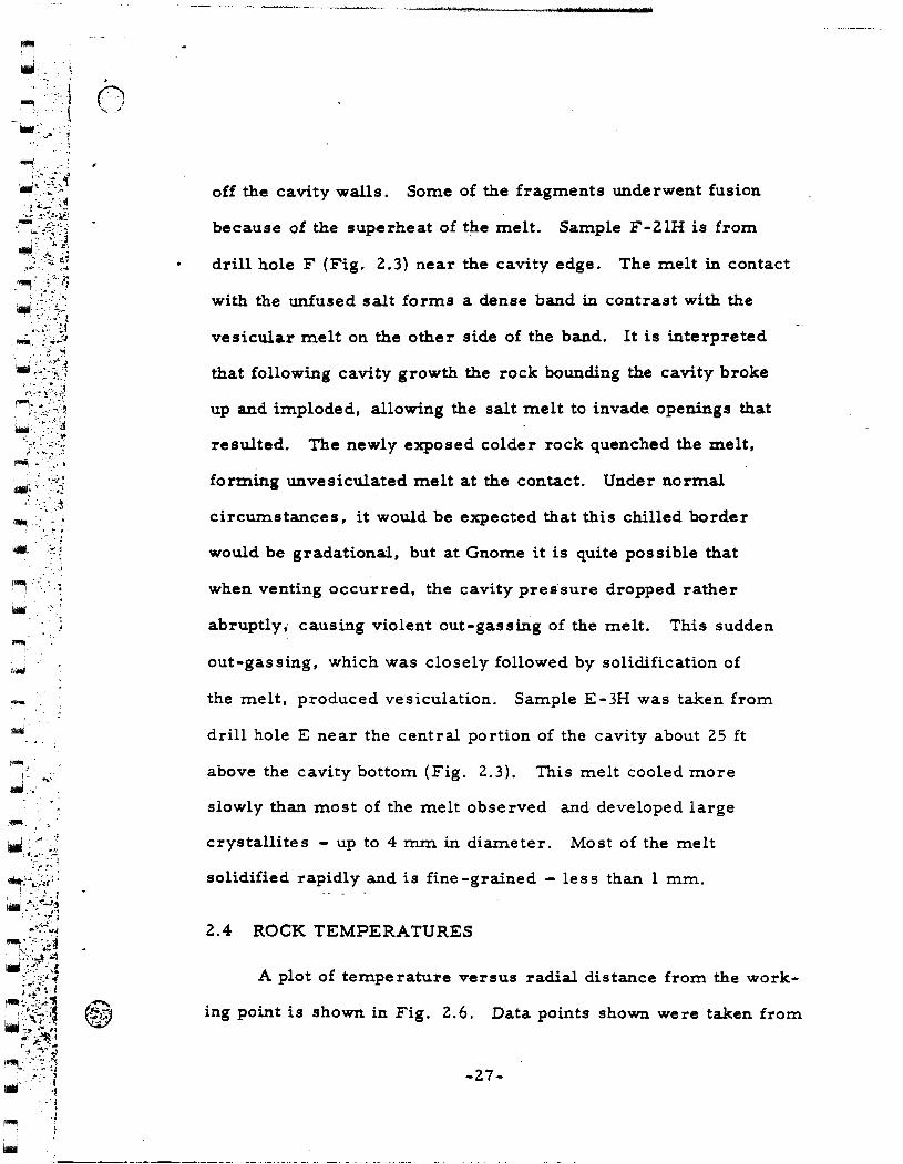
-
"""', [_
. l
__ ,J
~ ..... ..._.~ .
... '.
off the cavity walls. Some of the fragments underwent fusion
because of the superheat of the melt. Sample F-ZlH is from
drill hole F (Fig. 2.3) near the cavity edge. The melt in contact
with the unfused salt forms a dense band in contrast with the
vesicular melt on the other side of the band. It is interpreted
that following cavity growth the rock bounding the cavity broke
up and imploded, allowing the salt melt to invade openings that
resulted. The newly exposed colder rock quenched the melt,
forming unvesiculated melt at the contact. Under normal
circumstances, it would be expected that this chilled border
would be gradational, but at Gnome it is quite possible that
when venting occurred, the cavity pres·sure dropped rather
abruptly,. causing violent out-gassing of the melt. This sudden
out-gassing, which was closely followed by solidification of
the melt, produced vesiculation. Sample E-3H was taken from
drill hole E near the central portion of the cavity about 25 ft
above the cavity bottom (Fig. 2.3). This melt cooled more
slowly than most of the melt observed and developed large
crystallites - up to 4 mm in diameter. Most of the melt
solidified rapidly and is fine-grained- less than 1 mm.
2.4 ROCK TEMPERATURES
A plot of temperature versus radial distance from the work-
ing point is shown in Fig. 2.6. Data points shown were taken from
-27-

·: . .- • ~· 1
:.i !
·._-! .I ·I
.1 ~ .. -~.:
... ~ -~--~~
- :-i
..... _ • • ,r-:.._":;_:;1
~~:~~~-.~ i~~:1
.. _,; .J ' ' l . ' . ~
~· ··'~:·(
••
1"""1.
•
_.:.. ' ..
.· . ~· ·:
! l
'1
:- "l
...... ":' · ..
. ..._; .. ~.~ f'l"i•" _,.,_,;
~-'<:!:~ ~ ... ~
I...,
100~------------~---------------------------------------,
• I
I AVERAGE LOWER I HEMISPHERE CAVITY I BOUNDARY
/0. v 6 ~ I
~Ill!
HOLE • A o- B Q- c • D c; E c:; F
0.. • (STEM POINTS DOWN HOLE)
Q. 'G)
a.. ~_ .. ~BIEN!_ TEMPE_!!AT!RE_ ~ __ ~ I I I I
Fig. 2.6 Temperature vs radial distance from working point six months after the detonation.
temperature measurements made about 6 months after detonation,
in drill holes A through F. This plot indicates that the average
terperature was 71 o C in the rubble-melt zone of the cavity at
that time. Temperatures varied from 63 to 83°C in this region,
depending upon the elevation at which the measurement was made.
Maximum temperatures were recorded within about 1 m from
the lower cavity boundary in each hole that penetrated this zone.
The logs of holes B and C indicate that below the cavity,
at equal radial distances from the working point, and at equal angles
from the vertical; temperatures are 10-12° higher in a northerly
-28-
. - ~-~·---:--:--;--:-~--'""""'="" ------------··-. ---- . ·-·_:-f··;-:--:. ··-·
·~

-l~:<. I;_~;· j
- )::·-i < - .....
~--~-}~.4~: ~ ..__;. "1
'j~j t- 1
.. :·:·': .:.~ ·r:··: .. -·~1
f"!''1 >- ~ ,, :- .. .:..
L.J' ' -:· ·'~
... ;-
,,.., i
. ; ./
• , . .l . .;
. •, ·,
., .. ,J-'.
'· r,
"""1
-~- .: :;
direction than in the southerly. This asymmetry is consistent with
the asymmetrical position of the zone of highly-radioactive melt
described previously.
-29-
~-·-~-·-.---- ------- ...--·. . --...-.- ------ --- - --

~ I •
l.l
·" ..
, . .- I ... ~ -'~ .
" ., " .... ,.:,.
~ ."--."-: . ·- \ -- ... . '~
~ .• ~ < ·-~
~'-~-~- :·: ~., ·'
. - ---~·--~-~~~-~~----------------....... ~---------------~ ... •:.......- _____ . --. --- _ _,_ ·- - • .... ..:·_
CHAPTER 3
PERMANENT DISPLACEMENTS
3.1 GENERAL
Displacement of the material surrounding the Gnome explosion
ha~ been measured laterally at a distance of 298 m by gages in a
drill hole (Reference 6), and the permanent displacement of the
surface over the working point is known by surveys (Reference 7).
In addition, permanent radial displacements have been determined
from preshot and postshot positions of rock strata and other markers
such as instrument holes.
Preshot elevations of beds were obtained from the USGS litho-
logic log (Reference 8) and tunnel map (Reference 1). Postshot
positions were determined from geophysical logs of the vertical holes
and from core from the underground inclined drill holes. Pr-eshot
and postshot positions of beds are generally known within :I: 0.3 m.
The locations of instrument holes branching off from the main drift
were accurately surveyed before and after the detonation.
Figure 3.1 is a plot of the permanent displacement data obtained
by postshot underground exploration. R. - the preshot radial distance l
of a given point from the working point -is plotted against l/(Rf-Ri) 2 ,
where Rf is the corresponding postshot radial distance from the work
ing point. For convenience, a scale showing values for (Rf-Ri) is on
the plot and a theoretical curve drawn based on the relationship
-30-
"'" ---- ~---·--- --:---- ;~-----~ .... ~'"·.· ~"'"':"---~·-.:- ·-::_~·-~-~~:. ~--:..· ----:0:~
·- ~-- .

~
lllfll'. ·l • ,, 0 ,..: . ~
! (
i....J . ::·. ~ - · . ., ...
q·.;~ -~4/~:l~i
jJ. :;-~ A<~
•. <~·fJ ~---~- ~~:;· ~~
0~·~·.:;;~ -~ _ .. -~\:_.:.~i
~--. ~-~~ :~:~1
~·[-':;';r:; -~~>:)<;; _,_,.·~·,S
'• -~- .· ... -.·":-0-: . ·. -~· .'!_.:"*": ~~~~:_-~-~;~ •(~ ;;:;~
··-·
.. , ~ ···--;
·. '
~: ..... ~._
-., II: .., ... .... a -II: • 21 0 c ... ... z .., 2 a .., u c ~ L ., 4 Q
c
-- • HOLE A ---- • HOLE I • ••••• • HOI.! C ·-·-·- • HOL! D ---··· • HOU: E - -·-- • HOLE F
• DISPUCEMCNT OF ltM:-SHOT HOLD NILI.1.1,12,25 • VERTICAL HOU: JAW IELOW WP. • VERTICAL HOLE 3A AND 2A AIOYI W.~ A THEOitiTICAL DIPUCI:IIINT CUINI..AIIUIIES l..awnt
OF SPHERICAL CAVITY WITH 11.7-11 RADIUI AND VOID VOLUME OF 21,200 Ml
~ 0~~-~--~~~~-~~~~-~~~~~~~~~~~~~~~~
Fig. 3.1 point.
Permanent rock displacement vs distance from working
R = [ Rf3 - R.3] l/3 (Appendix C). In this equation, R is a theoretical c 1 c
radius of the void produced by the explosion. Assuming a void volume
of 27,200 m 3 resulting from the growth of a spherical cavity, R is c
equal to 18.7 m. The systematic departures of the data from the
theoretical curve are discus sed below.
3.2 DISPLACEMENTS SURROUNDING THE CAVITY
Permanent displacements of rock strata were obtained from
the records of holes drilled below the working point (drill holes B,
C, D, E, F, and 3AW). These displacements generally plot above
the theoretical curve for given R. values, indicating R is less than 1 c
-31-
._-.-------:--- -_--.---·_. - -··----~ .-- :-- .... ---- ---::".; -----

, • ·-··i
.. · . ~
... j r-'1 . :,· : ~--. :-~_.,;
~_(::~JJ ;~-.,.;,.~
.. -; -;, -;,~"=- .--::
;.:;f:t,J _.,; ... .f.j :r~:' -~~~-:~\~
' :····~ ~ .. c:. ..... j
~-~-{:~~~t~ :. .--~-~--: ~ ·:: .. ~~-~":_ :; ~
lilii!i ,' ~"
~- : __ ·-~
~~-I. -~~ ~-i ; ;
. '
. ·~ .. ;
~"'~~~,- ~ ~ -... :· -~~ ~
~ . · ......
·-
18.7 m in this region.
these data is 16.3 m.
The average value for R calculated from c
Permanent radial displacements of instru-
ment holes #3, 8, 9, 12, and 25 fall below the theoretical curve,
thus indicating that R in the equatorial region is greater than c
18.7 m.
22.9 m.
The average value for R calculated from these data is c
The displacement at 298 m was about 3.5 em at 0.5 sec
after the explosion, measured by gages in a drill hole at the
elevation of the working point (Reference 6}. The R of 21m c . '
calculated from this displacement compares favorably with the
average R calculated from instrument-hole data. c
Permanent-displacement-data in the equatorial region and
below the working point gene rally have nearly constant R values, c
and the slopes of these curves usually parallel the theoretical
curve (Fig. 3.1). Variations of R can generally be explained by c
differential motions of rock along fault planes revealed in the mining
and drilling exploration.
Applying the theoretical equation to the displacement data
obtained above the working point (drill holes A, 2A, and 3A), it is
found that R increases with radial distance from the working point c
and the slopes of the curves do not parallel the theoretical curve,
but are less steeply inclined.
These data indicate an asymmetrical distribution of rock dis
placement surrounding the cavity, implying different phenomena
above the cavity relative to the equatorial region and below the cavity.
This is further discussed in Section 3.3.
-32-
--.-. --~-· --- .- --- -: .. -------~------ ;:.::. __ ··:--~· . .,_ .. -- :·:,-~.-:--. ~ ._.

~.
~·--·. ·, ~·
,..--., 1-·. 1 '~J
3. 3 IMPLICATIONS OF LOCALIZED UPLIFT BETWEEN THE
CAVITY AND THE GROUND SURFACE
The asymmetry of the rock displacement associated with cavity
growth and subsequent rock motions may be explained in the following
manner:
A reasonable assumption is that the force resisting cavity
growth is about equal to the weight of the overlying rock. In Gnome,
the observed asymmetry in the equatorial region indicates· that this
force was nonuniformly distributed. The growing cavity met less
resistance horizontally, in the d.i.J"ection of the inherent weakness ~.-_.' ·-~(,:.
in the rock; i.e., bedding planes between various rock strata. Thin
clay seams between halite and polyhalite strata are most conspicuous
in that they form both structurally weak planes and lubricated glide
surfaces.
Immediately following an underground nuclear explosion, a
shock wave is produced by the impact of the expanding hot gases
with the confining rock medium. This shock wave travels to the
surface, where it is reflected back toward the cavity region. As
the rarefaction wave returns from the surface, the upper several
hundred feet of rock is spalled (goes into free fall) which also
momentarily decreases the overburden pressure. At that time the
compressed rock can adjust and much of the cavity volume is trans-
ferred from compressed rock into upward unloading and permanent
surface doming. Local cavity growth can also occur, since the gas
-33-
~......-~~------ --~----·" ---.-~--.. --· ,-- .··· . '
-·.·-.

~ I
r.J ...
~---.. !~-·...::. ;; :. ·. ·'!~ ·'.;
•• -1 '•') - ' .. _,.,
•. ·- -··
~ -~ . Y. I
~- ~-:
'""''
--·-~ -·- • t...... •· ••
pressure within it may well exceed the overburden pressure while
the upper few hundred feet of rock is spalling.
From the elevation about 105m above the working point down
to the cavity, the rock was found to be significantly more porous
and permeable than it was preshot. This phenomenon resulted in
circulation losses while drilling from the surface and was observed
by comparing preshot and postshot sonic geophysical logs. The
permeability is primarily associated with bedding plane partings
and extends at least 46 m laterally from the working point as
evidenced by circulation losses in USGS drill hole H6 (Reference 9) •
At the far end of drill hole A, Fig. 2.1, faulting above the cavity
was encountered in which the rock over the working point was dropped
downward relative to the rock lateral to the working point. These
data suggest that there was an inward sag or down-drop tL wards the
cavity of rock strata above the working point. The backdropping of
strata occurred for a distance of about 105 m vertically above the
working point. This movement is superimposed upon a general
uplift of the rock between the cavity and the surface. E-• ·,_ of these
motions are in addition to the rock motion associated with caVlty
growth that took place primarily during the first 75 to 100 msec
following the explosion.
Near the top of this permeable zone, at 85 m above the work-
ing point, where backdropping of strata is minimal, the difference
between the 6R (i.e., Rf - Ri) on the theoretical curve (Fig. 3.1)
-34-
------< .... __ -. -.· ...... --- .. ---.-. -- ·-·--:.-· --------:- ....... ~ :-:. .... -~---:-~·-... · ··:-_!'·-:: ;·-.-.--::-···._? ···---.·· ·--------·-------...
. '
-~ .. -; 1 I . ~

~ .. r.·~. ·: i !""""'\ .... '· .... -~ \ .. ~~
~-./
!'IIIII· . i i ·:-_. . '-·~- ,··.:
i.lo.tl ... \ .. : .
;
.• .., .... · ..
.~ ........ !·"' ·' . .. •:
. -:~ . }'
~I
and the AR shown on the curve from drill hole ZA and 3A data,
is almost 2 m. From the existing data, a minimum of Zm is the
best estimate of the magnitude of the uplift of the rock up to 85 m
above the cavity that is additional to the upward deformation
associated with cavity growth during the first 100 msec.
Uplift is probably a little greater in the rock immediately above
the cavity since gross permeability and associated porosity increases
were ob~erved as high as 105 m above the working point'. This
amount of uplift assumes a ma.x:i.m.um initial cavity radius R of 18.7 . c
m prior to uplift (see Section 3.~). --::-~--~. ·- -~-- t=>.,_~~::~~~-~~~7.:~;~. "" ' . -<f - . . _ _,.;...~ ... - . .
Doming at the surface was spre-ad over an area about· 360 m--
in radius (Reference 2), and had a maximum permanent vertical
displacement of 0. 6 m. The uplift of rock near the ceiling of the
cavity represents only a small volume increase relative to the total
cavity volume or the volume represented by perm:anent surface
uplift. Further evidence supporting the hypothesis that an uplifted
plug is formed is given in Section 4.1.
The cone-shaped uplifted zone shown in Fig. 3.2 indicates
that a possible effect of backdropping of some of the rock is to
tighten up the arch over the cavity, rather than weaken it. This
process may have been important in producing cavity stability.
The lack of a significant nwt?-ber of open fractures above the cavity
to interconnect the preshot structural weaknesses in the rock is
very important from a radiation-safety point of view. The radial
-35-

1"""1 .. ·~. i.
•••
.. , .t·.:
- - _. __ -_ -- ,.·:;:- . ~ ~- .
USGS-6 LRL-2A LRL-3A
DOWN
---COMPLETE DRILL FLUID CIRCULATION LOSS
\
APPROX I MAT.::.E _ _..,_ BOUNDARY .
OF LOCALIZED UPLIFT
t /TOPOF SALT
--------
----' .::: ' ZONE OF GROSS -y, PERMEABILITY
- INCREASE - I
---- I --I --I I ,
I
· T0-394m PROJECTION OF LRL HOLE 3AW
TD-423m
0
0
FEET 100 200 :300
25 50 METERS
100
TD-450m
Fig. 3.2 Vertical section showing configuration of localized uplift.
-36-
- .-. - -.----~- -·--.-.-. --. :-:-· ....,....._,-.--~:-_-~ ....... _ ~~~-~--::- ---- ---· - 7:. :---.,.-·.- ••
. .. -~; •· ··-o •• -.·_...----·-

. ~' '
~··::' .•. ·.·~ ,. -.
t'_ ., •• _ .....
~" ... ;,_:
.J·' '.'
fractures that were produced by the explosion were filled. with melt,
sealing in the gases.
3.4 SUMMARY OF CAVITY RADII AND IMPLICATIONS ABOUT
"BLOW -OFF" OF THE CAVITY WALLS
As pointed out in Section 3.1, R is the radius of the theoretical c J
cavity void. The void produced by the explosion is equivalent to
an 18.7-m-radius sphere; and the average value of R below the . c
working point is 16.2 m, contrasted to an average of 22.9 min the
equatorial region of the cavity. R above the working point cannot c
be greater than about 18.7 m and be consistent with the measured
cavity volume. Table 3.1 summarizes values of R , and compares c
these with the final cavity radii defined on p. 17.
TABLE 3.1 THEORETICAL AND FINAL CAVITY RADII
COMPARISON
Rc, Radius of Theoretical Final Cavity Cavity Void (m) Radius (m)
Range
Below the working point 12.5-21.9 a
Equatorial region 21.0-26.2 b
Above the working point Maximum
a20 data points
b 1 L data points
· of
c 10 data points
d25 data points
-37-
Average Range Average
16.2 14.9-19.8 c 17.4
22.9 19.5-30.2 d 24.4
18.7 20.4-27.1 e 22.9
e 15 data points
-~~-----·· --~· --r~,. :---.•·--....-.·•~---·-.·--• ..,--·-- ---:--:.·-.--- ·-:··~--- - - ~ ··- . . .. - -~· -. '

~ I '·· .• ·•·,
--·':·· .. 1
·_ •* r-, .. . 'i l . -... ; ... :-' 1 . ··:
~~~fL~~ .· -~ -~- -~-: ~~
j··l:.J~~ ~\: ~::~~~:
;" ' { . :.,._ ~ --~ ',;-: :"·
·- ·.-i ~-: --~-~
.J. -~~- J ~--- ·-.···· ~
"""' ' .. ~ ... ,.·.
I -
,___ ____ .......,.. __ ~-- ----- ......
Much of the variation in both R and final cavity radii shown c
by the range values in the table can be explained by observed differ-
entia! movement of rock along fault planes discussed in Section 4.3
on rock deformation.
In the region below the working point and in the equatorial
~egion, the difference between the average radius of the cavity
void (R ) and the final cavity radii is about 1.2 m. It seems probable c
that this thickness represents an annular shell of the cavity wall
that breaks up, decrepitates, spalls, or is imploded into the cavity.
Thus openings develop in the rock bounding the lower hemisphere
of the cavity and the fluid, radioactive salt melt invades these open-
ings. The extent of the melt defines the final cavity boundary. This
annular zone is called the "blow-off" zone; it produces the rock that
blows into the cavity where it mixes with and cools the melt. As sum-
ing that the average thickness of this zone is 1.2 m surrounding an
18. 7-m-radius sphere, then about 5.6 X 10 3 m 3 of rock mixed with I
\ 6 about 3.2 X 10 kg of melt in the rubble is "blow-off" material from
I
the cavity walls. The difference between 5.6 X 10 3 m 3 and the esti-
mated total rubble volume is 11.46 x 10 3 m 3, which would roughly,
be the amount added by ceiling collapse into the cavity. Figure 6.lb
is a schematic drawing illustrating the "blow-off'' phenomena and
the various dimensions discussed above. Appendix E is a further
discussion of the rubble distribution.
-38-
,-:>-<--·-:-T--~--~- - - .... --· ~---~- -~--- -.-·· --~ -- - -· --,:-~·-.---·· .•, _:t- •.
-~. _.

--.r~ · .
. ··-~ R . ~ ... ' '<:-"
. , ·~~~-~-~-- ----~~
·"'-- ..
- :
~ . •• < ~ -- .. :.
. -·-·· ·-··-···· -~~· ··---. ......--------------------------
CHAPTER 4
FRACTURING AND DIFFERENTIAL ROCK MOTIONS
4.1 LOCAL UPLIFT OF STRATA OVER THE SHOT POINT
The existence of an uplifted region over the shot point was
inferred on the basis of permanent displacement data and a mech-
anism for its formation was discussed in Section 3.3. Additional
evidence pointing to its existence and crudely defining its shape is
discussed in this section. Figure 4.1 is a map of the ground-surface
I
~\
O··~I0._2.S~===5~0._ ...... ~IooMETERS
Cl 50 100 200 300 FEET
APPROXIMATE BOUNDARY OF LOCALIZED U~IFT
X USGS HOLE No.6
I
Fig. 4.1 Map of Gnome ground surface showing fractures and approximate boundary of uplifted region (modified after Fig. 4.2 of Reference 2). ·
-39-

-' !"''Il- !
I. ; "·· ·.-·. -~ fiMj
-t . . :.~ ~
.~-~-~~·~:-~~:;] i .• J - ,r .1 •'""·':':~· ....
/~)~~~] IIIII· -~ "- J : I· - , ., ~ ---~:- ·; ~
~~- i ~~~ ~f~ '!
:~;~/;:~~j
:.,.>::i . \..\ ... _ ...
·-' - "'.-.
r'""" • ~;
~: ·-,:·_ '
·-1'111111
I .. ·.;
. ~
"""' -.1
-----------------~~~-----_-__ ... _.--------'"'c.'"'-----·--·--·-~.------~---~------~----
fracture pa~tern produced by the explosion as mapped by Hoy and
Foose (Reference 2). Figure 4.2 shows permanent-displacement
profiles of the ground surface along Section AcA2• B(B3 • and
c1-c
3located in Fig. 4.1. As these profiles show, the surface
>: Q. c a: est 0 A. 0 ... s : . ., = 0 A.
• ... f z ... ... !II ... ILl CD ILl u z ILl a:: ILl II. II.
0 > ILl ..J ILl
I PROFILES CONSTRUCTED FRO.. 1
HOLMES a NARVER DRAWING : /'"\
No ... O.IST /1 • ,./· : \
~ ., ·- /f ~·"\. ~',
• 1 {)/ Bzj;t·: \. ........ " 1•z .I 0.4 :a / • • ...._
.~· / )-. " ---·-, -· I : '- · · · ·, ---4 ( .) I " ' ,' , I / • " . ..
B L .. f> czJ;,· " ' r·} -I !• ~· ·, ',' e3 ---·--- _,... . .-- ~--~,
cl ,:;.-.· --~-~ ~~ ./ . '3 . ..........__ ---0 0.1~ ·~ ·-
,. 7!5 SO 2S 2S SO 7S 100 METERS • ---.-
.a
0
----0 300 200 100 100 200 300 400 FEET
HORIZONTAL DISTANCE FROM SURFACE ZERO
Fig. 4.2 Profiles of the Gnome ground-surface permanent displacements showing the uplifted region configuration (see Fig. 4.1 for plan view).
doming is not a smooth arch, but there are locations of abnormally
large uplift or differential rock motion within fairly restricted zones
(A1• B 1• Az• B2
, etc. ). It is. suggested that these zones may be
the locations of the boundary of the uplifted region. Figure 4.1 shows
the trace of these boundary zones based on the survey data and there
-40-
-- ~ ---:-~- -··":-. -_-. -.. -.----. -·.- -~- -·- --- ·:- -..---=--- ·-~· --~ ~,_:-:.
'j
.\t

~ I , ·- .. ,j
< ,
~- i
l.r::~ ·:
. f.··-;:, " .. · ... •·.
-~· ·.'· .. .-_...;, . ' .'
~:: ____ :·_.: -•• -1
!"""i -\
..~.. -~ ' "i
: -~- .'
'""''. ~----:
. '
:!--·: .. ~~ \iaiJ. - .. · •
~-)
. ...-,._ 'c -1
·--~
•
is a parallelism between this trace and the trace of observed surface
fractures.
The USGS drilled vertical hole #6 at a distance of 46 m from
surface ground zero. This hole encounte~ed fractures at depths of
122 and 183 m from the surface (Reference 9). This fracturing may
be associated with the boundary of the uplifted region. This boundary
is probably broad and diffuse consisting of slightly folded strata. and
some shear fracturing. There is no evidence indicating that
uplift though localized permitted leakage of radioactivity from the
immediate cavity environment.
4.2 MELT AND GAS INJECTED FROM THE CAVITY INTO
FRACTURES
Irradiation of rock salt results in distinctive yellow, blue,
and purple coloration. For this reason, areas where radioactive
gases were able to permeate are detectable even though radiation
levels in some in'stances were near background at the time of explo-
ration. Molten salt injected into cracks from the cavity character-
istically is black and contains varying amounts of radioactivity.
Using these color criteria, it was observed that above the working
point, both gases and slightly radioactive melt permeated a distance
of 38 m from the working point. This is rather surprising since a
zone of greatly increased permeability extends vertically to a dis-
tance of about 105 m. Because of the infrequency of melt injections
-41-
~--· ... ·-=- . -·-· .•... ~=---··--· ..o;-<··-... ..., --- "'': .-._,--·--.----- ·" ··: .-..•:: •, ,a "' 'I - •• - • • ~ -.· " . --:;' ~-' 7' ··, •·7
-·.·- .. :

.. _·,
~ ~ .. · . ~ '·· 1M ... ·._ :
·_. ·• •I
-.. , -~ ~--_.:
i ••. : -~:
~---1"""1 - .. -I I lilt ..
. - ~
~ '·
id· -- ... -.. '
-- ............. ----------~.~--. --------~--------------· -, -· - - ...... ·----- '..L-... .• •
LEGEND - Fig. 4.3
A. Echelon tension fractures resulting from movement on major thrust fault. Probably extend full length of "buttonhook drift.''
B. Voids encountered· at this location.
C. Major thrust fault associated with closure of the ''buttonhook drift."
D. Abrupt termination of radiation damage at tension fracture.
E. Approximate postshot boundary of left rib of "buttonhook" _ indicated by extent of melt and rock breccia.
F. Approximate extent of major tunnel closure.
G. Encountered water leakage from polyhalite 194 from this point to end of drift.
H. Location of accelerometer. that failed at 16 msec.
I. Major overthrust fault with maximum observed displacement of 3m (see Fig. 4.6a).
J. Postshot location of sand bags in hole #25 alcove.
K. Sheet of radioactive melt injected along a parting of clay beds.
L. Preshot location of hole #25 alcove.
M. Pre shot location of ''buttonhook drift."
•
-42-
- ··~.~.:~----~--~-·-.----:--- ... ----- -- ·-·':'-- _, -:-.
•

'j I i j
j ·I I
·'
L 1 . ~::_~]<:. ~:_:-r : . .::::i: ', 1 _j ( _ _]_ ~:_ j
... ~--.. i;)~,~~:~~~t:t~li{!:ji&~i--::·;~{·:~f~;>·~-~ .. (.· J ·. ·• ~: •.•• ~' . [ ]
I ~ w I
~,,
t) . . _.
NOTE: DATA SHOWN NORTH OF REFERENCE LINE ARE PLOTTED AT ELEV 676 METERS; DATA SOUTH OF THE LINE PLOTTED AT ELEV. 67~ METERS.
MAIN POST ·SHOT
BUTTON HOOK EXPLORATION DRIFT--
PRE-SHOT EMPLACEMENT
[ _j L J · [ -1··· .( -1 .-/,£-1 ·.( -J ·, L-1:' .-_:::... I_~ J ·, £_1
. -·: ·. ·_.. :·-_-·x~--~.·,::c~;z;~:~i::.~~~~-~;~~L\..J(~;;:._; .. .i:ELj~~~t-·.:,:i.· .:· ... \;: .. ~~ . .:- ~. ~ ~-
G'
VENTING PATH W.P. REFERENCE LINE
WALL
LEGEND ... RADIATION DAMAGED SALT .......
-MELT 8/0R MELT-ROCK BRECCIA
---~---FAULT DIPPING 60" S E EXPLORATORY DRILLING ALCOVE
SCALE
0 10203040~0
FEET
0 10 I~
METERS
Fig. 4. 3 Rock deformation revealed by poatshot mining plan view.

. .. . ~ • 4 ..., .c
llllll ..
.~- :. ;·: ·j I . ·_•. ; .. .. ~
~ ~~-= -~ -.. ,-~~~ ~--~,;::·~.:~; · ... _..-·-:
. . ~
. '
. '
and radiation-damaged salt encountered in exploration of this region,
the relatively short vertical extent of these injections above the work-
ing point, and since the amount of radioactivity in the injected melt
is much lower than melt encountered within the cavity; it is concluded
that the open fractures communicating with the cavity developed
early during the dynamic growth period. Injection at this time (10-
100 msec} is likely because good physical mixing between the molten
rock and the vaporized fission products would not yet have occurred.
In the equatorial region beyond the cavity, melt was observed
. as far as 40 m from the working pomt, and evidence of gaseous
injection was observed as far out as 65.5 m. T?ese distances refer
to melt and gas injections that are believed to be unrelated to the
vent path down the line -of-sight emplacement drift. Melt was injected
into a clay parting along the line -of- sight emplacement drift to a
distance of 58 m from the working point, and melt was also in the
drift as far away as the concrete block stemming (Fig. 1.2). Cracks
from this drift were also permeable to gases. Figure 4.3 shows
the fracturing and the distribution of radiation-damaged salt and
melt injection in this equatorial region.
Pre shot hole # 12 was explored to recover an instrument that
failed at 16 msec (Reference 6} following the explosion. It was found
to have been located in a region of anomalously large rock deformation
with accompanying radiation damage in the sal~ and water leakage
(Fig. 4.3} indicating permeable communication with the cavity. The
-44-
---•-----c·--- -;~.........;--~-.. -. -;----..,-.- -.-,--··- ---·· ,.---·~-- ,,. ·,.-- .. ...... _,__. ----- ...... --··- .
.:·-~·-.-~~~~-:.: . --.- -..... _ :·--· ,__ -~ ......... _..,._- -· .. ·.-..--:•::-··_"L. ___ -·- ----=-. ~- -
~ ..

.. ·~· :~··
. -~
, f . ~ ·.a ·).,
• > .. ' ·· ... ··;
' .,
.. ;.,
'"'""V ... ~ i ..: •• •
~ _.,~
~ W_;''<_~; :':~J'-·/~i
' -··:~::; ~-.7.
! 1 I ..
n, \.;~)
6l .. ---...
~
~
early failure of the instrument, coupled with the intense local defor-
mation and its associated permeability communicating with the cavity,
indicates that the fracturing started at about 16 msec, or immedi-
ately following the passage of the compressional shock wave. The
cross section H-H'" (Fig. 4.4) located in plan in Fig. 4.3 is a
detailed map of the deformation at the end of the hole 1HZ drift.
H
SCALE 0 Q.l 1.0 I.IMITIRI
LEGEND
POLYHAUTE MARKER BED No.94 AND BASAL CL.AY
RADIATION DAMAGED HAL.ITE ROCIC
PLASTICALLY DEFORMED HALITE ROCIC
SHEAR PLANES INTERTWINED ROUGHLY PARAL.LEL TO BEDDING. (THESE PLANES WERE PERMEABLE TO RADIOACTIVE GASES)
H'"
Fig. 4.4 Vertical section H-H"' showing deformation at end of hole # lZ drift (see Fig. 4. 3 for plan view).
Note the local d~wnward motion of rock unit #93 through and mixed
with that of the lower rock unit #94. This is very intense defor-
mation at a distance of 65 m and compares with the intensity of defor
mation associated with closure of the 1'buttonhook" drift at a distance
of about 30 m from the working point. The possible existence of a
-45-
....,....~"""".........-- -- ~-------:--,-~'1"----· .... ' ---·: ·---- ·-.·- .... -· ... - ..... ·. ~-. -· ........ -·-:•. ~-

- . ~ .-. . . ··I ( •
!""'~ ~ :: -·: .J·.: . . - ' . -~
f""'! •
' i illill
~-. I •. ~-
~ -~
' I
~
. ~ .,
..• ! •. _.·_- -··-
natural cavity in the salt near the instrument location that was col-
lapsed by the shock wave could be the explanation of this deformation.
Such cavities are known to occur in the Salado formation (C. Jones,
verbal communication) and are generally brine-filled. Figure 4.5
also shows the anomalously large radial displacements in that region.
' ' ' ', --' HQU JCI.rl: ' \
' ' ' lo.,
LEGENO
------ POSTS1C1' ICtLf I..OC&TICINI SNOW LDCATIOJII CW SlHIVEY POINT
SCALE
lO 00
Fig. 4.5 Displacement of underground instrument and shock-study sample holes - plan view.
Exploration along the postshot location of the "buttonhook" drift,
Fig. 4.3, encountered nonradioactive melt that was injected into the
open drift and was then caught up in the rock motions as so cia ted with
the drift closure. This relationship again supports the thesis that
melt and possibly some radioactive gases escaped from the cavity
-46-
····--· ---~. ---:----~:.,-;---·~--~ ... --~-~---~~----------- __ .,.. -----:--- ·---.- ... --. ":c··
:. '

·l
) -~ ·., ' i. iliri
·~_·_.;,_.- .-_"' • .• · t~ ....
1 . ~ · ... ~.-~;
'""' i I -
-~
..... -,
. . ·-~
~ ~- :~·
~
0
primarily during dynamic cavity growth. An exception, of course,
is melt and gases that vented into the emplacement drift.
Below the shot point, neither melt samples, radiation-damaged
salt, nor radiation levels above background, were noted further than
25 m from the working point or 6 m beyond the cavity edge.
4.3 DEFORMATION SURROUNDING THE CAVITY
• Fractures resulting from the expanding cavity produced by the
explosion and subsequent fracture development associated wi~ unload-
ing of the compressed rock can be grouped into the following four
general categories:
( 1) Radial tension cracks emanating from the cavity;
(2) Peripheral faults with planes that generally parallel the
cavity boundary;
(3) Bedding plane faults;
(4) Near vertical joints primarily in the vicinity of preshot
emplacement drifts.
Figure 4.3 shows the projection of the traces of major faults,
and joints at the elevations of 674.8 and 675.7 m that were revealed
during mining exploration. Figure 2.1 is a reflected ceiling plan
of the interior of the cavity showing the traces of major radial cracks.
These cracks (type 1) occur with a frequency of about one every 4
or 5 m at the equator of the cavity and extend to a distance laterally
and above the cavity of about 38 m. These are the cracks containing
-47-

~ . . ., :
~
r i.-1 I
-· 1
flllilll - .. :.- .:
.... :..:- -..-..- ... . -~- ..
injected melt (see Fig. 4. 3 in the region of the "buttonhook drift"
and the vertical section Fig. Z.Z) .
.Also sl:own in these two figures are the curved peripheral
faults.. Below the shot point in drill holes B and C, the peripheral
faults (type Z) are inferred from the attitude of fault planes in the
core relative to the orientation of bedding planes. In the vicinity of
the drill alcove (Fig. 4.3), this type of faulting grades into overthrust
faults that further grade into horizontal bedding-plane slips along
clay seams. Figures 4.6a and b show.s examples of this kind of fault-
ing .. The throw or differential motion be.tween blocks was measured
to be Z.S to 3.0 m across the fault marked (I) in Fig. 4.3. This was
the largest fault observed; most differential motions are on the order
of 0.5 m or less .. This peripheral type of faulting does not contain
melt injections and is probably formed after cavity growth when
unloading or rebound adjustments to the stressed rock are likely to
take place. Associated with these curved faults emanating from the I
\ re*ion below the cavity is a gentle upwarping of the strata in the
equatorial region. Marker bed #94 which was located a few meters
below shot point became uplifted from its preshot elevation out to a
distance of about 64 m. Beyond that point, the vertical displacement
is not measurable. In the drill alcove polyhalite marker bed #94 was
uplifted from 0.3 to 0.6 m instead of being depressed. This bed was
located below the working point elevation prior to the explosion (see
Fig. 2.1).
-48-
·- . ._,. ... ~ -,=--··.---. _,_. ---.... -... ":---------·--.... --::--- :-_·---·--.. -.-------..--~ :-··· --

·.--:,. ... -. .- -.-~ ~ ..... . ' I .•.• ~ I ~ r. "\
.r::::J·';
~:<:·.~:; ~- __ _,
~-: .. :~~:~~ -~.:~:.:-~--;~ .. :
0::'<:1 ~ ...... ·•;
•• :"'"".-'i ..... -- ··.,, ~ .~ ... · -. ·,· ~. ~·
(a)
M\- .. - ·<
-· . . :
. '
~ .. _·.
(b)
Fig. 4.6 Typical faults produced by the explosion:
-49-
. ~_,....._:--·-·_---------~ -"'"- -.~--,.----- .. - .... -... ~----- ---- ----.- -..... .

r""''
. ·' :~
.·:-:.-•
~-/~~.->~~ -~ _:(~}:; . •· '":'"':..;. ~
~-:- :-~~~'>:: ., . --~-: ·.
illllll : ,.:, ,-~ . "' .... . ~
· ... -:-:. ·~
~,.._ :~!-_ .. !
y .. , ·.l::· • .. ·"'··-- ~- -:::
••
#
'
.; ... ~,"-, ···:·
-'~ ~;-1
,:~·-,:·/· iral~ . _:·.: '
": ~ . .-,; .
. -r ~ .··-::.,
;:.:~~
~-~. it!~~. : :::~;~ ......
. . . ~ ~- ....
The near-vertical joints are primarily associated with defor-
mation in the rock near the line-of-sight portion of the emplacement
drift. These joints form two distinct sets that intersect each other
in a criss-crossed or trellis pattern. At a distance of 60 m from
the shot point, the joints intersect the line of the drift at an angle of
about ZO •. Close to the cav:ity edge this angle has increased to 75 •.
Figure 4.3 shows some of the major joints mapped and Fig. 4. 7 is
a schematic drawing illustrating the trellis pattern of the joints and
fractures associated with the line-of-sight drift. If this idealized
10
REF. LINE PRE-SHOT EMPLACEMENT DRIFT----~
Fig. 4. 7 Plan schematic of trellis fracture pattern associated with deformation along the line -of- sight emplacement drift.
-50-
- --------------- ---· --.--- -------- .... --- ~ . - ')•' --- - --·:--:'!"~-•. - .. --":'-· ="' -:-·.-- -- .. -:-..-- ·.:.----·:-..l_\ ••

iJ!'II •.
-I ·i i
----,
~<-:< I , .;, ' •,
IIi(· . ..-:j ... , ::.;..~~t>:-"'~
~:~:: ·_~;': . , -;,:," ..
~ . . -' ...,-
.: , .• 1
r""'! .. •
~----
- .. '· ...
""'\-·. . . ·-~ '
.I .. '-~ ~ "4
_-j
!f'lllllll: .· •••. _ ..
interpretation is correct, it indicates that the rock bounding the drift
failed in shear as the compressional wave passed and subsequent
cavity growth distorted these weak zones .
4.4 DEFORMATION OF THE PRESHOT EMPLACEMENT DRIFT
In addition to the trellis pattern of fractures associated with
the deformation of the line -of- sight portion of the emplacement drift,
the drift was noticeably constricted by plastic deformation. Cross
section E -E' (Fig. 4.8) located in plan on Fig. 4. 3 shows the ~pprox-
imate size of the postshot emplacement drift at 53.3 m from the
wt)\.·~t'com}iare·a to its preshot cross section. At this distance,
the drift apparently squeezed nearly shut prior to venting and was
RADIOACTIVE MELT
ELEV. MI!TtRS
678
I I
I I I
~4~.~.~!:~=}-~i~--~.----0---.~0~~~~~~ ,
0 ~ 0 0
APPROX. POST-SHOT
I CROSS-SECTION HOLE No.3 EMPLACEMENT DRIFT
POST-SHOT EXPLORATORY DRIFT DRIFT
0
e:J ROCK UNIT No.90-CLAY
eJ ROCK UNIT No.94-POLYHALITE
METERS I 2
SCALE
3
PRE-SHOT ELEVATION OF MARKER BEDS
Fig. 4.8 Vertical section E-E' showing partial closure of preshot emplacement drift (see Fig. 4.3 for plan view).
-51-
~ - ... ,.- - .. --. ".. , .. - --- .- ":'".

- I
' ":-J
.:;..
--
~- .,-1 - . ' .. ,- -:
:~_ .. · ~":
~:_-::~' .. :·' - . ,. . . ~. • .:. ·r
~·;_·11;··-;;·~~
..J··_</r:; -·: . : -,: __ -~
1::-:/L~~
~~-~~-~.i . -~ -~ ... :i~i
- • j .. '
!..I . i
1 !
- ---------~--"·~----------------------------
then blown open to its final shape when venting occurred (see dis-
cussion on Venting - Chapter 5).
The curved or "buttonhook" portion of the emplacement drift
sealed effectively and was not involved in the cavity venting process.
The explored portion of this drift was tangential to the shot point
rather than radial (as was the emplacement drift in the previous dis-
cussion), and the nature of tunnel closure was quite different. In the ':
line-of-sight drift, ineffective closure was accomplished by plastic
flow and slippage along the trellis fractures. In the 11buttonhook"
portion of the drift, the radial component of the outward moving,
compressional shock wave met the drift at a right angle and virtually
slammed one wall into the other. More precisely, the closure was
accomplished by the movement of a wedge-shaped block into the open
drift. The boundaries of this major block are partly controlled by
clay seams in the rock that appear to have lubricated the movement
of the major block. Figure 4·. 9 shows two eros s sections illustrat-
ing the detailed structure of the deformation; their locations in plan
view are marked in Fig. 4.3.
In the vicinity of Section G-G •, radial cracks following the
compressional shock w_ave opened up, allowing superheated melt to
enter the drift prior to its closure. Here, the melt was mixed and
trapped with the rock moving to seal off the drift and it formed the
matrix of a melt-rock breccia. As it was injected into the drift,
the melt encountered lead bricks and wood in an instrument alcove
-52-
--. ~ __ .;_ ___ ~_. ~ -- . -,-:.- ~---"!"'--.-·
-: ~-~ .. ._ ~

l.l
i I
.i
I
.. !l:: !-';:. ·:•-.- _j > .~ T~l·. ;·~:.'·.:~·· .I .. I_ J I J •. J ··; ·.' ~: -~: :~s~s"~ ~· · ,~'._;! '-~ :·. :: ·:·:;·;:::.!.~.?i):/:L· :~ .... -~ .~ .. L .. ~~-~~ L
L J. 1 .. , ... -'-~····· I ... J, .1. ~ l .. l :. ' ··,~ .... ·~·:: ... :.~.f.~· .. ~ 1!·. ~ -·/ .• :-:; . .-~·:::; ·,·:::::::.: ~ J : ,:
I. J ( ' 1' .. 1 i. J
..... .,_ ........ ,;~w .. ).:;.J.".!-•·.l..:S.t~t ........... , . ·~ .· .... . ... " ~ . . ) . •.. ~ -... ''
I Ul w •
@)
ELEV. (m) 678
oo•ooooo ooooooooo Oo --- - ..._ --- .... --- - .@_~Q._g_ ~D~- _a_-,:J. < . J1'-x-w.- x-x-•-x-x
677
676
675
674
673
G
677
676
675
674
673
EXPLORATORY DRIFTS
-~-1~1-
o • • o_ 4!..! •-!.. o o _ • .J'; ---- - ,e~~ooooooo!.C!."'""',.. ' -x-x-x-•-x_ ----- x ~~
)(_)(_)( __ , XPLORATORY DRIFT
1
dJ: ~
MELT BRECCIA MARKING POST-SHOT BOUNDARY OF BUTTONHOOK DRIFTS.
LT a SOOT-COATED BLOCKS
LT a SOOT-COATED VOIDS _ • - :_ • • - • -·-·- .,.,.,....·oo..a . - . .-- -. _.. .- • a ,a-.-. ,_.,.. -·-· a c -· ·-·-· .__.. • ....-.:,; P t:l !:!.o...-·-· --·-·gc::Jt:l_ .. -. a. • .2 • ...- • - •
CONTAINING MANY ROCK FRAGMENTS -92 a A FEW OF No.82 -89
G' .o ..........
o•?"" _,9-/
Cl>o,!'~'~ liC/ ~ ....... .......
-..... • I I • • I • No.ao: • • I •
I
•-"'
. ·-- /i -·-· --· _.... ,. " 0 _.... .,.,..... . -· . ··-
CAVITY ALL
--~RE-SHOT LOCATION OF BUTTONHOOK DRIFT F .. -· .• .. t:' Fig. 4.9 Vertical sections F-F' and G-G 1 showing closure of "buttonhook drift'' (see Fig. 4.3 for plan view).
(~ •. '..J

~- .: -•: 1.1 - ,· '~
' I ..
off the drift. The lead melted and the wood burned mixing with the
salt-melt breccia. Analyses of the melt breccia shown in Fig. 4.10a,
b, and c, indicate that lead combined with sulfur and chlorine from
the melt to form galena (PbS) and laurionite (Pb [OHJ 2· Pb[Cl} 2)
(Reference 10). The laurionite was probably formed by the reaction
of water dissolved in the salt melt with PbC12
. The sulfur necessary
to combine with the lead was probably r~leased by a reduction of
sulfates associated with the molten salt. Hydrocarbons from the
burning wood created a reducing atmosphere. An alternative ex:pla-
nation of the formation of the melt breccia is that it was produced
locally in the drift by extremely high pressures and temperatures
developed from the dynamic conditions of closure. The hypothesis
of melt injection from the cavity (even though it is nonradioactive)
is most consistent with the relationships observed. Some of these
relationships are as follows:
1. Voids in the same region are coated with a mixture of
soot, lead, and fused salt (see Section G-G' of Fig. 4.9);
2. In the breccia, insulation was still on wires and shock
* produced Neumann bands were not found in recovered steel samples
that had been intimately mixed with the melt, indicating not nearly
high enough pressures developed for melting;
* Neumann bands are characteristic deformation features in steel caused by intense shock or impact loading.
-54-
------~-~-· -- -------- ----~---;~.._.. ;.-~-:-~- .·: :~ --~---::-.~~~--;:-:·
.. . -:· ~-
, .. · . --.....-:--- ... ------~- ... -:--_~ ---::----.··· ~\(, ~ .... --~
-.

-..... 8
. ,_,,__ . -~·
·· ..
-~, .. ~--'·.: .. ~ .. ·-._,.
(JJijf ~ ~\• !_ · . • • . :. •"i .
--~·-· 41 . -~- . -.... ·
~
~- i
!'IIIII -11!111\
i.J
!"''Il
.i
1'!1'1
~-
~~-· .. :-i!
•2_.:,:~:~ . ·'
~;~'\.~ i. ~ : ..... ~ '
-~~::, ~:~ ~~~-•·
d;t~ <~{:fffi - .1
-~--~-- -,.--.. ---.------ •, -·-:
-~~-:- ·---e.·
.·_;:~~:--~. :..:: ....
Fig. 4.10
(a)
(c)
··;j~lPi 1 ·ti•''HPi
··C.J
Intrusive melt breccia.
-ss-

ai' '>-j . . ·:- -· -~
. --·· , .1<!011 ·. • •. ~l . •. ,. ;.' :-.:j Iiiii • .. ":··
·*! ~-1 #·:-~.~----~
' ... -1-._ .. _. i l.i.l . . -· '
. ~ . t. ~- _· ~-
··• , . 1
~ -· 1
3. The percentage of melt, lead, and carbon in the breccia
decreases from that located in the vicinity of cross section G-G'
until absent from the breccia in the vicinity of cross section F-F'.
Most of the matrix of the breccia is clay at that location.
4. As shown in Fig. 4.2, the preshot size of the drift was
large where the alcove is located compared to the rest of the drift.
This portion of the drift is also nearest the shot point and thus a
logical place for cracks to open to melt injection from the growing
cavity. If the melt was injected from the cavity into the cracks
. - ;.. ::;.;;..-..<~-:-' ~--- ... . ~~-
was rela$ely large (see Fig. 6.la):<'-JJ"nder these conditions poor
mixing of the thick melt zone with the vaporized fission products
would be likely and then explain the nonradioactive melt found in
the drift.
--.--.. ·.- ·--·-. ----- -~-~-·-'""·--:~
·.·· _---~-~---.
·. ~- .
-56-
,--"':'"--'. ~ ... -:-.. ·-- - ----- - . . .

~- .. "!~ ...... ~:f:. !, . . ~ '···· -~'
6:,&~ ;" '"·· r:-
·~>~\~ .J,·:-·.';
. ~r:1.-f 1
;_···-:- ~~r ~
:;: ;,,:~.:~1 t ......
:..."· -.:- .... :~ ... __ :::~· /~~~·\ ·f<~: •· .... ;;. " .. ~ . -· ~~·._:_·~·a_~
~-·.: :·~:
r-,: .. ~-
.J· -<~ !"""!·
r
-~·
I~
.. \
. ... · .•.
CHAPTER 5
VENTING
5.1 THE VENTING PROCESS
Before developing a generalized interpretation of the venting
processes a few pertinent facts and comments should be made:
1. As shown in Fig. l.Z, the neutron pipe was an open pipe
that extended from the line-of-sight portion of the emplacement drift
to the working point, thus introducing an inherent weakness in: that
region.
Z. As shown in Fig·. 4. 9, the strata at the elevation of the
emplacement drift were characterized by several clay seams of
unusually low tensile strength. The clay is also very plastic, thus
introducing another weak:nes s.
3. In Section 4.4, it was mentioned that the squeezing action
to close off the line -of-sight drift was ineffective compared to the
tight closure of the drift where its walls were oriented tangentially,
and not radially, to the shot point .
4. The block motion associated with the closure of the "button-
hook" portion of the drift must result in the development of a boundary
weak zone in the vicinity of the neutron pipe since south of this pipe
(Fig. l.Z) there is no drift and radial rock movement would be less.
5. As sho:wn in Figs. 4·.3 and 4.8, radioactive melt was injected
from the partly closed emplacement drift as a sheet into a parted clay
-57-
""'··-: ··-- -::.- .. .,. ..

i ____ j .·
('31~~··.; •,. .. '\.; ... ·. .. .· '~'
~~ .. ~~
· .... .:.; 1"''"1 •
. ... ~- ·'. . . ~
"""I : ...
··.
I
11M -;: ' ·. ·.·
; .. l
seam.. Here the melt quenched and was not vesiculated indicating
that it solidified under high pressure and, therefore, before the
pressure drop that resulted from venting.
6. Venting occurred within 1 minute after the explosion (Section
1.4).
Between about 100 msec and one minute following the explosion,
melt and gases were able to penetrate from the cavity into the closed
but apparently permeable line-of- sight portion of the emplacement
drift. This zone was especially weak for reasons 1 through 4, listed
above.
The compressional wave produced by the explosion was reflected
at the ground surface and returned to the cavity region as a rarefac-
tion wave at about 320 msec. The intensity of this wave may have
been great enough to put the rock into tension and cause parting of
the clay seam ( 5 above). The permeability in this region would then
be momentarily increased so that melt could be injected from the
cav1ty into the parting and probably then into the more permeable or I
operi drift beyond. When this occurred there was no longer much
resistance to the cavity pressure and dynamic venting occurred.
Melt, rock, neutron pipe, vent line, and most of what was in the
drift were blown do·..:vn the drift. Much debris piled up at the cement
domino (Fig. 1.2). Radioactive melt was encountered as far as the
concrete block stemming (Fig. 1.2). This stemming effectively
t;hrottled the dynamic venting and converted it to a leak. The drift
-58-
-·-.•-.,.-.,.-•";""-· ~- ...,. ·-·- -·~-- --..~~::r~·.~--.... --~ ·--. ~ '1 ,. . . __ :.-

.1111'11
i.r ,· " j
~' l 0 -~··.::'·~
,ll'lt _-, ' ~:: • I ~ • •\. j
IIIII.· ·: -l l''o • ~ ....
.,. ..: . J . .£ .. " ,,..·:..;·_~
.. ~~·· ~--~~ -l .r>.:~_;
- .. • -~
.. ' -~-- -~o, . -~ t -,~ ·: ~-~--~-~; .. ::::~
.. ;..~ ;,:·-- j
~ .. ···t .··.-.,·. _:_::~:._;; . :• .. \
'-.. :~·;:' I :. \~~ : • I
~"-~~~--~ ,io •. ~
~-/ ., ,,Ji • ..;.
:!
,_, .·
from the stemming into the cavity was probably near the overburden
pressure of 1,200 psi. From the porous plug to the blast door, the
pressure built up about 55 psi - sufficient to break one of two rupture
disks in the blast door. From there, the blow-out continued up the
shaft, through a filter and out into the open. The concrete block
stemming performed as it was designed, to hold overburden pressure,
but it was not gas -tight. Particulate radioactivity and violent venting
were contained underground while steam and gaseous fission products
escaped.
As was pointed out by E. Teller (Reference 11), the knowledge
of how to control venting could be very important in recov.;i~ . I
gaseous redioelements from a specially designed nucl~ar dt/J.ce. By
accident, Gnome venting contributed greatly to this knowledge.
5.2 THE VENT PATH ENVIRONMENT
Following is a pictorial trip down the vent path from the shaft
station down the emplacement drift and into the cavity:
Re-entry down the ~aft 6 days following the explosion revealed
very little damage. Hairline cracks were observed in several pla~es
in the concrete lining of the shaft between the surface and the top of
salt. In general, these cracks correlate with the location of bedding
planes between differing rock strata. Several below a depth of 146 m
were seeping water. Others developed at joints in the cement. In
the salt, there is an indication of slight parting at several places.
-59-
._,._ ... ...,......--.... .. ,...~----:r-r---.--- ···"':'!"""""~- -~---- ··--·. ·, ..... ----:·:---··

.. --~-~ ~--. :
. ~ -·
.,
•·
.. -...- .. - ..:~· . - ..
These were invariably associated with the bedding plane boundaries
of clay seams and stringers of polyhalite and anhydrite -planes of
essentially no tensile
from the shaft walls.
strength. In general, very little rock spalled
3 At a depth of 326.1 to 327.4 m, about 2.5 m
of material spalled from a very friable siltstone. The cage was
lowered to within a few meters of the bottom station or drift level
where the displacement of a metal safety railing stopped it. Fig. 5.1
shows the descent from the cage to the drift level and damage at the
bottom station. Note the sag of the ceiling where spall occurred to
a clay layer located 1 m above. Spall is the major damage in this
region and most likely would not have occurred if that clay seam
had been immediately above the drift. A 4.6-m-deep sump at the
bottom of the shaft was full of water and the drift floor had up to 25
em of standing water. Most of the water condensed from vented
steam; however, some also seeped from the above -mentioned cracks.
The salt exposed in these underground workings was colored due to
the high radiation fields developed as a result of venting.
Figure 5.1 b shows the "I" beam wall•buttres sing the concrete
block stemming through which leakage occurred. It was determined
that leakage was restricted to this region by pressurizing the Gnome
cavity with air and surveying the vent path leakage.
Figures S.lc and d show a comparison of the preshot and post-
shot condition of a portion of the drift between the concrete block
stemming and the blast door, a distance about 270m from the shot
-60-
- ·- - .!"·- - • -~ ;- :"'" . .._... -- ' •... - ------::-:- . - . ' .·--r-~-.-- -- .......... -. -·- ~
:,: .. ;y

.. . . ·~
~
•. ,.!
-··
.,
.,_ ; ~ ;""' . .J; .· ~:
1111111: I !
).
(a)
(c) (d)
Fig. 5.1 Deformation of emplacement drift near shaft.
-61-
·'.·•.

1'-
1
' ' ·~.t
.t~: ~.~:
·:··, .. -.-. ::.-~
~-- ;- _: -~-~;~-~ u .. :· ··- _:~·
O:J .. :t~ :~ ·~:~:-~}-~ ~- ~ -~·; a:1
~- ~:-:: ·. ~~;:j . -.~- ~ ~
~- -~~-·-~; __ ; I
~\. ::~ <! . ..~ ... q- ;
"'"".. -. .;.
.... . .~
-~·----··----- ---- .-
point. Again, most of the damage resulted from spall of the back
to the clay seam.
Figure 5.2a shows the drift on the side of the concrete block
stemming that experienced dynamic venting. Here, in addition to
epall, there is evidence that material had been transported down
the drift and had been subject to high pressure.
Figure 5.2b shows the collapsed neutron pipe in this region.
Radioactive melt was also. found that was ejected from the cavity.
Radiation field levels were 1 to 3 R/hr (gamma radiation) six months
following the explosion and the levels varied greatly, but generally
decreased toward the cavity. Readings were generally between 1
R/hr and 100 mR/hr in the drift.
:.J Figure 5.2c shows the drift in the vicinity of crosscut 1
qr· ~ -..
i .· ·-· ·.-·· .. . ' ,. . . . - ~ ; . · .. ..... -~·· .....
·~:. ';_;:. ;· .. :'. ·.
(Fig. 1.2) approximately 105m from the shot point. Note the curved
distortion of the back and the bent bars and straps. Also, considerable
scour of the walls was observed testifying to the violent movement of
debris down the drift.
Figure 5.2d shows the boundary of a shear zone that was encoun-
tered while excavating crosscut 2 (Fig. 1.2). In this zone shearing
in a horizontal direction occurred along vertical planes striking
parallel to the emplacement drift. It extends from the right rib of
the drift into the wall rock about 3 m and is associated with the
failure of a drill alcove excavated on the right rib of the emplacement
drift. The drill alcove was a departure from the line -of-sight drift,
-62-
,r;, ' -~
~

r ~- ... ,
·- '1 1
~'· .. ;'~ .·. : I ·' .: •·: --:~ ··.
~: -~-_:·_:....:
w··· .. :. ·;·~~ .·~:~~:i
rl>Oi/~· ·~-~ 'raJ •. ,-;~::y
;,_ : .... · .. .io··tf,
..... _.-~ ·-~~-.:_. ~ .... :
·.>.; ~:.
':' ,_ :~-'-~·; =~ ~
\JO!il .·.';~:; i ,. \·. ~ ··:
"' .. ' ~:- ::~ • ·0;
W: }.-:• ._.,.!· .. ,
I~
w.~·.
~-·
-- . -
Fig. 5.2 cavity.
---~~ .-------------.---.
(a) (b)
(d)
Deformation of emplacement drift between shaft and
-63-
-.·· .··: ... - -f_-

I I ... .:8 . .. -
in that the walls were· no longer line-of-sight to the shot point in the
alcove. This apparently was a significant perturbation on the stress
distribution associated with the. compressional shock wave causing
the rock beyond the alcove and adjacent to the emplacement drift
to fail in shear.
Figure 5.3a shows the drift at a distance of about 41 m from
the shot point near the end of the postshot location of the line-of-
sight portion of the emplacement drift. Here the salt is pock-marked
with many large etch pits caused by steam erosion. The smooth
dark patch in the center of the picture is a pond of water that con-''"'L .. o;. .~
~. .. ~j . ~' ..
~ ·.·.•.·
densed from the vented steam and the white crust is re-crystallized
salt left by evaporation of brine.
Figure 5.3b is a picture of a small portion of the breakthrough
region between the cavity and the line-of-sight drift. It is possible
to crawl from the cavity through to the drift.
Figure 5.3c is a view from inside the Gnome cavity looking
toward the portal to the vent path at the cavity wall.
~ • .!':; )~~ Figure 5.4 is a view of the cavity interior; the arrow points
,, ":·~-~--to a man for scale. The stalactites resulted from the evaporation
of brine introduced during re-entry drilling.
-64-
·.· .. -- ~ -- ,..-·-:-:-- -- - -- ~--- ,.-. :-. -

1...-i
••
--·'
·'
".!
. - ._; .. ::.
' . ·1
' ..
'
r0 \ . ·.·...;
~~~-----~----·~· ; ... - ... -·
(c)
Fig. 5.3 Vent path.
-65-
,•··,•··"7·-

i j
j
,., .l
•.
·:::
I ., i
·< I
.'1 ',I . I
·•·I 'I
,, ! I
1
'•:J
,, I
I
: .,
1
.1
I ,i· ,;
,;
l I l
•' .. /
[_
_ ... :;.
i w [ J; · :·,l_J ~:· .. I_J .:.' · 1,._1., .. {_ _ J
. .'j ~~\~~f:A~~L·;~~~r1~ru~~·~&:·~~~~I:..····.;,·z.:~~;:~~~~,~.:t··· ::;·':.
I (J) (J)
[
~ ;·
j [
:,,
j [_ J .. £.-1 (_~_ J £_~-]' . [ 1· .. ·'~-=-~ ,;' . .:- 1:•, .• - ]. ; ~[::_:}. £ J
••• • · ··. • c"':; ... :. : L•'f ~:, ,~JJ.i'h.i~-1:);~~,2~~'~ ,.}i~l!~~~~~{"; ~\.: ""~:0 .. ~~' .. ..,;. t •. r~.·· '·'·. ,,
Fig. 5.4 View of interior of the Gnome cavity. Note size of man.,
. . ·~·~· ~
, l;{
~~r)

..
~---1 lllllli-·· ~:.::
~- t
~ i .. '
!'""'~
i
--- ---~---------~--------------------------------
CHAPTER 6
AN INTERPRETATION OF THE EXPLOSION DYNAMICS
The description of the environment created by the Gnome event
and the interpretations of processes leading to the observed result~
have been rather arbitrarily compartmentalized for the purposes of
presenting the data. Actually, the period of cavity growth is about
100 msec, the accumulation of the melt and rubble at the base of the
cavity was completed after a few minutes, and venting was- co~plete
in about 24 hours. Thus, the environment described resulted from
very dynamic conditions and the observed effects are greatly inter-
related. In order to convey some feeling for the development of the
environment observed, a sequence of schematic illustrations have
been prepared re-constructing the growth of the cavity as a function
of time (Fig. 6.1). The illustrations are, of course, idealized;
guidance for the temperature and pressure of the cavity gas was
obtained from calculations made by Fred Seidl and Arturo Maimoni
of LRL. These are order-of-magnitude approximations.
Figure 6.la shows the cavity at about 3 msec and Fig. 6.lb
at about 30 msec. When the nuclear device explodes, it creates an
expanding plasma of extremely high temperature and pressure on
the order of a few million degrees Celsius and several million bars.
The plasma expands and slams into the confining rock, cr.eating a
supersonic compressional shock wave intense enough to vaporize
-67-
lilllll ,..~--.- ..... -~ -·-··"""'~ :---· --- , .. -~- ., "')'"

. :· .~.- . •.·- .:--. . ... -·,.o;-
,"'"''· J • ....
·..,... . ..:.
. ·' -· .. 1
~ -· .. " ... -~- ,~ :·~
~· .. . :.:·,
~-~).:~ l.i~/-i::~.-~!
.: ' ·. '::~.,~~ ~ -.... ~·
~~';. \; ~~-;~ .k~~-~~·~~-~~
~~~ ;-~ -~·~·:f.:.j
l-~ J-;;'1 ':-·: .... ~-.... " ~- ' ... ;~~
~""'~ ·.'A t.J
I
\ I.
LEGEND - Fig. 6.1
1 Working Point - cente:r of the nuclear explosive device.
2 Vaporized and ionized rock and device material.
3 Rock fused by supersonic compressional shock wave.
4 Location of rock strata.
5 Outgoing compressional shock wave.
6 Radial cracking and ~elt injection.
7 Rarefaction wave returning from ground surface.
8 Zone of ~ock that breaks up and "blows off" cavity surface.
· 9 Rock from 8 mixes with melt 3 and begins to accumulate a "puddle" at cavity base .
10 Return of rarefaction wave 7 leads to slight cavity growth and uplift of ceiling .
11
12
13
Fractures associated with uplift of cavity ceiling .
Extension of radial fractures and further melt injection.
Bedding plane partings in rock strata.
14 Probable time of venting from cavity into emplacement drift.
15 Melt and rock breccia - ''puddle."
16 Rubble from ceiling collapse.
Figure A B c D E F T1me -3 msec -ZS maec -300 msec -I sec -1 mm -5 min Cavity
Temperature .. 100,000 .. zo ,000 -4,000 .. z.ooo .. 1,000 .. 500 ("C)
Cavity Pre11ure -400,000 -300
(bars)· -80 -40 -zo -s
-68-
• --.-.• -.~-~---:--.-- ------ -· --~-:- ...... -·-.-. ;r•. ~--""""".,..-. .. ·. _:··-· ._. .. _ ·-· -----~- '"';""- ---... ~:--- .. --____ ....... -
. ···-·.;. ,..

(__ J l _ J l J.: L J. L. J. I J
~ ---· -- --~-- ~·;~~:~;:~~,ff:~ii.~:~~~;:}: ~·;:.:;;~·-:~> ~·:~ \ ··i l I l I
.I
'· I
.. ~ ,• ~
''I
. J
I (J)
(0
I
®. :'1 .....
5
a.
d.
(_ j I .,
• l, . ".. J.
J l J I _T· ~- T ~ __ J. ·, I __ ], [_~_] : .. 1::--- l
_ .. -·-·- ~: :.i·. -.• __ :;~.i. -~ ~ ---~:;,\::_~~·;/~:-L:~:·, :~·~·:,~,~:>~~~ _:~.: .;)~~~:;~\; ::·· i~ ·._ I J [ _j ( £-_) . £___]
,t_ ...... ,,;.. ...... _
·')_' L . : ... .... ·
1 I I ! 1 I I I '
b. c.
e. f Fig. 6.1 Schematic vertical sections showing cavity development.
I·

~ , ... ..; •' -~ .. :: ..
!""''. :-.: ·.•
·• .;. __ ..-: ..... · .. -·
~-· .. ·
~· ..
··.
lllll.:' ·: . _:: ; '·_- :,. ....... -~"'
,;;,;;.:·. ·.; ~- :..,..,;...
' . ' .. ~-~::_;:·:7.-.-:-
·~- -·~~·-~':
~)~·-3~~:. -·::,:~·;.;
.. : ~~~~~-~-;:
i~J!~.;.~ ... :::;.'-~ ~~~ ~- ... ··-··.~~<
,~:~~~~~
,...,
rock for some distance and then melt it for a further distance (about
7 min the case of Gnome). The shock wave moves out, compressing
the rock and decreasing in intensity with distance. It soon becomes
a wave moving at the sonic velocity of the rock. The growth of the
cavity follows behind the compressional wave and expands because
of the driving force of the gas until the internal pressure is balanced
by the resisting overburden pressure. At about 100 msec the expan-
sion of the cavity is complete and the compressional shock wave has
travelled a distance of about 475 m horizontally and about 300m
vertically (Reference 6). In the case of Gnome, it appears that the
force resisting ca_vity growth in the direction parallel to the bedding
planes in the rock was less than in the direction normal to these
planes; this led to the development of the bulge in the equatorial
region of the cavity. During this time period, radial tensional cracks
opened up permitting the injection of melt and possibly some gas from
the cavity. Generally, the injected melt contains little or no radio-
activity because of poor mixing with the vap0rized fis sian products.
As the expanding cavity comes to rest, the lining of fused
rock flows and rains under the influence of gravity. This brings the
melt into intimate contact with the condensing radioactive vapor and
traps much of the fission debris. Near the end of cavity growth
(Fig. 6.lc), "blow-off" of the cavity wall rock occurs resulting in
rather intimate mixing of cooler rock and rapidly dropping temper-
atures inside the cavity. Since molten salt is about as fluid as water,
-70-
·---- ··--::---. --~-;--------.- ......-----· --=-: ... -- ...... ~--~--- ...... ·•

~
L.J_.~ . ~ ', ~ · .. )
~-~·i·:~~~ . ' '1-,~ _-'1.!
.. ;. .~ ~;~ . .; . ~~-,~~(j
;; . .... ·;.·.
~.::·-~,:i _, ...... _~ .
·:...• ,_ -- . .;
~~-2-:::·.~~·-~.-1
r.J ·<-Il ...... -· ..
.... .-;:: · .. •
~~·
I
~--··:
"""! :· "-":
~--~· ... · ..
&W'#Wt'
it fills most of the pore spaces in the lower hemisphere that developed
as the wall rock breaks up and is quenched where in contact with the
cooler rock. The rain of rock and melt creates a "puddle" at the
base of the cavity where the nongaseous fission products are trapped
(Fig. 6.ld and e) .
While the puddle is forming another important event occurs -
the arrival of the rarefaction wave from the ground surface. This
wave tends to put the rock into tension, or at least decompression,
and provides one mechanism for relief of the compressed and
stressed rock and also slight further expansion of the cavity if it•
pressure then exceeds the resisting pressure of the confining rock
(Fig. 6.ld). While the rarefaction wave travels from the ground
surface back to the cavity region, the upper few hundred feet of
rock spalls, and at Gnome the free -flight period for the ground sur-
face lasted from 157 msec to a little over 1 second following the
explosion (Reference 6). This allowed time for the rarefaction wave
to return to the cavity and localized uplift to develop in the rock
overlying the cavity, while the overburden weight decreased because
of spall of the upper rock layers. Also at this time, compressed
rock surrounding the cavity was unloaded and adjustments were
made - most notably the upward arching of the rock surrounding
the cavity. A most probable time for venting would be at this time,
when the rarefaction wave arrives, tending to part the rock strata
and provide an escape path from the cavity to the open drift. The
-71-
·....,._,...,.._,....,.......-----.-..~--- --- -~· ·-~~- .. :··-- · r ·~- .. ~ --~ -·-· ·.-·-.--. ~ -~-·· . ·.·;. ·,·

!""~ . 1 .. '
I
I ' - ~,
- '1· :~
.•. ~ ·-~·:_··-~
' ... -!>. ~--.; ..--:·.·; - - .- t.- ·_..;
·..-..
• .. - 1
~!" :·.:.~ . :.:-: :--~ '- :... \ . ~.
~~~~J ~~:~~~ ' ... ..,.._
• c •<
~{:_1, :;•:w~!
. ':- -~~*,.~--=~ ~ -~. ,)\ ' .. . . . - , ~ .
• -· i
: -·~---·.0 :...1-:._ ••
rarefaction wave would also shake the cavity which might disrupt
its stability and initiate some roof collapse.
Figure 6.le shows the cavity after venting. Melt and rubble
are still accumulating in the base of the cavity. The uplifted rock
sags or partly drops back toward the cavity, leaving pa-rtings along
the bedding planes between rock strata, and the ceiling of the cavity
collapses.
In Fig. 6.1£, the "smoke is clearing," and the envisioned
picture is very similar to that observed on re-entry exploration .
-72-
~--,.--------.-- -- .-··---,·----~-~~-_,- --·~-- ·•." ' ··~··' •-' ·• r •• -~·~, • .- "':", ----·---·.-~~--- ••--.,::;;- .... ·-·-~:..·- -- .... ·-.:-·• ·:-:-.·:·-,_.·,'!:- •:-c-.---,~-- "4'-·.-
, .- . -:- ~~ . . --:-· -:::~,: ~ ... - --.

. -J ~-- ·:
~ .·: -~:·.~~~~; ~·~x~:;:
.:.. -~~;·~-i
'f'lll-:/-r~· I• J. --~
~-,--~_:;.·,
-. . ...; ·> ·:
.. l ._ 1
' !':"·;::;,~ :_ .·,J
!"'"( ' -~- . ·-· ... '
~- ~ ~.
~~ -- ~;j·
rcllll~Ji
0
REFERENCES
1. Hydrologic and Geologic Studies, Project Gnome Report
PNE-130F, U. S. Geologic Survey, September 25, 1962.
2. Hoy, R. B. and R. M. Foose, "Earth Deformation from a
Nuclear Detonation in Salt," PNE-109P, Stanford Research
Institute·, March, 1962.
3. Randolph, P. and G. Higgins, "Various Papers Giving Some
Early Gnome Results," Lawrence Radiation Laboratory (Live.rmore,
California) Rept. UCID-4423, January 19, 1962.
4. Higgins, G. H., D. E. Rawson, and W. Z. Wade,"Chemical
Reactions Induced by Underground Nuclear Explosions," Lawrence
Radiation Laboratory (Livermore, California) Rept. UCRL-5882 Rev.,
1961.
5. Nathans, M. W., "Isotope Program,'' PNE-102F (to be
published).
6. Weart, W. D., "Particle Motion Near a Nuclear Detonation
in Halite, " PNE -10 8P, 1961.
7, Holmes and Narver, Field Drawing #F-0!371, December 27,
1961.
8. Gard, L. M. , "Lithologic Log of the Recover-Hole Core,
Proj'ectGnome," U.S. Geol. Surv. Tech. Letter, Gnome 1,
November, 1961.
-73-
~-~~---~-- ... ---·-.·-- --~--~- ~-----·-- -· ---. ~- --.. ~-; -._<t_ .-.- --- . --- ........... :. --- -·,--:-:~-:

.-::-- .:....~ - . ·- ...... ,
.0 ., ...,;
REFERENCES (Continued)
9. Sterrett, T. S., "Summary of Drilling Data for USGS Hole 6
and 7, Project Gnome," U. S. Geol. Surv. Tech. Letter, Gnome 14,
September, 1962.
10. Gard, L. M. , "Some Geologic Effects of the Gnome Nuclear
Explosion," U. S. Geol. Surv. Tech. Letter, Gnome 15, October,
~~~~d!~1 :·-· .... ""-~.1
1962. ~~~~t:~(-:J
:· ·.;...• 1' ... ~.' 11. · Teller, E. , "Plowshare, n Nuclear News, Vol. 6, No. 3, .~~!'' {~· -·-~:"~~
- ~/_:;~~::j ...•.. !
March, 1963.
- ·-.;.. ·:; .. ' ~ -~~-.;~j
~ ' ·- .. ;
. - '.: ~ .. .•. . ~
l!iiiol . . . ~ . ·'
. ;l..
r•f. , ·;: ,;
-~ \ -~ '/
-74-
···- - --:-- --·-;·~~! --.----:·- ·-;,;.-.-~-
-~ •'

- ' lollill • .. ~'~\
- ~
. . ~ I
f~~ ~. ".-~~ ' ' • ._ 01 _. ·.>':.' .: -:~ :~; ~~;
,....;:J.-::f-.1 ~<~t
.~ .... " ' _;
.. '· ~. ' . . ~.:.'. ~9
:·-:<.~
~--;,,z3 ·~ ;;~·:;;
,~ - .. ~ ...
.. <:::·; :. (' · .... ;
c~. •.·•• ·: • 0 :
~~: .~'
~ ..... ·-::. . .,
< • j
-.J ' '
(....) ·.' U.'- •'
~~· :.,.
·1M'':.:" . .... . ;
?.~:.;\·! -~j~- t~;l -=;'I
_;;:: ... ~~ :~~~F~
~I~~ ~ ·.·· ~ 1
:~~ ~
~~ --~~-~-~ ~-------·--------------------------
APPENDIX A
DESCRIPTION OF ROCK STRATA SURROUNDING
THE GNOME EVENT
The rock units described below indicate the variability of strata
in the vicinity of the Gnome event, and Figs. 2.1, 2.2, 2.3, 4.4, 4.8,
and 4. 9 are maps showing the relations of certain of these units to
other features produced by the explosion. The descriptions are
condensed from the USGS Lithologic Log of the AEC Rec6very. Hole
(Tech. Letter: Gnome-!). The unit numbers were derived by assign-
ing number 1 to the first unit described in this log, at a d~pth of
304.8 m, and then cont~nuing consecutively through the last unit
described, No. 135, which ends at 396.2 m. In the listing below,
units which are referred to in this report are grouped together for
purposes of simplicity and clarity.
Preshot depth Unit Nos. (m)
14 - 17 311.7- 314.9
18 - 20 314.9- 316.1
21 - 26 316.1- 317.3
27 317.3-317.7
28 317.7 - 320.3
Description
Clear halite rock with minor clay and pol yhali te
Halite rock, clayey at top, 40% polyhalite in middle
Clear halite rock with considerable polyhalite and red clay near bottom
Polyhalite rock
Orange halite rock with minor polyhalite
-75-
--·--· · .. -~--- ..

~ ! ".j . ~
:"""~_ . • .. j·:· .fC ..
•. -·.·I
'.:"' ~:.:~:£~
· .. ..-~:.-.~
l;-~~ ~ .. \~-~:~
j:~"f~~
.. - .' ·: ,.,. ··! ~- ·-.~:}<:-~
~.~<.\ >l · ....
:. :. ·. ~ :. ' :
. '·
.. ' ~ .·-_. ··:~ .. i.J 'J _"'
' .
~- .·
I""' .•. __ ;
- .. : ~ i. "~
-· ,'.i,
. -~
Unit Nos.
2.9 - 31
32- 34
35 - 37
38
39
40 - 41
42
43
44
45 - 51
52 - 60
61
62 - 64
65
66 - 77
78 - 80
81
82- 93
Preshot depth (m)
320.3 - 322.4
. 322.4 - 323.9
323.9 - 325.4
325.4 - 328.4
328.4 - 328.9
328.9 - 331.1
331.1 - 332.9
332.9 - 336.5
336.5 337.2
337.2 - 339.5
339.5- 343.1
343.1 344.3
344.3 - 345.9
345.9 - 350.8
350.8 - 352.4
352.4- 357.2
357.2 - 357.7
357.7- 361.9
·-.--. -.--.·-:-----· -----~-·--:--~~~---·-.--.-- ·-:··,.. ··-·-• ~ ~1. ~ • • : . ..::: · •
. -.. ~·.
Description
Halite rock,. with several clay layers
Orange halite rock with thin polyhalite layer
Claystone and clayey halite rock
Orange halite rock with minor polyhalite and silt
Clayey halite rock
Reddish halite rock with minor clay and polyhalite
Polyhalite rock, with halite and clay layers
Halite rock with minor polyhalite
Clayey halite rock
Halite rock with minor silt and polyhalite
Pol yhali te, halite, anhydrite and clay layers
Silty halite rock
Halite rock with clay and polyhalite
Halite rock with many thin layers of anhydrite
Halite rock with clay and polyhalite layers
Halite rock with considerable polyhalite and clay
Polyhalite rock (Marker Bed # 120)
Halite rock with clay and polyhalite
-76-

--- - ------·----,.... b.)' .· 1
·+ n.: .. · ... , ~- ~ ~:
I""" ...• , I • ~· .J•: .; .r-~~j
~· ~·' }_~! ~:-~ ;_)
~ .. ,· .. 1 ~~.::~i
~-:: ':.~:~··:~ _, -· _ .... i
.. ~--. ·:- ~···{
~··<r~-:··; i ..;..:._ -~:·
.,.,·,·:··.~ •••• ~l" .• ..... ~·~
.. ~ ' ....... ; ~-. · .. , ... -~: ·.~·.;
~ .. . :.
,_·~ ···,; •l
•. ,· 'i ... _
. I
...........
~· '~=~; ·,.. r ..... . · .
~\;~~:~j ..:. '-_•!',.1
:Il\1 •:~;{! --<.·~~ .... -.;
. ' l.Jiiij .i
1
\
Unit Nos.
94
95 - 98
99 - 104
105
106 ... 107
108
109 - 110
111- 114
115 - 120
121 - 123
124 - 126
127 - 133
Preshot depth (m)
361.9 - 362.3
362.3- 366.1
366.1- 366.9
366.9 - 369.6
369.6 - 370.9
370.9 - 374. 7·
374.7 - 376.4
376.4 - 381.6
381.6 - 385.5
385.5 - 389.2
389.2 - 390.8
390.8 - 393.8
Description
Polyhalite rock (Marker Bed# 121)
Orange halite rock with minor polyhalite and clay
Halite, polyhalite and clay layers
Orange halite rock with minor polyhalite and clay
Halite rock with minor polyhalite
Pinkish-gray halite rock with 300/o clay
Clayey halite rock
Union anhydrite bordered on top and bottom by polyhalite
Clayey halite rock with gray clay seams
Orange halite rock with minor polyhalite
Claystone and halite rock
Gray to orange halite rock with 1-2% po1yhalite and 5-lOo/o clay
-77-

' . ' ... ~.:1
.. ...: .. . ,. '
il!ilii-·>-'-":
~ -~. .
.·._ '
....... ·. -~
I~ .
lliiil... . • .
~-:···:··< ·.·. ~-~;~~·:·--~·
~ .. ~~---·~~ .~-~~
--- _. --- ~~-- ......... _ ----~ ·- ~. ....:..;..-- ~ -- - ~-'---··· ··- . . ---·-- ... ~ -:... - -
APPENDIX B
APPROXIMATE PRESHOT CHEMICAL COMPOSITION
OF THE ROCK FUSED AND VAPORIZED BY
THE GNOME EVENT
The following percentages represent average values obtained
from chemical analyses of preshot drill-hole core samples weighted
to represent the zone of fused and vaporized rock. Composite samples
were analyzed representing a sphere of rock surrounding the explosion
center of 8.5 m radius.
Si 0.185% K 1.43o/o
Cl 55.4% Fe 0.04%
Ca 1.40% A1 0.071%
Mg 0.65% Na 35.0%
504 6.38% c 0.094%
H20 - 1.5% \
I.
-78-
-:-:-~-~------ ---~.--.--------... -~--~----~,__ _____ _ ·-~ ---- ··.·. ~·-· ---·· .- ..... ~-:-·-.- -.··--.._-_-:--··:-;.~-:-.··---.·.--~ ··_· -.,---- ---==~/,._··-:;---~ ~-r . ,_ ~;.- . .: ·_ -~·-· --=>;..-··
.· .. ·.· .. · ....

1_~-: ...... _ --.. ~
\ ~ .. -- ,,~ .... ~-.. - ,: -'!
,:::;<J~ i_:__J ~-; -.. _r--~;
·-:~_~;.;- :_; r--r,,~ ..... _ __.,• ~ ~
' ·-~~
. ---~· • ~ ; • - j
'T"Im... .."7, ~ 4.
I •,:-.; ,"!":;,
~~·.,_;::.] :.·-.·:._::.-i:
- "' ~-/ .. --. ... ~~ . .. ~- .•::
......
~ 'illll'· ~ - •· - - ~ ';'<'•
~·:c ." • I''
~ --.·~.
..
APPENDIX C
ASSUMPTIONS INHERENT IN THE TREATMENT
OF THE PERMANENT DISPLACEMENT DATA
The equation used to analyze the permanent displacement da~a
is: Rc = ( R/- Ri3) l/3 . This equation is based on the relationship:
where:
Rc = Radius of theoretical cavity void,
Rf = Postshot radial distance o£~J·P.'from working point, and · . . .
R. = Preshot radial distance of point p from working 1 point .
It assumes that the displacement of material is radial from the work-
ing point and that neither density changes nor faulting occur in the
rock as it yields to the force of the expanding cavity. These assump-
tions are not true, however. Faulting was observed, and probably
some permanent compaction of the rock, especially the clay units,
did occur. Thus, cavity radii calculated by means of the foregoing
equation are only approximations .
-79-

~ ~j ...... 1
,. '
~-:..:·_::i
~- .
"'"'' .. lM · •. ~
. .[ ... ~ ~- .~
r~. ~·r_~
·~ ·-· .·-_, -~ ~ . . -.'\. . . t .. ~-
.. · ••. -..._.-.-:1
q;:~;; ·-~;~---~-~~~-.: I .· • ..
'~:_:.i;~~
-~~~3i~ ··t~;~
~;~:~ ~·:f~~~~
• • r,;. ·~,-6oj . _._:.~~~~
- ·~· I..,. '.. ··•·
"1
I
~
•
APPENDIX D
CAVITY VOID, RUBBLE, AND MELT VOLUME
CALCULATIONS
D.l EXISTING CAVITY VOID VOLUME
The average planimetered area of three vertical sections of
the existing cavity void is 795m2
. Assuming this void to be roughly
hemispherical, the following relationship exists:
'IT 2 2 2 R . = 795 m or R = 22.6 m,
where R is the radi\J,. of the hemisph~re. The volume of the e_xist-· I'I'ITI·
ing cavity is there{o~.e·:. ···:r.:.·· !\:
2 3 3 3 1T'(22.6) = 24,180 m
D.2 TOTAL VOLUME OF RUBBLE, MELT AND INTERSTITIAL I
VOID IN THE LOWER HEMISPHERE OF THE CAVITY
D.2.1 Volume of Rubble and Interstitial Void Above the
"Approximate Upper Boundary of Melt" (Fig. 2.2). The average
height and radius of this zone are 5.2 m and 22.9 m respectively.
Assuming a cylindrical shape, its volume is
2 - 3 1T'(22.9) (5.2) = 8,560 m
D.2.2 Volume of Melt, Rubble, and Interstitial Void Below
the "Approximate Upper Boundary of Melt. " This zone is approx-
imately a spherical segment with an average height of 12.2 m and
-80-
---.·~ .. ·-~-;:..- ~---- _..,.. ___ ----.-.-· _._ ' ~ . -
! .·

.. -~
1 -· .. . ·- ···- .· .
. I """" . . . l
.. -.. . . '
-·· •. 1
~-- -....... --~· .. -~ ·. J ..... ( ... ,.,,:":
·.,: ,..?:~ ~- -~--~~~~~· ~;
: ··;- .. ..;.. ~.r:.~\.:' : ~
':. :'!~ .:-:_ .. '~ . ..,.. -,. .
~--~-.:_.: ~--:~- ~ I , o , .... , • ''~
I • • .,
ltiilli -<:.c
~;·_.:_····:;., ' ' ··_ .. ::;
~~\-·:...:;) ·' . ~
~· .. ;:~ ~· ~ ~-: ·:'·~
,...... .,
~ .. ·
... ·• .
~:~.:·:. . -~ : .. : :_ -.~'!-
... (\~:·i ·. ! 1 .. ,; ""'·
~·- ~~:--~ _·., ..... ~; ....... <.'. -·.
-~~:/~~ !.!'~;;~;~
. '; .. -:
~:"-":·~~ r: c •(:,
• 1.• ,;.c ~1 ·-~~,-'~
-~
~~:.:. .. '(:··, .. . I
~.iii: ·~ !
0
average radius at the upper melt boundary of 18.3 m. Its volume
can be expressed as follows, using the formula for volume of a
spherical segment.
'IT [ 2 2 3 V = b 12.2 3(18.3) + (12.2) J = 7,360 m
Total volume of cavity rubble, melt, and interstitial void is
3 therefore the sum of A and B or 15,920 m .
0.3 VOLUME AND MASS OF MELT
The average percentage· of melt encountered by the underground
drill holes is 27o/o. Using this percentage to represent the melt content
of the spherical segment in 0.2.2, the resulting melt volume is 1,980
3 m . The average bulk density of this melt is 1.6 g/cc. Therefore,
its mass is:
D.4 TOTAL VOID VOLUME CREATED BY THE DETONATION
D.4.1 Void Volume Represented by the Porosity of the Melt.
The porosity of the melt is approximately 27% (bulk density = 1.6,
natural state density= 2.2) and the total volume of the melt is 1,980
m 3 . Therefore its vesicular void volume is:
0.4.2 Void Volume Representing the Interstitial Pore Space
in the Rubble. Assuming a porosity of 280/o for the rubble (excluding
the melt which fills up a large amount of that space) the total void
-81-
•. "'"'":"'- :--·.oo:::_·.--·- ...... ~ --·-: ··-:·- .. ""'~: -·· ·- ·.- ... - ---

1""'1
~-- ~-. ; . -~ . -' . ~ ~ .
~ ·;.: . ·: w • .,._
'"""~
~-
~- .. --.-·
.~ .- . . .
~-; ···--
--~·- -·--·- _ ... ....., ...... ~ , ____ . -· ..-.'.~--.·. ~
volume of the rubble pile is:
3 3 (0.28)(15,920 m ) = 4,460 m
A porosity of 28o/o was chosen because the Hardhat event in granite
produced a rubble-filled chimney with this porosity. Subtracting
the volume of the melt (1,980 m 3), the resulting volume of rubble
pore space is 2,480 m 3
Total void volume created by the detonation is therefore the
sum of the following volumes:
D.S
Cavity
Melt pore volume
Rubble pore volume ' -=-~-· :. ;;~ ·- - :'
... ~--- ~· .........
24,180 m 3
540m3
2,480 m 3
, 2;~;ol!t{~~~J;~ir=~~ ·: .. -=· o;..,c-.:.~. ,L,
. -.
TOTAL VOLUME AND MASS OF RUBBLE
The volume of the rubble, obtained by subtracting the pore
3 volume of the rubble (2,480 m ) and melt, including pore space,
(1,980 m3
} from the total volume of the rubble pile (15,920 m 3} is
3 11,460 m .
Assuming a. natural state bulk density of 2.2 g/ cc, the rubble
mass is:
3 3 6 (2200-kg/m }(11,460 m ) = 25.2 X 10 kg
-82-
:- "'" .

r·~
,.,._. ~
·- ·.- ... :.!.
;=.:11 ... .:. .
. "':.. _;'. ~ ~-.' ~~ : . 4,,· . I~. •
w·:··_('~· :._ . .
·• .. :~~-;r:;.: ~· ::.·~~_.:,;)
w:,~: ~,<.~] ,L • i
~-:~_::}·~
~.: -~ ~:·=L~ ~: ~~:·~·~ ~
·J..:· .. t·'
r: I I ... ...l :: ':;.,
. ,.
~ ..
0 '
•
APPENDIX E
RUBBLE DISTRIBUTION
The total volume of rubble, exclusive of interstitial void, is
roughly 11,460 m 3. Of this volume, approximately 5,300 m 3 is
intimately associated with the melt in the lower hemisphere of the
cavity. The remaining 6,160 m 3 blankets this region and contains
very little melt.
The average theoretical cavity radius of the lower hemisphere,
defined by permanent rock displacements, is approximately 16.2 m,
and that defined by the extent of melt is 17.4 m. The difference of
1.2 min these radii may represent the thickness of the shell of rock
"blown off" the cavity walls at early times. Assuming this thickness
to be roughly uniform around the cavity and assuming a cavity radius
prior to "blow-off" of 18.7 m (the radius of a sphere of approximately
27,200 m 3 volume), the volume of the shell of blown-off rock is
3 5,600 m . Since this volume is very close to that of the rubble
associated with melt, it is suggested that the bulk of the rubble in
this region was blown off the cavity walls.
The average radius of the upper hemisphere of the cavity is
approximately 22.9 m. A maximum early-time cavity radius of
18.7 min this region is assumed. The 4.2-m difference in these
radii represents the thickness of both collapsed and blown-off rock.
Assuming a thickness of L2 m was blown off (as determined previously),
a 3-m-thick shell of rock collapsed from the roof of the cavity. Cavity
-83-
. .--·-~-.-----:- ··.·- ---:·· ·-

~ . :
..
•,:----· ... - --~--
profiles suggest this shell extended to an elevation of approximately
682 m or 7. 9 m above the working point. The volume of this shell of
collapsed rock can be approximated by the difference in volume of
spherical segments with respective heights of 13.7 m (21.6 less 7. 9
m) and 10.8 m (18.7 less 7.9 m), and basal radii of 25m (scaled
from Figs. 2.1 and 2.2) and 22.1 m. This results in a collapsed
rock volume of 5,850 m 3, which compares favorably with the volume
of rock overlying the melt zone.
-84-
"
.---.·---:--·--·--~. ~ .. ·.;-:---. -~-----r--- .... '""" -~·-,;---,...-- -.- . . . _- ·,.·--~-(.~,- - ____ ...... -~ - -.-·.·. ..·, ~.. ·:. .

!""'!. _··
,....
.. 4. ·.! .i
,.. .· ~ 'a• • ~: ~-~
~ . :~:;: ".• . ·:·:;;.-:i ~ ·- :.···~.
w.--,~;,:.': . . :. .. ~- ~
~7;··.};·}
J·;:~:) ·- ·:.·- ':4
~ • ~ "J. ~
~- ~~· 'i-::~ ~ -. <·_; :
- ·-;
! • ·. r
~·
-
-' ..
~ .;
, I.. . -: -~~,.
' '~
0
F~ w
TECHNICAL REPORTS SCHEDULED FOR ISSUANCE
BY AGENCIES PARTICIPATING IN PROJECT GNOME
AGENCY
LRL
LRL
ORNL
LRL
LRL
LRL
LRL
sc
SlU
USC&GS
sru
LRL
LRL
LASL
EG&G
WES
USWB
H&N, INC
REPORT NO.
PNE-101
102
103
104-
105
106
107
108
109
110
111
112
113
114
115
116
126
127
AEC REPORTS
SUBJECT OR TITLE
Power Studies
Isotopes Program
Design of Sequenced Gas Sampling Apparatus
Close-In Shock Studies
Stress Measurements with Piezoelectric Crystals
Post-Shot Temperature and Radiation Studies
Geologic Studies of the Tunnel and Shaft
Particle Motion near a Nuclear Detonation in Halite
Earth Deformation from a Nuclear Detonation in Salt
Seismic Measurements from a Nuclear Detonation in Halite
Intermediate-Range Earth Motion Measurements
An Investigation of Possible Chemical Reactions and Phase Transitions Caused by a Nuclear Explosive Shock Wave
Resonance Neutron Activation Measurements
Symmetry of Fission in u235 at Individual Resonances
Timing and Firing
Design, Test and Field Pumping of Grout Mixtures
Preliminary Report of Weather and Surface Radiation Prediction Activities for PToject Gnome; Final Analysis of Weather and Radiation Data
Pre-Shot and Post-Shot Structure Survey
-85-
~......-~~-~--- --··· --- --- -~·- ---- ... --.·•" ' - ... ..

~ . ;
::0J ~~-'~j~~ ' ·····«•-li"";}.
-!~i~~~<~
•... ;.:;, ~-":~,-:.a~
q~;;;~ C{~:~ ~ :;;_;-:£'~ Wo~~~· ;.:;:;.• - ........ ~ : .. .- -~
~.--- .. ___ .
. . •"' . .- .. ~
.. ~--.~-; ·;:;
~~--.·~-~
-' ,.>~-~
;1~1 --:.)~-~.
~~ &~ . l
. ' ' ·--.-..
AGENCY REPORT NO.
RFB. INC PNE- 1Z8
SC 1Z9
USGS 130
FAA 131
USPHS 13Z
REECo 133
USBM 134
.--.. ~-~--.~-~:Y'_---~ ---~-- ---, -..a:; ~ • . :: .... :- ~·-
~-· --~ ----
SUBJECT OR TITLE
Summary of Predictions and Comparison with Observed Effects of Gnome on Public Safety
Monitoring Vibrations at the US Borax and Chemical Company Potash Refinery
Hydrologic and Geologic Studies
Federal Aviation Agency Airspace Closure
Off-Site Radiological Safety Report
On-Site Radiological Safety Report
Pre and Post-Shot Mine Examination
-86-
'U.

I
~ . J
0
~ \
. I •· ·- ·1. - .1" 1~ : ·. j:..~ i ""''·:··~:::-'
, .... -~.-~.?;
,J
.. ~ l ::..--
"•r:~~< 1 1· .• •• •... -~
. . :.:. ~'. {_ r: io -".;,. ••
.I -:.;:_::·'~::
I
: i - .....
!"""' '·
I.
fj· I
@ . .
. ·'
AGENCY
EG&Ci
STL
sc
USGS
sc
EG&Ci
sec
ERDL
SRI
SRI
ERDL
TI
USGS
EG&G
C&GS
GeoTech
USGS
ARA
DOD REPORTS
SUBJECT OR TITLE
Technical Photography of Surface Motion
Shock Spectrum Measurements - Reed Gage
Mic robarographic Measurements
Study of Electric and Magnetic Effects
Electromagnetic Waves from Underground Detonations
Subsurface Electromagnetic Waves
~arth Currents from Underground Detonations
Reflectance s~,dies of Vegetation Damage
Visual and Photographic On-Site Inspection
Seismic Noise Monitoring
Soil Density Studies
Geochemical and Radiation Surveys
Solid State Changes in Rock
Radon Studies
Intermediate Range Seismic Measurements
Long Range Seismic Measurements
Aeromagnetic and Aeroradiometric Surveys
On-Site Resistivity and Self Potential Measurements
-87-

iillll ,,· · ..
. " ... -
--:~ .. :: """'!· ..
:- ··.
~·
ABBREVIATIONS FOR TECHNICAL AGENCIES
EGIEG
ERDL
GeoTech
LASL
LRL
sc SGC
SRI
STL
TI
USC&GS
USGS
WES
I FAA
I
H&'N, Inc.
RFB, Inc.
REECo
USBM
US PHS
USWB
Allied Research Associates Inc. , Boston
Edgerton, Germeshausen, and Grier, Inc., Boston, Las Vegas, and Santa Barbara
USA C of E Engineer Research and Develop· ment Laboratories, Ft. Belvoir
The Geotechnical Corporation, Garland
Los Alamos Scientific Laboratories, Los Alamos
Lawrence Radiation Laboratory, Livermore
Sandia Corporation, Albuquerque
Space-General Corporation, Glendale
St&D!ord Research Ins~,
~e l'echn.ology Laborato . RedOiUfi::Beac;)1 ~· .
T~~st~thcC O&lla.._"
Coast and GeoCM!c Survey, Washington, D. C. and Las Vegas
Geological Survey, Denver
USA C of E Waterways Experiment Station, Jackson
Federal Aviation Agency, Salt Lake City
Holmes and Narver, Inc. , Los Angeles
R. F. Beers, Inc. , Alexandria
Reynolds Electrical and Engineering Co., Las Vegas
U. S. Bureau of Mines, Washington, D. C.
U. S. Public Health Service, Las Vegas
U. S. Weather Bureau, Las Vegas
-88-
--·_-:---~~::'._--~~-,~---:":"" ·.· --- r--··· -.-. _, .... - ;·-----------: --~----.. -----~------,.---
, . ...

· .... "·- '!•
~ .. :.
•:·.·
. .... . . -., ... 41'!'
illli .·· '
-1
i I. _,
"""" ~
~
!>IIIIi
~ ,, ~
i"""'
11M
-~
-·: ... ·•·
~-
'
0 . ' .,
G":j ~-
DISTIUBUnON U5T - PROJECT CNOME
~ OU Rlclc• Na&toa&l Laloora&ory Uaioa CarWdo N...,laar Compa~~y P. 0. lloa X Oak JUcl&o, T_.uoo
ATTN: J. W • ........,
Sudla Col'pOncioa Sudla Buo P. 0. Box 5100 . Al~twt-....... N-· Malco
ATTN: W. L Wout
Stufol'll .. oaarcll. laod.tuao P. 0. lloa TIS Woalo Pan, CAUronda
ATTN: R. &.Hoy
St&lllol'll .. oaarcll. laodP. 0. BoaTU lloll8oJO Pan. Calllonda
ATTN: 1.. W., Swift
u. S. Couc ...a Oeodotlc Suftooy Wao~~ia~Coa ZS, D. C.
ATTN: Mr. W. V ... cl&oy
u. s. Coaot ...a Coodotlc ''""'OJ Waohiapoa U, D. C~
ATTN: Dr. Doaa S. Col'ller
U. S. Coaot aad C-ode Su:rYey Waobiqtoa ZS, D. C.
ATTN: Mr. 1.. M. Mtlrpby
Loo Alamoe Scieati!ic Labora&ory P. 0. Box 1663 Lo• Alamo• 1 New Mexico
ATTN: C. A. Cowaa
Ed.aerton, Ciermethau•ea • Grier 1 Inc. 160 Brookline Avenu• Bo•ton 15. Ma•••chu•ett•
ATTN: Mr. F. I. Strabala
NO. COPIES
U. S. Army Enl(iaftr Wa&orwayo Experimenl Station Corpo of Enpnooro Jact.oon Inotallll&i011, Concreto DIYioioa P. 0. Drawer Z131 Jackaon, htla•i••ippi
ATTN• J. W. Polany.
Sholl D-elopm- Co. 3737 Bellaire Blft. ""-· Taao ATTN: Dr. Aa- J. S.riU
UlliYorotty ol Calllonda ~'ln'OIICo lladlati011 Lalooruory LiYol'mOn, Calilonda
ATTN: Todalical·lllfonnalioa Dlriol011 ZS
Aaoio- to Ill• Seer...., of o.toaoo !or Atomic EaoriJ
O.partm- at o.toa .. Wulli ....... .lS, D. C.
Cbiof M•aacod llo .. arcll Projecto AIODCY Waohinpon ZS, D. C. 6
Cloiof Air l'orco TocbBtcal AppUca&toao C-or w~u.D. c.
Cld.r o.r ... Atomic hpport Acoacy W&oJdftiCoa U ,' D. C.
c-....aor l'tolool Comasaood, o.l_.o Atomic hppoft A1oncy ........... ~ ....... ~Waico
ATTN: J'CWT A'I'TNI I'CTGI
NC.COPU:S
- 6
6
• z AIPIDM S.rricoo Tocllldcal lllfonnalioa AcacY (M'nAI Arliqloa Hall. Vl.... . z s..MaCo...-naoa ..... Suo, AllNitu,._, "- Waico
ATT!f: lecdDD TZSO, Mr. A. D. Tllo.U...p
.,..... Tocluoolov Lalooruorlu, x.c. . a-. Wooldnqo c:....-r..m. P. 0 • ._95001 we Aapln 45, C&W'onda
ATTN: .... J- J', HalMJ: ·
u. S. C.Olopcal Soarwey Federal C-or O.avor U, Colonokt
ATTN: Dr. Cioor1• Keller aad Mr. K&rl lloacll
Edcortoa, C.rmoollau- • Crtor. Inc. 300 Wall St. , P. 0. Boa 191Z Lao V .. ao. N-ada
ATTN: Mr. ll. A. Lo.ot.
Director Mine Detection Branch .E.n1ineer Re•••rch • Development W.boruori•• Fort: .Belvoir. Virainia
ATTN: Mr. 5. E. Owornik
Texu ID•trument•. Inc. Cieo•cience• OiYi..•ion P. 0. Box 15084, Ai rlawn Station Dellao 3S. Toxaa
ATTN: Mr. Hllboft M. llackoto
Tho o.«ocluli.cal Corporutoa P. 0. Bo• ZUTT DaUao Zl, Toxao
ATTN: Mr. El'ftoot sc--• U. S. eoUt • Goodotic S.U..oy Doparcm- ol Commerce P. 0. BoaZ67 MorC11ry, N-oda
ATTN: Wr. 1'llomao H. Pearce
u. S. Cout • Cloodotlc Soai'YOJ Deparcm.~ ol Conunorco · WaaldJIIIoa ZS ,. D. C.
ATTNI Cld.t, DlriiOiDD ol c..,llyoico
AIUod ll .. oarcll. Aooociatu, x.c. 43 Leon Stroot Bootoa IS, Mooo.
ATTN: Dr. Arnold H. Claoor
-89-
z
z

.. - .-~ "i
~ ' .. :.
"""', ~->::,
-... -... ~_. ~-·~-
! :--
~-----:".~
9 1 I t 1 1 3 1
6
I 2 I 1 T 2 I 1
I I I I 3 2 1 2 1
12 I I
I 1 1 1 1 1. 1
1 1 1 I 3 2 2 1
DISTRIBUTION UST- PROJECT CNOME (TID· 4500(40th Ed.) Category UC- 35)
AIERDI!EM PROVING GROUND AEROJIT.GIMIRAI. CORPORATION AIR FORCllltlTITUTE OF TICHMOLOGY AIR FC!:.CI! II!APOHS LABORATORY
ALIUOUI!ROUI! OPI!RATIOtiS OFFICE ARGCINMI NATIONAL LA lORA TOllY ARl'" Fl''f.=l! ,•!!t MUQ.E.t.R CRATERIIfG GROUP
ARMY ENGINEER RISURQt AICD DEVELOP· MINT UIOIATORIIS
AIMY EMGIMIII W._TEicWA.YS EXPERIMEMT STATION-
ARMY MATERIAU R.I!SURQt A&EHCY ~MY WAn!llf!L Cl'l-W4AMO (DM-RE) ARMY MATEr.I!L COMMAML' (MA)
AllMY litATI!III!L COMM.U40 llfPI AIIMY !CAnCI UIORATORIES A .. Y NUCLEAR DI!PIKSI UIDRATORY
ATOMIC llt!HY CO.SSIOII, UTHESDA AFC SQI!I'nPfC I!PRESEMTATIVE,
AIGIIITIIIA AI!C 5afMTIFIC REPArS!MTAn'ff, Ill. GlUM AEC SCEMTIPIC REPRESEIITAnYE. EIIGUMO
AEC SQIMTIPIC REPRESIMTATI'fE, FRANCE AEC SQIMTIPIC REPRISIMTATIVI. JAPAIC ATOMIC ENERGY COMMISSION, IASHII4GTOtl ATOMIG IMTERMATIONAI. AVtr CIJRPORAnOI-1
IATTULE MEMORIAL INSTITUTE' BATTELLE.MORTHWEST lEERS (ROLAICD F.), IMC. PEERS IROU .. D F.), IHC., LAS VEGAS
BLUM! (J')H!f A.) Allfl ASSOOATES BROOKHAVE"' NATIONAL LABORATORY BUREAU OF MIMES. BARTLESVILLE BUREAU OF MIMES, COLLEGE PARK BUREAU OF MIMES, LARAMIE BUREAU OF MINES, WASHINGTON BUIIUU OF NAVAL WEAPONS BUREAU OF SHIPS (CODE 1500) DEFENSE ATOMIC SUPPORT AGEMCY,
LIVERMORE DEFENSE ATOAIIC SUPPORT AGEMCY, SANDIA DEFENSE ATOMIC SUPPORT AGENCY.
WASHINGTON DIVISION OF PUCF.FUL NUCLEAR
EXPLOSIVES lfASHINGTOM DU I'OMT COMPANY, AIKEN DUPONT COMPAMY, WILMII'IGTOtl E!lGERTO ... GEIWESJIAUS!M, J.Nt' GRIER,
IMC.. LAS VEGAS FUNDAMENTAL METHODS ASSOCIATION GENERAL ATOMIC DIVISJOM . GENERAL ELECTIIIC COMPAHY, OMOMNAT~ GENERAL ELECTRIC COMPANY, Ufl JOSE HAZLETON 14UCLUR SCIEI'ICE CORPORATION HOLMES AIIO fiAIVER, IMC. LOS ALAMOS SCIENTIFICUIORATORY LOVELACE FOUifl)ATIOH FOR MEDICAL
EOUCATIOtt AICO.ItESEARCif I«MtD LABORATORY
-90-
1 2
1 1 1 5 1 I I I
1 7 1 1 1 1 1 1 5 1 1 1 1 2
4 1 1 1 1 1 I 1 1 4 1 1
1 3 2 1 1 1
2 1 2 4 1 1 1
215
75
MUESfR, IIUTLUJGI, WENTliORTM AIID JOHNSTON
NU.t. ;~10 SPAC!CRAFT CEHTER NASA SQEMTJFIC AJID TECIIMJCAL
INFORMATION FACILITY NATIONAL AGIICJLTUIAL UIRARY NATIONAL REACTOR TESTING STATION (PPCO) NAVAL RADIOLOGICAL DI!JIEM$E LABORATORY MEV ADA OPERATIONS OPPICE ME'W TORI OPERATIONS OFFIC! NRA.IMC. Q.U :llr.GE OP!IIA TiotiS OJIFict OPFICE OP ASSIST AliT GEMEilAL COUNSEL
FOR PATI!MTS lAIC) OPFICE CJII MAYAL HSIAICIIICODf 4ZZ) ili'FICE OF TKt QtiEI' Ul' EJtGIMEERS 01110 STATE UIQYERSITY P'ETROLtUM CXIMSUL T ~TS-PMTSIG JMTEIMATIGMAL COMPANY PICATIICM'f ARSENAL I'O'fll RIACTOI DE'ULOPMfMT COMPAMT PUlL It- MEAL TK SII'IICE PUBLIC HEALTH SERYICE,.LA5 VEGAS PURDUE UMIVER.Sin UOIOPTIC:S, INC. RAND CORI'OU.TJON RESEAROt ~ALYSIS CORI'ORATIOH REYNOLDS ELECTRICAL At~D ENGINEERING
CIJIIP AICY, IMC. SAN FRANCISCO OPERATIONS OFFICE SANDIA CORPORATION, ALBUQUERQUE SAICDIA CORPORATICII, LIVERMORE SAVAH~AH RIVER CP!RATIOHS OFFICE
SChOOL OF AEROSPACE MEDICINE SOUTHWEST RESEARCH INSTITUTE STAN!'O~[! S:ESEAI:Cti I!"STI iUTE
STRATEGIC AIR COMMAND TENNESSEE VALLEY AUTHORITY UHIOII CARBIDE CORPORATION (ORGDP) UNION CARBIDE CORPORATIOII (ORNLI USAF HEADQUARTERS (AFTAC) U.S. COAST AlfD GEODETIC SURVEY, ~H !'RAHCISCO
U. S. GEOLOGICAL SURVEY, ALBUQUERQUE U. S. r.EOLO<;ICAL SUI!VEY, OENVER U. S. GEOLOGICAL SURVEY, MENLO PARK U.S. GEOLOGICAL SURVEY (NOUN I U.S. GEOLOGICAL SURVEY, WASHINGTON U. S. MISSION TO THE INTERNATIONAL
ATOioiiC ENERGY AGIMCY U. S. WEAThU JJURE.AU, LAS VEGAS U.S. WEATHER BUREAU, WASHINGTON
UNIVERSITY OF CALifORNIA. BERKELEY UHIVE!ISITY 01' CALIFORNIA, LIVERMORE UNIVFRSITY 01' CAUfOIIMIA, LOS ANGELES UMIYERSfTY OF TENNESSEE (UTA I WHITE SAIIOS MISSILE RAIIGE DIVISION Of TI!QtHICAL 1!4FIJRMATION
EXTEKSI'JM CLEARINGHOUSE FOR FEDERAL SOEMTIFIC
AMQ TECHHICAL INFORMATION
--------~""'~-~-~~- ··-c-:--·--~ :.-. ··~:··~ . ~
. - .,... .... : ·- -.~ .., .. ~- ·-:-·--;::"~---.-_ .-,~--:-.
."..:.4 -':
., . l '\. ' "'
-=---.....-·-