meteorology, and atmospheric physics - princeton...
TRANSCRIPT

Meteorol. Atmos. Phys. 67, 37-69 (1998) Meteorology, and Atmospheric
Physics �9 Springer-Verlag 1998 Printed in Austria
Department of Atmospheric Science, Colorado State University, Fort Collins, Colorado, U.S.A.
The Formation of Tropical Cyclones
W. M. Gray
With 33 Figures
Received November 10, 1997 Revised 20 March, 1998
Prologue
This paper is dedicated to Professor Herbert Riehl under whom I studied tropical meteorology at the University of Chicago from 1957-1961 and was later associated with at Colorado State University (CSU). Professor Riehl arranged my first aircraft flights into hmTicanes in the late 1950s and gave great encouragement to me to explore the secrets of what causes a tropical disturbance to be transformed into a tropical storm.
Herbert would persist in asking me nearly every week or so "what causes a hurricane to form?" I and my graduate students and research colleagues at CSU have been working to uncover the secrets of tropical cyclone formation ever since. The following article gives my current best estimate of the primary physical processes involved with this topic.
Summary
This paper attempts a synthesis of new observations and new concepts on how tropical cyclone formation occurs. Despite many worthy observational and numerical model- ing studies in recent decades, our understanding of the detailed physical processes associated with the early stages of tropical cyclone formation is still inadequate; operational forecast skill is not very high. Although theoretical ideas cover a wide range of possibilities, results of new observations are helping us to narrow our search into more specific and relevant topic areas.
1. Background
Hundreds o f speculat ive ideas have been put for th on how tropical cyc lone deve lopmen t occurs. M a n y numer ica l mode l ing s imulat ions
o f the deve lopment process have been made. But the crucial physics of how the a tmosphere real ly accompl ishes this ear ly stage format ion process is still open to debate. M a n y o f the previous ly advanced format ion ideas and numer ica l model- ing s imulat ions appear to be unsuppor table by observations. There are a lways doubts as to how well any idealized theory or numerical simulation mimics nature. There are many wrong ways to the right answer. The crucial physica l d i f ferences be tween tropical dis turbances which develop into tropical cyc lones versus those prominent systems which do not develop has yet to be welt elucidated.
Hol land (1987) states the case very well when he recent ly writes:
"There is, in particular, an inclination to assume that because one set of mechanisms produce a hurricane- like vortex, that other processes are unimportant. For example, each of the axisymmetric analytic and numerical models described by Ooyama (1969), Challa and Pfeffer (1980), and Emanuel (1986) contains quite different explicit physics from the others, yet each also produces 'realistic' tropical cyclone structures. Further, observational studies have noted consistent environmental interactions associated with tropical cyclone structure changes, yet most numerical models develop tropical cyclones without including such environmental interactions".
It seems unl ikely that the fo rmat ion o f tropical cyc lones will be adequate ly unders tood until we more thoroughly documen t the physica l differ-

38 w.M. Gray
ences between those systems which develop into tropical cyclones from those prominent tropical disturbances which have a favorable climatolog- ical and synoptic environment, look very much like they will develop but still do not. Models which merely simulate the formation of a circulation resembling a tropical cyclone should not necessarily be considered as an indication of a firm scientific grasp of this topic. It is important that successful tropical cyclone model runs be made with realistic data sets which are also able to well simulate those prominent disturbance cases which do not develop. It is the interaction of the fledgling tropical disturbance with its surrounding tropospheric environment which appear to be least understood and for which more research is needed. Background observa- tional papers which discuss tropical cyclone formation can be found in the reports by Riehl (1948a, 1948b), Palmen (1956), Yanai (1961a, 1961b, 1964, 1968), Shapiro (1977), Frank (1987), Gray (1968, 1975, 1988, 1990), Love (1985), McBride (1995) and Zehr (1976, 1992). Other general references on the tropics include Riehl (1950, 1954) and Riehl and Malkus (1958).
2. Climatological Considerations
I have previously shown that the climatological aspects of the seasonal frequency of tropical cyclone formation at any location are closely related to the product of six seasonally averaged parameters (Gray, 1975, 1979). There are:
1. the Coriolis parameter (f) 2. low-level relative vorticity ((r) 3. inverse of the tropospheric vertical wind shear
(llSz) 4. ocean thermal energy, manifest as ocean
temperatures greater than 26 ~ to a depth of 60 meters [E]
5. the difference in equivalent potential tem- perature between the surface and 500rob (A0e)
6. relative humidity in the mid-troposphere (RH)
The product of parameters 1, 2, and 3 specifies a dynamic potential (f~/Sz), while the product of parameters 4, 5 and 6 yields a thermal potential (E A0e RH). Multiplying both dynamic and thermal potentials together specifies a "seasonal genesis parameter" which provides very good
estimates of the long-term frequency of occur- rence of tropical cyclones at nearly all global locations for each season of the year.
It is remarkable that the frequency of a phenomenon as variable as tropical cyclones should have such a close association with the long term climatology of seasonally averaged parameters. This association is an indication of how tropical cyclones are, to a high degree, a consequence of the large-scale climatological conditions existing in each formation region. The surprisingly high degree of seasonal forecast skill for cyclone frequency in the tropical Atlantic (Gray et al., 1994) and in the Australia region (Nicholls, 1979, 1992) further attest to the strong environmental controls upon the tropical cyclone formation process (Gray, 1988).
Unfortunately, background climatology often means little to the cyclone forecaster with day- to-day requirements to make formation predic- tions. Parameters 4, 5, and 6 vary only slowly with season and are typically of little use in distinguishing on a day to day basis between those disturbances which will develop from those which will not. Rather, it is parameters 2 and 3, the low-level relative vorticity ((r) and vertical wind shear (1/Sz) respectively, which are most useful for day to day formation predictions. However, large values of vorticity and small magnitudes of vertical shear in association with a prominent tropical disturbance with ample deep convection do not guarantee development; only that the probability of formation is high. At the same time, when a relatively weak wave or cluster disturbance is observed with surrounding lower-level vorticity and vertical shear condi- tions which are only marginally adequate for development, there is no assurance that cyclone formation will not take place. Individual case formation requires additional ingredients.
When all background favorable formation conditions are present, it appears that environ- mentally induced asymmetric lower tropospheric wind surge action processes play a pivotal role in determining whether the formation process will occur or not.
Concentrated mesoscale deep convection is a basic formation requirement. Such outbreaks of deep convection requires a surrounding region mechanical wind forcing process to initiate them. When low-level wind surges are able to penetrate

The Formation of Tropical Cyclones 39
to near the center of a cloud cluster or tropical disturbance where areas of concentrated and high vorticity are present (from previous convection), then conditions are favorable for the initiation of the formation process. If environmental wind surge is not present however, or, if the inward directed wind surge fail to penetrate to the area of previous concentrated vorticity, formation is much less likely to occur even though all of the other climatological and synoptic background requirements have been met.
Tropical cyclone formation requires a back- ground understanding of tropical convection. The next section discusses the nature of tropical convection.
3. The Nature of the Tropical Convection
3.1 Background
Throughout the tropics there are a variety of traveling packets of mesoscale wind finds which oscillate in and out of balance with their ambient pressure fields. These imbalanced wind fields are caused by a variety of synoptic and mesoscale forcing mechanisms from both middle and low latitude. These traveling packets of imbalanced momentum produce temporary areas of strong convergence and divergence. Such moving and temporary convergence and divergence field areas manifest themselves in a variety of rapidly forming and short lived tropical convective systems such as cloud clusters, Mesoscale Convective Systems (MCS), or clear and scat- tered cloud regions of enhanced divergence and subsidence.
The forcing mechanisms which bring about these wind-pressure imbalances range from lower tropospheric monsoonal and trade wind surges to middle-latitude cold fiont and upper- level trough penetration into the tropics. In addition, the radiation induced subsidence of clear and scattered cloud areas also acts as a mass source for additional convergence into the cloud areas. That radiation is an important convective forcing process is verified by the large diurnal differences in clear and scattered region subsidence and of cloudy region cumulo- nimbus (Cb) convection. Synchronous satellite images well document this large diurnal varia- tions in oceanic tropical cumulonimbus convec-
tion. The typical oceanic diurnal modulation is for a mid-morning maximum and early evening minimum in both Cb convection and in surround- ing clear and scattered region subsidence (Gray and Jacobson, 1977; McBride and Gray, 1980). Forced vertical motion is also a product of Ekman type frictional induced up and down motion. Frictional vertical motion is proportional to the relative vorticity and is strongest in the high vorticity areas of monsoon troughs and most negative in high pressure areas. Thus, wind surges, radiation, and surface friction are all processes which act as forcing mechanisms for convergence and divergence resulting in the organization of deep convection and of broad- scale subsidence areas.
I view tropical convection as being primarily a result of mechanically forced convergence acting to drive vertical motion to the level of free convection from which individual cloud updraft buoyancy or Convection Available Potential Energy (CAPE) instability can be tapped. Vertical lapse rates of temperature show little variation in those tropical oceanic areas where heavy rainfall and tropical cyclones form. One should not, in general, look to lapse-rate varia- tions as a significant initiation of oceanic convection. Lapse rate variations can exercise some model alteration of already existing tropical convection however. Except in the eye- wall cloud of tropical cyclones convective variations are primarily a consequence of differ- ences in rnechanically forced convergence, not of lapse rate variation. In fact, tropical areas with the most unstable lapse rates are often the least likely to support convection due to their typical low middle-level moisture contents. And, as indicated in the observational stuaies of Grube and Gray (1979) and the modeling work of Hack and Schubert (1986), one should not necessarily expect large concentrations of condensation heating to lead to local areas of warming and pressure drop.
3.2 Definitions
Those rapidly forming and dying areas of oceanic deep convection can produce broad-scale cloud clusters of about 0-700kin width with embedded areas of more concentrated Mesoscale Convection Systems (MCSs) of about 0-250 km

40 W.M. Gray
I_ "1 I - 700 km
Fig. 1. Typical cloud cluster as seen by a satellite with concentrations of MCS deep cumulonimbus convection in the two areas outlined by the lighter shading. Convection in the MCS area in the northwest part of the cluster has a small area where Extreme Convection (EC) has formed
MCS 1
L / ~ S T E R
I I 250km
/
/ / / \
1 7 0 0 km
I.~ 2500 krn b I
Fig. 2. Illustration of the typical size and flow of an easterly wave (~2500 kin) in which a cloud cluster (~700 kin) and a MCS (~250 kin) are embedded
width (see Fig. 1). Some of these ~700 km cloud cluster systems may be embedded within the trough region of an easterly wave of approxi- mately 2500 km wavelength (Fig. 2). But many, perhaps the majority of cloud cluster systems cannot be readily associated with any wave system. The more intense smaller scale MCS convection systems typically develop strong middle level convergence from which middle- level Convective Vortices (CVs) of about 100 km radius form.
Within the most intense MCSs a small and more concentrated area of Extreme Convective (EC) of approximately 50kin width sometimes
develops. These small areas of EC can some- times act as the focus from which the centers of tropical cyclones develop.
Table 1 gives a brief description of these various wind and convective systems. These are the characteristic convection systems which are continually forming and dying in regions where tropical cyclones are known to develop.
3.3 Location and Timing of Organized Areas of Deep Convection
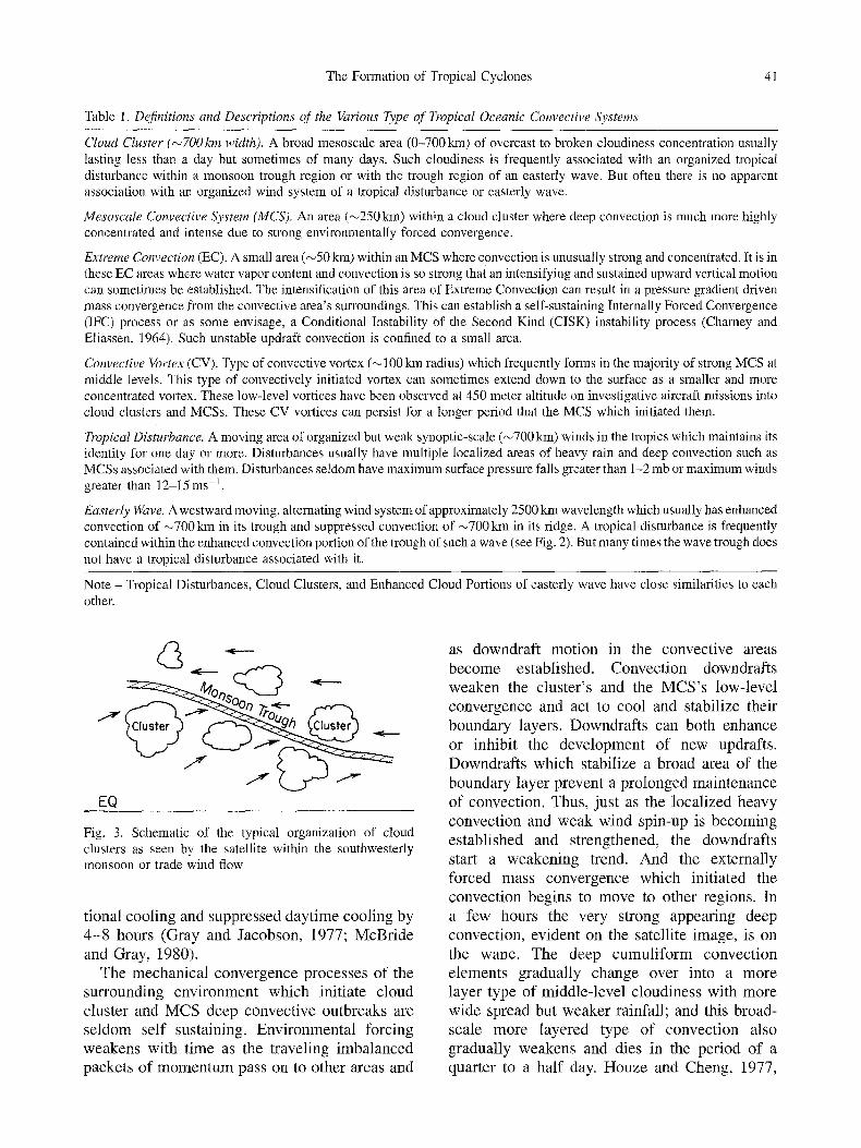
Although only a minority of the tropical cloud clusters which form have a multi-day conserva- tion, it is these more persistent clusters which frequently grow into tropical cyclones. The monsoon trough areas (see Fig. 3) are the most favorable places for the formation of these multi- day cloud clusters. It is here that middle-level humidity is the highest and where sea surface temperatures are close to their warmest; it is in these areas that the impingement of externally forced convergence processes can more readily initiate deep convection. Cloud clusters and MCS convection can also form within the trade winds at some distance from the monsoon trough and to the southeast side of Tropical Upper Tropospheric Troughs (TUTTs) as described by Sadler (1976, 1978). The general structure, mass, moisture, and momentum budgets of tropical cloud clusters have been described by Williams and Gray (1973), Ruprecht and Gray (1976) and Zehr (1976). Most cloud clusters form in association with the monsoon trough or along the Inter Tropical Convergence Zone (ITCZ).
Upper-level troughs from the middle latitudes may also enhance and, at times, contribute to the generation of cloud clusters and MCS convection at sub-tropical latitudes. Upper-level troughs may also act to enhance cloud clusters and MCS convection that has been established by processes not associated with the upper-level trough. Radiative cooling of the troposphere is also an important deep convection forcing mechanism. Typically, intense convection over the tropical oceans tends to break out in the early to late morning hours as a result of the mass convergence made available from enhanced nighttime radiational subsidence of the clear and scattered cloud regions. Both subsidence and convection lag the enhanced nighttime radia-
The Formation of Tropical Cyclones
Table 1. Definitions and Descriptions of the Various Type of Tropical Oceanic Convective Systems
41
Cloud Cluster (~700 km width). A broad mesoscale area (0-700 kin) of overcast to broken cloudiness concentration usually lasting less than a day but sometimes of many days. Such cloudiness is frequently associated with an organized tropical disturbance within a monsoon trough region or with the trough region of an easterly wave. But often there is no apparent association with an organized wind system of a tropical disturbance or easterly wave.
Mesoscale Convective System (MCS). An area (~250 kin) within a cloud cluster where deep convection is much more highly concentrated and intense due to strong environmentally forced convergence.
Extreme Convection (EC). A small area (~50 kin) within an MCS where convection is unusually strong and concentrated. It is in these EC areas where water vapor content and convection is so strong that an intensifying and sustained upward vertical motion can sometimes be established. The intensification of this area of Extreme Convection can result in a pressure gradient driven mass convergence from the convective area's surroundings. This can establish a self-sustaining Internally Forced Convergence (IFC) process or as some envisage, a Conditional Instability of the Second Kind (CISK) instability process (Chamey and Eliassen, 1964). Such unstable updraft convection is confined to a small area.
Convective Vortex (CV). Type of convective vortex (~ 100 kin radius) which frequently forms in the majority of strong MCS at middle levels. This type of convectively initiated vortex can sometimes extend down to the surface as a smaller and more concentrated vortex. These low-level vortices have been observed at 450 meter altitude on investigative aircraft missions into cloud clusters and MCSs. These CV vortices can persist for a longer period that the MCS which initiated them.
Tropical Disturbance. A moving area of organized but weak synoptic-scale (~700 kin) winds in the tropics which maintains its identity for one day or more. Disturbances usually have multiple localized areas of heavy rain and deep convection such as MCSs associated with them. Disturbances seldom have maximum surface pressure falls greater than 1-2 mb or maximum winds greater than 12-15 ms -1.
Easterly Wave. Awestward moving, alternating wind system of approximately 2500 kin wavelength which usually has enhanced convection of ~700 km in its trough and suppressed convection of ~700 km in its ridge. A tropical disturbance is frequently contained within the enhanced convection portion of the trough of such a wave (see Fig. 2). But many times the wave trough does not have a tropical disturbance associated with it.
Note - Tropical Disturbances, Cloud Clusters, and Enhanced Cloud Portions of easterly wave have close similarities to each other.
EQ
Fig. 3. Schematic of the typical organization of cloud clusters as seen by the satellite within the southwesterly monsoon or trade wind flow
t ional coo l ing and suppressed day t i m e cool ing by
4 - 8 hours (Gray and Jacobson , 1977; M c B r i d e and Gray, 1980).
The m e c h a n i c a l conve rgence p rocesses o f the sur rounding e n v i r o n m e n t which ini t iate c loud
c lus ter and M C S deep convec t ive ou tbreaks are s e ldom self sustaining. Env i ronm en t a l fo rc ing w e a k e n s wi th t ime as the t ravel ing i m b a l a n c e d packe t s o f m o m e n t u m pass on to o ther areas and
as downdra f t mo t ion in the convec t ive areas
b e c o m e establ ished. Convec t ion downdraf t s w e a k e n the c lus ter ' s and the M C S ' s low-level
conve rgence and act to cool and stabil ize their
bounda ry layers . Downdra f t s can bo th enhance
or inhibi t the d e v e l o p m e n t o f new updrafts .
Downdra f t s which stabil ize a b road area o f the
bounda ry layer p reven t a p ro longed ma in t enance
o f convect ion. Thus, jus t as the loca l ized h e a v y
convec t ion and w e a k wind spin-up is b e c o m i n g es tab l i shed and s t rengthened, the downdraf t s
start a w e a k e n i n g trend. A n d the ex terna l ly fo rced mass conve rgence which ini t iated the
convec t ion begins to m o v e to other regions. In
a few hours the very s t rong appear ing deep convect ion , ev ident on the satell i te image , is on
the wane . The deep c u m u l i f o r m convec t i on e lements gradual ly change over into a m o r e layer type of midd le - l eve l c loudiness wi th m o r e wide spread but w e a k e r rainfall ; and this broad-
scale m o r e l aye red type o f convec t ion also gradual ly weakens and dies in the per iod o f a quar ter to a ha l f day. H o u z e and Cheng, 1977,

42 w.M. Gray
and Houze, 1989, have discussed this typical life cycle of oceanic tropical convection.
During their lifetime the majority of strong MCS produce middle-level Convective Vortices (CVs). This is similar to the production of such vortices in the mid-latitudes (Velasco and Fritsch, 1987). The CVs often have weaker and smaller- scale extensions to the surface. Once formed, these convective vortices often continue to exist after their initiating parent MCS convection has weakened or dissipated. These weak vortices and their associated vorticity can persist for one to three days or more and frequently act as the focus for future concentrated cyclone wind spin- up. Areas of vorticity tend to persist because friction only slowly runs them down. To intensify further, however, these nascent centers of vortic- ity must await a second environmentally forced "parcel of mass convergence" to develop a new deep convection outbreak which can initiate a new round of wind spin-up which, if other conditions are favorable, can lead to tropical cyclone formation (Zehr, 1992).
3.4 Magnitudes of Convective Vertical Motion
The degree of tropical wind-pressure imbalance and mechanically driven convergence is, typi- cally, inversely related to the width and life time of the convective system. Smaller systems have
the most intense vertical motion but over a smaller area and for a shorter time. An MCS of about 250kin width has about five times the average vertical motion and rate of rainfall as does the 0-700 km sized cloud cluster. And an area of Extreme Convection (EC) has about five times larger vertical motion and rate of rainfall as does the typical MCS (Fig. 4) in which it is embedded.
One might analyze the degree of wind- pressure imbalance by considering the ratio of divergence to relative vorticity in the lower half of the atmosphere. For cloud cluster this ratio is typically 0.2 to 0.5 whereas for the MCS, it can, for short periods, range up to one or higher. The mid-morning maximum to early evening minimum of convergence and deep convection varies by approximately two to one. The experi- ence of most middle-latitude meteorologists is that cloudiness and convection are closely tied to the synoptic and mesoscale wind fields. This is much less the case for cumulus convection in those oceanic areas where tropical cyclones form.
The typical 700 km (wide) cloud cluster brings average rainfall amounts of about 1 mm per hour. Heavier amounts of rainfall are observed where groups of many cumulonimbi become more concentrated as in MCS and EC areas. Table 2 compares typical magnitudes of width, life cycle,
I00 ~,
2oo
3oo
-400
- 5 0 0
- 6 0 0 g
-700 ~.
-800
L900 -IOOO
i I 1 i i I I o z5 Ioo Lso
- CO ( m % r )
Fig. 4. Estimated vertical motion (in mb/h) derived from composite rawinsonde observa- tions for the different sized convective area of tropical cloud clusters (~700 km), MCS (~250 kin), and EC (~50 km) convective areas

The Formation of Tropical Cyclones 43
Table 2. Estimated Typical Values of Width, Duration, Vertical Velocity at 300 rob, and Rates of Rainfall for the Three Typical Modes of Organized Oceanic Deep Convection. The mean Rainfall Rate of a Typical ~ 700 km Cloud Cluster is about 1 mm/h
Mode Width 300 mb Typical Duration Approximate Vertical Average Velocity Rainfall Rates (mb/hr) (ram/h)
Cloud Clusters ~700 km 8 18-24 hours 1 Mesoscale Convective System (MCS) ~250 km 40 6-12 hours 5 Extreme Convection (EC) ~50 km 200 hours to days 25
vertical motion and rainfall of these three dif- ferent sized convective systems.
Although rainfall rates in the typical MCS may be about five times greater than that for the average cloud cluster, the actual amount of rainfall in the MCS, due to its smaller size and shorter life cycle, is less than that of the larger and longer and longer lived cluster. It is only in these small EC areas where deep convection becomes so strong and concentrated that middle- level moisture contents rise to values high enough that a sustaining and increased growth of deep convection can become established. Once established, such unstable growth can continue for many hours to many days. This is in contrast with MCS convection which typically dies out in 6-12 hours or cloud cluster convec- tion whose lifetime is not typically longer than a day.
3.5 Types of Convective System Forcing
In those regions where tropical cyclones form, conditionally unstable lapse-rates are always present. These conditionally unstable lapse-rates allow broadscale deep Cb-type convection to break-out where low-level mass convergence takes place to provide the forced lifting of air parcels to their level of free convection. Con- vergence and resulting deep convection initiation is more efficient where middle-tropospheric relative humidity is reasonably high so that entrainment does not overly inhibit updraft buoyancy.
There appears to be four physically distinct types of convergence forcing for the initiation and maintenance of mesoscale tropical convec- tion over the oceans. This includes:
�9 Externally Forced Convergence (EFC) �9 Frictionally Forced Convergence (FFC) �9 Radiationally Forced Convergence (RFC), and �9 Internally Forced Convergence (IFC)
Table 3 discusses these four convergence forcing mechanisms. The first three mechanisms are continuously operating within the tropical atmosphere whereas the Internally Forced Con- vergence (IFC) process, which is crucial to tropical cyclone formation, can be established only in special circumstances associated with the development and enhancement of small areas of Extreme Convection (EC). The Frictionally Forced Convergence (FFC) process occurs when- ever there is positive or negative low-level relative vorticity. The Radiationally Forced Convergence (RFC) process is always present due to the subsidence of the atmosphere to adiabatically balance its radiational cooling. This radiationally forced subsidence feeds mass into the convective areas. There is also a large diurnal modulation to this clear and scattered cloud region subsidence which follow the difference between daytime and nighttime radia- tional cooling.
3.6 Comparison of Forcing Mechanisms
It is the Externally Forced Convergence (EFC) which is the most dominant of the forced convergence processes and the one which is often responsible for initiating and enhancing organized deep convection.
There are a variety of wind regimes which can lead to the activation of the Externally Forced Convergence (EFC) mechanisms. These include:

44 W.M. Gray
Table 3. Types of Deep Convective Forcing Mechanisms
Externally Forced Convergence (EFC). The wind convergence into a region which is necessary to initiate or further intensify a cloud cluster (0-700 km) or a mesoscale convective system (MCS - ~0-250 km). Such convergence is generated by forcing processes external to the system and is typically the result of deep layer mass convergence resulting from traveling packets of imbalanced synoptic and mesoscale wind surges. Such wind surges are fundamental to the understanding of the genesis of cloud clusters, MCSs and tropical cyclones.
Frictionally Forced Convergence (FFC). The low-level convergence resulting from frictional drag at the surface and manifesting itself in an Ekman type of boundary layer (~ 1 km) convergence. Frictional convergence is proportional to the relative vorticity. Negative vorticity produces low-level divergence and downward motion. Convective processes can, at times, extend the depth of the frictional layer to much higher levels.
Radiationally Forced Convergence (RFC). Low-level convergence into cloud areas resulting from the mass made available from clear and scattered cloud region radiation induced subsidence or from cloud and cloud-free radiational differences. This type of convergence forcing also has a large diurnal component with a mid-morning maximum and early evening minimum.
Internally Forced Convergence (IFC). The unstable and self sustaining convergence which is occasionally initiated from the feedback of upward vertical motion taking place in Extreme Convective (EC) areas or the eye-wall cloud of a tropical cyclone. IFC convection lowers the pressure beneath it and draws in extra surrounding air as a result of the enhancement of inward directed pressure forces. IFC is analogous to Conditional Instability of the Second Kind or the CISK (Charney and Eliassen, 1964) process. IFC is a very difficult to initiate and is a relatively rare phenomena. When it is initiated a named tropical cyclone usually results
�9 wind surges in the trade winds or southwest monsoon flow.
�9 wind convergence resulting from easterly wave induced convergence.
�9 cold front penetration into the tropics causing concentrated low-level convergence.
�9 upper-tropospheric trough induced low-level convergence; this is mainly a feature of the sub tropics.
�9 cross hemispheric wind surges from opposite hemisphere winter time baroclinic cyclone movement.
All of these different EFC forcing mechanisms require a large degree of wind-pressure imbal- ance.
As the majority of the modeling and theoret- ical community of meteorologists have had most of their experience with quasi-balanced mid- latitude circulation patterns, they appear to have not been as aware of or as prepared to accept the high degree of mechanically forced wind-pres- sure imbalances which are a common feature of the tropical atmosphere. Imbalanced flow can more readily be established at lower latitudes where the earth's rotation is weak.
A full appreciation of the degree to which the tropical atmosphere's wind and pressure fields are able to oscillate in and out of wind-pressure balance and the inability to model such wind-
pressure balances appears to have been an important factor in the inability of the early (1960s to early 1980s) numerical modeling efforts to realistically simulate the early stages of tropical cyclone formation. Earlier analysis did not fully appreciate the speed and the magnitude with which Externally Forced Con- vergence (EFC) processes can initiate mesoscale areas of strong and deep convection. Initiating tropical cyclone formation models with condi- tions of the Jordan (1958) mean atmosphere or of the GATE Phase III mean atmosphere are unrealistic. On a temporary basis, the atmosphere will provide a much more favorable background environment for convergence and deep convec- tion.
Although oceanic wind and pressure fields in tropical regions are usually well in balance over broad areas and for long time periods, short period and smaller scale imbalances can be surprisingly large. Anyone who has closely monitored the hourly oceanic convective changes as seen by the geostationary satellites will be able to verify the rapid growth and decay of oceanic mesoscale convection. Changes in deep convection on such short time scales can only be explained by fast occurring changes in the wind- pressure relationship.
There are special situations when Internally Forced Convergence (IFC) can be initiated. This

The Formation of Tropical Cyclones 45
also requires imbalanced convergence forcing that is strong enough so as to establish highly concentrated area of Extreme Convection (EC) within an active MCS. If strong and concentrated vertical motion is initiated in special circum- stances of near saturated conditions, high relative vorticity, and low vertical wind shear, then this small area of EC is sometimes able to initiate a self-sustaining and continuously growing con- vergence processes which will feed back and cause an ever increasing enhancement of low- level inflow from the surrounding environment. It is under these very special conditions that the initial formation of a tropical cyclone can occur and in these conditions when the later develop- ment and maintenance of the tropical cyclone's eye-wall convection can take place. The main- tenance of EC for 3-6 hours usually assures the activation of IFC and the development of a named tropical storm within the next 12-24 hours.
The IFC is a feedback response forcing process that requires a special maximization of the other three forcing processes. These four basic con- vective forced mechanisms might be combined into a single equation as:
(Net Deep Convection Forcing)
= EFC + FFC + RFC + IFC (1)
3.7 Unstable Mesoscale Convection - The Internally Forced Convergence (IFC) Process
Unstable IFC convection involves the physical process associated with the feed-back influ- ences of multiple cloud convective buoyancy. This can occur after an earlier EFC event has produced deep convection and raised the moist- ure content in an EC area to near saturation. Once low-level horizontal convergence has driven an air parcel to its level of "free convection" in an environment of near water vapour saturation (entrainment under these conditions will not significantly inhibit updraft parcel buoyancy or allow the development of evaporating cooling downdrafts) a sustaining and growing upward vertical acceleration is then possible. An unstable growth of an area of multi-cloud convection can then occur. This type of unstable Internally Forced Convergence (IFC) growth process is similar to the concept behind Conditional
Instability of the Second Kind (CISK) idea of Charney and Eliassen (1964) and other research- ers of the 1960s. The concept of CISK was proposed to distinguish this type of instability from the instability of the individual cumulus updraft acceleration. They wanted to define an instability process which they believed occurred in nature and which was similar to the unstable growth of a developing cumulonimbus cloud (instability of the first kind) but different in the sense that it represented the upward vertical motion growth of a group of convective clouds on a distinctly larger space and time scale than that of the individual cumulus cloud; thus the name "conditional instability of the second kind". They envisaged this instability to occur on the size scale of 400 -500km and that frictionally forced convergence was the dominant mechanism leading to its activation. But more recent research shows that this type of friction- ally driven initiating mechanism could not activate an unstable upward vertical motion feedback on such a large space and time scale. In reality the IFC (or CISK) feedback processes is more difficult to establish than previously envisaged. And it can only occur on a much smaller space scale (~50 km). It appears that IFC can be initiated only near the center of an Extreme Convection area or in the eye-wall cloud of a developed tropical cyclones. And Externally Forced Convergence (EFC) rather than Frictionally Forced Convergence (FFC) appears to be the more important initiating mechanism. Figure 5 illustrates the differences between the previously described EFC and IFC processes.
3.8 Discussion
There have been a variety of different interpreta- tions of what the CISK process is and how it works. So many different interpretations in fact that Ooyama (1982) has suggested that CISK has almost becomes a useless term. There have been almost as many definitions of CISK as there have been researchers in the field. For this reason, I have chosen to use the term Internally Forced Convergence (IFC) mechanism to approximate the unstable growth of a small concentrated group of convective clouds. And, I define CISK to include only the IFC process as here defined.

46
(• EFC .2 t=l
~5
W. M. Gray
I FC
,c t=l
t=2
t=5
Fig. 5. Schematic comparison of EFC and IFC modes. In the left diagram there is no sustained buoyancy induced convergence feedback as occurs in the right diagram
I accept the concept of CISK as the unstable growth of a collection of deep cumulus clouds, but I do not subscribe to many of the previously proposed physical interpretations as to what this mechanism encompasses. The updrafts of the CISK mechanism here envisaged can be initiated only within a special area of Extreme Convection (EC) or within the eye-wall cloud of a developed tropical cyclone. This process makes possible the continuous drawing in of low level air from the surroundings so as to cause a steady enhancement of the net upward vertical motion of a group of cumulonimbus clouds.
4. Observations of Developing Versus Non-Developing Systems
We will now discuss various aspects of the tropical cyclone formation process from an
observational and semi-theoretical point of view. Many of the arguments follow recent studies by the author's former graduate students and col- leagues. These include Zehr (1976), McBride (1981a, 1981b), Lee (1986), Middlebrooke and Gray (1988) and Lunney and Gray (1988) and particularly the recent and very informative research by Zehr (1992). When background climatological requirements are met, we find that the most consistent differences between developing and non-developing disturbances are:
�9 Developing systems must be in areas of anticyclonic upper-tropospheric flow with very weak tropospheric vertical wind shear (Gray, 1968, 1979) near their center. Large values of anticyclonic vertical wind shear surrounding the disturbance (Gray, 1968; McBride, 1981a, 1981b) are favorable. Typical values of favor-
i ~ -12kin 12km / 5 km North
l N I km
( ~ N -12kin
5 km C - 5 krn C e n t e r
--I km S S - -
Ikm C u ~ -5km South
5 m/s ~ - I k m S
Vertical PLAN VIEW X- Section
Fig. 6. Plan and cross-section views of the typical arrangement of the zonal winds to the North (N) and South (S) of a pre-tropical cyclone cloud cluster disturbance whose center is located at C

The Formation of Tropical Cyclones 47
A t m
E
o L I J
(/3 W FF O_
I -2
-4
-6
-8
- I0
Sheer for _ d Formolion
I I I I I
neg. 0 pos.
Fig. 7. Typical vertical distribution of the tangential wind surrounding developing and non-developing tropical weath- er systems at outer radii of about 300 to 600kin. Note tl~e higher low-level winds and larger upper-tropospheric wind shear of the developing systems
able horizontal and vertical shear surrounding a pre-cyclone disturbance are shown in Fig. 6.
�9 The large-scale low-level tropospheric winds at radii of 300 to 600kin around the pre- cyclone disturbance have significantly larger relative vorticity values than the non-develop- ing systems. (See Gray, 1968; McBride and Zehr, 1981; Lee, 1989a, 1989b; Zehr, 1992)- see Fig. 7.
However, many individuai tropicaI distur- bances with ample amounts of deep convection still fail to develop when these two important background flow conditions have been satisfied. Figure 8 shows typical westward moving cloud cluster disturbances which live for 1-3 days and then die out in comparison with a cluster system which maintains itseIf for a number of days before developing into a tropical cyclone, Table 4 shows stepwise necessary requirements for tropical cyclone genesis. Yet, even when all three of these basic background requirements are met, there can still be uncertainties in distin- guishing between system which develop into named storms versus those systems which do not; additional physical elements are necessary. It appears that the presence or lack of concen- trated wind convergence at the center of a tropical disturbance can be a crucially important factor in determining whether the system will develop or not. It is important that environmen-
---- 5 4 3 2 I Doys
D i e s @ _ _
Dies
STORM
Fig. 8. Conceptual illustration of typical cloud cluster systems as they move west-ward in the trade winds. Whereas most cloud clusters live for less than one day, some persist for 2-3 days. Longer living cluster systems are able to frequently transform themselves into named storms
700 km ~'-i
Fig, 9. MCS within a broader cloud cluster disturbance in which a small-scale area of Extreme Convection (EC) has been formed by the concentrated convection within an intense MCS. The wind surge causes additional conver- gence to break out around the MCS area and frequently a center of middle-level Convective Vortex (CV) will be established there and a small area of EC will be developed
tally driven asymmetrical wind surges occur and be able to trigger intense convective outbreaks at locations where previous MCS convection has established a concentration of high relative vortic- ity (Fig, 9). These convective bursts frequently cause the formation of middte-leveI mesoscale Convective Vortices (CVs) which brings about a concentration of vorticity necessary to prepare the disturbance for wind spin-up when and if a later or second wind surge impinges upon it. Figure 10 shows how a smaller 100km diameter vortex with 5 ms -1 wind can have mean vorticity
48 W.M. Gray
I" 6 ~ ~[
1 ~ I [
5 m/s
f ~r ~r/f 3 m/s
110kmdiam 4x 10 5 20x 10 -~ -5
660kmdiam 4x 10 -5 20x 10a ~0.5
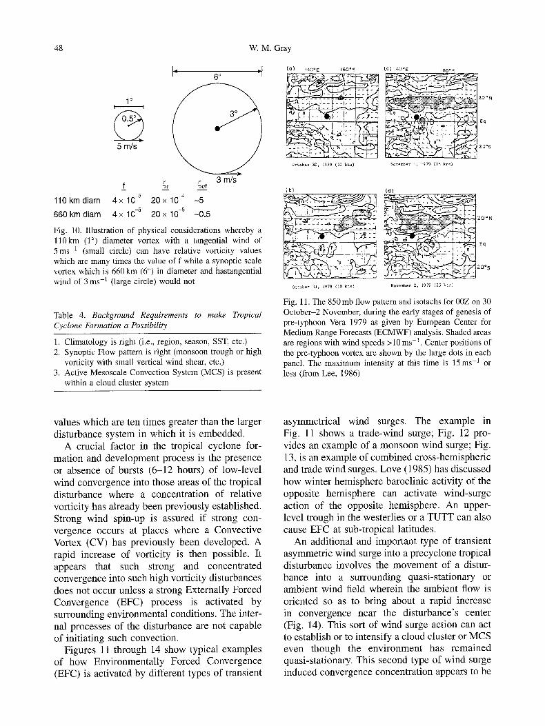
Fig. 10. Illustration of physical considerations whereby a ll0km (1 ~ diameter vortex with a tangential wind of 5 m s -1 (small circle) can have relative vorticity values which are many times the value of f while a synoptic scale vortex which is 660 km (6 ~ in diameter and hastangential wind of 3 m s -1 (large circle) would not
Table 4. Background Requirements to make Tropical Cyclone Formation a Possibility
1. Climatology is right (i.e., region, season, SST, etc.) 2. Synoptic Flow pattern is right (monsoon trough or high
vorticity with small vertical wind shear, etc.) 3. Active Mesoscale Convection System (MCS) is present
within a cloud cluster system
{O) 14tOE 160"E
October 30, 1979 (I0 kts)
(C) 140=E 160oE
November 1, I979 ( [5 k t s )
(b}
October 31, 1979 (10 kts)
(.d)
-~-~ ~ T .~ . . ~ '-~ ;. 2 0 ~
~20~ November 2, 1979 (25 k ts )
Fig. 11. The 850 mb flow pattern and isotachs for 00Z on 30 October-2 November, during the early stages of genesis of pre-typhoon Vera 1979 as given by European Center for Medium Range Forecasts (ECMWF) analysis. Shaded areas are regions with wind speeds >10 ms -1. Center positions of the pre-typhoon vortex are shown by the large dots in each panel. The maximum intensity at this time is 15ms -1 or less (from Lee, 1986)
values which are ten times greater than the larger disturbance system in which it is embedded.
A crucial factor in the tropical cyclone for- mation and development process is the presence or absence of bursts (6-12 hours) of low-level wind convergence into those areas of the tropical disturbance where a concentration of relative vorticity has already been previously established. Strong wind spin-up is assured if strong con- vergence occurs at places where a Convective Vortex (CV) has previously been developed. A rapid increase of vorticity is then possible. It appears that such strong and concentrated convergence into such high vorticity disturbances does not occur unless a strong Externally Forced Convergence (EFC) process is activated by surrounding environmental conditions. The inter- nal processes of the disturbance are not capable of initiating such convection.
Figures 11 through 14 show typical examples of how Environmentally Forced Convergence (EFC) is activated by different types of transient
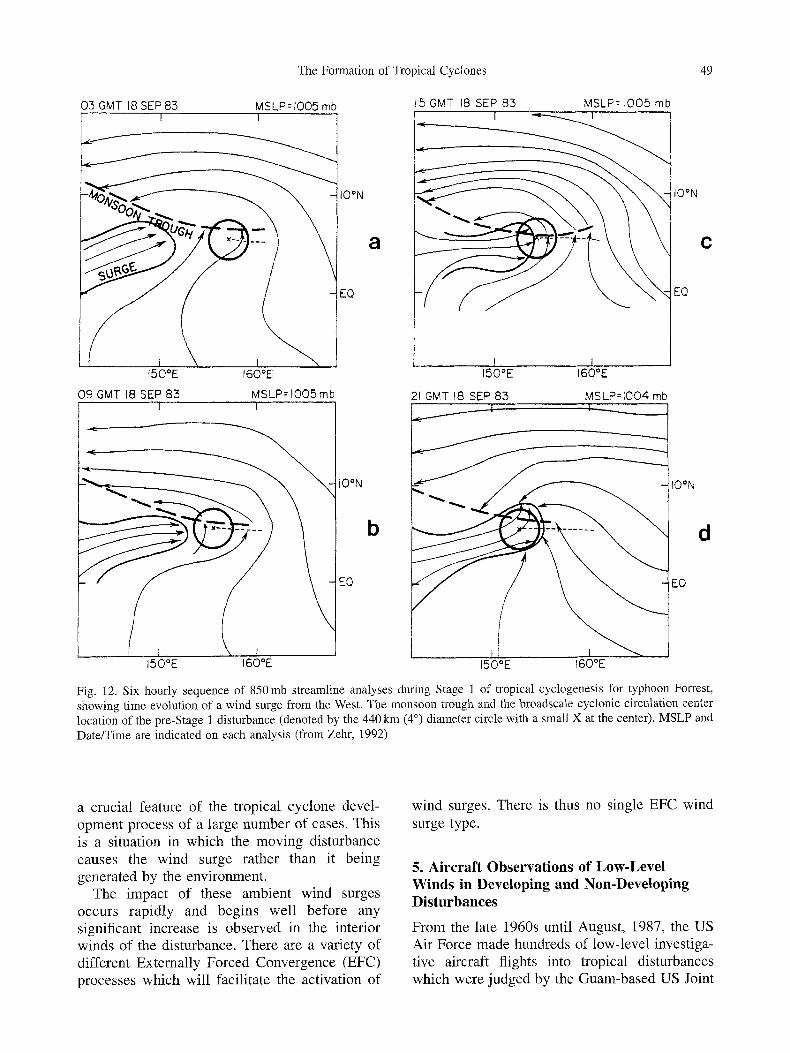
asymmetrical wind surges. The example in Fig. 11 shows a trade-wind surge; Fig. 12 pro- vides an example of a monsoon wind surge; Fig. 13, is an example of combined cross-hemispheric and trade wind surges. Love (1985) has discussed how winter hemisphere baroclinic activity of the opposite hemisphere can activate wind-surge action of the opposite hemisphere. An upper- level trough in the westerlies or a TUTT can also cause EFC at sub-tropical latitudes.
An additional and important type of transient asymmetric wind surge into a precyclone tropical disturbance involves the movement of a distur- bance into a surrounding quasi-stationary or ambient wind field wherein the ambient flow is oriented so as to bring about a rapid increase in convergence near the disturbance's center (Fig. 14). This sort of wind surge action can act to establish or to intensify a cloud cluster or MCS even though the environment has remained quasi-stationary. This second type of wind surge induced convergence concentration appears to be
The Formation of Tropical Cyclones 49
03 GMT 18 SEP83 MSLP=IO05 mb
I50~ 160~
09 GMT 18 SEP 83 MSLP=1005mb ! i
\
150OE 160~
IO~
b
EQ
5 GMT 18 SEP 83 MSLP= I005 mb
I50~ 160~
IO~
c
EQ
21 GMT t8 SEP 83 MSLP=[O04 mb
150~ 160~
IO~
EQ
d
Fig. 12. Six hourly sequence of 850 mb streamline analyses during Stage 1 of tropical cyclogenesis for typhoon Forrest, showing time evolution of a wind surge from the West. The monsoon trough and the broadscale cyclonic circulation center location of the pre-Stage 1 disturbance (denoted by the 440 km (4 ~ diameter circle with a small X at the center). MSLP and Date/Time are indicated on each analysis (from Zehr, 1992)
a crucial feature of the tropical cyclone devel- opment process of a large number of cases. This is a situation in which the moving disturbance causes the wind surge rather than it being generated by the environment.
The impact of these ambient wind surges occurs rapidly and begins well before any significant increase is observed in the interior winds of the disturbance. There are a variety of different Externally Forced Convergence (EFC) processes which will facilitate the activation of
wind surges. There is thus no single EFC wind surge type.
5. Aircraft Observations of Low-Level Winds in Developing and Non-Developing Disturbances
From the late 1960s until August, 1987, the US Air Force made hundreds of low-level investiga- tive aircraft flights into tropical disturbances which were judged by the Guam-based US Joint

50 W.M. Gray
3 OCT 4 OCT 5 OCT ~:.::::::..--: ~.~...,..~.,.,.~.-.-- .
'~:!~}~" "::'::~ - ~ s " ~ - -~
~ ~ - -~o :'i " ~=~
' ' - "= . . . . \ i" ' '
Fig. 13. ECMWF 850 mb analyses of the early stages of formation of pre-typhoon Ogden at 12Z on 3, 4, and 5 October 1983. Maximum wind in the disturbance at this stage were less than 15 ms -1 for all three periods (from Lee, 1986)
~ Z 5 2 I
EQ
Fig. 14. Illustration of a westward moving cloud cluster (shaded) entering a stationary ITCZ monsoon trough can bring about an effective wind surge on the equatorward side of the trough. Convection becomes rapidly enhanced
Typhoon Warning Center (JTWC) forecasters to have a good probability of developing into tropical cyclones. Figure 15 illustrates a typical investigative track. A primary objective of these flights was to determine if a mesoscale Con- vective Vortex (CV) had extended down to the surface within the broader region of disturbance convection. The satellite is unable to detect if such low-level vortices are present and where they are located. For years forecasters at Guam have known that these circulation centers pro- vided small local areas of very high and concentrated vorticity that often served as the focus on which tropical cyclone development occurred. Vortices typically displayed a west- ward movement. Some of the aircraft observed
westward moving calm wind regions displaying a vortex circulation when portrayed with respect to their moving center. These low-level centers are frequently found in both developing and in non- developing systems. Although an obvious closed vortex center, as seen in Fig. 15, might not always be found, small 50-100 km areas of near calm wind conditions and inferred cyclonic circulations (termed 'open' vortices by Middle- brooke and Gray, 1988) could usually be located if no obvious circulation centers were present. These low-level convective vortices or inferred vortex centers can exist for a few days. They will gradually run themselves down unless they become energized by a second wind surge. For development, it is necessary that a second wind surge sets off a new burst of deep convection where local relative vorticity is already high from previous convection.
An example of the strong radial and tangential winds which can develop at inner-radial locations from an externally induced wind surge or EFC is shown in Fig. 16. This analysis is based on 15- minute wind observations at an elevation of approximately 450 meters during an investigative flight mission into an early stage tropical disturbance deemed by Guam forecasters to have the potential to develop into a tropical cyclone. About half of the fledgling systems on which investigated flights were made went on to
The Formation of Tropical Cyclones 51
TYPICAL LOW-LEVEL INVEST MISSION PROFILE I I t I I I I
22
20
~ , , 1 8
- o 1 6 23 ..,,.~_ 13 _J Z~ 14
12
On.mi. G U A M
i r i i i I 144 146 148 150 152 I N
E. Long i tude (degrees)
c i r c l e
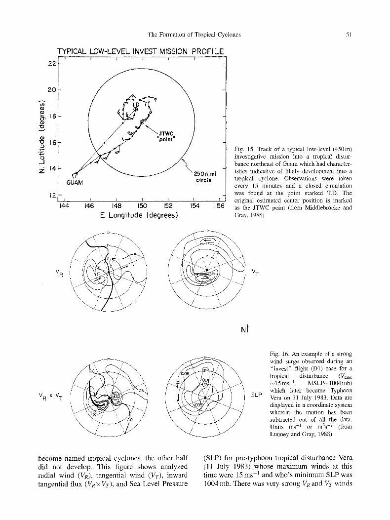
Fig. 15. Track of a typical low-level (450m) investigative mission into a tropical distur- bance northeast of Guam which had character- istics indicative of likely development into a tropical cyclone. Observations were taken every 15 minutes and a closed circulation was found at the point marked T.D. The original estimated center position is marked
156 as the JTWC point (from Middlebrooke and Gray, 1988)
3 o 3= /
,,, 0 // 5
VR ~(I~ / VT
Nt
X VT J 1 SLP
Fig. 16. An example of a strong wind surge observed during an "invest" flight (D1) case for a tropical disturbance (Vmax ~15ms -1 , MSLP~1004 rob) which later became Typhoon Vera on 11 July 1983. Data are displayed in a coordinate system wherein the motion has been subtracted out of all the data. Units ms -1 or m2s -2 (from Lunney and Gray, 1988)
b e c o m e n a m e d t ropica l cyc lones , the other ha l f did not develop. This f igure shows ana lyzed radial wind (VR), tangent ia l wind (Vr), inward
tangent ia l flux (VR • Vr), and Sea Leve l Pressure
(SLP) for p r e - t y p h o o n t ropica l d is turbance Vera (11 July 1983) whose m a x i m u m winds at this t ime were 15 ms -1 and w h o ' s m i n i m u m SLP was
1004 mb. There was ve ry s t rong VR and Vr winds

52 W.M. Gray
on the west side of the system. The combination of VR • Vr produced a very large inward flux of eddy angular momentum. This strong inward propagation of tangential momentum acted to trigger new outbreaks of deep cumulus convec- tion at the location where the highest wind circulation already existed. This type of inner wind surge action as measured for pre-typhoon Vera is typical of many other cases where inward radial convergence on one side of the tropical disturbance can be so strong. Such strong inward momentum flux is time limiting however. This type of wind surge action seldom lasts for more than 6-9 hours.
Examples of how strong such inflow radial winds can be is given in Table 5. This table shows some of the cases of radially directed winds near the centers of pre-named tropical disturbances during 1980-1984. This table shows that inner-region radial inflow as strong as 15-20 ms-1 can occur at individual azimuthal and radial locations of systems which are later to become named storms. Such strong inner radius inflow cannot be a product of the disturbance itself. It is a consequence of the combination of strong EFC from the disturbance's surrounding
environment (Figs. 11 through 13) and/or of the motion of the disturbance into an impinging environmental wind field (Fig. 14).
The presence of such strong environmental and movement induced wind surges (when all background climatological requirements have been met) into a tropical disturbance does not guarantee that the system will develop into a named storm, however. It is necessary that these wind surges also propagate into the area of the incipient disturbance where vorticity is concen- trated. The contrast in surge penetration between the pre-typhoon disturbance Abby, the pre- tropical storm Betty and a non-developing tropical disturbance (ND), as seen in Fig. 17, should be noted. In the cases of Abby and Betty, surges set off deep interior convection repre- sented by small circles (deduced from US DMSP 0.7 km resolution visual satellite images of Cb cells which extended above the cirrus shield). However, in the non-developing case, the Exter- nally Forced Convective (EFC) wind surges did not reach to the center of the disturbance (right side of Fig. 17) and the environmentally forced deep convection was not activated at the location of the disturbance's highest vorticity where the
Table 5. Radial Inflow Expressed in Moving Cyclones Relative Coordinates for 20 Wind Surge Cases Occurring During the Early Stages of Developing Systems. Values in ms-l (from Lunney and Gray, 1988)
Name/Year/Mission/ Maximum Radial Mean VR Wind VR (28-250 kin)
Radius
Number of Observations Defining Mean VR Value Within 28-250 km Radius
Dom 80-3 - 7 - 4 4 Joe 80-1 -11 - 8 5 Joe 80-2 - 8 - 6 9 Alex 81-1 -11 - 5 5 Lynn 81-1 - 1 7 - 1 2 4 Agnes 81-1 - 1 7 - 1 0 5 Pat 82-3 - 15 - 7 7 Owen 82-1 - 1 0 - 8 4 Vera 83-1 - 12 - 7 4 Vera 83-2 - 1 3 - 1 0 5 Wayne 83-1 - 11 - 6 9 Abby 83-1 - 6 - 4 6 Abby 83-1 - 8 - 7 7 Forrest 83-2 - 15 - 10 6 Forrest 83-3 -11 - 7 10 Lex 83-2 - 9 - 7 6 Marge 83-1 - 8 - 6 8 Sperry 83-1 - 11 - 6 7 Cary 84-1 - 6 - 5 6 Freda 84-2 - 2 0 - 11 8

The Formation of Tropical Cyclones 53
(o)
Abby 83-2: 8/410035Z
(b)
Betty 84-3: 4Jul/2129Z
(c)
ND 78-7: 80ct/2247Z
Fig. 17. Relationship between aircraft determined wind surge (arrow) and penetrative convective cells (small circles) for three disturbances with Vmax<15 ms -1. Two of these disturbances later developed, becoming typhoon Abbey and tropical storm Betty; the third system ND78-7 did not develop into a named storm. Deep convection did not break out near its center (from Lunney and Gray, 1988)
strongest potential wind spin-up and maximum pressure drop could take place. Development did not proceed even though all other background factors were quite favorable.
6. Need for Concentration of Strong MCS Vortieity
A tropical disturbance cannot and does not instantaneously intensify over its entire domain. It is much more efficient if the initial intensifica- tion occurs over a small central area of the disturbance which receives a higher and more concentrated portion of the externally forced mass convergence. The rapid wind spin-up in this restricted area of convergence then gradually spreads outward to larger radius. This is how early-stage tropical cyclone formation and later stage intensification typically occur. The combined larger-scale (700kin diameter) mean vorticity ((a) and mean convergence (-D) pat- terns of the tropical disturbance are much too weak (i.e., -Da (a is too small) to allow the early stages of disturbance intensification to occur simultaneously over the whole disturbance area or the whole MCS area. It is necessary to first initiate strong wind acceleration over a small interior area. Later period intensification of the outer region flow is then accomplished by the spreading out of the concentrated wind spin-up to the broader disturbance area (see Fig. 21).
These Guam aircraft measured low-level Convective Vortices appear to have strong simi- larities to the middle-level Convective Vortices of
the MCS systems. Systems which become named storms nearly always have a CV of about 100 km diameter which functions as a focus for a later and a larger-scale cyclone spin up. These middle- level mesoscale Convective Vortices frequently have a weaker and more concentrated extension downward to the surface. Similar middle-level convective vortices with downward extension to the surface have been observed in US Great Plains Mesoscale Convective Systems (MCSs) as discussed by Maddox (1980), Bartels and Maddox (1991), Fritsch and Maddox (1981a, 1981b), Menard and Fritsch (1989), and Miller and Fritsch (1991).
7. Composite Analyses of Developing Versus Non-Developing Systems
Aircraft observational studies of early stage tropical cyclone formation by Lunney and Gray (1988) and Middlebrooke and Gray (1988) provide a large statistical data sample on the fundamental role of CVs in the tropical cyclone formation process. Figure 18 shows composited data for symmetric low-level tangential winds (Vr) in 102 different disturbance systems. Data are composited in a "moving" coordinate system which is fixed on the storm center. Winds are plotted relative to the centers of closed CVs and of open (inferred) CV centers for both develop- ing and non-developing disturbances. There were 53 cases which went on to become named tropical cyclones versus 49 promising distur- bance cases that appeared to have a high

54 W.M. Gray
~ 7 DI
6
>~ 4 / / , . i NON-DEV
2
I I I I I [ [ I I 0 o I o 2 ~ 5 o 4 ~ 5 ~
RADIUS ( ~ l a t )
Fig. 18. Companson of "investigative" flight radial distributions of composited symmetric tangential winds at 450 m altitude for 53 cases of developing (DI) versus 49 promising cases of non-developing CVs located within a larger MCS or tropical disturbances. All wind speed values are adjusted to portray date relative to the center of the moving (or MOT) coordinate system (from Middlebrooke and Gray, 1988)
potential of development but did not form. Note that circular tangential winds are present within a half-degree radius in both data sets. This lack of significant tangential wind differences between these two classes of disturbances may appear surprising. Earlier analyses (McBride and Zehr, 1981) showed that developing systems typically had greater tangential wind than did the non- developing systems. The McBride and Zehr analysis however was for a larger and less selective sample than the special cases chosen for the investigative flights.
The apparent discrepancy between Fig. 18 and our prior research is due to the smaller scale of
the convective vortices and to the selection criteria used by Guam forecasters for initiating investigative flights. Reconnaissance missions were made only into those cloud cluster systems which, as judged from the satellite and synoptic flow data, appeared to have a very high potential for development. Hence, investigative flights were made into a more selective class of tropical disturbances which were not representative of the full population of typical tropical disturbances and MCS systems of our earlier and larger data set. About half (53 of 102) of the early stage investigative flights took place into systems which eventually became named storms. This is
A r
IE-2 v
t . r >
- 5 -
- I
m
/ / f - . ~ / N O N - D E V
r / 00o , iio t 21o , ~o
RADIUS (~
I I I 4o 5 ~
Fig. 19. Comparison of the radial distribution of the symmetric radial wind (VR) at 450m altitude in motion relative co- ordinates for 53 early-stage developing (D1) system versus 49 promising cases of non-de- veloping systems. Negative values denote inflow (from Middlebrooke and Gray, 1988); one degree of radius is about l l l k m

The Formation of Tropical Cyclones 55
a much higher percentage of development than is observed for all tropical disturbances or cloud clusters. It is only a small minority of all tropical disturbances which intensifies to named storm status.
Strong tangential winds were observed for the interior of both developing (D1) and non- developing systems (NON-DEV). Although these wind data imply that vorticity values within the 55 km radius are very high, they also show that the presence of strong concentrated vorticity was not a sufficient feature in itself for distin- guishing the likely formation of a tropical storm. Rather, as shown in Fig. 19, it was the magnitude of low-level radial winds near the disturbance's center which was the primary observational factor which differentiated between those distur- bances which developed from those which did not.
For the developing tropical cyclones, mean inward radial wind (--VR) at 55km radius was -1 .3 ms -1 and the mean tangential wind at this radius was 5 ms -1 . As the individual case inflow is asymmetric, it is likely that this 1.3 ms -1 symmetric inflow at 55 km radius was 4-5 ms -I or greater inflow over a quarter to a third of the azimuthal area with zero slight outflow at the other azimuths. For the developing systems the magnitude of the symmetric inward tangential momentum flux ( - VRX Vr) is more than suffi- cient to balance the system's fractional loss to the surface and still have additional momentum left over the spin-up of the inner-core vortex. However, for the non-developing systems, the mean inward radial wind at 55km radius was only - 0 . 4 ms -1, less than one-third of the mean developing case inflow. With 5 5 k m mean tangential wind of 3.6 ms -~ this represents an inward momentum flux (-VR• at 55km radius which is much smaller than that of the growing systems. Calculations using the tangen- tial wind equation show that the non-developing systems's inward momentum flux at 55 km radius is --VR• = 0.4ms - l x 3 . 6 m s -~ = --1.4mas 2. This is insufficient to balance the non-develop- ing systems's frictional loss to the surface. By contrast, the mean inward momentum flux of the developing system at 55 km was --VR x Vr= -1 .3 m/x x 5 m s -1 = - 6 . 5 m 2 / s 2 o r f o u r a n d a half times larger than that of the non- developing systems. Tangential wind calculations
show that in contrast to the non-developing systems this amount of inward momentum flux to the inner-core of the developing systems is more than sufficient to balance surface dissipation and still have additional momentum left over the interior wind increase. Note that it is the differences in inward radial winds at 55km radius ( -1 .3 ms -1 versus - 0 . 4 ms -1) which are p r imar i ly responsible for these inward flux differences. The developing systems have over three times the inward mass penetration inside their 55km radius as do the non-developing systems. These differences are believed to be due to differences in center penetrating wind surge action.
To fully understand the early stage formation of a tropical cyclone from a promising looking tropical disturbance it is crucially important that one be sensitive to the circulation conditions of the disturbance's environment. Such sensitivity to the environment has been lacking in many previous tropical cyclone formation theory and modeling studies.
Note that it is only inside the 100km radius that there are differences in the inward radial winds between these two system classes. The larger radius convergence of the two classes of disturbances was the same. It is only the inner- core radial winds and the inner-core concentra- tion of convection which is different.
Whereas the average low-level convergence within the 55 km radius for intensifying system is about three times that of the non-intensifying systems, there is comparatively little difference in the radial winds at radii larger than 160km. Convergence within the 160 to 330km (1.5 ~ to 3.0 ~ ) radial belt is essentially the same for both system classes. This is in agt~ with our pervious rawindsonde composite analyses showing that there is typically little difference between average values of deep layer conver- gences and vertical motion over the entire 0- 330km radius area for developing versus pro- mising appearing non-developing tropical dis- turbances. In addition, previous analysis of 0-4 ~ radius areas of composite satellite observed values of Outgoing Longwave Radiation (OLR) colder than - 6 5 ~ (equivalent to amounts of deep penetrating convection) indicate no differences between developing and non-developing tropical disturbances.

56 W.M. Gray
I00
80
60 %
AREA
40
20
I0/ 6
RADIUS=0-2 IOE
% A R E A < -65 DEG. C
Tr opicat ! Tropical Depression i :: Storm
Secondary Convective Maximum
i Typhoo~ ~
co.v,~tive ~i:i:.~ ~'~..:.'V..ii~
' iifiji :iiiji ii::iij; ';i;i;!i!iii!i!iii!i!i!i:i! !ii '!i 'iiiiil ~'[
i0/ 7 I0/ 8 i0/ 9 i0/i0 i0/II 10112 i0/13
DATE/TIME (GMT)
Fig. 20. Percent of the area extending out to 220km radius from pre-tropical storm Joe of the NW Pacific wherein IR temperatures were less than -65 degrees C. Note the two periods of blowup of deep convection which occurred quite early in the disturbance stage (October 6), three days before Joe's second convective blowup before it became a named storm. This example is typical of many other pre-cyclone disturbances which exhibit blowups of deep convection 2-3 days before the intensification to named storm stage (from Zehr, 1992)
The important factor then for the early stage development of tropical cyclones is not the amount of total disturbance mass inflow and vertical motion, but rather the magnitude of central region convection concentration within the small and high vorticity areas close to the disturbance's core. This assessment is well verified by satellite observations of changes of distur- bance inner-core cold IR cloudiness as a distur- bance develops into named storms. Developing systems have more concentrated deep convection neat their centers than do non-developing systems.
The initial formation of the tropical distur- bance or cloud cluster from which a tropical cyclone forms usually takes p lace- l -3 days before the beginning intensification of the' tropical disturbance to name storm strength�9 Figure 20 shows a typical example of the time evolution of OLR cloud top temperature. The very early stage pre-cyclone convective burst is set off by the action of an inward propagating wind surge or EFC. The initial wind surge acts to establish a cloud cluster and a MCS area of more concentrated convection from which an area of middle-level concentrated vorticity is developed.
This is followed one to three days later by a second wind surge and convective outbreak which triggers a rapid intensification to named storm status. Figure 21 shows how an asym- metric wind surge can initiate an inner-core tangential wind spin-up that then spreads to outer radius.
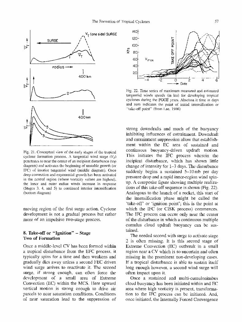
The observations presented here agree with previous ideas expressed by Ray Zehr, myself, and a few other investigators that tropical cyclone formation is a two-stage process�9 It typically (but not always) requires two triggering mechanisms each of which lasts only last 6-12 hours�9 These trigger mechanisms are usually separated from each other by 1-3 days during which little change occurs. The first triggering mechanism sets up conditions necessary for the second trigger to initiate the disturbance's beginning intensification to named storm status. Frequently, despite favourable larger-scale con- ditions and the execution of the first trigger, the needed second triggering of forced mass con- vergence to the disturbance's center never materializes and cyclone intensification does not proceed. It is the second triggering stage which is most unique�9 It must occur within the
The Formation of Tropical Cyclones 57
f i
t
f
V T (one side) SURGE
SURGE / ,,
/
rodius---~
t I
400 km
400 km
Fig. 21. Conceptual view of the early stages of the tropical cyclone formation process. A tangential wind surge (Vr) penetrates to near the center of an incipient disturbance (top diagram) and activates the beginning of unstable growth (or IFC) of interior tangential wind (middle diagram). Once deep convection and exponential growth has been activated in the central region (where vorticity values are highest), the inner and outer radius winds increase in response (Stages 3, 4, and 5) to continued interior intensification (bottom diagram)
moving region of the first surge action. Cyclone development is not a gradual process but rather more of an impulsive two-stage process.
8. Take-off or "Ignition" - Stage Two of Formation
Once a middle-level CV has been formed within a tropical disturbance from the EFC process, it typically spins for a time and then weakens and gradually dies away unless a second FEC driven wind surge arrives to reactivate it. The second surge, if strong enough, can often force the development of a small area of Extreme Convection (EC) within the MCS. Here upward vertical motion is strong enough to drive air parcels to near saturation conditions. Conditions of near saturation lead to the suppression of
140
120
I00
80
60
40
20
0 Vmox
- 4
J ' J ' % %
! I / / / \\ " \ i / , d ,' '\ t',
- - I 1
-2 0 2 4 6 > Date
Fig. 22. Time series of maximum measured and estimated tangential winds speeds (in kts) for developing tropical cyclones during the FGGE years. Abscissa it time in days and zero indicates the point of initial intensification or "take-off point" (from Lee, 1986)
strong downdrafts and much of the buoyancy inhibiting influences of entrainment. Downdraft and entrainment suppression allow that establish- ment within the EC area of sustained and continuous buoyancy-driven updraft motion. This initiates the IFC process wherein the incipient disturbance, which has shown little change of intensity for 1-3 days. The disturbance suddenly begins a sustained 5 -10mb per day pressure drop and a rapid inner-region wind spin- up. A composite figure showing multiple realiza- tions of this take-off sequence is shown (Fig. 22). Analogous to the launch of a rocket, this start of the intensification phase might be called the 'take-off' or 'ignition point'; this is the point at which the IFC (or CISK process) commences. The IFC process can occur only near the center of the disturbance in which a continuous multiple cumulus cloud updraft buoyancy can be sus- tained.
The needed second with surge to activate stage 2 is often missing. It is this second stage of Extreme Convection (EC) outbreak in a small region near a CV which is so uncertain and often missing in the prominent non-developing cases. If a tropical disturbance is able to sustain itself long enough however, a second wind surge will often impact upon it.
Once a sustained and multi-cumulonimbus cloud buoyancy has been initiated within and EC area where high vorticity is present, transforma- tion to the IFC process can be initiated. And, once initiated, the Internally Forced Convergence
58 W.M. Gray
(IFC) process rapidly becomes self sustaining. Surface pressure begins to fall over a small area beneath the clustering the cumulonimbus clouds. This under-cloud pressure drop beings an increased inward horizontal acceleration of surrounding low-level wind to the cloud area. Stronger and more intense upward vertical motion is established.
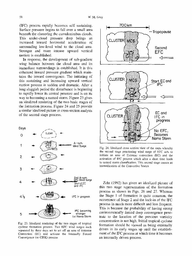
In response, the development of sub-gradient wing balance between the cloud area and its immediate surroundings is established. It is this enhanced inward pressure gradient which main- tains the inward convergence. The initiating of this sustaining and increasing upward vertical motion process is sudden and dramatic. After a long sluggish period the disturbance is beginning to rapidly lower its central pressure and is on its way to becoming a named storm. Figure 23 gives an idealized rendering of the two basic stages of the formation process. Figure 24 and 25 provide a similar idealized picture in cross-section analysis of the second stage process.
Days
0 / CLEAR \
A-sym. 1 ~ ~ Wind Surge
2
.'5
4 2nd A-sy.~. r_t-L, wina ~urge Start of EC and IFC
4- ~'2 ~ ~ IFC in progress
IFC becoming 5 ,~- ~ stronger
I st Nome Storm
Fig. 23. Idealized rendering of the two stages of tropical cyclone formation process. Two EFC wind surges each separated by three days act to set off an area of Extreme Convection (EC) and activate the Internally Forced Convergence (or CISK) process
700 km
iiiiiiiiiiiiilililiiiiiiiiiiiiii
:::::::::::::::::::::::::!:!~i::i::i
=-I --Tropopause
Second EFC
Start EC and / IFC
<2
EC and IFC in progress
No EFC, Becomes
Name Storm
Fig. 24. Idealized cross-section view of the steps whereby the second stage penetrating wind surge of EFC acts to initiate an area of Extreme convection (EC) and the activation of IFC process which after a short time leads to named storm classification. This second stage causes an intensification of the Convective Vortex
Zehr (1992) has given an idealized picture of this two stage representation of the formation process as shown in Figs. 26 and 27. Whereas the Stage 1 of formation is quite common, the occurrence of Stage 2 and the lock-in of the IFC process in much more difficult and less frequent. This is because the probability of having strong environmentally forced deep convergence pene- trate to the location of the previous vorticity concentration is not high. Initial tropical cyclone formation should be viewed as being externally driven in its early stages up until the establish- ment of the IFC process at which time it becomes an internally driven process.

The Formation of Tropical Cyclones 59
I FC and FFC
0 - , - r O
(]) m
E 0
Z "-~ . m
t -
970 SLP 990 mb
-<----Intensification
5 4
EFC
1002 m 1003 11004 1004 1006 genesis ~ l ~ genesis stage 2 stage 1
•1/2 ~ [ 2_ I 0 times in days
Fig. 25. Illustration of the typical day-to-day (right to left) westward propagating sequence of the two stages of tropical cyclone formation. In Stage 1, a transient environmental wind surge establishes an MCS from which a CV is generated. This CV persists for a few days until a second external wind surge provides a second packet of momentum. This second packet of momentum causes an area of EC to break out at a location within the CV. This is the start of Stage 2. It is at this time that the Internally Forced Convergence (IFC) process is initiated and central pressure commences a sustained decrease to named storm and then hurricane intensity
9. T rans fo rmat ion of Low Levels from Cold to Warm Core During Stage 2
Idealized vertical profiles of cloudiness, pressure slope, and convergence in the typical early and late stages of a MCS are indicated in Fig. 28. This involves the development of MCS max- imum convergence in the middle tropospheric levels. This strong middle level inflow is much enhanced by the later stage MCS convergence resulting from evaporating and cooling down- drafts and from the melting of frozen cloud particles caused by raining middle-layer cloud decks. Cloud and cloud-free radiation may also play a role. Research by Houze (1989, 1993), Mapes and Houze (1995) and their associates has shown middle level convergence increasing from the early stages of MCS formation when deep convection clouds are more prevalent to the later stages of the MCS when thick middle- layered clouds can cause broader-scale rain with evaporating and melting downdrafts becomes established - see the right diagrams of Fig. 28. Although the typical MCS cloudiness weakens and dies in 6-12 hours, it leaves a residual circulation of enhanced middle level cyclonic circulation with a more concentrated convective
vortex. The middle-level often extends down- ward to the surface but its circulation is weaker and of smaller size near the surface. The stronger middle-level cyclonic circulation of the residual MCS cloudiness produces a typical cold-core lower-level circulation and upper-level warm core as indicated by the middle-right diagram of Fig. 28. This is also representative of the typical middle level maximum circulation of the easterly wave.
A central question for many years (Riehl, 1954) has been how the tropical disturbance or easterly wave transforms itself from a lower tropospheric cold to a warm core system. Before named storms development can occur, it is necessary that this transformation takes place. It is the second EFC wind surge process which is responsible for bringing forth this transformation through the initiation of a second round of intense MCS convection. But the influence of this second wind surge and MCS convection is different because it impinges on the residual circulation of the first MCS convective burst. The second EFC wind surge is able to stimulate more low-level convergence and low-level wind spin- up than the first wind surge was able to accomplish. The first stage of MCS convection

60 W.M. Gray
f.
GENESIS ~ t~'INTENSIFICATION ' "
STAGE I STAGE [ TROPICAL " ~ TWO "--~l" STORM " - - *
I 1 Days Before ] Named After Storm
Deep Convelctive Clouds [ SURGE SURGE I / " "
J MSLP.[ Minimum Sea Level Pressure -]lOiO
l 1'~176176
I T Lo
Maximum Surface Wind Speed / I Z 5 I , ~ 4zo
Dvorak Intensity No.
,.b ,:5 s 2:5 fo 315
I I I I
Fig. 26. Conceptual model summarizing the important changes of Cb, MSLR and Vmax during tropical cyclogen- esis with estimates of the approximate numerical values. The associated Dvorak Intensity T-numbers are also shown (from Zehr, 1992)
is responsible for establishing a middle-level circulation. This middle-level circulation has higher inertial stability [( ~a ( 2 Vr/R + f]l/2. Higher inertial stability is able to act inhibit the second surge from a repeat of the large amounts of middle-level convergence that occurred with the first MCS out-break. High values of inertial stability inhibits radial displacement of air particles as discussed by Schubert and Hack (1982). The second wind surge is thus not as able to penetrate to neat the disturbance center in the middle levels. The already established middle- level circulation of the earlier MCS (see Fig. 29) has thus prepared the way for the second wind surge to concentrate low-level convergence and vorticity. This second wind surge can more easily
penetrate to near the disturbance's center at lower levels because the disturbance's vorticity and inertial stability is much smaller at lower levels. This second stage of MCS convection outbreak is thus able to convert the disturbance's low levels from a cold-core into a warm-core system.
It is for these reasons that formation is seen as a two stage process of 1) establishment of the middle level circulation and convective vortex (CV), and 2) the low-level convergence and concentration of the disturbance cyclonic circu- lation and the transformation of the lower troposphere from a cold to warm core. Only the second stage is able to provide this critical low- level cold to warm stage transformation. After the IFC process has been established and cyclone formation is well on its way, the inner convection begins to organize itself into eye-wall type convection. Eye-wall convection continues the IFC process. The outside environment then ceases to become a major player.
10. Requirement for High Concentration of Water Vapor for IFC Initiation
Questions have arisen as to the moisture and buoyancy requirements for the establishment of the IFC process. Modeling (Chen and Frank, 1993) and theoretical analysis indicate that multi-cloud IFC initiation requires that near saturation humidity (> 95% RH) conditions he present. High humidity inhibits downdraft devel- opment and also inhibits updraft weakening from entrainment. Rawindsonde composite informa- tion shows that the relative humidity of pre- tropical cyclone cloud clusters varies from about 85% near the surface to about 70 percent at 500 mb. The average relative humidity between the surface and 300 mb is 75 percent. The mean precipitable water of pre-cyclone cloud clusters is 5.7 gm/cm 2 and saturated precipitable water is 7.0 gm/cm ~, or 23 percent greater.
Air Force investigative flight data indicate that composited symmetric inflow into the developing disturbances at 55 km radius of 1.3 ms -1. This is equivalent to low-level 0-55 km radius conver- gence of ~ 5 • 10-5s -] or total mass replacement every five hours. Saturation could be reached in one to two hours if none of the converging vapor were to rain out. There appears to be enough low-level convergence of water vapor into the

The Formation of Tropical Cyclones
STAGE ONE
SYNOPTIC-SCALE DISTURBANCES:
MESOSCALE VORTEX,
OVERALL CONVECTION :
BEFORE
Brood, cyclonic circulation and/or easterly wave
None
Weak to moderate
CONVECTIVE MAXIMUM
Prominant, active cloud cluster j Initiation
Strong
AFTER
Brood, cyclonic circulation and/or easterly wove
Weak, with little or no deep convection
Weak to moderate
STAGE TWO
SYNOPTIC-SCALE DISTURBANCES:
MESOSCALE VORTEX:
OVERALL CONVECTION :
BEFORE
4 / Broad, cyclonic circulation and/or easterly wave Weak, with little or no deep convection
Weak to moderate
CONVECTIVE MAXIMUM
Weak, with deep convec- tion near its center
Strong
AFTER
Minimal Tropical Storm Max. Wind, 17.5 m s -I
Intensifying
Moderate to strong
61
Fig. 27. Conceptual model of tropical cyclogenesis with illus- trations and descriptions of char- acteristics which are observable using satellite images (from Zehr, 1992)
disturbance's small inner-core area by the second penetrating wind surge to be able to raise water vapor contents such that an additional 20-25 percent humidity increase [to near saturation] would occur in a very short time, even if a large percentage of this converging water vapor condenses and rains out. This would prepare a small inner-core area of Extreme Convection (EC) for the establishment of the IFC process.
Although water loading and ice melting can produce some downward motion, sustained updraft buoyancy can be maintained against these weaker inhibiting downdraft influences provided that most of the evaporation driven downdrafts are suppressed. Most liquid water falls out of updrafts and frees them from water loading at upper levels. It is observed that convective cloud updrafts make up only a faction of the IFC cloud area.
Thus, an important and auxiliary role of the second wind surge is to mechanically force convergence and upward vertical motion in the small EC region to the conditions of near
saturation. This mechanically forced moistening of the upper levels prepares the small EC region of the inner-core for the initiation of multi-cloud sustained updraft buoyancy and the start of the IFC (or CISK) intensification process. A forced upward vertical motion of just 50-100 millibars will produce such near saturated conditions.
11. Low-Level Oe of Developing Versus Non-Developing Disturbances
Some researchers have suggested that there are differing initial thermodynamic states between developing and non-developing disturbances. It has been hypothesized that higher values of low- level temperature and/or moisture and hence, equivalent potential temperature (0e) might be expected to occur with developing as compared with non-developing disturbance systems. Our rawindsonde analyses over many years has never indicated any early stage systematic moisture or temperature differences between prominent trop- ical disturbance or cloud clusters which develop

62 W.M. Gray
F I R S T SURGE
MCS EARLY STAGE
MCS LATER STAGE
TROR . . �9 , ~ . o , . . . . ~ . . . . . .
L w, os. fi 7 / / / / / / / / / / / / / / / / / / / / / / / / / /S FC
TROR
/////////////////////////////
TROR �9 . . . . . ~ o o . . . . . . . . . .
TROR
W_
z z
///////////////////////II// SFC
. c s
--.,--_ cv " ~ c ~ 900mb.~...~
/ / / / / / / / / / / / / / / / X / x / x / x / N / "
TROR TROP.
. . . . . . . . . . . . . . . . ~ 1 7 6 . . . . . . . . . . . . I . . . . . . . . . . .
f i z z
1 0 0
",-- neg pos ~, -',- neg pos. ,- DIV. DIV.
Fig. 28. Idealized vertical cross-sections of processes occurring with the early and late development stages of a MCS which is initiated by a wind surge. Top diagrams show the cloudiness, middle diagrams the slope of pressure surfaces with temperature anomalies (W or C), and the bottom diagrams the typical divergence profiles
into named storms and those prominent dis- turbances and cloud clusters which do not. This evaluation is not relevant to small IFC areas of individual disturbances. We have very few soundings from such selective areas.
Our analyses of measurements made from investigative aircraft flights into developing and non-developing disturbances in the NW Pacific also fail to indicate any systematic differences in temperature and/or moisture for developing versus non-systematic differences in temperature and/or moisture for developing versus non- developing systems. Equivalent potential tem- perature (0e) values, normalized to the 950mb level and shown in Table 6 indicate that no
appreciable thermodynamic differences exist between those disturbances which developed into tropical cyclones and those prominent disturbances which did not. These observations are consistent with forecaster experience and are not surprising. Little temporal or spatial variation of observed for sea surface temperature (SST), boundary layer temperature or moisture in the low latitude late summer and early autumn environments of the northwest tropical Pacific or in other regions where tropical cyclones form. There is no reason for there to be any systematic 0e boundary layer differences between distur- bances which develop in tropical cyclones and those which do not. This supports the argument

The Formation of Tropical Cyclones 63
SECOND WIND SURGE TROR
�9 ~ . �9 o . �9 �9 �9 �9 �9 �9 �9 . . o �9 �9 �9 �9
i iii J!" . - .
TROR
Z
W ~ ~ 1 7 6 /
~ / s f c
TROR �9 ~ �9 o �9 �9 . �9 �9 - � 9 1 4 9 - �9 �9 �9 o o �9 �9
2 / / ~ / / / ) / / / / / / / / / / / / / / / / sfc neg. 0 pos.
DIV
Fig. 29. Similar profiles to Fig. 28 but showing the further progression of development with the second stage. A second wind surge impinges upon the region of a prior MCS. Inertial stability of the middle layers causes much of the deep layer wind surge to become concentrated at lower levels. This acts to spin-up the lower levels more than the middle levels and to change the system from a low-level cold core to a warm core
support the air-sea interaction theory of tropical cyclones as advanced by Emanuel (1986) and Rotunno and Emanuel (1987).
12. Requirements for Inward Eddy Momentum Flux in the Outer-core
Lee (1986) has made calculations of the mean 1-5 ~ radius transverse circulation and vorticity fields of forming tropical cyclones. He found that the mean in-up-and-out transverse circulation was too weak to accommodate the observed rates of intensification. A high percentage of the inward flux of momentum during the early stage tangential wind intensification must be accom- plished by horizontal eddy (V~V~) momentum imports. As shown in Table 7, Lee found that 70 and 53 percent of the momentum import during the first and second stages of early tropical cyclone intensification be accomplished by in- ward horizontal eddy flux terms.
This requirement for large inward eddy fluxes of tangential momentum is sharply reduced as the cyclone formation process proceeds. In the latter stages of formation, the symmetrical component of the mean transverse circulation spin-up becomes increasingly dominant and the percentage of inward momentum transport by eddy flux processes is greatly decreased. The ratio of eddy to mean inward flux then drops appreciably. Other verifying evidence of the role of outer radius inward horizontal eddy flux has been given by Pfeffer and Challa (1992).
It is interesting to note that it is during the early stages of the tropical cyclone formation process that the numerical models have had their greatest difficulty. Modeling of the later stages of development where the ratio of eddy to total momentum import is much less has proven to be much more successful. It is likely that the difficulties in initial modeling efforts of the early stages of tropical cyclone formation have suf- fered from a failure to fully understand and adequately include the influences of asymme- trical and time dependent EFC wind surges.
that it is the mechanical and not the thermo- dynamic factors which are the dominant factors in determining whether and individual tropical disturbance will go on to become a tropical cyclone or not. These measurements do not
13. Upper-level Factors Affecting the Genesis of Tropical Cyclones
Both the early formation stage of the tropical cyclone and the cyclone's later stage intensifica-

64 W.M. Gray
Table 6. Aircraft Observations of Mean Radial Values of Equivalent Potential Temperature (Oe) Normalized to the 950 mb Temperature and Assumed Saturated Air for 52 Developing (D1) and 49 non-Developing (NON-DEV) Cases (from Lunney and Gray 1988)
Radius (~ Latitude)
0-.5 .5-1.0 1.0-1.5 1.5-2.0 2.0-2.5 2.5-3.0
D1 (52 Cases) 365 366 366 366 366 366 NON-DEV (49 Cases) 366 366 366 367 365 366 Difference (D 1-NON-DEV) -0 .2 -0.1 0.3 -0 .7 0.6 0.6
Table 7. Tropospheric Tangential Momentum Budgets (units." ms -1 per day) Between 1-5 ~ Radius. The Numbers in Parentheses Represent the Percentage of the Total Tangential Momentum Intensification by mean and by Eddy Terms Contributed for both the non-Developing (ND) and Developing Cases (D) (from Lee, 1986)
OV/Ot mean +eddy Spin-up terms terms +motion +surface ms -1 = VRVT VRtV7 ~ friction
(1-5 ~ Non-persistent ND 0 = +0.4 Persistent ND 0 = +0.4 Vma x < 8 m s - 1 + 1.7 = + 0 . 7 ( 3 0 % )
Vmax< 12ms -1 +2.0 = +1.4(47%) Vmax < 15 ms -1 +1.8 = +2.6(79%)
-0.1 -0 .2 -0.1 -0.1 -0 .2 -0.1 +1.6(70%) -0 .3 -0 .3 +1.6(53%) -0 .4 -0 .6 +0.7(21%) -0 .4 -1.1
tion require conditions of minimal tropospheric vertical wind shear over the system's center (Gray, 1968). Besides minimal shear require- ments, formation is also favored by having anti- cyclonic flow present in the upper tropospheric at 300-600km radius around developing distur- bances (Fig. 30). Dvorak (1975) has pointed out that unidirectional upper-tropospheric flow over a disturbance, as indicated by the right diagram of Fig. 30, is detrimental to the formation pro- cess. Anticyclonic flow is conducive to the export of negative tangential momentum. This is favour- able to the spin up of the growing cyclone's outer radius tangential winds. There must be a balance in the tropical cyclone's inner and outer-core wind spin-up. Although inner-core spin-up must lead, it is important that outer radius tangential winds also increase at an incremented rate so that outer radius inertial stability does not become too small.
A number of authors have been emphasizing the likely role of baroclinic zones as an important component of tropical cyclone formation at sub- tropical latitudes and off-season forming tropical cyclones (Molinari and D. Vollaro 1989; Bosart and Bartlo 1991; Montgomery and Farrell 1993; and others). Perhaps a quarter of the tropical
cyclone formations which occur around the globe are not of pure tropical origin. They have important baroclinic components associated with them. This is especially the case in the Southern Hemisphere where the westerly wind belt is closer to the equator. Upper level troughs can impact favorably in the early stage development of these hybrid type of combined tropical- baroclinic system formations through enhance- ment of a disturbance's upper-level outflow and upward vertical motion. But the majority of tropical cyclones form without the influences of an upper level trough. It is not a necessary condition of the majority of the globe's tropical cyclone formations. This hybrid type of devel- oping has been discussed in the literature. One must be aware not to use the baroclinic hybrid- type of tropical cyclone development as typical of all tropical cyclone formations.
Role of the TUTT. The summertime Tropical Upper-Tropospheric Trough (TUTT) often con- tributes to the development of tropical cyclones (Sadler, 1976, 1978), particularly those embedded in the trade winds at higher latitudes. Although the TUTT itself typically does not contribute to the initial formation of tropical disturbance or easterly wave, it can sometimes assist the genesis
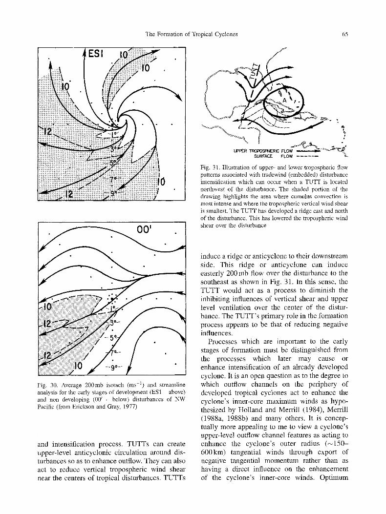
The Formation of Tropical Cyclones 65
Fig. 30. Average 200mb isotach (ms -1) and streamline analysis for the early stages of development (ES1 - above) and non developing (00 / - below) disturbances of NW Pacific (from Erickson and Gray, 1977)
and intensification process. TUTTs can create upper-level anticyclonic circulation around dis- turbances so as to enhance outflow. They can also act to reduce vertical tropospheric wind shear near the centers of tropical disturbances. TUTTs
b,
UPPER TFiOFOSPHERIC FLO SURFACE FLOW . . . . . .
Fig. 31. Illustration of upper- and lower-tropospheric flow patterns associated with tradewind (embedded) disturbance intensification which can occur when a TUTT is located northwest of the disturbance. The shaded portion of the drawing highlights the area where cumulus convection is most intense and where the tropospheric vertical wind shear is smallest. The TUTT has developed a ridge east and north of the disturbance. This has lowered the tropospheric wind shear over the disturbance
induce a ridge or anticyclone to their downstream side. This ridge or anticyclone can induce easterly 200 mb flow over the disturbance to the southeast as shown in Fig. 31. In this sense, the TUTT would act as a process to diminish the inhibiting influences of vertical shear and upper level ventilation over the center of the distur- bance. The TUTT's primary role in the formation process appears to be that of reducing negative influences.
Processes which are important to the early stages of formation must be distinguished from the processes which later may cause or enhance intensification of an already developed cyclone. It is an open question as to the degree to which outflow channels on the periphery of developed tropical cyclones act to enhance the cyclone's inner-core maximum winds as hypo- thesized by Holland and Merrill (1984), Merrill (1988a, 1988b) and many others. It is concep- tually more appealing to me to view a cyclone's upper-level outflow channel features as acting to enhance the cyclone's outer radius (~150- 600km) tangential winds through export of negative tangential momentum rather than as having a direct influence on the enhancement of the cyclone's inner-core winds. Optimum

66 W.M. Gray
arrangement of outflow channels can be favor- able to the maintenance of inner-core winds if these channels are configured so as to offer protection to the inner-core cyclone vortex from the negative environmental influences of upper- level inner-core wind impingement or shear. In this sense, the favorable arrangement of outflow channels act to inhibit negative vertical shear and ventilation influences, but is not a positive spin- up influence in itself.
14. Later Stage Intensification
It is important to emphasize the distinction be- tween wind increases in the inner-core (0-150kin radius) versus the outer-radius areas (150- 500 km radius) during the early stages of cyclone development. When intensifying inner-core winds lead the way, the inertial stability in the outer radius region remains low. The radial in- up-and-out circulation to the inner-core area can be readily accomplished; inner-core (0-150 kin) intensification can proceed rapidly. However, as outer-area tangential winds strengthen, then outer area inertial stability rises to values that signif- icantly inhibit the transverse circulation to the inner-core and the rate of intensification must slow. This is why it is important for tropical cyclones to intensify first in their inner regions and then spread this inner-core spin-up to outer radii. Figures 32 and 33 illustrate this early intensification rate. Tangential winds, and partic- ularly vorticity increases very strongly in the inner core before vorticity becomes elevated in the outer-core.
"~ 3O
25
z 20
~ 1 5
z 5 i
i I F I I I i I I I
I 2 3 4 5 RADIUS (deg. latitude)
Fig. 32. Radial profiles of symmetrical tangential wind, out to 550km from the center of D1 (early developer), D2 (middle developer), and D3 (late developer) composites (from Middlebrooke and Gray, 1987). Value in knots
50
I u~
40
h q) 30
0 bJ >- 20
I.U n-
< Z
\ \ \ \ \ \
"" \ \~ \ t
0 I 2 3 4 5 RADIUS (deg. Iotitude)
Fig. 33. Radial profiles of symmetrical relative vorticity out to 450km from the center for D1 (early developer) D2 (middle developer), and D3 (late developer) composites. Units is 10 .5 s -1. The Coriolis parameter f is approxi- mately 3.4 • 10-Ss 1 for D1 and D2, and approximately 4.5 • 10 5s-1 for D3 (from Middlebrooke and Gray, 1987)
Tropical cyclones typically do not evolve within fixed climatological environments. Tropical cyc- lones should not be thought of as going through their life cycle under unchanging and favorable environments. Tropical cyclones evolve in envir- onments exhibiting favourable temporary devia- tions from background climatology. The sur- rounding environment can change as much or more than the cyclone itself.
Tropical cyclone formation is initially depen- dent upon asymmetrical and rapidly varying ambient wind conditions. This involves envir- onmentally forced wind surge penetration ex- tending to near the center of a disturbance. These wind surges impinge on the disturbance from a single azimuthal direction causing a burst of deep convection. If this convective outbreak occurs within a tropical disturbance where strong vorticity values have been concentrated from a previous convective event, formation may follow. These energizing convective bursts are not the product of the internal dynamics of the dis- turbance itself, but rather, are the product of the temporary alteration of the environment. How- ever, the energizing wind surge action lasts only 12-18 hours and rapidly recedes with time. During its period of influence, wind surge action can sometimes establish an active MCS area

The Formation of Tropical Cyclones 67
within a disturbance where a small region of Extreme Convection (EC) breaks out and initi- ates an IFC process which leads to tropical cyclone formation. Other t imes the wind surge will, for various reasons, fail to initiate this physical sequence leading the development. In the latter case, the disturbance will gradually dissipate unless energized by the arrival of another wind surge a few days later.
Although the role of the environment as a player in early stage tropical cyclone formation has been known and accepted to varying degrees for many years, the full extent of and the dominant role of the environment in the early stage formation process has yet to be fully realized. But, once the tropical cyclone has grown into a well developed vortex, environ- mental influences decrease in importance. The spinning circulation of the developed cyclone isolates and protects itself f rom the surrounding environment and the cyclone acts as a barrier to environmental interactions. Environmental ly forced wind surge action plays little part in influencing the inner-region max imum intensity of the developed cyclone, although outer region circulation may be affected.
15. Discussion
Tropical cyclone formation is not a gradual process of the evolution of a tropical disturbance into a named tropical cyclone. Rather, it is more of a two-stage process including a rapid short period change followed, by an intermediate 1-3 day quiescent period of little change, followed by a second period of rapid transformation. It is necessary that during the second stage that a small area of Extreme Convection (EC) outbreak develop within an MCS. This EC causes a raising of humidi ty to near saturation over a small area. High humidi ty weakens downdraft and inhibits the entrainment cooling of updrafts. Intense and concentrated cumulon imbus convect ion in a region of near saturated humidi ty satisfies the requirements for the initiation of the Internally Forced Convergence (IFC) process which must take place if a tropical disturbance is to intensify to named storm stage. Externally Forced Con- vergence (EFC) is the dominant process in establishing the conditions f rom which the IFC process can be initiated. But once the IFC
process has been initiated, interior physics take over and the growing cyclone is able to operate independently of its environment. It is necessary, however, that once the tropical cyclone has developed that the cyclone is left alone by its environment. There must not be an impingement of too strong environmental vertical wind shear.
The forming tropical system's broader scale mean vertical motion is over a 0-300 km radius area always too weak to allow simultaneous broad-scale wind spin-up to occur at all radii on a time scale as rapidly as nature does it. It is necessary that the tropical disturbance initially concentrates its spin-up within a small central region where rapid growth is possible. Once this has taken place it is possible that the central area of high winds can then spread outward to the surrounding disturbance area. When the inner-core spins up first, the negative tangential wind shear from the inner to outer radius is large, and the vorticity, and inertial stability [((a) (2Vr/r + f ) ] remain small. The smaller the inertial stability the greater is the ability of the air to move radially. By keeping the inertial stability small it is possible to have stronger inward convergence and high wind spin-up from an enhanced in-up-out radial circulation. Were the outer winds to increase first the opposite situation would prevail. The inertial stability would be stronger. The ability for radial displacement would be reduced. The in-up-out radial circula- tion necessary to spin up the winds would be reduced. The intensification of the inner-core winds would be too slow to spin-up the large scale vortex or the spin-up would proceed too slowly - more slowly than is observed in nature.
Acknowledgement
Trying to explain tropical cyclone formation has been a career goal of mine. I consider it one of the most challenging of the meteorological question. It was Herbert Riehl who first challenged me try to figure out why tropical cyclones form and I am indebted to him for this early encouragement.
I have especially profited in recent years from his association with Ray Zehr and James Purdom of the CSU/ NOAA/NESDIS satellite group which is associated with our Colorado State University Department. Ray Zehr has taught me much about the tropical cyclone formation process. The daily map and satellite discussions we have had in recent years on tropical cyclone formation in the Atlantic and the northeast and the northwest Pacific has

68 W.M. Gray
been very beneficial to my understanding of the genesis process. I have also profited from extensive discussion on the TC formation topic over the years with Michio Yanai, John McBride, Bill Frank, Steve Erickson, Geoff Love, Cheng-Shang Lee, Middlebrooke, Pat Lunney, Pat Fitzpa- trick, Chris Landsea, and John Knaff. This research has been supported by research grants through the years by the National Science Foundation and recently by the CIRA/ NOAA/NESDIS satellite group.
References
Battles, D. L., Maddox, R. A., 1991: Mid-level cyclonic vortices generated by mesoscale convective systems. Mon. Wea. Rev., 119, 104-118.
Bosart, L., Bartlo, J. A., 1991: Tropical storm formation in a baroclinic environment. Mon. Wea. Rev., 119, 1979-2013.
Challa, M., Pfeffer, R. L., 1980: Effects of eddy fluxes of angular momentum and model hurricane development. J. Atmos. Sci., 37, 1603-1618.
Charney, J. G., Eliassen, A., 1964: On the growth of the hurricane depression. J. Atmos. Sci., 21, 68-75.
Chen, S. S., Frank, W. M., 1993: A numerical study of the genesis of extratropical convective meso-vortices. Part I: Evolution and dynamics. J. Atmos. Sci., 50, 2401-2426.
Dvorak, V., 1975: Tropical cyclone intensity analysis and forecasting. Mon. Wea. Rev., 103, 420-430.
Emanual, K. A., 1986: An air-sea interaction theory for tropical cyclones. Part I: Steady-state maintenance. J. Atmos. Sci., 43, 585-604
Erickson, S. L., Gray, W. M., 1977: Comparison of devel- oping vs. non-developing tropical disturbances. Dept. of Atmos. Sci. Paper No. 274, Colo. State Univ., Ft. Collins, CO, 80523, 81 pp.
Frank, W. M., 1987: Tropical cyclone formation (Chapter 3), A global view of tropical cyclones, WMO Bangkok, Thailand textbook, Printed by Dept. of Chicago, 53-90.
Fritsch, J. M., Maddox, R. A., 1981a: Convectively driven mesoscale weather systems aloft. Part I: Observation. J. Appl. Meteror., 20, 9-19.
Fritsch, J. M., Maddox, R. A., 1981b: Convectively driven mesoscale weather systems aloft. Part II: Numerical simulations. J. Appl. Meteor., 20, 20-26.
Gray, W. M., 1968: Global view of the origin of tropical disturbances and storms. Mon. Wea. Rev., 96, 669-700.
Gray, W. M., 1975: Tropical cyclone genesis. Dept. of Atmos. Sci. Paper No. 234, Colo. State Univ., Ft. Collins, CO, 121 pp.
Gray, W. M., 1979: Hurricanes: their formation, structure and likely role in the tropical circulation. Supplement of Meteorology Over the Tropical Oceans. Published by RMS, James Glaisher House, Grenville Place, Bracknell, Berkshire, RG 12 1BX, D. B. Shaw, (ed)., 155-218.
Gray, W. M., 1988: Environmental influences on tropical cyclones. Aust. Met. Mag., 36(3), 127-139.
Gray, M. W., 1990: Tropical cyclone formation. Proceedings of the Second WMO International Workshop on Tropical Cyclones (IWTC-II), Manila, Philippeans, 27 November to 8 December, 1989.
Gray, W. M., Landsea, C. W., Mielkle, E W., Jr., Berry, K. J., 1944: Predicting Atlantic basin seasonal tropical cyclone activity by 1 June. Wea. Forecasting, 9, 103-115.
Gray, W. M., Jacobson, R., Jr., 1977: Diurnal variation of deep cumulus convection. Mon. Wea. Rev., 105(9), 1171- 1188.
Grube, E G., Gray, W. M., 1979: Convection induced temperature temperature change in GATE. Dept. of Atmos. Sci. Paper No. 305, Colo. State Univ., Ft. Collins, CO, 128 pp.
Hack, J. J., Schubert, W. H., 1986: On the nonlinear response of atmospheric vortices to heating by organized cumulus convection. J. Atmos. Sci., 43, 1559-1573.
Holland, G., 1987: Chapter 3 of A Global View of Tropical Cyclones. WMO Bangkok TC Workshop Textbook (Prin- ter, Dept. of U. of Chicago), pp. 13-52.
Holland, G. J., Merrill, R. T., 1984: On the dynamics of tropical cyclone structure changes. Quart. J. Roy. Meteor Soc., 110, 723-745.
Houze, R. A., Jr., 1989: Observed structure of mesoscale convective systems and implications for large-scale heating. Quart. J. Roy. Meteor. Soc., 115, 425-461.
Houze, R. A., Jr., 1993: Cloud Dynamics. New York, NY: Academic Press.
Houze, R. A., Jr., Cheng, C. R, 1977: Radar characteristics of tropical convection observed during GATE: Mean proper- ties and trends over the summer season. Mon. Wea. Rev., 105, 964-980.
Jordan, C. L., 1958: Mean soundings of the West Indies area. J. Meteor., 15, 91-92.
Lee, C.-S., 1986: An observational study of tropical cloud cluster evolution and cyclogenesis in the western north Pacific. Dept. of Atmos. Sci. Paper No. 403, Colo. State Univ., Ft. Collins, CO, 250 pp.
Lee, C.-S., 1989a: Observational analysis of tropical cyclo- genesis in the western North Pacific: I: Structural evolu- tion of cloud clusters. J. Atmos. Sci., 46(16), 2580-2598.
Lee, C.-S., 1989b: Observational analysis of tropical cyclogenesis in the western North Pacific: II: Budget analysis. J. Atmos. Sci., 46(16), 2599-2616.
Love, G., 1985: Cross-equatorial interactions during tropical cyclone genesis. Mon. Wea. Rev., 113, 1499-1509.
Lunney, R., Gray, W. M., 1988: Environmental and con- vective influences on tropical cyclone development versus non-development. Dept. of Atmos. Sci. Paper No. 436, Colo. State Univ., Ft. Collins, CO, 105 pp.
Maddox, R. A., 1980: Mesoscale convective complexes. Bull. Amer. Meteor. Soc., 16, 1374-1387.
Mapes, B. E., Houze, R. A., Jr., 1993: Cloud clusters and superclusters over the ocean warm pool. Mon Wea. Rev., 121, 1398-1415.
Mapes, B. E., Houze, R. A., 1995: Diabatic divergence profiles in western Pacific mesoscale convective systems. J. Atmos. Sci., 52, (July issue).
McBride, J. L., 1981a: Observational analysis of tropical cyclone formation, Part I: Basic description of data sets. J. Atmos. Sci., 38, 1117-1131.
McBride, J. L., 1981b: Observational analysis of tropical cyclone formation, Part III: Budget analysis. J. Atmos. Sci., 38, 1152-1166.
The Formation of Tropical Cyclones 69
McBride, J. L., 1995: Tropical cyclone formations. Chapter 3 of Global Perspectives on Tropical Cyclones. Being published by the WMO, 57 pp.
McBride, J. L., Zehr, R., 1981: Observational analysis of tropical cyclone formation, Part II: Comparison of non- developing versus developing systems. J. Atmos. Sci., 38, 1132-1151.
McBride, J. L., Gray, W. M., 1980: Mass divergence and vertical velocity in tropical weather systems, Part I: Diurnal variation. Quart. J. Roy. Meteor. Soc., 106, 449, 501-516.
Menard, R. D., Fritsch, J. M., 1989: A mesoscale convective complex-generated inertially stable warm core vortex. Mon. Wea. Rev., 117, 1237-1261.
Merrill, R. T., 1988a: Characteristics of the upper-tropo- spheric environmental flow around hurricanes. J. Atmos. Sci., 45(11), 1665-1677.
Merrill, R. T., 1988b: Environmental influences on hurricane intensification. J. Atmos. Sci., 45(11), 1678-1687.
Middlebrooke, M. G., Gray, W. M., 1988: Investigation of tropical cyclone genesis and development using low-level aircarft flight data. Dept. of Atmos. Sci. Paper No. 429, Colo. State Univ., Ft. Collins, CO, 94 pp.
Miller, D., Fritsch, J. M., 1991: Mesoscale convective complexes in the western Pacific region. Mort. Wea. Rev., 119, 2978-2992.
Molinari, J., Vollaro, D., 1989: External influences on hurricane intensity. Part I: Outflow layer eddy angular momentum fluxes. J. Atmos. Sci., 46, 1093-1105.
Montgomery, M. T., Farrell, B. F., 1993: Tropical cyclone formation. J. Atmos. Sci., 50, 285-310.
Nicholls, N., 1979: A possible method of predicting seasonal tropical cyclone activity in the Australian region. Mon. Wea. Rev., 107, 1221-1224.
Nicholls, N., 1992: Recent performance of a method for forecasting Australian seasonal tropical cyclone activity. Austral. Meteor. Mag., 40, 105-110.
Ooyama, K. V., 1969: Numerical simulation of the life cycle of tropical cyclones. J. Atmos. Sci., 26, 3-40.
Ooyama, K., 1982: Conceputal evolution of the theory and modeling of the tropical cyclone. J. Meteor. Soc. Japan, 60, 369-379.
Palmen, E., 1956: A review of knowledge on the formation and development of tropical cyclones. Proc. of the Tro- pical Cyclone Symposium, Bureau of Meteorology, Bris- bane, Australia, 213-232.
Pfeffer, R. L., Challa, M., 1992: The role of environmental asymmetries in Atlantic hurricane formation. J. Atmos. Sci., 49, 1051-1059.
Riehl, H., 1948a: On the formation of typhoons. J. Met., 5, 247-264.
Riehl, H., 1948b: Waves in the easterlies. Misc. Report No. 17, Dept. of Met., University of Chicago, 215-229.
Riehl, H., 1950: On the role of the tropics in the general circulation of the atmosphere. Tellus, 2, 1-17.
Riehl, H., 1954: Tropical Meteorology. New York, NY: McGraw Hill Book. 392 pp.
Riehl, H., Malkus, J. S., 1958: On the heat balance in the equatorial trough zone. Geophysica, 6, 503-538.
Rotunno, R., Emanuel, K. A., 1987: An air-sea interaction theory for tropical cyclones. Part II: evolutionary study using a non-hydrostatic axisymmetric numerical model. J. Atmos. Sci. 44, 542-561.
Ruprecht, E., Gray, W. M., 1976: Analysis of satellite- observed tropical cloud clusters. Part I: Wind and dynamic fields. Tellus, 28, 391-413.
Sadler, J., 1976: A role of the tropical upper tropospheric trough in early season typhoon development. Mon. Wea. Rev., 104, 1266-1278.
Sadler, J., 1978: Mid-season typhoon development and intensity changes and the tropical tropospheric trough. Mon. Wea. Rev., 106, 1137-1152.
Suchubert, W. H., Hack, J., 1982: Inertial stability and tropical cyclone development. J. Atmos. Sci., 39, 1687- 1697.
Shaprio, L. J., 1977: Tropical storm formation from easterly waves: a criterion for development. J. Atmos. Sci., 34, 1007-1021.
Velasco, I., Fritsch, J. M., 1987: Mesoscale convective complexes in the Americas. Geophys. Res., 92, 9591- 9613.
Williams, K., Gray, W. M., 1973: Statistical analysis of satellite observed cloud clusters in the western Pacific. Tellus, 21, 313-336.
Yanai, M., 1961a: A detailed analysis of typhoon formation. J. Meteor. Soc. Japan, 39(4), 187-214.
Yanai, M., 1961b: Dynamical aspects of typhoon formation. J. Meteor. Soc. Japan, 39(4), 282-309.
Yanai, M., 1964: Formation of tropical cyclones. Rev. Geophys., 2, 367-414.
Yanai, M., 1968: Evolution of a tropical disturbance in the Caribbean Sea region. J. Meteor. Soc. Japan, II, 46, 86-108.
Zehr, R. M., 1976: Tropical cyclone intensification. Dept. of Atmos. Sci. Paper No. 259, Colo. State Univ., Ft. Collins. CO, 80523, 91 pp.
Zehr, R., 1992: Tropical cyclogenesis in the western North Pacific. NOAA Technical Report NESDIS 16, 181 pp (available from NESD1S, Washington, DC or CIRA, Colo. State Univ., Ft. Collins, CO).
Author's address: Prof. Dr. William M. Gray, Department of Atmospheric Science, Colorado State University, Fort Collins, Co 80523, U.S.A. (e.mail: [email protected]. colostate.edu).